CB1 Moderately undulating landscape with slight gilgai (few inches) formation: broad ridge tops and upper slopes of moderately shallow grey cracking
|
|
|
- Peter Simpson
- 5 years ago
- Views:
Transcription
1
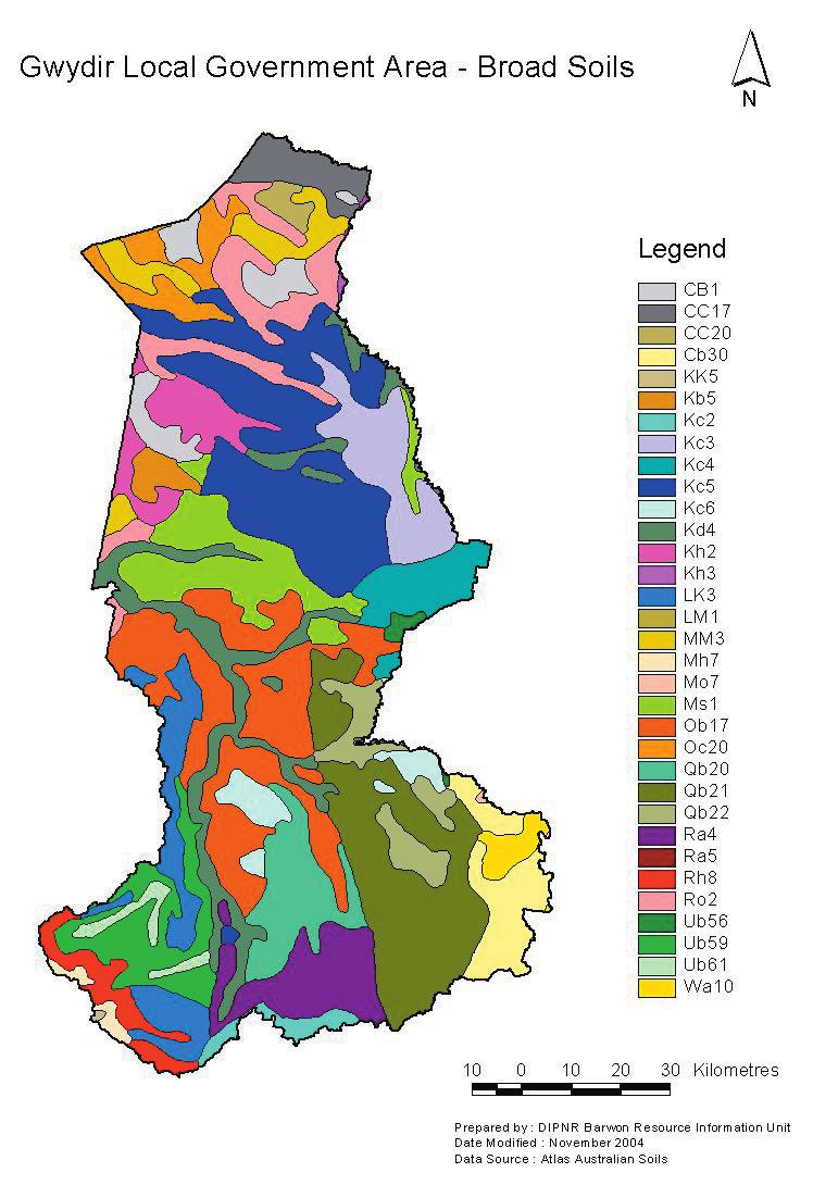
2 CB1 Moderately undulating landscape with slight gilgai (few inches) formation: broad ridge tops and upper slopes of moderately shallow grey cracking clays (Ug5.22 and Ug5.23). Associated are: (i) some dark cracking clays (Ug5.13); (ii) various alkaline (D) soils, such as (Db1.43) and (Dd1.33); and (iii) in the lower-lying situations deeper grey cracking clays (Ug5.25 and Ug5.24) with small areas of (Dy3.43) soils. As mapped, small areas of units HG3 and Kb6 are included in some localities. Occurs on sheet(s): 3,4 CC17 Plains of slightly gilgaied (few inches) cracking clays associated with major and minor functional and nonfunctional drainage-ways: chief soils are grey clays (Ug5.24 and Ug5.25) and brown clays (Ug5.34 and Ug5.35). Associated features and soils are: (i) many small low domes or rises (often levee banks) related to old drainage-ways, with soils of units B10, Si2, and R03 north of about the CollarenebriMoree line (Sheet 3) and of unit Oc12 south of about this line--note that these low domes may give rise to apparent toposequences of soils locally; (ii) small areas of (Dd1.33) and (Dd1.43) soils along the eastern margins of this unit; (iii) some areas of dark clays (Ug5.15 and Ug5.16), especially in the Moree-Narrabri localities (Sheet 3) and possibly related to adjacent elevated basalt areas; (iv) some undescribed (?U) soils on recent terraces and flood-plains along some present streams; (v) some repeatedly flooded areas with grey clays (Ug5.5) having a massive surface; and (vi) some swamps and mar. Occurs on sheet(s): 3,4 CC20 Gently undulating cracking clay plains with moderate to strong (2 4 ft) gilgai microrelief: chief soils are deep grey clays (Ug5.24) with smaller areas of (Ug5.25) and (Ug5.28) and some brown clays (Ug5.34). Soil reaction values of these cracking clays vary and comprise: (i) alkaline or neutral surfaces with acid subsoils (common); (ii) acid throughout (fairly common); and (iii) alkaline throughout (rare). In some areas (Dy2.33) and (Dy2.43) soils occur on the slightly raised flat areas between gilgai depressions or adjacent to small drainage-lines. As mapped, small areas of units B10, MM1, and Ro4 are included in Queensland, and unit Ro1 in the Narrabri area of New South Wales (Sheet 3). Occurs on sheet(s): 3,4 Cb30 Rugged granitic areas with rock walls and tors: chief soils are leached sands (Uc2.3), notably (Uc2.34) and (Uc2.31) with various shallow sand soils such as (Uc4.1) and (Uc1.21). Associated are soils common to unit Wa10 especially in areas of more subdued relief; (Dy3) soils, such as (Dy3.62), often with large amounts of ironstone gravel, especially on undulating ridge tops (?plateau remnants); (Dr2.21) soils on areas of dark intrusive rocks; occasionally soils of unit Rh5; and some of the wetter portions which may approach unit Mw4 in character. KK5 Plateau remnants at high elevation (>4500 ft), rock outcrops: organic loamy soils (Um7.11) in the moister sites with (Um5) or (Gn2) soils in the drier sites. Small area. Data are limited. Kb5 Gently sloping plain of dark cracking clays (Ug5.12) and/or other dark clays such as (Uf5.11) or (Uf6.11). Data are inadequate. Kc2 Dissected basaltic plateau: undulating terrain of dark cracking clays (Ug5.13) and (Ug5.15) in association with (Db3.12) and/or (Dr4.12) soils, often on the stony areas. Data are limited. Kc3 Dissected basaltic plateau--strongly rolling to hilly with some steep, broken slopes, bouldery: chief soils are dark cracking clays, principally (Ug5.13, Ug5.14, and Ug5.15). The associated soils are not known but are likely to include those recorded for unit Kc4 and, less commonly, soils of unit Ms1. Kc4 Dissected basaltic plateau with hills and flat-topped ridges, sometimes bouldery: gently rolling to rolling terrain of dark cracking clays, principally (Ug5.13, Ug5.14, and Ug5.15)and red-brown cracking clays (Ug5.37 and Ug5.38). Associated are (Um6.2), (Db3.12), and (Ug5.12) soils on hills, knolls, and ridges; and small areas of (Gn3.12) and (Gn2.11) soils, especially towards the boundary with unit Mo7. As mapped, areas of unit Kc3 may be included. Kc5
3 Dissected basaltic plateau with hills and flat-topped ridges, sometimes bouldery: gently rolling to rolling terrain of dark cracking clays, principally (Ug5.13, Ug5.14, Ug5.15), and red-brown cracking clays (Ug5.37 and Ug5.38), some of which may approach (Ug5.6) soils. Associated are (Um6.2), (Db3.12), and (Ug5.12) soils on hills, knolls, and ridges; unit Ms1 soils on ridges, principally the red and yellow earths (Gn2.12) and (Gn2.21), and on slopes, principally the (D) soils such as (Dr2.43); and the (D) soils of unit Ro2 on lower slopes adjacent to that unit. As mapped, areas of unit Kc3 may be included. Kc6 Undulating to hilly with some steep slopes, bouldery in places: chief soils are cracking clays (Ug5.13), (Ug5.15), and (Ug5.3) with red friable earths (Gn3.]2) and sometimes red earths (Gn2.1). Some variations exist between individual occurrences: this unit has similarities with units Kc4 and Mo7. Occurs on sheet(s): 3 Kd4 Valley plains of dark cracking clays (Ug5.15 and Ug5.16). Associated are hillocks and valley side slopes of (Dr2) and (Dy3) soils; and soils locally peculiar to the various adjoining units. As mapped, the size of some areas of this unit tends to be exaggerated. Kh2 Flat to gently undulating plains showing slight (few inches) gilgai features: chief soils are dark cracking clays (Ug5.16) and hard alkaline dark soils (Dd1.33 and Dd1.43) often occurring together as soil complexes. Associated are cracking grey and brown clays (Ug5.2 and Ug5.3); and various (D) soils, such as (Db1.33 and Db1.43). Some deep subsoil and/or D horizon layers may be strongly acid. Kh3 Valley plains of dark cracking clays (Ug5.16) and various alkaline (D) soils, such as (Db1.33), (Dy2.33), and (Dd1.33). LK3 Mountainous--very rugged to steep areas with rock outcrops and sometimes bare rock walls: shallow loamy soils having an A, horizon (Um4.1 and Um4.2) with shallow forms of many (D) soils, such as (Dy3.21), (Dy3.41), and (Dr2.21). As mapped, some areas of units Ub59 and Ub54 are included, and also minor areas of units Kc6 and Rh8. LM1 River terraces and levees: chief soils are loamy soils having an A2 horizon and red pedal subsoils (Um4.31), and yellow-brown earths (Gn2.43) with a general pattern as follows: younger terraces and levees of (Um4.31), (Um6.12), (Um6.11), and (Uf6.3) soils; older terraces and levee slopes of (Gn2.43), (Dr2.42), (Dr2.63), and smaller areas of (Gn2.8) soils. Associated are sand-ridge formations of (Uc1.2), and (Dy2.43) in areas of restricted surface drainage. As mapped, slopes of adjoining hilly country may be included. Occurs on sheet(s): 3 MM3 Flat to gently undulating with slight gilgai (few inches) formation: chief soils are deep cracking clays (Ug5.3), (Ug5.2), and sometimes (Ug5.16). Associated are shallow forms of (Dr2.33) often containing ironstone gravels (see unit Oc20 also). These areas are usually underlain by strongly mottled acid clays. Occurs on sheet(s): 3 Mh7 Plateau remnants at high elevation (>4000 ft)--generally steep slopes with some benches: chief soils are shallow brown friable porous earths (Gn4.31). Associated soils include (Db3.12) and (Dd3.12). Data are limited. Mo7 Dissected basaltic plateau--gently to strongly rolling terrain with hills, knolls, and flat-topped ridges: chief soils are neutral red friable earths (Gn3.12) and structured red clays (Uf6.31), together with various dark cracking clays (Ug5.13, Ug5.14, Ug5.15, Ug5.16) and red-brown cracking clays (Ug5.37, Ug5.38). These soils may cover relatively large individual areas as separate entities or may occur in various soil complexes. Associated are: red earths (Gn2.11) containing ironstone gravels on residuals, sometimes flat-topped, of bauxitized basalt; other red earths (Gn2.14) on rolling terrain and hill slopes, (Um6.2) and (Db3.12) soils on crests and upper slopes of knolls and ridges which are often flanked by cracking clays (Ug5) as recorded above; and minor areas of (Dy3.4) soils. As mapped, small areas of unit Kd4 are included. Occurs on
4 sheet(s): 3 Ms1 Undulating to hilly with some fairly broad flat areas, often broken by rocky knolls and ridges, some of which may be steep: chief soils are sandy acid yellow earths (Gn2.21), sandy acid and neutral red earths (Gn2.11 and Gn2.12), and shallow sand soils (Uc4.1 and Uc4.2) on the ridges and their slopes where ferruginized rock and ironstone gravels are common. Associated are: flatter and lowerlying areas generally of various hard-setting (D) soils, such as (Db2.32 and Db2.42), (Dy3.41 and Dy3.42); some sandy (D) soils, such as (Dy5.42); some slopes and flatter areas especially in northern expressions of the unit of (Dr2.43) and (Dy3.43) soils sometimes with cracking clays (Ug5); small areas of (Uc5.2) soils; and small areas of soils, such as (Dr4.12), associated with small basaltic flat tops and ridges. As mapped, small areas of units Mz1, Mo5, Kb2, Ke11, and Kc5 may be included. This is a broadly defined and complex unit which may be capable of further division when further data are available. Ob17 Undulating to hilly with some steep ridges, rock outcrops: chief soils are hard alkaline and neutral red soils (Dr2.23 and Dr2.22) with cracking clays, such as (Ug5.13), (Ug5.15), and (Ug5.3); sometimes the (Dr) and (Ug) soils form soil complexes. Associated are a variety of soils including related (Db) and (Dy) soils, and (Dr2.33) soils towards the western and northern limits of the unit. Data are limited. Oc20 Plain--generally slightly raised above the level of the adjacent cracking clay plains: chief soils are shallow forms of hard alkaline red soils (Dr2.33) which usually contain ironstone gravels. Associated are: the (D) soils of unit Ro2; the Ug5 soils of units CB1 and MM3; and some lateritic residuals. Acid clays may underlie these areas There are similarities between this unit and units Oc21 and My3 of south-western Queensland. Qb20 Steep hilly with rock outcrops: chief soils are hard neutral red soils (Dr2.22). Associated are: shallow loams such as (Um4.1) on steeper slopes; (Db1.22) on slopes; some (Uc) and (Um) soils on alluvial fans; and small areas of many other soils including (Gn2.14) on steeper colluvial slopes especially in eastern occurrences of the unit. As mapped, areas of unit Qb19 are included. Qb21 Hilly to steep hilly terrain with rock outcrops: chief soils are hard neutral red soils (Dr2.22) with shallow loamy soils such as (Um4.1). Associated are: (Dr2.21) soils on slopes; (Dy3.4) soils generally on flatter areas and in valleys; (Dr2.4) soils on lower slopes and in valleys; undescribed soils along the narrow stream valleys; and undescribed soils associated with areas of serpentine and associated rock types. Occurs on sheet(s): 3 Qb22 Rolling country: hard neutral red soils (Dr2.22) in association with (Db1.42) and (Dy3.4) soils; other soils including some areas of (Ug5.1) are likely along stream valleys. Ra4 Undulating to low hilly: chief soils are hard neutral brown and red soils (Db1.22) and (Dr2.22). Associated are: (Db1.23) and (Dr2.23) on slopes; (Db1.43), (Dy2.43), and (Dy3.43) in valleys; stony ridge tops of shallow loamy soils, such as (Um4.1) and (Um6.21); and less commonly, (Dr4.12) soils on tops of knolls. Ra5 Hilly with some steep slopes, rock outcrops: chief soils are hard neutral brown and red soils (Db1.22) and (Dr2.22) with shallow loamy soils such as (Um4.1). Associated are small areas of various soils, including (Dy) soils. Rh8 Mountainous--steep often rugged terrain with boulders: chief soils are friable brown soils (Db3.12) with variable areas of (Um6.2), (Ug5.12), and (Ug5.13) soils. Associated are red friable earths (Gn3.12) in areas of relatively gentle relief, and (Dy) soils in some valleys. Data are limited. Ro2 Plains: chief soils are hard alkaline brown soils (Db1.33 and Db1.43) and smaller areas of cracking clays such as (Ug5.15 and Ug5.16). These soils may form soil complexes locally. Associated are: (Dr2.33) on
5 slightly elevated portions of the plain; (Um6.21) soils on low limestone ridges; and other undescribed soils. Ub56 Low hilly to hilly terrain with some flat to undulating portions, rock outcrops: chief soils are hard neutral yellow mottled soils (Dy3.42). Associated are: (i) a great variety of other (Dy) soils including (Dy3.21) on upper slopes, (Dy3.41 and Dy3.42), both containing ironstone gravels, on relatively poorly drained areas, and (Dy3.43) on relatively low-lying sites and valleys; (ii) yellow earths (Gn2.55) on colluvial slopes; (iii) soils of unit Wa10; (iv) soils of unit JJ6 on hill tops; (v) minor areas of (Dr2) soils on hill slopes; (vi) minor areas (Dg1.41) in wet places; and (vii) minor occurrences of some soils of unit Rh5. Ub59 Hilly: chief soils are hard neutral and acidic yellow and yellow mottled soils (Dy2.42 and Dy2.41) and (Dy3.42 and Dy3.41). Associated are: various shallow soils such as (Um4.1), (Um4.2), (Um6.23), (Dy2.5) on crests and upper slopes; (Dr2.2) soils on upper and mid slopes; and (Dy3.43) and (Dr2.4) soils on lower slopes and flat areas. Ub61 Valley plains: chief soils are hard neutral yellow and yellow mottled soils (Dy2.42) and (Dy3.42) with (Dd1.42) and possibly (Db1.42) and (Dr2.42). Associated are (Um6.11) soils on terraces. Data are limited. Wa10 Undulating to hilly, granitic tors: chief soils seem to be sandy acidic yellow mottled soils (Dy5.41 and/or (Dy5.81); leached sands (Uc2.31) and/or (Uc2.34); and yellow earths such as (Gn2.24) Associated are soils common to unit Ub56; occasionally red earths (Gn2.14); and red earths con taining large amounts of ironstone or bauxitic gravel (Gn2.11). As mapped, areas of units Cb30 and Ub56 are included. There are similarities to units Wa9 and Wa14.
PHYSICAL CHAtlACTERISTICS REPORT FOR THE PROPOSED SAND AND GRAVEL SITE AT MANOR FARM, UFFINGTON
 PHYSICAL CHAtlACTERISTICS REPORT FOR THE PROPOSED SAND AND GRAVEL SITE AT MANOR FARM, UFFINGTON Introduction Following the" request for detailed information on the physical characteristics of soil at Manor
Swan Coastal Plain - Reading
 Swan Coastal Plain Almost all the soils of the Swan Coastal Plain are formed by material deposited by rivers and wind. The Yilgarn Block, east and south of the scarp bordering the Swan Coastal Plain, rose
2012 FINAL SOILS AREA 2 Envirothon Questions Answer KEY
 2012 FINAL SOILS AREA 2 Envirothon Questions Answer KEY Questions 1-6 to be answered at the soil pit: 1. Soil scientists categorize soils by drainage classes. What is the drainage class of the soil at
EDULABZ. Ans. (b) 7. The soft, porous layer with a good water-retaining capacity forms the
 7. The soft, porous layer with a good water-retaining capacity forms the") 3 SOIL I. Multiple choice questions: Tick ( ) the correct choice. 1. The process of soil formation is called (a) conservation (b) weathering (c) erosion (d) none Ans. (b) 2. Soil profile consists of (a)
3 SOIL I. Multiple choice questions: Tick ( ) the correct choice. 1. The process of soil formation is called (a) conservation (b) weathering (c) erosion (d) none Ans. (b) 2. Soil profile consists of (a)
Horner-McLaughlin Woods: Soil Types
 Horner-McLaughlin Woods: Soil Types Not present at HMW Adrian Muck Conover Loam 0-4% Slopes Houghton Muck Miami Loam 2-6% Slopes Miami Loam 6-12% Slopes Miami Loam 12-18% Slopes t 0 0.125 0.25 Miles Mary
URS Australia ADDENDUM. Caval Ridge Project Soil Survey and Land Resource Assessment Report
 URS Australia ADDENDUM Caval Ridge Project Soil Survey and Land Resource Assessment Report September 2009 ADDENDUM Addendum to the Caval Ridge Project Soil Survey and Land Resource Assessment Report 2009,
SOIL SURVEY FOR PROPOSED WET ASH DISPOSAL FACILITY, HENDRINA POWER STATION, MPUMALANGA PROVINCE
 REPORT for Lidwala Environmental and Planning Servives by the INSTITUTE FOR SOIL CLIMATE AND WATER AGRICULTURAL RESEARCH COUNCIL SOIL SURVEY FOR PROPOSED WET ASH DISPOSAL FACILITY, HENDRINA POWER STATION,
Pits 1 & 3 Questions. 7. Subsurface: Texture (5 pts) A. Coarse B. Moderately course C. Medium D. Fine E. Very Fine
 A. Coarse B. Moderately course C. Medium D. Fine E. Very Fine") Minnesota Soils Scorecard Questions for Pits 1-4 Scantron # 105481 Use your soils scorecard to fill out the answers on your scantron Bubble in the front side of the sheet for Pit 1 (# 1-45) and Pit 2 (#51-95)
Minnesota Soils Scorecard Questions for Pits 1-4 Scantron # 105481 Use your soils scorecard to fill out the answers on your scantron Bubble in the front side of the sheet for Pit 1 (# 1-45) and Pit 2 (#51-95)
Jerdacuttup Land Resource and Capability Study
 ISSN 0729-3135 1990 Jerdacuttup Land Resource and Capability Study GA Moore, ST Gee and D Vincent Resource Management Technical Report 101 Disclaimer The contents of this report were based on the best
Soil types of lake county
 Soil types of lake county Ad Adrian muck This deep, level, very poorly drained organic soil is in depressional areas on the lake plain. It is subject to frequent flooding. Slope is generally less than
STATEMENT OF PHYSICAL CHARACTERISTICS AND AGRICULTURAL LAND CLASSIFICATION WITTON PARK, COUNTY DURHAM PROPOSED QUARRY EXTENSION DECEMBER 1992

Land Capability Classifications
 Land Capability Classifications Unit: Soil Science Problem Area: Basic Principles of Soil Science Student Learning Objectives. Instruction in this lesson should result in students achieving the following
2014 Iowa FFA Soil Judging CDE Exam
 2014 Iowa FFA Soil Judging CDE Exam 1. Landscape position is one aspect of evaluating the surface features of a certain tract of land. Identifying the correct landscape position will indicate: a. If the
Problem soils & its management. Satira Udomsri, LDD
 Problem soils & its management Satira Udomsri, LDD Kingdom of Thailand Location: Southeast Asian mainland 5 o -20 o N 97 o -105 o E Area total: land: water: Capital: 513,120 sq km 510,890 sq km 2,230 sq
AGRICULTURAL LAND CLASSIFICATION AND STATEMENT OF PHYSICAL CHARACTERISTICS
 AGRICULTURAL LAND CLASSIFICATION AND STATEMENT OF PHYSICAL CHARACTERISTICS DALE PIT FARM. HATFIELD VOODHOUSE PROPOSED EXTRACTION OF SAND AHD GRAVEL ADAS April 1989 Leeds Regional office File Ref: 2FCS
Iowa FFA Soil Career Development Event 2008
 Iowa FFA Soil Career Development Event 2008 1. In Iowa, corn suitability ratings for soil mapping units specifies a. natural weather conditions b. surface and subsurface drainage installed where needed
AGRICULTURAL LAND CLASSIFICATION AND SOIL PHYSICAL CHARACTERISTICS LAND NEAR SHIRE HILL FARM SAFFRON WALDEN ESSEX
 AGRICULTURAL LAND CLASSIFICATION AND SOIL PHYSICAL CHARACTERISTICS LAND NEAR SHIRE HILL FARM SAFFRON WALDEN ESSEX AGRICULTURAL LAND CLASSIFICATION (ALC) AND SOIL PHYSICAL CHARACTERISTICS LAND NEAR SHIRE
LAND NORTH OF TAMWORTH. Agricultural Land Classification ALC Map and Report April 1998
 LAND NORTH OF TAMWORTH Agricultural Land Classification ALC Map and Report April 1998 A,L Cooke Resource Planning Team RPT Reference: 130/97 & 25/RPT/Ol loa Northern Region FRCA Reference: EL 37/11747
MAFF Ministry of Ifinil Agriculture Rsheries and Food
 MAFF Ministry of Ifinil Agriculture Rsheries and Food STATEMENT OF PHYSICAL CHARACTERISTICS AND AGRICULTURAL LAND CLASSIFICATION SHILBOTTLE COLLIERY RECLAMATION SCHEME NORTHUMBERLAND DECEMBER 1994 ADAS
Topoclimate Southland Soil Technical Data Sheet No Waiau
 This Technical Data Sheet describes the typical average properties of the specified soil. It is essentially a summary of information obtained from one or more profiles of this soil that were examined and
AGRICULTURAL LAND CLASSIFICATION
 AGRICULTURAL LAND CLASSIFICATION GOOLE/HOOK LOCAL PLAN SITES SURVEYED FOR BOOTHFERRY BOROUGH COUNCIL'S INDUSTRIAL LAND SUITABILITY STUDY ADAS February 1991 Leeds Regional Office 2FCS 5205 CONTENTS 1. Introduction
SOIL MAPOF PLATANOULIA SCALE 1:20,000
 SOIL MAPOF PLATANOULIA SCALE 1:20,000,^y^~^-^ z^ Sf^^^Jy^ J /f f f ^4-^ Kalamakiouv tî narrows N^ ft V ^^V s^n^s>\ j n i\ f^! ' Jzx>C^ U afe V^y^ç :Paved roads Rivers Unpaved roads all weather dry weather
MAFF I^inistry of IfiriEE Agriculture Fisheries and Food
 MAFF I^inistry of IfiriEE Agriculture Fisheries and Food AGRICULTURAL LAND CLASSIFICATION BROOMY HOLM FARM, EDMONDSLEY, CO DURHAM PROPOSED GOLF COURSE DECEMBER 1993 ADAS Leeds Statutory Group JobNo:- 168/93
1. Position (2 pts.) 2. Parent Material (2 pts.) 3. Slope Characteristics (2 pts.) 4. Surface Stoniness or Rockiness (2 pts.)
 2. Parent Material (2 pts.) 3. Slope Characteristics (2 pts.) 4. Surface Stoniness or Rockiness (2 pts.)") Maryland Envirothon SOILS Exam Guidance Information (revised 2017) Objective: To test students' knowledge and awareness of basic soil science and its application in wise land-use planning and therefore
Maryland Envirothon SOILS Exam Guidance Information (revised 2017) Objective: To test students' knowledge and awareness of basic soil science and its application in wise land-use planning and therefore
2016 Iowa FFA Soils Evaluation CDE Exam
 2016 Iowa FFA Soils Evaluation CDE Exam 1. Which of the following is true regarding soil horizons? a. A horizon is darker in color and has more organic matter b. B horizon is darker in color and has more
AGRICULTURAL LAND CLASSIFICATION AND SOIL PHYSICAL CHARACTERISTICS BIRCH PIT, NEAR COLCHESTER ESSEX
 AGRICULTURAL LAND CLASSIFICATION AND SOIL PHYSICAL CHARACTERISTICS BIRCH PIT, NEAR COLCHESTER ESSEX AGRICULTURAL LAND CLASSIFICATION AND SOIL PHYSICAL CHARACTERISTICS SEMI-DETAILED SURVEY BIRCH PIT, NEAR
Unit II Soil Management
 Unit II Soil Management Lesson 2: Using Soil Survey Manuals Soil survey manuals provide useful information for grassland management. Soil scientists evaluate the soil for chemical and physical properties,
TP73 4PTP101 TP45 TP9 TP74 TP46 TP47 TP115 TP48 TP32 TP5 TP31 TP22 TP49 V58 TP57 4F TP50 TP51 3PD 3PD TP80 TP28 TP55
 Figure 2.1-3 - Capability Assessment Map Part of Lots 18 and 19, Concession 3 Township of Russell sified unclas TP72 TP90 TP624P V18 3D TP35 TP73 4PTP101 3D TP45 TP9 TP74 TP89 TP117 V61 V34 TP19 TP20 TP100
SOILS OF THE FREEMAN RANCH, HAYS COUNTY, TEXAS
 Freeman Ranch Publication Series No. 4-2000 July, 2000 SOILS OF THE FREEMAN RANCH, HAYS COUNTY, TEXAS Dee Carson Department of Agriculture Southwest Texas State University San Marcos, Texas 78666 INTRODUCTION
Mature basalt volcanic soils
 MANAGING NORTHLAND SOILS Mature basalt volcanic soils 8.1.2 Soil types in this group Kerikeri friable clay (KE) Kerikeri friable clay with large boulders (KEb) Matarau friable clay (MC, MCH*) Matarau friable
STATEMENT OF PHYSICAL CHARACTERISTICS AND AGRICULTURAL LAND CLASSIFICATION
 STATEMENT OF PHYSICAL CHARACTERISTICS AND AGRICULTURAL LAND CLASSIFICATION BIRKWOOD FARM, ALTOFTS WEST YORKSHIRE Proposed Opencast Extraction of Clay and coal ADAS January 1990 Leeds Regional Office File
SUMMARY. alcholnie.doc\ih\jk
 SUMMARY A detailed Statement of Physical Characteristics and Agricultural Land Classification survey of ha of land at Stainton ("Holme Hall Quarry Extension") was carried out in September 1994. At the
 Cci
Cci
 *2301001* Pit #1 ontestant #1 Team #1 alifornia DE - Soil and Land Evaluation Group: 1 ontestant: 1 SURFE SOIL (Fill in ONE bubble for each item). D 1. OLOR (5) 2. TEXTURE (5) 3. GRVEL ND ROK (3) 4. THIKNESS
Lesson 3: Understanding Soil Color
 Lesson 3: Understanding Soil Color 1 Bright colored Color Dull colored Humus Mottle colored Native vegetation Structure Tall prairie grass Texture Deciduous hardwood forest 2 I. Soils have many features
Soil resources in upper Basho Valley.
 Soil resources in upper Basho Valley. Åge A. Nyborg, 2007 Norwegian Forest and Landscape Institute. Soil management challenges in Upper Basho Valley Low nutrient content, low organic matter content, deficient
IOWA FFA STATE SOILS CDE SATURDAY, OCTOBER 13, 2007 AMES, IOWA
 IOWA FFA STATE SOILS CDE SATURDAY, OCTOBER 13, 2007 AMES, IOWA 1. Moderately sloping has what percent slope: a. 9-14% b. 2-5% c. 5-9% d. over 14% 2. Which of the following horizons is the loose underlying
List of Equipment, Tools, Supplies, and Facilities:
 Unit A: Principles of Soil Lesson 4: Formation of Soil Student Learning Objectives: Instruction in this lesson should result in the students achieving the following objectives: 1. Identify 5 factors involved
Lornshill Academy. Geography Department Higher Revision Physical Environments - Biosphere
 Lornshill Academy Geography Department Higher Revision Physical Environments - Biosphere Physical Environments Biosphere Properties and formation processes of podzol, brown earths and gley soils Natural
ACRE NOOK EAST QUARRY, CHELFORD, CHESHIRE. Statement of Site Physical Characteristics January 1998
 ACRE NOOK EAST QUARRY, CHELFORD, CHESHIRE Statement of Site Physical Characteristics January 1998 J M LePage Resource Planning Team RPT Reference: 084/97 & 25/RPT/0863 Northern Region FRCA Reference: EL
Appendix E Soils Information
 Appendix E Soils Information Soil Information: Dinkey Project The following soil information is developed from project level data published in the Polk County, Tennessee Soil Survey (NRCS, 2003). The Soil
PROPOSED OPEN CAST COAL SITE SEPTEMBER 1992
 AGRICULTURAL LAND CLASSIFICATION AND STATEMENT OF PHYSICAL CHARACTERISTICS SKIERS SPRING, HOYLAND, SOUTH YORKSHIRE PROPOSED OPEN CAST COAL SITE SEPTEMBER 1992 ADAS LEEDS STATUTORY GROUP Job No. 98/92 MAFF
2 Older farm homes on the land
 2 Older farm homes on the land LAND RANCHES EXCHANGES This ranch consists of 70 +/_ acres of level farmland. Prime 13700 POWERHOUSE RD POTTER VALLEY agricultural land at an attractive price. This property
SOILS AND AGRICULTURAL USE & QUALITY OF LAND OFF HOLT ROAD, ROSSETT. Report 1067/1
 SOILS AND AGRICULTURAL USE & QUALITY OF LAND OFF HOLT ROAD, ROSSETT Report 1067/1 2 nd March, 2015 SOILS AND AGRICULTURAL USE AND QUALITY OF LAND OFF HOLT ROAD, ROSSETT M W Palmer, MSc, PhD, MISoilSci
CORNFORTH EAST QUARRY COUNTY DURHAM
 CORNFORTH EAST QUARRY COUNTY DURHAM AgricuUural Land Classification (ALC) and Statement of Physical Characteristics Report and Map MARCH 1999 Resource Planning Team RPT Job Number: 5/99 Northern Region
SOIL SURVEY OF PORTIONS 81 AND 82 OFTHE FARM VAALBANK 512JQ, NEAR MAGALIESBURG, SOUTH-WEST OF PRETORIA
 REPORT For Newtown Landscape Architects SOIL SURVEY OF PORTIONS 81 AND 82 OFTHE FARM VAALBANK 512JQ, NEAR MAGALIESBURG, SOUTH-WEST OF PRETORIA By N.M. Mushia, D.G. Paterson and S.D. Mkula Report Number
Topoclimate Southland Soil Technical Data Sheet No. 76. Mossburn
 This Technical Data Sheet describes the typical average properties of the specified soil. It is essentially a summary of information obtained from one or more profiles of this soil that were examined and
There are different types of weathering weathering and weathering. Both types work together to change Earth s surface.
 Weathering effects Classifying Sediment The surface processes that break down rock are called. Weathering breaks rock into smaller and smaller pieces. Tiny moss plants, earthworms, wind, rain, and even
AGRICULTURAL LAND CLASSIFICATION SEMI-DETAILED SURVEY EGG FARM KINGS LANGLEY HERTFORDSHIRE
 AGRICULTURAL LAND CLASSIFICATION SEMI-DETAILED SURVEY EGG FARM KINGS LANGLEY HERTFORDSHIRE AGRICULTURAL LAND CLASSIFICATION SEMI-DETAILED SURVEY EGG FARM, KINGS LANGLEY, HERTFORDSHIRE 1. BACKGROUND 1.1
Landscape Character Assessment
 Landscape Character Assessment What Is It? Survey of the county landscapes For what purpose? To analyse and define character Says Who? Planning and Development Act 2000 Applications To provide a basis
The issue of Protection of class I and class II soils in the One Plan
 The issue of Protection of class I and class II soils in the One Plan Alan Palmer Soil and Earth Sciences Massey University Palmerston North 1 What is the problem? Horizons appears to have backed away
PHYSICAL CHARACTERISTICS REPORT INCORPORATING AGRICULTURAL LAND CLASSIFICATION LAND AT BOLE INGS, WESTBURTON, NOTTINGHAMSHIRE (SK805875)
") (krahs 2% I?5 PHYSICAL CHARACTERISTICS REPORT INCORPORATING AGRICULTURAL LAND CLASSIFICATION LAND AT BOLE INGS, WESTBURTON, NOTTINGHAMSHIRE (SK805875) 1.0 INTRODUCTION 1.1 The site, an area of 84.5 hectares,
(krahs 2% I?5 PHYSICAL CHARACTERISTICS REPORT INCORPORATING AGRICULTURAL LAND CLASSIFICATION LAND AT BOLE INGS, WESTBURTON, NOTTINGHAMSHIRE (SK805875) 1.0 INTRODUCTION 1.1 The site, an area of 84.5 hectares,
WEATHERING AND SOIL FORMATION. 8th Grade- Mr. Stelma
 WEATHERING AND SOIL FORMATION 8th Grade- Mr. Stelma WEATHERING EFFECTS The surface processes that break down rock are called weathering. Weathering breaks rock into smaller and smaller pieces. Tiny moss
STATE TAX COMMISSION OF MISSOURI ASSESSOR MANUAL
 STATE TAX COMMISSION OF MISSOURI ASSESSOR MANUAL CHAPTER: REVISION DATE: 10/1/2008 Page 1 of 18 7.3 The purpose of this section of the Assessor s Manual is to supplement the State Tax Commission s published
DELHI PUBLIC SCHOOL TAPI
 DELHI PUBLIC SCHOOL TAPI CLASS VII SUBJECT: SCIENCE Ch 9- SOIL Subjective Type Exercises A. Very Short Answer Questions 1. What is weathering? Ans: The process of breaking down of rocks by the action of
Soil Physical Properties
 Soil Physical Properties ESRM 311 SEFS 507 Some examples of mineral soil development eg, Rock Weathering Types of Weathering Physical/Mechanical Chemical Biological Photo by D Vogt CO 2 + H 2 O H 2 CO
The entire site supports grass on which sheep had been grazing recently.
 PHYSICAL CHARACTERISTICS REPORT FOR LAND AT HORSEHAY A^ Agricultural Land Classification of approximately 14 hectares of land to the southwest of Horsehay was undertaken in November 1989. The site lies
Team number Page 1 of Canon Envirothon Soils Station Test. Soils and Climate Change
 Team number Page 1 of 9 2006 Canon Envirothon Soils Station Test Soils and Climate Change There are many kinds of soil on the surface of the earth. The kind of soil that is present at a given location
Alluvium Bedrock Chemical Weathering Climate Glacial Till Loess Native Vegetation
 1 Alluvium Bedrock Chemical Weathering Climate Glacial Till Loess Native Vegetation Organic Matter Outwash Parent Material Physical Weathering Prairie Soils Timber Soils Topography 2 There are five primary
Northland Regional Landscape Assessment Worksheet
 Northland Regional Landscape Assessment Worksheet DESCRIPTION AND CHARACTERISATION Component Land Types Northern and eastern dissected hills; moderate to high relief land type Unit name NORTH EAST BUSH
Soil Notes. General Soil Information
 Soil Notes General Soil Information Definition Soil relatively thin surface layer of the Earth s crust consisting of mineral and organic matter that is affected by agents such as weather, wind, water,
AGRICULTURAL LAND CLASSIFICATION AND STATEMENT OF PHYSICAL CHARACTERISTICS
 AGRICULTURAL LAND CLASSIFICATION AND STATEMENT OF PHYSICAL CHARACTERISTICS SEGHILL, NORTHUMBERLAND PROPOSED VASTE DISPOSAL SITE ADAS January 1989 Leeds Regional Office REF: 3/89 2FCS 4191 lds.rpg3.seghill
STATEMENT OF PHYSICAL CHARACTERISTICS OLDWICK FARM, WEST LAVANT, WEST SUSSEX
 STATEMENT OF PHYSICAL CHARACTERISTICS OLDWICK FARM, WEST LAVANT, WEST SUSSEX STATEMENT OF PHYSICAL CHARACTERISTICS OLDWICK FARM, WEST LAVANT, WEST SUSSEX 1. BACKGROUND 1.1 This 37.1 ha site was surveyed
During the field surveys, several species of wading birds and ducks were observed using permanently ponded areas.
 Preliminary Engineering / Environmental Impact Statement Northwest Corridor LRT Line to Irving and DFW Airport During the field surveys, several species of wading birds and ducks were observed using permanently
Using Land Capability Classifications
 Lesson C7 2 Using Land Capability Classifications Unit C. Plant and Soil Science Problem Area 7. Soil Erosion and Land Management Lesson 2. Using Land Capability Classifications New Mexico Content Standard:
Report on a soil survey and agricultural suitability investigation of the property known as Erf 660, De Doorns.
 De Doorns erf 660 Soil Report 1 Report on a soil survey and agricultural suitability investigation of the property known as Erf 660, De Doorns. by F. Ellis September 2006 CONTENTS 1 INTRODUCTION AND TERMS
3 From Bedrock to Soil
 CHAPTER 10 3 From Bedrock to Soil SECTION Weathering and Soil Formation BEFORE YOU READ After you read this section, you should be able to answer these questions: What is soil? How do the features of soil
SOIL SURVEY OF JEWELL COUNTY, KANSAS.
 SOIL SURVEY OF JEWELL COUNTY, KANSAS. KANSAS AGRICULTURAL EXPERIMENT STATION. MANHATTAN, KAN., January 1, 1916. HE soil survey of Jewell county was made by the Kansas T State Agricultural College in cooperation
DO YOU KNOW YOUR SOILS? (Rev. 10/11)
") DO YOU KNOW YOUR SOILS? (Rev. 10/11) Circle all the correct answers. 1. What is the layer normally present on the surface of the soil in cropped fields? a. O c. Ap e. B g. R b. A d. E f. C 2. Available
DO YOU KNOW YOUR SOILS? (Rev. 10/11) Circle all the correct answers. 1. What is the layer normally present on the surface of the soil in cropped fields? a. O c. Ap e. B g. R b. A d. E f. C 2. Available
Great Soil-Great Gardens I Basic Soil Science Brad Park, Rutgers University Materials developed by: Karen A. Plumley, Ph.D.
 Great Soil-Great Gardens I Basic Soil Science Brad Park, Rutgers University Materials developed by: Karen A. Plumley, Ph.D. Research Director, Alliance for Low Input Sustainable Turf Soils Instructor,
SOILS AND AGRICULTURAL POTENTIAL FOR THE PROPOSED P166 SERVITUDE, MBOMBELA, MPUMALANGA PROVINCE
 REPORT On contract research for Royal Haskoning DHV SOILS AND AGRICULTURAL POTENTIAL FOR THE PROPOSED P166 SERVITUDE, MBOMBELA, MPUMALANGA PROVINCE By F.T. Seabi (Pr. Nat. Sci. 400370/11) & D.G. Paterson
Topoclimate Southland Soil Technical Data Sheet No. 23. Waikiwi
 This Technical Data Sheet describes the typical average properties of the specified soil. It is essentially a summary of information obtained from one or more profiles of this soil that were examined and
 108 40' 29'' W Soil Map Mesa County Area, Colorado 108 36' 55'' W 39 10' 11'' N 39 6' 31'' N 4331700 4332500 4333300 4334100 4334900 4335700 4336500 4337300 4338100 701100 701900 702700 703500 704300 705100
feels very sandy, visible sand grains loamy sand (LS) Ball holds together fine sand can be felt fine sandy loam (FSL)
 Ball holds together fine sand can be felt fine sandy loam (FSL)") Module 5. Soil characterisation data 5. Soil characterisation data What soil type? 3. Soil Map of the Central Downs identifies the major soil groupings for the Darling Downs. Overlaid on these major groups
Module 5. Soil characterisation data 5. Soil characterisation data What soil type? 3. Soil Map of the Central Downs identifies the major soil groupings for the Darling Downs. Overlaid on these major groups
RAINFED AGRICULTURE CROP SUITABILITY FOR TANZANIA
 RAINFED AGRICULTURE CROP SUITABILITY FOR TANZANIA MLINGANO AGRICULTURAL RESEARCH INSTITUTE DEPARTMENT OF RESEARCH AND TRAINING MNISTRY OF AGRICULTURE, FOOD SECURITY AND CO-OPERATIVES TANGA, TANZANIA NOVEMBER
The Nature of Soil Soil Conservation Sustainable Ag.
 Chapter 6 & 7 The Nature of Soil Soil Conservation Sustainable Ag. Climate Soil Forming Factors Parent material Organisms Topography Time Value of Soil Soil is under appreciated Condition of soil affects
Appendix 3A Soil augering descriptions: land type Pediment
 Appendix 3A Soil augering descriptions: land type Pediment W. de Neef Auger T1 492260 / 5043110 35% limestone coverage at surface. Sized stones at surface around 5 m, some larger up to 20 m 0 0.22 m Loam,
Topoclimate Southland Soil Technical Data Sheet No. 11. Pukemutu
 This Technical Data Sheet describes the typical average properties of the specified soil. It is essentially a summary of information obtained from one or more profiles of this soil that were examined and
Historic soils of NSW
 Historic soils of NSW This project was initiated by the NSW branch of the Australian Society of Soil Science (ASSSI) for the Sydney 2004 Supersoil conference but not completed until after the conference.
2011 Wisconsin Envirothon Soils and Land Use Exam
 2011 Wisconsin Envirothon Soils and Land Use Exam USE THE OCONTO COUNTY SOIL SURVEY TO ANSWER QUESTIONS 1-4 The Pensaukee River Wetland Complex is a mixture of state (Pensaukee Wildlife Area) and privately
Sam Houston Ranger District West/Central WUI Fuels Reduction Project Soil and Water Resources
 Soil and Water Resources The Sam Houston National Forest has identified specific wildland urban interface (WUI) areas within Compartments 33, 36, 37, 49, 57, and 66 that contain high fuel loadings. This
Humisphere SOIL RECONNAISSANCE MISSION TO 3 ESTATES IN TANZANIA. Ir. J.H.M. (Hans) Scholten
 Scholten") Humisphere SOIL RECONNAISSANCE MISSION TO 3 ESTATES IN TANZANIA Ir. J.H.M. (Hans) Scholten September 2012 CONTENT 1. INTRODUCTION 3 2. SOIL INFORMATION OBTAINED 3 3. SOILS OF KWAMDULU ESTATE. 4 3.1 Soils..
Humisphere SOIL RECONNAISSANCE MISSION TO 3 ESTATES IN TANZANIA Ir. J.H.M. (Hans) Scholten September 2012 CONTENT 1. INTRODUCTION 3 2. SOIL INFORMATION OBTAINED 3 3. SOILS OF KWAMDULU ESTATE. 4 3.1 Soils..
Soil Geography Notes JC-Learn. JC-Learn. Geography Notes Soil. 1 P a g e
 JC-Learn Geography Notes Soil 1 P a g e Soil Soil is the thin covering of loose material that makes up the outermost layer of our planet. It is a living thing and a rich natural resource. Plants need soil
Report on the soil evaluation at Harakeke 2015 Ltd Properties, Tasman District, Nelson
 Report on the soil evaluation at Harakeke 2015 Ltd Properties, Tasman District, Nelson Dr Iain Campbell Land & Soil Consultancy Services Nelson October 2014 SUMMARY Five separate soil groupings were identified
TAXONOMIC CLASS: Loamy-skeletal, mixed, mesic Vitrandic Durochrepts
 ESRM311/SEFS507 Important Soil Series in Seattle Area ALDERWOOD SERIES The Alderwood series consists of moderately deep, moderately well drained soils formed in glacial till. Alderwood soils are on glacially
AGRICULTURAL USE & QUALITY OF LAND NEAR MINDALE HOUSE PRESTATYN. Report 762/1
 AGRICULTURAL USE & QUALITY OF LAND NEAR MINDALE HOUSE PRESTATYN Report 762/1 11 th April, 2012 AGRICULTURAL USE & QUALITY OF LAND NEAR MINDALE HOUSE PRESTATYN F W Heaven, BSc, MISoilSci Report 762/1 Ltd
Girtridge Monitor Farm Meeting
 Girtridge Monitor Farm Meeting 15 th August 2018 1 Managing Soil Drainage and Compaction in Pasture Key factors for movement of water in the soil Soil Texture Soil Structure Soil Compaction 2 1 Soil Texture
URBAN SOILS & SEATTLE EXAMPLES
 Class Results - Mystery Soil #1 14 12 10 8 6 4 2 0 Sandy Clay Loam Sandy Loam Silty Loam Class Results - Mystery Soil #2 6 5 4 3 2 1 0 Silty Clay Clay Loam Sandy Sandy Silty Sandy Silty Loamy Loam Clay
Topoclimate Southland Soil Technical Data Sheet No. 8. Sobig
 This Technical Data Sheet describes the typical average properties of the specified soil. It is essentially a summary of information obtained from one or more profiles of this soil that were examined and
Soils and the Environment. A Summary of RI Envirothon Study Materials Compiled by Sally Paul
 Soils and the Environment A Summary of RI Envirothon Study Materials Compiled by Sally Paul Why Soils Food and water resources Disposing of waste Support for human structures Growing timber and fibers
MAFF Ministry of iflmll Agriculture Fisheries and Food
 m MAFF Ministry of iflmll Agriculture Fisheries and Food AGRICULTURAL LAND CLASSIFICATION EAST YORKSHIRE BOROUGH LOCAL PLAN (SITES AROUND DRIFFIELD) FEBRUARY 1995 ADAS Job No:- 47-54/95 Leeds Statutory
3.44b. Soil Classification AK & BR
 3.44b Soil Classification AK & BR Why look at soil? Because soil and its constituents are the base material for growing trees. History Why a Forestry Commission soil classification? There is a need for
Ombrogenous Peat Swamps and Development
 Ombrogenous Peat Swamps and Development 1. Background 1.1. Formation of ombrogenous peat swamps Formation of ombrogenous peat is a geogenic process that results in the accumulation of plant debris in an
Do Now: From which materials do you think soil is made? Are all soils the same? Think of some ways that they are different?
 Do Now: From which materials do you think soil is made? Are all soils the same? Think of some ways that they are different? Basics Soil is a major component of the biosphere It contains solids, liquids
AGRICULTURAL LAND CLASSIFICATION AND STATEMENT OF SOIL PHYSICAL CHARACTERISTICS EXTENSION TO CLOUD HILL QUARRY, BREEDON ON THE HILL, LEICESTERSHIRE
 AGRICULTURAL LAND CLASSIFICATION AND STATEMENT OF SOIL PHYSICAL CHARACTERISTICS EXTENSION TO CLOUD HILL QUARRY, BREEDON ON THE HILL, LEICESTERSHIRE 1.0 BACKGROUND 1.1 A site of approximately 14.5 ha in
List of Equipment, Tools, Supplies, and Facilities:
 Unit C: Traits of Soil Lesson 3: Understanding Soil Color Student Learning Objectives: Instruction in this lesson should result in the students achieving the following objectives: 1. Identify physical
2017 Iowa FFA Soil Judging CDE Exam
 2017 Iowa FFA Soil Judging CDE Exam 1. Landscape positions vary in soil composition and makeup. What landscape position would be characterized by having strata and lenses of different textures in the profile:
Soil Formation. 6.E.2.3 Explain how the formation of soil is related to the parent rock type and the environment in which it develops.
 Soil Formation 6.E.2.3 Explain how the formation of soil is related to the parent rock type and the environment in which it develops. What is soil? A loose mixture of weathered rock, organic material,
SOIL CHARACTERIZATION USING DIAGNOSTIC PROPERTIES
 SOIL CHARACTERIZATION USING DIAGNOSTIC PROPERTIES The following are the characters of the pedologically important properties used in categorizing soils: SOIL CHARACTERIZATION Soil Profile Description:
Factoids on SC soils. Soils. What is Soil? Variability of soils in your yard. Soil Components. Soil Tilth 6/23/14
 Factoids on SC soils Soils Managing Soils Over 100 different soil types Soil type covering largest areas 7.0% Ben Lomond Complex 50-70% slope 5.6% Lompoc Felton Complex 50-75% slope 5.8% Lompoc Felton