Planning, Taxi Licensing and Rights of Way Committee Report
|
|
|
- Naomi Grace Anderson
- 5 years ago
- Views:
Transcription
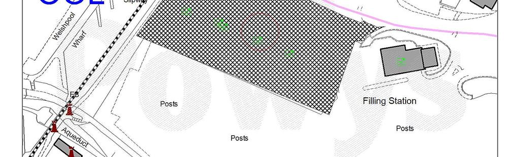
1 Planning, Taxi Licensing and Rights of Way Committee Report Application No: P/2015/1119 Grid Ref: Community Council: Welshpool Valid Date: 17/11/2015 Officer: Kate Bowen Applicant: Location: Proposal: Application Type: Mr Bill Sarre, TJL UK Ltd, 15 Esplanade, C/O Hawkesford, St. Helier, Jersey, Channel Islands, JE1 1RB Land adjacent Tesco Service Station, Mill Lane, Welshpool, Powys, SY21 7BL Erection of 2 no. retail units (class A1) with ancillary pet grooming and veterinary services, delivery area and all associated works Application for Full Planning Permission Reason for Committee determination The proposal is a departure from the development plan because the application site is located on part of a site allocated for housing within the Unitary Development Plan. Site Location and Description The application site extends to approximately 0.53 hectares and forms part of the former cattle market in Welshpool. The south east part of the cattle market has been developed with the construction of a supermarket and this application proposes the construction of two retail units in the north eastern part of the cattle market site. The Montgomery branch of the Shropshire Union Canal is located to the west of the application site and the unclassified highway known as Mill Lane travels along the northern boundary of the application site. The south of the site is bounded by the existing car park constructed when the supermarket was developed. The site is currently unoccupied and has been graded as part of previous demolition and construction works to provide a level surface and is secured with hoarding around its perimeter. The proposed development measures approximately 2,922 square metres gross external area and comprises: The erection of two retail units (use class A1), retail unit 1 being a general merchandise store of approximately 2,322 square metres gross internal area and retail unit 2 having a gross internal area of approximately 773 square metres including a ground floor area of approximately 501 square metres and a mezzanine floor with an approximate 272 square metres gross internal area. Unit 1 measures approximately 31.5 metres by a maximum of 22 metres and a maximum height of 10.8 metres. Unit 2 measures approximately 13.5 metres by 9.5 metres with a maximum height of 9.5 metres. The finish of the units would be a continuous brick plinth interrupted by rendered panels at low level with dark grey metal cladding panels above and partly cladded by timber fascia. The roof would be a light grey single ply. 1
2 Extended shared concrete service yard area; Demolition of existing retaining brick wall along Mill Lane and erection of a new brick wall (of varying heights but up to a maximum of 3 metres) with high level timber infill along the boundaries with Mill Lane and along the boundary of the service yard with the canal; Cycle stands; Pedestrian links either in tarmac or paviours; and Landscaping measures. Consultee Response Welshpool Town Council The Council supports this application. PCC Highway Authority First response: I note within the Transport statement on page 7 that there is reference to condition 10 of the original planning consent for application number M2006/0354 which states:- Prior to the commencement of any buildings details of a scheme of car park management to control the operation of the proposed car park as a short stay shoppers car park at the site shall be submitted to and approved by the LPA. The car park thereafter shall be managed in accordance with the approved scheme unless subsequently amended in writing by the LPA Was the above ever actioned as this is a fundamental part of this application. If it has not can be re-iterate this condition for this planning application. With regard to pedestrian access to facilitate the requirements under the Active Travel Plan legislation I am still a bit confused as to how pedestrians will reach the main access way to the buildings from Mill Lane. Perhaps you could enlighten me on this aspect. Second response: 1, After speaking to several of my colleagues on the parking scenario we feel that a 2 hour maximum stay would be more appropriate and would be in line with other supermarkets in the town. As it stands these units have no parking spaces stipulated within their application so I cannot approve until I have something in writing off Tesco that these new measures will be implented prior to the opening of the new stores. We need to have a condition attached to this application and this may be via a Section 106 agreement with Tesco and the County Council. Perhaps Colin Edwards can advise on this. 2, Pedestrian links- I appreciate the comments that have been submitted but as far as I am aware there are no drawings detailing the ramp from the canal footpath and along the west of the new stores which connect back into the Tesco car-park. Please request this information for us to consider further the inclusive mobility of the application. Until the above information is satisfactory resolved we are unable to support the application. 2
3 Third response: Can you please condition ramp details then together with a management company. This is nothing to do with Highways but I suspect the Canal and Rivers Trust would want to be involved as they would not want a wall toppling over onto the canal tow path. Have we looked for a commuted sum on this aspect? With regard to parking then that appears to be sorting itself out then would it be worth the Council writing to Tesco to just reinforce the Councils desire with there s to get the parking restrictions up and running. Highway conditions can t really see what I can impose just that the service yard access is constructed as per the approved plans prior to the opening of any of the units. PCC Building Control Building Regulations application required. Wales & West Utilities No response received. PCC Environmental Health I have no objection to the application provided the suggested condition in section 5.11 of the acoustic report by Sharps Redmore is attached to the application. I would also suggest a condition of no collection and deliveries to the units between and hours which is the same as the Tesco store. PCC Contaminated Land Officer In respect of Planning Application P/2015/1119 the following advice is provided for the consideration of Development Control. Advice 1. Historic records identify that the Eastern portion of the proposed development site was occupied by Smithfield cattle market. Furthermore, the proposed development site currently adjoins a Service Station and formed part of a wider development completed under Planning Approval P/2009/1027, which included the standard land contamination planning conditions (identified as Condition 12, Condition 13 and Condition 14 on the Decision Notice). The development site was investigated, assessed and remediated under the requirements of the conditions attached to Planning Approval P/2009/ Given the historic use of the proposed development site and the location of the adjoining service station it is recommended that the following Informant is attached to any permission granted for Planning Application P/2015/1119: 3
4 Potential Contamination Informant Due to the potential for contamination issues as a result of the historical land use, should any made ground and/or contamination be identified during the works it would be prudent to investigate the potential for such contamination and inform the Council s Contaminated Land Officers immediately. PCC Ecologist Ecological Topic EIA Screening Requirement Not applicable Observations The proposal involves the development of 0.53ha of land for retail units that was previously approved for development in 2009 (P/2009/0357). It is understood that an EIA Screening Opinion was received previously and an ES was completed for the development of the wider site, but has not been provided with this application. European Species The Ecological Report by Aspect Ecology dated November 2015 concludes that there is some minor potential for adverse effects on bat foraging and/or commuting routes, especially along the canal corridor e.g. via light spill. Recommended mitigation measures include: Ensuring that any new external lighting is minimised and directed to avoid light spill towards the western boundary. Protected Species & Habitats 1 UK Species The Ecological Report by Aspect Ecology dated November 2015 concludes that Badgers have been recorded in the local area, but not within the site. There is also potential for birds to use the establishing vegetation within the site as nesting habitat. Recommended mitigation measures include: Any clearance or management work affecting nesting birds should be undertaken outside of the bird nesting season (March to August inclusive). If this is not possible areas to be worked on should be checked by a suitably qualified ecologist in order to confirm the absence of active nests prior to removal. Sect. 42 Species & Habitat The Ecological Report by Aspect Ecology dated November 2015 concludes that Brown Hare and Hedgehog have been recorded in the local area, but not within the site. LBAP Species & Habitat See comments above. Protected Sites International Sites (within 2km) 2 The site is adjacent to the Montgomery Canal SAC. A Test of Likely Significant Effects has concluded that there would not be any adverse effects on the SAC. 1 Species records within 1km (minimum). Change distance dependant on project type, scale, etc. 2 Identify International designated site within 2km of the proposals. Consider International sites within 15km of proposals with bats as qualifying features, and 10km with otters as qualifying features if the proposal is likely to affect these features. 4
5 National Sites (within 500m) 3 Local Sites (within 500m) The site is adjacent to the Montgomery Canal SSSI. Bron y Buckley Wood and Gungrog Flash SSSIs are located within 2km of the site but separated by established development within Welshpool. None within 500m of the development. Invasive Non Native Species Cumulative Effect No No Click here to enter text. Click here to enter text. Summary of recommendations / further assessment or work A Test of Likely Significant Effects on the adjacent Montgomery Canal SAC has concluded that there is not likely to be a significant effect on this European site (Aspect Ecology, November 2015). Subject to the scheme drainage still being proposed as referred to in paragraph of Section 7 of the Aspect Ecology ecological report (dated November 2015) I would agree with this conclusion on behalf of the Competent Authority. I recommend that the views of NRW are obtained regarding the potential impacts on the SAC to ensure that they are in agreement with the conclusion of the Test of Likely Significant Effects. 1) The recommendations identified for the Montgomery Canal corridor, general construction safeguards, bats and nesting birds in Section 6 of the Ecological Report by Aspect Ecology dated November 2015 shall be adhered to and implemented in full unless otherwise agreed in writing by the LPA. Reason: To comply with Powys County Council s UDP Policies SP3, ENV2 and ENV7 in relation to The Natural Environment and to meet the requirements of Planning Policy Wales (Edition 7, July 2014), TAN 5: Nature Conservation and Planning and the NERC Act Recommended Conditions 2) Prior to commencement of development, a Biodiversity Enhancement Plan to include details of the enhancement measures recommended for new wildlife planting, habitat enhancement, birds and bats in Sections 6.7 to 6.9 of the Ecological Report by Aspect Ecology dated November 2015 shall be submitted to the Local Planning Authority and implemented as approved and maintained thereafter unless otherwise agreed in writing with the LPA. Reason: To comply with Powys County Council s UDP Policies SP3, ENV2, ENV3 and ENV7 in relation to The Natural Environment and to meet the requirements of TAN 5: Nature Conservation and Planning, Welsh government strategies, and the NERC Act ) Prior to commencement of development, a Species List for the 3 Any designated sites within 500m of the proposal, extending to 2km dependant on features of interest i.e. wetlands (Powys LDP) 5
6 Landscape Planting shall be submitted to the Local Planning Authority and implemented as approved and maintained thereafter unless otherwise agreed in writing with the LPA. Reason: To comply with Powys County Council s UDP Policies SP3 and ENV3 in relation to The Natural Environment and to meet the requirements of Planning Policy Wales (Edition 7, July 2014), TAN 5: Nature Conservation and Planning and the NERC Act ) A lighting design scheme to take into consideration any impacts on nocturnal/crepuscular wildlife along the Montgomery Canal riparian corridor to the west of the site boundary shall be submitted for written LPA approval. Reason: To comply with Powys County Council s UDP Policies SP3, ENV3, ENV4 and ENV5 in relation to The Natural Environment and to meet the requirements of Planning Policy Wales (Edition 7, July 2014), TAN 5: Nature Conservation and Planning and the NERC Act ) A site drainage plan to take into consideration any impacts on the Montgomery Canal SAC/SSSI shall be submitted for written LPA approval. Reason: To comply with Powys County Council s UDP Policies SP3, ENV3, ENV4 and ENV5 in relation to The Natural Environment and to meet the requirements of Planning Policy Wales (Edition 7, July 2014), TAN 5: Nature Conservation and Planning and the NERC Act ) Prior to the first use of the site, an ecological consultant shall visit the site to check that all of the ecology mitigation and enhancements have been implemented and are fit for purpose and a written report shall be submitted to the LPA confirming that this the case. Reason: To ensure that all species are protected having regard to the Wildlife and Countryside Act 1981 (as amended), the Conservation of Habitats and Species Regulations 2010 (as amended) and to comply with Powys County Council s UDP Policies SP3, ENV3 and ENV7 in relation to The Natural Environment and to meet the requirements of Planning Policy Wales (Edition 7, July 2014), TAN 5: Nature Conservation and Planning and the NERC Act Informatives Birds Wildlife and Countryside Act 1981 (as amended) All nesting birds, their nests, eggs and young are protected by law 6
7 and it is an offence to: intentionally kill, injure or take any wild bird intentionally take, damage or destroy the nest of any wild bird whilst it is in use or being built intentionally take or destroy the egg of any wild bird intentionally (or recklessly in England and Wales) disturb any wild bird listed on Schedule1 while it is nest building, or at a nest containing eggs or young, or disturb the dependent young of such a bird. The maximum penalty that can be imposed in respect of a single bird, nest or egg is a fine of up to 5,000 pounds, six months imprisonment or both. The applicant is therefore reminded that it is an offence under the Wildlife and Countryside Act 1981 (as amended) to remove or work on any hedge, tree or building where that work involves the taking, damaging or destruction of any nest of any wild bird while the nest is in use or being built (usually between late February and late August or late September in the case of swifts, swallows or house martins). If a nest is discovered while work is being undertaken, all work must stop and advice sought from Natural Resources Wales and the Council's Ecologist. Relevant UDP Policies Comments on Additional Information UDP SP 3 Natural, Historic And Built Heritage Policy Env 2 Safeguarding the Landscape Policy Env 3 Safeguarding Biodiversity and Natural Habitats Policy Env 4 Internationally Important Sites Policy Env 5 Nationally Important Sites Policy Env 7 Protected Species Click here to enter text. PCC Land Drainage No response received Natural Resources Wales (NRW) First response Thank you for referring the above application. Natural Resources Wales brings together the work of the Countryside Council for Wales, Environment Agency Wales and Forestry Commission Wales, as well as some functions of Welsh Government. Our purpose is to ensure that the natural resources of Wales are sustainably maintained, used and enhanced, now and in the future. 7
8 Natural Resources Wales do not object to the proposal provided that the applicant provides assurances that no buildings are constructed over the culverted Lledan Brook (IDD watercourse) and that appropriate pollution prevention measures are incorporated within the scheme. Flood Risk The application is for less vulnerable development, primarily in DAM A and partly C2. Whilst the principle of the development is acknowledged, the applicant may wish to liaise with the Lead Local Flood Authority for progress on the Powys County Council flood alleviation scheme and any proposals they may have for challenging our flood map. Until such time as the flood map is changed, there may be insurance related issues for owners of the unit. In any event, best practice in terms of raised floor levels and sensible infrastructure design is advised for the units. The Lledan Brook (IDD watercourse) is known to pass in culvert beneath the Tesco car park. The culvert may also pass under part of the application site, or at least influence construction techniques in the south eastern corner of the site. As this has not been considered within the submitted FCA we advise that the applicant consults the Powysland IDD representative Mr James West NRW Technical Senior Advisor, Tel: , james.west@naturalresourceswales.gov.uk for further information on the alignment of the culverted section. Environment Agency legacy culverting policy resists any development over a culverted watercourse and assurances are required that this will not be the case. It is proposed to utilise existing surface water drainage arrangements. Whilst the Lead Local Flood Authority should be consulted with regards to surface water control, NRW emphasises that TAN15 promotes the use of sustainable drainage techniques and betterment in terms of run-off control, wherever possible. For any units such as the proposed, we would expect rainwater harvesting, at the minimum, to be adopted as best practice. Pollution Prevention of Montgomery Canal SSSI / SAC Natural Resources Wales have considered the Ecological Appraisal by Aspect Ecology Land Adjacent to Tesco Service Station, Smithfield Road, Welshpool. November 2015 (ECO1707.ESR.vf) and we welcome the habitat enhancement recommendations. Due to the proximity of the SAC the applicant should incorporate pollution prevention measures to protect ground and surface waters during the construction process and from accidental discharge of fuel or run off from car parking areas during operation. NRW recommend the advice given in Pollution Prevention Guidance (PPG) note 5 Works and Maintenance in or Near Water as good environmental practice to inform a Pollution Prevention Plan. The guidance can be found at the following link Under the Conservation of Habitats and Species Regulations 2010 (as amended) the LPA will need to carry out a test of likely significant effect. Should your authority be minded to grant planning permission, Natural Resources Wales do not object to the proposal, subject to all avoidance measures described in section 6.3 of the 8
9 ecological report being set out in a method statement and secured through the inclusion of suitable planning conditions and/or a Section 106 agreement. The Natural Environment and Rural Communities (NERC) Act (2006) Please note that we have not considered possible effects on all species and habitats listed in section 42 of the Natural Environment and Rural Communities (NERC) Act 2006, or on the Local Biodiversity Action Plan or other local natural heritage interests. To comply with your authority's duty under section 40 of the NERC Act, to have regard to conserving biodiversity, your decision should take account of possible adverse effects on such interests. We recommend that you seek further advice from your authority's internal ecological adviser and/or nature conservation organisations such as the local Wildlife Trust, RSPB, etc. The Wales Biodiversity Partnership's web site has guidance for assessing proposals that have implications for section 42 habitats and species ( To conclude, NRW do not object to the proposal provided that the applicant provides assurances that no buildings are constructed over the culverted Lledan Brook (IDD watercourse) and that appropriate pollution prevention measures are incorporated within the scheme. Second response Thank you for sending Natural Resources Wales further information with regard to the above planning proposal. We previously responded on 14th January 2016 and said, Natural Resources Wales do not object to the proposal provided that the applicant provides assurances that no buildings are constructed over the culverted Lledan Brook (IDD watercourse) and that appropriate pollution prevention measures are incorporated within the scheme. Having considered further information that NRW received on 27th January 2016 we are satisfied with the applicant s confirmation that the development will not be constructed over the culvert in the vicinity of the proposals. With respect to the pollution prevention plan requirement we recommend that Condition No. 15 and Condition 27 of Planning Permission P/2010/1452 are included within any subsequent approval of this planning permission. The conditions state: 15. Any facilities for the storage of oils, fuels or chemicals shall be sited on impervious bases and surrounded by impervious bund walls. The volume of the bunded compound shall be at least equivalent to the capacity of the tank plus 10%. If there is multiple tankage, the compound shall be at least equivalent to the capacity of the largest tank, vessel or the combined capacity of the interconnected tanks or vessels plus 10%. All filling points, associated pipework, vents, gauges and sight glasses must be located within the bund or have secondary containment. The drainage system of the bund shall be sealed with no discharge to any watercourse, land or underground strata. Associated pipework shall be located above ground and protected from accidental damage. All filling points and tanks/vessels overflow pipe outlets shall be designed to discharge downwards into the bund. 27. The development shall be carried out in accordance with the approved Construction 9
10 Pollution Control Plan (ref: ), unless otherwise agreed in writing by the Local Planning Authority. To conclude, Natural Resources Wales do not object to the proposal subject to the imposition of appropriate conditions as described above. Welsh Government Transport I refer to your consultation of 3 December 2015 regarding the above application and advise that the Welsh Government as highway authority for the A483 trunk road does not issue a direction in respect of this application. Severn Trent Water Thank you for the consultation on the above planning application and have the following comments to make. I can confirm we have no objections to the proposals subject to the inclusion of the following condition. The development hereby permitted should not commence until drainage plans for the disposal of foul and surface water flows have been submitted to and approved by the Local Planning Authority. The scheme shall be implemented in accordance with the approved details before the development is first brought into use. This is to ensure that the development is provided with a satisfactory means of drainage as well as to reduce of creating or exacerbating a flooding problem and to minimise the risk of pollution. Clwyd Powys Archaeological Trust Thank you for the consultation relating to this application. As with the previous applications for this development area we would wish to recommend an archaeological watching brief due to the potential for sub-surface prehistoric and later archaeology. The earlier evaluation trenching in the area for the main Tesco development revealed features under deep soil cover that represented prehistoric activity (flint tools, post holes and gullies) on the edge of a former watercourse along which this activity focussed. Works to insert deep foundations or services in this area may encounter these deposits and a suitable record should be made of any archaeological features recognised during the early stages of development. I have provided a suitable condition below which will allow this work to take place: Suggested planning condition to facilitate an archaeological watching brief The developer shall ensure that a suitably qualified archaeological contractor is present during the undertaking of any ground works in the development area so that an archaeological watching brief can be conducted. The archaeological watching brief must meet the standards laid down by the Chartered Institute for Archaeologists Standard and Guidance for archaeological watching briefs. The Local Planning Authority will be informed in writing, at least two weeks prior to the commencement of the development, of the name of the said archaeological contractor. A copy of the resulting report should be submitted to the 10
11 Local Planning Authority and the Development Control Archaeologist, Clwyd-Powys Archaeological Trust (41 Broad Street, Welshpool, Powys, SY21 7RR Tel: ). After approval by the Local Planning Authority, a copy of the report and resulting archive should also be sent to the Historic Environment Record Officer, Clwyd-Powys Archaeological Trust for inclusion in the regional Historic Environment Record. Reason: To secure preservation by record of any archaeological remains which may be revealed during ground excavations for the consented development. Please contact me if you wish to discuss this advice or require further information. Disability Powys No response received. Canal & Rivers Trust Thank you for your consultation dated 03 December 2015 in respect of the above. The Canal & River Trust is a statutory consultee under the Town and Country Planning (Development Management Procedure) (England) Order The Canal & River Trust is a company limited by guarantee and registered as a charity. It is separate from government but still the recipient of a significant amount of government funding. The Trust has a range of charitable objects including: To hold in trust or own and to operate and manage inland waterways for public benefit, use and enjoyment; To protect and conserve objects and buildings of heritage interest; To further the conservation, protection and improvement of the natural environment of inland waterways; and To promote sustainable development in the vicinity of any inland waterways for the benefit of the public. Whilst the Trust does not oppose the principle of retail units in this location and can appreciate the economic benefits to Welshpool of such a development, after initial consideration of the application, the Canal & River Trust is unable to make a substantive response at this time due to the absence of information relating to the treatment of the canal elevation, the treatment of the canal side space and associated pedestrian links and proposals for surface water discharge. The Council has a recognised commitment to the restoration of the canal and the Powys County Council Unitary Development Plan seeks to establish the canal as a major tourist attraction and recognises the recreation, economic and employment benefits that enhancing the Waterway could bring. The Welsh Government Technical Advice Note 12 (TAN12) Design (July 2014) states that consideration should be given to how the layout makes the development integrate with its 11
12 surroundings whilst taking into consideration the orientation of the building to maximise energy efficiency and connectivity (the ways in which routes and open spaces within the development are provided, situated and orientated in relation to each other and to buildings and spaces outside the development); how the external area contributes towards the development and is used to make the development a more sustainable development; how is the chosen site the best location and how it links into adjacent uses (p.19). TAN12 further advises of the need to maximise safe and clear connections and the potential to cycle, walk and use public transport safely, and reducing the reliance on the car (p.24). The requested information is necessary to enable the Trust to consider fully the impact of the proposal against these considerations. The Trust is also unable to determine from the submitted information whether the applicant intends to discharge surface water into the canal. The Trust would be concerned if surface water from the proposed service yard was to enter the canal which is a designated Site of Special Scientific Interest (SSSI) along its whole length and in Wales is also a Special Area of Conservation (SAC).The submitted application form says that surface water will discharge to an existing watercourse whilst the submitted Flood Risk Assessment Section 5 Drainage Proposals states that it is understood that allowance was made for discharge surface water from the proposed development site to the surface water drainage scheme that was designed and constructed as part of the adjacent Tesco food store development. It was then proposed that all surface water runoff from the proposed development should be discharged to the existing surface water drainage system in accordance with the requirements of the submitted scheme. The Trust would therefore request clarification regarding proposals for surface water discharge from the proposed scheme to inform its response. In accordance with paragraph 45 of ODPM Circular 08/2005, the Canal & River Trust will provide a substantive response within 21 days of the receipt of the information requested above. The Trust would also advise that from the information submitted it appears that there are further measures which could be taken to enhance the scheme and improve the appearance of the development along the canal frontage and the pedestrian linkage between the site and the waterway. These aspects would not only benefit the Montgomery Canal Corridor but this part of Welshpool generally in line with National and Local Planning Policy. The Trust would be happy to meet with the applicant to discuss an opportunity to work with them on enhancing the appearance of the scheme from the canal and the potential for pedestrian linkage. Montgomery Waterway Restoration Trust Writing on behalf of Montgomery Waterway Restoration Trust We can find no evidence that you have consulted Canal and River Trust or Montgomery Waterway Trust or Inland Waterways Association on this proposal. There is no evidence that the impact upon the canal environment has been properly considered or addressed. Given the long standing support that Powys Council have given to the restoration of the canal and the clear UDP/LP policy support for it and the huge economic and environmental benefits to the town, it seems 12
13 extraordinary that the matter has only come to our attention by chance. We request that a proper appraisal of impacts upon the canal is sought before this progresses further. Inland Waterways Association I am writing on behalf of the Inland Waterways Association, which campaigns for the conservation, use, maintenance, restoration and sensitive development of Britain's canals and river navigations. Established in 1946, it now has over 15,000 members. We have no objections to the principal of retail units being built on this site, but we are objecting to the application on the grounds that the design is unsatisfactory because it ignores the site s relationship with the canal. Powys County Council is actively working with partners, one of which is the Inland Waterways Association, to restore the canal as a significant local amenity, tourism attraction, economic generator and environmental haven. Powys County Council s approved Development Management Policies include: The scale, massing, siting and external appearance of the development should integrate with the general character of the surrounding area and significantly enhance the appearance of the site.... The development should integrate with the overall character of the area and enhance the visual amenities of the area. Particular attention should be paid to the appearance of the site from surrounding key views and vistas of the site. One of the key views and vistas is that from the canal. The towpath is much used by walkers, both local residents and long-distance walkers. It is symptomatic that in the Evaluation and Design Objectives (Section 4), proximity to the Montgomery Canal is listed as a site constraint not as a site opportunity. On the following page, the first key design principle is stated as the scheme has to respect its position within its local setting and great importance will need to be given to the treatment of the site and its boundaries. This will need to ensure that the proposal sits comfortably within its setting and enhances the existing context. This expresses the requirement very well, but regrettably the proposal does not achieve this. Representations Following the display of site notices and publicity in the local press, no public representations have been received. Planning History P/2011/ Erection of a retail unit (Replacement of unit 4 granted under under P/2009/1027) for 70% comparison goods floorspace and 30% convenience goods floorspace. Conditional consent 8/8/2011 P/2011/0565 Display of various advertisement signs. Conditional consent 12/07/2011 P/2011/0436 Display of a variety of advertisement signs. Conditional consent 08/06/2011 P/2010/ Reserved matters application for the design & external appearance of the petrol filling station. Conditional consent 15/02/2011 P/2010/1452 Section 73 application to vary conditions 21, 22, 23 & 25 attached to planning permission P to increase the comparison goods floor area within Tesco Store by 71 sqm & reduce the comparison floor area allocated to retail warehousing units by 71 sqm. Conditional consent subject to a section 106 agreement 21/09/
14 P/2010/ Listed building consent for removal of bridge in order to renovate/upgrade offsite and reinstatement when works complete. Conditional consent 12/07/2010 P/2010/ Reserved matters application for the approval of siting, design, external appearance and landscaping in connection with planning application P for a mixed-use redevelopment including non-food retail (Class A1), foodstore (Class A1) petrol filling station (Class Sui Generis), associated food and drink facility (Class A3) and construction of vehicular access, car parking, servicing and landscaping. Conditional consent 04/05/2010 P/2009/ Section 73 application to vary condition 9 attached to planning permission M to vary the date of construction of the town centre traffic management route. Conditional consent subject to a section 106 agreement 22/2/2010 P/2009/0357 Details: Mixed use development including non food retail (Class A1) and foodstore (Class A1), Petrol Filling Station (Class sui generis), associated food & drink facilitiy (Class A3) and construction of vehicular access, car parking, servicing & landscaping (amendements showing town centre traffic management scheme). Conditional consent 09/12/2009 M/2006/ Outline application for mixed-use redevelopment including non-food retail (Class A1), foodstore (Class A1) petrol filling station (Class Sui Generis), associated food and drink facility (Class A3) and construction of vehicular access, car parking, servicing and landscaping (Amendments showing town centre traffic management scheme) Conditional consent subject to a section 106 agreement 28/05/2008 Principal Planning Constraints Adjacent to Site of Special Scientific Interest (SSSI) Montgomery Canal Adjacent to Special Area of Conservation (SAC) Montgomery Canal Located on part of site allocated for housing within the Unitary Development Plan (Site description M198 HA8 Smithfield South, Mill Lane) Part of site within C2 Flood Zone and National Flood Zone 2 Smithfield Road and Mill Lane are unclassified highways Welshpool Conservation Area located to north west and south of application site Domen Castell Mound and Bailey Castle Scheduled Ancient Monument is located approximately 123 metres to the south east of the application site Number of listed buildings in vicinity of application site including: Former Railway Bridge over Montgomeryshire Canal (Grade II) Lledan Brook Aqueduct and Weir (Grade II) Former Canal Warehouse (Grade II) Aqueduct Cottage (Grade II) Numbers 1 to 4 Clive Place (Grade II); and Powys County Council Offices (Neuadd Maldwyn) (Grade II). 14
15 Principal Planning Policies National Planning Policy Planning Policy Wales (Edition 8, January 2016) TAN 4 Retailing and Town Centres (1996) TAN 5 Nature Conservation and Planning (2009) TAN 11 Noise (1997) TAN 12 Design (2014) TAN 15 Development and Flood Risk (2004) TAN 18 - Transport (2007) TAN 23 Economic Development (2014) Welsh Government Circular 016/2014 The Use of Conditions for Development Management Welsh Office Circular 11/99 Environmental Impact Assessment Welsh Office Circular: 60/96 Planning and the Historic Environment: Archaeology Welsh Office Circular 61/96 Planning and Historic Environment: Historic Buildings and Conservation Areas Welsh Office Circular: 22/86 Development of Contaminated Land Local Planning Policy Powys Unitary Development Plan (2010) UDP SP3 - Natural, Historic and Built Heritage UDP SP7 Retail Developments, Leisure and other Town Centre Uses UDP SP14 - Development In Flood Risk Areas UDP ENV 2 Safeguarding the Landscape UDP ENV 3 - Safeguarding Biodiversity & Natural Habitats UDP ENV 4 - Internationally Important Sites UDP ENV 5 - Nationally Important Sites UDP ENV 7 - Protected Species UDP ENV11 - Development in Conservation Areas UDP ENV 14 Listed Buildings UDP ENV17 Ancient Monuments and Archaeological Sites UDP ENV18 Development Proposals Affecting Archaeological Sites UDP RP1 Retail Centre Hierarchy UDP RP2 Attractive Town Centres UDP RP6 Large Retail Developments UDP RP7 Bulky (Non-Food) Goods UDP GP1 Development Control UDP GP3 Design and Energy Conservation UDP GP4 Highway and Parking Requirements UDP EC1 Business, Industrial and Commercial Developments UDP T2 Traffic Management UDP T3 Transport Assessments and Travel Plans UDP T4 Transport User Hierarchy UDP T6 Walking and Cycling 15
16 UDP TR2 Tourist Attractions and Development Areas UDP DC1 Access by Disabled Persons UDP DC9 Protection of Water Resources UDP DC10 Mains Sewage Treatment UDP DC13 Surface Water Drainage UDP DC15 Development on Unstable or Contaminated Land RDG=Powys Residential Design Guide NAW=National Assembly for Wales TAN= Technical Advice Note UDP=Powys Unitary Development Plan, MIPPS=Ministerial Interim Planning Policy Statement Officer Appraisal Section 38 (6) of the Planning and Compulsory Purchase Act 2004 Members are advised to consider this application in accordance with Section 38 (6) of the Planning and Compulsory Purchase Act 2004, which requires that, if regard is to be had to the development plan for the purpose of any determination to be made under the Planning Acts, the determination must be made in accordance with the plan unless material considerations indicate otherwise. Town and Country Planning (Environmental Impact Assessment) Regulations 1999 and Test of Likely Significant Effects No statutory Environmental Impact Assessment has been requested as whilst the proposed development falls within Schedule 2 of the above Regulations and exceeds the applicable thresholds and criteria specified in the Regulations it has been considered against the Selection Criteria detailed in Schedule 3 of the Regulations and the advice in Welsh Office Circular 11/99 and in the opinion of the local planning authority the proposed development is not likely to have a significant effect on the environment. A Test of Likely Significant Effects on the adjacent Montgomery Canal SAC carried out by Aspect Ecology on behalf of the applicant has concluded that there is not likely to be a significant effect on this European site. Subject to the scheme drainage still being proposed as referred to in paragraph of Section 7 of the Aspect Ecology ecological report (dated November 2015), the response issued on behalf of the Council s Ecologist confirms that they agree with this conclusion on behalf of the Competent Authority. NRW have also been consulted on the application and have not raised concern over this aspect. Principle and Policy Welshpool is identified as an Area Retail Centre in the UDP and consequently is seen as strategically important in terms of retail and service provision. Although the application is a departure from the development plan because the application does not propose residential housing development, the principle of retail units at the site has been accepted under the various permissions relating to the site. In addition, the site is classified as a brownfield site, having been previously developed. The proposal would result in a reduction of the retail units permitted from 4 to 2 and a reduction in the total amount of consented retail floorspace. The extant permissions have accepted the need for up to 3,970 square metres gross of additional retail warehouse. 16
17 There is an extant permission granted under reference P/2010/1452 which was a Section 73 application to vary conditions 21, 22, 23 & 25 attached to planning permission P/2009/1027 to increase the comparison goods floor area within Tesco Store by 71sqm and to reduce the comparison floor area allocated to retail warehousing units by 71sqm. In addition, a further extant permission (P/2011/0591) exists for the erection of a retail unit (Replacement of unit 4 granted under P/2009/1027) for 70% comparison goods floorspace and 30% convenience goods floorspace. P/2010/1452 was granted in September 2011 subject to a number of conditions with the following conditions relating to the retail units: Condition 21 The gross floorspace of the comparison goods retail warehousing hereby permitted shall not exceed 3, sq m. Condition 22 No more than 1,953 sq m of the comparison goods retail warehousing floorspace shall be used for the sale of goods other than DIY goods, carpets and floor coverings; tiles; furniture and soft furnishings; motor vehicle accessories; pets and pet supplies; garden products; and major electrical appliances. Condition 23 The comparison goods retail units hereby permitted shall have minimum floor space of 500 sq m. Condition 24 None of the retail stores (convenience or comparison) shall be subsequently subdivided without the prior written consent of the local planning authority. For the avoidance of doubt, no additional mezzanine floorspace shall be constructed that would otherwise exceed the retail floorspace hereby permitted, unless otherwise agreed in writing with the local planning authority. The reason for these conditions was to protect the attractiveness, viability and vitality of the town centre as a shopping centre in accordance with Policy RP6 of the Powys Unitary Development Plan. Planning permission P/2011/0591 for the single retail unit was granted subject to a condition which states the permission hereby permitted shall be included in the calculation of the floorspace for the purposes of conditions 22 and 23 of planning permission P/2009/1027 and conditions 21 and 22 of planning permission P/2010/1452 and any variation of those conditions. TAN 4 states that all applications for retail developments over 2,500 square metres gross floor space should be supported by an impact assessment. In this instance, given the extant permissions and that there would be a reduction in the total amount of retail warehousing, no impact assessment has been submitted. However, given that the application site is not located within the town centre, a Supporting Retail Assessment has been submitted which considers the sequential test (whether there are more centrally located or closer sites to the town centre available for retail use) set out within national and local planning policy. The principle issue is whether there are any suitable sites within in the town centre that are available now and can meet the same market and locational requirements to provide floorspace which accords with the operational needs of retailers. It is proposed that B&M Retail Ltd will occupy the larger unit; however no retailer has been identified for the smaller 17
18 unit. The B&M store would comprise 2,322 square metres of gross internal area (GIA). B&M are generally regarded as a retailer which sells bulky and comparison goods in a DIY format. Such goods include indoor and outdoor furniture, greening products, home textiles, household goods, flooring, furnishings, housewares, seasonal items, paint, wallpaper and DIY products. These DIY and Home Improvement product categories account for approximately 70% of the floor space and sales with the average B&M store. The remaining 30% of the floorspace are used for the retail sale of other comparison and convenience goods. All of these items are permitted under the terms of the existing permissions. The market and locational requirements of B&M are: At least 1,500 square metres floor space; A car park adjacent to the store; An area to store trolleys; and The provision of the majority of the main sales area on a single, ground floor level. At the time of submission, the Co-Operative store was vacant; however the building is now occupied by a retailer. Otherwise there are no allocated sites for retail development within the UDP and Development Management is not aware of any other units or sites with planning permission that would suit the market and locational requirements of the retailer. The submission states that the proposal would require 28 full-time employees and 42 parttime employees and taking into account TAN 23, considerable weight should be given to the economic benefits of the proposal. Taking into account the economic benefits of the proposal, the fall-back position in terms of the extant permissions, the evidence which addresses the sequential test, subject to the use of appropriate conditions similar to that applied on the extant permissions in terms of floorspace, it is considered that the proposal complies with UDP Policies RP6 and RP7, TAN 4 and Planning Policy Wales. Impact upon character and appearance of settlement and surrounding area The concerns raised by the canal bodies in respect of the appearance of the proposed development and its relationship to the canal are noted. Firstly, it is clarified that Development Management s records indicate that the Canal & River Trust, Montgomery Waterway Restoration Trust and Inland Waterways Association were all consulted on the application. The site is currently unoccupied and has been graded as part of previous demolition and construction works to provide a level surface and is secured with hoarding around its perimeter. It is therefore recognised that the area would benefit from development, however consideration must still be given to the appropriateness of the proposed design. As discussed above, the fall-back position of the extant planning permissions can be relied upon. These permissions granted consent for four units in the format of two pairs. The layout of the proposed development would utilise a similar footprint to the approved layout, however, the units would have a layout in the format of two joined units. In addition, the turning circle for the service yard would be located in the north western corner of the development yard, to the rear of unit two. Therefore, the smaller unit would be sited adjacent to the canal with the larger unit set back. The proposal has retained the majority of the public realm area between the canal and the units, although in comparison to the extant permissions, the area also includes some additional soft landscape planting. It is noted that 18
19 the original approved plans included a café fronting onto the canal which was agreed to be omitted informally by Development Management. The original intention of the café and piazza area was to provide a public frontage onto the canal which would be somewhat lost within the proposed development because the service yard and western elevation of unit 2 would be located adjacent to the canal, however it is acknowledged that Development Management previously agreed to the removal of the café. The submitted drawings indicate that the design of the units would reflect the foodstore building and although the proposed development would be constructed as a single building with the loss of the gap between the previously approved units and a change in the roof line, the design of the units themselves is considered acceptable. Whilst the concerns from the canal bodies are accepted, it is not considered that given the informal change agreed by Development Management, the design is inappropriate such that would warrant refusal of the application. The Highway Authority has queried whether a commuted sum is required for the proposed pedestrian access ramp. The proposal includes the construction of the ramp and as such it is considered that a commuted sum is not required for these works. In addition, the section 106 agreement relating to the extant permissions do not include such a requirement. In order to ensure that the ramp is constructed prior to the units being operational, it is recommended that a condition should be attached to any consent granted. Overall, it is considered that the impact of the proposal on the appearance and character of the surrounding area is acceptable subject to the use of conditions relating to the approval and implementation of soft landscaping and a management scheme for the public realm area. Impact upon canal as an established tourist attraction As advised by the canal bodies, the canal is a tourist attraction in Welshpool with barges using the canal as well as the towpaths and wharf providing access for members of the public. In addition, it is agreed that the canal area will accommodate one of the key views of the proposed development. It is also recognised that the canal bodies and Powys County Council are actively seeking to enhance the canal. As discussed above, the proposal has sought to retain the public realm element of the approved scheme and it is not considered that refusal would be warranted in respect of the approved design. Subject to conditions relating to proposed landscaping and a management scheme for the public realm, it is considered that the proposal would not have an unacceptable adverse effect upon the environmental setting of the established tourist attraction in accordance with UDP Policy TR2. Impact upon heritage features Archaeology CPAT has recommended that as with the previous applications for this development area an archaeological watching brief shall be carried out. There is the potential for sub-surface prehistoric and later archaeology. The earlier evaluation trenching in the area for the main Tesco development revealed features under deep soil cover that represented prehistoric 19
20 activity (flint tools, post holes and gullies) on the edge of a former watercourse along which this activity focussed. Works to insert deep foundations or services in this area may encounter these deposits and a suitable record should be made of any archaeological features recognised during the early stages of development. Therefore, CPAT have recommended that a condition requiring a watching brief is attached to any consent granted. Taking into account the comments from CPAT and UDP Policies ENV17 and ENV18, it is considered reasonable that such a condition should be attached to any consent granted to ensure that any archaeology at the site is recorded. Conservation area The Welshpool conservation area is located approximately 65 metres to the north east of the application site, across the Mill Lane bridge and canal and 70 metres to the south across the existing car park. Members are advised that special attention must be given to the desirability of preserving or enhancing the character or appearance of the conservation area under section 72(1) of the Planning (Listed Buildings and Conservation Areas) Although the proposed development will be visible from parts of the conservation area and would affect views into the conservation area from the supermarket development area, these views would be at some distance. In addition, built form intercepts these views. Taking into account these factors along with the previously approved scheme, it is considered that proposal would not significantly detract from the character or appearance of the conservation area in accordance with UDP Policy ENV11. Listed buildings The old railway bridge over the canal, the canal warehouse building and a number of residential properties accessed off Severn Road together with the Council Offices at Neuadd Maldwyn are listed buildings. The closest listed building (the old railway bridge) is located approximately 58 metres to the south west across the existing car park. Members are advised that special regard to the desirability of preserving listed buildings or their settings is required under sections 66(1) of the Planning (Listed Buildings and Conservation Areas) Act The development will be visible from these listed buildings, however taking into account their settings, within an urban area and the distances involved, it is not considered that the proposal would unacceptably adversely affect the settings of the identified listed buildings in accordance with UDP Policy ENV14. Scheduled Ancient Monument Domen Castell Mound and Bailey Castle Scheduled Ancient Monument is located approximately 123 metres to the south east of the application site. There is a presumption in favour of safeguarding Scheduled Ancient Monuments and their settings. Given the distance involved and that the existing supermarket building intercepts the scheduled ancient monument and the proposed development, it is considered that the setting of the identified scheduled ancient monument will not be unacceptably affected by the proposal in accordance with UDP Policy ENV17. 20
21 Highway access, parking, pedestrian and cycling provision The application is accompanied by a Transport Statement and a Travel Plan. Members will be aware that the overall development of the site was subject to a significant highways scheme. Access to the shared car park would remain as existing, via the access to the supermarket off Mill Lane. The retail units would be accessed by members of the public from the southern elevations facing onto the existing car park (to be shared with the existing supermarket). The access to the service yard is located to the north west corner of the retail units jointed with the separate exit route for the petrol tanker onto Mill Lane. Cycle stands for approximately 10 bicycles would be provided along the west elevation facing the canal and pedestrian access from the canal would be provided via a ramp to a public realm area which would provide access to the main entrances of the units. The Highway Authority initially raised concern over the lack of car parking provision with the proposal. The car parking provision for the entire site, including the supermarket development has been already been provided and it is proposed to share the car parking as per the planning permission for the entire site. A car park management scheme restricting car parking to a maximum of 3 hours was approved under a condition of the previous consent. However this scheme has not been implemented and it is appreciated that the car park is well used at present. Although the Highway Authority s concerns are appreciated, the proposal does not propose additional floor space that would warrant additional dedicated car parking provision and if necessary, the condition attached to the overall site consent could be enforced by the planning authority to assist in ensuring there is adequate parking provision for the entire site. The Council s Highway Authority and the Canal & River Trust have raised concern over the absence of information relating the treatment of the canal side space and associated pedestrian links. Additional information has been submitted which has addressed the Highway Authority s concerns, although it is recommended that conditions requiring details of the ramp (construction method) and timing of its construction together with management of the public realm area are attached to any consent granted. Overall, subject to the use of conditions, it is considered that the proposal provides adequate provision for access, parking, cycles and pedestrians in accordance with UDP Policies GP1, GP4, T4 and T6. Ecology and pollution prevention The submission includes an Ecological Appraisal which recommends safeguards (both construction and operational) with regard to the canal corridor, general construction safeguards and protective measures, safeguards/timing considerations in respect of birds during clearance/construction works, provision and management of new areas of native planting to be incorporated where possible, particularly associated with the offsite canal corridor and consideration given to the potential for provision of bird boxes. Natural Resources Wales and the response on behalf of the Council s Ecologist have welcomed the recommendations subject to the use of conditions. NRW have also advised that due to the proximity of the Montgomery Canal SAC, the development should incorporate pollution prevention measures to protect ground and surface waters during construction and operation. In addition, the Ecologist has recommended that a 21
22 drainage plan is conditioned. The Canal & River Trust have also raised concern regarding this aspect. Additional information has been submitted which states that these measures are already in place as part of the overall drainage system implemented when the supermarket was constructed. In respect of this additional information, NRW has advised that they recommend that conditions 15 and 27 of planning permission P/2010/1452 are included within any subsequent approval of this planning permission. On the basis of this advice, it is considered reasonable that these conditions should be attached to any consent granted. In consideration of the submitted ecological assessment and the advice received from NRW and on behalf of the Council s Ecologist, it is concluded that the proposal would comply with the relevant local and national planning policies and guidance in respect of ecology subject to the use of conditions. Impact upon amenities enjoyed by occupiers of neighbouring properties The nearest residential properties (Clerk s Court) are located to the north west of the application site, at a distance of approximately 26 metres. Otherwise there are residential properties located to the south of the application site, across the car park and to the north across Mill Lane and the partly undeveloped old sheep pens site (incorporating the Smithfield Bell public house). The proposal has the potential to affect the amenities enjoyed by occupiers of residential properties by noise and the submission includes a noise assessment. The Council s Environmental Health officer has advised that there is no objection to the application provided the suggested condition in section 5.11 of the noise assessment is attached. This condition requires the submission, approval and implementation of details of the fixed plant and machinery. The Environmental Health officer has also suggested a condition of no collection and deliveries to the units between and hours which is the same as the condition relating to the supermarket development. Taking into account the information within the noise assessment and the comments from the Environmental Health officer, it is considered that the proposal accords with UDP Policy GP1 and TAN11 subject to the use of the suggested conditions. Flood risk and surface water drainage The application site is located primarily in DAM A and partly Zone C2 (north east corner). The proposed development is classed as less vulnerable development within TAN 15 and as such justification for the location is not required. The submission includes a Flood Consequences Assessment (FCA). It is proposed to connect into the existing overall drainage system that was implemented when the supermarket was constructed with the connection having been capped off for the previously approved four units. The Council s Land Drainage Engineer has not commented on the proposal and although NRW have advised that best practice surface water drainage principles are adopted, it is difficult to conclude that connection into the existing and approved drainage scheme for the whole site would not be an adequate means of surface water disposal. The Lledan Brook which is culverted passes beneath the existing car park and NRW advise that the culvert may also pass underneath part of the application site or at least influence 22
23 construction techniques in the south eastern corner of the site. This has not been considered within the FCA and NRW have requested assurances that the no buildings are proposed over the culverted brook. Additional information has been submitted which confirms that the culvert is 27m away from the culvert and that the only point where the culvert will be potentially crossed by vehicles involved in construction will be limited to the roundabout on Smithfield Road. NRW has been reconsulted on this additional information, and has advised that they are satisfied with the applicant s confirmation that the development will not be constructed over the culvert in the vicinity of the proposals.. Foul drainage The submission indicates that the foul sewage would be disposed of via mains sewer. This is the preferred method of disposal as advised by national and local planning policy. Severn Trent Water has advised that they have no objections to the proposal subject to a condition requiring the details of surface water and foul drainage. It is not clear what additional details are required in respect of foul drainage and as such it recommended that such a condition would be unreasonable. Contaminated Land The eastern portion of the proposed development site was occupied by the cattle market and the site currently adjoins a service station. The previous planning consents relating to the wider development included the standard land contamination planning conditions and as a result of those conditions, the development site was investigated, assessed and remediated. Therefore, the proposal does not raise any concerns in respect of contaminated land, however, the informant recommended by the Council s Contaminated Land Officer should be attached to any consent granted for information purposes. Access by Disabled Persons UDP Policy DC1 requires new buildings to provide suitable access and amenity facilities for disabled persons. The submission indicates that provision for access for all would be provided by such measures as access via shallow gradients and tactile paving, by the provision of a pedestrian layout which is simple, logical and has minimal kerbs and internal doors to be fully compliant with Part M of the Building Regulations. Taking into account these proposed measures and others, along with the requirement for Building Regulations approval, it is considered that the proposal would make adequate provision for disabled access in accordance with UDP Policy DC1. Conclusion The extant permissions on the site for retail units together with the economic benefits of the proposal carry significant weight for approving the development. In addition, it is considered that the proposed design is not inappropriate. Otherwise, the other matters raised by consultees can be conditioned accordingly. Overall, it is considered that the proposal complies with national and local planning policy and subject to the use of conditions, it is recommended that consent is granted. 23
24 Recommendation Conditional Consent 1. The development to which this permission relates shall be begun no later than the expiration of five years from the date of this permission. 2. The development shall be carried out strictly in accordance with the plans and documents stamped as approved on xxxx (drawing no's: AP00A, AP05D, AP07A, AP06B, AP08A, AP09C, AP10B, AP16, 1979/601 Rev 1, 82608/200 Revision J, documents: Design and Access Statement Revision A, Transport Statement /TS/01, Travel Plan /TP/01, Flood Consequences Assessment Revision 01, Noise Assessment dated 26th October 2015, Supporting Retail Assessment dated October 2015, Ecological Appraisal ECO1707.ESR.vf). 3. Prior to commencement of development, a Biodiversity Enhancement Plan to include details of the enhancement measures recommended for new wildlife planting, habitat enhancement, birds and bats in Sections 6.7 to 6.9 of the Ecological Report by Aspect Ecology dated November 2015 shall be submitted to and approved in writing by the Local Planning Authority and implemented as approved and maintained thereafter. 4. Prior to the commencement of development, the avoidance measures set out within section 6.3 of the Ecological Appraisal ECO1707.ESR.vf dated November 2015 shall be incorporated in a method statement and submitted to and approved in writing by the Local Planning Authority. The method statement shall be implemented in full. 5. Within one month of the implementation of this permission a landscaping scheme shall be submitted to and agreed in writing by the Local Planning Authority. The submitted design shall include drawings at a scale of 1:200 or 1:500 and a written specification clearly describing the species, sizes, densities and planting numbers. Drawings must include accurate details of all existing trees and hedgerows with their location, species, size, condition, any proposed tree surgery and an indication of which are to be retained and which are to be removed. 6. All planting, seeding or turfing comprised in the approved details of landscaping shall be carried out in the first planting and seeding seasons following the occupation of the buildings or the completion of the development, whichever is the sooner, and any trees or plants which within a period of 5 years from the completion of the development die, are removed or become seriously damaged or diseased shall be replaced in the next planting season with others of similar size and species, unless the Local Planning Authority gives written consent to any variation. If any plants fail more than once they shall continue to be replaced on an annual basis until the end of the 5 year defects period. 7. A lighting design scheme to take into consideration any impacts on nocturnal/crepuscular wildlife along the Montgomery Canal riparian corridor to the west of the site boundary shall be submitted to and approved in writing by the Local Planning Authority. The approved scheme shall be implemented in full. 8. The development shall be carried out in accordance with the approved Construction Pollution Control Plan (ref: ). 9. The developer shall ensure that a suitably qualified archaeological contractor is present during the undertaking of any ground works in the development area so that an archaeological watching brief can be conducted. The archaeological watching brief must meet the standards laid down by the Chartered Institute for Archaeologists Standard and Guidance for archaeological watching briefs. The Local Planning Authority will be informed in writing, at least two weeks prior to the commencement of the development, of the name of 24
25 the said archaeological contractor. A copy of the resulting report should be submitted to and approved in writing by the Local Planning Authority. 10. The cycle provision shall be implemented in accordance with drawing number AP05D prior to the first occupation of the application site by members of the public and shall be retained in perpetuity, 11. The gross floorspace of the comparison goods retail warehousing hereby permitted shall not exceed 3, sq m. 12. No more than 1,953 sq m of the comparison goods retail warehousing floorspace shall be used for the sale of goods other than DIY goods; carpets and floor coverings; tiles; furniture and soft furnishings; motor vehicle accessories; pets and pet supplies; garden products; and major electrical appliances. 13. The comparison goods retail units hereby permitted shall have minimum floorspace of 500 sq m. 14. Neither of the retail stores shall be subsequently subdivided without the prior written consent of the local planning authority. For the avoidance of doubt, no additional mezzanine floorspace shall be constructed that would otherwise exceed the retail floorspace hereby permitted. 15. Within one month of the implementation of this permission, details including cross sections of the ramp identified on drawing number: AP05D shall be submitted to and approved in writing by the Local Planning Authority. The scheme shall be implemented in accordance with the approved details. 16. Prior to the first occupation of the application site by members of the public the ramp identified on drawing number AP05D and subsequently approved pursuant to condition 15 shall be constructed and available for use. The ramp shall be retained in perpetuity. 17. Prior to the first occupation of the units by members of the public/customers the service yard identified on drawing number AP05D shall be constructed. The service yard shall be retained in perpetuity. 18. No fixed plant and/or machinery shall come into operation until details of the fixed plant and machinery serving the development hereby permitted, and any mitigation measures to achieve this condition, are submitted to and approved in writing by the Local Planning Authority. The rating level of the sound emitted from the site shall not exceed 45dBA between 0700 and 2300 hours and 35dBA at all other times. The sound levels shall be determined by measurement or calculation at the nearest noise sensitive premises. The measurements and assessment shall be made according to BS4142: Collection and deliveries to the units shall be between the hours of 0700 hours and 2100 hours. 20. Prior to first occupation of the retail units by members of the public/customers, a management scheme for the public realm area shall be submitted to and approved in writing by the Local Planning Authority. The scheme shall be implemented as approved and retained in perpetuity. 21. The proposed development shall be implemented in full accordance with the surface water regulation scheme approved as part of the reserved matters permission for the whole site (Ref: P/2010/0160) and also referred to within condition 10 attached to subsequent approval (Ref: P/2010/1452). 22. Any facilities for the storage of oils, fuels or chemicals shall be sited on impervious bases and surrounded by impervious bund walls. The volume of the bunded compound shall be at least equivalent to the capacity of the tank plus 10%. If there is multiple tankage, the compound shall be at least equivalent to the capacity of the largest tank, vessel or the combined capacity of the interconnected tanks or vessels plus 10%. All filling points, 25
26 associated pipework, vents, gauges and sight glasses must be located within the bund or have secondary containment. The drainage system of the bund shall be sealed with no discharge to any watercourse, land or underground strata. Reasons 1. Required to be imposed by Section 91 of the Town and Country Planning Act To ensure adherence to the plans stamped as approved in the interests of clarity and a satisfactory development. 3. To comply with Policies SP3, ENV2, ENV3 and ENV7 of the Powys Unitary Development Plan (2010) in relation to The Natural Environment and to meet the requirements of TAN 5: Nature Conservation and Planning, Welsh government strategies, and the NERC Act To comply with Policies SP3, ENV2 and ENV7 of the Powys Unitary Development Plan (2010) in relation to The Natural Environment and to meet the requirements of Planning Policy Wales (Edition 8, January 2016), TAN 5: Nature Conservation and Planning and the NERC Act To ensure a satisfactory and well planned development and to preserve and enhance the quality of the environment, for biodiversity enhancement and visual amenity in accordance with Policies GP1, ENV2, ENV3, SP3 of the Powys Unitary Development Plan (2010), Planning Policy Wales (Edition 8, 2016) and TAN5: Nature Conservation and Planning (2009). 6. To ensure a satisfactory and well planned development and to preserve and enhance the quality of the environment, for biodiversity enhancement and visual amenity in accordance with Policies GP1, ENV2, ENV3, SP3 of the Powys Unitary Development Plan (2010), Planning Policy Wales (Edition 8, 2016) and TAN5: Nature Conservation and Planning (2009). 7. To comply with Policies SP3, ENV3, ENV4 and ENV5 of the Powys Unitary Development Plan (2010) in relation to The Natural Environment and to meet the requirements of Planning Policy Wales (Edition 8, January 2016), TAN 5: Nature Conservation and Planning and the NERC Act To comply with Policies SP3, ENV3, ENV4 and ENV5 of the Powys Unitary Development Plan (2010) in relation to The Natural Environment and to meet the requirements of Planning Policy Wales (Edition 8, January 2016), TAN 5: Nature Conservation and Planning and the NERC Act To secure preservation by record of any archaeological remains which may be revealed during ground excavations for the consented development in accordance with Policy ENV18 of the Powys Unitary Development Plan (2010). 10. To promote cycle usage in accordance with Policies GP1, GP4 and T6 of the Powys Unitary Development Plan (2010), Planning Policy Wales (Edition 8, January 2016) and Technical Advice Note 18: Transport. 11. To protect the attractiveness, vitality and viability of the town centre of Welshpool in accordance with Policies RP8 and RP6 of the Powys Unitary Development Plan (2010). 12. To protect the attractiveness, viability and vitality of the town centre of Welshpool in accordance with Policies RP8 and RP6 of the Powys Unitary Development Plan (2010). 13. To ensure future control of the retail development commensurate with the needs of Welshpool in accordance with Policy RP6 of the Powys Unitary Development Plan (2010). 14. To ensure future control of the retail development commensurate with the needs of Welshpool in accordance with Policy RP6 of the Powys Unitary Development Plan (2010). 26
27 15. To ensure adequate walking provision in accordance with Policies GP1, GP4 and T6 of the Powys Unitary Development Plan, Planning Policy Wales (Edition 8, January 2016) and Technical Advice Note 18: Transport. 16. To promote walking provision in accordance with Policies GP1, GP4 and T6 of the Powys Unitary Development Plan, Planning Policy Wales (Edition 8, January 2016) and Technical Advice Note 18: Transport. 17. In the interests of highway safety and in accordance with the provisions of Powys UDP Policy GP1 and GP In order to protect the amenities of the residential properties within the area, in accordance with Technical Advice Note 11: Noise (1997) and policy GP1 of the Powys Unitary Development Plan (2010) 19. In order to protect the amenities of the residential properties within the area, in accordance with Technical Advice Note 11: Noise (1997) and policy GP1 of the Powys Unitary Development Plan (2010). 20. To ensure that the frontage to the canal is adequately maintained in terms of visual amenity and to ensure pedestrian access in accordance with Policies GP1 and ENV2 of the Powys Unitary Development Plan (2010) and Technical Advice Note 12: Design (2014). 21. To ensure the satisfactory drainage of the application site and in order to safeguard the integrity of the Montgomery Canal Special Area of Conservation, in accordance with Policies GP1 and DC9 of the Powys Unitary Development Plan and Planning Policy Wales (Edition 8, January 2016). 22. To ensure that risk from contamination is managed to an acceptable level in accordance with Planning Policy Wales (Edition 8, January 2016) and Policies GP1 and DC15 of the Powys Unitary Development Plan (2010). Notes Birds - Wildlife and Countryside Act 1981 (as amended) All nesting birds, their nests, eggs and young are protected by law and it is an offence to: "" intentionally kill, injure or take any wild bird "" intentionally take, damage or destroy the nest of any wild bird whilst it is in use or being built "" intentionally take or destroy the egg of any wild bird "" intentionally (or recklessly in England and Wales) disturb any wild bird listed on Schedule1 while it is nest building, or at a nest containing eggs or young, or disturb the dependent young of such a bird. The maximum penalty that can be imposed - in respect of a single bird, nest or egg - is a fine of up to 5,000 pounds, six months imprisonment or both. The applicant is therefore reminded that it is an offence under the Wildlife and Countryside Act 1981 (as amended) to remove or work on any hedge, tree or building where that work involves the taking, damaging or destruction of any nest of any wild bird while the nest is in use or being built (usually between late February and late August or late September in the case of swifts, swallows or house martins). If a nest is discovered while work is being undertaken, all work must stop and advice sought from Natural Resources Wales and the Council's Ecologist. The culvert may also pass under part of the application site, or at least influence construction techniques in the south eastern corner of the site. As this has not been considered within the submitted FCA we advise that the applicant consults the Powysland IDD representative Mr James West - NRW Technical Senior Advisor, Tel: , 27
28 for further information on the alignment of the culverted section. Environment Agency legacy culverting policy resists any development over a culverted watercourse and assurances are required that this will not be the case. Natural Resources Wales recommend the advice given in Pollution Prevention Guidance (PPG) note 5 - 'Works and Maintenance in or Near Water' as good environmental practice to inform a Pollution Prevention Plan. The guidance can be found at the following link Due to the potential for contamination issues as a result of the historical land use, should any made ground and/or contamination be identified during the works it would be prudent to investigate the potential for such contamination and inform Powys County Council's Contaminated Land Officers immediately. Case Officer: Kate Bowen- Planning Officer Tel: kate.bowen@powys.gov.uk 28


29
Planning, Taxi Licensing and Rights of Way Committee Report. Application No: P/2018/0725 Grid Ref:
 Planning, Taxi Licensing and Rights of Way Committee Report Application No: P/2018/0725 Grid Ref: 310683.45 291656.14 Community Council: Newtown and Llanllwchaiarn Valid Date: 18/07/2018 Officer: Gemma
The Town and Country Planning (Environmental Impact Assessment) (Wales) Regulations 2016, Regulation 13 Scoping Opinion
 (Wales) Regulations 2016, Regulation 13 Scoping Opinion") Mr Graham Clark Berrys Newchurch Farm Kinnersley Hereford HR3 6QQ BY EMAIL The Town and Country Planning (Environmental Impact Assessment) (Wales) Regulations 2016, Regulation 13 Scoping Opinion SC/2017/0001
Mr Graham Clark Berrys Newchurch Farm Kinnersley Hereford HR3 6QQ BY EMAIL The Town and Country Planning (Environmental Impact Assessment) (Wales) Regulations 2016, Regulation 13 Scoping Opinion SC/2017/0001
Planning, Taxi Licensing and Rights of Way Committee Report. Application No: P/2017/1289 Grid Ref:
 Planning, Taxi Licensing and Rights of Way Committee Report Application No: P/2017/1289 Grid Ref: 321657.35 298063.15 Community Council: Montgomery Valid Date: 03/11/2017 Officer: Gemma Bufton Applicant:
Planning, Taxi Licensing and Rights of Way Committee Report. Application No: P/2017/1489 Grid Ref: ,
 Planning, Taxi Licensing and Rights of Way Committee Report Application No: P/2017/1489 Grid Ref: 320433.6, 290788.45 Community Council: Kerry Valid Date: 21/12/2017 Officer: Bryn Pryce Applicant: Powys
Planning, Taxi Licensing and Rights of Way Committee Report. Application No: P/2017/1184 Grid Ref: ,
 Planning, Taxi Licensing and Rights of Way Committee Report Application No: P/2017/1184 Grid Ref: 321547.42, 298114.85 Community Council: Montgomery Valid Date: 13/10/2017 Officer: Bryn Pryce Applicant:
Planning, Taxi Licensing and Rights of Way Committee Report. Valid Date: 29/06/2016
 Planning, Taxi Licensing and Rights of Way Committee Report Application No: P/2016/0686 Grid Ref: 296587.2 267871.39 Community Council: Rhayader Valid Date: 29/06/2016 Officer: Karen Probert Applicant:
Schedule of Planning Applications Committee Date: 23 May Reference: 06/17/0726/F Parish: Hemsby Officer: Mr J Beck Expiry Date:
 Schedule of Planning Applications Committee Date: 23 May 2018 Reference: 06/17/0726/F Parish: Hemsby Officer: Mr J Beck Expiry Date: 22-05-2018 Applicant: Proposal: Site: Mr Gillett Change of use to the
PLANNING COMMITTEE DATE: 07/09/2015 REPORT OF THE SENIOR MANAGER PLANNING AND ENVIRONMENT SERVICE CAERNARFON. Number: 4
 Number: 4 Application Number: C15/0034/37/LL Date Registered: 21/05/2015 Application Type: Full - Planning Community: Llanaelhaearn Ward: Llanaelhaearn Proposal: Location: Summary of the Recommendation:
SOUTH CAMBRIDGESHIRE DISTRICT COUNCIL. Planning and New Communities Director
 SOUTH CAMBRIDGESHIRE DISTRICT COUNCIL REPORT TO: Planning Committee 9 January 2013 AUTHOR/S: Planning and New Communities Director S/2270/12/FL FEN DRAYTON 850m long flood defence embankment ranging in
Planning, Taxi Licensing and Rights of Way Committee Report. Application No: P/2013/0239 Grid Ref:
 Planning, Taxi Licensing and Rights of Way Committee Report Application No: P/2013/0239 Grid Ref: 329462.56 269584.05 Community Council: Knighton Town Council Valid Date: 05/03/2013 Officer: Holly-ann
Departure from the Development Plan. Town Council objection to a major application. DETERMINE
 Item No. 9 APPLICATION NUMBER CB/17/01642/OUT LOCATION Land rear of 43 to 91 Silver Birch Avenue South of Alder Green and Aspen Gardens, Aspen Gardens, Stotfold PROPOSAL Outline application for up to 95
Planning, Taxi Licensing and Rights of Way Committee Report. Application No: P/2018/0103 Grid Ref:
 Planning, Taxi Licensing and Rights of Way Committee Report Application No: P/2018/0103 Grid Ref: 291873.94 251225.81 Community Council: Treflys Valid Date: 25/01/2018 Officer: Thomas Goodman Applicant:
Derry City and Strabane District Council Planning Committee Report
 Derry City and Strabane District Council Planning Committee Report COMMITTEE DATE: 23 rd March 2016 APPLICATION No: APPLICATION TYPE: PROPOSAL: LOCATION: APPLICANT: LA11/2015/0395/F Residential Development
Sustainability Statement. Whitby Business Park Area Action Plan
 Sustainability Statement Whitby Business Park Area Action Plan November 2014 Contents Page 1. Introduction 1 2. Scoping 3 3. Sustainability Appraisal of Options 6 4. Assessment of Draft Area Action Plan
Reserved Matters application for a site that straddles the boundary between CBC and BBC
 BBC APPLICATION 15/02682/MAR NUMBER CBC APPLICATION CB/15/04294/RM NUMBER LOCATION Wixams Land at former storage depot, Bedford Road, Wilstead Bedfordshire PROPOSAL Reserved Matters Application for Strategic
DEVELOPMENT MANAGEMENT REPORT
 ITEM A08-1 DEVELOPMENT MANAGEMENT REPORT TO: BY: DATE: DEVELOPMENT: SITE: WARD: APPLICATION: APPLICANT: Development Management Committee Development Manager Proposed live/work unit in connection with existing
Derry City and Strabane District Council Planning Committee Report. Amended layout from approval A/2004/0462/F with reduction from 166 units
 Derry City and Strabane District Council Planning Committee Report COMMITTEE DATE: 1 st February 2017 APPLICATION No: APPLICATION TYPE: PROPOSAL: LOCATION: APPLICANT: AGENT: Full Planning application Amended
REPORT OF THE HEAD OF COMMUNITY WELLBEING AND DEVELOPMENT - 1 September 2014 LOCATION: PLAS DRAIN PLAS DRAIN ROAD PENYCAE WREXHAM LL14 1UH
 APPLICATION NO: P/2013 /0740 COMMUNITY: Rhos WARD: Ponciau LOCATION: PLAS DRAIN PLAS DRAIN ROAD PENYCAE WREXHAM LL14 1UH DESCRIPTION: CONVERSION OF OUTBUILDINGS TO SINGLE DWELLING APPLICANT(S) NAME: MR
LONGDEN VILLAGE DEVELOPMENT STATEMENT
 LONGDEN VILLAGE DEVELOPMENT STATEMENT 2017-2027 1 Longden Development Statement 2017-2027 15/01/18 1. Background 1.1 Longden Village Longden village is a very rural and traditional community first mentioned
Replacement Golf Course Facilities and Residential Development, Churston. Environmental Statement Non-Technical Summary
 Replacement Golf Course Facilities and Residential Development, Churston Environmental Statement Non-Technical Summary July 2011 Reproduced from the Ordnance Survey s map with the permission of the Controller
Newcourt Masterplan. November Exeter Local Development Framework
 Newcourt Masterplan November 2010 Exeter Local Development Framework Background The Exeter Core Strategy Proposed Submission sets out the vision, objectives and strategy for the development of Exeter up
Case Officer: Sarah Kay File No: CHE/14/00515/REM Tel. No: (01246) Plot No: 2/6132 Ctte Date: 15 th September 2014 ITEM 1
 Plot No: 2/6132 Ctte Date: 15 th September 2014 ITEM 1") Case Officer: Sarah Kay File No: CHE/14/00515/REM Tel. No: (01246) 345786 Plot No: 2/6132 Ctte Date: 15 th September 2014 ITEM 1 APPROVAL OF RESERVED MATTERS FROM APPLICATION CHE/12/00234/OUT (1) LAYOUT,
Case Officer: Sarah Kay File No: CHE/14/00515/REM Tel. No: (01246) 345786 Plot No: 2/6132 Ctte Date: 15 th September 2014 ITEM 1 APPROVAL OF RESERVED MATTERS FROM APPLICATION CHE/12/00234/OUT (1) LAYOUT,
SOUTH CAMBRIDGESHIRE DISTRICT COUNCIL. Planning and New Communities Director
 SOUTH CAMBRIDGESHIRE DISTRICT COUNCIL REPORT TO: Planning Committee 5 June 2013 AUTHOR/S: Planning and New Communities Director S/0747/13/FL HISTON Construction of Car Park at Histon Baptist Church, Station
Barvills Solar Farm Environmental Statement Non-Technical Summary
 Barvills Solar Farm Environmental Statement Non-Technical Summary 13 March 2015 Produced for Prepared by St John s House Queen Street, Manchester M2 5JB Contents Contents... 2 1 Introduction... 3 1.1 Development
UTT/17/2075/FUL - (BERDEN) (Referred to Committee by Councillor Janice Loughlin. Reason: In the Public Interest)
 (Referred to Committee by Councillor Janice Loughlin. Reason: In the Public Interest)") UTT/17/2075/FUL - (BERDEN) (Referred to Committee by Councillor Janice Loughlin. Reason: In the Public Interest) PROPOSAL: LOCATION: APPLICANT: Amendments to the design of a scheme for a 49.99MW battery
UTT/17/2075/FUL - (BERDEN) (Referred to Committee by Councillor Janice Loughlin. Reason: In the Public Interest) PROPOSAL: LOCATION: APPLICANT: Amendments to the design of a scheme for a 49.99MW battery
26 September 2014 CONSULTATION EXPIRY : APPLICATION EXPIRY : 22 July 2014 SUMMARY RECOMMENDATION: PERMISSION
 Item No.: 5 The information, recommendations and advice contained in this report are correct as at the date of preparation, which is more than one week in advance of the Committee meeting. Because of the
PLANNING COMMITTEE REPORT
 PLANNING COMMITTEE REPORT TO: BY: Planning Committee South Head of Development DATE: 19 December 2017 DEVELOPMENT: SITE: WARD: APPLICATION: APPLICANT: Conversion of existing water storage reservoir to
Site north of Hattersley Road West (east of Fields Farm Road), Hattersley
, Hattersley") Application Number 17/00982/REM Proposal Site Applicant Recommendation Reason for report Application for the approval of reserved matters (means of access, landscaping, layout, scale and appearance) relating
Application Number 17/00982/REM Proposal Site Applicant Recommendation Reason for report Application for the approval of reserved matters (means of access, landscaping, layout, scale and appearance) relating
SUBJECT TO ATTACHED SCHEDULE OF THIRTY SIX CONDITIONS
 Stratton House 58/60 High West Street Dorchester Dorset DT1 1UZ Duchy of Cornwall Poundbury Farmhouse Poundbury Farm Way Poundbury Dorchester DT1 3RT Tel: (01305) 251010 Fax: (01305) 251481 Minicom: (01305)
Application Recommended for Approval Hapton with Park Ward
 Application Recommended for Approval Hapton with Park Ward APP/2017/0036 Outline Planning Application Outline application for the construction of a new 3 bedroom dwelling (with all matters reserved for
2. The application, which is a full plans application, is for a commercial development comprising B1, D1, D2 and A3 uses.
 Former Taff Vale Shopping Centre, Taff Street, Pontypridd, CF37 4TR PLANNING APPLICATION SUPPORTING STATEMENT May 2017 Ref.11431/1 INTRODUCTION AND APPLICATION CONTEXT 1. This planning application statement
Public Consultation. Land at Monks Farm, North Grove. Welcome
 Welcome Welcome to our public exhibition for development on Land at Monks Farm, orth Grove. Gallagher Estates and Gleeson Strategic Land are preparing an outline planning application for new homes, open
SOUTH CAMBRIDGESHIRE DISTRICT COUNCIL. REPORT TO: Planning Committee 1 April 2015 Planning and New Communities Director
 SOUTH CAMBRIDGESHIRE DISTRICT COUNCIL REPORT TO: Planning Committee 1 April 2015 AUTHOR/S: Planning and New Communities Director Application Number: Parish(es): Proposal: Site address: Applicant(s): Recommendation:
Planning and Regulatory Committee 20 May Applicant Local Councillor Purpose of Report
 Planning and Regulatory Committee 20 May 2014 7. APPLICATION FOR PLANNING PERMISSION FOR THE CARRYING-OUT OF DEVELOPMENT PURSUANT TO PLANNING PERMISSION REFERENCE NUMBER 603451 DATED 28 FEBRUARY 2007 WITHOUT
Planning, Design and Access Statement
 Planning, Design and Access Statement November 2018 Demolition of Lansdowne House and garage, and part of the existing adjacent William Ainge Court development, and redevelopment and reconfiguration of
Planning, Taxi Licensing and Rights of Way Committee Report. JR, RM & JPR Andrews, C/O Roger Parry and Partners
 Planning, Taxi Licensing and Rights of Way Committee Report Application No: P/2016/0168 Grid Ref: 311016.88 302286.29 Community Council: Manafon Valid Date: 08/02/2016 Officer: Eddie Hrustanovic Applicant:
Derry City and Strabane District Council Planning Committee Report
 Derry City and Strabane District Council Planning Committee Report COMMITTEE DATE: 20.12.2017 APPLICATION No: APPLICATION TYPE: PROPOSAL: LOCATION: APPLICANT: AGENT: A/2014/0495/F Full Construction of
ROCHFORD LOCAL DEVELOPMENT FRAMEWORK: Sustainability Appraisal/ Strategic Environmental Assessment. Rochford Core Strategy Preferred Options Document
 ROCHFORD LOCAL DEVELOPMENT FRAMEWORK: Sustainability Appraisal/ Strategic Environmental Assessment Non Technical Summary Rochford Core Strategy Preferred Options Document October 2008 SUSTAINABILITY APPRAISAL
Former North Works, Lickey Road, Longbridge, Birmingham
 Committee Date: 14/11/2013 Application Number: 2013/06431/PA Accepted: 27/08/2013 Application Type: Full Planning Target Date: 26/11/2013 Ward: Longbridge Former North Works, Lickey Road, Longbridge, Birmingham
Derry City and Strabane District Council Planning Committee Report. Environmental Improvement Scheme. Derry City & Strabane District Council
 Derry City and Strabane District Council Planning Committee Report COMMITTEE DATE: 7 th September 2016 APPLICATION No: APPLICATION TYPE: PROPOSAL: LA11/2015/0776/F Environmental Improvement Scheme Provision
PLANNING, DESIGN AND ACCESS STATEMENT
 PLANNING, DESIGN AND ACCESS STATEMENT PROPOSED FREE RANGE CHICKEN SHED AT LAND NORTH OF GLANMYDDYFI, PENTREFELIN, LLANDEILO On behalf of Our Ref: 0161.a Date: February 2018 Prepared by: JDE 1.0 INTRODUCTION...3
Longbridge Town Centre Phase 2 Planning Application
 Longbridge Town Centre Phase 2 Planning Application Non-Technical Summary of the Environmental Statement December 2013 Introduction A full application for Planning Permission has been submitted to Birmingham
SOUTH CAMBRIDGESHIRE DISTRICT COUNCIL. Executive Director (Operational Services) Corporate Manager (Planning and New Communities)
 Corporate Manager (Planning and New Communities)") SOUTH CAMBRIDGESHIRE DISTRICT COUNCIL REPORT TO: Planning Committee 12 January 2011 AUTHOR/S: Executive Director (Operational Services) Corporate Manager (Planning and New Communities) Notes: S/1848/10
SOUTH CAMBRIDGESHIRE DISTRICT COUNCIL REPORT TO: Planning Committee 12 January 2011 AUTHOR/S: Executive Director (Operational Services) Corporate Manager (Planning and New Communities) Notes: S/1848/10
Welcome to our exhibition
 Welcome to our exhibition The Homes & Communities Agency (HCA) welcomes you to this public exhibition explaining our proposals for the redevelopment of the former Lea Castle Hospital site. About the Homes
Plumpton Neighbourhood Development Plan Revised Pre Submission Document - Regulation 14 Consultation
 REPRESENTATIONS... Plumpton Parish Council Plumpton Neighbourhood Development Plan Revised Pre Submission Document - Regulation 14 Consultation Representations submitted on behalf of: Cala Homes (South
Mid Suffolk District Council Planning Control Department 131 High Street Needham Market IP6 8DL
 Mid Suffolk District Council Planning Control Department 131 High Street Needham Market IP6 8DL OUTLINE PLANNING PERMISSION Town and Country Planning Act 1990 THE TOWN AND COUNTRY PLANNING (DEVELOPMENT
Date: TOWN AND COUNTRY PLANNING (ENVIRONMENTAL IMPACT ASSESSMENT) REGULATIONS 2011: REGULATION 13 SCOPING OPINION
 REGULATIONS 2011: REGULATION 13 SCOPING OPINION") PLANNING & BUILDING CONTROL Tracy Harvey Head of Planning & Building Control Rob Wells Savills Innovation Court 121 Edmund Street Birmingham B3 2HJ Our Ref: 5/16/3441 E-mail: Date: planning@stalbans.gov.uk
PLANNING & BUILDING CONTROL Tracy Harvey Head of Planning & Building Control Rob Wells Savills Innovation Court 121 Edmund Street Birmingham B3 2HJ Our Ref: 5/16/3441 E-mail: Date: planning@stalbans.gov.uk
an Inspector appointed by the Secretary of State for Communities and Local Government
 Appeal Decision Site visit made on 14 July 2015 by I Radcliffe BSc(Hons) MCIEH DMS an Inspector appointed by the Secretary of State for Communities and Local Government Decision date: 18 August 2015 Appeal
Description Details submitted pursuant to discharge of condition 5 (Design Code) attached to planning permission 13/01729/OUT.
 attached to planning permission 13/01729/OUT.") ITEM 9 Application Number: 18/00266/DISCON Description Details submitted pursuant to discharge of condition 5 (Design Code) attached to planning permission 13/01729/OUT. AT The Point, 602 Midsummer Boulevard,
ITEM 9 Application Number: 18/00266/DISCON Description Details submitted pursuant to discharge of condition 5 (Design Code) attached to planning permission 13/01729/OUT. AT The Point, 602 Midsummer Boulevard,
Special Landscape Area (Great Orme and Creuddyn Peninsular). Agricultural land (grade 3a). TPO A14 (1982) - group of trees (G4) on east boundary.
. Agricultural land (grade 3a). TPO A14 (1982) - group of trees (G4) on east boundary.") TAN 24 and TAN 5: Technical Advice Note (TAN) 24: The Historic Environment (2017) Guidance on how the planning system considers the historic environment during development plan preparation and decision
TAN 24 and TAN 5: Technical Advice Note (TAN) 24: The Historic Environment (2017) Guidance on how the planning system considers the historic environment during development plan preparation and decision
2014/0590 Reg Date 26/06/2014 Chobham
 2014/0590 Reg Date 26/06/2014 Chobham LOCATION: PROPOSAL: TYPE: APPLICANT: OFFICER: ASCOT PARK POLO CLUB, WESTCROFT PARK FARM, WINDLESHAM ROAD, CHOBHAM, WOKING, GU24 8SN Erection of a two storey detached
SOUTH CAMBRIDGESHIRE DISTRICT COUNCIL. S/1818/05/F - Girton General Purpose Agricultural Building at Manor Farm, Manor Farm Road for Mr & Mrs K Dawson
 SOUTH CAMBRIDGESHIRE DISTRICT COUNCIL REPORT TO: Development and Conservation Control Committee 2 nd November 2005 AUTHOR/S: Director of Development Services S/1818/05/F - Girton General Purpose Agricultural
3. Neighbourhood Plans and Strategic Environmental Assessment
 1. Introduction This report sets out a draft Screening Determination for the Preston Parish Council s Neighbourhood Plan and has been prepared by rth Hertfordshire District Council. The purpose of the
Peter Brett Associates LLP (PBA) act on behalf of db symmetry ltd in respect of the proposed symmetry park, Kettering development (the Site).
 act on behalf of db symmetry ltd in respect of the proposed symmetry park, Kettering development (the Site).") Our ref: 30062 2 nd August 2017 Kettering Borough Council Planning Department Municipal Offices Bowling Green Rd Kettering NN15 7QX 61 Oxford Street Manchester M1 6EQ T: +44 (0)161 245 8900 E: manchester@peterbrett.com
Our ref: 30062 2 nd August 2017 Kettering Borough Council Planning Department Municipal Offices Bowling Green Rd Kettering NN15 7QX 61 Oxford Street Manchester M1 6EQ T: +44 (0)161 245 8900 E: manchester@peterbrett.com
Perth and Kinross Council Development Management Committee 20 February 2013 Report of Handling by Development Quality Manager
 Perth and Kinross Council Development Management Committee 20 February 2013 Report of Handling by Development Quality Manager 4(4)(iii) 13/81 Erection of sports hall, associated changing facilities, offices
Town And Country Planning Act 1990 (As Amended) Town And Country Planning (General Development Procedure) Order 1995
 Town And Country Planning (General Development Procedure) Order 1995") Cornwall Council Council Offices St Clare Penzance TR18 3QW Tel: 01736 331166 Email: planning.west1@cornwall.gov.uk Web: www.cornwall.gov.uk Agent: Mr Paul Connelly LDA Design Kings Wharf The Quay Exeter
Cornwall Council Council Offices St Clare Penzance TR18 3QW Tel: 01736 331166 Email: planning.west1@cornwall.gov.uk Web: www.cornwall.gov.uk Agent: Mr Paul Connelly LDA Design Kings Wharf The Quay Exeter
The Place Solar Farm
 The Place Solar Farm Environmental Statement Non-Technical Summary 28 August 2014 Produced for Prepared by St John s House Queen Street, Manchester M2 5JB Contents Contents... 2 1 Introduction... 3 1.1
Unity Square, Nottingham Environmental Statement Non Technical Summary December 2013
 Unity Square, Nottingham Environmental Statement Non Technical Summary December 2013 in association with 1. Introduction Peel Holdings is applying to Nottingham City Council (NCC) for Outline planning
46 Burley Street, Leeds, LS3 1LB Retail Statement
 , LS3 1LB Retail Statement , LS3 1LB Retail Statement October 2014 Indigo Planning Indigo Planning Limited Toronto Square Leeds LS1 2HJ Tel: 0113 380 0270 Fax: 0113 380 0271 info@indigoplanning.com indigoplanning.com
1. Listed Building and Conservation Area considerations 2. Protection of Known Archaeological Remains 3. Parking
 08/01222/FUL ERECTION OF SINGLE STOREY SIDE EXTENSION TO CHURCH TO PROVIDE FOR PARISH HALL (RESUBMISSION OF 08/00206/FUL) AT St Mary And St Giles Church, Church Street, Stony Stratford FOR Rev R Northing
DESIGN & ACCESS STATEMENT
 DESIGN & ACCESS STATEMENT Land to the South East of the A495, Bronington Erection of 31 Dwellings (27 dwellings and 4 bungalows including 4 Affordable Dwellings), Realignment and Improvements to A495 (including
Habitat Regulations Assessment (HRA) Screening Determination. May 2017
 Screening Determination. May 2017") Cholsey Parish Council Cholsey Neighbourhood Plan Habitat Regulations Assessment (HRA) Screening Determination May 2017 Cholsey Neighbourhood Plan Page! 1 of! 10 SASR - HRA v1.1 Page Left Intentionally
Cholsey Parish Council Cholsey Neighbourhood Plan Habitat Regulations Assessment (HRA) Screening Determination May 2017 Cholsey Neighbourhood Plan Page! 1 of! 10 SASR - HRA v1.1 Page Left Intentionally
PARISH / WARD: Peacehaven / Peacehaven East PROPOSAL:
 APPLICATION ITEM LW/16/0802 NUMBER: NUMBER: 7 APPLICANTS NAME(S): Mr J Robison & Ms S Teng PARISH / WARD: Peacehaven / Peacehaven East PROPOSAL: Planning Application for Conversion of existing garage to
SOUTH EAST LINCOLNSHIRE LOCAL PLAN: HOUSING PAPER DONINGTON (JUNE 2016)
") SOUTH EAST LINCOLNSHIRE LOCAL PLAN: HOUSING PAPER DONINGTON (JUNE 2016) 1 DONINGTON S PLACE IN THE SPATIAL STRATEGY 1.1 Policy 2 of the South East Lincolnshire Local Plan 2011-2036 Draft for Public Consultation
SOUTH EAST LINCOLNSHIRE LOCAL PLAN: HOUSING PAPER DONINGTON (JUNE 2016) 1 DONINGTON S PLACE IN THE SPATIAL STRATEGY 1.1 Policy 2 of the South East Lincolnshire Local Plan 2011-2036 Draft for Public Consultation
Planning, Taxi Licensing and Rights of Way Committee Report. Land at Three Cocks,Brecon, Powys, LD3 0SD. Application for Outline Planning Permission
 Planning, Taxi Licensing and Rights of Way Committee Report Application No: P/2016/0786 Grid Ref: 316849.78 236996.2 Community Council: Gwernyfed Valid Date: 28/07/2016 Officer: Tamsin Law Applicant: Location:
PART 2 SOUTH DOWNS NATIONAL PARK AUTHORITY SECTION 1 SCHEDULE OF APPLICATION RECOMMENDATIONS
 42 PART 2 SOUTH DOWNS NATIONAL PARK AUTHORITY PLANNING COMMITTEE REPORT OF THE SERVICE MANAGER PLANNING DEVELOPMENT Applications to be determined by the council on behalf of the South Downs National Park
WELCOME. Land North of STEVENAGE. We would like to thank you for attending our public exhibition today.
 WELCOME We would like to thank you for attending our public exhibition today. The purpose of this event is to share our proposals and hear your thoughts on our ideas. Members of the project team are on
Perth and Kinross Council Development Management Committee 8 June Pre-Application Report by Development Quality Manager
 Perth and Kinross Council Development Management Committee 8 June 2016 5(3)(i) 16/259 Pre-Application Report by Development Quality Manager Residential development at St Martins Road, Land 120 metres West
NON-TECHNICAL SUMMARY
 Proposed Sand and Gravel Extraction and Associated Processing Operations with Restoration to a Mixture of Agriculture and Nature Conservation including Areas of Shallow Water at Hedgeley, Northumberland
I615. Westgate Precinct
 I615. Westgate Precinct I615.1. Precinct Description The Westgate Precinct is located approximately 18km west of the Auckland city centre. There are seven Sub-precincts in the Westgate Precinct: Sub-precinct
Hospital Road Talgarth Brecon LD3 0EE GRID REF: E: N: DATE VALIDATED: 13 September 2013 DECISION DUE DATE: 8 November 2013
 APPLICATION NUMBER: APPLICANTS NAME(S): SITE ADDRESS: ITEM NUMBER: 3 13/09962/FUL Mr Austin Gwillim Rhyd y bont Hospital Road Talgarth Brecon LD3 0EE GRID REF: E: 318809 N:231875 COMMUNITY: Talgarth DATE
Canal & River Trust response to the Consultation on the Working Draft Environmental Impact Assessment Report
 High Speed Two Phase 2a: West Midlands to Crewe Response to Working Draft Environmental Impact Assessment Report Please find below the response of the Canal & River Trust. The Trust is the guardian of
DEVELOPMENT MANAGEMENT REPORT
 ITEM A07-1 DEVELOPMENT MANAGEMENT REPORT TO: BY: Development Management Committee (South) Development Manager DATE: 21 June 2016 DEVELOPMENT: SITE: WARD: APPLICATION: APPLICANT: Outline application for
11. ISLINGTON ROUTE SECTION ENVIRONMENTAL BASELINE AND ASSESSMENT OF IMPACTS OVERVIEW OF ISLINGTON ROUTE SECTION... 2
 11. ISLINGTON ROUTE SECTION ENVIRONMENTAL BASELINE AND ASSESSMENT OF IMPACTS... 2 11.1 OVERVIEW OF ISLINGTON ROUTE SECTION... 2 11.2 POLICIES RELEVANT TO ALL WORKSITES IN ISLINGTON... 3 11.3 FARRINGDON
Neighbourhood Planning Local Green Spaces
 Neighbourhood Planning Local Green Spaces Introduction... 2 1. Why green space is important... 4 2. Neighbourhood plans and green space... 6 3. Evidence... 8 Statutory designations... 9 Green space audit...
INTRODUCTION CURRENT APPLICATION
 05/01805/FUL & 05/01807/LBC ERECTION OF A SINGLE DWELLING HOUSE WITH ANCILLARY ACCOMMODATION AT Flamingo Zoological Gardens, Olney Road, Weston Underwood FOR Mr A J Crowther (as amended by letter dated
SOUTH CAMBRIDGESHIRE DISTRICT COUNCIL. Planning and New Communities Director
 SOUTH CAMBRIDGESHIRE DISTRICT COUNCIL REPORT TO: Planning Committee 9 January 2013 AUTHOR/S: Planning and New Communities Director S/2064/12/FL WATERBEACH Demolition of existing 35 no. shared amenity apartments
Land at Cardigan Street / Belmont Row / Gopsal Street, Eastside, Birmingham, B4 7RJ
 Committee Date: 02/10/2014 Application Number: 2014/05637/PA Accepted: 07/08/2014 Application Type: Full Planning Target Date: 02/10/2014 Ward: Nechells Land at Cardigan Street / Belmont Row / Gopsal Street,
Persimmon Homes Thames Valley Date received: 2 nd April week date(major): 2 nd July 2014 Ward: Nascot
: 2 nd July 2014 Ward: Nascot") PART A Report of: DEVELOPMENT MANAGEMENT SECTION HEAD Date of Committee: 26 th June 2014 Site address: Rounton, 28, Nascot Wood Road Reference Number: 14/00497/REM Description of Development: Reserved
PART A Report of: DEVELOPMENT MANAGEMENT SECTION HEAD Date of Committee: 26 th June 2014 Site address: Rounton, 28, Nascot Wood Road Reference Number: 14/00497/REM Description of Development: Reserved
Small Heath Rail Sidings, Anderton Road, Small Heath, Birmingham, B11 1TG
 Committee Date: 20/03/2014 Application Number: 2013/07749/PA Accepted: 04/03/2014 Application Type: Full Planning Target Date: 03/06/2014 Ward: Sparkbrook Small Heath Rail Sidings, Anderton Road, Small
Statement of Community Involvement LAND OFF SOUTHDOWN ROAD HORNDEAN, HAMPSHIRE
 LAND OFF SOUTHDOWN ROAD HORNDEAN, HAMPSHIRE CONTENTS Page 1. Introduction 3 2. Pre-application Discussions 4 3. The Consultation Process 5 4. Consultation Feedback 7 5. Responses to Consultation Feedback
Interim Advice Note 76 / 06 ASSESSMENT PART 1 AIMS AND OBJECTIVES OF ENVIRONMENTAL ASSESSMENT. Contents
 Interim Advice Note 76 / 06 VOLUME 11 SECTION 1: ENVIRONMENTAL ASSESSMENT INTRODUCTION PART 1 AIMS AND OBJECTIVES OF ENVIRONMENTAL ASSESSMENT Contents 1. Introduction and Application 2. Aims and Objectives
Derry City and Strabane District Council Planning Committee Report
 Derry City and Strabane District Council Planning Committee Report COMMITTEE DATE: 29 th November 2017 APPLICATION No: APPLICATION TYPE: PROPOSAL: LOCATION: APPLICANT: AGENT: LA11/2016/0854/O Outline Shared
Agenda Update Sheet. Planning Committee A
 Agenda Update Sheet Planning Committee A Date: 22 nd June 2017 Agenda Section 5: Applications Part I Recommended for Approval ITEM: 1 DM/16/5502 Summary of Consultees Surrey County Council No objection
WELCOME. Welcome and thank you for visiting today.
 WELCOME Welcome and thank you for visiting today. Bellway Homes Ltd (Yorkshire) are preparing a reserved matters planning application for a residential development of 293 homes at land North of Yew Tree
DONCASTER METROPOLITAN BOROUGH COUNCIL. PLANNING COMMITTEE - 15th October Expiry Date:
 DONCASTER METROPOLITAN BOROUGH COUNCIL PLANNING COMMITTEE - 15th October 2013 Application 3 Application Number: 13/01158/FUL Application Expiry Date: 31st July 2013 Application Type: Full Application Proposal
SOUTH CAMBRIDGESHIRE DISTRICT COUNCIL. Planning and New Communities Director
 SOUTH CAMBRIDGESHIRE DISTRICT COUNCIL REPORT TO: Planning Committee 3 October 2012 AUTHOR/S: Planning and New Communities Director S/1723/12/OL CAXTON AND ELSWORTH OUTLINE APPLICATION FOR ERECTION OF RESTAURANT/TAKEAWAY
Planning, Taxi Licensing and Rights of Way Committee Report. Application No: P/2017/1389 Grid Ref:
 Planning, Taxi Licensing and Rights of Way Committee Report Application No: P/2017/1389 Grid Ref: 315794.7 267391.68 Community Council: Llanfihang Valid Date: 24/11/2017 Officer: Holly-ann Hobbs Applicant:
Parish of Repton NEIGHBOURHOOD DEVELOPMENT PLAN
 Parish of Repton NEIGHBOURHOOD DEVELOPMENT PLAN BASIC CONDITIONS STATEMENT December 2018 CEF 4 Legal Requirements This statement has been produced by the NDP Working Group on behalf of Repton Parish Council
CAIRNGORMS NATIONAL PARK AUTHORITY
 Title: REPORT ON CALLED-IN PLANNING APPLICATION Prepared by: KATHERINE DONNACHIE (SENIOR PLANNING OFFICER, DEVELOPMENT MANAGEMENT) DEVELOPMENT PROPOSED: FULL PLANNING PERMISSION FOR REPLACEMENT BRIDGE
Archaeology and Planning in Greater London. A Charter for the Greater London Archaeology Advisory Service
 Archaeology and Planning in Greater London A Charter for the Greater London Archaeology Advisory Service THE PURPOSE OF THE CHARTER This Charter sets out how English Heritage will provide archaeological
Land at Rampton Road. Cottenham
 Land at Rampton Road Cottenham Introduction TEP is preparing an outline planning application for 54 dwellings on 6.9 hectares of land adjacent to Rampton Road, Cottenham on behalf of the owners Cambridgeshire
South Worcestershire Development Plan. South Worcestershire Design Guide Supplementary Planning Document
 South Worcestershire Development Plan South Worcestershire Design Guide Supplementary Planning Document Statement of Consultation: Early Engagement Scoping Paper February 2017 1. Introduction 1.1 This
University Park, Worcester Non Technical Summary December 2011
 University Park, Worcester Non Technical Summary December 2011 Introduction UW Wrenbridge LLP, a Joint Venture Company of the University of Worcester and Wrenbridge Land Ltd (the Applicants ) intend to
Planning Area Committee 25 June 2018 Addendum to Officers Report RESTRICTION OF PERMITTED DEVELOPMENT RIGHTS - EXTENSIONS
 Planning Area Committee 25 June 2018 Addendum to Officers Report 17/8150/RMA West Hendon Regeneration Area (Phase 6) Pages 11 54 The conditions section shall be changed as follows: RESTRICTION OF PERMITTED
REFERENCE: 15/01661/FUL Registered: 16 March 2015 Expiry date: 25 October 2016
 LOCATION: Land North Of Charcot Road, Colindale REFERENCE: 15/01661/FUL Registered: 16 March 2015 Expiry date: 25 October 2016 WARD: Colindale APPLICANT: PROPOSAL: Fairview New Homes (Colindale) Ltd Erection
Appendix 1 Structure plan guidelines
 Appendix 1 Structure plan guidelines This appendix forms part of the regional policy statement [rps]. 1.1. Introduction Structure plans are an important method for establishing the pattern of land use
Site Assessment Technical Document Appendix A: Glossary
 Central Bedfordshire Council www.centralbedfordshire.gov.uk Site Assessment Technical Document Appendix A: Glossary July 2017 1.1.11-1 - ii Appendix A: Glossary Term Agricultural Land Classification AONB
Former RAF Sealand Site EIA
 Praxis (Holdings) Ltd. Former RAF Sealand Site EIA Environmental Statement - Non Technical Summary February 2012 in association with P a g e 1 1. Introduction Praxis (Holdings) Ltd. is applying to Flintshire
RULE 6 (6) STATEMENT OF CASE
 STATEMENT OF CASE") RULE 6 (6) STATEMENT OF CASE Former Allerthorpe Park Golf Club, Allerthorpe, YO42 4RL Submitted on Behalf of Allerthorpe Parish Council Appeal by Turnwalk Ltd. and Park Leisure 2000 Ltd. Appeal Reference:
RULE 6 (6) STATEMENT OF CASE Former Allerthorpe Park Golf Club, Allerthorpe, YO42 4RL Submitted on Behalf of Allerthorpe Parish Council Appeal by Turnwalk Ltd. and Park Leisure 2000 Ltd. Appeal Reference: