cc: K. Sandefur B. Greene TO: Mark Hite, P.E. R. Powell Division of Structural Design P. Sanders FROM: Bart Asher, P.E. V.
|
|
|
- Trevor Nash
- 5 years ago
- Views:
Transcription
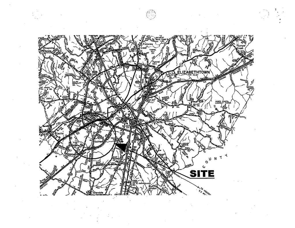
1 M E M O R A N D U M (SA ) cc: K. Sandefur B. Greene TO: Mark Hite, P.E. R. Powell Division of Structural Design J. Moore P. Sanders FROM: Bart Asher, P.E. V. Forsythe TEBM, Geotechnical Branch B. Eldridge P. Dunaway BY: Danny Molen M. Carrier Geotechnical Branch K. Meyer (HDR Inc.) DATE: June 6, 2011 SUBJECT: Hardin County FD KY 3005 (Ring Road) 42 x 10 3-sided WHF Parkway Station MARS # D Item Number Geotechnical Engineering Structure Foundation Report 1.0 INTRODUCTION The proposed project consists of the design and construction of the extension of Ring Road (KY 3005) from Gaither Station Road to the Western Kentucky Parkway in Elizabethtown. This report addresses the geotechnical issues for the proposed design and construction of the 42 x 10 foot, 3-sided culvert at the WHF Parkway Station A geotechnical engineering structure foundation report was originally issued on this project on January 7, 2004 as report number S The drilling was performed for this culvert showing that bedrock was not within 3 feet of the flowline of the culvert, whereas, this culvert would be designed for a yielding foundation. Advancing the borings to bedrock was not necessary for this type of culvert. The structure has now been changed to a 3-sided culvert. Additional drilling was required due to the bedrock elevation being critical for this type of structure. The abbreviated geotechnical engineering report addendum for this structure has been completed. The.DGN file for the subsurface datasheet is available on Projectwise and through for use in developing the structure plans. The structure is in the Cecelia (#263) Geologic Quadrangle. The geologic mapping indicates that the bedrock at this site is of the Ste. Genevieve and the St. Louis Limestone Formations.
2 Hardin Co. MARS # D Page 2 of SUBSURFACE CONDITIONS Eight additional holes were drilled for the 3-sided culvert. Two holes were soil sample and rock core borings, and the remaining six holes were mechanical rockline soundings. Thin-walled tube samples and standard penetration test samples were utilized for sampling. This is a highly karstic area. The bedrock elevation varied from feet to feet. Soils sampled at this location consisted primarily of clays. The Unified Classification of the soils was CL and CH. 3.0 ENGINEERING ANALYSIS Due to the low embankment heights, a settlement analysis was not necessary. Embankment stability analysis was performed in the Geotechnical Engineering Structure Report # R showing the slopes should be stable utilizing 2H:1V slopes or flatter. The soil strength parameters were determined from conservatively correlating SPT N- values and soil classifications with published values found in NAVFAC DM-7.2 and the FHWA Soils and Foundations Workshop Manual. The 100 year flood elevation is feet. The soils, at this location, have potential to scour. Potential scour depth calculations have not been performed. However, Cyclopean Stone Riprap is recommended as a scour abatement measure. The riprap shall be placed from the top of the stream bank to the walls of the culvert and extending to 10 feet beyond the culvert inlet and outlet. This riprap should protect the footings from damaging scour. 4.0 FOUNDATION RECOMMENDATIONS The recommendations given below are for a precast structure. 4.1 Foundation Alternate Alternate 1 Spread Footings on Soil: The spread footings shall be founded on soil. Size the footing at service limit state using a factored nominal bearing resistance of 2.2 ksf. For checking strength and extreme limit states, the nominal bearing resistance has been determined to be: 6.6 ksf. Use a resistance factor of 0.45 for strength limit state analysis and a resistance factor of 1.0 for extreme limit state analysis Alternate 2 Granular Replacement: The spread footing shall be founded on granular replacement material using the allowable bearing pressures shown on the attached sheet. The required depths of the granular replacement shall be shown on the plan sheet.
3 Hardin Co. MARS # D Page 3 of Alternate 3 Pile Foundation: Use piles founded on bedrock. The estimated pile tip elevation will vary from feet to feet. 4.2 The wingwalls should be designed using Soil Type 3 of Exhibit 413 in the Division of Bridge Design Guidance Manual. It should be noted that the backfill slope being referred to is that perpendicular to the wingwall. 4.3 Backfill the pre-cast structure and the accompanying wingwalls according to the manufacturers specifications. 4.4 Cyclopean Stone Rip-Rap shall be placed as a scour abatement measure inside the culvert. The riprap shall be placed from the top of the stream bank to the culvert walls and extend a minimum of 10 feet beyond the culvert inlet and outlet. The limits, size and thickness of cyclopean stone shall be designed for applicable flood flow velocities at the approach slopes of the bridge. Place a Type I, Geotextile Fabric as a separator between the soil and the stone. The Geotextile Fabric shall be in accordance with Sections 214 and 843 of the Standard Specifications for Road and Bridge Construction, current edition. 4.5 Granular replacement material, if utilized, shall consist of Granular Embankment. The Granular Embankment shall be non-erodible only, meeting the material requirements of section 805 in the current Kentucky Department of Highways Standard Specifications for Road and Bridge Construction. Contrary to the Standard Specifications, the maximum size limit for Granular Embankment is 4 inches. The excavation for the granular replacement shall extend a minimum width beyond the edges of the footings equal to the replacement depth. The granular replacement shall be placed on a 1H:1V slope or flatter from the base of the footing to the bottom of the excavation. Place a Type I, Geotextile Fabric as a separator between the soil and the granular replacement. The Geotextile Fabric shall be in accordance with Sections 214 and 843 of the Standard Specifications for Road and Bridge Construction, current edition. 4.6 The base of footing shall be placed at a minimum of 2 feet below the streambed.
4 Hardin Co. MARS # D Page 4 of PLAN NOTES 5.1 Temporary sheeting or shoring and a dewatering method may be required for installation of the footings. 5.2 Cyclopean Stone Rip-Rap shall be placed as a scour abatement measure inside the culvert. The riprap shall be placed from the top of the stream bank to the culvert walls and extend a minimum of 10 feet beyond the culvert inlet and outlet. The limits, size and thickness of cyclopean stone shall be designed for applicable flood flow velocities at the approach slopes of the bridge. Place a Type I, Geotextile Fabric as a separator between the soil and the stone. The Geotextile Fabric shall be in accordance with Sections 214 and 843 of the Standard Specifications for Road and Bridge Construction, current edition. Include the following note if spread footings on granular replacement is used. 5.3 Granular replacement material shall consist of Granular Embankment. The Granular Embankment shall be non-erodible only, meeting the material requirements of section 805 in the current Kentucky Department of Highways Standard Specifications for Road and Bridge Construction. Contrary to the Standard Specifications, the maximum size limit for Granular Embankment is 4 inches. The excavation for the granular replacement shall extend a minimum width beyond the edges of the footings equal to the replacement depth. The granular replacement shall be placed on a 1H:1V slope or flatter from the base of the footing to the bottom of the excavation. Place a Type I, Geotextile Fabric as a separator between the soil and the granular replacement. The Geotextile Fabric shall be in accordance with Sections 214 and 843 of the Standard Specifications for Road and Bridge Construction, current edition. Please feel free to contact this office if there are any questions pertaining to this report. Attachments
5
6
7
8 COORDINATE DATA SUBMISSION FORM KYTC DIVISION OF STRUCTURAL DESIGN -- GEOTECHNICAL BRANCH County Hardin County 3/15/2011 Road Number Survey Crew / Consultant Contact Person KY 3005 (Ring Road) District 4 Crew 204 Mark Cannon Notes: Project Datum coordinates were used, based on Item # KY South 1602 Mars # D Project # FD Elevation Datum = NAVD88 HOLE LATITUDE LONGITUDE HOLE STATION OFFSET ELEVATION (ft) NUMBER (Decimal Degrees) (Decimal Degrees) NUMBER N W Lt N W Lt N W Lt N W Lt N W Lt N W Lt N W Lt N W Lt
Division of Structural Design Geotechnical Branch
 Division of Structural Design Geotechnical Branch Presented By: Bart Asher What is Geotechnical Engineering? The art of molding materials we do not wholly understand into shapes we cannot precisely analyze
511 - RIP RAP - OPSS 511 ROCK PROTECTION - OPSS 511 GRAVEL SHEETING - OPSS 511 GEOTEXTILE - OPSS 511
 511 - - OPSS 511 ROCK PROTECTION - OPSS 511 GRAVEL SHEETING - OPSS 511 GEOTEXTILE - OPSS 511 511.1 GENERAL 511.1.1 Rip Rap 511.1.2 Rock Protection Excavation for placing Rip Rap, Rock Protection and Gravel
B511 - RIP-RAP, ROCK PROTECTION AND GRANULAR SHEETING - OPSS 511
 B511 - - OPSS 511 511.1 GENERAL 511.1.1 Rip-Rap Excavation for placing rip-rap, rock protection, and granular sheeting is part of each individual tender item. Rip-rap is a special application of rock protection.
HYDRAULIC DESIGN involves several basic
 Chapter 6 Tools for Hydr draulic and Road Design HYDRAULIC DESIGN involves several basic concepts that must be considered to build successful projects with a minimum risk of failure (Photo 6.1). Use of
Final Design Activity Descriptions July, 2017
 Final Design Activity Descriptions July, 2017 Check the Capital Project Delivery website to ensure this is the current version. Table of Contents Final Design Final Design Initiated (4000)... 7 Initiate
Alternate Green Stream Bank Stabilization Methods
 U.S. Army Corps of Engineers Philadelphia/Baltimore Districts Alternate Green Stream Bank Stabilization Methods Wissahickon Creek, Tannery Run and Rose Valley Creek Bo-Rit Asbestos Site Ambler, Pennsylvania
Advanced Foundation Engineering. Soil Exploration
 Shahrood University of Technology Department of Geotechnical Engineering Advanced Foundation Engineering Soil Exploration Mohsen Keramati, Ph.D. Assistant Professor 1 - Introduction The field and laboratory
Gary Person, Foundation Engineer Geotechnical Engineering Section
 Minnesota Department of Transportation MEMO Mailstop 64 14 Gervais Avenue Maplewood, MN 9 DATE: November 3 rd, 214 TO: FROM: CONCUR: Bruce Johnson, Project Manager Metro Design Hossana Teklyes, Assist.
STREAM ALTERATION PRACTICES
 STREAM ALTERATION PRACTICES Stream Diversion Channel SDC DEFINITION A temporary channel constructed to convey stream flow around in-stream construction. PURPOSE Stream diversion channels are used to allow
Information for File # JTF
 Information for File # 2013-04665-JTF Applicant Corps Contact Enbridge Energy, Limited Partnership Josh Fitzpatrick Address 1554 Highway 2, Suite 2, Two Harbors, MN 55616 E-Mail joshua.t.fitzpatrick@usace.army.mil
Structural Storm Water Best Management Practices (BMPs)
") Structural Storm Water Best Management Practices (BMPs) Storm Water Permitting: The SWPPP Revealed By Deron Austin, PE January 11, 2006 3:30-5:00 PM Orlando, Florida Presentation Outline Preface About
Structural Storm Water Best Management Practices (BMPs) Storm Water Permitting: The SWPPP Revealed By Deron Austin, PE January 11, 2006 3:30-5:00 PM Orlando, Florida Presentation Outline Preface About
June Pennsylvania Department of Transportation Engineering District Herr Street Harrisburg, PA 17103
 EROSION & SEDIMENT CONTROL REPORT FOR S.R. 0462 BOX CULVERT REPLACEMENT OVER TRIBUTARY TO STRICKLER RUN WEST HEMPFIELD TWP., LANCASTER CO. Prepared for: June 2006 Pennsylvania Department of Transportation
PLAN SUBMITTER'S CHECKLIST
 Page 1 of 8 PLAN SUBMITTER'S CHECKLIST FOR EROSION AND SEDIMENT CONTROL PLANS Please fill in all blanks and reference the plan sheets/pages where the information may be found, where appropriate, or write
Chapter 1 GENERAL SOUTH DAKOTA DRAINAGE MANUAL
 Chapter 1 GENERAL SOUTH DAKOTA DRAINAGE MANUAL October 2011 Table of Contents Section Page 1.1 INTRODUCTION...1-1 1.2 BASIC APPROACH...1-2 1.3 FUNCTIONAL RESPONSIBILITIES...1-3 1.3.1 Office of Road Design...1-3
City of Stoughton Erosion Control Permit Application (effective 2/6/2018)
") City of Stoughton Erosion Control Permit Application (effective 2/6/2018) Incomplete applications will not be accepted Project Name: Address of subject property: Landowner Name(s): Applicant Name: Landowner
City of Stoughton Erosion Control Permit Application (effective 2/6/2018) Incomplete applications will not be accepted Project Name: Address of subject property: Landowner Name(s): Applicant Name: Landowner
Urban Conservation Practice Physical Effects ESTABLISHMENT, GROWTH, AND HARVEST NUTRIENT MANAGEMENT
 NOT WELL 800 - Urban Stormwater Wetlands A constructed system of shallow pools that create growing conditions for wetland plants to lessen the impacts of stormwater quality and quantity in urban areas.
Advanced Foundation Engineering. Introduction
 Shahrood University of Technology Department of Geotechnical Engineering Advanced Foundation Engineering Introduction Mohsen Keramati, Ph.D. Assistant Professor 1 - Detailed Course Plan Introduction (Geotechnical
Gloucester County PLAN SUBMITTER'S CHECKLIST
 Page 1 of 9 Gloucester County PLAN SUBMITTER'S CHECKLIST FOR EROSION AND SEDIMENT CONTROL PLANS Please fill in all blanks and please reference the plan sheets/pages where the information may be found,
-AIHL NOISE UNIFIED SOIL CLASSIFICATION SYSTEM. Aqx. R CORPS OF ENGINEERS, U. S. ARMY APPENDIX A
 Aqx. R CORPS OF ENGINEERS, U. S. ARMY -AIHL NOISE THE UNIFIED SOIL CLASSIFICATION SYSTEM APPENDIX A CHARACTERISTICS OF SOIL GROUPS PERTAINING TO EMBANKMENTS AND FOUNDATIONS TECHNICAL MEMORANDUM NO. 3-357
Technical Supplement 14D. Geosynthetics in Stream Restoration. (210 VI NEH, August 2007)
") Technical Supplement 14D (210 VI NEH, August 2007) Issued August 2007 Cover photo: Inert or manmade materials can be used in restoration designs where immediate stability is required and can be used in
Technical Supplement 14D (210 VI NEH, August 2007) Issued August 2007 Cover photo: Inert or manmade materials can be used in restoration designs where immediate stability is required and can be used in
Advanced Foundation Engineering. Sheet-Pile Walls
 Shahrood University of Technology Department of Geotechnical Engineering Advanced Foundation Engineering Sheet-Pile Walls Mohsen Keramati, Ph.D. Assistant Professor 1 Introduction Connected or semiconnected
URBANIZED STREAM CORRIDOR: COMMUNITY APPROACH TO ADDRESS EROSION
 URBANIZED STREAM CORRIDOR: COMMUNITY APPROACH TO ADDRESS EROSION Stephen Crawford, P.E., CFM Romin Khavari, P.E., CFM NCTCOG Public Works Roundup MAY 23, 2018 Today s Agenda Urbanized Stream Erosion Solving
Department of Agriculture. Conservation Service. United States. Natural Resources REVISED 8/26/16
 GENERAL NOTES: SYMBOL LEGEND 1. All work shall comply with the constriction specifications, drawings, project-specific quality assurance plan and other contract requirements. 2. All notes on the drawings
Subsoil conditions are examined using test borings, provided by soil engineer (geotechnical).
.") SOIL & FOUNDATION TYPES: Subsurface investigations: Subsoil conditions are examined using test borings, provided by soil engineer (geotechnical). Number of borings and location of borings depends on building
SOIL & FOUNDATION TYPES: Subsurface investigations: Subsoil conditions are examined using test borings, provided by soil engineer (geotechnical). Number of borings and location of borings depends on building
KYTC and NFIP: Bridging Floodplain Management and Design KAMM CONFERENCE AUGUST 25, 2015
 KYTC and NFIP: Bridging Floodplain Management and Design KAMM CONFERENCE AUGUST 25, 2015 KYTC STATEWIDE DRAINAGE DESIGN Provide Drainage Design Services on an as needed basis: Perform hydraulic analysis
2014 HDR 2014 Architecture, HDR, Inc., all all rights reserved. reserved.
 2014 HDR 2014 Architecture, HDR, Inc., all all rights reserved. reserved. Uplift of a Wet Weather Stream: Satisfying Regulatory Requirements Agawela Drive Stream Project Chattanooga, TN 2014 HDR, Inc.,
E R O S I O N C O N T R O L
 E R O S I O N C O N T R O L GEOTEXTILES T O U G H O V E R T I M E EROSION CONTROL 1.0 Features of PERMANENT PG 2 EROSION CONTROL 2.0 How Typar geotextiles PG 2 work 4.0 Installation guide PG 6 5.0 Overlap
THE OBJECTIVES OF ROUTINE ROAD CUTS AND FILLS
 Chapter 11 Slope Stabiliza bilization and Stability of Cuts and Fills THE OBJECTIVES OF ROUTINE ROAD CUTS AND FILLS are 1) to create space for the road template and driving surface; 2) to balance material
V. EROSION CONTROL. -Drainage swales separation -Under rip-rap protected -Under rip-rap unprotected
 V. EROSION CONTROL This section describes three different types of erosion control applications where geotextiles can be used in conjunction with some form of stone or other energy dissipating material
Severn River Sub-Watershed: BMP 09-Retrofit
 Project ID: BMP_09 Total Treated Drainage Area: 4.57 acres Total Treated Impervious Area: 2.9 acres Total Water Quality Volume (WQv): ~10,300 cubic feet; 0.236 acre-foot Rainfall Depth Treated (Pe): 1
Information for File # ARC
 Information for File # 2016-02630-ARC Applicant Corps Contact Will Bomier-Carlton County Transportation Department Andrew R Chambers Address 600 South Lake Avenue, Suite 211, Duluth, MN 55802 E-Mail Andrew.R.Chambers@usace.army.mil
UNIFIED FACILITIES GUIDE SPECIFICATIONS
 USACE / NAVFAC / AFCEC / NASA UFGS-02 66 00 (February 2010) ----------------------------- Preparing Activity: USACE Superseding UFGS-02 66 00 (April 2006) UNIFIED FACILITIES GUIDE SPECIFICATIONS References
Erosion & Sediment Control Plan Application Form & Checklist
 Erosion & Sediment Control Plan Application Form & Checklist GENERAL INFORMATION Application Date: Project Address: Tax Map / Parcel Number(s): PROPERTY OWNER / DEVELOPER Firm Name: Contact Person: Title:
Geosynthetics for Erosion Control and Reinforcement
 Geosynthetics for Erosion Control and Reinforcement Stan Boyle, Ph.D., P.E. Shannon & Wilson, Inc. What are Geosynthetics? Geosynthetics are (generally) polymeric products used in civil engineering applications.
WQ-23 MOUNTAINOUS AND STEEP SLOPE SITES
 Greenville County Technical Specification for: WQ-23 MOUNTAINOUS AND STEEP SLOPE SITES 1.0 Mountainous and Steep Slope Sites 1.1 Description The geographic locations of portions of Greenville County are
Indirect Design Comparison of the structural strength of the pipe (Three- Edge-Bearing Test) to the field supporting strength of a buried pipe.
 to the field supporting strength of a buried pipe.") 2 Indirect Design Comparison of the structural strength of the pipe (Three- Edge-Bearing Test) to the field supporting strength of a buried pipe. Direct Design The design of pipe in the installed condition.
2 Indirect Design Comparison of the structural strength of the pipe (Three- Edge-Bearing Test) to the field supporting strength of a buried pipe. Direct Design The design of pipe in the installed condition.
Guidelines for Streambank Protection
 PDHonline Course C187 (3 PDH) Guidelines for Streambank Protection Instructor: John Poullain, PE 2012 PDH Online PDH Center 5272 Meadow Estates Drive Fairfax, VA 22030-6658 Phone & Fax: 703-988-0088 www.pdhonline.org
CASE HISTORY USE OF TECHGEO NONWOVEN GEOTEXTILE AND TECHGEO NONWOVEN GEOTEXTILE BAGS FOR RIVERBANK PROTECTION
 USE OF TECHGEO NONWOVEN GEOTEXTILE AND TECHGEO NONWOVEN GEOTEXTILE BAGS FOR RIVERBANK PROTECTION Project Description Project: Client: Contractor: Protection works to eroding left bank of river Churni at
ACTIVITY: Geotextiles ES 12
 Targeted Constituents Significant Benefit Partial Benefit Low or Unknown Benefit Sediment Heavy Metals Floatable Materials Oxygen Demanding Substances Nutrients Toxic Materials Oil & Grease Bacteria &
Addendum No. 2 for Drainage Improvements For Nueces River Fishing Area
 Project No. 15-015K September 20, 2016 TO ALL POTENTIAL BIDDERS Subject: Addendum No. 2 for Drainage Improvements For Nueces River Fishing Area Ladies/Gentlemen: This addendum is considered part of the
INSTALLATION GUIDELINES FOR GEOTEXTILES USED IN FILTRATION AND DRAINAGE APPLICATIONS
 INSTALLATION GUIDELINES FOR GEOTEXTILES USED IN FILTRATION AND DRAINAGE APPLICATIONS Prepared by TenCate Geosynthetics North America 365 South Holland Drive Pendergrass, GA 30567 Tel: (706) 693-2226 Fax:
ALTERNATIVE SHORELINE MANAGEMENT IN COASTAL MISSISSIPPI
 ALTERNATIVE SHORELINE MANAGEMENT IN COASTAL MISSISSIPPI Project supported via financial assistance provided by the Coastal Zone Management Act of 1972, as amended, administered by the Office of the Ocean
Sydney Road Reclaimed Water Main, Plant City, Florida. Prepared for: Jones Edmunds & Associates, Inc.
 . Geotechnical Report Sydney Road Reclaimed Water Main, Plant City, Florida Prepared for: Jones Edmunds & Associates, Inc. Prepared by: MADRID ENGINEERING GROUP, INC. 2030 Hwy 60 E. Bartow, FL 33830 863-533-9007
PROJECT SCOPE OF WORK CITY OF TOWN AND COUNTRY STORMWATER PROGRAM
 PROJECT SCOPE OF WORK CITY OF TOWN AND COUNTRY STORMWATER PROGRAM Project ID Number: 25-5 Problem: Stormwater collected from the neighborhood upstream is released at 9 Muirfield Lane and flows west toward
FURNEAUX CREEK 5 CHANNEL
 FURNEAUX CREEK 5 CHANNEL AND TRAIL IMPROVEMENTS TEXAS CHAPTER AMERICAN PUBLIC WORKS ASSOCIATION PROJECT OF THE YEAR CATEGORY: ENVIRONMENT PROJECT OF $2 MILLION BUT LESS THAN $5 MILLION ENGINEERING DEPARTMENT,
Full Scale Model Test of Soil Reinforcement on Soft Soil Deposition with Inclined Timber Pile
 Full Scale Model Test of Soil Reinforcement on Soft Soil Deposition with Inclined Timber Pile Suheriyatna 1, L. Samang 2, M. W. Tjaronge 3 and T. Harianto 4 1 Doctoral Student, Department of Civil Engineering,
Overall Stability Moving from Service to Strength Limit State: Why? Nick Harman, MS, PE Ani Carignan, PE, LEED AP STGEC Conference October, 2018
 Overall Stability Moving from Service to Strength Limit State: Why? Nick Harman, MS, PE Ani Carignan, PE, LEED AP STGEC Conference October, 2018 History In 2000 FHWA mandated state DOTs begin designing
MARBLE RIVER WIND POWER PROJECT Agricultural Protection Measures
 MARBLE RIVER WIND POWER PROJECT Siting Considerations 1. Locate access roads and, to the extent allowed by local laws, wetlands and topography, individual wind turbines and other structures along field
Rolled Erosion Control Products (RECPs) General Usage and Installation Guidelines for Slope
 General Usage and Installation Guidelines for Slope") March 2014 Version 1.0 Rolled Erosion Control Products (RECPs) General Usage and Installation Guidelines for Slope Erosion Control Technology Council IMPORTANT NOTICE on Safety Procedures: Manufacturer
March 2014 Version 1.0 Rolled Erosion Control Products (RECPs) General Usage and Installation Guidelines for Slope Erosion Control Technology Council IMPORTANT NOTICE on Safety Procedures: Manufacturer
Streambank Protection (SP)
") Streambank Protection (SP) Practice Description Streambank protection is the stabilization of the side slopes of a stream. Streambank protection can be vegetative, structural, or a combined method (bioengineering)
Streambank Protection (SP) Practice Description Streambank protection is the stabilization of the side slopes of a stream. Streambank protection can be vegetative, structural, or a combined method (bioengineering)
PROPOSED DRAINAGE PATTERNS
 1121 1118.50 Basin Floor 1120 1119 0 N 100 200 PROPOSED DRAINAGE PATTERNS Deroiser Drive Riverwood Drive County 260 0 100 200 Project Name: Riverwood Drive LITTLE FALLS TOWNHOMES Project Location: LITTLE
SILT FENCE MACHINE SLICED ERO-1A STEEL FENCE POST (T-POST), MINIMUM 5' LONG, 6' MAXIMUM SPACING.
, MINIMUM 5' LONG, 6' MAXIMUM SPACING.") STEEL FENCE POST (T-POST), MINIMUM 5' LONG, 6' MAXIMUM SPACING. ATTACH FABRIC TO POSTS WITH MINIMUM 3 ZIP TIES (50 LB. TENSILE) PER POST IN TOP 8" OF FABRIC. MONOFILAMENT GEOTEXTILE FABRIC PER MNDOT TABLE
STEEL FENCE POST (T-POST), MINIMUM 5' LONG, 6' MAXIMUM SPACING. ATTACH FABRIC TO POSTS WITH MINIMUM 3 ZIP TIES (50 LB. TENSILE) PER POST IN TOP 8" OF FABRIC. MONOFILAMENT GEOTEXTILE FABRIC PER MNDOT TABLE
APPENDIX E COMPACTION CHARACTERISTICS AND EQUIPMENT
 APPENDIX E COMPACTION CHARACTERISTICS AND EQUIPMENT When the Materials Division designs a pavement structure, there are a number of factors that influence it s outcome. Projected traffic counts, percentage
Guidelines for Installing Rolled Erosion Control Products in Slope, Channel and Shoreline Applications Laurie Honnigford
 Guidelines for Installing Rolled Erosion Control Products in Slope, Channel and Shoreline Applications Laurie Honnigford Soil erosion is evident in so many situations and the environmental impact can be
EROSION & SEDIMENT CONTROL
 EROSION & SEDIMENT CONTROL 1 EROSION & SEDIMENT CONTROL Effective Soil & Water Protection Whether you want to prevent soil erosion caused by rain, water and wind, or protect waterways from inevitable build
ENBRIDGE GAS DISTRIBUTION INC. Proposed Relocation for Ninth Line, Markham and Whitchurch-Stouffville. Environmental Screening Report
 Page 1 of 18 ENBRIDGE GAS DISTRIBUTION INC. Proposed Relocation for Ninth Line, Markham and Whitchurch-Stouffville Environmental Screening Report July 2011 Page 2 of 18 Table of Contents 1.0 INTRODUCTION
Erosion Control for Home Builders in the. City of Jacksonville
 Erosion Control for Home Builders in the City of Jacksonville Eroding construction sites are a leading cause of water quality problems in Jacksonville. For every acre under construction, about a dump truck
1 SITE AND PROJECT DESCRIPTION
 February 14, 2017 Our File Ref.: 160796 Denis Lacroix 6909 Notre Dame Street Ottawa, Ontario K1C 1H6 Subject: Slope Stability Analysis 6909 Notre Dame Street Ottawa, Ontario Pursuant to your request, LRL
Stream Restoration: Working with Nature?
 Stream Restoration: Working with Nature? Greg Jennings, PhD, PE jenningsenv@gmail.com Ecosystem Restoration activities that initiate or accelerate the recovery of ecosystem health, integrity, and sustainability
Stream Restoration: Working with Nature? Greg Jennings, PhD, PE
 Stream Restoration: Working with Nature? Greg Jennings, PhD, PE jenningsenv@gmail.com Ecosystem Restoration activities that initiate or accelerate the recovery of ecosystem health, integrity, and sustainability
A: Downtown Diversion Pipe
 A: Downtown Diversion Pipe b c with modifications Map highlighting conservation easement. The diversion pipe would run along the railroad. Will divert 40-44% of total flow.; and Reduce the impact on Sand
Project Name: Project Address or Location: Principal Designer Name and Company: Principal Designer Phone Number:
 SECTION 1: GENERAL INFORMATION Plan Submission Date: Total Disturbed Acreage: _ Project Name: Project Address or Location: Principal Designer Name and Company: Principal Designer Phone Number: email: SECTION
Appendix E Preliminary Location Hydraulic Study
 Appendix E Prepared for: State of Alaska Department of Transportation and Public Facilities Prepared by: HDR Alaska, Inc. 2525 C Street, Suite 305 Anchorage, Alaska 99503 February 2014 This page intentionally
PROJECT CLIMATE RISK ASSESSMENT AND MANAGEMENT REPORT
 Khyber Pakhtunkhwa Provincial Roads Improvement Project (RRP PAK 47360) PROJECT CLIMATE RISK ASSESSMENT AND MANAGEMENT REPORT I. Basic Project Information Project Title: Khyber Pakhtunkhwa Provincial Roads
Methods, approaches, and procedures to minimize active agricultural land impacts during pipeline construction, surface restoration, and pipeline
 Agricultural Impact Minimization Plan Methods, approaches, and procedures to minimize active agricultural land impacts during pipeline construction, surface restoration, and pipeline operation. PennEast
Lake Shoreline Stabilization Techniques
 Environment and Sustainable Resource Development Lake Shoreline Stabilization Techniques Compliance Assurance / Operations Central Region Suite #1, 250 Diamond Avenue Box 4240 Spruce Grove, Alberta T7X
CONSTRUCTION SPECIFICATION FOR RIP RAP, ROCK PROTECTION AND GRAVEL SHEETING
 ONTARIO PROVINCIAL STANDARD SPECIFICATION METRIC OPSS 511 FEBRUARY 1990 CONSTRUCTION SPECIFICATION FOR RIP RAP, ROCK PROTECTION AND GRAVEL SHEETING 511.01 SCOPE 511.02 REFERENCES 511.03 DEFINITIONS 511.04
Design and Installation of Embedded Culverts
 Kamloops March 12, 2002 Pilot 2 Design and Installation of Embedded Culverts Part 2: Design 1 2 Part 2: Design 6 Main Topics 1. Evaluation of site suitability 2. Detailed streambed profile 3. Sizing the
APPLICATIONS IN FILTRATION AND DRAINAGE & EROSION CONTROL
 Lecture 36 APPLICATIONS IN FILTRATION AND DRAINAGE & EROSION CONTROL Prof. G L Sivakumar Babu Department of Civil Engineering Indian Institute of Science Bangalore 560012 Geotextile filter requirements:
Methods, approaches, and procedures to minimize active agricultural land impacts during pipeline construction, surface restoration, and pipeline
 Agricultural Impact Minimization Plan Methods, approaches, and procedures to minimize active agricultural land impacts during pipeline construction, surface restoration, and pipeline operation. PennEast
Vegetating Disturbed Road & Stream Banks. By Mike Fournier NRCS Resource Conservationist
 Vegetating Disturbed Road & Stream Banks By Mike Fournier NRCS Resource Conservationist Clearly Identify The Problem Project Objectives Clearly Define Objectives Before Work Starts Determine Whether Project
Design, Construction and Maintenance of Irrigation Reservoirs in Ontario
 Design, Construction and Maintenance of Irrigation Reservoirs in Ontario R. Shortt FACTSHEET 16-009 AGDEX 753/562 MAY 2016 This Factsheet provides general guidelines for the design, construction and maintenance
DITCH BANK STABILIZATION TECHNIQUES
 onstructed Ditch Drainage anagement Guide - No. 0 in series Order No. 5.0- December 00 DITH BANK STABILIZATION TEHNIQUES It is important to maintain ditches using practices that ensure ditch banks remain
ABBREVIATIONS: TABLE OF CONTENTS: REFERENCE MATERIALS: CITY OF SEATTLE COMBINED SEWER OVERFLOW GALLONS PER MINUTE POLYVINYL CHLORIDE SQUARE FEET
 TABLE OF CONTENTS: ABBREVIATIONS: SHEET NO. A SHEET DESCRIPTION REFERENCE SHEETS TITLE SHEET COS CSO GPM PVC SF CITY OF SEATTLE COMBINED SEWER OVERFLOW GALLONS PER MINUTE POLYVINYL CHLORIDE SQUARE FEET
SECTION 6. Routine Maintenance Activity Details
 SECTION 6 Routine Maintenance Activity Details 80. DEBRIS REMOVAL When Deadfall, and other objects, such as shopping carts, tires, appliances, and mattresses have accumulated in the drain. Why To prevent
Guiding Landowners in Stream Restoration. The Science, Practice & Art of Restoring Native Ecosystems 2015
 Guiding Landowners in Stream Restoration The Science, Practice & Art of Restoring Native Ecosystems 2015 January 24, 2015 Guiding Landowners in Stream Restoration January 24, 2015 Agenda 1Watershed Planning
EROSION & SEDIMENT CONTROL
 EROSION & SEDIMENT CONTROL Surface Water Protection During Well Site Construction Kelly Kees, PE WVDEP, Office of Oil and Gas SEDIMENT & EROSION CONTROL PLANS Per West Virginia State Code 22-6-6(d) 22-6A-7(c),
Coastal and River Erosion Control. Erosion
 Coastal and River Erosion Control Erosion Definition: Erosion is the process by which individual soil particles are dislodged from the soil mass and carried away by a transporting medium. The soil erosion
Technical Specification Guidelines
 SECTION I- DESIGN CONSIDERATIONS PAGE 1.01 APPLICABILITY...I.2 1.02 PROTECTION AND PRECAUTIONS...I.3 1.03 SITE AND SUBSTRATE CONSIDERATIONS...I.3 1.04 PRODUCT CONSIDERATIONS...I.8 1.05 FASTENING CONSIDERATIONS...I.9
The City of Winnipeg Bid Opportunity No GEOTECHNICAL REPORT - TEST HOLE LOGS
 The City of Winnipeg Bid Opportunity No. 88-6 GEOTECHNICAL REPORT - TEST HOLE LOGS The City of Winnipeg Bid Opportunity 88-6 Template Version: C44 TEST HOLE LOGS TABLE OF CONTENTS TEST HOLE LOGS FOR DEARBORN
I. DESCRIPTION OF PROPOSED ACTION... 1 A. General Description... 1 B. Historical Resume and Project Status... 2 C. Cost Estimates...
 PROJECT COMMITMENTS SUMMARY... S-1 1. Type of Action... S-1 2. Description of Action... S-1 3. Summary of Purpose and Need... S-1 4. Alternatives Considered... S-2 5. NCDOT Alternatives Carried Forward...
CONSTRUCTION SPECIFICATION FOR RIP-RAP, ROCK PROTECTION, AND GRANULAR SHEETING
 ONTARIO PROVINCIAL STANDARD SPECIFICATION METRIC OPSS 511 NOVEMBER 2008 CONSTRUCTION SPECIFICATION FOR RIP-RAP, ROCK PROTECTION, AND GRANULAR SHEETING TABLE OF CONTENTS 511.01 SCOPE 511.02 REFERENCES 511.03
STORM SEWER OUTFALLS AND CONNECTING OUTFALL CHANNELS. General Submission Requirements
 COMPLETE APPLICATION CHECKLIST Jan 2016 STORM SEWER OUTFALLS AND CONNECTING OUTFALL CHANNELS The following checklist has been compiled to assist the applicant in preparing their application for approval
GEOMEMBRANE FIELD INSTALLATION
 GEOMEMBRANE FIELD INSTALLATION CONTENTS Introduction Quality Control and Quality Assurance Types of lining systems Basic Lining Design Executive Lining Design Basic Lining Design Specification Executive
ACE Geosynthetics. An Overview of
 ACE Geosynthetics An Overview of ACEGrid ACETex ACETube PRODUCT ACETex ACETex is the registered trademark of ACE Geosynthetics for all its geotextile products. ACETex is basically woven geotextile
field note Culvert foundation improvement design concepts The challenge of low-cost culvert foundations
 field note Culvert improvement design concepts Mark Partington, R.P.F., M.Sc., EP 1 Papa Masseck Thiam, Ing. Jr., M.Sc. 2 Introduction Canada s northern forested landscapes feature numerous wetlands, such
HILCORP ALASKA, LLC KALOTSA PAD
 , LLC ACCESS ROAD, PAD & FLOWLINE FLOWLINE END SEC 7 T1S R13W SM NINILCHIK, ALASKA FLOWLINE & ACCESS ROAD START PROPOSED 200' x 300' DRILL PAD M.P. 130 STERLING HWY ACCESS ROAD END INDEX S 0 1000 VICINITY
Slope Stabilization and Repair Solutions for Local Government Engineers
 Slope Stabilization and Repair Solutions for Local Government Engineers David Saftner, Principal Investigator Department of Civil Engineering University of Minnesota Duluth June 2017 Research Project Final
STANDARD SPECIFICATIONS SECTION TEMPORARY EROSION AND SEDIMENT CONTROL
 STANDARD SPECIFICATIONS SECTION 01570 TEMPORARY EROSION AND SEDIMENT CONTROL PART 1 GENERAL 1.1 DESCRIPTION A. Section includes requirements, procedures, and methods related to responsibilities for providing
Coffee Creek Park Development Low Impact Development (LID)
") Coffee Creek Park Development Low Impact Development (LID) City of Duluth, St. Louis County, MN Presented By: Christopher J. Rousseau, P.E. February 27, 2008 Developer / Owner Information Trinity Development
Coffee Creek Park Development Low Impact Development (LID) City of Duluth, St. Louis County, MN Presented By: Christopher J. Rousseau, P.E. February 27, 2008 Developer / Owner Information Trinity Development
CONSTRUCTION SPECIFICATION FOR RIP-RAP, ROCK PROTECTION, AND GRANULAR SHEETING
 ONTARIO PROVINCIAL STANDARD SPECIFICATION OPSS.MUNI 511 NOVEMBER 2018 (Formerly OPSS 511, November 2013) Note: The MUNI implemented in November 2018 replaces OPSS 511 COMMON, November 2013 with no technical
Goal 1 To establish and follow land use patterns for the long-range development of the campus.
 ELEMENT 4 FUTURE LAND USE Goal 1 To establish and follow land use patterns for the long-range development of the campus. Objective 1A Correct existing incompatible campus land uses. Policy 1A-1 Reduce
Landfill Closure, Intermediate Cover & Post-Closure Care. Municipal League Meeting
 Landfill Closure, Intermediate Cover & Post-Closure Care Municipal League Meeting 9-7-17 Gated and Closed Landfill Gated means no longer accepting waste. Closed means gated and final cover has been installed
UPLAND EROSION CONTROL, REVEGETATION, AND MAINTENANCE PLAN
 UPLAND EROSION CONTROL, REVEGETATION, AND MAINTENANCE PLAN 01/17/2003 VERSION UPLAND EROSION CONTROL, REVEGETATION, AND MAINTENANCE PLAN TABLE OF CONTENTS I. APPLICABILITY... 1 II. SUPERVISION AND INSPECTION...
Geotechnical Exploration and Evaluation Report
 Geotechnical Exploration and Evaluation Report UNF Transportation Projects Osprey Ridge Road Extension Jacksonville, Florida CSI Geo Project No.: --- Arcadis Project No.: JK. Prepared by CSI Geo, Inc.
Old Mill Community Association Bioretention Facility
 Project Overview This project will install a bioretention facility in a community recreation area owned by the Old Mill Community Association, Inc. Drainage from the area is currently unmanaged and has
Vermont Better Backroads Pocket Guide
 Vermont Better Backroads Pocket Guide Clean Water You Can Afford Northern Vermont Resource Conservation & Development (RC&D) Council 617 Comstock Road, Suite 2 Berlin, VT 05602 (802) 828-4595 June 1997
DuPage Mayors and Managers Conference June 21, 2013 TRANSPORTATION PROGRAM (STP) WORKSHOP
 WORKSHOP") DuPage Mayors and Managers Conference June 21, 2013 TRANSPORTATION PROGRAM (STP) WORKSHOP Lombard Village Hall Marilin Solomon, P.E. Field Engineer West Division (Central & North Central Cook County, DuPage
DuPage Mayors and Managers Conference June 21, 2013 TRANSPORTATION PROGRAM (STP) WORKSHOP Lombard Village Hall Marilin Solomon, P.E. Field Engineer West Division (Central & North Central Cook County, DuPage
Highway Alignment and Route Location Survey
 CHAPTER 2 Highway Route Surveys and Location Introduction To determine the geometric features of road design, the following surveys must be conducted after the necessity of the road is decided. Type of
Coir Block System (fabric attached coir block) add New Dimension to Streambank Stabilization Projects
 add New Dimension to Streambank Stabilization Projects") Coir Block System (fabric attached coir block) add New Dimension to Streambank Stabilization Projects Using geotextiles to confine soil in lifts between layers of live plants has become an increasingly
Coir Block System (fabric attached coir block) add New Dimension to Streambank Stabilization Projects Using geotextiles to confine soil in lifts between layers of live plants has become an increasingly