The Plan makes recommendations for land use, zoning, transportation, design, sustainability, community facilities and parks and open spaces.
|
|
|
- Edwina Hudson
- 5 years ago
- Views:
Transcription

1
2 Abstract This Sector Plan contains text and supporting maps for a limited amendment to the approved and adopted 1985 Boyds Master Plan, the 1989 Germantown Master Plan and the 2009 Germantown Employment Area Sector Plan. It also amends the General Plan (On Wedges and Corridors) for the Physical Development of the Maryland-Washington Regional District in Montgomery and Prince George s Counties as amended, the Master Plan of Highways and Transitways within Montgomery County as amended, the 2004 Rustic Roads Functional Master Plan as amended, the 2018 Countywide Bikeways Functional Master Plan as amended and the Master Plan for Historic Preservation in Montgomery County, Maryland. The Plan makes recommendations for land use, zoning, transportation, design, sustainability, community facilities and parks and open spaces. Source of Copies The Maryland-National Capital Park and Planning Commission 8787 Georgia Avenue Silver Spring, MD Online: montgomeryplanning.org/planning/communities/area-3/marc-railcommunities/ Notice to Readers Each area master or sector plan reflects a vision of future development that responds to the unique character of the local community within the context of a countywide perspective. Area master and sector plans are intended to convey land use policy for defined geographic areas and should be interpreted together with relevant countywide functional master plans. Sector plans generally look ahead about 20 years from the date of adoption. As communities evolve, the specifics of a master plan may become less relevant over time. Generally, sketches or drawings in an adopted sector plan are for illustrative purposes only; they are intended to convey a general character rather than a specific commitment to a particular detailed design. Sector plans do not specify all development possibilities for a particular property or area. To understand the full range of development options, the reader should be aware of additional land uses and development potential available through permitted conditional uses; variances; transferable development rights (TDRs); moderately priced dwelling units (MPDUs); rezoning by local map amendments; public projects and mandatory referral processes; and municipal annexations. The Maryland-National Capital Park and Planning Commission The Maryland-National Capital Park and Planning Commission is a bicounty agency created by the General Assembly of Maryland in The Commission s geographic authority extends to the great majority of Montgomery and Prince George s Counties; the Maryland-Washington Regional District (M-NCPPC planning jurisdiction) comprises 1,001 square miles, while the Metropolitan District (parks) comprises 919 square miles in the two counties. The Commission is charged with preparing, adopting and amending or extending the General Plan (On Wedges and Corridors) for the Physical Development of the Maryland-Washington Regional District in Montgomery and Prince George s Counties. The Commission operates in each county through a Planning Board appointed by and responsible to each county's government. All local plans, recommendations on zoning amendments, administration of subdivision regulations and general administration of parks are responsibilities of the respective Planning Boards.
3 MARC Rail Communities Sector Plan Prepared by the Montgomery County Planning Department MontgomeryPlanning.org Planning Board Draft December 2018 The Maryland-National Park and Planning Commission
4
5 Table of Contents I. INTRODUCTION...1 A. Plan Purpose... 1 B. Plan Background... 2 C. Plan Boundaries... 4 D. Community Engagement Process... 6 E. Previous Plans and Supporting Studies... 7 II. VISION...10 A. Assets, Challenges and Opportunities B. Boyds Vision and Priorities C. Germantown Vision and Priorities III. HISTORY OF THE MARC RAIL COMMUNITIES...21 A. Metropolitan Branch of the Baltimore and Ohio Railroad B. History of Boyds C. Boyds Today D. History of Germantown E. Germantown Today IV. PLAN RECOMMENDATIONS...31 A. Connect B. Renew C. Preserve D. Sustain V. IMPLEMENTATION...96 A. Zoning B. Special Districts C. Bicycle and Pedestrian Priority Areas D. Environmental E. Historic Preservation F. Capital Improvement Projects MARC Rail Communities Sector Plan Planning Board Draft December 2018 i
6 List of Figures and Tables Figures Figure 1 - MARC Plan Locations in Relation to Montgomery County... 2 Figure 2 - Boyds and Germantown MARC Station Areas with Walk Radii... 3 Figure 3 - Aerial of the Boyds Planning Area... 4 Figure 4 - Aerial of the Germantown Planning Area... 5 Figure 5 - Previous Area Master Plans in Relationship to the MARC Rail Communities Sector Plan... 8 Figure 6 - Concept for Boyds Figure 7 - Concept for Germantown Figure Scharf Map of the Metropolitan Branch of the B&O Railroad through Montgomery County Figure Hopkins Map with MARC Rail Communities Sector Plan Area Boundaries Figure 10 - Boyds Historic Resources Figure 11 - Germantown Historic Resources Figure 12 - Boyds Reference Key Figure 13 - Germantown Reference Key Figure 14 - Existing Boyds Land Use Figure 15 - Proposed Boyds Land Use Figure 16 - Existing Germantown Land Use Figure 17 - Proposed Germantown Land Use Figure 18 - The Expanded Boyds MARC Station on the Anderson Properties, as Viewed from Clarksburg Road (Illustrative) Figure 19 - The Expanded Boyds MARC Station on the Anderson Properties, as Viewed from Barnesville Road (Illustrative) Figure 20 - Proposed Boyds Road Classifications Figure 21 - Proposed Boyds Bike Classifications Figure 22 - Proposed Typical Street Section for Barnesville Road from the MARC Platform to the Post Office Figure 23 - Proposed Typical Street Section for Barnesville Road from Clarksburg Road to the MARC Platform Figure 24 - Proposed Typical Street Section for Clopper Road East of Clarksburg Road Figure 25 - Proposed Typical Street Section for Clarksburg Road Figure 26 - Replacement Clarksburg Road Railroad Bridge near the Existing Bridge Location (Illustrative) Figure 27 - Proposed Clopper Road Rustic Road Designation Figure 28 - Germantown Town Center Urban Road Code Area and Expanded Bicycle and Pedestrian Priority Area Figure 29 - Proposed Germantown Road Classifications Figure 30 - Proposed Germantown Bike Classifications Figure 31 - Existing Middlebrook Road ii MARC Rail Communities Sector Plan Planning Board Draft December 2018
7 Figure 32 - Proposed Typical Street Section for Middlebrook Road Long-Term Figure 33 - Existing Great Seneca Highway Figure 34 - Proposed Typical Street Section for Great Seneca Highway (North of the Rrailroad Tracks) Figure 35 - Proposed Typical Street Section for Wisteria Drive between Germantown Road to Crystal Rock Drive Figure 36 - Proposed Typical Street Section for Wisteria Drive between Crystal Rock Drive to Great Seneca Highway Figure 37 - Existing Germantown Road Figure 38 - Proposed Typical Street Section for Germantown Road (North of the Railroad Tracks) Figure 39 - Proposed Bowman Mill Road between Germantown and Walter Johnson Roads Figure 40 - Private Road Connecting Bowman Mill and Walter Johnson Roads Figure 41 - Proposed Typical Street Section for Crystal Rock Drive Figure 42 - Proposed Typical Street Section for Waters House Avenue Figure 43 - Proposed Typical Street Section for Waters Road Figure 44 - Existing Dawson Farm Road Figure 45 - Proposed Typical Street Section for Walter Johnson Road Figure 46 - Proposed Typical Street Section for Liberty Mill Road Figure 47 - Boyds MARC Station Conceptual Plan (Illustrative) Figure 48 - Germantown Conceptual Plan (Illustrative) Figure 49 - Perspective from the Intersection of Middlebrook Road and Crystal Rock Drive (Illustrative) Figure 50 - Perspective Looking North on Walter Johnson Road (Illustrative) Figure 51 - Housing Types (Illustratives along Top) Figure 52 - Conceptual Plans of Buildings Placed along Streets and Arranged Around Open Spaces (Illustrative) Figure 53 - Germantown Reference Key with Historic District Figure 54 - Proposed Germantown Building Heights Figure 55 - Existing Boyds Zoning Figure 56 - Proposed Boyds Zoning Figure 57 - Existing Germantown Zoning Figure 58 - Proposed Germantown Zoning Figure 59 - Parks' Best Natural Areas and Land Under Easements Tables Table 1 - Previous Plans and Key Recommendations... 7 Table 2 - Proposed Boyds Road and Bike Classifications Table 3 - Proposed Germantown Road and Bike Classifications MARC Rail Communities Sector Plan Planning Board Draft December 2018 iii
8 Appendices Appendix A - Boyds MARC Station Concept Study, Anderson Property Site Analysis, Montgomery County Department of Transportation Appendix B - Boyds MD 117 Crossing Study Evaluation Appendix C - Transportation Analysis Summary for the MARC Rail Communities Sector Plan Appendix D - Urban Land Institute Washington Leadership Institute Mini-Technical Assistance Panel Appendix E - Historic Preservation Appendix F - Strategies for Maintaining Historic Character, excerpt from Vision of Boyds: A Long-Range Preservation Plan Appendix G - Policy for Parks Appendix H - Pedestrian Road Safety Audit (Middlebrook Road) Appendix I - Germantown MARC Rail Carbon Emissions Analysis
9
10
11 I. INTRODUCTION A. Plan Purpose The purpose of this plan is to promote a range of safe transportation alternatives, improvements to the existing transportation systems and better connections to the Maryland Area Regional Commuter (MARC) train station areas that respect the residential neighborhoods and historic resources of Boyds and Germantown. The Plan looks to the future by offering recommendations that support and better utilize existing transit assets, improve transportation connections and traffic safety in both station areas. In addition, the Plan proposes ways to revitalize the built environment around the Boyds and Germantown stations in a manner that appropriately complements surrounding residential neighborhoods and historic resources. At the same time, the MARC Rail Communities Plan is a preservation strategy that aims to protect and enhance valued historic rural character and resources in both Boyds and Germantown. The Plan recommends actions related to four broadly defined planning principles, which provide the organizing framework for this document: CONNECT: Encourage multi-modal transportation. RENEW: Reinforce land uses and strengthen urban design and the public realm. PRESERVE: Support historic preservation and adaptive reuse. SUSTAIN: Ensure environmental sustainability and sufficient infrastructure capacity. MARC Rail Communities Sector Plan Planning Board Draft December
12 B. Plan Background Boyds and Germantown are historic rail communities that grew with the arrival of the Metropolitan Branch of the Baltimore and Ohio (B&O) Railroad. Although each community is distinguished by its different size and character, the two communities are connected as commuter rail stops along the Maryland Area Regional Commuter (MARC) Brunswick Line. They are linked by their rich history, historic resources, road network, surrounding natural systems and notable geology. Boyds and Germantown are located in the upper portion of Montgomery County, an area that has experienced significant population growth over the past 50 years. With this growth, anticipated to continue in coming decades, ongoing improvements to the transportation system will be necessary. These upgrades will require balanced mobility solutions that ease the impact on area roadways by providing alternative transportation choices at the Boyds and Germantown stations. The Boyds station with limited train service, insufficient parking and no public transportation connections faces the challenge of maintaining the viability of MARC service, while addressing traffic pressures in the vicinity of the station. The Germantown station, which supports the highest ridership along the Brunswick Line, is also unable to meet the commuter demand for accessing MARC service at the station. Due to the autooriented development patterns in both station areas including a lack of safe and convenient pedestrian and bicycle connections commuters rely heavily on the automobile for access to both stations. Frederick County Barnesville Dickerson Poolesville Boyds Clarksburg 270 Damascus Germantown Potomac Figure 1 - MARC plan Locations in Relation to Montgomery County County Boundary Municipalities Laytonsville Gaithersburg Rockville 495 Brookville Olney Bethesda 495 Silver Spring District of Columbia Howard County Burtonsville Prince George s County Agricultural Reserve 0 36,000 ft 2 MARC Rail Communities Sector Plan Planning Board Draft December 2018
13 Black Hill Regional Park Cl ar ks bu rg Rd Rd le vil es rn Ba 121 Li le Seneca Lake 270 lvd nute walk mi 5 W 5-minute w al k d y Hw nf ar m Rd King s Crossing Local Park ist e Dr Da ws o 118 r d d Ge leb ro o ria Rd Leaman Local Park Hu kr Camp Seneca Special Park 10-minute wal k 117 per Clop Hoyles Mill Conserva on Park r he t Fa ca Li le Seneca Stream Valley Park d nr w nto ma i Boyds Local Park B lr ey M e walk nut i -m e Sen t Grea 119 NTS Figure 2 - Boyds and Germantown MARC Station Areas with Walk Radii MARC Rail Communities Sector Plan Planning Board Draft December

14 C. Plan Boundaries The MARC Rail Communities Plan encompasses two distinct planning areas in the upper portion of Montgomery County, Boyds and Germantown. Located less than 2.5 miles apart, the two communities are connected by the CSXowned railroad corridor, along which the MARC Brunswick Line provides commuter rail service. Boyds The Boyds plan area includes approximately 252 acres surrounding the Boyds MARC Station. The area comprises private and public lands adjoining Little Seneca Lake; residential and commercial properties along Barnesville Road near its junction with Clarksburg Road; industrial properties on the south side of the railroad tracks north of Clopper Road; the undeveloped Boyds Local Park and portions of Hoyles Mill Conservation Park; and residential and institutional properties along White Ground Road and portions of Clopper Road. The area contains exceptional rustic roads, an historic district and an historic site, all designated as such by Montgomery County. Barnesville Rd White Ground Rd Ganley Rd Clarksburg Rd 117 Little Seneca Lake Clopper Rd Hoyles Mill Rd Boyds MARC Boundary Figure 3 - Aerial of the Boyds Planning Area 0 1,200 ft 4 MARC Rail Communities Sector Plan Planning Board Draft December 2018

15 Waterford Hills Blvd 118 Waters Rd Walter Johnson Rd Crystal Rock Dr Middlebrook Rd Germantown The Germantown plan area encompasses approximately 290 acres north and south of the CSX railroad tracks and Germantown MARC Station, in an area generally bounded by Middlebrook Road to the northeast, Great Seneca Highway to the southeast, Dawson Farm Road to the southwest and Germantown and Waters Roads to the northwest. On the north side of the railroad tracks, commercial and institutional uses predominate, while south of the railroad tracks, uses are mainly residential. The area contains an historic district and five historic sites, all designated on the Master Plan for Historic Preservation in Montgomery County, Maryland. Germantown Rd Liberty Mill Rd Mateny Hill Rd Wisteria Dr Dawson Farm Rd Great Seneca Hwy 119 Germantown MARC Boundary ft Figure 4 - Aerial of the Germantown Planning Area MARC Rail Communities Sector Plan Planning Board Draft December

.")
16 D. Community Engagement Process The Plan s recommendations emerged through a robust and iterative community engagement process that involved key stakeholders in both the Boyds and Germantown communities. This outreach was conducted in a variety of ways in order to reach a broad cross-section of both communities. Outreach methods included: Presentations to community groups, including the Boyds Civic Association, Germantown Alliance and the Upcounty Citizens Advisory Committee. Community surveys and questionnaires. Digital outreach and regular plan updates through the Plan s website (montgomeryplanning.org/marcrailplan). Place-based feedback through an online interactive feedback map. Informational posters placed at prominent and well-traveled locations. Community meetings and design workshops, including: A community kick-off meeting on November 4, 2015 held at the Sidney Kramer Upcounty Regional Services Center in Germantown. A four-day community design workshop held at the Sidney Kramer Upcounty Regional Services Center on March 7, 2016 and March 14-16, 2016, featuring both day and evening activities to allow for the broadest possible public participation. A community meeting held on November 30, 2016 at the Sidney Kramer Upcounty Regional Services Center. The Planning Board's Public Hearing held in Germantown at the BlackRock Center for the Arts on February 1, Agency presentation at the design workshop held in March 2016 at the Sidney Kramer Upcounty Regional Services Center Web-based interactive feedback map 6 MARC Rail Communities Sector Plan Planning Board Draft December 2018
17 E. Previous Plans and Supporting Studies Table 1 - Previous Plans and Key Recommendations Relationship to Previous Functional and Area Master Plans The MARC Rail Communities Plan focuses on two smaller geographic areas within the larger Boyds and Germantown planning areas that were the focus of earlier master and sector plans. The new plan examines land uses, zoning and urban design at the two MARC stations, as well as multi-modal transportation connections to the stations in greater detail than the previous plans. The key recommendations of the relevant functional and area master plans are summarized in Table 1 (right) Zoning Ordinance Montgomery County s zoning code and zoning map were updated to modernize zoning regulations and create new tools to help achieve goals in community plans. The new zoning code and zoning map became effective on October 30, This Plan seeks to tailor the application of the new zoning ordinance to the sector plan areas and respect the intentions of the previous master plans. Previous Plans 1979 Master Plan for Historic Preservation 1985 Amendment to the Master Plan for Historic Preservation 1985 Boyds Master Plan 1989 Germantown Master Plan 1996 Rustic Roads Functional Master Plan 2004 Rustic Roads Functional Master Plan Amendment 2018 Countywide Bikeways Functional Master Plan 2009 Germantown Employment Area Sector Plan Key Recommendations Designate Winderbourne (Totten House) in Boyds as an historic site. Designate the Madeline V. Waters House in Germantown as an historic site. Balance regional development pressures while retaining the integrity of the Boyds community. Establish the Boyds Historic District. Develop the Boyds Local Park. Realign Barnesville, Clopper and White Ground Roads. Rehabilitate the commuter rail station area. Envision the Town Center District as the downtown area of Germantown with a mix of uses. Designate the Germantown Historic District, Pumphrey/Mateny House, Upton Bowman House and Wallich Heimer House (as well as other resources) in the Master Plan for Historic Preservation. Expand and improve the Germantown commuter rail station. Provide a pedestrian promenade along Old MD 118 (now Walter Johnson and Liberty Mill Roads). Classify White Ground Road as a rustic road. Classify Hoyles Mill Road as an exceptional rustic road. Reclassify White Ground Road as an exceptional rustic road. Confirm bike facility recommendations on Germantown Road, Middlebrook Road and Great Seneca Highway. Transform Germantown s central employment corridor into a vibrant town center and mixed-use, uptown district. Build on the existing cultural, historic and civic facilities in Germantown. Incorporate structured parking, retail and enhancements to public spaces at the Germantown MARC Station. Provide a more varied mix of housing types to increase the number of commuters traveling to the MARC station on foot. MARC Rail Communities Sector Plan Planning Board Draft December
18 Figure 5 - Previous Area Master Plans in Relationship to the MARC Rail Communities Sector Plan Clarksburg Rd 270 Brink Rd Frederick Rd Barnesville Rd Crystal Rock Dr 1985 Boyds Master Plan Germantown Rd 1989 Germantown Master Plan Hwy Great Senec a 2009 Germantown Employment Area Sector Plan 0 6,000 ft 8 MARC Rail Communities Sector Plan Planning Board Draft December 2018
19 Supporting Studies The MARC Rail Communities Plan incorporates and builds on the findings of several studies conducted by county and state agencies and engineering consultants during the planning process. Four studies evaluated transportation options and have a bearing on this Plan s recommendations. Boyds MARC Station Ride On Bus Service and Parking: In Boyds, the Montgomery County Department of Transportation (MCDOT) evaluated options for Ride On bus service from Clarksburg and expanded commuter parking at the Boyds MARC Station. A site on the north side of the existing platform can accommodate both Ride On and parking facilities. Funding for the property acquisition has been approved (see Appendix A for MCDOT s Concept Plan). Boyds Traffic Operations: In Boyds, the Maryland State Highway Administration (SHA) installed traffic signals to alleviate traffic backups on Clarksburg and Barnesville Roads during the morning rush hour. The signals became operational in October 2018 (assessments of the operations are ongoing). Middlebrook Road Pedestrian Road Safety Audit: In Germantown, MCDOT conducted the Pedestrian Road Safety Audit for Middlebrook Road. A section of the audit area extends within the Plan boundary. The safety audit examined areas with a high incidence of collisions involving pedestrians and bicyclists. Funding to evaluate safety improvements was placed in the County's Capital Improvements Program. The Maryland Transit Administration's 2013 MARC Growth and Investment Plan: This Plan provides near- and long-term guidance for improvements to the MARC system. The plan release is anticipated in early MARC Rail Communities Sector Plan Planning Board Draft December


20 II. VISION A. Assets, Challenges and Opportunities 1. Ensuring Continued Viability and Future Demands of MARC Service MTA leases space from CSX on the Brunswick Line for limited commuter train service. CSX's freight movement is this line's priority, followed by Amtrak service. MARC service is the lowest priority on the line. The current lease agreement permits nine trains each morning southbound, and nine trains in the evening northbound, with one midday northbound train on Fridays only. The Boyds MARC Station has low ridership and receives limited train service. Only four morning trains stop at the Boyds station and, in 2005, the Maryland Transit Administration (MTA) recommended closing the station due to low ridership. However, the community lobbied to ensure that the station remained open and MCDOT is studying options to provide Ride On service and additional MARC parking at the station. Boyds MARC Station parking lot with a historic house in the background The Germantown MARC Station has high ridership and is the most used station on the Brunswick Line. All nine morning and evening trains stop at Germantown. Nearly a thousand daily riders board the train at this station. MARC ridership, while expected to increase, is limited by physical and operational constraints. Current commuter parking constraints at both stations, combined with commuters reliance on the automobile for accessing each station, impose limits on additional MARC ridership. At the Boyds station, only 16 parking spaces are currently available for MARC riders, thereby contributing to both low ridership and limited train service at this station. At the Germantown station, the station s parking lots have a utilization rate of 99 percent and are usually at Germantown MARC Station parking lot 10 MARC Rail Communities Sector Plan Planning Board Draft December 2018


21 capacity by 7:30 a.m. each morning. The operational constraints from CSX freight traffic, limited passenger seats and daytime train storage capacity constraints at Union Station in Washington, DC further limit the number of passengers, coaches and trains. 2. Improving Walking and Bicycling Both station areas are auto-dominated and driving-dependent. In Boyds, riders cannot easily bike or walk to the station due to the lack of sidewalks and pathways along the community s narrow roads. In Germantown, a large majority of riders reach the station via automobile, including those who live less than two miles away (55 percent). Pedestrian underpass connects both sides of the tracks at Boyds MARC Station Sidewalks along Middlebrook Road in Germantown The railroad tracks and limited street connections divide and fragment the station areas. The railroad tracks connecting Boyds and Germantown to the region are a physical barrier to the station areas. They fragment the surrounding communities by contributing to a disconnected street network that limits access to and through the station areas. At the Boyds station, a railroad bridge over Clarksburg Road and a pedestrian underpass, both built in 1927, provide the only connections across the tracks; neither meets modern design standards for pedestrian, bicycle and vehicular mobility. In Germantown, limited crossings of the tracks make walking and bicycling routes long and inefficient. Pedestrian and bicycle safety is a real concern. There is a history of collisions involving pedestrians and bicycles in both station areas. The lack of suitable connections across the tracks encourage informal crossings of the tracks on foot in Boyds. In Germantown, between 2011 and 2015 along Middlebrook Road between Father Hurley Boulevard and Waring Station Road, there were 11 pedestrian- and six bicycle-related collisions, along with 302 vehicular crashes. In 2017, a fatal pedestrian collision occurred at the intersection of Middlebrook Road and Great Seneca Highway. MARC Rail Communities Sector Plan Planning Board Draft December

 has installed traffic signals to help alleviate traffic backups at the intersection during morning rush hour. 4.")

22 3. Improving Traffic Flow Vehicular travel is constrained by traffic backups and out-of-date infrastructure. Significant vehicular backups regularly occur along both Barnesville and Clarksburg Roads north of the railroad tracks in Boyds. The existing underpass beneath the tracks is undersized for modern design standards. In some cases, it takes up to 15 minutes to drive through the intersection. The Maryland State Highway Administration (SHA) has installed traffic signals to help alleviate traffic backups at the intersection during morning rush hour. 4. Protect and Leverage the Area s History Boyds is an intact historic rural village with limited development potential. The Boyds community is a living representation of the post-civil War period of development and growth generated by the arrival of the railroad in the area and the growth of free black communities throughout Montgomery County. Boyds original Victorian-era Existing underpass beneath railroad tracks in Boyds Commercial area along Barnesville Road Historic house along White Ground Road 12 MARC Rail Communities Sector Plan Planning Board Draft December 2018


23 architecture, landscape and rural village character, along with the rail stop, remain intact today. Boyds has retained its historic integrity by being surrounded by parkland, forest and farmland, and through the limitations imposed by the community s well and septic systems. Germantown is an historic railroad community that has experienced significant growth and has two distinct areas divided by the railroad tracks. Germantown has lost much of the farmland surrounding the station area and some historic buildings to suburban development and expansion of the roadway network. However, the Germantown Historic District, located south of the railroad tracks and individual sites north of the railroad tracks, conveys the character of the original railroad village. The district, and other 19th and early 20th century buildings, provide a foundation for restoring the community s historic scale and character. Historic Germantown Bank, now home of the Germantown Historical Society Historic Pumphrey Mateny House Part of the Germantown Historic District along Mateny Hill Road MARC Rail Communities Sector Plan Planning Board Draft December


24 Adding a third track on this rail line may impact the historic districts in the two communities. CSX, which owns the rail lines, has long-term plans to install a third track along the north side of the existing railroad tracks that may impact the foundations of historic buildings in the Boyds Historic District and the steep slopes adjacent to the Germantown station. 5. Activate and revitalize the station areas, while reinforcing historic character New gathering and recreation spaces are needed to support MARC service and community character. The historic and rural character of Boyds remains remarkably intact. However, properties around the Boyds station, including some historic structures, are currently underutilized. In Germantown, expansive surface parking lots and isolated businesses surround the station and the historic district. Revitalizing both station areas with community-supporting uses and gathering spaces will activate the areas during non-marc hours. Historic Hoyle's Mill (right building) 6. Protect and celebrate the area s natural character Portions of Boyds and Germantown are shaped by unusual geology and rich natural assets. A large portion of Boyds and some of Germantown have large bedrock deposits close to the surface. This unusual geologic formation profoundly influences the soil, hydrology and vegetation in each area. In Boyds, approximately 40 percent of the community comprises forested land and includes streams, a large man-made lake and wetlands and two of Montgomery Park's designated Best Natural Areas. Properties adjacent to the Boyds MARC Station 14 MARC Rail Communities Sector Plan Planning Board Draft December 2018


25 Little Seneca Lake and existing rural conditions in Boyds Expansive surface parking lots near the Germantown MARC Station MARC Rail Communities Sector Plan Planning Board Draft December
26 B. Boyds Vision and Priorities Vision The Boyds plan area remains a gateway to Montgomery County s Agricultural Reserve, maintaining its quiet village character and historic feeling while providing a transition between the rural western part and more developed areas of the County. The Boyds village center and station area have been re-animated through the restoration and adaptive reuse of the historic Hoyle's Mill. The renovated Hoyle's Mill establishes a new focal point for the village s commercial center and a community gathering space. Additional parking to support increased MARC service is provided in small, well landscaped surface lots within safe and easy walking distance of the station. The station area is further enhanced by new and improved transportation connections to enable residents, commuters and visitors to access the station on foot and by bike, as well as via private automobile and public transportation. The Boyds Local Park is a gathering place and a gateway to the Boyds Historic District, offering a combination of active and resource-based recreation. The historic character of Boyds is protected through designation of a portion of Clopper Road as rustic through the County s Rustic Roads Program. In the future, the Edward U. Taylor School will be evaluated for designation as an historic site in the Master Plan for Historic Preservation in Montgomery County. Priorities Create a commuter and community-serving facility at the historic Hoyle's Mill site, integrating the mill as part of the facility. Provide Ride On service from Clarksburg to the Boyds MARC Station. Improve pedestrian and bicycle mobility near the Boyds MARC Station and throughout the community by adding new and improved pedestrian and bicycle facilities. Build a modern railroad bridge over Clarksburg Road as close as possible to the existing bridge to the station when it becomes necessary to replace the existing railroad bridge. Rebuild Clarksburg Road under the railroad bridge with pedestrian and bicycle facilities. Preserve the rural and historic character of the Boyds community by protecting historic structures, maintaining the character of rustic roads and ensuring context-sensitive development and transportation improvements. 16 MARC Rail Communities Sector Plan Planning Board Draft December 2018
27 Figure 6 - Concept for Boyds Historic District Barnesville Rd Ganley Rd 117 Best Natural Area 121 Clarksburg Rd Little Seneca Lake Protect the Boyds Historic District and sites. Protect the character of the rustic roads. Adaptively reuse commercial structures in the historic district. Historic Site Rehabilitate Winderbourne to the extent feasible. P P 117 Open Space Preserve Montgomery Park s Best Natural Areas. Develop a park on the undeveloped Boyds Local Park that serves as a community gathering space and a gateway to Boyds. White Ground Rd Hoyles Mill Rd Boyds Local Park Clopper Rd Connection Design a modern underpass that provides better mobility and also complements Boyds natural setting and the historic district. Trail Provide an enhanced Hoyle's Mill Natural Surface Trail. P Potential Additional MARC Parking Locations Potential MARC Station Relocation Boyds MARC Boundary 0 1,200 ft MARC Station MARC Rail Communities Sector Plan Planning Board Draft December
28 C. Germantown Vision and Priorities Vision The Germantown plan area is envisioned as a compact, connected and walkable neighborhood with a mix of land uses. These uses include community- and commuter-serving retail, a range of housing options and parking structures for MARC commuters near the station. The historic integrity of the station area is maintained through the preservation and adaptive reuse of historic structures, while the design and placement of new buildings are sensitive to the historic scale and character. A variety of public spaces and dedicated open spaces accommodates community gatherings and enhance existing public events, such as the flea market that draws visitors to the area. Walter Johnson/Liberty Mill Road, the historic alignment of MD 118, Germantown Road, is revitalized as a neighborhood main street, while an enhanced street network improves access to the station and provides a safer and more comfortable environment for walking and bicycling. The interconnected street grid and redesigned streets near a newly rebuilt Seneca Valley High School support increased walking, biking and student safety. Priorities Expand commuter parking at the MARC station, while enhancing existing Ride On bus service to the station. Confirm the 2009 Germantown Plan recommendation for structured parking adjacent to Germantown Road. Implement a road diet along Middlebrook Road to establish a treelined boulevard and improve pedestrian and bicycle mobility and safety. A road diet reduces the number of vehicular travel lanes to provide room for other modes of transportation, lower vehicle speeds, reduced crash rates and improved pedestrian and bicycle safety. The right-of-way is retained to provide an alternative alignment for the future Corridor Cities Transitway (bus rapid transit), if needed. Preserve existing historic structures and ensure context-sensitive development and transportation improvements to reinforce the historic character of the area. Establish a fine-grained, walkable, interconnected street grid. 18 MARC Rail Communities Sector Plan Planning Board Draft December 2018
29 Figure 7 - Concept for Germantown Waterford Hills Blvd Waters Rd Century Bl vd Walter Johnson Rd Crystal Rock Dr Middlebrook Rd Historic District (red) and Sites (outline) Protect historic district and sites. Existing Neighborhood Maintain and enhance established residential neighborhood. Mixed-Use Protect the historic district. Step up building heights from the railroad tracks. G Seneca Valley High School Germantown Rd 118 Liberty Mill Rd P Mateny Hill Rd P Wisteria Dr Provide pedestrian and bicycle improvements around the high school. Open Space Provide enhanced open spaces north of railroad tracks. Neighborhood Main Street Enhance historic streetscape. Connection Improve connectivity for all roadway users. Dawson Farm Rd P G Potential Additional MARC Parking or Garage Locations Great Seneca Hwy Minute Walk Locate additional garage within walking distance of MARC, if necessary. Pedestrian Connection Enhance north/south pedestrian connections ft Germantown MARC Boundary MARC Station MARC Rail Communities Sector Plan Planning Board Draft December
30 20 MARC Rail Communities Sector Plan Planning Board Draft December 2018

31 III. HISTORY OF THE MARC RAIL COMMUNITIES A. Metropolitan Branch of the Baltimore and Ohio Railroad In 1853, the Maryland General Assembly granted a charter to the Metropolitan Railroad Company to run a railroad line through Montgomery County that would connect Georgetown in Washington DC to western portions of the County. When the Metropolitan Railroad Company s franchise expired in 1865 with the railroad unbuilt, the Baltimore and Ohio (B&O) Railroad Company stepped in. The B&O engineers changed the route slightly to run from 6th and B Streets NW in Washington, DC through Silver Spring to meet the B&O main line at Point of Rocks, Maryland, in Frederick County. The opening of the Metropolitan Branch in 1873 greatly changed Montgomery County. Cutting through the County from southeast to northwest, the railroad brought easier access to Washington, DC and spurred the development of residential suburbs, summer resorts and new centers for trade and manufacturing. Farmers benefited from the importation of new fertilizers, the rail-side location of new steam-powered mills and easier shipment of goods to markets. Boyds and Germantown are examples of rural villages that grew and flourished at stops along the railway. Figure Scharf Map of the Metropolitan Branch of the B&O Railroad through Montgomery County MARC Rail Communities Sector Plan Planning Board Draft December

32 Figure Hopkins Map with MARC Rail Communities Sector Plan Area Boundaries 22 MARC Rail Communities Sector Plan Planning Board Draft December 2018
33 B. History of Boyds Boyds is a rural village that comprises two historic communities: White Grounds, a post-civil War freedman s community for blacks and, to the north, Boyds Station for whites, dating from the last quarter of the 19th century. The two communities maintained separate schools, churches and residential areas. A common water source, Gum Spring, and the railroad gave the two communities shared ties. Much of the architecture and agrarian landscape of Boyds remains intact today and the Boyds rail stop is still in use as a MARC station. 1. Early Inhabitants and Tobacco Plantations The land that became Boyds was traversed by Seneca and Piscataway peoples in the centuries prior to European exploration and settlement in the latter half of the 18th century. An early land grant in the area was Resurvey of Gum Spring, dating from By the late 1700s, tobacco plantations had supplanted forests, with labor provided by enslaved people. 2. White Grounds After the Civil War, former slaves from the Bucklodge Plantation bought land adjacent to the plantation and established a small enclave known as White Grounds due to the color of the soil in the area. White Grounds included houses, a church, a school and a lodge. Several of these buildings still stand, including the Boyds Negro School and St. Marks United Methodist Church. A late addition to the White Grounds community was the Edward U. Taylor Elementary School, a one-story modern brick building constructed in , with final additions completed in The school is significant as one of the few modern schools constructed in Montgomery County for black students during the era of segregation. The school was named for Edward Ulysses Taylor, Montgomery County s Supervisor of Negro Education from 1923 to 1951, who established the County s first high school for black students. Integrated by the enrollment of white students in 1961, the Edward U. Taylor School is now known as the Taylor Science Center and provides science instructional materials to Montgomery County public schools. The school is proposed to be evaluated for designation as an historic site in the Master Plan for Historic Preservation. 3. Boyds Station Boyds Station was established when James Alexander Boyd, a Scottish stonemason and engineer who built sections of the Metropolitan Branch of the Baltimore and Ohio Railroad, purchased land flanking the railroad in Boyd built homes for railway workers and established for himself a large residence and a dairy farm known as Bonnie Brae, which was lost to the creation of Little Seneca Lake in the 1980s. By 1879, prosperous Boyds Station, population 100, had a post office, stores, mills, schools and a church. A handsome brick station terminal designed by Baltimore architect Ephraim Francis Baldwin was built around on the south side of the tracks, replacing an earlier station house. When more room was needed for double tracking, the brick station house on the south side of the tracks was replaced around 1927 with a smaller building next to the tracks. This structure reportedly was open until the late 1950s and demolished around A pedestrian underpass system, a portion of which is still in use, was created in conjunction with double tracking around 1928, when White Ground Road was discontinued across the tracks. Concurrent construction of the railroad bridge re-established the roadway connection from Clopper Road to Barnesville Road. Summer visitors, liking the climate and convenience of Boyds Station, arrived by rail and patronized area boarding homes and resorts. By the late 19th century, substantial year-long residences were erected, including the Boyd-Maughlin House and Winderbourne. MARC Rail Communities Sector Plan Planning Board Draft December

34 4. Historic Resources There are several historic resources within the Boyds area of the MARC Rail Communities Plan that were designated in the Montgomery County Master Plan for Historic Preservation, including the Boyds Historic District and Winderbourne. Additionally, the Boyds-White Grounds Historic District (slightly larger than the Boyds Historic District) and Metropolitan Branch of the B&O Railroad in Montgomery County were found eligible for listing on the National Register of Historic Places (see Appendix E for descriptions). 5. Rustic Roads Roads within the Boyds portion of the Plan area that have notable historic character include White Ground Road and Hoyles Mill Road. They are designated as exceptional rustic roads in the Rustic Road Functional Master Plan. In addition, a portion of Clopper Road is proposed within this plan for designation as a rustic road. (See the Connect section for descriptions.) C. Boyds Today Today, Boyds is a small, rural, unincorporated town with a population of approximately 2,000 people. Situated near the intersection of Barnesville, Clarksburg and Clopper Roads, the heart of Boyds remains centered around the railroad tracks and includes a small commercial area west of the intersection. Much of the community falls within the Boyds Historic District, which encompasses the area on both sides of White Ground Road and north and south of the railroad tracks. Outside the center of Boyds, single-family homes on large lots, along with Boyds Local Park on the eastern edge of the community, serve as a gateway to the eastern edge of the County s Agricultural Reserve, which is preserved as farmland. The community is nearly surrounded by publicly owned and privately protected forest and farmland, and retains its rural village character. Hoyle's Mill: This two-story frame grist mill with pressed tin siding was built around 1915 along the north side of the railroad in the Boyds commercial area. It is one of the few surviving steampowered grist mills in Montgomery County. The mill s namesake, Smith Hoyle, moved to Boyds in For several generations, Hoyle s family operated the old water and turbine-powered mill on Little Seneca Creek in today s Hoyles Mill Conservation Park. The family abandoned that mill in After milling operations ceased in Boyds, the structure was used for a variety of purposes, including storage for the adjacent Anderson Supplies Company, which no longer stands. Today, the mill sits unused in a prominent location near the MARC station within the Boyds Historic District. 24 MARC Rail Communities Sector Plan Planning Board Draft December 2018
35 Figure 10 - Boyds Historic Resources Historic District (MP 18/8) Barnesville Rd Ganley Rd 117 Clarksburg Rd 121 Li le Seneca Lake Historic Sites 1. Winderbourne (MP 18/10) Open Space Boyds MARC Boundary Clopper Rd White Ground Rd Hoyles Mill Rd 0 1,200 ft MARC Rail Communities Sector Plan Planning Board Draft December

36 North of the railroad tracks, large properties owned by the Maryland- National Capital Park and Planning Commission (M-NCPPC) and Washington Suburban Sanitary Commission (WSSC), along with the historic Winderbourne property, frame the southern edge of Little Seneca Lake. The area north of the railroad tracks also includes the Boyds Post Office, a small office complex, Boyds Country Store, several small retail structures, including the historic Hoyle's Mill (along Barnesville Road) and a few residences. Portions of this area are within the Boyds Historic District. Little Seneca Lake within Black Hill Regional Park, a man-made lake serving as a backup drinking water supply, defines the northernmost edge of the Plan area. South of the railroad tracks, most of White Ground and Clopper Roads west of Clarksburg Road are situated within the Boyds Historic District. They are flanked by single-family homes and four institutional properties (the Boyds Presbyterian Church, St. Mark s United Methodist Church, Boyds Negro School and the Edward U. Taylor Science Materials Center). These properties are surrounded by an expanse of forested land. East of Clarksburg Road, a triangular area adjacent to the railroad tracks along Clopper Road contains a county-owned property, two industrial properties totaling about 10 acres and three single-family residential properties. D. History of Germantown Germantown evolved over time and its center shifted northward with transportation improvements. The original Germantown, which grew near the intersection of today s Liberty Mill and Clopper Roads, was a farming crossroads that began in the 1830s as German-speaking settlers established farms and businesses in the area. These settlers introduced a diverse agriculture to the area that stood in contrast to the soil-depleting, slavebased tobacco farming practiced by English settlers who had begun arriving in the late 18th century. Free blacks settled near the original Germantown in a pre-civil War community known as Brownstown, at the junction of Black Rock and Germantown Roads, and in another area on the east side of Riffleford Road. Prior to European settlement and slavery, native peoples, including Piscataway and Seneca, hunted and traveled through the area. After the Metropolitan Branch of the B&O Railroad opened in 1873, the commercial nucleus of Germantown shifted about one mile north to the railroad stop near today s Mateny Hill and Liberty Mill Roads, within the area of the MARC Rail Communities Plan. This area became known as New Germantown or Germantown Station. A small station house was built in 1878 and replaced in 1891 by a larger station house designed by Baltimore architect Ephraim Francis Baldwin. Historic houses and Boyds Presbyterian Church (upper right corner) along White Ground Road Built around the train station were numerous businesses for undertakers, harness and carriage makers, and other merchants. New residences, a bank and stores sprang up in 1888, when the Bowman Brothers constructed Bowman Brothers Mill near the station. The mill burned down in 1914, but in 1916, it was rebuilt with six silos and, from 1918, operated as Liberty Mill. Over the years, the mill became one of the state s largest steam- 26 MARC Rail Communities Sector Plan Planning Board Draft December 2018
 3. Upton Bowman House (MP/13-6) 4.")
37 Figure 11 - Germantown Historic Resources Historic District (MP 18/8) Waterford Hills Blvd 1 Liberty Mill Rd Crystal Rock Dr Middlebrook Rd Historic Sites 1. Madeline V. Waters House (MP 19/13-1) 2. Pumphrey Mateny House (MP 19/13-5) 3. Upton Bowman House (MP/13-6) 4. Wallich-Heimer House (MP 19/13-7) 3 2 Germantown Rd 118 Liberty Mill Rd Mateny Hill Rd Wisteria Dr Open Space Germantown MARC Boundary 4 Dawson Farm Rd Great Seneca Hwy ft MARC Rail Communities Sector Plan Planning Board Draft December

38 powered flour mills and made New Germantown a regional commercial center. Gradually, this enterprise lost business to mills in western wheatproducing states. The mill closed in 1963 and burned down in A fire also destroyed the station house and it was rebuilt in Late 19th-century Germantown near the railroad tracks remains largely intact, but has lost some of its commercial core. The area today includes an operating railroad station, several early commercial structures and several Victorian-era residences with high architectural integrity. The historic district excludes most of these residences, posing a challenge to maintaining the character of the area. Several historic resources within the Germantown portion of the Plan area are designated in the Master Plan for Historic Preservation in Montgomery County. The Germantown Historic District comprises commercial buildings, the railway stop and residences and associated structures. In addition, there are four individually designated historic sites: the Madeline V. Waters House Site, Pumphrey Mateny House, Upton Bowman House and Wallich- Heimer House. The CSX railroad tracks divide the Germantown community into two distinct neighborhoods with vastly different land uses and character. The Germantown MARC Station is located near the geographic center of the community. Large, single-use properties define the area north of the tracks. The properties along the northwest portion of the Germantown boundary adjacent to Walter Johnson, Germantown and Waters Roads have commercial/office, retail and industrial uses. Two regional stormwater ponds abut the north side of the railroad tracks. This northern area contains most of the Germantown MARC Station parking and three vacant sites with development potential. The northeastern portion of the Germantown Plan boundary contains three public facility/ institutional uses, the 1,300-student Seneca Valley High School, the regional Historic resources within the Germantown portion of the Plan area that are determined eligible for the National Register of Historic Places include the Metropolitan Branch of the B&O Railroad, Montgomery County. E. Germantown Today Today, Germantown is a large unincorporated town with a population of approximately 89,000 residents, representing nearly nine percent of the population in Montgomery County. Germantown s suburban development pattern emerged from the growth and expansion that occurred after Montgomery County s General Plan was approved in the 1960s, with the addition of new roads, housing, schools, businesses and a town center. North-to-south access is now provided by a new alignment of Germantown Road (MD 118) and Great Seneca Highway (MD 119), both four- to six-lane roadways, while east-to-west access is provided by Middlebrook Road, a four-lane roadway, Wisteria Drive, a two-lane roadway and Dawson Farm Road, a four-lane roadway. Germantown MARC Station 28 MARC Rail Communities Sector Plan Planning Board Draft December 2018


39 Germantown Post Office and a daycare facility. The northern portion of the area also includes the 40.5-acre Rolling Hills apartment complex. The area south of the railroad tracks is more homogeneous, consisting primarily of single-family homes. The few non-residential land uses south of the tracks, apart from the US Zen Institute on Liberty Mill Road, include commercial and industrial uses located immediately adjacent to the Germantown MARC Station and the Germantown Historical Society headquarters in the historic 1922 Germantown Bank. Although Germantown is largely developed, its remaining forested areas (roughly 11 percent of its total land area) are concentrated south of the railroad tracks, along a stream valley that is also the southern edge of the railroad and interspersed with residential development. Germantown MARC Station and pedestrian bridge Germantown MARC Station area north of the railroad tracks along Walter Johnson Road Germantown Historic District and residential area south of the railroad tracks MARC Rail Communities Sector Plan Planning Board Draft December
40 30 MARC Rail Communities Sector Plan Planning Board Draft December 2018
41 IV. PLAN RECOMMENDATIONS The MARC Rail Communities Plan recommendations are organized around the four overarching planning principles that comprise the vision for the Boyds and Germantown communities: CONNECT RENEW PRESERVE SUSTAIN For each principle, the Plan provides a series of goals and associated recommendations for fulfilling the MARC Rail Communities Plan vision. Recommendations are organized to include areawide strategies that apply to the entire planning area, followed by specific improvements for Boyds and Germantown. For recommendations that apply to specific areas, the sites are identified in the text for example, Site BA (B for sites in Boyds) or Sites GA and GB (G for sites in Germantown) and shown on the maps on the following two pages. Sketches and drawings in this Plan are for illustrative purposes; they are intended to convey the general character, but are not intended to limit ideas for layout and design consistent with the principles of this plan. During the development process, property owners should review the recommendations in the Plan. Site constraints found during that process may affect the layout of a particular proposed development. MARC Rail Communities Sector Plan Planning Board Draft December
42 Figure 12 - Boyds Reference Key BX Boyds Site Identifier Boyds MARC Boundary Barnesville Rd Ganley Rd Clarksburg Rd Little Seneca Lake BC BA BE BB BF BG BD White Ground Rd Clopper Rd Hoyles Mill Rd 0 1,200 ft 32 MARC Rail Communities Sector Plan Planning Board Draft December 2018
43 Figure 13 - Germantown Reference Key Waterford Hills Blvd Waters Rd GG Century Bl vd GH Walter Johnson Rd GL GK Crystal Rock Dr Middlebrook Rd GX Germantown Site Identifier Germantown MARC Boundary GE Germantown Rd GB GF GC Mateny Hill Rd GI GJ Wisteria Dr GA Liberty Mill Rd Dawson Farm Rd GD Great Seneca Hwy ft MARC Rail Communities Sector Plan Planning Board Draft December
44 Figure 14 - Existing Boyds Land Use Rural Residential Residential Single-Family Detached Retail Commercial (including Office) Cultural, Institutional and Public Facilities Barnesville Rd Ganley Rd Clarksburg Rd Li le Seneca Lake Agricultural Parks MARC Parking Lots Industrial 117 Vacant Boyds MARC Boundary Clopper Rd White Ground Rd Hoyles Mill Rd 0 1,200 ft 34 MARC Rail Communities Sector Plan Planning Board Draft December 2018
45 Figure 15 - Proposed Boyds Land Use Rural Residential Barnesville Rd Ganley Rd Clarksburg Rd Li le Seneca Lake Residential Single-Family Detached Retail Commercial (including Office) Cultural, Institutional and Public Facilities Agricultural Parks MARC Parking Lots 117 Industrial Boyds MARC Boundary Hatch notes mix of land uses. Clopper Rd White Ground Rd Hoyles Mill Rd 0 1,200 ft MARC Rail Communities Sector Plan Planning Board Draft December
46 Figure 16 - Existing Germantown Land Use Residential Single-Family Detached Residential Townhouse Residential Multi-Family Mixed-Use Retail Commercial (including Office) Cultural, Institutional and Public Facilities Parks Open Space MARC Parking Lots Industrial Vacant Waterford Hills Blvd Germantown Rd 118 Waters Rd Liberty Mill Rd Mateny Hill Rd Century Bl vd Walter Johnson Rd Crystal Rock Dr Wisteria Dr Middlebrook Rd Germantown MARC Boundary Dawson Farm Rd Great Seneca Hwy ft ft 36 MARC Rail Communities Sector Plan Planning Board Draft December 2018
47 Figure 17 - Proposed Germantown Land Use Waterford Hills Blvd Waters Rd Century Bl vd Walter Johnson Rd Crystal Rock Dr Middlebrook Rd Residential Single-Family Detached Residential Townhouse Mixed-Use Commercial (including Office) Cultural, Institutional and Public Facilities Open Space Germantown Rd 118 Liberty Mill Rd Mateny Hill Rd Wisteria Dr MARC Parking Lots Germantown MARC Boundary Hatch notes mix of land uses. Dawson Farm Rd Great Seneca Hwy ft ft MARC Rail Communities Sector Plan Planning Board Draft December
48 A. Connect Vision: Preserve and celebrate the MARC stations, their functions and roles as defining elements of each rail community s identity. Support the continued viability of MARC rail service at the Boyds and Germantown stations. Reduce dependency on the automobile for all daily trips by improving the pedestrian and bicycle environments around the stations, expanding public transportation options and managing the roadway network to minimize traffic backups. Ensure safe, context-sensitive transportation improvements that preserve the character, historic resources and community-serving facilities in both communities. 1. Support the future viability of MARC rail through measures to expand ridership and service, while improving connections to stations. Areawide Recommendations a. Maintain, support and increase MARC service by making improvements to bring more riders to each station: Retain and expand parking facilities to enable more MARC riders to park at the Boyds and Germantown stations. Improve and expand pedestrian and bicycle facilities to enhance access to and through the MARC station areas. Ensure regular Ride On bus service with convenient routes and appropriate bus facilities at each station. Coordinate bus and MARC schedules to increase ridership. Promote a variety of community-supporting events at MARC facilities during non-marc hours. Work with MTA and MCDOT to increase MARC service as ridership increases. b. Coordinate transportation improvements with the Montgomery County Planning Department s Historic Preservation Office and the Rustic Roads Advisory Committee when these upgrades are located within or adjacent to historic districts, historic sites or rustic roads. c. Sensitively design the addition of a third track within the Boyds and Germantown Historic Districts to prevent adverse impacts on the historic resources in these areas. Boyds Recommendations a. Retain the existing Boyds MARC stop and its function at its current location, and the existing MARC parking lot on Clopper Road south of the railroad tracks (Site BE). b. Expand the supply of commuter parking at the Boyds station by utilizing the Anderson properties on the north side of the MARC stop near the intersection of Barnesville and Clarksburg Roads as a commuter-serving parking lot (Site BE). c. Moving the Boyds MARC Station to another location is not anticipated during the lifetime of this plan, however: If the station can no longer meet the physical requirements for MARC service, consider a relocated and enlarged MARC rail station on the triangular, industrial property located east of the existing underpass between the railroad tracks and Clopper Road (Site BF). Design the site to be compatible with the historic and rural setting of Boyds. If the station moves to the industrial property, commercial reuse of the Anderson properties is recommended, given their key location within the Boyds commercial area, historic importance to the community and septic system limitations (Site BE). d. Establish regular Ride On bus service to the Boyds MARC Station, including appropriate bus-related facilities at the station, to accommodate additional MARC riders (Site BE): 38 MARC Rail Communities Sector Plan Planning Board Draft December 2018
 MARC Rail Communities Sector Plan Planning Board Draft December")
49 Figure 18 - The Expanded Boyds MARC Station on the Anderson Properties, as Viewed from Clarksburg Road (Illustrative) MARC Rail Communities Sector Plan Planning Board Draft December
 40 MARC Rail Communities Sector Plan Planning Board Draft")
50 Figure 19 - The Expanded Boyds MARC Station on the Anderson Properties, as Viewed from Barnesville Road (Illustrative) 40 MARC Rail Communities Sector Plan Planning Board Draft December 2018
51 Create a direct Ride On route connecting Clarksburg with Boyds, as recommended in the 1994 Clarksburg Master Plan. Use a portion of the Anderson properties to construct a Ride On bus layover and turnaround at the station. Provide a shelter for commuters and allow public access to the historic structures on the property by adapting the Hoyle's Mill structure and any other retained buildings. Establish design guidance for the adaptive re-use of the mill and any other structures, as described in the Preserve and Renew sections of this plan. e. Provide enhanced pedestrian connections along and across the tracks near the Boyds MARC Station (Site BE). Connect the expanded commuter parking lot and new bus facilities to the MARC platform with ADA-compliant walkways and facilities. Upgrade the existing pedestrian underpass with ADA-compliant ramps, wheelchair lifts, improved lighting on the ramps and entrance canopies to allow use during inclement weather. Improve the safety of the at-grade crossing over the railroad tracks for pedestrians, such as by installing a pedestrian warning signal for approaching trains. f. Improve pedestrian and bicycle access to the station through the addition of sidewalks and bicycle facilities (Sites BC and BE). Germantown Recommendations a. Retain the Germantown MARC Station and its function at its current location, and retain the parking lots on the south side of the tracks (Site GC). b. Expand the supply of commuter parking at the Germantown MARC Station through the construction of new parking structures and smaller parking lots: Confirm the 2009 Germantown Employment Area Sector Plan recommendation to construct a new MARC station garage structure north of the railroad tracks near the intersection of Bowman Mill Drive and Germantown Road (Site GF). Limit the garage height to 60 feet or less to protect the character of the nearby historic district and resources. Construct a second garage along Germantown Road, north of Bowman Mill Drive, if additional capacity is needed following the construction of the first garage (Sites GH or GI). Include secure, lighted bicycle storage areas within the garages to provide facilities for MARC patrons who bicycle to the station. Locate small, well-landscaped parking lots to serve the MARC station south of and adjacent to the tracks (Sites GC, GD or GE). New parking lots should be designed to be compatible with the historic district to protect the area s visual character and historic integrity. c. Enhance Ride On bus service to the Germantown MARC Station through the construction of new bus facilities and improvements to existing service (Site GF). Retain and enhance the Ride On bus drop-off facilities on the north side of the railroad tracks with a dedicated space for bus circulation, designed to complement the character of nearby historic resources. Coordinate Ride On circulation improvements with the construction of a parking garage. Encourage more MARC riders to take the bus to the MARC station by providing express service to the station and coordinating bus and MARC schedules. d. Improve pedestrian and bicycle access to the Germantown MARC Station. e. Provide bike share stations near the station and adjacent neighborhoods to increase bicycle access to the MARC station. To the extent possible, bike share stations should be located within higher density neighborhoods and near existing and masterplanned bicycle infrastructure. Expansion of bike share stations should be tied to new developments as well as considered as part of Montgomery County s Capital Improvements Program. MARC Rail Communities Sector Plan Planning Board Draft December
52 f. Conduct a feasibility study of the installation of gauntlet tracks and high platforms to speed train boarding and alighting, and improve access for MARC riders with disabilities. Ensure that improvements are compatible with the historic district and resources. Gauntlet Track for Trains: A gauntlet track or interlaced track is an arrangement in which railway tracks run parallel on a single track bed and are interlaced (i.e., overlapped) such that only one pair of rails may be used at a time. A gauntlet track can allow a passenger car to pull in beside a high platform, enabling level boarding for passengers, while still providing adequate clearance for freight car passage on the main tracks. Since this configuration requires only slightly more width than a single track, all rails can be carried on the same cross-ties/sleepers. Trains run on the discrete pair of rails appropriate to their direction. 2. Create a context-sensitive, interconnected street network that is safe, attractive, comfortable and convenient for all users regardless of age, mobility or transportation choice, supporting the County s complete streets and Vision Zero policies. Areawide Recommendations a. Prioritize each road s context and safety for all users when considering changes or improvements to infrastructure or facilities within the rights-of-way in the Plan area. b. Improve the connectivity of the street network for all users. Integrate historic resources through enhanced pedestrian and bicycle linkages. c. Classify the road network in a manner that appropriately balances safety, mobility and preservation goals. Modify standard roadway sections when appropriate to ensure safety and to respect and maintain the unique character of the community where these roads are located. d. Ensure that future transportation improvements are compatible with historic districts and resources. e. Support Montgomery County s efforts to implement its Vision Zero policy to reduce traffic-related fatalities and injuries. Vision Zero Policy: Vision Zero is an initiative to prevent traffic-related fatalities and serious injuries among vehicle occupants, bicyclists and pedestrians. Montgomery County, along with many other communities in this nation and abroad, is working to implement a plan that aims to reduce traffic-related deaths and serious injuries to zero by Boyds Recommendations a. Protect the rural and historic character of the community s roads while improving pedestrian and bicycle safety and mobility, especially on roads within the historic district. Improvements must be context-sensitive to preserve the historic district s character. b. Minimize roadway and pavement widths to minimize impervious surfaces that adversely impact the water quality of Little Seneca Lake and its watershed. 42 MARC Rail Communities Sector Plan Planning Board Draft December 2018
53 Table 2 - Proposed Boyds Road and Bike Classifications Roadway Classification Number Roadway Limits Arterial A-27 Clarksburg Road (MD 121) Country Arterial TBD Clopper Road (MD 117) Country Road A-7/A-8 Barnesville Road Northern Plan Boundary to Clopper Road Clarksburg Road to Little Seneca Creek Clarksburg Road to the MARC Platform Minimum ROW s¹ Target Speed Bikeway Classification Sidepath Bikeable Shoulder East Side Both Sides Sidewalk Under Bridge West Side Status Proposed /40² North Side Proposed South Side Proposed A-7/A-8 Barnesville Road MARC Platform to the Post Office³ South Side Proposed A-7/A-8 Barnesville Road Post Office to Bucklodge Road Rustic TBD Clopper Road Exceptional Rustic E-12 Hoyles Mill Road E-46 White Ground Road White Ground Road to Clarksburg Road White Ground Road to Little Seneca Creek Clopper Road to Old Bucklodge Road These are the number of through travel lanes for each segment, not including lanes for turning, parking, acceleration or other purposes auxiliary to through travel unless otherwise noted miles per hour (MPH) near intersection of Clopper and Clarksburg Roads, 40 MPH elsewhere. 3. Study extending sidewalk beyond the Plan boundary to Ganley Road at the time of feasibility study. MARC Rail Communities Sector Plan Planning Board Draft December
54 Figure 20 - Proposed Boyds Road Classifications Existing Proposed Arterial Country Arterial Country Road Rustic Road Exceptional Rustic Road Boyds MARC Boundary Barnesville Rd Ganley Rd Clarksburg Rd Li le Seneca Lake MARC Station 117 Clopper Rd White Ground Rd Hoyles Mill Rd 0 1,200 ft 44 MARC Rail Communities Sector Plan Planning Board Draft December 2018
55 Figure 21 - Proposed Boyds Bike Classifications Barnesville Rd Ganley Rd Clarksburg Rd Little Seneca Lake Existing Proposed Bikeable Shoulder Sidepath Sidewalk Boyds MARC Boundary MARC Station 117 Clopper Rd White Ground Rd Hoyles Mill Rd 0 1,200 ft MARC Rail Communities Sector Plan Planning Board Draft December
56 c. Preserve the rural character of Barnesville Road in the historic district by minimizing changes to the road, its width, alignment and elements along the edges, such as trees and slopes created by the roadway (Sites BA, BC and BE). Classify Barnesville Road as a country road. Shoulders should not be added to the roadway to maintain the rural character of the area. Install a sidewalk along the south side of Barnesville Road, from the Boyds Post Office at the western plan boundary to the MARC station. Design a narrow sidewalk with an informal, meandering alignment to limit the loss of trees and the need for retaining walls. At the design stage, determine if a sidepath should be extended beyond the Plan area to the residential community on Ganley Road to better serve the Boyds community. Coordinate the design of improvements, such as sidewalk materials and retaining walls, within the historic district with Montgomery Planning s Historic Preservation Office staff. Varies 5-8 Varies Maintenance Sidewalk Railroad side Grass Strip 20 Extent of Pavement 62 Right-of-Way Varies Maintenance Figure 22 - Proposed Typical Street Section for Barnesville Road from the MARC Platform to the Post Office Sidepaths for Walking and Cycling: Sidepaths are shared use paths located parallel to and within the road right-of-way. They are separated from motorized traffic by a curb, a barrier and/ or a landscaped panel, and provide two-way travel for walking, bicycling, jogging and skating. Sidepaths are typically 10 feet wide, but can very between 8 feet (in constrained locations) and 14 feet wide (where usage is likely to be high). Varies 8-14 Varies Maintenance Sidepath Railroad side Grass Strip 20 Extent of Pavement 62 Right-of-Way Varies Maintenance Figure 23 - Proposed Typical Street Section for Barnesville Road from Clarksburg Road to the MARC Platform 46 MARC Rail Communities Sector Plan Planning Board Draft December 2018
57 2 Varies Maintenance Grass Strip Extent of Pavement Right-of-Way Varies 8-14 Grass Strip Sidepath Railroad side Varies Maintenance d. Maintain the rural character of Clopper Road from Clarksburg Road to the eastern sector plan boundary, as a transition from developed Germantown to rural Boyds and the Agricultural Reserve farther west (Sites BF and BG). Classify this section of Clopper Road as a country arterial. Install a sidepath along the north and east side of Clopper Road connecting to the existing path in Germantown, outside the Plan area. Use the old Clopper Road alignment adjacent to Little Seneca Stream Valley Park for the sidepath to retain the wooded edges along the roadway. Minimize the impact of the sidepath on existing houses and their front yards by shifting the Clopper Road pavement southward. These older houses and yards serve as an informal gateway into historic Boyds and their relationship to the road should be maintained. Figure 24 - Proposed Typical Street Section for Clopper Road East of Clarksburg Road e. Confirm Clarksburg Road as an arterial roadway. Install a sidepath along the east side of the road connecting to the proposed sidepath on Clopper Road. Provide a crosswalk at the intersection of Clarksburg and Barnesville Roads that links to the sidepath connecting to the MARC station. Provide a sidewalk on the west side of the road under the railroad bridge when it is reconstructed. Provide bikeable shoulders on both sides of the road. 2 Varies Maintenance Grass Strip Bikeable Shoulder 38 Extent of Pavement 80 Right-of-Way Bikeable Shoulder Varies Grass Strip 8-14 Sidepath Li le Seneca Lake side Varies Maintenance Figure 25 - Proposed Typical Street Section for Clarksburg Road MARC Rail Communities Sector Plan Planning Board Draft December
58 f. Limit improvements along rustic roads, including the widening of roads and the addition of bicycle and pedestrian facilities, to avoid changing the historic character of the roads (Sites BD and BE). Classify Clopper Road as a rustic road within the historic district. An exception to road code policy for adding a sidewalk may be considered if needed for pedestrian connectivity to the MARC station along this section of Clopper Road. Confirm the classification of White Ground Road as an exceptional rustic road that is a shared roadway for vehicles, bicycles and pedestrians to use safely with no separated facilities. Confirm the classification of Hoyles Mill Road as an exceptional rustic road. The road is closed at Hoyles Mill Conservation Park and becomes a trail, as recommended by the 1996 Rustic Roads Functional Master Plan. No further changes are recommended. Coordinate the design of any changes to the roads with Historic Preservation staff and the Rustic Roads Advisory Committee, to ensure a coordinated sequence of local, state and federal reviews triggered by the historic resources and rustic road designations within the Plan area. Maintain the historic architectural character, scale, setbacks, trees, tree canopies, view sheds and development patterns along rustic roads. g. Avoid constructing roundabouts or vehicular overpasses, which are incompatible with Boyds rural, historic character (Sites BA, BB, BD, BE and BF). Rustic Road Program: Rustic roads are historic and scenic roadways that reflect the agricultural character and rural origins of the County. Roads that are preserved through the program may be classified as rustic or exceptional rustic roads. This plan confirms White Ground and Hoyles Mill Roads as exceptional rustic roads, and adds the segment of Clopper Road between Clarksburg and White Ground Roads to the program as a new rustic road. Best Natural Areas Criteria: The M-NCPPC Department of Parks Best Natural Areas contain the highest quality natural resources in Montgomery County. Features include large wetlands, high quality aquatic resources and forests, diverse native vegetation, dramatic topography and bedrock formations. The criteria for designating these areas include: Large acreage of contiguous, high quality forest Rare, threatened, endangered and watchlist plants Biodiversity areas Unique habitats or topography Wetlands of high quality (including wetlands of special state concern) Aquatic biological community rated good or excellent Special trout management areas h. Design and construct a context-sensitive replacement of the existing railroad bridge where Clarksburg Road passes beneath the CSX railroad tracks to improve access between Clarksburg and Clopper Roads (Sites BB, BE and BF). Retain the 1927 railroad bridge over Clarksburg Road (MD 121) in the Boyds Historic District as long as feasible. The bridge replacement may result from CSX adding a third track. Should the historic structure be replaced, locate the new railroad bridge immediately east of the existing bridge to limit negative impacts to the historic district. Design the new intersection to improve turning movements, overall operations and enhance sightlines at Clarksburg and Clopper Roads. Retain the existing underpass, if feasible, to provide a safe and comfortable pedestrian and bicycle connection between the Hoyles Mill Natural Surface Trail, Hoyles Mill Conservation Park, Boyds Local Park and Black Hill Regional Park. Design the new road under the new railroad bridge to modern standards with a span wide enough to accommodate a sidewalk on the west side connecting to the MARC station, a sidepath on 48 MARC Rail Communities Sector Plan Planning Board Draft December 2018

59 the east side and bikeable shoulders on both sides of Clarksburg Road. Ensure a context-sensitive design that complements the rural and historic context while protecting nearby natural resources and visual impacts on the historic district. Coordinate the alignment of the replacement underpass to limit its adverse effects on Black Hill Regional Park, the Hoyles Mill Natural Surface Trail connection and environmentally sensitive natural resources in this area. These natural features include forested buffers around water resources and county-designated Best Natural Areas within the park. During the design and construction of the replacement bridge, the design will be subject to the M-NCPPC Policy for Parks (see sidebar). Coordinate the new bridge design with members of the Planning Department s Historic Preservation Office, Department of Parks, Rustic Roads Advisory Committee and the community. Policy for Parks: The M-NCPPC policy for non-park uses of parkland is to avoid, minimize, mitigate or compensate, in this order of preference. (see Appendix G). i. Design and construct bicycle facilities to connect residents to the MARC station, the Boyds Historic District and the future Boyds Local Park. Construct a sidepath on the east side of Clarksburg Road and bikeable shoulders along both sides of the road that continues to Clarksburg (Sites BA and BE). This sidepath will connect to the sidepath on the north side of Clopper Road (Sites BF and BG). Construct a sidepath on the south side of Barnesville Road from Clarksburg Road to the MARC station (Site BC and BE). Provide secured, covered bicycle parking at the MARC station. Locations to be considered include the barn and near the platform (Site BE). j. If CSX track improvements occur between the western boundary of the Boyds Historic District and Bucklodge Road, install a sidepath along the south side of the tracks as part of track construction, as first recommended in the 1978 Boyds Master Plan (Site BD and BE). Figure 26 - Replacement Clarksburg Road Railroad Bridge near the Existing Bridge Location (Illustrative) MARC Rail Communities Sector Plan Planning Board Draft December
60 Clopper Road- Rustic Road Designation Justification: Clopper Road is a narrow road intended for local use with a traffic volume and accident history consistent with a rustic road designation. The road is located within the Boyds Historic District, has high historic value, provides access to historic resources and follows an historic alignment. Clopper Road meets the criteria for a rustic road. Significant Features: Historic roadway alignment. Narrow pavement width. Forest along the north side of road. Description: The section of Clopper Road recommended as a rustic road begins at the intersection of Clarksburg Road at the 1927 railroad bridge, and continues westward one block, rising gently and terminating in a sharp bend at White Ground Road, an exceptional rustic road. The north side of the road is bordered by the railroad embankment, which slopes upward from the road. This side is wooded and includes a small MARC parking lot screened from the road by trees. Homes line the south side of the road, with two-story frame Gothic Revival houses at each end of the road section. The asphalt pavement of the road is narrow, feet wide, with no shoulders, curbs, gutters, sidewalks, centerline or edge markings. This section of Clopper Road is located within the Boyds Historic District. Evaluation History: This segment of Clopper Road was established when the Metropolitan Branch of the B&O Railroad was constructed in Boyds in Earlier maps show Barnesville Road and eastern Clopper Road as a continuous road that met the railroad line at an oblique angle. To accommodate the tracks, the road alignment was moved slightly south, paralleling the tracks and connecting to White Ground Road, which crossed the tracks to reestablish the connection to Barnesville Road. When the railroad was widened to two tracks in 1927, Barnesville Road was extended and the railroad bridge was added at the eastern end of the block. This extension allowed the closure of the White Ground Road track crossing on the western end, and the addition of the pedestrian underpass. In 1984, Clarksburg Road was realigned with the completion of Little Seneca Lake, moving from the northwestern side of Boyds to join Barnesville and Clopper Roads at the railroad bridge. Driving Experience: Beginning at the intersection of Clarksburg Road, the 1927 concrete railroad bridge and a wooded embankment encloses the road on the north side. The road narrows as it passes a simple, 1880s Gothic Revival house located close to the road near the intersection, followed by two modern houses to the west and a second Gothic Revival house featuring a wheel window in the center gable. This house faces the road near its terminus, with a view of woods ahead and a sharp left turn onto White Ground Road. Small outbuildings can be glimpsed behind the houses. On the north side, the MARC parking lot, screened by trees and the railroad embankment to the east, becomes visible nearing the western end of the road. Traffic: A study completed in December 2014 by the Maryland State Highway Administration counted fewer than 700 trips per day on this portion of Clopper Road. 50 MARC Rail Communities Sector Plan Planning Board Draft December 2018


61 Figure 27 - Proposed Clopper Road Rustic Road Designation Historic District (MP 18/8) Forest Open Space Boyds Historic District Barnesville Rd Clarksburg Rd Arterial Proposed Country Arterial Proposed Country Road Proposed Rustic Road Exceptional Rustic Road MARC Station Clopper Rd 117 White Ground Rd Boyds Local Park ft MARC Rail Communities Sector Plan Planning Board Draft December
62 Figure 28 - Germantown Town Center Urban Road Code Area and Expanded Bicycle and Pedestrian Priority Area GTC Urban Road Code Area and BiPPA Germantown MARC Boundary MARC Station Father Hurley Blvd Locbury Dr Century Blvd Crystal Rock Dr Aircra Dr Germantown Rd Walter Johnson Rd Middlebrook Rd Liberty Mill Rd Mateny Hill Rd Dawson Farm Rd Wisteria Dr Great Seneca Hwy 0 1,200 ft 52 MARC Rail Communities Sector Plan Planning Board Draft December 2018
63 Germantown Recommendations a. Transform the MARC station area from an auto-dominated environment to an interconnected street network that is safe and comfortable for pedestrians, bicyclists, transit riders and motorists (Sites GA, GF, GG, GH, GI, GJ, GK and GL). Provide a network of local roads and pedestrian/bicycle facilities that will result in improved circulation and safe access, and create a fine-grained network of small, walkable blocks on the north side of the railroad tracks. Implement context-sensitive improvements to streets that calm traffic, improve safety and respect historic resources. Maintain the south side of the tracks with improved and safer pedestrian and bicycle facilities in a context-sensitive manner that recognizes the historic character of the area. Bicycle and Pedestrian Priority Area: In Montgomery County, these geographical areas are dedicated to enhancing pedestrian and bicycle traffic, and making safety a priority. The objective of the program is to improve safe bicycle and pedestrian access to neighborhoods and communities. b. Confirm the Urban Road Code Area and extend the Bicycle and Pedestrian Priority Area (BiPPA) to enable the enhanced pedestrian and bicycle environment. Urban Road Code: In 2014, the County Council updated a law commonly referred to as the Urban Road Code. This code is intended to maximize the choice, safety, convenience and mobility of all users. It requires each road and street within designated areas to facilitate multi-modal transportation and ensure all users can travel safely in the public right-of-way. The Urban Road Code promotes the installation of sidewalks and bicycle facilities throughout the designated areas. It requires urban roads to have narrow vehicles lanes, narrower curb radii than is typical and lower target speeds. MARC Rail Communities Sector Plan Planning Board Draft December
64 c. Design streetscapes as complete streets that are safe and comfortable for all users. Plant tall-growing shade trees between pedestrian and bicycle facilities and the roadway to buffer pedestrians and bicyclists from vehicles and provide traffic calming. Provide a double row of street trees along the sides of Middlebrook Road, Germantown Road and Great Seneca Highway. Provide shade trees in the medians to increase tree canopy along roadways. Design roadways with narrow lane widths within the Urban Road Code Areas. Design stormwater management facilities to safely accommodate on-street parking and pedestrians using the sidewalks. Ensure pedestrian safety and comfort on all area streets by limiting crossing distances to 60 feet or less (curb-to-curb or between the curb and a minimum six-foot wide refuge). Provide special design considerations for roads in the Seneca Valley High School vicinity to ensure safety and access for an expanded student population. d. Evaluate relocating existing overhead utilities underground to provide room for a shade tree canopy and unobstructed bicycle and pedestrian facilities. All new or reconstructed roads should have underground utilities, if feasible. Coordinated public-private ventures may be needed to complete undergrounding in some areas. Where overhead utilities remain, shade trees should be located to allow a mature tree canopy to develop. Table 3 - Proposed Germantown Road and Bike Classifications Number Roadway Limits Minimum ROW s 1 Parking Target Speed Separated Bike Conventional Bike Sidepath Status Major Highway M-61 Germantown Road (MD 118) Middlebrook Road to the railroad tracks 150 6D 30 West Side Proposed M-61 Germantown Road (MD 118) Railroad tracks to Dawson Farm Road 150 6D 40 West Side Proposed M-90 Great Seneca Highway (MD 119) Middlebrook Road to railroad tracks 150 4D 30/35 2 Both Sides Existing on East Side M-90 Great Seneca Highway (MD 119) Rrailroad tracks to Dawson Farm Road 150 4D 40 Both Sides Existing on East Side Arterial TBD Middlebrook Road Germantown Road to Great Seneca Highway D 30/35 2 Both Sides Proposed A-254 Dawson Farm Road Germantown Road to Great Seneca Highway 100 4D 30 Both Sides South Side Existing 54 MARC Rail Communities Sector Plan Planning Board Draft December 2018
65 Roadway Classification Bikeway Classification Number Roadway Limits Minimum ROW s 1 Parking Target Speed Separated Bike Conventional Bike Sidepath Status Business District B-1 Crystal Rock Drive Middlebrook Road to Wisteria Drive 70 2 Both Sides 25 East Side Proposed B-2 Wisteria Drive Crystal Rock Drive to Great Seneca Highway 100 4D 4 Off-Peak Both Sides 25 North Side South Side Proposed B-2 Wisteria Drive Waters Road to Crystal Rock Drive 115 4D Both Sides 25 North Side South Side Proposed B-3 Walter Johnson Road B-5 Waters Road B-16 Bowman Mill Road B-22 Waters House Avenue 5 Middlebrook Road to MARC pedestrian bridge Wisteria Drive to Germantown Road Germantown Road to Walter Johnson Road Wisteria Drive to Waterford Hills Boulevard 70 2 Both Sides 25 West Side Proposed 70 2 Both Sides South Side Proposed 70 2 Both Sides 25 TBD Bowman Mill Road Extended 6 Walter Johnson Road to Great Seneca Highway 70 2 One Side 25 South Side Proposed TBD Unclassified Crystal Rock Drive Extended 6 Wisteria Drive to Bowman Mill Extended 70 2 Both Sides 25 East Side Proposed NA Liberty Mill Road MARC pedestrian bridge to Dawson Farm Road West Side Proposed 1. These are the number of through travel lanes for each segment, not including lanes for turning, parking, acceleration or other purposes auxiliary to through travel unless otherwise noted. 2. Speed during school hours/speed during non-school hours. 3. In the event that the Corridor Cities Transitway alignment shifts to Middlebrook Road. The 150-foot right-of-way can accommodate the facility. 4. 4D during weekday morning and evening peak hours, 2D with on-street parking at all other times. 5. Identified as an extension of Century Boulevard in the 2009 Germantown Employment Area Sector Plan. 6. The alignment of new roads will be determined during the development review process. MARC Rail Communities Sector Plan Planning Board Draft December

66 Figure 29 - Proposed Germantown Road Classifications Existing Proposed Major Highway Arterial Business District Minor Arterial Germantown MARC Boundary MARC Station Alignments of proposed roads will be determined during development review process. Waterford Hills Blvd 118 Waters Rd Waters H o use Ave Bowman Mill Rd Century Bl vd Walter Johnson Rd Crystal Rock Dr Wisteria Dr Middlebrook Rd Germantown Rd Liberty Mill Rd Mateny Hill Rd Dawson Farm Rd 119 Great Seneca Hwy ft 56 MARC Rail Communities Sector Plan Planning Board Draft December 2018
67 Figure 30 - Proposed Germantown Bike Classifications Waterford Hills Blvd Waters Rd Century Bl vd Bowman Mill Rd Walter Johnson Rd Crystal Rock Dr Middlebrook Rd Existing Proposed Separated Bike Conventional Bike Sidepath Germantown MARC Boundary MARC Station 118 Germantown Rd Liberty Mill Rd Mateny Hill Rd Wisteria Dr Dawson Farm Rd 119 Great Seneca Hwy ft MARC Rail Communities Sector Plan Planning Board Draft December
68 e. Implement a road diet to transform Middlebrook Road into a tree-lined boulevard and a complete street. The goal is to create a safer, more pleasant walking and bicycling environment where vehicular traffic is slowed, safety is improved and the tree canopy is expanded. Classify Middlebrook Road as a four-lane divided arterial that provides through movements and access to abutting properties. Reduce the number of through lanes on Middlebrook Road from six lanes to four lanes, as analyzed in the traffic forecasting model. Set speed limits to 30 miles per hour during school hours and 35 miles per hour during nonschool hours. Incorporate a minimum 18-foot-wide central planted median with a minimum 6-foot pedestrian refuge where there are turn lanes. Maintain existing sidewalks on both sides of the street in the mid-term to encourage safety improvements more quickly and avoid moving curbs more than once. In the long term, establish 8-foot-wide sidewalks on both sides of the street. Provide one-way separated bike lanes on both sides of the street in the mid-term; in the long term, establish two-way separated bike lanes on both sides of the street. In the mid-term, implement street improvements in a phased approach, with incremental changes as redevelopment occurs or as capital projects are implemented. Varies Varies Maintenance Seneca Valley High School side Sidepath Figure 31 - Existing Middlebrook Road Median and Le Turn 88 Curb-to-Curb 150 Right-of-Way Varies Varies Plan ng and Maintentance Sidewalk Planted Buffer Two -Way Separated Bike Seneca Valley High School side Plan ng Strip Median with Le Turn 60 Curb-to-Curb Plan ng Strip Two -Way Separated Bike Sidewalk Planted Buffer Sidewalk Maintenance Plan ng and Maintentance 150 Right-of-Way Figure 32 - Proposed Typical Street Section for Middlebrook Road Long-Term 58 MARC Rail Communities Sector Plan Planning Board Draft December 2018
69 Varies Approximately Varies Maintenance Sidewalk Grass Strip Seneca Valley High School side Shoulder Approximately 91 Extent of Pavement Figure 33 - Existing Great Seneca Highway Median with Le Turn 150 Right-of-Way Grass Strip Sidepath Maintenance f. Maintain Great Seneca Highway as a four-lane divided roadway. Classify Great Seneca Highway as a fourlane divided major highway. North of the railroad tracks, the road falls within the Urban Road Code Area. Establish the street as a tree-lined boulevard with curbs and gutters to provide buffering for pedestrians and bicyclists, improve safety and comfort and expand pedestrian and bicycle facilities. Allow roadway intersection access within the proposed expansion of the Urban Road Code Area north of the railroad tracks. Provide curbs and gutters if required south of the railroad tracks to support shade trees in accordance with Montgomery County Department of Transportation s standards. Construct sidepaths with a double row of shade trees on both sides of the street. Varies Approximately Varies Plan ng and Maintenance Sidepath Seneca Valley High School side Plan ng Strip Maintain Exis ng Median Width Approximately 76 Curb-to-Curb 150 Right-of-Way Plan ng Strip Sidepath Plan ng and Maintenance Figure 34 - Proposed Typical Street Section for Great Seneca Highway (North of the Railroad Tracks)* *south of the tracks, lane widths may conform to the suburban major highway standards MARC Rail Communities Sector Plan Planning Board Draft December
70 g. Confirm the 2009 Germantown Employment Area Sector Plan classifications for Wisteria Drive as a four-lane divided business district street. Establish Wisteria Drive as a tree-lined boulevard with facilities that improve mobility and safety for pedestrians and bicyclists adjacent to Seneca Valley High School and in proximity to the Germantown MARC Station. Provide dedicated on-street parking lanes from Waters Road to Crystal Rock Drive. Use the curb lanes for off-peak parking between Crystal Rock Drive to Great Seneca Highway. Construct a sidewalk and two-way separated bike lanes on the northeast (school) side and a sidepath on the southwest side with shade trees on both sides along the curb. Incorporate medians with pedestrian refuges to ensure safe pedestrian crossings and median breaks to ensure safe vehicular turning movements Maintenance Sidewalk Two-Way Separated Bike Seneca Valley High School side Plan ng Strip Parking Median with Le Turn Curb-to-Curb Right-of-Way Parking Plan ng Strip Sidepath Maintenance h. Confirm the classification of Germantown Road as a six-lane divided major highway. Within the Plan area, the road falls within the Urban Road Code Area. Construct a sidepath on the northwest side of the street. Confirm restrictions on widening of Germantown Road intersections north of the tracks unless needed for pedestrian safety or improved bus and bicycle access. Figure 35 - Proposed Typical Street Section for Wisteria Drive between Waters Road to Crystal Rock Drive Maintenance Sidewalk Two-Way Separated Bike Seneca Valley High School side Plan ng Strip (Parking Off-Peak) Median with Le Turn 59 Curb-to-Curb 100 Right-of-Way (Parking Off-Peak) Plan ng Strip Sidepath Maintenance Figure 36 - Proposed Typical Street Section for Wisteria Drive between Crystal Rock Drive to Great Seneca Highway 60 MARC Rail Communities Sector Plan Planning Board Draft December 2018
71 Varies Planting and Maintenance Sidewalk intersects Waters Road Grass Strip Median with Left Turn Approximately 83 Curb-to-Curb Grass Strip Sidewalk Varies Planting and Maintenance intersects Bowman Mill Drive 150 Right-of-Way Figure 37 - Existing Germantown Road Varies Plan ng and Maintenance Sidepath Plan ng Strip Median with Le Turn Plan ng Strip Sidewalk Varies Plan ng and Maintenance intersects Waters Road Approximately 80 Curb-to-Curb intersects Bowman Mill Drive 150 Right-of-Way Figure 38 - Proposed Typical Street Section for Germantown Road (North of the Railroad Tracks)* *south of the tracks, lane widths may conform to the suburban major highway standards MARC Rail Communities Sector Plan Planning Board Draft December
72 i. Classify Bowman Mill Road as a two-lane business district street with wide sidewalks and shade trees. Realign Bowman Mill Road so that it runs along the south side of the Pumphrey-Mateney House to provide a dedicated bus drop-off loop adjacent to the Germantown MARC station. Extend Bowman Mill Road to Great Seneca Highway to improve connectivity and access to the MARC station. This extension will also help to distribute traffic and avoid the widening of intersections beyond the recommended 60-foot crossing distances for pedestrians. Confirm the recommended private road connection between Bowman Mill Road and Walter Johnson Road as recommended in the 2009 Germantown Employment Area Sector Plan, unless properties are consolidated for redevelopment (Site GH). Proposed Garage side Maintenance Sidepath Plan ng Strip 28 Curb-to-Curb 60 Right-of-Way Plan ng Strip Sidewalk Maintenance Figure 39 - Proposed Typical Street Section for Bowman Mill Road between Germantown Road to Walter Johnson Road 118 Existing Rights-of-Way Bowman Mill Rd Walter Johnson Rd Possible Connection Figure 40 - Private Road Connecting Bowman Mill and Walter Johnson Roads 62 MARC Rail Communities Sector Plan Planning Board Draft December 2018
73 j. Confirm Crystal Rock Drive as a two-lane business district street with parking on both sides to serve adjacent development. Continue a sidepath on the east (school) side and a sidewalk on the west side with shade trees on both sides. At redevelopment of the Germantown Post Office (Site GI) or Site GJ, construct a street southward toward the MARC station to improve station access. Connect the extension to Bowman Mill Road Extended. Private Maintenance Sidewalk Plan ng Strip Parking 38 Curb-to-Curb 70 Right-of-Way Parking Plan ng Strip Proposed Crystal Rock Drive Figure 41 - Proposed Typical Street Section for Crystal Rock Drive Sidepath Maintenance Private Seneca Valley High School side k. Connect Waterford Hills Boulevard to future Century Boulevard Extended (through the Lotte Plaza development) via Waters House Road. Confirm this linkage from the 2009 Germantown Employment Area Sector Plan as Waters House Avenue, formerly designated as Century Boulevard. Classify Waters House Avenue as a two-lane business district street with parking on both sides to serve adjacent development Maintenance Sidewalk Plan ng Strip Parking 38 Curb-to-Curb Parking Plan ng Strip Sidewalk 2 Maintenance 70 Right-of-Way Figure 42 -Proposed Typical Street Section for Waters House Avenue MARC Rail Communities Sector Plan Planning Board Draft December
74 l. Confirm the classification of Waters Road as a two-lane, business district street with parking on both sides, street trees and wide sidewalks. m. Provide needed roadway connections in the Rolling Hills apartments site, Germantown Regional Post Office site and Gunners Lake Thirteen property as determined at the time of future redevelopment of those properties (Sites GI, GJ, GK and GL). Provide a network of streets with limited curb cuts to create pedestrian-friendly, walkable blocks. Include wide sidewalks with shade trees buffering pedestrians from the roadway. n. Retain the existing pedestrian/bikeway bridge over the railroad tracks, west of the Germantown Historic District, connecting Liberty Mill and Walter Johnson Roads, and linking both sides of the railroad tracks (Sites GC and GF). o. Confirm Dawson Farm Road as a four-lane, divided arterial. Retain the conventional bike lane on both sides and the sidepath on the south side Maintenance Sidewalk Plan ng Strip Parking 38 Curb-to-Curb 70 Right-of-Way Parking Plan ng Strip Figure 43 - Proposed Typical Street Section for Waters Road Sidewalk 2 Maintenance Maintenance Sidepath Planting Strip Coventional Bike Median with Left Turn 71 Curb-to-Curb 100 Right-of-Way Coventional Bike Planting Strip Sidewalk MARC side Maintenance Figure 44 - Existing Dawson Farm Road 64 MARC Rail Communities Sector Plan Planning Board Draft December 2018
75 Private Garage side Maintenance Sidepath Plan ng Strip Parking 38 Curb-to-Curb 70 Right-of-Way Parking Plan ng Strip Figure 45 - Proposed Typical Street Section for Walter Johnson Road Sidewalk 2 Maintenance Private p. Enhance streetscapes along Walter Johnson and Liberty Mill Roads to improve the walking and bicycling experience while reinforcing the street s historic role as the spine of historic Germantown and a significant link to the MARC station (Sites GB, GC, GE, GF, GH, GI, GK and GL). Confirm classification of Walter Johnson Road as a two-lane business district street with parking on both sides. Design the streetscape to complement the historic character of the area. Construct a sidepath on the northwest side of the streets linking to the bridge and a broad sidewalk on the southeast side of the streets with shade trees on both sides. If pedestrian facilities (south of the railroad tracks) cannot be located on both sides of the street, a sidepath on the northwest side will suffice. Fill in missing sidewalk linkages along Liberty Mill Road to provide safe pedestrian connections to the MARC station from the adjacent neighborhood. Bury all utilities, if feasible, including overhead power lines, to reduce sidewalk obstructions and allow for the growth of mature trees. Incorporate signature lighting on Walter Johnson and Liberty Mill Roads in coordination with Historic Preservation staff and community stakeholders to enhance the historic character of the area. Varies Maintenance Sidepath Plan ng Strip 22 Curb-to-Curb Varies Maintenance Historic District side 70 Right-of-Way Figure 46 - Proposed Typical Street Section for Liberty Mill Road MARC Rail Communities Sector Plan Planning Board Draft December
76 q. Fill in missing sidewalk linkages along Mateny Hill Road to provide safe and pleasant pedestrian connections to the MARC station from the adjacent neighborhood (Site GD). Design the sidewalk and any necessary lighting within the Germantown Historic District in consultation with Historic Preservation staff and community groups. r. Study the potential for a new pedestrian bridge across the railroad tracks, east of the station, to provide more convenient connections between the north and south sides of the railroad tracks near Seneca Valley High School (Sites GC and GD). Such a facility may be needed as part of CSX's long-term plans for a third track. Consider a design that is reminiscent of the railroad context, such as a railroad trestle. south side of the tracks to avoid adverse effects on the historic Hoyle's Mill (Sites BD and BE). Germantown Recommendations a. If triple-tracking must occur within the Germantown Historic District, then it should be located along the north side of the tracks to avoid infringing upon the historic district. b. If track work necessitates reconstruction of the regional stormwater facilities north of the Germantown MARC Station and historic district, coordinate the design of these facilities with the Planning Department and community groups to ensure visual compatibility (Sites GF, GI and GJ). s. Allow extended pavement within two-foot maintenance strips on one or both sides of the rights-of-ways to allow for wide sidewalks and sidepaths within the Urban Road Code Area where pedestrian and cyclist activity warrants it or when there is an adjacent commercial or institutional use. 3. Ensure any expansion of rail facilities is compatible with existing historic districts and resources. Areawide Recommendations a. Sensitively design the addition of a third track within the Boyds and Germantown Historic Districts to preserve historic structures and resources. Boyds Recommendations a. If triple-tracking must occur within the Boyds Historic District, expansion of the railroad right-of-way must be located along the 66 MARC Rail Communities Sector Plan Planning Board Draft December 2018
77 B. Renew Vision: Build on the historic fabric of Boyds and Germantown by encouraging adaptive reuse of structures and infill projects that reflect the scale and character of each historic district and the surrounding neighborhoods. Create gathering places and well-designed streetscapes that enrich distinctive community identities and the public realm. Support MARC ridership by sensitively expanding commuter parking areas. 1. Promote compatible infill development around the Boyds and Germantown MARC Stations, while protecting existing residential uses, historically significant structures and natural areas. Areawide Recommendations a. Strengthen and enhance historic areas and residential neighborhoods by allowing infill development that echoes the existing patterns of nearby historic resources and residential neighborhoods: Emphasize quality design of new development. Encourage compatible land uses for infill development. Build new structures with compatible architectural styles, scales and heights. Reflect historical development patterns, such as reduced front building setbacks. Encourage the adaptive reuse of underutilized historic structures in a manner that is sensitive and appropriate to the historic context. Boyds Recommendations a. Preserve Boyds historic fabric and rural village character, continuing the community s historical function as a gateway to the Agricultural Reserve and a transition between rural Montgomery County and metropolitan Washington, DC. Retain existing uses throughout the Boyds plan area to preserve the character of the community and serve as a transition and a gateway to the historic district. Any modernizations or parking expansions should occur at the rear of the existing buildings to retain the architectural character and prevent adverse visual impacts on the community. Encourage reuse of historic structures to support the character of the area and strengthen the viability of the commercial district and MARC station area. Permit appropriately scaled infill development, consistent with recommendations in the Preserve section of this plan. Reduce building setbacks to maintain the historic character and development patterns of Boyds. Protect and manage designated historic districts and individual historic sites, as described in the goals and recommendations in the Preserve section. Follow guidance for architectural compatibility, landscapes, signage, lighting, paths and street furniture as provided in the Preserve section, to ensure compatibility with the character of the historic district. b. If the Boyds station can no longer meet the physical requirements for MARC service, use the existing station site as a trailhead, event parking or overflow commuter parking. Commemorate Boyds history and interpret the history of the B&O Railroad in this location, and develop and install interpretative signage (Site BE). MARC Rail Communities Sector Plan Planning Board Draft December
78 c. Design the enhanced MARC station area, including the Anderson properties, to be sensitive to the historic Hoyle's Mill and other structures (Site BE) (See Appendix A for MCDOT's Concept Study). Prior to any changes, additions and/or removals, assess all the structures on the site for National Register of Historic Places significance. This site falls within the National Register Historic District. Review all potential changes to the mill with the County s Historic Preservation Commission. Remove the large, Dutch-gabled building and the small block building adjacent to Barnesville Road to create the room for a Ride On bus loop and drop off. Provide a MARC and Ride On shelter possibly with a restroom. Existing or sensitively-designed new structures may be used for this purpose. These structures provide a co-location opportunity for community uses. Create a plaza area and green space within the bus loop. Preserve the green area to protect the existing septic field. Design the expanded MARC parking area with an extensive tree canopy and stormwater management treatments to protect the water quality of Little Seneca Lake. Screen all parking with landscaping and low walls to protect the historic resources and community character. Design the new walkways connecting the parking area and bus loop to the MARC platform for compatibility with the historic Hoyle's Mill and other resources. Sensitively design canopies over the pedestrian underpass with guidance from Historic Preservation staff to assure visual compatibility. Encourage community activities at the MARC station during evening and weekend hours, such as farmers markets, local fundraisers and civic meetings. Retain and improve the existing MARC parking lot south of the railroad tracks, including the addition of a sidewalk to the pedestrian underpass. d. Retain and support existing Boyds institutions (Site BD) in recognition of their roles as historical and physical landmarks, including the Boyds Negro School, Boyds Presbyterian Church, St. Mark s United Methodist Church and Edward U. Taylor School (now known as the Taylor Science Materials Center). e. Consider the adaptive reuse of the Boyds Post Office building if the United States Postal Service should decide to close or relocate the existing facility (Site BC). f. Support continued uses on the two existing industrial properties on Clopper Road abutting the railroad tracks (Sites BF and BG). Add landscaping to provide visual buffering of these uses from adjacent properties and the road, because these properties form the eastern gateway to the Boyds Historic District. 68 MARC Rail Communities Sector Plan Planning Board Draft December 2018

79 Historic Buildings Other Structures This illustrative shows shelters for transit users and community uses and ADA compliant facilities. It is for conceptual purposes only. Environmental assessments will impact the final site design ft 0 60 ft Figure 47 - Boyds MARC Station Conceptual Plan (Illustrative) MARC Rail Communities Sector Plan Planning Board Draft December
80 Germantown Recommendations a. Transform the Germantown MARC Station area into an inviting, walkable community destination with a mix of uses. Protect and enhance the historic district and resources to maintain the distinctive late-19th century character, which reflects the area s railroad history. Encourage compatible uses, renovations and adaptive reuse of historic structures to ensure their continued viability. Retain the integrity of the facades and exteriors of these historic structures. Detailed recommendations are in the Preserve section of this plan. Expand MARC parking in the core of the Germantown MARC Station area to support the future number of commuters. Design expansions to protect the scale, character and integrity of the surrounding Germantown Historic District. Maintain the character of the stable residential neighborhood south of the railroad tracks. b. Expand MARC parking with surface lots and garages to support greater ridership (Sites GD, GE GF, GH and GI). Confirm the location for a MARC station garage on the Countyowned north parking lot abutting Germantown Road. This site for the garage has been recommended since the relocation of Germantown Road in the 1990s and by the Maryland Transit Administration in its MARC Growth and Investment Plan Update 2013 to Allow heights of up to 60 feet for the proposed garage to reduce visual impacts on the Pumphrey-Mateny House and historic district. Screen the garage from Walter Johnson Road with buildings wrapping around its perimeter. These buildings should complement the height and scale of the Pumphrey-Mateny House and help to create a cohesive streetscape within the public realm. Construct a second parking structure north of Bowman Mill Road if parking needs exceed capacity following the construction of the first garage. For any parking garage facing public rights-of-ways, provide architectural details on the exteriors facing the rights-of-way. Provide activating uses at street level and screen the garage with buildings that line the street and complement the height and scale of the nearby historic structures. Work with Montgomery County s Public Art Program on possibly commissioning artwork on street facades. Connect new parking lots and structures to the station area and platform with wide, tree-lined sidewalks. Plant trees along the perimeter and interior of existing and new MARC parking lots to provide maximum shade and stormwater management enhancement. Retain and enhance the Ride On bus facilities as described in the Connect section. Support small surface parking lots south of and adjacent to the railroad tracks on properties abutting the tracks. Design parking lots to complement the historic district. Screen the perimeter and interior of new parking lots with plants and trees to provide shade and stormwater enhancement. Limit expansion of parking south of Mateny Hill Road. Beyond the life of this plan, future transportation technologies may reduce or eliminate the need for MARC passengers to park at the station. If such a decrease in parking occurs, provide a compatible mix of uses near the station at an appropriate scale that complements the historic district and the resources on both sides of the railroad tracks. 70 MARC Rail Communities Sector Plan Planning Board Draft December 2018

81 0 800 ft Figure 48 - Germantown Conceptual Plan (Illustrative) MARC Rail Communities Sector Plan Planning Board Draft December
 72 MARC Rail Communities Sector Plan Planning Board Draft December")
82 Middlebrook Rd Crystal Rock Dr Figure 49 - Perspective from the Intersection of Middlebrook Road and Crystal Rock Drive (Illustrative) 72 MARC Rail Communities Sector Plan Planning Board Draft December 2018

83 c. North of the MARC station, encourage compatible mixed-use infill development and redevelopment that include an expanded range of living options, as recommended in the 2009 Germantown Employment Area Sector Plan. Germantown s highest densities are located to the north of this plan area and step down to the Germantown Historic District to ensure compatibility with the historic sites and stable residential areas. Between Middlebrook Road and Wisteria Drive: Establish greater densities and taller buildings between Middlebrook Road and Wisteria Drive, where there will be a minimal impact on historic resources and residential areas (Site GK). Confirm the mixed-use recommendation emphasizing office and commercial uses where visibility is highest, along Middlebrook and Germantown Roads. Locate residential uses toward Wisteria Drive. Confirm the relocation of Germantown Square Urban Park to a more suitable location for community use near the Upcounty Services Center. Redevelop the site with a signature building, oriented toward the intersection of Middlebrook and Germantown Roads. Limited residential uses may be appropriate in this area, if located along Walter Johnson Road (Site GK). Between Wisteria Drive and the railroad tracks: Confirm lower densities and heights between Wisteria Drive and the railroad tracks. Develop a finely scaled pattern that respects the historic resources in this area, as well as the historic district, which begins at the railroad tracks. Figure 50 - Perspective Looking North on Walter Johnson Road (Illustrative) MARC Rail Communities Sector Plan Planning Board Draft December
.")


84 Allow mixed uses with a predominantly residential character and compatible nonresidential uses south of Wisteria Drive, such as the existing North Lake Medical Park and daycare center (Site GI). Encourage an expanded variety of housing types throughout the area, from small, detached residences to multifamily apartment buildings near the MARC station to serve the needs of a diverse population in terms of age, income and number of people in a household. Broaden housing types to include livework units, and units meeting the Design for Life accessibility standards set by the Montgomery County Department of Permitting Services. Consider cottage-style housing in which single-family homes are clustered around a shared open space and small apartment buildings arranged around courtyards. Shared parking and garages may also be clustered. Confirm the housing recommendations found in the 2009 Germantown Employment Area Sector Plan. Use rear lanes or alley-accessed driveways and garages throughout the area to improve the pedestrian realm with uninterrupted sidewalks and bike facilities. Avoid parking garages placed at the front of houses and buildings. Figure 51 - Housing Types (Illustratives along Top) Cottage houses Townhouses 74 MARC Rail Communities Sector Plan Planning Board Draft December 2018


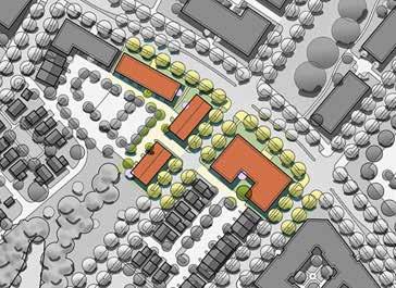
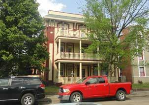
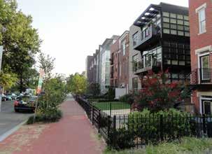
85 Live-work units Courtyard housing Small apartment buildings MARC Rail Communities Sector Plan Planning Board Draft December


86 d. South of the railroad tracks, protect the historic and residential character of the area (Sites GB, GC, GD and GE). Encourage the reuse of historic structures to support the character of the area and strengthen the viability of the commercial district and MARC station area. Permit appropriately scaled infill development, consistent with recommendations in the Preserve section of this plan. Maintain the setbacks of older structures to support the historic character and development patterns of Germantown. Follow guidance for landscapes, signage, lighting, paths and street furniture as provided in the Preserve section, to ensure compatibility with the character of the historic district. e. Create an attractive public realm that enhances the character of the Germantown MARC area. Carefully design infill development to reflect the character of the historic areas and promote a fine-scaled, walkable environment. Frame streetscapes and public spaces with buildings. Locate new buildings to define the street edges and create active street fronts. Orient the primary building facades and entrances to face public streets and improve pedestrian accessibility. Incorporate the setbacks, scale and architectural elements of historic buildings into any new infill or redevelopment in the existing residential area. Provide height transitions from existing buildings to new development. Screen parking areas with buildings, low site walls and landscaping. Figure 52 - Conceptual Plans of Buildings Placed along Streets and Arranged Around Open Spaces (Illustratives) 76 MARC Rail Communities Sector Plan Planning Board Draft December 2018
87 2. Promote compact, walkable and context-sensitive development that supports the Boyds and Germantown MARC Stations, while protecting and reinforcing each community s scale, historic character and sense of place. Areawide Recommendations a. Ensure context-sensitive new development that is compatible with the scale, placement and architectural styles of existing buildings that are part of the historic fabric in the Boyds and Germantown communities: Maintain the historic setback patterns and scale for any new buildings. Adaptively reuse buildings that add character and maintain the integrity of the historic district. Locate additions to existing buildings on the sides or rear of the structures, so as not to damage the original architectural character of the buildings. Encourage architectural styles that complement existing buildings in the historic district. Use materials for new buildings and additions that are similar to those found in the Boyds and Germantown communities. Incorporate traditional architectural elements into new buildings, such as porches, stoops, bay windows and dormer windows. Design signage as an integral part of a building facade to complement the architecture and not obstruct key architectural features. Boyds Recommendations a. Maintain the exceptional rustic road character of White Ground and Hoyles Mill Roads, including existing building setback patterns with the placement of buildings close to the road (Site BD). b. Use appropriate paving materials for sidewalks and shared-use paths that complement the architecture of the Boyds Historic District (Sites BC and BE). c. In the commercial area along Barnesville Road, incorporate pedestrian-scaled lighting, street furniture and wayfinding signage that complements the character of the historic district while helping to activate public space (Sites BC and BE). Germantown Recommendations a. Ensure that new building heights and transitions between building heights are context-sensitive and compatible with the Germantown Historic District and other existing structures that shape the character of the community. Transition the buildings along Waters Waters Rd GG Germantown Rd Liberty Mill Rd GH GF HISTORIC DISTRICT Mateny Hill Rd Walter Johnson Rd GI GL GK Crystal Rock Dr GJ Wisteria Dr Middlebrook Rd GA Great Seneca Hwy 0 1,000 ft Figure 53 - Germantown Reference Key with Historic District MARC Rail Communities Sector Plan Planning Board Draft December
88 Road, Germantown Road, Walter Johnson Road and Wisteria Drive from higher to lower heights to ensure compatibility with the Germantown Historic District: Building heights may reach 60 feet immediately north of the historic district on the existing MARC station surface parking lots (Site GF). Allow building heights up to 60 feet east of Walter Johnson Road and south of Wisteria Drive (Site GH). Allow building heights up to 60 feet along Waters Road (Site GG). The western side of the Rolling Hills apartments property should have heights limited to 60 feet, due to its proximity to the Germantown Historic District, but may step up to 90 feet near Great Seneca Highway. Allow building heights to step up to 75 feet on Germantown Road between Bowman Mill Road and Wisteria Drive (Site GH). Allow building heights up to 75 feet along north of Wisteria Drive between Walter Johnson Road and Crystal Rock Drive (Site GL) Allow building heights up to 100 feet along Germantown Road north of Wisteria Drive and along Middlebrook Road (Site GK). b. Foster a walkable and active environment along streets within the Germantown plan area by establishing short blocks and a building line along property frontage to regulate the relationship of buildings to streets: Create a network of new, local streets with 250 to 350- foot long, walkable blocks, as recommended in the 2009 Germantown Employment Area Sector Plan. Provide publiclyaccessible mid-block crossings where block lengths are greater. Incorporate a mix of land uses along the street. Locate buildings close to the street right-of-way, with parking located to the side or rear of buildings and structures. 118 Waters Rd 60 height limit Germantown Rd Dawson Farm Rd 75 height limit Historic District 60 height limit 100 height limit 75 height limit 90 height limit Great Seneca Hwy Figure 54 - Proposed Germantown Building Heights Seneca Valley High School 70 in height Middlebrook Rd Wisteria Dr c. Design streets and streetscapes to promote a comfortable walking environment that fosters a distinct sense of place: Design streets with wide sidewalks and tree-lined planting panels that provide shade for pedestrians. Reduce crossing distances with bulb-outs or neck downs to increase safety for pedestrians ,000 ft 78 MARC Rail Communities Sector Plan Planning Board Draft December 2018
89 Establish Walter Johnson Road as a neighborhood main street and primary pedestrian link to the MARC station by incorporating wide sidewalks, neighborhood-serving uses, a variety of public open spaces and outdoor gathering spaces and seating. Transform Middlebrook Road into a tree-lined, four-lane boulevard, creating a pedestrian- and bicyclist-friendly environment that slows traffic, enhances safety and increases the tree canopy. Accommodate on-street parking along Walter Johnson Road, Crystal Rock Drive and Wisteria Drive, and along new interior streets to expand parking opportunities; provide a landscaped buffer for pedestrians. Establish a walkable public realm with street-oriented buildings and gathering spaces at sidewalks within the Urban Road Code Area by locating public utilities within conduit in rights-of-ways and avoiding public utility easement setbacks. d. Incorporate interpretive signage or art that celebrates the late Walter Johnson, his history as a pitcher with the Washington Senators baseball team, a Montgomery County commissioner and a local dairy farmer. 3. Establish a network of attractive parks, public spaces, trails and community gathering places in the Boyds and Germantown communities to provide space for recreation and social interaction, while enhancing the beauty and environmental quality of both communities. Areawide Recommendations a. Encourage the use of the facilities at the MARC stations for community-supporting activities during non-marc (evening, weekend and holiday) hours. Such uses will activate the station areas throughout the week and establish a greater sense of place. Partner with community and civic groups in programming these facilities with activities. b. Provide residential uses with publicly accessible spaces to promote gathering and improve connectivity. Public spaces, such as civic greens, neighborhood greens and throughblock connections, as defined in the Montgomery County Planning Department s 2017 Recreation Guidelines, are recommended. Boyds Recommendations a. Promote the shared use of the repurposed and renovated Hoyle's Mill, proposed plaza area and expanded commuter parking in the Boyds MARC Station area. This revitalization will enable a variety of community-serving activities that will activate the station area during non-commuting hours and support a range of events and community gatherings (Site BE). Potential uses include a small farmers market, trailheads, heritage days activities, cultural celebrations, public or civic association meetings, and similar activities. b. Design and construct a small open space with attractive landscaping and paving in the commercial area along Barnesville Road that may serve as a gathering space for residents, visitors and commuters (Site BE). c. Develop the unimproved Boyds Local Park site to serve as a community green space, gathering place and gateway to the Boyds Historic District (Site BD). Conduct test borings to identify the extent and depth of the diabase geology on the site. The results will help determine the types and locations of potential facility options. Design new park facilities with active recreation, open green space and parking, in consultation with the community. Design a parking lot within Boyds Local Park to provide overflow commuter parking for an enhanced MARC station area. MARC Rail Communities Sector Plan Planning Board Draft December

90 Provide a safe pedestrian connection to the MARC station area from the shared parking lot. Provide a primary park entrance from Clopper Road and a secondary entrance, if needed, from White Ground Road. Coordinate the design of the park entrance with the replacement Clarksburg Road underpass. Retain and incorporate the existing Hoyles Mill Natural Surface trail to provide a connection between the Black Hill Regional Park to the north and the Hoyles Mill Conservation Park to the south. Germantown Recommendations a. Establish a network of public open spaces to serve as outdoor gathering places and community social spaces. These spaces may vary in size and contain facilities ranging from landscaping, seating and picnic areas. Private spaces with elements such as play equipment, sculpture or ornamental gardens and dog park facilities may supplement publicly accessible open spaces. station area as a community gathering place serving Germantown residents (Sites GC and GF). f. Confirm recommendations from the 2009 Germantown Employment Area Sector Plan. Relocate the Germantown Square Urban Park to a site by the Sidney Kramer Upcounty Regional Services Center at Middlebrook Road and Century Boulevard. Enhance the existing railroad pond stormwater facility between the Germantown Post Office and the railroad tracks with native plantings. Develop a nature-oriented trail for passive recreation connected to adjoining sidewalks. Provide seating areas for viewing wildlife (Site GI). Enhance the south end of Walter Johnson Road, the north end of Liberty Mill Road and the pedestrian bridge connecting them as an urban open space celebrating old Route 118 with seating, landscaping and public art (Sites GC and GF). Provide public amenities that enhance identity and character, integrating historic, cultural and nature-oriented themes. b. Create continuous open spaces for gathering and recreation. Maintain the mature Walter Johnson oaks growing on the area s diabase geology to the extent feasible. Following soil boring tests, consider designing required green spaces around diabase areas. c. Establish a community focal point and gathering place near the northeast corner of Wisteria Drive and Walter Johnson Road. d. Encourage the incorporation of private, landscaped open space as part of courtyard buildings, cottage-style housing and other housing types organized around central common areas. e. Continue to promote compatible shared uses of the Germantown MARC Station facilities, such as the coffee shop in the Germantown MARC Station and the seasonal Germantown Flea Market, that support MARC ridership, activate the station area during non- MARC hours (evenings, weekends and holidays) and establish the Example of a community gathering space 80 MARC Rail Communities Sector Plan Planning Board Draft December 2018
91 4. Provide high quality schools and community facilities throughout the Boyds and Germantown areas. Areawide Recommendations a. Support ongoing improvements to schools in the four school clusters located in the Boyds and Germantown areas. These clusters are Seneca Valley, Northwest, Clarksburg and Poolesville. Clarksburg Village Elementary School Site #2 is funded for construction and anticipated to open in September Montgomery County Public Schools has recommended planning for Clarksburg Elementary School #9. This new school would be constructed at the Cabin Branch site located at the intersection of Clarksburg and Byrne Park Roads and is scheduled to be completed in September 2022 (pending planning and construction funding approval). Seneca Valley High School is being rebuilt onsite and is anticipated to open in 2020, with an increased capacity of 2,581 students. A boundary realignment will ensure that this rebuilt school will help alleviate enrollment burdens at Northwest and Clarksburg High Schools. This boundary study will evaluate the utilizations and articulation patterns of the middle schools in the three clusters. b. Retain the future school sites in Germantown and Clarksburg. There are two future elementary school sites in Germantown. One is on Schaeffer Road south of Clopper Road, called Northwest Elementary School #8; and the second is Waring Station Elementary School in the Seneca Valley cluster. In the Clarksburg cluster where growth continues, one additional master planned elementary school site is located at the intersection of West Old Baltimore Road and Seneca Ayr Drive (the property is currently owned by the Maryland-National Capital Park and Planning Commission). During the site selection process for Clarksburg Elementary School #9, two additional properties were identified that could be considered for future elementary school sites. These include an M-NCPPC-owned property located at the intersection of Skylark and Piedmont Roads and a Washington Suburban Sanitary Commission (WSSC) owned property located at the intersection of Route 27 and Brink Road. c. Support needed school modernizations and expansions for area students. In the Northwest Cluster, Montgomery County Public Schools has recommended planning for additions at Ronald McNair Elementary School and Clopper Mill Elementary School. The McNair expansion is expected to add capacity for an additional 135 students and is scheduled for completion in September 2022 (pending planning and construction funding approval). The scope and timeline for the Clopper Mill expansion are not yet known. In the Seneca Valley Cluster, Montgomery County Public Schools has recommended planning for an addition at Lake Seneca Elementary School, however the scope and timeline for the expansion are not yet known. In the Clarksburg Cluster, Montgomery County Public Schools has recommended planning for a major capital project at Neelsville Middle School to address various building systems and programmatic needs. The scope (including the extent to which it would add student capacity) and timeline for the project are not yet known. In the Poolesville Cluster, Montgomery County Public Schools has recommended planning for a major capital project at Poolesville High School to address various building systems and programmatic needs. The scope (including the extent to which it would add student capacity) and timeline for the project are not yet known. d. Explore alternative solutions to school capacity challenges, such as repurposing vacant spaces or underutilized buildings for educational purposes. MARC Rail Communities Sector Plan Planning Board Draft December
92 Schools in the Planning Area: Schools in four school clusters, Seneca Valley, Northwest, Clarksburg and Poolesville, with 16 individual schools, serve the families in the MARC Rail Communities Plan area. It is estimated that the plan will increase residential capacity by 1,450 households in the Germantown area. If fully realized, this capacity will add approximately 310 more elementary students, 120 more middle school students and 160 more high school students to the area across the Clarksburg, Northwest and Seneca Valley Clusters. Due to septic system constraints, future residential growth in the Boyds area will be limited and is not anticipated to impact area schools. As a result, the plan does not anticipate that it will have any impact on the Poolesville Cluster. The Montgomery County Subdivision Staging Policy rates each school as open conditionally or in moratorium, depending on six-year enrollment projections. At this time, the Lake Seneca Elementary School service area is in moratorium with no planned capacity solutions. Until there is adequate school capacity, residential projects within the Lake Seneca Elementary School service area cannot move forward. School utilization is tested annually. Additional details may be found in the annual school test, published on the Planning Department s website at montgomeryplanning.org. The Germantown Library opened in 2007 on Century Boulevard within the Germantown Town Center. Other nearby library branches that serve the area are in Gaithersburg, Quince Orchard and Poolesville. The upcounty area is served by the Sidney Kramer Upcounty Regional Services Center, which opened in 2000 and is the largest of Montgomery County s five regional services centers. It is located at the intersection of Germantown and Middlebrook Roads. The Germantown Community Recreation Center and Germantown Outdoor Pool are located on Kingsview Road, and provide recreation facilities for residents of both Boyds and Germantown. 5. Apply zoning to support the land use recommendations. Areawide Recommendations a. Apply zoning to achieve the land uses, heights and densities recommended by the Plan. b. Replace zones retained from the previous zoning ordinance with the nearest equivalent zone, as required by the zoning code during the Sectional Map Amendment (SMA) process for this plan. Boyds Recommendations e. Multiple public facilities are located within and surrounding the planning area; the need for additional facilities is not anticipated. Two US post offices are located in the Plan area. The Germantown Post Office is located on Wisteria Drive and the Boyds Post Office is located on Barnesville Road. The 5th District Police Station serves both Boyds and Germantown. The station is located on Aircraft Drive. The Germantown/Kingsview Fire Station, Number 22, on Germantown Road at Clopper Road, opened in 2009 and serves both south Germantown and Boyds. a. Provide zoning that supports the historic and rural community character of Boyds, and is consistent with densities in locations outside of the water and sewer envelopes. Retain the existing residential and agricultural zones, Residential-200 (R-200), Residential Estate-1 (RE-1), Residential Estate-2 (RE-2) and Rural (R). Replace the Town Sector (T-S) zone on parkland surrounding Little Seneca Lake with the RE-2 and Rural zones. Replace the Neighborhood Retail zone (NR 0.75, H 45) with Commercial Residential Neighborhood zone (CRN 0.25, C 0.25, 82 MARC Rail Communities Sector Plan Planning Board Draft December 2018
93 R 0.25, H 45) to allow flexibility of uses in historic structures and reflect densities that can be reached using well and septic facilities. Replace the Moderate Industrial zone (IM 2.5, H 50) with the Moderate Industrial zone (IM 0.25, H 50) to reflect densities that can be achieved using well and septic facilities. b. Allow reduced setbacks and additional septic capacity across property lines, where the patterns are compatible and replicate existing development, consistent with the Historic Area Work Permit and County permitting processes. Germantown Recommendations a. Apply zoning that supports the historic and residential areas of Germantown and allows compatible redevelopment. South of the Railroad Tracks Retain the residential zones, Residential-200 (R-200) and Residential-60 (R-60) (Sites GB and GC). Replace the Residential Townhouse zones, Residential Townhouse 6.0 (RT-6.0) and RT-12.5 zones with the Townhouse Low Density (TLD) and Townhouse Medium Density (TMD) zones, respectively (Sites GB, GC and GD). Retain the Commercial Residential Neighborhood zone (CRN 0.5, C 0.5, R 0.25, H 35). North of the Railroad Tracks Retain the Residential-200 zone (R-200) on the Seneca Valley High School area (Site GA). Replace the Commercial Residential zone (CR 2.0, C 1.5, R 1.5, H 40T) with the Commercial Residential Neighborhood zone (CRN 0.75, C 0.25, R 0.75, H 60) to reflect the recommended land uses, heights and densities in this plan (Site GF). Replace the Commercial Residential Town zone (CRT 1.0, C 0.5, R 0.75, H 65T) with (CRT 0.75, C 0.75, R 0.75, H 60) to allow for existing land uses and provide a future mix of uses (Site GG). Replace the Commercial Residential zone (CR 0.5, C 0.25, R 0.25, H 60T) with the Commercial Residential zone (CR 1.0, C 0.75, R 0.75, H 70) to allow a mix of uses along Walter Johnson Road in proximity to the MARC station (Site GH). Replace the Commercial Residential zones (CR 1.0, C 0.5, R0.75, H 60 T; CR 0.75, C 0.25, R 0.5, H 60T; and CR 1.0, C 0.25, R 1.0, H 60T) with a single, consistent Commercial Residential zone (CR 0.75, C 0.5, R 0.75, H 60) to reflect the Plan's recommendations (Site GI). Replace the Commercial Residential Town zone (CRT 1.5, R 0.5, R 1.0, H 90T) with the Commercial Residential zone (CR 1.0, C 0.25, R 0.75, H 90) to support the Plan's recommendations (Site GJ). Replace the Commercial Residential zone (CR 2.0, C 1.75, R 0.75, H 100T) with the Commercial Residential zone (CR 1.25, C 0.75, R 0.75, H 75 to support the Plan recommendations (Site GL). Replace the Commercial Residential zones (CR 2.0, C 1.0, R 1.5 H 100T) and (CR 2.0, C 1.75, R 0.75, H 100T) with the Commercial Residential zone (CR 1.25, C 0.75, R 0.75, H 100) to support the Plan recommendations and the concept of building heights increasing toward the Germantown Town Center (Site GK). b. Confirm the Germantown Transit Mixed-Use Overlay Zone to prioritize the use of building lot terminations (BLTs) in optional method developments. Site Constraints: During the development process, property owners should review the recommendations in the Plan. Site constraints found during this process will affect the layout of a particular proposed development. MARC Rail Communities Sector Plan Planning Board Draft December
94 Figure 55 - Existing Boyds Zoning R Rural RE-1 RE-2 R-200 NR Residential Estate, 1 Acre Residential Estate, 2 Acre One-Family Detached, Large Lot Neighborhood Retail NR 0.75, H 45 Barnesville Rd Ganley Rd Clarksburg Rd Little Seneca Lake T-S Town Sector IM Moderate Industrial IM 2.5, H 50 Boyds MARC Boundary Clopper Rd White Ground Rd Hoyles Mill Rd 0 1,200 ft 84 MARC Rail Communities Sector Plan Planning Board Draft December 2018
95 Figure 56 - Proposed Boyds Zoning R Rural Barnesville Rd BC Ganley Rd BA Clarksburg Rd Li le Seneca Lake RE-1 RE-2 R-200 CRN IM Residential Estate, 1 Acre Residential Estate, 2 Acres One-Family Detached, Large Lot Commercial Residential Neighborhood CRN 0.25, C 0.25, R 0.25, H 45 Moderate Industrial IM 0.25, H 50 BB Boyds MARC Boundary BE BG BD BF Clopper Rd White Ground Rd Hoyles Mill Rd 0 1,200 ft MARC Rail Communities Sector Plan Planning Board Draft December
96 Figure 57 - Existing Germantown Zoning R-200 R-60 RT-6.0 RT-12.5 CRN One-Family Detached, Large Lot One-Family Detached, Residential Residential, Townhouse Residential, Townhouse Commercial Residential Neighborhood 1 CRN 0.5, C 0.5, R 0.25, H 35 CRT Commercial Residential Town 2 CRT 1.0, C 0.5, R 0.75, H 65T 3 CRT 1.5, C 0.5, R 1.0, H 90T CR Commercial Residential 4 CR 2.0, C 1.5, R 1.5, H 40T 5 CR 0.5, C 0.25, R 0.25, H 60T 6 CR 2.0, C 1.0, R 1.5, H 100T Waterford Hills Blvd 1 Germantown Rd Waters Rd Liberty Mill Rd Mateny Hill Rd Walter Johnson Rd Crystal Rock Dr Wisteria Drive Middlebrook Rd 7 CR 2.0, C 1.75, R 0.75, H 100T 8 CR 1.0, C 0.5, R 0.75, H 60T 9 CR 0.75, C 0.25, R 0.5, H 60T Dawson Farm Road 10 CR 1.0, C 0.25, R 1.0, H 60T 11 CR 2.0, C 1.5, R 1.5, H 40T Germantown Transit Mixed-Use Overlay Germantown MARC Boundary Great Seneca Hwy ft 86 MARC Rail Communities Sector Plan Planning Board Draft December 2018
97 Figure 58 - Proposed Germantown Zoning R-200 One-Family Detached, Large Lot Waterford Hills Blvd Waters Rd GG GH Walter Johnson Rd GL GK Crystal Rock Dr Middlebrook Rd R-60 TLD TMD CRN One-Family Detached, Residential Townhouse Low Density Townhouse Medium Density Commercial Residential Neighborhood GE CRN 0.5, C 0.5, R 0.25, H 35 GE Germantown Rd GB Liberty Mill Rd GC GF Mateny Hill Rd GD GI GJ Wisteria Drive GA GF CRN 0.75, C 0.25, R 0.75, H 60 CRT Commercial Residential Town GG CRT 0.75, C 0.75, R 0.75, H 60 CR Commercial Residential GH CR 1.0, C 0.75, R 0.75, H 75 GI CR 0.75, C 0.5, R 0.75, H 60 GJ CR 1.0, C 0.25, R 0.75, H 90 GK CR 1.25, C 0.75, R 0.75, H 100 Dawson Farm Road GL CR 1.25, C 0.75, R 0.75, H 75 Great Seneca Hwy Germantown Transit Mixed-Use Overlay Germantown MARC Boundary ft MARC Rail Communities Sector Plan Planning Board Draft December

98 C. Preserve Vision: Preserve, celebrate and interpret the shared history and unique historic resources of the Boyds and Germantown rail communities to foster distinctive community identities and strong sense of place. Position both station areas for the future by sensitively adapting and enhancing historic structures for continued use, while ensuring that future development and transportation improvements are compatible with, and maintain the integrity of, the historic settings. 1. Retain, restore and rehabilitate historic resources that contribute to the historic fabric of both communities. Areawide Recommendations Incorporate ramps and wheelchair lifts to meet accessibility standards. Provide sufficient agency budgets for maintenance of the pedestrian underpass. c. Rehabilitate historic Winderbourne to the extent feasible (Site BB). If the Historic Preservation Commission determines that rehabilitation of the building is infeasible and the property becomes free of built structures, support public acquisition of the property and its use as a park, with appropriate commemoration of the historic building. If the site becomes public land, place an interpretive sign in the landscape to commemorate the history of the original building and site. a. Evaluate 20th-century resources within the Boyds and Germantown planning areas for designation in the Montgomery County Master Plan for Historic Resources. b. Reconfirm the existing Master Plan for Historic Preservation designations in Boyds and Germantown, as described in Appendix E. Boyds Recommendations a. Protect and enhance the Boyds Historic District while preserving and rehabilitating individual historic sites within the district (Sites BA, BC, BD and BE). b. Retain the 1927 pedestrian underpass under the railroad where White Ground Road once crossed the tracks (Sites BD and BE). Improve lighting and flood prevention measures, such as by adding weather-protective canopies over the entrances to the pedestrian underpass. Boyds Negro School 88 MARC Rail Communities Sector Plan Planning Board Draft December 2018

99 d. Encourage retention of existing homes east of the existing underpass, between the railroad tracks and Clopper Road, due to their contributing character to the Boyds area (Site BG). Although these properties are not designated by the County as historic, their architecture, location and scale serve as a transition to the Boyds Historic District. Modernization of these houses or parking expansions should be located behind the existing buildings to retain the original architectural character of the dwellings, as seen from the street. e. In the future, evaluate the Edward U. Taylor Science Materials Center for designation as an historic site to commemorate its role as one of the few modern schools constructed in Montgomery County for black students during the era of segregation (Site BD). Germantown Recommendations a. Protect and enhance the Germantown Historic District, the residential neighborhood south of the railroad tracks and the historic resources north and south of the railroad tracks (Sites GC, GE, GF, GG and GH). b. Maintain the entire Madeline V. Waters House (MP 19/13-1) historic site (Sites GF and GG) and all rights-of-way, including Germantown Road and Wisteria Drive within its designated environmental setting as follows: The portion of the site north of Germantown Road, within the Wisteria Drive right-of-way, must maintain the existing linear park with benches, lighting, stone wall, pavers and commemorative monument/signage. Street signage should be added for Waters House Avenue. The portion of the site south of Germantown Road must maintain the historic row of trees (including replanting as necessary) and existing commemorative signage within a publicly accessible, grassy open space. For both north and south portions of the site, commemorative signage must be erected along the street frontage of every parcel and the existing environmental setting, and these requirements will remain in place even if there is parcel assemblage, resubdivision or redevelopment of the site. Edward U. Taylor Science Materials Center MARC Rail Communities Sector Plan Planning Board Draft December
100 2. Encourage the compatible reuse of structures that lend historic character to the Boyds and Germantown communities, and maintain the rail communities historic integrity while revitalizing and enhancing MARC station areas. Areawide Recommendations a. Allow appropriate flexibility in the reuse of historic structures to ensure their continued viability and maximize opportunities for active uses that will serve the community and MARC commuters. Boyds Recommendations a. Adaptively reuse the historic Hoyle's Mill within the Boyds Historic District and explore reuse of the nearby barn building outside of the historic district to establish a focal point for the Boyds commercial area (Site BE) (See Appendix A for MCDOT's Concept Study): Assess all of the structures on the site with the historic Hoyle's Mill, Parcels 155 and 157, for National Register eligibility prior to any changes, additions and/or removals. Commemorate historical uses on the parcel, including, among others, the location of the former station house, which is no longer standing. Redesign the site, to support the reuse of the mill building. Coordinate all changes to the mill with the Montgomery County Historic Preservation Commission. Design alterations to the repurposed mill and any other buildings including landscaping, lighting and walkways in a manner that is sensitive to the surrounding historic district. Design landscaping, lighting, signage, paths and structures that support and are sensitive to the character of the historic district. Explore relocation and reuse of the Quonset hut and the barn building, if possible. Germantown Recommendations a. Renovate and promote the continued adaptive reuse of existing structures, such as the former Germantown Presbyterian Church building and many of the older homes south of the tracks, which contribute to the historic fabric of Germantown. 3. Ensure that future development and supporting elements are compatible with existing historic districts and resources. Areawide Recommendations a. Ensure that land uses and public spaces are compatible with historic resources. Incorporate relevant historic themes to these land uses and public spaces (Native American, agricultural, railroad, industrial and African American) wherever possible. b. Maintain and restore the historic setback pattern and scale of historic structures where infill development occurs. c. Encourage the use of architectural styles and paving materials that complement the architecture of existing buildings within the Boyds and Germantown historic districts. d. Locate parking to the backs or sides of buildings. Screen parking areas with low walls or plantings to minimize their visual impact on historic resources. e. Apply Americans with Disabilities Act (ADA) accessibility requirements and stormwater management facilities compatible with each historic district in order to maintain the historic integrity of the Boyds and Germantown communities. 90 MARC Rail Communities Sector Plan Planning Board Draft December 2018
101 f. Design all sidewalks, necessary lighting and street furniture within historic districts to complement and enhance the historic character of each district. Boyds Recommendations a. Refer to the Strategies for Maintaining Historic Character in Vision of Boyds: A Long-Range Preservation Plan, a 1992 study conducted by M-NCPPC, for additional guidance (see Appendix F). Germantown Recommendations a. Design parking structures to be sensitive to and complementary in scale and materials to nearby historic resources. Discourage the construction of garages within the historic district to preserve the area s historic and visual character (Site GF, GG and GH). Limit the heights of any new buildings north of the historic district adjacent to the Pumphrey-Mateny House to 60 feet to reduce their visual impact on historic resources and character (Site GF). 4. Celebrate, interpret and highlight Boyds and Germantown historic resources through programming, interpretive elements and improvements to wayfinding. Areawide Recommendations Follow applicable public art guidelines and adopt the National Park Service standards for signage. Boyds Recommendations a. Develop appropriate interpretive signage commemorating historic Boyds, the history of the B&O Railroad and the former Baldwindesigned train station in Boyds (Site BE). b. Support the Boyds Historical Society s ongoing activities at the 1895 Boyds Negro School to highlight this important example of an educational facility for rural black children in Montgomery County. The historical society purchased and restored this school in 1980 (Site BD). Germantown Recommendations a. Celebrate Germantown s history and historic resources through local events, walking tours, signage and artwork. b. Support the design and installation of wayfinding, signage and public art to create connections and interpretive narratives linking area destinations and historic resources. Potential locations should include, but are not limited to, Wisteria Drive, Walter Johnson Road and Liberty Mill Road (Sites GF, GH and GI). a. Support activities within the plan area that enliven and highlight historic resources. Consult local historical societies and civic groups for ideas about programs. b. Encourage history-themed signage and art in the Boyds and Germantown plan areas that integrate and highlight historic resources within each community. Prioritize these elements as public amenities. Identify funding sources and coordinate content in consultation with Historic Preservation staff and local historical societies. MARC Rail Communities Sector Plan Planning Board Draft December
102 D. Sustain Vision: Foster environmental stewardship by protecting the area s sensitive natural assets, enhancing the tree canopy and water resources, and adapting the built environment to sustainably manage stormwater runoff. Acknowledge and celebrate the area s distinctive environmental setting, while thoughtfully managing infrastructure and utilities to support community character and public health. Barnesville Rd Ganley Rd Clarksburg Rd Li le Seneca Lake 1. Preserve and enhance the area s natural assets and tree canopy, including designated Best Natural Areas. 117 Areawide Recommendations a. Preserve scarce existing forested land within the Plan area and implement additional forest planting near sensitive water resources to maintain protected and connected stream valleys. b. Expand the tree canopy by planting new trees along streets and designing surface parking lots to include significant tree canopy. This vegetation will better manage stormwater and mitigate the heat island effect within the densely built environment. Boyds Recommendation White G round Rd Hoyles Mill Rd 0 1,600 ft Clopper Rd a. Expand forest planting within the naturalized buffer of the tributary to Little Seneca Creek that meanders along the western side of the Taylor Science Materials Center, to protect stream banks and improve water quality (Site BD). b. Confirm the extensive farmland and forest conservation easements in and around the Boyds MARC Station area. Figure 59 - Parks' Best Natural Areas and Land Under Easements Parks' Best Natural Areas Agricultural Easements Forest Conservation Easements 92 MARC Rail Communities Sector Plan Planning Board Draft December 2018


103 Germantown Recommendations a. Promote the planting of shade trees along streets and within parking lots. The goal is to shade at least one-third of the parking lots and one-fourth of the roads in the Germantown community. Implement design standards for tree planting that ensure a full canopy at maturity, such as providing adequate soil volume and water during summer months. b. Minimize the extent of grading and removal of existing vegetation as part of environmental site design of infill development, while promoting the preservation of existing trees and woodland buffers along property boundaries and between uses. c. Maintain the stand of mature Walter Johnson oaks on the properties north of the intersection of Crystal Rock and Wisteria Drives to the extent feasible (Sites GK and GL). Existing vacant land with the Walter Johnson oaks Diabase geology in Germantown MARC Rail Communities Sector Plan Planning Board Draft December


104 2. Protect and restore the area s water resources. Areawide Recommendations a. Limit and reduce the extent of impervious surfaces in the Plan area. Incorporate areas for rain gardens, planters and other sustainable stormwater management features to capture and filter stormwater before it enters water bodies and the public sewer system. Incorporate landscape planting strips, shade trees and stormwater management features within parking lots to limit the heat island effect and collect stormwater runoff. Boyds Recommendations a. Maintain and enhance forested buffers to protect sensitive water resources and water quality, including near Little Seneca Lake and along Little Seneca Creek and its tributaries. b. Limit impervious surfaces on properties near Little Seneca Lake, Little Seneca Creek and tributary streams to protect water quality. c. If redevelopment occurs on properties near sensitive water resources, such as Little Seneca Lake and the Little Seneca Creek watershed, require appropriate environmental site design best practices, incorporate open spaces as required by zoning and, as appropriate, dedicate stream buffers. Germantown Recommendation a. Retrofit or upgrade older regional stormwater ponds throughout the Plan area as redevelopment occurs to provide water quality treatment as well as quantity control according to current standards. The dams for two existing ponds are classified as high hazard dams because of their potential impacts on the railroad line in the event of a failure. The railroad pond is at or above capacity and additional stormwater treatment facilities are needed in this area to support future development. Shaded sidewalk Tree canopy in parking lot Planted area on sidewalk for stormwater management 94 MARC Rail Communities Sector Plan Planning Board Draft December 2018
master plan of highways bus rapid transit amendment
 Scope of Work master plan of highways bus rapid transit amendment September 2011 Montgomery County Planning Department M-NCPPC MontgomeryPlanning.org 1 Scope of Work master plan of highways bus rapid transit
Town Center. Block 5 Existing multifamily residential units are expected to remain.
 Area Guidelines Germantown s districts should be developed as distinct communities with unique features that are supported through the guidelines. The guidelines not only help distinguish these districts
S C O P E O F W O R K A P R I L
 white flint 2 sector plan S C O P E O F W O R K A P R I L 2 0 1 2 MONTGOMERY COUNTY PLANNING DEPARTMENT M-NCPPC MontgomeryPlanning.org 1 white flint 2 sector plan Scope of Work abstract This scope of work
master plan of highways
 scope of work master plan of highways abstract This Scope of Work outlines the tasks and goals of updating the Master Plan of Highways, as well as the outreach that will be used in the planning process.
Gold Line Bus Rapid Transit Transit Oriented Development (BRTOD) Helmo Station Area Plan
 Helmo Station Area Plan") Appendix F Gold Line Bus Rapid Transit Transit Oriented Development (BRTOD) Helmo Station Area Plan Introduction and Purpose of the Plan The Gold Line Bus Rapid Transit facility is an eleven-mile dedicated
Appendix F Gold Line Bus Rapid Transit Transit Oriented Development (BRTOD) Helmo Station Area Plan Introduction and Purpose of the Plan The Gold Line Bus Rapid Transit facility is an eleven-mile dedicated
Seneca Meadows. Block 4 Locate office, technology, and medical development adjacent to I Screen views of garage structures from I-270.
 Seneca Meadows Seneca Meadows has an industrial park in its southern end and a mixed-use employment area planned for the north end. The district benefits from extensive I-270 visibility, stream valley
Chapter IV: Development Pattern
 Chapter IV: Development Pattern Introduction The 2002 Prince George s County Approved General Plan designates three growth policy tiers Developed, Developing, and Rural as well as three center designations
INTRODUCTION PLANNING HISTORY
 INTRODUCTION The Upper Rock Creek Master Plan Area lies in the east central part of Montgomery County. The Master Plan Area is adjacent to the City of Rockville to the south, the Olney Planning Area to
Status Report: MD 355 Project
 Status Report: MD 355 Project OCTOBER 2006 M-NCPPC MONTGOMERY COUNTY PLANNING DEPARTMENT Summary of Community Comments, and break to the Results of the MD 355 Participation Session Brookside Gardens -
Midtown Greenway Land Use and Development Plan Executive Summary
 Midtown Greenway Land Use and Development Plan Executive Summary Introduction The Midtown Greenway Land Use and Development Plan sets policy direction for land use and development in the Midtown Greenway
CHAPTER 1. Ms. Guajardo s Class - Central Elementary CH 1 1
 INTRODUCTION CHAPTER 1 Ms. Guajardo s Class - Central Elementary CH 1 1 1.1 SETTING South Centre City is a linear corridor south of Downtown Escondido paralleling Centre City Parkway and South Escondido
The transportation system in a community is an
 7 TRANSPORTATION The transportation system in a community is an important factor contributing to the quality of life of the residents. Without a sound transportation system to bring both goods and patrons
burtonsville commercial crossroads neighborhood planning study
 Sector Plan burtonsville commercial crossroads neighborhood planning study Scope of Work Abstract This Scope of Work examines community issues in the Burtonsville Crossroads at US 29 and MD 198, outlines
CONTENTS BACKGROUND AND CONTEXT... 3 Plan Area... 3 History... 3 Previous Planning Initiatives... 4 PLANNING FRAMEWORK... 5 Countywide Transit
 CONTENTS BACKGROUND AND CONTEXT... 3 Plan Area... 3 History... 3 Previous Planning Initiatives... 4 PLANNING FRAMEWORK... 5 Countywide Transit Corridors Functional Master Plan... 5 Veirs Mill Road Bus
Proposed Comprehensive Plan Strategies DRAFT for discussion June 28, 2017
 Proposed Comprehensive Plan Strategies DRAFT for discussion June 28, 2017 Land Use Rural Areas Refine the Farm and Forest area (FF) Update FF boundaries to account for existing lots less than five acres
THE 355/270 CORRIDOR:
 THE 355/270 CORRIDOR: Strategic Ideas for Sustaining a Livable Work Place Project Summary ACCESS LIFE DESIGN HEALTH WORK Montgomery County Planning Department The Maryland-National Capital Park and Planning
BROOKHILL NEIGHBORHOOD MODEL ZONING MAP AMENDMENT PREFACE TO APPLICATION
 BROOKHILL NEIGHBORHOOD MODEL ZONING MAP AMENDMENT PREFACE TO APPLICATION June 15, 2015 Revised: August 1, 2016 I. VISION Brookhill is a proposed community based upon the principles of Albemarle County
Preliminary Recommendations Tk Takoma/Langley Crossroads Sector Plan
 Preliminary Recommendations Tk Takoma/Langley Crossroads Sector Plan Vision is to achieve a Transit Oriented, pedestrian friendly Community that Celebrates and builds upon the cultural Diversity of the
Chapter 1.0 Introduction
 Chapter 1.0 Introduction 1.1 Background The North Metro commuter rail line is part of the RTD FasTracks regional transit system expansion program to build more than 100 miles of rail transit throughout
Town Center (part of the Comprehensive Plan)
") Town Center (part of the Comprehensive Plan) Mercer Island Town Center Looking North (2014) In 1994, a year-long process culminated in a set of design guidelines and code requirements for the Town Center
Town Center (part of the Comprehensive Plan) Mercer Island Town Center Looking North (2014) In 1994, a year-long process culminated in a set of design guidelines and code requirements for the Town Center
Planning Board Briefing
 Planning Board Briefing Why Now? The Sector Plan Implementation Chapter States: Before Stage 1 begins, the following must occur: Approval of the Sectional Map Amendment. Approval of the Greater Lyttonsville
DRAFT Civic Center Station Area Plan. Executive Summary
 DRAFT Civic Center Station Area Plan Executive Summary This project is funded in part through the Metropolitan Transportation Commission s Station Area Planning Program. The preparation of this report
ARLINGTON COUNTY, VIRGINIA
 ARLINGTON COUNTY, VIRGINIA County Board Agenda Item Meeting October 15, 2005 DATE: September 28, 2005 SUBJECT: Request to Advertise the adoption of the 2005 Clarendon Sector Plan C. M. RECOMMENDATION:
STATEMENT OF JUSTIFICATION CLARKSBURG PREMIUM OUTLETS AT CABIN BRANCH NORTH DISTRICT, PHASE
 STATEMENT OF JUSTIFICATION CLARKSBURG PREMIUM OUTLETS AT CABIN BRANCH NORTH DISTRICT, PHASE 1 Southwest Corner of Clarksburg Road and Interstate-270 Clarksburg, Maryland Application for Site Plan #820140160
Westwood Shopping Center Sketch Plan, Plan # February 23, 2017 Item # 9
 Westwood Shopping Center Sketch Plan, Plan # 320170010 February 23, 2017 Item # 9 Westwood II Site 64,111 s.f. Manor Care site: vacant two story building HOC-Westwood Towers, 15 story tower To be considered
City of Farmington. Downtown Plan. Amendment to the 1998 Master Plan Adopted October 11, 2004
 City of Farmington Amendment to the 1998 Master Plan Adopted October 11, 2004 Introduction Planning Background 1 Scope and Components of the Plan Amendment 2 Concept Introduction 3 Plan Concepts 3 Conceptual
Public input has been an important part of the plan development process.
 Lakewood s Comprehensive Plan recognizes that transportation helps shape the community, and that the way the community provides for the safe and efficient movement of people affects the character of the
LAND USE AMENDMENT DOWNTOWN COMMERCIAL CORE (WARD 7) MACLEOD TRAIL SE AND 5 AVENUE SE BYLAW 254D2017
 MACLEOD TRAIL SE AND 5 AVENUE SE BYLAW 254D2017") Page 1 of 10 EXECUTIVE SUMMARY This Land Use Amendment application seeks to redesignate a full downtown block (currently the YWCA site) from a Direct Control based on the CM-2 District (Land Use Bylaw
Page 1 of 10 EXECUTIVE SUMMARY This Land Use Amendment application seeks to redesignate a full downtown block (currently the YWCA site) from a Direct Control based on the CM-2 District (Land Use Bylaw
gaithersburg west master plan The Life Sciences Center
 July2009 appendix gaithersburg west master plan The Life Sciences Center Montgomery County Planning Department The Maryland-National Capital Park and Planning Commission MontgomeryPlanning.org Appendix
CHAPTER 7: Transportation, Mobility and Circulation
 AGLE AREA COMMUNITY Plan CHAPTER 7 CHAPTER 7: Transportation, Mobility and Circulation Transportation, Mobility and Circulation The purpose of the Transportation, Mobility and Circulation Chapter is to
Hockessin Community Redevelopment Plan
 Hockessin Community Redevelopment Plan 3.1 Introduction The Community Redevelopment Plan for the Village of Hockessin is the result of the people s vision for a distinct village center that serves as the
Sector Plan Briefing October 16, 2014
 Sector Plan Briefing October 16, 2014 M-NCPPC Greater Lyttonsville Team Robert Kronenberg, Chief Marc DeOcampo, Supervisor Erin Banks, Project Manager Melissa Williams, Outreach Matt Folden, Transportation
FUTURE LAND USE ELEMENT
 FUTURE LAND USE ELEMENT GOAL I: To create and sustain a great place to live, play, and prosper Objective 1: The City of Ocala shall incorporate the principles and strategies of the Ocala 2035 Vision into
7Page 91 CLEMMONS COMMUNITY COMPASS 7 COMMUNITY CHARACTER
 7 Community Character The beauty of Clemmons won t necessarily be a reflection of our past, but our future. This quote from Comprehensive Plan Steering Committee member Wayne Dodson captures the essence
Land Use. Hardware Street Vendor Mixed-Use
 Land Use Definition Land Use is the way a piece of real estate is utilized. Existing, proposed, and adopted land uses all play a role in the planning process. Once a land use plan is adopted, the next
Introduction. Chapter 1. Purpose of the Comprehensive Plan Plan Organization Planning Process & Community Input 1-1
 Chapter 1 Introduction Lakewood 2025: Moving Forward Together Purpose of the Comprehensive Plan Plan Organization Planning Process & Community Input 1-1 Purpose of the Comprehensive Plan The Comprehensive
Chapter 2: Vision, Goals and Strategies
 Chapter 2: Vision, Goals and Lake Elmo Today & Tomorrow Comprehensive Plan 2040 2 VISION, GOALS & STRATEGIES - DRAFT 4-6-2018 INTRODUCTION Comprehensive Plan Purpose Perhapse the most important objective
Mississippi Skyway Preliminary Engineering Report
 EXECUTIVE SUMMARY Mississippi Skyway Preliminary Engineering Report CITY OF RAMSEY, MINNESOTA DECEMBER 2014 City of RAMSEY EXECUTIVE SUMMARY Project Need and Intent The Mississippi Skyway pedestrian bridge
Corridor Vision. 1Pursue Minnehaha-Hiawatha Community Works Project. Mission of Hennepin County Community Works Program
 1Pursue Minnehaha-Hiawatha Community Works Project Minnehaha-Hiawatha Community Works is a project within the Hennepin Community Works (HCW) program. The mission of the HCW program is to enhance how the
Table of Contents. Elm Avenue Improvement Plan City of Waco, Texas. Introduction 1. Existing Context 1 Figure 1 2.
 Table of Contents Introduction 1 Existing Context 1 Figure 1 2 Plan Guidelines 3 Future Urban Form 4 The West-End 4 Main Street 6 The East-End 7 Figure 2 9 Public Improvement Recommendations 7 General
ELMVALE ACRES SHOPPING CENTRE MASTER PLAN
 ELMVALE ACRES SHOPPING CENTRE MASTER PLAN Contents 1.0 INTRODUCTION... 2 2.0 LOCATION... 2 3.0 EXISTING CONTEXT... 2 4.0 VISION & GUIDING PRINCIPLES... 2 5.0 LAND USE AND BUILT FORM... 4 5.1 St. Laurent
Living in Albemarle County s Urban Places
 Living in Albemarle County s Urban Places ALBEMARLE COUNTY, VIRGINIA A Closer Look at Albemarle s Approach to Managing Growth and Creating Quality Urban Environments www.albemarle.org Page 2 Living in
greenprint midtown SUSTAINABILITY ACTION PLAN 2012
 greenprint midtown SUSTAINABILITY ACTION PLAN 2012 MIDTOWN ALLIANCE SOUTHFACE ENERGY INSTITUTE RENAISSANCE PLANNING GROUP SUSTAINABLE ATLANTA PERKINS+WILL 2 GREENPRINT MIDTOWN 1. Introduction Sustainability
John M. Fleming Managing Director, Planning and City Planner. Old East Village Dundas Street Corridor Secondary Plan Draft Terms of Reference
 Report to Planning and Environment Committee To: From: Subject: Chair and Members Planning & Environment Committee John M. Fleming Managing Director, Planning and City Planner Old East Village Dundas Street
1.0 Introduction. Purpose and Basis for Updating the TMP. Introduction 1
 1.0 Introduction The Town of Castle Rock is situated between the metropolitan areas of Denver and Colorado Springs, amidst a unique terrain of rolling hills, mesas, ravines, and waterways. Like many Front
13 THORNHILL YONGE STREET STUDY IMPLEMENTATION CITY OF VAUGHAN OPA 669 AND TOWN OF MARKHAM OPA 154
 13 THORNHILL YONGE STREET STUDY IMPLEMENTATION CITY OF VAUGHAN OPA 669 AND TOWN OF MARKHAM OPA 154 The Planning and Economic Development Committee recommends the adoption of the recommendations contained
DRAFT. October Wheaton. Design Guidelines
 October 2011 DRAFT Wheaton Design Guidelines 2 Draft - Design Guidelines - Wheaton Sector Plan Contents 04 Section 1: Introduction 06 Section 2: Context 08 Section 3: Design Guidelines 09 Goal 1: Create
Establish a network of streetscaped vehicle and pedestrian routes that connect within and outside the Plan area.
 This Plan s urban design goals are to create an urban scale, walkable community with connections to transit, parks, and services and with amenities and facilities for residents and employees. The 1992
Germantown Forward Status Report to the Planning Board M NCPPC
 Germantown Forward Status Report to the Planning Board Germantown Forward March 27, 2008 What s new? CCT alignment Capital Improvement Program Agency partners Water quality conditions Sustainability Design
Status Update (2006 vs. Now) Citizen s Advisory Committee February Plan for Prosperity
 Citizen s Advisory Committee February Plan for Prosperity") Status Update (2006 vs. Now) Citizen s Advisory Committee February 2018 Plan for Prosperity 2000 2017 2000 2017 Gardnerville Population 6,000 5,760 5746 5,500 5,000 5,067 5,550 5,165 5,394 5,412 5,250
Status Update (2006 vs. Now) Citizen s Advisory Committee February 2018 Plan for Prosperity 2000 2017 2000 2017 Gardnerville Population 6,000 5,760 5746 5,500 5,000 5,067 5,550 5,165 5,394 5,412 5,250
Tyvola & Archdale Transit Station Area Plan. May 15, 2008
 Tyvola & Archdale Transit Station Area Plan First Public Meeting May 15, 2008 Presentation Outline 1. Purpose and Process 2. Station Area Overview 3. Plan Recommendations Vision Land Use Transportation
Windsor Locks Transit-Oriented Development Planning Grant Request. Project Background
 Windsor Locks Transit-Oriented Development Planning Grant Request Project Background Downtown Windsor Locks runs along Main Street in the vicinity of the intersection of Routes 159 and 140. The current
MONTGOMERY COUNTY PLANNING DEPARTMENT THE MARYLAND-NATIONAL CAPITAL PARK AND PLANNING COMMISSION
 MONTGOMERY COUNTY PLANNING DEPARTMENT THE MARYLAND-NATIONAL CAPITAL PARK AND PLANNING COMMISSION MCPB Item No. 6 Date: 7.22.13 Bethesda Purple Line Station Minor Master Plan Amendment, Scope of Work Elza
Downtown Huntersville in 2030
 Downtown Huntersville in 2030 In 2030 Huntersville s Downtown will be a thriving, mixed-use town center with a variety of housing types (single-family, townhomes, live-work, and apartments), retail establishments,
Prosperity Hucks Area Plan. Transportation and Planning Committee May 11, 2015
 Prosperity Hucks Area Plan Transportation and Planning Committee May 11, 2015 Presentation Outline 1. Background and Location 2. Community Dialog Process 3. Activity Center Recommendations 4. Wedge Recommendations
Planning Districts INTRODUCTION
 INTRODUCTION To facilitate detailed examination of development prospects for all areas of the community, Delano has been divided into 14 planning districts. The location of these planning districts is
3. Endorse the LRT vision in transforming Surrey into Connected-Complete-Livable communities, and more specifically, the official vision statement:
 CORPORATE REPORT NO: R038 COUNCIL DATE: February 20, 2017 REGULAR COUNCIL TO: Mayor & Council DATE: February 16, 2017 FROM: General Manager, Engineering FILE: 8740-01 SUBJECT: Surrey Light Rail Transit
CITY OF COLWICH COMPREHENSIVE PLAN LAND USE LAND USE 1
 LAND USE LAND USE 1 WHAT YOU WILL FIND IN THIS CHAPTER: Discussion of today s conditions and tomorrow s projections Discussion of challenges and opportunities Discussion of the environmental quality goals,
Implementation Guide Comprehensive Plan City of Allen
 Implementation Guide 2030 Comprehensive Plan City of Allen DRAFT 2015 Implementation Guide Allen 2030 Comprehensive Plan INTRODUCTION The Comprehensive Plan serves as a guide for the growth and development
Citizen Comment Staff Response Staff Recommended Revision Planning Committee
 Citizen Comment Staff Response Staff Recommended Revision Planning Committee Area No. 1: Owner desires retail land uses. Area No. 1a: Owner of two small parcels adjacent to Area No. 1 desires retail land
The GATEWAYS Sub Area Master Plan. City of Walker
 The GATEWAYS Sub Area Master Plan City of Walker Introduction: The Walker City Commission and Planning Commission decided in 2011 to create a sub-area master plan for the Remembrance Road and Wilson Avenue
Secrest Short Cut and Monroe Expressway Small Area Plan AUGUST 29, 2018
 Secrest Short Cut and Monroe Expressway Small Area Plan AUGUST 29, 2018 Background and Process Monroe Expressway will be open by the end of 2018 Union County and Indian Trail identified a need to revisit
Northwest Rail Corridor and US 36 BRT Development Oriented Transit Analysis 4.4 STATION AREA FINDINGS
 4.4 STATION AREA FINDINGS Each station is different, and each one requires a separate set of recommendations based on the vision for the site. This section outlines an initial TOD strategy and recommendations
EXHIBIT A. Tax Increment Reinvestment Zone No. 1 (Town Center) First Amended Project Plan 1
 First Amended Project Plan 1") EXHIBIT A Tax Increment Reinvestment Zone No. 1 (Town Center) First Amended Project Plan 1 1 As amended by Resolution No. 2008-02-001(TR1R) of the Tax Increment Reinvestment Zone No.1, and approved to
EXHIBIT A Tax Increment Reinvestment Zone No. 1 (Town Center) First Amended Project Plan 1 1 As amended by Resolution No. 2008-02-001(TR1R) of the Tax Increment Reinvestment Zone No.1, and approved to
Obey Creek July 17, Vicinity Map. Concept Plan Submittal. No
 15/501 Fordham Blvd. 15/501 By-Pass To Downtown Chapel Hill Vicinity Map 0 1000 2000 FT Arlen Park DR. Bennett Road Mt. Carmel Church Rd. Southern Village Parkside Circle Market St. 15/501 Founder's Ridge
CHAPTER 3 VISION, GOALS, & PLANNING PRINCIPLES. City of Greensburg Comprehensive Plan. Introduction. Vision Statement. Growth Management Goals.
 CHAPTER 3 VISION, GOALS, & PLANNING PRINCIPLES Introduction The Greensburg Comprehensive Plan is intended as a working community document. A combination of long and short-term goals, this document is intended
Queensborough Eastern Neighbourhood Node. Community Open House
 Queensborough Eastern Community Open House The Vision The Queensborough Eastern will become the heart of eastern Queensborough. Through a sensitive mix of viable commercial and residential areas, the neighbourhood
POCKET COMMUNITY PLAN
 POCKET COMMUNITY PLAN Part Three : COMMUNITY PLAN AREAS AND SPECIAL STUDY AREAS CONTENTS Community Location... 3-P-3 Community Vision... 3-P-4 Community Profile... 3-P-4 Community Issues... 3-P-6 Land
Ten Mile Creek Planning Area
 PLANNING AREA POLICIES TEN MILE CREEK Ten Mile Creek Planning Area Location and Context The Ten Mile Creek Planning Area ( Ten Mile Creek area ) is located south of the current Boise AOCI, generally south
Plan Overview. Manhattan Area 2035 Reflections and Progress. Chapter 1: Introduction. Background
 Plan Overview The Manhattan Urban Area Comprehensive Plan (the Comprehensive Plan) is a joint planning initiative of the City of Manhattan, Pottawatomie County, and Riley County. The 2014 Comprehensive
Subregion 4 Central Avenue-Metro Blue Line Corridor Transit-Oriented Development (TOD) Implementation Project. Community Meeting April 27, 2011
 Implementation Project. Community Meeting April 27, 2011") Subregion 4 Central Avenue-Metro Blue Line Corridor Transit-Oriented Development (TOD) Implementation Project Community Meeting April 27, 2011 Overview Introduction to Subregion 4 TOD Implementation Program
Subregion 4 Central Avenue-Metro Blue Line Corridor Transit-Oriented Development (TOD) Implementation Project Community Meeting April 27, 2011 Overview Introduction to Subregion 4 TOD Implementation Program
CHAPTER 7: VISION AND ACTION STATEMENTS. Noble 2025 Vision Statement
 CHAPTER 7: VISION AND ACTION STATEMENTS This chapter presents the vision, policy and action statements that transform the comprehensive planning study, an analysis of Noble s past, future trends and community
Kenilworth Avenue and Town of Cheverly Industrial Study Briefing
 Kenilworth Avenue and Town of Cheverly Industrial Study Briefing The Maryland-National Capital Park and Planning Commission Prince George s County Planning Department www.pgplanning.org Vanasse Hangen
Executive Summary. NY 7 / NY 2 Corridor
 Executive Summary NY 7 / NY 2 Corridor Transportation and Land Use Study December 2005 Prepared for: Town of Colonie Capital District Transportation Committee Prepared by: Introduction: Land use decisions
PART 1. Background to the Study. Avenue Study. The Danforth
 The Danforth 1.1/ Study Purpose & Key Municipal Goals 1.2/ The Local Advisory Committee 1.3/ The Project Team 1.4/ Study Process/Summary of Method 1.5/ Summary of Consultation 1.1 Study Purpose and Key
2.7 ac park. TOTAL 5,403 DU 1,297,900 sf 1,105,450 sf 3.87 ac 5,563 DU 1,121,200 sf 1,105,450 sf 3.87 ac
 PLAN AMENDMENT 2013-I-B1: SEVEN CORNERS SPECIAL STUDY Summary of Pre-staffing Comments Planner: Bernard Suchicital bsuchi@fairfaxcounty.gov (703) 324-1254 Background On October 29, 2013, the Board of Supervisors
APPENDIX D: Visual and Aesthetic Conditions for NCCU Station Refinement. Durham-Orange Light Rail Transit Project
 APPENDIX D: Visual and Aesthetic Conditions for NCCU Station Refinement Durham-Orange Light Rail Transit Project October 2016 1. Introduction The Combined FEIS/ROD summarizes the effects of the D-O LRT
Urban Planning and Land Use
 Urban Planning and Land Use 701 North 7 th Street, Room 423 Phone: (913) 573-5750 Kansas City, Kansas 66101 Fax: (913) 573-5796 Email: planninginfo@wycokck.org www.wycokck.org/planning To: From: City Planning
Long Branch Sector Plan
 June 2012 Long Branch is one of Montgomery County s most affordable, older communities and has served as a gateway community, especially for newly arriving immigrants, since the 1960s. Many within this
I. Introduction. Prior Approvals
 Statement of Justification First National Bank 19790 Crystal Rock Drive, Germantown, Maryland Application for Site Plan and Limited Preliminary Plan Amendment I. Introduction DPH Architecture, for First
38 Queen s University Campus Master Plan Part 1
 38 Queen s University Campus Master Plan Part 1 46 The Campus at the City Scale Chapter 4 The Campus at the City Scale 39 Queen s is an urban University centrally located in Kingston. Decisions made by
ANDERSON PROPERTY SITE ANALYSIS
 ANDERSON PROPERTY SITE ANALYSIS Introduction The Montgomery County Department of Transportation (MCDOT) initiated a feasibility study in the fall of 2012 to evaluate the need for transit service expansion
VILLAGE OF BOLTON HERITAGE CONSERVATION DISTRICT PLAN
 Page 1 1. INTRODUCTION AND BACKGROUND 1.1 THE PROJECT VILLAGE OF BOLTON HERITAGE CONSERVATION DISTRICT PLAN TERMS OF REFERENCE The Town of Caledon (Town) is a large, predominantly rural municipality with
STAFF SUMMARY FOR S17-02 SPECIAL USE PERMIT APPLICATION
 APPLICATION SUMMARY Case Number: S17-02 Request: STAFF SUMMARY FOR S17-02 SPECIAL USE PERMIT APPLICATION SUP application in order to develop a convenience food store. Applicant: Property Owner(s): Cindee
Port Credit Local Advisory Panel October 20 th Meeting
 Port Credit Local Advisory Panel October 20 th Meeting Focus Of This Evening s Meeting: 1. Hurontario Main Street Higher Order Transit Study 2. Port Credit Mobility Hub & GO Station Parking Structure Study
V. Vision and Guiding Principles
 V. Vision and Guiding Principles The Master Plan for the Powers Ferry Corridor seeks a foundation in the desires of the community. At times, various elements of the community offered opposing viewpoints,
The Illinois Department of Transportation and Lake County Division of Transportation. Route 173, including the Millburn Bypass
 The Illinois Department of Transportation and Lake County Division of Transportation welcome you to this Public Hearing for U.S. Route 45 from Illinois Route 132 to Illinois Route 173, including the Millburn
Public may provide comments on the GDP within the next two weeks (December 24)
") 25/70 General Development Plan (GDP) Public Meeting Wednesday, December 10, 2014 6:00 8:00 P.M. District 1 Police Station Community Room 1311 W 46th Ave, Denver, CO 80211 Council Woman Montero: This particular
25/70 General Development Plan (GDP) Public Meeting Wednesday, December 10, 2014 6:00 8:00 P.M. District 1 Police Station Community Room 1311 W 46th Ave, Denver, CO 80211 Council Woman Montero: This particular
Tyvola & Archdale Transit Station Area Plan. June 5, 2008
 Tyvola & Archdale Transit Station Area Plan Second Public Meeting June 5, 2008 Presentation Outline 1. Purpose and Process 2. Station Area Overview 3. Plan Recommendations 4. Comments Received and Proposed
URBAN DESIGN BRIEF. 2136&2148 Trafalgar Road. Town of Oakville
 URBAN DESIGN BRIEF 2136&2148 Trafalgar Road Town of Oakville Prepared By: METROPOLITAN CONSULTING INC For 2500674 Ontario Inc November 2016 TABLE OF CONTENTS Page No. 1.0 Introduction/Description of Subject
b r a n c h av e n u e tr a n s it co r r i d o r r e vita lization pl a n a m o d el fo r s u b u r ban retro fit
 b r a n c h av e n u e tr a n s it co r r i d o r r e vita lization pl a n a m o d el fo r s u b u r ban retro fit P R I N C E G EO RG E S CO U NT Y, M D ADO PTED 0 p R O J E C T C AT E G O R Y : U R B
SAN RAFAEL GENERAL PLAN 2040 INTRODUCTION AND OVERVIEW
 SAN RAFAEL GENERAL PLAN 2040 INTRODUCTION AND OVERVIEW Steering Committee Presentation February 14, 2018 Purpose of General Plan Guide land use and development decisions Coordinate transportation, infrastructure,
Page 1 of 19 URBAN DESIGN FRAMEWORK FOR BOLTON STREET WATERFORD
 Page 1 of 19 URBAN DESIGN FRAMEWORK FOR BOLTON STREET WATERFORD 1.0 Introduction: The relocation of the City Council stores and depot from Bolton Street creates an exciting opportunity for development
A citizen s guide to the. Comprehensive Plan. City of Lakeville, Minnesota 1
 A citizen s guide to the Comprehensive Plan 2008 City of Lakeville, Minnesota 1 Introduction The City of Lakeville completed an update of its Comprehensive Plan in 2008. A comprehensive plan is a tool
white flint 2 sector plan
 white flint 2 sector plan Public Hearing Draft NOVEMBER 2016 MONTGOMERY COUNTY PLANNING DEPARTMENT M-NCPPC MontgomeryPlanning.org White Flint 2 Sector Plan Public Hearing Draft Abstract This Plan contains
3. VISION AND GOALS. Vision Statement. Goals, Objectives and Policies
 Vision Statement Queen Creek s interconnected network of parks, trails, open spaces and recreation opportunities provide safe and diverse activities and programs that sustain its unique, small town, equestrian
Beatties Ford Road & Mt. Holly-Huntersville Road Small Area Plan
 Beatties Ford Road & Mt. Holly-Huntersville Road Small Area Plan Town of Huntersville October 2005 Town of Huntersville Planning Department 101 Huntersville Concord Road Post Office Box 664 Huntersville,
III. Design Principles
 III. Design Principles The design of Bay Meadows Phase II has been guided by a series of Urban Design Principles. These principles, informed by consultant site analysis, City staff recommendations, and
Public Open House. Overview of the Downtown Plan Official Plan Amendment April 23, 2018
 Public Open House Overview of the Downtown Plan Official Plan Amendment April 23, 2018 1 A 25-Year Plan for Downtown To ensure growth contributes positively to Toronto s Downtown as a great place to live,
Outline Plan in Belvedere (Ward 9) at Street SE, LOC (OP)
 at Street SE, LOC (OP)") 2018 October 04 Page 1 of 12 EXECUTIVE SUMMARY This outline plan application was submitted by B&A Planning Group on 2016 July 15, on behalf of Tristar Communities Inc. for 50.14 hectares (123.89 acres)
2018 October 04 Page 1 of 12 EXECUTIVE SUMMARY This outline plan application was submitted by B&A Planning Group on 2016 July 15, on behalf of Tristar Communities Inc. for 50.14 hectares (123.89 acres)