Cottenham Civil Parish. Neighbourhood Development Plan to 2031
|
|
|
- Leona West
- 5 years ago
- Views:
Transcription

1 Cottenham Civil Parish Neighbourhood Development Plan 2017 to 2031 Cottenham Parish Council Pre-submission Draft Plan v3.1a October 2017 In 2031 Cottenham will still be an attractive safe rural village, proud of its character and retaining its sense of community with improved amenities and facilities, reduced impact of traffic, especially in the centre of the village, and having more affordable housing for the next generation of residents. Page 1
2 Foreword Cottenham has a long, varied history with much of its character deriving from the collection of architecturally-significant homes and buildings along the High Street, five arterial minor roads that link it to neighbouring villages and the wider undeveloped fenland within which it lies. To be sustainable, a village should provide local homes and employment opportunities for current and future generations, with adequate education, health, leisure and recreation facilities within easy walking distance for most residents and good public transport links. Cottenham s radial expansion threatens that sustainability. Some residents may be able to walk or cycle into the village centre, but many will be tempted to stay at home or use the car and, once mobile, travel to other villages or cities rather than support Cottenham s amenities. This Neighbourhood Development Plan includes measures to reverse some of the effects of that unsustainable arterial expansion by adding new homes, employment opportunities and improved facilities and services within easy walking distance of the village centre, while mitigating some of the traffic issues. Why should Cottenham have a Neighbourhood Development Plan? Without some development, Cottenham risks becoming an expensive dormitory town for rapidly-growing Cambridge, with through-traffic increasing as commuters move to lowerpriced housing elsewhere. Too much, or inappropriate, development will destroy the character of the village forever. A Neighbourhood Development Plan, alongside South Cambridgeshire s Local Plan, can guide where and how much development should be allowed. What s next? Recent planning permissions have materially changed the draft plan requiring further consultation. Comments on this draft will inform the Submission version to be published by South Cambridgeshire District Council for comment and independent examination. If successfully examined, the Referendum version of the plan will be prepared and become part of local planning law if a majority vote for it in the subsequent referendum. Thanks to: Working Party Neighbourhood Plan Ambassadors who have provided a useful sounding board Survey participants who provided much of the evidence base on which the plan is based Cottenham Parish Council for supporting the project Village Design Group, without which, Cottenham would have succumbed to piecemeal development Chair, Cottenham Parish Council Page 2
3 Contents Foreword... 2 Why should Cottenham have a Neighbourhood Development Plan?... 2 What s next?... 2 Thanks to: Context... 7 National and local planning policy... 7 The parish and village... 7 Preparation of the plan Format of the plan Surveys, Key issues, Vision & Objectives Neighbourhood Plan survey (NP survey) Vision Plan survey (VP survey) Key issues Vision Objectives Policies Site-specific Policies Site Reference Conserving the village character Policy C/1: Landscape character Policy C/2: Village character Policy C/3: Heritage character Policy C/4: Open Spaces &Tree conservation Improving Amenities & Facilities Figure 10: Amenities & Facilities Policy Map Policy AF/1: Medical & Day Centre Policy BF/4: Co-op site (X6 in Figure 29) Policy BF/2: Durman Stearn site (X4 in Figure 29) Policy BF/3: Watson s Yard / Fire Station site (X5 in Figure 29) Policy AF/2: Multi-purpose Village Hall Policy BF/1: King George V Field & Recreation Ground (X2 in Figure 29) Policy AF/3: Nursery Policy BF/1: King George V Field & Recreation Ground (X2 in Figure 29) Policy AF/4: Primary School Policy GF/1: Field (X3 in figure 29) Page 3
4 Policy GF/7: Field () Policy AF/5: Sports facilities Policy GF/2: Field (larger of the two sites in Figure 9) Policy GF/3: Allotments site (X1 in Figure 29) Policy AF/6: Play facilities Policy AF/7: Supermarket Policy BF/3: Watson s Yard / Fire Station site (X5 in Figure 29) Policy BF/4: Co-op site (X6 in Figure 29) Policy BF/2: Durman Stearn site (X4 in Figure 29) Policy AF/8: Extension of burial grounds Policy GF/4: Land in the vicinity of All Saints Church (X8 in Figure 29) Providing more housing Policy H/0: Residential framework Policy H/1: New affordable housing development Policy H/2: New housing sites Policy H/3: Cluster design Encouraging Employment Policy E/1: Village employment Policy E/2: Rural employment Policy E/3: new Durman Stearn site Reducing the impact of traffic Policy T/1: Improved off-road routes within Cottenham Policy T/2: Improved access to countryside Policy T/3: Improved public transport Site assessment and allocation Site-specific policies greenfield sites Policy GF/5: Field (X9 in Figure 29) Policy GF/6: Field (X10 in Figure 29) Policy GF/7: Field (X12 in Figure 29) Site-specific policies brownfield sites Policy BF/5: Broad Lane Industrial Estate site (X13 in Figure 29) Policy BF/7: Voland Industrial site (X7 in Figure 29) Action plan (not statutory policies) Appendix A: Glossary Appendix B: Bibliography Appendix C: Cottenham s Scheduled Monuments & Listed Buildings (2017) Page 4
5 Scheduled Monuments Listed Buildings Appendix D: Drainage & Flooding Appendix E: Traffic & Transport Strategy key themes Changing the character and speed of traffic throughout the village Improving pedestrian safety Improving public transport links, especially with Cambridge Improving cycle links Appendix F: Cottenham Community Bus scheme Page 5
6 Figures Figure 1: Cottenham Civil Parish Neighbourhood Area... 8 Figure 2: Table of key issues Figure 3: The NP Golden Thread: Vision > Objectives > Policies Figure 4: Map and Key vistas of and around Cottenham Figure 5: Cottenham centre, including key pedestrian distances Figure 6: Cottenham s variety of architecture Figure 7: Cottenham s Conservation area Figure 8: Some of Cottenham s 66 Grade II Listed Buildings Figure 9: Cottenham s Public Open Spaces Figure 10: Amenities & Facilities Policy Map Figure 11: Reasonable alternative locations for AF/1 Medical Centre Figure 12: Probable location for AF/2 Village Hall Figure 13: Probable location for AF/3 Nursery Figure 14: Possible alternative locations for AF/4 Primary School extension Figure 15: Reasonable alternative locations for AF/6 Sports facilities Figure 16: Reasonable alternative locations for AF/6 Play facilities Figure 17: Reasonable alternative locations for AF/7 Larger supermarket Figure 18: Indicative layout of a 600 plot graveyard Figure 19: Reasonable alternative locations for AF/8 Burial ground extension Figure 20: Proposed extensions to Cottenham s Development Framework * Figure 21: Limits of easy walking distance from village centre Figure 22: Reasonable alternative locations for H/2 housing sites (brownfield) Figure 23: Reasonable* alternative locations for H/2 housing sites (greenfield) Figure 24: Sites that may increase employment (to be completed) Figure 25: Map - Current and proposed off-road links between open spaces Figure 26: Map current and proposed access areas for country walks Figure 27: Reasonable alternatives for community bus routes (illustrative) Figure 28: Map of the Cottenham sites in the 2013 SHLAA Figure 29: Cottenham assessed and potential sites Figure 30: Locations of Scheduled Monuments & Listed Buildings Page 6
7 1 Context National and local planning policy 1.1 This Neighbourhood Development Plan G1 for Cottenham sets out a number of parishspecific planning policies to govern land use and development from 2017 to It has been written to complement rather than duplicate existing national and district policies. 1.3 The National Planning Policy FrameworkB1 sets out national planning policy. The Planning Practice GuidanceB2 provides practical advice on how that policy is to be implemented. 1.4 South Cambridgeshire District Council, as the Local Planning Authority (LPA) G2 is responsible for the production of the emerging Local Plan B3, which sets out strategic planning policies in the District up to In the adopted Local Development Framework B4, the Core StrategyB5 and Development Control Policies B6 set out the immediate context for the preparation of this plan, notably housing requirements, and policies on issues such as employment, open space and infrastructure. 1.5 Cottenham s Village Design Statement B7, originally approved as a Supplementary Planning Document (SPD) G3 in 1994 and updated in 2007 sets out a wide range of advisory material, much of which is now absorbed into local planning criteria. The design principles and some Cottenham-specific policies have been retained or adapted in this plan. The parish and village 1.11 Cottenham, a working fen-edge village with around 6,400 residents in 2017, has developed along what is now the B1049. This road links Wilburton and villages along the A142 and Ely in the north with Histon & Impington, the A14 and Cambridge to the south In addition the busy A10 route, linking Ely with Cambridge, runs parallel to the B The flat fen-edge landscape creates big skies but makes drainage challenging. Much of the parish depends on pumped assistance to drain surface water into the Great Ouse G4 which forms the northern village boundary. Cottenham Lode G5 adds water from villages far to the west and south-west. Climate change will increase this drainage challenge The High Street and five main access roads have around 500 houses, some dating from 1600; many are immediately adjacent to the road. Pavements are often narrow and uneven making movements particularly difficult for the elderly or less mobile The village has three scheduled monuments (part of Car Dyke G6 between Green End and Top Moor, a Romano-British settlement on Bullocks Haste Common G7 and Crowlands Moat G8 ). Cottenham has 66 listed buildings, most of which are in the Conservation Area G9. There are also many well-loved mature native trees, although the size of this collection is slowly reducing, mostly as a result of ageing with inadequate replacement Several hundred houses will be added following permissions granted in Page 7
8 Preparation of the plan 1.21 The Plan has been prepared by a Neighbourhood Plan Working Party comprising parish councillors and a district councillor, with input from planning consultants, an architect, the Planning Policy Team at South Cambridgeshire District Council (SCDC) G10 and many others. The Plan covers the area of Cottenham Civil Parish G11, which was approved as a Neighbourhood Area G12 by SCDC G10 in November Figure 1: Cottenham Civil Parish Neighbourhood Area 1.22 The Local Planning Authority (LPA) for Cottenham is South Cambridgeshire District Council (SCDC) G The area of the plan was designated by SCDC, following public consultation, on 17 th November This document has been prepared as a Pre-Submission draft Plan G13 so residents and others can comment and suggest revisions prior to preparation of a Submission Plan G14 to South Cambridgeshire District Council G10 as the Local Planning Authority G1. Page 8
9 1.25 Five main layers of evidence gathering have been applied: a) Initially, over several public events in mid-2015, the Working Party inviting residents to rank in order of importance a simple set of nine development principles We thought Cottenham residents need: DP1 More affordable homes DP2 More pre-school places DP3 Better medical and day care facilities DP4 More local employment DP5 Improved leisure and recreation facilities DP6 Easier movement into, out from, and around the village We also understand that Cottenham residents do not want to: DP7 Compromise our conservation area and the character of our village core DP8 Increase noise and pollution from our busiest roads DP9 Overload our Primary School. b) The second stage was a more detailed parish-wide survey based on a 17- question survey distributed to every residential address in the parish and returned either by post or online by 973 residents. This survey was focused on likes, dislikes, omissions etc. in Cottenham now and in 15 years time. c) The third stage analysed recent SCDC Planning Officer reports on four speculative planning applications for substantial numbers of residential properties in the parish. d) Vision Plan 2014 e) Occasionally, further specific research has been conducted. Where the source is not a public document the relevant data or text will be included in the text The Working Party has undertaken a number of consultations, including drop-in events, attendance at both the Fen Edge Family Festival and Cottenham Feast Parade, and other local publicity including on the Parish Council s website and Facebook page and in the bimonthly Cottenham Newsletter distributed to every house in the village. The Parish Council is advised of progress every month in the reports pack and at its public meetings. A developing group of over 250 Neighbourhood Plan Ambassadors is advised of progress regularly and, on occasions, asked to comment on specific aspects of the emerging plan. A parish-wide questionnaire-based Neighbourhood Plan Survey B7 was carried out in winter 2015/6. These exercises have produced valuable information and insights which have been used in preparing this Plan The Working Party has discussed with some local landowners the scope for land to be brought forward for development. A preliminary assessment of site suitability was carried out in January 2017 against a series of criteria. The initial findings were used to inform the formal call for sites issued in March / April 2017 and an independent site assessment Page 9
10 was conducted by AECOM G15 in May / July Permission for several hundred additional houses was granted in This draft Plan has been developed from the version (v2.1) B9 prepared for Pre-Submission Consultation G5 and publicity in May Comments on that version and subsequent planning permissions have necessitated a significant revision. This version (v3.0) has been prepared for Pre-Submission Consultation G16 and publicity in September / December Comments received will be detailed in the Consultation Statement G17, which will be prepared to list all the consultations undertaken in preparing the Plan and explain how they have influenced its development. There may be minor modification to the text during the consultation; these amendments will be highlighted and paragraph numbers will be retained for continuity This Plan, like all development plans, will be screened before submission, as a Submission Plan G14, to the Local Planning Authority G1 to assess whether or not it needs a Strategic Environment Assessment G18 in accordance with EU legislation That plan will be subject to formal consultation and examination by a Neighbourhood Plan Examiner G19 for compliance with basic conditions After that a Referendum Plan G20 will be submitted to a referendum in Cottenham and, if approved by a majority of those voting, become part of local planning regulations, alongside National Planning Policy B1 and the SCDC Local Plan B3. Page 10
11 2 Format of the plan 2.1 A map showing the extent of the Neighbourhood Area G12 is included as figure 1 in section 1. This corresponds to the extent of the Cottenham Civil Parish G11 and was approved by SCDC G10 in November Several Key Issues G21 drawn from the findings of the parish-wide Neighbourhood Plan survey B7 are highlighted in section 3 (figure 3). 2.3 Not all of these can be addressed within a Neighbourhood Development Plan G2 which focuses on where and how land is developed. 2.4 A separate Traffic & Transport Strategy G22 (summarised in Appendix E) is being developed to address those concerns with key partners over the coming years. 2.5 A short Vision statement G23 (section 3, figure 3) expresses how Cottenham will appear if the plan s Policies G24 succeed in dealing with the Key Issues G21 and related Objectives G Five Objectives G25 (section 3, figure 3) were identified; four of which are within the scope of a Neighbourhood Development Plan G2 ; one has to be mostly addressed by the Traffic & Transport Strategy G22 (summarised in Appendix E). 2.7 Each of the five Objectives G25 is separately described with related Policies G24 in more detail in sections 4 to The Policies G24 will, alongside National Planning Policy Framework B1 and SCDC s emerging Local Plan B3, once adopted, guide where and how development should be allowed within the Neighbourhood Area G Each Policy G24 has a number of related actions gathered in an Action Plan G26 in section 12. These actions are not statutory planning policies A series of appendices include: Appendix A Glossary of terms used, often with a hyperlink to external documents Appendix B Bibliography of referenced documents with hyperlinks to sources Appendix C Cottenham s Scheduled Monuments & Listed Buildings (2107) Appendix D Drainage & Flooding Appendix E Traffic & Transport Strategy Appendix F Cottenham s Community Bus Scheme Page 11
12 3 Surveys, Key issues, Vision & Objectives Neighbourhood Plan survey (NP survey) 3.1 The Neighbourhood Plan survey (NPS) B7 was conducted by a specialist market research company, Enventure Research G27 in December 2015 January It consisted of a selfcompletion survey to find out how Cottenham residents felt about issues, priorities and ideas as well as evaluate likes, dislikes and satisfaction with living in the village and surrounding area. Each household was posted a copy of the survey (2,628 copies) and a further 1,372 copies of the paper questionnaire were made available in shops, pubs, library etc. In addition it was possible to complete the survey online. In total 973 responses were received. 3.2 Detailed results, providing supporting evidence for aspects of the Neighbourhood Plan have been included in the relevant sections of this report. The top line survey results were: a) The majority of respondents (88%) were very or fairly satisfied with Cottenham as a place to live in at the moment b) In an open-ended question (with no answers listed to prompt them) the most widely mentioned aspect they disliked about living in Cottenham was volume of traffic, HGVs and speeding cars c) Looking to the future, 91% of respondents said that improving the medical services was important and 90% indicated that they felt preserving the character of the village was important d) 69% felt that Cottenham needed more affordable or starter homes (1 2 bedrooms) e) The preference was for small estates of affordable homes to be built on the outskirts of the village rather than houses to be built in large mixed estates Vision Plan survey (VP survey) 3.3 The Vision Plan survey was completed by residents of Cottenham via three means: a) face to face interviews and self-completion surveys at a village festival in June 2014 b) self-completion surveys included in the July/August issue of the Cottenham Newsletter c) online survey replies were received (almost 100 of which completed online). 3.5 The survey s questions related to village facilities, concentrating on leisure amenities. Detailed results, providing supporting evidence for aspects of the Neighbourhood Plan have been included in the relevant sections of this report. The top line results of this survey were: a) There were 4 facilities desired by over half of those sampled: i. Swimming pool (70%) ii. Links to other villages via cycle paths and footpaths (69%) iii. Circular walk/nature trail in wood/countryside (2 miles) (59%) iv. Marked out walking routes of 1 mile / 3 mile / 5miles (57%) b) Another three were chosen by just under half: i. Trail for bike learners/cycling proficiency circuit (48%) ii. Pond and wildlife area (48%) iii. New/refurbished village hall (46%) Page 12
13 Key issues 3.11 National and local planning policies set sustainable development at the heart of the planning system. A sustainable community is one that provides ample opportunity for sociability, equality, personal development, and community participation for the needs of the present without compromising the ability of future generations to their own needs That requires a combination of amenities and facilities that are readily accessible to most residents, preferably by being affordable and within easy walking distance. Cottenham s key issues which can be addressed within the Neighbourhood Plan are: limitations of our facilities and services for: a. education both early years and primary, and b. medical, and c. welfare and day-care, and d. leisure, and e. recreation shortages of homes that are truly affordable for local people Other concerns addressed separately as a Traffic & Transport Strategy, include: limitations of our local road network, especially if developments do not create local employment or increase local provision of services increasing noise and pollution as certain junctions become heavily congested In addition, any improvements must respect the village s character as a rural working village developed around a Conservation Area rich in architectural heritage. Figure 2: Table of key issues 3.13 These issues have been used as the basis of both the: a) Vision G23, Objectives G24 and Policies G25 in the Neighbourhood Development Plan G2 (expanded in the following sections), and the b) Traffic & Transport Strategy G22 (summarised in appendix E). Page 13
14 Vision In 2031 Cottenham will still be an attractive safe rural village, proud of its character and retaining its sense of community with improved amenities and facilities, reduced impact of traffic, especially in the centre of the village, and having more affordable housing for the next generation of residents. Objectives Policies Site-specific Policies Conserving the character of the village as an attractive, safe community C/1 Landscape character C/2 Village character C/3 Heritage character C/4 Open Spaces & Tree conservation Site Reference Improving amenities and facilities AF/1 Medical Centre BF/2 Durman Stearn BF/3 Watson s Yard X4 X5 AF/2 Multi-purpose Village Hall BF/1 King George Field X2 AF/3 Nursery BF/1 King George Field GF/1 X2 X3 AF/4 Infants School GF/1 X3 AF/5 Sports facilities GF/2 GF/3? X1 AF/6 Play facilities? AF/7 Supermarket BF/3 Watson s Yard X5 AF/8 Burial grounds GF/4 X8 Making housing more affordable for the next generation of residents H/0 Village framework H/1 New housing development H/2 New housing sites BF/2 Durman Stearn BF/3 Watson s Yard BF/4 Co-op site GF/5 Long Drove GF/6 Beach Road GF/7 Broad Lane H/3 Cluster design X4 X5 X6 X9 X10 X12 Encouraging employment opportunities Reducing the impact of traffic, especially in the core of the village E/1 Village employment BF/1 BF/2 BF/3 E/2 Rural employment E/3 New Durman Stearn site BF/6 Hay Lane X11 T/1 Improved off-road routes T/2 Improved access to countryside T/3 Improved public transport Appendix G: Traffic & Transport Strategy Figure 3: The NP Golden Thread: Vision > Objectives > Policies Page 14
15 4 Conserving the village character Why? Cottenham s surrounding landscape may be relatively featureless, creating the big sky effect of the fen-edge and fenland. However the character of the landscape can easily be destroyed by relatively modest features in the foreground of such a vista. Policy C/1: Landscape character Developments that conserve the landscape character of Cottenham will be considered if they, and provided they: a) respect key landscape policies (VDS L/x below) within the Cottenham Village Design Statement B8, and b) avoid placing even relatively modest man-made features in the foreground of the big sky / open space fen edge landscape (VDS L/2), especially outward views across open countryside that include a. All Saints church from Cottenham Lode or Long Drove, and b. Haddenham from Cottenham Lode, and c) use partial screens of hedges and native tree species with subdued lighting (VDS L/3) to create wildlife corridors and protect the external view of the village, and d) protect vistas (VDS L/7) that contribute to the character and attractiveness of Cottenham, especially those viewable from publiclyaccessible land; notably All Saints church from parts of Beach Road, Cottenham Lode, Long Drove and Rampton Road; the village edge when viewed from parts of Cottenham Lode, Oakington Road, and Rampton Road C/1.1 C/1/2 C/1.3 Cottenham residents enjoy the surrounding fen-edge countryside with its relatively featureless fen-edge setting of considerable scale and natural beauty punctuated by a distant view of a Church or Water Tower. Relatively modest scale infrastructure (VDS L/2) can have a disproportionate effect in this landscape. This character has not been protected well by recent developments, whose continuous tree screens may hide back gardens of new developments but prevent their residents from enjoying the outward views. It is important to minimise the impact of development in and around the village on the surrounding landscape by appropriate wildlife-friendly gapped hedge and tree screens with minimal lighting. Village Design Statement B7 policy L/7 (VDS L/7) advises protect vistas that contribute to the character and attractiveness of Cottenham. Page 15
 All Saints church")
.")

16 C/1.4 Certain vistas of Cottenham (figure 4) identified in the Cottenham Village Design Statement B8, visible from publicly-accessible land are particularly valued; notably: a) All Saints church from parts of Cottenham Lode (1L), and Long Drove (1R); b) Haddenham from Cottenham Lode (5); c) the village edge viewed from parts of Cottenham Lode or Oakington Road (3). All Saints Church from Cottenham Lode (1L) and Long Drove (1R) 3 Cottenham from Oakington Road 4 Sunset from King George V Field 5 Haddenham from Cottenham Lode Figure 4: Map and Key vistas of and around Cottenham Page 16
17 Why? Cottenham has evolved from its saxon roots mostly through ribbon development along the five arterial links with neighbouring villages followed by in-fill and backland development with an occasional larger cluster. Policy C/2: Village character Planning applications that would enrich the character of the settlement, by: a) respecting the principles embodied in the Cottenham Village Design Statement B7, and b) avoiding clusters of more than 50 houses, and c) retaining a similarity in character buff bricks, dark roofs, muted colours, and d) achieving a variety in architectural detail and finishes, and e) maintaining or creating views to the open countryside from the public realm, and f) maintaining or creating wildlife corridors around and through the village, and g) being within easy walking distance of the village centre to encourage economic and social development while minimising environmental impacts, or h) where beyond easy walking distance of the centre, making provisions to: i. enhance public transport connections with the centre, neighbouring villages and transport hubs, and ii. reduce dependence on cars through segregated cycle-ways and foot paths and accessibility improvements within the village centre such as secure cycle parking, improved pavements and safer crossings. will be considered appropriate. C/2.1 Cottenham, although no longer dependent on agriculture, remains a working village with many High Street properties retaining side access to a deep plot and views to the open countryside. Loss of any remaining views through to the open countryside from within the Conservation Area should be resisted and creation of new vistas encouraged. C/2.2 Village Design Statement B7 policy S/3 (VDS S/3) advises infill developments or lateral extensions to existing buildings should maintain gaps where these provide views out of the village to countryside C/2.3 Financial contributions will be based on the marginal cost of providing additional or extended facilities or services to ensure economic, environmental and social sustainability. C/2.4 Cottenham s development from the original settlement has been: Page 17
18 a) along the arterial roads linking Cottenham with neighbouring villages where development has been individual houses along the road-side or occasional larger groups of houses provide by the Local Authority b) infill between individual properties within the settlement c) backfill where large garden have been divided up to provide individual or small groups d) occasional larger clusters wrapped around the existing settlement but retaining relatively short pedestrian routes into the village centre. C/2.5 C/2.6 Further development, while inevitable, must respect the evolving character of the village. The sustainability of a village centre is linked to its distance from the residential areas. Cottenham s expansion radially has accompanied a gradual denudation of central facilities as parking difficulties, aggravated by loss of facilities, make it progressively more convenient for many outlying residents to drive and park elsewhere for most purposes. a. Residents living within 800 metres easy walking distance of the amenities in the village centre might still be persuaded to walk much of the time, or cycle if there are secure storage places within the central area. Improving the pedestrian experience with better pavements and safer crossing places might extend their stay and help restore facilities. b. Residents beyond 800 metres from the centre will, as distance increases, travel elsewhere, usually by car, for most facilities unless there is adequate parking provision for cars and cycles sufficiently near the village centre or suitable public transport. C/2.7 In Cottenham there are two considerations for the village centre: i. The village core G19 is regarded as the 800 metre long section of the High Street including the most popular destinations for business, leisure and recreation. This area is bounded by the Post Office in the north, the Cottenham Club at the northern dog-leg the Community Centre on the southern dog-leg, and the Chequers and War Memorial in the south (see figure 5). ii. The village centre G19 may logically be regarded as the core supplemented by the spurs along Lambs Lane to the Primary School and the High Street to the Village College plus those along Margett Street and Telegraph Street (including the Dentist, Library and second GP practice) in the Lanes. All these facilities are within around 400 metres of the old Post Office and within around 800 metre walking distance of each other (shown by the blue lines in figure 5). C/2.8 The focus within the centre should be to prioritise safe pedestrian, mobility scooter, pushchair and cycle movement and discourage unnecessary access by car. Page 18

19 C/2.9 Making the centre more accessible to outlying residents requires increased provision of formal and informal car-parking, charging points, secure cycle storage and bus stops at/near the main entry points to the central area to reduce traffic. Through traffic will remain an issue, requiring more zebra crossings, improved pavements and a 20mph limit within the streets of the village centre. Figure 5: Cottenham centre, including key pedestrian distances Page 19


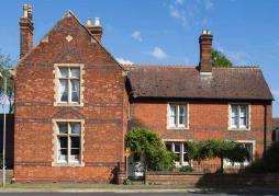
20 C/2.10 Improvements need to be sensitive to the village character as outlined in the Village Design Statement B7, updated in 2007 from the first edition in in It supplemented SCDC s Development Control Policies B6, and still mostly relevant today. C/2.12 When ranking sites for future housing development, shorter distances from the village core/centre are a positive contributor to economic, social and environmental sustainability. C/2.13 CIL G31 or s.106 G30 developer contributions will be sought from all developments in line with prevailing SCDC policies. C/2.14 In addition, CIL G31 or s.106 G30 developer contributions will be sought from all developments outside the outer circle to compensate for the additional measures, including community bus services, necessary to encourage integration and discourage use of unsustainable forms of transport. Figure 6: Cottenham s variety of architecture Page 20
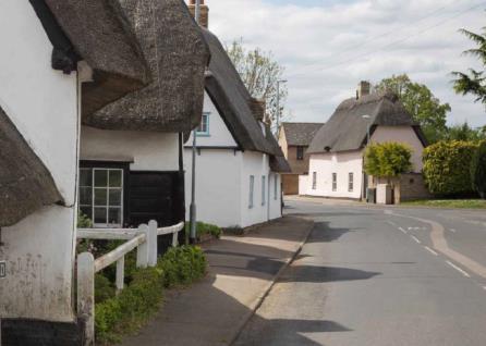
21 Why? Cottenham s heritage embraces Scheduled monuments, Listed Buildings, and an extensive Conservation Area G9. Policy C/3: Heritage character Planning applications that would result in harm to the heritage assets, including Scheduled Monuments, the Listed Buildings or their settings, or the wider Conservation Area G9 or its setting will be considered inappropriate unless outweighed by overriding local public benefits. To prevent further erosion of this character: a) Demolition should only be allowed as a last resort and only after a structural engineer s report b) Extensions should follow the principles laid out in the Village Design Statement B7 C/2.1 The physical character of Cottenham is defined by the Conservation Area G9 and the Lanes that form the heart around which linear expansion has occurred along the arterial roads within the rural parish. Typical features include: a) mid-victorian Cottenham villas, built from buff bricks under a slate roof. Houses are often aligned directly on the pavement edge with no front border or garden, with five large windows arranged symmetrically around an imposing front door and a gated side entrance through to a yard and cascade of outbuildings and, near the village edges, on to open farmland behind. b) Smaller, simpler terraced or semi-detached houses of similar date and materials. c) a substantial number of bespoke properties of various styles and vintage, usually aligned directly on the edge of a pavement which is often narrow. C/2.2 Designated and non-designated heritage assets, including all those listed in Appendix E, enhance local distinctiveness and should be protected in a manner appropriate to their significance. C/2.3 C/2.4 C/2.5 Car Dyke G6 (between Green End and Top Moor), the Romano-British settlement at Bullocks Haste Common G7 and Crowlands Moat G8 (off Broad Lane) are Scheduled Monuments G33. Cottenham s All Saints Church is a Grade I Listed Building G32 Cottenham has 66 Grade II Listed Buildings G32 (listed in Appendix C), mostly located on the High Street and, apart from Tower Mill G34 and the Moreton 1853 Almshouses G35, inside the Conservation Area G9. Page 21

22 Figure 7: Cottenham s Conservation area Page 22


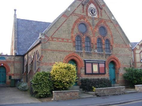
23 Cottenham Club War Memorial Moreton 1853 Almshouses Community Centre Denmark Road c Tower Mill Figure 8: Some of Cottenham s 66 Grade II Listed Buildings Page 23
24 Why? Cottenham has a substantial amount of public open space yet is losing its tree population, partly through ecology and partly due to development. Policy C/4: Open Spaces &Tree conservation Wherever possible, Cottenham s larger public open spaces will be maintained to encourage public use while nurturing Cottenham s collection of trees by: a) seeking Tree Preservation Orders on specific trees visible from the public realm, especially in the Conservation Area G9, and b) encouraging landowners, especially in the Conservation Area G9, community groups and individuals (VDS L/4) to plant native tree species to retain landscape character and to benefit wildlife within the parish. c) Requiring that any permission to remove a tree within the Conservation Area G9 should require a similar tree specimen to be supplied for planting in the public realm or 250 C/4.1 C/4.2 C/4.3 C/4.4 C/4.5 C/4.6 Trees form an important part of Cottenham s heritage. Particular protection should be afforded to: a) Horse Chestnut and Lime trees on the Village Green b) Monkey Puzzle trees within the Dissenters cemetery Additional planting of native tree species around public open spaces G36 will be encouraged to replace the gradual loss over time. The rural parish provides a fen-edge setting of considerable scale and natural beauty. Carefully-sited plantings of native tree species can enhance the landscape but village edge developments need particular care to balance the need for screening of the development when looking inwards against creation and retention of vistas when looking outward. Village Design StatementB7 policy L/4 advises Landowners, community groups and individuals should be encouraged to plant native tree species to retain landscape character and to benefit wildlife within the village. Cottenham has a generous amount of open space (see figure accessible to the public, although more use could be made of each, by encouraging greenway inter-connections, especially alongside footpaths to extend the habitat opportunities for wildlife. a) The Village Green (around 0.6 ha) will be conserved as a central feature of the village to: i. encourage a variety of shared activities for the benefit of all age groups ii. maintain a central green space planted with protected mature indigenous trees Page 24
25 b) The Recreation Ground, including the King George V Playing Field will be conserved as the village s principal hub for formal sports and informal play, recreation and community activity i. broaden the range of sports activities supported ii. interconnect the grounds with other village green spaces using off-road pathways wherever possible iii. nurture the benefits of proximity to the primary school by supporting provision of nursery and out-of-school care c) The Crowlands Moat ( ) will be conserved as an ancient monument and habitat for the established population of Great Crested Newt i. maintain the space, its ditches and trees in accordance with the agreed plan ii. provide informal dog-walking area and informal recreation facilities d) The Broad Lane Recreation Ground (~1.77 ha) and neighbouring Amenity Area will be developed to: i. Increase the stock of native English trees ii. provide a mix of recreational opportunities including play areas and informal recreation space iii. interconnect the grounds with other village green spaces using off-road pathways wherever possible iv. create safe dog-walking opportunities e) Trustees of Cottenham s three Cemeteries G37 will be encouraged to develop them as peaceful Local Green Spaces with new plantings of indigenous trees supplementing the established trees. f) Fen Reeves, Les King Wood and the Tenison Manor tree belts will be conserved and made more accessible to residents. g) The WARG field (~0.6 ha) will be conserved as an open space in the south end of the village with appropriate tree plantings over time h) The Landing Stage, and the Town Ground will continue to be leased to local businesses. Page 25

26 Figure 9: Cottenham s Public Open Spaces Page 26

27 5 Improving Amenities & Facilities 5.1 The NP survey B13 conducted in 2016/2017 highlighted the need for improvements to amenities and facilities in Cottenham. The wish list included a number of capital facilities, not all of which have been assessed as sustainable for a village of Cottenham s size. The principal challenge has been a Swimming Pool which, while desired by many, has high capital cost with no realistic possibility of recovering either its capital or operating costs. 5.2 Additional Community Facilities are required and, to encourage walking between them, will be located within the village centre G29 a low-density cluster connected by safe pedestrian and cycle paths which, where feasible, are segregated from arterial roads carrying heavy traffic. 5.3 To meet the needs, a number of planning policies have been identified: Figure 10: Amenities & Facilities Policy Map Page 27
28 Why? More people in the village will increase demand for medical services at a time when the current facilities are already regarded as inadequate by most residents. Policy AF/1: Medical & Day Centre Support development, on a central village site, of: A. a Medical Centre G38 (including five NHS-compliant consulting / examination rooms, two treatment rooms facilities for minor medical procedures plus reception / admin space), and, if feasible, B. a drop-in Day Centre G39 facility for the elderly and less mobile residents: These facilities must: i. be imaginative and original in design, to extend and renew the distinctive character and traditions of Cottenham s built environment, and ii. contribute to safer traffic movements by inclusion of appropriate on-site parking and delivery facilities. AF/1.1 Both Cottenham s existing GP practices G40 have insufficient capacity to accommodate the current before development demand. Premises Net Internal Area (NIA) Patient capacity based on NIA Spare capacity (NIA m 2 ) High Street , Telegraph Street , Total , AF/1.2 Development approved in 2017 and developments in this plan and general population growth could generate approximately 1,750 additional residents by 2031, increasing demand upon existing constrained services. Premises Residents Floor space m 2 Current 6, ? Shortfall 445? Additional / replacement 1, (at 120m 2 per 1,750) Population growth (+1% p.a.) (at 120m 2 per 1,750) Total (approx.) 8,150 (2031) 1,200 AF/1.3 AF/1.4 The Medical Centre G38 objective is to provide a building large enough to cater for an expanded population of 8,150 based on both existing GP practices. The practices and local Clinical Commissioning Group G41 have expressed interest, especially if various ancillary services, such as minor operations, X-Ray, social services etc. are co-located. The Day Centre G39 objective is to provide a central, fully-accessible drop-in meeting place / waiting area for elderly and less mobile residents. Page 28
29 AF/1.5 AF/1.6 AF/1.7 Cottenham Neighbourhood Development Plan A central village site G29 will encourage walking by able-bodied residents living in or near the centre. Provision of secure cycle parking and nearby community bus G41 stop should help discourage car use by those living further afield in the village and beyond. Village Design Statement B7 policy B/1 advises High-quality contemporary architecture is encouraged. Imaginative and original design can extend and renew the distinctive character and traditions of Cottenham s built environment. Slightly more than the (policy TI/3 - compliant) number of parking spaces will be required as a result of the high proportion of Cottenham residents who live beyond easy walking or cycling distance of the centre and do not have access to appropriate bus services. AF/ car parking spaces will be necessary 3 for each Consulting or Treatment Room, 7 for the 100 m 2 Day Centre plus 12 shared between approximately 25 (?) staff. AF/1.9 Several sites have been considered, including the current Co-op or Durman Stearn sites, or Watson s Yard (see figure 10 for locations). Figure 11: Reasonable alternative locations for AF/1 Medical Centre Page 29
30 Policy BF/4: Co-op site (X6 in Figure 29) Support development of the 2,000+m 2 High Street Co-op site, if and when vacated, to provide: A: a modern Medical Centre (including consulting rooms and facilities for minor medical procedures) plus parking, and B: 5 to 10 1 or 2-bed affordable apartments on upper floors, and C: 2 to 5 small retail or office units, provided the design: a) applies imaginative and original designs to extend and renew the distinctive character and traditions of Cottenham s built environment and especially the buildings already on-site b) includes infrastructure for modern technology to facilitate drop-in working within walking distance of home c) contributes to safer pedestrian, cycle and vehicular access by inclusion of appropriate on-site parking and delivery facilities Site between High Street and Denmark Road Possible site layout Page 30
31 Policy BF/2: Durman Stearn site (X4 in Figure 29) Support development of the 3,000+ m 2 High Street Durman Stearn site, if and when vacated, to provide: A: a modern Medical Centre (including consulting rooms and facilities for minor medical procedures, such as X-Ray and phlebotomy) plus parking, or residential accommodation, and B: 5 to 10 small retail or office units within refurbished buildings fronting the High Street C: 5 to 10 1 or 2-bed apartments on upper floors across the site, provided the design: a) applies imaginative and original designs to extend and renew the distinctive character and traditions of Cottenham s built environment and especially the buildings already on-site b) includes infrastructure for modern technology to facilitate drop-in working within walking distance of home c) contributes to safer pedestrian, cycle and vehicular access by inclusion of appropriate on-site parking and delivery facilities Site off High Street and Eastlands Close Possible site layout Page 31
32 Policy BF/3: Watson s Yard / Fire Station site (X5 in Figure 29) Support development of the ~5,000+m 2 Watson s Yard / Fire Station site, if and when vacated, to provide: A: a modern larger supermarket plus parking, and B: a modernised Fire Station building and training area, and C: a new Medical Centre, or 5 to 20 new or retained small business units, and D: 3 to 5 small High Street office or retail units, provided the design: a) retains adequate Fire Service provision within Cottenham village, and b) applies imaginative and original designs to extend and renew the distinctive character and traditions of Cottenham s built environment and especially adjacent buildings in the Conservation Area, and c) includes infrastructure for modern communications technology to facilitate drop-in working within walking distance of home, and d) contributes to safer pedestrian, cycle and vehicular access by inclusion of appropriate on-site parking and delivery facilities Site location off High Street possible site layout AF/1.10 The preferred site appears deliverable within the plan period. AF/ % of NP Survey B participants felt that medical facilities in Cottenham should be improved and 71% that land and money should be made available for a new medical centre Page 32
33 Why? More people in the village will increase the pressure on our tired Village Hall but bring several hundred thousand pounds towards the cost of a replacement. We are working with the County Council to satisfy their concerns about safety on the access road which should open the way to a revised planning application for a new Hall and (probably separate) Nursery, reusing the studies conducted as part of the refused application. Policy AF/2: Multi-purpose Village Hall Support development of a modern multi-purpose Village Hall G42 on the Recreation Ground to provide more appropriate community facilities, including out-of-school child-care, and an informal day centre for the elderly, provided the design: a) does not lead to loss of any sports pitches, and b) is imaginative and original to extend and renew the distinctive character and traditions of Cottenham s built environment, and c) is accompanies by an appropriate event management plan Gx to coordinate people and vehicle movements, and d) includes broadband communications technology to facilitate small business working in a central village location, and e) encourages pedestrian access, and f) contributes to safer traffic movements by inclusion of appropriate onsite parking and site access improvements AF/2.1 AF/2.2 Design limitations restrict the current hall to one use at a time. It is structurally unsound, energy-inefficient and not compliant with the Disability Discrimination Act; yet serves as: a) a meeting place for community clubs and societies b) an informal Day Centre for elderly residents to meet socially over a hot meal c) an out-of-school club for primary school children before and after school d) democratic services, including Council meetings and elections e) a Sports & Social Club, as resident licensee and security services provider f) exercise classes and indoor sport facility g) a range of casual activities Three partner organisations regularly operate in or alongside the Village Hall: a) Cottenham United Sports & Social Club G43 has operated from part of the existing Village Hall throughout its near 50 year life. It was members of that club who built the hall incrementally from its original use as sports changing rooms. They provide facility and site security services as well as providing resident licensee services for community functions in the Hall, a role that is expected to continue. b) The Ladybird pre-school G44 building was built and financed by the Parish Council nearly 25 years ago and extended some 15 years ago; this is unaffected by the proposal. They are also planning to operate the new Nursery when that is built. Page 33
34 c) Cambridge Kids Club G45 operate an out-of-school club for primary-age children. AF/2.3 The SCDC Community Facilities Audit 2009 B states that, based on a population of 6,100 at the 2011 census G46 Cottenham, with only 294 square metres of indoor community meeting space had a deficit of 383 square metres, applying the SCDC average of 110m 2 AF/2.4 AF/2.5 AF/2.6 AF/2.6 AF/2.7 AF/2.8 AF/2.9 per 1,000 head of population. In addition the Village Hall, accounting for some 200 m 2 of that provision was rated only as poor in terms of both quality and accessibility, leaving only 100 m 2 of good quality provision in a facility (Cottenham Salvation Army Hall G47 ) with limited access to the public. Nearly 250 m 2 was added when the Cottenham Community Centre G48 opened, but with Cottenham s population growing to 8,000, the need is now around 880 m 2. The largest facility in South Cambs in terms of total hall/meeting space, is the Milton Community Centre (which has a total of 531m 2 ). The average main hall size is 152m2. Cottenham has only limited village hall facilities in other venues: a) Cottenham Club G49 in a central location with low fees and parking, but ageing b) All Saints Church Hall G50 limited availability and parking and far from village centre c) CVC G51 good facilities but high fees and limits on availability, especially in daytime d) Community Centre G52 central, moderate fees and good facilities but no parking e) Cottenham Salvation Army Hall G47 central, but limited availability and parking An extensive search during 2016 (Business Plan Village Hall & Nursery) B reviewed several possible sites for expansion. Key location criteria include: a) proximity to the primary school G52, to limit traffic and improve child safety b) location within the village centre G29 for easy walking distance for most residents c) site scale to provide secure parking facilities for those further afield or less mobile d) potential to integrate multiple users, improving utilisation and reducing costs. The study concluded that no other site in the village can provide a safe cluster to safeguard children and minimise traffic. The safe cluster of Primary School G52, Ladybird Pre-School G44 and the planned new Nursery G38 permit minimum-distance safe off-road transfers between the facilities when children transfer between Primary School and out-of-school club or parents are dropping off or collecting children from any of these facilities. It is therefore necessary for this building to be located on the same site as its predecessor, despite this being in the countryside (conflict with DP/7 and S/7). Improved access and control of on-site car parking will also be necessary for residents living some distance from the site and beyond the range of bus services. Page 34
35 AF/2.10 The design aim is an overall size of 650 m 2, incorporating a 250m 2 dividable Main Hall with 60m2 of separate securable user storage spaces to cater for a range of indoor meeting, performance, recreation and sport, 100 m2 for small meeting rooms, 50 m 2 for a sport-related social club, 25 m 2 for a Parish Council office and 10 m 2 for a Manager s office with 25m 2 informal and semi-professional catering and kitchen spaces and fully-accessible toilets. AF/2.11 Village Design Statement B7 B/1 advises High-quality contemporary architecture is encouraged. Imaginative and original design can extend and renew the distinctive character and traditions of Cottenham s built environment. AF/2.13 The proposed Indoor Facilities (policy ) standard for Rural Centres G53 is as follows: a) Rural Centres G53 should feature at least one large facility which offers extended access to all community groups at competitive rates. b) The centre should have at least one high quality main hall space suitable for a variety of uses, potentially including club sport and physical activity; theatrical rehearsals/performances and social functions, ideally in a central and accessible location in the community. The facility should also offer smaller, separate meeting spaces and significant storage. c) All facilities, including toilets, should be fully accessible, or retro-fitted to ensure compliance with Disability Discrimination Act B legislation wherever possible. Additional facilities, for example changing rooms, should be fit for purpose and compliant with design best practice (for example Sport England). d) Facilities should include a sizable kitchen/catering area (potentially professionally equipped) for the preparation of food and drink. It is desirable that the hall be licensed, with a personal licence holder, to permit a larger number of events. The facility may also require employed staff. e) All new-build facilities should be designed with significant energy-efficiency measures in place. This includes energy efficient lighting (including timers and automatic censors); double/triple glazing; draught proofing; insulation; appropriate central heating etc. Additional measures, such as the capture and use of grey water, photovoltaic cells, Combined Heat and Power (CHP), should also be explored. f) All current facilities should be upgraded where appropriate and feasible to ensure that management/revenue costs are kept to a minimum. Page 35
36 Figure 12: Probable location for AF/2 Village Hall Page 36
37 Policy BF/1: King George V Field & Recreation Ground (X2 in Figure 29) Support development of the King George V Field and Recreation Ground to provide community facilities primarily intended to encourage wider participation in and enjoyment of indoor and outdoor recreation or, due to proximity of the Primary School, to provide facilities for early years education and child-care, and a day centre for the elderly provided any development: a) Does not lead to loss of any sports pitches, and b) retains adequate changing and washing facilities to support participation in formal and informal sports, and c) supports sports for all by providing indoor and outdoor facilities to encourage participation irrespective of age, disability or gender, and d) retains and updates appropriate indoor community facilities to support a wide range of community activity including a meeting place for the elderly, and e) supports safe child-care and pre-school education, and f) applies imaginative and original designs to extend and renew the distinctive character and traditions of Cottenham s built environment and especially the buildings already on-site, and g) includes infrastructure for modern communications technology to facilitate drop-in working within walking distance of home, and h) encourages pedestrian access, and i) contributes to safer traffic movements by inclusion of appropriate on-site parking and site access and co-ordination improvements The site location off Lambs Lane Visualisation Page 37
38 Why? With 400+ new houses will come a lot of children; enough eventually to trigger a need for more Primary School places. One solution is to build an extension on part of our leased 3 rd Field at the Recreation Ground, exchanging that land for some of the field between the Allotments and Rampthill Farm. This could be quite disruptive to both the school and our provision of sports pitches requiring close co-operation between the school, CCC and CPC. Ahead of primary school expansion comes the need for early years provision, either colocated with or in close proximity to the primary school. Policy AF/3: Nursery Support development of a 50-place Nursery G54 on the Recreation Ground (in conflict with SCDC planning policies DP/7 and S/7) to provide facilities for early years education and child-care, provided the design: a) does not lead to loss of any sports pitches, and b) is imaginative and original to extend and renew the distinctive character and traditions of Cottenham s built environment, and c) is supported by an event management plan Gx to co-ordinate people and vehicle movements on-site, and d) encourages pedestrian access, and e) contributes to safer traffic movements by inclusion of appropriate on-site parking and site access improvements AF/3.1 Cottenham has an estimated need for a 50-place Nursery G54 to meet the need for allday all-year-round pre-school care for 0 to 5 year old children, arising from: a) a shortfall in pre-school space for early years (0-5) education at the statutory level of provision with limited supply of all-day care within the village resulting in avoidable traffic delivering children to carers in neighbouring villages. b) Increased demand arising from housing development adding over 100 children to the early years contingent c) increasing demand for all-day pre-school places as a result of the proposed change to 30-hour free state provision. Page 38

39 Figure 13: Probable location for AF/3 Nursery Page 39

40 Policy BF/1: King George V Field & Recreation Ground (X2 in Figure 29) Support development of the King George V Field and Recreation Ground to provide community facilities primarily intended to encourage wider participation in and enjoyment of indoor and outdoor recreation or, due to proximity of the Primary School, to provide facilities for early years education and child-care, and a day centre for the elderly provided any development: a) retains outdoor space sufficient to support at least one dedicated cricket square and regulation-size association football pitch, with ample additional space to support additional formal sports pitches and training areas, and b) retains adequate changing and washing facilities to support participation in formal and informal sports, and c) supports sports for all by providing indoor and outdoor facilities to encourage participation irrespective of age, disability or gender, and d) retains and updates appropriate indoor community facilities to support a wide range of community activity including a meeting place for the elderly, and e) supports safe child-care and pre-school education, and f) applies imaginative and original designs to extend and renew the distinctive character and traditions of Cottenham s built environment and especially the buildings already on-site, and g) includes infrastructure for modern communications technology to facilitate dropin working within walking distance of home, and h) encourages pedestrian access, and i) contributes to safer traffic movements by inclusion of appropriate on-site parking and site access and co-ordination improvements The site location off Lambs Lane Visualisation Page 40
41 Why? With 400+ new houses will come a lot of children; enough eventually to trigger a need for more Primary School places. One solution is to build an extension on part of our leased 3 rd Field at the Recreation Ground, exchanging that land for some of the field between the Allotments and Rampthill Farm. This could be quite disruptive to both the school and our provision of sports pitches requiring close co-operation between the school, CCC and CPC. Policy AF/4: Primary School Support development of a school extension near the Recreation Ground and Cottenham Primary School, provided the design: a) is imaginative and original to extend and renew the distinctive character and traditions of Cottenham s built environment, and b) encourages pedestrian access, and c) contributes to safer traffic movements by inclusion of appropriate on-site parking and site access and co-ordination improvements AF/4.1 The permitted and anticipated developments will create a need for approximately N additional primary school places which cannot be fully accommodated in the existing school buildings. Figure 14: Possible alternative locations for AF/4 Primary School extension Page 41
 applies imaginative and original designs to extend and renew the distinctive character and traditions of Cottenham s built environment and especially the buildings already on-site, and")
42 Policy GF/1: Field (X3 in figure 29) Support development of 2 ha field X3, if and when available, to provide: A: an appropriately-sized on campus extension to the Cottenham Primary School, provided the design: a) applies imaginative and original designs to extend and renew the distinctive character and traditions of Cottenham s built environment and especially the buildings already on-site, and b) includes specific provision for primarily off-road safe footpath and cycle links to Cottenham s residential clusters, and c) encourages pedestrian access, and d) contributes to safer traffic movements by inclusion of appropriate on-site parking and site access and co-ordination improvements Site location off Victory Way field red line GF/1.1 The site lies outside but adjacent to the existing residential framework, is mostly within easy walking distance of Cottenham s core, and adjacent to the Cottenham Primary School. GF/1.2 GF/1.3 GF/1.4 The land, in three pieces, is owned by three private landowners but understood to be available for development The site is within easy walking distance of the village core via Lambs Lane and can readily be connected by foot path to the adjacent Primary School and the Tenison Manor and Victory Way estates Use of the site avoids compromising Cottenham s limited open space for sport and respects the proposed Local Green Space. Page 42
43 Policy GF/7: Field () Support development of 2 ha field X7, if and when available, to provide: A: an appropriately-sized on campus extension to the Cottenham Primary School, provided the design: a) applies imaginative and original designs to extend and renew the distinctive character and traditions of Cottenham s built environment and especially the buildings already on-site, and b) includes specific provision for primarily off-road safe footpath and cycle links to Cottenham s residential clusters, and c) encourages pedestrian access, and d) contributes to safer traffic movements by inclusion of appropriate on-site parking and site access and co-ordination improvements Site location off Victory Way field red line GF/1.1 The site lies outside but adjacent to the existing residential framework, is mostly within easy walking distance of Cottenham s core, and adjacent to the Cottenham Primary School. GF/1.2 GF/1.3 GF/1.4 The land, in three pieces, is owned by three private landowners but understood to be available for development The site is within easy walking distance of the village core via Lambs Lane and can readily be connected by foot path to the adjacent Primary School and the Tenison Manor and Victory Way estates Use of the site avoids compromising Cottenham s limited open space for sport and respects the proposed Local Green Space. Page 43
44 Why? Although the Colts have a girl s football team, most of the sport supported by the Parish Council is for boys and younger men. CPC will receive developer funds to build an all-weather multi-use games area (MUGA) supporting basketball, football and netball but will need to find space for the courts and changing facilities. Policy AF/5: Sports facilities Support "sport for all" by allocation of land and development of additional sports facilities at, and adjacent to, the Recreation Ground, provided these create safer traffic movements by including appropriate on-site parking facilities. The land would: a) be contiguous with the existing Recreation Ground, especially near the Sports Pavilion, and b) include provision for a 3-court floodlit MUGA and, if feasible, a rugby football pitch, and c) provide a road route through the site to Rampton Road AF/5.1 AF/5.2 AF/5.3 AF/5.4 AF/5.5 Additional facilities require space on which to develop playing surfaces and associated drainage and lighting or buildings. SCDC list B 1.6 ha per 1,000 population as the benchmark for formal sports provision in their Recreation & Open Space study B (derived from Design Standards for Outdoor Sport & Play). This implies a requirement for around 10 ha for Cottenham against an actual freehold provision of 4.66 ha supplemented (currently) by 3.4 ha of leased land, some of which is used for sport, a shortfall of around 2 ha. The proposed new facilities include an all-weather floodlit 3-court Multi-Use Games Area (MUGA) G55 for basketball, 5-a side football and netball and/or a simpler boules court and/or an extension to the Sports Pavilion G56. To be most effective socially, economically and environmentally, any land extension should be contiguous with the existing second field allowing shared use of the recently-built Sports Pavilion and planned Village Hall. Two candidate green field sites are included in figure 14; only a part of either would be required. Page 44

45 Figure 15: Reasonable alternative locations for AF/6 Sports facilities Page 45
 provides a roadway access between")
46 Policy GF/2: Field (larger of the two sites in Figure 9) Support development of approximately 3 hectare field between Rampthill Farm and the Allotments on Rampton Road, if and when available, to provide additional open space for sports adjacent to the Recreation Ground behind a small strip housing development of 10 houses, provided that the design: a) provides a roadway access between Rampton Road and the Sports Pavilion on the Recreation Ground, and b) contributes to safer pedestrian, cycle and vehicular access by inclusion of appropriate on-site parking and delivery facilities The site location off Rampton Road field red line GF/2.1 The site lies outside but close to the existing residential framework, is mostly within easy walking distance of Cottenham s core, and adjacent to the Recreation Ground. GF/2.2 GF/2.3 GF/2.4 The land is owned by a single public-sector landowner and understood to be available for development, although the owner has its own agenda as a speculative developer. The site is just beyond easy walking distance of the village centre via Rampton Road but can readily be integrated with the Recreation ground and connected by foot path to the adjacent Primary School. Use of the site complements Cottenham s limited open space for sport and respects the proposed Local Green Space. Page 46
 retains or secures adequate allotment")
47 Policy GF/3: Allotments site (X1 in Figure 29) Support development some or all of the ~15,000+ m 2 site, if and when vacated, to provide: A: a mixed unit housing development along Rampton Road, and B: additional open space for sports adjacent to the Recreation Ground, provided that alternative suitable allotment space is provided and the design: a) retains or secures adequate allotment space, and b) provides a roadway access between Rampton Road and the Sports Pavilion on the Recreation Ground, and c) applies imaginative and original designs to extend and renew the distinctive character and traditions of Cottenham s built environment, and d) contributes to safer pedestrian, cycle and vehicular access by inclusion of appropriate on-site parking and delivery facilities The site location off Rampton Road possible site layout GF/3.1 The site lies outside but adjacent to the existing residential framework, is mostly within easy walking distance of Cottenham s core, and adjacent to the King George V Playing Field, part of the Recreation Ground. GF/3.2 Cottenham Charities manages the allotments, provides almshouses and offers grants to residents in need. GF/3.3 Cottenham has over 8 hectares more than the average 0.4 hectares of allotment per 1,000 residents (SCDC Recreation & Open Space Study 2013) and the land is well-connected to both the village and the Recreation Ground. GF/3.3 Relocation of the allotments, followed by limited development of the site, could increase the Charity s ability to deliver all three aims. Page 47

 from Fields in Trust G41, the successor to the National Playing Fields Association g41 and King George V Fields G41, recommends")
48 Why? Issue: Cottenham s formal play spaces are concentrated at the Recreation Ground despite recent development more than 1km from there. The issue is most acute for Brenda Gautrey Way and Tenison Manor. How do we ensure there is appropriate play space total and location - in Cottenham? Policy AF/6: Play facilities Support the provision of equipped areas for child play being included in future residential development sites larger than 50 houses AF/6.1 AF/6.2 AF/6.3 Guidance for Outdoor Sport & Play (Beyond the Six Acre Standard B ) from Fields in Trust G41, the successor to the National Playing Fields Association g41 and King George V Fields G41, recommends that: a) children considered old enough to play independently should have access to a 20m * 20m Local Equipped Area for Play (LEAP) G42 within 400 metres (a 5 minute walk) and, b) for older children, access to a 31.6m * 31.6m Neighbourhood Equipped Area for Play (NEAP) G43, including a hard surface suitable for 5-a-side football, within 1000 metres (a 15 minute walk). Longer distances discourage spontaneous short visits to play areas while shorter distances also encourage social contact within neighbourhoods. Much of Cottenham is within reach of the extensive play facilities at the Recreation Ground. However, Design Standards for Outdoor Sport & Play B indicates provision of a Local Equipped Area for Play G42 is necessary at Brenda Gautrey Way and on Tenison Manor, both of which have more than 50 dwellings without a LEAP G42. Figure 16: Reasonable alternative locations for AF/6 Play facilities Page 48
49 Why? The pedestrian entrance to the current supermarket site is located on a dangerous bend, often aggravated by vehicles parked outside rather than using the rear entrance and car park. The car park entrance itself is too narrow for two vehicles to pass and has poor visibility splays. Policy AF/7: Supermarket Development of a supermarket G44 to meet local needs will be supported in the village core, provided this: a) creates safer traffic movements by including appropriate on-site parking and delivery facilities, and b) releases the current site for a community purpose AF/7.1 AF/7.2 AF/7.3 AF/7.4 The Co-operative supermarket, alongside the two convenience stores, is a vital part of the village's retail facilities and is looking to move to a larger central site within Cottenham. Its current location, on a dangerous bend with limited visibility on the High Street, creates safety issues caused by HGV deliveries and bad parking. Larger premises within the central area of the village would be ideal but availability of suitable centrally-located alternative sites is limited. Site BF/ 3 is suitable, and will become available within the plan timescale. The current site has access issues but could, following relocation, be re-developed (see BF/4 in section 11) as affordable homes (H/1) or, possibly, the Medical Centre (AF/1) Page 49
50 Figure 17: Reasonable alternative locations for AF/7 Larger supermarket Page 50

 includes infrastructure for modern communications technology to facilitate drop-in working within")
51 Policy BF/3: Watson s Yard / Fire Station site (X5 in Figure 29) Support development of the ~5,000+m 2 Watson s Yard / Fire Station site, if and when vacated, to provide: A: a modern larger supermarket plus parking, and B: a modernised Fire Station building and training area, and C: 5 to 20 new or retained small business units, and D: 3 to 5 small High Street office or retail units, provided the design: a) retains adequate Fire Service provision within Cottenham village, and b) applies imaginative and original designs to extend and renew the distinctive character and traditions of Cottenham s built environment and especially adjacent buildings in the Conservation Area, and c) includes infrastructure for modern communications technology to facilitate drop-in working within walking distance of home, and d) contributes to safer pedestrian, cycle and vehicular access by inclusion of appropriate on-site parking and delivery facilities Site location off High Street possible site layout Page 51
 plus parking, and B: 5 to 10 1 or 2-bed affordable apartments on upper floors, and C: 2 to 5 small retail or office units, provided the design: d) applies")
 contributes to safer pedestrian, cycle and vehicular access by inclusion of appropriate on-site parking and")
52 Policy BF/4: Co-op site (X6 in Figure 29) Support development of the 2,000+m 2 High Street Co-op site, if and when vacated, to provide: A: a modern Medical Centre (including consulting rooms and facilities for minor medical procedures) plus parking, and B: 5 to 10 1 or 2-bed affordable apartments on upper floors, and C: 2 to 5 small retail or office units, provided the design: d) applies imaginative and original designs to extend and renew the distinctive character and traditions of Cottenham s built environment and especially the buildings already on-site e) includes infrastructure for modern technology to facilitate drop-in working within walking distance of home f) contributes to safer pedestrian, cycle and vehicular access by inclusion of appropriate on-site parking and delivery facilities Site between High Street and Denmark Road Possible site layout Page 52
 plus parking, or residential accommodation, and B: 5 to 10 small retail or office units within refurbished")
 includes infrastructure for modern technology to facilitate drop-in working")
53 Policy BF/2: Durman Stearn site (X4 in Figure 29) Support development of the 3,000+ m 2 High Street Durman Stearn site, if and when vacated, to provide: A: a modern Medical Centre (including consulting rooms and facilities for minor medical procedures, such as X-Ray and phlebotomy) plus parking, or residential accommodation, and B: 5 to 10 small retail or office units within refurbished buildings fronting the High Street C: 5 to 10 1 or 2-bed apartments on upper floors across the site, provided the design: d) applies imaginative and original designs to extend and renew the distinctive character and traditions of Cottenham s built environment and especially the buildings already on-site e) includes infrastructure for modern technology to facilitate drop-in working within walking distance of home f) contributes to safer pedestrian, cycle and vehicular access by inclusion of appropriate on-site parking and delivery facilities Site off High Street and Eastlands Close Possible site layout Page 53
54 Why? Estimates indicate that, even with the existing population, all three burial grounds in Cottenham will fill within ten years. Policy AF/8: Extension of burial grounds Extension of the village s burial grounds G45 to meet anticipated local needs will be supported, provided these: a) are adjacent to, and integrated with existing facilities, and b) contribute to the village s accessible open space, and c) create safer traffic movements by including appropriate on-site parking and access facilities AF/8.1 AF/8.2 AF/8.3 AF/8.5 AF/8.4 Cemeteries are an important part of the village's facilities. Residents have a right to buried in the parish where they die. Expansion of the population, despite the trend towards cremation, will increase the demand for space in our three burial grounds, all of which are nearing their capacity. Everyone has a right to be buried within the Parish in which they die. For every thousand people, with an average life expectancy of around 80 years, a community can expect 1,250 deaths every hundred years (the age at which the graves, subject to agreement, can be recycled in some way). Demand for burials is likely to be about 30% (Constitutional Affairs Select Committee, Eighth Report, 2006) of this number or around 4 per year per thousand population. Whether by re-engineering, extension or provision of new space, additional capacity is needed to meet the anticipated demand for about 30 new interments per annum over the plan period 450 in total. Cottenham s graveyards are of different ages. All three date back, at least in part more than 100 years so various solutions might be considered for limited re-engineering to extend their life: a. All Saints Churchyard dates back long before the ½ acre extension added in 1911, so much of it could be re-engineered if appropriate, or another extension considered. b. The Dissenters cemetery originated from 1845 and extended in 1913, so some could be re-engineered. Land purchased in the 1970s could be brought into use with suitable investment. c. The Public Burial Ground, ½ acre alongside the All Saints graveyard and funded by public subscription in 1911, could also be re-engineered progressively. Page 54


55 AF/8.6 The indicative graveyard layout below shows that the anticipated demand over a 50 year period could be met with an additional 1 acre of burial space. This could be delivered by extension or re-engineering of existing spaces or development of a new graveyard. Figure 18: Indicative layout of a 600 plot graveyard. AF/8.7 Should additional land be needed a suitable plot has been identified adjacent to the existing burial grounds at All Saints Churchyard. All Saints Public Burial ground Dissenters Figure 19: Reasonable alternative locations for AF/8 Burial ground extension Page 55
 extension to the Village s Public Burial ground, provided that the area: a) is enclosed by a suitable robust fence and/or hedge to blend with the immediate surroundings, and b) includes footpath")

56 Policy GF/4: Land in the vicinity of All Saints Church (X8 in Figure 29) Support development to provide a small (1/2 acre?) extension to the Village s Public Burial ground, provided that the area: a) is enclosed by a suitable robust fence and/or hedge to blend with the immediate surroundings, and b) includes footpath extensions for the existing burials provision, and c) includes planting of several native tree species with the burial ground The site location adjacent to All Saints Church Part of the 1911 deed with the proposed extension GF/4.1 GF/4.2 GF/4.3 GF/4.4 Demand for additional burials space has been assessed as approximately 0.75 per household per hundred years (cited in SCDC Case Officer report into planning application S/1411/16/OL dated 23 rd March 2017 Cottenham currently has around 2,500 houses, implying a future 50-year need for around 900 plots Cottenham burials in recent times have been split more or less equally between the Dissenters cemetery and the two burial grounds at All Saints church. With graveyard capacity estimated to be 1,250 graves per acre, a 1 acre total expansion would provide capacity for around 100 years within an additional public open space at the Church End of the village. Page 56
57 6 Providing more housing Cottenham Neighbourhood Development Plan 6.1 Sustainable development and growth enhances the self-reliance of the local community and economy. A sustainable community involves human diversity and variety but high housing costs effectively exclude people of different income levels. 6.2 More sustainable communities encourage a mix of housing types and income levels by preferring housing provision by Community Land Trusts G46 and other non-profit means. The NP survey B8 identified providing more affordable homes in Cottenham as important. 6.3 SCDC s emerging Local Plan W includes an objectively assessed need for 19,500 homes which are mostly allocated to city edge and strategic sites like Northstowe. However 4,748 houses will be allocated to Rural Centres and Minor Rural Centres. Over 4,000 of those houses had been allocated by 6.4 In 2012, a Housing Needs Assessment B for Cottenham indicated there were 108 households with local connections (3*4bH, 20*3bH, 60*2bH, 7*2bB, 16*1bH, 21bB) on the Housing Register and 44 households in need of affordable housing, 19 of which were already on the Housing Register indicating a need for 133 new affordable homes. 6.5 As of May 2016, the unmet Housing Need B had fallen to 81. There were 70 people with a local Cottenham connection seeking affordable rented housing (51 under 60 17*1b, 25*2b, 6*3b, 3*4b; *1b, 1*2b) on the Housing Statistical Information leaflet and 11 people living in Cottenham registered on the Help to Buy list. 6.6 Assuming growth rates of up to 2% pa this leads to a possible need for 92 new rented and 15 new shared ownership homes by SCDC has approved applications for some 376 homes to be built in Cottenham on three sites over the next few years. By policy, these will include 150 affordable homes. However, the SCDC allocation policy allocates only the first 8 and 50% of the remainder on a site to people with a local connection, indicating that 87 (61 rented and 36 shared ownership) affordable homes could be made available to local people under this policy. 6.8 There could thus be a need for up to 31 new homes at affordable rents in Cottenham over and above those already identified or planned. 6.9 The Housing Needs Survey for Cottenham, developed in August / September Affordable homes are ideally located within easy walking distance of the village centre and less than 400 metres of a well-served* (bi-directional service to Cambridge) bus stop to discourage car usage and reduce costs Developer contributions, as Community Infrastructure Levy (CIL) or Section 106 conditions and obligations, will be sought from all market homes. These contributions will mostly be directed to enabling the Amenities & Facilities or Traffic & Transport parts of the plan. Page 57
58 Why? The current framework is out of date. The framework should include all permitted developments and the sites of Community Facilities like the Nursery and Village Hall Policy H/0: Residential framework Extend the residential framework to include: a) the recent development at Racecourse View, and b) south-west edge sites permitted for development, and c) the greenfield development sites (GF/x) selected for development in this plan d) the community facilities proposed H/0.1 The existing residential framework does not include the recently completed development at Racecourse View H/0.2 H/0.3 The framework is extended to include facilities and sites approved for development or selected for development under this plan. SCDC s planning policies will continue to apply according to whether a proposal is inside or outside the framework. Page 58

59 Figure 20: Proposed extensions to Cottenham s Development Framework * Page 59
60 Why? Given other developments, the focus in the NP is to deliver truly affordable homes for local people in perpetuity. Policy H/1: New affordable housing development Support development of at least 31 affordable homes on several sites (see section 9 for candidate sites) over the 15-year plan period, provided that: a) the homes are located on sites inside or immediately adjacent to Cottenham s established development framework, and b) the homes are within easy walking distance of the village centre or a wellserved* (bi-directional service to Cambridge) bus stop, and c) the homes incorporate up-to-date communications technology to facilitate working from home and reduce car dependency, and d) the homes remain available in perpetuity to residents with a local connection, and e) designs (VDS B/1) are imaginative and original to extend and renew the distinctive character and traditions of Cottenham s built environment, especially for designs of affordable homes H/1.1 Cottenham will have a shortfall of around 31 affordable homes for local people by H/1.2 H/1.3 H/1.4 H/1.5 H/1.6 Current SCDC policy requires 40% of homes within larger new developments to be classified as affordable (by households with lower than local median incomes) but only around 24 per 100 are prioritised for local people. Around 130 additional homes would be needed to eliminate demand fully within mixed developments of market-priced and affordable homes and these would not be held for local people in perpetuity. A Community Land Trust Gx has more than usual flexibility on land which it could develop and, more importantly by reducing the profit available to landowner and developer, can guarantee lower priced homes available only to people with local connections in perpetuity. A Community Land Trust Gx can deliver clusters of 20 or more affordable homes within mixed (affordable and market-priced) developments of up to 50 homes. Repeated every 5 years, this approach will deliver affordable homes at a rate equivalent to 4 times the rate of growth in demand and eliminate the unmet demand. Village Design Statement G7 B/1 High-quality contemporary architecture is encouraged. Imaginative and original design can extend and renew the distinctive character and traditions of Cottenham s built environment, especially for designs of affordable homes. Page 60
61 Why? Additional housing will generate more traffic-related noise, pollution and safety issues but this can be minimised by choice of location and provision of technology to facilitate working from home. Policy H/2: New housing sites Support development of mixed housing clusters over the 15-year plan period, provided that each green field site: a) conserves the fen-edge landscape character of Cottenham, and b) contains no more than 50 homes to remain consistent with Cottenham s character and minimise impact on the landscape, and c) is more than 200 metres from any other cluster to ensure conservation of inter-cluster views of open countryside, and d) is within easy walking distance of Cottenham s centre to facilitate social and economic integration, and e) is within 400 metres on foot of a scheduled frequent public transport service to reduce car dependency, and f) is provided with up-to-date communications systems to facilitate home working and reduce car dependency, and g) is closely connected to one of Cottenham s five arterial roads H/2.1 In the Neighbourhood Plan survey residents agreed with the need for affordable homes in Cottenham but expressed a strong dislike of larger developments, favouring mixed developments in smaller clusters, each of up to 50 homes, at the village edge. H/2.2 H/2.3 Development in Cottenham has generally followed a simple sequence, avoiding large, disconnected developments: a) ribbon development along five arterial roads towards adjacent villages a. Twentypence Road b. Beach Road c. Histon Road d. Oakington Road e. Rampton Road b) in-fill and back-fill within the expanding residential framework c) occasional larger wrap-around developments close to the village centre a. Brenda Gautrey Way b. Tenison Manor Concerns about traffic generation from developments lead to cluster location within easy walking distance of the village centre and well-served* (bi-directional service to Cambridge) bus stops while fibre-optic broadband also helps minimise traffic by facilitating home-working. H/2.4 Sites for further consideration are included in sections 9 and 10. Page 61

62 Figure 21: Limits of easy walking distance from village centre Page 62
63 Figure 22: Reasonable alternative locations for H/2 housing sites (brownfield) Figure 23: Reasonable* alternative locations for H/2 housing sites (greenfield) Page 63
64 Why? Cottenham s character is important to residents and is a complex sum of design and materials with attention paid to safety and flood risk. Policy H/3: Cluster design Require that each housing cluster of more than three houses on a site facilitates integration into the village (VDS S/2) by: a) providing safe off-road pedestrian, cyclist and mobility scooter access to key village facilities, including the High Street, Primary School and Village College, Recreation Ground and Broad Lane Amenity Area (VDS O/4), and b) applying landscape design criteria (VDS L/1) in the layout, form and urban design qualities of each site, and c) requiring the layout of each cluster and architectural design of each house to respect (VDS B/6) its Cottenham context, especially the use of buff bricks and dark roofing materials, and d) using subtle variations to minimise repetitious designs in form or proportion, and e) keeping car parking areas to the sides rather than fronts, and f) maintaining and creating vistas of open countryside (VDS S/3) between properties wherever possible, and g) requiring that the design of each cluster minimises flood risk by reducing surface water run-off rates to below 1.1 litres / ha / second by design, using an adequately-sized sustainable drainage systems, minimising the use of impermeable surfaces, and h) requiring that urban creep is either allowed for or restricted by removing permitted development rights that would otherwise allow further hardening of the surfaces, and i) including legal agreements on provision of long-term maintenance of drainage systems, and j).. H/3.1 H/3.2 H/3.3 A key aspect of sustainability is access to village facilities without having to use a car for relatively short journeys given the limited availability of parking spaces. Village Design Statement policy S/2 advises New developments need to be integrated into the village and form part of a linked overall pattern Focusing on safe pedestrian and mobility scooter access (including parents with children in pushchairs or riding small scooters or bicycles) provides safe and cost-effective access to village facilities by a broad range of residents. Page 64
65 H/3.4 H/3.5 H/3.6 H/3.7 H/3.8 H/3.9 H/3.10 Village Design Statement policy O/4 advises new developments must add to the provision of open space for leisure and play, linked by off-road paths to existing developments Cottenham residents are proud of the village atmosphere and character, much of which stems from being a working village with a High Street unified by the presence of many buildings in a similar architectural style and materials relieved by subtle variations of detail and punctuated by buildings of a more varied style. This character has been maintained and extended by the layout and mixed architecture of recent developments. Village Design Statement policy B/6 advises new developments should acknowledge their Cottenham context and minimise repetitious designs in form or proportion, keeping car parking areas to the sides rather than fronts. Most of Cottenham village lies between only 5 and 10 metres above sea level. Much of the rural area of the Parish and the south-west of the village, lies below the level of the Cottenham Lode and much of the surface water in and around Cottenham has to be taken to the Great Ouse via ditches and culverts under Cottenham Lode to the pumping stations operated by the Old West Internal Drainage Board. Those pumping stations are designed to cope with run-off rates of 1.1 litres per hectare per second. When land is developed, run-off rates from the impermeable surfaces are much higher than 1.1 litres per second per hectare and sustainable urban drainage systems techniques must be applied to attenuate the flows, often by use of a 1 in 100 year + 40% storm capacity retention or balancing pond as a short-term storage tank with longer-term outflow rates limited to 1.1 litres per second per hectare Allowance should be included for 10% urban creep as householders make permitted small extensions or driveway improvements that harden surfaces and accelerate runoff. Page 65
66 7 Encouraging Employment Why? Increasing employment opportunities within the parish and especially the village are important but may increase traffic and parking issues. Policy E/1: Village employment Support development of a wider range of small scale retail and commercial facilities within the village centre that: a) minimise the amount of additional traffic, and b) improve the presence, evenness and width of pavement provision in front of the development, and c) where practicable, provides or increases readily-accessible on-site parking spaces and secure cycle stands to reduce the need for street-side parking. E/1.1 E/1.2 E/1.3 E/1.4 Why? Within the village residential framework, increased employment will arise from redevelopment of brown field sites (see section 11) mostly within improved amenities and facilities such as the Medical Centre (AF/1) Developments within the village centre and within 400 metres of a well-served* (bidirectional service to Cambridge) (public or community bus stop are favoured as they are less likely to increase vehicular traffic movements. Developments likely to increase pedestrian or vehicular traffic should include measures to mitigate the effects of these or improve the pedestrian and cycling environment nearby. Employment will also increase indirectly as a result of facilitating access to shops and other facilities by: a) improving pavement quality, b) increasing the number of formal pedestrian crossings, near higher-use amenities c) providing additional edge of centre parking spaces to stimulate trade without increasing demand for street-side parking d) ensuring there are at least 2 cycle stands and at least 2 short-term parking spaces within 50 metres of each convenience store on the High Street e) encouraging relocation of businesses requiring heavy vehicle activity away from the core to improve road safety. Increased employment in the rural parish can reduce traffic elsewhere by reduced commuting and associated parking issues. Page 66
67 Policy E/2: Rural employment Support development with potential to increase participation in fenlandrelated eco-tourism outdoor pursuits or create agro-tourism opportunities likely to increase employment, provided that it: a) minimises the need for additional HGV traffic passing through Cottenham, and b) seeks to reduce the impact of traffic by contributing to Cottenham s Community Bus Scheme, and c) minimises the impact on the fen-edge landscape d) wherever practicable, re-uses redundant or disused buildings to enhance the immediate setting, and e) for ditch, drain or riverside locations, facilitates public access to water-side walks and views of the open countryside E/2.1 E/2.2 E/2.3 E/2.4 Employment will increase through development of eco-tourism (e.g. fishing, riding, shooting and walking) and agro-tourism (e.g. speciality cheese-making and fruitgrowing), related to historic activity and the surrounding waterways. Traffic is a major issue for residents of Cottenham and developments in the rural parish almost inevitably increase traffic on the B1049 through the village towards the A14 and/or Cambridge. Any rural development should: a) demonstrate how any additional traffic can avoid routing through Cottenham or be limited in scale and frequency by contributing financially to Cottenham s Community Bus scheme, and b) re-use and disused buildings to enhance the setting, and c) facilitate public access to countryside and waterside walks wherever possible. Increased employment, outside the current village residential framework, will also arise within improved amenities and facilities such as the integrated Village Hall and Nursery (AF/2) which need, for child safety and traffic reduction, to be co-located with Cottenham Primary School or on land at the village edge previously used for these purposes. Page 67
68 Why? Durman Stearn is an important employer in the village with potential to expand but its business is based on heavy machinery which does not sit well in a central village location. Moving to another location outside the village could bring additional benefits in terms of access to Green Belt countryside. Policy E/3: new Durman Stearn site Support the relocation of Durman Stearn and enable their expansion near the village edge on a site in Hay Lane, provided this: a) can be shown to increase local employment, and b) reduces HGV traffic within the village core, and increases access to the countryside, and c) makes provision for increased public access to the countryside from small car park near Beach Road. E/3.1 E/3.2 E/3.3 E/3.4 E/3.4 Durman Stearn is one of the region's largest civil engineering and groundworks contractors. Founded nearly 50 years ago in Cottenham, their current High Street premises within the Conservation Area have limited potential for growth leading to consideration of village-edge premises at Hay Lane for secure storage of more heavy machinery and potentially office accommodation for their HQ staff. The alternative site on Hay Lane has established relevant planning B1, B2 and B8 permissions but facility expansion will be required if a transfer and growth are to be achieved. Expansion beyond the current building footprint will be supported if provision is made to improve public access to the Green Belt countryside from a small car park adjacent to Beach Road. The current site, although in the Conservation area, has potential for re-development for a community-related purpose, either as a medical centre AF/1 or for affordable housing H/1 Page 68
 Page")
69 Figure 24: Sites that may increase employment (to be completed) Page 69
70 8 Reducing the impact of traffic Why? Traffic, both HGV and light through traffic, is a major issue for Cottenham residents, especially those living on the High Street and other arterial roads. Policy T/1: Improved off-road routes within Cottenham Reduce the impact of traffic by supporting development of safe, clearly signposted footpath links between key village locations, specifically on the route from Broad Lane Amenity Area to the Recreation Ground and Les King Wood T/1.1 The overall provision of Open Space with public access in Cottenham is higher than average but the space is scattered around the village necessitating use of busy roads if more than one is to be included in a walk. T/1.2 By linking some of the larger open spaces (Recreation Ground and Broad Lane Amenity Area) to key village facilities (Post Office, Primary School and Village College) by (mostly) off-road, marked footpaths, some of the perceptions and realities of road safety can be mitigated and the impact of traffic reduced. T/1.3 The focus is on safe pedestrian routes between outlying amenity areas and from those areas to the centre. T/1.4 Village Design Statement O/1 advises A coherent overall strategy is needed to increase the extent and variety of public spaces suitable for informal recreation. Page 70

71 Figure 25: Map - Current and proposed off-road links between open spaces Page 71

72 Why? Cottenham is surrounded by open countryside and waterways but these are often inaccessible for a variety of reasons. Policy T/2: Improved access to countryside Reduce the impact of traffic by supporting improved access to open countryside, waterside or woodland walks in the rural parish from small parking areas on the arterial roads T/2.1 T/2.2 T/2.3 T/2.4 T/2.5 The rural parish provides a fen-edge setting of considerable scale and natural beauty which has been home to a variety of fenland pursuits. Some limited scale, safe access to open countryside, waterside or woodland walks will improve the amenity for residents while promoting healthy pursuits such as walking. Safe access requires parking areas for cars and cycles, signposting and some development or improvement of the pathways themselves. Where practical, connect village edge paths to form circular walking routes around the village; modest developments in the Green Belt could facilitate this. Village Design StatementB7 O/5 complete and expand the village footpath network both within and around the perimeter of the parish. Village Design StatementB7 O/1 advises A coherent overall strategy is needed to increase the extent and variety of public spaces suitable for informal recreation. Figure 26: Map current and proposed access areas for country walks Page 72
73 Why? Traffic, both HGV and light through traffic, is a major issue for Cottenham residents, especially those living on the High Street and other arterial roads. More housing developments beyond easy walking distance of the village centre will increase traffic without proportionately increasing usage of village facilities. Policy T/3: Improved public transport Reduce the impact of traffic by seeking developer contributions to extend Cottenham Community Bus routes scaled: from 0 per house within 800 metres of the village centre, and rising to 750 per house outside 800 but within 1,200 metres walking distance of the village centre; and rising to 900 per house situated beyond 1,200 metres walking distance from the village centre. T/3.1 T/3.2 T/3.3 Increased distance from the village centre and the well-served public transport stops on the High Street, or beyond 800 metres easy walking distance of the village centre, increases dependency on cars. Cottenham Community Bus service, when introduced, will help reduce dependency on private car usage by providing a low-cost regular service to: a) link outlying areas of the village with village services, and b) link the core of the village to neighbouring villages and/or transport hubs, and c) integrate with commercial services to provide a better service for residents, and d) provide ad-hoc additional transport services for groups of residents. A development contribution will be required per new house to make developments beyond easy walking distance of the village centre and High Street bus stops sustainable in planning terms with the rate per house increasing as outlined in the policy. Page 73
 Page")
74 Figure 27: Reasonable alternatives for community bus routes (illustrative) Page 74
75 9 Site assessment and allocation 9.1 Several planning priorities emerged from the survey conducted in late 2015 to early 2016: A Medical Centre, large enough to house both existing practices and with a wider range of services A new, larger Village Hall and Nursery, to cater for all age groups and abilities A larger supermarket, with safer delivery facilities and more accessible parking Measures to reduce traffic flows within the village Two or three housing development sites (each for 30 to 50 houses) near the village edge More and better connected open space within the village supporting a wider range of activities Conserving the character of the village and surrounding landscape 9.2 Figures 28 and 29 shows all the sites under consideration and offered for public comment in the draft pre-submission Plan (v2.1). A number of possible SHLAA* sites (see Figure 28) were appraised and rejected by the District Council in recent years, although some speculative applications have subsequently emerged and been permitted for development. Further sites X1 to X13 in Figure 29 - emerged during the call for sites stage of preparation of this plan. 9.3 The circle encloses sites which would encourage residents use of village facilities and minimise additional traffic by being within a nominal 800 metre easy walking distance of the village core. 9.4 A Housing Needs Assessment conducted in late 2017 has re-appraised the need for additional affordable and market housing in Cottenham. This identified a need for: 9.5 Several sites have recently been permitted and reduce the need to 9.6 To meet that need, all the identified sites are being assessed against sustainability and availability criteria (including ) and offered for public. 9.7 Page 75

76 Figure 28: Map of the Cottenham sites in the 2013 SHLAA Page 76

77 Figure 29: Cottenham assessed and potential sites Page 77
78 10 Site-specific policies greenfield sites Several greenfield sites within the village may become available. This section outlines some sitespecific policies for their use to meet the plan s priorities. The sites will be subjected to a more detailed independent site assessment and prioritisation for development. Fig 29 Reference Plan reference Description Size (ha) Possible uses AECOM view Potential BH Bellway S/1952/*/* Housing N/A - permitted Up to 50 G Gladman S/2413/*/* N/A - permitted Up to 200 PH Persimmon S/1606/*/* N/A - permitted Up to 126 CCC (part) GF/2 County Farms Housing SHLAA reject 0 SU021 Smith/Unwin Housing SHLAA reject 0 X1 GF/3 Allotments 1.5 Housing, Aspirational due MedCentre, POS to availability conditions X3 GF/1 CPS extension 2 School Aspirational due 0 to availability conditions X8 GF/4 County Farms 0.2 Burial ground Aspirational due 0 to availability conditions X9 GF/5 Long Drove Nursery site 4 Mixed housing Acceptable with Up to 72 availability conditions X10 GF/6 Beach Road 5 Mixed housing Suitable with Up to 70 minor constraints X12 GF/7 Broad Lane 5 Mixed housing Acceptable with conditions Up to 40 Page 78

 maintains existing wildlife corridors and vistas within the site and along its edge, and d) contributes to safer")
79 Policy GF/5: Field (X9 in Figure 29) Support development of approximately 0.5 ha within the NW corner of approximately 4 hectare field X9 adjacent to the Cottenham residential framework to provide a small mixed housing development of properties, provided that the design: a) applies imaginative and original designs to extend and renew the distinctive character and traditions of Cottenham s built environment and especially the buildings already on-site b) includes infrastructure for modern technology to facilitate working from home c) maintains existing wildlife corridors and vistas within the site and along its edge, and d) contributes to safer pedestrian, cycle and vehicular access by inclusion of appropriate on-site parking facilities The site location off Long Drove Google Earth view GF/5.1 The site lies outside but close to the existing residential framework, but is mostly within easy walking distance of Cottenham s core. GF/5.2 GF/5.3 GF/5.4 GF/5.5 The land is owned by a single landowner and is available for limited development. The site is just beyond easy walking distance of the village core and would need some improvement to the southern section of Long Drove or negotiation of footpath or road access to the village from the northern end of the site. The site has established vistas across the site and wildlife corridors along its edge that should be preserved. Some care will be needed at the southern end of the site to avoid conflicting with the view to All Saints Church from Long Drove. Page 79
 applies imaginative and original designs to extend and renew the distinctive character and traditions of Cottenham s built environment, and b) is")
 includes infrastructure for modern technology to facilitate working from home, and d) contributes to safer pedestrian, cycle and vehicular access by inclusion of appropriate")
80 Policy GF/6: Field (X10 in Figure 29) Support development of some of approximately 5 hectare field X10 adjacent to the Cottenham residential framework to provide a small mixed housing development of 30 to 50 properties, provided that the design: a) applies imaginative and original designs to extend and renew the distinctive character and traditions of Cottenham s built environment, and b) is carefully laid out with hedge and tree screening to soften the built edge, grass areas, retention ponds, and footpaths to permit views through the site towards the All Saints Church and the racecourse, and c) includes infrastructure for modern technology to facilitate working from home, and d) contributes to safer pedestrian, cycle and vehicular access by inclusion of appropriate on-site parking facilities The site location off Beach Road / Long Drove Google Earth view GF/6.1 The site lies outside but close to the existing residential framework, is mostly within easy walking distance of Cottenham s centre; however attention will be needed to ensure a safe route to school can be provided or a contribution made to Cottenham s proposed Community Bus service. GF/6.2 GF/6.3 GF/6.4 The land is owned by a single landowner and understood to be available for development. The site could incorporate a substantial area of public open space providing views of the Grade I Listed All Saints Church and retaining views through the site towards the Racecourse while complementing the provision at the diagonally-opposite Recreation Ground.This would justify a lower than usual development density on the site. Hedge and tree screen could soften the built edge. Beach Road is a busy road and additional traffic will need safety improvements to roadside pavements into the village. Page 80
 applies imaginative and original designs to extend and renew the distinctive character and traditions of Cottenham")
 includes infrastructure for modern technology to facilitate working from home, and d) contributes to safer pedestrian, cycle and")
81 Policy GF/7: Field (X12 in Figure 29) Support development of some or all of approximately 5 hectare field X12 adjacent to the Cottenham residential framework, if and when available, to provide a small mixed housing development of 30 to 50 properties, provided that the design: a) applies imaginative and original designs to extend and renew the distinctive character and traditions of Cottenham s built environment and especially the buildings already on-site, and b) is carefully laid out with hedge and tree screening to soften the built edge, grass areas, retention ponds, and footpaths to permit views through the site towards the All Saints Church, and c) includes infrastructure for modern technology to facilitate working from home, and d) contributes to safer pedestrian, cycle and vehicular access by inclusion of appropriate on-site parking facilities Site location off Broad Lane Google Earth view GF/7.1 The site lies outside but close to the existing residential framework, but is mostly within easy walking distance of Cottenham s core. GF/7.2 GF/7.3 GF/7.4 GF/7.5 The land is owned by a single landowner and understood to be available for development. The site would need some improvement to the northern section of Broad Lane and negotiation of footpath access to the village from the southern end of the site. Development of the site would need a 9 metre separation from the Catchwater Drain at the southern boundary, including provison of a rustic pathway along its edge. Development should avoid the northern end due to flood plain considerations and include a gapped tree screen to soften the view from Cottenham Lode while creating views of countryside. Page 81
82 11 Site-specific policies brownfield sites Several brownfield sites within the village may become available. This section outlines some sitespecific policies for their possible re-use to meet the plan s priorities. Fig 29 Plan Description Size Possible uses AECOM view Potential Reference reference (ha) X2 BF/1 Village Hall 0.18 Comm Facilities Suitable 0 X4 BF/2 Durman Stearn 0.3 Med Centre, Retail, Suitable with 5-10 Residential minor constraints X5 BF/3 Watson s Yard / Fire Station 0.5 S maret, Fire Stn, Suitable with 0 Residential minor constraints X6 BF/4 Co-op 0.2 Med Centre, Retail, Suitable with 9 Residential minor constraints X7 BF/7 Voland 5 Office HQ, vehicle Suitable 0 mtce, storage X11 BF/6 Hay Lane 1.5 Office HQ, vehicle Suitable with 0 mtce, storage minor constraints X13 BF/5 Broad Lane Industrial 0.31 Mixed housing Aspirational due to availability conditions 9 Policies for sites allocated to use for amenities and facilities or additional employment have been included in the relevant section. Page 82
 applies imaginative and original designs to extend and renew the")
 contributes to safer pedestrian, cycle and vehicular access by inclusion of appropriate on-site parking and delivery facilities Current block layout off Broad Lane")
83 Policy BF/5: Broad Lane Industrial Estate site (X13 in Figure 29) Support development of the 2,000+m 2 street-facing part of the Broad Lane industrial site, if and when vacated, to provide: A: 2 to 5 small office units at the rear of the site, and B: 3 to 5 residential units fronting the site onto Broad Lane, provided the design: a) applies imaginative and original designs to extend and renew the distinctive character and traditions of Cottenham s built environment and especially the buildings already on-site b) includes infrastructure for modern technology to facilitate drop-in working within walking distance of home c) contributes to safer pedestrian, cycle and vehicular access by inclusion of appropriate on-site parking and delivery facilities Current block layout off Broad Lane possible site layout Page 83


84 Policy BF/7: Voland Industrial site (X7 in Figure 29) Support development of the ~5 ha Voland site, if and when available, to provide: A: a modern office HQ for a light engineering business, and B: workshops for vehicle maintenance, and C: provision for a safe bus turning and parking area, and C: secure vehicle storage areas, provided the design: a) applies imaginative and original designs to blend in with the rural location, and b) contributes to safer pedestrian, cycle and vehicular access by inclusion of appropriate on-site parking and delivery facilities Current site block layout off Twenty Pence Road Google Earth view Page 84
85 12 Action plan (not statutory policies) These actions identify how the various policies in the plan can be delivered. Objective Policy Action AF/1 Facilitate development of a purpose-built medical centre within the village centre, bringing together GPs, X-ray, other medical facilities and social services, by facilitating land acquisition, finance and other support. Amenities & Facilities Housing AF/2 AF/3 AF/4 AF/5 AF/6 AF/7 AF/8 Facilitate development of a purpose-built Multi-purpose Village Hall (for Out-of-School Club, Day Centre etc.) on the Recreation Ground so as to be in the vicinity of the Cottenham Primary School to promote child safety and reduce the impact of traffic. Facilitate development of a purpose-built Nursery so as to be in the vicinity of the Cottenham Infant School to promote child safety and reduce the impact of traffic. Infants School co-locate with BOTH Nursery and Primary School but possible sites are in conflict with DP/7. Play Areas on both Brenda Gautrey Way and Tenison Manor Procure additional land to improve road access and for sport, including a floodlit 3-court MUGA, adjacent to the Recreation Ground, provided these create safer traffic movements, especially protecting vulnerable road users such as children walking and cycling, by including appropriate parking facilities for cycles, mobility scooters and cars. Provide 20 metre * 20 metre Local Equipped Areas for Play (LEAP) within Brenda Gautrey Way and Tenison Manor and at least 20 metres from the nearest habitable room as soon as practicable. Co-operate with the Co-op to find alternative larger premises in the central area of the village, provided this increases employment and creates safer traffic movements by including appropriate parking and delivery facilities involving fewer HGV movements in the village core and especially if the relocation creates opportunities to redevelop the land for a community-related purpose. H/1 Work with landowners to identify sites for small clusters, each of up to 50 houses, outside the established village development framework but within 800 metres of the village core and preferably within 400 metres of a well-served High Street bus stop. The actual number of clusters allowed will depend on the success or otherwise of pending planning applications. H/2 Encourage formation and operation of one or more Community Land Trusts which, if feasible, are the best way to deliver the maximum number of locally-affordable homes per amount of land developed. A Community Land Trust, by focusing housing on local needs and by reducing the profit made by landowner and developer, can deliver a higher proportion of locally-affordable housing at lower costs. This approach can be used to deliver clusters of 20 or more affordable homes within mixed (affordable and market-priced) developments of 50 homes. Repeated every 5 years, a rate equivalent to 4* the rate of demand growth will significantly reduce unmet demand. H/3 Minimise the amount of impermeable surfaces within developments and compensate for unavoidable impermeability with on-site sustainable urban drainage systems verified to achieve run-off rates lower than 1.1 litres / second per hectare of developed land with sufficient margin to ensure long-term performance. Require planning conditions are applied to minimise increases in impermeability over time and assure the performance of drainage systems over the long term. Page 85
86 Employment E/1 Require that all development likely to increase the number of employees or visitors seeks to improve the presence, evenness and width of pavement provision in front of the development and where practicable, provides or increases readily-accessible on-site parking spaces and cycle stands to reduce the need for street-side parking and reduce the impact of traffic. E/2 Encourage both expansion of established and creation of new enterprises in the countryside within National Planning Policy provided these minimise traffic impact and deliver social benefits in terms of access to the countryside. E/3 Encourage development of a larger Durman Stearn site in the area, provided this can be shown to increase local employment and reduce HGV traffic within the village core and especially if the relocation creates opportunities to redevelop the current village centre site for a community-related purpose. Traffic Character T/1 Link some of the larger open spaces (Recreation Ground and Broad Lane Amenity Area) and key village facilities (central High Street, Primary School and Village College) by (mostly) off-road, marked footpaths. T/2 Identify specific access points for small parking areas adjacent to waterside walks, working with landowners to obtain permissive rights to pass over any private land. T/3 Seek developer contributions to Cottenham Community Bus service scaled from 0 per house within 400 metres of the High Street and 600 per house situated 1,200 metres from the High Street Strategy Implement the projects and policies in the Traffic & Transport strategy C/1 Require developers to minimise the visual impact of any development, especially near the village edges. Ensure that adequate planning weight is given to loss of open countryside vistas from the High Street into open countryside. C/2 Require developers to respect the character of Cottenham by ensuring that new developments are consistent with existing styles and layouts, and to minimise the visual impact of any development. Review the desirability and feasibility of extending the scope of the designated Conservation area to include some or all of Corbett Street, Margett Street and Rooks Street and, possibly, the spur roads only accessible via them plus Tower Mill and the Moreton Almshouses. C/3 Seek an extension of planning policy to require prompt replacement of any trees lost, especially in the Conservation area, by suitable mature native trees. Brown field BF/x Undertake further work to determine deliverability of potential development sites, especially where on duplications and interdependencies between developments. Greenfield GF/x Undertake a site assessment and prioritisation study to assess deliverability and sequence of potential housing development sites. Require developers of sites centred further than 400 metres from the High Street to contribute to a Community Bus scheme with payments proportionate to development scale and distance from the village core with payments proportionate to 600 per new house at 1,200 metres distance and 0 within 400 metres. Require developers to contribute to a Burial Grounds extension scheme with payments of approximately 200 per new house. Page 86
87 Appendix A: Glossary Cottenham Neighbourhood Development Plan Reference Term Explanation G1 LPA Local Planning Authority South Cambridgeshire District Council here. G2 NDP or NP Introduced through the Localism Act 2011, Neighbourhood Development Plans (NDP or NP) become part of the Local Plan and the policies contained within them are then used in the determination of planning applications. G3 SPD Supplementary Planning Document an advisory planning document focused on a particular planning issue or area. G4 Great Ouse Also known as the Old West River or Ely Ouse, forms the northern parish boundary as it passes from Bedford to the Wash. G5 Cottenham Lode A short, relatively straight, man-made stretch of water, connecting Cottenham to the Great Ouse. G6 Car Dyke (between Green End and Top Moor), G7 Bullocks Haste common Romano-British settlement G8 Crowlands Moat Off Broad Lane G9 Conservation Area G10 SCDC South Cambridgeshire District Council, the Local Planning Authority for Cottenham G11 Cottenham Civil Parish G12 Neighbourhood Area G13 Pre-submission Plan Pre-submission Plan Regulation 14 of the Neighbourhood Planning Regulations requires a formal local consultation on the pre-submission plan plan before it is submitted to the Local Planning Authority. G14 Submission Plan Submission Plan Regulation 16 of the Neighbourhood Planning Regulations requires a formal local consultation on the submission plan by the Local Planning Authority. G15 AECOM G16 Pre-submission consultation G17 Consultation Statement G18 Strategic Environment Assessment Strategic Environmental Assessment is a systematic decision support process, aiming to ensure that environmental and possibly other sustainability aspects are considered effectively in policy, plan and programme making. G19 Neighbourhood Plan Neighbourhood Plan Examiner Examiner G20 Referendum Plan Referendum Plan G21 Key issues Key challenges raised in the Neighbourhood Plan survey conducted in 2015/6 G22 Traffic & Transport Strategy G23 Vision G24 Policies Evidence, deliverable and politically acceptable G25 Objectives G26 Action Plan G27 Enventure G28 Village Design Statement (VDS) Village Design Statement - a Supplementary Planning Document (SPD) intended to provide additional guidance in planning decisions affecting Page 87
88 Cottenham. G29 Village Centre & Core The High Street from the Cottenham Club to the Cottenham Community Centre. G30 s.106 Usually referring to an agreement under Section 106 of the Town & Country Planning Act 1990 that embodies a number of conditions and obligations related to the planning application into a legal agreement. G31 CIL Community Infrastructure Levy, introduced by the Planning Act 2008 to replace the Section 106 payment by category obligations G32 Listed Buildings G33 Scheduled Monuments G34 Tower Mill G35 Moreton 1853 Almshouses G36 Open Spaces G37 Cemeteries G38 Medical Centre G39 Day Centre G40 GP Practices G41 Community Bus Service G42 Multi-purpose Village Hall G43 Cottenham United Sports & Social Club G44 Ladybird Pre-school G45 Cambridge Kids Club G census G47 Cottenham Salvation Army G48 Community Centre G49 Cottenham Club G50 All Saints Church Hall G51 Cottenham Village College G52 Cottenham Primary School G53 Rural Centre G54 Nursery G55 MUGA Multi-Use Games Area typically an enclosed floodlit hard court marked out for basketball, 5-a-side football and netball. G56 Sports pavilion Fields in Trust LEAP NEAP Supermarket Burial Ground Community Land Trust CIHT Fields in Trust - Successor to the National Playing Fields Association and King George V Fields. Chartered Institute of Highways & Transportation usually as source of 800 metres being within easy walking distance for able-bodied adults. NP survey A parish-wide survey of all residences within Cottenham; there were 973 responses. Page 88
89 Appendix B: Bibliography Cottenham Neighbourhood Development Plan Reference B1 National Planning Policy Framework (NPPF) B2 National Planning Policy Guidance (NPPG) B3 Emerging SCDC Local Plan (elp) B4 Adopted SCDC Local Plan (LDF) B5 Adopted SCDC Core Strategy B6 Adopted SCDC Development Control Policies (DCP) B7 Cottenham Village Design Statement (VDS) B8 Cottenham Neighbourhood Plan Survey Final Report (NPS) B9 Cottenham draft Pre-submission Neighbourhood Plan v2.1 B10 Consultation statement B11 Basic Conditions Statement B12 Strategic Environment Assessment Page 89

90 Appendix C: Cottenham s Scheduled Monuments & Listed Buildings (2017) Figure 30: Locations of Scheduled Monuments & Listed Buildings Scheduled Monuments Car Dyke segment - in east of parish between Green End and Top Moor Crowlands Moat - within village Romano-British settlement - adjacent to Cottenham Lode north of the village Page 90
LONGDEN VILLAGE DEVELOPMENT STATEMENT
 LONGDEN VILLAGE DEVELOPMENT STATEMENT 2017-2027 1 Longden Development Statement 2017-2027 15/01/18 1. Background 1.1 Longden Village Longden village is a very rural and traditional community first mentioned
Cottenham Civil Parish. Neighbourhood Development Plan to 2031
 Cottenham Civil Parish Neighbourhood Development Plan 2017 to 2031 Cottenham Parish Council Basic Conditions Statement December 2018 In 2031 Cottenham will still be an attractive safe rural village, proud
Cottenham Civil Parish. Neighbourhood Development Plan to 2031
 Cottenham Civil Parish Neighbourhood Development Plan 2017 to 2031 Cottenham Parish Council NP Evidence Recreation Ground December 2018 In 2031 Cottenham will still be an attractive safe rural village,
Land at Rampton Road. Cottenham
 Land at Rampton Road Cottenham Introduction TEP is preparing an outline planning application for 54 dwellings on 6.9 hectares of land adjacent to Rampton Road, Cottenham on behalf of the owners Cambridgeshire
Copyright Nigel Deeley and licensed for reuse under this Creative Commons Licence
 1 Copyright Nigel Deeley and licensed for reuse under this Creative Commons Licence Prepared by the Neighbourhood Plan Steering Group on behalf of Garway Parish Council with assistance from 2 Table of
Statement of Community Involvement LAND OFF SOUTHDOWN ROAD HORNDEAN, HAMPSHIRE
 LAND OFF SOUTHDOWN ROAD HORNDEAN, HAMPSHIRE CONTENTS Page 1. Introduction 3 2. Pre-application Discussions 4 3. The Consultation Process 5 4. Consultation Feedback 7 5. Responses to Consultation Feedback
Stratford Neighbourhood Plan Questionnaire
 Stratford Neighbourhood Plan Questionnaire Please tick the appropriate box or answer in the space provided. If you require further copies of the questionnaire, as more than one person in the household
Briefing Document of CNP. June 2017
 Cholsey Parish Council Cholsey Neighbourhood Plan Briefing Document of CNP June 2017 Cholsey Neighbourhood Plan Page! 1 of! 8 Cholsey Plan Briefing v1.4 Page Left Intentionally Blank Cholsey Neighbourhood
Parish of Repton NEIGHBOURHOOD DEVELOPMENT PLAN
 Parish of Repton NEIGHBOURHOOD DEVELOPMENT PLAN BASIC CONDITIONS STATEMENT December 2018 CEF 4 Legal Requirements This statement has been produced by the NDP Working Group on behalf of Repton Parish Council
3. Neighbourhood Plans and Strategic Environmental Assessment
 1. Introduction This report sets out a draft Screening Determination for the Preston Parish Council s Neighbourhood Plan and has been prepared by rth Hertfordshire District Council. The purpose of the
SOUTH CAMBRIDGESHIRE DISTRICT COUNCIL. Planning and New Communities Director
 SOUTH CAMBRIDGESHIRE DISTRICT COUNCIL REPORT TO: Planning Committee 5 June 2013 AUTHOR/S: Planning and New Communities Director S/0747/13/FL HISTON Construction of Car Park at Histon Baptist Church, Station
WELCOME TO THE NEW WILTON PARK
 WELCOME TO THE NEW WILTON PARK VISION HISTORY OF WILTON PARK TOWARDS A PLANNING APPLICATION Our objective is to create a truly outstanding environment at Wilton Park. At the heart of our proposals is a
Neighbourhood Planning Local Green Spaces
 Neighbourhood Planning Local Green Spaces Introduction... 2 1. Why green space is important... 4 2. Neighbourhood plans and green space... 6 3. Evidence... 8 Statutory designations... 9 Green space audit...
PLANNING COMMITTEE DATE: 07/09/2015 REPORT OF THE SENIOR MANAGER PLANNING AND ENVIRONMENT SERVICE CAERNARFON. Number: 4
 Number: 4 Application Number: C15/0034/37/LL Date Registered: 21/05/2015 Application Type: Full - Planning Community: Llanaelhaearn Ward: Llanaelhaearn Proposal: Location: Summary of the Recommendation:
EXTRACT FROM THE CUDDINGTON NEIGHBOURHOOD PLAN The Policies
 EXTRACT FROM THE CUDDINGTON NEIGHBOURHOOD PLAN The Policies Environment and Landscape Policy 1 - Landscape Setting Development should respect and wherever possible enhance the landscape setting of Cuddington
Copyright Nigel Deeley and licensed for reuse under this Creative Commons Licence
 1 Copyright Nigel Deeley and licensed for reuse under this Creative Commons Licence Prepared by the Neighbourhood Plan Steering Group on behalf of Garway Parish Council with assistance from 2 Table of
Newcourt Masterplan. November Exeter Local Development Framework
 Newcourt Masterplan November 2010 Exeter Local Development Framework Background The Exeter Core Strategy Proposed Submission sets out the vision, objectives and strategy for the development of Exeter up
Neighbourhood Planning Guidance Local Green Spaces
 Neighbourhood Planning Guidance Local Green Spaces Introduction This guidance note has been produced for communities preparing neighbourhood plans in North Dorset to help them to identify, assess and designate
INTRODUCTION NORTH HEYBRIDGE GARDEN SUBURB
 INTRODUCTION This event is being hosted by the promoters of the proposed North Heybridge Garden Suburb who are working with Maldon District Council and other key stakeholders on the preparation of a comprehensive
CLEVE PARK, THORNBURY
 CLEVE PARK, THORNBURY Community Planning Day Report Back Broadsheet February 206 A VISION FOR CLEVE PARK Over 0 local people attended the Cleve Park Community Planning Day at Armstrong Hall on Saturday
To secure a Green Belt around Cambridge whose boundaries are clearly defined and which will endure for the plan period and beyond.
 4. GREEN BELT OBJECTIVES GB/a GB/b GB/c GB/d To secure a Green Belt around Cambridge whose boundaries are clearly defined and which will endure for the plan period and beyond. To maintain the purposes
Site ref: AS06 Site Name or Address: Murreys Court, Agates Lane
 Site ref: AS06 Site Name or Address: Murreys Court, Agates Lane Proposed Land Use: Total Site Area (Ha): Housing 1.85 Ha Description: It is understood that the owner has no plans to dispose of the site
Kibworth Harcourt. Introduction. Introduction
 Introduction Introduction Welcome to this public exhibition on the proposals for the delivery of new homes on land at The Kibworths. The purpose of today s exhibition is to give you the opportunity to
Basic Conditions Statement
 POTTON NEIGHBOURHOOD DEVELOPMENT PLAN Basic Conditions Statement Date: 19/10/2018 Version: 1 Status: draft Table of Contents 1 INTRODUCTION... 3 1.1 POTTON NEIGHBOURHOOD PLAN DESIGNATED AREA... 3 1.2 PREPARATION
Basic Conditions Statement
 POTTON NEIGHBOURHOOD DEVELOPMENT PLAN Basic Conditions Statement Date: 19/10/2018 Version: 1 Status: draft Table of Contents 1 INTRODUCTION... 3 1.1 POTTON NEIGHBOURHOOD PLAN DESIGNATED AREA... 3 1.2 PREPARATION
Plumpton Neighbourhood Development Plan Revised Pre Submission Document - Regulation 14 Consultation
 REPRESENTATIONS... Plumpton Parish Council Plumpton Neighbourhood Development Plan Revised Pre Submission Document - Regulation 14 Consultation Representations submitted on behalf of: Cala Homes (South
8.0 Design and Form of Development 43/
 42/ 8.0 Design and Form of Development 43/ Rothwells Farm, Golborne/ Development Statement Figure 7. Site Constraints Key 44/ Site Boundary 360 Bus Route/Stops Existing Trees Underground Water Pipe Sensitive
Neighbourhood Plan Representation
 Date: 10 th November 2017 Neighbourhood Plan Representation Land to the east of Callow Hill Road, Alvechurch Introduction This representation has been prepared by RPS Planning and Development on behalf
Full Name /title*. Address 1. Address 2 Post Code* *.. Phone* *Required fields for draw
 You can return this later to post boxes at: the Parish Council Office, Rowney Green Village Hall, The Petrol Station at Hopwood, or the Library. Closing date 14 th March: Draw on 14 th April 2014 at Alvechurch
The Gwennap Parish Vision Statement
 QUICK GUIDE What is a Neighbourhood Development Plan? Ultimately it is a document used by developers or anyone wishing to submit a planning application that describes the vision, strategy, plans, regeneration,
About 10% of the Borough's population lives in the seven rural parishes. Population figures from the 1991 census are given below:-
 8. THE DISTRICT VILLAGES 8.1 Population About 10% of the Borough's population lives in the seven rural parishes. Population figures from the 1991 census are given below:- Village No. of Persons Cottingham
STATEMENT OF OBJECTION TO THE PROPOSED DEVELOPMENT OF LAND AT CHURCH CLIFF DRIVE FILEY
 STATEMENT OF OBJECTION TO THE PROPOSED DEVELOPMENT OF LAND AT CHURCH CLIFF DRIVE FILEY You will be aware that Scarborough borough council have adopted a new local plan that includes land at Church Cliff
WHITELEY TOWN COUNCIL NORTH WHITELEY DEVELOPMENT SEPTEMBER 2014
 WHITELEY TOWN COUNCIL NORTH WHITELEY DEVELOPMENT SEPTEMBER 2014 Dear Resident This Special Edition of the Whiteley Voice which has been prepared in conjunction with the North Whiteley Consortium is to
Cookham Parish Council s Response to The Draft Local Borough Plan
 Cookham Parish Council s Response to The Draft Local Borough Plan As Agreed at the Planning Committee Meeting on 10 th January 2017. Designation of Poundfield as a Local Green Space The Parish Council
Welcome to our public exhibition
 About our scheme Welcome to our public exhibition Taylor Wimpey East Anglia intends to submit a detailed planning application for a new residential development of 39 high-quality homes at the B&M Concrete
Rochford District Council Allocations Development Plan Document: Discussion and Consultation Document Sustainability Appraisal
 Option SWH1 Balanced Communities Option SWH1 1 To ensure the delivery of high quality sustainable communities where people want to live and work Will it ensure the phasing of infrastructure, including
DUNSFOLD NEIGHBOURHOOD PLAN Site Selection Policies
 DUNSFOLD NEIGHBOURHOOD PLAN Site Selection Policies The criteria for assessing sites for future housing and business development in Dunsfold are set out below. (Development criteria, covering what it is
Public Consultation. Land at Monks Farm, North Grove. Welcome
 Welcome Welcome to our public exhibition for development on Land at Monks Farm, orth Grove. Gallagher Estates and Gleeson Strategic Land are preparing an outline planning application for new homes, open
ROCHFORD LOCAL DEVELOPMENT FRAMEWORK: Sustainability Appraisal/ Strategic Environmental Assessment. Rochford Core Strategy Preferred Options Document
 ROCHFORD LOCAL DEVELOPMENT FRAMEWORK: Sustainability Appraisal/ Strategic Environmental Assessment Non Technical Summary Rochford Core Strategy Preferred Options Document October 2008 SUSTAINABILITY APPRAISAL
Sustainability Statement. Whitby Business Park Area Action Plan
 Sustainability Statement Whitby Business Park Area Action Plan November 2014 Contents Page 1. Introduction 1 2. Scoping 3 3. Sustainability Appraisal of Options 6 4. Assessment of Draft Area Action Plan
Wallingford Neighbourhood Plan
 Wallingford Neighbourhood Plan Introduction What is neighbourhood planning? Neighbourhood planning was introduced by the Localism Act 2011 to give local people more influence over how development comes
INTRODUCTION. Land West of Main Road, Stanton Harcourt THE SITE. Why is the Site Suitable for Development?
 0 INTRODUCTION THE SITE Application Boundary Gladman Developments Ltd has successfully invested in communities throughout the UK over the past 0 years, developing high quality and sustainable residential,
Welford-on-Avon. Neighbourhood Development Plan Welford-on-Avon Parish Council
 Welford-on-Avon Neighbourhood Development Plan 2011-2031 Welford-on-Avon Parish Council Parish Consultation: Summary Version December 2014 January 2015 Foreword This is the latest version of the Welford
Schedule of Planning Applications Committee Date: 23 May Reference: 06/17/0726/F Parish: Hemsby Officer: Mr J Beck Expiry Date:
 Schedule of Planning Applications Committee Date: 23 May 2018 Reference: 06/17/0726/F Parish: Hemsby Officer: Mr J Beck Expiry Date: 22-05-2018 Applicant: Proposal: Site: Mr Gillett Change of use to the
SOUTH CAMBRIDGESHIRE DISTRICT COUNCIL. REPORT TO: Planning Committee 1 April 2015 Planning and New Communities Director
 SOUTH CAMBRIDGESHIRE DISTRICT COUNCIL REPORT TO: Planning Committee 1 April 2015 AUTHOR/S: Planning and New Communities Director Application Number: Parish(es): Proposal: Site address: Applicant(s): Recommendation:
Derry City and Strabane District Council Planning Committee Report
 Derry City and Strabane District Council Planning Committee Report COMMITTEE DATE: 23 rd March 2016 APPLICATION No: APPLICATION TYPE: PROPOSAL: LOCATION: APPLICANT: LA11/2015/0395/F Residential Development
Land at Fiddington Hill Nursery, Market Lavington
 Land at Fiddington Hill Nursery, Market Lavington Briefing Report for Market Lavington Parish Council Persimmon Homes (Wessex) April 2016 Background This brief report has been prepared following the Market
Effingham Neighbourhood Plan 1. Basic Conditions Statement
 Effingham Neighbourhood Plan 1 Basic Conditions Statement Effingham Neighbourhood Plan 2016: Basic Conditions Statement 2 Contents This statement has been prepared by Effingham Parish Council to accompany
Public Consultation 23 January Peel Hall, Warrington Board 1. A message from Satnam... Site history...
 Board 1 A message from Satnam... Thank you for attending today s public consultation about proposals to develop a new residential neighbourhood at. The display boards show why the development is needed
Neighbourhood Planning Site Assessment Pro-forma and Guide Version 2
 Neighbourhood Planning Site Assessment Pro-forma and Guide Version 2 September 2014 Site HNP 006 Land East of Stanbridge Road and North of Lower Road 1. Background information Site location and use Site
Suffolk Coastal Local Plan Review Issues and Options, August 2017, Public Consultation
 Suffolk Coastal Local Plan Review Issues and Options, August 2017, Public Consultation Having reviewed the issues and options documents, the Society has made the following response: Part 1 - Strategic
OKEFORD FITZPAINE NEIGHBOURHOOD PLAN
 OKEFORD FITZPAINE NEIGHBOURHOOD PLAN Dear Parishioner, The Neighbourhood Plan Project Team have prepared this leaflet to summarise the full Neighbourhood Plan document. It provides a summary of the Vision,
Great Easton Neighbourhood Plan Statement of Basic Conditions
 Great Easton Neighbourhood Plan 2017-2031 Statement of Basic Conditions OCTOBER 2016 GREAT EASTON PARISH COUNCIL Contents 1.0 Introduction....Page 2 2.0 Summary of Submission Documents and Supporting Evidence..
Welcome to our exhibition
 Welcome to our exhibition The Homes & Communities Agency (HCA) welcomes you to this public exhibition explaining our proposals for the redevelopment of the former Lea Castle Hospital site. About the Homes
WELCOME GYPSY LANE. Wider Site Location plan. Proposals for the development of LAND OFF FOXLYDIATE LANE WEBHEATH. Proposals for the development of
 WELCOME The developers are preparing an outline planning application for a residential led development and need the community s views in order to develop the proposals further WHAT IS PROPOSED? A high
Lower Hollow Copse. Questions and Answers on Proposals for Permanent Gypsy and Traveller Accommodation
 Lower Hollow Copse Questions and Answers on Proposals for Permanent Gypsy and Traveller Accommodation 0 Why does Mid Sussex District Council need to provide permanent gypsy and traveller accommodation?
The proposals presented in September drew a large number of comments and feedback and have been grouped together as follows:
 Appendix A Stakeholder presentation + powerpoint slides Planning Context and Emerging Proposals presentation Nick Tyrrell, Alder King, Planning Consultants Alder King began by setting the site context
CENTRAL BEDFORDSHIRE COMMITTED TO WORKING TOGETHER WITH LOCAL COMMUNITIES
 WELCOME Thank you for coming to our consultation event to find out more about our emerging proposals for Hayfield Park, a residential development jointly promoted by the Hayfield Consortium: Martin Grant
WELCOME. Land North of STEVENAGE. We would like to thank you for attending our public exhibition today.
 WELCOME We would like to thank you for attending our public exhibition today. The purpose of this event is to share our proposals and hear your thoughts on our ideas. Members of the project team are on
SOUTH CAMBRIDGESHIRE DISTRICT COUNCIL. Planning and New Communities Director
 SOUTH CAMBRIDGESHIRE DISTRICT COUNCIL REPORT TO: Planning Committee 9 January 2013 AUTHOR/S: Planning and New Communities Director S/2270/12/FL FEN DRAYTON 850m long flood defence embankment ranging in
Development of land adjacent to Braggs Farm Lane and Rumbush Lane, Dickens Heath. Welcome. Today s exhibition. The proposal site
 Welcome Welcome to this event to discuss the development of land adjacent to Braggs Farm Lane. is currently in the preliminary stages of designing proposals to sensitively develop this site with high-quality
Site Assessment Technical Document Appendix A: Glossary
 Central Bedfordshire Council www.centralbedfordshire.gov.uk Site Assessment Technical Document Appendix A: Glossary July 2017 1.1.11-1 - ii Appendix A: Glossary Term Agricultural Land Classification AONB
Babergh and Mid Suffolk Joint Draft Local Plan Consultation, August 2017, Public Consultation
 Babergh and Mid Suffolk Joint Draft Local Plan Consultation, August 2017, Public Consultation Having reviewed the documents, the Society has made the following response: Housing Delivery Q 7. Do you agree
SOUTH EAST LINCOLNSHIRE LOCAL PLAN: HOUSING PAPER DONINGTON (JUNE 2016)
") SOUTH EAST LINCOLNSHIRE LOCAL PLAN: HOUSING PAPER DONINGTON (JUNE 2016) 1 DONINGTON S PLACE IN THE SPATIAL STRATEGY 1.1 Policy 2 of the South East Lincolnshire Local Plan 2011-2036 Draft for Public Consultation
SOUTH EAST LINCOLNSHIRE LOCAL PLAN: HOUSING PAPER DONINGTON (JUNE 2016) 1 DONINGTON S PLACE IN THE SPATIAL STRATEGY 1.1 Policy 2 of the South East Lincolnshire Local Plan 2011-2036 Draft for Public Consultation
Repton Parish Neighbourhood Development Plan - Consultation March 2017
 Repton Parish Neighbourhood Development Plan - Consultation March 2017 25 replies Policy No Comments Response H1 Agree 22 Amend to include Milton Road & footpath but exclude above footpath. Neither agree
Examination of South Cambridgeshire Local Plan
 Matter SC6A - Policy SS/5 Waterbeach New Town Historic England( formerly English Heritage) 874 Rep Nos 59748, 60250, 60253 Examination of South Cambridgeshire Local Plan Historic England, Hearing Statement
MATURE SUBURBS RESIDENTIAL DEVELOPMENT GUIDELINES
 MATURE SUBURBS RESIDENTIAL DEVELOPMENT GUIDELINES DRAFT FEBRUARY 2005 BIRMINGHAM CITY COUNCIL 1 Introduction Mature Suburbs Residential Development Guidelines - Interim Supplementary Planning Advice -
Welford-on-Avon Neighbourhood Plan Consultation Event Sunday, 6 April Your name Your address
 Welford-on-Avon Neighbourhood Plan Consultation Event Sunday, 6 April 2014 Your name Your email address Please either: - complete this feedback form and put it in the box before leaving the Memorial Hall
APP/G1630/W/15/
 Appeal Decision Site visit made on 20 October 2015 by William Fieldhouse BA (Hons) MA MRTPI an Inspector appointed by the Secretary of State for Communities and Local Government Decision date: 20 November
Sutton cum Lound Neighbourhood Plan
 Sutton cum Lound Parish Neighbourhood Plan 2016-2031 Pre-Submission Consultation Version Sutton cum Lound Neighbourhood Plan 2016-2031 Sutton cum Lound Neighbourhood Plan Steering Group on behalf of Sutton
Welcome. Land adjacent Sandy Lane WALTHAM CHASE THE PROPOSED SITE
 Land adjacent Sandy Lane WALTHAM CHASE Existing Linden Homes developments Welcome Welcome to Linden Homes Southern s ( Linden ) public exhibition about its proposals for a range of high-quality homes for
SPG 1. * the northern and western sections which are open fields used for pasture and grazing;
 SPG 1 1.0 INTRODUCTION This development brief is based on the allocation of the Priors Hall site for employment and countryside recreational purposes in the Corby Borough Local Plan. The brief is intended
Planning and Sustainability Statement
 Land adjacent to Manor Farm, Catterick Village Pallett Hill Sand and Gravel Co Ltd Proposed 10 new dwellings, (6 No market dwellings and 4 No affordable dwellings) with access, associated car parking and
Perth and Kinross Council Development Management Committee 20 February 2013 Report of Handling by Development Quality Manager
 Perth and Kinross Council Development Management Committee 20 February 2013 Report of Handling by Development Quality Manager 4(4)(iii) 13/81 Erection of sports hall, associated changing facilities, offices
Chapter 2: OUTLINE PLANNING APPLICATION PROPOSALS. A New Garden Neighbourhood Matford Barton 17
 Chapter 2: OUTLINE PLANNING APPLICATION PROPOSALS A New Garden Neighbourhood Matford Barton 17 2.1. SUMMARY AND STATUS OF THE PROPOSALS 2.1.1. The parameter plans and associated wording in this chapter
Wildlife and Planning Guidance: Neighbourhood Plans
 Wildlife and Planning Guidance: Neighbourhood Plans This Leaflet is one of a series of 4 Wildlife and Planning Guidance Leaflets and is intended to provide useful information to assist you to campaign
1. Objectives of this consultation
 1. Objectives of this consultation Provide an update on the results of the December 2014 consultation Provide a summary of the Pre-Submission Plan which is now out for formal consultation To ask for your
Brighton Marina Neighbourhood Forum AGM. City Plan Part Two - Draft Plan
 Brighton Marina Neighbourhood Forum AGM City Plan Part Two - Draft Plan 16 May 2018 Sandra Rogers Planning Manager Carly Dockerill & Robert Davidson Principal Planning Officers Presentation outline: Context
Vigo Neighbourhood Plan Basic Conditions Statement
 Vigo Neighbourhood Plan Basic Conditions Statement Plan Period: 2016 to 2028 Status: Submission Version Qualifying Body: Vigo Parish Council Glossary of Some Terms & Abbreviations Used in this Document
South Worcestershire Development Plan. South Worcestershire Design Guide Supplementary Planning Document
 South Worcestershire Development Plan South Worcestershire Design Guide Supplementary Planning Document Statement of Consultation: Early Engagement Scoping Paper February 2017 1. Introduction 1.1 This
A VISION FOR BLAIRGOWRIE
 Welcome to the Westpark Partnership and Lidl UK GmbH Community Presentation. The purpose of this presentation is for you to view and comment upon the revised and updated proposals for the allocated development
Draft Masterplan Consultation Report Summer 2015 Spring (Updated following community review)
") Draft Masterplan Consultation Report Summer 2015 Spring 2016 (Updated following community review) CONTENTS FOREWORD FROM BRITISH LAND 04 CHAPTER 1 EXECUTIVE SUMMARY 07 CHAPTER 2 CONTEXT 15 CHAPTER 3 CONSULTATION
Draft Masterplan Consultation Report Summer 2015 Spring 2016 (Updated following community review) CONTENTS FOREWORD FROM BRITISH LAND 04 CHAPTER 1 EXECUTIVE SUMMARY 07 CHAPTER 2 CONTEXT 15 CHAPTER 3 CONSULTATION
Further input invited as Colchester Growth Strategy nears final phase
 IUE 3 / NOVEMBER 2015 Further input invited as Colchester Growth trategy nears final phase trathcona County is seeking public feedback as it enters the final phase of work on a Growth Management trategy
Cotswolds AONB Landscape Strategy and Guidelines. June 2016
 Cotswolds AONB Landscape Strategy and Guidelines June 2016 Cotswolds AONB Landscape Strategy and Guidelines Introduction The evolution of the landscape of the Cotswolds AONB is a result of the interaction
Stantonbury Neighbourhood Plan
 Stantonbury Neighbourhood Plan 2018-2031 Basic Conditions Statement October 2018 Intentionally blank 1.0 Basic Conditions Statement Introduction 1.1 This statement has been prepared by Stantonbury Parish
Derry City and Strabane District Council Planning Committee Report. Amended layout from approval A/2004/0462/F with reduction from 166 units
 Derry City and Strabane District Council Planning Committee Report COMMITTEE DATE: 1 st February 2017 APPLICATION No: APPLICATION TYPE: PROPOSAL: LOCATION: APPLICANT: AGENT: Full Planning application Amended
WELCOME. North East Haverhill. The Planning Process
 WELCOME North East The site to the North East of, known as Great Wilsey Park, is identified by St Edmundsbury Borough Council in its Core Strategy as capable of delivering a Sustainable Urban Extension.
CALA HO ME S WELCOME
 WELCOME Welcome to this public consultation event for our proposed residential development of 56 high quality homes on land to the north east of Station Road in Earls Colne. Thank you for taking the time
CALA Homes is preparing a planning application for a development of up to 36 new homes, including a mix of properties to meet local demand.
 WELCOME Welcome to this public consultation event for our proposed development on land to the south of Twelve Leys in Wingrave. Thank you for taking the time to come along today. Homes is preparing a planning
Settlement Boundaries Methodology North Northumberland Coast Neighbourhood Plan (August 2016)
") Introduction This background paper sets out a methodology for the definition of settlement boundaries in the North Northumberland Coast Neighbourhood Plan. The neighbourhood plan is planning positively
Introduction This background paper sets out a methodology for the definition of settlement boundaries in the North Northumberland Coast Neighbourhood Plan. The neighbourhood plan is planning positively
Welcome. Site/11/04. Site/11/03. Proposed Site. 11,400 new homes needed in east Cambs
 Welcome Welcome to our consultation on our proposals for new homes on land north east of Soham Road, Fordham. Members of the project team are available to answer any questions you have and listen to feedback.
Droitwich Spa 6. Reasoned Justification
 87 Droitwich Spa 6 Reasoned Justification 6.1 Droitwich Spa is identified in the settlement hierarchy (Policy SWDP1) as a main town being the largest settlement in Wychavon District with an estimated population
Local Development Scheme
 Local Development Scheme 2012 2016 The Local Development Scheme (LDS) is a project plan that outlines how and when the Authority will update its planning policies and other associated documents. It ensures
FORMER CANADIAN FORCES BASE (CFB) ROCKCLIFFE SECONDARY PLAN. Official Plan Amendment XX to the Official Plan for the City of Ottawa
 ROCKCLIFFE SECONDARY PLAN. Official Plan Amendment XX to the Official Plan for the City of Ottawa") FORMER CANADIAN FORCES BASE (CFB) ROCKCLIFFE SECONDARY PLAN Official Plan Amendment XX to the Official Plan for the City of Ottawa 1 INDEX THE STATEMENT OF COMPONENTS PART A THE PREAMBLE PAGE Purpose...
FORMER CANADIAN FORCES BASE (CFB) ROCKCLIFFE SECONDARY PLAN Official Plan Amendment XX to the Official Plan for the City of Ottawa 1 INDEX THE STATEMENT OF COMPONENTS PART A THE PREAMBLE PAGE Purpose...
SOUTH CAMBRIDGESHIRE DISTRICT COUNCIL. Executive Director (Operational Services) Corporate Manager (Planning and New Communities)
 Corporate Manager (Planning and New Communities)") SOUTH CAMBRIDGESHIRE DISTRICT COUNCIL REPORT TO: Planning Committee 12 January 2011 AUTHOR/S: Executive Director (Operational Services) Corporate Manager (Planning and New Communities) Notes: S/1848/10
SOUTH CAMBRIDGESHIRE DISTRICT COUNCIL REPORT TO: Planning Committee 12 January 2011 AUTHOR/S: Executive Director (Operational Services) Corporate Manager (Planning and New Communities) Notes: S/1848/10
2014/0590 Reg Date 26/06/2014 Chobham
 2014/0590 Reg Date 26/06/2014 Chobham LOCATION: PROPOSAL: TYPE: APPLICANT: OFFICER: ASCOT PARK POLO CLUB, WESTCROFT PARK FARM, WINDLESHAM ROAD, CHOBHAM, WOKING, GU24 8SN Erection of a two storey detached
Warren Farm, Ampthill
 1 Welcome The developers of the Warren Farm site, Bloor Homes and Connolly Homes, are holding this exhibition on the emerging Design Codes for the development prior to their formal submission to Central
SAHAM TONEY NEIGHBOURHOOD DEVELOPMENT PLAN : THE POLICIES
 SAHAM TONEY NEIGHBOURHOOD DEVELOPMENT PLAN 2018-2036: THE POLICIES This is a much-abridged version of the full neighbourhood Plan, and includes only the policy text, the main policy maps and some key charts.
BLACKHEATH SQUASH CLUB Blackheath Sports Club, Rectory Field, Charlton Road, London, SE7 7EY. Planning, Design and Access Statement
 Planning, Design and Access Statement Revised: 28 th Jan 2016 Peter Pendleton & Associates Ltd Introduction Planning permission will be sought for a refurbishment of existing courts and extension to provide
Welcome to our public exhibition
 About our development Welcome to our public exhibition This exhibition gives you the chance to view and comment on our proposals for a new residential development of 165 high-quality homes, along with