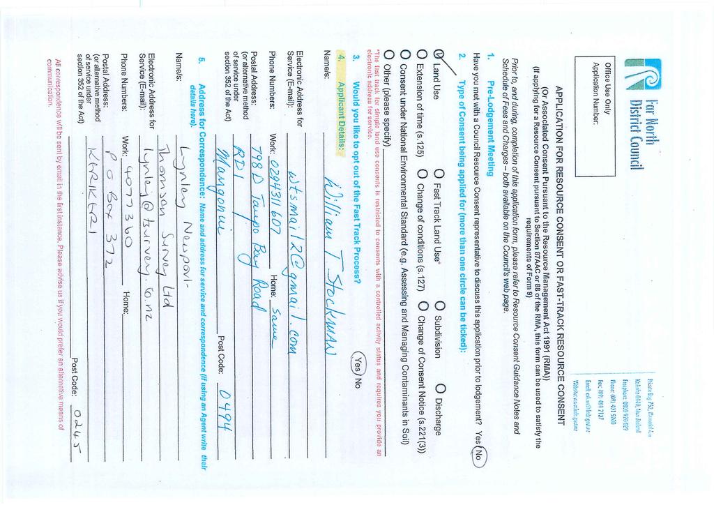
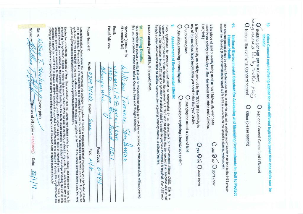
Bill Stockman PROPOSED SHED PLANNER S REPORT & ASSESSMENT OF ENVIRONMENTAL EFFECTS
|
|
|
- Clinton Mervin Higgins
- 5 years ago
- Views:
Transcription
1
2
3
4
5 Thomson Survey Limited Shed Land Use Proposal January-19 Bill Stockman PROPOSED SHED 798D Taupo Bay Road PLANNER S REPORT & ASSESSMENT OF ENVIRONMENTAL EFFECTS Thomson Survey Ltd Kerikeri 1.0 INTRODUCTION 1.1 The Proposal The applicant, Bill Stockman, seeks to construct a shed next to an existing dwelling at property at 798D Taupo Bay Road. The shed is proposed to be 7.5m x 7.5m = 56.25m 2 in size, and at its closest point, it will be 4.8m from the property boundary with the adjoining site to the west, and 5m from boundary with the ROW over which the application site gains access currently. The proposal requires land use consent pursuant to the Rural Production Zone setback from boundary rule, as well as the district wide rule in Chapter 12.1 relating to buildings within an Outstanding Landscape. A full set of plans prepared by Coppermine CAD services is attached as Appendix 1. The applicant has prepared some conceptual drawings in regard to boundary treatment and landscaping, and these are attached in Appendix 2, referenced S1-S9. Further schematics are contained within Appendix 3 to assist in assessing visual amenity effects and any effects on the immediate neighbour to the west. 1.2 Scope of this Report This assessment and report accompanies the Resource Consent Application made by our clients, and is provided in accordance with Section 88 and Schedule 4 of the Resource Management Act Page 1 Planning Report and Assessment of Environmental Effects Stockman; Job # 9424 Taupo Bay Road
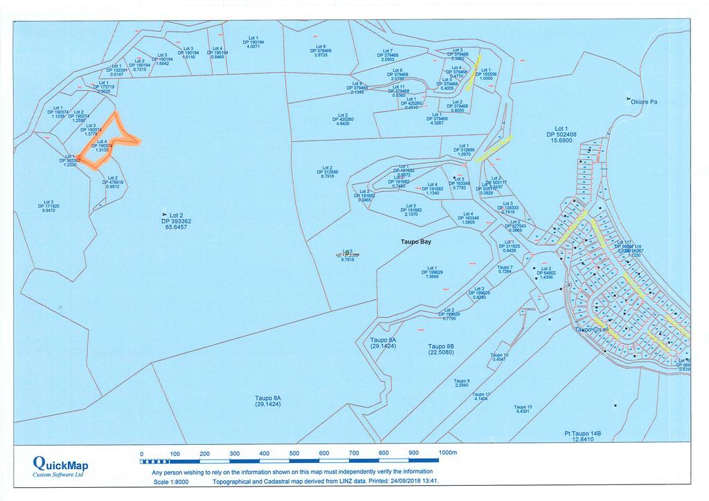
6 Thomson Survey Limited Shed Land Use Proposal January-19 The application seeks land use consent to construct a dwelling, as a restricted discretionary land use activity. The information provided in this assessment and report is considered commensurate with the scale and intensity of the activity for which consent is being sought, and covers: A description of the proposal; A description of the site and its environs; An assessment of environmental effects; An assessment of the proposal against relevant objectives and policies of the Far North District Plan; An assessment of the proposal against relevant provisions of Part 2 of the Act and other National and Regional Standards, Policies and Plans; The applicant s details are recorded in the Form 9 Application Form accompanying this application. 2.0 PROPERTY DETAILS Location: Zoning: Legal description: 798D Taupo Bay Road, Taupo Bay. A Location Map is attached as Appendix 5. Rural Production Zone. Lot 4 DP , contained in RT NA120B/682, a copy of which is attached as Appendix SITE DESCRIPTION 3.1 Physical characteristics The application site is ha in area. It is zoned Rural Production and has an Outstanding Landscape notation. It is a generally rectangular shaped property, with its high point being at the ROW access. The site then slopes downwards in a generally northeast direction. The property is one of several gaining access via a metal ROW off Taupo Bay Road. The property supports an existing modestly sized residence with deck area orientated towards the sea. The area around and downslope of the existing dwelling is in grass cover, with an area of bush/scrub on the lower northeastern portion of the site. Page 2 Planning Report and Assessment of Environmental Effects Stockman; Job # 9424 Taupo Bay Road

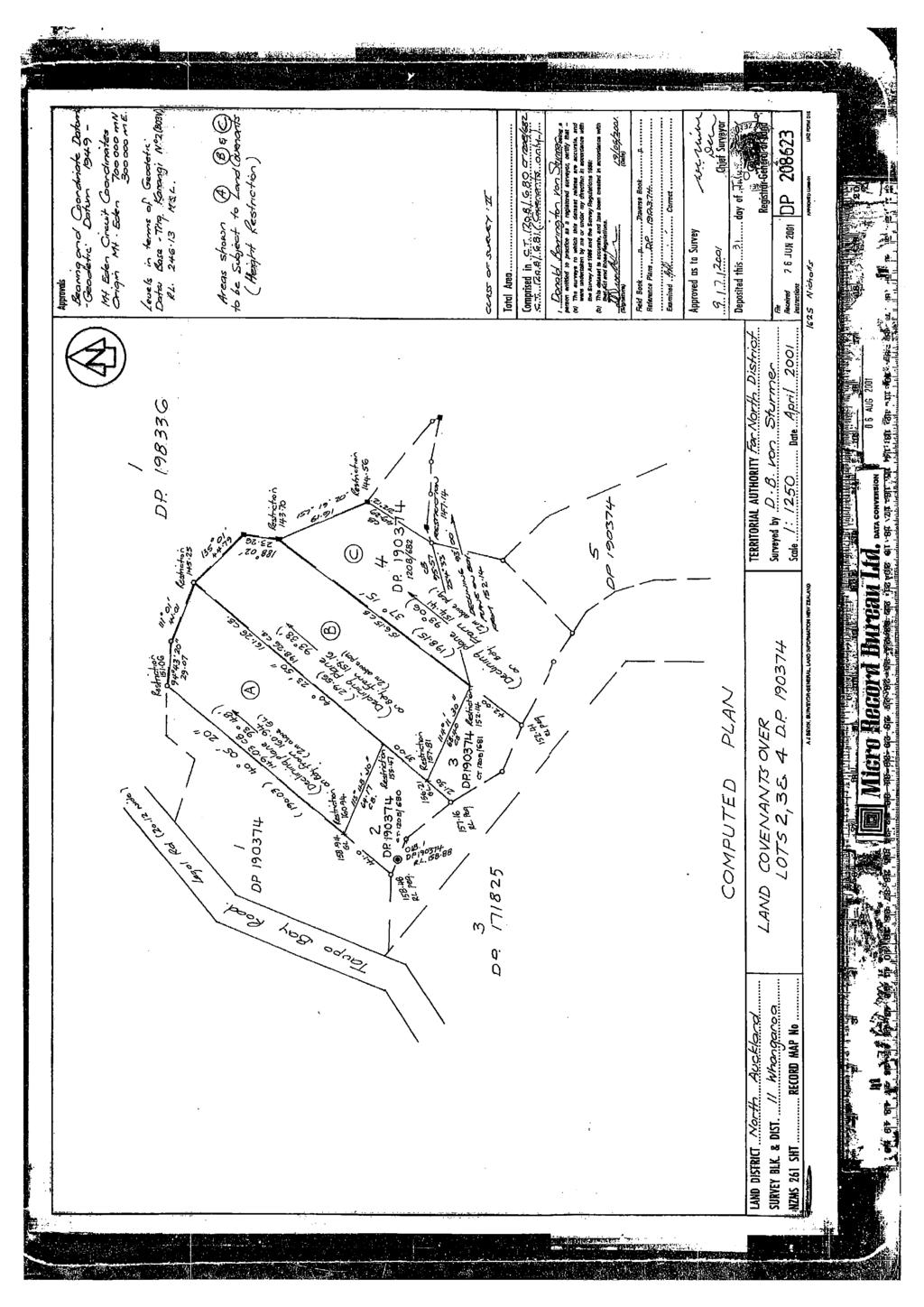
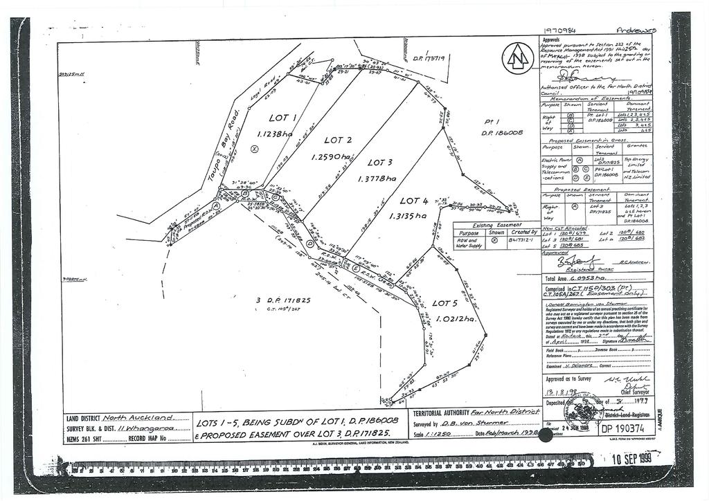
7 Thomson Survey Limited Shed Land Use Proposal January-19 The existing residential dwelling is serviced by an on site effluent treatment and disposal system. 3.2 Legal Interests The title is subject to a private land covenant, D , attached in Appendix 6. The property has an appurtenant right of way in easement certificate D This is attached in Appendix Consent History Lot 4 DP was one of 5 lots, ranging in size from 1.02ha to 1.38ha, created via RC , titles deposited in The following consents applying to the property have been given effect to: Page 3 Planning Report and Assessment of Environmental Effects Stockman; Job # 9424 Taupo Bay Road
8 Thomson Survey Limited Shed Land Use Proposal January-19 BC was issued in 2012 for the current building; deck and effluent disposal system on the site. This BC was issued in accordance with a resource consent granted for a breach of setback from boundaries and for building in an Outstanding Landscape (OL). RC is attached as Appendix 8. This current application for a shed associated with the existing dwelling will require consent for the same breaches, i.e. setback from boundaries and for building in an OL. 4.0 THE PROPOSAL IN DETAIL Refer to Plans and schematics in Appendices 1-3 inclusive. The existing dwelling was consented via Resource and Building Consents in Conditions of land use consent included consistency with plans and landscaping. The current applicant is committed to ensuring that the appropriate landscaping is established and maintained. The proposed two bay garage/shed is over 50m 2 in size, being 56m 2. It is a simple square shaped building, less than 4m in height. It is proposed to be located to the west of the existing dwelling, between it and the western boundary of the site. It is proposed to be located on the level portion of the site, 5m from front boundary, and 4.8m from western boundary. A concrete apron/turning area is proposed to enable vehicle and trailer manoeuvring. Building materials and colour scheme are proposed to be consistent with the existing modest dwelling. 5.0 ACTIVITY STATUS 5.1 Zoning The property is zoned Rural Production and is within an area noted in the District Plan as Outstanding Landscape. 5.2 Far North District Plan Rules An assessment of the proposal (as described in section 4.0 above), is contained in the following Table: Table 1: Far North Operative District Plan: RURAL PRODUCTION ZONE RULES: Permitted Standards Comment Compliance Assessment RESIDENTIAL Proposal is for a shed. N/A Page 4 Planning Report and Assessment of Environmental Effects Stockman; Job # 9424 Taupo Bay Road
9 Thomson Survey Limited Shed Land Use Proposal January-19 INTENSITY SUNLIGHT No part of any building shall project beyond a 45 degree recession plane as measured inwards from any point 2m vertically above ground level on any site boundary (refer to definition of Recession Plane in Chapter 3 - Definitions), except where a site boundary adjoins a legally established entrance strip, private way, access lot, or access way serving a rear site, the measurement shall be taken from the farthest boundary of the entrance strip, private way, access lot, or access way STORMWATER MANAGEMENT The maximum proportion of the gross site area covered by buildings and other impermeable surfaces shall be 15% SETBACK FROM BOUNDARIES No building shall be erected within 10m of any site boundary Refer to Sheet 03 of plans by Coppermine CAD services. Shed complies with permitted sunlight angle. Total impermeable coverage has been calculated at 302m 2 including roofs, watertanks, driveway and gravel. This is less than 15% of gross site area. The shed is proposed to be within 5m of front boundary and 4.8m of western boundary KEEPING OF ANIMALS No keeping of animals proposed NOISE Shed is associated with a residential activity BUILDING HEIGHT The proposed shed is less The maximum height of any than 4m in height. building shall be 12m HELICOPTER No helicopter landing area LANDING AREA proposed BUILDING COVERAGE Any new building or alteration/addition to an existing building is a permitted activity if the total Building Coverage of a site does not exceed 12.5% of the gross site area. Proposed total building coverage is calculated at 250m 2. This is less than 12.5% of gross site area. Permitted. Permitted. Does not meet permitted standard. A breach of setback from boundaries rule in this zone defaults to restricted discretionary Rule N/A Permitted Permitted N/A Permitted Page 5 Planning Report and Assessment of Environmental Effects Stockman; Job # 9424 Taupo Bay Road
10 Thomson Survey Limited Shed Land Use Proposal January SCALE OF The activity is a shed N/A ACTIVITIES associated with residential use TEMPORARY EVENTS N/A N/A DISTRICT WIDE RULES 12.1 LANDSCAPE AND NATURAL FEATURES INDIGENOUS VEGETATION CLEARANCE IN OUTSTANDING LANDSCAPES TREE PLANTING IN OUTSTANDING LANDSCAPES EXCAVATION AND/OR FILLING WITHIN AN OUTSTANDING LANDSCAPE Excavation and/or filling on any site within an Outstanding Landscape as shown on the Resource Maps, is permitted provided that: (a) it does not exceed 300m3 in any 12 month period per site; and (b) it does not involve a cut and/or filled face exceeding 1.5m in height i.e. the maximum permitted cut and/or fill height may be 3m; and (c) any cut or fill areas that will be visible from a viewing point on a public road, public reserve, coastal marine area or the foreshore shall be stabilised using mulch, hydroseeding, or other rapid effective stabilisation technique. All other cut and fill areas will be revegetated as soon as practicable in the spring or autumn immediately following construction BUILDINGS WITHIN OUTSTANDING LANDSCAPES The following are permitted activities in an Outstanding Landscape, as shown on the Property is within an area shown as Outstanding Landscape in the District Plan No indigenous vegetation clearance is proposed No tree planting in breach of Rule is proposed. A small amount of cut and fill will be required to create the platform for the shed. Cut is calculated at 76m 3 and fill at 2m 3 for creation of platform, with the remainder 74m 3 spread around the site. No cut or fill face higher than 1.5m. Part (c) of this rule will not be breached. Part (a) N/A site not zoned General Coastal; Part (b) is not believed to apply as the building site for the shed is not visible from a Permitted Permitted. Permitted. Proposal does not meet part (e) of Rule Page 6 Planning Report and Assessment of Environmental Effects Stockman; Job # 9424 Taupo Bay Road
11 Thomson Survey Limited Shed Land Use Proposal January-19 Resource Maps: public road or reserve and (a) where the zoning of the the coastal marine area is building platform is General more than 500m away Coastal any new building(s) (1.7km from coast). not for human habitation Part (c) only applies to provided that the gross floor alterations/additions. area of any new building or Part (d) only applies to a buildings permitted under this residential dwelling. rule, does not exceed 25m2 ; Part (e) is applicable. This and; restricts buildings to 25m 2 in (b) where that building will area. The proposed shed is be visible from a viewing 56m 2 in area. point on a public road, public reserve, coastal marine area or the foreshore that is within 500m of that building, the exterior is coloured within the BS5252 standard colour palette range with a reflectance value of 30% or less or is constructed of natural materials which fall within this range; or (c) any alteration/addition to an existing building where...: (d) where the building site is not in the General Coastal Zone construction of one residential dwelling per site, provided that the building is not visible from a public viewing point on a public road, public reserve, or the foreshore that is within 2km of the site; (e) where the building site is not in the General Coastal Zone any new building, including relocated buildings, with a gross floor area of less than 25m BUILDINGS WITHIN OUTSTANDING LANDSCAPES The following are restricted discretionary activities in an Outstanding Landscape, as shown on the Resource Maps: (a) any new building, including relocated buildings, exceeding a gross floor area Proposed shed is 56m 2 in area. Meets restricted discretionary rule of 25m2 ; or... Page 7 Planning Report and Assessment of Environmental Effects Stockman; Job # 9424 Taupo Bay Road
12 Thomson Survey Limited Shed Land Use Proposal January-19 No other aspects within Chapter 12 of the District Plan considered relevant TRAFFIC, PARKING and ACCESS Table A.1 MAXIMUM DAILY ONE WAY TRAFFIC MOVEMENTS Coastal Living Zone B.1.1 PARKING this analysis only lists sub parts that are relevant to the zone and site Where: (i) an activity establishes on a site, (ii) the nature of an activity changes, (iii) buildings are altered to increase the number of persons provided for on the site; the minimum number of on-site car parking spaces to be provided for the users of the activity, shall be determined by reference to Appendix 3C B.1.4 ACCESSIBLE CARPARKING SPACES B.1.5 CAR PARKING SPACE STANDARDS (a) The required size of offstreet car parking spaces, the manoeuvring space between, and the vehicle circulation routes providing access to them, shall be as set out in Appendix 3D. (b) Stacked parking will be permitted for one of two spaces associated with a specific residential unit. In determining the extent of area required for manoeuvring space, the Council will be guided by the Tracking Curve diagrams as shown in Appendix 3E. (c) All parking, loading, access drives and manoeuvring Residential use is deemed to generate 10 daily one way traffic movements, with one residential unit exempt in any event. Appendix 3C deems a residential dwelling to require two car parking spaces. This is achieved. The proposed shed does not add any requirement. Nil requirement for this level of activity. Part (a) is able to be complied with for a single car (without trailer). When a utility vehicle with boat trailer is using the site, then it will be necessary to use the ROW for manuouevring onto and off the application site. As a dominant tenement of the ROW, the application site is entitled to utilise the ROW for manoeuvring. This is not believed to breach any rule. Permitted Permitted. N/A N/A Permitted. Page 8 Planning Report and Assessment of Environmental Effects Stockman; Job # 9424 Taupo Bay Road
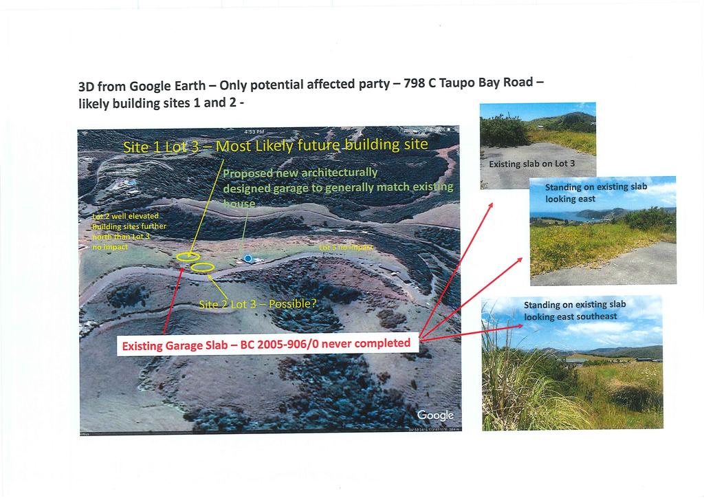
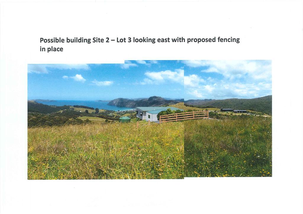
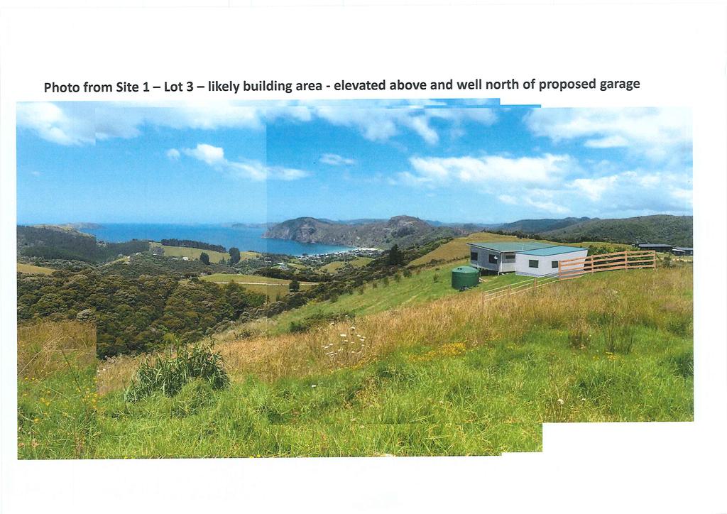
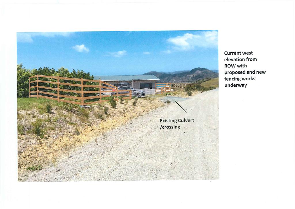
13 Thomson Survey Limited Shed Land Use Proposal January-19 areas shall be formed and provided with an all weather surface, drained, marked out and maintained to the satisfaction of the Council, and shall be kept free and available for the uses intended B.1.6 LOADING SPACES Nil required. N/A Restricted Discretionary and Discretionary rules in Section B.2 and 3 do not apply C.1.1 PRIVATE ACCESSWAY IN ALL ZONES Access is existing, via ROW Permitted. In summary, in terms of Part 2 Zone rules, the proposal breaches the following rule: SETBACK FROM BOUNDARIES. This results in restricted discretionary activity status pursuant to Rule In terms of District Wide rules in Part 3 of the District Plan, the proposal breaches the following rule: BUILDINGS WITHIN OUTSTANDING LANDSCAPES. This results in restricted discretionary activity status pursuant to Tule In summary, the activity is considered to be a restricted discretionary activity, pursuant to Rules and ASSESSMENT OF ENVIRONMENTAL EFFECTS 6.1 Effects associated with breach Setback from Boundary rule In assessing an application resulting from a breach of Rule Setback from Boundaries the matters to which the Council will restrict its discretion are: (a) the extent to which the building(s) reduces outlook and privacy of adjacent properties; (b) the extent to which the buildings restrict visibility for access and egress of vehicles; (c) the ability to mitigate any adverse effects on the surrounding environment, for example by way of planting;... (f) the extent to which the buildings and their use will impact on the public use and enjoyment of adjoining esplanade reserves and strips and adjacent coastal marine areas. The front boundary breach with the ROW does not result in any reduction in outlook or privacy. There is no building site across the ROW, with the land dropping off sharply in that Page 9 Planning Report and Assessment of Environmental Effects Stockman; Job # 9424 Taupo Bay Road
14 Thomson Survey Limited Shed Land Use Proposal January-19 direction. There is an existing consented dwelling already within the setback distance on this boundary. The west boundary breach similarly will not, in my opinion, adversely impact on outlook or privacy in regard to 798C Taupo Bay Road. The existing dwelling is already within the outlook of probable house sites at 798C. Outlook corridors are depicted in the set of drawings/montage provided in Appendix 3. The proposed shed will nestle in beside the existing dwelling, not protruding any further into 798C s outlook. In regard to privacy, it is proposed to retain and maintain the existing landscaping on a portion of the boundary between 798C and the application site (required as a condition of RC ), and additionally to construct /erect fencing along this boundary. The fencing by the landscaping is proposed to be wooden five rail, before moving into standard stock fencing. I believe that the location of the shed, its modest size and height, along with boundary landscaping and fencing, will result in less than minor effects in regard to reduction in outlook and privacy of adjoining properties. The proposed shed will not restrict visibility for access and egress of vehicles using the ROW, or entering/leaving the application site. The existing dwelling was consented in 2012 for breaches of the same rules. Conditions of consent required landscaping. Refer to condition 3 of RC attached in Appendix 8, and associated stamped approved landscaping plan. Some, but not all, of the approved landscaping is in place. Boundary plantings in the southwest corner are established and will prove effective in screening / softening views of the proposed shed from 798C, as well as users of the ROW travelling west to east. The applicant has ascertained that there may be one specimen broadleaf on the other side of the his boundary, within 798C. This, along with the other existing plantings on his side of the boundary, will remain. Landscape planting is already required to be maintained as part of RC and it should not be necessary to include a new condition for the shed consent as this would be repetitious. The proposed shed does not impact on public use and enjoyment of any esplanade area or the coastal marine area (which is more than 1.7km away). In summary, subject to maintenance; the new fencing; the blending and scale of existing and new buildings; and landscaping generally, or as required by RC , I believe the effects of the setback breaches are less than minor. 6.2 Effects associated with Building within an Outstanding Landscape In assessing any application pursuant to Rule of the District Plan, the Council will restrict the exercise of its discretion to the following matters: Page 10 Planning Report and Assessment of Environmental Effects Stockman; Job # 9424 Taupo Bay Road
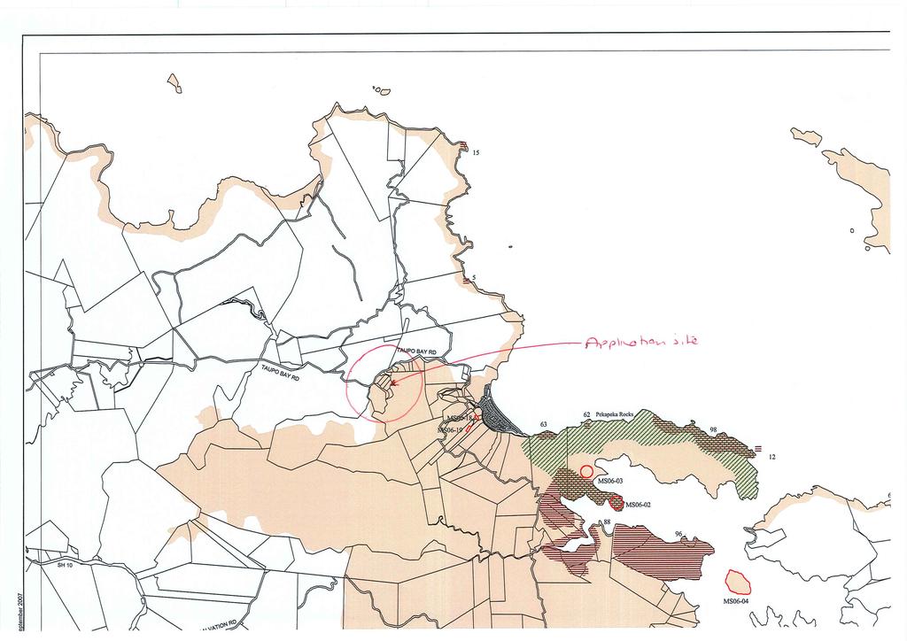
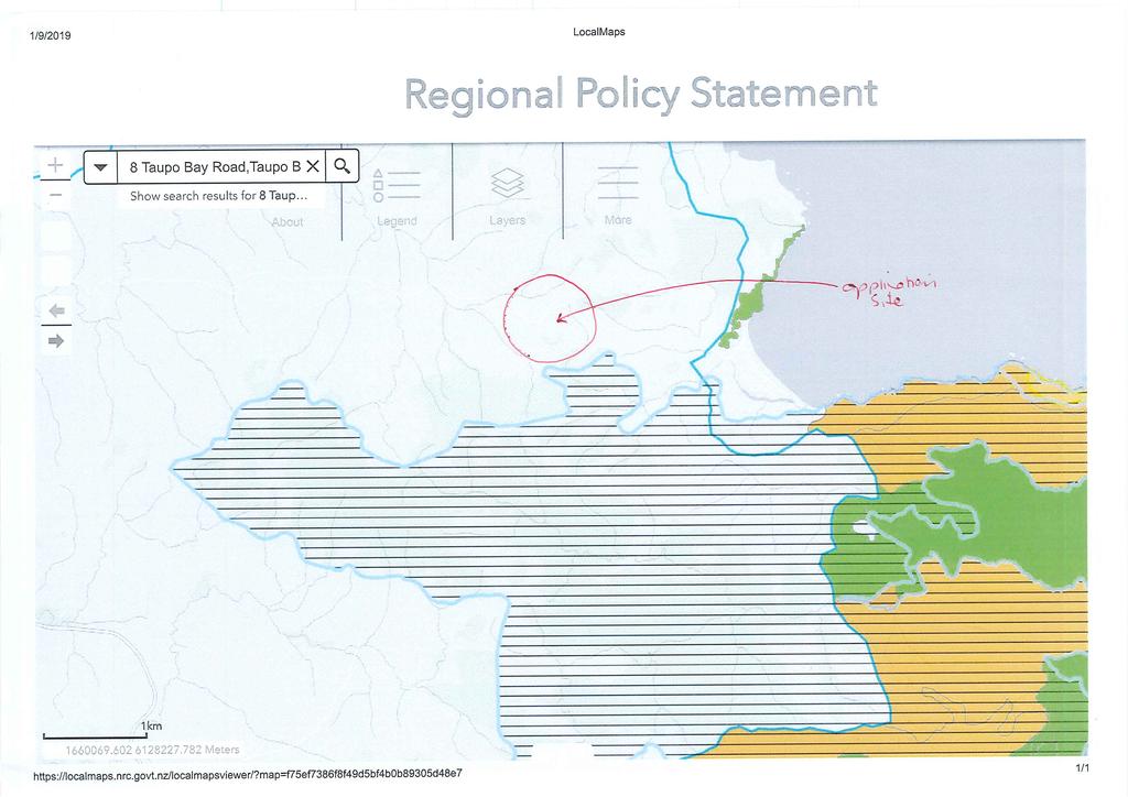
15 Thomson Survey Limited Shed Land Use Proposal January-19 (i) (ii) (iii) (iv) (v) (vi) (vii) (viii) the location of the building; and the size, bulk and height of the building in relation to ridgelines, areas of indigenous vegetation and habitats of indigenous fauna, existing trees and other natural features; and the degree to which the landscape will retain the qualities that make it outstanding, including naturalness, and visual and amenity values; and the design of the building; and the location and design of associated vehicle access, manoeuvring and parking areas; and the extent to which planting can mitigate visual effects; and the means by which permanent screening of the building from public viewing points on a public road, public reserve, or the foreshore may be achieved, and the cumulative visual effects of all buildings on the site. By way of a preamble to this section of the report, it is noted that the current (and now more than 10 year old) outstanding landscape (OL) notation applying to the property may no longer be justified. Appendix 9 shows the extent of the OL on Far North Maps along with the relevant Resource Map from the Far North District Plan. However, in preparing and finalising the Regional Policy Statement and associated maps a higher order planning document the Regional Council did not include the application site, or any of the surrounding sites, within any area of Outstanding Natural Landscape. Refer to Appendix 10. This is perhaps acknowledging the current land use in the area (modified as opposed to natural), and the distance this area is from the coast. Addressing the matters to which the Council restricts its discretion: (i) the location of the buildings; The proposed shed is nestled behind the existing dwelling when looking at the site from the east (the coast). As such any distant or fleeting glimpses that one might have from the Taupo Bay foreshore (if one knows where to look), will not differentiate the proposed shed from the existing consented dwelling. (ii) the size, bulk, and height of the buildings in relation to ridgelines and natural features; The shed is no higher than the existing consented dwelling. It is only 56m 2 in area and the dwelling (excluding the deck) is only 102m 2 in area. The size and bulk of the proposed shed is not significant. As stated above, the shed is behind the consented house when viewed from the foreshore and will not be distinguishable as a separate building. (iii) the degree to which the landscape will retain the qualities that make it outstanding, including naturalness, and visual and amenity values; Page 11 Planning Report and Assessment of Environmental Effects Stockman; Job # 9424 Taupo Bay Road
16 Thomson Survey Limited Shed Land Use Proposal January-19 The Regional Policy Statement no longer regards the area as having any outstanding natural values. Notwithstanding this, the proposed shed is modest in size and will sit adjacent to, and behind the existing consented dwelling. (iv) the design of the building; The proposed shed will be completed in a similar colour scheme and external appearance to the consented dwelling. The design and shape are similar, with a mono pitched roof proposed to match that of the dwelling. (v) the location and design of associated vehicle access, manoeuvring and parking areas; The vehicle access and manoeuvring areas are behind the dwelling and not visible from the east/coast. (vi) the extent to which planting can mitigate visual effects; The use of landscaping is discussed earlier in this report. (vii) the means by which permanent screen of the building from public viewing points may be achieved; The shed is located behind the dwelling when viewed from the east/coast. (viii) the cumulative visual effects of all the buildings on the site; Both the already consented dwelling and proposed shed are small and low. Even when combined the result is not significant in regard to cumulative size or bulk. The shed nestles in behind the consented dwelling and from most views will not be discernible as a separate building. I do not believe, therefore, that there will be any significant adverse cumulative effects. In summary I believe that the proposed shed will have less than minor adverse effects on landscape values. 6.3 Other Matters Hazardous Installations: The activity does not involve any hazardous installations. Protected Customary Rights: The activity is not within an area subject to the exercise of a protected customary right. Precedent & Cumulative Effects Page 12 Planning Report and Assessment of Environmental Effects Stockman; Job # 9424 Taupo Bay Road
17 Thomson Survey Limited Shed Land Use Proposal January-19 The activity is a restricted discretionary activity, and as such is an activity envisaged, and provided for, by the Operative Far North District Plan. There is no precedent effect. Cumulative effects are addressed in section 6.2. Positive Economic and Social Effects The ability to develop this site for activities associated with residential use has a positive economic and social effect. The site already supports residential use and this proposal does not propose any intensification of the use of the site beyond that for a single residential unit with ancillary buildings. 7.0 STATUTORY ASSESSMENT 7.1 District Plan Objectives and Policies Objectives and policies relevant to this proposal are predominantly those listed in Chapter 8.6 Rural Production Zone, and Chapter 12.1 Outstanding Landscapes and Features. As a restricted discretionary activity under both these chapters, the proposal is considered consistent with the objectives and policies applicable. The proposed shed is associated with a residential use of a Rural Production zoned piece of land and as such is an anticipated use of the land consistent with the zone s objectives and policies. Although currently shown as an outstanding landscape within the District Plan, the more up to date Regional Policy Statement maps do not show the site, nor any adjacent site, as containing any outstanding natural landscape values. Notwithstanding this, the modest size of the proposed shed and its proximity to the existing dwelling result in minimal impact on landscape values and the proposal is considered consistent with relevant objectives and policies in the District Plan. 7.2 Part 2 Matters 5 Purpose (1) The purpose of this Act is to promote the sustainable management of natural and physical resources. (2) In this Act, sustainable management means managing the use, development, and protection of natural and physical resources in a way, or at a rate, which enables people and communities to provide for their social, economic, and cultural well-being and for their health and safety while (a) (b) (c) sustaining the potential of natural and physical resources (excluding minerals) to meet the reasonably foreseeable needs of future generations; and safeguarding the life-supporting capacity of air, water, soil, and ecosystems; and avoiding, remedying, or mitigating any adverse effects of activities on the environment. The proposal is considered to provide for the sustainable management of natural and physical resources. It provides for an ancillary building associated with residential development and is an anticipated use of the site. Page 13 Planning Report and Assessment of Environmental Effects Stockman; Job # 9424 Taupo Bay Road
18 Thomson Survey Limited Shed Land Use Proposal January-19 6 Matters of national importance In achieving the purpose of this Act, all persons exercising functions and powers under it, in relation to managing the use, development, and protection of natural and physical resources, shall recognise and provide for the following matters of national importance: (a) the preservation of the natural character of the coastal environment (including the coastal marine area), wetlands, and lakes and rivers and their margins, and the protection of them from inappropriate subdivision, use, and development: (b) the protection of outstanding natural features and landscapes from inappropriate subdivision, use, and development: (c) the protection of areas of significant indigenous vegetation and significant habitats of indigenous fauna: (d) the maintenance and enhancement of public access to and along the coastal marine area, lakes, and rivers: (e) the relationship of Maori and their culture and traditions with their ancestral lands, water, sites, waahi tapu, and other taonga: (f) the protection of historic heritage from inappropriate subdivision, use, and development: (g) the protection of protected customary rights: (h) the management of significant risks from natural hazards. Whilst the Far North District Plan shows the site as being within an area of Outstanding Landscape, this is largely superseded by the more recent/current Regional Policy Statement. This removes that notation from the site and the surrounding area. The site is not within the coastal environment. I do not believe that there are any Section 6 matters relevant to the proposal. 7 Other matters In achieving the purpose of this Act, all persons exercising functions and powers under it, in relation to managing the use, development, and protection of natural and physical resources, shall have particular regard to (a) kaitiakitanga: (aa) the ethic of stewardship: (b) the efficient use and development of natural and physical resources: (ba) the efficiency of the end use of energy: (c) the maintenance and enhancement of amenity values: (d) intrinsic values of ecosystems: (e) [Repealed] (f) maintenance and enhancement of the quality of the environment: (g) any finite characteristics of natural and physical resources: (h) the protection of the habitat of trout and salmon: (i) the effects of climate change: (j) the benefits to be derived from the use and development of renewable energy. Page 14 Planning Report and Assessment of Environmental Effects Stockman; Job # 9424 Taupo Bay Road
19 Thomson Survey Limited Shed Land Use Proposal January-19 Regard has been had to any relevant parts of Section 7 of the RMA, Other Matters. Maintenance of amenity values, and quality of the environment have been considered and the proposed development design has had regard to these aspects. 8 Treaty of Waitangi In achieving the purpose of this Act, all persons exercising functions and powers under it, in relation to managing the use, development, and protection of natural and physical resources, shall take into account the principles of the Treaty of Waitangi (Te Tiriti o Waitangi). The principles of the Treaty of Waitangi have been considered and it is believed that this proposal does not offend any of those principles. In summary, it is considered that all matters under s5-8 inclusive have been adequately taken into account. 7.3 National Policy Statements The application site is not within the Coastal Environment or zoned coastal. As such the NZ Coastal Policy Statement (NZCPS) is not considered relevant. There are no other relevant National Policy Statements identified as relevant. 7.4 National Environmental Standards There are no national environmental standards relevant to this proposal. There are no known Hazardous Activities or Industries (either current or historic) and as such the National Environmental Standard for Assessing and Managing Contaminants in Soil to Protect Human Health is not applicable. 7.5 Regional Policy Statement for Northland In preparing this application, the Regional Policy Statement for Northland has been considered. Whilst within an Outstanding Landscape area in the Far North District Plan, the site is devoid of any resources or features notated as outstanding landscape or natural character value within the Regional Policy Statement. Neither does the site display any known heritage or cultural values. The site contains no areas of significant indigenous vegetation or habitat. As such, the only aspects of the Regional Policy Statement for Northland considered relevant are those addressed below. Objective 3.5 Enabling economic wellbeing Northland s natural and physical resources are sustainably managed in a way that is attractive for business and investment that will improve the economic wellbeing of Northland and its communities. I believe the proposed development is a sustainable use of the site and provides for the property owners social and economic wellbeing Regional form Page 15 Planning Report and Assessment of Environmental Effects Stockman; Job # 9424 Taupo Bay Road
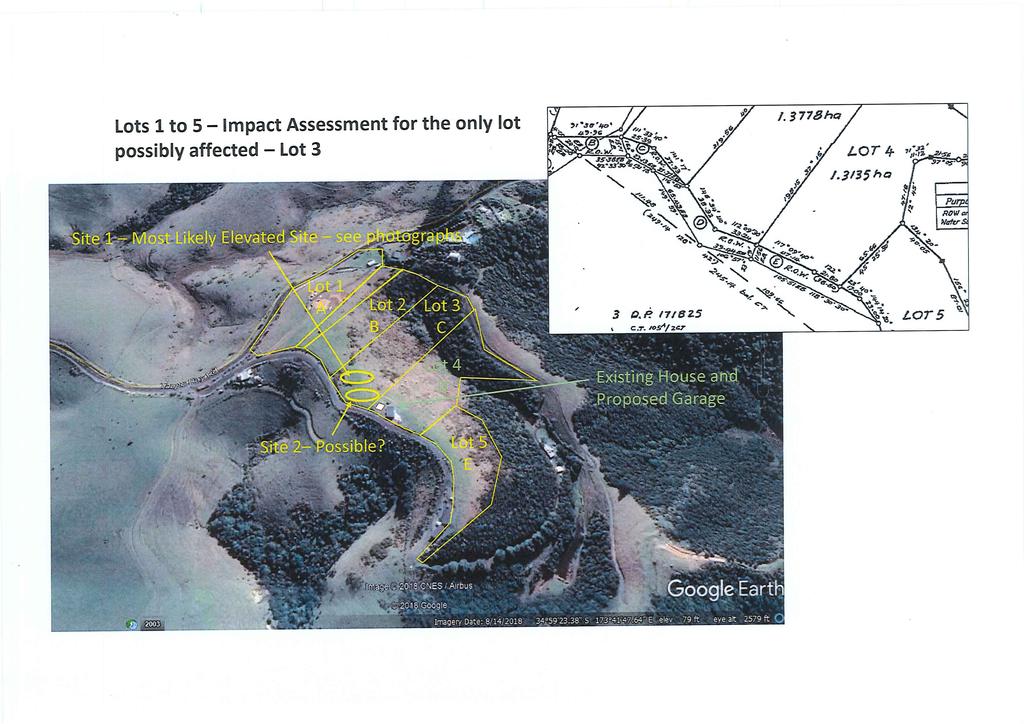
20 Thomson Survey Limited Shed Land Use Proposal January-19 Northland has sustainable built environments that effectively integrate infrastructure with subdivision, use and development, and have a sense of place, identity and a range of lifestyle, employment and transport choices. The site supports an existing residential dwelling and the proposed shed is ancillary to this use. It is located close to the dwelling and will be similar design and colour. The existing use is supported by on-site services. 7.6 Regional Water and Soil Plan There are no rules in the current Operative Regional Plans, nor recently notified Proposed Regional Plan that are relevant to the development. 8.0 CONSULTATION No detailed consultation has been carried out prior to lodging the application. The proposed shed is modest in size, is adjacent to the existing dwelling, and has minimal, if any, adverse effects on landscape values. In regard to the adjacent property to the west, where a 4.8m setback is achieved, the applicant has put together a series of montage / concept drawings that help assess potential effects. There are two potential building sites on the higher points of the adjacent property, and the drawings/photos show that these already have the existing house in their view shaft, but can nonetheless achieve and maintain coastal views looking out over Taupo Bay. The addition of a shed, in the proposed location, does not adversely impact on the ability to retain the existing outlook, as the shed does not protrude out into the existing view corridor. In addition, it is proposed to retain landscape planting on the boundary, and to add a 5 rail wooden fence on the boundary. These measures will retain privacy. In regard to the boundary with the ROW (owned by another property), the proposed shed is no closer than the existing dwelling is to the ROW boundary. The application site has existing ROW access and the ability to access and egress their site. This will continue. The application site has ongoing obligations to meet the conditions of the easement instrument, which appear to be standard requirements as per relevant legislation, e.g. responsibilities in terms of maintenance and upgrade; obligation not to impede or block the use of the ROW by others. I believe that effects on adjacent properties can be successfully mitigated such that they are less than minor. Page 16 Planning Report and Assessment of Environmental Effects Stockman; Job # 9424 Taupo Bay Road
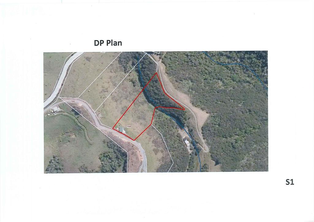
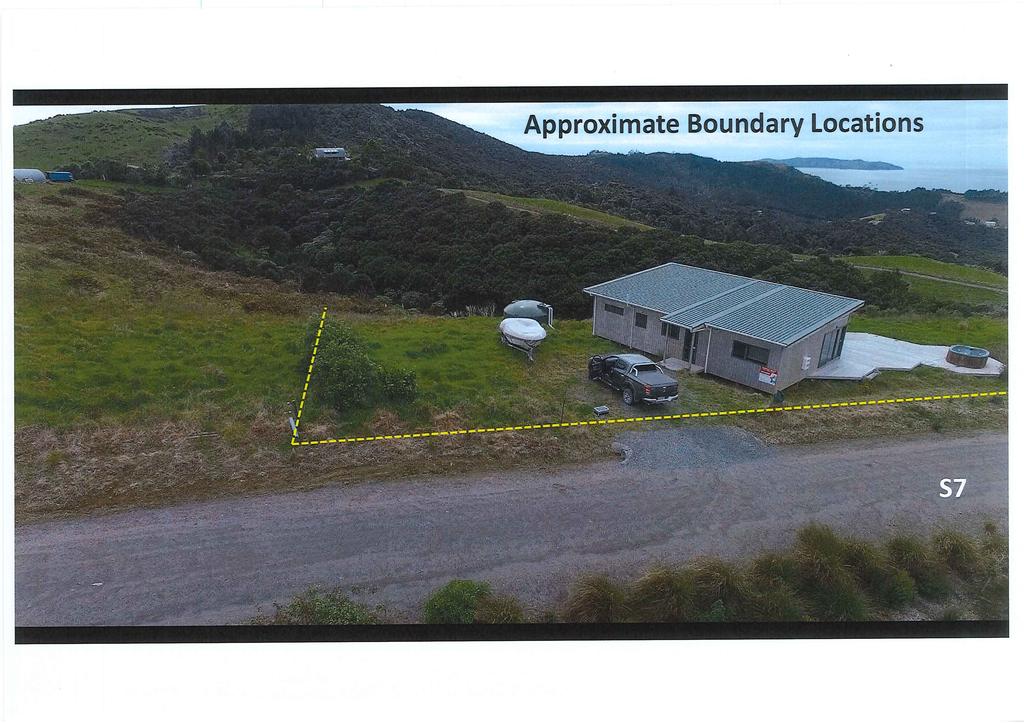
21 Thomson Survey Limited Shed Land Use Proposal January CONCLUSION The activity is a restricted discretionary activity with less than minor adverse effects. I do not believe the application requires either limited or full notification. It is therefore requested that the Council grant approval to the proposal on a non notified basis, subject to appropriate conditions. Lynley Newport Date 22/01/2019 Senior Planner Thomson Survey Ltd 10.0 APPENDICES Appendix 1 Appendix 2 Coppermine CAD Services Plans Applicant Plans (conceptual drawings) Appendix 3 Pictorial Impact Assessment Lot 3 Appendix 4 Appendix 5 RT NA120B/682 Location Map Appendix 6 Land Covenant D & DP Appendix 7 Easement Instrument D Appendix 8 Appendix 9 Appendix 10 RC RMALUC Extent of Outstanding Landscape Far North District Plan Extent of Outstanding Natural Landscape Regional Policy Statement Page 17 Planning Report and Assessment of Environmental Effects Stockman; Job # 9424 Taupo Bay Road
22 Thomson Survey Limited Shed Land Use Proposal January-19 Appendix 1 Coppermine CAD Services Plans Site Plan(s); Floor Plans; Elevations and Roof Plan Page 18 Planning Report and Assessment of Environmental Effects Stockman; Job # 9424 Taupo Bay Road
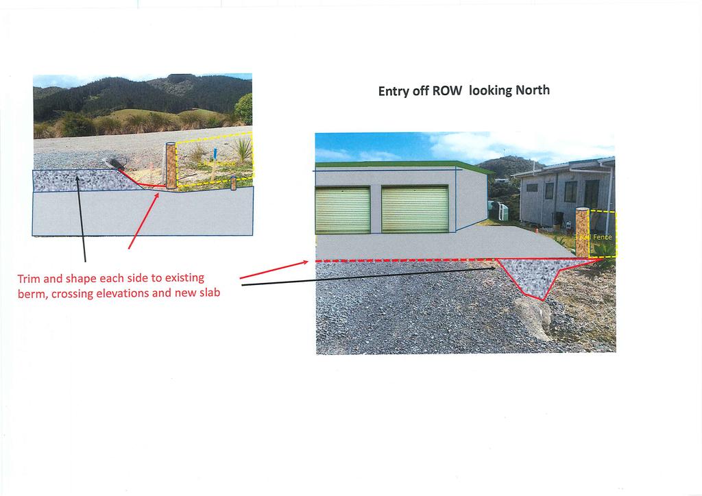
23 Thomson Survey Limited Shed Land Use Proposal January-19 Appendix 2 Applicant Plans Conceptual Drawings Page 19 Planning Report and Assessment of Environmental Effects Stockman; Job # 9424 Taupo Bay Road
24 Thomson Survey Limited Shed Land Use Proposal January-19 Appendix 3 Pictorial Impact Assessment Lot 3 Page 20 Planning Report and Assessment of Environmental Effects Stockman; Job # 9424 Taupo Bay Road
25 Thomson Survey Limited Shed Land Use Proposal January-19 Appendix 4 Record of Title NA120B/682 Page 21 Planning Report and Assessment of Environmental Effects Stockman; Job # 9424 Taupo Bay Road
26 Thomson Survey Limited Shed Land Use Proposal January-19 Appendix 5 Location Map Page 22 Planning Report and Assessment of Environmental Effects Stockman; Job # 9424 Taupo Bay Road
27 Thomson Survey Limited Shed Land Use Proposal January-19 Appendix 6 Land Covenant D & DP Page 23 Planning Report and Assessment of Environmental Effects Stockman; Job # 9424 Taupo Bay Road
28 Thomson Survey Limited Shed Land Use Proposal January-19 Appendix 7 Easement Instrument D Page 24 Planning Report and Assessment of Environmental Effects Stockman; Job # 9424 Taupo Bay Road
29 Thomson Survey Limited Shed Land Use Proposal January-19 Appendix 8 RC RMALUC Page 25 Planning Report and Assessment of Environmental Effects Stockman; Job # 9424 Taupo Bay Road
30 Thomson Survey Limited Shed Land Use Proposal January-19 Appendix 9 Extent of Outstanding Landscape Far North District Plan Page 26 Planning Report and Assessment of Environmental Effects Stockman; Job # 9424 Taupo Bay Road
31 Thomson Survey Limited Shed Land Use Proposal January-19 Appendix 10 Extent of Outstanding Natural Landscape Regional Policy Statement Page 27 Planning Report and Assessment of Environmental Effects Stockman; Job # 9424 Taupo Bay Road
32
33
34
35
36
37
38
39
40
41
42
43
44
45
46
47
48
49
50
51
52
53
54
55
56
57
58
59
60
61
62
63
64
65
66
67
68
69
70
71
72
73
74
75
76
77
78
79
80
81
82
83
84
85
86
87
4 Residential and Urban Living Zones
 4 Residential and Urban Living Zones Refer to Chapters 11 to 20 for additional rules that may apply to these zones. 4.1 OBJECTIVES AND POLICIES Objective Res1 Policy 1 Policy 2 Policy 3 Policy 4 Policy
open space environment
 This section updated August 09 GUIDELINE TO THE RULES The Open Space Environment Rules apply to activities on sites within the Open Space Environment as shown on the Human Environments Maps. Most of the
CA.1 Coastal Area. Index. CA.1.1 Description and Expectations
 Index.1.2.3.4 CA.2 CA.2.1 CA.2.2 CA.2.3 CA.3 CA.3.1 CA.3.2 CA.3.1 CA.4 CA.4.1 CA.4.2 CA.4.3 CA.4.4 CA.5 CA.5.1 CA.5.2 Description and Expectations Objectives Policies Guidance Note Landuse Eligibility
PART 5 - NATURAL AND PHYSICAL ENVIRONMENT
 CONTENTS...PAGE 5.1 INTRODUCTION...3 5.2 NATURAL RESOURCES...4 5.3 PHYSICAL RESOURCES...4 5.4 COASTAL ENVIRONMENT...4 5.5 HERITAGE FEATURES...4 5.6 HAZARDS...4 5.7 SUMMARY...4 ISTHMUS SECTION - OPERATIVE
Chapter 3: Natural Environment. Proposed Waikato District Plan Stage 1. (Notified version)
") Chapter 3: Natural Environment Proposed Waikato District Plan Stage 1 Page 2 of 7 Contents Chapter 3: Natural Environment... 3 3.1 Indigenous Vegetation and Habitats... 3 3.1.1 Objective Biodiversity and
Chapter 3: Natural Environment Proposed Waikato District Plan Stage 1 Page 2 of 7 Contents Chapter 3: Natural Environment... 3 3.1 Indigenous Vegetation and Habitats... 3 3.1.1 Objective Biodiversity and
GIBBSTON CHARACTER ZONE. QLDC PROPOSED DISTRICT PLAN [PART FOUR] AUGUST gibbston character zone
![GIBBSTON CHARACTER ZONE. QLDC PROPOSED DISTRICT PLAN [PART FOUR] AUGUST gibbston character zone](/thumbs/75/72573993.jpg "GIBBSTON CHARACTER ZONE. QLDC PROPOSED DISTRICT PLAN [PART FOUR] AUGUST gibbston character zone") 23 GIBBSTON CHARACTER ZONE QLDC PROPOSED DISTRICT PLAN [PART FOUR] AUGUST 2015 23 gibbston character zone QLDC PROPOSED DISTRICT PLAN [PART FOUR] AUGUST 2015 23 gibbston character zone 23.1 Zone Purpose
23 GIBBSTON CHARACTER ZONE QLDC PROPOSED DISTRICT PLAN [PART FOUR] AUGUST 2015 23 gibbston character zone QLDC PROPOSED DISTRICT PLAN [PART FOUR] AUGUST 2015 23 gibbston character zone 23.1 Zone Purpose
Proposed Southland District Plan 2012 Appeal Version October 2016
 S e c t i o n 3. 5 - F i o r d l a n d / R a k i u r a Z o n e The Fiordland/Rakiura Zone encompasses the Fiordland and Rakiura National Parks and part of Mt Aspiring National Park. It also includes areas
Section 6A 6A Purpose of the Natural Features and Landscapes Provisions
 Section 6A 6A Purpose of the Natural Features and Landscapes Provisions This Chapter addresses the protection and management of natural features and landscapes within the City. The City has a number of
Section 12C Subdivision in the Rural Residential Zone
 Section 12C 12C Subdivision in the Rural Residential Zone The Rural Residential Zone provides part of the range of residential opportunities within the City. Land zoned rural residential is considered
I511. Hatfields Precinct
 I511. Hatfields Precinct I511.1. Precinct Description The Hatfields Precinct is a contiguous 183.8 hectare block of rural land held in 8 freehold titles, located immediately to the north of Hatfields Beach.
H7 Open Space zones. (a) provide for the needs of the wider community as well as the needs of the community in which they are located;
 provide for the needs of the wider community as well as the needs of the community in which they are located;") H7. Open Space zones H7.1. Background The majority of land zoned as open space is vested in the Council or is owned by the Crown. However some areas zoned open space are privately owned. While the open
H7. Open Space zones H7.1. Background The majority of land zoned as open space is vested in the Council or is owned by the Crown. However some areas zoned open space are privately owned. While the open
I611. Swanson North Precinct
 I611. Swanson North Precinct I611.1. Precinct Description Swanson North is located in the north eastern foothills of the Waitakere Ranges. It is outside the Waitakere Ranges Heritage Area Act and the Waitakere
Tāhuhu whakaruruhau ā-taone The sheltering ridge pole
 B2. Tāhuhu whakaruruhau ā-taone - Urban growth and form B2.1. Issues Tāhuhu whakaruruhau ā-taone The sheltering ridge pole Auckland s growing population increases demand for housing, employment, business,
NEW ZEALAND COASTAL POLICY STATEMENT
 NEW ZEALAND COASTAL POLICY STATEMENT 1994 This New Zealand Coastal Policy Statement 1994 was issued by notice in the Gazette on 5 May 1994. PREFACE The Resource Management Act 1991 established a new coastal
E15. Vegetation management and biodiversity
 E15. management and biodiversity E15.1. Background contributes to a range of ecosystem services such as erosion and sediment control, reducing stormwater flows, protecting or enhancing water quality, amenity
I615. Westgate Precinct
 I615. Westgate Precinct I615.1. Precinct Description The Westgate Precinct is located approximately 18km west of the Auckland city centre. There are seven Sub-precincts in the Westgate Precinct: Sub-precinct
11.3 SPECIAL CHARACTER ZONE HAWKE S BAY REGIONAL SPORTS PARK
 11.3 SPECIAL CHARACTER ZONE HAWKE S BAY REGIONAL SPORTS PARK 11.3.1 INTRODUCTION The availability of sports and recreation activities and facilities is important for the maintenance and enhancement of
Plan Modification to Chapter B2 of the Auckland Unitary Plan(AUP) Operative in part (15 November 2016)
 Operative in part (15 November 2016)") UNITARY PLAN UPDATE REQUEST MEMORANDUM TO FROM Phill Reid Linley Wilkinson DATE 25 September 2018 SUBJECT Plan Modification to Chapter B2 of the Auckland Unitary Plan(AUP) Operative in part (15 November
UNITARY PLAN UPDATE REQUEST MEMORANDUM TO FROM Phill Reid Linley Wilkinson DATE 25 September 2018 SUBJECT Plan Modification to Chapter B2 of the Auckland Unitary Plan(AUP) Operative in part (15 November
Section 3b: Objectives and Policies Rural Environment Updated 19 November 2010
 Page 1 of Section 3b 3b RURAL ENVIRONMENT 3b.1 Introduction The Rural Environment comprises all the land outside of the Residential, Town Centre and Industrial Environments. Most land within the District
15 Rural Residential Zone
 15 Rural Residential Zone Section 15A 15A Purpose of the Rural Residential Zone... 1 15A.1 Objectives and Policies of the Rural Residential Zone... 1 15A.2 Activity Status Rules... 5 15A.3 Permitted Activity
12 Subdivision, Services and Infrastructure
 12 Subdivision, Services and Infrastructure Section 12A 12A Purpose of Subdivision Provisions... 1 12A.1 General Subdivision Objectives and Policies... 2 12A.2 Activity Status Rules... 4 12A.3 General
I403 Beachlands 1 Precinct
 I403. Beachlands 1 I403.1. Precinct Description Beachlands is a rural and coastal village located on the eastern side of Auckland, adjoining the Tamaki Strait coastline. The original Beachlands village
LANDSCAPE GUIDELINES. Countryside & Coastal Countryside Environments. Landscape, Natural Character & Amenity Values Guide
 Landscape, Natural Character & Amenity Values Guide Copyright WDC 2009 Version A2 18May09 Environmental Services Group Publication Countryside & Coastal Countryside Environments START HERE Quality Land
Rural (Urban Expansion) Environment
 Environment") RUEE.1 Rural (Urban Expansion) Environment Subsequent to the receipt of appeals, a 'marked up' version of the Proposed District Plan was prepared. The provisions of the Proposed Version of the Plan subject
RUEE.1 Rural (Urban Expansion) Environment Subsequent to the receipt of appeals, a 'marked up' version of the Proposed District Plan was prepared. The provisions of the Proposed Version of the Plan subject
H1. Residential Large Lot Zone
 H1. Residential Large Lot Zone H1.1. Zone description The Residential Large Lot Zone provides for large lot residential development on the periphery of urban areas. Large lot development is managed to
64 Mineral Extraction Area Rules
 64 Mineral Extraction Area Rules 64.1 Introduction For the purposes of this Chapter: Active Area, in relation to a Mineral Extraction Area (MEA), is that part of the Mineral Extraction Area which is owned
Ensure that development within the Arrowtown Urban Growth Boundary provides:
 URBAN DEVELOPMENT 4 4.2.5.2 Ensure that development within the Arrowtown Urban Growth Boundary provides: an urban form that is sympathetic to the character of Arrowtown, including its scale, density, layout
Rural (Urban Expansion) Environment
 Environment") RUEE.1 Rural (Urban Expansion) Environment Index RUEE.1 RUEE.1.1 RUEE.1.2 RUEE.1.3 RUEE.1.4 RUEE.2 RUEE.2.1 RUEE.2.2 RUEE.2.3 RUEE.2.4 RUEE.3 Rural (Urban Expansion) Environment Description and Expectations
RUEE.1 Rural (Urban Expansion) Environment Index RUEE.1 RUEE.1.1 RUEE.1.2 RUEE.1.3 RUEE.1.4 RUEE.2 RUEE.2.1 RUEE.2.2 RUEE.2.3 RUEE.2.4 RUEE.3 Rural (Urban Expansion) Environment Description and Expectations
Guidance Notes Completing an AEE
 Guidance Notes Completing an AEE The purpose of this guidance note is to assist you with completing your Assessment of Environmental Effects (AEE) for your land-use consent application. If you do not provide
subdivision GUIDELINES TO THE RULES
 This section updated September 2013 GUIDELINES TO THE RULES This part of the Plan contains rules relating to the of land. Other rules in the Plan also need to be referred to, including the following: The
Proposed Kapiti Coast District Plan
 5 This Chapter primarily implements Objectives 2.1 Tāngata Whenua, 2.3 Development Management, 2.11 Character and Amenity Values, and 2.12 Housing Choice and Affordability as set out in Chapter 2. The
Section 32 Evaluation Report Variation 1 - Arrowtown Design Guidelines, 2016 Contents
 Section 32 Evaluation Report Variation 1 - Arrowtown Design Guidelines, 2016 Contents Section 32 Evaluation Report: Variation 1 - Arrowtown Design Guidelines, 2016 (ADG, 2016)... 3 1. Strategic Context...
I602. Birdwood Precinct
 I602. Birdwood Precinct I602.1. Precinct description The Birdwood Precinct applies to an area west of Don Buck Road and south of Red Hills Road in west Auckland. It incorporates subdivision and development
H14. Business General Business Zone
 H14. Business General Business Zone H14.1. Zone description The Business General Business Zone provides for business activities from light industrial to limited office, large format retail and trade suppliers.
Appendix A. Planning Processes. Introduction
 1 Planning Processes Introduction This appendix outlines a number of planning processes which are used in the Auckland Region to support the effective management of development in the region s rural and
I539. Smales 2 Precinct
 I539. Smales 2 Precinct I539.1. Precinct Description The Smales 2 Precinct applies to a 4.8 hectare block of land located on the southern side of Northcote Road and fronting Lake Pupuke, Takapuna. The
Section 12B 12B Subdivision in Residential Zones
 Section 12B 12B Subdivision in Residential Zones The Residential Zones provide for a range of infill and greenfield living opportunities across the City for the community to accommodate current and future
JACKS POINT QLDC PROPOSED DISTRICT PLAN [PART SIX] DECISIONS VERSION 41 JACKS POINT
![JACKS POINT QLDC PROPOSED DISTRICT PLAN [PART SIX] DECISIONS VERSION 41 JACKS POINT](/thumbs/84/89530979.jpg "JACKS POINT QLDC PROPOSED DISTRICT PLAN [PART SIX] DECISIONS VERSION 41 JACKS POINT") 41 JACKS POINT QLDC PROPOSED DISTRICT PLAN [PART SIX] DECISIONS VERSION 41 JACKS POINT QLDC PROPOSED DISTRICT PLAN [PART SIX] DECISIONS VERSION JACKS POINT 41.1 Zone Purpose The purpose of the Jacks Point
41 JACKS POINT QLDC PROPOSED DISTRICT PLAN [PART SIX] DECISIONS VERSION 41 JACKS POINT QLDC PROPOSED DISTRICT PLAN [PART SIX] DECISIONS VERSION JACKS POINT 41.1 Zone Purpose The purpose of the Jacks Point
H13. Business Mixed Use Zone
 H13. Business Mixed Use Zone H13.1. Zone description The Business Mixed Use Zone is typically located around centres and along corridors served by public transport. It acts as a transition area, in terms
TAURANGA CITY COUNCIL CITY PLAN SECTION 32 REPORT. Chapter 16 Rural Zones
 125 TAURANGA CITY COUNCIL CITY PLAN SECTION 32 REPORT Chapter 16 Rural Zones Table of Contents 1. INTRODUCTION... 3 2. PURPOSE OF THE CHAPTER... 3 3. RECORD OF DEVELOPMENT OF PROVISIONS... 4 3.1 Background
Historic Heritage Historic Heritage Explanatory Statement Significant Issues Objectives and Policies...
 Section Contents Historic Heritage... 2 7. Historic Heritage... 2 Explanatory Statement... 2 7.1 Significant Issues... 3 7.2 Objectives and Policies... 3 7.3 Activity Lists... 4 7.4 Matters of Control
RLE.1 Rural Living Environment
 Index.1 Description and Expectations.2 Objectives.3 Policies.4 Guidance RLE.2 Landuse RLE.2.1 Eligibility Rules RLE.2.2 Notification Rules RLE.2.3 Discretionary Activities RLE.3 Subdivision RLE.3.1 Eligibility
Landowners Coalition Incorporated. Whangarei District Council
 IN THE ENVIRONMENT COURT ENV-2018-AKL- AT AUCKLAND IN THE MATTER of the Whangarei District Plan and the Resource Management Act 1991 (RMA) AND IN THE MATTER of an appeal under Clause 14(1) of Schedule
Draft Housing Choice and Supply Plan Change for Tawa and Karori Released for informal consultation Nov 2015
 Housing Choice & Supply Draft Amendments to the District Plan (Additions shown in underline, deletions are shown as strikethrough) 1. Include 2 new definitions as follows (Chapter 3: Definitions): RETIREMENT
49 Scheduled Activities
 49 Scheduled Activities 49.1 Rules Explanation The rules for scheduled activities take precedence over the other rules for the Environment in which the scheduled activity is located. This means that, where
H9. Business Metropolitan Centre Zone
 H9. Business Metropolitan Centre Zone H9.1. Zone description The Business Metropolitan Centre Zone applies to centres located in different subregional catchments of Auckland. These centres are second only
QLDC PROPOSED DISTRICT PLAN [PART FIVE] NOVEMBER 2017 OPEN SPACE & RECREATION
![QLDC PROPOSED DISTRICT PLAN [PART FIVE] NOVEMBER 2017 OPEN SPACE & RECREATION](/thumbs/89/100753530.jpg "QLDC PROPOSED DISTRICT PLAN [PART FIVE] NOVEMBER 2017 OPEN SPACE & RECREATION") 38 QLDC PROPOSED DISTRICT PLAN [PART FIVE] NOVEMBER 2017 38 O P E N S PA C E & R E C R E AT I O N OPEN SPACE & RECREATION QLDC PROPOSED DISTRICT PLAN [PART FIVE] NOVEMBER 2017 38 OPEN SPACE & RECREATION
38 QLDC PROPOSED DISTRICT PLAN [PART FIVE] NOVEMBER 2017 38 O P E N S PA C E & R E C R E AT I O N OPEN SPACE & RECREATION QLDC PROPOSED DISTRICT PLAN [PART FIVE] NOVEMBER 2017 38 OPEN SPACE & RECREATION
4 RESIDENTIAL ZONE. 4.1 Background
 4 RESIDENTIAL ZONE 4.1 Background The residential areas within the City are characterised by mainly lowrise dwellings sited on individual allotments. Past architectural styles, settlement patterns and
2A District-wide Policies
 2A Introduction This Chapter contains policies which are relevant to subdivision, use and development activities occurring across all zones and areas of the District. The policies in this Chapter implement
I604. Hobsonville Marina Precinct
 I604. Hobsonville Marina Precinct I604.1. Precinct description Hobsonville Marina Precinct is located at Clearwater Cove, Hobsonville in Auckland s upper Waitemata Harbour. The precinct includes the coastal
I209 Quay Park Precinct
 I209. Quay Park I209.1. Precinct description The Quay Park Precinct is located on reclaimed land at the eastern end of the city centre and along the City Centre waterfront. It is dissected to the east
H10. Business Town Centre Zone
 H10. Business Town Centre Zone H10.1. Zone description The Business Town Centre Zone applies to suburban centres throughout Auckland, the satellite centres of Warkworth and Pukekohe, and the rural towns
Subdivision and Development
 Subdivision and Development 8.0 Introduction - Subdivision and Development The principle purpose of subdivision is to provide a framework for land ownership so that development and activities can take
I207. Learning Precinct
 I207. Learning Precinct I207.1. Precinct description The Learning Precinct is centred on the Symonds Street ridge where the University of Auckland and Auckland University of Technology have the majority
RPE. Rural Production Environment. Index. RPE.1.1 Description and Expectations
 RPE.1 Rural Production Environment Index RPE.1 Rural Production Environment RCE.1.1 RCE.1.2 RCE.1.3 RCE.1.4 RPE.2 RCE.2.1 RCE.2.2 RCE.2.3 Landuse Description and Expectations Objectives Policies Guidance
Simpson Shaw Surveyors
 \ t Simpson Shaw Surveyors Resource Managers APPLCATON for Resource Consent: 4 DP 399566 Whangarei District Plan Prepared for: Colonel Holgate Estate Date: September 2016 File: 15097 Application Application
PRIVATE PLAN CHANGE REQUEST REZONING OF LAND AT 49, 57 AND 71 MILL ROAD FROM RURAL 3 ZONE TO MAIN RESIDENTIAL ZONE. Amendments to:
 PRIVATE PLAN CHANGE REQUEST REZONING OF LAND AT 49, 57 AND 71 MILL ROAD FROM RURAL 3 ZONE TO MAIN RESIDENTIAL ZONE Amendments to: MANUKAU OPERATIVE DISTRICT PLAN 2002 AUCKLAND REGIONAL POLICY STATEMENT
Section Three, Appendix 16C Medium Density Housing, Design Assessment Criteria (Residential 8A zone)
") APPENDIX 16C MEDIUM DENSITY HOUSING, DESIGN ASSESSMENT CRITERIA (RESIDENTIAL 8A ZONE) PURPOSE OF APPENDIX 16C (RESIDENTIAL 8A ZONE) In the Residential 8A Zone the following are defined as restricted discretionary
APPENDIX 16C MEDIUM DENSITY HOUSING, DESIGN ASSESSMENT CRITERIA (RESIDENTIAL 8A ZONE) PURPOSE OF APPENDIX 16C (RESIDENTIAL 8A ZONE) In the Residential 8A Zone the following are defined as restricted discretionary
Palmerston North City Council District Plan May 2018 INSTITUTIONAL ZONE Introduction Resource Management Issues 2
 SECTION 19: INSTITUTIONAL ZONE CONTENTS 19.1 Introduction 1 19.2 Resource Management Issues 2 19.3 Objectives and Policies 2 19.4 Rules: Permitted Activities 4 19.4.1 Institutional and Associated Ancillary
RESIDENTIAL. QLDC PROPOSED DISTRICT PLAN [PART THREE] DECISIONS VERSION 8 medium density residential
![RESIDENTIAL. QLDC PROPOSED DISTRICT PLAN [PART THREE] DECISIONS VERSION 8 medium density residential](/thumbs/84/89275880.jpg "RESIDENTIAL. QLDC PROPOSED DISTRICT PLAN [PART THREE] DECISIONS VERSION 8 medium density residential") 8 MEDIUM DENSITY RESIDENTIAL QLDC PROPOSED DISTRICT PLAN [PART THREE] DECISIONS VERSION 8 medium density residential QLDC PROPOSED DISTRICT PLAN [PART THREE] DECISIONS VERSION 8 medium density residential
8 MEDIUM DENSITY RESIDENTIAL QLDC PROPOSED DISTRICT PLAN [PART THREE] DECISIONS VERSION 8 medium density residential QLDC PROPOSED DISTRICT PLAN [PART THREE] DECISIONS VERSION 8 medium density residential
an Inspector appointed by the Secretary of State for Communities and Local Government
 Appeal Decision Site visit made on 11 October 2016 by Mike Hayden BSc DipTP MRTPI an Inspector appointed by the Secretary of State for Communities and Local Government Decision date: 21 November 2016 Appeal
I404 Beachlands 2 Precinct
 I404. Beachlands 2 I404.1. Precinct Description The Beachlands 2 precinct covers approximately 6 hectares of land at the corner of Beachlands and Whitford Maraetai Roads. Its purpose is to provide for
AOTEA SUPERMARKET ZONE. Zone Introduction
 C18 AOTEA SUPERMARKET ZONE Zone Introduction C18.1 Objective This zone identifies a specific area in Aotea for a stand alone supermarket. The zone is site specific and has a range of objectives, policies
I541. Te Arai North Precinct
 I541. Te Arai North Precinct I541.1. Precinct Description The Te Arai North Precinct contains approximately 616ha of coastal land north of Te Arai Point, generally known as Mangawhai North Forest. The
SUSTAINABLE MANAGEMENT
 . Sustainable Management.1 The Concept of Sustainable Management The concept of sustainable management recognises there are limits to the use of natural and physical resources and there is a need to balance
STRATEGIC DIRECTION. QLDC PROPOSED DISTRICT PLAN [PART TWO] DECISIONS VERSION 3 strategic direction
![STRATEGIC DIRECTION. QLDC PROPOSED DISTRICT PLAN [PART TWO] DECISIONS VERSION 3 strategic direction](/thumbs/79/79711764.jpg "STRATEGIC DIRECTION. QLDC PROPOSED DISTRICT PLAN [PART TWO] DECISIONS VERSION 3 strategic direction") 3 STRATEGIC DIRECTION QLDC PROPOSED DISTRICT PLAN [PART TWO] DECISIONS VERSION 3 strategic direction QLDC DISTRICT PLAN [PART TWO] AUGUST 2015 3 strategic direction 3.1 Purpose This chapter sets out the
3 STRATEGIC DIRECTION QLDC PROPOSED DISTRICT PLAN [PART TWO] DECISIONS VERSION 3 strategic direction QLDC DISTRICT PLAN [PART TWO] AUGUST 2015 3 strategic direction 3.1 Purpose This chapter sets out the
King s College Proposed Private Plan Change 41 Golf Avenue, Otahuhu URBAN DESIGN ASSESSMENT
 King s College Proposed Private Plan Change 41 Golf Avenue, Otahuhu URBAN DESIGN ASSESSMENT CONTENTS 1.0 EXCECUTIVE SUMMARY... 1 2.0 INTRODUCTION... 2 2.1 Purpose of document... 2 2.2 Report structure...
23B.1 ACTIVITY STATUS RULES COASTAL ZONE
 RULE 23B COASTAL ZONE 23B.1 ACTIVITY STATUS RULES COASTAL ZONE 23B.1.1 PERMITTED ACTIVITIES COASTAL ZONE The following activities are Permitted Activities in the Coastal Zone if they meet all the standards
Section Three, Part 16 Takanini Structure Plan Area
 PART 16 TAKANINI STRUCTURE PLAN AREA 16.1 Residential 8 zone 16.1.1 Objectives and Policies 16.1.2 Rules: General 16.1.3 Rules: Activity Status Subdivision (Except within the Addison Neighbourhood Centre)
B4. Te tiaki taonga tuku iho - Natural heritage
 B4. Te tiaki taonga tuku iho - Natural heritage Tuia I runga, tuia i raro, tuia ki te waonui a Tiriwa Bind the life forces of heaven and earth to the great realm of Tiriwa B4.1. Issues Auckland s distinctive
RURAL ZONE - POLICY. Rural Zone Policy. Issue: Rural Environment. Ruapehu District Plan Page 1 of 8
 Rural Zone Policy RU2 RURAL ZONE - POLICY RU2.1 Introduction The natural resources of the rural environment in the Ruapehu District provide the basis for the existing and potential character, intensity
SECTION 2.4 URBAN DEVELOPMENT AND STRATEGIC URBAN DIRECTIONS
 SECTION 2.4 URBAN DEVELOPMENT AND STRATEGIC URBAN DIRECTIONS 2.4.1 INTRODUCTION In 1993/94 the Hastings District Council completed the Hastings Urban Development Strategy. The purpose of this study was:
FRANKTON FLATS (B) ZONE - RULES
 ZONE - RULES") .19.3 Implementation Methods.19.3.1 District Plan and Other Methods The Objectives and Policies will be implemented through: i District Plan Specific Zone rules, including the use of the Structure Plan
.19.3 Implementation Methods.19.3.1 District Plan and Other Methods The Objectives and Policies will be implemented through: i District Plan Specific Zone rules, including the use of the Structure Plan
Proposed Plan Change 55: District Wide Rules. Hearing Report
 Proposed Plan Change 55: District Wide Rules Hearing Report Appendix 5 BEFORE THE HEARINGS PANEL In the Matter of: The Resource Management Act 1991 And Proposed Plan Change 55: Chapter 3 District Wide
QLDC PROPOSED DISTRICT PLAN [PART FIVE] AUGUST 2015 SUBDIVISION & DEVELOPMENT
![QLDC PROPOSED DISTRICT PLAN [PART FIVE] AUGUST 2015 SUBDIVISION & DEVELOPMENT](/thumbs/96/128451269.jpg "QLDC PROPOSED DISTRICT PLAN [PART FIVE] AUGUST 2015 SUBDIVISION & DEVELOPMENT") 27 QLDC PROPOSED DISTRICT PLAN [PART FIVE] AUGUST 2015 27 S ub division & D evelopment SUBDIVISION & DEVELOPMENT 27.1 Purpose Subdivision and the resultant development enables the creation of new housing
27 QLDC PROPOSED DISTRICT PLAN [PART FIVE] AUGUST 2015 27 S ub division & D evelopment SUBDIVISION & DEVELOPMENT 27.1 Purpose Subdivision and the resultant development enables the creation of new housing
I542. Te Arai South Precinct
 I542. Te Arai South Precinct I542.1. Precinct Description The Te Arai South Precinct contains approximately 750ha of coastal land south of Te Arai Point, known as Mangawhai South Forest. The land within
The Proposed Auckland Unitary Plan (notified 30 September 2013)
") 3 Business zones Introduction There are 10 business zones in the Unitary Plan: City Centre Metropolitan Centre Town Centre Local Centre Neighbourhood Centre Mixed Use General Business Business Park Light
3 Business zones Introduction There are 10 business zones in the Unitary Plan: City Centre Metropolitan Centre Town Centre Local Centre Neighbourhood Centre Mixed Use General Business Business Park Light
Section 32 report: Natural heritage for the Proposed Natural Resources Plan for the Wellington Region
 Section 32 report: Natural heritage for the Proposed Natural Resources Plan for the Wellington Region Issues and Evaluation Report Section 32 report: Natural heritage for the Proposed Natural Resources
UNITARY PLAN. Your Easy Guide to understanding the Residential Standards. Version 35. waste. outlook. landscapes. context. parking
 UNITARY PLAN Your Easy Guide to understanding the Residential Standards waste outlook landscapes height context fencing parking street interface daylight Version 35 June March 2017 2018 The Easy Guide
9.1 ISSUES OBJECTIVES RULES - Class B - Heritage Items RULES - Class C - Heritage Items RULES - Old Town Overlay Area 18
 9 HISTORIC HERITAGE 9.1 ISSUES 7 9.2 OBJECTIVES 7 9.3 POLICIES 8 9.4 RULES - Class A - Heritage Items 13 9.5 RULES - Class B - Heritage Items 15 9.6 RULES - Class C - Heritage Items 17 9.7 RULES - Old
AMENDMENTS. Date Effective. Amendment No. Council. DCP 14 Davidson St, Greenacre Page 2
 AMENDMENTS Amendment No. Description Adopted by Council Date Effective DCP 14 Davidson St, Greenacre Page 2 TABLE OF CONTENTS 1.0 INTRODUCTION... 4 1.1 NAME OF THIS PLAN... 4 1.2 COMMENCEMENT OF DEVELOPMENT
18 Industrial Zones. Section 18A. Appendices
 18 Industrial Zones Section 18A 18A Purpose of the Industrial Zones... 1 18A.1 Purpose of the Industry Zone... 1 18A.2 Purpose of the Port Industry Zone... 1 18A.3 Purpose of the Tauriko Industry Zone...
Part 9 Specific Land Uses - Housing on Small and Narrow Lots
 19 HOUSING ON SMALL AND NARROW LOTS This section of the DCP applies where development for the purpose of a dwelling house, attached dwellings, or semi-detached dwellings is or are proposed in the R2 Low
Section 18A Purpose of the Industrial Zones
 Section 18A 18A Purpose of the Industrial Zones The purpose of the Industrial Zones is to provide consolidated areas that are strategically located near higher order roads, rail lines and shipping routes
Planning Proposal Toronto Road, Booragul. Amendment to Lake Macquarie Local Environmental Plan (LMLEP) 2014
 2014") Planning Proposal Toronto Road, Booragul Amendment to Lake Macquarie Local Environmental Plan (LMLEP) 2014 Local Government Area: Name of Draft LEP: Subject Land: Land Owner: Applicant: Folder Number:
Planning Proposal Toronto Road, Booragul Amendment to Lake Macquarie Local Environmental Plan (LMLEP) 2014 Local Government Area: Name of Draft LEP: Subject Land: Land Owner: Applicant: Folder Number:
Planning Proposal Concurrent DA/LEP Amendment for Belmont North Pharmacy Amendment No. 24 to Lake Macquarie Local Environmental Plan (LMLEP) 2014
 2014") Planning Proposal Concurrent DA/LEP Amendment for Belmont North Pharmacy Amendment No. 24 to Lake Macquarie Local Environmental Plan (LMLEP) 2014 Local Government Area: Name of Draft LEP: Subject Land:
Planning Proposal Concurrent DA/LEP Amendment for Belmont North Pharmacy Amendment No. 24 to Lake Macquarie Local Environmental Plan (LMLEP) 2014 Local Government Area: Name of Draft LEP: Subject Land:
SECTION 7A: WHAKARONGO RESIDENTIAL AREA
 SECTION 7A: WHAKARONGO RESIDENTIAL AREA CONTENTS 7A.1 Introduction 1 7A.2 Resource Management Issues 1 7A.3 Objectives and Policies 1 7A.4 Methods 4 7A.5 Residential Zone 4 7A.5.1 Rules: Controlled Activities
WELLINGTON CITY DISTRICT PLAN
 Section 32 Report WELLINGTON CITY DISTRICT PLAN PROPOSED DISTRICT PLAN CHANGE 54 REZONING 178 AND 180 OWHIRO BAY PARADE 1 Introduction Before a Proposed District Plan change is publicly notified the Council
2 Status of the Design Guidelines The Design Controls are to be applied to each of the residential titles by way of consent notices.
 6 October 2015 HARAKEKE 2015 LTD DESIGN CONTROLS 1 Introduction The Design s apply to all of the buildings to be erected in the Harakeke Subdivision on the sites 101-130, 201-232, 301-322, 401-426, and
LOTS 3 DP 3146 BLK IV TE MATA SD 1239 Howard Street TW Property Holdings Limited (CT 110/280)
") Schedule 2 - Land Areas to be taken by Designation PLAN Property Address Owner Legal Description Land Area (m 2 ) A LOTS 3 DP 3146 BLK IV TE MATA SD 1239 Howard Street TW Property Holdings Limited (CT
Schedule 2 - Land Areas to be taken by Designation PLAN Property Address Owner Legal Description Land Area (m 2 ) A LOTS 3 DP 3146 BLK IV TE MATA SD 1239 Howard Street TW Property Holdings Limited (CT
D10. Outstanding Natural Features Overlay and Outstanding Natural Landscapes Overlay
 D10. Outstanding Natural Features Overlay and Outstanding Natural Landscapes Overlay D10.1. Background These provisions give effect to Policy 15(a) of the New Zealand Coastal Policy Statement 2010, and
Retirement Village & Carehome Complex BUPA New Zealand 25 Ulyatt Road, Napier
 Retirement Village & Carehome Complex BUPA New Zealand 25 Ulyatt Road, Napier Resource Consent Application Wasley Knell Consultants Limited Table of Contents 1.0 PROPOSAL... 2 2.0 LOCATION... 3 3.0 RESOURCE
1. Assessment of Environmental Effects
 1. Assessment of Environmental Effects Table of Contents 1. Introduction and Overview 1 2. Statutory Assessment 3 3. Site Description 5 4. Proposal Description 7 5. Assessment of Effects on the Environment
RESIDENTIAL ACTIVITY PERFORMANCE STANDARDS
 Preferred Options Consultation Q&A Sheet RESIDENTIAL ACTIVITY PERFORMANCE STANDARDS What are the key goals for managing the design of residential buildings in the Second Generation Plan (2GP)? The key
7. Landscape. Introduction
 Introduction Our landscapes provide us with a Marlborough identity and are an integral part of the Marlborough environment. Landscapes are distinct spatial areas influenced by location-specific processes
Section Three, Appendix 17C Multiple Unit Housing Design Assessment Criteria
 APPENDIX 17C MULTIPLE UNIT HOUSING DESIGN ASSESSMENT CRITERIA Purpose of Appendix 17C In the Residential 9 Zone the construction and use of multiple household units located within the Multiple Household
I609. Penihana North Precinct
 I609. Penihana North Precinct I609.1. Precinct description The Penihana North Precinct is located south of the Swanson Railway Station, adjacent to the Rural Urban Boundary (RUB) and Waitakere Ranges Heritage
6 Landsc apes and rur al char ac
 LANDSCAPES AND RURAL CHARACTER QLDC PROPOSED DISTRICT PLAN [PART TWO] DECISION VERSION ter 6 Landsc apes and rur al char ac 6.1 Purpose Appendix C QLDC DISTRICT PLAN [PART TWO] DECISION VERSION 6 Landsc
Lake Macquarie City. A copy of the published amendment including the instrument and maps, is provided in Attachment 7 of this report.
 Planning Proposal Amendment No. 77 to Lake Macquarie Local Environmental Plan 2004 and proposed Amendment to Draft Lake Macquarie Local Environmental Plan 2013 Minor Zone Boundary Adjustment - Pasminco
APPENDIX MATAKANA COMMERCIAL URBAN DESIGN GUIDELINES
 APPENDIX MATAKANA COMMERCIAL URBAN DESIGN GUIDELINES 1.0 INTRODUCTION The following urban design guidelines are to be utilised by landowners, planners and other persons involved in development at early