NJ native terrestrial wildlife species Review draft list Review summary of data availability and species ecology back from species leads
|
|
|
- Melvin Perry
- 5 years ago
- Views:
Transcription
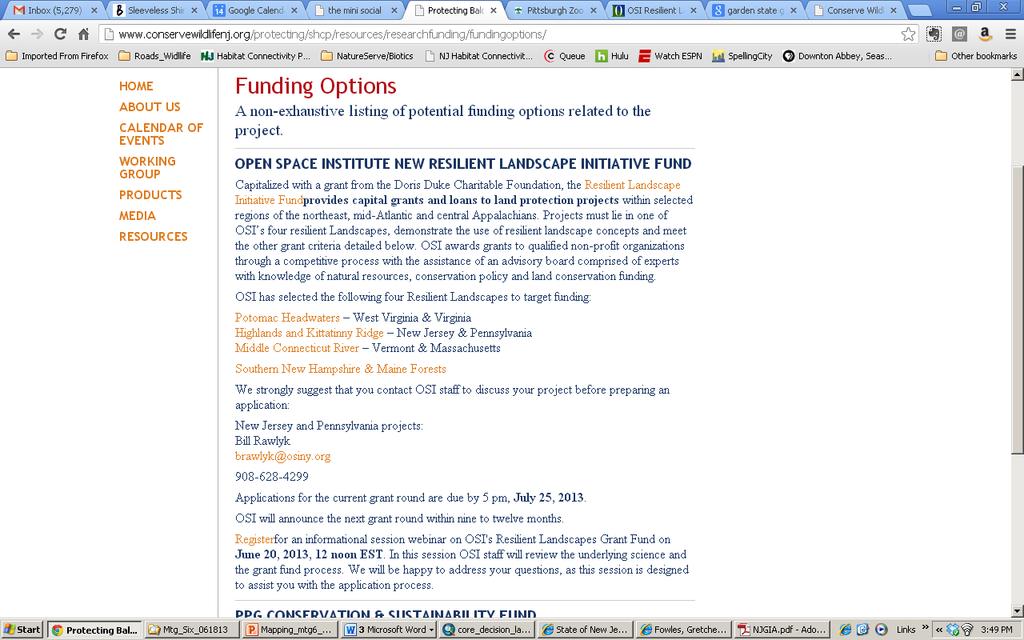
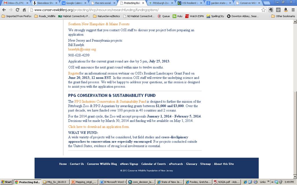
1 AGENDA Working group participation as match for SWG reminder Upcoming meetings: Next meeting on 8/20/2013 (NO meeting in July) Upcoming meetings related to connectivity ICOET: June 23-27, 2013 in Scottsdale, Arizona ICCB: July 21-25, 2013 in Baltimore, MD TRB: July 22 25, 2013 in New Brunswick, NJ Funding opportunities: PPG Conservation & Sustainability Fund: OSI Resilient Landscape Initiative Fund: Discuss June 17 th WAConnected webinar: Addressing Habitat Connectivity in Northeast Washington Forest Plan Revisions Review of May core team meetings NJ native terrestrial wildlife species Review draft list Review summary of data availability and species ecology back from species leads Review possible methodologies for defining core areas based on existing methodologies applied in and outside of NJ Next steps: Finish summarizing species information Sub-team to experiment with core mapping methodologies while considering species information Present options at August meeting
2
3
4 RECAP Guidance Document Core Team Meeting Four May 20, 12-2pm Assunpink Wildlife Management Area, Main Building Meeting attendees: Debra Firman, Gretchen Fowles, Paula Scelsi, Joe Sweger, Kelly Triece, Nellie Tsipoura, Charu Vaidya, Brian Zarate Meeting Notes: Quick poll about using core team participation as match for SWG-funded project. Review of past core team meetings and general announcements. Review of Transportation Enhancement Funding awarded to Bedminster Township for turtle tunnels. o ENSP staff will set up meeting with township to schedule additional preimplementation studies, timeline dependent, and post-implementation study. Review of federal transportation funding options to see which are available/applicable to potential NJ projects. Continuation of economic analysis Next steps: NJDOT review of FHWA funding options Continue discussion on economic analysis
5 RECAP Communication Core Team Meeting Five May 20 th, 2:30-4:30 Assunpink Wildlife Management Area, Main Office Meeting attendees: Gretchen Fowles, MacKenzie Hall, Bill Pitts, Kelly Triece, Audrey Wendolowski, Brian Zarate Discussed possibilities for a public Habitat Connectivity website Brainstormed elements important for the site to have Begin working on pieces and parts for a video snyopsis to post Discussed improving research collaboration aspect of working group site and future public site New, snazzier name for project? Tasks: Think about public site design/elements & research how other, similar projects did it Draft research template and complete for a project to evaluate Think about/research new name possibilities Review ppt script from past Habitat Connectivity presentations and finesse
6 RECAP Mapping Core Team Meeting Five May 20 th, 9:30 11:30 am Assunpink Wildlife Management Area, Main Office Meeting attendees: Rick Brown, John Cecil, Margaret Conroy, Gretchen Fowles, Dave Jenkins, Kim Korth, Amy Miller, Robert Somes, Kelly Triece, Pete Winkler, Patrick Woerner, Brian Zarate Reviewed draft list of NJ native terrestrial wildlife species for which lack of habitat connectivity could be a problem for the species long-term viability Reviewed list of questions that will be sent out to species experts related to: Data availability Species ecology reflecting movement and habitat needs Review of Natural Landscape metric applied to the Highlands Tasks: Species list and questions finalized and sent out to species lead Reviewed Pinelands Ecological Integrity Index and others to compare to Theobald Natural Landscape Approach Flesh out known/likely mapping variables
7 SPECIES QUESTIONS PRELIMINARY LOOK Defining terrestrial species: NJ native terrestrial species for which lack of habitat connectivity or isolation of habitat from similar habitat is potentially a significant problem for the species and may jeopardize its long-term viability WA: Focused on species whose movement can be limited by humancreated landscape alterations... Most move on the ground and would be sensitive to barriers Species list review 128 species currently 30 = E, T, SC 81 on Nongame list Data availability Data in Biotics for 44 species on road data collected for 20 species Number of records Taxonomic Class Number of Species Insecta 4 Chelonia 11 Aves 12 Reptilia 25 Amphibia 32 Mammalia 44
8 CORE AREAS Possible methods/ideas Definitions of cores used by others: Habitat blocks are areas large enough to sustain healthy wildlife populations and support essential biological processes into the future (Noss 1983, Noss and Harris 1986, Noss 1987, Noss et al. 1996).... make sure adequate size and with low enough levels of human disturbance (important for large, wide ranging, or highly specialized species) (Noess and Harris 1986) A specific type of habitat patch that contains critical habitat, that is unique or rare in its ability to provide all habitat needs (e.g., foraging/prey, cover, reproduction) or area of particularly high productivity (Schwartz et al. 2013)
9 CORE AREAS Possible methods/ideas * WA habitat connectivity ecoregional analysis landscape integrity Pinelands Ecological-Integrity Assessment TNC Ecological Assessment TNC Terrestrial Resilience local connectedness Landscape Project Garden State Greenways Proposal: Follow WA s landscape integrity methodology, but use methodologies applied previously in NJ to inform how we parameterize variables
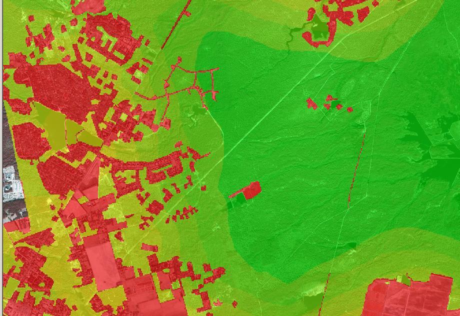
10 NATURAL LANDSCAPE METRIC 4. Housing density 1 = Residential + 100m buffer Theobald, David M. Estimating Natural Landscape Changes from 1992 to 2030 in the Conterminous US. Landscape Ecology 25, no. 7 (May 1, 2010): doi: /s z. This was a 1 st take, making quick and dirty decisions much fine-tuning needed, but wanted to try out the methodology Compute naturalness as a function of 4 factors: 1. Land cover 1 = human-dominated (Urban, Agriculture) 0 = natural (Forest, Wetlands) 2. Presence of roads 1.0 = interstates/state highways 0.5 = secondary roads (500 and 600 series county roads) 0.3 = local roads 3. Effects of traffic volume Convert traffic volume using a quadratic kernel density that assumes the impact declines with distance out to 1km away from road - generates smoothed traffic volume raster 0 = no impact 1 = AADT > 10,000
11 NATURAL LANDSCAPE METRIC 1. Land cover (10m resolution) 1 = human-dominated (Urban, Agriculture) (Gray) 0 = natural (Forest, Wetlands) (Green)
12 NATURAL LANDSCAPE METRIC 2. Presence of roads (10m resolution) 1.0 = interstates/state highways 0.5 = secondary roads (500 and 600 series county roads) 0.3 = local roads

13 NATURAL LANDSCAPE METRIC 3. Effects of traffic volume Convert traffic volume using a quadratic kernel density that assumes the impact declines with distance out to 1km away from road - generates smoothed traffic volume raster 0 = no impact (Black) 1 = AADT > 10,000 (White)

14 NATURAL LANDSCAPE METRIC 4. Housing density 1 = Residential + 100m buffer (Black)
15 NATURAL LANDSCAPE METRIC Took the max of each cell value and that was the final naturalness value Values range from 0 (most natural) to 1 (most human modified)
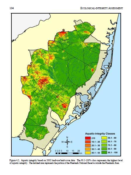
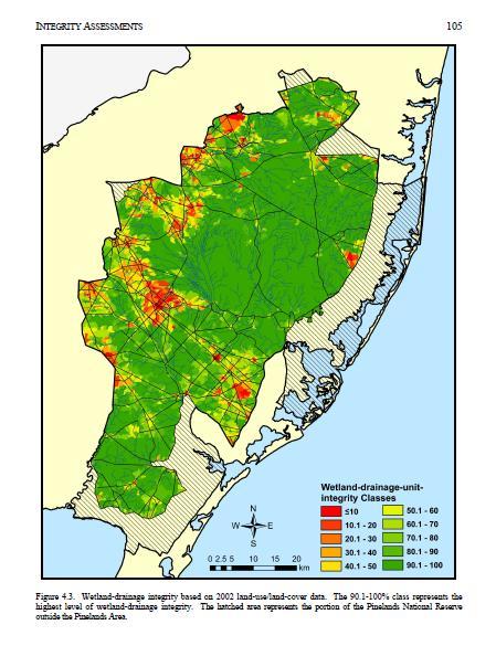
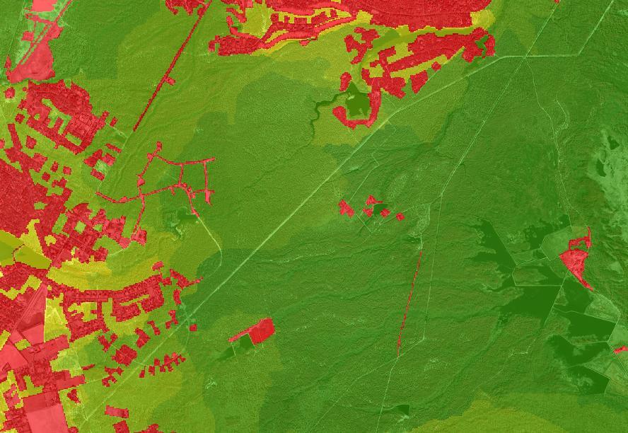
16 PINELANDS ECOLOGICAL-INTEGRITY ASSESSMENT Goal: The focus of the Pinelands ecological-integrity assessment was the status of the Pinelands Area in 2002, the period for which the most current and detailed land-use data were available. To identify areas of potentially high ecological integrity that were affected by land-use changes and to provide an indication of the cumulative effect of land-use changes in one area on adjacent areas, assessments were also completed using 1986 and 1995 land-use data.
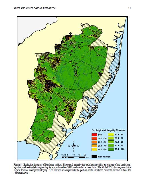
17 PINELANDS ECOLOGICAL-INTEGRITY ASSESSMENT Ecological Integrity. The overall ecological integrity of the Pinelands is a composite of landscape-, watershed-, and wetland-drainage-integrity measures. An average of all of the integrity scores Landscape Integrity Definition: Landscape integrity is a measure of the extent of Pinelands habitat in an area. Pinelands habitat includes upland forests, water, and wetlands, with the exception of managed wetlands and wetland agriculture. The landscape-integrity assessment included an analysis of separate m Pinelands-habitat cells using a window with a 1,000-m (3,281-ft) radius Aquatic Integrity Definition: percentage of land in a watershed that is neither developed land nor upland agriculture. The integrity score assigned to a drainage unit was then assigned to every m cell in that drainage unit. Wetlands-drainage Integrity Definition: percentage of land in a wetlands drainage unit that is neither developed land nor upland ag. The wetlands drainage unit is a discrete area of wetlands and the adjacent uplands that contribute surface water and groundwater to the wetlands.

18 PINELANDS ECOLOGICAL-INTEGRITY ASSESSMENT
19
20
21
22
23

24 PINELANDS ECOLOGICAL-INTEGRITY ASSESSMENT
25 TNC ECOLOGICAL ASSESSMENT We defined matrix blocks within New Jersey as areas of 10,000 acres or larger, comprised of at least 75% natural lands cover, that are bounded by major roads (county, state, or federal roads) We defined umbrella blocks as areas 4,250 acres or larger, comprised of at least 75% natural lands cover, that are bounded by major roads (county, state, or federal roads) Rare species: we selected blocks of land which contain EOs, are 250 acres or larger in size, are comprised of more than 50% natural land, and are located within three miles of an umbrella or matrix block Secondary natural blocks: We defined these secondary natural blocks as roadbounded polygons of 250 acres or larger, comprised of at least 50% natural land cover, and are located within three miles of a matrix block or are touching a rare species block

26 TNC ECOLOGICAL ASSESSMENT

27 TNC ECOLOGICAL ASSESSMENT

28 TNC ECOLOGICAL ASSESSMENT

29 TNC TERRESTRIAL RESILIENCE LOCAL CONNECTEDNESS Local connectedness: started with a focal cell and looked at the resistance to flows outward in all directions through the cell s local neighborhood.

30 TNC TERRESTRIAL RESILIENCE LOCAL CONNECTEDNESS

31 LANDSCAPE PROJECT

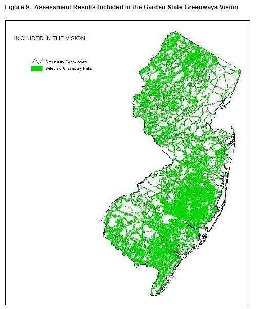
32 GARDEN STATE GREENWAYS
33 GARDEN STATE GREENWAYS a map-based vision for a potential statewide system of parks, natural areas, farmland and historic sites, linked together by greenways and trails Garden State Greenways sets forth eight broad goals towards achieving this vision: 1. Establish parks, trails or other protected lands within walking distance of every New Jersey resident. 2. Permanently protect New Jersey s critical natural resource lands: those contributing to groundwater or aquifer recharge, surface water quality, rare and endangered species habitat, and prime soils. 3. Permanently protect large, contiguous tracts of natural land for the long-term survival of native plant and animal species. 4. Permanently protect large, contiguous tracts of farmland for the long-term viability of agriculture and the maintenance of scenic and cultural landscapes. 5. Permanently protect parks, natural lands and farmland surrounding historic sites, in order to maintain their historic character, visual context and interpretive value. 6. Link together New Jersey s protected natural, agricultural, historic and recreation lands via trails and greenway connectors. 7. Grant public access and trail rights-of-way, where appropriate, across green infrastructure lands to allow the public to benefit from the scenic, recreational and interpretive opportunities provided therein. 8. Coordinate state, local and private preservation as well as land use planning efforts, around common maps and shared GIS data, towards achieving goals one through seven.
34 GARDEN STATE GREENWAYS Hubs: classified all undeveloped land in New Jersey according to land cover type, using roads to partition the different land cover types into potential hub polygons Hubs had to one or more of the following nine landscape features: (1) contiguous forest, (2) unmodified wetlands, (3) 300 ft. buffers around environmentally sensitive water bodies, (4) critical habitat, according to the NJDEP-ENSP Landscape Project, (5) critical habitat, according to NJDEP-ONLM Natural Heritage Priority Sites, (6) currently preserved land, (7) agricultural/ grassland, (8) vegetated dunes and upper beach zone, and (9) land identified as hubs in regional Garden State Greenways mapping charrettes. Once selected, greenway hubs were assessed according to the degree to which each polygon captured various resource values. 22 assessment categories included: hub size, extent preserved/unpreserved, estimated groundwater recharge, buffers around environmentally sensitive water bodies, floodplains, prime soils, and concentrations of rare, threatened and endangered species. Greenway connectors were routed between source/destination hubs; those ranking in the top 10% area-wise among all hubs in each assessment region, for at least one assessment category.
35 GARDEN STATE GREENWAYS Greenway connectors: First, greenway suitability/impedance values were mapped by assigning impedance values to selected landscape features and combining them through weighted overlay. Results were then used as inputs to cost-distance and least-cost path analyses, which in turn were used to route optimal riparian/wetland and upland connectors, respectively, between hubs. Connectors were buffered, converted to fuzzy lines of uniformly spaced points, and assessed according to their underlying per-point and average greenway suitability values.
36 NEXT STEPS Finish summarizing species information Sub-team to experiment with core mapping methodologies while considering species information Present options at August meeting

37 REGIONS
NRCS webinar TOPIC: How and What Social Media is Being Used in Natural Resource Outreach March 13, 2013; 2-3pm
 HOUSEKEEPING Zotero Notes Upcoming meetings related to connectivity: NJ Land Conservation Rally March 9, 2013; NJIT in Newark, NJ One-day educational conference about preserving New Jersey s open space
Resiliency Initiative (based on TNC Terrestrial Resilience) Open Space Institute - - March; webinar
 Open Space Institute - - March; webinar") HOUSEKEEPING Notes Recent/upcoming meetings related to connectivity: DEP Commissioner update - - March Division of Fish and Wildlife regional meetings - - March NJ Land Conservation Rally --March Resiliency
HOUSEKEEPING Notes Recent/upcoming meetings related to connectivity: DEP Commissioner update - - March Division of Fish and Wildlife regional meetings - - March NJ Land Conservation Rally --March Resiliency
Resiliency Initiative (based on TNC Terrestrial Resilience) Open Space Institute - - March; webinar
 Open Space Institute - - March; webinar") HOUSEKEEPING Notes Recent/upcoming meetings related to connectivity: DEP Commissioner update - - March Division of Fish and Wildlife regional meetings - - March NJ Land Conservation Rally - - March Resiliency
HOUSEKEEPING Notes Recent/upcoming meetings related to connectivity: DEP Commissioner update - - March Division of Fish and Wildlife regional meetings - - March NJ Land Conservation Rally - - March Resiliency
Review of 12/17/2012 meeting and other core team meetings. Review mapping approaches taken by other states
 Review of 12/17/2012 meeting and other core team meetings Core team working structure, future meeting goals, and general project outline Connectivity planning summary overview Review mapping approaches
New Jersey Habitat Connectivity Project
 Mapping Core Team Meeting Two January 25 th, 10 am - noon Assunpink Wildlife Management Area, Main Office Meeting attendees: Patrick Carr, Margaret Conroy, Karl Figueiredo, Gretchen Fowles, Gylla MacGregor,
Florida Forever Conservation Needs Assessment Overview Maps
 Florida Forever Conservation Needs Assessment Overview Maps Prepared by Florida Natural Areas Inventory, The maps in this document are derived from the Florida Forever Conservation Needs Assessment, an
I ll be talking about the Designing Sustainable Landscapes project today. This is a large integrated modeling effort our group at UMass has been
 1 I ll be talking about the Designing Sustainable Landscapes project today. This is a large integrated modeling effort our group at UMass has been working on for the past 5 years, in close collaboration
NJ Habitat Connectivity Initiative
 NJ Habitat Connectivity Initiative Full Working Group Update #1 Spotted Salamander Crossing Road in Northern NJ Wildlife Habitat Connectivity Initiative A strategic plan to reconnect New Jersey s landscape
Green Infrastructure. by Karen Engel, NYS DEC. NYS Department of Environmental Conservation
 Green Infrastructure by Karen Engel, NYS DEC What is Green Infrastructure? For some it s all about water Green Infrastructure techniques use soils and vegetation to infiltrate, evapotranspirate, and/or
The Landscape Project. New Jersey Department of Environmental Protection Division of Fish and Wildlife Endangered and Nongame Species Program
 The Landscape Project New Jersey Department of Environmental Protection Division of Fish and Wildlife Endangered and Nongame Species Program New Jersey is One of the smallest states in the country Yet
Blue/Green Infrastructure Study Accomack County, VA
 Blue/Green Infrastructure Study Accomack County, VA Draft Asset Maps March 8-9, 2010 Green Infrastructure Center, Inc. 2 Overview What is Green and Blue Infrastructure Project Timeline & Tasks Literature
National Association of Conservation Districts. Kris Hoellen Vice President, Sustainable Programs The Conservation Fund September 19, 2013
 National Association of Conservation Districts Kris Hoellen Vice President, Sustainable Programs The Conservation Fund September 19, 2013 Our Mission The Conservation Fund forges partnerships to conserve
Wide-ranging Species Conservation
 Wide-ranging Species Conservation The overwhelming message from population viability studies of large carnivores is that conservation planning must be undertaken at vast spatial scales and must consider
STEWARDSHIP OF LONG ISLAND SOUND S ECOLOGICAL AND RECREATIONAL RESOURCES
 STEWARDSHIP OF LONG ISLAND SOUND S ECOLOGICAL AND RECREATIONAL RESOURCES Robin Kriesberg, Save the Sound, Inc. Thomas Halavik, US Fish and Wildlife Service Coastal Program An Initiative to Identify, Protect
Overview of Southwestern Pennsylvania Commission s (SPC) 2040 Long Range Transportation Plan (LRTP)
 2040 Long Range Transportation Plan (LRTP)") Overview of Southwestern Pennsylvania Commission s (SPC) 2040 Long Range Transportation Plan (LRTP) Presented to Pennsylvania Agency Coordination Meeting May 27, 2015 Doug Smith & Ryan Gordon 1 Southwestern
Overview of Southwestern Pennsylvania Commission s (SPC) 2040 Long Range Transportation Plan (LRTP) Presented to Pennsylvania Agency Coordination Meeting May 27, 2015 Doug Smith & Ryan Gordon 1 Southwestern
Development of a Resource Planning Index for Washington's Scenic and Recreational Highways
 Development of a Resource Planning Index for Washington's Scenic and Recreational Highways WA-RD 740.1 Kevin Ramsey February 2010 WSDOT Research Report Office of Research & Library Services Final Technical
Landscape Conservation Design June, 2014
 Designing Sustainable Landscapes in the Northeast A project of the North Atlantic Landscape Conservation Cooperative & Northeast Climate Science Center June, 2014 Adaptive Establish Conservation Goals
Conservation Corridor Base and Thematic Maps
 Conservation Corridor Base and Thematic Maps August 20, 2010 This project is funded in part by the Virginia Coastal Zone Management Program at the Department of Environmental Quality through Grant #NAO9NOS4190163
Virginia DCR- Natural Heritage Program. Tools for Linking Conservation and Transportation Planning
 Virginia DCR- Natural Heritage Program Tools for Linking Conservation and Transportation Planning November 9, 2009 MISSION: to conserve Virginia's biodiversity through statewide biological inventory, protection,
3-2 Environmental Systems
 3-2 Environmental Systems 3.0 ENVIRONMENTAL SYSTEMS CONTENTS 3.1 GREENWAY SYSTEM 3.1.1 General Policies 3.1.2 Natural Heritage Network 3.1.3 Natural Heritage Network Enhancement Lands 3.1.4 Rouge Watershed
INTRODUCTION Key Issues and Findings Goals, Objectives, and Policies - Natural Resources - Map M18 - Environmental Resources
 Natural, Environmental, Cu INTRODUCTION This Element provides policies related to the preservation and protection of the Centre Region s natural, environmental, cultural, and historic resources. This Element
ELIGIBILITY CRITERIA CHECKLIST OPEN SPACE CLASSIFICATION
 THURSTON COUNTY DEVELOPMENT SERVICES OPEN SPACE TAX PROGRAM ELIGIBILITY CRITERIA CHECKLIST OPEN SPACE CLASSIFICATION Use this checklist to help you determine whether your property is eligible for open
Key Elements of Successful Conservation Planning. John Paskus October 17, 2013 Pierce Cedar Creek Institute Michigan Natural Features Inventory
 Key Elements of Successful Conservation Planning John Paskus October 17, 2013 Pierce Cedar Creek Institute Michigan Natural Features Inventory What is Conservation Planning? Pressey et al (2008): The process
ITS Concept Development Activity Descriptions
 ITS Concept Development Activity Descriptions October 2015 Procedures are subject to change without notice. Check the NJDOT website to ensure this is the current version. Table of Contents Concept Development
Green Infrastructure Policies and Ordinances
 Green Infrastructure Policies and Ordinances October 23, 2013 By Karen Firehock, Green Infrastructure Center 2013 Georgia Urban Forest Council s 23 rd Annual Conference The mission of the nonprofit Green
Project Summary. Rationale
 Modeling and Evaluating Potential Constraints Between Siting of Commercial Wind Power and Ecological and Social Values in the Mountains of the Northern Forest Principal Investigator(s): Dr. David Publicover
Aquatic, Terrestrial and Landscape Conservation Design Tools and Products of the North Atlantic LCC
 Aquatic, Terrestrial and Landscape Conservation Design Tools and Products of the North Atlantic LCC Scott Schwenk Science Coordinator, North Atlantic LCC Chesapeake Bay FWS Partners Meeting Annapolis,
Level 1: GIS-based Desktop Assessments. Meghan Burns, Landscape Ecologist
 Level 1: GIS-based Desktop Assessments Meghan Burns, Landscape Ecologist EPA three-tier framework WETLAND AND RIPARIAN MAPPING LEVEL 1 LANDSCAPE ASSESSMENT WETLAND LANDSCAPE PROFILES LEVEL 2 RAPID ASSESSMENT
BLOOMSBURY BOROUGH. Regional Master Plan Overlay Zone Designation. 1 inch = 0.28 miles. Zone. Sub-Zone FRANKLIN TOWNSHIP GREENWICH TOWNSHIP
 Regional Master Plan Overlay Zone Designation Zone Protection Lakes Greater Than 10 acres Conservation Existing Community Sub-Zone Existing Community Environmentally Constrained Conservation Environmentally
Great Lakes Conservation Blueprint for Terrestrial Biodiversity on the Canadian Shield
 Great Lakes Conservation Blueprint for Terrestrial Biodiversity on the Canadian Shield Bonnie L. Henson 1, Kara E. Brodribb 2 and John L. Riley 3 1 Ontario Ministry of Natural Resources 2,3 The Nature
RECREATION, OPEN SPACE AND GREENWAYS ELEMENT GOALS, OBJECTIVES, AND POLICIES
 RECREATION, OPEN SPACE AND GREENWAYS ELEMENT GOALS, OBJECTIVES, AND POLICIES GOAL R-1: DEVELOP A RECREATION, OPEN SPACE AND GREENWAYS SYSTEM AS AN INTEGRAL COMPONENT OF AN OVERALL, COUNTY-WIDE ECONOMIC
Southwest Florida Water Management District Conservation Land Acquisition Project Boundary Review Ecological GIS Decision Support System Final Report
 Southwest Florida Water Management District Conservation Land Acquisition Project Boundary Review Ecological GIS Decision Support System Final Report Introduction By: Tom Hoctor, Ph.D. Director, Center
Preface. Erie. Scranton. Allentown. Pittsburgh. Harrisburg. Philadelphia
 The Southern Alleghenies Region The Southern Alleghenies Region spans the Laurel Highlands and Allegheny Front in the west across the Appalachians to the east. It is comprised of Blair, Bedford, Cambria,
Map Development 5/15/2012. New Virginia Modeling Tools
 Regional Green Infrastructure Base Map Development 5/15/2012 RRRC Land Use & Environment Committee New Virginia Modeling Tools VA Natural Landscape Assessment Forest Habitats Cultural Model Historic Resources
IMPLEMENTING SOMERSET COUNTY S INVESTMENT FRAMEWORK
 IMPLEMENTING SOMERSET COUNTY S INVESTMENT FRAMEWORK SMART CONSERVATION THROUGH SMART GROWTH NJ LAND CONSERVATION RALLY March 22, 2014 Laurette Kratina, PP, AICP, Supervising Planner Somerset County Planning
Minnesota Department of Natural Resource - Natural Resource Guidance Checklist Conserving Natural Resources through Density Bonuses
 Minnesota Department of Natural Resource - Natural Resource Guidance Checklist Conserving Natural Resources through Density Bonuses NRDB Why Use Density Bonuses & This Checklist Local units of government
Open Space and Farmland Preservation
 Vibrant. Green. Connected. Competitive. Open Space and Farmland Preservation Statement of Purpose The purpose of this section of the Plan is to encourage and support the preservation of open space areas
January 23, Heather Shaw The Louis Berger Group, Inc. 412 Mount Kemble Avenue Morristown, NJ 07960
 CHRIS CHRISTIE Governor KIM GUADAGNO Lt. Governor Heather Shaw The Louis Berger Group, Inc. 412 Mount Kemble Avenue Morristown, NJ 07960 Re: Dear Ms. Shaw: DEPARTMENT OF ENVIRONMENTAL PROTECTION State
Oakland County s Green Infrastructure Vision. L. Brooks Patterson Oakland County Executive
 Oakland County s Green Infrastructure Vision L. Brooks Patterson Oakland County Executive Southeast Michigan 20 miles northwest of Detroit Consists of 910 square miles Population of 1.2 million More than
City of Surrey Ecosystem Management Study. Integration of ecological processes with land use
 City of Surrey Ecosystem Management Study Integration of ecological processes with land use Natural areas in Surrey are changing as the City grows and evolves. Many important natural areas remain or may
Master Plan Objectives and Policies
 Master Plan Objectives and Policies Introduction This chapter identifies the Park issues and recommended policies established by this Master Plan. The issues were identified through meetings with staff,
Re: Application Type: Proposed Highlands Redevelopment Area Designation
 CHRIS CHRISTIE Governor KIM GUADAGNO Lt. Governor State of New Jersey Highlands Water Protection and Planning Council 100 North Road (Route 513) Chester, New Jersey 07930-2322 (908) 879-6737 (908) 879-4205
Green Infrastructure Planning for Sustainability and Resiliency
 Green Infrastructure Planning for Sustainability and Resiliency Linking Lands and Communities in the Land-of-Sky Region SAMAB Conference - November 18, 2010 www.linkinglands.org Linda Giltz, AICP, Regional
Road Ecology in Practice: Building Resiliency of Urban Ecosystems through Informed Road Network Planning
 Road Ecology in Practice: Building Resiliency of Urban Ecosystems through Informed Road Network Planning Outline What is road ecology? Why is road ecology important? TRCA and road ecology application Peel
Conservation Corridor Planning and Green Infrastructure Themes
 Conservation Corridor Planning and Green Infrastructure Themes Prepared by the Green Infrastructure Center Inc. and the Northern Virginia Regional Commission February 22, 2011 Brief Overview Project Background
DRAFT Open Space Technical Bulletin
 DRAFT Open Space Technical Bulletin This guidance is intended to clarify how the Open Space Goal and Objectives of the Regional Policy Plan (RPP) are to be applied and interpreted in Cape Cod Commission
Community Conservation Workshop. Lake Placid
 Community Conservation Workshop Lake Placid 2 Community Conservation Program Welcome! We have designed a Community Conservation Program that listens to the needs of community members. We are conducting
Draft Stillwater 2030 Comprehensive Plan- Goals and Policies
 Draft Stillwater 2030 Comprehensive Plan- Goals and Policies Instructions- Review each goal and policy and discuss with group any changes, deletions for additions to the list using your groups pen. Keep
Green Infrastructure. NYS Department of Environmental Conservation
 Green Infrastructure Green infrastructure is an interconnected network of natural areas and open spaces that sustains ecosystems. Benedict, M.A. and E.T. McMahon. 2006. Green Infrastructure Linking Landscapes
Staff will be providing an overview of the project need, purpose and intent for consideration as part of the Amendment cycle.
 Agenda Item D-2 City of Tacoma Planning and Development Services To: Planning Commission From: Stephen Atkinson, Planning Services Division Subject: Open Space Corridors Project Meeting Date: March 1,
Gadsden County Planning Commission Agenda Request
 Date of Meeting: November 16, 2017 To: From: Through: Subject: Gadsden County Planning Commission Agenda Request Honorable Chairperson and Members of the Board Jill A. Jeglie, AICP, Senior Planner Clyde
Executive Summary. Essential Connectivity Map (Figure ES-1)
") Executive Summary The California Department of Transportation (Caltrans) and California Department of Fish and Game (CDFG) commissioned the because a functional network of connected wildlands is essential
Executive Summary The California Department of Transportation (Caltrans) and California Department of Fish and Game (CDFG) commissioned the because a functional network of connected wildlands is essential
ROLE OF LANDSCAPE CONSERVATION COOPERATIVES IN EVERGLADES RESTORATION
 ROLE OF LANDSCAPE CONSERVATION COOPERATIVES IN EVERGLADES RESTORATION GEER April 2017 Steve Traxler 1, Todd Hopkins 1, Beth Stys 2 1 US Fish and Wildlife Service 2 Florida Fish & Wildlife Conservation
REVIEW AND EVALUATION OF REGIONAL LAND USE
 REVIEW AND EVALUATION OF REGIONAL LAND USE AND TRANSPORTATION SCENARIOS #220831 Environmental Justice Task Force October 7, 2014 VISION 2050 Process Development of Guiding Vision for Land Use and Transportation
Highlands Region Stormwater Management Program Guidance
 DRAFT Highlands Region Stormwater Management Program Guidance Release Date: January 2016 Abstract This guidance document provides an overview of the Highlands Stormwater Management Program. It is intended
Landscape Conservation Design April, 2014
 Designing Sustainable Landscapes in the Northeast A project of the North Atlantic Landscape Conservation Cooperative & Northeast Climate Science Center Landscape Conservation Design April, 2014 Conceptual
SRP Profile Directions
 NJ-GeoWeb Home Page (figure 1) SRP Profile Directions 1. Launch NJ-Geo Web Home Page at http://www.nj.gov/dep/gis/geowebsplash.htm If needed, use the Tutorial button on the NJ-GeoWeb main screen for NJ-GeoWeb
Natomas Joint Vision Open Space Plan
 Natomas Joint Vision Open Space Plan First Workshop series The City of Sacramento The County of Sacramento LAFCo ERA Economic Research Associates EIP Associates a Division of PBS & J Natomas Joint Vision
California State Parks
 California State Parks State Parks and Natural Resources 94% of land base is un-developed 31% of the state s endangered, threatened or rare species 19 units with national or international recognition
PARKS AND RECREATION
 PARKS AND RECREATION WHAT YOU WILL FIND IN THIS CHAPTER: Background information on the development of the Park, Recreation, and System Plan (PRSP). General overview of Ellensburg s parks and recreation
Woodland Conservation and the Master Plan
 1 WHAT IS A MASTER PLAN? A Vision for the Future of Your Community Woodland Conservation and the Master Plan Goals Objectives Strategies 2 How Will Your Community Look? TREE PRESERVATION AND THE MASTER
DRAFT SCOPE FOR THE DRAFT ENVIRONMENTAL IMPACT STATEMENT FOR HUDSON HIGHLANDS RESERVE TOWN OF PHILIPSTOWN, NEW YORK June 5, 2018
 DRAFT SCOPE FOR THE DRAFT ENVIRONMENTAL IMPACT STATEMENT FOR HUDSON HIGHLANDS RESERVE TOWN OF PHILIPSTOWN, NEW YORK June 5, 2018 Project Name: Project Location SEQRA Classification of Project: Lead Agency:
Master Environmental Servicing Plan & Secondary Plan
 East Side Lands Stage 2 1 Master Environmental Servicing Plan & Secondary Plan Public Information Centre #1 June 16, 2016 Welcome! Today s Agenda Please sign in at the front desk. 5:30 pm 6:30 pm: Open
COMMUNITY ENVIRONMENTAL MANAGEMENT
 COMMUNITY ENVIRONMENTAL MANAGEMENT CEM HANDBOOK FOR COMMUNITY CONSERVATION PLANNING ----- Draft ----- Prepared by the CENTER FOR COMMUNITY ENVIRONMENTAL MANAGEMENT in association with the NEW YORK STATE
Countywide Green Infrastructure
 Montgomery County s Countywide Green Infrastructure F U N C T I O N A L M A S T E R P L A N The Maryland National Capital Park and Planning Commission INFRASTRUCTURE An underlying base or foundation especially
7.0 SOCIAL, ECONOMIC, AND ENVIRONMENTAL ISSUES
 7.0 SOCIAL, ECONOMIC, AND ENVIRONMENTAL ISSUES The following list of social, economic, and environmental issues have been identified based on a preliminary inventory of resources in the project area, an
This page intentionally blank.
 This page intentionally blank. Parks, Recreation, and Open Space Chapter Relationship to Vision Vision Parks, Recreation and Open Space Chapter Concepts County Government. County government that is accountable
Greenways as an alternative to traditional infrastructure. Green Infrastructure
 Greenways as an alternative to traditional infrastructure Green Infrastructure What is a Greenway? Little (1990) - A linear open space along a natural or human made corridor. Fabos - linked corridors nature
Whitemarsh Township Greenway Plan
 Whitemarsh Township Greenway Plan Prepared for: Whitemarsh Township August 16, 2007 Table of Contents Table of Contents... i Introduction... 1 Study Area Setting... 2 Regional Setting... 2 Township Character...
TOWN OF BETHLEHEM OPEN SPACE CONSERVATION PLAN PUBLIC MEETING: OCTOBER 12, 2017
 TOWN OF BETHLEHEM OPEN SPACE CONSERVATION PLAN PUBLIC MEETING: OCTOBER 12, 2017 Welcome and Agenda 6:00 6:45: Open House, Part One 6:45 7:15: Presentation and Questions 7:15 8:00: Open House, Part Two
MEMORANDUM. Re: A3680, New Jersey Economic Opportunity Act of 2013
 New Jersey Conservation Foundation NJ Highlands Coalition Association of New Jersey Environmental Commissions (ANJEC) American Littoral Society Burnham Park Association Musconetcong Mountain Conservancy
THREE-STEP DESIGN PROCESS FOR OPEN SPACE SUBDIVISIONS
 00216106.DOC NMA/RRK 1/30/14 THREE-STEP DESIGN PROCESS FOR OPEN SPACE SUBDIVISIONS Open space subdivisions, sometimes called cluster developments, maintain a significant portion of a development site in
NJ Department of Environmental Protection
 NJ Department of Environmental Protection COASTAL AND LAND USE PLANNING New Jersey Coastal Management Program Covers NJ coastal waters to limit of tidal influence including 239 municipalities in 19 counties,
Albion Hills Conservation Area Master Plan. Public Information Session
 Albion Hills Conservation Area Master Plan Public Information Session 1 03.25.2014 Meeting Agenda 1. Project Introduction Property History Current Use Master Plan Process 2. Draft Vision Goals and Objectives
Regional Open Space Conservation Plan Putting the Plan into Action
 Regional Staff Committee June 21, 2018 Regional Open Space Conservation Plan Putting the Plan into Action Comments on the draft Include more discussion of urban open space Benefits, challenges to maintaining/increasing
Boardman River Watershed VILLAGE OF KALKASKA. WATER QUALITY ACTION PLAN Fall 2009
 Boardman River Watershed VILLAGE OF KALKASKA WATER QUALITY ACTION PLAN Fall 2009 Partners: The Watershed Center Grand Traverse Bay Northwestern Michigan College - Great Lakes Water Studies Institute Grand
Gather information from online resources covering the following topics:
 Assignment #1: Regional Analysis Project Site Location: Greater Boston Area What comprises a region? The many elements within a region comprise the region as a whole. Natural as well as manmade environmental
Green Infrastructure for Resiliency
 Green Infrastructure for Resiliency Climate Resilience Webinar Series Kendra J. Briechle U.S. Department of Housing and Urban Development Disclaimer This presentation is intended to provide communities
Westport Master Plan. Town of Westport. Master Plan Master Plan Update Committee. Westport, Massachusetts
 Town of Westport Master Plan 2004 Master Plan Update Committee Westport, Massachusetts Open Space and Recreation 5-1 Table of Contents Table of Contents... i List of Tables... ix List of Figures... ix
AMENDMENT NO. 30 TO THE OFFICIAL PLAN OF THE TOWN OF MILTON
 AMENDMENT NO. 30 TO THE OFFICIAL PLAN OF THE TOWN OF MILTON Subject: Boyne Survey Secondary Plan and Related Official Plan Amendments The following text and schedules constitute Amendment No. 30 to the
TOWN OF SPRINGFIELD, NEW HAMPSHIRE
 TOWN OF SPRINGFIELD, NEW HAMPSHIRE NATURAL RESOURCES INVENTORY EXECUTIVE SUMMARY March 2008 Prepared by: Watershed to Wildlife, Inc. Natural Resource Consultants 42 Mill Street, Suite 3 Littleton, NH 03561
I. STAFF POLICY RECOMMENDATIONS. The following RMP policy strategies are proposed by staff in support of a Scenic Resource Protection Program:
 Policy Consideration: Scenic Resource Protection Program Status: For Consideration by the Highlands Council at September 14, 2006 Work session Date: September 12, 2006 I. STAFF POLICY RECOMMENDATIONS The
Consequences of Landscape Patterns on Flows of Energy, Nutrients, Organisms
 Consequences of Landscape Patterns on Flows of Energy, Nutrients, Organisms Consequences of Landscape Patterns on Flows of Energy, Nutrients, Organisms Questions: How does landscape structure influence
Draft Impervious Cover Reduction Action Plan for West New York, Hudson County, New Jersey
 Draft Impervious Cover Reduction Action Plan for West New York, Hudson County, New Jersey Prepared for the Town of West New York by the Rutgers Cooperative Extension Water Resources Program March 29, 2017
FEGN Update Goals and Objectives
 FEGN Update Goals and Objectives Update the FEGN to identify a functionally connected statewide ecological network of public and private conservation lands that incorporates new and updated GIS data. Ensure
East River Waterfront Esplanade and Piers New York, New York Draft Environmental Impact Statement
 East River Waterfront Esplanade and Piers New York, New York Draft Environmental Impact Statement October 12, 2006 CEQR No.: TO COME ULURP Nos.: TO COME Lead Agency: Lower Manhattan Development Corporation
Visual Impact Rating Form - Instructions
 Visual Impact Rating Form Instructions Project Name: Baron Winds Project EDR Project No: 13039 Date: 05.16.17 Reference: Visual Impact Rating Form - Instructions These instructions are intended to guide
GIS to Estimate Archaeological Site Loss and Develop Conservation Strategies
 GIS to Estimate Archaeological Site Loss and Develop Conservation Strategies Terry Jackson Office of Decision Support Systems Planning and Environmental Management Division Georgia Department of Community
LANDSCAPE SCALE PLANNING AND SITING FOR SHALE DEVELOPMENT
 LANDSCAPE SCALE PLANNING AND SITING FOR SHALE DEVELOPMENT An Energy by Design approach to reducing the overall environmental footprint. MICHELLE MCGREGOR SR. OIL & GAS DEVELOPMENT ADVISOR Agenda Introduction
SECTION 1 Introduction...1. SECTION 2 Regional Context Criteria for Planning Districts Description of Planning District...
 Table of Contents SECTION 1 Introduction...1 SECTION 2 Regional Context...2 2.1 - Criteria for Planning Districts...2 2.2 - Description of Planning District...2 SECTION 3 Goals & Objectives...5 SECTION
Riparian Buffer on the Bushkill Creek. Policies
 Riparian Buffer on the Bushkill Creek Riparian buffers provide numerous benefits to landowners and the community by protecting groundwater recharge areas, providing flood control, providing stormwater
Introducing Green Infrastructure for Coastal Resilience
 Introducing Green Infrastructure for Coastal Resilience National Oceanic and Atmospheric Administration (NOAA) Office for Coastal Management Gloucester, MA Office of Travel Courtesy, Tim Grafft What Is
CFLRP 5-Year Ecological Indicator Progress Reporting EXPERT PANEL GUIDANCE
 CFLRP 5-Year Ecological Indicator Progress Reporting EXPERT PANEL GUIDANCE In passage of the Omnibus Public Land Management Act of 2009, Congress required Collaborative Forest Landscape Restoration (CFLR)
Arlington, Virginia is a worldclass
 EXECUTIVE S U M M A RY Arlington maintains a rich variety of stable neighborhoods, quality schools and enlightened land use policies, and received the Environmental Protection Agency s highest award for
Community Conservation Workshop. Saranac River Basin Communities
 Community Conservation Workshop Saranac River Basin Communities 2 Community Conservation Program Welcome! We have designed a Community Conservation Program that listens to the needs of community members.
Gold Line Bus Rapid Transit Transit Oriented Development (BRTOD) Helmo Station Area Plan
 Helmo Station Area Plan") Appendix F Gold Line Bus Rapid Transit Transit Oriented Development (BRTOD) Helmo Station Area Plan Introduction and Purpose of the Plan The Gold Line Bus Rapid Transit facility is an eleven-mile dedicated
Appendix F Gold Line Bus Rapid Transit Transit Oriented Development (BRTOD) Helmo Station Area Plan Introduction and Purpose of the Plan The Gold Line Bus Rapid Transit facility is an eleven-mile dedicated
DRAFT MAP AMENDMENT FLU 04-4
 DRAFT MAP AMENDMENT FLU 04-4 SW 24 TH AVENUE ROADWAY CORRIDOR The University of Florida participates with the Metropolitan Transportation Planning Organization (MTPO) in its responsibilities for the continuing,
Meeting Agenda. City of Guelph. River Systems Advisory Committee. Agenda Items. Item 1, 2 and 3. Item 4 Ward to Downtown Pedestrian Bridge
 Meeting Agenda City of Guelph River Systems Advisory Committee September 19, 2018 City Hall, Meeting Room B From 4:00 to 6:00 p.m. Meeting Chair: Mariette Pushkar Agenda Items Welcome to all Item 1, 2
City of Tacoma Planning and Development Services
 Agenda Item D-3 City of Tacoma Planning and Development Services To: Planning Commission From: Stephen Atkinson, Associate Planner, Planning Services Division Subject: Land Use Designations - Phase 2 Meeting
City of Missoula and Missoula County Open Space Planning Open House
 City of Missoula and Missoula County Open Space Planning Open House FEBRUARY 6, 2018 The following slides contain the display board content from the open house. Please use boards to answer questions in