KANATA LAKES NORTH NEIGHBOURHOOD PARK FACILITIES PROGRAM UPDATE
|
|
|
- Denis Todd
- 5 years ago
- Views:
Transcription
1 Prepared by: Corush Sunderland Wright Limited Anne Robinson and associates
2 EXECUTIVE SUMMARY The 1989 Open space Master Plan was based on the existing Community Master Plan prepared by Genstar. This Master Plan for the subdivision set the conceptual direction for the 40% open space which included an 18 hole golf course, a natural environment area (NEA) and municipal parkland. The golf course, and NEA land areas and configurations were based on program and natural features, while the parks were somewhat more flexible and related to community design principles and the recreation needs. The findings of the recreation needs assessment at that time endorsed the provision of natural and linear, open space, as well as identified program elements which should be accommodated in the parks. Thirteen years later, in 2002, the golf course has been expanded, development has reached the NEA area and the definition of those lands have been refined as an "on the ground" survey line. The subdivision layout requires refinement by the present owner KNL Developments Inc. to reflect this more precise NEA boundary with it's associated buffer zone and current market conditions as they relate to lot size, School Board options and the like in terms of subdivision layout. This juncture presents an opportunity to revisit the recreation need and trends as we find them in 2002, and revisit the municipal park configuration and program as part of the subdivision redesign. In this context the needs assessment is focused on the program needs which might best be accommodated within the remaining parklands. A current review of recreation patterns, as reflected in current national surveys continues to endorse the concept of linear open space. Activities such as walking, bike riding and cross country skiing continue to be among the highest frequency of recreation activities. While no direct survey was conducted in the now existing neighbourhood, a comparison was made to determine recreation patterns of people of similar demographic profile. A review of the demand for sports field bookings and interviews with various sports groups confirmed that while linear open space is in high demand there is also need for community level sports fields within the available parkland. While it would have been possible to configure the parkland component of the open space to connect and augment the NEA lands, this type of approach would be at the expense of providing active sports fields within the community. Luckily this need not be an "all or none" decision as the NEA lands provide an extraordinary resource in terms of path network community connectivity and distinctive neighbourhood character, such that sports fields in the remaining parks will provide that recreation component in addition, rather than at the expense of unstructured activities. More specifically, soccer pitches are in high demand as this sport has virtually exploded in participation numbers over the last decade, while softball and baseball participation has declined. Moreover it is clear that grouping of soccer pitches best accommodates, user needs, be it for families with children of different ages practicing at the same time, or to host tournaments. This being said it may be possible to configure these sports parks so that they also provide through community linkages. Based on the review of recreation needs the following principles were developed to guide the configuration of parkland in the revised subdivision layout. These principles were presented for discussion at a public meeting in July and received general community support.. The parks will be designed to accommodate Kanata's two main user groups: individuals and small groups participating in unstructured outdoor activities and Kanata Soccer; Park location and configuration will contribute to open space connections, i.e. Nodes of activity or destination points that are linked by trail systems;
3 The size of the parks will optimize the number of sports fields; Sports fields will be clustered together to allow for the development of ancillary facilities such as washrooms, play areas and parking; Trail management is necessary to reconcile conflicts among user groups and reduce trail deterioration; Sports fields will be provided for both introductory/ developmental play and competitive / tournament level activity. These principles guided the redesign of the subdivision layout as it related to parks. This plan uses some of the allotted parkland to enhance community connections which can contain other elements such as seating areas, shade structures and play equipment, and does provide two small neighbourhood level parks within the core of the planned neighbourhood. One community level park adjacent to the Goulbourn Forced Road is large enough to provide four soccer pitches. This location on the edge of the community is deliberate, both to reduce traffic conflicts and to present a green gateway at that edge of the community. This park is large enough to provide up to four intermediate sized soccer pitches and 160 parking spaces (40/ pitch) as well as a field house/shade structure plus play area, which would serve a the orientation point for soccer activities as well as a community amenity. Another location, adjacent to Shirley's Creek is large enough to provide two small soccer practice fields. The KNL Developments Inc. plan provides approximately twice the area, compared the 10.6 ha. provided for in the 1989 Open Space Master Plan for Marchwood - Lakeside. In closing, this reworking of the subdivision from a parks perspective both supports the recreation needs for both natural and linear open space concept surrounding the NEA lands without trading off that land for sports fields as is usually the condition with the conventional 5 % to 6% parkland dedication. I. PURPOSE OF THIS UPDATE The lands which will become Kanata Lakes North neighbourhood were purchased from Genstar by KNL Developments. This new owner wished to revise the subdivision concept to reflect their corporate view in response to not only current market conditions, but also the final refinement of the actual Natural Environment Area (NEA) boundary. The 1989 Open Space Master plan was based on the Community Master Plan prepared by the original landowner and land developer, Genstar. While the concept and agreement to provide 40% open space (this includes the golf course, NEA lands as well as parks) continues to be the core planning principle, with the passage of time several parameters have been fixed and with the presence of a the existing neighbourhoods there is a community with which to consult, which was not present thirteen years ago. Additionally a plan has been developed for the Trillium Woods Park which is on the north side of the Goulbourn Forced Road, the Terry Fox Road extension alignment has been fixed and some 600 acres or hectares of the March Highlands, which are high quality natural lands, have been purchased by the City of Ottawa adjacent to the Marchwood ' Lakeside community. The City of Ottawa planning and park planning staff were aware of shifts in recreation demands as well as changes in the approach to location and provision of sports fields in parkland since the 1989 study. In short the revisiting of the subdivision concept and the impending development of Kanata Lakes North provided not only an opportunity to revisit the park configurations and facilities program, but
4 has also instilled some urgency to update the plans before the subdivision plans are refiled. 2. SYNOPSIS OF 1989 OPEN SPACE MASTER PLAN FOR MARCHWOOD. LAKESIDE Torrance and Wright July, 1989 Open Space Master Plan Marchwood-Lakeside. City of Kanata The main objectives of the Study were to record and assess the recreational potential of proposed park sites, identify the recreational needs of the Marchwood-Lakeside Community and prepare conceptual park plans and cost estimates for the development of proposed park sites. The study includes an inventory of parkland, demographic analysis, community survey results, standards for recreation amenities and costing. The Open Space System included 40% of the total development area (567 hectares (1,400 acres) of land, eventually housing 23,000 people. The parkland included: a. 18 hole golf course (72 ha or 177 acres) b. municipal parkland (41 ha (102 acres) c. natural environment area (128 ha 316 acres) d. storm water management areas (within parkland or NEA's) The survey results rated playgrounds, swimming, cycling and skating as highly important activities as well as 'enjoyment of nature'. From the survey results the report recommended preserving natural features as much as possible, providing an extensive bike path system, providing loose surface trails through natural settings, provide interpretive information at points of interest; provide recreational skating at local neighbourhood level ponds; locate sports fields on or near school sites and possibly out of the area in the business park or close by. The proposed program included 8 soccer fields, 3 ball diamonds, 1 multipurpose field, 3 tennis court areas, 1 athletic track, 7 play structures, 8 tot lots, 2 pond areas for outdoor skating. The Report notes the need to use Beaverbrook's facilities and also that these need improvement. A review of the parks and facilities within the Kanata Lakes North neighbourhood in the 1898 is summarized in the table below. Summary of Park Facilities within the Kanata Lakes North Neighbourhood Park # ha. twinned with 2 school sites 2, 60 x 100 m soccer pitches paths 2, play areas Park #8 2.2 ha. twinned with school site play area paths "potential field" - would require extensive clearing. and grubbing Total Park Area 10.6 ha. 3. RECREATION NEEDS ASSESSMENT In order to understand the needs of both existing and projected Kanata Lakes residents and
5 recommend preferred options for the development of the remaining parkland in this area, the Needs Assessment, detailed in Appendix A, included the following steps: A review of relevant background documents; An analysis of trends, specifically popular physical activities, recreation expenditures and the health status of children and youth in Canada; A demographic comparison of Ottawa, former Kanata and Kanata Lakes, profiling age, income and education variables; A Situational Analysis - determining the current registration numbers of Kanata organizations, discussions with some community groups; A review of the community's comments and feedback from the public and stakeholder meetings. Given the time frame, the desire to find practical solutions and the fact, to some extent, that the community has been quite satisfied with its outdoor amenities, no comprehensive random sample household survey was conducted. With respect to pertinent background documents, the 1989 Open Space Master Plan Marchwood- Lakeside Report, has been described earlier. Some of the germane highlights from other reports are summarized below and elaborated in Appendix A: The 1992 Brunton Report recommended an amendment to Kanata's Official Plan to consolidate, clarify and expedite sound ecological planning and management direction for the NEA's of the Kanata Lakes Study Area (Lots 6,7,8 and 9 of Concessions 2 and 3), that non-conforming activity be removed from the NEA area such as biking activity that erodes the environment; The South March Community Parks Master Plan which included Morgan's Grant and Riddell Village had an anticipated population of 9,600 and the Plan noted the need for larger scale outdoor facilities and a shortage of ball diamonds and sports fields within the community; the Plan also recommended that the City start acquiring school property options in order to meet the needs of the Morgan's Grant area; The 1997 Rural Parks and Open Space Plan recommended developing criteria for property acquisition, enhancing facilities at Pinhey's Point, and acquiring land to provide a centrally located community scale active park facility; The 1995 City of Kanata Parks and Recreation Facilities Master Plan recommended the initiation of a major outdoor sports complex with 1 major baseball field, 1 intermediate softball field, 1 major soccer, 1 intermediate soccer, 1 minor soccer field and 6 tennis courts built in the short term (1996,99) to service the entire city. In the medium term (2000,2005) the Report identified the need to continue the outdoor sports complex with 3 additional intermediate softball diamonds, 2 intermediate soccer fields and 2 tennis courts; A 1999 Staff Report to Kanata Council indicated the immediate need, as a result of rapid growth in soccer, for 3 sports fields, and upgrades to existing fields to service the entire city. The Report indicated that soccer registration in Kanata had grown from 2500 in 1995 to 3500 in Today, it's reported to be about 4,200.
6 Based on the demographic and trends information we know that: Kanata Lakes is a young, highly educated, family oriented community with above average household incomes, so we can anticipate above average participation rates in recreation and cultural activities; Based on both the demographic data and soccer registration information, it's anticipated that soccer participation will continue to grow in the short and medium terms; The current number of soccer fields in Kanata does not meet the need as identified in several earlier reports and supported by the anecdotal evidence that the Kanata Soccer Club is turning away 250,350 potential participants annually; this shortage is not a Kanata Lakes issue, as much as it is both a ward-wide and most definitely a city-wide issue; With the aging baby boomers, walking, which has consistently been the most popular physical activity over the past two decades, will continue to be popular and therefore trail use will certainly continue to escalate; Of the twenty-eight Kanata residents who attended the Kanata 'Lakes July Open House, 22 supported a ratio allocation of Open Space of 88% NEA complete with an integral trail network and 12% active park space ratio; the majority also supported clustered sports fields and on-street parking; With greater concern about the 'environment' and degradation flagged as early as 1992, a review of whether trail bike riding is appropriate, and should be allowed is necessary before refining the width, material alignment of the actual trails. Based on the above overview of findings, the following is recommended: With increased numbers of users trail conflict can be anticipated and will need to be resolved; a well marked trail system and trail management plan should be developed; Based on existing trail use patterns, the City's Study on Natural Environment Areas being undertaken currently, and the earlier Brunton Report, the City needs to work with the local community and trail users to clearly define the Kanata Lakes Trail Network including its purpose, destination points, linkage, surface type, usage, prime users, liability, maintenance and conflict resolution; There is a need for 'community-level' soccer fields, preferably clustered, possibly with a school location, to maximize parking/ washroom and complementary play amenities. Some smaller park locations may serve neighbourhood needs and if possible, should connect to the Trail Network.
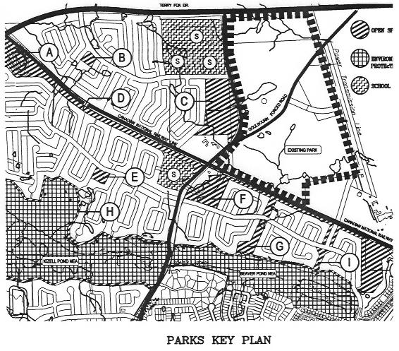
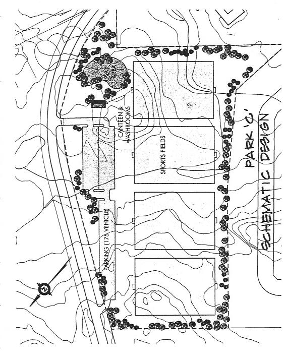
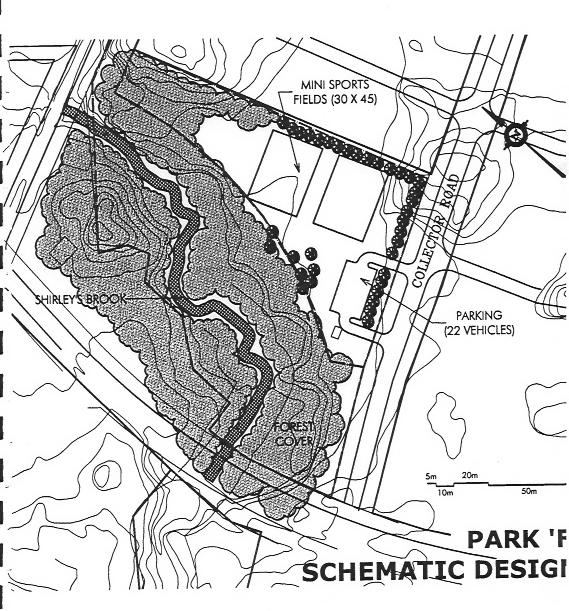
7 4. PARK FACILITIES RECOMMENDATIONS In addition to the recreation needs a shift in the approach to planning parks over the thirteen years since the Open Space Master Plan for Marchwood _ Lakeside influenced the location and configuration of the parks as set out in the KNL developments Inc. Sub-division plan. This park planning approach is, based in response to observations gained from dealing with programming and user's comments from other similar suburban neighbourhoods in Ottawa, as experienced by the authors of this report and as reported by City of Ottawa Park Planning professionals. The 1989 plan assumed that parks should be centrally located within the neighbourhood and twinned with school properties. While the concept of locating parks centrally still applies for the small neighbourhood parks, thinking has changed in regards to parks with sports fields. The current approach to providing sports fields is to consolidate fields together in larger parks rather than distributed sites, locate the parks at the edges of neighbourhoods and provide parking, accessed from collector roadways. This approach is in response observations about how the fields are used and complaints about traffic circulation and parking in existing neighbourhoods. Parks with several fields optimize the number of fields per hectare of parkland, as well as facilitate the efficiency of maintenance. Not only do multiple field facilities work better for tournaments, but often different age groups are able to practice in the same park, which simplifies practice logistics for families with siblings on different teams practicing at the same time. While the model of sports fields being within walking distance of the participant's homes, the actual usage usually involves arrival by car. This association of cars to fields is for many reasons, including athletes arriving from other neighbourhoods, parents running late and bringing younger siblings, matches with other districts and the like. On street parking adjacent to homes near parks is a constant source of resident complaints, with safety in areas without sidewalks being sited as the main concern. The associated traffic on local streets abutting homes is also an irritant, and can be mitigated by locating sports parks on collector roads so that access to parking, and even on street parking minimizes circulation on the local street network. In support of the use patterns of sports parks, a centralized gathering area with shade, play structure, seating and even water or washroom facilities sets up a natural location for registration and the like for tournaments and community events but also recognizes the need for parents with young children to allow them to play while their older sibling is practicing or participating in a match. The trail system within the NEA, and linkages to that trail is intended to be a continuous system. Care must be taken not to interrupt this trail with storm water fore bays. A preliminary alignment was flagged in the field by Jerry Corush, Bernie Muncaster and Alan Cameron in the Summer of While the width and surface material of this trail was not resolved, the assumption was that this trail would be for pedestrian use. Should a bike riding trail, be required the alignment, particularly as it relates to slopes would be quite different from a walking trail so that it is challenging as well as separate from the pedestrian trail to minimize conflicts. Surface materials, slope retention and the like for a bike trail would also be considerably different from a walking trail to withstand the erosion, and limit the tendency for cyclists to create new trails. The following key plan and table set out recommendations for the facilities within the parks in the KNL developments Inc. subdivision Plan. Schematic plans of parks "C" and "F" have been developed to test the potential field layouts. Actual design of these parks will require judgements as to removal of existing trees and more detailed review of the size of fields required.
8
9 Park Area Role Facilities A 3.86 ha Natural Amenity. rock knoll, natural feature B 0.46 ha Neighbourhood Amenity. along collector roadway and Punctuation. shade structure, sitting area. play area. open level grass area for informal play C 3.9ha Community Level Sports. up to four 60 x 100 m soccer pitches Park. parking for 160 cars (forty/pitch). central shade structure, gathering area, play equipment. preserve groups of existing trees, where practical D 3.14 ha Linear Connector and. 30 m width additional to railway corridor in Relocated Stream which a recreation path or trail can be located as part of the community wide trail and patch network. retain exiting trees as practical E 0.57 ha Neighbourhood Amenity. shade structure, sitting area and Punctuation along. play area Collector Roadway. open level grass area for informal play. preserve existing trees as practical F 8.64 ha Natural Amenity Area,. path and trail connection along railway Containing Stream corridor, preservation of Shirley's Brook as fish habitat. sufficient space for two mini soccer practice pitches, sand twenty-two parking spaces subject to evaluation of existing trees ha Natural Open Space. trail connection from rail corridor to NEA as Corridor and part of the community wide trail and path network H 2.0ha 10 m Wide Buffer Strip. buffer for NEA along NEA (natural environment area) Lands I 0.42 ha Natural Open Space NEA lands Total Park Area ha Corridor and Landscape Boulevards as Community Entry Feature. four possible 60 x 100 soccer pitches and two mini soccer practice pitches
10
11
, including: An 18 hole golf course (72 ha/ 177 acres) Municipal parkland (41 ha/ 102 acres) Natural Environment Area (128 haj316 acres) The 1989 Marchwood-Lakeside Open Space Master Plan")
12 4. Situational Analysis - The Study Area The overall development plan for the Marchwood-Lakeside community had an open space component representing 40% of the total development area (836haj595 acres), including: An 18 hole golf course (72 ha/ 177 acres) Municipal parkland (41 ha/ 102 acres) Natural Environment Area (128 haj316 acres) The 1989 Marchwood-Lakeside Open Space Master Plan recommended preserving natural features as much as possible, providing an extensive bike path system, providing loose surface trails through natural settings and interpretive information at points of interest; providing recreational skating at local neighbourhood level ponds; locating sports fields on or near school sites and possibly out of the area in the business park or close by. The proposed program for the entire Marchwood- Lakeside area included 8 soccer fields, 3 ball diamonds, 1 multipurpose field, 3 tennis court areas, 1 athletic track, 7 play structures, 8 tot lots, 2 pond areas for outdoor skating. The Kanata Lakes North Neighbourhoods specifically included 2 park sites twinned
13 with a potential school site and the following amenities were proposed in 1989: Park #7 (8.4 ha): Park # 8 (2.2 ha): 2 (60xl00 m) soccer pitches Paths 2 play areas 1 play area Paths Potential field (extensive clearing required) At the public meeting in July, 2002, the City of Ottawa indicated, after researching the various agreements and legal documents, that Kanata Lakes has a total of 560 acres of dedicated open space and within the Urbandale land holdings, approximately 271 acres is to be dedicated to active parks, natural environment area (NEA) and walkway linkages, with about 88% or acres of NEA and 12% or 35.5 acres in active park spaces. The community was asked for their feedback at this meeting and the full results are documented in Appendix C. Some highlights of this feedback are: 78% supported the ratio of 88% NEA and 12% Active Park Space 78% agreed with the criteria for defining the environmental sensitive area within the NEA being: representation of diverse natural features, protection of sensitive natural features, and topography While the majority agreed with the criteria, only half agreed with the proposed boundary 57% preferred a cluster of sports fields versus individual sports fields 50% preferred on-street parking versus 39% on-site parking 50% wanted mountain bikers restricted to their own trail system42% did not want them restricted 71% supported restrictions on trail use
North Oakville East Parks Facilities Distribution Plan. November, 2009
 North Oakville East November, 2009 POLICY CONTEXT 1) Purpose a) The purpose of this document is to be a guide for the location, configuration, design and development of the parks system for the North Oakville
CHAPPLES PARK MASTER PLAN
 CHAPPLES PARK MASTER PLAN Presentation of Preliminary Development Options Public Open House #2 Wednesday November 2 nd, 2016 TONIGHT S AGENDA 1. Welcome & Introductions 2. Presentation by Sierra Planning
ESTABLISH AN EFFICIENT TOWN CENTER
 ESTABLISH AN EFFICIENT TOWN CENTER 4 Overview Lisbon residents are proud of the history of Newent and at the same time recognize its current importance as a centralized location for a variety of municipal
General Manager, Planning and Development; General Manager, Parks, Recreation and Culture. Proposed Mini-Park and Plaza Designations
 Corporate NO: R106 Report COUNCIL DATE: June 16, 2008 REGULAR COUNCIL TO: Mayor & Council DATE: June 12, 2008 FROM: SUBJECT: General Manager, Planning and Development; General Manager, Parks, Recreation
SECTION 4(f) DE MINIMIS DOCUMENTATION
 DE MINIMIS DOCUMENTATION") SECTION 4(f) DE MINIMIS DOCUMENTATION Illinois Route 60/83 IL 176 to the intersection of IL 60 (Townline Road) Lake County P-91-084-07 Mundelein Park and Recreation District Project Limit SECTION 4(f)
SECTION 4(f) DE MINIMIS DOCUMENTATION Illinois Route 60/83 IL 176 to the intersection of IL 60 (Townline Road) Lake County P-91-084-07 Mundelein Park and Recreation District Project Limit SECTION 4(f)
Gold Line Bus Rapid Transit Transit Oriented Development (BRTOD) Helmo Station Area Plan
 Helmo Station Area Plan") Appendix F Gold Line Bus Rapid Transit Transit Oriented Development (BRTOD) Helmo Station Area Plan Introduction and Purpose of the Plan The Gold Line Bus Rapid Transit facility is an eleven-mile dedicated
Appendix F Gold Line Bus Rapid Transit Transit Oriented Development (BRTOD) Helmo Station Area Plan Introduction and Purpose of the Plan The Gold Line Bus Rapid Transit facility is an eleven-mile dedicated
Executive Summary.. 1. Introduction
 Executive Summary.. 1. Introduction 1.1. Park and Open Space Development... 1 1.2. Park and Open Space Designations and Zones.... 2 1.3. Types of Parks... 2 1.4. Types of Open Spaces... 3 1.5. Who Should
The West Vaughan Employment Area Secondary Plan Policies
 Part 2: The West Vaughan Employment Area Secondary Plan Policies 2.1 General Policies It is the policy of Council: 2.1.1. That the West Vaughan Employment Area (the WVEA), identified on Schedule 1, will
City Council March 27, Parks, Recreation, and Trails Master Plan
 City Council March 27, 2018 Parks, Recreation, and Trails Master Plan Planning Process Develop Goals and Objectives Inventory of Areas and Facilities Needs Assessment And Identification Public Participation
Chapter 10 IMPLEMENTATION RECOMMENDATIONS
 Chapter 10 IMPLEMENTATION RECOMMENDATIONS The recommended land use plan presented in the previous chapter provides a design for the attainment of the urban and rural development and open space preservation
T O W N O F H I G H R I V E R
 T O W N O F H I G H R I V E R o p e n s p a c e p l a n The Town of High River, 30 minutes South of Calgary, still retains much of its distinctive small town character and provides residents with a high
The Recreational Heart of Cannington - MacLeod & Claire Hardy Parks
 The Site Claire Hardy Park and MacLeod Park are both located within the community of Cannington on opposing shorelines of the Beaver River and are accessible to each other by a footbridge spanning the
Comprehensive Plan ADOPTED APRIL 2014
 Comprehensive Plan ADOPTED APRIL 2014 8 8. Outstanding Recreational & Cultural Opportunities We are proud of our community s parks and recreation system. Our community will ensure that the legacy of our
What We Heard Public Engagement - Stage 1
 What We Heard Public Engagement - Stage 1 Background Early planning is underway for a potential new river crossing over the North Saskatchewan River, in the northeast part of the Edmonton region. The City
FORMER CANADIAN FORCES BASE (CFB) ROCKCLIFFE SECONDARY PLAN. Official Plan Amendment XX to the Official Plan for the City of Ottawa
 ROCKCLIFFE SECONDARY PLAN. Official Plan Amendment XX to the Official Plan for the City of Ottawa") FORMER CANADIAN FORCES BASE (CFB) ROCKCLIFFE SECONDARY PLAN Official Plan Amendment XX to the Official Plan for the City of Ottawa 1 INDEX THE STATEMENT OF COMPONENTS PART A THE PREAMBLE PAGE Purpose...
FORMER CANADIAN FORCES BASE (CFB) ROCKCLIFFE SECONDARY PLAN Official Plan Amendment XX to the Official Plan for the City of Ottawa 1 INDEX THE STATEMENT OF COMPONENTS PART A THE PREAMBLE PAGE Purpose...
Complete Neighbourhood Guidelines Review Tool
 Complete Neighbourhood Guidelines Review Tool Prepared By: City of Regina Planning Department October 2014 Page 1 of 14 Community Development Review Checklist for Secondary Plans and Concept Plans The
CHAPPLES PARK MASTER PLAN. Presentation to Council April 10, 2017
 CHAPPLES PARK MASTER PLAN Presentation to Council April 10, 2017 1 PRESENTATION AGENDA 1. Project Background, Aim and Process 2. The Site Issues and Opportunities 3. Community Engagement 4. Vision and
THE CORPORATION OF THE TOWN OF ST. MARYS
 THE CORPORATION OF THE TOWN OF ST. MARYS DISCUSSION PAPER #8 (update) RECREATION AND PARKLAND - DRAFT - Presented to the Town of St. Marys Planning Advisory Committee on December 18, 2017 Introduction
ROAD CLOSURE AND LAND USE AMENDMENT SILVER SPRINGS (WARD 1) NORTHEAST OF NOSEHILL DRIVE NW AND SILVER SPRINGS ROAD NW BYLAWS 2C2018 AND 29D2018
 NORTHEAST OF NOSEHILL DRIVE NW AND SILVER SPRINGS ROAD NW BYLAWS 2C2018 AND 29D2018") Page 1 of 19 EXECUTIVE SUMMARY This application proposes redesignating two parcels in the community of Silver Springs from Special Purpose Future Urban Development (S-FUD) District and undesignated road
Page 1 of 19 EXECUTIVE SUMMARY This application proposes redesignating two parcels in the community of Silver Springs from Special Purpose Future Urban Development (S-FUD) District and undesignated road
SEWRPC OUTDOOR RECREATION AND OPEN SPACE PLANNING OBJECTIVES, PRINCIPLES, AND STANDARDS
 SEWRPC OUTDOOR RECREATION AND OPEN SPACE PLANNING OBJECTIVES, S, AND STANDARDS Introduction The Southeastern Wisconsin Regional Planning Commission (SEWRPC), as part of the regional park and open space
TABLE OF CONTENTS. Tables Table UC Davis Park and Open Space Resources
 TABLE OF CONTENTS 4.13 Recreation... 4.13-1 4.13.1 Environmental Setting... 4.13-1 4.13.2 Impacts and Mitigation Measures... 4.13-4 4.13.3 References... 4.13-8 Tables Table 4.13-1 UC Davis Park and Open
MAYFIELD WEST SECONDARY PLAN PHASE 2
 MAYFIELD WEST SECONDARY PLAN PHASE 2 Public Open House #3 February 25, 2010 Draft Preferred Land Use Scenario TOWN OF CALEDON PLANNING & DEVELOPMENT DEPARTMENT Open House Agenda TOWN OF CALEDON 1. Welcome
Design Specifications & Requirements Manual
 11 PARKS & OPEN SPACES 11.1 DEFINITIONS... 1 11.1.1 Neighbourhood Parks... 1 11.1.2 District Parks... 1 11.1.3. Sport Parks... 1 11.1.4 Urban Parks... 1 11.1.5 Civic Spaces... 1 11.1.6 Open Space System...
MAYFIELD WEST SECONDARY PLAN PHASE 2
 MAYFIELD WEST SECONDARY PLAN PHASE 2 Council Information Workshop February 16, 2010 Draft Preferred Land Use Plan TOWN OF CALEDON PLANNING & DEVELOPMENT DEPARTMENT Workshop Agenda TOWN OF CALEDON 1. Welcome
URBAN DESIGN BRIEF. 2136&2148 Trafalgar Road. Town of Oakville
 URBAN DESIGN BRIEF 2136&2148 Trafalgar Road Town of Oakville Prepared By: METROPOLITAN CONSULTING INC For 2500674 Ontario Inc November 2016 TABLE OF CONTENTS Page No. 1.0 Introduction/Description of Subject
South th E ast Communit ity Centre (SECC)
") South East Community Centre (SECC) 1 New Park Design & Community Centre Update Thursday, February 8, 2018 Public Open House Thank you for attending this Open House! The town and the Consulting Team will
South East Community Centre (SECC) 1 New Park Design & Community Centre Update Thursday, February 8, 2018 Public Open House Thank you for attending this Open House! The town and the Consulting Team will
Courthouse Planning Area
 Courthouse Planning Area Current Reality The Courthouse Planning Area is the characterized by expansive suburbanscale residential areas as well as the community resource planned area of athletic, educational,
1. Parks & Recreation Neighborhood Parks Community Parks Special Use Sites 2. Open Space 3. Trails
 Appendix A: Park Classifications The intent of parks and recreation classifications is to aid in making acquisition and design decisions for park sites, facilities and the organization of recreation space
CITY CLERK. Parkland Acquisition Strategic Directions Report (All Wards)
") CITY CLERK Clause embodied in Report No. 10 of the, as adopted by the Council of the City of Toronto at its meeting held on November 6, 7 and 8, 2001. 10 Parkland Acquisition Strategic Directions Report
CITY CLERK Clause embodied in Report No. 10 of the, as adopted by the Council of the City of Toronto at its meeting held on November 6, 7 and 8, 2001. 10 Parkland Acquisition Strategic Directions Report
The Illinois Department of Transportation and Lake County Division of Transportation. Route 173, including the Millburn Bypass
 The Illinois Department of Transportation and Lake County Division of Transportation welcome you to this Public Hearing for U.S. Route 45 from Illinois Route 132 to Illinois Route 173, including the Millburn
Northeast Quadrant Plan
 Northeast Quadrant Plan Northeast Quadrant Distinctive Features Land Use The Northeast Quadrant includes all the area within the planning area that is east of Interstate 5 and to the north of State Route
10.0 Open Space and Public Realm
 10.0 Open Space and Public Realm 10.0 Open Space and Public Realm The Public Open Space System is comprised of: outdoor spaces available for public use that are either publicly owned (e.g., parks and
Report to: Development Services Committee Report Date: April 24, 2017
 SUBJECT: Cornell Rouge National Urban Park Gateway - Report on Design Charrette and Next Steps PREPARED BY: Lilli Duoba, MES, MCIP, RPP, Manager, Natural Heritage (ext. 7925) REVIEWED BY: Marg Wouters,
EL DORADO COUNTY GENERAL PLAN PARKS AND RECREATION ELEMENT PRINCIPLE INTRODUCTION STATE AUTHORIZATION
 EL DORADO COUNTY GENERAL PLAN PARKS AND RECREATION ELEMENT PRINCIPLE The General Plan must identify the types of governmental services, including parks and recreation facilities, which are necessary to
APPENDIX E: CITY OF HAMILTON* STANDARD REQUIREMENTS FOR PARK OR OPEN SPACE DEVELOPMENT
 * Standard Requirements by Open Space Development and Park Planning Section (OSD & PP) of Capital Planning and Implementation Division (CP&I) of Public Works. 1.1 Standard Comments at Draft Plan Approval
Land Use Amendment in Southwood (Ward 11) at and Elbow Drive SW, LOC
 at and Elbow Drive SW, LOC") 2018 November 15 Page 1 of 10 EXECUTIVE SUMMARY This land use amendment application was submitted by Rick Balbi Architect on 2017 August 31 on behalf of Sable Developments Ltd, and with authorization from
2018 November 15 Page 1 of 10 EXECUTIVE SUMMARY This land use amendment application was submitted by Rick Balbi Architect on 2017 August 31 on behalf of Sable Developments Ltd, and with authorization from
Attachment 1 TOWN OF NEW TECUMSETH. Manual for the Preparation of an Urban Design Report
 Attachment 1 TOWN OF NEW TECUMSETH Manual for the Preparation of an Urban Design Report July 2010 TABLE OF CONTENTS Background, Policy Framework and the Preparation of Urban Design Reports 1. Introduction
CCI Concerned Citizens Group, Inc. Report on Community Survey Regarding Future Use of CCI Property after Cleanup July 1, 2005
 CCI Concerned Citizens Group, Inc. Report on Community Survey Regarding Future Use of CCI Property after Cleanup July 1, 2005 Introduction CCI is a 1.5 acre Superfund site at 320 South Blake Street, Olathe,
Municipal Development Plan. Summer Village of ROCHON SANDS. Bylaw #241-18
 Municipal Development Plan Summer Village of ROCHON SANDS Bylaw #241-18 TABLE OF CONTENTS PART ONE: BACKGROUND AND PURPOSE 3 SECTION 1: BACKGROUND 3 SECTION 2: GOALS AND POLICIES 3 PART TWO: PHYSICAL ENVIRONMENT
Appendix A. Park Land Definitions
 Appendix A Park Land Definitions Mini Park May serve specific function for any and all ages, depending on need of the user area. Size range 1-5 acres with optimum size being 3 acres. Service area is sub-neighborhood
Master Site Development Plan (MSDP) Rocky View County Campus at Balzac East
 Rocky View County Campus at Balzac East") Master Site Development Plan (MSDP) Rocky View County Campus at Balzac East Balzac East, Alberta July 2009 CONTENTS 1.0 purpose 1 2.0 guiding principles 2 3.0 site description 3 4.0 site analysis and county
Master Site Development Plan (MSDP) Rocky View County Campus at Balzac East Balzac East, Alberta July 2009 CONTENTS 1.0 purpose 1 2.0 guiding principles 2 3.0 site description 3 4.0 site analysis and county
This application has been applied for with support of an Outline Plan to provide the technical details for the site s development.
 Page 1 of 13 EXECUTIVE SUMMARY This application consists of a Land Use Amendment application proposing redesignation from Special Purpose Future Urban Development (S-FUD) District to an assortment of multiresidential,
ELMVALE ACRES SHOPPING CENTRE MASTER PLAN
 ELMVALE ACRES SHOPPING CENTRE MASTER PLAN Contents 1.0 INTRODUCTION... 2 2.0 LOCATION... 2 3.0 EXISTING CONTEXT... 2 4.0 VISION & GUIDING PRINCIPLES... 2 5.0 LAND USE AND BUILT FORM... 4 5.1 St. Laurent
3.0 Community Consultation. BW Land
 3.0 Community Consultation A BW Land 3.0 Community Consultation See Appendix G The Results of the Public Consultation 3.1 Community Consultation The community consultation consisted of three open house
OP Council Resolution June 16, Planning and Development Services
 OP-08-01 Council Resolution June 16, 2008 Planning and Development Services Kingsgate Landing Outline Plan Table of Contents 1.0 Introduction 1 1.1 Purpose of Plan 1 1.2 Plan Area Location 1 1.3 Ownership
PARTF Scoring System for Grants
 PARTF Scoring System for Grants The members of the N.C. Parks and Recreation Authority use the PARTF scoring system as one of several tools to select grant recipients. Please provide all of the information
Further input invited as Colchester Growth Strategy nears final phase
 IUE 3 / NOVEMBER 2015 Further input invited as Colchester Growth trategy nears final phase trathcona County is seeking public feedback as it enters the final phase of work on a Growth Management trategy
Design Specifications & Requirements Manual
 11 PARKS & OPEN SPACES 11.1 DEFINITIONS... 1 11.1.1 Neighbourhood Parks... 1 11.1.2 District Parks... 1 11.1.3. Sport Parks... 1 11.1.4 Urban Parks... 1 11.1.5 Civic Spaces... 1 11.1.6 Open Space System...
6. RECREATION AND OPEN SPACE ELEMENT
 6. RECREATION AND OPEN SPACE Introduction This Recreation and Open Space Element includes Goals, Objectives and Policies (GOP) that apply to the main campus in Gainesville and the Lake Wauburg Recreation
East Panorama Ridge Concept Plan Amendment
 Page 1 of 7 L003 : East Panorama Ridge Concept Plan Amendment Corporate NO: L003 Report COUNCIL DATE: March 4, 2002 REGULAR COUNCIL LAND USE TO: Mayor & Council DATE: February 27, 2002 FROM: General Manager,
Population, Housing, and Employment Analysis
 Population, Housing, and Employment Analysis Reviewed housing development patterns, trends, needs, affordability, and estimated employment and population capacity at full build out. Total 28,200 people
Tāhuhu whakaruruhau ā-taone The sheltering ridge pole
 B2. Tāhuhu whakaruruhau ā-taone - Urban growth and form B2.1. Issues Tāhuhu whakaruruhau ā-taone The sheltering ridge pole Auckland s growing population increases demand for housing, employment, business,
PROJECT BACKGROUND. Preliminary Design Scope and Tasks
 PROJECT BACKGROUND Preliminary Design Scope and Tasks The purpose of this Study is the development of preliminary designs for intersection improvements for Trunk Highway (TH) 36 at the intersections of
TABLE OF CONTENTS 1.0 INTRODUCTION GENERAL OBJECTIVES LAND USE DESIGNATIONS, OBJECTIVES AND POLICIES 4
 Schedule I- Redstone Golf Course Resort Area Sector Plan 1 TABLE OF CONTENTS 1.0 INTRODUCTION 3 2.0 GENERAL OBJECTIVES 3 3.0 LAND USE DESIGNATIONS, OBJECTIVES AND POLICIES 4 4.0 TRANSPORTATION AND ROAD
Charles P. Johnson and Associates. Annapolis Landscape Architects
 Charles P. Johnson and Associates Annapolis Landscape Architects AGENDA Introduction Project Limits and Scope Site Analysis Opportunities & Constraints Program Goals Image Boards Design Alternatives Pros
Parks, Recreation, and Open Space Land Use Goals
 Parks, Recreation, and Open Space Land Use Goals Issue: The preservation of open space and natural features will enhance the character of the built environment, promote public health and safety, provide
Re: Hazeldean Road - Minto Potters Key Subdivision Responses to Resident Concerns
 November 28, 2015 D07-16-14-0013 Councillor Shad Qadri 110 Laurier avenue west Ottawa, Ontario K1P 1J1 Dear Councillor Qadri, Re: 6111 6141 Hazeldean Road - Minto Potters Key Subdivision Responses to Resident
Westwind Developments Ltd. PIONEER LANDS AREA STRUCTURE PLAN - PROPOSED AMENDMENT
 FEBRUARY 2013 TABLE OF CONTENTS 1.0 BACKGROUND... 1 1.1 Amendment... 1 2.0 LOCATION & CONTEXT... 2 2.1 Land Ownership... 2 3.0 POLICY CONTEXT... 3 3.1 Municipal Development Plan... 3 3.2 Capital Region
This Review Is Divided Into Two Phases:
 Semiahmoo Town Centre Review The purpose of this review: To review the Semiahmoo Town Centre Concept Plan, originally approved in 1993, to ensure that this centre will continue to serve the needs of South
Applicant Name Phone / Fax / Address City State Zip Code . Property Owner Phone / Fax / Address City State Zip Code
 Master Development Plan Application Community Development Department City of Redmond 411 SW 9 th Street Redmond, Oregon 97756 541-923-7721 541-548-0706 FAX Master Development Plan Fee $38,862.52 File Number
City of Bonney Lake Allan Yorke Park. MASTER PLAN SUMMARY REPORT June 30, 2016
 City of Bonney Lake Allan Yorke Park MASTER PLAN SUMMARY REPORT June 30, 2016 TABLE OF CONTENTS INTRODUCTION PUBLIC INVOLVEMENT PROCESS MASTER PLAN North Park Central Park South Park East Park Field Development
Arlington, Virginia is a worldclass
 EXECUTIVE S U M M A RY Arlington maintains a rich variety of stable neighborhoods, quality schools and enlightened land use policies, and received the Environmental Protection Agency s highest award for
Description of Preferred Alternative
 Chapter 2 Description of Preferred Alternative 2.1 Introduction This chapter of the programmatic Sammamish Town Center Sub-area Plan Final EIS provides a more detailed description of the Preferred Alternative
LAND USE AMENDMENT DOWNTOWN COMMERCIAL CORE (WARD 7) MACLEOD TRAIL SE AND 5 AVENUE SE BYLAW 254D2017
 MACLEOD TRAIL SE AND 5 AVENUE SE BYLAW 254D2017") Page 1 of 10 EXECUTIVE SUMMARY This Land Use Amendment application seeks to redesignate a full downtown block (currently the YWCA site) from a Direct Control based on the CM-2 District (Land Use Bylaw
Page 1 of 10 EXECUTIVE SUMMARY This Land Use Amendment application seeks to redesignate a full downtown block (currently the YWCA site) from a Direct Control based on the CM-2 District (Land Use Bylaw
APPENDIX I Presentations
 APPENDIX I Presentations Workshop Summary Report 11 Peel Region Official Plan Review May 5, 2010 Compatible Active Recreation Workshop July 29, 2010 Components of PROPR Sustainability Planning Tools/Updates
Clair-Maltby Community visioning
 Clair-Maltby Community visioning workshop #1 Summary April 27th, 2017 Table of Contents INTRODUCTIon 1 PURPOSE 1 CONSULTATION STRUCTURE 2 PARTICIPANT FEEDBACK 3 VISIONING EXERCISE 8 ONLINE SURVEY RESULTS
Edward R. Sajecki Commissioner of Planning and Building
 Corporate Report Clerk s Files Originator s Files CD.03.POR DATE: TO: FROM: SUBJECT: Chair and Members of Planning and Development Committee Meeting Date: February 27, 2012 Edward R. Sajecki Commissioner
Barrie Park Site Master Plan
 Barrie Park Site Master Plan Community Meeting Number 4 May 13th, 2015 Barrie Park Site Master Plan: Process A Blue Print for the Future Already taken place: Site walkthrough, Focus Groups, 3 Community
Westpark Middle School Relocation & Area Redevelopment Plan updates
 June 28, 2016 Westpark Middle School Relocation & Area Redevelopment Plan updates Important news for the community: A new Westpark Middle School will be built just steps away from the current school. While
GATEWAY AREA STRUCTURE PLAN
 CHESTERMERE GATEWAY AREA STRUCTURE PLAN COMMUNITY OPEN HOUSE SEPTEMBER 22 nd, 2015 PLAN AREA ± 512 hectares (± 1,265 acres) GATEWAY LOCATION UNDEVELOPED LANDS PRESENT AGRICULTURAL USE REGIONAL LAND USE
Section 3 INVENTORY OF RECREATION LAND AND FACILITIES
 Photo of Juan Bautista de Anza Park Section 3 INVENTORY OF RECREATION LAND AND FACILITIES Summary of Findings Park Definitions Summary of Recreation Facilities Other Recreation Facilities Nearby Recreation
Parks, Trails, and Open space Element
 Parks, Trails, and Open space Element Parks, Trails, and Open Space element Parks, Recreation, and Open Space are important components of the quality of life desired by the residents of Elk Grove. This
CITY OF GAINESVILLE PARKS, RECREATION AND CULTURAL AFFAIRS DEPARTMENT VISION 2020
 CITY OF GAINESVILLE PARKS, RECREATION AND CULTURAL AFFAIRS DEPARTMENT VISION 2020 A BLUE PRINT FOR THE NEXT 20 YEARS The PRCA Vision 2020 Master Plan, adopted in November 2012, addresses the current state
Whitemarsh Comprehensive Plan Update: Housing & Land Use. Public Workshop #3: September 20, 2018
 Whitemarsh Comprehensive Plan Update: Housing & Land Use Public Workshop #3: September 20, 2018 Agenda Welcome Process Recap What We ve Heard The Plan Framework Review of Recommended Actions Land Use Housing
Chapter 2: Vision, Goals and Strategies
 Chapter 2: Vision, Goals and Lake Elmo Today & Tomorrow Comprehensive Plan 2040 2 VISION, GOALS & STRATEGIES - DRAFT 4-6-2018 INTRODUCTION Comprehensive Plan Purpose Perhapse the most important objective
Sherwood Forest Park REVITALIZATION PLAN. Public Meeting (P.I.C) # 3 JUNE / 25 /2015
 # 3 JUNE / 25 /2015") Sherwood Forest Park REVITALIZATION PLAN Public Meeting (P.I.C) # 3 JUNE / 25 /2015 1 Agenda i. Where we are in the process and schedule ii. Consultation process iii. Key messages from PIC#2 iv. Purpose
Sherwood Forest Park REVITALIZATION PLAN Public Meeting (P.I.C) # 3 JUNE / 25 /2015 1 Agenda i. Where we are in the process and schedule ii. Consultation process iii. Key messages from PIC#2 iv. Purpose
Town of Peru Comprehensive Plan Executive Summary
 Town of Peru Comprehensive Plan Executive Communities that plan grow by choice, not by chance. A plan makes growth thoughtful, understandable, and predictable. A plan shows that a community is managing
REPORT SPECIAL COUNCIL MEETING MEETING DATE: MAY 2, Five Year Review of the 2012 Parks, Recreation and Library Facilities Master Plan
 REPORT SPECIAL COUNCIL MEETING MEETING DATE: MAY 2, 2017 FROM: Recreation and Culture Department DATE: April 25, 2017 SUBJECT: Five Year Review of the 2012 Parks, Recreation and Library Facilities Master
Appendix D OUTDOOR RECREATION AND OPEN SPACE PLANNING OBJECTIVES, PRINCIPLES, AND STANDARDS FOR WASHINGTON COUNTY
 Appendix D OUTDOOR RECREATION AND OPEN SPACE PLANNING OBJECTIVES, S, AND FOR WASHINGTON COUNTY OBJECTIVE NO. 1 The provision of an integrated system of public -use outdoor recreation sites and related
Mendota Heights 2040 Comprehensive Plan Draft Vers
 4 Parks and Trails The City of Mendota Heights boasts a variety of recreational and open space opportunities. Few cities can claim access to regional trails, riverside and lakeside parks, scenic bluffs
Town Centre Park Master Plan Update - Terms of Reference
 CoQuitlam For Committee Our File: 12-6100-20/14-001/1 Doc#: 2176441.V7 To: From: Subject: For: City Manager General Manager Parks, Recreation & Culture Services Town Centre Park Master Plan Update - Terms
Southeast Quadrant Plan
 Southeast Quadrant Plan Southeast Quadrant Distinctive Features Land Use The Southeast Quadrant includes all the area within the planning area that is east of Interstate 5 and south of State Route 44.
3.2 P - Park District
 3.2 P - Intent - The P: s are established to promote and maintain the development of recreational opportunities within the. The development of new parks or the major expansion of existing parks within
1120 Haist Street - Pelham Arena Community Co-Design Recommendation Report Haist Street - Pelham Arena Community Co-Design Recommendation Report
 1120 Haist Street - Pelham Arena Community Co-Design Executive Summary: In May, 2017 the Town retained the services of The Planning Partnership to undertake a community design charrette process to determine
Planned Development Review Revisions (Project No. PLNPCM )
") Planned Development Review Revisions (Project No. PLNPCM2014-00139) Standard residential development Planned Development Example: Smaller lot sizes than what is allowed to create open space amenity. What
Planned Development Review Revisions (Project No. PLNPCM2014-00139) Standard residential development Planned Development Example: Smaller lot sizes than what is allowed to create open space amenity. What
GREENBANK DEVELOPMENT MASTERPLAN
 DEVELOPMENT MASTERPLAN POTENTIAL TRAIN STATION COMMUNITY CENTRE Greenbank will be a connected masterplanned community providing easy access to local and surrounding amenity. Affordable quality homes, green
Employment and Commercial Review Analysis of Policy Directions
 Employment and Commercial Review Analysis of Policy Directions Appendix A The following analysis is town staff s response to the policy directions provided by the consultants who prepared the Employment
CITY COUNCIL AGENDA REPORT
 CITY COUNCIL AGENDA REPORT Subject: COUNCIL MOTION LRT ALIGNMENT REMOVAL FROM THE TRANSPORTATION MASTER PLAN On February 10, 2016 Councillor Hughes provided notice in accordance with Section 23 of Procedure
Access Management: An Overview
 Figures 1-5 Below Evolution of development along a highway. In the early stages, land along the road is used for farming with little traffic generated. As time passes, the highway corridor becomes a de
Parks Master Plan Implementation: Phase I Waterfront Use and Design REPORT #: September 7, 2016 File #
 0 'O DI Lan-171-14 1 - THE CORPORATION OF THE TOWN OF COBOURG..,. STAFF REPORT TO: FROM: Mayor and Members of Council Dean A. Hustwick, Director of Recreation and Culture DATE OF MEETING: Committee of
April 11, 2016 Park Board Chair and Commissioners General Manager Vancouver Board of Parks and Recreation New Brighton Salt Marsh - Preferred Concept
 TO: FROM: SUBJECT: April 11, 2016 Park Board Chair and Commissioners General Manager Vancouver Board of Parks and Recreation New Brighton Salt Marsh - Preferred Concept RECOMMENDATION A. THAT the Vancouver
RESPONSES TO PUBLIC CONCERNS AND QUESTIONS
 RESPONSES TO PUBLIC CONCERNS AND QUESTIONS Stations and Summary Questions for Public Meeting #2 June 23, 2015 General Questions / Concerns: 1. Is there any way this development can raise revenue for the
6 Growth Management Challenges and Opportunities
 6 Growth Management Challenges and Opportunities The Town has established a goal of attaining a 50% participation rate with respect to employment opportunities versus residential population. The Town s
Welcome & Introduction
 Welcome & Introduction Sports Field Public Information Session Public feedback is critical to planning a successful park! Please review the boards and provide your comments and ideas Tell us what you like,
Appendix A: Park Improvement Plan. Cecelia Ravine Park Improvement Plan. Summary Report. April Cecelia Ravine Park Improvement Plan
 Appendix A: Park Improvement Plan Cecelia Ravine Park Improvement Plan Summary Report April 2018 Cecelia Ravine Park Improvement Plan 1 CITY OF VICTORIA 2 Appendix A: Park Improvement Plan Table of Contents
BURTON STATION STRATEGIC GROWTH AREA PLAN UPDATE PUBLIC MEETING 3/26/18
 BURTON STATION STRATEGIC GROWTH AREA PLAN UPDATE PUBLIC MEETING 3/26/18 1 WHERE WE ARE? 2 PRIMARY OBJECTIVES OF THE PLAN UPDATE 1. Update the land use designation for Burton Station Village to reflect
STAFF RECOMMENDATION: Adopt the Parks and Recreation Master Plan 2013, or take other action as deemed appropriate.
 Regular 7. CITY COUNCIL AGENDA Meeting Date: 12/02/2013 TITLE: Parks and Recreation Master Plan 2013 Adoption Proposal - Dwight Curtis Responsible Staff: Dwight Curtis Backup Material: Backup material
Don Mills Crossing Study and Celestica Lands Development Application Community Meeting, Open House, and Breakout Discussions
 Consultation Summary Don Mills Crossing Study and Celestica Lands Development Application Community Meeting, Open House, and Breakout Discussions This report is not intended to provide a verbatim transcript
Little Neck Planning Area
 Little Neck Planning Area Current Reality The Little Neck Planning Area is characterized by established residential neighborhoods, Town Center and Pembroke. The Eastern and Western Branches of the Lynnhaven
DEFINED VILLAGE CENTRES & NEIGHBOURHOODS
 DEFINED VILLAGE CENTRES & NEIGHBOURHOODS residents in Nanoose Bay support focusing attractive, planned future development in Red Gap Centre and the Area s neighbourhood centres. In addition, the development