Facilitating Wildlife Movements in South East Queensland
|
|
|
- Osborn Grant
- 5 years ago
- Views:
Transcription
. Mel McGregor (B. Env. Sci.")
1 Environmental Futures Research Institute Facilitating Wildlife Movements in South East Queensland Scientific justification for overpass constructions at Drewvale (Logan Motorway and Gateway Arterial Motorway). Mel McGregor (B. Env. Sci. Hons) and Darryl Jones (PhD) Environmental Futures Research Institute, Griffith University.
2 Executive summary The current loss of natural ecosystems within South East Queensland (SEQ) is higher than ever before, making remnant corridors and natural areas irreplaceable ecological assets for the surrounding region. Continual intensive impacts from human activity, particularly associated with roads, facilitate habitat loss and landscape fragmentation which reduces population sizes and increases localised extinction. The Flinders Karawatha Corridor is the largest remaining continuous stretch of forest in SEQ and is a significant feature of the region s landscape, as recognised by Government planning documentation. Connectivity within the corridor must be maintained if it is to adequately facilitate the movement of wildlife and the subsistence of remnant forest within SEQ. Currently, the presence of large roads within the Flinders Karawatha Corridor severely compromises the primary objective of maintaining the corridor for landscape connectivity. This must be rectified to protect wildlife and ensure the persistence of the flora and fauna communities which inhabit the area. Karawatha Forest and Kuraby Bushlands are recognised as critical components of the Flinders Karawatha Corridor. Connecting Karawatha and Kuraby to the body of the Flinders Karawatha Corridor is a small expanse of remnant bushland around the suburb of Drewvale. Currently, any fauna movements between the reserve and the remnants at Drewvale are severely restricted by the intersecting presence of the Logan and Gateway Motorways. This restriction creates real problems for the safe passage of wildlife that attempts to move between Karawatha and the rest of the Flinders Karawatha Corridor. The immediate and long term success of the Compton Road overpass is very likely to predict the success of similar structures at Drewvale. The construction and physical characteristics of the Compton Road overpass are a sound basis for further overpass construction. Therefore we recommend the following: Construction of three vegetated overpasses and complementary infrastructure in the Drewvale area; The overpasses follow the design and implementation of the Compton Road overpass; The overpasses are of increased size (wider than Compton Road); and Overpass placement is identified through fauna and road kill surveys. Social and financial benefits of reconnecting Drewvale: Encouraging wildlife away from housing areas; Reduction of road kill and fauna-related accidents; Improved lifestyle and positive contribution of increased greenspace; Overpasses display government contributions publicly; Removing the chance of lost revenue from investing in a fragmented corridor; and Preservation of natural areas. Outcomes: Far greater connectivity for the northern end of the Flinders Karawatha Corridor; Ensure long term persistence of Karawatha Forest and Kuraby Bushlands; and Integrate Drewvale forested areas into the corridor as functional refuges. 2
3 Background The current loss of natural ecosystems within SEQ is higher than ever before, making remnant corridors and natural areas priceless and entirely irreplaceable ecological assets for the surrounding region. Continual intensive impacts from human activity and associated pressures could seriously impact the longevity of remaining natural areas. Many are already isolated by urban infrastructure, restricting wildlife movements and endangering local populations (Goosem et al. 2001; Bissonette and Adair 2008; Hayes and Goldingay 2009). Roads, in particular, facilitate habitat loss and landscape fragmentation (Underhill and Angold 1999; Bissonette and Adair 2008; Taylor and Goldingay 2010), increasing the pressure placed on urban reserves and corridors. This habitat fragmentation limits the ability of animals to access critical resources, reduces population sizes (Taylor and Goldingay 2009) increases localised extinction (Forman et al. 2003; Bond and Jones 2008), and alters population dynamics (Bellis et al. 2007). The ecological processes and components that function as part of urban reserves and corridors are under continued and unsustainable stress. This requires constant, wellresearched management to prevent deterioration and the loss of those characteristics that make them valuable. Improvements in landscape connectivity between urban remnants are of particular importance within urban landscapes. Connectivity increases the individual value of each reserve, while improving the combined contribution of these spaces. As a result, urban reserves can provide established, working network of corridors and sanctuaries for the longterm persistence of wildlife impacted by urbanisation. Over eighty percent of the naturally occurring vegetation in SEQ has been lost since European settlement (Catteral and Kingston 1993). The Flinders Karawatha corridor is the largest, and one of the last, remaining continuous stretches of forest in SEQ. The corridor includes 56,300 hectares of native vegetation and is a significant feature of the region s landscape, extending from Karawatha Forest to Flinders Peak on to the southern side of Ipswich. It encompasses Bulimba Creek, Oxley Creek and a number of reserves and conservation estates (DEHP 2013, Figure 1). The importance of the Flinders Karawatha Corridor lies in facilitating movement opportunities and providing natural refuges for local biodiversity. The local and regional significance of the corridor has been recognised by local and state governments who encourage ongoing efforts to manage and preserve the Flinders Karawatha Corridor (DEHP 2013). Connectivity within the corridor must be maintained if it is to adequately facilitate the movement of wildlife and the subsistence of remnant forest within SEQ. At present, the corridor is bisected by highways and smaller roads, to the detriment of its primary purpose. The presence of large roads within the Flinders Karawatha Corridor must be overcome to protect travelling species and ensure the persistence of the flora and fauna communities which inhabit the area. 3
.")

4 Brisbane Ipswich Aratula Figure 1. Location of the Flinders Karawatha Corridor within the urban sprawl of Brisbane City, Logan City and Ipswich City, South East Queensland. Critical Aspects of the Flinders Karawatha Corridor Karawatha Forest and Kuraby Bushlands are recognised as critical components of the Flinders Karawatha Corridor (Figure 1). High species diversity is a prominent attribute of both reserves, as they are considered biodiversity hotspots within the Greater Brisbane Area (Brisbane City Council 2015). Karawatha Forest is one of Brisbane s most well-known recreational nature reserves. Kuraby Bushlands are connected to Karawatha by a series of fauna passages, built in 2005, to accommodate wildlife movements between the reserves. 4

5 Connecting Karawatha and Kuraby to the body of the Flinders Karawatha Corridor is a small expanse of remnant bushland around the suburb of Drewvale (Figure 2). Currently, any fauna movements between the reserve and the remnants at Drewvale are severely restricted by the intersecting presence of the Logan and Gateway Motorways. This restriction creates real problems for the safe passage of wildlife that attempts to move between Karawatha and the rest of the Flinders Karawatha Corridor. Figure 2. The presence of urban remnant vegetation at Drewvale connects Karawatha forest and Kuraby bushland to the Flinders Karawatha corridor. Species Diversity The regional significance of the Flinders Karawatha Corridor is based primarily on the presence of threatened ecological communities and biodiversity. The corridor comprises a number of threatened communities including box-gum woodland and Brigalow comprised of local Acacia species. The corridor is home to 58 threatened or near threatened flora species and endangered 5
6 fauna include 12 species of threatened fauna. Twenty-five priority species have been identified by a panel specifically addressing the Flinders Karawatha Corridor (DEHP 2013). The biodiversity within Karawatha and Kuraby is the most intensively studied within the Flinders Karawatha Corridor. Over 300 native plant species (Veage and Jones 2007; Bond and Jones 2008; Jones et al. 2011), including a number of significant, rare or restricted species support over 200 known fauna species (Brisbane City Council 2015). These fauna communities include at least 16 significant or in-decline species including the powerful owl (Ninox strenua), tusked frog (Adelotus brevis), squirrel glider (Petaurus norfolcensis), greater glider (Petauroides volans), koala (Phascolarctos cinereus) and grey-headed flying fox (Pteropus poliocephalus). The reserves also include some of the last remaining wet heathlands and melaleuca wetlands in Brisbane, which support the highest frog diversity in Brisbane (Brisbane City Council 2015). Reliable species lists for the Drewvale area are lacking. The last substatinal wildlife monitoring program occurred in 1994, from which the most recent species list has been obtained (Appendix 1). Considering the proximity and restricted connectivity of the area to Karawatha Forest, it is expected that the current species diversity will closely resemble that found in Karawatha and Kuraby. This is most likely to include a number of the rare and threatened species supported within Karawatha and Kuraby. Facilitating wildlife movements The most distinct feature of Karawatha Forest and Kuraby Bushlands is the array of fauna passages that connect the two forest reserves. In , the widening of Compton Road threatened to further bisect Karawatha and Kuraby. To mitigate these impacts, the road design was negotiated to include the Compton Road fauna array, which included two fauna underpasses, three rope ladders, a line of glider poles and an overpass. At the time of construction, the Compton Road fauna array was the most complex fauna crossing assembly in Australia (Veage and Jones 2007). Since their establishment, these passages have been shown to greatly improve the landscape connectivity for mammals (Veage and Jones 2007, Jones and Bond 2008), birds (Pell and Jones 2015) reptiles (McGregor et al. 2015) and bats (McGregor et al. unpublished data). The overpass in particular has been identified as a vital component to the ecological functionality of the reserves. The overpass is the most prominent feature of the Compton Road fauna array (Figure 3). To increase landscape connectivity, the overpass was planned to be a continuation of the remnant natural habitat (Jones et al. 2010). In order to replicate the remnant vegetation type on the overpass, the structure was planted with native tree and shrub species (Jones et al. 2010). The vegetation present on the overpass was planted in early 2005 and surveys undertaken in 2009 found that 95% of the trees and shrubs had survived (Jones et al. 2011). It is suspected that the planning and implementation of natural habitat across the overpass is has been the key to its success. The diversity and abundance of wildlife utilising the overpass has been astounding, and is likely due to the presence of well-planned and maintained habitat. 6

7 Figure 3. Compton Road fauna overpass in 2015, as seen from the west. Current research supporting fauna overpasses Overpass success in facilitating the movement of mammal populations has been reported globally. In France and Switzerland, studies have found evidence that larger mammal species including roe deer (Capreolus capreolus) and Eurasian badgers (Meles meles) use overpasses frequently (see Corlatti et al. 2009). Similar results have been recorded in North America, where overpasses facilitate landscape permeability for large mammal populations, while minimising fauna-vehicle incidents (Bissonette and Adair 2008). Other non-target species such as reptiles have been observed utilising underpasses and overpasses (Abson and Lawrence 2004; Bond and Jones 2008; Mata et al. 2008), as well as opportunistically using existing culverts (Yanes et al. 1995). Contemporary designs of fauna overpasses There has been considerable evolution of the design and constuction procedures of modern fauna overpasses during the past decade. As usual, this is most clearly seen in Europe where the traditional short wooden dome shape has given way to elgant sweeping concrete structures, often with minimal support and wide open expanses, beneath which provides excellent vision for motorists. The examples shown below (Figure 4) reflect these changes, though both are typical open structures without significant vegetation, as they are sited in flat pastoral lands and are intended primarily for the movement of deer. Note than these overpasses are situated in flat terrain, with raised soil batters on either side of the road. 7


8 Figure 4. Modern fauna overpasses in Europe; M7 in southern Hungary (above) and A66 motorway in north-west Spain (below). In contrast, Australian fauna overpasses tend to be vegetated, with the planting of substantial amounts of local plants added to the surface following construction. This is typical of the Compton Road overpass as well as Australia s largest fauna overpass situated at Bonville in northern New South Wales and spanning the Pacific Highway (Figure 5). This structure is noteworthy in being thickly vegetated with a high density of shrubs and trees across its entire 50 m width. Following the recent findings obtained from the Compton Road structure, it is highly likely that the Bonville overpass function as a safe passage, as well as useable habitat, for a wide diversity of species including reptiles, frogs and microbats. 8


9 Figure 5. Australia s newest and widest fauna overpass at Bonville, NSW. The bulk of this structure contrasts starkly with the relatively light-weight European overpasses, a difference primarily associated with the requirement for substantial soil depth to support the reasonably sized trees that will eventually grow. This difference in design is directly related to the target species of the local area. Open, grassy surfaces are optimal for the deer and large carnivores which are the main species of concern in much of Europe (and the reason for the many hundreds of overpasses in that part of the world). In Australia, the focus is much broader and although our larger mammals (kangaroos and wallabies) are of primary interest, our fauna overpasses can also benefit a much wider suite of species. Thus the provision of a fully vegetated overpass has the primary objective of allowing a range of species to use it, as is the case with Compton Road. Figure 6. The Groene Woud amphibian ecoduct in the Netherlands. Other innovations in the design of fauna overpasses have involved the use of flat bridge-like structures over road cuttings, as exemplified by the famous Groene Woud salamander ecoduct in Holland (Figure 6) and the Hamilton Road overpass in northern Brisbane (Figure 7). These 9


10 styles are considerably easier to erect and therefore less expensive but are reliant on local topography. Both of these flatter structures are more lightly vegetated than some of the other examples, and therefore do not need to provide the required support required for larger trees. Note also the differing methods for screening provided along the sides. Such screening is important for mitigating the indirect effects of vehicles such as noise, light and airborne pollution. In the case of the Groene Woud overpass, the screening is provided by a row of small trees growing atop a mound of soil; these large constructions are possible because the overpass itself is 80 m wide. In the case of the much more modestly-sized 20 m overpass at Hamilton Road, the screening is provided by an artistically designed mesh-like metal plates, which minimises shading of the plants growing nearby. Figure 7. Hamilton Road fauna overpass in northern Brisbane. The design of sound and noise barriers (eg. Figure 8) is undergoing considerable development at present, following many studies which have shown clearly that both can have significant negative impacts on animals seeking to use the overpass. Figure 8. Recent sound and noise barrier structure on fauna ecoduct in The Netherlands. 10
11 Compton Road overpass Compton Road in particular, has become an internationally recognised example of a holistically successful fauna overpass. From soon after the completion of construction, the overpass demonstrated immediate success for small mammals (Bond and Jones 2008) and reptiles (McGregor et al. 2015). Bond and Jones (2008) reported mammal scat appearance as early as three weeks after construction, while scats of three macropod species were reported early on in the study. McGregor et al. (2015) reported the presence of reptiles on the overpass as early as 2006, with some reptiles and amphibians colonising and living on the overpass by Flying animals have also been shown to use the overpass, with Pell and Jones (2015) demonstrating that many small forest birds that use the overpass to feed and cross would not otherwise do so. Similarly, recently collected data on microbat activity around the overpass has provided the first evidence that the overpass is being used intensively by a great diversity of microbats (McGregor et al. unpublished data). Planning for Drewvale Connectivity within SEQ is required to meet State and Local Government planning requirements for preserving natural areas. The current Government resources that are used to maintain the Flinders Karawatha corridor, and Karawatha forest in particular, are of little value if connectivity is not maintained. Isolating areas of the corridor will lead to reduced success and increased local species decline, potentially leading to extinction. The Drewvale forest area is of critical importance to Karawatha and Kuraby, as it is the only natural land connecting the reserves to the Flinders Karawatha corridor. At present, the Logan Motorway and the Gateway Motorway in particular, are preventing any useful connectivity from being established. This issue must be addressed if flora and fauna communities are to persist in the area. Overpasses have been shown to facilitate the highest diversity of species compared with other fauna passages (Glista et al. 2009; Hayes and Goldingay 2009). This trend can be seen globally, as well as in Brisbane. Therefore, overpasses are the most valuable and preferred method of reestablishing landscape connectivity for wildlife. Underpasses are also encouraged as a supporting facility of overpasses, as some animals are more likely to use underpasses (koalas, for example). The Drewvale area is highly segregated and requires a number of overpasses to assist in reconnecting the landscape. At present, we are recommending three overpasses in the Drewvale area. This recommendation is based on the physical characteristics of the location and approximate locations have been identified (see Bulimba Catchment document). However, the location of these overpasses will need to be determined by fauna monitoring and road kill surveys to identify the most effective placement. 11
12 Overpass implementation and success The success of any given fauna passage will depend on the structure and function of the passage itself, and potential and target fauna communities. For a fauna passage to be successful, it is critical that the diversity and ecological requirements of the surrounding fauna communities be considered prior to implementation (Jochimsen et al. 2004), as well as the success of different passages with the identified target fauna communities. Much of this research has been completed at Compton Road, and is vital to the process of establishing new and successful overpasses. The importance of the Compton Road overpass to the Drewvale area is the immediate and long term success that has been observed at Compton Road. This is very likely to predict the success of similar structures at Drewvale. The close proximity of the bushland at Drewvale to Karawatha Forest suggests that the flora and fauna communities will be very similar and therefore use any passages in the same way. Similarly, the construction and physical characteristics of the Compton Road overpass are a sound basis for further overpass construction. The overpass vegetation is of critical importance, while the size and style of the overpass is generally accepted to be useful but could be improved. One recommendation is an increase in overall size of new overpasses at Drewvale, particularly at the midpoint of the overpass, which is currently restrictive at Compton Road (measuring 15 m at the narrowest section). Prior to identifying exact locations of overpasses at Drewvale, monitoring of local wildlife must occur. Understanding the fauna movements in the area, along with identifying roadkill hotspots, will ensure that the overpass location is successful. It is of great benefit to have access to the Compton Road overpass in close proximity; however the ultimate success of any fauna passages constructed at Drewvale will rely on a clear understanding of local fauna patterns and movements. It is expected that a monitoring program such as this would take 12 months to be effective and to consider seasonal variation. Financial and social benefits The social and financial benefits of overpass construction around Drewvale are numerous. The importance of enhancing habitat connectivity and improving natural areas within urban spaces is positive for residents. Encouraging wildlife away from housing and roads can reduce roadkill incidents, risks from fauna vehicles interactions and confrontations between wildlife and residents. Similarly, increasing urban greenspace has been shown to improve lifestyles of residents and can lead to an overall positive contribution to local areas. The additional benefit of constructing prominent structures such as fauna overpasses is that residents and road users can visually appreciate the contribution of Government and asset owner to maintaining local wildlife. This not only displays the works of local and state governments in preserving natural areas, but also increases community awareness and appreciation of integrating urbanisation with the natural landscape. 12
13 Currently, the matrix of isolated vegetation and urban structures is likely to be severely impacting Karawatha and Kuraby, as well as restricting the connectivity of the Flinders Karawatha Corridor. To ensure that the financial contributions of the state and local governments to Karawatha in particular, but also the surrounding bushland are not wasted, it is vital to re-establish this landscape connectivity. Maintaining certain areas and not considering a landscape approach to remediation will not be financially beneficial long term, and will likely result in lost revenue and deteriorating natural areas. Outcomes and conclusion The construction of three overpasses around the Drewvale and Karawatha area is recommended for the required benefit to local wildlife communities and maintaining connectivity. This will only be enhanced by the construction of associated underpasses and rope ladders. Sufficient monitoring of wildlife communities in the immediate area must occur prior to determining locations for each overpass, for approximately 12 months, to account for seasonal change in movement patterns. Connectivity within SEQ is required to meet State and Local Government planning requirements for preserving natural areas. The overall anticipated outcome of this proposal would be far greater connectivity for the northern end of the Flinders Karawatha Corridor. In particular, it will greatly benefit Karawatha Forest and the associated landscape connectivity. Constructing these overpasses will effectively integrate the current Drewvale Forest into the Karawatha Forest reserve and the Flinders Karawatha Corridor, allowing it to become a fully functional and valuable aspect of the natural landscape. Ensuring the habitat connectivity within the Drewvale and Karawatha area will ensure the long term persistence and success of Karawatha Forest and the Flinders Karawatha Corridor, as well as the associated wildlife communities that depend on them for survival. Cited literature Abson, R.N. and Lawrence, R.E. (2004). Monitoring the use of the Slaty Creek wildlife underpass, Calder Freeway, Black Forest, Macedon, Victoria, Australia. In Proceedings of the 2003 International Conference on Ecology and Transportation, Eds. Irwin C.L., Garrett P., McDermott K.P. Center for Transportation and the Environment, North Carolina State University, Raleigh, NC: pp Bellis, M., Jackson, S., Griffin, C., Warren, P., Thompson, A. (2007). Utilizing a Multi-Technique, Multi-Taxa Approach to Monitoring Wildlife Passageways on the Bennington Bypass in Southern Vermont. In Proceedings of the 2007 International Conference on Ecology and Transportation, eds, C. Leroy Irwin, Debra Nelson, and K.P. McDermott. Raleigh, NC: Centre for Transportation and the Environment, North Carolina State University, pp Bissonette, J.A. and Adair, W. (2008). Restoring habitat permeability to roaded landscapes with isometricallyscaled wildlife crossings. Biological Conservation, 141(2), pp Bond, A.R. and Jones, D.N. (2008). Temporal trends in use of fauna-friendly underpasses and overpasses. Wildlife Research, 35(2), pp
14 Brisbane City Council (2015). [Accessed: January 2015]. Catterall, C.P. and Kingston, M. (1993). Remnant bushland of South East Queensland in the 1990s: Its distribution, loss, ecological consequences and future prospects. Pp. 97. Institute of Applied Environmental Research, Griffith University. Corlatti, L., Hackländer, K. and Frey-Roos, F. (2009). Ability of wildlife overpasses to provide connectivity and prevent genetic isolation. Conservation Biology, 23(3), pp Department of Environment and Heritage Protection (DEHP) (2013). Flinders Karawatha Corridor environmental values and land use data report Brisbane, Queensland. Forman, R.T.T., Sperling, D., Bissonette, J.A., Clevenger, A.P., Cutshall, C.D., Dale, V.H., Fahrig, L., France, R., Goldman, C.R., Heanue, K., Jones, J.A., Swanson, F.J. (2003). Road Ecology: Science and Solutions. Island Press. Glista, D.J., DeVault, T. L. and DeWoody, J.A. (2009). A review of mitigation measures for reducing wildlife mortality on roadways. Landscape and Urban Planning, 91(1), pp Goosem, M., Izumi, Y. and Turton, S. (2001). Efforts to restore habitat connectivity for an upland tropical rainforest fauna: a trial of underpasses below roads. Ecological Management and Restoration, 2(3), pp Hayes, I.F. and Goldingay, R.L. (2009). Use of fauna road-fauna passages in north-eastern New South Wales. Australian Mammalogy, 31(2), pp Jochimsen, D.M., Peterson, C.R., and Andrews, K.M. (2004). A literature review of the effects of roads on amphibians and reptiles and the measures used to minimize those effects. Idaho Fish and Game Department, USDA Forest Service, Boise, ID. 79 p. Jones, D. (2010). Vegetation structure on overpasses is critical in overcoming the road barrier effect for small birds. In IENE 2010 International Conference on Ecology and Transportation. Scope Ltd, Jones, D.N., Bakker, M., Bichet, O., Coutts, R., Wearing, T. (2011). Restoring habitat connectivity over the road: vegetation on a fauna land-bridge in south-east Queensland. Ecological Management and Restoration, 12, pp Mata, C., Hervás, I., Herranz, J., Suárez, F., Malo, J.E. (2008). Are motorway wildlife passages worth building? Vertebrate use of road-fauna passages on a Spanish motorway. Journal of Environmental Management, 88(3), pp McGregor, M., Wilson, S. and Jones, D. (2015). Vegetated overpass enhances habitat connectivity for forest dwelling herpetofauna. Global Ecology and Conservation, 4, pp Pell, S. and Jones, D. (2015). Are wildlife overpasses of conservation value for birds? A study in Australian subtropical forest, with wider implications. Biological Conservation, 184, pp Taylor, B. and Goldingay, R. (2009). Can road-fauna passages improve population viability of an urban gliding mammal? Ecology and Society, 14(2), pp Taylor, B.D. and Goldingay, R.L. (2010). Roads and wildlife: impacts, mitigation and implications for wildlife management in Australia. Wildlife Research, 37(4), pp
15 Underhill, J.E. and Angold, P.G. (1999). Effects of roads on wildlife in an intensively modified landscape. Environmental Reviews, 8(1), pp Veage, L. and Jones, D.N. (2007). Breaking the barrier: Assessing the value of fauna-friendly crossing structures at Compton Road. Report to Brisbane City Council, Centre for Innovative Conservation Strategies, Griffith University, p Yanes, M., Velasco, J.M. and Suárez, F. (1995). Permeability of roads and railways to vertebrates: The importance of culverts. Biological Conservation, 71(3), pp

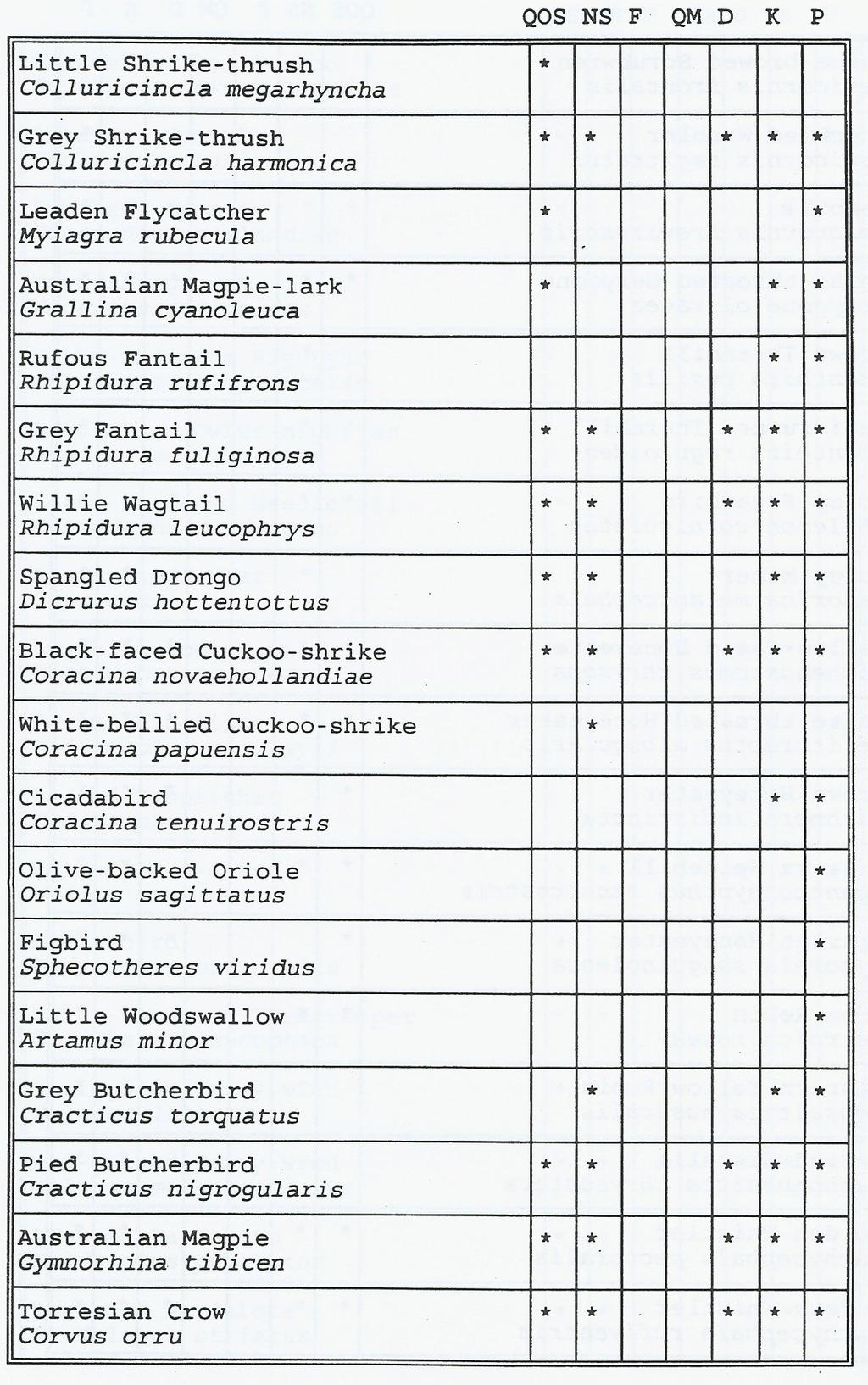
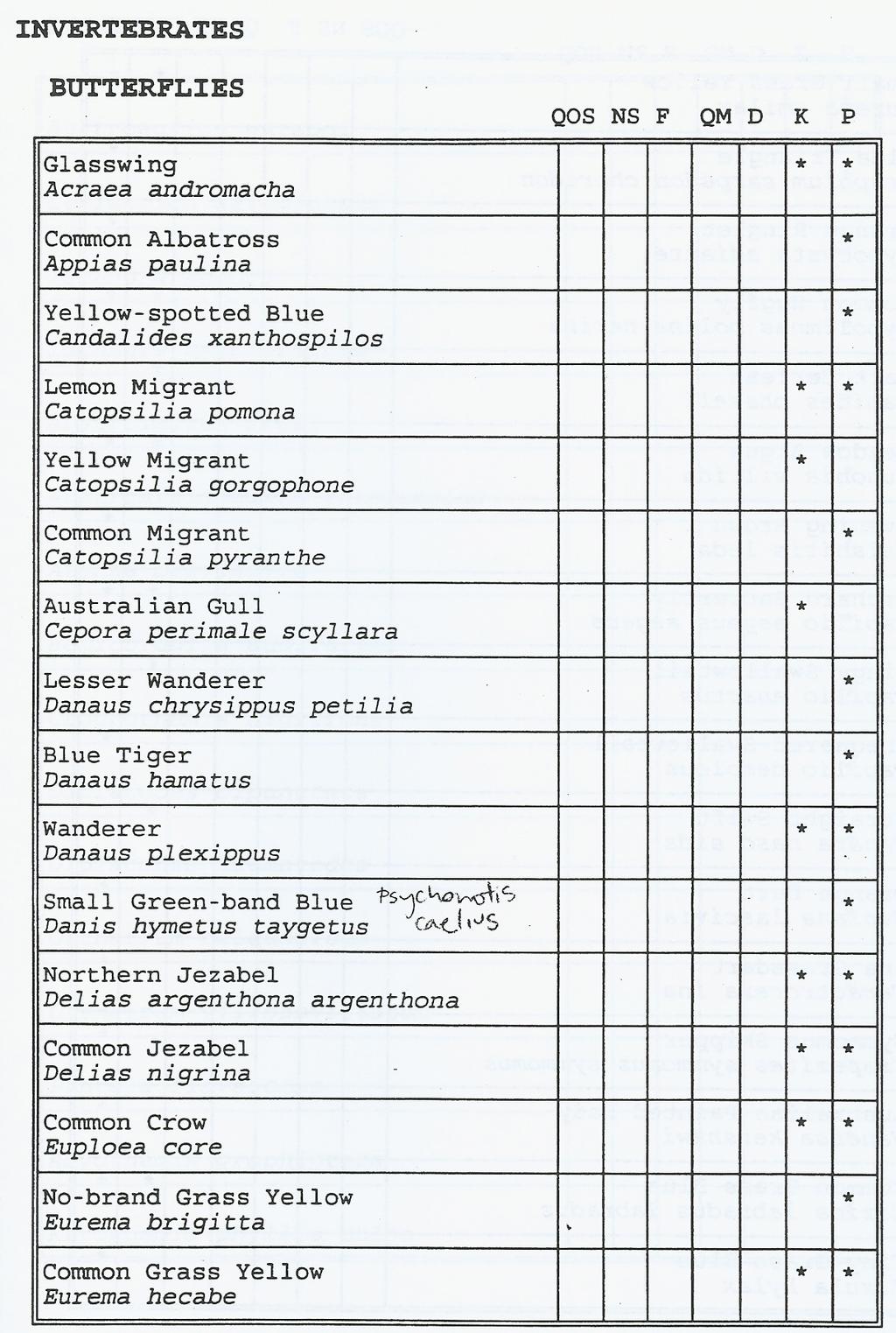
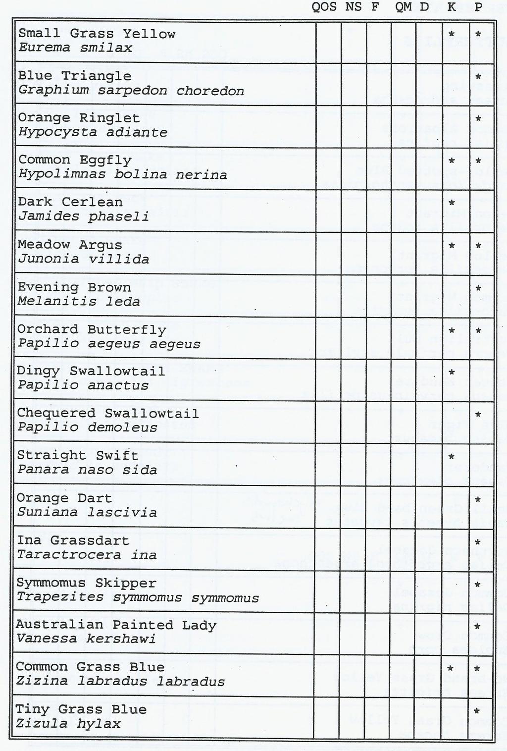
16 THE FAUNA OF THE KARAWATHA RESERVE 1994 Survey (Appendix1)

17 1))

18

19

20

21
22

23

24

25

26
27
28
29
Vegetation structure on overpasses is critical in overcoming the road barrier effect for small birds
 Vegetation structure on overpasses is critical in overcoming the road barrier effect for small birds Author Jones, Darryl Published 2010 Conference Title Improving Connections in a Changing Environment
NEWSLETTER #03 BEAUDESERT ROAD LOGAN MOTORWAY
 NEWSLETTER #03 MT. LINDESAY HIGHWAY Feedback shapes design changes Thank you to the more than 600 stakeholders and community members that provided feedback on the Logan Enhancement Project initial concept
Presentation. Effects of roads on fauna Loss, fragmentation and degradation of habitat. Questions
 Fauna Sensitive Road Design Manual Volume 2: Preferred Practices Dr. Sarah Robinson-Wolrath Senior Environmental Officer (Standards), Environment & Heritage Branch Presentation Impact of roads Why create
3. STATEMENTS OF DESIRED CHARACTER FOR PLANNING AREAS AND PRECINCTS
 3.30 Planning Area No. 30 Mary River Valley 3.30.1 Location and Role This Planning Area encompasses rural lands in the western part of the Shire. These lands are located within the catchment area of the
GREENBANK DEVELOPMENT MASTERPLAN
 DEVELOPMENT MASTERPLAN POTENTIAL TRAIN STATION COMMUNITY CENTRE Greenbank will be a connected masterplanned community providing easy access to local and surrounding amenity. Affordable quality homes, green
Planning Considerations for Wildlife Passage in Urban Environments. (Prepared by Tony Clevenger, PhD)
") Scope Planning Considerations for Wildlife Passage in Urban Environments. (Prepared by Tony Clevenger, PhD) As urban populations grow and expand into rural areas there are changes in land use patterns
Scope Planning Considerations for Wildlife Passage in Urban Environments. (Prepared by Tony Clevenger, PhD) As urban populations grow and expand into rural areas there are changes in land use patterns
Tropical, Subtropical and Warm Climate Gardening
 Tropical, Subtropical and Warm Climate Gardening ISSUE 41 $12.50 AUD ISSN 1832 8717 GARDENS sarina + somerset FOLIAGE funky & curious TROPICALS of the world MOVING TREES transplanting 01 10 20 24 14 Feature
Potential Solutions to Transportation-Wildlife Conflicts An Overview. Tony Clevenger WTI Montana State University
 Potential Solutions to Transportation-Wildlife Conflicts An Overview Tony Clevenger WTI Montana State University Effects on wildlife Habitat loss Wildlife mortality Decrease habitat quality Habitat fragmentation
CENTENNIAL PARKLANDS CONSERVATION MANAGEMENT PLAN: VOLUME
 EXECUTIVE SUMMARY Location Centennial Parklands is located at the heart of Sydney s Eastern Suburbs, just a couple of kilometres from the city centre. It forms a green swathe of parkland, ponds and sporting
Wetland Design Manual. A1: Vision, core outcomes and aspirational outcomes
 Wetland Design Manual A1: Vision, core outcomes and aspirational outcomes Table of contents Introduction 5 Vision 6 Core outcomes 7 Effective pollutant removal and flow management... 7 Community safety...
Western Sydney Parklands Australia s Largest Urban Park
 Western Sydney Parklands Australia s Largest Urban Park 37 WLA 1 MAGAZINE 21 38 WESTERN SYDNEY PARKLANDS AUSTRALIA S LARGEST URBAN PARK Large urban parks have dual roles to play in meeting the demands
Lecture: Landscape Ecology
 Borderland: Border Landscapes Across Europe 2013 Lecture: Landscape Ecology Dr Iwona Markuszewska Department of Landscape Ecology iwmark@amu.edu.pl Presentation schedule: Landscape ecology as a scientific
10.0 Open Space and Public Realm
 10.0 Open Space and Public Realm 10.0 Open Space and Public Realm The Public Open Space System is comprised of: outdoor spaces available for public use that are either publicly owned (e.g., parks and
Section 3b: Objectives and Policies Rural Environment Updated 19 November 2010
 Page 1 of Section 3b 3b RURAL ENVIRONMENT 3b.1 Introduction The Rural Environment comprises all the land outside of the Residential, Town Centre and Industrial Environments. Most land within the District
RURAL ZONE - POLICY. Rural Zone Policy. Issue: Rural Environment. Ruapehu District Plan Page 1 of 8
 Rural Zone Policy RU2 RURAL ZONE - POLICY RU2.1 Introduction The natural resources of the rural environment in the Ruapehu District provide the basis for the existing and potential character, intensity
Landscape Ecology and Amphibians
 and Amphibians WFS 533 Wyn Miller March 26, 2009 Overview Introduction to landscape ecology Metapopulation dynamics Natural habitat fragmentation Anthropogenic habitat fragmentation landscape ecology Introduction
3. Highway Landscaping Assessment
 Guidelines for Highway Landscaping 3-1 3. Highway Landscaping Assessment 3.1 Introduction This section outlines the steps necessary to assess the highway landscaping component of a state highway construction
BREEDON NORTHERN LIMITED
 Non Technical Summary CONTENTS 1 INTRODUCTION... 1 2 SITE DESCRIPTION... 1 3 DESCRIPTION OF THE DEVELOPMENT... 6 4 NEED FOR THE DEVELOPMENT... 8 5 KEY ISSUES CONSIDERED IN THE ENVIRONMENTAL IMPACT ASSESSMENT...
Policy DM19: Development and Nature Conservation
 Avonmouth Wetland Habitat Project October 2010 and December 2011 (the Cresswell study). Policy Links Bristol Local Plan Core Strategy Lead Policy BCS4: Avonmouth and Bristol Port BCS9: Green Infrastructure
Landcare on the Mornington Peninsula. Jacqui Salter Landcare Facilitator
 Landcare on the Mornington Peninsula Jacqui Salter Landcare Facilitator The Mornington Peninsula Most biodiverse 750km 2 in Victoria New landholders no previous land management experience Habitat loss
100 Allingham Street
 INFORMATION MEMORANDUM 100 Allingham Street KURABY CONTACT Alex Stevenson Proudly Presented by: LJ Hooker Sunnybank Hills 0421 638 618 astevenson.sunnybankhills@ljh.com.au INTRODUCTION Thank You Kuraby
Community Conservation Workshop. Lake Placid
 Community Conservation Workshop Lake Placid 2 Community Conservation Program Welcome! We have designed a Community Conservation Program that listens to the needs of community members. We are conducting
Recognising & encouraging conservation in the areas where we live & work
 Verified Conservation Areas Recognising & encouraging conservation in the areas where we live & work Conservation Optimism Summit London, UK 20-21 May 2017 ConserveAreas.org @ConserveAreas Verified Conservation
A Landowner s Guide to Creating Woodland Pools for Amphibians and Other Wildlife
 Cornell Department of Natural Resources Conservation Education Program Fact Sheet Kristi L. Sullivan and Stephen J. Morreale A Landowner s Guide to Creating Woodland Pools for Amphibians and Other Wildlife
Biodiversity Action Plan Background Information for discussion purposes
 Biodiversity Action Plan Background Information for discussion purposes Our commitment As directed by Council, The City of Calgary has agreed to sign the Durban Commitment, an international agreement on
RE: Ecological Constraints Advice and Strategy Master Plan and Neighbourhood Plan Avondale Road, Avondale
 Matthew Royal DF Partners C/- Sarah Houston, Urbis Pty Ltd Level 23, Darling Park Tower 2 201 Sussex Street Sydney NSW 2000 ABN 87 096 512 088 www.ecoaus.com.au Ref: 13SUTENV-0029 30 July 2014 Dear Matthew,
Monitoring and evaluation of the restoration of a highly
 Monitoring and evaluation of the restoration of a highly degraded remnant of the endangered ecological community Eastern Suburbs Banksia Scrub: Potential lessons for how monitoring can guide a restoration
7. Biodiversity & Conservation Areas
 7. & Conservation Areas 7.1. Objectives The objectives of biodiversity and conservation areas are founded on the need to recognise the importance of biodiversity and acknowledge the need to protect, restore
Cotswolds AONB Landscape Strategy and Guidelines. June 2016
 Cotswolds AONB Landscape Strategy and Guidelines June 2016 Cotswolds AONB Landscape Strategy and Guidelines Introduction The evolution of the landscape of the Cotswolds AONB is a result of the interaction
Conserving Large Landscapes One Highway at a Time
 Conserving Large Landscapes One Highway at a Time Alex Taylor Tony Clevenger Western Transportation Institute Montana State University T Clevenger Content 1. Conserving Large Landscapes - Challenges 2.
Mollers Lane, Leopold, Victoria Significant Landscape Overlay Re-assessment
 XURBAN Mollers Lane, Leopold, Victoria Significant Landscape Overlay Re-assessment For: TGM Group November 2016 Final Mollers Lane, Leopold, Victoria Significant Landscape Overlay Re-assessment Client
THE LANDSCAPE ECOLOGICAL ASSESSMENT MODEL AND ITS APPLICATIONS
 The 5 th International Conference of the International Forum on Urbanism (IFoU) 2011 National University of Singapore, Department of Architecture Global Visions: Risks and Opportunities for the Urban Planet
Frankston s Biodiversity Policy
 Frankston s Biodiversity Policy 1. Policy Statement: Frankston City Council (FCC) values the biodiversity and its ecosystems of the Municipality in support of the health, wellbeing and quality of life
Community Conservation Workshop. Saranac River Basin Communities
 Community Conservation Workshop Saranac River Basin Communities 2 Community Conservation Program Welcome! We have designed a Community Conservation Program that listens to the needs of community members.
Wildlife Connections 101: Confronting the Challenge of Habitat Fragmentation
 Wildlife Connections 101: Confronting the Challenge of Habitat Fragmentation Dr. Raymond M. Sauvajot U.S. National Park Service Santa Monica Mountains National Recreation Area Habitat Fragmentation and
Building with nature
 Building with nature Prioritising ecology and biodiversity for better buildings and cities Executive Summary May 2018 National Strategic Sponsor Research and evidence demonstrating the positive impacts
UNIVERSITY TOWN NEIGHBOURHOODS 5.2 ECO-CORRIDOR MELBOURNE CAMPUS MASTER PLAN 2014
 5.2 ECO-CORRIDOR 37 ECO-CORRIDOR EXISTING CONDITIONS & VISION NEIGHBOURHOOD VISION Investment in the Eco-corridor Neighbourhood will signify the University s commitment to supporting local ecology and
BRE Strategic Ecological Framework LI Technical Information Note 03/2016
 BRE Strategic Ecological Framework Technical Information Note 03/2016 September 2016 Contents 1. Introduction 2. Aims of BRE s Strategic Ecological Framework 3. How SEF is different from previous approaches
Executive Summary. Essential Connectivity Map (Figure ES-1)
") Executive Summary The California Department of Transportation (Caltrans) and California Department of Fish and Game (CDFG) commissioned the because a functional network of connected wildlands is essential
Executive Summary The California Department of Transportation (Caltrans) and California Department of Fish and Game (CDFG) commissioned the because a functional network of connected wildlands is essential
Green Infrastructure. IENE 2012 International Conference
 Green Infrastructure IENE 2012 International Conference Marco Fritz, DG Environment Potsdam, 22/10/2012 Content 1) Green Infrastructure why does it matter? 2) Added value 3) Policy development framework
Road Ecology in Practice: Building Resiliency of Urban Ecosystems through Informed Road Network Planning
 Road Ecology in Practice: Building Resiliency of Urban Ecosystems through Informed Road Network Planning Outline What is road ecology? Why is road ecology important? TRCA and road ecology application Peel
green infrastructure and biodiversity
 PERFECT factsheet 2 green infrastructure and biodiversity Definitions Green infrastructure: A strategically planned network of high-quality natural and semi-natural areas with other environmental features,
4 RESIDENTIAL ZONE. 4.1 Background
 4 RESIDENTIAL ZONE 4.1 Background The residential areas within the City are characterised by mainly lowrise dwellings sited on individual allotments. Past architectural styles, settlement patterns and
B4. Te tiaki taonga tuku iho - Natural heritage
 B4. Te tiaki taonga tuku iho - Natural heritage Tuia I runga, tuia i raro, tuia ki te waonui a Tiriwa Bind the life forces of heaven and earth to the great realm of Tiriwa B4.1. Issues Auckland s distinctive
THE CORPORATION OF THE CITY OF WINDSOR Office of the City Solicitor Planning Department
 THE CORPORATION OF THE CITY OF WINDSOR Office of the City Solicitor Planning Department REPORT TO THE CITY OF WINDSOR PLANNING ADVISORY COMMITTEE DATE OF REPORT: August 19, 2010 SUBJECT: Official Plan
Guidance for Developers on the Management of Biodiversity issues in the Planning Process
 Biodiversity and the Planning Process Guidance for Developers on the Management of Biodiversity issues in the Planning Process 1.0 March 2017 Table of Contents: Page What is biodiversity and why is it
INTEGRATED BIODIVERSITY MANAGEMENT PLAN July 2018
 INTEGRATED BIODIVERSITY MANAGEMENT PLAN 2018 2023 24 July 2018 DOCUMENT PROPERTIES Contact for enquiries and proposed changes If you have any questions regarding this document or if you have a suggestion
Welcome to our exhibition
 Welcome to our exhibition The Homes & Communities Agency (HCA) welcomes you to this public exhibition explaining our proposals for the redevelopment of the former Lea Castle Hospital site. About the Homes
Yarra Strategic Plan community engagement summary
 Yarra Strategic Plan community engagement summary Between May and August 2018 Melbourne Water undertook community engagement to build the content of the draft Yarra Strategic Plan. This engagement included
Statutory and Non-Statutory Designated Sites and Ecology
 Statutory and Non-Statutory Designated Sites and Ecology The National Planning Policy Framework considers the conservation and enhancement of the natural environment in chapter 11 paragraphs 109-119, where
Planning Proposal Toronto Road, Booragul. Amendment to Lake Macquarie Local Environmental Plan (LMLEP) 2014
 2014") Planning Proposal Toronto Road, Booragul Amendment to Lake Macquarie Local Environmental Plan (LMLEP) 2014 Local Government Area: Name of Draft LEP: Subject Land: Land Owner: Applicant: Folder Number:
Planning Proposal Toronto Road, Booragul Amendment to Lake Macquarie Local Environmental Plan (LMLEP) 2014 Local Government Area: Name of Draft LEP: Subject Land: Land Owner: Applicant: Folder Number:
Ecological Factors in Environmental Impact Assessment
 Position Statement by the Ecological Society of Australia Ecological Factors in Environmental Impact Assessment Coordinated by Kirsten Benkendorff Department of Biological Sciences University of Wollongong
4.2 Ecological Principles
 4.2 Ecological Principles Introduction The overall character of the campus is one of open woodland in which locally and regionally indigenous tree species predominate. The colours, textures and quality
Great Lakes Conservation Blueprint for Terrestrial Biodiversity on the Canadian Shield
 Great Lakes Conservation Blueprint for Terrestrial Biodiversity on the Canadian Shield Bonnie L. Henson 1, Kara E. Brodribb 2 and John L. Riley 3 1 Ontario Ministry of Natural Resources 2,3 The Nature
University Park, Worcester Non Technical Summary December 2011
 University Park, Worcester Non Technical Summary December 2011 Introduction UW Wrenbridge LLP, a Joint Venture Company of the University of Worcester and Wrenbridge Land Ltd (the Applicants ) intend to
Draft Eastern District Plan
 Draft Eastern District Plan Submission_id: 31238 Date of Lodgment: 13 Dec 2017 Origin of Submission: Online Organisation name: Turrulla Gardens Pty Ltd C/- Mecone Organisation type: Industry First name:
for Biosphere Reserves
 Sustainable Tourism in Biosphere Reserves in Central and Eastern Europe Tourism Management Plans for Biosphere Reserves Ecological Tourism in Europe - E.T.E. e.v. Page 1 What is a Tourism Management Plan?
Respect of the urban green and the techniques to connect green
 Respect of the urban green and the techniques to connect green Shozo SHIBATA Graduate School of Global Environmental Studies, Kyoto University Graduate School of Agriculture, Kyoto University President
Biodiversity and Urban Streets
 Biodiversity and Urban Streets Urban Street Design for Engineers CPD Session 3 Constituent Elements Engineers Ireland Maryann Harris BSLA MSc Dip Law Past-President, Irish Landscape Institute Parks Services
Biodiversity in Urban Landscapes
 Biodiversity in Urban Landscapes Method in the Madness MANOJ DABAS Urbanisation Global Trends and Prospects Year 2010, the urbanized proportion of the world s population overtook the rural population (rising
Tāhuhu whakaruruhau ā-taone The sheltering ridge pole
 B2. Tāhuhu whakaruruhau ā-taone - Urban growth and form B2.1. Issues Tāhuhu whakaruruhau ā-taone The sheltering ridge pole Auckland s growing population increases demand for housing, employment, business,
What Is Linking Landscapes?
 What Is Linking Landscapes? Viable habitat is critical to the survival of all organisms. As forests, wetlands, open spaces and other habitats are converted to human uses, such as housing, industrial development,
RURAL TRANSPORT TRAINING MATERIALS
 RURAL TRANSPORT TRAINING MATERIALS Module 5: Social and Environmental Issues Environmental impact assessment: Mkuze river crossing to Phelendaba, South Africa Session: 5.4 Part 2 Case Study Presentation:
Appendices. Contents. Appendices - Sep 1997 CP-1 AP-1
 Appendices Contents 1. Goals for Protected Areas in British Columbia... AP-3 2. Guiding Principles for Protected Areas... AP-4 3. Resource and Recreation Use Guidelines for Protected Areas... AP-5 4. Aboriginal
ELLIOTT HEADS STRUCTURE PLAN
 ELLIOTT HEADS STRUCTURE PLAN BACKGROUND This report has been prepared to provide an overview of the land that has been included in the Urban Footprint within the Wide Bay Burnett Regional Plan, September
Guidelines for Bridge Construction or Maintenance to Accommodate Fish & Wildlife Movement and Passage
 Guidelines for Bridge Construction or Maintenance to Accommodate Fish & Wildlife Movement and Passage Arizona Game and Fish Department, Habitat Branch November 2008 Introduction/Background General Recommendations
Making Space for Nature A Leicester Case Study. Dr Helen O Brien Leicester City Council
 Making Space for Nature A Leicester Case Study Dr Helen O Brien Leicester City Council Helen.Obrien@Leicester.gov.uk Definitions Biodiversity (biological diversity) The variety of plant and animal life
Ventura County Planning Division. Roads and Biodiversity Project: Guidelines for Safe Wildlife Passage
 Ventura County Planning Division Roads and Biodiversity Project: Guidelines for Safe Wildlife Passage A project funded by the Southern California Association of Governments This project was a joint effort
Nature & Biodiversity
 Nature & Biodiversity Urban ecosystems are key to protecting biodiversity in cities and other urban areas. Cities can play an important role in hosting rare and endangered species and habitat types. Biodiversity
Appendix C Example Infrastructure Designs, Costs, and Schedules
 Appendix C Example Infrastructure Designs, Costs, and Schedules There is extensive scientific literature on the effectiveness and economic benefits of various infrastructure designs as mitigation for wildlife
Mt Gravatt Showgrounds Precinct Landscape Plan
 Mt Gravatt Showgrounds Precinct Landscape Plan Version 2.2 Prepared by: Michael Fox President Mt Gravatt Environment Group PO Box 5 Carina Qld 4152 www.megoutlook.wordpress.com megoutlook@gmail.com Table
Outline of remarks. Corridor ecology: a snapshot. Definitions, cont.
 Outline of remarks Corridor ecology: a snapshot William Z. Lidicker, Jr. Museum of Vertebrate Zoology, University of California, Berkeley 1. Definitions of corridor a) Structural b) Functional 2. Advantages
Review of the Flora and Fauna Guarantee Act March 2017
 Review of the Flora and Fauna Guarantee Act 1988 Name of respondent Hume City Council 27 March 2017 1. Setting the Direction Hume City Council supports the focus on setting clear objectives, principle
CALGARY: City of Animals Edited by Jim Ellis
 CALGARY: City of Animals Edited by Jim Ellis ISBN 978-1-55238-968-3 THIS BOOK IS AN OPEN ACCESS E-BOOK. It is an electronic version of a book that can be purchased in physical form through any bookseller
LIVING INFRASTRUCTURE PLAN
 LIVING INFRASTRUCTURE PLAN AUSTRALASIAN NETWORK FOR ECOLOGY AND TRANSPORTATION 30 APRIL 2018 Maggie Baron, Melbourne Metro Rail Authority Sheridan Blunt, Loci Environment & Place Inc. RAIL AND SUSTAINABILITY
Infrastructure, Development and Enterprise Services. Natural Heritage Action Plan (NHAP) Project Initiation
 Project Initiation") Staff Report To Service Area Committee of the Whole Infrastructure, Development and Enterprise Services Date Monday, March 6, 2017 Subject Natural Heritage Action Plan (NHAP) Project Initiation Report
Staff Report To Service Area Committee of the Whole Infrastructure, Development and Enterprise Services Date Monday, March 6, 2017 Subject Natural Heritage Action Plan (NHAP) Project Initiation Report
General Manager of Planning, Urban Design and Sustainability
 ADMINISTRATIVE REPORT Report Date: May 2, 2017 Contact: Katherine Isaac Contact No.: 604.873.7167 RTS No.: 10847 VanRIMS No.: 08-2000-20 Meeting Date: May 16, 2017 TO: FROM: SUBJECT: Vancouver City Council
Pinellas County Greenways
 Pinellas County Greenways USING GREENWAYS TO LINK OPEN SPACES The Florida Greenways Commission has defined a greenway as...a corridor of protected open space that is managed for conservation and/or recreation.
Rural Environment and Conservation
 Rural Environment and Conservation 117 Rural Environment and Conservation Introduction and Resources 118 BSc (Hons) Conservation and Environment 119 BSc (Hons) Wildlife Management 120 BSc (Hons) Rural
APPENDIX 1: SCOPED ENVIRONMENTAL IMPACT STATEMENT (EIS) FORM
 FORM") APPENDIX 1: SCOPED ENVIRONMENTAL IMPACT STATEMENT (EIS) FORM This form is intended for use by applicants (primarily private landowners) who need to conduct a Scoped EIS in support of minor development
APPENDIX 1: SCOPED ENVIRONMENTAL IMPACT STATEMENT (EIS) FORM This form is intended for use by applicants (primarily private landowners) who need to conduct a Scoped EIS in support of minor development
Overview of International and Federal Activities Habitat Fragmentation Due to Infrastructure, Hans Bekker and Bjørn Iuell... 1
 Click on the paper title below to link directly to it. Overview of International and Federal Activities Habitat Fragmentation Due to Infrastructure, Hans Bekker and Bjørn Iuell... 1 New Ecological Research
8.0 Design and Form of Development 43/
 42/ 8.0 Design and Form of Development 43/ Rothwells Farm, Golborne/ Development Statement Figure 7. Site Constraints Key 44/ Site Boundary 360 Bus Route/Stops Existing Trees Underground Water Pipe Sensitive
Wingerworth, Chesterfield. February Surveyor: James Porter
 Report Wingerworth, Chesterfield February 2014 Surveyor: James Porter (Natural England Licence Number: CLS00241 Contents Contents Notice to readers 1.0 Introduction Background Information Site Description
NON-TECHNICAL SUMMARY
 NON-TECHNICAL SUMMARY THE HIDE, BISHOP AUCKLAND PROPOSED ECO CHALET DEVELOPMENT NON-TECHNICAL SUMMARY 1 Introduction 1.1.1 This non-technical summary for the (ES) prepared in relation to the proposed eco-chalet
North West Rail Link - Environmental Assessment Urban Design and Visual Assessment Prepared for Transport Infrastructure Development Corporation
 North West Rail Link - Environmental Assessment Urban Design and Visual Assessment Prepared for Transport Infrastructure Development Corporation November 2006 HASSELL Ltd 007 711 435 88 Cumberland Street
Visioning Background Report: Goals and Objectives
 Visioning Background Report: Goals and Objectives Review of Conservation Plans VISIONING BACKGROUND SUMMARY REPORT: Goals and Objectives 1. Introduction The City of Edmonton, through the Office of Natural
THREE-STEP DESIGN PROCESS FOR OPEN SPACE SUBDIVISIONS
 00216106.DOC NMA/RRK 1/30/14 THREE-STEP DESIGN PROCESS FOR OPEN SPACE SUBDIVISIONS Open space subdivisions, sometimes called cluster developments, maintain a significant portion of a development site in
submission_details represented_by_who title age_bracket first_name last_name organisation position_in_organisation withhold_name address_1
 submission_details represented_by_who title age_bracket first_name last_name email organisation position_in_organisation withhold_name address_1 I am making a personal submission 50-59 X Targeting jobs
Experiences of dealing with Lesser Horseshoe Bats (Rhinolophus
 Experiences of dealing with Lesser Horseshoe Bats (Rhinolophus hipposideros) in Wales, UK Len Wyatt Environmental Science Advisor, Transport, Housing and Strategic Regeneration, Welsh Assembly Government,
NEWCASTLE LIGHT RAIL Review of Environmental Factors (REF) Submission 20 May 2016
 Submission 20 May 2016") NEWCASTLE LIGHT RAIL Review of Environmental Factors (REF) Submission 20 May 2016 INTRODUCTION The Hunter Business Chamber is the largest regional business chamber in Australia and was established in 1886.
NEWCASTLE LIGHT RAIL Review of Environmental Factors (REF) Submission 20 May 2016 INTRODUCTION The Hunter Business Chamber is the largest regional business chamber in Australia and was established in 1886.
volume 11 environmental assessment section 2 environmental impact assessment Part 7 ha 218/08
 DESIGN MANUAL FOR ROADS AND BRIDGES volume 11 environmental assessment section 2 environmental impact assessment Part 7 ha 218/08 glossary of terms Used in DMRB Volume 11, Sections 1 and 2 SUMMARY This
Plan Modification to Chapter B2 of the Auckland Unitary Plan(AUP) Operative in part (15 November 2016)
 Operative in part (15 November 2016)") UNITARY PLAN UPDATE REQUEST MEMORANDUM TO FROM Phill Reid Linley Wilkinson DATE 25 September 2018 SUBJECT Plan Modification to Chapter B2 of the Auckland Unitary Plan(AUP) Operative in part (15 November
UNITARY PLAN UPDATE REQUEST MEMORANDUM TO FROM Phill Reid Linley Wilkinson DATE 25 September 2018 SUBJECT Plan Modification to Chapter B2 of the Auckland Unitary Plan(AUP) Operative in part (15 November
Rannoch 132 / 33 kv Substation Extension
 Who we are Scottish and Southern Energy Power Distribution is part of the SSE plc group of companies. We own, maintain and invest in the networks in the north of Scotland the electricity transmission network
WELCOME. Land North of STEVENAGE. We would like to thank you for attending our public exhibition today.
 WELCOME We would like to thank you for attending our public exhibition today. The purpose of this event is to share our proposals and hear your thoughts on our ideas. Members of the project team are on
NZIS Urban Design Strategy. September 2012
 NZIS Urban Design Strategy September 2012 What is Urban Design? There are a multitude of different definitions available on Urban Design Following are some from well recognised Urban Design organisations
PRESENTATION ON JOHANNESBURG S BIODIVERSITY PROGRAMME
 PRESENTATION ON JOHANNESBURG S BIODIVERSITY PROGRAMME Member of Mayoral Committee: Cllr Prema Naidoo Environmental Management & Johannesburg City Parks PRESENTATION OVERVIEW Jo burg Overview & Context
Hobart A Strategic Framework
 Hobart 2025 A Strategic Framework Adopted by the Hobart City Council 15 October 2007 Table of Contents Introduction...2 Vision and Future Directions...3 FD1 Offers opportunities for all ages and a city
Principles for Ecological Landscape Design in Brownfield Business Parks
 Principles for Ecological Landscape Design in Brownfield Business Parks Part of USDA Forest Service research project # 00-JV-11231300-033: Aligning Social and Ecological Drivers of Urban Landscape Change
submission_details represented_by_who title age_bracket first_name last_name organisation position_in_organisation withhold_name address_1
 submission_details represented_by_who title age_bracket first_name last_name email organisation position_in_organisation withhold_name address_1 I am making a personal submission 20-29 X Targeting jobs
A Short History of Landcare at Absalom Reserve
 A Short History of Landcare at Absalom Reserve This project commenced in 2009 Volunteer hours for this site are 3,720 @ $37 per hour = $137,640 Funding received is $9,542 from NRMA, HCCU and Council s