JDM Frederickson Draft Policy Language pdf. Frederickson Parks Section-JC pdf. Frederickson Parks Map D14 edits.pdf
|
|
|
- Octavia Peters
- 5 years ago
- Views:
Transcription
1 1. 7:00 P.M. Frederickson LUAC-Agenda Documents: FAC Agenda.pdf Frederickson LUAC-Draft Community Plan Documents: JDM Frederickson Draft Policy Language pdf Frederickson LUAC-Parks Proposal Documents: Frederickson Parks Section-JC pdf Frederickson LUAC-Parks Map Documents: Frederickson Parks Map D14 edits.pdf
2 AGENDA FREDERICKSON ADVISORY COMMISSION September 25, 2017, 7:00 p.m. Bethel Learning Center, th Avenue East, Spanaway, WA STUDY SESSION Frederickson Community Plan Review The Frederickson Advisory Commission (FAC) will conduct a study session to review progress to date on the Frederickson Community Plan, review draft policy changes based on FAC recommendations from study sessions, as well as Parks and Community Plan policy updates. No action will be taken. Staff contact: Jeff Mann, jmann@co.pierce.wa.us The public is welcome to attend. Pierce County is seeking new members for the Frederickson Advisory Commission. If you are interested in volunteering, please visit the Frederickson Advisory Commission website for an application, or contact Cindy Anderson at cindy.anderson@co.pierce.wa.us or FAC Agenda

3 Frederickson Community Plan Draft Policy Language LUAC Review Frederickson LUAC Meeting September 25, 2017 Page 1

4 GOAL FR LU-1 Detailed Notes on Policy Changes Land Use Policies Goals In the Frederickson Community the principle goal of the plan is to foster a predominantly residential community that balances environmentally sensitive areas, high traffic corridors, desired open space, and job creation while maintaining a quality living environment. The predominant housing type within the community will be moderate density single-family housing. Limited areas of multifamily housing will be provided along major traffic corridors near commercially zoned lands 1. Locate multifamily housing in close proximity to transit services. Where multi-family housing cannot be served by transit, the minimum parking requirements shall be met. Low density housing will be located along Clover Creek to minimize development impacts to this high value natural system. A commercial center will develop at the intersection of 176th Street East and Canyon Road. This center will help to provide a greater sense of identity to the community through quality site planning and building design. This center will meet the daily needs of 2 residents and the growing workforce employed within the Employment Center. Continued growth and development within the Frederickson Employment Center will be actively encouraged by ensuring that necessary infrastructure is available 3 to meet the desired level of service and by promoting an efficient and predictable regulatory environment. General FR LU-1.1 FR LU FR LU Promote the continued development of the Frederickson Employment Center by emphasizing a regulatory environment that is supportive of the establishment of new businesses and the expansion of existing businesses. Promote a system of land use control that meets future growth needs in a predictable and efficient manner. Provide sufficient residential and commercial land capacity, 4 and the necessary supporting infrastructure, within the community to meet the needs of the community for the next 20 years. Ensure that the residential densities 1 Address Issue: locate multifamily where transit services are provided, and if not, then increase parking requirements 2 Add Text: residents and 3 Add Text: in a 6-year timeframe or reasonable amount of time 4 Add Text: and the necessary supporting infrastructure 5 Address Issue: is 4 units per acre too many, should this be lowered and set as the overall residential density 6 Address Issue: change the definition of net acreage to represent only developable land (include buffers in net calculations) Page 2

5 GOAL FR LU-2 FR LU FR LU FR LU-2.1 FR LU-2.2 FR LU-2.3 GOAL FR LU-3 FR LU-3.1 FR LU-3.2 FR LU-3.3 FR LU-3.4 FR LU and land area provided for each of the various zone classifications within the community enable a residential density of at least 4 dwelling units 5 per net acre 6 to be achieved as the community is developed. Regularly monitor and evaluate growth trends within the community to determine if planned densities are being achieved. In the event 7 Address Issue: no opinion either way on these four Rural Separator policies but if they are retained add language about Waller Road. 8 Delete policy monitoring indicates that planned densities are not being achieved, Pierce County shall develop recommendations to address the situation and shall present such recommendations for consideration during the next community plan update. Support the continued existence of the Rural Separator north of Frederickson. Recognize the benefits the Employment Center and the overall Frederickson community derive from the presence of the Rural Separator. In the event any changes to allowed uses, density, or zoning within the Mid-County area are contemplated, Pierce County should analyze the impacts of such changes on future traffic volumes and operating conditions of Canyon Road and 176th Street East. 7 The Rural Separator provides a desirable buffer between the Urban Growth Areas for Pierce County and the cities of Tacoma, Fife, and Puyallup. The presence of this buffer helps to create more defined urban areas, improved community identity, and valuable open space benefits. The important public benefits the Rural Separator provides, as discussed above, should be considered and analyzed as a component of any proposal to study or modify the Rural Separator. Provide strict guidance for rezones to ensure community plan goals and objectives are properly implemented. The proposed zone must be an allowed zone under the existing land use designation. Changes in land use designation are not permitted through the rezone process. Ensure commercial and industrial rezone applications are consistent with the goals, objectives, and standards set forth in the Frederickson Community Plan. Commercial and industrial rezones shall be allowed only when the following criteria are met: A Planned Development District (PDD) application shall accompany all rezone applications; 8 Commented [JM1]: Staff does not support any change. If any number is used here it would need to be at least 4 dwelling units per acres to be consistent with the density polices for Urban areas under GMA. Commented [JM2]: Staff would not support any change Net Developable is backed by a Comprehensive Plan policy applicable County-wide: GOAL LU-26 The allowable number of dwelling units within individual urban development proposals shall be calculated using net developable acreage. LU-26.1 In determining net developable acreage, deductions shall be made for roads and environmentally constrained lands. A Comprehensive Plan Amendment would be required to change this. Commented [JM3]: Community Plan should focus on the Community. Page 3
6 GOAL FR LU-4 FR LU An analysis of market vacancy has demonstrated there is a need for the commercial or industrial use type 9 Delete policy within the Frederickson Community 10 Plan area. The analysis must consider Delete part: and PDD the availability of vacant commercial or industrial buildings and land for the same type of use and shall demonstrate why the rezone is necessary. The analysis shall not be an analysis of market potential; and 9 FR LU The Examiner shall provide written findings that the proposed zone and PDD 10 implement the goals, objectives, and standards of the designation better than the existing zone. Employment Center FR LU-4.1 GOAL FR LU-5 FR LU FR LU-5.1 FR LU FR LU FR LU FR LU-5.2 FR LU Ensure that changes in land use designations, zoning, and development standards within the community do not adversely affect the viability of the Employment Center. Utilize the industrial land location criteria set forth in the Pierce County Comprehensive Plan when evaluating Employment Center zoned lands for possible rezoning. Evaluate the benefits of any proposed change in land use designations, zoning, or development standards within or adjacent to the Employment Center against the impacts to businesses within the center. Provide an orderly transition from the Employment Center to residentially zoned properties and environmentally sensitive areas. Review the zoning atlas and recommend changes to create logical boundaries and transitions from the Employment Center to residentially zoned properties and environmentally sensitive areas. Use ownership patterns, roadways, topography, lot size, and environmental features to establish logical boundaries to the Employment Center. Zone areas within the Employment Center designation along Clover Creek as Community Employment (CE). Limit development within the CE zone to light industrial and office uses only. Mineral extraction, salvage yards, and similar heavy industrial uses should be prohibited. Establish a transition area between the Employment Center and residential zones. Limit heights and uses within the transition area or provide some other means of promoting greater compatibility with residentially zoned parcels. Page 4
7 This highlighted section is being moved and edited into the Centers and Corridors and becomes the Community Plan specific polices for the Centers and Corridors. In this Plan 11 Delete policy GOAL FR LU-6 FR LU FR LU-6.1 FR LU FR LU Delete part: delete entire second All developments on the periphery of sentence the industrial area shall be designed, screened, or bermed to mitigate undesirable impacts upon surrounding residential areas. Create a well-defined commercial and civic service area within the Employment Center that will meet the daily goods and service needs of the employees of the center and local residents. Designate identified properties around the intersection of 176th Street East and Canyon Road East as Employment Service. The Employment Service zone shall be considered a light industrial zone and shall be permitted only under the Employment Center land use designation. The boundaries and size of the area zoned as Employment Service shall be based upon the employment capacity of the Employment Center, land ownership patterns, and natural and built environment features. FR LU The Employment Service area shall not exceed 95 acres in size. 11 FR LU FR LU FR LU FR LU FR LU FR LU Limiting the size of the Employment Service area is necessary to avoid the risk of traffic congestion associated with retail development in the Central Place. Therefore, rezones or other subsequent expansions of the Employment Service zone at Canyon Road and 176th Street are prohibited. 12 The Employment Service area shall permit a range of light industrial, office, retail, service, utility, and civic uses. Residential uses shall be prohibited within the Employment Service zone. For purposes of Chapter 8.76 of the Pierce County Code, the Employment Service zone should be assigned a Class C Environmental Designation for Noise Abatement. High quality site and building design shall be required within the Employment Service zone. Design standards shall seek to create a well-defined sense of place, ensure compatibility with adjacent uses, provide ample landscaping, facilitate pedestrian movement, and limit the number of vehicular access points onto Canyon Road East and 176th Street East. Page 5
8 Commercial This highlighted section is being moved and edited into the Centers GOAL FR LU-7 Provide welldesigned, appropriately scaled retail and and Corridors and becomes the Community Plan specific polices for the Centers and Corridors. In this Plan service development at limited locations in the community. FR LU-7.1 FR LU-7.2 FR LU FR LU FR LU FR LU FR LU FR LU Retail and service development within the plan area should be scaled to meet neighborhood and community needs. Anchor tenants between 75,000 and 170,000 square feet may be authorized in the Central Place subject to Council approval of a Project Specific Development Agreement. Individual buildings or tenants shall not exceed 170,000 square feet in the Employment Service zone. Strive for the development of well-designed, well-placed neighborhood and community-scale commercial development within the plan area. Retail and service uses should primarily meet the needs of the Frederickson community. The type and intensity of retail uses within the Employment Center shall be consistent with the Frederickson Community Plan. Anchor tenants between 75,000 and 170,000 square feet may be authorized in the Central Place subject to Council approval of a Project Specific Development Agreement pursuant to RCW 36.70B.170 and Pierce County Code 18A.100. Individual buildings or tenants shall not exceed 170,000 square feet in the Employment Service zone. A Project Specific Development Agreement submitted for Council consideration shall include a detailed site plan with identification of specific uses and activities. The level of detail shall be such that the County can determine the appropriate level of mitigation related to, but not limited to, transportation, stormwater and critical areas. Before Council approval of a Development Agreement authorizing retail buildings larger than 75,000 square feet, project proponents shall be required to demonstrate to the satisfaction of the County Engineer that traffic impacts will be mitigated resulting in no adverse impacts on freight movement within the 176th Street East corridor and Canyon Road East corridor. The burden of mitigating cumulative traffic impacts shall not fall on future industrial development within the Frederickson Manufacturing/Industrial Center. Commercially zoned areas should be compact in size and should be located at prominent intersections within the community. Require all commercial developments to meet architectural and site design standards. Page 6

9 FR LU FR LU-7.3 FR LU Landscaping of commercial sites should be required, particularly along public roads and within parking areas. Control the location, scale, and range of commercial uses within the community in a manner as appropriate to accomplish the objectives of the community plan. Allow for the continued existence of a limited mixed use commercial area at the intersection of Military Road East and Canyon Road East. FR LU This area should not exceed 15 acres in size. 13 FR LU FR LU FR LU-7.4 GOAL FR LU-8 FR LU Residential FR LU-8.1 FR LU-8.2 Limit the impacts of additional commercial development along 176th Street east and west of the planned commercial center at 13 Delete policy 14 Address Issue: change policy to not limit commercial along Canyon, but limit access points to those businesses through shared access and frontage roads 15 Address Issue: want to see larger lot sizes, such that 4 units per acre would mean.25-acre lots 16 Change text: 4 This highlighted section is being moved and edited into the Centers and Corridors and becomes the Community Plan specific polices for the Centers and Corridors. In this Plan 176th Street East and Canyon Road by limiting access points through shared access and frontage roads or other access restriction methods. 14 Encourage the communities of Summit View and North Clover Creek Collins to carefully control and limit commercial development along Canyon Road to maximize the efficiency of this roadway as a major north-south arterial and to prevent the development of a continuous commercial strip into the Frederickson community. Implement compatibility requirements to minimize the impact of commercial activities on adjacent residential uses. Require intensive screening and buffering of commercial uses adjacent to residential areas. Residential density should vary based upon characteristics of the built and natural environment. 15 Areas of the community with no significant environmental constraints or compatibility issues should be zoned as Moderate Density Single-Family (MSF) and should be developed generally at densities of to 6 dwelling units per acre. Properties along the Clover Creek corridor should be zoned Residential Resource (RR) reflecting the more environmentally sensitive nature of these lands. Page 7 Commented [JM4]: Net Developable is backed by a Comprehensive Plan policy applicable County-wide: GOAL LU-26 The allowable number of dwelling units within individual urban development proposals shall be calculated using net developable acreage. LU-26.1 In determining net developable acreage, deductions shall be made for roads and environmentally constrained lands. A Comprehensive Plan Amendment would be required to change this,

10 FR LU FR LU-8.3 FR LU FR LU-8.4 FR LU FR LU FR LU-8.5 FR LU FR LU FR LU FR LU-8.6 FR LU-8.7 GOAL FR LU-9 Zoning Overlays FR LU-9.1 These properties should be developed generally at densities of 1 to 3 dwelling units per acre. Properties in the upper drainage basin of Clover Creek should be zoned Single-Family (SF) reflecting the environmental characteristics of these lands and proximity to Clover Creek. These properties should develop generally at a density of 4 dwelling units per acre. Limited areas for high density single- and multifamily development should be designated near the intersections of 78th Avenue/176th Street East and 40th Avenue/176th Street East, reflecting proximity to major public transportation routes and commercial centers. 17 These areas should be zoned as Moderate-High Density Residential (MHR) or Residential/Office-Civic (ROC). Density in these areas should range generally from 12 to 18 dwelling units per acre. Lots of record within the Employment Center (EC) having an area of 2 acres or less created for the purpose of single-family residential use and recorded prior to January 1, 1995 should be allowed to accommodate one single-family unit per parcel. 18 Accessory dwelling units should not be permitted. 17 Change text: remove reference to location of designation; add public between major and transportation 18 Delete policy and all sub-policies; redesignate residential subdivision in EC to MSF on map Design standards should be applied to reduce compatibility issues with existing or future industrial uses within the Employment Center. Existing or future industrial uses should not be construed as a public nuisance to residential uses. Efforts should be taken to ensure consistency/compatibility with residentially zoned lands immediately adjacent to the Community Plan area. The SF zone should primarily be developed with detached single-family housing and compatible civic uses. Multifamily housing should be prohibited. Develop special overlay standards to protect special interest areas from incompatible uses. Utilize airport overlays within the plan area to protect the public s health, safety, and welfare and to address incompatible uses with airport operations. Page 8

11 FR LU-9.2 FR LU-9.3 Establish an Airport Overlay-Small Airport designation in the vicinity of Shady Acres Airport. Apply Airport Overlay-Small Airport regulations to the portion of the Plan area identified as Airport Overlay-Small Airport in the vicinity of Shady Acres Airport. 19 Add text: general language about areas where new through roads enter the community Incorporation/Annexation (Policies regarding Annexation/Incorporation will be presented for LUAC review in a future meeting.) GOAL FR D-1 Design and Character Policies Goals Promote community cohesion and a high-quality visual environment by establishing requirements related to architectural, site, and landscape design. Community Entries and Streetscapes FR D-1.1 FR D-1.2 FR D-1.3 FR D-1.4 FR D FR D FR D FR D FR D Provide design concepts and policies that will create attractive, easily identifiable community entrances and streetscapes within the Frederickson community. Create identifiable boundaries, entries, gateways, and other visual cues so that residents, workers, and visitors know they are entering the community. Provide distinctive designs at the edges, entrances, and other key locations within the community. Use a variety of measures to create distinctive entrances, e.g., landscaping, tree planting, graphics, signage, lighting, monuments, pavement treatment, and public art. Recognized entries where new through roads enter the Community Plan area, with landscaping consisting of tree plantings, signage, or public art. shall be established at the following locations to create a gateway effect into the community: 19 Canyon Road East at 160th Street East; Military Road East at Waller Road; 176th Street East at Canyon Road East; 176th Street East in the vicinity of 22nd Avenue East; 176th Street East at 78th Avenue East; Page 9

12 FR D FR D FR D FR D FR D FR D-1.5 GOAL FR D-2 FR D-2.1 FR D FR D FR D-2.2 FR D FR D FR D th Street East in the vicinity of 87th Avenue Court East; Future Canyon Road East extension at 208th Street East; 192nd Street East at 22nd Avenue East; Waller Road East at Brookdale Road East; and 208th Street East at 22nd Avenue East. Pierce County shall support and assist the community in developing and maintaining entrances. Support and assistance may be in the form of grant writing, developing a landscaping plan, working with the business community, and other methods to solicit interest in the development of the entrances. Enhance neighborhood quality and promote a strong sense of community by utilizing design standards to promote streetscapes. 20 Develop a standard streetscape design for Canyon Road East and 176th Street East. Landscaped medians, landscaped buffer areas, lighted crosswalks, textured or decorative crosswalk surfaces, sidewalks, and sidewalk connections to adjacent developments should be incorporated into the design and construction of road improvement projects affecting Canyon Road East and 176th Street East. Where feasible, safe and practical, pedestrian refuges should also be provided. 21 Promote the planting of street trees to enhance community character. 20 Address issue: keep future expansion of roads in mind when incorporating streetscapes 21 Address issue: add language about where safe and that they should only be provided in places with crosswalks to not promote jaywalking 22 Address issue: change require to encourage because there are instances where it should not be required 23 Delete policy 24 Address issue: clarify who maintains and who enforces street tree management 25 Delete policy Promote Require 22 the planting of street trees and other vegetation along all arterial roadways within the community. Pierce County shall update standards and guidelines for street tree species selection, installation, and maintenance. 23 Pierce County, in conjunction with Business owners, shopping center associations, organizations, community groups, home owners associations, and property owners, shall develop street tree management programs. Such programs shall focus on maintenance. 24 Page 10 Commented [JM5]: Pierce County does not maintain street trees or require street tree management programs. Street Trees are maintained by business owners, shopping center associations, home owners associations, and property owners.
13 FR D-2.3 Require a standard streetscape design for future road expansions. Promote the use of native vegetation as an integral part of streetscapes Delete policy 27 Delete policy Commercial and Industrial Character GOAL FR D-3 FR D-3.1 FR D-3.2 FR D-3.3 FR D-3.4 FR D-3.5 FR D-3.6 GOAL FR D-4 FR D-4.1 FR D-4.2 FR D-4.3 FR D-4.4 FR D-4.5 FR D-4.6 Develop commercial and industrial requirements dealing with site design, building design, landscape design, and sign design and placement. Emphasize the importance of street corners through building location, pedestrian access, special site features, or landscape features. Develop detailed streetscape plans addressing streets, crosswalks, sidewalks, signage, landscaping, street furniture, utilities, public spaces, etc. Use durable, high quality materials in site furnishings and features for ease of maintenance. Use fencing and landscaping to conceal outside storage and sales areas with high quality materials. Integrate water quality treatment techniques such as biofiltration swales and ponds with overall site design, where appropriate. 26 Encourage pedestrian movement between commercial properties and neighborhoods by providing gates, ramps, and steps where natural or man-made barriers exist. 27 Architectural and site design of non-residential, commercial developments should reflect desired community character. Discourage nondescript architecture that has few design features, lacks cohesiveness, or is scaled to be appreciated at automobile speeds. Within a given commercial or civic development, require consistent architectural themes and colors for buildings, street furniture, and amenities. Provide pedestrian-friendly facades on the ground floor of all buildings that face public streets and parking areas. Enhance building entries with a combination of weather protection, landscaping, pedestrian amenities, or distinctive architectural features. Locate or screen roof-mounted mechanical equipment to minimize visibility from public streets, building approaches, and adjacent properties. Locate or screen utility meters, electrical conduit, and other utility equipment to minimize visibility from the street. Page 11
14 GOAL FR D-5 FR D-5.1 FR D-5.2 FR D-5.3 GOAL FR D-6 Central Place FR D-6.1 FR D FR D-6.2 FR D FR D FR D Site and building design requirements within the Employment Center zone should focus primarily on ensuring appropriate transitions to non-industrial areas and public roadways. Limit site and building design requirements within the Employment Center zone to landscaping, setback, height, and lighting control. Industrial uses should provide substantial landscaped areas when adjacent to residentially zoned areas and public roadways. A system of varied building setbacks and heights should be implemented for industrial uses based upon the intensity of the use, site characteristics, and adjacent land uses. Through policy, design, and This highlighted section is being moved and edited into the Centers and Corridors and becomes the Community Plan specific polices for the Centers and Corridors. In this Plan land use regulations, create an urban core or central place that is a focal point for the Frederickson community. Promote the development of a centralized, coordinated, high-quality commercial center that can meet many of the goods and service needs of residents, employers, and employees while also serving as a civic and social center for the community. Designate the Employment Service zoned properties at the four corners of the intersection of 176th Street East and Canyon Road East Plan as the Frederickson Central Place. Adopt design standards for the Frederickson Central Place that facilitate the development of a high quality, pedestrian-friendly built environment that can serve as a focal point for the community. Site design shall require the coordination of site layout, landscaping, setbacks, pedestrian access points, vehicular entrances, and other site elements to unify all four corners of the Frederickson Central Place. Significant landscaping shall be used to reduce the scale of parking lots, define pedestrian routes and common areas, screen and buffer adjacent uses, and create an attractive streetscape along the perimeter of the Frederickson Central Place. The Frederickson Central Place should have a strong pedestrian and transit orientation that is reflected in site development and design standards which separate automobile and pedestrian circulation through the use of raised walkways, change in pathway material texture, use of landscaping, covered walkways, and parking lots broken into segments. Page 12

15 This highlighted section is being moved and edited into the Centers and Corridors and becomes the Community Plan specific polices for the Centers and Corridors. In this Plan FR D FR D FR D FR D FR D FR D Residential Uses Pedestrian amenities such as plazas, courtyards, covered walkways, outdoor art, seating, lighting, and trash receptacles should be incorporated into the overall design. Site design should create distinct street 29 Delete policy edges along Canyon Road East and 176th Street East and should accentuate the intersection of these two roads through building placement or a special landscaping or pedestrian feature. Integrate the design and placement of exterior lighting with the architectural design and materials of on-site buildings, overall site character, and the surrounding neighborhood. Building architecture and materials shall be of high quality in order to emphasize the role of the Frederickson Central Place in the community. Street-facing building façades shall employ a variety of measures including window and entrance treatments, overhangs and projections, and innovative use of building materials and landscaping to increase visual interest and visually break up large building mass. Provide pedestrian-friendly façades on the ground floor of all buildings that face public streets and parking areas. GOAL FR D-7 Promote the development of well-designed urban residential areas. 28 FR D-7.1 FR D-7.2 FR D FR D Address issues: make residential roads wider when allowing parking along the side and to make emergency access easier; promote consistent uniform fencing within developments, and fences should be required around each lot in a subdivision Develop specific design guidelines for single-family and multifamily residential development dealing with site planning and building placement. Provide incentives for innovative site designs and clustering of single-family residential uses and high density multifamily uses. Promote the visual quality of neighborhood streetscapes so that they become a valued element of the character of the community and enhance neighborhood quality. Encourage use of curvilinear streets and narrower street profiles within residential neighborhoods. 29 Page 13

16 FR D FR D FR D FR D FR D-7.3 FR D-7.4 FR D-7.5 FR D-7.6 FR D-7.7 Provide opportunity for porches and decks within front yard setbacks. When parallel parking is allowed the width of the street should be increased over the standard width to provide for emergency access. Require uniform fencing within and around within subdivisions and other developments. Require fencing for backyards for each lot in a subdivision. 30 Address issues: define incentives or possibly remove; native vegetation is often not aesthetically pleasing. Delete all sub-policies 31 Delete part: remove all examples in parenthesis Permit single-family detached dwelling units to encroach into front yard setbacks the same distance the garage entrance is recessed behind the front yard setback line. The front yard setback shall not be less than 15 feet. Encourage underground stormwater retention systems by providing development incentives. Provide incentives for innovative architectural design of two-family (duplex), attached single-family, and multifamily residential development. Encourage two-family developments that provide alley access to the vehicle enclosure. Avoid locating parking areas for multifamily developments between the buildings and the street. Commented [JM6]: Staff has questions regarding implementation GOAL FR D-8 FR D-8.1 FR D FR D FR D-8.2 Encourage and provide incentives for providing open space and retaining existing native vegetation on sites proposed for urban development. 30 Provide a procedure for removing dangerous or diseased trees that require mitigation including replacement of any removed trees. Sites that are devoid or deficient in vegetation shall be required to introduce supplemental landscaping with plantings that are native to the Pacific Northwest and are based on the historic indigenous plant species for the underlying soils. These supplemental plantings shall equal the minimum amount required for retention. Reduce the amount of density or intensity allowed within a proposed development for lack of permanently designated usable open space. Commented [JM7]: Staff does not support this change. Staff supports removal of native vegetation from landscaping policies but should remain in Open Space policies. Page 14

17 GOAL FR D-9 Urban Open Space FR D-9.1 FR D-9.2 FR D FR D FR D FR D FR D Property improved with buildings, parking areas, and other impervious cover shall include areas of natural and landscaped vegetative cover to protect the aesthetic qualities of the area, to protect aquifers and aquifer recharge areas, provide urban wildlife habitat, and to prevent runoff to adjoining properties, streams, and other critical areas. Provide a range of open space dedication requirements based upon the density or intensity of the proposed use. Require a permanent dedication of open space as a condition of approval for a site plan or division of land. The following activities should be allowed within designated open space areas and are listed in order of priority. Preservation of natural vegetation including fish and wildlife habitat. Natural resource protection including steep slopes, streams, and wetlands. Buffers between incompatible land uses. Passive recreation (pervious and impervious trails). Active recreation (parks). FR D On-site utilities (drainfields, stormwater retention facilities). 31 FR D FR D-9.3 Landscape Design 32 Address issues: shouldn t be required for all roads; change to encourage to acknowledge there are maintenance issues 33 Delete policy 34 Delete policy 35 Delete policy Pedestrian and bicycle trails shall be permitted uses within designated open space tracts. Require the open space area to be clearly marked and identified as a protected area through the use of methods such as fencing (when appropriate) and signage. GOAL FR D-10 FR D-10.1 Use creative landscaping to calm traffic, attractively screen service areas, minimize the impact of parking lots, and revitalize the natural environment. Require Encourage a landscaped area between the traffic and the sidewalk that includes elements, such as mature trees, that provide shade. The purpose of the landscaped area is to provide shade to pedestrians and to provide a safe buffer between pedestrians and the street. Landscaping shall not inhibit driver sight distance or visibility. 32 FR D-10.2 Newly planted landscaped strips shall contain trees that are at least 8 tall and 2 in diameter. Trees must be a minimum of 35 at maturity, except where conflicts occur with utility or corridors. 33 Commented [JM8]: This either has to be policy/ standard or not. Or else we would need to develop the policy for exceptions. This is the reason we do not get the street trees and landscaping treatment we need to have particularly in urban areas. Page 15

18 FR D-10.3 FR D-10.4 FR D-10.5 FR D-10.6 FR D-10.7 FR D-10.8 FR D-10.9 FR D GOAL FR D-11 Sign Design FR D-11.1 FR D-11.2 Trees that serve to assist in noise reduction for commercial or industrial properties shall consist primarily of evergreen and coniferous species. Landscape Canyon Road East with trees, plants in the median, and lush green areas along its edges. New plantings should be at least 12 in height and 3 diameter and capable of a minimum height of 35 at maturity Delete policy 37 Delete part: end sentence at new signs. 38 Delete policy 39 Text: railing to trailing 40 Add text: and traffic at the end Encourage the use of bioretention swales in parking lot landscaped areas to break up the expanse of asphalt and assist in stormwater treatment and infiltration. Parking lot landscaping shall be significant and dispersed throughout the lot in order to provide shade, pedestrian refuge, and visual relief. Parking lot vegetation should consist of a variety of trees and vegetation New trees should be at least 8 in height and 2 diameter and capable of a minimum height of 35 at maturity, except where conflicts with utility corridors would occur. 35 Where commercial or industrial land uses abut residential uses, a landscaped buffer shall be provided to reduce noise and glare impacts. Vegetation that is native to the Pacific Northwest and that is drought tolerant is preferred for landscaping. Increase the amount for the landscaping bond that is required prior to final plat approval to ensure developments are built-out with the required landscaping. The increase of the bond shall cover the potential overhead costs that Pierce County may experience in the employment of a third party to plant the required landscaping. 36 Establish and implement uniform and balanced requirements for new signs. and an amortization schedule for the removal of signs made nonconforming with the adoption of regulations implementing this plan. 37 Incentives should be provided to bring existing signs into conformance with new codes. Incentives should include tax credits or dismissal of permit fees for replacing the sign prior to the assigned sunset date. Billboards should have an amortization period consistent with the Internal Revenue Service depreciation schedule. 38 Page 16
19 FR D-11.3 FR D-11.4 GOAL FR D-12 FR D-12.1 FR D-12.2 FR D-12.3 FR D-12.4 FR D-12.5 FR D-12.6 FR D-12.7 FR D-12.8 GOAL FR D-13 FR D-13.1 FR D-13.2 FR D-13.3 GOAL FR D-14 FR D-14.1 FR D-14.2 Aggressively seek nuisance abatement to eliminate problems that inhibit the goals of the districts and the community. Pierce County shall identify dilapidated, abandoned, and illegal signs for future abatement action. Ensure that temporary signs are promptly removed after the culmination of the event described or symbolized on the sign. Ensure that all signs undergo design review to ensure that the design and placement of signs is consistent with the Frederickson Design Standards and Guidelines. Ensure that signage is integrated with the overall architectural framework and structural elements of the building, reinforcing the shape and proportion of the façade through such techniques as detailing, use of colors and materials, and placement. Prohibit the use of flashing or rotating signs, video signs, roof signs, trailing signs, inflatable signs, and signs attached to private light standards. 39 Prohibit the use of lights and surfaces that result in glare onto adjacent properties and traffic. 40 Limit the use of pole signs. Allow monument and wall signs. Require consolidation of signage within commercial development to reduce visual clutter along streets and the freeway. Prepare standards that limit overall signage to a proportion of the length of the building façade. Prohibit canvas canopy signs and canopy signs that are backlit. Minimize the use of off-premise signs within Frederickson. Restrict the use of off-premise signs to temporary applications such as the directional signage used to identify real estate open houses and garage sales. Prohibit new billboards within Frederickson. Existing billboards should be eliminated over time through use of an amortization period. Enable individuals, businesses, and community groups to promote temporary activities to the wider community through the adoption of clear regulations governing the use, size, and allowed duration of temporary signs. Allow banners for community activities and events. Banners should be of a style, size, and color that complement the surrounding environment and standard on which they are affixed. Consideration should be given to whether or not the structures from which the banners are being suspended can support the weight and the force of the wind upon the banners. Page 17
20 FR D-14.3 FR D-14.4 FR D-14.5 GOAL FR D-15 Lighting Design FR D-15.1 FR D-15.2 FR D-15.3 GOAL FR D-16 FR D-16.1 FR D-16.2 GOAL FR D-17 FR D-17.1 FR D-17.2 FR D-17.3 GOAL FR D-18 GOAL FR D-19 Commercial center banners must be primarily promoting the commercial center where they are displayed. Specific advertising of businesses or merchandise is prohibited. Temporary signs that are placed within a permanent structure, such as on private light standards, shall be prohibited. Prohibit temporary signs that are affixed to a utility pole unless expressly reviewed and approved by the utility provider. Consistently apply and enforce lighting regulations. Provide lighting that is integrated with the overall architectural concept in scale, detailing, use of color and materials, and placement. Integrate the design and placement of exterior lighting with the architectural design and materials of on-site buildings, overall site character, and surrounding neighborhood. Require lighting to be reviewed during design review in all new developments. Ensure that lighting in communities contributes to vehicle and pedestrian safety. Provide adequate lighting levels in all pedestrian areas including building entries, along walkways, parking areas, transit, and other public areas. School bus stops should be lit and safe. The school district should plan the stops and developments should contribute to construction and safety. Encourage energy efficient lighting solutions. Encourage all non-essential exterior commercial and residential lighting be turned off after business hours and/or when not in use. Encourage the use of lights on a timer. Encourage the use of motion-activated lighting for security purposes. Encourage parking area lights to be greater in number, lower in height, and lower in light level, as opposed to fewer in number, higher in height, and higher in light level. Parking lot lighting shall not exceed Illuminating Engineering Society of North America recommended lumens. Environment Policies Goals Protecting the health of the natural environment and providing adequate parks and other public and private open space areas are of high importance and interest to the community. These features must be present to achieve the high quality living environment envisioned in the plan. At a minimum, the plan will strive to ensure: Page 18
21 GOAL FR ENV-1 The area s natural resources, natural beauty, and livability will be maintained and preserved by ensuring that when development occurs, changes to vegetation, topography, and surface water runoff characteristics will be minimized; Surface and ground water quality will be protected by controlling the intensity and density of land uses within sensitive areas and by enforcing existing regulations aimed at protecting streams, wetlands, and aquifer recharge areas; Areas of critical importance to fish and wildlife will be adequately protected; and Tree cover will be maintained in the community through tree preservation, replacement, and restoration. Clover Creek and Associated Resources FR ENV-1.1 FR ENV-1.2 FR ENV FR ENV Delete part: delete phrase before strive 42 Delete policy and all sub-policies Maintain the natural functions and values of Clover Creek and its associated wetlands and floodplains to the greatest extent possible as the community continues to urbanize. Manage land use in the vicinity of Clover Creek and associated wetlands and floodplains so as to maintain, and where appropriate, restore the natural hydrologic and habitat values of this system. Adopt development standards and zoning restrictions that 41 strive to maintain sufficient habitat adjacent to Clover Creek and other riparian areas to meet the needs of terrestrial species, including sufficient travel corridor widths and sufficient areas for cover, foraging, and other habitat requirements. Apply resource based zoning to lands that contain or are adjacent to designated riparian corridors and other significant habitat areas. The goal of this zoning is to ensure the conservation of the habitat functions and values these areas provide. At a minimum, these performance standards should address intensity of land use (density, impervious surfaces, etc.), open space and vegetation retention, surface water management, and lighting and noise control. Develop a system of incentives and credits to encourage greater protection of designated riparian corridors and other significant habitat areas. This system could provide for on and off-site density transfers, variances to bulk requirements (e.g., building setbacks, lot sizes, roadway widths, etc.), and property tax incentives. Page 19

22 FR ENV-1.3 GOAL FR ENV-2 FR ENV FR ENV FR ENV FR ENV-2.1 FR ENV-2.2 FR ENV-2.3 Allow limited activities within riparian area buffers only when such activities are compatible with the overall functions of the buffer and when such activities do not diminish the functional value of the buffer. 42 Buffers should include any associated flood hazard areas and wetlands, as well as adjacent slopes having grades of 30% or greater. Require the location of all designated riparian area buffers be clearly and permanently marked as a native growth protection/stream buffer area on any project site prior to initiation of site work. Require all designated riparian area buffers be reserved as open space and identified as native growth protection/stream buffer area on the face of the plat and/or as a deed restriction on the property. Native growth protection easements for buffers should be established and recorded as part of the approval process. 43 Identify and remove barriers to fish passage in Clover Creek. Prioritize correction of any fish blockages in the next Capital Improvement Program update. Reconstruct infrastructure that acts as a barrier to fish passage as part of any public road or utility projects associated with the blockage. Reduce culverts and encourage bridges, when needed, when constructing or reconstructing water passages under roads. GOAL FR ENV-3 Identify and inventory the spring-fed headwaters of Clover Creek. 44 FR ENV-3.1 FR ENV-3.2 FR ENV-3.3 FR ENV-3.4 FR ENV-3.5 Coordinate freshwater spring inventory activities with the Clover Creek Basin Plan. Delineate freshwater springs within the headwater vicinity. Consider spring locations when determining development standards and land uses. Pursue grants and other alternative funding options to acquire monies that would be used to hire a consultant to conduct the inventory. Ensure that the freshwater springs, which form the headwaters of Clover Creek, are preserved and adequately buffered from development activity. Surface and Groundwater Resources 43 Delete policy 44 Move policy language and sub-policies up to 3.4 into action steps section 45 Delete policy 46 Delete policy GOAL FR ENV-4 Protect and conserve groundwater supplies contained within the Chamber-Clover Creek aquifer. Page 20
23 FR ENV-4.1 Institute minimum tree/natural vegetation retention requirements that provide areas for infiltration of surface water and groundwater recharge to occur. Such requirements should be complimentary to retention requirements for other elements of the natural environment. 45 FR ENV-4.2 Establish impervious surface limitations within the community. 46 FR ENV-4.3 FR ENV-4.4 FR ENV-4.5 FR ENV-4.6 Install signage around the perimeter of wellhead protection areas and/or the most sensitive aquifer recharge areas. Pursue funding opportunities to map spill locations on state routes for areas that have a potential to enter the one-year time of travel zone and/or storm drainage systems. Work with the Pierce County Emergency Management Department to identify appropriate methods for handling spill response in high-risk areas. Maintain the natural hydrologic conditions within the community to the greatest extent possible. GOAL FR ENV-5 Promote the use of low impact development techniques in the community. 47 FR ENV-5.1 FR ENV FR ENV FR ENV FR ENV FR ENV FR ENV FR ENV FR ENV Delete policy and all sub-policies 48 Delete policy and all sub-policies Support development standards that allow low impact development techniques for controlling stormwater such as: Maximize retention of native vegetation and tree cover to intercept, evaporate, and transpire precipitation. Assess the site s soils, current and native vegetation cover, wetland areas, streams, ponds, and other critical areas. Establish buffers and delineate protected areas. Preserve permeable, native soils and restore disturbed soils with compost and other amendments to infiltrate and store stormwater. Retain and incorporate topographic site features that promote infiltration and storage of stormwater. Direct the location of buildings and roads away from critical areas and soils that can effectively infiltrate stormwater. Minimize building footprints, and road widths and lengths to reduce impervious surfaces. Eliminate effective impervious surfaces. Utilize permeable surfaces (e.g., pervious pavement, pavers, and gravel systems) where possible to promote stormwater infiltration. Utilize small, decentralized bio-retention areas with appropriate vegetation to infiltrate, store and transpire precipitation. Page 21

24 GOAL FR ENV-6 FR ENV FR ENV FR ENV-6.1 GOAL FR ENV-7 Reduce the reliance on traditional conveyance and pond technologies to manage stormwater quality and quantity. Manage stormwater as close to its origin as possible. Develop a Transfer of Development Rights and Purchase of Development Rights program for wetland area density transfers. 48 Development right transfers shall only be permitted when both the sending and receiving site are located within the Frederickson Community Plan area boundaries. Development rights from other communities shall not be transferred to Frederickson. Tree Cover and Vegetation Resources FR ENV-7.1 FR ENV-7.2 FR ENV FR ENV FR ENV FR ENV FR ENV Delete policy and all sub-policies 50 Delete policy and all sub-policies Emphasize the conservation and restoration of tree canopy cover and wooded areas, in order to ensure the protection and preservation of the important and necessary environmental functions and processes provided by these resources and the high value placed upon these resources by the community. Promote the long-term conservation of trees, wooded areas, and native vegetation within the community. Establish minimum development standards for the conservation and restoration of wooded areas and tree canopy cover within the community. 49 Establish minimum tree conservation requirements by land use designation and use within the community plan area. Encourage the retention of existing trees whenever possible, but permit the use of replacement trees whenever site design, tree health, or tree or stand structure does not favor retention. Sites that contain too few trees to meet the minimum tree conservation standards shall be required to plant supplemental trees as necessary to achieve the standards. Trees selected for planting must be compatible with the natural and built features of the site. Emphasis should be given to the use of native tree species, whenever feasible. Monitor construction activities to ensure developer compliance with vegetation retention and replacement requirements. In the event violations of these requirements occur, withhold occupancy permits, final plat approval, and other needed final approvals until such time as the violations are rectified. Page 22

25 FR ENV-7.3 GOAL FR ENV-8 FR ENV Open Space FR ENV-8.1 FR ENV-8.2 GOAL FR ENV-9 FR ENV-9.1 FR ENV FR ENV FR ENV FR ENV FR ENV FR ENV-9.2 GOAL FR ENV-10 Pierce County should assume a leadership role in the conservation and restoration of trees and tree cover within the County. 50 Pierce County should adopt design standards for public buildings, roadways, and other public infrastructure that promotes the conservation and restoration of trees and tree cover within the urban growth area. Foster the acquisition and conservation of open space within the plan area through the use of a variety of strategies. Pierce County should shall utilize park impact fees that are collected within the Frederickson Community Plan area to develop and maintain parks purchase open space land within the community plan area. 51 Pierce County should encourage participation within the Conservation Futures and Current Use Assessment programs by conducting informational workshops on the programs within the plan area. 52 Public open space acquisition efforts within the plan area should give a higher priority to those parcels located within a designated open space area as depicted on the official Open Space Corridors Map. 53 The highest priorities for open space acquisition should be given to those parcels that contain the following characteristics in the order listed: Contain Clover Creek or its associated wetlands and floodplains. Contain high priority resources, i.e., critical salmon habitat, fish and wildlife habitat areas, streams, wetlands, and wooded areas or contain other sensitive resources such flood hazard areas, and landslide and erosion hazard areas. Provide important links between existing open space, park and recreation, and school sites. Offer significant views of Mount Rainier; or Exceed five acres in size. 51 Address issue: change should to shall and change purchase open space land to develop and maintain parks in order to get at the issue of keeping impact fees in Frederickson to develop/maintain/purchase park land 52 Delete policy 53 Delete policy and all sub-policies Properties identified on the County s officially adopted Open Space Corridors map should be given higher priority for acquisition than non-identified properties. Protect and maintain publicly-owned and/or purchased open space sites in perpetuity. Page 23

26 FR ENV-10.1 FR ENV FR ENV-10.2 FR ENV GOAL FR ENV-11 FR ENV-11.1 FR ENV-11.2 FR ENV-11.3 FR ENV-11.4 FR ENV-11.5 FR ENV-11.6 FR ENV-11.7 Place conservation easements or covenants on existing and acquired publicly-owned open space sites that restrict future uses to passive open space recreation activities. Conservation easements should be worded to maintain open space use and function of a parcel in perpetuity. The sale of publicly-owned open space areas within the Frederickson Community Plan area is discouraged. 54 Address issues: goal to become a viable city and allow/attract land uses that would make it financially feasible. Coordinate transportation with traffic types related to different industries (trucking). Highlight rail as important to industrial. Encourage growth in industry and commercial and provide a variety of all skilled workers and wages; issue with businesses that provide high-paid jobs but only a few. In the event that such sales occur, any proceeds from the sales shall be used to purchase an equivalent or greater amount of land for passive open space recreation use and/or land which provides an equivalent or greater ecological function and value within the Frederickson Community Plan area. Promote privately owned greenbelts and passive recreational areas as a supplement to the public open space system within the community. Establish standards for the private dedication of greenbelts and passive recreational areas within new development. The dedication of greenbelts and passive recreational areas should be proportional to the scale and impact of a development proposal. Dedication requirements should be determined based upon a review of the Pierce County Parks and Recreation plan and other available documents including published state and national guidelines and standards. Utilize greenbelts as buffers between uses and visual relief from the built environment. Utilize greenbelts and passive recreational areas for pathways and integrate this system into the nonmotorized transportation network. Greenbelt and passive recreational areas should integrate or bridge critical areas, such as wetlands and fish and wildlife habitat areas, or designated open space areas when possible. Page 24

27 Economic Development Policies Goals The following statements comprise the goal for economic development in the Frederickson community: 54 Encourage economic investments which will result in a variety of family wage job opportunities and help to create a well-balanced economic base; Economic activities are encouraged, but not to the detriment of either the natural environment or residential neighborhoods as identified in this plan. Minimum design requirements, including but not limited to, aesthetics, noise, and odor control, will be achieved; The type and scale of economic development proposed for specific locations in the community shall be compatible with nearby residential neighborhoods and other land uses. New uses will be designed and located in manner that minimizes impacts on surrounding properties and the community; and, Promote a mix of industrial and commercial uses that will generate sufficient tax revenue to provide the community with an opportunity to establish an economically viable local government. Coordinate transportation with traffic types related to different industries (trucking)? GOAL FR EC-1 Encourage growth in industry and commercial to provide a variety of skilled workers and wages with a focus on businesses that provide a higher number of jobs with living to high wages. Ensure that allowed uses adjacent to the Employment Center will be controlled so as to minimize compatibility problems in the future. Employment Center FR EC Address issue: now that there is not much land left to develop in the industrial center is it worth doing a programmatic SEPA for the leftover parcels? Could those parcels use the SEPA work done by the larger parcels that already developed? Want to see expedited review. 56 Address issue: reword so it is not so specific; want to ensure expedited review as quickly as possible rather than set timeframe 57 Add text: add Executive before priority Develop a planned action ordinance for the Frederickson Employment Center. Expedite State Environmental Policy Act (SEPA) review for permits in the Frederickson Employment Center Define and implement an appropriately sized planned action area within the Employment Center. Page 25
28 FR EC-1.2 FR EC-1.3 GOAL FR EC-2 FR EC-2.1 FR EC-2.2 FR EC-2.3 Use any existing State Environmental Policy Act (SEPA) documents, buildable land wetland and steep slope information, screenline and traffic count information, as well as information from environmental analysis from other projects within the Employment Center to expedite environmental review. and other information to develop a baseline environmental analysis for the planned action area. Enable uses identified within the baseline environmental analysis to utilize an abbreviated review process to satisfy SEPA requirements. 55 Seek to issue Provide expedited review of development permits within the Employment Center with issuance of permits as soon as possible following within 60 days of the submittal of a complete application. 56 Give Executive priority to proposals within the Employment Center in the development review process. 57 Establish an ombudsman/permitting team for the Employment Center. Monitor permit issuance timelines within the Employment Center and take corrective actions as necessary to achieve permit issuance goals. GOAL FR EC-3 FR EC-3.1 FR EC-3.2 FR EC-3.3 GOAL FR EC-4 FR EC-4.1 GOAL FR EC-5 FR EC-5.1 Identify and correct infrastructure deficiencies that impede development of the center. Establish a task force to identify gaps in water, sewer, transportation and other infrastructure within the Employment Center. Work with the appropriate service provider to address infrastructure deficiencies. Encourage businesses within the Employment Center to consider the use of freight rail service as an alternative to truck transport. Monitor areas designated for commercial and industrial development, redevelopment, and revitalization to determine if the actual level of development provides an adequate amount of land for economic growth and vitality within the community plan area. Pierce County shall track annual development of commercial and industrial uses within the community plan area to determine if it is consistent with the levels of anticipated growth. Monitor a variety of economic indicators to determine if policies contained within this plan are meeting the objectives for economic growth and vitality. 58 Pierce County shall prepare a report related to annual economic indicators every five years or in conjunction with a community plan update, whichever comes first. Deleted: <object> Page 26

29 FR EC-5.2 FR EC-5.3 Economic indicators shall include but are not limited to the following: taxes in the area, new construction permits, business licenses, increase/decrease in the standard of living, wage levels, business stability/turnover (if declining or high turnover, what kind, how many and why), kinds of businesses the community attracts and why, and police activity (crime level increasing/decreasing, graduation rates/drop out rates). Monitoring shall include ongoing review of consistency with and progress toward financial feasibility for viability as a future city under State RCWs. Commercial Core This highlighted section is being moved and edited into the Centers GOAL FR EC-6 Develop strategies to encourage the and Corridors and becomes the Community Plan specific polices for the Centers and Corridors. development of a high quality commercial and civic core within the community. 59 GOAL FR EC-7 GOAL FR EC-8 GOAL FR EC-9 GOAL FR EC-10 Promote the development of a commercial and civic core at the intersection of 176th Street East and Canyon Road East that is scaled to meet the needs of the local community and employers and employees within the Employment Center. Desired commercial uses within the commercial core include grocery stores, financial services, personal services, restaurants, day care centers, recreation and entertainment, and government offices. Encourage federal, state, or local government services to locate within the commercial core in order to provide an anchor for other businesses Business Assistance and Marketing FR EC Address issue: focus on smaller industrial areas 61 Change text: Division to Department 62 Note: important to community-keep Seek the support of business organizations and associations to provide marketing and promotion assistance to businesses within the communities plan areas targeted for commercial and industrial development with a focus on the smaller industrial designated areas throughout the Plan area. 60 Request that the Economic Development Department Division 61 of Pierce County and other appropriate organizations prepare a market assessment for the Frederickson area to help determine the market strengths and weakness of the area. Page 27

30 FR EC-10.2 FR EC-10.3 FR EC-10.4 GOAL FR EC-11 FR EC-11.1 FR EC-11.2 GOAL FR EC-12 Market assessments shall provide an update of the commercial and industrial market through analyzing the area s past and recent performance in the various sectors; documenting existing conditions, emerging trends, opportunities, and constraints (i.e., the depth of the market); and identifying a portfolio of key properties and development opportunities. 62 The market assessment shall help rank and prioritize the potential target areas for the receipt of public improvements. after the semicolon Utilize existing or form new local business associations to help develop common promotion (advertising, joint merchandising, and special events) and future business development (leasing, business recruitment, and market research) within selected commercial target areas. Provide educational opportunities to businesses within the communities plan area on community values. Pierce County shall through development of policies and implementing actions in the Land Use and Community Character and Design Elements promote amenities within the commercial areas that address safety, adequate lighting and parking, and cleanliness. Pierce County shall maintain current commercial and industrial site survey information such as available and projected public services, surrounding land uses, transportation capabilities, critical areas, and other relevant economic information. Public/Private Partnerships FR EC Address issue: change wording to encourage not require 64 Address issue: express bus to link Frederickson to key transportation hubs 65 Address issue: want to see bus rapid transit, not local service, and a park and ride. 66 Delete part: new and entire portion 67 Delete part: and neighborhood parks Pierce County shall participate in special public/private ventures within the community plan area when such ventures provide public benefits, support commercial or industrial development or commercial revitalization policies, and are appropriate to the long-range goals of the County. Pierce County shall 63 seek opportunities to act in partnership with the private sector to fund infrastructure as part of the community plan to encourage redevelopment to convert outdated and underutilized land and buildings to highvalued or appropriate land uses. Page 28
31 FR EC-12.2 GOAL FR EC-13 FR EC-13.1 FR EC-13.2 FR EC-13.3 FR EC-13.4 Pierce County shall budget for public infrastructure to encourage commercial and industrial development, with the priority towards those areas with substantial private development. Ensure access to jobs within the communities plan area by coordinating public transportation between residential areas and commercial and employment center sites. 64 Encourage Pierce Transit to route bus service between and through residential neighborhoods and commercial and employment center sites and in those corridors such as Canyon Road East and 176th Street East where service is currently not provided. 65 Encourage employers to promote rideshare and public transportation subsidies for employees who utilize public transportation. Encourage express bus service or bus rapid transit service from vicinity of the Frederickson Manufacturing/Industrial Center and the Center at 176 th and Canyon with connections to regional transit centers in Puyallup and Tacoma. Locate a park and ride facility in the Center at 176 th and Canyon with bus rapid transit service to regional transit connections. Parks and Recreation Policies (Please see recommended Pierce Parks and Recreation will be providing recommendations for updated policies based on the County Parks, Recreation and Open Space (PROS) plan. updated Parks and Recreation policies in separate document) Goals Improve park and recreational opportunities by developing new regional park facilities and improving existing facilities; providing support to community efforts to establish a system of publicly owned and maintained community and neighborhood parks; and by pursuing cooperative agreements with the Bethel School District to improve public recreational opportunities at public school sites. 66 Provide and maintain a level of service for regional parks in the community that meets or exceeds the countywide standard. Promote various efforts and methods for park and recreation organizations to acquire and develop facilities to be used as community and neighborhood parks. Enter into cooperative agreements between Pierce County and the Bethel School District to improve and maintain public recreational opportunities at public school sites. 67 Page 29

32 Pierce Parks and Recreation will be providing recommendations for updated policies based on the County Parks, Recreation and Open Space (PROS) plan. GOAL FR PR-1 Regional Parks FR PR-1.1 FR PR FR PR-1.2 FR PR-1.3 FR PR FR PR FR PR FR PR FR PR-1.4 FR PR FR PR FR PR-1.5 Achieve and sustain an acceptable level of service for regional park facilities. Monitor and maintain the level of service for regional park facilities. The level of service for regional parks shall be evaluated annually. Level of service deficiencies in regional park facilities should be corrected through capital improvements such as constructing new facilities and/or expanding existing facilities. Non-capital remedies, such as lowering the desired level of service, are not preferred and should be avoided. The Frederickson community should be identified as a high priority location for a new regional park based upon the following: 68 The Frederickson community currently contains no public park and recreation facilities within its boundaries; The Frederickson community is serviced by several major arterial roadways and is close to the urban population centers of Pierce County. A regional park facility within Frederickson would be readily accessible to the citizens of Pierce County; Sewer facilities and other necessary utilities are available; and, 68 Delete policies 1.3 through 1.5 and all sub-policies A regional park facility accessible to the employees of the Frederickson Employment Center could improve the desirability of the area for current and future businesses. New regional parks within the Frederickson Community Plan area should be designed and located to serve the needs of community residents as well as providing countywide benefits. New regional parks should meet the following criteria. Park sites should be located in a manner to take advantage of the physical amenities in the plan area. Priorities include Clover Creek, wetlands, forested areas, steep slopes, and historical and scenic areas. Regional parks should generally be 40 acres or more in size; however, these parks may be developed on smaller parcels based upon land availability, facility type, community need, site characteristics and other factors. The following are high priority sites for regional park land acquisition within the Frederickson Community Plan area. The sites are not listed in any order of preference or importance. Page 30

33 Pierce Parks and Recreation will be providing recommendations for updated policies based on the County Parks, Recreation and Open Space (PROS) plan. 69 Delete policy FR PR FR PR FR PR FR PR FR PR-1.6 FR PR-1.7 FR PR-1.8 GOAL FR PR-2 FR PR FR PR Triple-play properties and adjacent wetlands (formerly Brewers, 30 acres); County-owned property located at the intersection of 173rd and Waller (36 acres); Properties located within or adjacent to the Clover Creek open space corridor; Other properties as identified on the Park Acquisition Recommendations Map for Frederickson. The Frederickson representative on the Pierce County Parks Citizens Advisory Board should be provided with all necessary information to help inform civic, community groups, and local governmental agencies about the plans and operations of the County regarding regional park location and development. Development of facilities at a regional park should not occur prior to completion of the necessary site plan. 69 Where appropriate, develop park facilities that generate funds. Incorporate revenue collection into the design of new parks. Consider charging user fees at sites that provide recreational opportunities at an appropriate rate that will help support the maintenance and operation of these facilities. Neighborhood 70 and Community Parks FR PR-2.1 FR PR FR PR FR PR Address Issue: delete all references to Neighborhood Parks 71 Delete policy and all sub-policies Pierce County shall support the creation of a Park Service Area or District to help fund and develop community and neighborhood scale parks throughout the plan area. 71 Identify local organizations interested in the improvement of park and recreational opportunities within the community and provide the initial technical and financial assistance necessary to form a Park Service Area or District. The Pierce County Parks and Recreation should conduct a series of education workshops regarding the formation, financing, and management of park service areas and districts. Identify a sponsor(s) willing to lead in efforts to form the park service area or district. Upon generating sufficient public interest in the formation of a park service area or district, Pierce County shall bring the issue to a vote of the citizens at the following general election. Page 31


34 Pierce Parks and Recreation will be providing recommendations for updated policies based on the County Parks, Recreation and Open Space (PROS) plan. GOAL FR PR-3 FR PR FR PR FR PR-3.1 FR PR-3.2 FR PR-3.3 GOAL FR PR-4 FR PR-4.1 Pierce County Parks Department shall provide the park and recreation providers technical expertise in site planning and facility needs assessments. Pierce County Parks Department shall provide assistance in the preparation of grants for property acquisition, operation, and maintenance. Pierce County should require an impact fee, land dedication, or fee-in-lieu-of dedication for community and neighborhood scale parks based upon the LOS standards set forth in Tables 11 and Pierce County should require all new residential subdivisions and multifamily residential developments to pay an impact fee, dedicate land, or pay a fee-in-lieu of land dedication for the development of community and neighborhood parks. The structure of each of these options shall be correlated to the LOS standards set forth in Figure 1 and Figure Pierce County should delay the implementation of the impact fee and fee-in-lieu of dedication program until such time as a Park Service Area or District is formed. In the interim, Pierce County should only require land dedication. Such land dedication shall be focused on the provision of small-scale parks within new residential development. Pierce County shall develop regulations controlling the location, use, and improvement of land dedicated for community and neighborhood park purposes. Such regulations shall, at a minimum, prescribe minimum park dedication amounts, access, amenities, location, and maintenance. Establish LOS standards for community and neighborhood level park and recreation facilities. 74 Utilize the following LOS standards for community level parks within the plan area: FIGURE 1: FREDERICKSON COMMUNITY PARK FACILITIES LEVEL OF SERVICE STANDARDS Community Park Land Facility Fields for softball and youth baseball, and soccer, football, or pickup games Multi-use outdoor paved courts (tennis, basketball) 75 Address 72 Address issue: move Issue: to delete open all space references to priorities, Neighborhood need good park Parks land and tables 76 Delete 73 Address policy issue: delete policy and add 77 Delete policy one about and sub-policies using impact fees collected in the community only for improvements within the community plan area 74 Delete policy and sub-policies including Unit 3.5 acres per 1,000 population 0.23 fields per 1,000 population 0.4 courts per 1,000 population Page 32 Commented [JM9]: Staff does not support any policy change regarding the use of impact fees. Deleted: Figure 1 Deleted: Figure 2 Commented [JM10]: This needs to be replaced with the spending per capita standard now adopted by the County.
35 Pierce Parks and Recreation will be providing recommendations for updated policies based on the County Parks, Recreation and Open Space (PROS) plan. Tennis court Children's play area Picnic area Trails or pathways (minor) Restrooms Parking FR PR-4.2 GOAL FR PR-5 Facility Unit 0.3 courts per 1,000 population 0.35 play area per 1,000 population 0.5 area per 1,000 population 0.2 miles per 1,000 population 0.23 facilities per 1,000 population 0.23 spaces per 1,000 population Utilize the following LOS standards for neighborhood level parks within the plan area: FIGURE 2: FREDERICKSON NEIGHBORHOOD PARK FACILITIES LEVEL OF SERVICE STANDARDS Neighborhood Park Land Facility Multi-use paved games court (1/2 court) Children's play area FR PR-5.1 FR PR Unit 3.0 acres per 1,000 population 0.3 courts per 1,000 population 0.2 play area per 1,000 population New community and neighborhood parks within the plan area should be designed and located to serve the needs of all segments of the community. New park sites should be located in a manner to take advantage of the physical amenities within the plan area. Priorities include Clover Creek, wetlands, forested areas, steep slopes, historical areas and scenic areas. 75 FR PR-5.2 The size of a community park is typically 15 to 25 acres. 76 FR PR FR PR Access to a community park should be from an arterial street if traffic volumes are anticipated to be high and parking shall be dependent upon the facilities provided. Restroom facilities should be provided at a community park. FR PR-5.3 Ideally, a neighborhood park should be 5 to 10 acres in size. 77 FR PR FR PR FR PR However, these parks may be considerably smaller when located within a private development. Neighborhood parks should be separated from one another in a relatively even manner throughout the plan area. Typically a 1- to 2-mile separation is desirable. Page 33

36 Pierce Parks and Recreation will be providing recommendations for updated policies based on the County Parks, Recreation and Open Space (PROS) plan. 78 Delete policy and sub-policies FR PR FR PR FR PR FR PR FR PR-5.4 FR PR Neighborhood parks should be reasonably central to the neighborhood they are intended to serve. Access to a neighborhood park should be via a local residential street. automobile. Walking and bicycle access routes should avoid physical barriers such as major arterial roads or stream crossings whenever possible. 79 Address issue: set levels of service that cannot be changed. Need to obtain right of way to address future needs and not vacate any right of way. 80 Delete part: without relying upon the Parking or restroom facilities are typically not provided at a neighborhood park. Neighborhood parks should be developed adjacent to school sites whenever possible in order to promote facility sharing. 78 Facilities on the neighborhood park site should supplement uses that the school does not provide such as trails, open space, picnic areas, playground equipment, and multi-purpose paved courts. Transportation Policies Goals 79 Transportation Planning will also be providing updated policies for this highlighted section at a future meeting Adequate public infrastructure and services including, but not limited to, roads, water, sewer, recreation, and schools will be available prior to or concurrent with actual need; Neighborhoods will be more livable with new developments being designed in a manner which supports interaction of residents and pedestrian mobility, and existing neighborhoods protected from incompatible or more intense uses; and Nonmotorized transportation facilities including sidewalks, pathways, and trails will be planned and systematically developed within the community so that in the future residents can travel to schools, parks, commercial areas, and other destinations safely without relying upon the automobile. 80 Establish firm Level of Services Standards and provide transportation improvements that improve the level of services as opposed to lowering the standard. Commented [JM11]: Staff does not support any change. Overtime some adjustments in levels of services is necessary. Page 34


37 Transportation Planning will also be providing updated policies for this highlighted section at a future meeting Provide for future transportation needs by obtaining needed right of way in advance as well as retaining existing rights-of-way. A quality transportation system is vital to the Frederickson community. Unfortunately, past growth in the community and surrounding areas coupled with limited public expenditures for roads and other transportation improvements have resulted in increasing levels of traffic congestion in the community and a progressive degradation in the quality of the transportation system. The current transportation system is becoming inadequate and is no longer able to fully meet the needs of area residents, business, and industry. Improvements to the transportation Policies system are necessary to address current and future needs. Recent efforts by government, business and industry leaders, residents and others hold the promise of accomplishing some of the needed improvements. Examples of these efforts include the development of the South Canyon Corridor Plan and the reopening of freight rail service in the area. The community must build upon and supplement these efforts to achieve the transportation system it desires. At a minimum, the plan will strive to ensure: The transportation system within Frederickson and adjacent communities is designed and improved in a manner that seeks to balance the needs of residents, business, and industry; The South Canyon Road Corridor Plan is implemented and considered for f Future improvements along and adjacent to Canyon Road East; 81 Recommended transportation improvements are implemented; Rail service to the Frederickson community is encouraged and improved; Arterial road access to, from, and within the community is improved by controlling access in a manner which improves safety and reduces congestion; 82 Pedestrian and bicycle mobility is improved in the community, where appropriate; and Transit service is encouraged. 81 Address issue: south of 200th; consider freight corridor to SR7 82 Address issue: increase north/south corridors 83 Address issue: flexible control of signals to address north/south traffic flows following the commuting patterns. Allow left turns at signals 84 Address issue: require developers to provide a full improvement from the project to an adequate road 85 Address issue: identify corridors to provide north/south access Additonal north-south road connections to improve the road system that parallels Meridian Ave. Canyon Road and Pacific Avenue and provide additional ways to access the central Pierce County area. Commented [JM12]: Staff does not support policy to not remove or vacate any right of way. Commented [JM13]: Staff does not support the retention of this language. The South Canyon Road corridor is located in the Rural area and future development would increase development pressure in the rural area. Commented [JM14]: Staff does not support the retention of this goal. Major arterials should not be extended to rural areas. Deleted: Page 35

38 Transportation Planning will also be providing updated policies for this highlighted section at a future meeting An equitable system of financing transportation system improvements is developed. This system should include an impact fee system that ensures new development 86 Delete policy pays its fair share of the cost of transportation improvements necessitated by such development. All new development, regardless of size, will be subject to the system in order to avoid unmitigated cumulative impacts. Access Control 83 GOAL FR T-1 FR T-1.1 FR T-1.2 FR T-1.3 GOAL FR T-2 Connectivity 84 FR T-2.1 FR T-2.2 FR T-2.3 FR T-2.4 GOAL FR T-3 FR T-3.1 GOAL FR T-4 FR T-4.1 Ensure road safety and traffic flows by controlling access points on selected roadways. Encourage the consolidation of access to Canyon Road East, 176th Street East and other major and secondary arterials in order to reduce interference with traffic flow on the arterials, and reduce conflicts between nonmotorized modes of travel and motor vehicles. Provide flexible control of signals to address north/south traffic flows following the commuting patterns. Allow left turns at signals to facilitate traffic flow. In order to connect the community, encourage community involvement in the preparation of a road network throughout Frederickson. Through roads and nonmotorized facilities shall be provided when feasible in order to complete the grid system within the community. 85 Identify opportunities to increase north-south road connections to increase the road systems that parallels Meridian Ave. Canyon Road and Pacific Avenue. Require that new access roads which are connected to arterials or local roads that are adequate to serve the increased project traffic. Encourage development along Canyon Road East and 176th Street East that considers pedestrian use and the retrofitting of existing land and commercial uses. Require existing commercial development along Canyon Road East and 176th Street East to provide pedestrian and automobile access to adjacent property when improvements are made to the existing business. Develop regulations that require new subdivisions to be designed in a manner that maximizes opportunities for connectivity. Through-roads or road stub outs shall be provided when feasible in order to increase connectivity for the community. Commented [JM15]: Staff does not support this policy as a patent requirement. May not recognized different situations and road standard requirements. Needs additional discussion.. Page 36

39 Transportation Planning will also be providing updated policies for this highlighted section at a future meeting FR T-4.2 FR T-4.3 FR T-4.4 GOAL FR T-5 Allow internal sidewalk requirements to be reduced to one side of road if 30 or fewer lots within the development access roadway. The County shall actively explore opportunities to connect existing subdivisions and neighborhoods with surrounding subdivisions and the larger community. Ensure connections are provided between neighborhoods and to commercial centers for local traffic. Environmental Design FR T-5.1 GOAL FR T-6 Allow nonmotorized connections, including trails, through wetland buffers and other sensitive areas where roads cannot occur. Pierce County should explore the need and options for providing a safe wildlife crossing and pedestrian crossing of Canyon Road in the Clover Creek Corridor when Canyon Road is improved between 160 St. E. and 176 St. E. 86 Nonmotorized Transportation FR T-6.1 GOAL FR T-7 FR T-7.1 FR T-7.2 Rail Service 87 Address issue: only allow if the width is adequate to provide for parking safely 88 Address issue: connect Canyon to the closest north rail station with express bus services 89 Delete all policies under section header Encourage provisions for nonmotorized facilities, including sidewalks and trails, where it is appropriate to provide safe and convenient access between properties and pedestrian oriented facilities. Pierce County should work cooperatively with the school districts to develop a program to identify and fund the construction of needed sidewalks to provide access to existing and proposed schools. Local nonmotorized networks should provide reasonable direct routes to properties within the area by minimizing dead end cul-de-sacs and providing direct connections to adjacent developments. Discourage the vacation of right-of-way when the right-of-way could complete the grid system within the community. Work with the County Public Works department to allow on-street parking on its roadways provided the roads have adequate width.. 87 GOAL FR T-8 FR T-8.1 Support and encourage rail service as an important element of the transportation system in the plan area. Preserve Frederickson Rail Lines to provide transportation and economic benefits to Pierce County. Page 37

40 Transportation Planning will also be providing updated policies for this highlighted section at a future meeting FR T-8.2 GOAL FR T-9 Transit FR T-9.1 FR T-9.2 FR T-9.3 FR T-9.4 FR T-9.5 FR T-9.6 FR T-9.7 FR T-9.8 FR T-9.9 FR T-9.10 FR T-9.11 FR T-9.12 FR T-9.13 FR T-9.14 Improve passenger and freight rail service. Encourage Pierce Transit to evaluate and prioritize service on the following routes: High Priority Other th Street East between Pacific Avenue (SR 7) and Meridian (SR 161); Park and Ride Lot at 176 Street E/Tacoma Rail; Canyon Road East to its new terminus; Park and Ride Lot/Train Station in the vicinity of Canyon Road E/176 Street E; 88 Express bus service to connect the Canyon Road and 176 th Street East area to the closest north rail station either in Tacoma or Puyallup by way of Canyon Road 22nd Avenue East; 38th Avenue/Military Road/36th Avenue/176th Street East (Brookdale Road East to 224th Street East): See projects F3, F4, F5 and F6 shown in Appendix B (New arterial proposal); 70th Avenue East (New arterial proposal); 86th Avenue East (New arterial proposal); 152 Street East; 192 Street East; 200th Street East (38th Avenue East to Canyon Road East); 208 Street East; Brookdale Road East/160 Street East; Military Road East; and Waller Road East. Utilities Policies Goals 90 Address issue: add policy regarding EMF testing before building homes 91 Address issue: protect downstream areas that are affected by developments on higher land that flows down into the area and causes flooding during heavy rains 92 Delete policy and sub-policies The existing conditions of public facilities, services, and infrastructure within the community will be evaluated. Where deficiencies exist, such that the adopted level of service standards are not being achieved, measures will be taken to correct the deficiency or to prevent the deficiency from becoming more severe; Page 38

41 The need for public facilities, services, and infrastructure will be anticipated and planned for in advance, where possible. Growth and development within the community will be managed to the extent feasible to ensure that these facilities, services, and infrastructure can be provided as efficiently as possible; The cost of providing additional public facilities, services, and infrastructure needed to serve development will be paid by the development; and, 93 Address issue: check status and move to implementation actions if not complete. Reword to reflect current status 94 Delete policy Annual monitoring of the condition of public facilities, services, and infrastructure in the community will be performed and corrective action will be taken as necessary. GOAL FR U-1 GOAL FR U-2 General 90 The community intends to balance future residential and industrial growth with adequate infrastructure needed to maintain a desired quality of life. Require testing for EMF impacts for homes or developments located in the vicinity of high-voltage power lines. Sanitary Sewer GOAL FR U-3 GOAL FR U-4 Schedule construction activities to avoid sensitive time periods in the lifecycle of fish and wildlife, such as spawning, nesting, and migration. Whenever possible, construction will be scheduled to minimize disruption of access to area residences and businesses. GOAL FR U-5 Stormwater Service 91 FR U-5.1 FR U-5.2 FR U Minimize development related impacts to existing hydrologic conditions and functions and strive to correct current deficiencies resulting from past development practices. 92 Identify the areas within and adjacent to the community that are highly sensitive to changes in hydrologic conditions and functions. Within these highly sensitive areas, establish standards that provide for near zero change in hydraulic and hydrologic function on a property (i.e., no net increase in the peak flow or volume of runoff or erosion leaving a site) post development. Reduce the amount of allowable impervious surface that can be placed on a site. Change existing parking standards to reduce the total amount of effective impervious surface. GOAL FR U-6 Support the Clover Creek Basin planning effort. 93 Page 39
42 FR U-6.1 FR U-6.2 FR U-6.3 FR U-6.4 FR U-6.5 Potable Water Utilize the results of the Clover Creek Basin planning effort to help identify needed modifications to land use designation and development regulations to protect water quality, riparian habitat and alleviate flooding problems within the community. Request that the basin planning process model changes to hydrologic conditions resulting from development under current land use designations and under the changes to land use designations proposed by the community plan. Consider the basin modeling results when making decisions regarding the allowable range and intensity of land uses within the community. Protect downstream areas that are affected by developments on higher land that flows down into the area and causes flooding during heavy rains. Coordinate the identification of appropriate areas for potential rezoning with the watershed basin planning processes. Evaluate the current Pierce County Surface Water Management fee credit program in light of any changes in performance standards resulting from the community plan or basin plan efforts. GOAL FR U-7 Revise water service boundaries in cases where the designated water service provider cannot provide timely or reasonable service. 94 Page 40
43 Appendix D: Frederickson Community Plan The Frederickson Community Plan s narrative text and policies are in addition to the Countywide Comprehensive Plan narrative text and policies and are only applicable within the Frederickson Community Plan Boundary. DESCRIPTION OF CURRENT CONDITIONS The following sections provide an analysis of the existing infrastructure and services in the community plan area. PUBLIC PARKS The Pierce County Comprehensive Plan contains general policies that serve as a guide for future development of park and recreation facilities in the County. These policies cover a range of issues including the responsibility for providing parks, technical assistance, and location criteria for new regional parks. The Parks and Recreation Element of the Comprehensive Plan states that the County s role in providing local parks is to land-bank sites identified in Community Plans when capital funding is available and a partnership is formed with a local jurisdiction for eventual transfer of the property.. The location criteria for park and recreation areas state that new parks must be located on public roads. If a park is located in an urban area then urban services need to be available. Open space recreation parks should be located on land offering significant environmental features. The Frederickson community has one Pierce County park within the plan area, the undeveloped 64-acre Cross Park. Other public recreation facilities located in the plan area are associated with five public schools. The community is served by the following Pierce County facilities: Spanaway Regional Park in Spanaway and Frontier Park in Graham both of which are within two and one-half miles of the plan boundary. Table D-12, Recreation Land Inventory and Facility Inventory describe the park land and recreation facilities that serve the Frederickson community. Brewer s Sports Complex (30 acres) and Tacoma Sportsman s Club (80 acres) are two private recreation facilities located within the plan area. Table D-12: Recreational Park Land Inventory Park Name* Location Acres Facilities PARKS WITH THE FREDERICKSON COMMUNITY PLAN AREA Cross Park Frederickson 64 REGIONAL & COUNTY PARKS WITHIN 2.5 MILES OF THE FREDERICKSON COMMUNITY PLAN AREA Deleted: This information provides the basis for analyzing the levels of service (LOS) for infrastructure in the community and for developing policies which articulate the community s desires. The LOS described in these sections may show that some facilities or services exceed Pierce County s adopted levels of service for public facilities or that there is a deficiency in certain circumstances. Deleted:. Section 19A Deleted: primary reliance is upon cities and towns and special purpose districts to provide local park facilities and service appropriate to serve local needs Deleted: does not have any Deleted: two Deleted: The only o Deleted: three Deleted: Regional Deleted: Facilities Deleted: Sprinker Recreation Center and Deleted: Lake Deleted: all Deleted: five Deleted: and Table D-13 Deleted: which are not considered in determining level of service Deleted: Classification Pierce County Comprehensive Plan Community Plans D-1
44 Deleted: Classification Deleted: 65.0 Deleted: Resource Conservancy Deleted: Bresemann Forest at Spanaway Park Park Name* Location Acres Facilities Frontier Park Graham 71 County Park Heritage Recreation Center South Hill 47 Meridian Habitat Park South Hill 36 Spanaway Regional Park Spanaway 327 Baseball, softball, and soccer fields. Community center, playground, and trails. Ice rink, tennis courts, skate park, ballfields, golf course, fishing pier, boat launch, trails, and 3,800 linear feet of shoreline access. *All parks listed in this table are within two and one-half miles of the Frederickson Community Plan boundaries and are considered to be providing services to the Frederickson Community. The Pierce County Park, Recreation, and Open Space Plan (referred to as the PROS Plan) provides direction and guidance for management of park facilities and programs. Although, the Parks and Recreation Department is a regional provider, the department assists communities with identifying their individual park and recreation needs. Pierce County Comprehensive Plan Community Plans D-2 Deleted: Spanaway Deleted: 60.0 Deleted: Resource Activity Deleted: Gonyea Playfield Deleted: 14.0 Deleted: Resource Activity Deleted: Parkland Deleted: Spanaway Park Deleted: 70.0 Deleted: Resource Activity Deleted: Spanaway Deleted: Spanaway Golf Course Deleted: Deleted: Special Use Deleted: Spanaway Deleted: Sprinker Recreation Center Deleted: 35.0 Deleted: Resource Activity Deleted: Spanaway Deleted: five Deleted: Table D-13: Recreational Facility Inventory Deleted: Comprehensive ark, Recreation, and Open Space Plan... Deleted: general irection and guidance for both... Deleted: The Parks Plan does not contain project specific plans for... Deleted: Table D-14 describes the park land and facility inventory... Deleted: Facility Type Deleted: 2001 Inventory * Deleted: Pierce County Standard per 1,000 Population Deleted: Number of New Facilities needed by 2017** Deleted: Land Resource Conservancy (acres) Deleted: 0 Deleted: Deleted: Deleted: Land Resource Activity (acres) Deleted: 0 Deleted: Deleted: Deleted: Land Linear Trails (acres) Deleted: 0 Deleted: Deleted: 1.38 Deleted: Land Special Use Facility (acres) Deleted: 0 Deleted: Deleted: Deleted: Facilities Courts, Fields and Play Areas (units) Deleted: 0...
45 DESCRIPTION OF DESIRED CONDITIONS PUBLIC PARKS The objectives, policies, and standards focus on the acquisition and development of property for public parks in the next 15 years. The northern portion of Cross Park is anticipated to be completed in the next 6 years and will provide a community center, playground, picnic areas and walking trails. Strategies identify possible funding mechanisms and public agency partnerships. Additional policies address deficiencies in park land and facilities and identify methods of creating, funding, and operating local scale parks. Properties and methods identified attempt to remedy the deficiency in level of service within the plan area and attempt to achieve a level of service that meets the needs and desires of the Frederickson community. Table D-14: Potential Park Acquisitions identifies three new sites as possible parks. Any acquisition of new property must adhere to the adopted Comprehensive Plan policies.. PARK ACQUISITION RECOMMENDATIONS The potential acquisition sites that are identified in Table D-14 are not listed in order of priority. Table D-14: Potential Park Acquisitions NAME Naches Trail Elementary LOCATION Waller Road E SIZE (acres) 13-acre undeveloped portion of 23- acre parcel with existing Elementary School CURRENT OWNER Bethel School District PROPOSED Local Park Deleted: neighborhood and Deleted: community Deleted: Map Deleted: Properties Deleted: nine Deleted: including many properties located within or adjacent to the Open Space Corridor Deleted: The CPB has recommended the following sites as potential park and recreation facilities: Deleted: <#>Naches Trail Elementary (152nd St E & Waller Rd) Pierce County property at 27th Ave E Pierce County property at Brookdale Rd E Tacoma City Water parcels at 164th St E & Canyon Rd Tacoma Sportsmen s Club (16409 Canyon Rd E) Brewer s Sports Complex ( th St E) Port of Tacoma parcel (Lake Frederickson) at 192nd St E Viewpoint properties in the vicinity of 30th Ave E & 208th St E (Section 24, Township 18, Range 03) Oxbow properties in the vicinity of 204th St E and 208th St E Pioneer Valley Elementary (7315 Eustis Hunt Rd E) Deleted: Pierce County Waller Road Property Waller Road E between 166 th Street E & 172 nd Street E 36 Pierce County Public Works Local Park Brewer s Sports Complex th St E 25 Brewer s Sports Complex LLC Local Park Deleted: Properties Identified in 2000 Plan - Proposed for Removal from Acquisition List Pierce County Comprehensive Plan Community Plans D-3
46 NAME LOCATION SIZE (acres) CURRENT OWNER COMMENT Pierce County property at Brookdale Rd E 46 th Avenue E & Brookdale Road E 11 Pierce County Public Works Surface Water Management Developed drainfield/catch Basin, not available for acquisition. Port of Tacoma parcel (Lake Frederickson) at 192nd St E 20-acre parcel & 23-acre parcel Port of Tacoma Industrial zoned property surrounded by industrial development Oxbow Properties 70 Avenue E between 204th Street E & 208th Street E 8-acres Parcel# ; Parcel# private individual; Parcel# is a single-family residence; Parcel# is dedicated open space for Country Heights Plat. Pioneer Valley Elementary 7315 Eustis Hunt Rd E Bethel School District Elementary & Jr High School site. No vacant property available for acquisition. Tacoma City Water parcels 164th St E & Canyon Rd 145 City of Tacoma- TPU Redundant with Cross Park. Tacoma Sportsmen s Club Canyon Rd E 80 Tacoma Sportsmen s Club Redundant with Cross Park. Viewpoint properties 30th Ave E & 208th St E (Section 24, Township 18, Range 03) 10-acre parcel zoned industrial Sierra Pacific Industries Corporation Does not serve urban density. Pierce County Comprehensive Plan Community Plans D-4
47 PARKS AND RECREATION POLICIES GOALS GOAL FR PR-1 Improve park and recreational opportunities by developing new park facilities and improving existing facilities; providing support to community efforts to establish a system of publicly owned and maintained local parks; and by pursuing cooperative agreements with the Bethel School District to improve public recreational opportunities at public school sites. Provide and maintain a level of service for regional parks in the community that meets or exceeds the countywide standard. Promote various efforts and methods for park and recreation organizations to acquire and develop facilities to be used as local parks. Enter into cooperative agreements between Pierce County and the Bethel School District to improve and maintain public recreational opportunities at public school sites. COUNTY PARKS NOTE: As defined in the 2014 PROS Plan, County Parks are between 40 and 200 acres in size. Regional Parks are 200 acres and above. FR PR-1.1 FR PR FR PR FR PR-1.2 FR PR FR PR-1.3 Achieve and sustain an acceptable level of county park facilities. New county parks within the Frederickson Community Plan area should be designed and located to serve the needs of community residents as well as providing countywide benefits. New county parks should meet the following criteria. Park sites should be located in a manner to take advantage of the physical amenities in the plan area. Priorities include Clover Creek, wetlands, forested areas, and historical and scenic areas. County parks are between 40 and 200 acres in size and should. support a wide range of recreation interests and typically attract residents from one or more nearby communities. County Parks typically provide facilities that include, playgrounds, trails, swimming beach, boat launch, trails, sport field complexes, space for community events, and community centers. The following are high priority sites for county park land acquisition within the Frederickson Community Plan area. The sites are not listed in any order of preference or importance. Properties located within or adjacent to the Clover Creek open space corridor; The Frederickson representative on the Pierce County Parks Citizens Advisory Board should be provided with all necessary information to help inform civic, community groups, and local governmental agencies about the plans and operations of the County regarding park location and development. Pierce County Comprehensive Plan Community Plans D-5 Deleted: regional Deleted: community Deleted: and neighborhood Deleted: community and neighborhood Deleted: REGIONAL Deleted: service for Deleted: regional Deleted: <#>Monitor and maintain the level of service for regional park facilities. The level of service for regional parks shall be evaluated annually. Level of service deficiencies in regional park facilities should be corrected through capital improvements such as constructing new facilities and/or expanding existing facilities. Non-capital remedies, such as lowering the desired level of service, are not preferred and should be avoided. Deleted: <#>The Frederickson community should be identified as a high priority location for a new regional park based upon the following: The Frederickson community currently contains no public park and recreation facilities within its boundaries; The Frederickson community is serviced by several major arterial roadways and is close to the urban population centers of Pierce County. A regional park facility within Frederickson would be readily accessible to the citizens of Pierce County; Sewer facilities and other necessary utilities are available; and, A regional park facility accessible to the employees of the Frederickson Employment Center could improve the desirability of the area for current and future businesses. Deleted: <#>regional Deleted: <#>regional Deleted: steep slopes, Deleted: Regional Deleted: should generally be Deleted: or more Deleted: ; however, these parks may be developed on smaller parcels based upon land availability, facility type, community need, site characteristics and other factors. Deleted: regional Deleted: <#>Triple-play properties and adjacent wetlands (formerly Brewers, 30 acres); County-owned property located at the intersection of 173rd and Waller (36 acres); Deleted: <#>Other properties as identified on the Park Acquisition Recommendations Map for Frederickson. Deleted: <#>regional
48 FR PR-1.4 FR PR-1.5 FR PR FR PR Development of facilities at a county park should not occur prior to completion of the necessary site plan. Where appropriate, develop park facilities that generate funds. Incorporate revenue generation into the design of new parks. Consider charging user fees at sites that provide recreational opportunities at an appropriate rate that will help support the maintenance and operation of County facilities. Deleted: regional Deleted: collection Deleted: these LOCAL PARKS Deleted: NEIGHBORHOOD AND COMMUNITY NOTE: As defined in the 2014 PROS Plan, Local Parks are between 5 and 40 acres in size. GOAL FR PR-2 FR PR-2.1 GOAL FR PR-3 FR PR FR PR FR PR FR PR FR PR FR PR-3.1 GOAL FR PR-4 Pierce County shall support the creation of a Park Service Area or District to help fund and develop local scale parks throughout the plan area. Identify local organizations interested in the improvement of park and recreational opportunities within the community and provide the initial technical and financial assistance necessary to form a Park Service Area or District. The Pierce County Parks and Recreation should conduct a series of education workshops regarding the formation, financing, and management of park service areas and districts. Identify a sponsor(s) willing to lead in efforts to form the park service area or district. Upon generating sufficient public interest in the formation of a park service area or district, Pierce County shall bring the issue to a vote of the citizens at the following general election. Pierce County Parks Department may provide the park and recreation providers technical expertise in site planning and facility needs assessments. Pierce County Parks Department may provide assistance in the preparation of grants for property acquisition, operation, and maintenance. Pierce County should require land dedication or fee-in-lieu-of dedication for local scale parks. Pierce County should require all new residential subdivisions and multifamily residential developments to dedicate land or pay a fee-in-lieu of land dedication for the development of local parks.. New local parks within the plan area should be designed and located to serve the needs of all segments of the community. Pierce County Comprehensive Plan Community Plans D-6 Deleted: community and neighborhood Deleted: shall Deleted: shall Deleted: an impact fee, Deleted:, Deleted: community and neighborhood Deleted: based upon the LOS standards set forth in Tables 11 and 12 Deleted: pay an impact fee, Deleted:, Deleted: community and neighborhood Deleted: The structure of each of these options shall be correlated to the LOS standards set forth in Table D-10 and Table D-11 Deleted: <#>Pierce County should delay the implementation of the impact fee and fee-in-lieu of dedication program until such time as a Park Service Area or District is formed. In the interim, Pierce County should only require land dedication. Such land dedication shall be focused on the provision of smallscale parks within new residential development. Pierce County shall develop regulations controlling the location, use, and improvement of land dedicated for community and neighborhood park purposes. Such regulations shall, at a minimum, prescribe minimum park dedication amounts, access, amenities, location, and maintenance. Establish LOS standards for community and neighborhood level park and recreation facilities. Utilize the following LOS standards for community level parks within the plan area: Table D-10: Frederickson Community Local Park Facilities Level of Service Standards Facility... Deleted: <#>Utilize the following LOS standards for neighborhood level parks within the plan area: Table D-11: Frederickson Neighborhood Park Facilities Level of Service Standards Facility... Deleted: community and neighborhood
49 FR PR-4.1 FR PR FR PR-4.2 FR PR FR PR FR PR FR PR FR PR FR PR FR PR FR PR-4.3 FR PR FR PR-4.4 FR PR New park sites should be located in a manner to take advantage of the physical amenities within the plan area. Priorities include Clover Creek, wetlands, forested areas, historical areas and scenic areas. The size of a local park is typically 5 to 40 acres. Access to a local park should be from an arterial street if traffic volumes are anticipated to be high, otherwise access should be via a local residential street. Parking shall be dependent upon the facilities provided. Local parks should include a playground, a sports field, tennis or basketball courts, internal pathway, restroom, and supporting amenities.. Local parks should be separated from one another in a relatively even manner throughout the plan area. Typically a 1- to 2-mile separation is desirable. Local parks should be reasonably central to the neighborhood they are intended to serve. Walking and bicycle access routes should avoid physical barriers such as major arterial roads or stream crossings whenever possible. Local parks should be developed adjacent to school sites whenever possible in order to promote facility sharing. Facilities on the local park site should supplement uses that the school does not provide such as trails, open space, picnic areas, playground equipment, and multi-purpose paved courts. The following are high priority sites for local park land acquisition within the Frederickson Community Plan area and are listed in Table D-14. The sites are not listed in any order of preference or importance. Triple-play properties and adjacent wetlands (formerly Brewers, 30 acres); FR PR County-owned property located at the intersection of 173rd and Waller (36 acres); FR PR IMPLEMENTING ACTIONS Property (10 acres) adjacent to Naches Trail Elementary school. Deleted: steep slopes, Deleted: community Deleted: 15 Deleted: 25 Deleted: community Deleted: and parking Deleted: Restroom facilities should be provided at a community park Deleted: <#>Ideally, a neighborhood park should be 5 to 10 acres in size. However, these parks may be considerably smaller when located within a private development. Neighborhood Deleted: Neighborhood Deleted: Access to a neighborhood park should be via a local residential street Deleted: <#>Parking or restroom facilities are typically not provided at a neighborhood park. Neighborhood Deleted: neighborhood Deleted: <#>Other properties as identified on the Park Acquisition Recommendations Map for Frederickson. SHORT TERM ACTIONS Parks Pierce County Comprehensive Plan Community Plans D-7
50 1. Support the development of Stan and Joan Cross County Park. (Parks) MID-TERM ACTIONS Parks 1. Support efforts to establish mechanisms that support the development of local scale parks by conducting a series of education workshops regarding the formation, financing, and management of parks service areas and districts and require impact fees, land dedication, or fee-in-lieu-of dedication. (Parks) 2. Partner with the Bethel School District to facilitate joint County-District recreational opportunities within the community. (Parks) 3. Partner with county agencies to develop recreational facilities on the Waller Road property. Deleted: Annually evaluate the level of service for regional parks in the plan area and correct deficiencies through capital improvements Deleted: <#>Amend the Pierce County Parks and Recreation Plan to: (Parks) Identify Frederickson as a high priority location for new regional county parks; Include criteria established in this plan element for the design location, and acquisition of parks and/or parklands within the plan area. Deleted: <#>neighborhood and community Deleted: <#>Utilize the level of service standards and the design and location standards when establishing neighborhood or communitylocal scale parks. (Parks) Pierce County Comprehensive Plan Community Plans D-8
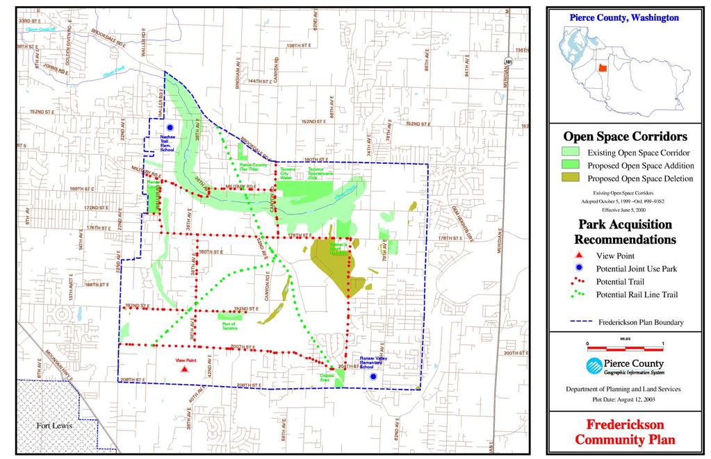
51
Frederickson Advisory Commission-Agenda Map Change Requests FRED.pdf Frederickson Draft Policy Language-JDM.pdf
 1. 7:00 P.M. Frederickson Advisory Commission-Agenda Documents: 10 16 17 FAC Agenda.pdf Frederickson LUAC-Map Changes Requests Documents: 10 16 17 Map Change Requests FRED.pdf Frederickson LUAC-Draft Policy
COMMUNITY DESIGN. GOAL: Create livable and attractive communities. Intent
 COMMUNITY DESIGN Intent An attractive, well-designed County will attract quality development, instill civic pride, improve the visual character of the community, and create a strong, positive image for
VEHICULAR AND PEDESTRIAN CIRCULATION
 This perspective sketch communicates the intended character and quality of a proposed streetscape design. Locate benches near a major intersection where people tend to gather. Seating and lighting provide
4. INDUSTRIAL 53 CASTLE ROCK DESIGN
 4. INDUSTRIAL 53 CASTLE ROCK DESIGN CASTLE ROCK DESIGN 54 4. INDUSTRIAL Overview Well-designed and attractive industrial centers are the product of blending economic realities with both functional and
The West Vaughan Employment Area Secondary Plan Policies
 Part 2: The West Vaughan Employment Area Secondary Plan Policies 2.1 General Policies It is the policy of Council: 2.1.1. That the West Vaughan Employment Area (the WVEA), identified on Schedule 1, will
Planned Development Review Revisions (Project No. PLNPCM )
") Planned Development Review Revisions (Project No. PLNPCM2014-00139) Standard residential development Planned Development Example: Smaller lot sizes than what is allowed to create open space amenity. What
Planned Development Review Revisions (Project No. PLNPCM2014-00139) Standard residential development Planned Development Example: Smaller lot sizes than what is allowed to create open space amenity. What
LAND USE DESIGNATIONS AND ZONING CLASSIFICATIONS
 LAND USE DESIGNATIONS AND ZONING CLASSIFICATIONS One of the most significant issues addressed within the community plan process is land use. How land is utilized within a community directly affects the
DRAFT DESIGN GUIDELINES
 IHZ Booklet #7 May 6, 2010 DRAFT DESIGN GUIDELINES CANTERBURY 7 Overview During the recent planning process for the Plan of Conservation and Development community character was identified as an important
The open space system should provide connective elements, relate to natural resources, and enhance the suburban character of the landscape..
 The open space system should provide connective elements, relate to natural resources, and enhance the suburban character of the landscape.. Mixed-use and infill development should maintain or enhance
Policies and Code Intent Sections Related to Town Center
 Policies and Code Intent Sections Related to Town Center The Town Center Vision is scattered throughout the Comprehensive Plan, development code and the 1994 Town Center Plan. What follows are sections
Transportation. Strategies for Action
 Transportation A major priority for the Overlake Neighborhood is to develop a multimodal transportation system. To achieve this system, a balance has to be found among travel, circulation and access needs;
SECTION II SECTION II STATEMENT OF GOALS, OBJECTIVES, PRINCIPLES, ASSUMPTIONS, POLICIES AND STANDARDS
 STATEMENT OF GOALS, OBJECTIVES, PRINCIPLES, ASSUMPTIONS, POLICIES AND STANDARDS 1 2 STATEMENT OF GOALS, OBJECTIVES, PRINCIPLES, ASSUMPTIONS, POLICIES AND STANDARDS INTRODUCTION The New Jersey Municipal
Corridor Identity. Section 9. Introduction. Corridor Guiding Principles
 Corridor Identity An attractive and healthy community is a critical element of a quality place, and the design of quality places is a balance between environmental, economic, and social considerations.
4.1.3 LAND USE CATEGORIES
 4.1.3 LAND USE CATEGORIES a. City Center District The City Center District incorporates the existing character and mix of uses in downtown Belmont to encourage redevelopment and new development in keeping
RECREATION AND OPEN SPACE ELEMENT GOALS, OBJECTIVES, AND POLICIES
 RECREATION AND OPEN SPACE ELEMENT GOALS, OBJECTIVES, AND POLICIES Goal 7 To provide park facilities, recreation programs, and open space resources that are safe, adequate, and accessible to all City residents,
B L A C K D I A M O N D D E S I G N G U I D E L I N E S for Multi-family Development
 B L A C K D I A M O N D D E S I G N G U I D E L I N E S for Multi-family Development Adopted June 18, 2009 This section of the Design and focuses on site planning and design guidance for new multi-family
Narcoossee Roadway Corridor
 Community Meeting Narcoossee Roadway Corridor April 5, 2012 Meeting Agenda Purpose of Meeting Continuation of Study Update Process (Previous Meetings Oct. & Nov., 2011) Tonight s Objective Review Proposals
Landscape and Streetscape Design 2.5
 Landscape and Streetscape Design 2.5 2.5.1 Goals 2.5.2 Planting 2.5.3 Sidewalks and Pavement 2.5.4 Furnishings 2.5.5 Walls 2.5.6 Lighting 2.5.7 Stormwater 2.5.8 Street Cross Sections 2.5 LANDSCAPE AND
The transportation system in a community is an
 7 TRANSPORTATION The transportation system in a community is an important factor contributing to the quality of life of the residents. Without a sound transportation system to bring both goods and patrons
Chapter Master Planned Communities (MPC) District
 District") Sections 14.53.010 Purpose and Intent 14.53.020 Applicability 14.53.030 Procedure 14.53.040 MPC Standards 14.53.050 Required Findings 14.53.010 Purpose and Intent Chapter 14.53 Master Planned Communities
Sections 14.53.010 Purpose and Intent 14.53.020 Applicability 14.53.030 Procedure 14.53.040 MPC Standards 14.53.050 Required Findings 14.53.010 Purpose and Intent Chapter 14.53 Master Planned Communities
Community Design Plan
 Gardena General Plan 2006 Authority While the is not a required element of a General Plan, it is included because improving the community appearance and image is paramount to the overall quality of life
for Master Planned Development Framework Design Standards & Guidelines
 B L A C K D I A M O N D DE S I G N G U I D E L I N E S for Master Planned Development Framework Design Standards & Adopted June 18, 2009 Introduction and Purpose The Master Planned Development (MPD) Framework
REZONING APPLICATION MPD SUPPLEMENT
 REZONING APPLICATION MPD SUPPLEMENT For Staff Use Only: DATE/TIMESTAMP: ZA# RECEIVED BY: The intent of the Master Planned District (MPD) designation is to allow flexibility in the design and construction
ATTACHMENT A. SILVERDALE DESIGN STANDARDS Amendments to the Waaga Way Town Center Chapter
 ATTACHMENT A SILVERDALE DESIGN STANDARDS Amendments to the Waaga Way Town Center Chapter Chapter 10. Waaga Way Town Center 10.1 Physical Identity Elements & Opportunities The Waaga Way Town Center includes
FLORIN ROAD CORRIDOR Site Plan and Design Review Guidelines Checklist
 FLORIN ROAD CORRIDOR Site Plan and Design Review Guidelines Checklist Applicant s Name: Project Address: Phone: Email: Applicant shall fill out the design guidelines checklist for all guidelines applicable
PUBLIC RIGHT-OF-WAY IN THIS CHAPTER PUBLIC REALM
 PUBLIC RIGHT-OF-WAY This section provides design guidelines for improvements in the public right-of-way. The public right-of-way refers to streets, sidewalks, non-vehicular thoroughfares, parks and greenways
ARTICLE 6: Special and Planned Development Districts
 ARTICLE 6: Special and Planned Development Districts 6-10 Traditional Neighborhood Development (TND) District 6-10.10 Purpose and Intent The Traditional Neighborhood Development (TND) District provides
IV. Development in the Rural Overlay District
 Intracoastal Waterway Route 17 Route 168 Great Dismal Swamp VIRGINIA NORTH CAROLINA IV. Development in the Rural Overlay District IV-1 Route 17 in Chesapeake s Rural Overlay District affords distant views
SUBCHAPTER 4-B GUIDELINES FOR THE B-3 COMMERCIAL CHARACTER AREA
 1 SUBCHAPTER 4-B GUIDELINES FOR THE B-3 COMMERCIAL CHARACTER AREA Downtown Bozeman should be the location of buildings of greatest height and intensity in the community. The following guidelines apply
Draft Memorandum #1: Goals and Vision for Revitalization
 Keizer Revitalization Plan Draft Memorandum #1: Goals and Vision for Revitalization Submitted to: City of Keizer April 12, 2018 (revised) Prepared By: Angelo Planning Group and Otak, Inc. Project No. 17482.A
Gas Stations ottawa.ca
 Urban Design Guidelines for Gas Stations ottawa.ca Ce document est disponible en français sur ottawa.ca. This document is available in French on ottawa.ca. Approved by City Council May 24, 2006 City of
NEW CASTLE COUNTY S ZONING DISTRICTS
 NEW CASTLE COUNTY S ZONING DISTRICTS This is general information about New Castle County s zoning districts. The information included is by no means exhaustive or complete. Before designing plans to develop
VILLAGE OF SKOKIE Design Guidelines for Mixed-Use Districts NX Neighborhood Mixed-Use TX Transit Mixed-Use CX Core Mixed-Use
 VILLAGE OF SKOKIE Design Guidelines for Mixed-Use Districts NX Neighborhood Mixed-Use TX Transit Mixed-Use CX Core Mixed-Use TABLE OF CONTENTS CHAPTER 1 SITE DESIGN Purpose 1 CHAPTER 2 SITE DESIGN Streetscape
EXISTING COMPREHENSIVE PLAN
 EXISTING COMPREHENSIVE PLAN Town Center Land Use Element: V. LAND USE POLICIES Town Center Mercer Island's business district vision as described in "Your Mercer Island Citizen-Designed Downtown" was an
Town Center (part of the Comprehensive Plan)
") Town Center (part of the Comprehensive Plan) Mercer Island Town Center Looking North (2014) In 1994, a year-long process culminated in a set of design guidelines and code requirements for the Town Center
Town Center (part of the Comprehensive Plan) Mercer Island Town Center Looking North (2014) In 1994, a year-long process culminated in a set of design guidelines and code requirements for the Town Center
COMPLETE GREEN STREET CHECKLIST
 COMPLETE GREEN STREET CHECKLIST This document was developed to dissect the structure of an urban street and explore opportunities to make our streets more complete while also integrating green street strategies.
6.0 Land Use Policies for Rural Settlements. 6.1 Rural Settlement Strategy
 6.0 Land Use Policies for Rural Settlements 6.1 Rural Settlement Strategy INTRODUCTION AMENDMENT NO. 131 PURPOSE Designated rural settlements comprise Rural Clusters, Villages and Serviced Villages as
URBAN DESIGN BRIEF URBAN DESIGN BRIEF 721 FRANKLIN BLVD, CAMBRIDGE August 2018
 URBAN DESIGN BRIEF URBAN DESIGN BRIEF 721 FRANKLIN BLVD, CAMBRIDGE August 2018 DESIGN BRIEF CONTENTS PART A 1.0 INTRODUCTION 2.0 DESCRIPTION & ANALYSIS OF SITE CONTEXT 3.0 DESIGN CONSTRAINTS AND OPPORTUNITIES
The Vision. Photo provided by The Minervini Group. 46 Vision, Objectives & Strategies
 Vision, Objectives & Strategies The is the public framework and guide for future development of the Grand Traverse Commons. The establishes public polices for infrastructure, the preservation of natural
City of Yelm. Tahoma Terra Final Master Plan Development Guidelines. Table of Contents
 City of Yelm Tahoma Terra Final Master Plan Development Guidelines Table of Contents Table of Contents... 1 Purpose... 2 Low Density Residential (R4-6)... 3 Moderate Density Residential (R6-10)... 5 Neighborhood
AIRPORT BUSINESS PARK
 PIER MAC PETROLEUM INSTALLATION LTD. AIRPORT BUSINESS PARK DEVELOPMENT APPLICATIONS March 2003 4.1 Airport Business Park Development Permit Area 4.1.1 Justification/Design Concept The design concept envisioned
When planning stormwater management facilities, the following principles shall be applied where possible.
 2.0 Principles When planning stormwater management facilities, the following principles shall be applied where possible. 2.0.1 Drainage is a regional phenomenon that does not respect the boundaries between
SECTION UNIFIED DEVELOPMENT ORDINANCE SECTION Part 1 Ordinance. ARTICLE 1 Zoning Districts
 SECTION 1-100 UNIFIED DEVELOPMENT ORDINANCE SECTION 1-300 Part 1 Ordinance SECTION 1-100. Introduction. ARTICLE 1 Zoning Districts Crystal Lake strives to maintain a balance of various land uses for a
River Corridor Overlay Zone (RCOZ) Article 5
 Article 5") River Corridor Overlay Zone (RCOZ) Article 5 The site is in one of two designated districts. The first is the CBD (central business district) River District, which recognizes the urban character and unique
River Corridor Overlay Zone (RCOZ) Article 5 The site is in one of two designated districts. The first is the CBD (central business district) River District, which recognizes the urban character and unique
LAND USE ELEMENT. Purpose. General Goals & Policies
 LAND USE ELEMENT Purpose This Land Use Element contains the goals and policies necessary to support the City s responsibility for managing land resources and guiding development through implementing regulations,
Section 9 NEIGHBORHOOD DESIGN
 Section 9 NEIGHBORHOOD DESIGN City of Lancaster Comprehensive Plan D u n k i n, S e f k o & A s s o c i a t e s, I n c. NEIGHBORHOOD DESIGN INTRODUCTION There are many ways in which a neighborhood can
CITY OF PUYALLUP. Background. Development Services
 CITY OF PUYALLUP Development Services 333 South Meridian Puyallup WA 98371 To: City Council From: Katie Baker, AICP, Planning Division Re: South Hill Neighborhood Plan Adoption Date: (Meeting date: February
Gold Line Bus Rapid Transit Transit Oriented Development (BRTOD) Helmo Station Area Plan
 Helmo Station Area Plan") Appendix F Gold Line Bus Rapid Transit Transit Oriented Development (BRTOD) Helmo Station Area Plan Introduction and Purpose of the Plan The Gold Line Bus Rapid Transit facility is an eleven-mile dedicated
Appendix F Gold Line Bus Rapid Transit Transit Oriented Development (BRTOD) Helmo Station Area Plan Introduction and Purpose of the Plan The Gold Line Bus Rapid Transit facility is an eleven-mile dedicated
Planned Residential Neighborhoods Land Use Goals
 Planned Residential Neighborhoods Land Use Goals Issue: Guidelines that provide for diverse high quality residential areas that include a variety of housing styles and layouts are needed. Goal 1: Create
AWH REPORT OF THE PLANNING AND DEVELOPMENT DEPARTMENT FOR APPLICATION FOR REZONING ORDINANCE TO PLANNED UNIT DEVELOPMENT
 AWH REPORT OF THE PLANNING AND DEVELOPMENT DEPARTMENT FOR APPLICATION FOR REZONING ORDINANCE TO PLANNED UNIT DEVELOPMENT MAY 8, 2014 The Planning and Development Department hereby forwards to the Planning
MULTIFAMILY RESIDENTIAL DESIGN PRINCIPLES Site Plan and Design Review Principles Checklist
 MULTIFAMILY RESIDENTIAL DESIGN PRINCIPLES Site Plan and Design Review Principles Checklist Applicant s Name: Project Address: Phone: Email: Applicant shall fill out the design guidelines checklist for
COMMERCIAL DESIGN REVIEW APPLICATION
 CITY OF LACEY Community Development Department 420 College Street Lacey, WA 98503 (360) 491-5642 COMMERCIAL DESIGN REVIEW APPLICATION OFFICIAL USE ONLY Case Number: Date Received: By: Related Case Numbers:
II. SINGLE FAMILY RESIDENTIAL
 II. SINGLE FAMILY RESIDENTIAL Castle Rock is made up of numerous individually built houses and subdivision tracts that have been developed during the past century. Some of the tracts are diverse in architectural
SECTION TWO: Overall Design Guidelines
 SECTION TWO: Overall Design Guidelines This section provides overall design principles and guidelines for the Gardnerville Mixed-use Overlay. They provide criteria for mixed-use places consisting of residential,
FREEWAY/TOURIST DISTRICT
 FREEWAY/TOURIST DISTRICT DESIGN STANDARDS FOR THE CITY OF MOUNTLAKE TERRACE March, 2014 MOUNTLAKE TERRACE FREEWAY/TOURIST DESIGN STANDARDS March, 2014 1 TABLE OF CONTENTS Introduction...1 Design Site Design
Westwind Developments Ltd. PIONEER LANDS AREA STRUCTURE PLAN - PROPOSED AMENDMENT
 FEBRUARY 2013 TABLE OF CONTENTS 1.0 BACKGROUND... 1 1.1 Amendment... 1 2.0 LOCATION & CONTEXT... 2 2.1 Land Ownership... 2 3.0 POLICY CONTEXT... 3 3.1 Municipal Development Plan... 3 3.2 Capital Region
FORMER CANADIAN FORCES BASE (CFB) ROCKCLIFFE SECONDARY PLAN. Official Plan Amendment XX to the Official Plan for the City of Ottawa
 ROCKCLIFFE SECONDARY PLAN. Official Plan Amendment XX to the Official Plan for the City of Ottawa") FORMER CANADIAN FORCES BASE (CFB) ROCKCLIFFE SECONDARY PLAN Official Plan Amendment XX to the Official Plan for the City of Ottawa 1 INDEX THE STATEMENT OF COMPONENTS PART A THE PREAMBLE PAGE Purpose...
FORMER CANADIAN FORCES BASE (CFB) ROCKCLIFFE SECONDARY PLAN Official Plan Amendment XX to the Official Plan for the City of Ottawa 1 INDEX THE STATEMENT OF COMPONENTS PART A THE PREAMBLE PAGE Purpose...
lot flankage Y street 16m 6m landscape strip for large site 3m landscape strip for small medium site
 Commercial General Commercial Objectives Create developments compatible with adjacent land uses in scale, function and character Define a consistent and attractive street edge with quality landscaping,
Derry Green Corporate Business Park
 Town of Milton Derry Green Corporate Business Park Urban Design Guidelines BMI/Pace - June 2010 Draft 3 Prepared by: Brook McIlroy Planning + Urban Design / Pace Architects Suite 300-51 Camden Street Toronto,
CHAPTER FIVE COMMUNITY DESIGN
 CHAPTER FIVE COMMUNITY DESIGN CHAPTER FIVE - COMMUNITY DESIGN Assumptions Frazier Park and Lebec have historically developed according to different patterns of spatial form. While both communities are
Landscaping Standards
 CHAPTER 29 ARTICLE 403 29.403 Landscaping Standards Purpose: The purpose of this section is to protect and promote the public health, safety and general welfare by requiring landscaping in relation to
Clairtrell Area Context Plan
 Clairtrell Area Context Plan March 2005 Urban Development Services City Planning Contents 1. Introduction... 4 2. Development Structure... 6 2.1 Streets... 7 2.1.1 Sheppard Avenue and Bayview Avenue...
CHAPTER 13 DESIGN GUIDELINES
 CHAPTER 13 DESIGN GUIDELINES Section 1300.00 Section 1300.01 Design Guidelines Purpose The purposes of this section are to: A. The purpose of this Section is to establish procedures and standards to serve
Incentive Zoning Regulations Florida Municipal City of Orlando
 Topic: Resource Type: State: Jurisdiction Type: Municipality: Year (adopted, written, etc.): 2002 Community Type applicable to: Title: Incentive Zoning Regulations Florida Municipal City of Orlando Document
LOW DENSITY RESIDENTIAL
 LOW DENSITY RESIDENTIAL Corner lots with coach houses to increase diversity, provide unity to the streetscape and increase eyes on the street. Garages and ancillary units accessed via rear lanes. Parking
Parks, Trails, and Open space Element
 Parks, Trails, and Open space Element Parks, Trails, and Open Space element Parks, Recreation, and Open Space are important components of the quality of life desired by the residents of Elk Grove. This
4.9 Mendocino Avenue Corridor Plan Design Guidelines
 4.9 Mendocino Avenue Corridor Plan Design Guidelines The Mendocino Avenue Corridor Plan addresses the area between College Avenue and Steele Lane. Mendocino Avenue is a busy arterial that runs parallel
Bylaw A Bylaw to amend Bylaw 12800, as amended, The Edmonton Zoning Bylaw Amendment No. 2239
 Bylaw 17672 A Bylaw to amend Bylaw 12800, as amended, The Edmonton Zoning Bylaw Amendment No. 2239 WHEREAS City Council at its meeting of February 22, 2001, gave third reading to Bylaw 12800, as amended;
Urban Design Guidelines Townhouse and Apartment Built Form
 Urban Design Guidelines Townhouse and Apartment Built Form Town of Wasaga Beach Table of Contents 1. Introduction 1.1. Purpose 1.2. Urban Design Principles 1.3. Application of Guidelines 2. Site Design,
McDonald s Restaurant - Purcellville Town of Purcellville Special Use Permit Statement of Justification July 24, 2014
 Introduction / Written Statement McDonald s Restaurant - Purcellville McDonald s Corporation is proposing to redevelop the existing McDonald s eating establishment with a drive-through located at 121 N
The Highway Overlay District applies to an area within the City of Papillion's zoning jurisdiction described as:
 ARTICLE XXVIII. HOD Highway Overlay District 205-164. Intent. The Highway Overlay District recognizes the strategic importance of the Highway 370 corridor as an entrance to Papillion from Interstate 80
Community Design Guidelines. Port Wallace DRAFT
 Community Design Guidelines Port Wallace DRAFT Energy 1 2 3 Nature Movement Connections Built Form DRAFT Layout Energy 1 Nature Community Design Guidelines GREAT COMMUNITIES PROTECT, CELEBRATE, AND CONSERVE
4.0 Design Guidelines For The Village Centre. South fields Community Architectural Design Guidelines Town of Caledon
 4.0 Design Guidelines For The Village Centre 4.0 Design Guidelines for the Village Centre The Village Centre is the focal point of the entire South Fields Community and is designed as a traditional commercial
DEVELOPMENT DESIGN GUIDELINES
 DEVELOPMENT DESIGN GUIDELINES Approved by Surrey City Council January 26, 2004 Campbell Heights Business Park - Development Design Guidelines TABLE OF CONTENTS 1.0 DEVELOPMENT CONCEPT... 1 2.0 DESIGN OBJECTIVES...
B. Blocks, Buildings and Street Networks
 B. Blocks, Buildings and Street Networks Figure IV.4 A rational block pattern with connected streets Introduction The single most important element in the physical and functional integration of mixed use
CHESAPEAKE LANDSCAPE ORDINANCE
 CHESAPEAKE LANDSCAPE ORDINANCE CONSERVATION PRESERVATION CZO 19-600 Effective October 16, 2008 BUFFER YARD C PARKING LOT REFORESTATION YEAR 1 REFORESTATION YEAR 4 BUFFER YARD F CBPA REFORESTATION Page
Port Lavaca Future Land Use
 Port Lavaca Future Land Use Introduction The City of Port Lavaca is beginning to see sustained growth, after many years of relative stable population. New single family homes, apartments, and businesses
Future Five. Design/ Development Guidelines. January 2008 Amended June 08 per City Council motion
 Future Five Design/ Development Guidelines January 2008 Amended June 08 per City Council motion 5-Points Design Guidelines Table of Contents I. Introduction 3 II. Area boundaries 4 III. Review Process
DEVELOPMENT CONTROLS MEDICAL DISTRICT
 6.01. GENERAL DESIGN GUIDELINES A. Site Planning B. Architectural Design C. Medical Facility Signage & Lighting D. Exhibit 48. ARCHITECTURAL DESIGN CONCEPTS 6.02. MEDICAL FACILITY STANDARDS & GUIDELINES
Metro. Activity Center Design Guidelines. Recommendations For Developing Focused, Mixed-Use Commercial/Residential Centers
 Metro Activity Center Design Guidelines Recommendations For Developing Focused, Mixed-Use Commercial/Residential Centers Metro Activity Centers What is a MAC? Legacy, the adopted guide for the future growth
Mark-up of the effect of the proposed Bronte Village Growth Area OPA No.18 on the text of section 24, Bronte Village, of the Livable Oakville Plan
 Mark-up of the effect of the proposed Bronte Village Growth Area OPA No.18 on the text of section 24, Bronte Village, of the Livable Oakville Plan Notes: This document is provided for information purposes
PORT WHITBY COMMUNITY
 PORT WHITBY COMMUNITY SECONDARY PLAN UPDATE COMMUNITY IMPROVEMENT PLAN URBAN DESIGN GUIDELINES September 2015 DRAFT PROPOSED AMENDMENT NUMBER # to the Whitby Official Plan PURPOSE: The intent of this Amendment
Applicant Name Phone / Fax / Address City State Zip Code . Property Owner Phone / Fax / Address City State Zip Code
 Master Development Plan Application Community Development Department City of Redmond 411 SW 9 th Street Redmond, Oregon 97756 541-923-7721 541-548-0706 FAX Master Development Plan Fee $38,862.52 File Number
City of Tacoma Planning and Development Services
 Agenda Item D-3 City of Tacoma Planning and Development Services To: Planning Commission From: Stephen Atkinson, Associate Planner, Planning Services Division Subject: Land Use Designations - Phase 2 Meeting
3. VISION AND GOALS. Vision Statement. Goals, Objectives and Policies
 Vision Statement Queen Creek s interconnected network of parks, trails, open spaces and recreation opportunities provide safe and diverse activities and programs that sustain its unique, small town, equestrian
Highland Village Green Design Guidelines
 Highland Village Green Design Guidelines Publishing Information Title Highland Village Green Design Guidelins Author The City of Calgary Status DRAFT - Proposed document subject to changes Additional Copies
North Oakville East Parks Facilities Distribution Plan. November, 2009
 North Oakville East November, 2009 POLICY CONTEXT 1) Purpose a) The purpose of this document is to be a guide for the location, configuration, design and development of the parks system for the North Oakville
13. New Construction. Context & Character
 13. New Construction Context & Character While historic districts convey a sense of time and place which is retained through the preservation of historic buildings and relationships, these areas continue
COUNTY COUNCIL OF PRINCE GEORGE'S COUNTY, MARYLAND SITTING AS THE DISTRICT COUNCIL 2010 Legislative Session. Council Members Dernoga and Olson
 DR- COUNTY COUNCIL OF PRINCE GEORGE'S COUNTY, MARYLAND SITTING AS THE DISTRICT COUNCIL 00 Legislative Session Bill No. CB--00 Chapter No. Proposed and Presented by Introduced by Co-Sponsors The Chairman
Proposed for Vic West Neighbourhood Plan. Design Guidelines for Intensive Residential Development - Townhouse and Attached Dwelling
 Proposed for Vic West Neighbourhood Plan Design Guidelines for Intensive Residential Development - Townhouse and Attached Dwelling Design Guidelines for Intensive Residential Development - Townhouse and
Dwelling Units Max 12 dwelling units per acre/min 8 dwelling units per acre. Development Mix 80% non residential/20% residential
 13. OSTEEN LOCAL PLAN Background: The Osteen Local Plan area is located in southwest Volusia County along the SR 415 corridor between Lemon Bluff Road and Acorn Lake Road and includes 3,990 acres. The
3.1 community vision. 3.3 required plan elements
 Chapter 3 Community Form 3.1 community vision 3.2 Parks & landscaping concepts 3.3 required plan elements D R A F T 20 Community Form Chapter 3 3.0 Community form 3.1 community vision The Specific Plan
A. Background Summary of Existing Challenges and Potential Possibilities. 1. Summary of Existing Assets and Potential Opportunities
 A. Background 1 A Main Street Master Plan Study was performed and completed in October of 2007. The study was initiated to review current land uses and development patterns along Main Street, from Parrish
WEST LOOP DESIGN GUIDELINES CHECKLIST
 WEST LOOP DESIGN GUIDELINES CHECKLIST Section 1.0 General Strategies 1.1 DESIGN EXCELLENCE: ENCOURAGE HIGH QUALITY AND INNOVATIVE DESIGN OF NEW BUILDINGS WITHIN THE WEST LOOP WITHOUT BEING PRESCRIPTIVE
CHAPTER SPECIAL PURPOSE AND OVERLAY ZONING DISTRICTS
 Special Purpose and Overlay Zoning Districts 106.28.010 CHAPTER 106.28 - SPECIAL PURPOSE AND OVERLAY ZONING DISTRICTS SPECIAL PURPOSE AND OVERLAY ZONING DISTRICTS Sections: 106.28.010 - Purpose 106.28.020
CHAPTER 3. Design Standards for Business, Commercial, Industrial, Recreational and Institutional Uses
 CHAPTER 3 Design Standards for Business, Commercial, Section Number Title Ordinance Number Date of Ordinance 16-3-1 Applicability 2006-11 2008-04 07-01-08 16-3-2 Uniform Standards for Architectural Design
ORDINANCE WHEREAS, this Ordinance is consistent with the City of Winter Garden Comprehensive Plan; and
 ORDINANCE 17-06 AN ORDINANCE OF THE CITY COMMISSION OF THE CITY OF WINTER GARDEN, FLORIDA, CREATING ARTICLE XIV OF CHAPTER 118 OF THE CITY OF WINTER GARDEN CODE OF ORDINANCES PROVIDING FOR THE EAST PLANT
2016 Comprehensive Plan Amendments C OMPREHENSIVE P LAN T EXT AND M AP A MENDMENT
 2016 Comprehensive Plan Amendments T EXT A MENDMENTS D ISTILLERIES IN R URAL P OLICIES #844110 LID POLICIES #844112 M AP A MENDMENTS B ETHEL S CHOOL D ISTRICT #844237 P ARKS AND R ECREATION #844305 C OMPREHENSIVE
TOP TEN LIST OF COMMUNITY CONCERNS REGARDING PROPOSED AMENDMENTS TO CHAPTER 42
 TOP TEN LIST OF COMMUNITY CONCERNS REGARDING PROPOSED AMENDMENTS TO CHAPTER 42 1. Extend the urban area to Beltway 8 in stages, over say a three-year period, prioritizing development in transit and declining
Planning Commission Staff Report June 5, 2008
 Owner/Applicant Taylor Village Sacramento Investments Partners, LP c/o Kim Whitney 1792 Tribute Road #270 Sacramento, CA 95815 Staff Recommendation Planning Commission Staff Report Project: File: Request: