Truro & Threemilestone Draft Final Report November 2008
|
|
|
- Clarence Griffith
- 5 years ago
- Views:
Transcription
1 65 V. Masterplan The city centre has been identified as the priority location for new development, which must reinforce its historic character, its retail, civic and cultural role. Particular focus is given to the two major development sites at Pydar Street and Garras Wharf. Garras Wharf in particular has been identified as a priority by local residents. These sites must however be considered in the context of a comprehensive strategy for the city centre as a whole. The priority must be to maintain and protect the existing businesses within Truro, and then to ensure that new development reinforces the strengths of the city centre. Consideration is therefore first given to defining a strategy for the historic core. The strategy for the city centre must be defined to meet the four key criteria identified in Section II: Reinforcing the city centre; Protecting the long term landscape setting; Providing high quality jobs; and Promoting sustainable communities. Whilst the first criteria is the most obvious, all are integral to creating a robust, long term, sustainable framework for the city centre. In particular all four criteria must inform the development briefs for Pydar Street and Garras Wharf development sites and all other development opportunities in the city centre. The strategy has therefore been prepared in collaboration with Alan Baxter & Associates, who prepared the Conservation Area Management Plan and in consultation with DTZ, who have advised on retail strategy and policy. It has also had regard to the previous findings and recommendations of the Urban Design Strategy.
2 66


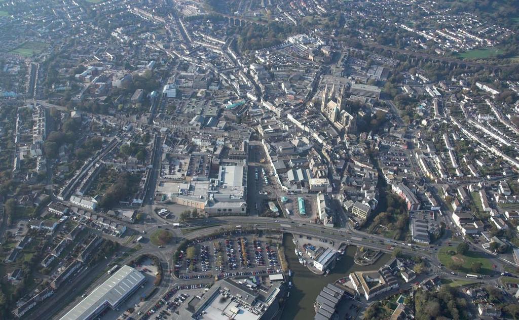
3 The Historic City 67 Vision For The Area Truro city centre will remain Cornwall s premier shopping destination, and its distinctive environment and specialist retailers will enable it to compete more effectively with larger centres further afield. Redevelopment of underutilised sites in the retail core will revitalise the historic streets and the independent retailers that give the city its distinctive character. The setting of the historic buildings will be improved through redevelopment and public realm improvements. The city s rivers and waterfront will be recognised as major attractions. River walks will be created connecting Boscawen Park to Garras Wharf to Victoria Park and the Kenwyn Valley, revealing the iconic views of the cathedral and the viaduct. Mixed-use development at Garras Wharf will create a vibrant waterfront destination for residents and visitors. It will act as a natural extension of the historic core. Morlaix Avenue will provide a new shopwindow to the city and its waterfront. Mixed-use redevelopment of Pydar Street sites will add to the retail and leisure offer of the city centre. New office and residential development will reinforce the civic role of Truro, and support the retailers during the day and the evening. A fast and efficient park & ride service will bring commuters and visitors into the heart of the city. Cycle routes and local bus services will connect the city centre to its residential hinterland. Car parking will be concentrated in safe, modern car parks on the edge of the city centre.
 as one end of the dumbbell, and the Pydar Street development site as the northern balance.")


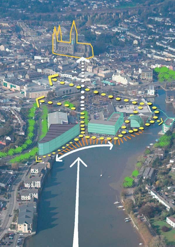
4 68 Masterplanning Criteria Reinforcing The The retail strategy for the city centre, as outlined in the 2007 draft AAP preferred options, was based on Extending the dumbbell. This identifies Lemon Quay and a redeveloped waterfront (Garras Wharf) as one end of the dumbbell, and the Pydar Street development site as the northern balance. The historic core of the cathedral and Boscawen Street is identified as the centre of the dumbbell. Larger retail units are clustered in Pydar Street and Lemon Quay, and are one of the reasons why these areas have been identified as the key elements in the dumbbell. The dumbbell strategy The relocation of Marks & Spencer has created a destination at the southern end of the city centre, whilst Pydar Street remains the prime retail location in Truro. With the major tourist destination, Truro Cathedral, and Boscawen Street at the centre of the dumbbell, Figure 5.2 (below) identifies most visitors perceptions of the area which defines the heart of the city centre s retail offer. Re-evaluating the dumbbell strategy Both the Retail Strategy and the Urban Design Strategy identified the importance of reinforcing the secondary retail areas. For many residents and visitors these areas, and the specialist and independent shops that can be found there, are the defining retail characteristic of the city centre and a key reason for visiting. Figure 5.3 below includes the key streets and spaces that define these areas.together these areas create a consolidated, and compact, city centre retail area. Fig. 5.1 The dumbbell strategy identifies the key destinations and pedestrian routes. Fig. 5.2 The dumbbell approach creates a linear city centre which could be exacerbated by Pyder Street and the waterfront. Fig. 5.3 Recognising the secondary retail streets creates a more compact city centre.

5 69 Development Opportunities Pydar Street and Garras Wharf have been identified as the two major opportunity sites in the city centre. In addition there are a number of underutilised sites which have been considered in previous studies, and identified through our own assessment. Some, such as the service area of Moorfield car park, are considered to be short term development priorities. Others, such as Old Bridge Street car park and the Pannier Market, have longer term potential which is more likely to be released once other development opportunities have come forward. Fig 5.4 Pydar Street and Garras Wharf are not natural extensions of the core retail area but their edges can be integrated. These development sites provide a variety of opportunities for extending the retail and leisure offer within the city centre. Although the retail capacity study has identified significant potential for new floorspace, there is concern at the ability of the city centre to accommodate significant development on the Garras Wharf and Pydar Street sites without changes to pedestrian flow patterns across the city. Figure 5.4 shows that new retail development on both these sites would significantly extend the boundary of the city centre. It would also place significantly more reliance on the dumbbell, emphasising the linear nature of the link between the Pydar Street and Lemon Quay, and potentially undermining the vibrancy and viability of the important specialist retail areas as they become more peripheral.
6 70 Masterplanning Criteria Reinforcing The Truro Retail Appraisals The Truro Retail Offices and Leisure Study was undertaken by Donaldsons (now DTZ) in It concluded that in order to maintain Truro s sub-regional shopping centre status there was a need for a major new retail development in the city centre and in particular stated: We forecast a need for a substantial new prime retail development or developments in Truro city centre, ideally anchored by a new department store....we consider that the only sites which could potentially accommodate such a development are the Pydar Street site and the combined Garras Wharf and Tesco sites (with or without the adjacent retail warehouses site). However, development of the Pydar Street for this use would bring greater benefits to the city centre in retail terms, and be less likely to have an adverse impact on the city centre. The Garras Wharf and Tesco sites, if they become available for development, would be better used for a mixed use waterfront development of housing, leisure (principally A3/A4 uses) and some small scale festival shopping. We therefore recommend that the Council continues to allocate the Pydar Street site for a major prime retail development (together with other uses as appropriate). The latest retail advice to the Council provides less certainty on the likeihood of Pydar Street site coming forward for major retail development and places greater priority on the organic redevelopment of smaller city centre sites. The analysis of pedestrian flow (opposite) shows strong pedestrian flow in red, and weaker flows in green and blue. Strong pedestrian flow leads directly to increased expenditure and stronger retail areas. The analysis confirms the strength of Pydar Street, and its attractiveness to potential developers, but also the potential vulnerability of other areas which could be undermined by a single major scheme on the edge of the retail core. Lemon Quay is surprisingly vulnerable, and many of the distinctive secondary streets show relatively weak pedestrian flow. Any future retail strategy for the city centre should seek to address these issues, and ensure that activity feeds into these important streets and spaces.


7 71 Red areas show strong pedestrian flow, and therefore strong retail demand, on Boscawen Street and Pydar Street. Green and blue indicate potentially vulnerable areas which includes Lemon Quay. The retail strategy must therefore support these areas.


 The Moorfield car park is an important car park strategically located close to Victoria Square.")
8 72 Masterplanning Criteria Reinforcing The Delivering organic growth There is an opportunity for the city centre development sites to provide a comprehensive but organic approach to enhancing the retail and leisure offer of the city. Public sector landownership within the city, including Garras Wharf and Pydar Street, will help in delivering this comprehensive approach. Lemon Quay (East) The bus station and Pannier market (right) are important uses for the city centre but more efficient use could be made of these centrally located sites. Higher density development could bring more life to the city centre and to Lemon Quay and still provide important space for the indoor market. The area is identified as a priority for redevelopment in the Conservation Area Management Plan. Moorfield Car Park (right) The Moorfield car park is an important car park strategically located close to Victoria Square. Its connections to the retail core are however unattractive and appear unsafe. Improvements to the car park could include new retail space along the frontage and side elevations, replacing underused service areas and providing overlooking of these routes. Residential development on the surface car park area could bring increased vitality to the city centre and reduce pressure on greenfield sites.


9 73 Individual Stores The Bhs store trades on only one level, has a poor quality frontage on Boscawen Street and St Mary s Street with its service entrance close to the cathedral. Redevelopment could enhance the setting of these historic spaces and buildings and provide additional retail floorspace in the city centre. Old Bridge Street As part of a comprehensive access strategy for the city centre, redevelopment of surface car parks, such as Old Bridge Street, can provide retail and leisure floorspace which connects well to the secondary retail streets, boosting trade for independent retailers. Old Bridge Street has an attractive frontage to the River Allen and could be a distinctive retail and leisure destination, and an attractive place to live, in the city centre.
.")
10 74 Masterplanning Criteria Reinforcing The Truro Conservation Area The Conservation Area Management Plan has been prepared by Alan Baxter & Associates. It supports the strategy of redeveloping core city centre sites including Moorfield car park, New Bridge Street car park and the east side of Lemon Quay (including the Pannier Market). It also emphasises the need for strong pedestrian connections, and pedestrian flow which will reinforce the key historic streets and spaces. The report expressed concern at the potential impact of the proposed Pydar Street scheme on the rest of the city centre and stated that: The poposed uses for the site should complement and not undermine the retail and service vitality of the historic core and the Conservation Area, and that it should establish greater permeability and new pedestrian routes between the site and the town centre and to the cathedral. The report also recommended that the Conservation Area be extended to include Garras Wharf. It highlighted the negative impact of the Tesco store and associated surface car parking on the setting of the Conservation Area. It also stressed the importance of improved pedestrian crossings to address the barrier created by Morlaix Avenue and the importance of protecting long distance views to the cathedral and to the countryside. The Conservation Area Management Plan identifies key spaces for improvement which include potentially vulnerable secondary retail areas such as the Opes (above right) and Victoria Square (right).

 is an important public space and")
11 This service space (shown brown on the plan opposite) is an important intersection of opes connecting secondary retail areas. It is identified in the Conservation Area Management Plan as a priority for enhancement.. 75 Victoria Square (shown pink on the plan opposite) is an important public space and has been the subject of recent public realm improvements.


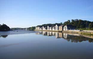
12 76 Masterplanning Criteria Landscape Setting The view corridor shows the areas within which development must protect the views of both the cathedral and the viaduct. This impacts on almost all of the Garras Wharf site. Protecting the long term landscape setting (river views) The Truro Waterfront is identified in the Landscape Framework as a distinctive character area. The estuary, and the green hills which frame it, provides long views into and out of the city. The connection with Boscawen Park is fundamental to the relationship of the city with the surrounding countryside, and the views of the cathedral and the viaduct from Boscawen Park can be considered an iconic part of Truro s historic character. This is recognised in the Conservation Area Management Plan and is one of the reasons why it is recommended that the Conservation Area be extended to include not just Garras Wharf but the estuary itself. In order to protect these key views it is essential that future redevelopment of both Garras Wharf and the Pydar Street site is subject to detailed development briefs that recognise their character, potential contribution to the Conservation Area and the impact of the height, scale and bulk of development on key views into and out of the Conservation Area.

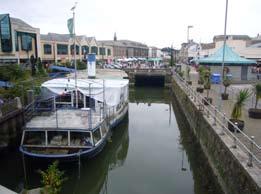
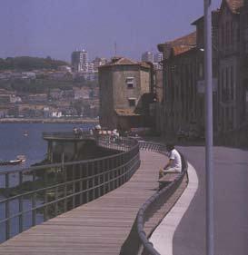
13 77 The Garras Wharf site presents a natural opportunity for a riverfront space with long distance views connecting the city with its estuary and its natural surroundings.


14 78 Masterplanning Criteria Landscape Setting A river walk River walk key (plan opposite) The city centre waterways have been identified as an underutilised asset. Creating a river walk which improves and connects these waterways can create high quality development opportunities, such as New Bridge Street car park and can encourage visitors to move around the secondary shopping areas and see other attractions, such as Victoria Park. The city centre river walk can also form part of the wider green links network, creating linear routes from the city waterfront to the Kenwyn and Allen valleys. The plan opposite presents an initial strategy for enhancing the river walk through the city centre and identifies areas where new routes can be created and existing routes improved. It responds to the priority given to this issue in the public workshops and needs further investigation into the detail of the individual routes proposed. Many areas of the city s rivers are neglected and undisovered.


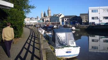


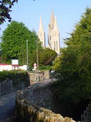


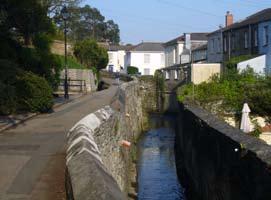

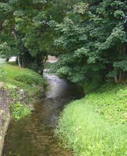
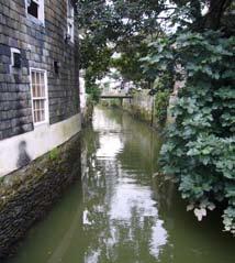
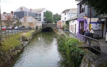

15 79 Potential for river walks to be created connecting Boscowen Park to the city centre and on to the wider Truro & Threemilestone Draft countryside. Final Report November 2008
16 80 Masterplanning Criteria Providing high value jobs The promotion of the retail and tourism sector is a critical element in maintaining the vibrancy of the Truro economy. A key factor in supporting the range of businesses in the city centre is however the scale of office employment. For example, the level of public sector employment immediately north of the city centre is one of the main reasons why Pydar Street continues to operate as a prime retail area. Maintaining, and increasing, the level of office floorspace within the city centre is therefore a priority for the Area Action Plan. The Pydar Street development site should remain a focus for office employment so as not to undermine retail demand in this area. Office development should be incorporated as part of the Garras Wharf redevelopment to strengthen retail demand in Lemon Quay. In the medium term redevelopment of the Newham Industrial Estate could provide further capacity for office based employment and higher value jobs within walking distance of the city centre. Promoting sustainable communities Increasing retail and office floorspace in the city centre will promote sustainable travel modes as there is a large catchment within walking distance and the city centre is the most accessible location by public transport. Increasing the resident population within the city centre will help promote the retail and leisure sectors, make the city more attractive to potential employers, reduce the need to travel into the city, increase the viablity of community facilities and increase activity and safety in the evening. Mixed-use redevelopment of Garras Wharf is important as it lies outside the core retail area. It will be an important evening destination and there will be a need for residential uses as well as office and leisure to maintain vibrancy throughout the day. It will be an attractive place to live and work and can help to create a unique sense of place within the city. Residential uses within the Pydar Street redevelopment and the Moorfield car park redevelopment, as part of mixed-use scheme, can again promote vibrancy in the evening reinforce the existing character of the city.

17 81 Garras Wharf and Pydar Street are important generators of pedestrian flow into the city retail core. Offices, housing and public parking on these sites help maintain the strength of Pydar Street and Lemon Quay. Garras Wharf in particular is of course an important desintation in its own right.
18 82 Summary Prioritising the city centre The city centre is the most accessible location by public transport and for pedestrians. It is therefore the most sustainable location for new commercial floorspace. The development sites within the city centre provide significant opportunities to reinforce the vibrancy of the city centre retail and leisure offer. The success of the city centre has however been founded on its distinctive historic character. Any redevelopment that does not respect and enhance this character will undermine the longer term health of the city, and would therefore be contrary to the main masterplanning criteria. All the development sites provide the opportunity for mixed-use schemes, incorporating residential and / or office uses. They will therefore contribute to creating high value jobs in the city centre and promoting sustainable communities. Promoting development within the city core reduces the need for greenfield expansion and therefore helps protect the landscape setting of the city. The key area for detailed investigation is the potential impact of development on the Truro Waterfront landscape, and views of the cathedral and viaduct. In order to deliver these objectives an Organic Vision for the city centre is required, which then informs the scale and nature of development at Garras Wharf and Pydar Street. An Organic Vision Redeveloping the opportunity sites within the historic core can reinforce the existing retail streets, and in particular the historic streets and secondary retail areas. Redeveloping the edges of the Pydar Street and Garras Wharf development sites for retail maintains their current role and does not radically alter the shape or form of the retail core. This requires a comprehensive approach to be taken to all development sites within the city centre. It also requires a mixed-use approach to be taken, but this is consistent with the existing built form and is therefore more in keeping with the historic character of the city By considering the Pydar Street site alongside other development sites in the city centre a comprehensive approach to funding and delivery. In particular the scale of public sector landownership allows for potential cross-subsidy if a developer is appointed to deal with a range of sites rather than a single development site. This encourages the developer to consider the health of the whole city, not just to maximise the viability of a single development. Consideration should therefore be given to a comprehensive funding and delivery approach for Pydar Street, Garras Wharf, Moorfield car park, New Bridge Street car park and the Bus Station/Pannier Market sites. This revised strategy, focusing on the existing retail area, was supported by the consultant team and by the public consultation workshop in January The public workshops also reinforced the clear message that the priority was to enhance the waterfront and Garras Wharf.

19 Improved public car park Housing fronting the river Organic Vision for Truro Offices fronting St Clement Street NCP car park demolished to create new connection to cathedral, city centre and river Improvements to BhS store Setting of cathedral enhanced Public realm improvements to opes and spaces Riverfront walks opened up Improvements to Moorfield car park with retail frontage Redevelopment of bus station and Pannier Market New housing scheme Surface level crossing of Morlaix Avenue City centre foodstore Improved edge to Marks & Spencer fronting the street Bridge to eastern riverfront and Boscawen Park MIx of offices and housing Waterfront hotel Cafes and restaurants facing south along the estuary New waterfront destination

20 84


21 Garras Wharf 85 Vision Garras Wharf will be a waterfront destination and will reconnect the waterfront to the city centre. New public spaces, visitor attractions and waterfront walks will raise awareness of the natural environment and Special Area of Conservation and promote bird watching and environmental tourism. Improved retail uses will provide a shop window to Morlaix Avenue. A mix of residential and employment uses with create a vibrant atmosphere in the day and the evening, with new leisure uses focused on the southfacing waterfront, and new cultural attractions adding to the tourist offer of the city centre. Enhanced crossings of Morlaix Avenue will create a natural extension of the city centre. Long views of the estuary and of the cathedral will bring residents and visitors to enjoy and explore the waterfront. A new bridge will improve connections to other areas of the waterfront. The new scale of development will reflect the character and scale of the city centre. Smaller permeable blocks will create a more intimate environment with a variety of streets and public spaces enhancing the character of the Conservation Area. Parking will be retained but will not dominate the site.


 to support the retail businesses in Lemon Quay and the city centre.")

22 86 Design Principles Treating Morlaix Avenue Morlaix Avenue is a significant barrier to pedestrian and cycle movement, and separates the city centre from its waterfront. Tackling this, and introducing surface crossings, was highlighted as a priority by local residents and by the Conservation Area Management Plan. The barrier created by Morlaix Avenue. For pedestrians, there should be a natural flow from the core retail area of Lemon Quay to support the proposed waterfront destination at Garras Wharf. Similarly, there should be a natural movement from the public car parking which it is proposed will remain in Garras Wharf (albeit not as surface car parking) to support the retail businesses in Lemon Quay and the city centre. The pedestrian subway prevents this, and obscures what should be a long, direct, view from the city centre to its waterfront. Morlaix Avenue should be a key gateway to the city centre for motorists, particularly those passing through to Falmouth and beyond. Improving the quality of the street, slowing the traffic and opening up views to the water and the historic city would encourage visitors to break their journey or return to the city at a later date.


23 87 The opportunity exists to create an at-grade crossing of Morlaix Avenue from Lemon Quay to Garras Wharf. The waterfront destination would then act as an extension of the historic core, and encourage residents and visitors to spend longer in the city centre. In principle discussions with the County Council have suggested that the at-grade crossing and the introduction of a signal controlled crossing, could be introduced without unacceptable impact on traffic flows. Detailed modelling would be required in conjunction with future proposals for Garras Wharf. The replacement of the western roundabout with a signal controlled junction could help pedestrians seeking to cross in this area. It would also help create a circuit along Fairmantle Street, which is also in need of improvement. This circuit would encourage pedestrians to return to the city centre via Lemon Street, thus reinforcing the vitality of this important historic street. Surface crossings can break barriers and increase pedestrian flow (Sheffield city centre).

24 88 Improving the waterfront The site is currently dominated by the Tesco foodstore, Staples/Currys retail warehouse and large areas of surface car parking. Whilst these do not create a vibrant or attractive waterfront environment, the foodstore and parking in particular are important uses that help to anchor the southern end of the city centre and bring footfall into Lemon Quay. New development needs to protect long distance views of the city along the estuary and protect the layers of Truro provided by the waterfront, the viaduct and Cathedral and the green hills behind. Development generally therefore needs to be restricted to 3-4 storeys across the site. Within this framework, development should also create a bold new frontage to the estuary, and create a strong sense of enclosure to the waterfront and the new public spaces which should be created. The opportunity exists for landmark, pavilion buildings at the eastern and western ends of the site to mark where the city meets the water without impacting on important views. These would provide opportunities for new cultural or leisure attractions for the city s residents and visitors. A new waterfront hotel would enhance the offer within the city centre. A modern and lively quayside should also mark the point at which the historic city meets the waterfront. Careful and imaginative use of high quality landscaping and lightweight timber decking could create a distinctive place for locals and visitors to explore, and enhance the sense of connection with the water and the natural environment. Floating or cantilevered decks can incorporate restaurants and leisure facilities and bring people closer to the water and to the boats. Development on Garras Wharf must protect views of the cathedral and viaduct but can still create an interesting skyline.


25 89 Garras Wharf has the potential to create an exciting waterfront space connecting city to the estuary.


26 90 Retaining a foodstore Tesco has proposed a significantly larger store to address the problems of overtrading. Initial proposals have been put forward for the relocation of Tesco to Higher Newham as part of a wider development of this part of the city and for redevelopment on its existing site. The Council would not wish to lose a major foodstore from within the city centre, and the preferred approach is to retain a foodstore on this site. There are however potential benefits in terms of scale and character of the waterfront if an alternative city centre location could be found for food retail development. The development principles for Garras Wharf must therefore allow for redevelopment with or without a major foodstore, but should define clearly the acceptable size of a foodstore that is compatible with these principles. Two options were drawn up to test the capacity of Garras Wharf to accommodate a store of the size being sought, providing 80,00sqft over two levels. In both options the existing roundabout on Morlaix Avenue is replaced by a cross roads, which gives more development capacity within the site and makes it easier for pedestrians to cross the street. In both options the waterfront has a leisure and visitor focus Option 1 shows the Tesco store in its exsting position. Discussions with Tesco indicate that they could continue trading from within the Staples store which would then become available for redevelopment. This approach creates a large retail anchor further into the site and gives the potential for additional retail units to be provided between the foodstore and Lemon Quay. The scale of the store, and the size of service yard required, creates a single large development block across the site. This lack of permeability would be unacceptable on the waterfront. Option 2 shows a slightly smaller store, but relocated to front Morlaix Avenue. This brings the anchor store closer to Lemon Quay but the main advantage is the ability to create an additional street breaking up the developmnent block. The scale of the development blocks created is still however unacceptable for this key site. The conclusion therefore is that whilst it is preferable to retain a foodstore on Garras Wharf, and essential to retain one within the city centre, the scale of foostore needs to be appropriate to the scale and historic character of the city centre. These options show that a very large foodstore, and its servicing requirements, is incompatible with the desire to create smaller development blocks and a finer grain of streets and spaces as Garras Wharf becomes an extension of the city centre.


27 91 Design Principles for Garras Wharf The retail analysis, Conservation Area Appraisal and Masterplan, public consultation and urban design appraisals agree that the waterfront is a special place for Truro, and an underutilised and undervalued asset. Redevelopment is essential but delivery is likely to be complicated. The priority is to secure the right form, scale and mix of uses for the city, its residents and its visitors and this will require detailed design work and negotiations with the County Council and with existing landowners and occupiers. The key principles which should underpin any future redevelopment of Garras Wharf include: Providing a waterfront destination which is accessible to visitors and residents Creating a mix of uses, including leisure, retail, residential, offices and car parking Creating a permeable layout with a variety of streets which connect to the city centre and the riverbanks Ensuring active frontages and overlooking of main pedestrian routes Creating the scale and character appropriate to the city centre Conservation Area Providing public access to the waterfront with a series of spaces drawing visitors along the route Improving soft landscaping Protecting key views of the cathedral and the viaduct, with heights generally limited to three storeys Ensuring Morlaix Avenue provides a natural, at-grade, crossing for pedestrians Ensuring car parking and servicing does not dominate the site Creating visual connections between the site, the city centre and the waterfront Providing overlooking of public routes and spaces Ensuring issues of flood protection are addressed Protecting the Special Area of Conservation and seeking opportunities to enhance it and the visitor experience Protecting the wharf developments from the impacts of climate change. The design principles illustrate that it is still possible to deliver a large city centre foodstore, trading on two levels. A development brief for this site should be prepared, and discussions held with Tesco as landowner and retailer, regarding the delivery, and detailed design, of such a scheme.
28 92


29 Pydar Street 93. Vision The visual impact of the NCP car parks and existing blank frontages on St Clement Street should be addressed. The Pydar Street site will anchor the north of the city centre as an important office, residential, parking and retail location. It will provide high quality employment in the city centre. It will provide a desirable city centre residential location for young people, close to facilities and with a riverfront aspect. It will be an iconic arrival point in the city for visitors, providing views of the viaduct and an attractive river walk to the cathedral. The NCP car park will be removed and the setting of the cathedral enhanced. New retail and leisure facilities will function as a natural extension of the city centre and have a window onto St Clement s Street. The Pydar Street site provides office employment, retail and leisure facilities and public car parking that are important functions to retain in this part of the city. The retail analysis, Conservation Area appraisal, public consultation and urban design appraisals agree that the Pydar Street site is a critical part of the city centre strategy. Redevelopment is essential but as with Garras Wharf, delivery has proved to be complicated The Pydar Street site must provide for the retention of office employment and public parking on the site. This is critical to the long term vitality of Pydar Street retailers and the city centre as a whole. There is a danger that a unitary council could see a move of Council employees out of the city centre. This would undermine the civic role of the Truro and would also make it more difficult to secure anchor tenants undermining the viability of a mixed-use scheme. Housing development should be incoprorated as part of a mixed-use scheme and should exploit the potential of the river frontage. This is an underutilised asset within the city centre and has the potential to create a unique sense of place for city centre residents. Redevelopment must improve public perception of the city from the street. Redevelopment should seek to ensure that the blank elevations currently presented to St. Clements Street are removed in the longer term. Access to the cathedral should be improved. The city rivers provide an alternative setting for new development.


30 94 Design Principles A number of options have previously been considered for the Pydar Street redevelopment. The scheme shown below was prepared for the Truro Urban Design Strategy in As with many proposals it incorporates a department store and seeks to create an internal link within the scheme. It also seeks to realign St Clement Street. From a construction and viability perspective, these elements mean that the scheme must be delivered comprehensively. Substantial work has been undertaken on development proposals for the Pydar Street site by Simons Developments, although no definitive scheme has been provided and no application submitted. Through consultation, concerns have been expressed at the scale and the deliverability of the proposals, as well as the ability of the scheme to integrate with the existing street pattern and hence its potential impact on secondary retail streets. Above is an extract from the Urban Design Strategy illustrating earlier retail-led proposals for the Pydar Street site. Below are two alternative approaches to securing a mixed-use, office and residential led, approach As part of the design process, consideration has been given to a scheme that can be phased, and which can also form part of a wider series of retail improvements across the city centre. The schemes therefore folllow the principle of mixed use established in the Urban Design Strategy but does not seek to incorporate a department store. The scale of associated retail provision and parking provision is therefore reduced, and the scale of office and residential development can be increased. Public car parking should still be retained within the site. There will be a net loss of parking spaces if the NCP car park, and smaller surface car parks are developed. Pydar Street is an important arrival point, and has the potential to increase capacity of its existing decked car park at relatively low cost. Redevelopment must allow for the long term demolition of the NCP car park. Whilst this has proved too costly to deliver within the previous schemes, it is essential for opening up access to the cathedral and improving its setting. As the car park ages, maintenance costs will increase and the viability of demolition will improve. Any masterplan and subsequent scheme must therefore allow sufficient flexibility for this to be delivered, even if it is not an early phase of the scheme.

31 95 Design Principles for Pydar Street The priority is to secure the right form, scale and mix of uses and to create the right connections which will reinforce the retail, cultural and civic role of the city centre. The key principles which should underpin any future redevelopment of the Pydar Street site include: Creating a mix of uses, including leisure, retail, residential, offices and car parking which reinforces the city centre Creating connections which improve accessibility to the cathedral and the city centre Creating the scale and character appropriate to the city centre Conservation Area Removing the NCP car park and improving the setting of the cathedral Protecting key views of the cathedral and the viaduct Providing active ground floor frontages, retail/leisure/office, to St Clement Street Creating a green space with better access to the river Ensuring issues of flood protection are addressed Improving the existing decked car park. The redevelopment of the NCP car park can be brought forward at a later date. The connection to the existing car park opens up views of the cathedral to visitors from the car park by bringing them in via the riverfront. The crossing point of St Clement Street allows for views in both directions. Improving the north facing frontage to St Clement Street, which is a service area for existing retail areas, will be difficult to achieve but should be a long term objective for future redevelopment.
32
A. The sites in Table 16 below, as identified on the Policies Map, are allocated for retail-led development:
 SWDP 44: Worcester City Centre A. The sites in Table 16 below, as identified on the Policies Map, are allocated for retail-led development: Table 16: Sites Allocated for Retail-Led Development Policy Reference
0 9 Areas of Change 59
 09 Areas of Change 59 09 Areas of Change This section explores seven areas of change within Solihull Town Centre which provide practical interventions in order to deliver the emerging concepts outlined
WINCHESTER TOWN 3.1 LOCATION, CHARACTERISTICS & SETTING
 WINCHESTER TOWN 3.1 LOCATION, CHARACTERISTICS & SETTING 3.1.1 The area referred to by the City Council, as Winchester Town, consists of the Winchester Wards plus the adjoining built up areas of Badger
SWLP 42: Worcester City Centre
 SWLP 42: Worcester City Centre A. The following sites are allocated for retail development (as shown on the Proposals Map): Policy Reference SWDP7/1 SWDP7/2 SWDP7/3 Sites allocated for retail development
Paignton Neighbourhood Plan (Submission version 2017)
") Paignton Neighbourhood Plan (Submission version 2017) Introduction This brief statement covers the views of the TDA, only in relation to its role as adviser to the Council on delivery of town centre regeneration.
Paignton Neighbourhood Plan (Submission version 2017) Introduction This brief statement covers the views of the TDA, only in relation to its role as adviser to the Council on delivery of town centre regeneration.
The Proposed Auckland Unitary Plan (notified 30 September 2013)
") 3 Business zones Introduction There are 10 business zones in the Unitary Plan: City Centre Metropolitan Centre Town Centre Local Centre Neighbourhood Centre Mixed Use General Business Business Park Light
3 Business zones Introduction There are 10 business zones in the Unitary Plan: City Centre Metropolitan Centre Town Centre Local Centre Neighbourhood Centre Mixed Use General Business Business Park Light
Page 1 of 19 URBAN DESIGN FRAMEWORK FOR BOLTON STREET WATERFORD
 Page 1 of 19 URBAN DESIGN FRAMEWORK FOR BOLTON STREET WATERFORD 1.0 Introduction: The relocation of the City Council stores and depot from Bolton Street creates an exciting opportunity for development
4 Proposed masterplan 4.1 Proposed masterplan: The scheme The scheme s component parts Urban form and grain
 4 Proposed masterplan 4.1 Proposed masterplan: The scheme... 36 4.2 The scheme s component parts... 36 4.2.1 Urban form and grain...36 4.2.2 Retail Circuits...38 4.2.3 Mix of uses...39 4.2.4 Public realm...40
Chapter 2: OUTLINE PLANNING APPLICATION PROPOSALS. A New Garden Neighbourhood Matford Barton 17
 Chapter 2: OUTLINE PLANNING APPLICATION PROPOSALS A New Garden Neighbourhood Matford Barton 17 2.1. SUMMARY AND STATUS OF THE PROPOSALS 2.1.1. The parameter plans and associated wording in this chapter
SUB AREA 3 CENTRAL STRATFORD AND SOUTHERN QUEEN ELIZABETH OLYMPIC PARK
 191 ADOPTED LOCAL PLAN: THE SUB AREAS SUB AREA 3 CENTRAL STRATFORD AND SOUTHERN QUEEN ELIZABETH OLYMPIC PARK SECTION 12 Vision VISION Central Stratford and Southern Queen Elizabeth Olympic Park will become
Vision for East Cowes
 Vision for East Cowes A better East Cowes for now and the future The East Cowes Regeneration project is a major regeneration scheme on the Isle of Wight. It will create a vibrant community with a long-term
Colchester Northern Gateway Master Plan Vision Review Draft. July 2016
 Colchester Northern Gateway Master Plan Vision Review Draft July 2016 Contents Introduction 4 Context 8 Purpose of the Report 8 Strategic Position 9 Overview of the Process 11 2012 Master Plan Vision 12
3.3. Urban Structure Defining a New Hierarchy of Routes and Spaces >Images
 Section 3.0 I The Masterplan Framework 18 >Images Examples of high quality routes and spaces 3.3. Urban Structure The success of any masterplan lies in a clear definition of the future urban structure
Vision for Irvine: a self-confident town where people aspire to live and work and which they are proud to call home
 Vision for Irvine: a self-confident town where people aspire to live and work and which they are proud to call home Stunning view out to the harbourside Artist s impression of how the Bridgegate area could
2.0 Strategic Context 4
 2.0 Strategic Context 4 2.1 The Area Action Plan is a non-statutory plan, which forms a corporate policy document, expressing particular issues and areas of concern while also providing a vision for the
GREENFORD HALL & ADJOINING LAND
 GREENFORD HALL & ADJOINING LAND CONTENTS 1. Introduction 1. Introduction 2. Urban Context 2.1 The Site and Surroundings 2.2 Urban Context Map 2.3 Access and Movement 3. Planning Context 3.1 Planning History
Response to the London Bridge Area Vision and Site Allocations within the New Southwark Plan
 1 Melior Place London SE1 3SZ 020 7407 4701 teamlondonbridge.co.uk info@teamlondonbridge.co.uk 28 April 2017 Response to the London Bridge Area Vision and Site Allocations within the New Southwark Plan
Rotherhithe Rotherhithe Area Vision Map
 Area Vision Map CWAAP1 Improved pedestrian and cycle links to the wider area Improved link from town centre to River Thames and docks CWAAP2 Brunel Museum NSP79 CWAAP3 Proposed Thames Crossing Station
Appendix A: Retail Planning Assessment
 Rotherham Town Centre Masterplan Appendix A: Retail Planning Assessment 139 Appendix A Rotherham Town Centre Masterplan Retail Planning Background and Policy Context 1. Introduction 1.1 The Masterplan
Longbridge Town Centre Phase 2 Planning Application
 Longbridge Town Centre Phase 2 Planning Application Non-Technical Summary of the Environmental Statement December 2013 Introduction A full application for Planning Permission has been submitted to Birmingham
PUBLIC REALM STRATEGY
 CONSULTATION DRAFT PUBLIC REALM STRATEGY Trenchard Street & Frogmore Street City Design Group Place Directorate Public Realm Strategy Trenchard Street & Frogmore Street Contents 1. Introduction 2. Understanding
5. Bankside and The Borough 5.1. Bankside and The Borough Area Vision
 5. 5.1. Area Vision 5.1.1. are: A globally significant central London business district which is home to international business headquarters; At the heart of the commercial and cultural life of the capital
Making the case for Sustainable Transport Project Potential
 Making the case for Sustainable Transport Project Potential The Structural Investment Fund (SIF) Strategy for Greater Lincolnshire identifies the barriers to growth identified by having poor transport
16. Peckham Peckham Area Vision
 16. 16.1. Area Vision 16.1.1. is: A lively town centre providing a range of daytime and night time activities on Rye Lane including a Library, a Leisure Centre and many independent retailers which specialise
3.0 Area-Wide Strategies 30
 3.0 Area-Wide Strategies 30 3.6 Tourism Strategy This section of the plan aims to develop and improve the tourism potential of the area. Strategic Context The City Plan outlines the potential of Cork to
13. London Bridge London Bridge Area Vision
 13. 13.1. Area Vision 13.1.1. is: A globally significant central London business district which is home to international business headquarters; Internationally renowned for its prominent riverfront location
Chapter 5 Urban Design and Public Realm
 5.1 Introduction Public realm is all areas of the urban fabric to which the public have access. It is where physical interaction takes place between people. It therefore, includes buildings and their design,
Eastbourne Borough Council. Summary Proof of Evidence Of Barry John Cansfield BA (Hons), BTP, MRTPI on behalf of PRLP
, BTP, MRTPI on behalf of PRLP") Eastbourne Borough Council (Arndale Centre and surrounding Land at Terminus Road, Sutton Road and Ashford Road) (Compulsory Purchase Order 2015) Section 226 (1)(a) of the Town and Country Planning Act
Eastbourne Borough Council (Arndale Centre and surrounding Land at Terminus Road, Sutton Road and Ashford Road) (Compulsory Purchase Order 2015) Section 226 (1)(a) of the Town and Country Planning Act
January Galashiels Development Parcels
 January 2018 Galashiels Development Parcels 3 This document summarises each of the key Galashiels Projects. The business case for each project will contain additional information to assist with costing.
PUBLIC REALM STUDY AREA
 WELCOME PUBLIC REALM STUDY AREA WHAT IS PUBLIC REALM? Welcome to the Ballina Town Public Realm public consultation event. Mayo Council is in the process of producing a Public Realm Strategy for Ballina
Peckham Peckham Area Vision Map
 Area Vision Map PNAAP13 PNAAP8 Sumner Road Surrey Canal Walk Bird in Bush Park Key: NSP Site Allocations PNAAP Allocations Greenspace Low Line Cycle Network Primary Shopping Areas Square Surrey Canal Walk
I615. Westgate Precinct
 I615. Westgate Precinct I615.1. Precinct Description The Westgate Precinct is located approximately 18km west of the Auckland city centre. There are seven Sub-precincts in the Westgate Precinct: Sub-precinct
Proposed Amendment to the
 Proposed Amendment to the Carrigaline Electoral Area Local Area Plan Amendment No 1: Carrigaline (T-02, O-02 & U-02) August 2012 Proposed Amendment to the Carriagline Electoral Area Local Area Plan 2011
elbridge Core Strategy
 C elbridge Core Strategy Celbridge is designated as a Moderate Growth Town in the RPGs. The County Development Plan reinforces this designation in its settlement strategy. Moderate Growth Towns within
Newcourt Masterplan. November Exeter Local Development Framework
 Newcourt Masterplan November 2010 Exeter Local Development Framework Background The Exeter Core Strategy Proposed Submission sets out the vision, objectives and strategy for the development of Exeter up
Consultation Response to Lisburn and Castlereagh City Council LDP Preferred Options Paper (POP)
") Consultation Response to Lisburn and Castlereagh City Council LDP Preferred Options Paper (POP) Retail NI welcomes the opportunity to respond to the Council s Preferred Options Paper (POP) consultation
Consultation Response to Lisburn and Castlereagh City Council LDP Preferred Options Paper (POP) Retail NI welcomes the opportunity to respond to the Council s Preferred Options Paper (POP) consultation
Can town centres retain the social heart of our communities?
 Urban Design Group Solent - June 2013 Can town centres retain the social heart of our communities? Examples of strategic masterplanning and public realm design to re-invent urban centres Peter Frankum
Proposals for the regeneration of Standard Quay, Faversham, Kent
 Proposals for the regeneration of Standard Quay, Faversham, Kent The purpose of this information is to explain the progress in regenerating Standard Quay and to outline proposals with indicative timescales
1. Creating a liveable, vibrant, safe and inclusive city centre for the benefit of people of all ages to live, work, learn and enjoy.
 City Centre Framework - Summary Bristol City Council has produced a draft City Centre Framework document. The Framework is a planning and transport document that outlines what the city centre could be
STATEMENT OF OBJECTION TO THE PROPOSED DEVELOPMENT OF LAND AT CHURCH CLIFF DRIVE FILEY
 STATEMENT OF OBJECTION TO THE PROPOSED DEVELOPMENT OF LAND AT CHURCH CLIFF DRIVE FILEY You will be aware that Scarborough borough council have adopted a new local plan that includes land at Church Cliff
Has there been interest in the site from other parties since St. Modwen owned it? No
 Wolverton Works Q&A from November Public Meeting January 2016 1. General Proposals Can you explain the phases and why they have been timed in the way they have? The discount foodstore will be delivered
FOR PUBLICATION CHESTERFIELD TOWN CENTRE MASTERPLAN UPDATE AND REVIEW 2015
 FOR PUBLICATION CHESTERFIELD TOWN CENTRE MASTERPLAN UPDATE AND REVIEW 2015 MEETING: 1. CABINET 2. LEADER AND CABINET MEMBER FOR REGENERATION IN CONSULTATION WITH CABINET MEMBER FOR TOWN CENTRE AND VISITOR
BLETCHLEY PARK AREA - DEVELOPMENT FRAMEWORK
 ANNEX A To Item 9 REVISED TEXT: additions shown bold and underlined, deletions in (brackets and in italics). BLETCHLEY PARK AREA - DEVELOPMENT FRAMEWORK This framework sets out the key objectives and requirements
PLANNING STATEMENT. Market House Market Place Kingston upon Thames KT1 1JS
 PLANNING STATEMENT To support planning and listed building consent applications for change of use from Class A1 shop and Class A3 cafe to Class A3 restaurant at: Market House Market Place Kingston upon
Ipswich Issues and Options for the Ipswich Local Plan Review, August 2017, Public Consultation
 Ipswich Issues and Options for the Ipswich Local Plan Review, August 2017, Public Consultation Having reviewed the issues and options documents, the Society has made the following response: Part 1 Strategic
BRIDGE OF DON MASTERPLAN & PLANNING SUMMARY
 BRIDGE OF DON MASTERPLAN & PLANNING SUMMARY SITE LOCATION The site of the existing AECC lies in an area of predominately residential and business use in Bridge of Don and extends approximately 50 acres.
Place Brief. National Collections Facility (NCF site)
") Place Brief. National Collections Facility (NCF site) Contents 1.0 Purpose 2.0 Location and Proposal 3.0 Vision and Aim 4.0 Placemaking Principles 5.0 Conclusion Plan 1 Location Plan Plan 2 Placemaking
Place Brief. National Collections Facility (NCF site) Contents 1.0 Purpose 2.0 Location and Proposal 3.0 Vision and Aim 4.0 Placemaking Principles 5.0 Conclusion Plan 1 Location Plan Plan 2 Placemaking
Urban Design Guidelines
 Urban Design Guidelines These Urban Design Guidelines comprise the Key Design Objectives below, the Roads Design Guidelines overleaf and Neighbourhood Framework Plans. Together with Section 3: Urban Design
London Bridge London Bridge Area Vision Map
 Area Vision Map Borough Market Southwark Cathedral NSP54 Hay s Galleria Key: NSP Site Allocations Greenspace Low Line Thames Path Cycle Network Primary Shopping Areas Borough High Street Tube Station NSP51
Shaping the heart of Stroud - Policy options
 Shaping the heart of Stroud - Policy options Objective Relevant LP policies Policy options (options may be inconsistent and/or conflict with one another) To make the town centre accessible by all modes
Prepared by: a for the of the. Waterspace Strategy Sustainable Development Liverpool South Docks
 Prepared by: a for the of the Waterspace Strategy Sustainable Development Liverpool South Docks a Waterspace Strategy for the Sustainable Development of the Liverpool South Docks British Waterways identified
Droitwich Spa 6. Reasoned Justification
 87 Droitwich Spa 6 Reasoned Justification 6.1 Droitwich Spa is identified in the settlement hierarchy (Policy SWDP1) as a main town being the largest settlement in Wychavon District with an estimated population
Site 2 Development Brief
 a South Marketgait Site 2 b Union Street c Site 2 Development Brief Thomson Avenue (Northern Boulevard) Dundee Riverside Drive Discovery Plaza South Union Street Station Earl Grey Place West Site 5 Site
Suffolk Coastal Local Plan Review Issues and Options, August 2017, Public Consultation
 Suffolk Coastal Local Plan Review Issues and Options, August 2017, Public Consultation Having reviewed the issues and options documents, the Society has made the following response: Part 1 - Strategic
York Road Arial View
 Arial View Bridge Ave YORK ROAD THE SITE TODAY View west down View west from View east The 1.5 ha site is located south of the and to the east of Queen Street. The site includes an existing car park, disused
Sustainability Statement. Whitby Business Park Area Action Plan
 Sustainability Statement Whitby Business Park Area Action Plan November 2014 Contents Page 1. Introduction 1 2. Scoping 3 3. Sustainability Appraisal of Options 6 4. Assessment of Draft Area Action Plan
[PLANNING RATIONALE] For Site Plan Control and Lifting of Holding Zone By-Law 101 Champagne Avenue. May 23, 2014
![[PLANNING RATIONALE] For Site Plan Control and Lifting of Holding Zone By-Law 101 Champagne Avenue. May 23, 2014](/thumbs/75/71599615.jpg "[PLANNING RATIONALE] For Site Plan Control and Lifting of Holding Zone By-Law 101 Champagne Avenue. May 23, 2014") [PLANNING RATIONALE] For Site Plan Control and Lifting of Holding Zone By-Law 101 Champagne Avenue May 23, 2014 Contents 1.0 Introduction... 2 2.0 Site Context... 2 2.1 Adjacent Uses... 2 Figure 1: Site
[PLANNING RATIONALE] For Site Plan Control and Lifting of Holding Zone By-Law 101 Champagne Avenue May 23, 2014 Contents 1.0 Introduction... 2 2.0 Site Context... 2 2.1 Adjacent Uses... 2 Figure 1: Site
2. The application, which is a full plans application, is for a commercial development comprising B1, D1, D2 and A3 uses.
 Former Taff Vale Shopping Centre, Taff Street, Pontypridd, CF37 4TR PLANNING APPLICATION SUPPORTING STATEMENT May 2017 Ref.11431/1 INTRODUCTION AND APPLICATION CONTEXT 1. This planning application statement
WHITELEY TOWN COUNCIL NORTH WHITELEY DEVELOPMENT SEPTEMBER 2014
 WHITELEY TOWN COUNCIL NORTH WHITELEY DEVELOPMENT SEPTEMBER 2014 Dear Resident This Special Edition of the Whiteley Voice which has been prepared in conjunction with the North Whiteley Consortium is to
Design Guidance. Introduction, Approach and Design Principles. Mauritius. November Ministry of Housing and Lands. .. a
 sig evelo r D Mauritius s. Utilities.. Individu a s. er itects.to ls chpers.po e Public. T. h rban D Sc U e me Promot e h ners. A Design Guidance o.h Planne rs n w iticians r l useholde National Development
Huddersfield Urban Design Framework. 3. Framework
 3. Framework The illustrative plan has been used as the basis for developing an urban design framework and strategy in Part 3 of this report. This is based on a series of regulatory plans that code the
intu Bromley Planning Summary Bringing more to Bromley February 2014
 intu Bromley Planning Summary February 2014 Bringing more to Bromley Contents Introduction 1 Description of the Proposals 2 Economic Benefits 4 Planning Policy 6 Cinema and Catering Assessment 7 Design
Welcome to the Oakridge Centre Open House
 Welcome to the Oakridge Centre Open House Why is the City hosting this event? This open house is to inform you of a rezoning application submitted to the City of Vancouver to amend the existing CD-1 (Comprehensive
Wallingford Neighbourhood Plan
 Wallingford Neighbourhood Plan Introduction What is neighbourhood planning? Neighbourhood planning was introduced by the Localism Act 2011 to give local people more influence over how development comes
8.0 Design and Form of Development 43/
 42/ 8.0 Design and Form of Development 43/ Rothwells Farm, Golborne/ Development Statement Figure 7. Site Constraints Key 44/ Site Boundary 360 Bus Route/Stops Existing Trees Underground Water Pipe Sensitive
6. Bermondsey 6.1. Bermondsey Area Vision
 6. 6.1. Area Vision 6.1.1. is: An inner-london neighbourhood characterised by modest worker ho associated with the historic Rotherhithe docks and local manufacturing industries such as biscuits, jam, vinegar
Draft Western District Plan
 Powered by TCPDF (www.tcpdf.org) Draft Western District Plan Submission_id: 31440 Date of Lodgment: 15 Dec 2017 Origin of Submission: Online Organisation name: Goodman Property Services Australia Pty Ltd
WELLINGTON HOSPITAL DESIGN GUIDE TABLE OF CONTENTS
 WELLINGTON HOSPITAL DESIGN GUIDE TABLE OF CONTENTS 1.0 Introduction Page 2 The Place of Wellington Hospital 2 The Future of the Hospital 2 2.0 The Intention of the Design Guide 3 3.0 Analysis 4 General
01 the vision NEW LYNN IS WAITING FOR THE GREAT LEAP FORWARD
 [A] FRAMEWORK 01 the vision 02 the framework 03 urban design principles 04 c o n t e x t 05 issues a n d o p p o r t u n i t i e s 06 creating a t.o.d. 07 key recommendations 08 seven strategic areas of
Public Consultation. Land at Monks Farm, North Grove. Welcome
 Welcome Welcome to our public exhibition for development on Land at Monks Farm, orth Grove. Gallagher Estates and Gleeson Strategic Land are preparing an outline planning application for new homes, open
WELCOME TO THE NEW WILTON PARK
 WELCOME TO THE NEW WILTON PARK VISION HISTORY OF WILTON PARK TOWARDS A PLANNING APPLICATION Our objective is to create a truly outstanding environment at Wilton Park. At the heart of our proposals is a
March General enquiries: Web site:
 REDEVELOPMENT OF WILSON HOSPITAL FOR MITCHAM LOCAL CARE CENTRE Community Planning & Design Brief for Merton Clinical Commissioning Group and London Borough of Merton March 2016 1. Mitcham Cricket Green
Chapter 03 Planning framework
 Vauxhall Nine Elms Battersea Opportunity Area Planning Framework Chapter 03 Planning framework Mayor of London 25 preferred option - 16,000 residential units 20,000-25,000 jobs northern line extension
BRIDGING THE GAP - SPECIAL EDITION PLEASE VOTE. Thursday 29 November. BRIDGING the GAP Stratford-upon-Avon
 Stratford-upon-Avon TOWN COUNCIL BRIDGING THE GAP - SPECIAL EDITION PLEASE Thursday 29 November BRIDGING the GAP Stratford-upon-Avon IT IS TIME FOR STRATFORD-UPON-AVON RESIDENTS TO ON THE TOWNʼS FUTURE
Anston House, Brighton
 Anston House, Brighton Welcome to our Anston House community consultation event Welcome to our first public consultation event regarding Anston House, Brighton. The site has been acquired by One Preston
Housing development on the edge of Forres
 Project Reference Dallas Dhu Details Housing development on the edge of Forres Location Forres, Moray Use Type Housing / Masterplan Client/Developer Sir Alastair Gordon-Cumming, Altyre Estate Lead Designers
Milburngate House Site, Durham City. Design and Development Brief for Consultation. Summary for Public Consultation
 Milburngate House Site, Durham City Design and Development Brief for Consultation Summary for Public Consultation October 2011 Introduction to the Brief Background The Milburngate House site is a large
8. Camberwell 8.1. Camberwell Area Vision
 8. 8.1. Area Vision 8.1.1. is: Centred on a medieval village centre which has become a thriving modern town centre surrounded by residential streets laid out in the Georgian era; Linked by rail to central
4.00 STAKEHOLDERS. urbanprojects
 4.00 STAKEHOLDERS 94 heuston gateway: regeneration strategy and development framework plan 95 The Heuston Gateway presents one of the greatest concentrations of brown field development sites located adjacent
WELCOME. Welcome to this public exhibition about the future of the Aylesham Shopping Centre.
 WELCOME Welcome to this public exhibition about the future of the Aylesham Shopping Centre. This exhibition has been organised by Tiger Developments Ltd and members of the project team are available today
Camberwell Camberwell Area Vision Map
 Area Vision Map NSP23 Burgess Park Edmund Street NSP29 NSP30 NSP31 New Road Benhill Road NSP27 NSP33 Green Brunswick Park NSP22 station NSP24 Peckham Road NSP26 St Giles Church Lucas Gardens NSP28 NSP25
DUBLIN DOCKLANDS MASTER PLAN AND RELATIONSHIP WITH OTHER PLANS
 .1 National Policy and Programmes.1.1 Sustainable Development A Strategy for Ireland, 1997.1.2 National Climate Change Strategy, 2007-2012.1. National Development Plan 2007-201.1.4 National Spatial Strategy,
DRAFT WESTERN CITY DISTRICT PLAN PLANNING PRIORITIES AND ACTIONS
 Greater Sydney Commission DRAFT WESTERN CITY DISTRICT PLAN PLANNING PRIORITIES AND ACTIONS Issued: 26 OCTOBER 2017 Version: 1 Subject: Greater Sydney Region and District Plans This information note is
Introduction to MP3. MP3 H4 Park Central (North)
") MP H4 Park Central (North) Introduction to MP A visualisation of the Illustrative Masterplan with MP shaded in blue MP is the third phase of the Elephant Park regeneration and is bounded by on the north,
MP H4 Park Central (North) Introduction to MP A visualisation of the Illustrative Masterplan with MP shaded in blue MP is the third phase of the Elephant Park regeneration and is bounded by on the north,
WEST BLACKHALL STREET PUBLIC REALM + TOWN CENTRE CONNECTIONS Public Exhibition 28 th June 2018
 WEST BLACKHALL STREET PUBLIC REALM + TOWN CENTRE CONNECTIONS Public Exhibition 28 th June 2018 Welcome Introduction Design Your Involvement Thank you for coming Engagement We would like to gather to this
West Blackhall Street Public Realm Public Exhibition
 West Blackhall Street Public Realm Public Exhibition Welcome Introduction Thank you for coming to this public engagement, your input is sought to help to deliver high quality public realm improvements
Description Details submitted pursuant to discharge of condition 5 (Design Code) attached to planning permission 13/01729/OUT.
 attached to planning permission 13/01729/OUT.") ITEM 9 Application Number: 18/00266/DISCON Description Details submitted pursuant to discharge of condition 5 (Design Code) attached to planning permission 13/01729/OUT. AT The Point, 602 Midsummer Boulevard,
ITEM 9 Application Number: 18/00266/DISCON Description Details submitted pursuant to discharge of condition 5 (Design Code) attached to planning permission 13/01729/OUT. AT The Point, 602 Midsummer Boulevard,
Elephant and Castle. Elephant and Castle Area Vision Map. Elephant and Castle. 216 New Southwark Plan Proposed Submission Version NSP42 NSP49 NSP44
 Area Vision Map Lamberth North Station Waterloo Road Southwark Station NSP49 NSP43 Blackfriars Rd St George s Road Borough Road NSP48 Great Suffolk Street NSP42 NSP44 NSP45 Borough Station Newington Gardens
REPORT BACK BROADSHEET 3 May 2016
 Paddington Place REPORT BACK BROADSHEET May 06 Architects and planners should work with the community first and then thinking about developers profits second. - Quote from participant at Paddington Place
Stowford Mill, Ivybridge Introduction
 Stowford Mill, Ivybridge Introduction 1. What is the purpose of this exhibition? Burrington Estates would like residents and interested parties to have the opportunity to review updated proposals for the
Grade II listed building of significant social and cultural historical value
 Project title: Main Street Rotherham Town Centre Masterplan Rothe Don Street Grade II listed building of significant social and cultural historical value Land Dwg Nº Drawn:RK Scale@A3: 1 Quay West, 0161
A VISION FOR THE FUTURE
 A VISION FOR THE FUTURE Doncaster Urban Centre Masterplan Foreword CREATING A SUCCESSFUL URBAN CENTRE THE MASTERPLAN Doncaster is an ambitious borough and very few places in the UK come close to us in
2.1 Location and Size
 2.0 Context 7 2.1 Location and Size The Saanich Penninsula The study area is centrally located within the Town boundaries on the east side of Highway 17, which runs through Sidney in a north-south direction.
Our City Centre is a vibrant, creative and welcoming destination, with a modern business, cultural, shopping, leisure and residential offer
 3. Sheffield in 2034 Our City sits at the heart of a strong, distinctive and internationally successful City Region economy which supports innovation and enterprise Our City Centre is a vibrant, creative
LDF. Local Development Framework. Manor House Area Action Plan. Adopted January 2013 PJ50811
 LDF Local Development Framework Manor House Area Action Plan Adopted January 2013 PJ50811 CONTENTS PART A Introduction, Baseline and Options 1. Introduction 4 1.1. Why prepare an Area Action Plan? 4 1.2.
Memorial Business Park Site. Proposed Future Development. Design guidelines. August
 Memorial Business Park Site Proposed Future Development Design guidelines August 2014 www.designenvironment.co.nz 0064 3 358 3040 Contents 1.0 Background 1.1 Introduction 3 1.2 Objectives 4 2.0 Context
Horwood Map of London, Westminster & Southwark First edition
 Barratt London is developing plans in tandem with Southwark Council and TfL to transform the southern end of Blackfriars Road. The residential-led, mixed-use scheme will deliver new private and affordable
CORNUBIA RETAIL PARK- PLANNING REPORT REVERT 3
 CORNUBIA RETAIL PARK- PLANNING REPORT 19.04.2013 REVERT 3 1 FOR: BY: 28 DEVONSHIRE AVENUE GLENWOOD DURBAN 4001 P.O. BOX 17390 CONGELLA 4013 T +27 31 202 9550 F +27 31 202 9551 1st FLOOR THE MEDIA MILL
(Y)OUR BROOMIELAW SUMMARY DOCUMENT
OUR BROOMIELAW SUMMARY DOCUMENT") (Y)OUR BROOMIELAW SUMMARY DOCUMENT Glasgow City Centre District Regeneration Frameworks Broomielaw District August 2018 Broomielaw District Regeneration Framework as defined in Glasgow City Centre Strategy
(Y)OUR BROOMIELAW SUMMARY DOCUMENT Glasgow City Centre District Regeneration Frameworks Broomielaw District August 2018 Broomielaw District Regeneration Framework as defined in Glasgow City Centre Strategy
Draft Sustainability Appraisal for Draft North Finchley Town Centre Framework
 Sustainability Appraisal Site Specific Allocations Draft Sustainability Appraisal for Draft North Finchley Town Centre Framework Supplementary Planning Document (SPD) Sustainability Appraisal Incorporating