final report CGC41249 Hamlet of Nanuet Transit Oriented Development Plan Town of Clarkstown, New York Cambridge Systematics, Inc.
|
|
|
- Mervyn Emory Quinn
- 5 years ago
- Views:
Transcription


1 CGC41249 Hamlet of Nanuet Transit Oriented Development Plan final report prepared for Town of Clarkstown, New York prepared by in collaboration with AKRF, Inc. October 1,
2
3 final report Hamlet of Nanuet Transit Oriented Development Plan prepared for Town of Clarkstown, New York prepared by 38 East 32nd Street, 7th Floor New York, NY date October 1, 2017
4
5 Table of Contents 1.0 Introduction Existing Conditions Study Area Description Study Area History Study Area Natural Systems Literature Review Land Use and Urban Design Land Use Urban Design Transportation Pedestrian Network Bicycle Network Transit Service Automobile Access Future Development Plans and Projects Demographics Age Cohorts Educational Attainment Household Income Poverty Rate Employment Status Employment Industries Public Engagement Program Steering Committee Public Workshop & Engagement Stakeholder Outreach Interviews & Surveys Additional Review & Public Communication Opportunities TOD What is TOD? TOD Guidelines Minimum net density: Appropriate floor area ratio (FAR): ES-1
6 4.2.3 Land use mix: Case Studies and Best Practices Regional Trends in TOD Local Trends in TOD The Hamlet of Nanuet TOD Indicators Nanuet Transit Oriented Development (TOD) Plan Goals and Principles Zoning Overall Program & TOD Design Transit Oriented Development (TOD) Area Transit Oriented Development (TOD) Area Transit Oriented Development (TOD) Area Hamlet Commercial (HC) Infrastructure Transportation Infrastructure Parking Programmatic Elements Civic Spaces, Parks and Recreation Facilities Pedestrian Space Design Public Buildings, Schools, Police, Fire Stations, Municipal Buildings Water, Stormwater, and Wastewater Infrastructure Light Emitting Diode (LED) Lighting Electrical Utilities Electrical Vehicle (EV) Parking Integration of LEED ND Design Principles Cost Estimates for Proposed Infrastructure and Programmatic Elements Implementation Strategy Short Term (1 5 years) Long Term (6 15 years) ES-2
7 List of Figures Figure 1: TOD area, Primary (Red) and Secondary (Blue) Study Areas... 1 Figure 2: Greater Nanuet TOD Area (Black Dotted Circle) and Demographic Analysis Area (Solid Red Boundaries)... 2 Figure 3: Erie Railroad Station, Nanuet 1909 (Left) and Nanuet Mall 1969 (Right)... 3 Figure 4: Town of Clarkstown Historical Population... 4 Figure 5: Relationship Between Built Environment and Topography and Flood zones (with TOD Area and Primary Study Area)... 5 Figure 6: Existing Zoning within the Primary TOD Study Area... 9 Figure 7: Age Cohorts, Town of Clarkstown &TOD Zone (source: 2014 ACS 5 year estimate) Figure 8: Educational Attainment, New York State &TOD Zone (2014 ACS 5 year estimate) Figure 9: Annual Household Income, New York State &TOD Zone (2014 ACS 5 year estimate) Figure 10: Poverty Rate, Nanuet & New York State (2014 ACS 5 year estimate) Figure 11: Employment Status, New York State &TOD Zone (2014 ACS 5 year estimate) Figure 12: Public Workshop Figure 13: Public Workshop Figure 14: Public Workshop Figure 15: Historic Trends in Trans Hudson Travel by Mode Figure 16: Mode Split by Origin for Trans Hudson Commuters to Manhattan Figure 17: Mode Share of Rail by Origin for Trans Hudson Commuters to Manhattan Figure 18: Atlantic Street Park, Main Street Hackensack Figure 19: Old Swackhamer Building, 122 Westmoreland Avenue, White Plains, NY Figure 20: Existing Zoning in the TOD Plan Boundary Area Figure 21: Conceptual Zoning Map Figure 22: Birds Eye View of Proposed Zoning Districts with Aerial Imagery Figure 23: TOD Area 1 Building Design Example Figure 24: TOD Area 1 Building Design Example Figure 25: Conceptual Rendering Intersection of Fisher Avenue and Prospect Street Figure 26: TOD Area 1 Conceptual Site Plan and Cross Section for Proposed Area, Bulk, and Density Regulations and Streetscape Program Figure 27: TOD Area 2 Building Design Example Figure 28: TOD Area 2 Building Design Example Figure 29: Conceptual Rendering of Prospect Street West of the Rail Line Figure 30: TOD Area 2 Conceptual Site Plan and Cross Section for Proposed Area, Bulk, and Density Regulations and Streetscape Program Figure 31: TOD Area 3 Building Design Example ES-3
8 Figure 32: TOD Area 3 Building Design Example Figure 33: TOD Area 3 Conceptual Rendering of Prospect Street East of Rail Line Figure 34: TOD Area 3 Conceptual Rendering of Orchard Street (Southbound Perspective) Figure 35: TOD Area 3 Conceptual Site Plan and Cross Section for Proposed Area, Bulk, and Density Regulations and Streetscape Program Figure 36: Conceptual Rendering of Streetscape and Beautification Enhancements to Main Street Figure 37: HC Conceptual Site Plan and Cross Section for Streetscape Program Along Main Street Figure 38: Proposed Transportation Infrastructure Improvements Figure 39: Example of a Multi Use Path Figure 40: Example of a Multi Use Path Figure 41: Pocket Park and Street Furniture Figure 42: Pedestrian Crosswalk Improvements Figure 43: Urban Design Showcasing Consistent Street Frontages Figure 44: Example of Streetscape Beautification Figure 45: Example of Above Ground Junction Box Interfering with Streetscape in Park Ridge Figure 46: Identification of Infrastructure and Programmatic Project Areas ES-4
9 List of Tables Table 1: TOD Area Transit Station Parking Amenities Table 2: Setback Requirements for Zoning Districts in the Nanuet TOD Area Table 3: Employment Industries, New York State &TOD Zone (source: 2014 ACS 5 year estimate) Table 4: Nanuet TOD Plan Project Team Table 5: Nanuet TOD Plan Steering Committee Table 6: Summary of TOD Guidelines Table 7: Summary of TOD Case Studies Table 8: Zoning, Bulk, and Parking Regulations of Neighboring Towns Table 9: Proposed Area, Bulk and Density Requirements for TOD Area Table 10: Proposed Area, Bulk and Density Requirements for TOD Area Table 11: Proposed Area, Bulk and Density Requirements for TOD Area Table 12: Cost Estimate of Bundled Treatment Packages of Proposed Infrastructure and Programmatic Elements Table 13: Planning Cost Estimate for Proposed Project Areas Table 14: Summary of Short Term and Long Term Strategies ES-5
10

11 1.0 Introduction This planning study was undertaken to develop a transit oriented development (TOD) plan for the Nanuet Hamlet Center in the Town of Clarkstown in New York State. The objective of the TOD plan is to support the development of a transit oriented neighborhood, centered around the Nanuet Train Station and mixed use infill development that will link the historical downtown commercial district and the Shops at Nanuet, a regional outdoor shopping center. Developing a vibrant, walkable neighborhood will provide new workforce housing, encourage public transit use, create jobs, and strengthen the local economy. TOD is especially useful in achieving these goals and objectives because it prioritizes and encourages efficient land uses that create sustainable, attractive communities where people of all ages, incomes and backgrounds can live, work and play. The Town of Clarkstown joins a growing list of towns and cities of all sizes all across the United States that are embracing TOD as a means of growing the local economy, maximizing use of existing infrastructure and increasing overall quality of life. National trends indicate that people are increasingly gravitating towards mixed use communities with access to public transportation. Given the Nanuet Hamlet Center s proximity to New York City, Northern New Jersey, Westchester and local commercial centers, as well as its position on the Pascack Valley Rail Line operated by New Jersey Transit, the community, referred to in this document as the Greater Nanuet TOD area, is in an excellent position to reap the benefits of smart growth TOD. SECONDARY PRIMARY Figure 1: TOD area, Primary (Red) and Secondary (Blue) Study Areas The Greater Nanuet TOD area is defined as the area within a short (10 15 minute) walk of the Nanuet Train Station, and as illustrated above approximately a circle with a ½ mile radius. Within the Greater Nanuet TOD area, there is both a primary and secondary study area (Figure 1). The primary study area within the TOD area focuses on parcels currently zoned as hamlet center, commercial, or light industrial office or those parcels adjacent to or one block 1

12 removed from Middletown Road (also known as Main Street or CR 33) between SR 59 and Church Street in Downtown Nanuet. The secondary study area is focused on the interface between the Nanuet hamlet and the Shops at Nanuet regional shopping mall. Shops at Nanuet is the largest employer and attractor of trips in the area. It is important that residents, employees and shoppers alike experience a safe and pleasant connection between the train station and the mall. The TOD area is located at the intersection of four 2010 Census Block Groups ( , , , and ). Although the TOD plan primarily focuses on the area within a ½ mile radius of the Nanuet Train Station, all four census block groups that form the Greater Nanuet TOD area were utilized for demographic analysis purposes. The maps below (Figure 2) illustrate the TOD area as a dotted black circle, while the four census block groups are outlined in red Figure 2: Greater Nanuet TOD Area (Black Dotted Circle) and Demographic Analysis Area (Solid Red Boundaries) 2


13 2.0 Existing Conditions Existing conditions pertain to the physical setting, historical context, urban design, multimodal accessibility and current local demographic trends of the Hamlet of Nanuet. Combined, these features help illustrate the role that transportation has played in the historical development of Nanuet, as well as how it stands to further benefit in the future by embracing the full potentials of on site passenger rail service. 2.1 Study Area Description Nanuet is a hamlet and census designated place in the town of Clarkstown, Rockland County, New York, United States located north of Pearl River, south of New City, east of Spring Valley, and west of West Nyack. Located approximately 2 miles north of Bergen County, New Jersey, Nanuet has one of three Rockland County stations on New Jersey Transit's Pascack Valley Line. The other Pascack Valley stations in Rockland County are located in Pearl River (approximately 2.5 miles to the south) and Spring Valley (approximately 2.5 to the north). The Nanuet TOD area is located on North Middletown Road (also known as Main Street in Nanuet / CR 33) running about ½ mile south of SR 59 West (Nanuet) to Church Street. On average the corridor road right of way (referred to as ROW) is 54 feet, and is configured to include an 11 foot lane, 8 feet of parallel parking, and an 8 foot sidewalk in each direction. The corridor is primarily zoned Hamlet Center (HC), Light Industrial Office (LIO), Commercial Shopping (CS), and Regional Shopping (RS). 2.2 Study Area History In 1797 the hamlet was named Nannawitt s Meadow after a Kakiat Native American named Nannawitt 1. In 1856 Clarkstown founder James DeClarke changed the town name to Nanuet, most likely due to mispronunciation. Nanuet's growth has always been linked to its accessibility to New York City. The Town s early roads and railways, like later transportation infrastructure, played an important part in regional development. Nanuet can attribute its growth to the construction of the Erie Railroad in Rockland County in 1841 (Figure 3 left). Figure 3: Erie Railroad Station, Nanuet 1909 (Left) and Nanuet Mall 1969 (Right) 1 IF YOU'RE THINKING OF LIVING IN: Nanuet you re thinking of living in nanuet.html 3
14 Later, during the twentieth century, several transportation projects had enormous impacts on the development of Clarkstown. The construction of the Palisades Interstate Parkway (1947) and the Tappan Zee Bridge (1955) brought immense changes to Clarkstown s landscape, and led to the development which shaped the Town into the place it is today. With the rapid growth in population during the 1960s and 1970s and subsequent infrastructure expansion, the Town experienced an influx of business and industry (Figure 4). Small retail stores and strip malls developed throughout the Town, and several large firms located their offices and industrial works in Clarkstown. The Nanuet Mall, which opened in 1969, featured 101 stores in a fully enclosed two level complex (Figure 3 right). Figure 4: Town of Clarkstown Historical Population 100,000 90,000 80,000 70,000 60,000 50,000 40,000 30,000 20,000 10, The Nanuet Hamlet Center has continued to grow and develop through the turn of the century. The Nanuet Station, located on the Pascack Valley Line, offers access to Pascack Valley Line stations (Pearl River and Spring Valley in Rockland County) including Hoboken, the PATH which offers access to World Trade Center, as well as transfer opportunities to Penn Station, New York at Secaucus Junction and to other New Jersey stations including Newark, New Jersey and Newark Liberty International Airport. Ridership has continued to grow on the Pascack Valley Line, and infrastructure projects have been proposed which would offer a transfer free ride on the Pascack Valley Line into New York City. In 2007 the Rockland County Highway Department and Town of Clarkstown completed a Nanuet Hamlet Center streetscape revitalization project, which improved pedestrian infrastructure throughout the area. In 2013 Simon Properties completed construction on the Shops at Nanuet. This 880,000 SF open air shopping mall redeveloped the former Nanuet Mall and has created new jobs and attracted a number of new shoppers from throughout the region. In 2016, residents, business and landowners had the opportunity to voice their opinions and concerns on the direction and quality of life of the Nanuet Hamlet Center, as well as the entire Town of Clarkstown. Citing concerns of traffic, pedestrian safety and other important quality of life indicators, a comprehensive transportation corridor study was put together to explore means of better integrating land use and transportation planning in the local community. Focused on the Greater Nanuet TOD Area, this TOD plan aims to build off of Nanuet s rich history, well established transportation ties and the desires of the local community as highlighted in the most recently conducted transportation corridor study. 4

15 2.3 Study Area Natural Systems The majority of the Primary Nanuet TOD area is located in a low lying part of Nanuet (Figure 5). Located between two North South floodways and surrounded by acres of predominantly non permeable vehicle parking lots, the area experiences a high likelihood for flooding. PRIMARY Figure 5: Relationship Between Built Environment and Topography and Flood zones (with TOD Area and Primary Study Area) In particular, significant flooding in the area was reported in September of 1999 when Hurricane Floyd struck Rockland County. Located immediately adjacent to the Nanuet Train Station, Prospect Street and Nanuet s fire station flooded. The fire engine bays took in 3 feet of water, and the recreation room and parking lot were inundated. As a result, a new fire station was constructed at a new location just south of the primary study area on Old Middletown Road that is better protected from local flooding. Similarly, following severe thunderstorms in 2011, numerous local roads in Nanuet were closed due to flooding, resulting in a State of Emergency for the County. Thus, any proposed development for the Study area will need to mitigate potential flooding. 2.4 Literature Review The following local planning guides offer guidance to understanding the existing plans proposed for the hamlet center and its surrounding environment. Clarkstown Comprehensive Plan 2009 In 2009, the Town of Clarkstown updated its 1999 Comprehensive Plan to examine the past, present and potential future conditions of the Town and works to serve as a reference and guide for land use decisions. The comprehensive plan has the following vision statement for the Hamlet of Nanuet: 5
16 A hamlet center with a small town feel, focused on the development and vibrancy of its downtown. The center will focus on quality dining and entertainment, as well as communal greenspace all defined by specific design standards. The center will provide a multimodal environment providing safety and accessibility for bicycles and pedestrians and will continue to advocate for uses important to current residents including housing for seniors and young professionals. Mid-Hudson Regional Sustainability Plan The Mid Hudson Regional Sustainability Plan (May 2013) charts a path of both sustainability and economic development for its approximately two million residents that live in seven counties. Within the broad context of sustainable development, this plan outlines strategies to mitigate the effects of climate change. It aims to achieve this by managing land use, transportation, and materials to improve community health, reduce energy consumption, and protect agriculture, open space, and water resources. Rockland County, and Nanuet, are within the Mid Hudson region, and will benefit from a properly executed Regional Sustainability Plan. This Transit Oriented Development Plan for Nanuet will complement the pre existing Regional Sustainability Plan by using common performance metrics and using the regional plan as a guidance document. Partnerships & Connections: Town of Clarkstown Commercial Corridor Transportation & Land Use Study A comprehensive transportation corridor study was completed for the Town in 2016 that sought to rebalance transportation investment priorities and support the integration between land use and transportation planning. The study included an extensive analysis of existing conditions, documentation of community led corridor visions and development concepts, and specific zoning code alterations to support the goals identified by the Town and community. As part of the study, a business and landowner survey was conducted and a series of public outreach meetings were completed. The survey sought to build on the vision established in the Town of Clarkstown s Comprehensive plan as it relates to land use, zoning, transportation and overall quality of life in Clarkstown. Businesses and landowners in the TOD area reported that their primary areas of concern included traffic congestion, excessive road speeds, lack of parking, unsafe pedestrian crossings, and power outages. Survey respondents were concerned that the Nanuet Hamlet Center was lacking a Town feel and needed landscaping, preservation, improved signage, and building renovation. Respondents also requested additional options for senior and affordable housing. Community members also felt that limited senior and affordable housing created a challenge to the corridor s demographic visions. Regardless of the narrow roadway and parallel parking, members felt that road speeds were excessive. Finally, they noted that the existing zoning requirements and current mix of uses (especially light industrial office adjacent to the hamlet center and train station) were serious impediments to achieving the community vision. The corridor vision as developed through community meetings includes the following goals: retain urban nature and small town feel; focus development efforts on ensuring vibrancy of its core, establish quality destinations (dining, arts entertainment, urban greenspace, etc.), and prioritize safe and convenient access to key destinations for bicyclists, pedestrians and public transit users. The ideal hamlet center developments will not displace current residents and be inclusive of housing and opportunities for seniors and young professionals. 6
17 Hudson Valley Pattern for Progress Urban Action Agenda: A Regional Plan for Urban Centers The Hudson Valley Pattern for Progress Urban Action Agenda (UAA) is an ongoing regional planning effort that seeks to promote sustainable initiatives, including preserving green and open space, avoiding urban sprawl, and attracting and retaining population through informed urban growth practices. The UAA planning process is comprised of 25 urban centers within a 9 county region of New York that includes the northern and northwestern suburbs of New York City, the Hudson River Valley and the southern and eastern portions of the Catskill Mountains. As a major transportation and commercial hub in Rockland County, Nanuet was identified as one of these 25 urban centers where growth efforts should be concentrated in order to further cultivate social, cultural, civic and economic activity. The ongoing efforts of the Nanuet TOD plan to establish a walkable, mixed use community centered around the Nanuet Train Station and Hamlet Center further work to advance those initiatives set forth by Patterns for Progress. These efforts will ultimately and effectively contribute to the sustainable development and vibrancy of Nanuet, while also serving as a bedrock for future TOD plans in the Hudson Valley. 2.5 Land Use and Urban Design This section focuses on how the Town of Clarkstown s current zoning districts are applied across the study area Land Use The following zoning districts are present in the primary study areas 2 : HC: Hamlet Commercial The purpose and intent of the Hamlet Commercial District is to reinforce and protect the existing historic character of the hamlet by encouraging renovation and new construction which is in keeping with the local historic scale and character as recommended in the Town Comprehensive Plan. Located in the Town's hamlet centers, this district encourages the provision of pedestrian and bicycle amenities as well as apartments over ground floor commercial development. CS: Community Shopping This district offers goods and services that are needed by a larger segment of the town, including items of a more special nature such as clothing, banks and printing shops. This district does attract persons throughout the town but is not meant to be a major attraction to large numbers of shoppers from adjacent towns or counties. RS: Regional Shopping This district offers the full range of commercial shopping needs from convenience to shopping specialty items in a location that is on or immediately adjacent to major state highways, in order to handle shoppers from the surrounding region. LIO: Light Industrial Office The purpose of the Limited Light Industrial Office District is to permit the development of selected industrial uses on land planned and suited to such uses but at the same time protecting the character of the surrounding residential areas or planned residential areas. Manufacturing operations are to be permitted only if they are incidental or accessory to the primary operation of the plant, or allowed by special permit of the Town Board. This district is planned and intended for industrial land uses characterized by low land coverage, with large year round landscaped setbacks for protection of residential 2 From Town of Clarkstown Zoning Map. 7
18 areas, attractive building designs and developing an industrial parklike setting. The regulations are designed to promote industrial developments using the highest acceptable planning standards to properly handle any obnoxious and objectionable external effects upon the surrounding residential areas, circulation systems, drainage and other natural features. MF 1 and MF 3: The MF 1 and MF 3 zones are established in order to provide additional housing opportunities in attached housing developments. These zones are designed for areas which can provide local services necessary to support relatively intensive housing development and where such developments will be compatible with the existing scale of development. As such, these zones are intended and to be located in the dense portions of the town's hamlets. Figure 6 illustrates that the primary study area is comprised of a mix of residential, commercial, retail and office uses which generally conform with corresponding zoning districts. Regional shopping, in the form of the Shops at Nanuet, occupies a bulk of the TOD area. Residential districts comprise an appreciable amount of the area, but are restricted to the east of the Hamlet Commercial (HC) District; the exception is one multifamily district (MF 1) situated inside the Light Office Industrial (LIO) District, and below the Regional Shopping District, which is developed as a commuter lot. The Hamlet Commercial District lies in the middle of the TOD Area. This zoning configuration poses some challenges to achieving transit oriented development goals. The district immediately abutting the Nanuet train station to the west is the Light Industrial Office (LIO) zone. The LIO allows light industry and office but does not allow residential uses. Recent changes to Clarkstown s zoning codes have made it possible to include denser mixed housing and mixed use development and encourage alternative modes of transportation in the HC zone east of the train station, but the redevelopment of this area is limited. Another zoning element that may pose challenges to TOD development is both height, and the number of floor restrictions within the TOD area; erecting at least 3 floor structures will enable more compact development in critically accessible areas. A variety of opportunities exist to update the town s zoning code that can help attract new businesses, beautify existing buildings, and increase connectivity and accessibility for all travelers. Various zoning changes can be made that will help create opportunities better suited for the community and future development of the Hamlet Center. 8


19 Figure 6: Existing Zoning within the Primary TOD Study Area 9
20 2.5.2 Urban Design The Nanuet TOD Area is considered a downtown area made up of small businesses located on small lot sizes (0.08 to 1.8 acres). Although this is a busy corridor with many retail uses, there are three key sites that shape the zone s urban form: Shops at Nanuet, the Nanuet Hamlet Center, and the Nanuet train station. Located on the former site of the Nanuet Mall mentioned above, the Shops at Nanuet is a $150 million development which opened in Designed as an outdoor mall with an open air main street, it features two anchor tenants (Macy s and Sears), shops, restaurants, a fitness center, movie theater, and high end supermarket. The Shops at Nanuet has ample parking area (approximately 1.5 million square feet) and includes a multi bay bus stop with four shelters and a dedicated bus lane that is currently used by the Clarkstown Mini Trans. While the Shops at Nanuet covers 750,000 square feet and is recognizable as large scale retail, most commercial structures in the TOD Area are smaller, with multiple tenants. The Nanuet Hamlet Center is located on North Middletown Road (also known as Main Street in Nanuet / CR 33) running about ½ mile South of SR 59 West to Church Street and ¼ Mile south of Shops at Nanuet. On average the public street (door to door) is 54 feet, and is configured to include an 11 foot lane, 8 feet of parallel parking, and an 8 foot sidewalk in each direction. The Hamlet Center is primarily zoned CS and RS. Very little acreage is utilized for parking due to the age of the parcels and the fact that the retail activity is primarily small businesses (often with second floor residences) that are located on small lot sizes (0.08 to 1.8 acres). It is important to note that most of the buildings would not be approved if they were constructed under existing zoning requirements. Nanuet Hamlet is unique in the context of Clarkstown s typical urban form due to its high concentration of small one and two story buildings which support a variety of neighborhood shopping and professional office land uses. It is the only hamlet within the Town of Clarkstown with access to a train station. Corridor buildings are situated close to the street (minimal setbacks / buffers). The small block sizes facilitate pedestrian access, as does the presence of high quality pedestrian infrastructure. The roadway and sidewalks were recently resurfaced and designed with attractive streetscape features. The Nanuet train station is a key destination within the TOD area. The track and infrastructure is owned by New Jersey Transit (NJ Transit) and leased to the Metropolitan Transportation Authority s (MTA) Metro North Railroad (Metro North), and the transit service is operated by NJ Transit under contract with Metro North. The urban form adjacent the train station is predominantly comprised of parking and light industry to the west of the tracks, and light industry and mixed use residential/retail to the east of the tracks. The following parking facilities are present: Nanuet Train Station Lot 1 (Clarkstown Lot). The Nanuet Train Station Lot 1 is located on the south side of West Prospect Street near the intersection with South Middletown Road, on the west side of the train station. Lot 1 has 332 spaces, including 12 handicapped accessible parking spaces. No fees are required but a Town residential permit is needed. The lots are relatively close to commercial activities on Main Street. Some guide signs are in disrepair and may hinder access. There are no bicycle racks and travel lanes within the lot are tight and narrow. Nanuet Train Station Lot 2 (County Lot).The Nanuet Train Station Lot 2 is located on the north side of West Prospect Street further from the intersection with South Middletown Road, to the northwest of the Train Station. The lot has 229 spaces with 12 handicapped accessible spaces. No fees or residential permits are required. As with Nanuet Train Station Lot 1, while approximately 250 feet further west, the lot provides access to stores on 10
21 Main Street. Some guide signs are in disrepair and may hinder access and there are no bicycle racks. There is no signage to the train station platform for pedestrians from Lot 2, and the available path to the platform is poor. Nanuet Train Station Lot 3 (MTA Lot). The Nanuet Train Station Lot 3 is located to the north of West Prospect Street behind the US Post Office. The lot has 235 spaces. The lot is owned by Metro North and operated under contract by LAZ Parking ( and not by the Town of Clarkstown. The fee for 16 hours (1 working day) is $1.25 and for 24 hours the cost is $3.25. Annual permits are also available for $21.68 (fee with tax). These spaces are furthest from the Nanuet Train Station. Table 1: TOD Area Transit Station Parking Amenities Parking Asset Spaces Utilization ADA Cost Nanuet Train Station Lot 1 (Clarkstown Lot) 332 At Capacity 12 Free Nanuet Train Station Lot 2 (County Lot) 229 High 12 Free Nanuet Train Station Lot 3 (MTA Lot) 235 Low 0 $1.25 (16 hrs) $3.25 (24 hrs) The above table compares the three parking assets (Table 1). Given that the three parking lots are very close to each other, their land use profiles are similar. The existing land use is predominantly single family residential and multifamily residential covering over 50% of the area in walking distance. There are regional and community business centers near the lots, which make up to 35% of the area. A nominal share of the area (3%) is used for recreation activities. Providing pedestrian access to these locations will be instrumental in improving walkability and increasing non motorized trips to these locations. Building Form Requirements The Town of Clarkstown s building form requirements limit the construction of tall structures in our study area. Regional Shopping allows for the tallest structures (height of 55 feet), while Hamlet Center (HC) allows for a maximum building height of 28 feet. Setback Requirements In the Town of Clarkstown setbacks differ between residential, commercial, retail and industrial uses. The following table summarizes the setbacks for zoning districts located within the Nanuet TOD Area. 11
22 Table 2: Setback Requirements for Zoning Districts in the Nanuet TOD Area HC: Hamlet Commercial Front Back Side None required when adjacent to commercial district, but 15 feet when provided 20 feet when adjacent to residential district CS: Community Shopping 30 feet None required when adjacent to commercial district, but 15 feet when provided 25 feet when adjacent to residential district RS: Regional Shopping 40 feet 50 feet when adjacent to non residential district 75 feet when adjacent to residential district LIO: Light Industrial Office 80 feet 15 feet when adjacent to non residential district 22.5 feet when adjacent to residential district MF 1 & MF 3: Multifamily 25 Feet from any private street 50 Feet from any public street 100 Feet from any state highway 25 feet None required when adjacent to commercial district, but 15 feet when provided 25 feet when adjacent to residential district 50 feet 25 feet when adjacent to nonresidential district 37.5 feet when adjacent to residential district 40 feet when adjacent to nonresidential district 60 feet when adjacent to residential district 50 feet 50 feet 12
23 Landscaping Requirements All zoning districts within Nanuet s TOD area require minimum yard area on all sides of a structure. Residential districts (R 15, R 10, RG 2) require the largest yards in the rear of the structure, the next largest in the front, and the smallest on the sides. This is consistent across Regional Shopping, Community Shopping and Professional Office districts. However, Light Office Industrial districts require the largest yards in the front of the structure and smallest yards in the rear, while Laboratory Office districts require equally sized front and rear yards. Hamlet Commercial districts only require a rear yard near residential districts. Design Standards The Nanuet Hamlet Commercial (HC) District is intended to preserve the look and feel of the hamlet center. The code states that its purpose is to to reinforce and protect the existing character of the hamlet commercial center by encouraging renovation and new construction which is in keeping with the local historic scale and character. 3 This district follows a Main Street Style common to small towns in the region. Buildings are mixed use, with second floor residential or commercial space, and dwelling unit densities are relatively high. Additional steps could be taken to further beautify the district and induce transit uses and pedestrian activities therein. For example, consistent design guidelines that detail clear signage and transparent building frontages with large windows would provide easy visual access to shops and their contents. Consistent design standards will help ensure improved community, commercial and retail aesthetics that may spur pedestrian activities and draw future residents. Additionally, a welcome sign at South Middletown Road and SR 59 West could improve the cohesive community feel and unique town identity. Design standards may help this corridor feel like a destination with attractive shops and restaurants. But to achieve this, town actions must be closely coordinated with local businesses (through a strong business improvement district, for example). A key element is ensuring that standards incorporate existing small scale parks (such as the Rose Garden) that are connected through greenways and protected bicycle and pedestrian linkages to the hamlet center. This would improve access to commercial activities in the HC district and improve non motorized transit options. Design standards, in conjunction with zoning adjustments, infill development and business supported programming will help achieve this plan s TOD development goals. 2.6 Transportation This section analyzes the transportation access to, from, and within the TOD Area study area. This has significant impacts on the economic vitality of the areas, the safety and comfort of potential customers, and the overall identity of the commercial area Pedestrian Network The Nanuet hamlet center has good foundational elements, such as a preliminary street grid network and a historic Main Street, to build upon. However, supportive zoning and infrastructure improvements would enhance these foundational elements to create a truly walkable and multi modal environment. For example, with the exception of a 3 Clarkstown, NY zoning codes, ecode360 ( 13
24 few blocks of South Middletown Ave / Main Street sidewalks, curb cuts, crosswalks and pedestrian signals are missing or substandard across Nanuet s street network. Numerous physical barriers exist in Nanuet that hamper pedestrian and non motorized activities. The lack of a complete, ADA accessible sidewalk network is one of the largest of these barriers, along with properly striped crosswalks, enforcement and education of proper crosswalk usage, pedestrian friendly walk signals at traffic signals (ones that are automatic and not push button activated) and all way stop signs. Additionally, long block sizes and wide street crossings discourage pedestrian activities, as do high vehicle speeds (even with a sidewalk present). One of the major indicators of the potential for increased pedestrian traffic and decreased vehicle miles travelled (VMT) is the level of connectivity in a street network 4. A dense, well connected street network gives bicyclists and pedestrians a wide range of options when choosing a route, and helps to decrease the speed of motor vehicles. Currently, Nanuet maintains a limited sidewalk program that is disjointed, fragmented, and disconnected from major activity centers. The only true sidewalk infrastructure of significance is the aging sidewalk along Main Street. While many commuters walk from adjacent parking lots, they do so on unmarked, run down, and severely deteriorating asphalt. By introducing new pedestrian infrastructure Nanuet has the potential to encourage neighboring residents to walk to the train station rather than driving, thus reducing VMT Bicycle Network Bicycling is a popular recreational activity in Clarkstown and Nanuet, especially with access to various parks (Lake Nanuet Park and Mountainview Nature Park), state parks (Blauvelt and Hook Mountain) and the Hudson River within six miles of the TOD Area. However, cycling is less viable for casual cyclists who may wish to use their cycle to commute or make local trips in the neighborhood. While cycling should be encouraged for all ages, it is important to note that 12% 5 of Nanuet residents are between the ages of 10 to 19; for them biking is not only a source of recreation, it is also a cost effective means of transportation and potent symbol of personal freedom. Cycling infrastructure both within Nanuet and to access these resources is missing across the street network. This will be crucial to focus on in order to facilitate robust TOD development Transit Service Local Bus Service Two local bus services operate within Nanuet s TOD Area. Transport of Rockland runs Routes 59 and 93, and Clarkstown Mini Trans runs Routes A, B, C, D, and E. These public bus services grant resident access to crucial retail amenities. In addition, the Clarkstown Mini Trans Route D provides service to the Nanuet Train Station, while Transport of Rockland Route 93 can be accessed through a short walk from the Nanuet Train Station. Commuter Bus Service Two commuter bus services operate within Nanuet s TOD Area. COACH USA runs Routes 11T, 11AT, 20, 20T, 47, 49 and 49J, mostly with connections to the Shops at Nanuet. Saddle River Tours/AmeriBus operates Route 11C. The 4 Ewing, R. and R. Cervero, Travel and the built environment: a meta analysis. Journal of the American Planning Association, vol ACS, 5 year estimate 14
25 TAPPAN ZEExpress is also an important transit service, with connections to multiple train stations (Spring Valley Transit Center, Tarrytown Metro North Station, White Plains Transit Center) shopping amenities (Palisades Center Stores at Macy s and White Plains Galleria Mall), and locations in Nyack and White Plains. However, it falls outside of the TOD Area: Nanuet s only stop is the Exit 14 Park & Ride stop, which is 1 mile northwest of the Shops at Nanuet. Rail Service Nanuet residents have access to Metro North s (provided through an operating agreement with New Jersey Transit) Pascack Valley Line service. The Pascack Valley Line operates 7 days a week between Hoboken Terminal and Spring Valley, with direct services to the PATH system and connecting services to New York Penn Station and other New Jersey Transit rail lines available at Secaucus Junction. During peak direction rush hours, rail service operates at approximate frequencies between 15 and 30 minutes. During off peak hours, service operates approximately on an hour schedule with less frequent service available during the evening. It should be noted that for inbound service from Spring Valley to Hoboken, there are no trains in operation between 3:46 PM and 9:14 PM. On weekends, service is operated hourly and every other hour, depending on the time of day. This rail service is critical to residents and a focal point of TOD development; access to the New York City metropolitan area improves Nanuet residents access to jobs, education, health care and recreation. Demand Response Transit Not specific to Nanuet or Clarkstown, Rockland County operates TRIPS paratransit bus service. Both disabled (physical, mental, developmental, or intellectual disabilities) residents and those age 60 or over can use this service if they are unable to use the municipal, fixed route bus service Automobile Access Nanuet is situated within close proximity to the region s major roadways; offering easy automobile and bus transit access to employment, commercial, and residential centers throughout the region. Directly to the north, I 287 provides east west mobility and access to Westchester County and employment centers in White Plains via the Tappan Zee Bridge, as well as north south connections along I 87. In addition, running parallel to I 287 is New York State Route (SR) 59. SR 59 is a major commercial corridor that provides easy access to the north south SR 304 and Palisades Interstate Parkway, and destinations in New Jersey and access to New York City via Hudson River crossings to the south. In short, Nanuet is positioned ideally for commuting via a number of modes (automobile, bus, and rail) to New York City, Westchester, and northern New Jersey. Parking Automobile access is dependent on the availability of parking. While Nanuet s actual supply of parking may be sufficient, a lack of coordinated parking resources for the HC district creates a perception of a parking shortage. Park and Ride facilities can solve this problem, but they must be managed such that they do not impact station access for pedestrians. Additionally, parking resources adjacent to the HC District exist (large, often vacant lots at the Shops at Nanuet) but need to be managed so that people can comfortably walk to the train station and Hamlet Commercial destinations. Community members have cited a lack of parking in close proximity to shopping destinations along Main Street in the heart of the Hamlet Center. To solve this problem they suggested shifting parking to the rear of buildings, creating angular parking and improving walking and bicycling infrastructure, or leveraging under utilized parking facilities such 15
26 as the MTA Metro North Railroad parking lot behind the Post Office. Other public recommendations include the creation of a shuttle bus that could connect the Hamlet Commercial District to less walkable parking lots and mixeduse development Future Development Plans and Projects The following area projects may have significant impacts on the study area s transportation system. New NY (Tappan Zee) Bridge Construction The new Tappan Zee Bridge, called the New NY Bridge, is slated to open in In order to meet the needs of residents on both sides of the Hudson River, a Mass Transit Task Force (MTTF) was convened to make assessments and recommendations for public transit across the New NY Bridge. The 31 member MTTF recommended that a Bus Rapid Transit system operates across the new bridge. At present approximately $91 million has been identified to implement the Lower Hudson Transit Link (LHTL). The LHTL will provide an important, transit service to Clarkstown, and possibly Nanuet in the future 6. In the short term, the bridge construction does not initially impact the Nanuet TOD Area, however potential remains to leverage Nanuet s transit assets for multi modal connections in the future. The first phase of the LHTL is being developed along the I 287 corridor between Suffern to the west and White Plains to the east. The LHTL also includes integrated corridor management (ICM) elements that will improve traffic flow on I 287 and other key roads in Rockland and Westchester Counties. Through these enhancements, the LHTL project aims to improve reliability and safety for travelers, improve the availability, accessibility and quality of transit services in the Lower Hudson Valley, and reduce travel times along the I 287 corridor for all travelers. Pfizer Pearl River Campus Redevelopment The Pfizer Pearl River Campus (401 N Middletown Rd) is located approximately 1.5 miles from the Nanuet Train Station off Middletown Road just over the Clarkstown border in the neighboring town of Orangetown. This campus is of particular interest to the TOD project as it has a high potential for mixed use redevelopment. The sprawling 500 acre campus has been a big part of Rockland County's economic and social fabric since The company currently employs 1,300 employees; however, it is reported to be cutting its workforce down to 550 by In 2015, Industrial Realty Group (IRG) bought 200 acres of the campus including 38 buildings. Most existing buildings will be kept for uses such as biotech, medical tech, manufacturing and office space. IRG envisions using vacant land facing Middletown Road to create a mix of residential, retail, office space, a medical facility and a hotel that would attract employees (especially Millennials 7 ) to live and work at the campus. IRG has prefaced its ability to hire qualified workers on its success in creating a vibrant urban environment that attracts businesses. The Nanuet Train Station is closer to the planned development than the Pearl River station; thus it is likely that new employees will be using the station which will benefit the surrounding community businesses. The Nanuet TOD Area will similarly need to respond to the preferences of these new workers if it hopes to attract them and their families. Effective transit connections through improved local bus (or corporate shuttle) options could reduce potential congestion impacts on the area road network campus millennials/ / 16
.")

27 2.7 Demographics Key demographic information describes the residents that live in Nanuet s TOD Area, which constitutes a ½ mile limit around the Nanuet Train Station (Please see Section 1. Introduction and Overview, Study Area Description). This section explores six demographic points that were selected to assess the economic composition of the TOD Area, establish baseline data to compare against in the future (5, 15, and 30 years), and to act as possible predictors of Nanuet s demand for TOD development: Educational Attainment, Employment Status, Employment Industries, Annual Household Income, Poverty Rate and Age. Comparing the residents of the project study area (TOD Zone area comprised four block groups surrounding the Nanuet Hamlet Center) to the composition of the Town of Clarkstown and/or New York State as a whole provides a comparative understanding of the studies areas demographic conditions Age Cohorts Town of Clarkstown TOD Zone Figure 7: Age Cohorts, Town of Clarkstown &TOD Zone (source: 2014 ACS 5 year estimate) Age is an important demographic factor because for those that desire to age in place, access to transit and amenities is crucial. In addition to being able to comfortably access transit and amenities, seniors may want to downsize, which may increase demand for smaller housing units in the TOD Area. The pedestrian network is important to everyone, but it is especially important to seniors that come to rely more on transit if their ability, or desire, to drive decreases. For all of these reasons the needs of Nanuet seniors must be carefully considered in the TOD Area developments. As observed in Figure 7, the population within the four Nanuet census blocks maintains similar demographic cohorts as the Town as a whole. Interestingly, of the senior citizen population, Nanuet maintains a larger share of the eldest members of the community and a smaller share of Boomers, as compared to the Town as whole. This may be an opportunity for and create a scenario where Nanuet could be a landing spot for Clarkstown Boomers wishing to age in place, if appropriate alternative housing stock is developed to cater to their new housing needs Educational Attainment The TOD Area does not differ appreciably from New York State in educational attainment, except for two categories: high school graduate (includes equivalency) and bachelor s degree (Figure 88). A higher percentage of residents of the TOD Area have a bachelor s degree (24%) than New York State overall (19%), while the opposite is true for the 17


28 percentage of high school graduates: New York State has a higher percentage (27%) than does the TOD Area (23%). Because these categories are mutually exclusive, it is likely that the TOD Area has less residents with only a high school diploma because more of them have a bachelor s degree. Figure 8: Educational Attainment, New York State &TOD Zone (2014 ACS 5 year estimate) Household Income Household income is the demographic with the greatest variance between New York State households and Nanuet TOD Area households. Households in the TOD Area Block Groups are wealthier than New York State households. 25% Percentage of Residents 20% 15% 10% 5% 7.7% 3.0% 5.3% 6.1% New York State TOD Zone 9.9% 9.0% 8.0% 4.8% 11.8% 6.5% 16.4% 14.3% 12.0% 12.6% 10.3% 20.1% 6.3% 15.1% 7.3% 13.5% 0% Figure 9: Annual Household Income, New York State &TOD Zone (2014 ACS 5 year estimate) New York State s 2014 median household income is $58,687, compared to $103,577 for TOD Area residents. Nanuet s largest household income bracket is $100,000 to $149,999 (20% of households) while New York State s largest household income bracket is $50,000 to $74,999 (16% of households). Additionally, a significantly higher percentage of Nanuet s households belong to the two highest income brackets, at 28%, compared to 13% of New York State households that belong to the two highest income brackets. It is also significant to compare the lowest earning 18
 Another important demographic is poverty.")
29 households: 28% of TOD Area households earn less than $50,000 a year, compared to 44% of New York State households Poverty Rate Figure 10: Poverty Rate, Nanuet & New York State (2014 ACS 5 year estimate) Another important demographic is poverty. The United States Census Bureau defines poverty in the following manner, if a family s total income is less than the family s threshold, then that family and every individual in it is considered in poverty The official poverty definition uses money income before taxes and does not include capital gains or noncash benefits (such as public housing, Medicaid, and food stamps). 8 Poverty is significant because it determines a household s or individual s buying power, demand for social services, and particular demands for housing stock. As evident from the annual household income chart above, Nanuet s poverty rate is well below the State s poverty rate Employment Status Figure 11: Employment Status, New York State &TOD Zone (2014 ACS 5 year estimate) Nanuet and New York State do not differ greatly on unemployment status, as this statistic in both areas is between 5 and 6%. However, the two areas vary more in both the percentage of residents not in the labor force and those who are employed. 58% of New York State residents are employed, compared to 64% of TOD Area residents, and 37% of 8 United States Census Bureau 19
30 New York State residents are not in the labor force, compared to 31% of TOD Area residents. Though speculative, these statistics may be explained by a smaller percentage of retirees in Nanuet compared to New York State Employment Industries Table 3: Employment Industries, New York State &TOD Zone (source: 2014 ACS 5 year estimate) Industry NYS TOD Area Agriculture, forestry, fishing and hunting, and mining 1% 0% Construction 6% 3% Manufacturing 7% 7% Wholesale trade 3% 4% Retail trade 11% 11% Transportation and warehousing, and utilities 5% 5% Information 3% 3% Finance and insurance, and real estate and rental and leasing 8% 9% Professional, scientific, and management, and administrative and waste 11% 11% management services Educational services, and health care and social assistance 28% 28% Arts, entertainment, and recreation, and accommodation and food services 9% 9% Other services, except public administration 5% 7% Public administration 5% 4% The break out of the percentage of residents that work in different industries are similar between New York State and the TOD Area: in both areas 28% of residents work in Educational services, health care and social assistance, 11% work in Professional, scientific, management, and administrative and waste management services and 11% work in retail trade. As mentioned, the differences between the two areas are small, with the largest variance found in construction: 6% of New York State residents work in construction compared to 3% of TOD Area residents. 20
31 3.0 Public Engagement Program The project team developed an extensive public engagement program in order to draw from the expertise of local stakeholders and residents in the development of an effective and inclusive TOD Plan. The public engagement program additionally served the purpose of educating the public on the benefits of TOD, especially within the local context of Nanuet. The engagement program consisted of a steering committee, public workshops and stakeholder surveys. The following is a description of the project team, led by the New York State Energy Research & Development Authority and the Town of Clarkstown: Table 4: Nanuet TOD Plan Project Team Stakeholder Organization Role Contact, Title NYSERDA Project Manager Christopher Roehr, NYSERDA Town of Clarkstown Project Lead/Primary Contact Jose Simoes, Principal Planner Cambridge Systematics Lead Consultant Chris Titze, Senior Associate AKRF Sub Consultant Nina Peek, Senior Vice President Behan Planning and Design Sub Consultant Michael Allen, Senior Associate 3.1 Steering Committee The project team coordinated a formal steering committee to represent a diverse spectrum of local representation of the Nanuet Hamlet. The steering committee included the Town Supervisor, Town Attorney, as well as members of the Nanuet Civic Association, Chamber of Commerce, School District, EMS and Post Office. Additionally, representatives from Simon Properties (manager of the Shops at Nanuet), NYSDOT, MTA Metro North Railroad and Rockland County Planning, were included in the steering committee. Throughout the project, the Steering Committee periodically met to assess project goals, project deliverables and advise the project team on current plan strategies. The Steering Committee included the following members: Table 5: Nanuet TOD Plan Steering Committee Committee Member Honorable George Hoehmann Lino Sciarretta Risa Hoag Susan Farese Anthony Pallogudis James Flynn Roberta Bangs Barbara Wallenstein Mark McNeil Vincent Carella Jeff Hutt Honorable Edwin Day Douglas J. Schuetz Helen Kenny Burrows Robyn Hollander Thomas Weiner Todd Westhuis Ryan Hidalgo Role Town Supervisor Town Attorney Chamber of Commerce Chamber of Commerce Chamber of Commerce Civic Association Civic Association Nanuet EMS Superintendent of the Nanuet Union Free School District Principal, Nanuet Senior High School Nanuet Post Office County Executive, Rockland County Rockland County Public Transportation & Planning Rockland County Planning MTA Metro North Railroad NYSDOT NYSDOT Simon Properties 21
32 These committee members were selected because of their local knowledge of the Nanuet hamlet, their experience with previous local planning efforts and their ability to represent and leverage discussions with the public. A total of six meetings were held between the Project Team and the Steering Committee at the Town of Clarkstown Town Hall. Review materials and draft deliverables were provided to the Steering Committee in advance of each meeting. Notes from each Steering Committee meeting were also compiled and documented as a record of the project. A record and short summary of each meeting is summarized below: Steering Committee Meeting 1 The introductory meeting was conducted on August 5, 2016 and introduced the consultant and project team. Additionally, the group discussed project opportunities and constraints, as well stakeholder feedback, land use, and the upcoming market analysis and property owner business survey. Steering Committee Meeting 2 The second meeting was conducted on October 12, 2016 and the steering committee covered multiple items. The committee reviewed the draft existing conditions report to further assess and analyze the study. Additionally, the results of the business and landowner interviews was discussed. Key issues disseminated from these interviews included the following: Lack of parking within the Downtown/Nanuet Hamlet Center Traffic and travel speeds on Prospect and Main Streets A general need for improved connectivity between the Nanuet Train Station and the Shops at Nanuet. Lastly, input was solicited for the Future Land Use and Market Analysis Report. The meeting concluded with the development of an agenda for the first public engagement workshop to be held in November, Steering Committee Meeting 3 The Steering Committee met for a series of additional committee meetings throughout the Winter 2017 to review the market trends and to discuss potential TOD alternatives. These activities culminated in Steering Committee meeting #3 which occurred on March 20, During this meeting the group reviewed the draft TOD Plans and Alternatives document entailing the proposed development designs set forth by Cambridge Systematics. Additionally, the group discussed and planned for upcoming public workshops to be held at the beginning of April, 2017 Steering Committee Meeting 4 The fourth steering committee meeting was conducted May 5, During this meeting the results of the public workshops held on April 1 and April 3 were reviewed and discussed. Additionally, an initial concepts for the Final TOD Plan, that took public comment into consideration, was presented to members for review and comment. Steering Committee Meeting 5 The final steering committee meeting was conducted on May 26, During this meeting the project team presented the revised draft TOD Plan to the Steering Committee from comments provide on May 5 th, presented draft 22

33 presentation materials and discussed logistics for Public Workshop #3 that was held on June 4 th. Lastly, the project team presented area renderings for each TOD area, and reviewed next steps to bring the project to completion. 3.2 Public Workshop & Engagement Over the course of the project, a total of four public meetings were conducted to introduce the public to the project, present draft ideas and solicit additional ideas and suggestions. All comments and suggestions from the public during these meetings were documented, collected and organized into meeting summaries, including sign in sheets, photographs, copies of presentation materials, notes and a written summary of major findings. To advertise these public meetings, the Town of Clarkstown contacted all property owners in Nanuet via post mail with a meeting announcement and invitation. The announcement was also augmented on the Town website, a Press Release, as well as on posters and flyers which were posted in and around the project area in advance of each meeting. A record and short summary of those meetings is as follows: Public Workshop 1 The initial public workshop was conducted on November 16, 2016 in the Nanuet High School cafeteria. Within this meeting the project team introduced the goals, objectives and outcome for the project, a timeline in which the work would be completed, as well as how their input would be beneficial to the project s development and progression. As part of the session, members of the project team worked with groups review potential areas of significance and what they would like to see from transit oriented development in Nanuet. The workshop was attended by at least 77 members of the public (those who officially signed the sign in sheet). Figure 12: Public Workshop 1 23


34 Public Workshop 2 Public workshop #2 was held on two dates, Saturday April 1 st at 10:00 AM and Monday April 3 rd at 7:00 PM, to provide a weekday/weekend option as well as a daytime/evening option to the public. During the second workshop, the public was presented with the draft TOD plan alternatives and was given the opportunity to provide feedback on the proposed designs elements. The input gathered from this meeting was used to help identify the preferred design alternatives to pursue further. 38 attendees signed the sign in sheet for the Saturday morning session and 39 attendees signed the sign in sheet for the Monday evening session. Figure 13: Public Workshop 2 Public Workshop 3 Public workshop #3 was held outdoors on Sunday June 4 th from 10:00 AM to 2:30 PM at the Greater Nanuet Chamber of Commerce Annual Street Fair. The project team maintained a booth at the northwest corner of Prospect Street and Main Street and presented the draft TOD Plan to the public through a series of visuals and walking tours. The public was receptive of the plan and solicited feedback by writing comments on a mounted comment board. Approximately 65 people visited the booth over the 4.5 hours, 19 people participated in the two walking tours, and 30 individuals signed their names on the official sign in sheet. The following image depicts a resident reviewing the draft Final Plan. 24

35 Figure 14: Resident Examining Conceptual Zoning at Public Workshop Stakeholder Outreach Interviews & Surveys In addition to the steering committee and public workshops, stakeholder groups were also involved in the project through interviews and property owner surveys. Those stakeholders included: Local residents Local property and business owners Nanuet School District Shops at Nanuet Nanuet Post Office Nanuet Civic Association Nanuet Chamber of Commerce 25
36 Transport of Rockland (Rockland County Public Transportation) Metropolitan Transportation Authority (MTA) New York State Department of Transportation (NYSDOT) As part of the stakeholder outreach, local property and business owners were identified, with an emphasis on owners who hold multiple properties or key parcels within the immediate study area. With assistance from the Town of Clarkstown, these owners were contacted to introduce them to the project and request to participate in a survey with interview questions in advance of the first public meeting. This introduction also served the dual function of raising initial awareness of the upcoming public meetings and soliciting their attendance. A total of ten interviews were conducted. Some of the main takeaways and common themes discerned from these interviews are as follows: Stakeholders expressed interest in changing zoning in order to allow the private sector to bring in development. Promote mixed use development consisting of apartments, condominiums, townhouses, along with businesses and options to shop and eat after work. Access and increased connectivity to the Nanuet Train Station and to the Shops at Nanuet. Make downtown Nanuet more aesthetically attractive with additional landscaping elements, greenspace and pedestrian amenities. 3.4 Additional Review & Public Communication Opportunities In addition to the stakeholder groups and public meetings, additional input was available throughout the entire planning process via the following methods: Town Website During the course of the project, the Town of Clarkstown Planning Department provided copies of all project materials on a dedicated page of the town website, document the planning process and public input. Provided materials include meeting announcements, meeting notes, copies of presentation materials, survey results and copies of draft deliverables. Additionally, the project team received public comment through . Tri-State Transportation Campaign: Pedestrian & Bicycling Safety in the Town of Clarkstown Results from September 2016 Walking Audit of Nanuet Hamlet Stemming from the ongoing Nanuet TOD planning and design efforts, the Tri State Transportation Campaign (TSTC) recently performed an audit to examine bicycle and pedestrian conditions in the area near the Nanuet Train Station and Main Street within the Hamlet Center. The Tri State Transportation Campaign is an advocacy group dedicated to reducing automobile dependency in New York, New Jersey and Connecticut. On September 16, 2016 members of the Steering Committee, public officials, project staff, and members of the public joined TSTC staff in a walking audit throughout Nanuet that was open to the public. In their audit, TSTC focused on two primary corridors; Prospect Street and Main Street. Although the TSTC individually analyzed segments of these primary thoroughfares, certain 26
37 overarching themes are evident throughout the extents of both streets within the Hamlet Center. For the most part, bicycle and pedestrian accommodation and infrastructure can be described as limited and inconsistent, with the design of these thoroughfares favoring automobile usage. TSTC made multiple recommendations in their audit, including the need for clearly marked crosswalks, street and landscape improvements, bike lanes, thematic wayfinding signage and ADA accommodation, especially in those locations adjacent to the Nanuet Train Station. Through the development of a vibrant TOD neighborhood centered around the Nanuet Train Station, the Nanuet TOD Plan and the ongoing planning process gives special attention and consideration to these important programmatic elements, as identified by the TSTC and general public. Incorporation of these elements in the TOD planning and design process will ensure that Downtown Nanuet is a vibrant community open and accessible to residents and business owners alike. Additional Government Reviews / Public Opportunities In addition to the public meetings listed above, additional opportunities for public review and comment will be available during forthcoming public workshops and Town Board hearings as the Town officially considers proposed zoning regulatory changes for adoption and performs SEQRA review. 27

38 4.0 TOD 101 Transit Oriented Development (TOD) is an emerging and growing trend in development in the United States. The Center for Transit Oriented Development projects that by 2025 near half of all households (4.9 million out of 8.7 million) in the New York City region will be located within one half mile of a transit station and that demand for TOD will outpace supply What is TOD? Broadly stated, TOD is a development pattern intended to take advantage of high levels of accessibility to fixed guideway transit systems. Due to the nature of fixed guideway transit, TOD typically implies compact, walkable development with a mix of uses and high levels of multimodal accessibility. The benefits of successful TODs include increased transit ridership and more walking and cycling, reduced reliance on private auto use, lower household transportation costs, greater access to jobs, better quality of life and reduced energy consumption. Classic TOD concept. (source: Calthorpe Associates) Generally speaking, TOD refers to an area between a onequarter mile and a one half mile radius from a transit station. The scale and character of TOD can vary by the specific mode and frequency of transit service, surrounding character (urban or suburban), local and regional markets and other factors. 4.2 TOD Guidelines There are a number of TOD guidelines published for communities and regions that prescribe characteristics or criteria such as density, intensity and land use mix. Guidelines are typically stratified into typologies for different station areas to account for differences in context (a downtown urban core versus a suburban location, for example). Several published TOD guidelines were reviewed to get insight into how other communities and regions address TOD from a development standpoint. A summary of findings for station area typologies most similar to the Hamlet of Nanuet is identified in Table 4. Most of the typologies are not mode specific, instead of more generally describing premium or rail transit service, but all of them describe a primarily residential, neighborhood oriented setting. The following table summarizes TOD guidelines observed from other agencies. This type of comparison is valuable when determining the scale and size of a particular TOD project and can be used to determine potential impacts. A summary of three key observations follows Table 6. 9 Hidden in Plain Sight: Capturing the Demand for Housing Near Transit, Center for Transit Oriented Development,
39 Table 6: Summary of TOD Guidelines Average Density Average Intensity Building Height Agency TOD Type Description Net Gross Net Gross Land Use Mix Other Massachusetts Bay Transportation Authority (MBTA) 1 Florida Department of Transportation (FDOT) 2 Reconnecting America and the Center for Transit Oriented Development 3 Metropolitan Atlanta Rapid Transit Authority (MARTA) 4 Town & Village Neighborhood Center Commuter Rail Transit Neighborhood Commuter rail station areas in mixed use town centers, business districts, or villages, ranging from outlying Boston neighborhoods to suburban downtowns and small village centers. Neighborhood Centers are dominated by residential uses and are served by some type of premium transit. Non residential uses in them are limited to local serving retail and services. Transit neighborhoods are primarily residential areas that are served by rail service or high frequency bus lines that connect at one location. Densities are low to moderate and economic activity is not concentrated around stations, which may be located at the edge of two distinct neighborhoods. Neighborhood stations are located in primarily residential districts, and their principal transportation function is to help the people who live nearby get to work, school, shopping, entertainment, medical services, and other destinations accessible through the transit network. The immediate station area is appropriate for higher density housing or neighborhood scale mixed use development. NA 26.2 du/ac NA 21.8 emp/ac du/ac du/ac 9 12 du/ac FAR jobs/acre NA 76% population; 24% employment 3 stories 75% residential/25% non residential 1.0 FAR NA Primarily residential with some supporting retail. Employment is market based. Neighborhood Multi family du/ac FAR stories residential and/or neighborhood scale mixed use with retail, restaurant, and serviceoriented offices. [1] "Growing Station Areas: The Variety and Potential of Transit Oriented Development in Metro Boston", Metropolitan Area Planning Council, 2012 [2] "Florida TOD Guidebook", Florida Department of Transportation, 2012 [3] "TOD 202: Station Area Planning", Reconnecting America, [4] "Transit Oriented Development Guidelines", MARTA, 2010 Total station area population and employment are 2,000 3,000 each. Total station area dwelling units 2,000 5,
40 4.2.1 Minimum net density: Net density is defined as the total number of dwelling units divided by the total amount of residential land, exclusive of other land uses, in the TOD area. Most of the guidelines prescribe net density ranges, although some also prescribe gross density ranges (which is the total number of dwelling units divided by the total amount of all land in the TOD area). The minimum net density falls within the range of 12 to 25 dwelling units per acre. This translates approximately into development types ranging from two story townhomes to low rise (up to three stories) apartments, depending on unit size, parking, yard area, amenities, etc. The prescribed maximum net density varies significantly, from a low of 15 dwelling units per acre to a high of 50 dwelling units per acre Appropriate floor area ratio (FAR): FAR is defined as the ratio of a building's total floor area (zoning floor area) to the size of the piece of land upon which it is built. FAR is traditionally used by municipalities as a mechanism in zoning codes to control the density of development on any given parcel. Conversely, FAR plays a key role in private development. Since FAR limits the amount of allowable development (building size) on a given parcel, lower FAR s may act as a deterrent and limit a parcels attractiveness to private development. As a result, establishing an appropriate FAR that meets municipal, community, and private development needs is critical. Most guidance for TOD prescribes a minimum FAR of 1.0, in which the total amount of building area is equal to the total amount of land area. In theory, this could be a one story building that covers an entire lot. However, because of other site factors such as yard area, parking, setbacks, etc., actual building heights are in the two to four story range. The prescribed maximum FAR ranges from 1.5 to Land use mix: All of the guidelines prescribe that a majority of the land use within a TOD area is residential. Some go a step further to prescribe the specific amount (75%) of residential land. The prescribed non residential uses include retail to support adjacent residential and transit passenger foot traffic and service oriented office uses. 4.3 Case Studies and Best Practices In additional to prescriptive guidelines, it is also useful to get an on the ground perspective of TOD that has been implemented both within the region and nationally. A number of published reports on TOD case studies and best practices were reviewed for this study. Many of the case studies are not applicable because they are in a context much different than the Hamlet of Nanuet. However, a handful of case studies are applicable. All of the case studies included here are served by commuter rail into a major employment center. Two of the case studies, Cranford Crossing in New Jersey and Georgetown TOD in Connecticut, are located in New York City bedroom communities. The other two case studies are located in exurban Boston (Concord Commons) and Chicago (Arlington Heights). Most of the stations are located in neighborhood/village settings, although one (Arlington Heights) is adjacent to a traditional downtown. Additionally, all of the case studies reviewed feature a significant residential component, ranging from 20 to 1,500 units. Exact development data isn t published, so it s difficult to estimate net density. However, based on information about building heights, the densities appear to be in the same range as prescribed by the TOD guidelines cited above. 30
41 Lastly, all of the case study developments include supporting retail, ranging from 22,000 square feet to 157,000 square feet. The Georgetown TOD in Connecticut also includes 300,000 square feet of commercial space, including office and retail uses. The Arlington Heights TOD includes a performing arts facility. Table 7: Summary of TOD Case Studies TOD Location Context Size Development Characteristics Notable characteristics Cranford Crossing 1 Georgetown TOD Concord Crossing Downtown Arlington Heights Cranford, NJ Redding, CT Concord, MA Arlington Heights, IL Commuter rail station in a New York City bedroom community. Former Brownfield site in a New York City bedroom community. Commuter rail station in a suburban Boston village. Serves Boston commuter as well as historic downtown tourism. Suburban Chicago commuter rail station adjacent to a traditional downtown. 50 condominiums 22,000 of of retail 310 space public parking garage Three to four story building heights 55 acres 416 housing units 300,000 of commercial space 2.3 acres 20 rental apartments Office/retail mixed use 180 seat restaurant 126 parking spaces 1,500 residential units 157,000 of retail Performing arts facility Four to six story building heights Uses a Special Improvement District to fund streetscape improvements. Uses shared parking to reduce the total number of spaces. Relocated station and platform to be closer to downtown. Public investment of $27 million (including transit agency, DOT and local TIF funds) has leveraged the private investment of $225 million. [1] "At the Heart of Your Community A Citizen s Guide to Transit Oriented Development", New Jersey Future, 2011 [2] "Transit Oriented Development (TOD) Success Stories", New Haven Hartford Springfield Rail Program "Growing With the Flow: How Connecticut Communities can Take Advantage of TOD," Conference on Transit Oriented Development, Central Connecticut State University,
42 4.4 Regional Trends in TOD Over the next 3 years, 1.5 million Americans will turn 65 a rate that is quadruple the rate of a decade prior. By the year 2029, all of the baby boomers will be 65 or over and more than 20 percent of the total U.S. population will comprise people over the age of The United States also has a population of approximately 80 million people born between the years 1982 and 2000 an age cohort commonly known as the Millennials. 11 The changing housing and lifestyle preferences of these generational cohorts are driving a market shift toward living scenarios where residents are surrounded by a mix of uses in a pedestrian friendly environment that is proximate to numerous transportation options. In the Hudson Valley region, trends published by the United States Census Bureau (U.S. Census) and informed by the American Community Survey (ACS) show that of survey responders who changed residences between the year 2000 and 2013, only about 20 percent moved to another location within the Hudson Valley. During this time period in Rockland County, about 83 percent of people migrated to a location outside the region while only about 17 percent of movers stayed within the region. Those from the region who moved away tended to be younger, at the beginning of their careers and without children. 12 Regional statistics detailing exactly why people chose to move during these years are not available; however, on a national level, the U.S. Census determined that close to 50 percent of everyone who moved in 2013 chose to relocate for housing related reasons. 13 The national trends indicate that people are moving to urbanized areas to find better, more desirable and affordable housing options. These motivations likely reflect motivations of movers leaving the Hudson Valley as well. As noted in Urban Action Agenda s 2015 report Hudson Valley Pattern for Progress, the Hudson Valley region does not have a single urban center that acts as the region s heart, but instead consists of a constellation of urban centers along the Hudson River [and within] transportation corridors such as railroad corridors. While this may be true based on spatial patterns, regional commuting trends and patterns would cite New York City as the regional engine of growth and major trip generator and trip attractor. Because commuting patterns and housing preferences are inextricably linked, it is important to analyze regional commuting trends to assess the type of housing, and development, which may be in demand. The following figure depicts the historic trend of travel across the Hudson River (bi directional) to and from Manhattan, from 1980 to 2014 from data provided by the Port Authority of New York/New Jersey. As observed, the mode share of public transportation has been continuously growing while the share of automobile commuters has remained relatively stagnant for over 30 years. This has direct implications for the demand for housing if people continue to increase their mode share utilization of public transit, then demand for TOD should increase. This should hold true for all travel into Manhattan, including commuters from the Hamlet of Nanuet. 10 US Census Bureau pdf 11 US Census Bureau: Millennials Outnumber Baby Boomers and Are Far More Diverse releases/2015/cb html 12 Urban Action Agenda: Hudson Valley Pattern for Progress: September for progress.org/wp content/uploads/2015/09/population brief final.pdf 13 Ihrke, David, U.S. Census Bureau. Reasons for Moving: 2012 to June


43 Source Port Authority of New York & New Jersey; Trans Hudson Commuting Capacity Study Figure 15: Historic Trends in Trans Hudson Travel by Mode The following graphically represent the modal choice of commuters into Manhattan, based on origin. These figures show that Rockland County residents commute into Manhattan mostly by car and bus but enclaves of commuters do travel by rail. Based on Figure 3 approximately 10 percent of commuters from Rockland County travel to Manhattan by rail. Source Port Authority of New York & New Jersey; Trans Hudson Commuting Capacity Study Figure 16: Mode Split by Origin for Trans Hudson Commuters to Manhattan 33

44 The distribution of passengers modal split and why certain counties have higher shares of rail commuters than others may be due to accessibility of rail services and frequency, duration of trip, required transfers of one seat rides, availability of train station parking and many other factors. Explanation of these distributions is beyond the scope of this memorandum, but the important message is that demand for TOD is directly linked to commuting patterns and Rockland County has a presence among Manhattan bound commuters. Rockland County is currently underserved by rail, but encouraging TOD along the Pascack Valley Line supports potential improvements to service frequency, infrastructure improvements, and may help to justify the return on investments. Source Port Authority of New York & New Jersey; Trans Hudson Commuting Capacity Study; Appendix A: Interstate Bus Network Operational and Service Strategies Figure 17: Mode Share of Rail by Origin for Trans Hudson Commuters to Manhattan Commuting trends and housing are inextricably linked. Many transportation corridor communities lack the facilities, amenities or housing stock to accommodate the national and regional shifts in housing preferences not only for the Millenials but also for those who are 65 and over. It has been widely recognized in contemporary urban planning and economic development literature that there is a tremendous renewed interest in walkable, transit oriented and urban style living accommodations for both young adults and senior citizens. Housing preference changes amongst varying age cohorts are supported by national surveys such as those conducted by real estate advisors Robert Charles Lessor Company (RCLCO). Of those who identified as baby boomers, 83 percent ranked walking, 67 percent ranked nearby shopping, and 51 percent ranked bicycling as top priorities for choosing housing. 14 A poll by AARP in 2010 of people age 45 and older found nearby transit stops, grocery stores, 14 RCLCO, Best Practices Report, Seniors Housing Innovative Intergenerational Projects, 34
45 parks, pharmacies and drug stores particularly important for deciding upon housing. 15 A RCLCO survey also stated a trend that aging seniors often prefer intergeneration housing projects, or age restricted housing projects closely integrated into an intergenerational walkable neighborhood. 16 Therefore, development proposals that would create walkable, lively and active neighborhoods upon existing urban infill may find a viable residential market by encompassing senior citizens in the future. Del Webb, one of the most prominent developers of retirement communities in the United States conducted a survey of baby boomers and found that approximately 28 percent of boomers surveyed anticipated that their housing needs would change in the next five years and of those, 60 percent planned to downsize in their next home purchase. 17 A survey in the Sacramento California region showed almost two thirds of survey respondents in the Baby Boomer cohort wanted their next home to be an attached townhouse, condominium or small home. 18 Generation Y and Millennials also indicate an inclination toward urban living. A 2013 RCLCO survey of those identifying as part of Generation Y indicated approximately 40 percent of those surveyed would prefer to live in an urban environment. A 2013 Urban Land Institute (ULI) survey of those identifying as Millennials showed that close to 40 19, 20 percent also prefer urban style living. These shifts are not only abstract housing preferences amongst age cohorts but also have come to fruition on a national level. The ACS indicates that from 2010 to 2013, the population of 20 to 29 year olds in core counties rose by 407,400, or 3.2 percent. In addition, between 2007 and 2011, the number of renter households increased by 3.4 million and 3 million household units shifted from owner occupied to rental housing stock. 21 Almost simultaneously, the rate of homeownership in the U.S. has steadily declined since 2006 and is now reaching a 50 year low, according to the U.S. Census. 22 Survey data indicates a market for urban style, rental living accommodations in combination with other design and transit elements that contribute to desirable living conditions. March 5, seniors housing innovativeintergenerational projects 15 AARP, Where ages 45+ want to live, November, 2010, community services 10.pdf 16 RCLCO, Best Practices Report, Seniors Housing Innovative Intergenerational Projects, March 5, seniors housing innovativeintergenerationalprojects 17 Del Webb Baby Boomer Survey findings fact sheet.pdf 18 RCLCO, Demographic Trends Support Robust Multifamily Demand, August 8, 2013, demographic trends support robust multifamily demand 19 RCLCO, The Impact of Gen Y on Housing: The Market and Demographic Perspective, July 23, 2013, housing demand 20 Urban Land Institute, America in 2013: Key Findings on Housing, Community, Transportation, and the Generations, March 2013, content/uploads/ulidocuments/america in 2013 Compendium_web.pdf 21 America s Rental Housing: Evolving Markets and Needs, Joint Center for Housing Studies of Harvard University., U.S Census, Quarterly Homeownership Rates and Seasonally Adjusted Homeownership Rates for the United States:
46 In the past, employers located commercial office campuses immediately in and around regional highways to facilitate access for their employees. Workers living in low density suburbs without direct access to public transit, commute either directly to work, or to transportation hubs using private vehicles creating peak hour congestion and seas of atgrade parking in/around train stations. Some contend that the introduction of autonomous cars onto American roads is likely to further exacerbate congestion due to induced demand for road space. 23 When accounting for these factors, combined with the volatility of fuel prices and increasing real estate costs, it is easy to understand why regional policy and planning organizations want to reassess whether current residential and commercial land use patterns can meet anticipated demand. Employers seeking talent from around the globe and remote working arrangements are the norms rather than the exception. As noted above, preferences are changing toward more efficient and geographically focused living. Therefore, to not only sustain economic viability and retain residents, but also to accommodate changing housing preferences, communities in the Hudson Valley region should focus on creating vibrant town centers, walkable neighborhoods, and access to high quality public spaces, residential rental opportunities, and competitive transportation alternatives. This can be accomplished by encouraging growth and TOD in the village, town, and urban centers. In 2007, the Regional Planning Association (RPA) completed the Rockland County Tappan Zee Corridor Transit Oriented Development Study of the Route 59 and I 287 Tappan Zee Bridge corridors, which featured TOD concepts. One of the workshop sites featured in the study was the Hamlet of Nanuet due to suburban development opportunities and challenges including the relationship between traditional main streets in downtown Nanuet, commercial strip development along Route 59 and the edge city collection of big box retail and hotels, surrounded by large swaths of surface parking at the Nanuet Mall. 24 The study suggested two alternatives: create a future commuter rail stop east of the Route 59/Thruway overpass, which would locate a train station closer to the concentration of higher density housing on the north side of the Thruway or a possible transfer to the Pascack Valley Line. The disadvantages of this proposal were that the location was more isolated from a future potential pedestrian activity because arterial roadways and parking lots for big box retail would have made the environment hostile to the pedestrian. The other alternative for a future train station was south of the Route 59/Thruway overpass on the south side of the Thruway east of the park and ride off Forman Drive and Route 59. This alternative was closer to the higher density residential areas south of the Thruway accessed from Old Turnpike Road. The study explored an incremental approach to accommodating future parking needs in the Hamlet of Nanuet for train station commuters and shoppers. Instead of future development projects creating a single large parking structure in the Hamlet of Nanuet, the findings proposed that future parking needs for all uses would be better accommodated if each future development project was required to provide some shared and commuter parking. Such an initiative would foster a walkable environment throughout the area because it would avoid vast expanses of parking lots and the traffic bottlenecks that so often come in conjunction with parking facilities with minimal access points. Finally, the study suggested that in order to facilitate this community vision derived from these workshops, the Hamlet of Nanuet would need to create a new mixed use overlay district, write new shared parking requirements, and implement design guidelines to promote a pedestrian friendly environment. 23 Barnard, Michael 2016: Autonomous Cars Likely to Increase Congestion cars likely increase/ 24 TZ Corridor Transit Oriented Development Study p

47 In 1999, the State of New Jersey launched the Transit Village Initiative creating a transit village designation to encourage growth and revitalization in areas where infrastructure and public transit already exist. The Transit Village Initiative operates under the assumption that adding residential housing options, transit supportive parking, place making, pedestrian emphasis and a high quality walking and biking environment within walking distance of a transit facility reduces traffic congestion, improves air quality and revitalizes downtown. 25 Since 2016, the program has successfully added 32 municipalities each year to its list of designated Transit Villages. Source: njmda.org Figure 18: Atlantic Street Park, Main Street Hackensack To attain designation, a municipality must meet transit village criteria, which includes having a village district with a half mile radius around the transit station and significant planning and visioning work setting the stage for multiple TOD projects within the area. Along the Pascack Valley Line, the city of Hackensack recently was designated by the New Jersey Department of Transportation as the State s 31 st transit village. Their application focused on reimaging the downtown and creating an 18 hour city that encourages mixed use development, walkability, and a sustainable urban growth pattern. 26 By demonstrating a commitment to good planning through the adoption of zoning ordinances and policies that encourage accessibility to multiple mass transit options, as well as biking and walking, Hackensack can access additional grant and funding opportunities. Figure 4 highlights the newly redeveloped Atlantic Street Park and the mixed use Metro Meridia project located at 94 State Street in the background. Communities throughout the Hudson Valley region have also embraced transit oriented development projects with the goal of providing more affordable housing choices, spurring downtown revitalization, increasing multi modal transportation alternatives and reducing automobile dependence. TOD is a community development tool and a public realm design enhancement that often includes developing a mixture of housing, office space, retail and other amenities integrated into a walkable neighborhood located within a half mile of quality public transportation State of New Jersey Department of Transportation, Transit Village Initiative Overview. Accessed December David Troast, Hackensack City Manager. anticipated_downtown_redevelopment_takes_shap.html 27 National Leage of Cities Sustainable Cities Institute: Guide for TOD: use and planning/transit oriented development (tod)/guide for tod 37

48 The Smart Growth Cabinet suggests that a true transit oriented plan is built with a mixed use core of about a quarter to a half mile in size (sometimes considered a traditional village scale), often incorporating the walkable, bike able and human scale design elements of New Urbanism where buildings are constructed close to the street on small lots with parking in back. In theory, residents of places that have been developed with access to transit as a priority need not be completely dependent on their cars. TOD is a term used in walkable development plans for the last several decades but development around transit hubs is not a radical concept. The truth is that many villages, towns, and cities grew around transit from their inception whether that was a city growing from a shipping and trade waterway like New York City, or a village growing around a train station, like many communities in the Hudson Valley. Today, those living in the region are not newcomers to the concept of TOD. Many communities are looking to their transit stations as potential catalysts to spur investment, revitalize their downtown corridors and keep empty nesters and younger members of the workforce commuting to NYC in these downtowns. 28 Hamlets like the Hamlet of Nanuet seeking to implement innovative land use and best practices for developing TOD can find guidance in methodologies and lessons learned within communities throughout the region. The White Plains Metro North Railroad Station is an express stop station that offers one stop express trains to and from New York City. Therefore, it offers abundant potential redevelopment opportunities for increased residential development around the train station. White Plains was an early adopter of TOD principles with several apartment buildings built two decades ago within a short walking distance of the train platform. In August 2015, the City of White Plains rezoned Westmoreland Avenue, which is approximately one half mile from the White Plains Metro North Railroad Station, from Light Industrial (LI) to Light Industrial Mixed Use (LI M). The new LI M District now permits multi family dwellings, hotels and extended hotel uses to maximum heights of six stories or 85 feet alongside light industry. In addition to adding vitally needed housing stock, a secondary benefit was the ability for developers to reclaim rare original architecture (previously razed in other parts of White Plains during urban renewal projects of the 1970 s), such as the Old Swackhamer Building seen above, and repurpose uses that meet current market demands. Source: The Westchester View Figure 19: Old Swackhamer Building, 122 Westmoreland Avenue, White Plains, NY 28 Garbarini, Samantha, Breaking Down Westchester s Future Transit Oriented Development, Westchester Magazine, INC/Q2 2015/Breaking Down Westchesters Future Transit Oriented Development/ 38
49 Additionally, the rezoning was an opportunity to bring in new private investment to Westmoreland Avenue. For example, Norden Lofts LLC converted an existing 48,000 square foot (SF) structure into a 56,424 SF transit oriented residential building. 29 Today, the City of White Plains is currently preparing an evaluation of public transit use, development potential and the feasibility of a transit zone around the Metro North Railroad Station and regional bus station. The ongoing Downtown White Plains Transit District planning study is currently gathering public input for a 1,500 foot study area around the train station. The City of New Rochelle amended its zoning code and parking requirements to allow for heights, densities and parking requirements (maximum parking requirements at transit areas) consistent with TOD principles. 30 Through this process, the City learned that economic development, downtown pedestrian circulation and transit connectivity, as well as accommodating a range of income levels currently residing in the TOD zone, were important to a robust TOD plan. 31 Through a public/private partnership, the City of New Rochelle and RDRXR (a private developer) created a zoning plan with clusters of TOD study areas forming a series of gateways in conjunction with a complete streets plan to facilitate pedestrian wayfinding and a more efficient transit oriented street layout. The land around the New Rochelle Metro North Railroad station and transit hub were split into six downtown overlay zone districts based on a proposed development program and walking distance/travel time on foot to the train station. Central districts were proposed closer to the train station to encourage higher density office, restaurant, and residential uses. As the distance from the train station increases, the proposed development intensity is proposed to decrease. For example, the Downtown Core District DO 1 and Downtown District DO 2 are both within a 5 minute walk of the train station while the farther North of Lincoln District DO 6 district is within a 15 minute walk of the train station. 32 Each overlay zone guides development to meet design standards, offer community benefits and coalesce with an overall transit oriented master plan. In return, as long as developers meet guidelines established in the master planning process, projects would only have to provide minimal traffic impact studies to gain City approval rather than lengthy full state environmental quality review (SEQRA) process. In 2016, the area surrounding the train station is poised for transit oriented redevelopment due to conditions created by the downtown overlay zones. In 2003, the City of Yonkers carefully carried out urban design enhancements such as the daylighting of the Saw Mill River in combination with multi family mixed use development on the Hudson riverfront. These efforts created a successful TOD around the Yonkers Metro North Railroad station. The City adopted a master plan and a Master Plan Zone that steered development by creating as of right status for developments that conformed to specific design standards outlined in the Master Plan Zone zoning text; this reduced parking requirements by 50 percent, is economically appealing to developers and has numerous community benefits. 33 The zone facilitated the development of Hudson Park along the Yonkers waterfront, which included 780 rental studio, one, two, and three bedroom apartments, with 15,500 square feet of commercial space and a pedestrian only river walk. In 2016, South Norwalk, Connecticut sought to revitalize the area centered on the South Norwalk Metro North Railroad Station and released a plan to encourage contextual infill development around the station area and create complete, compact neighborhoods that would encourage new residential and commercial growth. A South Norwalk 29 Woyton, Michael, White Plains Oks Rezoning for Transit Oriented Development, Patch.com/new york/whiteplains/white plains oks rezoning transit oriented development 30 Transit Oriented Development Smart Growth Study, New Rochelle, NY. January Transit Oriented Development Smart Growth Study, New Rochelle, NY. January RDXR At New Rochelle Traffic Study, 2015, p Pace Law School Land Use Law Center: TOD Developments, Hudson Park, Yonkers NY, developments/ 39
50 Railroad Station Area TOD Strategy Report released in 2011 established goals, objectives, and implementation strategies, which were expanded upon in the South Norwalk TOD Redevelopment Plan, released in January The overall goal of the TOD efforts in Norwalk was to maintain and bolster the economic viability of the downtown core by attracting workers and residents. This initiative established a TOD Study Area that would be called a TOD Core zone. The plan proposed to replace existing zoning districts with new TOD focused guidelines, encourage TOD principals and identify future development corridors to connect developments in the TOD area. As noted above, many villages and communities throughout the region relied on transit since their inception and developed due to their proximity to rail. Now, after half a century of vehicular oriented land use development patterns (often referred to as Sprawl), many Hudson Valley municipalities are looking inward toward their central transit and rail corridors and partnering with private entities to realize development goals as they plan for the future of their communities. For example in 2016, private developer GDC opened the Harbor Square development immediately adjacent to the Ossining Metro North station in the Village of Ossining. The development contains 188 unit luxury apartments and a 5,000 square foot destination waterfront restaurant. In approving the project, the Village of Ossining aimed to attract newcomers and bring visitors from other communities to shop, dine and enjoy Ossining. Similarly, the Comprehensive Plan for the Village of Harrison identified a similar community goal and recognized an opportunity for a mixed use TOD near the train station. In 2015, the MTA entered into a Joint Development Agreement for the first Metro North initiated TOD, partnering with Avalon Bay Communities to create 143 residential units, 27,000 SF of retail and pedestrian plazas on a 3.28 acre site adjacent to the station, on the south side of the tracks. The proposed development, created by a public private partnership between the MTA, the Village of Harrison and Avalon Bay, is aimed to enliven the Village of Harrison with stores and a 24 hour community of residents In 2013, the Village of Port Chester created a master plan and a zoning text rewrite, which has incentivized mixed use and TOD and revitalized the area along the railroad tracks. The Village code offers incentives in the form of density bonuses for height, floor area, or the number of dwelling units in exchange for a public benefit including the provision of donations toward a fund to create publicly accessible open space or a downtown parking garage. 35 These changes have facilitated the development of buildings like a proposed 79 unit mixed use building on Westchester Avenue two blocks from the Metro North Station and an approved 50 unit rental project on North Pearl Street. 36 In February 2016, the Village of Sleepy Hollow Planning Board unanimously approved the phase one site plan for the redevelopment of the 85 acre former General Motors (GM) plant a riverfront property one half mile north of the Tarrytown Metro North Railroad station. The project proposes approximately 1,000 new residential units, 135,000 square feet of retail space, 30,000 square feet of office space and 16 acres of parkland. 37 The development has been incorporated into the 2016 Tarrytown Station Area Study exploring pedestrian connectivity and way finding, placemaking, and development opportunities and constraints immediately around the Tarrytown Metro North Railroad 34 South Norwalk TOD Redevelopment Plan, January Donelson, Dave, Will Gritty Port Chester Capitalize on Its Various Assets? Westchester Magazine. INC/Q2 2015/Port Chester Development Projects/ 36 Wilson, Reid. Five Story, 79 Unit Mixed Use Building Proposed at 59 Westchester Avenue, Port Chester, NY YIMBY. December story 79 unit mixed use building proposed at 59 westchester avenue port chester.html 37 What s Happening On the Hudson, Edge On Hudson. Accessed December gm property on hudson river gets new life/ 40
51 Station in conjunction with the New New York Bridge (NNYB) and Lower Hudson Transit Link regional projects. 38 Other similarly scaled municipalities that have initiated TOD station area studies include Villages of Mamaroneck and the City of Rye. 4.5 Local Trends in TOD When examining opportunities for TOD in a community, it is instructive to examine local peers so standards and planning concepts are as informed and harmonious as possible. For this study, the Hamlet of Nanuet s peers are neighboring municipalities that have engaged or are actively engaging in TOD activities within approximately 10 miles from Nanuet. What follows summarizes the local trends observed in the bulk and zoning regulations of neighboring towns. Table 8 shows important building code limits based on zoning in the Hamlet of Nanuet s peer towns. The most important aspects of this table are building heights and units per acre for condos and apartment buildings and minimum lot areas for single family and semi attached homes because these zoning codes dictate what kinds of dwelling units could be built around the Hamlet of Nanuet s train station. In terms of TOD market competition for new residents, minimum lot sizes and units per acre will impact a municipality s competitiveness; greater dwelling unit density and smaller minimum lot sizes will make projects more attractive to developers, which would induce the creation of housing close to a transit hub; these factors may also make dwelling units more affordable for renters and buyers, which would induce people to move into an area. Building height requirements impact the competitiveness of a community in terms of retaining existing residents and attracting new residents to places that can retain their character and scale of livability; existing and potential residents may not want buildings that are too high if they are out of scale with the surroundings, even if such projects may be more attractive to developers. As observed below, the average building height of all zoning codes for these seven communities is 42 feet, the average density is 26 units per acre and the average minimum lot area is 35,057 square feet. However, these figures include multifamily housing, high rise units, apartments, single family detached and semi attached units. Additionally, the minimum parking requirements vary from two and a half spots per dwelling unit to zero spots, depending on the municipality and its zoning area. Suffern does not list explicit minimum parking requirements, perhaps due to its Transit Development District zone, which is the only community of the eight (including the Hamlet of Nanuet) with a proper TOD zoning district. 38 Tarrytown, Connected. A Framework for the Station Area & Waterfront, October connected final_with_appendices.pdf 41
52 Table 8: Zoning, Bulk, and Parking Regulations of Neighboring Towns Units / Building Minimum Parking Town Zoning Code Acre Height Min. lot area (SF) Requirements Spring Valley, NY R 4 (multifamily) 68.0* 80 ft 20,000 2 spots / DU R 5 (multifamily) 50.0* 40 ft 40,000 2 spots / DU RSH (1 family semi attached) ft 7,000 2 spots / DU PRD (multifamily dwellings) 30* 40 ft 20,000 2 spots / DU Pearl River, NY R 22 (single family detached) ft 22,500 2 spots / DU R 15 (single family detached) 5 30 ft 15,000 2 spots / DU MFR (multifamily residence) 26.6* 25 ft 40, / 1 br; 2 spots / 2 br Ridgewood NJ R 4 (Garden apartment ft 44,000 residence dist.) 1.8 spots/ DU R 5 (multifamily residence ft 44,000 district) spots / DU R 7 (multifamily residence ft 44,000 district) spots / DU Park Ridge NJ R ft 10,000 2 spots / DU R GA 1 58* 35 ft 87, spots / DU + 1 for every 6 DU's for visitors R GA 2 58* 35 ft 217, spots / DU + 1 for every 6 DU's for visitors Nyack, NY MFR ft 20, / DU MFR ft 20, / DU MFR ft 40, / DU DMU ft / DU RMU ft 7, / DU Suffern, NY MR 15 (Multiple dwellings) ft 40,000 MR 50 (Multiple dwellings, ft 40,000 high rise) TDD (Multiple dwellings, highrise) ft 40,000 Tarrytown, NY M 4 (Multifamily) ft 20,000 (4k each add. DU) 2.5 spots / DU M 3 (Multifamily) ft 15,000 (3k each add. DU) 2.5 spots / DU M 2 (Multifamily) ft 10,000 (2.5k each add. DU) 2.5 spots / DU M 1.5 (Multifamily) ft 7,500 (1.5k each add. DU) 2.5 spots / DU M 1 (Multifamily) 4.8 5,000 (1k each add. DU) 2.5 spots / DU * These numbers were not stated in zoning codes but were calculated based on dwelling units of 1,500 square feet, maximum building footprints and a maximum number of stories. 42
53 4.6 The Hamlet of Nanuet TOD Indicators There are a few critical indicators that can be drawn for the Hamlet of Nanuet TOD: Residential as the primary focus: Without exception, every single guideline and case study features residential as the primary use. Densities in the 10 to 35 unit range: The net residential density should begin at ten (10) dwelling units per acre as a starting point. This is the equivalent of two story townhomes or low rise apartments. Maximum residential densities, as high as 40 dwelling units per acre, should be determined by market demand. Supporting retail is a key component: Virtually all of the guidelines and case studies include retail as an important supporting component. This is both to satisfy local demand, drive station related foot traffic and create a more robust activity center. Retail uses can include restaurants, shopping, and services. Other uses are optional: Beyond residential and supporting retail, there are no readily evident land use themes among the guidelines and case studies. Any other uses should be considered specialized and subject to the Hamlet of Nanuet s unique circumstance. These conclusions can be used as a framework to guide planning decisions as the Hamlet of Nanuet TOD moves forward. They should not be considered specific targets, but rather a starting point for more detailed, site specific planning and analysis. 43
54 5.0 After a review of existing conditions, a thorough assessment of physical opportunities and constraints was conducted with feedback and outreach with property and business owners in the area. Combined with the ongoing public participation process, this allowed the project team to effectively determine the most effective TOD zoning and design recommendations as they relate the scale and scope of transformation of the Greater Nanuet TOD area. This additionally included a preliminary examination of moving the Nanuet Train Station from its current location to an acceptable location further north and closer to the Shops at Nanuet regional shopping center and its parking lot. Metro North Railroad, as a stakeholder and member of the project s steering committee, has occasionally been asked to consider such an approach. However, after review within the context of this study, constraints such as power lines, track geometry, property ownership and a new high level station platform, would make the relocation significantly cost prohibitive. Most importantly, moving the train station further away from the Nanuet downtown would be counteractive to the goals and objectives of the project as expressed by the community. As a result, relocation of the Nanuet Train Station was not further considered. The following TOD plan components have been shaped by a well defined public vision and characterize planned configurations of form and character for the TOD area, shaped by public input and an appetite for public investment. Prior planning processes that have occurred in this area include in depth corridor land use studies and the comprehensive plan, which clearly defined the overall vision of the area residents as part of the participatory process to focus on the rejuvenation of the Main Street corridor to spur activity and economic development in downtown Nanuet. The TOD Plan is not meant to be a stringent architectural design code, but rather a set of guidelines meant to foster vibrant and inclusive residential and economic development around the Nanuet Train Station. The Plan leverages the designs and concepts of successful examples of TOD throughout the New York City region, keeping in mind the local context of Nanuet. Ultimately, it is the hope that this plan and the Greater Nanuet TOD Area will serve as a model TOD neighborhood achieving sustainability and economic vitality. 5.1 Goals and Principles The creation of the draft TOD Plan is rooted in the community developed vision that the Nanuet Hamlet Center will enhance its small town feel and will be focused around the train station, main street, and communal green spaces. The center will focus on quality dining, local shopping, and housing for seniors and young professionals; and guided by specific design standards. The center will support a safe and accessible multimodal environment for bicycles and pedestrians. Recommendations were developed using the vision statement as a backbone and refined to support the traits or qualities the residents, landowners, and businesses consider worthwhile for the Nanuet TOD Plan Area. Each recommendation element attempts to support the following goals verbalized by the community: Use train station as a catalyst for redevelopment of less desirable land uses into more desirable assets that enhance the community; Promote a mixed use community around a transit center that encourage alternative housing choices for young professionals and seniors; Encourage walkability; 44
55 Ensure visual continuity through a signage and streetscape program; Improve parking management through more efficient use of existing parking infrastructure; and Support the creation of employment centers and other economic engines. 5.2 Zoning Zoning is an integral part of the TOD Plan and Clarkstown s ability to maximize the full potential of Nanuet s train station. Because zoning dictates the specifications of what types of buildings and uses are permitted, an effective TOD plan is only as good as the zoning ordinances that dictate the area s land use. TOD Plan recommendations are restricted within the TOD Plan Boundary Area (see Figure 20) that was approved by the community. Under these existing conditions, current zoning ordinances inhibit TOD potential. Land uses within the TOD Plan Boundary Area are comprised predominantly of light industrial office (LIO) and hamlet commercial (HC), with the remainder of the area is comprised of regional shopping (RS), and multi family (MF 1), and an inconsequential amount of residential (R 10, R 15), commercial (CS), and multi family (MF 3). The TOD Plan Boundary Area is comprised of 72 parcels and is approximately acres in size. Within the TOD Plan Boundary Area, four areas with distinct features and development potential have been identified TOD Area 1, TOD Area 2, TOD Area 3 and Hamlet Center (illustrated in Figure 21). Collectively, all four areas would aim to attract amenities that would support a diverse, multi generational community; with a more residentially focused area west of the rail line transitioning to a commercially mixed use core which then seamlessly blends into the existing hamlet center along Main Street. This publicly accepted four development zone concept is a foundational element, acting as the backbone for each of the following TOD Plan recommendations. As defined by the public for potential transit oriented development treatments, these four development areas are further defined as follows: TOD Area 1 an area between Fisher Avenue and Babcock Avenue/Jerrys Avenue and to the west of TOD Area 2 and the railroad tracks that is currently zoned Light Industrial Office (LIO) and occupied by light industrial and commercial uses, as well as single family homes; TOD Area 2 an area immediately west of the railroad tracks that is currently zoned Light Industrial Office (LIO) and Multi Family (MF 1) and occupied by vacant parcels previously used for industrial activities; TOD Area 3 an area immediately to the east of the railroad tracks and along Orchard Street that is currently zoned HC and occupied by light industrial and commercial uses; and Hamlet Center an area along Main Street (Middletown Road) that is currently zoned Hamlet Commercial (HC) and occupied by mixed use downtown commercial uses with residential on the second and third floors This section presents the recommended changes to existing zoning regulations within the TOD study area, including zoning, building placement and building height. 45


56 Figure 20: Existing Zoning in the TOD Plan Boundary Area 46


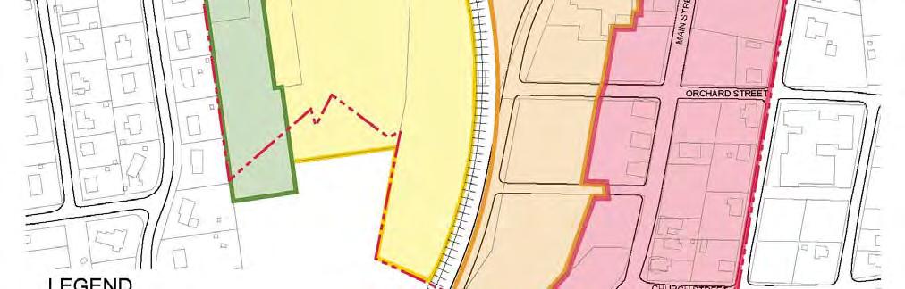

57 Nanuet Station Figure 21: Conceptual Zoning Map 47

58 5.2.1 Overall Program & TOD Design The TOD Plan zoning recommendations are modeled after a concentric zoning design centered around the Nanuet Train Station. In this design, the Train Station serves as the focal point of the TOD neighborhood, with an emphasis on improving pedestrian flow between neighborhoods and residences on both sides of the railroad tracks. Radiating from the Nanuet Train Station are a series of higher density mixed use residential buildings up to four stories in height. With respect to the character of the existing Hamlet Center (HC) downtown portion of Nanuet, ground floor commercial within these residential buildings is most prevalent in the area immediately to the east of the railroad tracks, further enhancing the neighborhood s vibrant character. Conforming to neighborhood TOD design, ground floor commercial space is additionally prioritized in those buildings adjacent to the Nanuet Train Station and railroad tracks. Further to the west of the Train Station and Hamlet Center, the denser residential buildings gradually transition into attached townhomes and apartments with limited commercial development. This portion of the TOD area is meant to serve as a buffer between the denser developments closer to the Train Station and the existing single family residential neighborhoods along Prospect Street. The concentric design additionally seeks to maintain all existing green and public spaces while providing additional green space and pedestrian oriented areas, especially within and adjacent to the Hamlet Center. Figure 22: Birds Eye View of Proposed Zoning Districts with Aerial Imagery Transit Oriented Development (TOD) Area 1 Zoning Description TOD Area 1 is located west of the rail line and directly adjacent to the residential neighborhood along Prospect Street, and runs predominately along Fisher Avenue. The TOD 1 zoning district serves as a buffer between the denser developments (TOD Areas 2 and 3) closer to the Nanuet Train Station and the existing single family residential neighborhoods to the west along Prospect Street. The area would consist of two and three story walk up residential attached townhomes or condominiums. These types of residences could appeal to attract young families, couples and 49

59 empty nesters. Although the area s existing use as LIO functions as a buffer, a rezone to accommodate townhome style development would make better use of proximity to the Train Station and Hamlet Center, while providing increased flow and connectivity to those shops and amenities to the east of the railroad tracks. TOD Area 1 would consist of attached townhomes of two and three stories, rising no higher than 35 feet. A total of 10 units per acre would be permitted. Of the three TOD Areas, TOD Area 1 is the most suburban in design, providing parking for each unit in the form of street parking and private garages. The front side of each townhome would also be set back from the street by 30 feet, which would be reserved for parking and bio swales. A setback of 35 feet would be required for property boundaries adjacent to residentially zoned district, and would be exclusively reserved for greenspace and buffering treatments. Sidewalks of 10 feet in width would align the public right of way, separated from a two way, 22 foot lane street by grass and lined with trees. TOD Area 1 would provide a minimum of 15% green space. The following figures offer visual examples of what type of design and style buildings that are planned for development in TOD Area 1. Source: Normandy Village, Nanuet, NY; Town of Clarkstown Figure 23: TOD Area 1 Building Design Example 1 50


60 Source: Coventry Park Townhomes, Morris Plains, NJ Figure 24: TOD Area 1 Building Design Example 2 The following illustration offers a conceptual rendering of TOD Area 1 development located along the northeast side of Fisher Avenue. The images perspective is looking north up Fisher Avenue with Prospect Street in the foreground. Figure 25: TOD Area 1 Conceptual Rendering Intersection of Fisher Avenue and Prospect Street (perspective is looking northbound along Fisher Avenue) 51
61 Area, Bulk and Density Requirements The following table summarizes the proposed bulk and area requirements for TOD 1. Table 9: Proposed Area, Bulk and Density Requirements for TOD Area 1 LOT SIZE (min.) Lot size Lot width 40,000 s.f. 150 ft min BUILDING HEIGHT (max.) Principal building Accessory building 35 ft (3 stories) 1 story SETBACK PRIMARY BUILDING Front yard Side yard Rear yard Frontage build out min % Buffer 30 ft min n/a n/a n/a 35 ft buffer when adjacent to a residential zoned district SETBACK ACCESSORY BUILDING Front yard Side yard Rear yard 30 ft min 10 ft min 10 ft min SETBACK PARKING Front yard Side yard Rear yard 10 ft min 0 ft min 35 ft min LOT DENSITY AND GREENSPACE Greenspace % min Maximum floor area ratio Maximum principal building(s) coverage Maximum lot coverage (including principal building(s) coverage) 25% min % 50% RESIDENTIAL DENSITY Square feet of land area per unit Units per acre Units per building Bedrooms per unit Unit size 7, max 8 max 1 2 bedrooms (maximum of 50% 2 bedroom units) 1,000 1,250 sf COMMERCIAL DENSITY Maximum size of 1 st floor commercial n/a 52

62 The following illustration is conceptual site plan and cross section using proposed area, bulk, and density regulations for TOD Area 1 and a conceptual site plan and cross section for a streetscape program along Fisher Avenue. Figure 26: TOD Area 1 Conceptual Site Plan and Cross Section for Proposed Area, Bulk, and Density Regulations and Streetscape Program 53

63 5.2.3 Transit Oriented Development (TOD) Area 2 Zoning Description TOD Area 2 is located directly west of the rail line. The proposed new zoning in this area would consist of two and three story residential apartments with one and two bedroom units. These types of residences could appeal to couples, young professionals, empty nesters and senior citizens. As an area of increasing density given its adjacency to the Nanuet Train Station, TOD Area 2 would also include limited ground level commercial space (comprised of 10% of the floor building square foot footprint and frontage facing the rail line) with a program aimed at serving commuters. The purpose of TOD Area 2 is to act as a transitional zone between the single family residency and townhomes and the true mixed use focused TOD Area 3 east of the rail line. TOD Area 2 would consist of apartment buildings of three stories and rising no higher than 35 feet or 3 stories. A total of 30 units per acre would be permitted as of right. However, developers may be eligible for a potential development bonus of 10 additional units per acre for LEED certified units and/or additional streetscape beautification efforts. The frontage of each buildings first two floors must be setback 5 feet from the lot line and the 3 rd floor must be setback 15 feet from the properties lot line. This architectural nuance promotes a more open feeling at ground level. As compared with TOD Area 1, TOD Area 2 is architecturally more aligned with Main Streets urban character and focused on promoting a walkable community of alternative housing options. Sidewalks of 10 feet in width would align the public right of way, separated from a two way, 24 foot lane street by grass and lined with trees. TOD Area 2 would also provide a minimum of 15% green space. Additionally, TOD Area 2 would be supportive of including public parks or other amenities. The following figures offer visual examples of what type of design and style buildings that are planned for development in TOD Area 2. Source: Swansea MetroLink Station Senior Apartments, Southwestern Illinois Development Authority (SWIDA) Figure 27: TOD Area 2 Building Design Example 1 54


64 Source: 86 Madison Avenue, Park Ridge, NJ, Cambridge Systematics Figure 28: TOD Area 2 Building Design Example 2 Figure 29: TOD Area 2 Conceptual Rendering of Prospect Street West of the Rail Line 55
65 Area, Bulk and Density Requirements The following table summarizes the proposed bulk and area requirements for TOD 2. Table 10: Proposed Area, Bulk and Density Requirements for TOD Area 2 LOT SIZE (min.) Lot size Lot width 10,000 s.f. 60 ft min BUILDING HEIGHT (max.) Principal building Accessory building 35 ft (3 stories, with 3 rd floor setback at least 15 ft from lot line )* 1 story SETBACK PRIMARY BUILDING Front yard Side yard Rear yard Frontage build out min % Buffer 5 ft min with 3 rd floor is setback at least 15 ft from lot line 10 ft min 30 ft min At least 50% at front setback n/a SETBACK ACCESSORY BUILDING Front yard Side yard Rear yard 5 ft min 10 ft min 10 ft min SETBACK PARKING Front yard Side yard Rear yard 10 ft min 5 ft min 5 ft min LOT DENSITY AND GREENSPACE Greenspace % min Maximum floor area ratio 20% min 1 RESIDENTIAL DENSITY Square feet of land area per unit Units per acre Units per building Bedrooms per unit Unit size 1, max (potential for up to 40 units per acre with LEED development and Nanuet beautification bonus) n/a 1 2 bedrooms (maximum of 50% 2 bedroom units) 1,000 1,250 sf COMMERCIAL DENSITY Maximum size of 1 st floor commercial 10% of the first floor footprint and commercial frontage must face the rail line 56

66 The following graphic offers a conceptual site plan and cross section using proposed area, bulk, and density regulations for TOD Area 2 and a conceptual site plan and cross section for a streetscape program along Prospect Street west of the rail line. Figure 30: TOD Area 2 Conceptual Site Plan and Cross Section for Proposed Area, Bulk, and Density Regulations and Streetscape Program 57
67 5.2.4 Transit Oriented Development (TOD) Area 3 Zoning Description TOD Area 3 is located immediately east of the rail line, with its northern boundary just north of the current Metro North parking lot. The area is currently zoned LIO and HC and is being proposed to be rezoned for mixed use development commercial uses on the first floor and residential uses above. Of the three TOD areas, TOD Area 3 is proposed to be the most urban in character and serves to act as a continuation of Main Street and provide enough population density to enable Nanuet s commercial activities to become more lively, diverse, and supportive of a 24 hour community. It should be noted that if development within the proposed TOD Area 3 is successful and additional three to four story apartment housing is needed, the Town should consider expanding the TOD Area 3 further north to Market Street, a private road south of the Shops at Nanuet, which connects to First Street to the east. Within TOD Area 3, as of right buildings will be three to four story apartment buildings, with commercial uses exclusive to the first floor. The program of commercial uses would be servicing the overall community living in the Hamlet of Nanuet as well as some commuter services. Residential units located on upper floors of buildings will cater to smaller studio and one bedroom apartments of around 750 sq. ft. to 1,000 sq. ft. in size. These types of residences would appeal to couples, young professionals, empty nesters and senior citizens who are looking to downsize but remain in their community. The proposed uses would be required to blend seamlessly into the character of the hamlet center along Main Street. There should be a focus to maintain the existing green space and integrate the Rose Garden into the design as a community focal point. TOD Area 3 would consist entirely of apartment style building of a height no greater than 45 feet. A total of 40 units per acre would be permitted. However, developers would be eligible for a potential development bonus of 10 additional units per acre for LEED certified units and/or additional streetscape beautification efforts. Buildings in TOD Area 3 will be required to maximize street frontages (a minimum of 75 percent of frontage must be used in building program) in order to encourage a continuous streetscape and Main Street like design. Additionally, emphasis should be given to building and sidewalk amenities that will attract foot traffic. The frontage of each buildings first three floors must be setback 5 feet from the lot line and the 4 th floor must be setback 15 feet from the properties lot line. This architectural nuance promotes a more open feeling at ground level. Sidewalks of 10 feet in width would align the public right of way, separated from a two way boulevard and lined with trees. The boulevard would contain a 10 foot wide, landscaped median, in order to calm passing vehicular traffic. Vehicle travel lanes would be 12 feet in width with one lane per direction. TOD Area 3 would provide a minimum of 15% green space. The following figures offer visual examples of what type of design and style buildings that are planned for development in TOD Area 3. 58


68 Source: The Foundry, Student Apartment Adjacent to Iowa State University s Ames Campus, Opus AE Group, L.L.C. Figure 31: TOD Area 3 Building Design Example 1 Source: Apartment Bldg. Roosevelt Neighborhood, North Seattle Figure 32: TOD Area 3 Building Design Example 2 59


69 Figure 33: TOD Area 3 Conceptual Rendering of Prospect Street East of Rail Line Figure 34: TOD Area 3 Conceptual Rendering of Orchard Street (Southbound Perspective) 60
70 Area, Bulk and Density Requirements The following table summarizes the proposed bulk and area requirements for TOD 3. Table 11: Proposed Area, Bulk and Density Requirements for TOD Area 3 LOT SIZE (min.) Lot size Lot width 10,000 s.f. 60 ft min BUILDING HEIGHT (max.) Principal building Accessory building 45 ft (4 stories, with 4 th floor setback at least 15 ft from lot line )* 1 story SETBACK PRIMARY BUILDING Front yard Side yard Rear yard Frontage build out min % Buffer 5 ft min with 4 th floor is setback at least 15 ft from lot line 10 ft min 30 ft min At least 75% at front setback n/a SETBACK ACCESSORY BUILDING Front yard Side yard Rear yard 5 ft min 10 ft min 10 ft min SETBACK PARKING Front yard Side yard Rear yard 10 ft min 5 ft min 5 ft min LOT DENSITY AND GREENSPACE Greenspace % min Maximum floor area ratio 15% min 1.5 RESIDENTIAL DENSITY Square feet of land area per unit Units per acre Units per building Bedrooms per unit Unit size 1, max (potential for up to 50 units per acre with LEED development and Nanuet beautification bonus) n/a Studios, 1, and 2 bedrooms (maximum of 50% 2 bedroom units) 750 1,000 sf COMMERCIAL DENSITY Maximum size of 1 st floor commercial 100% 61

71 The following graphic offers a conceptual site plan and cross section using proposed area, bulk, and density regulations for TOD Area 3 and a conceptual site plan and cross section for a streetscape program along Prospect Street east of the rail line. Figure 35: TOD Area 3 Conceptual Site Plan and Cross Section for Proposed Area, Bulk, and Density Regulations and Streetscape Program 62
 uses. This area is to remain as currently zoned; mixed use with ground floor commercial and one or two residential stories above.")
72 5.2.5 Hamlet Commercial (HC) The Hamlet Commercial (HC) area, comprising the current core of the historic downtown Nanuet, is defined as the area along Main Street (Middletown Road) and is currently zoned for Hamlet Commercial (HC) uses. This area is to remain as currently zoned; mixed use with ground floor commercial and one or two residential stories above. The only proposed modification to the existing zoning is to increase the maximum building height from 28 feet to 35 feet. The most significant improvement to the Main Street area would be landscape and streetscape improvements, as well as targeted infill development opportunities. It is proposed that a beautification bank be created for the sole purpose of collecting funds from developers of TOD Area 1, 2, and 3 and reinvested through a single vision and program of streetscape and beautification enhancements along Main Street. The following illustration offers a conceptual rendering of what potential beatification enhancements may look like along Main Street. Figure 36: Conceptual Rendering of Streetscape and Beautification Enhancements to Main Street The following illustration provides offers conceptual site plan and cross section for a streetscape program along Main Street. 63

73 Figure 37: HC Conceptual Site Plan and Cross Section for Streetscape Program Along Main Street 5.3 Infrastructure Transportation Infrastructure Several new vehicular and pedestrian connections are proposed. These connections would improve circulation and facilitate access from the transit hub to the adjacent commercial and retail development within the TOD area. 64


74 PROPOSED Figure 38: Proposed Transportation Infrastructure Improvements 65

75 As illustrated in Figure 38, a new one way southbound vehicular connection from First Street to Prospect Street would run mostly parallel to Main Street on its western side. This roadway would provide a critical link between the train station and the commercial/retail development to the north, while also alleviating existing congestion on Main Street. It should be noted, that if Nanuet Mall South is rezoned in the future to TOD Area 3 and, the property owner would need to take the one way southbound portion of new Orchard Street into consideration and should plan for a bidirectional two lane vehicular travel way. In addition, traffic signals at the intersection of Market Street and the proposed northern extension of Orchard Street and the intersection of Main Street and First Street would require signal coordination. In addition, the proposed northern extension of Orchard Street would also create exposure to new development on the Post Office parcel and activate the on street environment on parcels north of Prospect Street and east of Main Street. South of Prospect Street, improvements to Orchard Street and the creation of a street grid with new east west roadways that connect to Main Street will improve access and mobility throughout the Hamlet of Nanuet. The new roadway will be designed based on best practices for complete streets, incorporating traffic calming and green infrastructure elements to contribute to the treatment of storm water runoff from rooftops and impervious surfaces. Figure 39: Example of a Multi Use Path A new multi use path is recommended to improve north south pedestrian/cyclist mobility along the eastern edge of the rail line, but not within the railroad right of way. It would provide additional access from the mixed use development around the train station to The Shops at Nanuet and the regional shopping activities. The new multi use path will be constructed with a hard surface of adequate width for two way pedestrians and slow moving cyclists. Lush vegetation will provide a visual buffer from the rail road tracks and seating areas will be provided at regular intervals. This segment of path may be integrated into a future roadway connecting local and regional green spaces, as well as retail and commercial uses, to public transportation nodes Parking A key component of the Nanuet TOD planning process is to prepare for evolving parking needs as a factor in the area s transformative landscape. In consultations with residents of the area, public parking has been identified as being a concern that will need a careful consideration during the TOD planning process. The follow discussion presents the proposal outlined under the TOD plan: The Nanuet TOD planning process addresses existing parking in the Hamlet and additional parking infrastructure development on the proposed new roads. Modifications to current parking include: Enhanced enforcements; Improved signage; and 66
76 Establishing a parking agreement(s) with MTA Metro North. Enhanced Enforcement: From the outreach for TOD planning process, public comment stated that the 2 hour parking along Main Street is not actively enforced, which reduce the turnover of parking and creates a perceived shortage in parking availability. Also mentioned was the issue of parking availed by the establishment owners and their employees who typically need to stay for extended durations during business hours. Time limited parking and its enforcement along the business/commercial areas of the TOD are of high importance to tackle the parking availability in the area. Improved Signage: Information on parking availability in the TOD area is of importance for managing the need and availability of parking across the area. This measure is aimed at educating riders about available parking at various locations in the vicinity as well as better managing parking demand in key locations like the intersection of Prospect and Main St. Parking Agreement with MTA Metro-North: The changes in development across the TOD area will have to be matched with appropriate availability for parking. Apart from the existing parking facilities and their optimized use to meet the demand, Town of Clarkstown should consider leveraging other areas for parking to meet the demand and provide adequate parking to patrons of businesses and citizens overall in the area. This will require identification, coordination, and provision of parking across the TOD area. Among the options that may be available for consideration include: The MTA parking lot currently has paid parking spaces available, but there could be provision for arranging for a section of parking to be allotted for retail parking or parking for business owners and their employees. Providing parking vouchers to business owners and their employees to park in MTA parking lot in order to open up parking along Main Street. New Roadway Infrastructure: The following options address parking on new roadway infrastructure: On street parking on new road infrastructure; Moving the County parking lot to the train station by swapping land that includes allotment of land of a similar size 39 ; and Evaluate and establish metered parking along Main Street; Some of the actions regarding existing and proposed new parking may need careful additional consideration and thorough parking studies to estimate changes in parking demand due to the influx of development and the types of commercial facilities that may induce travel demand from the surrounding areas that may involve the need for parking for short, and long periods in the Nanuet TOD area during various times of the day. It should be noted, that over the 39 Note: the concept of relocating the County lot would first need to be coordinated with the Rockland County Department of Public Transportation and NYSDOT. 67

 uses including public spaces, parks and recreation facilities, pedestrian amenities, water infrastructure, as well as lighting and electrical infrastructure")
77 course of the TOD construction, there should be no loss in Railroad commuter parking. Once completed however, customers should actually see in an increase in parking availability in order to accommodate future growth. 5.4 Programmatic Elements Programmatic elements include those additional recommendations designed to supplement zoning and transportation improvements. These includes civic (public) uses including public spaces, parks and recreation facilities, pedestrian amenities, water infrastructure, as well as lighting and electrical infrastructure recommendations Civic Spaces, Parks and Recreation Facilities Streetscape and pedestrian space improvements are proposed for the Main Street (South Middletown Road) retail corridor and Prospect Street. The improvements include short and long term improvements to create a vibrant, attractive, and enjoyable pedestrian environment and also improve the safety, navigation, glow and overall quality of the vehicular travel experience. Investment in the shared public ROW will enhance the user experience, promote economic activity and encourage private investment in property. Physical improvements will also provide a foundation for the planned TOD district and solidify the connection of future land development to Nanuet s character. In the short term, the use of a consistent design language along Main Street will strengthen the sense of place as a local retail and dining destination, accentuating Main Street s historic character and pedestrian scale. Design elements will include street furniture (benches, recycling bins, light poles), hard scape materials (sidewalk borders, curbs), and signage (identification and directional). Public art, accent lighting and containerized vegetation may be introduced to further define, energize and enliven the pedestrian space. Design treatment of street corners and crosswalks will assure accessibility and pedestrian safety with tactile and visual cues, and suitable pedestrian drop curbs. Figure 40: Example of a Multi Use Path Main Street can be understood as a linear space made up of a series of linked experiences. Each experience along the corridor adds to the overall perception of the urban environment. Each experience also serves a navigational function such as entry, transition, arrival or connection. Three intersections have been identified for treatment focused on reinforcement of specific navigational function: 68

78 Entry/ Gateway: Church Street Intersection Arrival/ Center: Prospect Street Intersection Transition/ connection : Market Street Intersection Special attention will be paid to the design of directional signage and pedestrian amenities at each of these intersections. Design elements may include seating, paving materials, public art and vegetation to emphasize nodal quality of the intersection and its navigational function. This focused treatment will begin to create a hierarchical structure to be carried through the TOD district. Short term recommendations include: enforcing existing regulations and creating new guidance to include incentives for commercial façade improvements, review of existing regulations and guidance for signage, and a strategy to reduce vehicle crossing of sidewalks (at parking lot access and automobile oriented businesses). In the long term, a more extensive reorganization of the urban structure will be implemented. In addition to the short term aesthetic improvements, the roadway network will be redesigned, creating new vehicular connections from north of the study area to the train station. Providing new vehicular Figure 41: Pocket Park and Street Furniture travel ways will alleviate traffic on Main Street and allow for the realignment of travel lanes to better accommodate multimodal transportation. Prospect Street will become an attractive boulevard, with a significant vegetated median and activated pedestrian spaces, strengthening the east west connection for both vehicular and alternative transportation modes. A new public green space fronting on Prospect Street west of the proposed relocated County Parking Lot and the existing Veteran s Memorial Garden located just east of the track crossing will be expanded and improved to function as a central hamlet green. A new multi use path from the train station to existing retail centers north of the study area will be introduced to provide an essential connection for shoppers and employees. Sidewalks, roadways and public areas will be designed with adequate space for alternative transportation modes and pedestrian amenities to support the active urban environment envisioned in the TOD plan. These public amenities will play a significant role in the character and accessibility of the TOD neighborhood. As a Figure 42: Pedestrian Crosswalk Improvements 69


79 result, it is recommended that the TOD developers play a big role in the development of these amenities when constructing and maintaining their properties. This can be achieved effectively by enticing developers through development bonuses in exchange for going above and beyond to promote environmentally sustainable initiatives and public spaces. Main Street The design and realignment of Main Street will include complete streets elements such as bike lanes and/or shared lane markings and traffic calming techniques such as bulb outs at corners and pedestrian crossings. Regulations for signage and façade treatments will be updated to create a unified image for the historic retail corridor. Regulations for infill buildings, additions and new construction will encourage the strengthening of a consistent street wall and building height, and appropriate architectural styles and materials. Prospect Street The TOD Plan envisions a lively, vibrant and active pedestrian scale character with uses supporting the needs of local residents and a new mix of residential and commercial development. The reconstructed Prospect Street will take on a boulevard like character with ample green space and high quality hard scape materials. A wide vegetated median and regularly spaced canopy trees along the curb line will create a strong visual connection between Main Street and the Nanuet Train Station. Planning of the shared ROW will prioritize the pedestrian experience with a dual focus on safety and enjoyment. Building setback regulations for new development along Prospect Street in TOD Areas 1 and 2 promote consistent retail frontages. The dimensional and use requirements for new construction assure sufficient pedestrian space within the public ROW with zones allocated for utilities, signage, street furniture and quasi public uses such as café seating. Source: Marquette, Michigan, Credit: Brad Neumann Figure 43: Urban Design Showcasing Consistent Street Frontages 70

80 5.4.2 Pedestrian Space Design The design of the public spaces and building facades within the TOD will adhere to comprehensive Pedestrian and Public Recreation Space Design Guidelines. This document will be created to provide guidance to architects and landscape architects for the design of both private and publically funded projects. It will establish a cohesive design vision for the design of the hamlet s urban environment and a flexible system of design tools, materials, treatments and dimensions guidance to assure consistency while allowing for the creativity and expression necessary in creating a unique sense of place. Figure 44: Example of Streetscape Beautification Public Buildings, Schools, Police, Fire Stations, Municipal Buildings Long term redevelopment of TOD Area 2 would include the potential relocation of the County municipal parking lot from its current location to just west of the railroad tracks on the north side of Prospect Street. However, this conceptual relocation would require coordination with the County Department of Public Transportation and the New York State Department of Transportation (DOT), and final approval by Rockland County. Long term redevelopment within TOD Area 3 could include the relocation of some or all of the functions at the U.S. Post Office sorting facility to a proximate location. Any repurposing of this parcel, could incorporate some Post Office services, while the more space intensive uses associated with sorting and distribution could be relocated along Route 59. It should be noted, that since a goal of TOD is to provide sustainable development with densities and land uses that complement the use of transit systems and residents not relying on automobiles for everyday activities (including the use of existing transit infrastructure); an analysis and consideration of impacts to transit infrastructure (including but not limited to Nanuet Station facilities and grade crossings) will need to be performed for each development application. Additionally, mitigation measures, such as but not limited to improvement to the pedestrian grade crossing, striping, signage, wayfinding, etc., may be required to accommodate the additional use and/or traffic associated with new development within TOD Area 1, 2, and 3, and should be considered accordingly Water, Stormwater, and Wastewater Infrastructure Preliminary evaluation of current potable water and wastewater infrastructure has indicated sufficient available capacity to accommodate short and long term recommendations. Any proposed redevelopment project within the TOD Zone would require a site specific environmental review as part of the Town of Clarkstown Site Plan Approval process during which project generated utility demand would be evaluated. Similarly, all development would be required to incorporate suitable stormwater management practices into their Site Plan. Development within the lowlying areas of TOD Areas 2 and 3, which are known to be prone to flooding during high intensity short duration storms (i.e., the former Fire Station) would be required to incorporate sufficient stormwater management practices or otherwise mitigate the impacts of developing in a flood zone. 71
Stakeholders Advisory Working Groups (SAWGs) Smart Growth and TOD Land Use (#11) SAWG Meeting
 Smart Growth and TOD Land Use (#11) SAWG Meeting") Presentation - Part II Tappan Zee Bridge/I-287 Corridor Project July 21, 2010 Slide 1. David Kooris (Regional Plan Association) welcomed members of the Land Use Stakeholders Advisory Working Groups (SAWGs)
Presentation - Part II Tappan Zee Bridge/I-287 Corridor Project July 21, 2010 Slide 1. David Kooris (Regional Plan Association) welcomed members of the Land Use Stakeholders Advisory Working Groups (SAWGs)
PLAN ELEMENTS WORKSHOP. April 5, 2016
 PLAN ELEMENTS WORKSHOP April 5, 2016 needs more housing. But there is no one-size fits-all solution. Every neighborhood has its own character. In some places, density is not only appropriate it is badly
CHAPTER 7: Transportation, Mobility and Circulation
 AGLE AREA COMMUNITY Plan CHAPTER 7 CHAPTER 7: Transportation, Mobility and Circulation Transportation, Mobility and Circulation The purpose of the Transportation, Mobility and Circulation Chapter is to
Policies and Code Intent Sections Related to Town Center
 Policies and Code Intent Sections Related to Town Center The Town Center Vision is scattered throughout the Comprehensive Plan, development code and the 1994 Town Center Plan. What follows are sections
12/9/2013. HOLLYWOOD/PINES CORRIDOR PROJECT AMPO 2013 Annual Conference October 24, Our Perspective. Broward.
 HOLLYWOOD/PINES CORRIDOR PROJECT AMPO 2013 Annual Conference October 24, 2013 Our Perspective Broward Fort Lauderdale 1 Broward Metropolitan Planning Organization Fort Lauderdale Fort Lauderdale Skyline
EXISTING COMPREHENSIVE PLAN
 EXISTING COMPREHENSIVE PLAN Town Center Land Use Element: V. LAND USE POLICIES Town Center Mercer Island's business district vision as described in "Your Mercer Island Citizen-Designed Downtown" was an
Chapter 1: Introduction
 Chapter 1: Introduction The Penn Avenue Community Works Corridor Vision and Implementation Framework presents an integrated communitybased vision and a coordinated, long-term implementation framework for
Executive Summary. NY 7 / NY 2 Corridor
 Executive Summary NY 7 / NY 2 Corridor Transportation and Land Use Study December 2005 Prepared for: Town of Colonie Capital District Transportation Committee Prepared by: Introduction: Land use decisions
Gold Line Bus Rapid Transit Transit Oriented Development (BRTOD) Helmo Station Area Plan
 Helmo Station Area Plan") Appendix F Gold Line Bus Rapid Transit Transit Oriented Development (BRTOD) Helmo Station Area Plan Introduction and Purpose of the Plan The Gold Line Bus Rapid Transit facility is an eleven-mile dedicated
Appendix F Gold Line Bus Rapid Transit Transit Oriented Development (BRTOD) Helmo Station Area Plan Introduction and Purpose of the Plan The Gold Line Bus Rapid Transit facility is an eleven-mile dedicated
Transportation. Strategies for Action
 Transportation A major priority for the Overlake Neighborhood is to develop a multimodal transportation system. To achieve this system, a balance has to be found among travel, circulation and access needs;
Making Transit Oriented Development Work For Boonton, NJ
 Making Transit Oriented Development Work For Boonton, NJ Bloustein School of Planning and Public Policy Studio Dan Burton Loannie Dao Webster Slater Brandon Williams Ian Watson Maria Laham Nicola Mammes
Metro. Activity Center Design Guidelines. Recommendations For Developing Focused, Mixed-Use Commercial/Residential Centers
 Metro Activity Center Design Guidelines Recommendations For Developing Focused, Mixed-Use Commercial/Residential Centers Metro Activity Centers What is a MAC? Legacy, the adopted guide for the future growth
Route 1 Corridor Study
 Route 1 Corridor Study Westbrook, Connecticut A Vision for the Connecticut Shoreline Public Informational Meeting July 28, 2015 Lower Connecticut River Valley Council of Governments Fitzgerald & Halliday,
Chapter 4. Linking Land Use with Transportation. Chapter 4
 Chapter 4 Linking Land Use with Transportation Chapter 4 59 Chapter 4 Linking Land Use with Transportation Community Design and Transportation Program Introduction Since the 1950s, the predominant development
greenprint midtown SUSTAINABILITY ACTION PLAN 2012
 greenprint midtown SUSTAINABILITY ACTION PLAN 2012 MIDTOWN ALLIANCE SOUTHFACE ENERGY INSTITUTE RENAISSANCE PLANNING GROUP SUSTAINABLE ATLANTA PERKINS+WILL 2 GREENPRINT MIDTOWN 1. Introduction Sustainability
CHAPTER 3 VISION, GOALS, & PLANNING PRINCIPLES. City of Greensburg Comprehensive Plan. Introduction. Vision Statement. Growth Management Goals.
 CHAPTER 3 VISION, GOALS, & PLANNING PRINCIPLES Introduction The Greensburg Comprehensive Plan is intended as a working community document. A combination of long and short-term goals, this document is intended
4.1.3 LAND USE CATEGORIES
 4.1.3 LAND USE CATEGORIES a. City Center District The City Center District incorporates the existing character and mix of uses in downtown Belmont to encourage redevelopment and new development in keeping
Subregion 4 Central Avenue-Metro Blue Line Corridor Transit-Oriented Development (TOD) Implementation Project. Community Meeting April 27, 2011
 Implementation Project. Community Meeting April 27, 2011") Subregion 4 Central Avenue-Metro Blue Line Corridor Transit-Oriented Development (TOD) Implementation Project Community Meeting April 27, 2011 Overview Introduction to Subregion 4 TOD Implementation Program
Subregion 4 Central Avenue-Metro Blue Line Corridor Transit-Oriented Development (TOD) Implementation Project Community Meeting April 27, 2011 Overview Introduction to Subregion 4 TOD Implementation Program
The transportation system in a community is an
 7 TRANSPORTATION The transportation system in a community is an important factor contributing to the quality of life of the residents. Without a sound transportation system to bring both goods and patrons
EXHIBIT A. Tax Increment Reinvestment Zone No. 1 (Town Center) First Amended Project Plan 1
 First Amended Project Plan 1") EXHIBIT A Tax Increment Reinvestment Zone No. 1 (Town Center) First Amended Project Plan 1 1 As amended by Resolution No. 2008-02-001(TR1R) of the Tax Increment Reinvestment Zone No.1, and approved to
EXHIBIT A Tax Increment Reinvestment Zone No. 1 (Town Center) First Amended Project Plan 1 1 As amended by Resolution No. 2008-02-001(TR1R) of the Tax Increment Reinvestment Zone No.1, and approved to
Port Credit Local Advisory Panel October 20 th Meeting
 Port Credit Local Advisory Panel October 20 th Meeting Focus Of This Evening s Meeting: 1. Hurontario Main Street Higher Order Transit Study 2. Port Credit Mobility Hub & GO Station Parking Structure Study
Town Center (part of the Comprehensive Plan)
") Town Center (part of the Comprehensive Plan) Mercer Island Town Center Looking North (2014) In 1994, a year-long process culminated in a set of design guidelines and code requirements for the Town Center
Town Center (part of the Comprehensive Plan) Mercer Island Town Center Looking North (2014) In 1994, a year-long process culminated in a set of design guidelines and code requirements for the Town Center
Table of Contents. Elm Avenue Improvement Plan City of Waco, Texas. Introduction 1. Existing Context 1 Figure 1 2.
 Table of Contents Introduction 1 Existing Context 1 Figure 1 2 Plan Guidelines 3 Future Urban Form 4 The West-End 4 Main Street 6 The East-End 7 Figure 2 9 Public Improvement Recommendations 7 General
Welcome. Comprehensive Plan & Transportation Plan Open House November 7, 2012
 Welcome Comprehensive Plan & Transportation Plan Open House November 7, 2012 Agenda Proposed future land use plan Comprehensive Plan strategies Traffic forecasts Future traffic operations Possible future
City of Farmington. Downtown Plan. Amendment to the 1998 Master Plan Adopted October 11, 2004
 City of Farmington Amendment to the 1998 Master Plan Adopted October 11, 2004 Introduction Planning Background 1 Scope and Components of the Plan Amendment 2 Concept Introduction 3 Plan Concepts 3 Conceptual
Chapter 1.0 Introduction
 Chapter 1.0 Introduction 1.1 Background The North Metro commuter rail line is part of the RTD FasTracks regional transit system expansion program to build more than 100 miles of rail transit throughout
The University District envisions, in its neighborhood
 Envisioning the University District Link Light Rail in Seattle s neighborhoods CIY OF SEALE CONCEP-LEVEL SAION AREA PLANNING RECOMMENDAION RESOLUION # 30165 EXHIBI L Vision 08.2000 he University District
[PLANNING RATIONALE] For Site Plan Control and Lifting of Holding Zone By-Law 101 Champagne Avenue. May 23, 2014
![[PLANNING RATIONALE] For Site Plan Control and Lifting of Holding Zone By-Law 101 Champagne Avenue. May 23, 2014](/thumbs/75/71599615.jpg "[PLANNING RATIONALE] For Site Plan Control and Lifting of Holding Zone By-Law 101 Champagne Avenue. May 23, 2014") [PLANNING RATIONALE] For Site Plan Control and Lifting of Holding Zone By-Law 101 Champagne Avenue May 23, 2014 Contents 1.0 Introduction... 2 2.0 Site Context... 2 2.1 Adjacent Uses... 2 Figure 1: Site
[PLANNING RATIONALE] For Site Plan Control and Lifting of Holding Zone By-Law 101 Champagne Avenue May 23, 2014 Contents 1.0 Introduction... 2 2.0 Site Context... 2 2.1 Adjacent Uses... 2 Figure 1: Site
Bourne Downtown Site Planning
 Prepared for: The Town of Bourne, MA In Cooperation with: Bourne Financial Development Corporation Prepared by:, Inc. June 24, 2009 Table of Contents Introduction and Summary... 1 Site Existing Conditions...
C. Westerly Creek Village & The Montview Corridor
 C. Westerly Creek Village & The VISION Community Vision When the goals of the city are achieved Westerly Creek Village, a distinctive community defined by Montview Boulevard and Westerly Creek, is a strong
WELCOME and introduction
 1 WELCOME and introduction Mobility Hub Locations within Burlington STUDY OVERVIEW STUDY OBJECTIVES The City of Burlington is developing four Area Specific Plans, one for each of Burlington s Mobility
Small Area Plan. South Gateway
 Small Area Plan Adopted May 12, 2008 South Gateway Purpose. The South Gateway Small Area Plan defines the City s expectations for the future of the southern entrance to the City at Interstate 85 and Highway
Concord Community Reuse Project Goals and Guiding Principles. Overarching Goals (OG)
") Concord Community Reuse Project Goals and Guiding Principles Overarching Goals (OG) No priority is implied by the order of presentation of the goals and guiding principles. Overarching goals for the Concord
Concord Community Reuse Project Goals and Guiding Principles Overarching Goals (OG) No priority is implied by the order of presentation of the goals and guiding principles. Overarching goals for the Concord
A P P E N D I X B - O P P O R T U N I T Y S I T E S
 A P P E N D I X B - O P P O R T U N I T Y S I T E S OPPORTUNITY SITES As listed in the Land Use Element, the City has identified 15 Opportunity Sites expected to be the focus of change and revitalization
Subarea 4 Indian Creek. Vision The combination of park networks and transportation amenities make Subarea 4 the greenest hub in the Corridor.
 indian creek 180 extends south from 101st Street to I-435. The I-435 and Metcalf intersection is one of the primary intersections in the Kansas City Metro Area. The area includes several residential neighborhoods
North Fair Oaks Community Plan Summary and Information
 North Fair Oaks Community Plan Summary and Information WHAT IS THE NORTH FAIR OAKS COMMUNITY PLAN? The North Fair Oaks Community Plan is part of the San Mateo County General Plan, and establishes policies
Status Update (2006 vs. Now) Citizen s Advisory Committee February Plan for Prosperity
 Citizen s Advisory Committee February Plan for Prosperity") Status Update (2006 vs. Now) Citizen s Advisory Committee February 2018 Plan for Prosperity 2000 2017 2000 2017 Gardnerville Population 6,000 5,760 5746 5,500 5,000 5,067 5,550 5,165 5,394 5,412 5,250
Status Update (2006 vs. Now) Citizen s Advisory Committee February 2018 Plan for Prosperity 2000 2017 2000 2017 Gardnerville Population 6,000 5,760 5746 5,500 5,000 5,067 5,550 5,165 5,394 5,412 5,250
Public Open House #1
 Public Open House #1 TONIGHT S AGENDA Welcome Project Overview The Big Picture The Station Area The Analysis Thoughts about Future Change Breakout Group Discussions Summation / Next Steps Project Overview
Wasatch CHOICE for 2040
 Wasatch CHOICE for 2040 Economic Opportunities We Can Choose a Better Future We enjoy an unparalleled quality of life along the Wasatch Front. People from all over the world are drawn to our stunning scenery,
Land Use Amendment in Southwood (Ward 11) at and Elbow Drive SW, LOC
 at and Elbow Drive SW, LOC") 2018 November 15 Page 1 of 10 EXECUTIVE SUMMARY This land use amendment application was submitted by Rick Balbi Architect on 2017 August 31 on behalf of Sable Developments Ltd, and with authorization from
2018 November 15 Page 1 of 10 EXECUTIVE SUMMARY This land use amendment application was submitted by Rick Balbi Architect on 2017 August 31 on behalf of Sable Developments Ltd, and with authorization from
A. WHAT IS A GENERAL PLAN?
 I. Introduction A. WHAT IS A GENERAL PLAN? A general plan is the planning guideline for the future of a city. It contains goals and policies which regulate urban development, the protection of the natural
Create Policy Options Draft Plan Plan Approval. Public Consultation Events. Phase 2
 Background Grandview-Woodland Community Plan In the spring of 2012, the City of Vancouver embarked on a comprehensive community planning program in the Grandview-Woodland neighbourhood. The process has
Transit-Oriented Development
 Transit-Oriented Development Path to Sustainability West Windsor February 22, 2007 George S. Hawkins Context for Presentation NJ Future is a non-partisan, 501(c)3 non-profit organization. Offer perspective,
Corridor Vision. 1Pursue Minnehaha-Hiawatha Community Works Project. Mission of Hennepin County Community Works Program
 1Pursue Minnehaha-Hiawatha Community Works Project Minnehaha-Hiawatha Community Works is a project within the Hennepin Community Works (HCW) program. The mission of the HCW program is to enhance how the
Planning Districts INTRODUCTION
 INTRODUCTION To facilitate detailed examination of development prospects for all areas of the community, Delano has been divided into 14 planning districts. The location of these planning districts is
Today Land & People. Northeast Nampa Gateway District. Employment. Land Use Characteristics. Demographics. Current Zoning
 Today Land & People Employment Major employers include Saint Alphonsus, the College of Western Idaho, the Auto Mall, Sorrento Lactalis and Walmart. 3,004 jobs in 2010 (COMPASS-CIM 2040 TAZ data) 4,345
Welcome to the Oakridge Centre Open House
 Welcome to the Oakridge Centre Open House Why is the City hosting this event? This open house is to inform you of a rezoning application submitted to the City of Vancouver to amend the existing CD-1 (Comprehensive
13 THORNHILL YONGE STREET STUDY IMPLEMENTATION CITY OF VAUGHAN OPA 669 AND TOWN OF MARKHAM OPA 154
 13 THORNHILL YONGE STREET STUDY IMPLEMENTATION CITY OF VAUGHAN OPA 669 AND TOWN OF MARKHAM OPA 154 The Planning and Economic Development Committee recommends the adoption of the recommendations contained
ELMVALE ACRES SHOPPING CENTRE MASTER PLAN
 ELMVALE ACRES SHOPPING CENTRE MASTER PLAN Contents 1.0 INTRODUCTION... 2 2.0 LOCATION... 2 3.0 EXISTING CONTEXT... 2 4.0 VISION & GUIDING PRINCIPLES... 2 5.0 LAND USE AND BUILT FORM... 4 5.1 St. Laurent
John M. Fleming Managing Director, Planning and City Planner. Old East Village Dundas Street Corridor Secondary Plan Draft Terms of Reference
 Report to Planning and Environment Committee To: From: Subject: Chair and Members Planning & Environment Committee John M. Fleming Managing Director, Planning and City Planner Old East Village Dundas Street
This Review Is Divided Into Two Phases:
 Semiahmoo Town Centre Review The purpose of this review: To review the Semiahmoo Town Centre Concept Plan, originally approved in 1993, to ensure that this centre will continue to serve the needs of South
Sahuarita District & Phase 1 Master Plan. Town Council December 11, 2017
 Sahuarita District & Phase 1 Master Plan Town Council December 11, 2017 Visioning Study Visioning Process Advisory Group Meetings Community Questionnaire Town Center Case Studies Community Analysis The
Windsor Locks Transit-Oriented Development Planning Grant Request. Project Background
 Windsor Locks Transit-Oriented Development Planning Grant Request Project Background Downtown Windsor Locks runs along Main Street in the vicinity of the intersection of Routes 159 and 140. The current
DRAFT Land Use Chapter
 Stevens Creek Urban Village DRAFT 1 18 17 Land Use Chapter INTRODUCTION This Land Use Chapter describes how the Stevens Creek Urban Village will accommodate the growth that is planned for it in the Envision
Hockessin Community Redevelopment Plan
 Hockessin Community Redevelopment Plan 3.1 Introduction The Community Redevelopment Plan for the Village of Hockessin is the result of the people s vision for a distinct village center that serves as the
THE CIVIC DISTRICT DEVELOPMENT OPPORTUNITIES
 1 THE CIVIC DISTRICT DEVELOPMENT OPPORTUNITIES The Civic District is the physical and emotional heart of the downtown. It is also a major gateway into the central core, establishing the image and identity
SECTION ONE: INTRODUCTION. introduction
 introduction 1 INTRODUCTION Since it was first established in 1843 as a trading post for the Hudson s Bay Company, Victoria has evolved into a Provincial capital city that is recognized across Canada and
FRUITVALE TRANSIT VILLAGE (Phase 2) Residential Project
 Residential Project") FRUITVALE TRANSIT VILLAGE (Phase 2) Residential Project DEVELOPER: SIGNATURE PROPERTIES ARCHITECT: HKIT ARCHITECTS April 23, 2010 TABLE OF CONTENTS 3 Vision 4 Description of Site 5 Guiding Concepts 6
FRUITVALE TRANSIT VILLAGE (Phase 2) Residential Project DEVELOPER: SIGNATURE PROPERTIES ARCHITECT: HKIT ARCHITECTS April 23, 2010 TABLE OF CONTENTS 3 Vision 4 Description of Site 5 Guiding Concepts 6
Issues, Challenges & Opportunities
 Below is a summary of issues, challenges, and opportunities relating to the revitalization of Downtown Romeoville and potential development of the Village s East Side TOD Area. Current Issues & Challenges
REVIEW AND EVALUATION OF REGIONAL LAND USE
 REVIEW AND EVALUATION OF REGIONAL LAND USE AND TRANSPORTATION SCENARIOS #220831 Environmental Justice Task Force October 7, 2014 VISION 2050 Process Development of Guiding Vision for Land Use and Transportation
Sewanee Village + Request for Builder/Developer Proposals
 Sewanee Village + Request for Builder/Developer Proposals Contact: Frank X. Gladu Special Assistant to the Vice Chancellor University of the South 735 University Ave Version 3 Sewanee TN 37383 Released:
7Page 1 CLEMMONS COMMUNITY COMPASS 1 PLAN OVERVIEW
 1 Plan Overview WHAT IS I THE CLEMMONS COMMUNITY COMPASS? The Clemmons Community Compass is our community s comprehensive plan. It serves as our blueprint and provides direction for the future of the Village
Former Rockcliffe Airbase Community Design Plan Guiding Design Vision and Principles December 4, 2013
 APPENDIX 5 - Guiding Design Vision and Principles Former Rockcliffe Airbase Community Design Plan Guiding Design Vision and Principles December 4, 2013 Vision Statement The redevelopment of the former
Complete Neighbourhood Guidelines Review Tool
 Complete Neighbourhood Guidelines Review Tool Prepared By: City of Regina Planning Department October 2014 Page 1 of 14 Community Development Review Checklist for Secondary Plans and Concept Plans The
BROOKLYN PARK / 85TH AVE LRT STATION CDI DEVELOPMENT GUIDELINES DRAFT
 August 2018 Page intentionally left blank The Brooklyn Park Library adjacent to the 85th Ave LRT Station Area. OVERVIEW The Blue Line LRT Extension / Bottineau corridor offers a unique opportunity to leverage
Secrest Short Cut and Monroe Expressway Small Area Plan AUGUST 29, 2018
 Secrest Short Cut and Monroe Expressway Small Area Plan AUGUST 29, 2018 Background and Process Monroe Expressway will be open by the end of 2018 Union County and Indian Trail identified a need to revisit
REGIONAL ACTIVITY CENTER
 DRAFT REGIONAL ACTIVITY CENTER 70 EAST BENCH MASTER PLAN DRAFT 06 Introduction The East Bench Regional Activity center is comprised of large educational, research, medical, and employment centers. These
1.0 Introduction. Purpose and Basis for Updating the TMP. Introduction 1
 1.0 Introduction The Town of Castle Rock is situated between the metropolitan areas of Denver and Colorado Springs, amidst a unique terrain of rolling hills, mesas, ravines, and waterways. Like many Front
Northwest Rail Corridor and US 36 BRT Development Oriented Transit Analysis 4.4 STATION AREA FINDINGS
 4.4 STATION AREA FINDINGS Each station is different, and each one requires a separate set of recommendations based on the vision for the site. This section outlines an initial TOD strategy and recommendations
Midtown Greenway Land Use and Development Plan Executive Summary
 Midtown Greenway Land Use and Development Plan Executive Summary Introduction The Midtown Greenway Land Use and Development Plan sets policy direction for land use and development in the Midtown Greenway
Be it enacted by the Town Board of the Town of Guilderland that the following new A (Transit Oriented Development (TOD) District) is adopted:
 District) is adopted:") Local Law No. 4 of 2018 (Adoption of 280-18A (Transit Oriented Development District) Be it enacted by the Town Board of the Town of Guilderland that the following new 280-18A (Transit Oriented Development
Local Law No. 4 of 2018 (Adoption of 280-18A (Transit Oriented Development District) Be it enacted by the Town Board of the Town of Guilderland that the following new 280-18A (Transit Oriented Development
Ivywild On The Creek PRELIMINARY CREEK DISTRICT MASTER PLAN
 Ivywild On The Creek PRELIMINARY CREEK DISTRICT MASTER PLAN Introduction: Rejuvenating an extraordinary Creekside neighborhood THE CREEKSIDE DISTRICT The Ivywild On The Creek Neighborhood District Master
1 Introduction. 4 Environmental Integrity. 7 Community Facilities
 2037: A CALL TO ACTION 2017 COMPREHENSIVE PLAN EXECUTIVE SUMMARY is the purpose of the Q: What Comprehensive Plan? The comprehensive plan serves as a guide for the community s physical, social, and economic
Economy Vision Statements: Social Wellbeing Vision Statements: Natural Environment Vision Statements:
 Economy Vision Statements: 1. Our business environment makes us a region of choice for new employers as we encourage entrepreneurship and have a vibrant, diversified and resilient regional economy. 2.
The Five Components of the McLoughlin Area Plan
 The Five Components of the McLoughlin Area Plan This documents contains the complete language of the five components of the McLoughlin Area Plan: The Vision Statement The Values The Guiding Principles
DALY CITY VISIONING PROCESS COMMUNITY WORKSHOP 3 MAY 8, 2008
 DALY CITY VISIONING PROCESS COMMUNITY WORKSHOP 3 MAY 8, 2008 PROCESS General Plan - a statement of the community s values, vision and aspirations for now and into the future... Timeframe LONG TERM - 2030
Downtown Streetscape Manual & Built Form Standards
 City of Guelph Downtown Streetscape Manual & Built Form Standards July 2014 Prepared by Brook McIlroy Inc. in association with Unterman McPhail Associates and McCormick Rankin Inc. City of Guelph Downtown
FUTURE LAND USE ELEMENT
 FUTURE LAND USE ELEMENT GOAL I: To create and sustain a great place to live, play, and prosper Objective 1: The City of Ocala shall incorporate the principles and strategies of the Ocala 2035 Vision into
DRAFT ROOSEVELT ROAD. District Recommendations. Figure 5.23 The Roosevelt Road Corridor
 CHAPTER 5 Figure 5.23 The Road Corridor Road will develop as a mixed-use corridor, emphasizing regional retail, west of the river and mixed-use development east of the river. KEY RECOMMENDATIONS 1. High
5 TOWN OF MARKHAM OFFICIAL PLAN AMENDMENT NO. 144 MILLIKEN MAIN STREET SECONDARY PLAN
 5 TOWN OF MARKHAM OFFICIAL PLAN AMENDMENT NO. 144 MILLIKEN MAIN STREET SECONDARY PLAN The Planning and Economic Development Committee recommends the following: 1. The communication from Brendan O Callaghan,
CITY OF CHARLOTTESVILLE, VIRGINIA CITY COUNCIL AGENDA
 CITY OF CHARLOTTESVILLE, VIRGINIA CITY COUNCIL AGENDA Agenda Date: December 16, 2013 Action Required: Adoption of Resolution Presenter: Staff Contacts: Title: James E. Tolbert, AICP, Director of NDS James
CHARLES PUTMAN CHARLES PUTMAN AND ASSOCIATES, INC
 MEMORANDUM CHARLES PUTMAN & ASSOCIATES, INC. LAND DEVELOPMENT CONSULTANTS PLANNING ZONING PERMITTING 4722 NW Boca Raton Boulevard, Suite C-106 Boca Raton, Florida 33431 Phone: 561/994-6411 FAX: 561/994-0447
hermitage town center
 hermitage town center A Community Vision prepared by Strada for The City of Hermitage and The Mercer County Regional Planning Commission January 2007 table of contents introduction 3 design principles
ROBBINSDALE LRT STATION CDI DEVELOPMENT GUIDELINES
 August 2018 OVERVIEW The City of Robbinsdale has a prime-opportunity site in the middle of the 13 mile stretch of the Bottineau LRT corridor / Blue Line extension. Robbinsdale offers a prominent, vital,
SPRINGHILL LAKE TRANSIT VILLAGE
 Greenbelt Metro Area Sector Plan - Subarea Design Policies and Guidelines - Springhill Lake Transit Village 113 SPRINGHILL LAKE TRANSIT VILLAGE Residential Neighborhood and Village Center CONCEPT Springhill
REQUEST FOR QUALIFICATIONS
 REQUEST FOR QUALIFICATIONS VILLAGE OF HAMBURG COMPREHENSIVE ZONING/LAND USE REGULATIONS UPDATE Prepared By: Village of Hamburg 100 Main Street Hamburg, New York 14075 Village of Hamburg RFQ Page 1 of 10
1 October Dear Citizens of Charlotte and Mecklenburg County,
 1 October 2011 Dear Citizens of Charlotte and Mecklenburg County, As co-chairs of the Center City 2020 Vision Plan Steering Committee, we are proud to present the Center City 2020 Vision Plan, which sets
Plano Tomorrow Vision and Policies
 Plano Tomorrow Vision and Policies PLANO TOMORROW PILLARS The Built Environment The Social Environment The Natural Environment The Economic Environment Land Use and Urban Design Transportation Housing
Silverdale Regional Center
 Silverdale Regional Center Vision for Silverdale Regional Center The Silverdale Regional Center Plan (Plan) will guide the evolution of the Silverdale Regional Center from a collection of strip malls and
ARLINGTON COUNTY, VIRGINIA
 ARLINGTON COUNTY, VIRGINIA County Board Agenda Item Meeting October 15, 2005 DATE: September 28, 2005 SUBJECT: Request to Advertise the adoption of the 2005 Clarendon Sector Plan C. M. RECOMMENDATION:
DRAFT. October Wheaton. Design Guidelines
 October 2011 DRAFT Wheaton Design Guidelines 2 Draft - Design Guidelines - Wheaton Sector Plan Contents 04 Section 1: Introduction 06 Section 2: Context 08 Section 3: Design Guidelines 09 Goal 1: Create
TRANSPORTATION AND LAND USE
 CHAPTER 10 TRANSPORTATION AND LAND USE Transportation and land use are intimately linked. The expansion of a highway typically spurs housing, employment growth and land development in the communities that
A BLUEPRINT FOR BROCKTON A CITY-WIDE COMPREHENSIVE PLAN
 A BLUEPRINT FOR BROCKTON A CITY-WIDE COMPREHENSIVE PLAN Public Meeting October 2016 1 Plan Summary and Discussion Public Meeting May 4 2017 City of Brockton Bill Carpenter, Mayor Department of Planning
Additional information about land use types is given in Chapter 5. Design guidelines for Centers and Neighborhoods are given in Chapter 7.
 4. Place Types Introduction In Albemarle County s Development Areas, the Neighborhood is the fundamental unit of community planning. The County s Neighborhood Model, an adopted part of the Comprehensive
Atlanta BeltLine Subarea 3 Master Plan Update
 Atlanta BeltLine Subarea 3 Master Plan Update April 14, 2018 Workshop Meeting 1 22 miles, connecting 45 neighborhoods 22 MILES of transit 46 MILES of streetscapes and complete streets 33 MILES of urban
Urban Design Manual PLANNING AROUND RAPID TRANSIT STATIONS (PARTS) Introduction. Station Study Areas
 Introduction. Station Study Areas") 111111 PLANNING AROUND RAPID TRANSIT STATIONS (PARTS) Introduction The ION rapid transit system will link Waterloo, Kitchener and Cambridge through a central transit corridor (CTC). There are a number
111111 PLANNING AROUND RAPID TRANSIT STATIONS (PARTS) Introduction The ION rapid transit system will link Waterloo, Kitchener and Cambridge through a central transit corridor (CTC). There are a number
V. Vision and Guiding Principles
 V. Vision and Guiding Principles The Master Plan for the Powers Ferry Corridor seeks a foundation in the desires of the community. At times, various elements of the community offered opposing viewpoints,
6. Consistency with Local Plans
 6. Consistency with Local Plans 6.1. Chapter Overview 6.1.1. Introduction This section presents the goals, objectives and policies of municipal, county and state planning entities, as well as known development/redevelopment
TRANSIT SUPPORTIVE DEVELOPMENT ANALYSIS
 7 TRANSIT SUPPORTIVE DEVELOPMENT ANALYSIS One of the key comments heard over and over through the public involvement process was that the region needs a more robust transit system to provide a viable alternative
East Central Area Plan
 East Central Area Plan Steering Committee Meeting March 8 th, 2018 CHUN Tears McFarlane House Vision Statement Development Opportunities Analysis Vision Elements 1. Equitable, Affordable and Inclusive