ISSUES AND OPPORTUNITIES OUTREACH REPORT
|
|
|
- Cameron Chapman
- 5 years ago
- Views:
Transcription


1 ISSUES AND OPPORTUNITIES OUTREACH REPORT

2 PREPARED FOR: The Town of Brookhaven, New York Department of Planning, Environment and Land Management Town Supervisor Brian X. Foley Planning Commissioner David W. Woods, AICP Steering Committee Members: Connie Kepert, Chair Steve Fiore-Rosenfeld Kathy Walsh Lori Baldassare David Woods Brenda Prusinowski Jeff Kassner Bill Schilling Doug Dittko Terry Karl Raymond Donnelly Valerie Biscardi Brian Oakley Tawaun Whitty Robert DeZafra Erma Gluck Robert Mille Tom Talbot George Schramm Bob DeBona PREPARED BY: Urbitran Associates December 17th, Issues and Opportunities Report


3 Table of Contents 1.0 INTRODUCTION Intergovernmental Interviews Brookhaven Town Fair Issues and Opportunities Workshops RESULTS Community Character Results Community Development Results Transportation Results Infrastructure Results CONCLUSION 10 Issues and Opportunities Report 3
4 1.0 INTRODUCTION
")


5 1.0 Introduction OVERVIEW AND PURPOSE In order to assess the community s interests and concerns and to help prioritize issues to be addressed in Brookhaven 2030, the Phase I Comprehensive Planning process began with an Issues and Opportunities outreach component, executed in three different modes: Intergovernmental Interviews with Brookhaven Town Officials and Employees (August-September 2007) Brookhaven Town Fair (September 8th and 9th 2007) Issues and Opportunities Workshops (October 25th and November 13th, 2007) 1.1 INTERGOVERNMENTAL INTERVIEWS Brookhaven 2030 Team Members conducted interviews with elected officials and key Town, Village, and County staff, and Chairs of Boards and Commissions to gain insight and understanding on particular issues and opportunities that should be addressed when planning for the Town s future. BROOKHAVEN TOWN FAIR The Town Fair marked the beginning of the public outreach process. People passing by the Brookhaven 2030 booth in the Town of Brookhaven tent, first asked to place a blue dot on the Location Identification Map, to indicate where they live (Image 1). This helped the Brookhaven 2030 Team understand if the results of the following step were indicative of the many different Brookhaven communities. Next, participants were faced with 16 ballot boxes representing the range of issues that must be addressed in the Comprehensive Plan, and given Brookopoly Bucks ($500, $200 and $100) to vote with, thereby identifying and prioritizing these issues (Images 2-3). The ballot issues were grouped into Character Themes (Natural Resources; Open Space and Recreational Resources; Historic, Cultural and Sacred Places and Resources; and Coastal Resources), Development Themes (Main Street Development; Transit Oriented Development; Residential Development; and Commercial and Industrial Development), Transportation Themes (Transit; Vehicular Road Networks; Bicycle and Pedestrian Networks; Maritime Networks) and Infrastructure Themes (Community Facilities and Services; Educational Facilities and Services; Piped Utilities; Wired and Wireless Facilities and Services). Placing Brookopoly Bucks in a ballot box did not mean that participants were necessarily for or against any specific issue, but indicated the need for its careful consideration in Brookhaven ISSUES AND OPPORTUNITIES WORKSHOPS Finally, two interactive workshops were held, bringing together members of the Steering Committee, the Citizens Assembly, and the public at large. The purpose of these meetings was to introduce the public to the scope, goals, methodology, and schedule of the project; to assess the community s interests and concerns; and to help prioritize issues. Attendees participated in two activities. First, in The Best and Least of Brookhaven participants each placed a blue dot on the Location Identification Map indicating where they live, and three green dots on the Best of Brookhaven Map and three red dots on the Least of Brookhaven Map (see images 4-8), to indicate positive or negative areas or aspects of the Town. Comment cards were used to further describe their three best s and least s, and placed in a ballot box. Next, attendees participated in the Brookopoly exercise, once again using Brookopoly Bucks to vote for broad topics to address in the Plan Image 1: Citizens at the Town Fair place blue dots on the Location Identifi cation Map to indicate where they live and to show the distribution and range of participants. Image 2: Participants prioritize issues to be addressed in Comprehensive Plan Image 3: Participants in Brookopoly were faced with sixteen ballot boxes representing issues the must be addressed in the development of Comprehensive Plan Issues and Opportunities Report


6 INTRODUCTION Later in the workshop, the Location Identification, Best of and Least of maps were brought to the front of the room and a Brookhaven 2030 team member pointed out the distribution of the population in attendance and gathered feedback on the major concentrations of red and green dots. The Brookopoly ballot boxes were tabulated and the results were presented and discussed. Figure 3-1: Brookopoly Bucks Results The composite results from the Town Fair and both Issues and Opportunities Workshops show that Coastal Resources and Main Street Development are the top two issues according to Town stakeholders. Images 4-8: Workshop participants place Brookopoly Bucks in ballot boxes, indicate the Best and Least of Brookhaven by placing green and red dots on maps and discuss the results with a Brookhaven 2030 Team Member. Issues and Opportunities Report 3
7 2.0 RESULTS


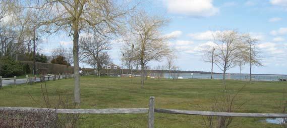
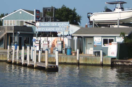
8 2.0 Results ISSUES AND OPPORTUNITIES The interviews, votes, comment cards, and discussions generated through the Issues and Opportunities outreach events produced valuable information on cherished resources, conflicting issues, places and matters of pride and concern, and goals for the future. The results, compiled from the input of over five hundred Brookhaven stakeholders, including the Brookhaven 2030 Steering Committee, residents, merchants, town employees and officials from a wide range of communities, are presented below. 2.1 COMMUNITY CHARACTER RESULTS: Protection of Coastal, Inland and Ground Water Resources Participants in the Issues and Opportunities outreach process decisively indicated the need to preserve and protect their water resources. This includes coastal resources such as the Long Island Sound and the Great South Bay; shoreline beaches such as Cedar Beach, Shoreham Beach, Fire Island National Seashore and West Meadow Beach; inland water resources as the Peconic River, Forge River, Flax Pond, Lake Ronkonkoma, Carman s River and scattered wetlands; and ground water resources and recharge zones. Comments suggested that all of these resources face pressures compromising their ecological health and conflicting with the community s cultural values. Stakeholders often requested that the tranquil, natural character of the shoreline be protected from development that threatens to harden the shoreline. More specifically, Fire Island National Seashore was frequently highlighted as an important resource to shelter from development impacts. Comments indicate that the Island s ecological needs, dynamic processes and the historic and cultural significance must all be complimentarily addressed. Participants pointed out that all of these water resources face degraded quality due to various factors such as polluted stormwater runoff; absence of a coordinated stormwater plan; existing and pending developments over groundwater recharge zones; and the poor drainage, lack of sewers and high water table in the low-lying, high density residential areas of Shirley and Mastic. Other human actions, such as bulkheads, a proposed liquid natural gas facility and development on bluffs hindering beach replenishment, were cited as other issues compromising the viability of coastal resources. With over 20 watersheds in the region, some stakeholders point out the opportunity for using watershed plans to coordinate infrastructure planning and improvements. Stakeholders also indicated their enjoyment in utilizing water resources for an array of active and passive recreational opportunities, such as kayaking, boating, fishing and surfing; however many noted the need for improved access to these resources. Comments indicated that marinas are succumbing to residential development, although marina redevelopment may provide economic development opportunities. Protection of Natural Resources Numerous participants recognized the importance of protecting, maintaining and restoring the Town s natural resources, citing satisfaction with the air quality, concern over water quality, climate change and habitat fragmentation, and the need to protect scattered woodlands and the Pine Barrens. Map 1: The Location Identifi cation Map shows the distribution of the 500+ Issues and Opportunities participants. Images 10-11: Brookhaven stakeholders value their coastal resources from a cultural, recreational and ecological perspective. 6 Issues and Opportunities Report

9 RESULTS Conflicts between local wildlife and residents are increasing as deer, birds and other wild animals lose their natural habitat to development and travel through residential zones to find food or reach other patches of land. Acquiring key areas including the Pine Barrens and the ecologically diverse and sensitive Overton Preserve, are seen as key action towards the protection of all natural resources. Some stakeholders also believe a carrying capacity analysis is necessary to protect ecological and public health, safety and welfare as the Town continues to grow. Climate change is a significant issue for Brookhaven stakeholders. This great threat is anticipated to result in additional precipitation, thereby producing more polluted stormwater runoff and adverse affects on water quality. Furthermore, the increasing quantity and intensity of storms associated with climate change poses a great danger to both the inland and coastal communities of Brookhaven. Climate change may also compromise the natural processes and ability of some local plant species and wildlife to survive in the region. There is some concern over how development is changing the natural geography of the land and thereby affecting the natural, dynamic processes of nature and the community s character. For instance, development on bluffs is affecting beach replenishment. Additionally, a few participants indicated that light pollution, from excessive or unshielded outdoor lighting, also affects natural processes and community character, and should be addressed through Dark Sky initiatives. Preservation of Open Space Results showed that another top priority for Issues and Opportunities stakeholders is the need to preserve open space for the protection of the Town s character; historic, cultural and natural resources; and recreational opportunities. However, participants questioned: How can we pay for preservation as development pressures ensue? Comments indicated satisfaction over permanently preserved open space that exists scattered throughout the Town of Brookhaven such as The Wertheim Wildlife Preserve, Bald Hill, portions of the Pine Barrens, various ball-fields, golf courses, playgrounds, horse riding facilities, and parks such as Southaven, Smithtown, and Davis Park. However, stakeholders are concerned about the large amount of unpreserved, undeveloped land that still exists, including: The 1000 acres Keyspan-Soreham property; Overton Preserve; AVR Realty Property in Ridge; and 500 acres of agricultural land near Exit 69 in Manorville. Participants indicated that more parks are needed, especially in Manorville and Port Jefferson Station, and the need for greater access to open space and recreational opportunities, especially through a pedestrian and bicycle friendly trail system. Feedback indicated the importance of developing a network of open space accessible to any resident through a short walk or bicycle ride. Such a network would also help address other issues including habitat fragmentation and the need to protect local wild life such as deer, birds and other wild animals. Maintaining a Sense of Place With fifty-two hamlets and eight villages, participants acknowledged that Brookhaven is a diverse region, from its geography to its population, and their comments indicated that no one adjective can accurately describe the Town s character or sense of place. Many Images 12: Natural resources and open space should be preserved and protected. Image 13: Downtown Port Jefferson serves as an example of the type of Main Street participants would like to see encouraged and developed throughout Brookhaven hamlets. Issues and Opportunities Report 7


,")
10 RESULTS residents pointed out the small town feel, others cited the rural character, and still others penned the beauty and tranquility of the coast as composing their community s unique sense of place. A commonly cited issue was that overdevelopment or poorly planned developments are compromising the individual character, history and culture of rural and coastal communities throughout the Town. Comments further describing this threat include the conversion of former agricultural lands to subdivided, oversized McMansion homes, degradation of coastal and inland water resources, the loss of farm stands, sprawling development patterns and the lining of rural and historic transportation corridors with strip malls. 2.2 COMMUNITY DEVELOPMENT RESULTS: Supporting Main Street Development Brookhaven stakeholders tend to agree that Patchogue, Port Jefferson, and Stony Brook serve as model downtowns (Image 13), providing pedestrian-friendly, mixed-use districts for community members to gather and socialize. While comment cards indicated that every hamlet throughout Brookhaven should have a Main Street, it was suggested that communities such as Center Moriches, Manorville, Gordon Heights and North Bellport would provide prime opportunities. Comments indicated that the Town should use incentives to support this type of development which would incorporate a mix of uses, such as shopping, restaurants, retail, and affordable housing, with a higher density, vertical component as compared to traditional residential and commercial development. They also suggest utilizing existing planning studies such as the Rocky Point Vision Plan, the Gordon Heights Vision Plan and the Middle Country Road Vision Plan, for guidance. Promoting Transit Oriented Development Comments emphasized the importance of creating transit-oriented developments surrounding Brookhaven s Long Island Railroad stations, including those in Port Jefferson Station, Patchogue, Ronkonkoma, Bellport, Medford, Mastic and Yaphank. This vibrant, pedestrian-friendly mixed-use type of development would offer easy access to local amenities and the greater region, while minimizing automobile dependency, resulting in a more convenient, efficient, economical and environmental friendly commute and life-style. Residential Development: Diversity, Form, and Location Many stakeholders indicated dissatisfaction at the prevalence of sprawling, unplanned residential development. Comments criticized these developments for building homes that are homogenized, oversized McMansions compromising the community s sense of place, yet not fulfilling the housing variety needed for the residents diverse lifestyles, such as senior, affordable, multi-family and rental housing. Feedback suggested that while housing should be provided for all, housing types should not be segregated. Seniors, families, singles, market rate and affordable housing units should be mixed in order to create strong communities where citizens can grow and learn from each other. These diverse residential needs must be balanced with other, conflicting issues. For instance, some participants complain that rental housing often means absentee landlords who don t properly maintain their properties. A key residential development issue was the provision of affordable housing. Participants questioned the definition of affordable, pointing out that many seniors and workforce households fall Images 14-16: Stakeholders are concerned about the character of new residential and commercial development. 8 Issues and Opportunities Report


11 RESULTS below the required income. Fearing a brain drain, stakeholders pointed out the risk of losing the young college-educated population because they can t afford to stay in the Town. Some participants expressed their concern over the County plan to provide affordable housing near the Yaphank Correctional Facility, while others suggested Rocky Point, Yaphank and Manorville might be prime areas for the consideration of residential development. Stakeholders indicated some preference towards preserving community character from both an ecological and cultural standpoint through infill opportunities and brownfield redevelopment in communities such as Patchogue, Holbrook, Bellport and Ronkonkoma. Others suggested employing higher density, compact development to preserve open space. Residential developments should maintain or promote sensitivity to groundwater recharge zones, as discussed previously in the Protection of Coastal, Inland Water and Ground Water Resources section, and address public health and water quality issues in existing residential areas that lack sewers. Furthermore, there is concern over how natural processes such as rising sea level will affect low-lying coastal communities. Character and Location of Commercial and Industrial Development As apparent from the Least of Brookhaven board (Maps 2-3), a large number of Issues and Opportunities participants noted their distaste for the strip malls and big box stores found along a number of transportation corridors, especially along Montauk Highway (CR 80) and the southern portion of William Floyd Parkway (CR 46) in Shirley and Mastic; along Middle Country Road (Route 25) through Centereach, Selden, Coram, Gordon Heights and Middle Island; and along Nesconset Highway (Route 347). Participants pointed out that these commercial corridors are dangerous due to the high volume of traffic and do not properly reflect the desired community character. Stakeholders would prefer to see more mixed-use, pedestrian-friendly developments and the revitalization of existing downtowns. Corridor studies, integrating transportation and land use planning to evaluate issues, determine goals, and set forth guidelines to reinforce the desired community character along many of these roads have been conducted or are underway and should be utilized in the Brookhaven 2030 planning process. Some participants indicated that the Town of Brookhaven must also determine the appropriate siting for industrial uses. Waste management concerns stakeholders residing in Manorville and Yaphank, as there are many compost facilities in these communities. Other Town residents felt large sand mines, including one in Middle Island, need to be addressed. Conflicting opinions towards industrial development are also apparent, as some stakeholders feel the Long Island Expressway and Long Island Rail Road corridors should maintain and promote industrial uses, yet others feel these spaces should be green corridors linking a network of open space. ***** Whether a residential, commercial, industrial or mixeduse development, participants agreed that developers need to create stronger site plans, which preserves open space, and displays sensitivity to the community s character and eco-system by building without clear cutting the site. Many stakeholders stressed the importance of developing sustainable communities which balance economic development, social needs and environmental protection, utilizing green building practices and alternative energy sources, as opposed to the wrong Images 17-18: Participants indicated the need for better bicycle and walking trails, as well as protection of marinas and harbors. type of development. Comments cards and discussions also indicated conflicting opinions over the Tall Grass development proposal, which involves the conversion of the 320-acre sod farm and golf course into residential units, commercial property and ball fields. 2.3 TRANSPORTATION RESULTS: Safe and Flexible Vehicular Networks While many residents value the Town s prime location which provides access to the best of both worlds New York City and the East End of the Island, a large number of participants indicated traffic and congestion as problematic. Coordination between State, County and Local roads is necessary but regarded as a hindrance to planning and implementation, as the lack of cooperation often slows down the process. There is some concern over safety issues in residential zones, including speeding and commercial traffic on neighborhood streets. Participants believe design restrictions result in a lack of flexibility and safety issues. Suggestions also indicated the need for a formal access management policy and plan. New subdivisions are viewed as disconnected from the greater community, as there tends to be only one vehicular access point and the presence of cul-de-sacs in new and old subdivisions also causes community disconnect. Some residents would like to see the construction of tap streets to connect subdivisions, and await construction of paper streets that were planned but never built. Transportation planning should consider historic and cultural issues, as well as community-based plans and visioning studies. Participants value the existing tree-lined streets and would like to see them preserved and used as a model for future corridor development. William Floyd Parkway also has historic significance, and stakeholders see the opportunity for this corridor to undergo enhancement and re-development as a gateway to Fire Island National Seashore. Provision of a Bicycle and Pedestrian System Numerous participants expressed strong interest in a bicycle and pedestrian network, believing it is Issues and Opportunities Report 9


 is too long.")
12 RESULTS progressive and healthy form of transportation. They feel all communities should be able to access open space in minutes through a pedestrian/bicycle trail, but currently there are few connections. These advocates suggest producing an inventory and assessment of current infrastructure, including open space along highways, to implement a multi-modal trail system. Many comments indicated that Brookhaven is not bicycle and pedestrian friendly, but dangerous in many places, even in interior neighborhoods. Stakeholders complained about the lack of sidewalks throughout the Town, but others argue that providing sidewalks would compromise the rural character of many Town roads. Suggestions indicated that the Safe Routes to School Program can serve as a funding source for implementing sidewalks and traffic calming. These stakeholders noted that the community needs better crosswalks, signs and markings, designated trails and sidewalks. Expansion of the Transit Network Participants are appreciative of their close proximity to New York City but feel the travel time through the Long Island Rail Road (LIRR) is too long. They also feel bus and rail service is insufficient in its capacity and extent. Comments indicate the need for complete electrification of the rail system, larger platforms, crossisland transit and more frequent trips. Stakeholders on the North Shore would like to see the LIRR extended beyond Port Jefferson. Protect Maritime Networks Stakeholders like traveling to Connecticut and other parts of the Island by ferry. There was concern that marinas are succumbing to residential development and should be preserved and protected, possibly through a marina overlay district. Others suggested that ferries, marinas and harbors should be carefully regarded for economic development possibilities in Brookhaven communities. 2.3 INFRASTRUCTURE RESULTS: Expanding Community Facilities and Services As development continues and population increases, participants noted that more community resources are needed to address rising crime, expand library facilities, provide more community centers and to ensure that the volunteer fire departments are adequately funded and staffed. Participants also indicated that the Town is lacking a Recreation Plan to coordinate recreational needs and responsibilities of the public and groups that use them, and that public spaces need better maintenance and upkeep Feelings are mixed over the responsiveness of Town government. Many comments indicated that the Town ignores the community s needs while some participants did express satisfaction at the community outreach process. Comments also criticized a slow permitting process, poor code enforcement and zoning, conflict between council districts and a lack of progress on planning issues despite the abundance of studies and high taxes. Educational facilities There were few comments on educational facilities. Generally, participants agreed that institutions of higher education, such as SUNY Stony Brook are beneficial to the community, and expressed satisfaction with the local schools, despite the indication of some friction and a lack of diversity between school districts. Piped Facilities As discussed throughout this summary, a principal Images 19-22: With population anticipated to increased by 90,000 over the next 30 years, Brookhaven will need to improve and expand existing infrastructure including, piped, wired and educational facilities. issue for many participants is the lack of sewers in the low-lying, high-density residential areas. These residences sit above soils with poor drainage and a high water table, consequently compromising the health and viability of the local eco-system, groundwater and residents. Centralized sewage plants are needed for new and existing developments instead of numerous cesspools that are implemented in a piecemeal fashion. Furthermore, sewage treatment plants should utilize environmentally appropriate systems. In the absence of a sewer system, some participants suggest sewage undergo tertiary treatment. Wired and Wireless Facilities There were few comments on this topic, however, participants suggested new utilities should be built underground, and expressed interest in having more wireless service, especially in Town Hall. 10 Issues and Opportunities Report
13 3.0 CONCLUSIONS


14 3.0 Conclusions With over five hundred stakeholders representing communities from all over the Town of Brookhaven participating, the Issues and Opportunities outreach process provided a useful means of determining the community s top interests and concerns. While the Brookhaven 2030 team recognizes that this data collection was a casual means of analysis and is not an exhaustive look at all the issues that must be regarded in the development of the Plan, it has helped us to prioritize issues to be addressed. Below are six broad goals, extracted from this summary, that reflect the most important issues to participating stakeholders: Protect Coastal, Inland Water, Ground Water and Natural Resources Preserve Open Space and Community Character Promote Main Street and Transit Oriented Development Supply Diverse Housing Opportunities Provide a Multi-Modal, Safe and Flexible Transportation Network Expand Community Facilities and Services The means of achieving these goals has not yet been determined, and as discussed throughout this summary, many conflicting values and issues need to be addressed. Stakeholder support and participation throughout the Brookhaven 2030 process will continue to serve as an invaluable tool for working out a shared vision and approach for Brookhaven s future. Best of Brookhaven Least of Brookhaven Maps 2-3: Stakeholders indicated the Best and Least places and aspects of Brookhaven using green and red dots. 12 Issues and Opportunities Report
CHAPTER 7: Transportation, Mobility and Circulation
 AGLE AREA COMMUNITY Plan CHAPTER 7 CHAPTER 7: Transportation, Mobility and Circulation Transportation, Mobility and Circulation The purpose of the Transportation, Mobility and Circulation Chapter is to
Town of Peru Comprehensive Plan Executive Summary
 Town of Peru Comprehensive Plan Executive Communities that plan grow by choice, not by chance. A plan makes growth thoughtful, understandable, and predictable. A plan shows that a community is managing
PUBLIC ENGAGEMENT & SIX THEMES OF THE PLAN
 Connecting the heart of Eagle to the soul of the river - Kathy Chandler-Henry, Commissioner Eagle County CHAPTER 1 PUBLIC ENGAGEMENT & SIX THEMES OF THE PLAN town of eagle - river corridor plan 1 PUBLIC
Improve Neighborhood Design and Reduce Non Point Source Water Pollution
 HOW TO Planning Guide Improve Neighborhood Design and Reduce Non Point Source Water Pollution This document was funded by a grant from the New Hampshire Coastal Program with funding from the National Oceanic
S A C R A M E N T O C O U N T Y JACKSON HIGHWAY & GRANT LINE EAST VISIONING STUDY
 JACKSON HIGHWAY & GRANT LINE EAST S A C R A M E N T O C O U N T Y P L A N N I N G D E P A R T M E N T SUMMARY AND WORKBOOK November 19, 2008 History of the Visioning Study Sacramento County has two growth
CHAPTER 3 VISION, GOALS, & PLANNING PRINCIPLES. City of Greensburg Comprehensive Plan. Introduction. Vision Statement. Growth Management Goals.
 CHAPTER 3 VISION, GOALS, & PLANNING PRINCIPLES Introduction The Greensburg Comprehensive Plan is intended as a working community document. A combination of long and short-term goals, this document is intended
OVERVIEW OF PLANS FOR THE JEFFERSON COUNTY COUNTRYSIDE FARM In the Context of Quality Place Characteristics
 OVERVIEW OF PLANS FOR THE JEFFERSON COUNTY COUNTRYSIDE FARM In the Context of Quality Place Characteristics By Steve Grabow, Professor and Community Development Educator University of Wisconsin-Extension,
Master Plan for Preservation and Scenic Conservation (1995)
") 3.2 Master Plan for Preservation and Scenic Conservation (1995) The Master Plan for Preservation and Scenic Conservation was developed under the direction of the Guilford Preservation Alliance in the 1980s
3.2 Master Plan for Preservation and Scenic Conservation (1995) The Master Plan for Preservation and Scenic Conservation was developed under the direction of the Guilford Preservation Alliance in the 1980s
Route 1 Corridor Study
 Route 1 Corridor Study Westbrook, Connecticut A Vision for the Connecticut Shoreline Public Informational Meeting July 28, 2015 Lower Connecticut River Valley Council of Governments Fitzgerald & Halliday,
SAN RAFAEL GENERAL PLAN 2040 INTRODUCTION AND OVERVIEW
 SAN RAFAEL GENERAL PLAN 2040 INTRODUCTION AND OVERVIEW Steering Committee Presentation February 14, 2018 Purpose of General Plan Guide land use and development decisions Coordinate transportation, infrastructure,
PSRC REVIEW REPORT & CERTIFICATION RECOMMENDATION
 PSRC REVIEW REPORT & CERTIFICATION RECOMMENDATION KITSAP COUNTY COUNTYWIDE PLANNING POLICIES July 2, 2012 BACKGROUND A major emphasis of the Washington State Growth Management Act (GMA) is the need to
Port Lavaca Future Land Use
 Port Lavaca Future Land Use Introduction The City of Port Lavaca is beginning to see sustained growth, after many years of relative stable population. New single family homes, apartments, and businesses
North Fair Oaks Community Plan Summary and Information
 North Fair Oaks Community Plan Summary and Information WHAT IS THE NORTH FAIR OAKS COMMUNITY PLAN? The North Fair Oaks Community Plan is part of the San Mateo County General Plan, and establishes policies
Gloucester County s Comprehensive Plan. The Community Connection
 Gloucester County s Comprehensive Plan The Community Connection Current Comp Plan Adopted in 1991 with a 20 year planning horizon Updated in 1995 with Part V- Implementation Recommendations and Appendix
WATERFORD Plan of Preservation, Conservation and Development Supplement Part 1 - Policy Element
 WATERFORD 2012 Plan of Preservation, Conservation and Development 2015 Supplement Part 1 - Policy Element Effective June 11, 2015 2015 Plan Update GOAL To respond to the evolving land use needs and continually
CHAPTER 8 ISSUES, CONCERNS, CONSTRAINTS AND OPPORTUNITIES
 CHAPTER 8 ISSUES, CONCERNS, CONSTRAINTS AND OPPORTUNITIES Introduction This River Conservation Plan was developed during a time of tremendous activity and effort in planning the transformation of the Delaware
Benzie County Master Plan: Priority Issues & Opportunities
 Benzie County Master Plan: Priority Issues & Opportunities From March 2015 through January 2016, Networks Northwest staff worked with the Benzie County Master Plan Committee to obtain input from the public
Town Center (part of the Comprehensive Plan)
") Town Center (part of the Comprehensive Plan) Mercer Island Town Center Looking North (2014) In 1994, a year-long process culminated in a set of design guidelines and code requirements for the Town Center
Town Center (part of the Comprehensive Plan) Mercer Island Town Center Looking North (2014) In 1994, a year-long process culminated in a set of design guidelines and code requirements for the Town Center
4- PA - LD - LIVELY DOWNTOWN. LD - Background
 4- PA - LD - LIVELY DOWNTOWN LD - Background The downtown has been the service centre for the community since the city s inception and the area continues to supply people with their personal services,
7Page 1 CLEMMONS COMMUNITY COMPASS 1 PLAN OVERVIEW
 1 Plan Overview WHAT IS I THE CLEMMONS COMMUNITY COMPASS? The Clemmons Community Compass is our community s comprehensive plan. It serves as our blueprint and provides direction for the future of the Village
COMMUNITY DESIGN. GOAL: Create livable and attractive communities. Intent
 COMMUNITY DESIGN Intent An attractive, well-designed County will attract quality development, instill civic pride, improve the visual character of the community, and create a strong, positive image for
Denton. A. Downtown Task Force
 2 Public Involvement Early and ongoing public involvement was solicited so that the public had ample opportunity to help direct the DTIP s concepts and implementation strategies. The residents of Denton
This page intentionally blank.
 This page intentionally blank. Parks, Recreation, and Open Space Chapter Relationship to Vision Vision Parks, Recreation and Open Space Chapter Concepts County Government. County government that is accountable
TREASURE COAST REGIONAL PLANNING COUNCIL M E M O R A N D U M. To: Council Members AGENDA ITEM 5H
 TREASURE COAST REGIONAL PLANNING COUNCIL M E M O R A N D U M To: Council Members AGENDA ITEM 5H From: Date: Subject: Staff October 17, 2008 Council Meeting Local Government Comprehensive Plan Review Draft
Chapter 10 IMPLEMENTATION RECOMMENDATIONS
 Chapter 10 IMPLEMENTATION RECOMMENDATIONS The recommended land use plan presented in the previous chapter provides a design for the attainment of the urban and rural development and open space preservation
495/MetroWest Development Compact Plan Citizen Planner Training Collaborative Conference. March 17, 2012
 495/MetroWest Development Compact Plan Citizen Planner Training Collaborative Conference March 17, 2012 Project Process Local and Regional Priority Areas Growth Scenarios Transportation Investment Categories
Chapter 2: Vision, Goals and Strategies
 Chapter 2: Vision, Goals and Lake Elmo Today & Tomorrow Comprehensive Plan 2040 2 VISION, GOALS & STRATEGIES - DRAFT 4-6-2018 INTRODUCTION Comprehensive Plan Purpose Perhapse the most important objective
PLAN ELEMENTS WORKSHOP. April 5, 2016
 PLAN ELEMENTS WORKSHOP April 5, 2016 needs more housing. But there is no one-size fits-all solution. Every neighborhood has its own character. In some places, density is not only appropriate it is badly
4-Town Comprehensive Plan DRAFT 7/30/07
 4-Town Comprehensive Plan DRAFT 7/30/07 Acknowledgements ning Committee Town of Harrisburg Norman Roof Randy Nicol Town of Martinsburg Terry Thisse Paul Kelly Town of Montague Jan Bagdanowicz Wendy Perry
Concord Community Reuse Project Goals and Guiding Principles. Overarching Goals (OG)
") Concord Community Reuse Project Goals and Guiding Principles Overarching Goals (OG) No priority is implied by the order of presentation of the goals and guiding principles. Overarching goals for the Concord
Concord Community Reuse Project Goals and Guiding Principles Overarching Goals (OG) No priority is implied by the order of presentation of the goals and guiding principles. Overarching goals for the Concord
DALY CITY VISIONING PROCESS COMMUNITY WORKSHOP 3 MAY 8, 2008
 DALY CITY VISIONING PROCESS COMMUNITY WORKSHOP 3 MAY 8, 2008 PROCESS General Plan - a statement of the community s values, vision and aspirations for now and into the future... Timeframe LONG TERM - 2030
Windsor, Connecticut Plan of Conservation & Development DRAFT PLAN SUMMARY
 Windsor, Connecticut 2015 Plan of Conservation & Development DRAFT PLAN SUMMARY Plan Overview What is a Plan? Visionary Advisory Implementable Maintainable What it is not! Regulatory Binding Static Passive
4.1.3 LAND USE CATEGORIES
 4.1.3 LAND USE CATEGORIES a. City Center District The City Center District incorporates the existing character and mix of uses in downtown Belmont to encourage redevelopment and new development in keeping
Laberge Group. Town of Coeymans. Draft Comprehensive Plan. Overview of Planning Process
 Draft : Presentation of Goals & Strategies Laberge Group Benjamin H. Syden, A.I.C.P., E.D.P Director in Charge Nicole Allen, A.I.C.P. Senior Planner Anjali Malhotra Planner Presentation Outline Introductions
South Central Connecticut Region Plan of Conservation & Development 2018 Update. Municipal Planners
 South Central Connecticut Region Plan of Conservation & Development 2018 Update Municipal Planners July 28th, 2017 1 Introductions 2 Purpose of Today s Meeting Supplement data analysis with qualitative
A. Selma Park, Davis Bay and Wilson Creek
 A. Selma Park, Davis Bay and Wilson Creek This waterfront neighbourhood consists of three separate community areas, linked by Highway 101, but with different character, land use patterns and future potential.
TRANSPORTATION AND LAND USE
 CHAPTER 10 TRANSPORTATION AND LAND USE Transportation and land use are intimately linked. The expansion of a highway typically spurs housing, employment growth and land development in the communities that
CHAPTER 4 FUTURE LAND USE AND URBAN SERVICES DISTRICTS
 CHAPTER 4 FUTURE LAND USE AND URBAN SERVICES DISTRICTS Introduction This chapter discusses how Benzie County should grow and change in the future. A community can grow and change in many different ways.
TOWN COUNCIL / PLANNING COMMISSION
 Workshop #3 TOWN COUNCIL / PLANNING COMMISSION January 20, 2011 Consultant Team In Attendance Tonight BMS Design Group Nevada City and San Francisco Michael Smiley, AICP, ASLA Partner-in-Charge Nancy L.
What s in a Name Sustainability, Smart Growth, New Urbanism
 What s in a Name Sustainability, Smart Growth, New Urbanism Published in the Summer 2011 Issue of APA s The Commissioner Pete Pointner FAICP Planning commissioners frequently hear abstract terms bantered
Shoreline Master Program Town of La Conner, Washington
 Shoreline Master Program Town of La Conner, Washington Department of Ecology approval effective Adopted September 24, 2013 by Town of La Conner Ordinance No.1106 Amended May 13, 2014 by Town of La Conner
Land Use & Transportation Primer
 Land Use & Transportation Primer Presented By Smitha Vijayan Center for Urban Transportation Studies University of Wisconsin-Milwaukee Role of Local Government Land use decision-making power mostly given
Urban Planning and Land Use
 Urban Planning and Land Use 701 North 7 th Street, Room 423 Phone: (913) 573-5750 Kansas City, Kansas 66101 Fax: (913) 573-5796 Email: planninginfo@wycokck.org www.wycokck.org/planning To: From: City Planning
A BLUEPRINT FOR BROCKTON A CITY-WIDE COMPREHENSIVE PLAN
 A BLUEPRINT FOR BROCKTON A CITY-WIDE COMPREHENSIVE PLAN Public Meeting October 2016 1 Plan Summary and Discussion Public Meeting May 4 2017 City of Brockton Bill Carpenter, Mayor Department of Planning
The Five Components of the McLoughlin Area Plan
 The Five Components of the McLoughlin Area Plan This documents contains the complete language of the five components of the McLoughlin Area Plan: The Vision Statement The Values The Guiding Principles
Envision Front Royal Workshop 1 of 2
 Envision Front Royal Workshop 1 of 2 September 12, 2013 Summary The Envision Front Royal project held the first of two public workshops on September 12, 2013. The purpose of the workshop was to evaluate
Silverdale Regional Center
 Silverdale Regional Center Vision for Silverdale Regional Center The Silverdale Regional Center Plan (Plan) will guide the evolution of the Silverdale Regional Center from a collection of strip malls and
Dwelling Units Max 12 dwelling units per acre/min 8 dwelling units per acre. Development Mix 80% non residential/20% residential
 13. OSTEEN LOCAL PLAN Background: The Osteen Local Plan area is located in southwest Volusia County along the SR 415 corridor between Lemon Bluff Road and Acorn Lake Road and includes 3,990 acres. The
12/9/2013. HOLLYWOOD/PINES CORRIDOR PROJECT AMPO 2013 Annual Conference October 24, Our Perspective. Broward.
 HOLLYWOOD/PINES CORRIDOR PROJECT AMPO 2013 Annual Conference October 24, 2013 Our Perspective Broward Fort Lauderdale 1 Broward Metropolitan Planning Organization Fort Lauderdale Fort Lauderdale Skyline
10.0 Open Space and Public Realm
 10.0 Open Space and Public Realm 10.0 Open Space and Public Realm The Public Open Space System is comprised of: outdoor spaces available for public use that are either publicly owned (e.g., parks and
Sheridan Boulevard S TAT I O N A R E A P L A N S H E R I D A N B O U L E VA R D S TAT I O N A R E A P L A N
 Sheridan Boulevard S TAT I O N A R E A P L A N 1 City of Lakewood Adopted November, 2006 S H E R I D A N B O U L E VA R D S TAT I O N A R E A P L A N The Vision The City of Lakewood s overall vision is
Clair-Maltby Community visioning
 Clair-Maltby Community visioning workshop #1 Summary April 27th, 2017 Table of Contents INTRODUCTIon 1 PURPOSE 1 CONSULTATION STRUCTURE 2 PARTICIPANT FEEDBACK 3 VISIONING EXERCISE 8 ONLINE SURVEY RESULTS
DRAFT Amsterdam/Churchill Community Plan (4/17/08) Adopted By the Gallatin County Commission
 Adopted By the Gallatin County Commission") DRAFT Amsterdam/Churchill Community Plan (4/17/08) Adopted By the Gallatin County Commission Table of Contents Acknowledgements Chapter 1: Introduction A Brief History What s Next Authority Organization
DRAFT Amsterdam/Churchill Community Plan (4/17/08) Adopted By the Gallatin County Commission Table of Contents Acknowledgements Chapter 1: Introduction A Brief History What s Next Authority Organization
COMMUNITY SUSTAINABILITY AND ENVIRONMENTAL MASTER PLAN IMPLEMENTATION UPDATE
 Attachment 1 COMMUNITY SUSTAINABILITY AND ENVIRONMENTAL MASTER PLAN IMPLEMENTATION UPDATE Priorities and Key Initiatives Committee May 2013 Page E-1 How we grow Goal 2: To ensure sustainable development
Anatomy of A Vibrant Downtown. Anatomy of a Vibrant Downtown
 Anatomy of A Vibrant Downtown The goal of MAIN ST. REVITALIZATION PLANNING is to provide a framework that will help transform your downtown into a VIBRANT DOWNTOWN a place where people love to LIVE, WORK,
{Best Practices. Summary of Tools, Strategies and Best Practices from 11 Michigan Case Study Communities
 Case Studies Michigan Coastal Community Working Waterfronts { Summary of Tools, Strategies and from 11 Michigan Case Study Communities Table of Contents Zoning...2 Community and Stakeholder Collaboration
EXISTING COMPREHENSIVE PLAN
 EXISTING COMPREHENSIVE PLAN Town Center Land Use Element: V. LAND USE POLICIES Town Center Mercer Island's business district vision as described in "Your Mercer Island Citizen-Designed Downtown" was an
Subject: Hendry County Evaluation and Appraisal Report Letter of Understanding - Identification of Major Issues
 HENDRY COUNTY PLANNING & ZONING DEPARTMENT POST OFFICE BOX 2340 165 S. LEE STREET LABELLE, FLORIDA 33975 (863) 675-5240 FAX: (863) 675-5317 SUNCOM 744-4750 November 16, 2007 Mr. Mike McDaniel, Chief Office
PREVIOUS PUBLIC PARTICIPATION BRIEF October 2014
 Comprehensive Planning During the development of the county comprehensive plan, Cultivating Community: A Plan for Union County s Future from 2007 through 2009, and three concurrent multi municipal plans
hermitage town center
 hermitage town center A Community Vision prepared by Strada for The City of Hermitage and The Mercer County Regional Planning Commission January 2007 table of contents introduction 3 design principles
A. WHAT IS A GENERAL PLAN?
 I. Introduction A. WHAT IS A GENERAL PLAN? A general plan is the planning guideline for the future of a city. It contains goals and policies which regulate urban development, the protection of the natural
Wasatch CHOICE for 2040
 Wasatch CHOICE for 2040 Economic Opportunities We Can Choose a Better Future We enjoy an unparalleled quality of life along the Wasatch Front. People from all over the world are drawn to our stunning scenery,
Planning Commission March 14, Presented by: City of Bellingham Port of Bellingham
 Planning Commission March 14, 2013 Presented by: City of Bellingham Port of Bellingham 1 Agenda Waterfront District Background Waterfront District Proposal Overview Sub-area Plan Development Regulations
VILLAGE & TOWN OF BERGEN: COMPREHENSIVE PLAN
 VILLAGE & TOWN OF BERGEN: COMPREHENSIVE PLAN CPC Public Hearing April 21, 2016 History 1996 Comprehensive Plan Comprehensive Plan Update Committee Consultant (LaBella Associates): December 2014 Residents
THE POLICY FRAMEWORK FOR WALKABLE COMMUNITIES. Community Technical Assistance Program Building Active Communities Institute March 2016
 THE POLICY FRAMEWORK FOR WALKABLE COMMUNITIES Community Technical Assistance Program Building Active Communities Institute March 2016 ACTIVE COMMUNITIES BACK THEN ACTIVE COMMUNITIES BACK THEN Lifestyle
Municipal Plan*Assessment
 Municipal Plan*Assessment This tool was developed to assist in reviewing municipal master plans and in determining if these plans are consistent with smart growth principles, neighboring municipal plans,
Wadsworth Boulevard S TAT I O N A R E A P L A N
 Wadsworth Boulevard S TAT I O N A R E A P L A N City of Lakewood Adopted November, 2006 The Vision The City of Lakewood s overall vision is to transform the area around the light rail station into a mixed-use
Whitemarsh Comprehensive Plan Update: Housing & Land Use. Public Workshop #3: September 20, 2018
 Whitemarsh Comprehensive Plan Update: Housing & Land Use Public Workshop #3: September 20, 2018 Agenda Welcome Process Recap What We ve Heard The Plan Framework Review of Recommended Actions Land Use Housing
WORKSHOP PURPOSE PERRY COMPREHENSIVE PLAN COMMUNITY WORKSHOP APRIL 4 TH, 2013 WHAT IS A COMPREHENSIVE PLAN? AGENDA
 WORKSHOP PURPOSE PERRY COMPREHENSIVE PLAN COMMUNITY WORKSHOP APRIL 4 TH, 2013 Provide background information on the Perry Comprehensive Plan Tap the expertise of the local experts (YOU!) Understand what
CITY OF UNION CITY MINUTES GENERAL PLAN ADVISORY COMMITTEE
 CITY OF UNION CITY MINUTES GENERAL PLAN ADVISORY COMMITTEE WEDNESDAY, MARCH 4, 2015, 6:30 P.M. IN THE CITY COUNCIL CONFERENCE ROOM OF CITY HALL 34009 ALVARADO-NILES BLVD., UNION CITY, CALIFORNIA Attachment
DRAFT City of Titusville 2040 Comprehensive Plan Future Land Use, Housing, and Transportation Elements April 16, 2018
 DRAFT City of Titusville 2040 Comprehensive Plan Future Land Use, Housing, and Transportation Elements April 16, 2018 Prepared by Canin Associates for the City of Titusville About the Comprehensive Plan:
9 th Street Sub Area Plan
 9 th Street Sub Area Plan In the 1990 s, when the Township prepared the last Master Plan, the 9 th Street corridor was studied as part of a larger 9 th Street Focus Area that included the West Main Street
Making TOD Work in the Heart of Suburban Sprawl
 Making TOD Work in the Heart of Suburban Sprawl Rocky Mountain Land Use Institute March 6, 2009 Speakers Ben Herman, FAICP, Principal Clarion Associates Darcie White, AICP, Principal Clarion Associates
Loved hearing what others shared and having a dialogue about the possibilities/opportunities
 MEMO To: Dave Efland, Director of Planning & Community Development November 7, 2018 From: Sarah Kelly and Emily Long, planning NEXT Re: Round 1 of Public Engagement, Delaware Together, Comprehensive Plan
PLANNING ADVISORY BOARD AGENDA OCTOBER
 ! City of Langley PLANNING ADVISORY BOARD AGENDA OCTOBER 1, 2014 3-5pm LANGLEY CITY HALL - 112 2 nd Street, Langley WA 1) Call to Order and Roll Call 2) Approval of the Minutes September 10, 2014 3) Public
One said, without a clear understanding of what will be annexed, this is an exercise in futility.
 Stakeholder Focus Groups: Summary of Meetings Stakeholder Focus Group meetings were held on at the Pinellas County Planning Department conference room. Focus Group meetings will be held during each of
City of Charlottesville
 City of Charlottesville MEMORANDUM To: Charlottesville Planning Commission From: Ebony Walden, Neighborhood Planner and Missy Creasy, Planning Manager Date: November 15, 2012 Re: Comprehensive Plan Fall
Draft Stillwater 2030 Comprehensive Plan- Goals and Policies
 Draft Stillwater 2030 Comprehensive Plan- Goals and Policies Instructions- Review each goal and policy and discuss with group any changes, deletions for additions to the list using your groups pen. Keep
Introduction. Chapter 1. Purpose of the Comprehensive Plan Plan Organization Planning Process & Community Input 1-1
 Chapter 1 Introduction Lakewood 2025: Moving Forward Together Purpose of the Comprehensive Plan Plan Organization Planning Process & Community Input 1-1 Purpose of the Comprehensive Plan The Comprehensive
Northwest Rail Corridor and US 36 BRT Development Oriented Transit Analysis 4.4 STATION AREA FINDINGS
 4.4 STATION AREA FINDINGS Each station is different, and each one requires a separate set of recommendations based on the vision for the site. This section outlines an initial TOD strategy and recommendations
G. RECREATION AND OPEN SPACE ELEMENT. The following summarizes the Recreation and Open Space Element:
 G. RECREATION AND OPEN SPACE ELEMENT The purpose of the Element is to provide the framework and direction for a comprehensive system of public and private sites for recreation, including, but not limited
CHAPTER 12 IMPLEMENTATION
 CHAPTER 12 IMPLEMENTATION The 2010 Town of Denton Comprehensive Plan is intended to capture a vision of the future of Denton. As such, it provides a basis for a wide variety of public and private actions
CHAPTER 1: INTRODUCTION
 CHAPTER 1: INTRODUCTION MAP OF OUTAGAMIE COUNTY, WI N 1 = 6 miles INTRODUCTION The Town and Village of Black Creek are located in central Outagamie County, Wisconsin. The Village is located in the north
The Illinois Department of Transportation and Lake County Division of Transportation. Route 173, including the Millburn Bypass
 The Illinois Department of Transportation and Lake County Division of Transportation welcome you to this Public Hearing for U.S. Route 45 from Illinois Route 132 to Illinois Route 173, including the Millburn
Central Lake Ontario Conservation Conservation Lands Master Plan
 Conservation Lands Master Plan Top 13 Frequently Asked Questions 1. What are conservation lands? Where are these conservation lands located in the Central Lake Ontario Conservation watershed? Conservation
Official Plan Review
 Official Plan Review Summary Report - The Built Environment August 2014 Part 1: Introduction Planning for a healthy, prosperous and sustainable community is an important goal for our municipality. From
Planned Development Review Revisions (Project No. PLNPCM )
") Planned Development Review Revisions (Project No. PLNPCM2014-00139) Standard residential development Planned Development Example: Smaller lot sizes than what is allowed to create open space amenity. What
Planned Development Review Revisions (Project No. PLNPCM2014-00139) Standard residential development Planned Development Example: Smaller lot sizes than what is allowed to create open space amenity. What
The Vision. Photo provided by The Minervini Group. 46 Vision, Objectives & Strategies
 Vision, Objectives & Strategies The is the public framework and guide for future development of the Grand Traverse Commons. The establishes public polices for infrastructure, the preservation of natural
Executive Summary. NY 7 / NY 2 Corridor
 Executive Summary NY 7 / NY 2 Corridor Transportation and Land Use Study December 2005 Prepared for: Town of Colonie Capital District Transportation Committee Prepared by: Introduction: Land use decisions
TREASURE COAST REGIONAL PLANNING COUNCIL M E M O R A N D U M. To: Council Members AGENDA ITEM 5I
 TREASURE COAST REGIONAL PLANNING COUNCIL M E M O R A N D U M To: Council Members AGENDA ITEM 5I From: Date: Subject: Staff December 12, 2008 Council Meeting Local Government Comprehensive Plan Review Town
STEWARDSHIP OF LONG ISLAND SOUND S ECOLOGICAL AND RECREATIONAL RESOURCES
 STEWARDSHIP OF LONG ISLAND SOUND S ECOLOGICAL AND RECREATIONAL RESOURCES Robin Kriesberg, Save the Sound, Inc. Thomas Halavik, US Fish and Wildlife Service Coastal Program An Initiative to Identify, Protect
AVONDALE ESTATES GREENSPACE AD-HOC COMMITTEE
 AVONDALE ESTATES GREENSPACE AD-HOC COMMITTEE INVENTORY AND RECOMMENDATIONS REPORT November 7, 2018 Our Mission Statement: To provide assistance and support, through professional expertise in matters of
City of Hermosa Beach Administrative Policy #
 City of Hermosa Beach Administrative Policy # SUBJECT: Living Streets Policy Date: Approved by: City Council Authority: Public Works Department & Community Development Department Mayor, PURPOSE The City
Create Policy Options Draft Plan Plan Approval. Public Consultation Events. Phase 2
 Background Grandview-Woodland Community Plan In the spring of 2012, the City of Vancouver embarked on a comprehensive community planning program in the Grandview-Woodland neighbourhood. The process has
CHAPTER 7: VISION AND ACTION STATEMENTS. Noble 2025 Vision Statement
 CHAPTER 7: VISION AND ACTION STATEMENTS This chapter presents the vision, policy and action statements that transform the comprehensive planning study, an analysis of Noble s past, future trends and community
Westport Master Plan. Town of Westport. Master Plan Master Plan Update Committee. Westport, Massachusetts
 Town of Westport Master Plan 2004 Master Plan Update Committee Westport, Massachusetts Open Space and Recreation 5-1 Table of Contents Table of Contents... i List of Tables... ix List of Figures... ix
The following principles guide the development of goals and strategies to protect and promote these amenities:
 OPEN SPACE/PARKS/TRAILS/RECREATION GOALS/STRATEGIES Cherry Hills Village is a living environment that offers low density development, open areas, public scenic vistas, public trails and public parks. This
Secrest Short Cut and Monroe Expressway Small Area Plan AUGUST 29, 2018
 Secrest Short Cut and Monroe Expressway Small Area Plan AUGUST 29, 2018 Background and Process Monroe Expressway will be open by the end of 2018 Union County and Indian Trail identified a need to revisit
4 Sustainability and Growth Management
 4 Sustainability and Growth Management Introduction Traditionally, has assumed growth and development with limited consideration for the long-term negative social, environmental or economic impacts on
TO: Denver Planning Board FROM: Analiese Hock, Senior City Planner DATE: March 13, 2018 RE:
 Community Planning and Development Planning Services 201 W. Colfax Ave., Dept. 205 Denver, CO 80202 p: 720.865.2915 f: 720.865.3052 www.denvergov.org/cpd TO: Denver Planning Board FROM: Analiese Hock,