VARIATION NO. 1 OF THE ATHY TOWN DEVELOPMENT PLAN
|
|
|
- Stuart Evans
- 5 years ago
- Views:
Transcription


1 VARIATION NO. 1 OF THE ATHY TOWN DEVELOPMENT PLAN For: Kildare County Council Áras Chill Dara Devoy Park Naas County Kildare By: Simon Clear & Associates 3 Terenure Road West Terenure Dublin 6W OCTOBER 2016
2 Table of Contents Section Introduction 1.2 Reason for Variation No. 1 to the Athy Town Development Plan How to Read this Document Section Variation No. 1 to the Athy Town Development Plan
3 1.1 Introduction On Monday 17 th October 2016, Kildare County Council adopted Variation No. 1 to the Athy Town Development Plan under Section 13 of the Planning and Development Act 2000 (as amended). 1.2 Reason for Variation No. 1 to the Athy Town Development Plan The variation: Realigns the route of the Southern Distributor Road to accord with the preferred route selected and renames the route Athy Distributor Road in the Athy Town Development Plan; Removes the Northern Distributor Road Study corridor from the Athy Plan Removes sections of the New Town Street that cross the River Barrow from the Athy Plan; and Revises the policy in relation to a pedestrian / cyclist bridge over the River Barrow in the Athy Plan to one of carrying out a feasibility study in relation to this proposal. The reasons for the variation are: To provide clarity in relation to the specific intentions of Kildare County Council in relation to a Distributor Road for Athy, and To ensure consistency with the Kildare County Council Development Plan for which a variation has been made pursuant to Section 13 of the Planning and Development Act 2000 (as amended). Kildare County Council has undertaken a Strategic Environmental Assessment Determination in accordance with Article 13K of the Planning and Development Regulations which determines that adopted variation No. 1 to the Athy Town Development Plan is not likely to have significant effects on the environment. Kildare County Council has undertaken Appropriate Assessment Screening under Section 177V Part XAB of the Planning and Development Act which concludes in view of best scientific knowledge that Variation No. 1 to the Athy Town Development Plan
4 individually or in combination with another plan or project is not likely to have a significant effect on a European site taking into account the conservation objectives of any site and that there is no doubt or uncertainty in this regard. 1.3 How to Read this Document This document sets out the adopted Variation No. 1. New text is highlighted in blue. The new maps and graphics are enclosed.
5 Chapter 1 Introduction and Strategic Context 1.6 Appropriate Assessment Articles 6 (3) and 6 (4) of the Habitats Directive require an Appropriate Assessment of any plan or project whether within or outside a designated Natura 2000 site, which does not directly relate to the management of the site but may impact upon its conservation objectives. All land use plans also require to be screened for any potential impact on areas designated as Natura 2000 sites. In any case where, following screening, it is found that the draft plan may have an impact on the objectives of a Natura site, or such an impact cannot be ruled out, an Appropriate Assessment (AA) under the EU Habitats Directive must be undertaken. This AA process comprises the assessment, based on scientific knowledge, of the potential impacts of the plan on the conservation objectives of any Natura site and the development, where necessary, of mitigation or avoidance measures to preclude negative effects. The impacts assessed must include the indirect and cumulative impacts of the plan, considered with any current or proposed activities, developments or policies impacting on the site. It informs plans of the environmental impacts of alternative actions and contributes to the integration of environmental considerations into plan making. In particular, provisions for transport infrastructure and a marina have the potential to significantly impact on the SAC. The risks to the safeguarding and integrity of the qualifying interests and conservation objectives of the Natura site have been largely addressed by the inclusion of a number of objectives to ensure that developments arising through the implementation of the plan are subject to Appropriate Assessment at a more appropriate level and when further details of design and location are available. Infrastructure such as the marina and distributor roads will be subject to feasibility studies and route/site selection where appropriate. Other measures have been included for the protection of water quality including the requirement for ecological buffer zones and measures for prevention of pollutants entering watercourses. Having incorporated mitigation measures, it is considered that the Athy Town Development Plan will not have a significant adverse effect on the River Barrow/River Nore SAC, and that the integrity of that site will not be adversely affected. A Stage 2 Appropriate Assessment of the Athy Development Plan has been carried out. A number of policies and objectives within the Plan were identified which could lead to impacts on the River Barrow/River Nore SAC.
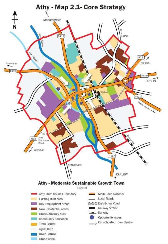
6 Chapter 2 Core Strategy Future Population Growth and Housing Targets This Plan provides sufficient new residential zoning to facilitate approximately 1,667 no. of units (75.8ha). This is a significant decrease in lands zoned for new residential development from 185 ha in the Athy Town Development Plan It is recognised that this level of zoning is of a scale which could facilitate future development up to in line with the projected demands of the Regional Planning Guidelines. This level of zoning is deemed appropriate for the following reasons it will: Within the agricultural zone, housing will be restricted to people with a genuine housing need and who can demonstrate that they comply with local need requirements as outlined in Section 4.9 of the Sustainable Rural Housing- Guidelines for Planning Authorities and the proper planning and sustainable development of the area. Achieve more balanced residential development in all areas within the town boundary. Ensure accessibility to the proposed new road infrastructure. Be proximate and accessible to existing and future educational facilities. To ensure compliance with the core strategy of the plan a monitoring mechanism will be put in place in accordance with Policy CS 16. Furthermore, as part of the two year midterm review an analysis of compliance with the Core Strategy will be undertaken and appropriate measures implemented if required (Refer Policy CS 17). 1 On the basis of Athy continuing to have 4.5% of the projected overall growth of the County as provided for in the RPGs, it is estimated that 78.6ha of residential land will be required up to 2022.
7 (Indicative only)
8 3.5 Factors Influencing Future Economic Development I. Availability of zoned land One of the key enablers to attract potential investment and employment to Athy will be the availability of appropriately zoned lands. Under the Athy Development Plan approximately 101 hectares of land is zoned for employment, industry and enterprise purposes in and around Athy. It should be noted that this figure does not include such uses as Town Centre, Retail, Leisure and Amenity which would also provide an element of employment generation. Approximately 50 hectares of lands zoned for employment purposes remain undeveloped. This figure solely relates to lands zoned for employment such as industrial warehousing and commercial and does not take into account potential job creation on other lands zoned for town centre, retail or leisure and amenity uses. It is considered that there is sufficient land zoned for employment generation to meet job creation needs for the town up to 2018 and beyond. Table 3.4 provides further information in relation to the location and availability of undeveloped zoned employment land in Athy. II. Infrastructure Adequate infrastructure is vital for the facilitation of future economic development activity in the town. This includes water services, effective road and public transport networks, energy, telecommunications, waste management, education and recreation facilities etc. There is a significant infrastructural deficit in relation to road infrastructure and to a lesser extent the public transport network in Athy. The Athy Distributor Road has been identified as a key infrastructural priority and its delivery is viewed as being essential for the future expansion of the town as well as the significant improvement of the accessibility and attractiveness of the town centre. Improvement of the broadband and telecommunications network in Athy is also required in terms of the quality and range of broadband provision throughout Athy. The development of a comprehensive and efficient broadband and telecommunications network will bring significant economic benefits to the town. The availability of this telecommunications infrastructure in Athy enables high speed access to information for industry, public and private sector organisations.
9 Table 3.4 Location and Availability of Employment Land in Athy Land Use Zoning Objective Location and availability of (undeveloped) land Employment Opportunities/Sectoral Strengths H2 Industrial & Warehousing To provide for and improve industrial and warehousing development and to include retail/warehousing. Woodstock South Along Athy Distributor Rd Development in these areas will be generally less employment intensive. Opportunity for development of high value added manufacturing and small medium enterprise (SME). Significant capacity for infill industrial development and re-development of brownfield sites. Opportunity for new industrial and warehousing development, and small-medium sized enterprise in undeveloped areas. H2 to include Retail/Warehousing
10 Chapter 5 Town Centre 5.6 Movement, Access and the Public Realm Vehicular traffic in the town centre and the proximity of vehicular traffic to pedestrian movement on narrow pavements diminishes the quality of the environment for shopping, visitors, pedestrians etc. This Plan proposes the reduction in vehicular traffic in the town centre and promotes streets as living spaces which are a functional part of the community and the focus of activities. The Plan seeks to link commercial areas, employment areas and public spaces through a network of quality pedestrian and cycling routes in an enhanced public realm. An improved pedestrian environment will encourage higher levels of footfall on the main thoroughfares with associated higher levels of economic activity. It is an aim of the Council to facilitate public realm improvements, both in terms of regeneration, building fabric, street materials and furniture and connectivity. In general, any urban renewal or environmental improvement scheme should retain historic features, street furniture and features of interest. In exceptional cases where any of these features need to be removed, their reuse where appropriate within the town centre will be encouraged. This Plan seeks to promote pedestrian and cycle priority in parts of the town centre, such as the area in the vicinity of Emily Square, during the plan period and to examine the feasibility of constructing a pedestrian crossing over the River Barrow as appropriate to link schools, parks, playing fields and residential areas on both sides of the river. It is the policy of the Council: PR 1: To examine the feasibility of providing a pedestrian / cycle crossing over the River Barrow as appropriate to link schools, parks, playing fields and residential areas on both sides of the river. PR 2: To encourage the improvement of the area surrounding the Dominican Church. PR 3: To work towards improving the overall visual appearance of Athy by encouraging the following: (a) The removal of overhead cables and wires placing them underground within the town centre in conjunction with the various utility companies. (b) The control of advertising, including the removal of existing signage which is visually obtrusive or out of character, in particular neon and poor quality plastic signage will be prohibited. 5.7 Town Centre Objectives It is an objective of the Council: TCO 1: To maintain the Council s Derelict Sites Register and to exercise its powers under the Derelict Sites Act TCO 2: To seek the removal of unauthorised advertising/ signage through enforcement provisions and to encourage new advertising and signage which is appropriate to the streetscape and positively contributes to the public realm.
11 TCO 3: To prepare and implement an Environmental Improvement Scheme within the lifetime of this Plan to visually enhance the streetscape and key urban spaces with an emphasis on promoting a pedestrian and public transport friendly environment. TCO 4: To investigate the feasibility of the pedestrianisation of all or part of Emily Square during the Plan period. TCO 5: To examine the feasibility of constructing a pedestrian / cycle crossing over the River Barrow as appropriate to link schools, parks, playing fields and residential areas on both sides of the river. TCO 6: To provide for a pedestrian crossing from the train station to the park/playground in People s Park.

12 Map 5.1A Town Centre and Associated Zoning
13 Chapter 7 Movement and Transport Walking and Cycling In accordance with the principles of sustainable development, this Plan aims to promote walking and cycling as effective modes of transport within the urban area. The Plan supports and encourages the continued development of walking as a sustainable form of transportation and the Council will work with organisations and groups in the promotion of safe walking throughout the town including historic/heritage walks which are an important amenity and tourism resource. Future developments should provide for the safe movement of pedestrians. Currently cycling does not play a significant role as a mode of transportation in Athy. A number of development objectives set out in the plan will enhance the pedestrian and cycling environment for the enjoyment of Athy residents and visitors alike. This Plan seeks to promote pedestrian and cycle priority in parts of the town centre, such as the area in the vicinity of Emily Square, during the plan period and to examine the feasibility of constructing a pedestrian crossing over the River Barrow as appropriate to link schools, parks, playing fields and residential areas on both side of the River Southern Distributor Road (SDR) The route comprises an urban single carriageway circa 3.2 km in length. The proposed Southern Distributor Road is intended to divert through traffic away from the town centre. This road will facilitate improved safety due to the removal of vehicles from the existing N78 in the town centre, especially heavy goods vehicles and will free up capacity for road users who want to avail of the facilities of the town. The secondary function of the Athy SDR is to facilitate the orderly expansion of Athy increasing connectivity and allowing for the integration of different modes of transport. The proposed scheme will include pedestrian and cycle paths, additional crossing points over the River Barrow, Grand Canal and railway line and will facilitate linkages between zoned land, the town centre and railway station linking the N78 southwest of the town at Bennetsbridge to the N78 northeast of the town at Gallowshill. From its commencement, there will be a roundabout at the tie into the N78, Kilkenny road southwest of the town. The proposed route will run for part of the route along the line of the disused CIE rail line. It then crosses the River Barrow and the main Dublin to Waterford rail line before tying into the newly constructed N9/N10 link road roundabout Northern Distributor Road (NDR) New Town Centre Streets A number of new town centre streets are proposed to provide access to opportunity sites in the southern town centre area. Indicative routes are shown from St. Michael s Terrace to Emily Square; from the River Barrow to the Grand Canal (via Dominican site); and from the Grand Canal to Upper William Street (via Tegral site). While the delivery of these streets is unlikely to be achieved in the short to medium term, the Council will seek to preserve the indicative routes free from development to protect the viability of these routes and to promote the
14 coordinated development of these backland areas in the longer term Distributor/Relief Roads The primary function of Distributor Roads in Athy is to divert through traffic away from the town centre and to improve the public realm, while also contributing to an efficient transport network in the town. It is the policy of the Council: DR 1: DR 2: DR 3: To ensure that new distributor/relief roads are designed and constructed in a manner that will enable them to fulfill their functions. To limit direct access onto distributor/relief roads to a number of strategically located junctions. To continue the development of the proposed Athy Distributor Road General Movement and Transport Objectives It is an objective of the Council: GO 1: Sustainable Travel It is an objective of the Council: STO 1: To engage with service providers to regularise the number of bus stops and provide bus pull in bays and shelters along the main routes thereby improving safety and traffic flow. STO 2: To encourage Iarnród Éireann, Bus Éireann and private companies to improve the frequency and quality of public transport facilities to, from and within the town. STO 3: To investigate the potential for a number of park and walk sites which would provide convenient pedestrian access to the town centre, as an alternative to providing additional car parking within the town centre area. STO 4: To continue the road and footpath improvements, which facilitate pedestrian safety at various locations within the town centre, and in particular at the following junctions: (a) N78 / Kirwans Lane (b) N78 / Church Road (c) N78 / Chapel Lane (d) N78/ Meeting Lane (e) N78 / St John s Lane (f) N78 / Green Alley (g) N78 / Nelson Street (h) Mount Hawkins / Chapel Lane (i) Kirwans Lane / Mount Hawkins (j) Woodstock Street / Barrack Lane STO 5: To examine the feasibility of the pedestrianisation of certain town centre routes. STO 6: To examine the feasibility of a pedestrian bridge over the River Barrow as appropriate to link schools, parks, playing fields and residential areas on both sides of the river, thereby providing safer routes
15 to school. Any bridge would have to be constructed to the specifications of all statutory bodies. STO 7: To upgrade and construct continuous walkways and cycle ways along both sides of the River Barrow and Grand Canal, to provide attractive leisure routes and alternative routes to the town centre. STO 8: To assist and encourage the development and expansion of rural transport initiatives, in conjunction with other statutory and development agencies Roads Programme It is an objective of the Council: RP 1: RP 2: RP 3 RP 4: RP 5: RP 6: RP 7: To construct the Athy distributor road including links to the town centre and the train station and to preserve these routes free from development. This is a priority objective of this plan. (Refer to Land Use Zoning Map 16.1A) To support the construction of new town centre streets and acquire land to facilitate construction. To complete road improvements to the Fortbarrington Road from Blackparks to Ardrew. To improve the junctions of the R418 (Castledermot Road) with the N78. To improve the junction of the Kildare Road with the N78, having regard to the constraints of nearby protected structures. RP 8: RP 9: To continue the construction of gateway features on the west-end of the N78 and to introduce gateway features on the eastern-end of the N78 to alert drivers that they are entering an urban area. This will include improved lighting, traffic calming measures, provision of higher level of signage along with road markings. To carry out the improvement of the local road from Prusselstown Cross Roads to the N78 Dublin Road. RP 10: To ensure that adequate set back is provided adjacent to the four railway bridges in Athy to allow for the upgrading of the railway in consultation with Iarnrod Eireann. RP 11: To implement traffic calming and other associated measures on the R417 and R428 as part of new developments. RP 12: To implement traffic calming measures on Stanhope Place and Mount Hawkins. RP 13: To implement traffic calming measures on the N78 at the GAA club. RP14: RP 15: To review and set out an implementation plan for the roads programme, including the improvement of walking and cycling routes, as part of a local traffic plan to be prepared following publications of the NTA Transport Strategy for the GDA and in accordance with Section 65 of the DTA Act 2008.
16 Chapter 11 Recreation and Amenity 11.4 Amenity It is the policy of the Council: A1: To continue the development of riverside and canal side walking routes with the creation of a linear park along the River Barrow and canal in conjunction with the relevant statutory bodies. A 2: To continue the amenity development of the People s Park and to retain its enclosed urban park character. A 3: To maintain and develop the amenity potential of the canal for recreation. A4: To ensure that any future development along the Canal and the River provides walking routes and does not disproportionately affect their amenity value. A5: To promote an increased awareness of Athy walking routes and heritage trails as attractive and unique recreational and educational amenities. A6: To protect and improve all existing rights-of-way and to create further rights-of-way where necessary and appropriate. A7: To facilitate, where practicable, the provision of cycle-ways or walkways along the extent of the canal, in cooperation with landowners, Waterways Ireland and government departments. Any proposed cycling or walking routes along or across the Grand Canal and River Barrow will be subject to a feasibility study and Appropriate Assessment in accordance with Article 6(3) of the Habitats Directive Parks and Open Spaces Open spaces are a vital part of the urban environment. Open space amenities create benefits not only for the enhancement of the quality of life of residential areas but also provide opportunities for recreational activities, ecological and environmental preservation as well as education. The Council is responsible for the maintenance and management of a number of open spaces and amenity areas in Athy. The planning process plays a vital role in ensuring that existing parks and open spaces are protected and enhanced. In addition it is key to the provision of appropriate, high quality additional parks and open spaces to cater for increased demand as new residential areas are developed and the population increases. Athy contains a range of sizes and types of open spaces which are accessible to the public. The land use zoning map 16.1A outlines the areas for Open Space and Amenity in the town. These areas include lands which are in public and private ownership and consist of a variety of sports clubs, the People s Park and the open space area north of Barrack Lane. These areas in are in addition to approximately 57ha of land zoned for open space and amenity purposes throughout Athy. An Open Space Strategy was completed for County Kildare in The strategy identified a hierarchy of open space for the county, provided an audit of open space based on this hierarchy and assessed current and future open space needs within the county. The
17 strategy noted that there is an adequate diversity of public open space throughout Athy including one neighbourhood park, two local parks and small areas of amenity greenspace throughout the residential areas of the town. The recommendations arising from the strategy have been taken into consideration in the policies and objectives outlined below. The open space area to the north of the town centre is largely undeveloped therefore it is proposed to intensify the usage of this open space area with the intention of developing a town park and providing a range of sports and community facilties in a coordinated manner. The provision of such facilities will benefit both schools and residential areas located to the north of the town which will maximise the usage of such facilities. The feasibility of provding a new footbridge across the River Barrow at this point to increase accessibility to services will be examined. A landscape management plan for this area will seek to enhance the amenity value of this open space.
18 Table 13.1: Protected Views and Prospects Views and Prospects VP1 VP2 VP3 VP4 VP5 VP6 VP7 Views of the River Barrow upstream & downstream from Cromaboo Bridge & from Horse Bridge Views from the River Barrow across open land to the south and north of the town. Views of the Grand Canal and of the Barrow Navigation, upstream and downstream from all bridges. Views along the River Barrow from all existing public rights of way (including public roads as well as footpaths). Views of the Dominican Church from Barrow Quay and from the banks of the River Barrow. Views and prospects forming the setting and environs of all protected structures.

19 Map 13.1A Natural Heritage, Views and Prospects

20 Chapter 14 Urban Design and Opportunity Areas Regularise Traffic It is the aim of this strategy to intensify and transform Athy from a busy through route to a bustling core. Presently, Leinster Street and Duke Street are characterised by significant levels of vehicular activity that is largely associated with through traffic, however commercial activities within the town also contribute to the traffic flows in the area. The proposed Athy Distributor Road will remove significant levels of the through traffic from the town centre. Upon the construction of this road, it is therefore an objective of this strategy that traffic be calmed, most importantly at the entrances and approaches to the town in order to improve the comfort for pedestrians and enhance the public realm. This can be achieved by providing alternative routes through the town centre, reducing the level and speed of traffic through the town by appropriate use of surface material combined with pedestrian priority zones. new street and the Kilkenny Road. A key building should signify this important entrance to the town. Key Figure 14.1 Western Approach Formalise Entrances and Approaches to the Town Centre The existing entrances to the town create a poor sense of arrival. Derelict buildings set a negative tone along the approach from the west, while vacant sites and the awkward road layout provide a poor sense of enclosure as the town is approached from the east. It is therefore proposed to mark the entrances to the town as follows: The Western Approach Create a new approach to the town at the Tegral Site at the junction of the proposed

21 The Eastern Approach Create a new public space with a key building at the junction of the proposed new street and Leinster Street. Figure 14.2 Eastern Approach Key

22 Figure 14.3 Urban Design Framework
23 Town Core Character Area The Study Area The subject lands comprise primarily of the area to the north and south of Leinster Street including Emily Square. These lands are bounded by the Railway line to the East, Kirwans Lane to the North, and Church Road and the Abbey Lands to the south and south west respectively and the River Barrow to the west. developments should enhance the character of the existing historic core. It is proposed that the New Town Street will link to Emily Square. Development along the New Street should complement and add to the existing town core providing a successful urban centre with a concentration and variety of uses. Key Urban Design Issues The study area provides an opportunity to revitalise an underutilised area in the historic centre. There are a number of key opportunity sites within the character area, mostly occurring to the rear of the existing buildings north and south of Leinster Street. Design Objectives It is proposed to develop a new street to the south of Leinster Street. This street provides an opportunity to maximise the potential of extensive backland opportunity sites to the south of Leinster Street. The character area presents an opportunity to formalise the approach and entrance and create a new well defined entrance into the town centre in order to create a sense of arrival and departure. It is envisaged that a key building at the junction of Leinster Street and the New Street will signal the significance of the site as an entrance into the Town Centre. Care should be taken that this building addresses both street frontages and must be designed to an exceptional standard on all elevations. Care should be taken with regard to the scale and massing of this structure to ensure that it does not become too bulky. New

24 Figure 14.6 Town Core Character Area
25 Figure 14.7 The Abbey Character Area
26 Dominican Lands Character Area Study Area The Dominican lands are located between the Barrow Navigation of the Grand Canal and the River Barrow. The subject lands comprise of the undeveloped lands around the Dominican Church and include the underutilised and backland sites along the church access road to the south of Duke Street. A number of fields are located at the junction of the Barrow Navigation of the Grand Canal and the River Barrow. There is currently restricted access to the area via a pedestrian bridge and an access road to the church. Key Urban Design Issues Although there have been a number of modern developments in this area in recent years, the built form generally provides poor street frontage resulting in a low quality public realm and streetscape. The existing access road consists of few active frontages and town centre uses resulting in an underutilised and underdeveloped area within the town centre. Both the river to the east and the canal to the west form barriers and sever the character area from nearby Emily Square and surrounding areas and permeability is poor between these areas. increasing links between these character areas and to establish links with the historic town centre. TABLE 14.3 KEY DESIGN GUIDELINES Create a sustainable town centre extension with a mix of uses. Extend the river and canal side walkways. Transform the church access roadway (Dominican Lane) into a bustling street within the town core. Provide appropriate infill development with active frontages and a strong building line along Dominican Lane and Convent Lane. Improve the quality of the public realm and reinforce the existing linkages between the character area, Duke Street and Emily Square. Provide an area of passive recreational space to the south of the character area overlooked by larger detached residential development. Design Objectives The canal is an important historic and amenity element within the town. The canal itself is an underutilised asset which currently presents a physical barrier between the urban centre and the industrial lands to the west. The development of this area provides an opportunity to maximise the potential of the industrial lands to the west of the town by

27 Figure 14.8 The Dominican Lands Character Area
28 Edmund Rice Square Character Area The Study Area The subject site is located immediately adjacent to the existing Town Centre and is zoned for town centre uses. Pettits Supermarket and Shaws Department Store mainly define this area towards the town centre, while a large expanse of residential development and a public park define the character area to the north. The character area is bounded by the River Barrow to the east, Woodstock Street to the west and Duke Street to the south. The character area is outlined in blue on the following graphic, Fig Key Urban Design Issues Edmund Rice Square provides a poor quality public realm used entirely as a surface car park. The square is currently flanked by under scaled one and two storey retail units. The current configuration of the square does little to improve the streetscape along Duke Street. pedestrian walkway to the housing area adjacent to the school. Design Objectives The redevelopment of the area provides an opportunity to connect with the residential development, park and community facilities to the north of the square behind the supermarket. It is proposed to investigate the feasibility of constructing a new pedestrian bridge linking the park and residential area with the schools to the east of the river. It is also proposed to provide additional opportunities for community facilities within the park which will overlook an extended riverside walkway. The walkway should run from Duke Street to the proposed pedestrian bridge. In the development of this walkway due consideration should be taken of the SAC status of the River Barrow. Pettits Supermarket severs the town centre from the adjacent residential area. The supermarket does not address the river or the open space to the north. The existing riverside walkway is not overlooked, is of poor quality, is poorly lit, attracts anti social behaviour and consequently is uninviting. The existing built form along St. John s Lane is of poor quality and comprises derelict industrial buildings and vacant sites, overall providing a poor public realm. There is no connectivity with residential development to the north of Edmund Rice Square apart from an unsupervised
29 TABLE 14.4 KEY DESIGN GUIDELINES Create a sustainable town centre extension with a mix of uses. Extend the river and canal side walkways. Transform the church access roadway (Dominican Lane) into a bustling street within the town core. Provide appropriate infill development with active frontages and a strong building line along Dominican Lane and Convent Lane. Improve the quality of the public realm and reinforce the existing linkages between the character area, Duke Street and Emily Square. Provide an area of passive recreational space to the south of the character area overlooked by larger detached residential development.

30 Figure 14.9 Edmund Rice Square Character Area
31 Chapter 16 Land Use Zoning Table 16.2 Land Use Zoning Objectives Ref Use Land-Use Zoning H2 Industrial and Warehousing To provide for light industrial and industrial office type employment in a high quality campus environment and to provide for retail warehousing in accordance with the retail policy and subject to the provision of necessary physical infrastructure. Lands located to the north and south of the Athy Distributor Road A Master Plan much be prepared for this area and any application must be submitted having regard to this Master Plan. The Master Plan should be prepared by the landowners ideally working together, and in consultation with Kildare County Council and any other service providers. Any development on these sites must not seriously injure the amenities of adjoining land uses. Lands zoned as H2: Industrial and Warehousing off the N78 Ballylynan Road It is recommended that development of these lands be accompanied by a Site Specific Flood Risk Assessment appropriate to the nature and scale of development being proposed. Such Development Proposals shall also: (i) Indicate and quantify loss of floodplain storage arising from the development proposal; (ii) Provide compensatory storage located within or adjacent to the proposed development; (iii) Indicate measures to ensure that water-vulnerable elements of the Development would not be flooded during the 1000year flood; (iv) Ensure that existing flow paths for flood waters will not be compromised.

32 Map 16.1A Land Use Zoning Map
33
elbridge Core Strategy
 C elbridge Core Strategy Celbridge is designated as a Moderate Growth Town in the RPGs. The County Development Plan reinforces this designation in its settlement strategy. Moderate Growth Towns within
Overview Report. Proposed Development
 Overview Report Proposed Development the construction of a 1km cycle/pedestrian trail including a new footbridge, new car park and entrance road at Drumshanbo Lock and a new pedestrian/cycle road crossing,
28. Coolaney-Rockfield Mini-Plan
 28. Coolaney-Rockfield Mini-Plan 28. Coolaney-Rockfield Mini-Plan Community facilities Community facilities in Coolaney-Rockfield consist of a primary school, crèche, community centre, sports field and
17. Coolaney-Rockfield Mini-Plan
 County Development Plan 2017-2023 Consolidated Draft + Adopted Amendments - August 2017 17. Coolaney-Rockfield Mini-Plan Village profile Coolaney is located approximately 23 km to the south-west of Sligo
Page 1 of 19 URBAN DESIGN FRAMEWORK FOR BOLTON STREET WATERFORD
 Page 1 of 19 URBAN DESIGN FRAMEWORK FOR BOLTON STREET WATERFORD 1.0 Introduction: The relocation of the City Council stores and depot from Bolton Street creates an exciting opportunity for development
BLETCHLEY PARK AREA - DEVELOPMENT FRAMEWORK
 ANNEX A To Item 9 REVISED TEXT: additions shown bold and underlined, deletions in (brackets and in italics). BLETCHLEY PARK AREA - DEVELOPMENT FRAMEWORK This framework sets out the key objectives and requirements
EVALUATION OF MASTER PLAN ALTERNATIVES
 7 The Environmental Report is required to identify, describe and evaluate reasonable alternatives, taking into account the objectives and geographical scope of the Master Plan 2008. Three plan alternatives
Proposed Amendment to the
 Proposed Amendment to the Carrigaline Electoral Area Local Area Plan Amendment No 1: Carrigaline (T-02, O-02 & U-02) August 2012 Proposed Amendment to the Carriagline Electoral Area Local Area Plan 2011
20. Ballysadare Mini-Plan
 20. Ballysadare Mini-Plan 20. Ballysadare Mini-Plan Community facilities Ballysadare has a wide range of community facilities: a primary school, St Mary s College (secondary school), a health centre, playing
I615. Westgate Precinct
 I615. Westgate Precinct I615.1. Precinct Description The Westgate Precinct is located approximately 18km west of the Auckland city centre. There are seven Sub-precincts in the Westgate Precinct: Sub-precinct
2.0 Strategic Context 4
 2.0 Strategic Context 4 2.1 The Area Action Plan is a non-statutory plan, which forms a corporate policy document, expressing particular issues and areas of concern while also providing a vision for the
Schedule of Planning Applications Committee Date: 23 May Reference: 06/17/0726/F Parish: Hemsby Officer: Mr J Beck Expiry Date:
 Schedule of Planning Applications Committee Date: 23 May 2018 Reference: 06/17/0726/F Parish: Hemsby Officer: Mr J Beck Expiry Date: 22-05-2018 Applicant: Proposal: Site: Mr Gillett Change of use to the
Making the case for Sustainable Transport Project Potential
 Making the case for Sustainable Transport Project Potential The Structural Investment Fund (SIF) Strategy for Greater Lincolnshire identifies the barriers to growth identified by having poor transport
3.0 Area-Wide Strategies 30
 3.0 Area-Wide Strategies 30 3.6 Tourism Strategy This section of the plan aims to develop and improve the tourism potential of the area. Strategic Context The City Plan outlines the potential of Cork to
Urban Design Guidelines
 Urban Design Guidelines These Urban Design Guidelines comprise the Key Design Objectives below, the Roads Design Guidelines overleaf and Neighbourhood Framework Plans. Together with Section 3: Urban Design
6. Ballintogher Mini-Plan
 County Development Plan 2017-2023 Consolidated Draft + Adopted Amendments August 2017 Volume 2, Chapter 6 Ballintogher Mini-Plan 6. Ballintogher Mini-Plan Village profile Ballintogher is located approximately
Edenderry Local Area Plan
 Edenderry Local Area Plan 2017-2023 MATERIAL ALTERATIONS TO DRAFT EDENDERRY LOCAL AREA PLAN Public Display Document Section 1: Introduction 1.1 Introduction This report focuses on the proposed material
4.0 URBAN DESIGN FRAMEWORK. The vision for the future development of the plan area is to:
 4.0 The vision for the future development of the plan area is to: Create a new neighbourhood that focuses on the highly valued natural and aesthetic features of the lands and provides good quality homes,
The Proposed Auckland Unitary Plan (notified 30 September 2013)
") 3 Business zones Introduction There are 10 business zones in the Unitary Plan: City Centre Metropolitan Centre Town Centre Local Centre Neighbourhood Centre Mixed Use General Business Business Park Light
3 Business zones Introduction There are 10 business zones in the Unitary Plan: City Centre Metropolitan Centre Town Centre Local Centre Neighbourhood Centre Mixed Use General Business Business Park Light
Strategic Environmental Assessment Screening Report. Dublin Port Masterplan Review 2017
 Strategic Environmental Assessment Screening Report Dublin Port Masterplan Review 2017 Table of Contents 1 Introduction... 1 2 Purpose of the Masterplan... 2 3 Task 1.1 Pre-Screening Check... 5 4 Task
BORRISOKANE SETTLEMENT PLAN
 BORRISOKANE SETTLEMENT PLAN 1.0 General Introduction and Development Context Location Borrisokane is located 15km north of Nenagh on the N52. While the town is primarily residential, it acts as a market
Former North Works, Lickey Road, Longbridge, Birmingham
 Committee Date: 14/11/2013 Application Number: 2013/06431/PA Accepted: 27/08/2013 Application Type: Full Planning Target Date: 26/11/2013 Ward: Longbridge Former North Works, Lickey Road, Longbridge, Birmingham
30. Riverstown Mini-Plan
 County Development Plan 2017-2023 Consolidated Draft + Adopted Amendments August 2017 Volume 2, Chapter 30 Riverstown Mini-Plan 30. Riverstown Mini-Plan Village profile Riverstown is located approximately
The West Vaughan Employment Area Secondary Plan Policies
 Part 2: The West Vaughan Employment Area Secondary Plan Policies 2.1 General Policies It is the policy of Council: 2.1.1. That the West Vaughan Employment Area (the WVEA), identified on Schedule 1, will
8.0 Design and Form of Development 43/
 42/ 8.0 Design and Form of Development 43/ Rothwells Farm, Golborne/ Development Statement Figure 7. Site Constraints Key 44/ Site Boundary 360 Bus Route/Stops Existing Trees Underground Water Pipe Sensitive
Poolbeg West SDZ Draft Planning Scheme
 Poolbeg West SDZ Draft Planning Scheme Introduction/vision Housing Community Economy/Employment Movement/transport Infrastructure green infrastructure /open space Land-use and phasing Public Realm Urban
Variation No 1: Dundalk & Environs Development Plan Core Strategy
 Variation No 1: Dundalk & Environs Development Plan 2009-2015 Core Strategy Adopted on 29 th August 2011 CONTENTS Page Section 1 1.0 Synopsis 1 1.1 Background Document 1 1.2 Variation of Dundalk and Environs
County Development Plan Consolidated Draft + Adopted Amendments August 2017 Volume 2, Chapter 22 Easky Mini-Plan
 22. Easky Mini-Plan Village profile Easky is a coastal settlement located approximately 40 km to the west of Sligo City, in a designated Rural Area In Need of Regeneration. The nearby coastline is designated
I539. Smales 2 Precinct
 I539. Smales 2 Precinct I539.1. Precinct Description The Smales 2 Precinct applies to a 4.8 hectare block of land located on the southern side of Northcote Road and fronting Lake Pupuke, Takapuna. The
Chapter 5 Urban Design and Public Realm
 5.1 Introduction Public realm is all areas of the urban fabric to which the public have access. It is where physical interaction takes place between people. It therefore, includes buildings and their design,
Newcourt Masterplan. November Exeter Local Development Framework
 Newcourt Masterplan November 2010 Exeter Local Development Framework Background The Exeter Core Strategy Proposed Submission sets out the vision, objectives and strategy for the development of Exeter up
CLOUGHJORDAN SETTLEMENT PLAN
 CLOUGHJORDAN SETTLEMENT PLAN 1.0 General Introduction and Development Context Location The market town of Cloughjordan lies close to the border with Offaly at the junction of the R490 and R491 Regional
3.3. Urban Structure Defining a New Hierarchy of Routes and Spaces >Images
 Section 3.0 I The Masterplan Framework 18 >Images Examples of high quality routes and spaces 3.3. Urban Structure The success of any masterplan lies in a clear definition of the future urban structure
DUBLIN DOCKLANDS MASTER PLAN AND RELATIONSHIP WITH OTHER PLANS
 .1 National Policy and Programmes.1.1 Sustainable Development A Strategy for Ireland, 1997.1.2 National Climate Change Strategy, 2007-2012.1. National Development Plan 2007-201.1.4 National Spatial Strategy,
PORT WHITBY COMMUNITY
 PORT WHITBY COMMUNITY SECONDARY PLAN UPDATE COMMUNITY IMPROVEMENT PLAN URBAN DESIGN GUIDELINES September 2015 DRAFT PROPOSED AMENDMENT NUMBER # to the Whitby Official Plan PURPOSE: The intent of this Amendment
Woodbrook - Shanganagh
 Section 4: Key Sites Framework Strategy Woodbrook - Shanganagh Local Area Plan 2017-2023 4. Site Framework Strategies The Master Plans shall have regard to the thematic objectives under the LAP Development
Glossary of Terms. 430 Kildare County Development Plan Kildare County Development Plan
 Glossary of Terms 430 431 Glossary of Terms Appropriate Assessment A requirement to consider the possible nature conservation implications of any plan or project on the Natura 2000 site network before
This page has been intentionally left blank.
 This page has been intentionally left blank. Chapter 3 3-2 3. Employment 3.A Niagara Economic Gateway 3.A.1 General The Niagara Economic Gateway comprises: a) The Gateway Economic Zone which includes all
heuston gateway: sections heuston gateway: regeneration strategy and development framework plan
 B B1 A B1 B C A heuston gateway: sections B B1 C 117 4.3.3 Zoning The station is the central hub of the area and this function must be preserved and developed. However large areas of the Heuston Station
Hockessin Community Redevelopment Plan
 Hockessin Community Redevelopment Plan 3.1 Introduction The Community Redevelopment Plan for the Village of Hockessin is the result of the people s vision for a distinct village center that serves as the
6 Site Framework Strategies
 6 Site Framework Strategies 6.1 Introduction Section 6 identifies a number of specific areas which are considered to be key sites within the Plan area and which may have potential for development / redevelopment.
4 RESIDENTIAL ZONE. 4.1 Background
 4 RESIDENTIAL ZONE 4.1 Background The residential areas within the City are characterised by mainly lowrise dwellings sited on individual allotments. Past architectural styles, settlement patterns and
Mark-up of the effect of the proposed Bronte Village Growth Area OPA No.18 on the text of section 24, Bronte Village, of the Livable Oakville Plan
 Mark-up of the effect of the proposed Bronte Village Growth Area OPA No.18 on the text of section 24, Bronte Village, of the Livable Oakville Plan Notes: This document is provided for information purposes
WHITELEY TOWN COUNCIL NORTH WHITELEY DEVELOPMENT SEPTEMBER 2014
 WHITELEY TOWN COUNCIL NORTH WHITELEY DEVELOPMENT SEPTEMBER 2014 Dear Resident This Special Edition of the Whiteley Voice which has been prepared in conjunction with the North Whiteley Consortium is to
Rochford District Council Allocations Development Plan Document: Discussion and Consultation Document Sustainability Appraisal
 Option SWH1 Balanced Communities Option SWH1 1 To ensure the delivery of high quality sustainable communities where people want to live and work Will it ensure the phasing of infrastructure, including
Rathmolyon Written Statement
 Settlement Rathmolyon Position in Settlement Hierarchy Village - Local centre for services and local enterprise development Position in Retail Strategy Fourth tier retail centre Population (2011) Census
16. Collooney Mini-Plan
 16. Collooney Mini-Plan Village profile Collooney is located approximately 13 km to the south of Sligo City, in a designated Rural Area under Urban Influence. The village provides a range of services for
Sustainability Statement. Whitby Business Park Area Action Plan
 Sustainability Statement Whitby Business Park Area Action Plan November 2014 Contents Page 1. Introduction 1 2. Scoping 3 3. Sustainability Appraisal of Options 6 4. Assessment of Draft Area Action Plan
Chapter 2: OUTLINE PLANNING APPLICATION PROPOSALS. A New Garden Neighbourhood Matford Barton 17
 Chapter 2: OUTLINE PLANNING APPLICATION PROPOSALS A New Garden Neighbourhood Matford Barton 17 2.1. SUMMARY AND STATUS OF THE PROPOSALS 2.1.1. The parameter plans and associated wording in this chapter
Great Easton Neighbourhood Plan Statement of Basic Conditions
 Great Easton Neighbourhood Plan 2017-2031 Statement of Basic Conditions OCTOBER 2016 GREAT EASTON PARISH COUNCIL Contents 1.0 Introduction....Page 2 2.0 Summary of Submission Documents and Supporting Evidence..
North Lotts and Grand Canal Dock
 Proposed Amendments North Lotts and Grand Canal Dock Planning Scheme 2014 February 2018 w ww Comhairle Cathrach Bhaile Atha Cliath Dublin City Council North Lotts and Grand Canal Dock SDZ Planning Scheme
Draft Ada Street Cardiff Area Plan
 Draft Ada Street Cardiff Area Plan (Draft Amendment to Lake Macquarie Development Control Plan 2014) Exhibition: The draft Area Plan is on public exhibition from 29 February 2016 to 29 March 2016. Submissions:
OKEFORD FITZPAINE NEIGHBOURHOOD PLAN
 OKEFORD FITZPAINE NEIGHBOURHOOD PLAN Dear Parishioner, The Neighbourhood Plan Project Team have prepared this leaflet to summarise the full Neighbourhood Plan document. It provides a summary of the Vision,
Northern Territory Compact Urban Growth Policy
 Northern Territory Compact Urban Growth Policy A Reference Policy Document to clause 2.7 (Reference to Policy) of the NT Planning Scheme May 2015 Table of Contents 1 Policy Setting... 3 1.1 Context for
Neighbourhood Planning Local Green Spaces
 Neighbourhood Planning Local Green Spaces Introduction... 2 1. Why green space is important... 4 2. Neighbourhood plans and green space... 6 3. Evidence... 8 Statutory designations... 9 Green space audit...
Plan Modification to Chapter B2 of the Auckland Unitary Plan(AUP) Operative in part (15 November 2016)
 Operative in part (15 November 2016)") UNITARY PLAN UPDATE REQUEST MEMORANDUM TO FROM Phill Reid Linley Wilkinson DATE 25 September 2018 SUBJECT Plan Modification to Chapter B2 of the Auckland Unitary Plan(AUP) Operative in part (15 November
UNITARY PLAN UPDATE REQUEST MEMORANDUM TO FROM Phill Reid Linley Wilkinson DATE 25 September 2018 SUBJECT Plan Modification to Chapter B2 of the Auckland Unitary Plan(AUP) Operative in part (15 November
COMMUNITY DESIGN. GOAL: Create livable and attractive communities. Intent
 COMMUNITY DESIGN Intent An attractive, well-designed County will attract quality development, instill civic pride, improve the visual character of the community, and create a strong, positive image for
URBAN DESIGN BRIEF URBAN DESIGN BRIEF 721 FRANKLIN BLVD, CAMBRIDGE August 2018
 URBAN DESIGN BRIEF URBAN DESIGN BRIEF 721 FRANKLIN BLVD, CAMBRIDGE August 2018 DESIGN BRIEF CONTENTS PART A 1.0 INTRODUCTION 2.0 DESCRIPTION & ANALYSIS OF SITE CONTEXT 3.0 DESIGN CONSTRAINTS AND OPPORTUNITIES
Ballivor Written Statement
 Settlement Ballivor Position in Settlement Hierarchy Village - Local centre for services and local enterprise development Position in Retail Strategy Fourth tier retail centre Population (2011) Census
Horwood Map of London, Westminster & Southwark First edition
 Barratt London is developing plans in tandem with Southwark Council and TfL to transform the southern end of Blackfriars Road. The residential-led, mixed-use scheme will deliver new private and affordable
Peckham Peckham Area Vision Map
 Area Vision Map PNAAP13 PNAAP8 Sumner Road Surrey Canal Walk Bird in Bush Park Key: NSP Site Allocations PNAAP Allocations Greenspace Low Line Cycle Network Primary Shopping Areas Square Surrey Canal Walk
Chapter 3 Core Strategy
 Chapter 3 Core Strategy 3.0 Introduction The core strategy sets out how the development objectives in the Development Plan are consistent with the National Spatial Strategy and the Regional Planning Guidelines.
Carton Avenue Action Area Plan Maynooth
 Carton Avenue Action Area Plan Maynooth Kildare County Council JULY 2006 (AAP) Table of Contents Section 1. Introduction...3 Statement of Strategy...3 Location of the Lands...3 Context in the Town Development
Kibworth Harcourt. Introduction. Introduction
 Introduction Introduction Welcome to this public exhibition on the proposals for the delivery of new homes on land at The Kibworths. The purpose of today s exhibition is to give you the opportunity to
Tāhuhu whakaruruhau ā-taone The sheltering ridge pole
 B2. Tāhuhu whakaruruhau ā-taone - Urban growth and form B2.1. Issues Tāhuhu whakaruruhau ā-taone The sheltering ridge pole Auckland s growing population increases demand for housing, employment, business,
Section 1: Canal. 1.1 Introduction
 Section 1: 1.1 Introduction This Action Area Plan (hereinafter referred to as the Drummonds Mill site or the AAP lands) as indicated on Maps 1 and 2, has been prepared in the context of the Kildare County
INTRODUCTION BACKGROUND
 INTRODUCTION 1 1 INTRODUCTION 18 INTRODUCTION 1 1.1 BACKGROUND The Dublin Docklands Development Authority (DDDA) is required to conduct a Strategic Environmental Assessment (SEA) of the review of the Draft
16. Peckham Peckham Area Vision
 16. 16.1. Area Vision 16.1.1. is: A lively town centre providing a range of daytime and night time activities on Rye Lane including a Library, a Leisure Centre and many independent retailers which specialise
Ipswich Issues and Options for the Ipswich Local Plan Review, August 2017, Public Consultation
 Ipswich Issues and Options for the Ipswich Local Plan Review, August 2017, Public Consultation Having reviewed the issues and options documents, the Society has made the following response: Part 1 Strategic
New-Cast Mixed-use Development Proposal King Street West, Newcastle, Ontario
 URBAN DESIGN BRIEF New-Cast Mixed-use Development Proposal King Street West, Newcastle, Ontario TABLE OF CONTENTS: 1.0 Executive Summary 2.0 Creating Vibrant and Sustainable Urban Places: Excerpts from
Public Consultation. Land at Monks Farm, North Grove. Welcome
 Welcome Welcome to our public exhibition for development on Land at Monks Farm, orth Grove. Gallagher Estates and Gleeson Strategic Land are preparing an outline planning application for new homes, open
35. Gorteen Mini-Plan
 35. Gorteen Mini-Plan 35. Gorteen Mini-Plan Community facilities Community facilities in Gorteen consist of a crèche, community centre, sports field, church, burial ground and health centre. The former
Urban Design Manual PLANNING AROUND RAPID TRANSIT STATIONS (PARTS) Introduction. Station Study Areas
 Introduction. Station Study Areas") 111111 PLANNING AROUND RAPID TRANSIT STATIONS (PARTS) Introduction The ION rapid transit system will link Waterloo, Kitchener and Cambridge through a central transit corridor (CTC). There are a number
111111 PLANNING AROUND RAPID TRANSIT STATIONS (PARTS) Introduction The ION rapid transit system will link Waterloo, Kitchener and Cambridge through a central transit corridor (CTC). There are a number
Stratford Neighbourhood Plan Questionnaire
 Stratford Neighbourhood Plan Questionnaire Please tick the appropriate box or answer in the space provided. If you require further copies of the questionnaire, as more than one person in the household
DUNSFOLD NEIGHBOURHOOD PLAN Site Selection Policies
 DUNSFOLD NEIGHBOURHOOD PLAN Site Selection Policies The criteria for assessing sites for future housing and business development in Dunsfold are set out below. (Development criteria, covering what it is
Colchester Northern Gateway Master Plan Vision Review Draft. July 2016
 Colchester Northern Gateway Master Plan Vision Review Draft July 2016 Contents Introduction 4 Context 8 Purpose of the Report 8 Strategic Position 9 Overview of the Process 11 2012 Master Plan Vision 12
Environmental Impact Assessment Screening Report for proposed Environmental Improvement Works to the Front of Emily Square, Athy
 Environmental Impact Assessment Screening Report for proposed Environmental Improvement Works to the Front of Emily Square, Athy by CAAS Ltd for Kildare County Council July 2018 CAAS Ltd, 1 st Floor, 24-26
QUEEN-RIVER SECONDARY PLAN
 34 QUEEN-RIVER SECONDARY PLAN 34. QUEEN RIVER SECONDARY PLAN 1. INTRODUCTION The Queen-River area is approximately 6.4 hectares and is located at the eastern edge of the Downtown as shown on Map 34-1.
Parish of Repton NEIGHBOURHOOD DEVELOPMENT PLAN
 Parish of Repton NEIGHBOURHOOD DEVELOPMENT PLAN BASIC CONDITIONS STATEMENT December 2018 CEF 4 Legal Requirements This statement has been produced by the NDP Working Group on behalf of Repton Parish Council
YONGE STEELES CORRIDOR SECONDARY PLAN. Young + Wright / IBI Group Architects Dillon Consulting Ltd. GHK International (Canada) Ltd.
 Ltd.") PART A: PREAMBLE 1.0 PURPOSE The purpose of this Secondary Plan is to provide a development framework for intensification of the Yonge/ Steeles corridor including the north side of Steeles Avenue West
PART A: PREAMBLE 1.0 PURPOSE The purpose of this Secondary Plan is to provide a development framework for intensification of the Yonge/ Steeles corridor including the north side of Steeles Avenue West
Appendix 1 Structure plan guidelines
 Appendix 1 Structure plan guidelines This appendix forms part of the regional policy statement [rps]. 1.1. Introduction Structure plans are an important method for establishing the pattern of land use
ELMVALE ACRES SHOPPING CENTRE MASTER PLAN
 ELMVALE ACRES SHOPPING CENTRE MASTER PLAN Contents 1.0 INTRODUCTION... 2 2.0 LOCATION... 2 3.0 EXISTING CONTEXT... 2 4.0 VISION & GUIDING PRINCIPLES... 2 5.0 LAND USE AND BUILT FORM... 4 5.1 St. Laurent
Section 4 - Public Realm & Landscape proposals Landscape Masterplan. Section 4 52
 - Public Realm & Landscape proposals Landscape Masterplan 52 Proposed Masterplan - Green Infrastructure Strategy District Park 4.33 Ha to provide Passive and active recreation with a large play area which
Shaping the heart of Stroud - Policy options
 Shaping the heart of Stroud - Policy options Objective Relevant LP policies Policy options (options may be inconsistent and/or conflict with one another) To make the town centre accessible by all modes
97 Lea Bridge Road, Leyton, E10 7QL London Borough of Waltham Forest December 2015
 97 Lea Bridge Road, Leyton, E10 7QL London Borough of Waltham Forest December 2015 Public Realm and Landscape Proposals LEA BRIDGE ROAD, WALTHAMSTOW Public Realm & Landscape Proposals BDP(90)RPT001 December
Droitwich Spa 6. Reasoned Justification
 87 Droitwich Spa 6 Reasoned Justification 6.1 Droitwich Spa is identified in the settlement hierarchy (Policy SWDP1) as a main town being the largest settlement in Wychavon District with an estimated population
Variation No. 2 Introduction & Explanatory Document Variation made on 19th May 2014
 Meath County Development Plan 2013 2019 Variation No. 2 Introduction & Explanatory Document Variation made on 19th May 2014 1.0 INTRODUCTION The Meath County Development was adopted on 17 th December
REMARKABLES PARK ZONE
 .10 Remarkables Park Zone.10.1 Resources, Activities and Values The Remarkables Park Area comprises approximately 150 hectares of perimeter urban land in the vicinity of Frankton and occupies a strategic
Dunboyne/Dunboyne North/ Clonee/ Local Area Plan
 Dunboyne/Dunboyne North/ Clonee/ Local Area Plan Strategic Policy SP 1 To operate an Order of Priority for the release of residential lands in compliance with the requirements of CS OBJ 6 of the County
Drrumconrratth Wrriitttten Sttattementt. Position in Settlement Hierarchy Village - Local centre for services and local enterprise development
 Drrumconrratth Wrriitttten Sttattementt Settlement Drumconrath Position in Settlement Hierarchy Village - Local centre for services and local enterprise development Position in Retail Strategy Level 4
Welcome to our exhibition
 Welcome to our exhibition The Homes & Communities Agency (HCA) welcomes you to this public exhibition explaining our proposals for the redevelopment of the former Lea Castle Hospital site. About the Homes
A Growing Community Rural Settlement Areas
 Town of Huntsville Official Plan Review - POLICY BACKGROUND PAPER A Growing Community Rural Settlement Areas BACKGROUND: In addition to the fully municipally-serviced Urban Settlement Area and the Hidden
PUBLIC REALM STUDY AREA
 WELCOME PUBLIC REALM STUDY AREA WHAT IS PUBLIC REALM? Welcome to the Ballina Town Public Realm public consultation event. Mayo Council is in the process of producing a Public Realm Strategy for Ballina
Camberwell Camberwell Area Vision Map
 Area Vision Map NSP23 Burgess Park Edmund Street NSP29 NSP30 NSP31 New Road Benhill Road NSP27 NSP33 Green Brunswick Park NSP22 station NSP24 Peckham Road NSP26 St Giles Church Lucas Gardens NSP28 NSP25
URBAN DEVELOPMENT QLDC PROPOSED DISTRICT PLAN [PART TWO] AUGUST 2015
![URBAN DEVELOPMENT QLDC PROPOSED DISTRICT PLAN [PART TWO] AUGUST 2015](/thumbs/80/81778199.jpg "URBAN DEVELOPMENT QLDC PROPOSED DISTRICT PLAN [PART TWO] AUGUST 2015") 4 URBAN VLOPMNT U R P QLC PROPO ITRICT PLAN [PART TWO] AUGUT 2015 4 ur b an de v elop ment QLC ITRICT PLAN [PART TWO] AUGUT 2015 4 urban development 4 2 4.1 Purpose The purpose of this Chapter is to set
4 URBAN VLOPMNT U R P QLC PROPO ITRICT PLAN [PART TWO] AUGUT 2015 4 ur b an de v elop ment QLC ITRICT PLAN [PART TWO] AUGUT 2015 4 urban development 4 2 4.1 Purpose The purpose of this Chapter is to set
FORMER CANADIAN FORCES BASE (CFB) ROCKCLIFFE SECONDARY PLAN. Official Plan Amendment XX to the Official Plan for the City of Ottawa
 ROCKCLIFFE SECONDARY PLAN. Official Plan Amendment XX to the Official Plan for the City of Ottawa") FORMER CANADIAN FORCES BASE (CFB) ROCKCLIFFE SECONDARY PLAN Official Plan Amendment XX to the Official Plan for the City of Ottawa 1 INDEX THE STATEMENT OF COMPONENTS PART A THE PREAMBLE PAGE Purpose...
FORMER CANADIAN FORCES BASE (CFB) ROCKCLIFFE SECONDARY PLAN Official Plan Amendment XX to the Official Plan for the City of Ottawa 1 INDEX THE STATEMENT OF COMPONENTS PART A THE PREAMBLE PAGE Purpose...
[PLANNING RATIONALE] For Site Plan Control and Lifting of Holding Zone By-Law 101 Champagne Avenue. May 23, 2014
![[PLANNING RATIONALE] For Site Plan Control and Lifting of Holding Zone By-Law 101 Champagne Avenue. May 23, 2014](/thumbs/75/71599615.jpg "[PLANNING RATIONALE] For Site Plan Control and Lifting of Holding Zone By-Law 101 Champagne Avenue. May 23, 2014") [PLANNING RATIONALE] For Site Plan Control and Lifting of Holding Zone By-Law 101 Champagne Avenue May 23, 2014 Contents 1.0 Introduction... 2 2.0 Site Context... 2 2.1 Adjacent Uses... 2 Figure 1: Site
[PLANNING RATIONALE] For Site Plan Control and Lifting of Holding Zone By-Law 101 Champagne Avenue May 23, 2014 Contents 1.0 Introduction... 2 2.0 Site Context... 2 2.1 Adjacent Uses... 2 Figure 1: Site
SUB AREA 3 CENTRAL STRATFORD AND SOUTHERN QUEEN ELIZABETH OLYMPIC PARK
 191 ADOPTED LOCAL PLAN: THE SUB AREAS SUB AREA 3 CENTRAL STRATFORD AND SOUTHERN QUEEN ELIZABETH OLYMPIC PARK SECTION 12 Vision VISION Central Stratford and Southern Queen Elizabeth Olympic Park will become
EXTRACT FROM THE CUDDINGTON NEIGHBOURHOOD PLAN The Policies
 EXTRACT FROM THE CUDDINGTON NEIGHBOURHOOD PLAN The Policies Environment and Landscape Policy 1 - Landscape Setting Development should respect and wherever possible enhance the landscape setting of Cuddington
Planning and Sustainability Statement
 Land adjacent to Manor Farm, Catterick Village Pallett Hill Sand and Gravel Co Ltd Proposed 10 new dwellings, (6 No market dwellings and 4 No affordable dwellings) with access, associated car parking and