DIVISION OF PLANNING MEMORANDUM
|
|
|
- Shona Elliott
- 5 years ago
- Views:
Transcription

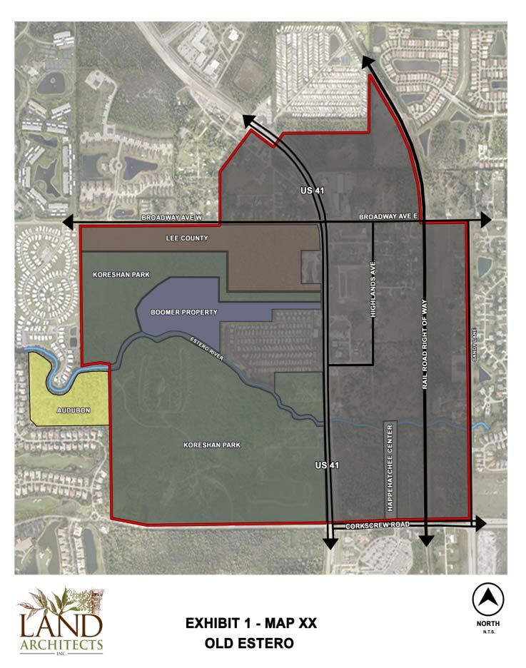
1 to: DIVISION OF PLANNING MEMORANDUM from: subject: Estero Community Planning Panel Kathie Ebaugh, AICP, Principal Planner Estero Goal, Objectives, and Policies date: March 18, 2014 Attached is the final draft Estero Goal, Objectives, and Policies, which has been revised to address comments received by Lee County Staff, Estero Planning Panel, and Estero Council of Community Leaders. Specifically, the changes: 1. Better organize the policies into seven objectives pertaining to: a. Estero Character and Land Use; b. Estero Mixed-Use Centers and Economic Areas; c. Estero Residential Neighborhoods; d. Estero Transportation Connectivity and Mobility; e. Estero Natural Resources and Environment; f. Estero Public Spaces, Parks, and Recreational Facilities; and g. Estero Public Participation; 2. Define and establish specific tasks to be implemented through land development regulations, incentives, and other planning efforts; 3. Reduce redundancy while better clarifying the purpose of each policy; 4. Remove inconsistencies within the plan as well as between the plan and overall county policy; and 5. Ensure that the public participation policies are consistent with the policies being established as part of the Communities Element. The working group, which was comprised of Bill Prysi, Ned Dewhirst, Howard Levitan, and myself with the assistance of Paul O Connor have reviewed these changes and are confident that they address the concerns of the Estero Community and provide a solid foundation for future planning efforts. We look forward to going over the document with you at your meeting on March 24, Additional documents include the Old Estero Map, Proposed Estero Land Use Map, and LPA draft Land Use Element Goal 1.
2 ESTERO ESTERO VISION To establish a community that embraces its historic heritage and protects the environment, while carefully planning for future development resulting from a desirable high quality of life, expanding economic opportunities, and proximity to Florida Gulf Coast University and the Southwest Florida International Airport. Estero's growth will be planned as a village with strong neighborhoods, diverse economic generators, interconnected mixed-use centers, varied parks, public spaces, recreational facilities, and unique natural environments that fosters a sense of belonging and creates a sense of place. Estero will be a highly valued place to live, work, and visit because of development standards and design guidelines that promote:1) desirable neighborhoods and public amenities; 2) attractive landscaping, streetscaping, lighting, signage, and architectural features; and 3) an interconnected transportation network, while limiting strip commercial centers as well as certain undesired commercial uses. The implementation of this vision will successfully link residential and commercial areas and uphold Estero as a vibrant Lee County community. GOAL 19: Promote the development of Estero as a community with a unique quality of life, distinct character, and diverse housing, economic, recreational, and social opportunities by: a. Protecting the natural resources, environment, and lifestyle; b. Establishing minimum aesthetic and design requirements; c. Managing the type, location, quality, design and intensity of future land uses; d. Providing greater opportunities for public participation in the land development approval process; and e. Promoting a true sense of place in Estero. ESTERO CHARACTER & LAND USE OBJECTIVE 19.1: Estero will promote its community character through the implementation of planning and development practices that create a visually attractive community, an enhanced quality of life, and foster a unique sense of place. POLICY : Support the unique character and quality of life within Estero by working with Lee County to manage growth and development and by maintaining, drafting, updating and executing Lee Plan policies, Land Development Code (LDC) regulations, and other planning tools that: a. Implement and maintain development standards for architecture, landscaping, buffering, signage, lighting designs and visual appearance of developments, transportation facilities, and other community amenities; b. Promote the use of low impact design, sustainable energy, water, and other environmental features; c. Establish higher density, mixed-use development within areas targeted on the Mixed-Use Overlay; d. Encourage the redevelopment and infill of underutilized commercial and residential lands; and e. Enable the community to increase public participation in the land development approval process to ensure future development efforts support the Estero community plan and adopted Lee Plan policies and LDC standards.
3 POLICY : Lee County is discouraged from approving any proposed project that does not adhere to Estero s Lee Plan policies and LDC standards unless there is a demonstration of (a) community benefit or (b) attainment of other goals or policies of the Estero community plan. Such projects will be reviewed through a collaborative process that includes the Estero community, property owner, and Lee County staff to ensure that the development supports and upholds the community s plan and vision. POLICY : Encourage new developments that achieve the Estero community s vision and planning goal and policies and meet specific smart growth oriented, mixed-use design, architectural, location, connectivity and public access standards by working with Lee County to establish and implement development incentives that: a. Promote urban integrated forms of development in targeted areas identified on the Mixed-Use Overlay; b. Promote targeted industries in appropriate areas of Estero e.g.: healthcare, arts and culture, technology, and research and development facilities; c. Promote the use of green design, sustainable energy, water, and other environmental features; d. Expedite and streamline desired development projects particularly in targeted incentive zones where the community has adopted mixed-use plans and LDC standards; e. Enable infill of underutilized commercial and residential lands; and f. Encourage residential developments to use the incentive density established through the Lee Plan Urban land use categories. POLICY : Facilitate the redevelopment of properties constructed prior to the adoption of Estero Lee Plan policies and LDC regulations by: a. Establishing incentives and streamlined development processes that enables older properties to come into compliance with adopted Lee Plan policies and LDC standards. b. Working with property owners and developers to utilize incentives and streamlined review processes to redevelop their properties; and c. Encouraging property owners to redevelop their properties utilizing Incentive Densities established through the Lee Plan Urban land use categories. POLICY : Recognize the unique historical and cultural values of the Estero Community by: a. Encouraging the development of the Old Estero area into a mixed-use center as depicted on Map XX; b. Diversifying the architectural character of Estero by incorporating design features of Estero s historic structures into future architectural design, streetscape, and community LDC standards; and c. Identifying, protecting, and promoting historic resources and facilities such as those related to Koreshan Park, Old Estero area, and the Estero Community Park. POLICY : Establish and promote Estero s unique character and identity by defining the community s boundaries through the use of gateway entry features such as ornamental landscape features, hardscape elements and Estero identification signs. Ensure the gateways are constructed by working with Lee County, the Florida Department of Transportation and private property owners to build the gateways at appropriate locations. POLICY : Identify, prioritize, and fund local capital improvement projects particularly projects that enhance transportation and infrastructure systems within the Estero community by working with Lee County to explore local, dedicated funding options (e.g.: MSBU, Tax Increment Finance District, or other
4 similar mechanism). Capital projects that should be targeted for such funding include: a. Streetscape improvements such as roadway pavers, street furniture, street signs / lighting, trash receptacles, and other hardscape features particularly in Old Estero and within new mixed-use centers; b. Pedestrian scale lighting; c. Landscaping and hardscape features particularly along US 41; d. Public trails and greenways facilities; e. Blue way facilities that provide public access to Estero River; and f. Multi-modal transportation facilities that expand or establish pedestrian, bike, transit, and rail services; g. Public space, park, and recreational facilities; h. Urban level infrastructure services and systems with mixed-use center areas; and i. Historic resources and facilities such as those associated with the Koreshan Park and Estero Community Park. ESTERO MIXED-USE CENTERS AND ECONOMIC AREAS OBJECTIVE 19.2: Promote Estero s quality of life and diverse local economy by fostering the development of mixed-use centers and targeted economic areas. The aim of the mixed-use centers is to provide Estero with central gathering places for Estero s residents, business people, and visitors. The aim of the economic areas is to provide the community a diverse employment and economic base while meeting the commercial, professional, and service needs of the people who live, work, and play within the community. POLICY : Provide for the development of walkable mixed-use town centers and economic areas featuring diverse housing options; government offices and public facilities; medical facilities; employment centers; public gathering places, parks, outdoor plazas, and other public spaces; greenway trails and pathways; and public access to the community s natural resources through Lee Plan policies and LDC regulations that support Estero s distinct community character and adhere to the following community priorities: a. Support the development of a central town center to unify the community; b. Improve the connectivity between Estero s residential neighborhoods, economic areas, civic uses, and park and recreational facilities; c. Diversify the community s economic base and employment opportunities; d. Encourage the development of targeted industry clusters particularly health industries, professional services and businesses, and technology, research, and development; e. Expand multi-modal transportation options through improved pedestrian access, bikeways, transit service, and rail opportunities; f. Improve access to the community s blueways particularly the Estero river, greenway trails, other open spaces; g. Promote the community s cultural and historic resources; public spaces, parks, and recreational facilities; and other community amenities; and h. Maintain a unified and pleasing aesthetic/visual quality in landscaping, architecture, lighting, and signage; i. Promote and incentivize private investment within mixed-use centers and economic areas.
5 POLICY : Facilitate the development of a town center for the Estero community through the development of LDC standards, plans, and incentives that address the community s need for a central civic and economic core that is connected to surrounding residential neighborhoods, commercial areas, and community park and recreational facilities. POLICY : Establish a safe and desirable urban environment within the Estero community by adopting Lee Plan policies and LDC standards that guide development in the community s major economic areas near FGCU, along the U.S. 41 corridor, along Corkscrew Road, and in the Old Estero area that: a. Address streetscaping design and amenities, residential buffering standards, commercial center developments, signage, transportation facility needs, and other community concerns; b. Provide for the economic and employment needs of the Estero community by utilizing the Mixed- Use Overlay to facilitate the development of mixed-use centers along the US 41, Corkscrew Road, Three Oaks Parkway, Ben Hill Griffin Parkway, Via Coconut/Sandy Lane, and in the Old Estero area; and c. Discourage stand alone commercial retail in favor of mixed-use centers at these locations. POLICY : Ensure that future commercial and mixed-use developments meet the community s planning priorities by requiring that all new commercial development which requires rezoning within Estero must be reviewed as a Commercial (CPD), Mixed Use (MPD), or Compact Communities Planned Development (CCPD). POLICY : Support the development of mixed-use centers by enabling nightclub, bar, and cocktail lounges within mixed-use centers developed through the CCPD or MPD of a DRI to be considered through a public review process that receives significant community support. The specific location of these uses are to be designed as part of an overall development project and placed within the project so that it 1) supports and is supported by other entertainment and restaurant establishments and 2) is placed near the physical center of the mixed-use development project. Except as set forth above in this policy, the following uses are prohibited within Estero: any detrimental use (as defined in the LDC); nightclubs or bar and cocktail lounges not associated with a group III restaurant; tattoo parlors, and retail uses that require outdoor display in excess of one acre. Outdoor display in excess of one acre is permitted within the property located in the interchange. POLICY : Encourage the development of medical related uses within Estero by working with Lee County and private property owners to adopt appropriate land use policies, land development standards, identify appropriate sites and locations, and establish incentives for the development of health related facilities. Particular emphasis will focus on establishing a medical economic center in the southern section of Estero along U.S. 41. POLICY : Facilitate the development of professional, and research and development economic areas by working with Lee County and private property owners to adopt appropriate land use policies, land development standards, identify appropriate sites and locations, and establish incentives for the development of professional and research and development facilities. Particular emphasis shall be on locating such facilities in areas that take advantage of FGCU educational resources and high technology facilities.
6 ESTERO RESIDENTIAL NEIGHBORHOODS OBJECTIVE 19.3: Support Estero s quality of life, promote the community s unique character through the development of diverse, well-designed, and well-connected residential neighborhoods, and provide for the needs of multigenerational community by supporting a variety of housing types and neighborhood development forms. POLICY : Support and enhance the Estero s residential character by strictly evaluating how the proposed residential neighborhoods: a. Relate to adjacent uses, public facilities, and infrastructure systems; b. Impact surrounding environmental and natural resources; c. Access nearby parks, public spaces, recreational facilities, and greenways, blueways, and natural open spaces; d. Connect to adjacent residential developments, mixed-use centers, economic areas, public facilities, and community resources; and e. Contribute to the overall design, landscaping, and aesthetics that make up the community s built environment. POLICY : Meet the future needs of Florida Gulf Coast University by encouraging higher density residential developments, with a mix of unit types and design forms, including affordable housing and mixed-use centers, in close proximity to Florida Gulf Coast University. The development of such housing and mixed-use centers will consider the transitions between the adjacent residential neighborhoods, commercial centers, and park and recreational facilities. POLICY : Maintain a well-designed and landscaped community while providing appropriate transitions between residential uses and surrounding areas by establishing LDC landscaping requirements consistent with, and appropriate to, adjacent uses. Such landscaping requirements may be greater between residential and commercial uses, while less stringent within differing uses within a mixed-use center. ESTERO TRANSPORTATION CONNECTIVITY AND MOBILITY OBJECTIVE 19.4: Facilitate the development of an interconnected, well linked community that enables people to easily access Estero s neighborhoods, commercial and mixed-use centers as well as other areas within the county and region through an integrated transportation and mobility system. POLICY : Establish land development code standards that ensure the development of a well connected transportation system that includes pedestrian pathways, bikeways, transit, and roadways by encouraging private developments to: a. Provide interconnects with adjacent uses; b. Minimize access points onto primary road corridors by providing multiple access to adjacent properties; c. Link neighborhoods, commercial and mixed-use centers, public facilities, and parks; and d. Enable multi-modal transportation access (pedestrian, bike, vehicular, and transit) within and between the different neighborhoods, economic and employment centers, civic uses, and public space, park, and recreational facilities within the Estero Community.
7 POLICY : Support the efforts to establish an active passenger rail corridor along the existing rail line that passes through Estero in order to provide alternate modes of transportation linking Estero to Naples in the south and to Fort Myers and Punta Gorda in the north. Additionally, while planning continues with respect to the development of such passenger rail service, Estero strongly supports the efforts of Lee County to establish a rails to trails corridor. POLICY : Expand Estero s transportation network of pedestrian and bicycle pathways, sidewalks, trails, and other facilities by working with Lee County and other local, state, and regional entities to: a. Construct multi-use pathways that feature shade trees, benches, bike racks, and other design elements to attract usage; b. Identify targeted funding sources including development contributions, private donations, public funding sources (e.g.: MSBU), or other mechanisms; c. Implement the greenways master plan within the Estero community by working with Lee County Parks Department; d. Utilize the FP&L right of way within Estero State Buffer Preserve by working with FP&L and Lee County; and e. Establish a pedestrian bike trail within or along the rail right of way for public recreation by working with the existing rail corridor and private developers; and f. Encourage the development of an effective rail system by working with the existing rail corridor to improve and expand use of existing rail facilities. POLICY : All public and private rights of way within future mixed-use centers and the Old Estero area are encouraged to be designed to include pedestrian ways, cross walks and traffic calming measures including, where appropriate, on-street parking, raised crosswalks, narrow lane widths or other similar mechanisms. POLICY : Provide for well designed, safe, and multi-use transportation corridors by establishing, maintaining, and implementing complete street design guidelines for the major roadways within Estero including the US 41, Corkscrew Road, Via Coconut/Sandy Lane, and Three Oaks Parkway. Complete street design guidelines address roadway and median landscape standards, access management guidelines, signage, street lighting, and sidewalks to ensure safe and effective pedestrian crossings within the context of a comprehensive pedestrian and bikeway system. POLICY : Address regional transportation demands and considerations by proactively working with Lee County, private developers, and the applicable advisory boards to Lee County to improve transportation connectivity and mobility throughout Estero and to other communities. ESTERO NATURAL RESOURCES AND ENVIRONMENT OBJECTIVE 19.5: Ensure that Estero s natural environment enhances the character and quality of life of the community by protecting the natural resources of Estero, promoting the area s natural environment to visitors and residents, and supporting public access to greenway and waterfront areas.
8 POLICY : Protect the natural environment and resources of Estero by working with Lee County to maintain, amend, and implement Lee Plan or LDC regulations that: a. Protect the quality and prevent degrading of Estero s natural environment, native species and habitats, and ecological resources. b. Ensure new development provides public access to Estero waterways and greenways, as appropriate. Particular emphasis shall be given to properties along Estero River, its tributaries, and any Estero open spaces. c. Incentivize the protection of Estero s natural resources e.g.: wetlands, uplands, historic flow ways, native habitat, or other ecological resources. d. Require all new developments adjacent to Estero River or its tributaries to incorporate design techniques that protect the river s water quality through improved runoff or stormwater discharge practices. These techniques may include: the preservation of wetland areas, the incorporation of Low Impact Development techniques, or other surface water quality enhancement technologies. POLICY : Estero will work with Lee County, private property owners, and developers to improve public access, use, and enjoyment of Estero s waterfront and water-based resources by creating community water-based amenities such as Estero Bay water taxi, marina facilities, or other water-dependent facilities. POLICY : Support the long term protection of Estero s environment and natural resources by working with Lee County and other local, regional, state, and national agencies and organizations to identify and preserve natural resources and the environment. POLICY (Alternative Addition): The Estero Community attaches great importance to the integrity of Lee County provisions in the Lee Plan and the Land Development Code with respect to the Density Reduction/Groundwater Resource Area (DR/GR) in so far as actions with respect to the DR/GR have an impact on the environment, natural resources, mobility, sense of place, and character of Estero. Accordingly, the Estero Community urges Lee County in its regulations, policies, and actions to protect the Estero Community from any such significant impacts in this regard. ESTERO PUBLIC SPACES, PARKS, AND RECREATIONAL FACILITIES OBJECTIVE 19.6: Support Estero s quality of life through the development of a broad array of community parks, public spaces, and recreational facilities. POLICY : Promote the development of a variety of public spaces, park, and recreational facilities within Estero by collaborating with Lee County, State of Florida, private developers and other local, state, and national organizations on the development of active and passive public resources and facilities. POLICY : Expand the use, variety, and type of public spaces, parks, and recreational facilities within Estero by working with private developments to provide linkages, access, public parks, public space, and recreational amenities through the use of incentives, LDC requirements, and other development tools. POLICY : Promote Estero Community Park as a hub for the entire community by utilizing park areas to link neighborhoods, commercial and mixed-use centers, and other open space and recreational facilities through an integrated system of bike, pedestrian, and roadways connections.
9 POLICY : Integrate the Koreshan State Historic Site into the fabric of the community by collaborating with the State of Florida, Lee County, and Estero to improve the area s landscaping, enhance pedestrian and bicycle access, historic resources and structures, and program community park activities. POLICY : Provide passive recreational opportunities within Estero State Buffer Preserve, Estero River, and Estero Bay by collaborating with the State of Florida, Lee County, private property owners, and the Estero community to ensure the community s parks, natural amenities, and open spaces have easy access, parking, trails, and other community amenities. ESTERO PUBLIC PARTICIPATION OBJECTIVE : The public will have meaningful and appropriate opportunities to participate in and comment upon development in and around the Estero community. POLICY : As a courtesy, Lee County will register citizen groups and civic organizations within the Estero community planning area that desire notification of pending review of Land Development Code amendments and Lee Plan amendments. Upon registration, Lee County will provide registered groups with documentation regarding these pending amendments. This notice is a courtesy only and is not jurisdictional. Accordingly, the county's failure to mail or to timely mail the notice, or failure of a group to receive mailed notice, will not constitute a defect in notice or bar a public hearing from occurring as scheduled. POLICY : Estero will establish an online document clearing house for their community, where copies of selected zoning submittal documents, staff reports, Hearing Examiner recommendations, and resolutions will be provided for public inspection. The county's failure to provide or to timely provide documents to the online document clearing house, or failure of the online document clearing house to receive documents, will not constitute a defect in notice or bar a public hearing from occurring as scheduled. POLICY : The owner or agent applying for Planned Developments, Rezonings, Variances, Special Exceptions, Plan Amendments, Administrative Amendments, Development Orders and Limited Development Orders of county approval within the Estero community planning area must conduct one public informational session within the community in a publicly owned or leased facility where the agent will provide a general overview of the project for any interested citizens. Lee County encourages planning, zoning, and/or development services staff to participate at such public meetings. This meeting must be conducted before the application can be found sufficient. The applicant is fully responsible for providing the meeting space, providing advance notice of the meeting place, time and date and providing security measures as needed. Subsequent to this meeting, the applicant must provide county staff with a meeting summary document that contains the following information: the date, time, and location of the meeting; a list of attendees; a summary of the concerns or issues that were raised at the meeting; and a proposal for how the applicant will respond to any issues that were raised. If the applicant chooses to hold the public meeting before any established community groups, then the minutes of that meeting as may be applicable must be provided prior to a finding of sufficiency.
10
11 ATTACHMENT 1 CPA TEXT AMENDMENTS: Land Use Element Goal 1 INTENT The Land Use Element intends is intended to guide new development, infill, and redevelopment efforts through land use practices that support urban, suburban, coastal, and rural places; economic development; interconnected transportation and land use projects; land and wetland conservation; and existing neighborhoods. The element s growth management strategies included in this element are designed to coordinate the location and timing of development with the availability of infrastructure, public services, and needed public facilities. (New) GOAL 1: LAND USE. Provide for a wide array of land uses that support mixed-use centers, economic development, defined urban and rural areas, protection and enhancement of natural resources, and provision of essential public services and facilities. (New Goal) OBJECTIVE 1.1: LAND USE MAP. Maintain a land use map that defines a structure of urban and non-urban land use areas, establishes a pattern for future development and provides for appropriately located residential densities, and nonresidential intensities. (Map ## and Table XX) (New Objective) POLICY 1.1.1: Utilize the Land Use Map to identify and distinguish urban and non-urban land use areas within the county as identified in Table XX). a. Urban Land Use Areas include the county s major development areas and consist of the following land use categories: 1. Urban Land Use Categories: Urban Core, Urban Places, Urban Neighborhoods; 2. Suburban Land Use Categories: Suburban Ten, Suburban Six, Suburban Four, Suburban Two, Coastal Suburban 3. Economic Development and Job Center Land Use Categories: Commercial, Industrial/Research Development, Tradeport, Airport Lands, University Community, and Interchange b. Non-Urban Land Use Areas include predominantly rural, agricultural, and conservation areas and consist of the following land use categories: 1. Rural Land Use Categories: Rural, Rural Community Preserve, Coastal Rural, Outer Islands, Open Lands, and Density Reduction/Groundwater Recharge Resource (DR/GR); and 2. Conservation Land Use Categories: Conservation Lands Uplands and Conservation Lands Wetlands. c. General Land Use Areas may be found in areas throughout the county and consist of the following land use categories: 1. County-wide Land Use Categories: Public Facilities and Wetlands; and 2. Place-Based Land Use Categories: Burnt Store Marina and Destination Resort Mixed Use Water Dependent (DRMUWD). (New Policy)
12 Land Use Categories Densities and Intensities Residential Densities and Intensities Base Standard Incentive Commercial Intensities (Maximum FAR) Urban Core 15 DU/Ac. 25 DU/Ac. 40 DU/Ac Urban Places 8 DU/Ac. 18 DU/Ac. 25 DU/Ac Urban Neighborhood 1,2 4 DU/Ac. 810 DU/Ac. 16 DU/Ac Suburban 10 4 DU/Ac. 10 DU/Ac Suburban 6 4 DU/Ac. 6 DU/Ac. 10 DU/Ac Suburban 4 2 DU/Ac. 4 DU/Ac Suburban 2 2 DU/Ac Coastal Suburban 3 DU/Ac Commercial 1.00 Industrial Research Development 1.00 Tradeport????? Airport Lands See Table ## University Community See Land Use Element Policy Interchange Rural 3 1 DU/Ac.????? Rural Community Preserve 1 DU/Ac.????? Coastal Rural See Land Use Element Policy Outer Islands 1 DU/Ac.????? Open Lands 4 1 DU / 10 Ac. 1 DU / 5 Ac.????? Density Reduction/ 1 DU / 10 Groundwater Resource 5 Ac.????? Conservation Lands Upland Conservation Lands Wetland Public Facilities Wetlands Burnt Store Marina Village Destination Resort Mixed Use Water Dependent Gasparilla Island Conservation District 1 DU / 20 Ac. See Land Use Element Policy See Land Use Element Policy See Land Use Element Policy 1.8.4
13 Clarifications and Exceptions: 1. Within the Urban Neighborhood land use category in Pine Island Center, rezonings that will allow in excess of 2 dwelling units per gross acre must acquire the density above 2 dwelling units per gross acre utilizing TDRs that were created from Greater Pine Island Coastal Rural or Greater Pine Island Urban Categories. TDRs that were created from receiving sites outside of Greater Pine Island are not permitted to be transferred into Greater Pine Island. 2. In all cases on Gasparilla Island, the maximum density must not exceed 3 DU/Ac. See also the Gasparilla Island Conservation District Act of 1980, as amended. 3. In the Rural category located in Section 24, Township 43 South, Range 23 East and south of Gator Slough, the maximum density is 1DU/2.25 Ac. 4. The maximum density of 1 unit per 5 acres can only be approved through the planned development process (see Policy ), except in the approximately 135 acres of land lying east of US41 and north of Alico Road in the northwest corner of Section 5, Township 46, Range See Policies , , and Southeast Lee County Goal in the Communities Element for potential density adjustments resulting from concentration or transfer of development rights. POLICY 1.1.2: Promote the character of Urban Land Use Areas through planning and development practices that by: a. Identifying and enabling incentive density and higher intensity within these Urban and Suburban Land Use Categories -- Urban Core, Central Urban Place, and Urban Neighborhoods, and Suburban Six; b. Utilizing higher range densities in the Urban Land Use Categories to promote transit, walkability, complete streets and the integration of mixed uses; c. Employing good urban design to foster compatibility and diversity of uses between urban, suburban, and rural places; d. Supporting and incentivizing the development of mixed-use centers within Urban Areas that connect communities urban and suburban places and support redevelopment of commercial corridors; e. Establishing a multi-modal transportation system that connects and completes the existing transportation network within Urban Areas with a variety of walk, bike, transit, and vehicular options; f. Supporting the development of higher levels of density and intensity in Urban Areas by providing Provide for greater levels of public services, infrastructure, and park resources within Urban Areas; g. Protecting capital investments by supporting development that is built at or above standard level density as permitted by the applicable land use category; and h. Facilitating higher levels of employment and economic activity within the Urban Areas particularly within mixed-use centers and Urban, Economic Development and Job Center, and Interstate Highway Land Use Categories. (New Policy) POLICY 1.1.3: The existence of lower density developments in proximity to proposed projects within the Urban Areas will not be used as the sole reason to lower the proposed project s density and intensity of use. (New Policy) POLICY 1.1.4: Retain the character of Non Urban Areas through planning and development
14 practices that: a. Promote development design that maintains large, contiguous tracts of open space, while supporting agricultural uses; b. Identify, and evaluate, and incentivize opportunities to sell or transfer development rights from Non Urban Areas within Rural and Conservation Land Use Categories to Urban Land Use Categories or other appropriate locations; c. Maintain existing low density standards within Non Urban Areas; d. Allow for ancillary businesses and uses that support and serve agriculture and farm operations; and e. Discourage the expansion of public services, public utilities, and transportation services into Non Urban Areas. (New Policy) POLICY 1.1.5: Facilitate the development of urban, suburban, and rural developments through the appropriate assignment of suggested base, standard, and incentive density provisions as follows: a. Base Density is the suggested, but not required, minimum base-line density for a particular land use category based on the expected development form in that area; b. Standard Density is the most appropriate maximum density that can be achieved by right in a particular land use category; and c. Incentive Density is additional the maximum density that may be provided permitted within Urban Land Use Categories in exchange for meeting specific land use and development goals. within the following land use categories: Urban Core, Urban Places, Urban Neighborhoods, and Suburban Six; and d. Incentive density does not apply to any islands or to Greater Pine Island. (New Policy) POLICY 1.1.6: Incentive Density Units are may be used to provide permit additional development rights within the Urban Core, Urban Places, Urban Neighborhoods, and Suburban 6 Urban Land Use Categories except for any islands or to Greater Pine Island. Incentive Density Unities may be obtained through participation in various county programs including: The incentive density may be obtained in exchange for meeting specific land use and development goals including: a. Transfer or purchase of development rights from sending areas to receiving areas; b. Provision of enhanced public infrastructure and urban services; c. Meeting established industry guidelines for green building construction and design verified by a certified third party; d. Redevelopment of strip commercial centers, vacant or decaying properties, or properties located within the Urban Core land use classification; e. Development of mixed-use projects that meet the standards established through Goal 4;
15 f. Promoting transit services by locating within a current and future transit service area; construction of transit related infrastructure (e.g.: transit stops, bus shelters, bus lanes, etc ), or contribution to transit services (e.g.: busses, transit fees, or maintenance or operation costs; or g. Provision of affordable housing. h. Provision of contribution towards: 1. Infrastructure improvements; or 2. Affordable housing. (New Policy) OBJECTIVE 1.2: URBAN LAND USE CATEGORIES. Urban Land Use Categories are Urban Areas that strengthen the economic base, and provide a more diverse and better balanced tax base, and improve the quality of life. Urban land uses feature interconnected forms of development and provide for mixture of land uses, diverse economic opportunities, multi-modal transportation systems, varied housing types, and an array of park and public spaces. Maximum densities and intensities within Urban Land Use Categories are encouraged and densities below the minimum base density range are discouraged. There are three urban land use categories: a. Urban Core; b. Urban Places; and c. Urban Neighborhoods. (New, addresses issues from Objective 1.2) POLICY 1.2.1: Urban Core. The Urban Core land use category is located along major arterial roads in Fort Myers, North Fort Myers, East Fort Myers west of I-75, and South Fort Myers. Due to their locations, existing, development patterns, and the available and potential levels of public services, Urban Core land uses are interconnected urban areas that have the greatest range of uses and highest levels of urban infrastructure. Development in the Urban Core land use category is well suited to accommodate high densities and intensities and would include planned mixed-use centers of highdensity residential, commercial, limited light industrial, and office uses are encouraged to be developed in Urban Core land uses retail, office/professional, limited light industrial land uses, civic spaces, and park and recreational facilities. The development of mixed-use centers within Urban Core areas will enable the county to develop a better connected, more diverse land use pattern with a variety of economic, residential, and recreational opportunities. The Urban Core land use category has the following land use standards: a. Residential Density Range: 1. Base Density: Fifteen units per acre (15 du/a) 2. Standard Density: Twenty-five units per acre (25 du/a) 3. Incentive Density Units: Forty units per acre (40 du/a) b. Non-Residential Intensity: 1. Maximum Floor Area Ratio: 4.00 (Modified Policy 1.1.2) POLICY 1.2.2: Urban Places. The Urban Places land use category typically surrounds the Urban Core land uses and urban areas in Central Tice, Iona/McGregor near the gateway to Sanibel, and
16 Captiva, the eastern gateway to Lehigh Acres, and North Fort Myers. These Urban Places are among the most heavily settled areas within Lee County and are intended to have the greatest a diverse range of uses supported by a and highest level of urban infrastructure. Urban Places include an integrated and highly connected variety of residential, commercial, retail, office/professional, limited light industrial land uses, civic spaces, and park and recreational resources facilities. Future development is encouraged in mixed-use forms or connected to central mixed-use developments via multi-modal transportation system. The Urban Places land use category has the following land use standards: a. Residential density range: 1. Base Density: Eight units per acre (8 du/a) 2. Standard Density: Eighteen units per acre (18 du/a) 3. Incentive Density Units: Twenty-five units per acre (25 du/a) b. Non-Residential Intensity: 1. Maximum Floor Area Ratio: 2.00 (Modified Policy 1.1.3) POLICY 1.2.3: Urban Neighborhoods. The Urban Neighborhoods Land Use Category includes a mixture of relatively intense commercial and residential uses. While these places have a distinctly urban character, they should be developed at slightly lower densities than the Urban Core or Urban Places land use categories due to the proximity to more suburban, mostly residential, communities. Predominant land uses in the Urban Communities Neighborhoods will be residential, commercial, public and quasi-public, and limited light industry retail, office/professional, limited light industrial land uses, civic spaces, and park and recreational facilities. Future development in this category is encouraged to be developed as a mixed-use, that are intended to support and connect to nearby residential suburban communities. The Urban Neighborhoods land use category has the following land use standards: a. Residential density range: 1. Base Density: Four units per acre (4 du/a) 2. Standard Density: Ten Eight units per acre (10 8 du/a) 3. Incentive Density Units: Sixteen units per acre (16 du/a) b. Non-Residential Intensity: 1. Maximum Floor Acre ratio: 1.00 (Modified Policy 1.1.4) OBJECTIVE 1.3: SUBURBAN LAND USE CATEGORIES. Suburban Land Use Category are predominantly residential places located within includes Urban Areas that promote the development of suburban places including: residential communities neighborhoods; economic centers with commercial, office, and professional businesses; public facilities and resources; and, park and recreational opportunities. These categories are intended to be well connected communities with land uses that are linked via a system of roadways, pedestrian and bike connections, and open spaces. There are four five suburban land use categories. a. Suburban Ten;
17 b. Suburban Six; c. Suburban Four; d. Suburban Two; and e. Coastal Suburban. (New) Policy 1.3.1: Suburban Ten. The Suburban Ten Land Use Category consists of predominantly residential communities that link more intensely developed urban mixed-use centers and nearby suburban neighborhood areas. The Suburban Ten Land Use Category features the development of moderately high density suburban land use areas that are characterized by a mixture of residential communities; commercial, office, and professional businesses; public facilities and resources; and, park and recreational opportunities. The Suburban Ten land use category has the following land use standards: a. Residential density range: 1. Base Density: Suggested Four units per acre (4 du/a) 2. Standard Density: Ten units per acre (10 du/a) (New) POLICY : Suburban Six. The Suburban Six Land Use Category consists of predominantly residential areas that allow the development of moderately density dense suburban communities land use areas that are characterized by a mixture of residential neighborhoods, commercial and professional shops and services, civic uses, and park and recreational facilities residential communities; commercial, office, and professional businesses; public facilities and resources; and, park and recreational opportunities. Additional density is available through the use of Incentive Density Units. The Suburban Six land use category has the following land use standards: a. Residential density range: 1. Base Density: Suggested Four units per acre (4 du/a) 2. Standard Density: Six units per acre (6 du/a) 3. Incentive Density Units: Ten units per acre (10 du/a) b. Non-Residential Intensity Range: 1. Maximum Floor Area Ratio: 0.50 (New) POLICY : Suburban Four. The Suburban Four Land Use Category consists of predominantly residential areas allow the development of moderately low density suburban areas that provide diverse housing options in locations near the urbanized areas supported by a mix of land uses that support a residential lifestyle including commercial shops and entertainments uses, professional and office businesses and services, civic uses, and park and recreational resources residential communities; commercial, office, and professional businesses; public facilities and resources; and, park and recreational opportunities. The Suburban Four land use category has the following land use standards: a. Residential Density Range: 1. Base Density: Two units per acre (2 du/a) 2. Standard Density: Four units per acre (4 du/a)
18 3. Incentive Density Units: None b. Non-Residential Intensity Range: 1. Maximum Floor Area Ratio: 0.30 (New) POLICY : Suburban Two. The Suburban Two Land Use Category are predominantly residential areas allow the development of low-density residential neighborhoods that do not have the public infrastructure resources needed for higher density development. Suburban two land use areas are located within low density communities areas where it is desirable to retain a low-density residential community character without large commercial, office, or industrial developments. The Suburban Two areas have the following land use standards: a. Residential density range: 1. Base Density: No Base units per acre 2. Standard Density: Two units per acre (2 du/a) 3. Incentive Density Units: None b. Non-Residential Intensity Range: 1. Maximum Floor Area Ratio: 0.25 (New) POLICY : Coastal Suburban. The Coastal Suburban Land Use Category consists of predominantly residential areas that allow the development of low-density residential neighborhoods and limited commercial uses in a coastal environment subject to storm events. These areas are mainly located adjacent to the Gulf of Mexico, the Caloosahatchee River, Estero Bay, and on Pine Island. The majority of the property within this category is located in the Coastal High Hazard zone and therefore increased or Incentive Density is not permitted. The Coastal Suburban land use category has the following land use standards a. Residential density range: 1. Base Density: No base dwelling units per acre 2. Standard Density: Three units per acre (3 du/a) 3. Incentive Density Units: None b. Non-Residential Intensity Range: 1. Maximum Floor Area Ratio: 0.25 (New) OBJECTIVE 1.4: ECONOMIC DEVELOPMENT AND JOB CENTER LAND USE CATEGORIES. Economic Development and Job Center Land Use Categories are Urban Areas needed to establish a strong, vibrant local economy. Economic Development and Job Center land use categories accommodate commercial, industrial, and research and development enterprises. This category provides opportunities for: expanded job and workforce opportunities; new and innovative investment, research, and production industries; and, a diversified economy base. Additionally, it protects and allows the expansion of major economic engines such as the Southwest Florida International Airport, Florida Gulf Coast University, and other commercial and industrial areas. There are five six Economic Development and Job Center land use categories:
19 a. Commercial; b. Industrial Research Development; c. Tradeport; d. Airport Lands; e. University Community; and f. Interstate Interchange. (New) POLICY 1.4.1: Commercial. The Commercial Land Use Category is located proximate to existing commercial areas or along corridors accommodating employment centers, tourist oriented needs, and where commercial services are necessary to meet the projected needs of residential lands of the county. Residential uses, other than bona fide caretaker residences, are not permitted in this land use category except to the extent provided in the Procedures and Administration Element. The Commercial land uses are located where residential uses are not expected or compatible due to the nature of the surrounding land uses and their location. The infrastructure needed for commercial development is planned or in place. New developments must connect to a potable water and sanitary sewer system. Commercial retail developments, hotels and motels, banks, all types of office development, research and development, public, and other similar development will predominate in the Commercial Land Use Category. Limited light industrial uses are also permitted, excluding outdoor storage type uses. Redesignation of land to the Commercial land use category should occur along major travel corridors and at road intersections. The planned development rezoning process must be used to prevent adverse impacts to the surrounding areas and to ensure site development regulations are incorporated into the development plans. A maximum Floor Area Ratio (FAR) of 1 will be used as an index of intensity of development. Development in the commercial category is not required to comply with the site location criteria provided in the LDC. POLICY 1.4.2: Industrial/Research Development. Industrial/Research Development Land Use Category plays an important role in strengthening the county s economic base and will become increasingly important as the county grows in size and urban complexity. Industrial/Research Development land uses provide expanded job opportunities, investments, and production opportunities, as well as a balanced and sufficient tax base. These land uses have special location requirements that are more stringent than those for residential land uses, including transportation needs (e.g., air, rail, and highway); industrial levels of water, sewer, fire protection, and other urban services; and locations that are accessible to employees. Other Urban Areas will include a broad combination of residential, commercial, public and limited industrial land uses. The Industrial/Research Development land uses are reserved mainly for industrial activities and for selective land use mixtures such as the combined uses of industrial, manufacturing, research, properly buffered recreational uses (except where precluded by airport hazard zone regulations) and office complexes (if related to industrial uses and research and development activities) that constitute a growing part of Florida s economic development sector. Retail and commercial service uses supporting the industrial neighborhood are allowed if the following criteria are met:
20 a. Retailing and/or wholesaling of products manufactured or directly related to that manufactured on the premises; b. Commercial uses are integrated into the primary R&D/Industrial development; or, c. Commercial service and retail uses may not exceed 20% of the total acreage within the Industrial Development areas per each Planning District. (Modified Policy 1.1.7) POLICY 1.4.3: Tradeport. The Tradeport Land Use Category includes commercial and industrial lands adjacent to the airport needed to accommodate projected growth through the year These land uses will include developments consisting of light manufacturing or assembly, warehousing, and distribution facilities; research and development activities; laboratories; ground transportation and airport-related terminals or transfer facilities; hotels/motels, meeting facilities; and office uses. Stand alone retail commercial uses intended to support and compliment the surrounding business and industrial land uses are permitted if approved as part of a Development of Regional Impact (DRI) or Planned Development zoning. Stand alone retail commercial uses are limited to 1 acre out of every 10 Tradeport and preserved wetland acres within the project. DRI or Planned Developments may also receive additional stand alone retail acres at the rate of 1 additional acre out of every 10 acres of preserved and enhanced uplands within the project that protect wetlands, flow ways or occupied listed species habitat to provide an incentive to preserve upland habitat. Ancillary retail commercial uses, related directly to the sale of products manufactured or services provided in Tradeport, are allowed if permitted in a Planned Development. Residential uses, other than bona fide caretaker residences, are not permitted except to the extent provided in Procedures and Administration Element. Caretaker residences are prohibited in the Airport Noise Zone B. Limerock mining may be approved using the Mine Excavation Planned Development zoning process if the property is on the Future Limerock Mining map (Map 14.) Tradeport land is located within the Six Mile Cypress Basin and is a primary point of entry into Lee County. As a result, special environmental and design review guidelines will be applied to development to maintain the appearance of this area as a primary point of entry into Lee County. Property in Section 1 and the east ½ of Section 2, Township 46 South, Range 25 East, and in Section 6, Township 46 South, Range 26 East, must be rezoned to a planned development zoning category prior to any development other than the construction of essential public services. During the rezoning process, the best environmental management practices identified on pages 43 and 44 of the July 28, 1993 Henigar & Ray study entitled, Groundwater Resource Protection Study will be presumed necessary to protect potential groundwater resources in the area. (Modified Policy 1.2.2) POLICY 1.4.4: Airport Lands. The Airport Lands Land Use Category includes the existing facility and projected growth lands of the Southwest Florida International Airport (RSW) and Page Field General Aviation Airport (Fort Myers (FMY)) through the year The Airport Lands comprising the RSW includes airport and airport-related development and non-aviation land uses approved in the Airport Master Plan update and as depicted on the Airport Layout Plan sheet (Map XX) and the RSW Proposed Development Schedule (Table XX The uses are intended to support the continued development of the RSW. Future development at the RSW will include non-aviation related land uses such as hotels/motels, light industrial, service stations, retail/shopping, and office
21 development. The Airport Lands comprising FMY includes airport and airport-related development and non-aviation land uses approved in the Airport Master Plan update and depicted on the Airport Layout Plan sheet (Map XX) and FMY Proposed Development Schedule (Table XX). The uses are intended to support the continued development of FMY. Future development at FMY will include non-aviation related land uses such as hotels/motels, light industrial, service stations, retail/shopping, and office development. The physical design of any airport expansion will minimize any degradation of the recharge capability of land being developed. Wetland mitigation for any future expansion or development of aviation and non-aviation uses on Airport Lands must be designed so it does not create a wildlife hazard. Development and land management practices on airport property will be in accordance with FAA directives and other required agency approvals. Airport expansion beyond the present boundaries will be subject to necessary amendments to the Lee Plan. (Modified Policy 1.2.1) POLICY 1.4.5: University Community. The University Community Land Use Category provides for the development of the university campus and surrounding areas. The purpose of this land use category is to ensure that the land uses within the category (e.g.: residential, research/development, office/professional, commercial, retail, civic spaces, and park and recreational resources.) support and enhance a university environment. The location and timing of development, provision of infrastructure facilities, and demand for public services within this category must be coordinated with the associated university and applicable service providers. Specific details that define how this category is to be applied to a specific area are established within the Communities Element. (New) POLICY 1.4.6: Interchange. Interchange Land Use Category lands are Urban Areas that provide for the unique development and land use needs of property adjacent to the interchanges of Interstate 75. Interchange uses permit a broad range of land uses that include tourist commercial, general commercial. Light industrial uses will only be permitted at the Alico Road and Luckett Road interchanges. (New) OBJECTIVE 1.5: RURAL LAND USE CATEGORIES. Rural Land Use Categories are Non-Urban Areas that promote the unique character of the county s rural places and protect vital environmental lands. Rural communities convey a sense of rural lifestyle including: farm lands and ranches, large lot or clustered residential development, ample wooded areas, open spaces, river fronts, and environmentally sensitive lands. Rural land use categories consist of low population communities, existing and evolving commercial agricultural operations, open space and environmental lands preservation, and natural habitat protection. Rural land uses are not programmed to receive urban-type capital improvements, and can anticipate levels of public services below that of the urban areas. There are six Rural land use categories: a. Rural; b. Rural Community Preserves; c. Coastal Rural; d. Outer Islands; e. Open Lands; and f. Density Reduction/Groundwater Resource (DR/GR). (New Objective)
22 POLICY 1.5.1: Rural. The Rural Land Use Category will remain predominantly rural with low density residential, agricultural uses, and minimal non-residential land uses needed to serve the rural community. These areas are not to be programmed to receive Urban Area capital improvements, and can anticipate a continued level of public services below that of the urban areas. Rural land uses must adhere to the following land use standards: a. Base Density: None b. Standard Density: One dwelling unit per acre (1 du/a) c. Incentive Density Units: None (Modified Policy 1.4.1) POLICY 1.5.2: Rural Community Preserves. The Rural Community Preserves Land Use Category is established following special studies of the county's intact rural communities. Special design approaches are necessary to maintain existing rural character. Such approaches include: conservation easements, flexible transportation design standards (including relocation of future arterials not serving the rural community), special fencing and sign standards, and retention of historic rural uses. Rural Community Preserves are not programmed to receive urban-type capital improvements. Rural Community Preserves are not intended for conversion to Urban Areas; rather, they are to remain rural in character and use. These Rural Community Preserves are restricted to low density residential uses (with minimum lot size requirements), agricultural uses, and minimal non-residential uses that are needed to serve the rural community. Property in this category may not be rezoned to any RV district. Rural Community Preserve land uses must adhere to the following land use standards: a. Base Density: None b. Standard Density: One dwelling unit per acre (1 du/a) c. Incentive Density Units: None (Modified Policy 1.4.3) POLICY 1.5.3: Coastal Rural. The Coastal Rural Land Use Category will remain rural except for property where residential lots are permitted in exchange for permanent preservation or restoration of native upland habitats or a commitment, in the form of a perpetual easement, to preserve agricultural activity on existing farmland, on the remainder of the property. The standard maximum density is one dwelling unit per ten acres (1DU/10 acres). Maximum densities may increase as higher percentages of native habitat are permanently preserved or restored on the uplands portions of the site, or a commitment, in the form of a perpetual easement, to preserve agricultural activity on existing farmland, in accordance with the chart below. Permitted land uses include agriculture, filldirt extraction, conservation uses, minimal non-residential land uses, limited to minor commercial, that are necessary to provide basic commercial services to serve the island residents and visitors, and residential uses up to the following densities: Percentage of the on site uplands that are preserved or restored native habitats or continued in agricultural use on existing farmland Maximum density if undeveloped land will be permanently preserved or restored as native habitats 1 Maximum density if undeveloped land will be continued in agricultural use on existing farmland
23 0% 1 DU/ 10 ac 1 DU/ 10 ac 5% 1 DU/ 9 ac 10% 1 DU/ 8 ac 1 DU/ 9 ac 15% 1 DU/ 7 ac 20% 1 DU/ 6 ac 1 DU/ 8 ac 30% 1 DU/ 5 ac 1 DU/ 7 ac 40% 1 DU/ 4 ac 1 DU/ 6 ac 50% 1 DU/ 3 ac 1 DU/ 5 ac 60% 1 DU/ 2 ac 1 DU/ 3 ac 70% 1 DU/ 1 ac 1 DU/ 2 ac Footnote 1: Existing farmland is depicted on Map 21. Areas for buffers, lakes, and utilities may consist of up to 10% of the upland preserve areas. (Edited Policy 1.4.7) POLICY 1.5.4: Outer Islands. The Outer Islands Land Use Category includes sparsely settled lands that have minimal existing or planned infrastructure, distant from major shopping and employment centers. With minor exceptions, Outer Islands are not expected to be programmed to receive Urban Area capital improvements in the time frame of this plan. Outer Islands lands uses will continue to experience levels of public services below that of other land use categories. The continuation of the Outer Islands in their present character is intended to provide for rural lifestyle, and conserve open space and important natural upland resources. Outer Islands uses must adhere to the following land use standards: a. Base Density: None b. Standard Density: One dwelling unit per acre (1 du/a) c. Incentive Density Units: None (Edited Policy 1.4.2) POLICY 1.5.5: Open Lands. Open Lands Land Use Category consists of upland land uses located north of Rural and sparsely developed areas in Township 43 South. These lands are remote from public services and characterized by agricultural and low-density residential uses. Commercial and industrial uses are permitted consistent with the standards in the Rural category. Open Lands land uses must adhere to the following land use standards: a. The maximum density in this category is one dwelling unit per ten acres (1 du/10 acres); except that a maximum density of one dwelling unit per five acres (1 du/5 acres) is permitted if the planned development process is used to prevent adverse impacts on environmentally sensitive lands (Edited Policy 1.4.4) POLICY 1.5.6: Density Reduction/Groundwater Resource (DR/GR). The DR/GR Land Use Category includes uplands that provide substantial recharge to aquifers most suitable for future wellfield development. These lands also are the most favorable locations for physical withdrawal of water from those aquifers. Minimal public facilities exist or are programmed. a. New land uses in these areas that require rezoning or a development order must demonstrate compatibility with maintaining surface and groundwater levels at their historic levels (except as provided elsewhere in the plan, particularly the Southeast Lee County goal and policies within
24 the Communities Element utilizing hydrologic modeling, the incorporation of increased storage capacity, and inclusion of green infrastructure. Modeling must also show that no adverse impacts will result to properties located upstream or downstream, as well as adjacent to the site. Offsite mitigation can be utilized, and may be required, to demonstrate compatibility. Evidence as to historic levels may be submitted during the rezoning or development review processes. b. Permitted land uses include agriculture, natural resource extraction and related facilities, conservation uses, public and private recreation facilities, and residential uses at a maximum standard density of one dwelling unit per ten acres (1 du/10 acres). See the DR/GR Policies within the Communities Element for potential density adjustments resulting from concentration or transfer of development rights. 1. For residential development, also see Southeast Lee County goal and policies within the Communities Element. Commercial and civic uses can be incorporated into Mixed-Use Communities to the extent specifically provided in those policies. 2. Individual residential parcels may consist of up to two acres of Wetlands without losing the right to have a dwelling unit, provided that no alterations are made to the wetland areas. 3. The Future Limerock Mining overlay (Map ##) identifies sufficient land near the traditional Alico Road industrial corridor for continued limerock mining to meet regional demands through the 2035 planning horizon. c. Private Recreational Facilities may be permitted in accordance with the site location requirements and design standards. No Private recreational facilities may occur within DR/GR land use category without zoning to an appropriate planned development zoning category, and compliance with the Private Recreation Facilities performance standards. (Modified Policy 1.4.5) OBJECTIVE 1.6: CONSERVATION LANDS LAND USE CATEGORIES. Conservation Lands are Non-Urban Areas used for conservation purposes via a binding mechanism such as statutory requirements, funding or grant conditions, mitigation preserve areas required for land development approvals, or by agreement from the property owner. There are two Conservation Lands Categories: a. Conservation Lands Uplands and b. Conservation Lands Wetlands. (New Objective) POLICY 1.6.1: Conservation Lands Uplands. The Conservation Lands Upland Land Use Category includes uplands owned and used for long range conservation purposes. Conservation Lands Uplands may include wildlife preserves; wetland and upland mitigation land uses and banks; natural resource based parks; ancillary uses for environmental research and education, historic and cultural preservation, and natural resource based parks (e.g.: signage, parking facilities, caretaker quarters, interpretive kiosks, research centers, and quarters and other associated support services); and water conservation lands including aquifer recharge areas, flow ways, flood prone areas, and well fields. Conservation 2020 lands designated as Conservation Lands are also subject to the more stringent use provisions of the Conservation 2020 Program and its governing ordinances. (Modified Policy 1.4.6)
25 POLICY 1.6.2: Conservation Lands Wetlands. The Conservation Lands Wetlands includes wetlands owned and used for long range conservation purposes. Conservation Wetlands are subject to the most stringent provisions of the Wetlands land use category described in the Wetlands and Conservation Lands land use categories. (Modified Policy 1.4.6) OBJECTIVE 1.7: COUNTY-WIDE LAND USE CATEGORIES. County-Wide Land Use Categories are General Areas that are found throughout the county in Urban and Non-Urban areas. County-Wide Land Use categories include: a. Public Facilities; and b. Wetlands. (New Objective) POLICY 1.7.1: Public Facilities. The Public Facilities areas Land Uses Category includes the publicly owned lands such as public schools, parks, public transportation, rail corridors, utilities, and governmental facilities. The allowable uses in these areas are determined by the entity owning the parcel and the local government with zoning and permitting jurisdiction. (Modified Policy 1.1.8) POLICY 1.7.2: Wetlands. Wetlands Land Use Category lands identified as Wetlands in accordance with Florida Statutes Chapter 373 through the use of the unified state delineation methodology described in FAC Chapter Permitted land uses in Wetlands consist of very low density residential uses and recreational uses that will not adversely affect the ecological functions of wetlands. Development in Wetlands must be consistent with other plan goals, objectives, and policies The maximum density is one dwelling unit per twenty acres (1 du/20 acre) except as provided in the Procedures and Administration Element a. When Wetlands boundaries are in question, the Procedures and Administration Element provides an administrative process to define the boundary. b. Wetlands that are conservation lands will be subject to the provisions of the most stringent provisions of the Conservation Lands and Wetlands land use categories. Conservation wetlands will be identified on the Land Use Map to distinguish them from non-conservation wetlands. c. If the dwelling units are Dwelling units can be relocated off-site through the provisions of the Transfer of Development Rights Oridance; or d. Dwelling units may be relocated to developable continguous uplands designated Urban Core, Urban Places, Urban Neighborhood, Suburban 6, Suburban 4, Suburban 2, or Coastal Suburban from preserved freshwater wetlands at the same underlying density as is permitted for those uplands. Impacted wetlands will be calculated at the standard Wetlands density of 1 dwelling unit per 20 acres. Planned Developments or Development Orders approved prior to October 20, 2010 are permitted the density approved prior to the adoption of CPA by such Planned Development or Development Order. (Edited and merged Objective 1.5, and Policies 1.5.1, and 1.5.3) OBJECTIVE 1.8: PLACE-BASED LAND USE CATEGORIES. Place-Based Land Use Categories
26 address the unique needs and conditions of specific locations by establishing land use categories with specific development plans and requirements pertinent to the location. (New Objective) POLICY 1.8.1: Discourage the adoption of additional placed-based land use categories. (New Policy) POLICY 1.8.2: The Burnt Store Marina Village Land Use Category is located within Urban Land Areas. The category provides for the redevelopment that enhances the existing character of the Burnt Store Marina project, protects natural resources, and provides continuing public access to the water via boat ramps and docks. By establishing realistic aesthetic requirements designed to allow Burnt Store Marina Village the ability to develop as a community center, the category manages the location and intensity of future commercial, residential and commercial marina uses The following uses are permitted within the Burnt Store Marina Village category: a maximum of 55,000 square feet of retail uses; a maximum of 1,325 wet and dry spaces slips; a maximum of 15,000 square feet of office space; a maximum of 145 hotel units; and a maximum of 160 residential units. (Edited Policy ) POLICY 1.8.3: Destination Resort Mixed Use Water Dependent (DRMUWD). The DRMUWM Land Use Category provides for attractive, functioning mixed use water dependent destination resorts. The land uses within this category are characterized by their proximity to water and need for redevelopment due to changes in the market and outdated development patterns. By virtue of their proximity to navigable water and availability of public services, these locations are suitable for a mixture of uses including residential, resort, commercial, and industrial type activities that benefit from access to the water front. These developments offer a diverse living, working and vacationing experience that benefit the entire county while being environmentally friendly and economically viable. The density ranges up to ten dwelling units per acre (10 du/a). Residential densities in developments that include commercial and residential uses in the same project or same building may be developed through mixed-use development practices. Determine appropriate locations for Destination Resort Mixed Use Water Dependent areas by evaluating considerations such as: a. Characterized by predominantly outdated RV type living facilities meant for temporary habitation without individual type land ownership and depressed/underutilized water dependent waterfronts; b. Located in Areas predominantly impacted by a declining water dependant industry (like commercial fishing) or other and with a minimum of 8 acres of contiguous lands under unified control; c. Areas within coastal wind zones depicted as 100 Year Flood Plains, as illustrated on Map## of the Lee Plan; d. Areas with direct access to existing roadways and navigable bodies of water; e. Areas with multiple zoning districts that may not be compatible with each other; and f. New dwelling units are limited to existing platted, recorded, or vested units. (Modified Policy )
27 POLICY 1.8.4: Gasparilla Island Conservation District. The Gasparilla Island Conservation District is located on Gasparilla Island. Although the Gasparilla Island Conservation District has a distinctly urban character, it should be developed at slightly lower densities. As the vacant portions of these communities are urbanized, they will need to maintain their existing bases of urban services and expand and strengthen them accordingly. The predominant land uses in the Gasparilla Island Conservation District will be residential, commercial, public and quasi-public, and limited light industry with future development in this category encouraged to be developed as a mixed-use, where appropriate. Standard density ranges from one dwelling unit per acre (1 du/acre) to six dwelling units per acre (6 du/acre), with a maximum of ten dwelling units per acre (10 du/acre). In all cases on Gasparilla Island, the maximum density must not exceed 3 DU/Ac. See also the Gasparilla Island Conservation District Act of 1980, as amended. (Modified Policy 1.1.4) OBJECTIVE 1.9: SPECIAL TREATMENT AREAS. Designate as overlays on the Future Land Use Map special treatment areas that contain special restrictions or allowances in addition to the requirements of the underlying land uses categories. (Formerly Objective 1.7) POLICY 1.9.1: Airport Noise Zones. Airport Noise Zones include lands subject to varying levels of airport-related noise. The Port Authority will update the aviation forecasts and associated noise contours for RSW, on an as needed basis as required by the FAA or as determined by the Lee County Port Authority; and initiate an amendment to the Airport Noise Zone Overlay Map to reflect the findings of this study. In addition to the requirements of the underlying Future Land Use Map categories, properties within the Noise Zone Overlay must meet the following: a. Airport Noise Zone A is limited to uses compatible with airports and air commerce, including but not limited to uses necessary to provide services and convenience goods to airline passengers, uses generally associated with airport operation, and related development. b. Airport Noise Zone B prohibits residential units, places of worship, libraries, schools, hospitals, correctional institutions or nursing homes. However, residential units, including mobile or manufactured homes, lawfully existing as of June 27, 2000 will be treated as legally permitted uses and may be replaced with a new mobile or manufactured home or conventional single family construction as long as the replacement would be allowed by the LDC. Existing conventional homes may not be replaced with new mobile or manufactured homes. One conventional single family home is permitted on each lot in a plat properly recorded before June 27, 2000 if the use would have been permitted on the lot prior to June 27, Airport Noise Zone B requires formal notification to property owners through recording of the Airport Noise Zone in the official county records of potential noise and over flights. c. Airport Noise Zones C and D allow development permitted by the LDC. However, this zone requires notification by recording of the Airport Noise Zone in the official county records of potential noise and over flights. (Modified Policy 1.7.1) POLICY 1.9.2: Urban Reserve. The Urban Reserve Overlay includes areas suitable for annexation into the adjoining municipality. Urban Reserve areas are established by interlocal agreement pursuant to Florida Statute Chapter 163. (Edited Policy 1.7.3)
28 POLICY 1.9.3: Water-Dependent. The Water-Dependent Overlay zone includes shoreline areas where priority will be granted to water-dependent land uses. Specific requirements are detailed for these zones are located within the Conservation and Coastal Management Element as well as the San Carlos Island and Greater Pine Island goals and policies within the Communities Element. (Edited Policy 1.7.5) POLICY 1.9.4: Agricultural. The Agricultural Overlay (Map ##) reflects existing active and passive agricultural operations in excess of 100 acres located outside Future Urban Areas. Since agriculture plays a vital role in the economy, these lands should be protected from the impacts of new developments, and the county should not attempt to alter or curtail agricultural operations on them to satisfy the lifestyle expectations of residents. (Edited Policy 1.7.8) POLICY 1.9.5: Urban Infill and Redevelopment. The Urban Infill and Redevelopment Overlay (Map ##) designates areas that have been targeted for economic development, job creation, housing, transportation, crime prevention, neighborhood revitalization and preservation, and land use incentives to encourage infill and redevelopment within the urban core, in accordance with Florida Statute Chapter 163. These areas have the opportunity to receive additional funding to implement the planning programs through the Urban Infill and Redevelopment Assistance Grant Program. (Edited Policy 1.7.9) POLICY 1.9.6: Irrigation Well. The Irrigation Well Overlay (Map ##) is a critical area for future potable water supply, based on evidence that withdrawals from the main potable aquifer, the lower Tamiami aquifer, are approaching or exceeding the maximum safe yield. The county will maintain regulations to prohibit issuance of new irrigation well permits in the Irrigation Well overlay that utilize the main potable water source. The boundaries of the Irrigation Well overlay are reflected on Map ## of the Future Land Use Map series. Also see other plan elements including Conservation and Community Facilities and Services Elements. (Edited Policy ) POLICY 1.9.7: Future Limerock Mining. The Future Limerock Mining Overlay (Map ##) identifies sufficient land near the traditional Alico Road industrial corridor for continued limerock mining to meet regional demands through the Lee Plan's planning horizon (currently 2035). See additional Southeast Lee County goal and policies within the Communities Element. (Edited Policy ) POLICY 1.9.8: Southeast Residential DR/GR. The Southeast Residential DR/GR Overlay (Map ##) is described in the other Southeast Lee County goal and policies within the Communities Element and identifies four types of land: a. Existing Acreage Subdivisions : existing rural residential subdivisions that should be protected from adverse external impacts such as natural resource extraction; b. Rural Golf Course Communities potential locations for the concentration of development rights on property zoned Private Recreational Facilities Planned Development and located in the DR/GR land use category;
29 c. Mixed-Use Communities locations where this concentration of development rights from large contiguous tracts with the DR/GR that can be supplemented by transfer of development rights from non-contiguous tracts in the DR/GR; and d. Improved Residential Communities: Property with existing residential approvals that are inconsistent with the Southeast Density Reduction/Groundwater Resource area that could be improved environmentally. (Edited Policy ) POLICY 1.9.9: Historic Surface and Groundwater Levels. The Historic Surface and Groundwater Levels Overlay (Map ##) depicts the best available analysis of historic wet-season water depths and hydro-periods for Southeast Lee County as of March This depiction is based on detailed ecological analyses of 1953 aerial photography described in the 2008 report, Ecological Memorandum of the Density Reduction/Groundwater Resource Area, by Kevin L. Erwin, Consulting Ecologist, Inc. For purposes of determining compliance with the DR/GR land use category, additional evidence on historic water levels and hydro-periods may be submitted during the rezoning or development review processes as a basis for site-specific hydrological analysis for project design. POLICY : Hideaway Cove. The Hideaway Cove Overlay (Map ##) depicts the development standards for Lots 6-11, San Carlos Groves Tract, Section 20, Township 46 S, Range 25 E of the San Carlos/Estero area: a. The property may be developed at a gross density of one dwelling unit per acre; however, a gross density of up to two dwelling units per acre is permitted through the planned development zoning process, in which the residential development is clustered in a manner that provides for the protection of flow ways, high quality native vegetation, and endangered, threatened or species of special concern. Clustered development must also connect to a central water and sanitary sewer system. b. A maximum of one hundred and twenty (120) residential dwelling units, along with accessory, and accessory active recreation uses are permitted through the use of clustering and the planned development zoning process. The dwelling units and accessory uses must be clustered on an area not to exceed thirty two (±32) acres, which must be located on the northwestern portion of the property. No development may occur in the flow way, with the exception of the improvement of the existing road access from the site to Pine Road. The remainder of the property will be designated as preserve/open space, which can be used for passive recreation, and environmental management and education. In addition, the developer will diligently pursue the sale or transfer of the preserve/open space area, along with development rights for thirty (30) of the maximum one hundred and twenty (120) residential dwelling units, to the State, County, or other conservation entity. (Excerpted Policy ) POLICY : Research and Enterprise Diamond. The Research and Enterprise Diamond Overlay (Map ##) depicts an is located in the Urban Areas in the general vicinity of Florida Gulf
30 Coast University (FGCU) and the Southwest Florida International Airport (SWFIA). The area is targeted for the creation of an economically diverse center for businesses. Located within a The approximately 40+/-square-mile area of south Lee County, businesses in the Diamond will benefit from existing and planned infrastructure in transportation, education and recreation. Resources, such as the SWFIA, JetBlue Park, and FGCU, establish a prime location for creating synergies among research, renewable energy, enterprise opportunities, and economic growth. Infill development to create more walkable, transit-oriented communities that meet complete streets objectives will be encouraged. (New)
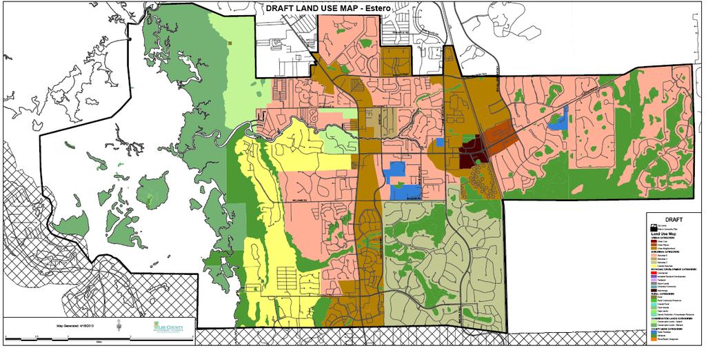
31
Future Land Use and Transportation
 Planning & Zoning Board Workshop Comprehensive Plan for Village of Estero Future Land Use and Transportation April 6, 2017 January Kick-off Meeting Public Input What do you like about Estero? Location
The transportation system in a community is an
 7 TRANSPORTATION The transportation system in a community is an important factor contributing to the quality of life of the residents. Without a sound transportation system to bring both goods and patrons
FUTURE LAND USE ELEMENT
 FUTURE LAND USE ELEMENT GOAL I: To create and sustain a great place to live, play, and prosper Objective 1: The City of Ocala shall incorporate the principles and strategies of the Ocala 2035 Vision into
Lehigh Acres Land Development Regulations Community Planning Project
 Lehigh Acres Land Development Regulations Planning Effort Summary In July, 2010 Commissioner Frank Mann invited the Lehigh Acres community to start discussing how to achieve their recently adopted community
NEW CASTLE COUNTY S ZONING DISTRICTS
 NEW CASTLE COUNTY S ZONING DISTRICTS This is general information about New Castle County s zoning districts. The information included is by no means exhaustive or complete. Before designing plans to develop
The Five Components of the McLoughlin Area Plan
 The Five Components of the McLoughlin Area Plan This documents contains the complete language of the five components of the McLoughlin Area Plan: The Vision Statement The Values The Guiding Principles
City of Long Beach. creating vibrant and exciting places
 City of Long Beach creating vibrant and exciting places Land Use Element Urban Design Element Overview of the two draft General Plan elements Discuss areas of change Economic goals of the plans Case study
Silverdale Regional Center
 Silverdale Regional Center Vision for Silverdale Regional Center The Silverdale Regional Center Plan (Plan) will guide the evolution of the Silverdale Regional Center from a collection of strip malls and
Transportation. Strategies for Action
 Transportation A major priority for the Overlake Neighborhood is to develop a multimodal transportation system. To achieve this system, a balance has to be found among travel, circulation and access needs;
Dwelling Units Max 12 dwelling units per acre/min 8 dwelling units per acre. Development Mix 80% non residential/20% residential
 13. OSTEEN LOCAL PLAN Background: The Osteen Local Plan area is located in southwest Volusia County along the SR 415 corridor between Lemon Bluff Road and Acorn Lake Road and includes 3,990 acres. The
Hockessin Community Redevelopment Plan
 Hockessin Community Redevelopment Plan 3.1 Introduction The Community Redevelopment Plan for the Village of Hockessin is the result of the people s vision for a distinct village center that serves as the
Mark-up of the effect of the proposed Bronte Village Growth Area OPA No.18 on the text of section 24, Bronte Village, of the Livable Oakville Plan
 Mark-up of the effect of the proposed Bronte Village Growth Area OPA No.18 on the text of section 24, Bronte Village, of the Livable Oakville Plan Notes: This document is provided for information purposes
AWH REPORT OF THE PLANNING AND DEVELOPMENT DEPARTMENT FOR APPLICATION FOR REZONING ORDINANCE TO PLANNED UNIT DEVELOPMENT
 AWH REPORT OF THE PLANNING AND DEVELOPMENT DEPARTMENT FOR APPLICATION FOR REZONING ORDINANCE TO PLANNED UNIT DEVELOPMENT MAY 8, 2014 The Planning and Development Department hereby forwards to the Planning
CHAPTER 7: Transportation, Mobility and Circulation
 AGLE AREA COMMUNITY Plan CHAPTER 7 CHAPTER 7: Transportation, Mobility and Circulation Transportation, Mobility and Circulation The purpose of the Transportation, Mobility and Circulation Chapter is to
THEMES, VISION, + PRINCIPLES
 CHAPTER 2: THEMES, VISION, + PRINCIPLES This page intentionally left blank. 20 VISION DRAFT AUGUST 2018 2 2 THEMES, VISION, + GUIDING PRINCIPLES The Key Themes, Vision, and Guiding Principles presented
TREASURE COAST REGIONAL PLANNING COUNCIL M E M O R A N D U M. To: Council Members AGENDA ITEM 5H
 TREASURE COAST REGIONAL PLANNING COUNCIL M E M O R A N D U M To: Council Members AGENDA ITEM 5H From: Date: Subject: Staff October 17, 2008 Council Meeting Local Government Comprehensive Plan Review Draft
CHAPTER 12 IMPLEMENTATION
 CHAPTER 12 IMPLEMENTATION The 2010 Town of Denton Comprehensive Plan is intended to capture a vision of the future of Denton. As such, it provides a basis for a wide variety of public and private actions
Plano Tomorrow Vision and Policies
 Plano Tomorrow Vision and Policies PLANO TOMORROW PILLARS The Built Environment The Social Environment The Natural Environment The Economic Environment Land Use and Urban Design Transportation Housing
CHARLES PUTMAN CHARLES PUTMAN AND ASSOCIATES, INC
 MEMORANDUM CHARLES PUTMAN & ASSOCIATES, INC. LAND DEVELOPMENT CONSULTANTS PLANNING ZONING PERMITTING 4722 NW Boca Raton Boulevard, Suite C-106 Boca Raton, Florida 33431 Phone: 561/994-6411 FAX: 561/994-0447
BROOKHILL NEIGHBORHOOD MODEL ZONING MAP AMENDMENT PREFACE TO APPLICATION
 BROOKHILL NEIGHBORHOOD MODEL ZONING MAP AMENDMENT PREFACE TO APPLICATION June 15, 2015 Revised: August 1, 2016 I. VISION Brookhill is a proposed community based upon the principles of Albemarle County
A. WHAT IS A GENERAL PLAN?
 I. Introduction A. WHAT IS A GENERAL PLAN? A general plan is the planning guideline for the future of a city. It contains goals and policies which regulate urban development, the protection of the natural
Draft Memorandum #1: Goals and Vision for Revitalization
 Keizer Revitalization Plan Draft Memorandum #1: Goals and Vision for Revitalization Submitted to: City of Keizer April 12, 2018 (revised) Prepared By: Angelo Planning Group and Otak, Inc. Project No. 17482.A
Windsor, Connecticut Plan of Conservation & Development DRAFT PLAN SUMMARY
 Windsor, Connecticut 2015 Plan of Conservation & Development DRAFT PLAN SUMMARY Plan Overview What is a Plan? Visionary Advisory Implementable Maintainable What it is not! Regulatory Binding Static Passive
CITY OF TARPON SPRINGS DCA#11-1AR
 Agenda Item #3.H.2 05/09/11 TAMPA BAY REGIONAL PLANNING COUNCIL LOCAL GOVERNMENT COMPREHENSIVE PLAN ADOPTED AMENDMENT REPORT CITY OF TARPON SPRINGS DCA#11-1AR 1 ADOPTED WITH THE FOLLOWING CHANGES: Ordinance
Implementation Guide Comprehensive Plan City of Allen
 Implementation Guide 2030 Comprehensive Plan City of Allen DRAFT 2015 Implementation Guide Allen 2030 Comprehensive Plan INTRODUCTION The Comprehensive Plan serves as a guide for the growth and development
CITY OF PUYALLUP. Background. Development Services
 CITY OF PUYALLUP Development Services 333 South Meridian Puyallup WA 98371 To: City Council From: Katie Baker, AICP, Planning Division Re: South Hill Neighborhood Plan Adoption Date: (Meeting date: February
8implementation. strategies
 PROGRAM STRATEGIES 8implementation strategies T he implementation actions of this chapter are designed to support and carry out the land use, economic development, transportation, urban design, and program
Land Use Amendment in Southwood (Ward 11) at and Elbow Drive SW, LOC
 at and Elbow Drive SW, LOC") 2018 November 15 Page 1 of 10 EXECUTIVE SUMMARY This land use amendment application was submitted by Rick Balbi Architect on 2017 August 31 on behalf of Sable Developments Ltd, and with authorization from
2018 November 15 Page 1 of 10 EXECUTIVE SUMMARY This land use amendment application was submitted by Rick Balbi Architect on 2017 August 31 on behalf of Sable Developments Ltd, and with authorization from
Town Center (part of the Comprehensive Plan)
") Town Center (part of the Comprehensive Plan) Mercer Island Town Center Looking North (2014) In 1994, a year-long process culminated in a set of design guidelines and code requirements for the Town Center
Town Center (part of the Comprehensive Plan) Mercer Island Town Center Looking North (2014) In 1994, a year-long process culminated in a set of design guidelines and code requirements for the Town Center
The Vision. Photo provided by The Minervini Group. 46 Vision, Objectives & Strategies
 Vision, Objectives & Strategies The is the public framework and guide for future development of the Grand Traverse Commons. The establishes public polices for infrastructure, the preservation of natural
PORT WHITBY COMMUNITY
 PORT WHITBY COMMUNITY SECONDARY PLAN UPDATE COMMUNITY IMPROVEMENT PLAN URBAN DESIGN GUIDELINES September 2015 DRAFT PROPOSED AMENDMENT NUMBER # to the Whitby Official Plan PURPOSE: The intent of this Amendment
EXHIBIT A. Tax Increment Reinvestment Zone No. 1 (Town Center) First Amended Project Plan 1
 First Amended Project Plan 1") EXHIBIT A Tax Increment Reinvestment Zone No. 1 (Town Center) First Amended Project Plan 1 1 As amended by Resolution No. 2008-02-001(TR1R) of the Tax Increment Reinvestment Zone No.1, and approved to
EXHIBIT A Tax Increment Reinvestment Zone No. 1 (Town Center) First Amended Project Plan 1 1 As amended by Resolution No. 2008-02-001(TR1R) of the Tax Increment Reinvestment Zone No.1, and approved to
Visioning Statement and Guiding Principles
 Visioning Statement and Guiding Principles Planning for the Future The General Plan The General Plan represents Woodland's shared vision of the future and defines a path to lead the community toward its
West Ocala Vision & Community Plan City Council Work Session. Presented by West Ocala Community Plan Steering Committee
 West Ocala Vision & Community Plan City Council Work Session Presented by West Ocala Community Plan Steering Committee November 29,2011 Ocala 2035 Vision West Ocala Community Vision & Master Plan West
V. Vision and Guiding Principles
 V. Vision and Guiding Principles The Master Plan for the Powers Ferry Corridor seeks a foundation in the desires of the community. At times, various elements of the community offered opposing viewpoints,
4.1.3 LAND USE CATEGORIES
 4.1.3 LAND USE CATEGORIES a. City Center District The City Center District incorporates the existing character and mix of uses in downtown Belmont to encourage redevelopment and new development in keeping
Living in Albemarle County s Urban Places
 Living in Albemarle County s Urban Places ALBEMARLE COUNTY, VIRGINIA A Closer Look at Albemarle s Approach to Managing Growth and Creating Quality Urban Environments www.albemarle.org Page 2 Living in
Gold Line Bus Rapid Transit Transit Oriented Development (BRTOD) Helmo Station Area Plan
 Helmo Station Area Plan") Appendix F Gold Line Bus Rapid Transit Transit Oriented Development (BRTOD) Helmo Station Area Plan Introduction and Purpose of the Plan The Gold Line Bus Rapid Transit facility is an eleven-mile dedicated
Appendix F Gold Line Bus Rapid Transit Transit Oriented Development (BRTOD) Helmo Station Area Plan Introduction and Purpose of the Plan The Gold Line Bus Rapid Transit facility is an eleven-mile dedicated
Be it enacted by the Town Board of the Town of Guilderland that the following new A (Transit Oriented Development (TOD) District) is adopted:
 District) is adopted:") Local Law No. 4 of 2018 (Adoption of 280-18A (Transit Oriented Development District) Be it enacted by the Town Board of the Town of Guilderland that the following new 280-18A (Transit Oriented Development
Local Law No. 4 of 2018 (Adoption of 280-18A (Transit Oriented Development District) Be it enacted by the Town Board of the Town of Guilderland that the following new 280-18A (Transit Oriented Development
CHAPTER 3 VISION, GOALS, & PLANNING PRINCIPLES. City of Greensburg Comprehensive Plan. Introduction. Vision Statement. Growth Management Goals.
 CHAPTER 3 VISION, GOALS, & PLANNING PRINCIPLES Introduction The Greensburg Comprehensive Plan is intended as a working community document. A combination of long and short-term goals, this document is intended
Executive Summary. NY 7 / NY 2 Corridor
 Executive Summary NY 7 / NY 2 Corridor Transportation and Land Use Study December 2005 Prepared for: Town of Colonie Capital District Transportation Committee Prepared by: Introduction: Land use decisions
Proposed Comprehensive Plan Strategies DRAFT for discussion June 28, 2017
 Proposed Comprehensive Plan Strategies DRAFT for discussion June 28, 2017 Land Use Rural Areas Refine the Farm and Forest area (FF) Update FF boundaries to account for existing lots less than five acres
D-O LRT Zoning Discussion. Chapel Hill Boards & Commissions October 16, 2017
 D-O LRT Zoning Discussion Chapel Hill Boards & Commissions October 16, 2017 Update on Overall D-O LRT Station Area Initiative Objectives Design and educate on principles of Good Transit-Oriented Development
DRAFT Subject to Modifications
 TREASURE COAST REGIONAL PLANNING COUNCIL M E M O R A N D U M To: Council Members AGENDA ITEM 8 From: Date: Subject: Staff May 19, 2017 Council Meeting Florida Department of Transportation Complete Streets
Urban Planning and Land Use
 Urban Planning and Land Use 701 North 7 th Street, Room 423 Phone: (913) 573-5750 Kansas City, Kansas 66101 Fax: (913) 573-5796 Email: planninginfo@wycokck.org www.wycokck.org/planning To: From: City Planning
Former Rockcliffe Airbase Community Design Plan Guiding Design Vision and Principles December 4, 2013
 APPENDIX 5 - Guiding Design Vision and Principles Former Rockcliffe Airbase Community Design Plan Guiding Design Vision and Principles December 4, 2013 Vision Statement The redevelopment of the former
EXISTING COMPREHENSIVE PLAN
 EXISTING COMPREHENSIVE PLAN Town Center Land Use Element: V. LAND USE POLICIES Town Center Mercer Island's business district vision as described in "Your Mercer Island Citizen-Designed Downtown" was an
3. VISION AND GOALS. Vision Statement. Goals, Objectives and Policies
 Vision Statement Queen Creek s interconnected network of parks, trails, open spaces and recreation opportunities provide safe and diverse activities and programs that sustain its unique, small town, equestrian
Planning Commission April 4, 2013 BOCC Workshop Page 1
 Planning Commission April 4, 2013 BOCC Workshop Page 1 Planning Commission April 4, 2013 BOCC Workshop Page 2 Planning Commission April 4, 2013 BOCC Workshop Page 3 Planning Commission April 4, 2013 BOCC
ARTICLE 6: Special and Planned Development Districts
 ARTICLE 6: Special and Planned Development Districts 6-10 Traditional Neighborhood Development (TND) District 6-10.10 Purpose and Intent The Traditional Neighborhood Development (TND) District provides
City of Palm Coast 2035 Comprehensive Plan - Goals, Objectives, and Policies EXECUTIVE SUMMARY
 EXECUTIVE SUMMARY INTRODUCTION The original Comprehensive Plan, with two adopted planning timeframes, was adopted in 2004, following the City s incorporation in 1999. The first timeframe is five (5) years
DOMINION BOULEVARD CORRIDOR STUDY AND ECONOMIC DEVELOPMENT STRATEGIC PLAN A MODEL FOR CHESAPEAKE S FUTURE
 DOMINION BOULEVARD CORRIDOR STUDY AND ECONOMIC DEVELOPMENT STRATEGIC PLAN A MODEL FOR CHESAPEAKE S FUTURE Overview I. Draft Plan Process II. Draft Plan Overview a. Market Analysis b. Master Land Use Plan
THE 355/270 CORRIDOR:
 THE 355/270 CORRIDOR: Strategic Ideas for Sustaining a Livable Work Place Project Summary ACCESS LIFE DESIGN HEALTH WORK Montgomery County Planning Department The Maryland-National Capital Park and Planning
Staff Report and Recommendation
 Community Planning and Development Planning Services 201 W. Colfax Ave., Dept. 205 Denver, CO 80202 p: 720.865.2915 f: 720.865.3052 www.denvergov.org/cpd TO: City Council Neighborhoods and Planning Committee
Guiding Principles, Objectives, Strategies and Policies
 Guiding Principles, Objectives, Strategies and Policies Section 1 Introduction These Guiding Principles were adopted as part of the 1999 Athens-Clarke County Comprehensive Plan and are carried over, in
Ten Mile Creek Planning Area
 PLANNING AREA POLICIES TEN MILE CREEK Ten Mile Creek Planning Area Location and Context The Ten Mile Creek Planning Area ( Ten Mile Creek area ) is located south of the current Boise AOCI, generally south
ORANGE COUNTY IMPLEMENTING THE FOUR C s
 ORANGE COUNTY IMPLEMENTING THE FOUR C s East Central Florida Corridor Task Force O R A N G E COUN TY P LA N N I N G DIVISION C O M M U N I T Y, E N V I R O N M E N T A L A N D D E V E L O P M E N T S E
Micco Park Village Development
 FOR SALE Call For Pricing Micco Park Village Development Proposed Project Property Details Micco Park Village Development PRICE Call For Pricing A monumental development opportunity of a lifetime! The
City of Woodinville Planning Commission Study Session. Development Regulations 101: An Overview of Specific Regulatory Items To Help You in 2012
 City of Woodinville Planning Commission Study Session Development Regulations 101: An Overview of Specific Regulatory Items To Help You in 2012 Development Regulations 101 Overview of the Different Zones
ARLINGTON COUNTY, VIRGINIA
 ARLINGTON COUNTY, VIRGINIA County Board Agenda Item Meeting October 15, 2005 DATE: September 28, 2005 SUBJECT: Request to Advertise the adoption of the 2005 Clarendon Sector Plan C. M. RECOMMENDATION:
DRAFT City of Titusville 2040 Comprehensive Plan Future Land Use, Housing, and Transportation Elements April 16, 2018
 DRAFT City of Titusville 2040 Comprehensive Plan Future Land Use, Housing, and Transportation Elements April 16, 2018 Prepared by Canin Associates for the City of Titusville About the Comprehensive Plan:
2040 LUP is a part of the Comprehensive Plan and carries the same legal authority. Economic Challenges
 1.1. Guiding Anchorage s Growth Where will new residents settle over the next two decades? Where will people work, shop, and play? Will there be enough room to grow? How will Anchorage look? Will growth
Small Area Plan. South Gateway
 Small Area Plan Adopted May 12, 2008 South Gateway Purpose. The South Gateway Small Area Plan defines the City s expectations for the future of the southern entrance to the City at Interstate 85 and Highway
2.0 AREA PLANS. Lakeside Business District. Lakeside Business District Land Use Categories:
 Lakeside Business District Lakeside Business District Land Use Categories: Campus Commercial Campus Commercial means a mixture of uses which includes corporate offices, office parks, hotels, commercial,
Port Lavaca Future Land Use
 Port Lavaca Future Land Use Introduction The City of Port Lavaca is beginning to see sustained growth, after many years of relative stable population. New single family homes, apartments, and businesses
TRANSIT-ORIENTED DEVELOPMENT POLICY DRAFT. City Planning and Development Department Kansas City, Missouri
 TRANSIT-ORIENTED DEVELOPMENT POLICY DRAFT City Planning and Development Department Kansas City, Missouri What is Transit Oriented Development (TOD)? Development that focuses land uses around a transit
6 PORT SYDNEY SETTLEMENT AREA
 Section 6 Port Sydney Page 61 6 PORT SYDNEY SETTLEMENT AREA 6.1 Basis and Principles Village of Port Sydney Waterfront Community Existing Services 6.1.1 Port Sydney is an historic settlement that has developed
S A C R A M E N T O C O U N T Y JACKSON HIGHWAY & GRANT LINE EAST VISIONING STUDY
 JACKSON HIGHWAY & GRANT LINE EAST S A C R A M E N T O C O U N T Y P L A N N I N G D E P A R T M E N T SUMMARY AND WORKBOOK November 19, 2008 History of the Visioning Study Sacramento County has two growth
Seneca Meadows. Block 4 Locate office, technology, and medical development adjacent to I Screen views of garage structures from I-270.
 Seneca Meadows Seneca Meadows has an industrial park in its southern end and a mixed-use employment area planned for the north end. The district benefits from extensive I-270 visibility, stream valley
LAND USE ELEMENT. Purpose. General Goals & Policies
 LAND USE ELEMENT Purpose This Land Use Element contains the goals and policies necessary to support the City s responsibility for managing land resources and guiding development through implementing regulations,
Subject: Hendry County Evaluation and Appraisal Report Letter of Understanding - Identification of Major Issues
 HENDRY COUNTY PLANNING & ZONING DEPARTMENT POST OFFICE BOX 2340 165 S. LEE STREET LABELLE, FLORIDA 33975 (863) 675-5240 FAX: (863) 675-5317 SUNCOM 744-4750 November 16, 2007 Mr. Mike McDaniel, Chief Office
CITY OF LANGLEY OFFICIAL COMMUNITY PLAN BYLAW, 2005, NO APPENDIX II - REGIONAL CONTEXT MAP
 CITY OF LANGLEY OFFICIAL COMMUNITY PLAN BYLAW, 2005, NO. 2600 APPENDIX II - REGIONAL CONTEXT MAP ± Legend Agricultural Mixed Employment Industrial Conservation & Recreation Regional City Centre Urban Containment
RECREATION AND OPEN SPACE ELEMENT GOALS, OBJECTIVES, AND POLICIES
 RECREATION AND OPEN SPACE ELEMENT GOALS, OBJECTIVES, AND POLICIES Goal 7 To provide park facilities, recreation programs, and open space resources that are safe, adequate, and accessible to all City residents,
SPRINGHILL LAKE TRANSIT VILLAGE
 Greenbelt Metro Area Sector Plan - Subarea Design Policies and Guidelines - Springhill Lake Transit Village 113 SPRINGHILL LAKE TRANSIT VILLAGE Residential Neighborhood and Village Center CONCEPT Springhill
EXECUTIVE SUMMARY DRAFT CHAPTER 1 INTRODUCTION EXECUTIVE SUMMARY
 CHAPTER 1 EXECUTIVE SUMMARY INTRODUCTION Through the joint efforts of the City of Tulsa planning staff and the Land Services division of Indian Nations Council of Governments (INCOG), the Berryhill Land
Chapter 2: Vision, Goals and Strategies
 Chapter 2: Vision, Goals and Lake Elmo Today & Tomorrow Comprehensive Plan 2040 2 VISION, GOALS & STRATEGIES - DRAFT 4-6-2018 INTRODUCTION Comprehensive Plan Purpose Perhapse the most important objective
4. INDUSTRIAL 53 CASTLE ROCK DESIGN
 4. INDUSTRIAL 53 CASTLE ROCK DESIGN CASTLE ROCK DESIGN 54 4. INDUSTRIAL Overview Well-designed and attractive industrial centers are the product of blending economic realities with both functional and
LAND USE OVERVIEW WHAT YOU WILL FIND IN THIS CHAPTER
 LAND USE WHAT YOU WILL FIND IN THIS CHAPTER Information about the City s expected population and employment growth. Description and capacity of existing and future land use designations. Policies that
PLANNING COMMISSION WORKSESSION AGENDA. City Hall Second Floor Conference Room 9027 Center Street. July 1, :30 PM
 MEMBERS Harry J. Clark, Chairperson Bruce Wood, Vice-Chairperson Russell Harrison Ken Johnson Robert W. Schilpp Martha Wilson PLANNING COMMISSION WORKSESSION AGENDA City Hall Second Floor Conference Room
Lower Merion Commercial Districts Issues and Characteristics Handbook November 2013
 Lower Merion Commercial Districts Issues and Characteristics Handbook November 2013 DRAFT TOWNSHIP-WIDE VISION: To maintain and enhance commercial areas to complement the surrounding high-quality residential
RECREATION, OPEN SPACE AND GREENWAYS ELEMENT GOALS, OBJECTIVES, AND POLICIES
 RECREATION, OPEN SPACE AND GREENWAYS ELEMENT GOALS, OBJECTIVES, AND POLICIES GOAL R-1: DEVELOP A RECREATION, OPEN SPACE AND GREENWAYS SYSTEM AS AN INTEGRAL COMPONENT OF AN OVERALL, COUNTY-WIDE ECONOMIC
Making TOD Work in the Heart of Suburban Sprawl
 Making TOD Work in the Heart of Suburban Sprawl Rocky Mountain Land Use Institute March 6, 2009 Speakers Ben Herman, FAICP, Principal Clarion Associates Darcie White, AICP, Principal Clarion Associates
Secrest Short Cut and Monroe Expressway Small Area Plan AUGUST 29, 2018
 Secrest Short Cut and Monroe Expressway Small Area Plan AUGUST 29, 2018 Background and Process Monroe Expressway will be open by the end of 2018 Union County and Indian Trail identified a need to revisit
STATEMENT OF JUSTIFICATION CLARKSBURG PREMIUM OUTLETS AT CABIN BRANCH NORTH DISTRICT, PHASE
 STATEMENT OF JUSTIFICATION CLARKSBURG PREMIUM OUTLETS AT CABIN BRANCH NORTH DISTRICT, PHASE 1 Southwest Corner of Clarksburg Road and Interstate-270 Clarksburg, Maryland Application for Site Plan #820140160
OVERVIEW OF PLANS FOR THE JEFFERSON COUNTY COUNTRYSIDE FARM In the Context of Quality Place Characteristics
 OVERVIEW OF PLANS FOR THE JEFFERSON COUNTY COUNTRYSIDE FARM In the Context of Quality Place Characteristics By Steve Grabow, Professor and Community Development Educator University of Wisconsin-Extension,
Strategic Growth Area #1 Northampton Boulevard Corridor Area
 Strategic Growth Area #1 Northampton Boulevard Corridor Area Description Strategic Growth Area #1 has established itself as a major employment center in Southside Hampton Roads. Opportunities exist to
LAND USE DESIGNATIONS AND ZONING CLASSIFICATIONS
 LAND USE DESIGNATIONS AND ZONING CLASSIFICATIONS One of the most significant issues addressed within the community plan process is land use. How land is utilized within a community directly affects the
DISCUSSION TOPIC: ST JOHNS RIVER & ITS TRIBUTARIES (BPII) 2030 COMPREHENSIVE PLAN POLICES AND REGULATORY FRAMEWORK
 2030 COMPREHENSIVE PLAN POLICES AND REGULATORY FRAMEWORK") DISCUSSION TOPIC: ST JOHNS RIVER & ITS TRIBUTARIES (BPII) 2030 COMPREHENSIVE PLAN POLICES AND REGULATORY FRAMEWORK St. John s River & Its Tributaries Issue Summary: The St. Johns River is an important
DISCUSSION TOPIC: ST JOHNS RIVER & ITS TRIBUTARIES (BPII) 2030 COMPREHENSIVE PLAN POLICES AND REGULATORY FRAMEWORK St. John s River & Its Tributaries Issue Summary: The St. Johns River is an important
3 Vision and Goals. Vision and Goals. Blueprint for Bloomsburg. Vision. Town of Bloomsburg Comprehensive Plan,
 Vision and Goals 3 Vision and Goals Citizens of the Town of Bloomsburg clearly value their natural and cultural heritage, the walkable, mixed use pattern of downtown, the access to education, and the community
The University District envisions, in its neighborhood
 Envisioning the University District Link Light Rail in Seattle s neighborhoods CIY OF SEALE CONCEP-LEVEL SAION AREA PLANNING RECOMMENDAION RESOLUION # 30165 EXHIBI L Vision 08.2000 he University District
City of Bristol Route 6 Corridor Implementation Program
 City of Bristol Route 6 Corridor Implementation Program FITZGERALD & HALLIDAY, INC. Innovative Planning, Better Communities June 2017 Route 6 Corridor Plan IMPLEMENTATION PROGRAM The following Implementation
Public input has been an important part of the plan development process.
 Lakewood s Comprehensive Plan recognizes that transportation helps shape the community, and that the way the community provides for the safe and efficient movement of people affects the character of the
1.0 VISION STATEMENT. December 6, PRINCIPLES
 Vision Statement Lincoln Regional Airport 1.0 VISION STATEMENT 1.1 City LOCATION of AND OVERVIEW The Easton Lincoln Place Land Use Master Plan identifies the principles, goals, policies, and standards
REGIONAL ACTIVITY CENTER
 DRAFT REGIONAL ACTIVITY CENTER 70 EAST BENCH MASTER PLAN DRAFT 06 Introduction The East Bench Regional Activity center is comprised of large educational, research, medical, and employment centers. These
Metro. Activity Center Design Guidelines. Recommendations For Developing Focused, Mixed-Use Commercial/Residential Centers
 Metro Activity Center Design Guidelines Recommendations For Developing Focused, Mixed-Use Commercial/Residential Centers Metro Activity Centers What is a MAC? Legacy, the adopted guide for the future growth
Somers Point Master Plan
 Somers Point Master Plan Progress Report and Public Meeting August 20, 2014 Master Plan Reexamination Municipal Land Use Law require that all municipalities reexamine their master plan every ten years.
CHAPTER 1. Ms. Guajardo s Class - Central Elementary CH 1 1
 INTRODUCTION CHAPTER 1 Ms. Guajardo s Class - Central Elementary CH 1 1 1.1 SETTING South Centre City is a linear corridor south of Downtown Escondido paralleling Centre City Parkway and South Escondido
DALY CITY VISIONING PROCESS COMMUNITY WORKSHOP 3 MAY 8, 2008
 DALY CITY VISIONING PROCESS COMMUNITY WORKSHOP 3 MAY 8, 2008 PROCESS General Plan - a statement of the community s values, vision and aspirations for now and into the future... Timeframe LONG TERM - 2030
PINE CURVE REZONING. BACKGROUND Purchased as two parcels in 2001 and 2002
 BACKGROUND Purchased as two parcels in 2001 and 2002 WHAT THE PROJECT IS AND IS NOT A Rezoning establishes the land use standards for Annexed and Zoned Greater Downtown District Historic Center September
PINE CURVE REZONING. Property does not meet criteria for open space preservation and is not a candidate for a park
 PINE CURVE REZONING BACKGROUND Purchased as two parcels in 2001 and 2002 Annexed and Zoned Greater Downtown District Historic Center September 25, 2002 and October 7, 2002 WHAT THE PROJECT IS AND IS NOT