Special Exception. Project Name: Mill Branch Crossing (Walmart) Planning Board Review Date: 12/12/13. Staff Report Date: 11/26/13
|
|
|
- Henry Singleton
- 5 years ago
- Views:
Transcription
1 The Maryland-National Capital Park and Planning Commission Prince George s County Planning Department Development Review Division Note: Staff reports can be accessed at Special Exception Application Project Name: Mill Branch Crossing (Walmart) General Data SE-4734 Planning Board Review Date: 12/12/13 Staff Report Date: 11/26/13 Location: East side of Robert Crain Highway (US 301), south of Laurel Bowie Road (MD 197) to Mill Branch Road. Applicant/Address: Wal-Mart Real Estate Business Trust 2001 SE 10th Street Bentonville, AZ Property Owner: Mill Branch Crossing, LLC. 150 White Plains Road Tarrytown, NY Date Accepted: 07/10/13 Planning Board Action Limit: N/A Plan Acreage: Zone: C-S-C Gross Floor Area: 186,933 sq. ft. Lots: N/A Parcels: 8 Planning Area: 71B Tier: Developing Council District: 04 Election District 07 Municipality: 200-Scale Base Map: Bowie 205NE14 Purpose of Application Special exception for a department or variety store over 125,000 square feet in the C-S-C Zone. Notice Dates Informational Mailing 02/05/13 Acceptance Mailing: 07/08/13 07/09/13 Sign Posting Deadline: N/A Staff Recommendation APPROVAL APPROVAL WITH CONDITIONS Staff Reviewer: Tom Lockard Phone Number: Thomas.Lockard@ppd.mncppc.org DISAPPROVAL X DISCUSSION
2 2 SE-4734
3 November 26, 2013 TECHNICAL STAFF REPORT: TO: VIA: FROM: SUBJECT: REQUEST: The Prince George s County Planning Board The Prince George s County District Council Jimi Jones, Zoning Supervisor, Development Review Division Tom Lockard, Planner Coordinator, Zoning Section, Development Review Division Special Exception Application No. SE-4734 Mill Branch Crossing (Walmart) Special exception for a department or variety store over 125,000 square feet in the C-S-C Zone. RECOMMENDATION: DISAPPROAL NOTE: The Planning Board has scheduled this application to be reviewed on the agenda date of December 12, If the Planning Board decides to hear the application, it will be placed on a future agenda. Any person may request the Planning Board to schedule a public hearing. The request may be made in writing prior to the agenda date or in person on the agenda date. All requests must specify the reasons for the public hearing. All parties will be notified of the Planning Board s decision. You are encouraged to become a person of record in this application. The request must be made in writing and addressed to the Prince George s County Office of the Zoning Hearing Examiner, County Administration Building, Room 2184, Governor Oden Bowie Drive, Upper Marlboro, MD Questions about becoming a person of record should be directed to the Hearing Examiner at All other questions should be directed to the Development Review Division at SE-4734
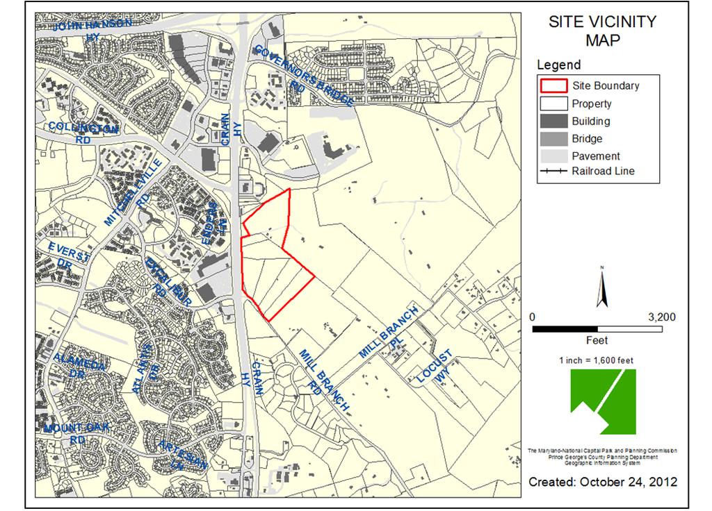
4 FINDINGS A. Location and Field Inspection: The subject property is located in the northeast quadrant of the intersection of Robert Crain Highway (US 301) and Mill Branch Road. The site is comprised of portions of six parcels and contains a total of 24.9 acres. It is part of a larger 74-acre site which was placed in the Commercial Shopping Center (C-S-C) Zone in 2006 and given the appellation Mill Branch Crossing. As presently configured, the special exception site does not have frontage on or access to a public road, although the site plan does show frontage and access through a limited-movement (right-in/right-out) entrance from US 301 consistent with that approved in the prior preliminary plan of subdivision for the site. The site is partially wooded, but is largely cleared from many decades of agricultural use. The site is currently encumbered by a 50-foot access easement (Liber at Folio 685), to the benefit of The Maryland-National Capital Park and Planning Commission (M-NCPPC), which extends northeast from Mill Branch Road along the entire southeastern property line of the site to provide access to the Green Branch Regional Park property abutting to the east and northeast. B. Development Data Summary: EXISTING PROPOSED Zone(s) C-S-C C-S-C Use(s) Vacant, Agriculture Department/Variety store Acreage Lots 0 0 Parcels Parts of 6 Parts of 6 Square Footage/GFA 0 186,933 Variances No No C. History: 1. On March 26, 2002, the 2002 Preliminary General Plan proposal showed the Mill Branch Crossing property in the Rural Tier. The Prince George s County District Council proposed amendments to the Preliminary General Plan by County Council Resolution CR , including Amendment 2 for the Mill Branch Crossing property to be placed in the Developing Tier. 2. On July 16, 2002, a joint public hearing on the amendments proposed by CR was held. The District Council approved the 2002 Prince George s County General Plan (General Plan) in CR on October 7, 2002, with amendments, including Amendment 2 placing the now Mill Branch Crossing property in the Developing Tier. 3. The 2006 Approved Master Plan for Bowie and Vicinity and Sectional Map Amendment for Planning Areas 71A, 71B, 74A, 74B (Bowie Master Plan and SMA) reclassified the site from the Residential-Agricultural (R-A) Zone to the C-S-C Zone. 4. On June 12, 2007, the applicant submitted a Preliminary Plan of Subdivision ( ) for Mill Branch Crossing shopping center. The application was ultimately withdrawn on November 1, On May 28, 2009, the Prince George s County Planning Board approved Preliminary Plan of Subdivision for the Mill Branch Crossing shopping center. The approved 4 SE-4734
5 preliminary plan was for the development of a shopping center and a 150-room hotel on the larger 74-acre property of which the subject site is a portion. Prince George s County Planning Board Resolution No created Parcel A and contains 36 conditions of approval, including the requirement for a detailed site plan prior to final plat. The approved preliminary plan is valid until December 31, No final plat has been filed or recorded for the subject site. 6. On June 8, 2010, the applicant submitted a limited Detailed Site Plan (DSP-10018) for an entrance road onto the 74-acre site. This case remains pending. 7. On January 6, 2011, the applicant requested a reconsideration of Conditions 2, 6, 8, 9, 18, 19, 20, 21, 22, 26, and 32, of PGCPB Resolution No relating to the DSP. On February 3, 2011, the Planning Board denied the request for a waiver of the rules and thus the reconsideration. 8. On March 22, 2012, the applicant submitted a new Preliminary Plan, , to create five parcels for the development of a shopping center and to adjust the previous DSP conditions. This application was ultimately withdrawn. 9. The applicant has submitted a Detailed Site Plan (DSP-13034) for the entire 74-acre site. D. Master Plan Recommendation: The application conforms to the commercial development land use recommendations of the Bowie Master Plan and SMA. However, the application does not conform to the master plan policies, strategies, and guidelines pertaining to the type of commercial building and uses, which specifically discourages big-box commercial uses. The master plan addresses the subject property on pages 12 and 16: POLICY 6: Improve site design to maximize the preservation of environmentally sensitive areas, encourage a diversity of housing types, provide a mix of land uses in appropriate locations, and reduce the cost of providing new roads and other public facilities. Strategies: 1. Recommend development and/or redevelopment in conformance with the following stated land use concept and development guidelines at the following locations: b. Property located at the northeast quadrant of the US 301/Mill Branch Road intersection: This property, given its proximity to the Bowie Regional Center, should be developed with high-quality commercial retail uses, including a hotel. Future development should promote the optimum use of the transportation system and public infrastructure, preserve environmentally sensitive areas, and provide for the needs of workers and residents in the area. The property should be rezoned to a suitable zone, such as the C-S-C (Commercial Shopping Center) Zone, to permit development of elements such as an upscale hotel, etc. The development should incorporate the following design guidelines: (1) The development should include quality department stores but should not include discount or big-box commercial activities. No individual retail uses; other than food or beverage stores (grocery store) shall exceed 125,000 square feet in size. Retail sales of 5 SE-4734
6 alcoholic beverages in a food or beverage store are limited to 5,000 square feet or less. (2) The existing 22-foot easement that provides access to the Green Branch Regional Park should be vacated and replaced by a new temporary easement, fifty feet in width, located on this property at its eastern most property line on Mill Branch Road. The new temporary easement should be vacated when it is replaced by permanent access via a right-of-way to be constructed at the time this property is developed. The new temporary easement on the easternmost property line should form the boundary between the Developing Tier and the Rural Tier. (3) The development should include a pedestrian hiker/biker system that is comprehensively designed to encourage pedestrian and biking activity within the development and with connections to the Green Branch Regional Park and Prince George s Stadium. The master plan s vision and desire for the ultimate development of this site seem to be for something more than what is being proposed by the applicant. A Walmart Supercenter, albeit one more aesthetically pleasing than the older model directly across Crain Highway (US 301) to the west, would seem to staff to be the quintessential example of the big-box discount store being discouraged by the District Council. The applicant is proposing a building that far exceeds the square footage recommendation for a single-use. The applicant explains The proposed building which is 186,933 square feet is not a typical retail use, and does not impair this Master Plan suggestion. The proposed building and department store contains a number of retail uses. The store has three main entrances: one for general merchandise, one for grocery component, and one for the outdoor garden center. In addition, interior space is provided for tenants. Walmart stores of this size typically include tenant space for additional uses such as fast food, banks florists, beauty and health related operators. Notwithstanding the applicant s explanations to the contrary, staff finds this proposal to be a big-box discount development irrespective of the upgraded façade, multiple entrances, and other retail uses proposed within the building footprint. The plan does show the existing 50-foot-wide easement along the southeastern property line and, in fact, proposes an additional 62-foot easement to M-NCPPC, all of which is in an area not included in the special exception. However, it does provide for access to the proposed development and will be the primary access for trucks and customers travelling south on US 301. The applicant has not explained how they intend to meet the second guideline or when this temporary easement will be replaced by a permanent right-of-way. The applicant has provided for sidewalks along internal driveways and within the parking lot, but otherwise does not address or incorporate pedestrian and hiker/biker connectivity between the proposed shopping center and the adjacent Green Branch Regional Park. These would be further analyzed through the DSP process, presumably. The General Plan locates the subject property in the Developing Tier. The vision for the Developing Tier is to maintain a pattern of low- to moderate-density, suburban, residential communities, distinct commercial centers, and employment areas that are increasingly transit-serviceable. 6 SE-4734
7 E. Request: The applicant is proposing to build a square-foot Walmart Supercenter on the subject property. The proposal would incorporate three major uses within one building: a grocery store, a general merchandise store, and a garden center. Additional small tenant retail is also usually found in this type of development. Access is proposed from both Crain Highway (US 301) and via a driveway from Mill Branch Road. A 748-space parking lot fronts the proposed building. The southern and eastern sides of the proposed building, which border farmland in the Rural Tier and a future regional park, are the proposed location of an automotive center and the loading docks/recycling/organic waste/wood pallet storage area, respectively. F. Neighborhood and Surrounding Uses: The subject property is located in a recently annexed portion of the City of Bowie, east of Crain Highway (US 301). The neighborhood is defined by the following boundaries: North East South Green Branch Regional Park The Patuxent River Mill Branch Road West Robert Crain Highway (US 301) This is the same neighborhood as was accepted in the most recent nearby Special Exception, SE-4454 (Locust Lane Farms), approximately 2,500 feet to the southeast. The subject neighborhood has a dual character. To the east and south, it is rural, consisting of farmland and scattered single-family residences. The exceptions are an old golf driving range located at the intersection of Mill Branch Road and Mill Branch Place (seemingly deserted, at present, although the buildings remain) and the Locust Lane Farms landscaping/hydroseeding business at the end of Mill Branch Place. The property to the east, as previously mentioned, is to be developed as a regional park. To the north and west is undeveloped land and retail commercial uses along US 301. The site is surrounded by the following uses: North East South West The remainder of the 74-acre Mill Branch Crossing site, beyond which is an unnamed tributary to Green Branch, a gas station and Rips motel, restaurant, and package store all in the C-S-C Zone. Agricultural land slated for development as the Green Branch Regional Park (M-NCPPC) in the Open Space (O-S) Zone. Undeveloped land and agricultural fields in the R-A Zone. The remainder of the Mill Branch Crossing site in the C-S-C Zone. Across US 301 is the existing Walmart store in the C-S-C Zone. G. Effect of Previous Approvals: When the Planning Board approved Preliminary Plan of Subdivision , it did so subject to 36 conditions including the requirement for a DSP prior to final plat. A DSP was submitted three months subsequent to the subject application and has not been finally accepted. The special exception site plan is essentially the detailed site plan for that portion of the 74-acre site, since a special exception site plan takes precedence over any other 7 SE-4734
8 plan approval (Zoning Ordinance Section [a]). This is not to say, however, that a DSP is not required, just that it will have to be identical to any approved site plan for that portion of the site covered by the special exception. Many of the conditions of approval in the preliminary plan required specific tests and findings be made at the time of the DSP. Logically, many of the conditions related to DSP approval should also be applied with the special exception site plan to avoid the need for revisions. It is therefore recommended that the special exception site plan address these elements at this time, with the caveat that a final plat cannot be recorded until an overall DSP is approved. In light of this, staff has made an effort to assess the relevant conditions from Preliminary Plan and Type I Tree Conservation Plan TCPI/022/07 that have some impact on the special exception. They are divided into areas of interest according to the referring agencies. The numbers correspond to the condition numbers contained in the resolution for Environmental 2. In conjunction with the detailed site plan, a Type II tree conservation plan shall be approved. A revised Type I tree conservation plan (TCPI) was originally submitted with the current application; however, a Type II tree conservation plan (TCPII) is required to be submitted with a special exception site plan. A TCPII was previously submitted with Detailed Site Plan DSP-10018, but did not move forward to approval; however, the same TCPII number is retained for the site and will be applied. A TCPII has been submitted for review with the revised application, and will be addressed in later sections in this memorandum. 3. Development of this site shall be in conformance with the Stormwater Management Concept Plan and any subsequent revisions. A Stormwater Management Concept Approval Letter ( ), valid until October 28, 2014, was submitted with the application. An unapproved Phase I stormwater management concept plan was submitted with the subject application, which shows stormwater management being handled in an underground storage facility as well as numerous small bioretention facilities scattered around the site. The stormwater management concept plan does not match the layout within the area of the current special exception application. It is unclear whether all elements shown on the approved stormwater management concept plan are reflected on the TCPII. After the stormwater management concept approval plan is confirmed by the City of Bowie, all proposed stormwater management elements shall be added to the TCPII. The subject property was annexed into the City of Bowie in 2012, which has local stormwater management authority. Subsequently, a revised Stormwater Management Concept Approval Letter, , was issued by the Prince George s County Department of Permits, Inspection and Enforcement (DPIE) on September 13, 2013, but confirmation has not been received from the City of Bowie that they endorse the revised concept approval. 18. The detailed site plan shall show the use of low-impact development stormwater management techniques such as bioretention, French drains, depressed parking lot 8 SE-4734
9 islands and the use of native plants throughout the site. Low-impact development techniques shall be applied on this site to the greatest extent possible. This condition should be evaluated in conjunction with the review of the special exception, because the special exception site plan will govern within the limits of the special exception. The stormwater management concept plans show the use of some of these techniques, but confirmation from the City of Bowie is necessary concerning the application of the approved concept plan going forward. The Environmental Planning Section will be requesting a revision to the TCPII to show the location of all stormwater management features approved with the stormwater management concept approval, subject to confirmation by the City of Bowie, to assess any conflicts with woodland conservation or impacts to the primary management area which are inconsistent with the impacts approved at the time of preliminary plan or the TCPI. The TCPII plan currently shows numerous bioretention areas scattered throughout the site, which are currently obscured by graphic landscape elements which must be removed from the TCPII plan if they are not credited as woodland conservation. 19. At time of detailed site plan review, the applicant shall demonstrate the use of alternative parking methods and paving materials to reduce the area of impervious surfaces to the greatest extent possible; insert additional green areas and tree canopy to cover to break up the areas of impervious surfaces; provide large islands of shade; and demonstrate the use of low-impact development techniques. This condition should be addressed within the limits of the special exception with the current application. Paving materials, landscape materials, green space, and tree canopy coverage area are all elements which fall under the review authority of the Urban Design Section and are addressed in a later section of this report. Review for the use of low-impact development techniques lies with the City of Bowie, Department of Public Works. The parking areas shown on the site plan are broken up into smaller sections by landscape islands. The parking has been reduced to the minimum required, provided the use comes in as part of an integrated shopping center. 20. The landscape plan submitted at time of detailed site plan shall demonstrate the following: a. A minimum of twenty percent tree canopy coverage, after ten years of growth, to provide shading and reduce the heat-island effect within the parking lot area. b. Planting strips designed to promote long-term growth of trees and increase tree canopy coverage. These strips should be considered for bioretention. c. Distribution of tree planting throughout the site to provide shade to the maximum amount of impervious area. d. The use of conservation landscaping techniques that reduce water consumption to the greatest extent possible. e. Incorporate environmentally sensitive stormwater management techniques throughout. 9 SE-4734
10 f. Provide bufferyard along Parcel 29 to create a transition between the Developing Tier and Rural Tier. These conditions for DSP approval should be addressed within the limits of the special exception with the current application by the Urban Design Section. This will assure that the special exception site plan and the DSP are consistent at the time of final plat. These landscape elements should not be shown on the TCPII, unless they are proposed to be credited as woodland conservation and meet the woodland conservation methodology for on-site landscaping found in Section (c)(K) of the Prince George s County Code. Twenty percent tree canopy coverage is provided and the plans show numerous bioretention areas, mostly within the landscape islands within the parking lot. 26. Prior to submittal of the detailed site plan, a conceptual design for the environmentally sensitive restoration of the problem areas identified in the Stream Corridor Assessment Report shall be prepared and submitted for approval as part of that application. The restoration plan shall include a Coastal Plain Outfall type system, or its equivalent, to slow the velocity of the stormwater running through the stream bed, and stabilize the stream banks to prevent sedimentation into the Patuxent River. The final design shall show integration of the stormwater management and stream restoration. This condition is not applicable to the current special exception application which includes no regulated streams, but will be applied with the DSP for the remainder of the site which includes regulated environmental features and areas requiring stream restoration. 28. Prior to the issuance of any permits which impact wetlands, wetland buffers, streams or Waters of the U.S., the applicant shall submit copies of all federal and state wetland permits, evidence that approval conditions have been complied with, and associated mitigation plans. The limits of the special exception, as currently delineated, do not include any wetlands or wetland buffer, and does not propose impacts to any wetland features regulated by state or federal agencies. This condition may be applicable with the future DSP application. 30. Prior to signature approval of the preliminary plan, the preliminary plan and TCPI shall be revised to show a 40-foot-wide scenic easement, free of parallel public utility easements, adjacent to the ultimate right-of-way of Mill Branch Road. This condition was met prior to signature approval of the preliminary plan. It is not applicable within the currently delineated limits of the special exception application, and will be applied with the DSP for the remainder of the site. 32. The detailed site plan shall address: protection of significant visual features; preservation of existing woodlands; planting of the scenic easement; limiting of access points; supplemental landscaping appropriate to conserve and enhance the viewshed of the historic road; and the relationship between the Developing Tier and Rural Tier. 10 SE-4734
11 Subdivision The above condition should be applied to the current application as applicable, specifically the relationship between the proposed special exception in the Developing Tier and the adjacent Rural Tier. The Rural Tier is located 147 to 213 feet from the proposed structure and 50 feet from proposed circulation elements (including the drive aisle used by trucks for loading purposes and waste removal). There are no woodlands to be retained within the area of interface between the tiers, although a large 3.2-acre woodland reforestation/afforestation area is proposed. A 30-foot-wide landscape strip, consistent with the requirements of the 2010 Prince George s County Landscape Manual (Landscape Manual), is provided along the property line. Although the intersection of the two tiers is partially off the special exception site plan, more information is needed to ensure that this condition is addressed. 4. At the time of final plat, the applicant shall dedicate a ten-foot public utility easement along the public rights-of-way as delineated on the approved preliminary plan of subdivision. The area under review with this special exception contains frontage on an area to be dedicated, which reflects the ten-foot-wide public utility easement. 5. At the time of final plat, the applicant shall dedicate rights-of-way along the property s street frontage consistent with the approved preliminary plan of subdivision, and subsequent detailed site plan if modified by SHA along the frontage of Mill Branch Road. The site plan delineates the right-of-way dedication along the frontage of Mill Branch Road and Crain Highway (US 301) as reflected on the approved preliminary plan. The property frontage along Mill Branch Road is not within the limit of this special exception. However, prior to building permits, dedication should be required for master plan and preliminary plan conformance to ensure adequate access. 6. Prior to the approval of final plats, a detailed site plan shall be approved by the Planning Board in accordance with Part 3, Division 9, of the Zoning Ordinance. The detailed site plan shall include, but not be limited to the following: a. A final determination shall be made by SHA for the ultimate right-of-way dedication along the southern property line at Mill Branch Road, b. Conformance to the Prince George s County Landscape Manual, c. Establishing an appropriate relationship between the Developing and Rural Tiers while taking into account the impact of the proposed commercial development on the rural character of the area and the regional park facility currently under construction to the east, d. The placement and orientation of buildings, landscaping, and driveways, e. The architectural elevations, massing and scale of the improvements, 11 SE-4734
12 f. Evaluate appropriate pedestrian connections and circulation including a connection to the Green Branch Regional Park, g. The use of LID and green building techniques, h. Conformance to the master plan guidelines, i. Viewshed analysis from US 301 corridor. A DSP is required for the site prior to approval of final plats. A DSP was submitted subsequent to the special exception application, and is not yet finally accepted or scheduled for review. The current proposed layout, placement, and orientation of the store with the rear of building closest to the Rural Tier and regional park do not clearly address the issues raised by the Planning Board in the conditions and findings of the preliminary plan, which required an analysis of the relationship of the buildings on this site as it relates to the Rural Tier boundary to the south and east. In addition, the special exception does not propose any pedestrian connection to the regional park and only peripherally addresses any green building techniques, and does not propose any mixed use on the site, which may not be consistent with the master plan guidelines. The special exception must better address Condition 6, which was a result of the master plan and General Plan tier designations and the relationship and impact on abutting properties. 7. An automatic fire suppression system shall be provided in all new buildings proposed in this subdivision, unless the Prince George s County Fire/EMS Department determines that an alternative method of fire suppression is appropriate. Condition 7 should be added to a general note on the special exception. 12. Prior to the issuance of building permits, the applicant, his heirs, successors and/or assignees shall provide a financial contribution of $ to the DPW&T for the placement of a bikeway sign(s) along Mill Branch Road, designated a Class III Bikeway. A note shall be placed on the final plat for payment to be received prior to the issuance of the first building permit. If DPW&T declines the signage, this condition shall be void. Conformance to Condition 12 will be determined at the time of building permits. 13. The applicant and the applicant s heirs, successors and/or assignees shall provide, unless modified by the DPW&T and the SHA: a. Multiuse sidepath for pedestrians and bicyclists on Mill Branch Road connecting to the intersection of US 301 and Excalibur Road. b. Provide a wide crosswalk with pedestrian islands on US 301 to create a safe road crossing and accommodate both pedestrians and bicyclists using the recommended sidepath. c. Raised crosswalks on roads approaching Mill Branch Road to create safe road crossings for pedestrians and bicyclists. 12 SE-4734
13 d. Install bikeway narrows signage on the approach to Mill Branch Road and the site entrance. The site frontage along US 301 and Mill Branch Road are not within the limit of this special exception. Conformance to Condition 13 will be reviewed and determined at the time of the building permits. In fact, presently, the special exception boundary does not front on any public right-of-way. Prior to building permits, adequate dedication will be required in accordance with the approved preliminary plan. 25. The following note shall be placed on the Final Plat of Subdivision: Development is subject to restrictions shown on the approved Type I Tree Conservation Plan (TCPI/022/07), or as modified by the Type II Tree Conservation Plan, and precludes any disturbance or installation of any structure within specific areas. Failure to comply will mean a violation of an approved Tree Conservation Plan and will make the owner subject to mitigation under the Woodland Conservation Ordinance. This property is subject to the notification provisions of CB Copies of all approved Tree Conservation Plans for the subject property are available in the offices of the Maryland-National Capital Park and Planning Commission, Prince George s County Planning Department. Conformance to Condition 25 should be reviewed and determined at the time of final plat. 31. At time of final plat, a scenic easement shall be established adjacent to Mill Branch Road as delineated on the preliminary plan, and a note shall be placed on the final plat as follows: Mill Branch Road is a county designated Historic Road. The scenic easement described on this plat is an area where the installation of structures and roads and/or the removal of vegetation are prohibited without prior written consent from the M-NCPPC Planning Director or designee. The removal of hazardous trees, limbs, branches or trunks is allowed. The scenic easement adjacent to Mill Branch Road is not within the limit of this special exception. Conformance to Condition 31 should be reviewed and determined at the time of final plat. Historic Preservation The Planning Board determined that a Phase III recovery is appropriate for a historic site (Site 18PR857) contained within the special exception area. However, the applicant will be required to return some of the artifacts recovered for display and interpretation back to this site. Prior to the approval of the DSP, the applicant should submit a Phase III mitigation and data recovery plan for review and approval by the Historic Preservation staff and the Historic Preservation Commission. The applicant should provide a final report detailing the Phase III investigations and ensure that all artifacts are curated and some of them then brought back to the site for interpretative exhibits to be determined by the Planning Board at the time of review of the DSP. 13 SE-4734
14 As stated in PGCPB Resolution No , to ensure that an appropriate context is established, and to provide for the greatest benefit for an accurate interpretation of the site, the applicant should submit a proposal for the interpretation of the artifacts recovered which includes detailing the location and type of appropriate displays. The Planning Board will expect a creative and innovative approach to reach a wide audience and be easily accessible, all while ensuring that an appropriate context is established for the artifacts. The locations of the display and interpretation may include a structure(s), a park like setting or may be located in one of the buildings proposed on the site (i.e. the hotel). It is the desire of the Planning Board that the applicant presents a proposal that is inspiring and one which recognizes the importance of this site and the cultural significance is has to the County. 8. Prior to the approval of the detailed site plan, the applicant shall submit a Phase III mitigation and data recovery plan for review and approval by the Historic Preservation staff and the Historic Preservation Commission for 18PR857. The applicant shall provide a final report detailing the Phase III investigations and ensure that all artifacts are curated in a proper manor and brought back to the site for interpretative exhibits to be determined by the Planning Board at the time of review of the Detailed Site Plan. A Phase III mitigation and data recovery plan was submitted to Historic Preservation staff on September 12, The Historic Preservation Commission reviewed and approved the Phase III mitigation and data recovery plan at its September 15, 2009 meeting. Phase III mitigation and data recovery cannot precede until the U.S. Army Corps of Engineers and the Maryland Historical Trust (MHT) completes their Section 106 review of potential impacts to Site 18PR The applicant shall provide interpretive signage detailing the results of the archeological investigations at site 18PR857. The location, wording and timing for its installation shall be reviewed at the time of detailed site plan and be reviewed by the staff archeologist. The Phase III archeological investigation has not been completed and, therefore, Condition 9 above cannot be addressed at this time. In addition, the US Army Corps of Engineers and the Maryland Historical Trust have not completed their Section 106 review of potential impacts to Archeological Site 18PR If Archeological Site 18PR859, located in the northern portion of the property, will be impacted by the proposed development, the applicant shall provide a plan for: a. Evaluating the resource at the Phase II level, or b. Avoiding and preserving the resource in place. Archeological Site 18PR859 will not be impacted by this proposal. 11. If state or federal monies or federal permits are required for this project, Section 106 review may require archeological survey for state or federal agencies. Section 106 of the National Historic Preservation Act (NHPA) requires federal agencies to take into account the effects of their undertakings on historic properties, to include archeological sites. The applicant shall provide proof to Historic Preservation staff that they have forwarded all necessary materials to the Maryland 14 SE-4734
15 Historical Trust for their review of potential effects on historical resources on the subject property prior to approval of final plat. The subject application clearly illustrates that the proposed commercial development would result in the destruction of Site 18PR857. In a letter dated June 4, 2013 (Beth Cole, Administrator, Project Review and Compliance, Maryland Historical Trust to Kathy Anderson, Chief, Maryland Section Southern, Regulatory Branch, Baltimore District, U.S. Army Corps of Engineers), MHT acknowledged the receipt of updated site plans for the Mill Branch Crossing project dated March MHT noted that the redesigned commercial development will still result in the complete destruction of Site 18PR857 and will still constitute an adverse effect on the eighteenth century site. The letter states: If site 18PR857 is located within the Corps area of jurisdiction, the Corps and Mill Branch Crossing LLC will need to continue to coordinate with MHT on specific construction plans and on ways to reduce and/or mitigate the adverse effect on the historic property. If it is determined that site avoidance is not feasible, then Mill Branch Crossing LLC must provide MHT and the Corps with documentation detailing the constraints and providing justification as to why site 18PR857 cannot be avoided during construction. (Please note that both the Corps and MHT were provided with documentation on September 30, 2010 detailing why site avoidance would not be feasible in the case of the originally proposed development. As the proposed site development plans have been significantly altered, the possibility of site avoidance and/or the reduction of impacts must be revisited). If site avoidance is not possible, Phase III data recovery investigations will be warranted to mitigate the undertaking s adverse effects on the archeological resource. Transportation 14. Total development within the subject property shall be limited to a mix of commercial/retail development or equivalent development which generates no more than 606 AM peak-hour trips and 1,017 PM peak-hour (weekdays) vehicle trips, and 1,431 peak trips on Saturdays. Any development generating a traffic impact greater than that identified herein above shall require a new preliminary plan of subdivision with a new determination of the adequacy of transportation facilities. Based on trip generation rates obtained from the Institute of Transportation Engineers (ITE) Trip Generation Manual 9th Edition, 2012, the proposed Walmart Supercenter is expected to generate 282 AM net peak-hour vehicle trips and 582 net PM peak-hour (weekdays) vehicle trips, and 860 net peak trips on Saturdays. This is within the cap set by this condition. 15. At the time of final plat approval, the applicant and the applicant s heirs, successors or assignees shall either: a. Dedicate of right-of-way along Mill Branch Road to facilitate the construction of the master plan interchange and associated improvements on Mill Branch Road as shown on the approved preliminary plan OR b. Dedicate the amount of land on Mill Branch Road to be determined by SHA redesign of the interchange and associated improvements on Mill Branch Road. 15 SE-4734
16 6. At the time of final plat approval, the applicant and the applicant s heirs, successors or assignees, shall dedicate right-of-way along US 301 (including the right-in right-out) as shown on the approved preliminary plan and shall show dedication within MD 197 master plan alignment necessary for the right-in right-out. 17. Prior to the issuance of any building permits within the subject property, the following road improvements shall (a) have full financial assurances through either private money or full funding in the Maryland Department of Transportation Consolidated Transportation Program (CTP) or the Prince George s County Capital Improvement Program (CIP); (b) have been permitted for construction through the operating agency s permitting process; and (c) have an agreed-upon timetable for construction with the appropriate operating agency: a. US 301 at Governors Bridge Road-Harbor Way Modify eastbound Harbor Way from a two lane approach to a three lane approach that would include an eastbound double left turn lane, and a combined left, through and right-turn lane b. US 301 at MD 197-Rip s Restaurant Access Modify the westbound exit from the Rips restaurant to a three (3) lane exit to provide an exclusive left lane, a through lane and a right-turn lane Provide an additional left turn lane along the northbound approach to provide a total of three left-turn lanes Provide three receiving lanes on the western leg (MD 197) of the intersection subject to SHA requirement c. US 301 at Mill Branch Road-Excalibur Road Construct a double southbound left turn along US 301 at Mill Branch Road Widen Mill Branch Road to a four lane westbound approach providing two left-turn lanes, one through lane and a free right-turn lane Provide two receiving lanes on the eastern leg of the intersection (Mill Branch Road) subject to the requirements of SHA and DPW&T Provide a third northbound through lane along US 301 beginning at a point south of Mill Branch Road, and ending at a point north of Mill Branch Road. The beginning and end point of this third lane shall be determined by SHA 16 SE-4734
17 d. US 301 at Heritage Boulevard Re-stripe the southbound right-turn lane along US 301 to a shared through/right lane e. Mill Branch Road at Site Access Provide a double left-turn and a separate through lane on the eastbound approach Provide two receiving lanes on the site access leg On the site access approach leg, provide a channelized free right-turn lane and a separate left-turn lane Install a traffic signal f. US 301 at Site Access Provide a right-in right-out access point on US 301 at the northernmost point of the site, subject to SHA s approval. This access point shall be designed so that left turns from this access point to MD 197 are prohibited. The applicant recognizes and acknowledges their responsibility to provide these dedications and improvements. H. Parks and Recreation Concerns: The Department of Parks and Recreation (DPR) has reviewed the above referenced special exception application submitted jointly by the owner of the property, Mill Branch Crossing LLC, and Wal-Mart Real Estate Business Trust for conformance with the requirements and recommendations of approved Preliminary Plan , the existing Joint Access Easement Agreement (Liber 28018, at Folio 685), current zoning, and Subdivision Regulations, as well as the impact of this special exception on adjacent parkland. DPR staff believes that it should be noted that the access drive from Mill Branch Road shown on the special exception plan will serve both Walmart and Green Branch Park from Mill Branch Road, but this access drive was not included in the special exception application. During the Subdivision and Development Review Committee meeting held on August 2, 2013, DPR staff made a request to revise the boundaries of SE-4734 to include the access drive as part of the special exception because the drive will provide an important vehicular access to Wal-Mart from Mill Branch Road and because it is needed to facilitate the development of the public park. The September 23, 2013 resubmission of SE-4734 does not include the access drive as part of the special exception. The applicant has shown a proposed 62-foot easement to M-NCPPC in the submitted plans, but has not included the easement within the boundaries of the special exception, or requested that the existing 50-foot easement be relocated to the proposed 62-foot easement area. We are assuming that the applicant intends to request relocation of the existing 50-foot-wide easement, which is currently located along the southeastern property line. While DPR has no objection to the applicant s proposed commercial development on this property, the owner of the property has not addressed the need to relocate the existing 50-foot easement that was executed to provide joint access to the adjacent parkland from Mill Branch Road. 17 SE-4734
18 Existing Joint Access Easement As previously noted, the subject property is encumbered by an existing 50-foot-wide joint access easement (Liber 28018, Folio 685) along the southeastern property line. The submitted landscape plan shows a 30-foot landscape buffer within the same area. The access easement was conveyed to M-NCPPC on April 21, 2007 for the installation, construction, reconstruction, maintenance, repair, and operation of a two-lane drive (access drive) for vehicular and pedestrian ingress/egress from Mill Branch Road to the planned Green Branch Athletic Complex. The easement agreement states that the grantor (owner of the property) retains the right to use the easement in common with the grantee (M-NCPPC). In addition, the easement agreement states that the grantor at any time may request the grantee to relocate all or any portion of the right-of-way to a different easement area at the location designated by the grantor at the sole cost and expense of the grantor, and the grantee shall have the same rights and privileges in the new location. In 2009, DPR retained a consultant to prepare plans for the construction of the access drive within the existing easement area as part of the first phase of the Green Branch Athletic Complex development plan. The access drive was designed within the easement area with minimal alteration to existing topography and with minimal impact to the applicant s property. During the review and approval of Preliminary Plan , the owner of the property requested that DPR relocate the planned access drive 45 feet from the southeastern property line in order to accommodate the required 40-foot-wide landscaping buffer between the subject property and adjacent property to the southeast, which is located in the Rural Tier. DPR staff agreed to relocate the access drive 45 feet from the property line. The easement agreement also states that the design of the access drive shall be such that it can readily be assimilated into the ultimate four-lane entrance drive design. After approval of Preliminary Plan , the owner also requested that DPR build the access drive at the elevation suitable for the ultimate four-lane drive. The owner of the property provided proposed elevations for the ultimate four-lane entrance drive to DPR. DPR redesigned the access drive at the elevations proposed by the applicant and agreed to build a 22-foot-wide asphalt cross section ( half- section of the ultimate four-lane drive) as requested by the applicant. The relocation of the access drive from the existing easement area to a new location, and construction of the access drive at the elevation suitable for the ultimate four-line access drive, created additional costs associated with design, engineering, and construction. DPR staff has concerns that this special exception for the portion of the property, including a new layout of the site, may result in the need for redesign of the ultimate four-lane access drive. This would result in additional costs for engineering and construction of the half-section of access drive to be constructed by DPR. Joint Access Drive Construction Status DPR has county-issued permits for construction of the access drive which will serve as half-section of the future four-lane drive through this property (at the location suggested by the Applicant) and construction of the phase-one recreational facilities in the Green Branch Athletic Complex. The construction drawings for the access drive include: grading, stormwater management, soil erosion and sediment control, tree conservation plans, construction details, and horizontal and vertical alignments of the access drive. Since there is no other suitable public access to the Green Branch Athletic Complex available at this time, the development of the access drive through this property is needed to facilitate construction of the first phase of the Green Branch Athletic Complex and provide public access to the new park. Construction of this project cannot begin until a new joint access easement agreement is executed. 18 SE-4734
19 I. Specific Special Exception Requirements for a Department or Variety Stores Combined with Food and Beverage Stores: A department or variety store over 125,000 square feet is permitted in the C-S-C Zone by a special exception. Section of the Zoning Ordinance sets forth the specific special exception requirements for this use: (a) Department or Variety Stores and Department or Variety Stores combined with Food and Beverage Stores permitted in the use tables by Special Exception (SE) in the I-3, C-S-C and C-M zones shall be subject to the following requirements: (1) The site shall have frontage on and direct vehicular access to an existing arterial roadway, with no access to primary or secondary streets. As presently configured, the subject property does not have frontage on or access to an arterial roadway. The site plan shows frontage on an entrance drive off of Crain Highway (US 301) which is proposed to be dedicated to the Maryland State Highway Administration. If this dedication were to transpire, this would satisfy this requirement. The secondary access is to a driveway from Mill Branch Road within an area proposed as an easement to M-NCPPC for shared access to the park property to the east. This section of Mill Branch Road is classified as a local collector, not a primary or secondary street. (2) The applicant shall demonstrate that local streets surrounding the site are adequate to accommodate the anticipated increase in traffic. The subject property is part of a larger site which has an approved preliminary plan. At the time of the preliminary plan, the Planning Board found the surrounding roads to be adequate for development of a mix of commercial uses and a hotel on the site, so long as certain improvements were made to the surrounding road network. The preliminary plan established a trip cap based on a mixture of uses which generates no more than 606 AM peak-hour vehicle trips and 1,017 PM peak-hour (weekdays) vehicle trips, and 1,431 peak trips on Saturdays. The proposed Walmart Supercenter is well within the established trip cap. (3) The site shall contain pedestrian walkways within the parking lot to promote safety. The site plan shows several pedestrian walkways within the parking lot, corresponding to the multiple entrances to the building. Clearly marked pedestrian crosswalks are shown. (4) The design of the parking and loading facilities shall ensure that commercial and customer traffic will be sufficiently separated and shall provide a separate customer loading area at the front of the store. The submitted plan indicates five loading spaces being provided at the rear of the building in the southeastern corner of the site. The loading spaces are shown to have a separate driveway cut from the shared driveway for the shopping center and regional park. The location of these loading spaces, separated from the customer parking lot, and the provision of a special Customer Loading Area in the front of the building on the submitted plan demonstrate conformance to this requirement. 19 SE-4734
Note: Staff reports can be accessed at Zone: I-3. Tier:
 The Maryland-National Capital Park and Planning Commission Prince George s County Planning Department Development Review Division 301-952-3530 Note: Staff reports can be accessed at www.mncppc.org/pgco/planning/plan.htm.
Project Name: MELWOOD HOTEL. Date Accepted: 1/12/04. Waived. Planning Board Action Limit: Plan Acreage: 1.7 Zone: Dwelling Units:
 The Maryland-National Capital Park and Planning Commission Prince George's County Planning Department Development Review Division 301-952-3530 Note: Staff reports can be accessed at www.mncppc.org/pgco/planning/plan.htm.
Note: Staff reports can be accessed at Special Permit Application No.
 The Maryland-National Capital Park and Planning Commission Prince George's County Planning Department Development Review Division 301-952-3530 Note: Staff reports can be accessed at www.mncppc.org/pgco/planning/plan.htm.
SPECIFIC DESIGN PLAN
 The Maryland-National Capital Park and Planning Commission Prince George's County Planning Department Development Review Division 301-952-3530 Note: Staff reports can be accessed at www.mncppc.org/pgco/planning/plan.htm.
R E S O L U T I O N. Single-Family Residence/ Church. 2,488 sq. ft. 2,488 sq. ft. Area Parking Required: Church
 R E S O L U T I O N WHEREAS, the Prince George s County Planning Board is charged with the approval of Detailed Site Plans pursuant to Part 3, Division 9 of the Zoning Ordinance of the Prince George s
Chesapeake Bay Critical Area Conservation Plan
 The Maryland-National Capital Park and Planning Commission Prince George s County Planning Department Development Review Division 301-952-3530 Note: Staff reports can be accessed at www.mncppc.org/pgco/planning/plan.htm.
R E S O L U T I O N. 2. Development Data Summary:
 R E S O L U T I O N WHEREAS, the Prince George s County Planning Board has reviewed Departure from Design Standards DDS-631 requesting a departure to allow the loading space and the driveway to the loading
R E S O L U T I O N. 2. Development Data Summary:
 R E S O L U T I O N WHEREAS, the Prince George s County Planning Board is charged with the approval of Detailed Site Plans pursuant to Part 3, Division 9 of the Zoning Ordinance of the Prince George s
COUNTY COUNCIL OF PRINCE GEORGE'S COUNTY, MARYLAND, SITTING AS THE DISTRICT COUNCIL ORDER AFFIRMING PLANNING BOARD DECISION (CORRECTED)
") Case No. Applicant: Lanham LLLP COUNTY COUNCIL OF PRINCE GEORGE'S COUNTY, MARYLAND, SITTING AS THE DISTRICT COUNCIL ORDER AFFIRMING PLANNING BOARD DECISION (CORRECTED) IT IS HEREBY ORDERED, after review
Case No. Applicant: Lanham LLLP COUNTY COUNCIL OF PRINCE GEORGE'S COUNTY, MARYLAND, SITTING AS THE DISTRICT COUNCIL ORDER AFFIRMING PLANNING BOARD DECISION (CORRECTED) IT IS HEREBY ORDERED, after review
The Maryland-National Capital Park and Planning Commission Prince George's County Planning Department Development Review Division
 The Maryland-National Capital Park and Planning Commission Prince George's County Planning Department Development Review Division 301-952-3530 Note: Staff reports can be accessed at www.mncppc.org/pgco/planning/plan.htm.
DEPARTURE FROM DESIGN STANDARDS DDS-586
 The Maryland-National Capital Park and Planning Commission Prince George s County Planning Department Development Review Division 301-952-3530 Note: Staff reports can be accessed at www.mncppc.org/pgco/planning/plan.htm.
The Maryland-National Capital Park and Planning Commission Prince George's County Planning Department Development Review Division
 The Maryland-National Capital Park and Planning Commission Prince George's County Planning Department Development Review Division 301-952-3530 Note: Staff reports can be accessed at www.mncppc.org/pgco/planning/plan.htm.
12 January 12, 2011 Public Hearing APPLICANT: TAILWIND DEVELOPMENT GROUP,LLC PROPERTY OWNER: CITY OF VIRGINIA BEACH
 12 January 12, 2011 Public Hearing APPLICANT: TAILWIND DEVELOPMENT GROUP,LLC PROPERTY OWNER: CITY OF VIRGINIA BEACH STAFF PLANNER: Faith Christie REQUEST: Conditional Change of Zoning (from PD-H1 Planned
The Maryland-National Capital Park and Planning Commission Prince George's County Planning Department Development Review Division
 The Maryland-National Capital Park and Planning Commission Prince George's County Planning Department Development Review Division 301-952-3530 Note: Staff reports can be accessed at www.mncppc.org/pgco/planning/plan.htm.
1. Request: The subject application is for approval of a gymnasium addition to an existing private school and church.
 R E S O L U T I O N WHEREAS, the Prince George's County Planning Board is charged with the approval of Detailed Site Plans pursuant to Part 3, Division 9 of the Zoning Ordinance of the Prince George's
TCPII/193/ Project Name: BELMONT CREST SUBDIVISION. Date Accepted: 03/08/04. Planning Board Action Limit: Waived. Plan Acreage: 62.
 The Maryland-National Capital Park and Planning Commission Prince George's County Planning Department Development Review Division 301-952-3530 Note: Staff reports can be accessed at www.mncppc.org/pgco/planning/plan.htm.
The Maryland-National Capital Park and Planning Commission Prince George's County Planning Department Development Review Division
 The Maryland-National Capital Park and Planning Commission Prince George's County Planning Department Development Review Division 301-952-3530 Note: Staff reports can be accessed at www.mncppc.org/pgco/planning/plan.htm.
Note: Staff reports can be accessed at Special Exception Application No. SE Tier:
 The Maryland-National Capital Park and Planning Commission Prince George's County Planning Department Development Review Division 301-952-3530 Note: Staff reports can be accessed at www.mncppc.org/pgco/planning/plan.htm.
COUNTY COUNCIL OF PRINCE GEORGE'S COUNTY, MARYLAND, SITTING AS THE DISTRICT COUNCIL ORDER AFFIRMING PLANNING BOARD DECISION, WITH AMENDED CONDITIONS
 Case No. Applicant: Dawn Limited Partnership COUNTY COUNCIL OF PRINCE GEORGE'S COUNTY, MARYLAND, SITTING AS THE DISTRICT COUNCIL ORDER AFFIRMING PLANNING BOARD DECISION, WITH AMENDED CONDITIONS IT IS HEREBY
AWH REPORT OF THE PLANNING AND DEVELOPMENT DEPARTMENT FOR APPLICATION FOR REZONING ORDINANCE TO PLANNED UNIT DEVELOPMENT
 AWH REPORT OF THE PLANNING AND DEVELOPMENT DEPARTMENT FOR APPLICATION FOR REZONING ORDINANCE TO PLANNED UNIT DEVELOPMENT MAY 8, 2014 The Planning and Development Department hereby forwards to the Planning
R E S O L U T I O N. 2. Development Data Summary:
 R E S O L U T I O N WHEREAS, the Prince George's County Planning Board is charged with the approval of Detailed Site Plans pursuant to Part 3, Division 9 of the Zoning Ordinance of the Prince George's
COUNTY COUNCIL OF PRINCE GEORGE S COUNTY, MARYLAND SITTING AS THE DISTRICT COUNCIL FINAL DECISION APPROVAL OF DETAILED SITE PLAN
 Case No.: Applicant: Woodmore Towne Centre at Glenarden, Lots 1 & 2, Nordstrom Woodmore Towne Centre, LLC COUNTY COUNCIL OF PRINCE GEORGE S COUNTY, MARYLAND SITTING AS THE DISTRICT COUNCIL FINAL DECISION
1. Request Construction of a second phase of the Oak Creek Club development to include 86 single-family residential units.
 R E S O L U T I O N WHEREAS, the Prince George's County Planning Board is charged with approval of Specific Design Plans pursuant to Part 8, Division 4 of the Zoning Ordinance of the Prince George's County
The Maryland-National Capital Park and Planning Commission Prince George s County Planning Department Development Review Division
 The Maryland-National Capital Park and Planning Commission Prince George s County Planning Department Development Review Division 301-952-3530 Note: Staff reports can be accessed at www.mncppc.org/pgco/planning/plan.htm.
COMMUNITY DESIGN. GOAL: Create livable and attractive communities. Intent
 COMMUNITY DESIGN Intent An attractive, well-designed County will attract quality development, instill civic pride, improve the visual character of the community, and create a strong, positive image for
WHEREAS, after consideration of the evidence presented at the public hearing on January 14, 2010, the Prince George's County Planning Board finds:
 R E S O L U T I O N WHEREAS, the Prince George s County Planning Board has reviewed DDS-600 requesting a departure for the location of two loading spaces without driveway access along Toledo Terrace in
McDonald s Restaurant - Purcellville Town of Purcellville Special Use Permit Statement of Justification July 24, 2014
 Introduction / Written Statement McDonald s Restaurant - Purcellville McDonald s Corporation is proposing to redevelop the existing McDonald s eating establishment with a drive-through located at 121 N
COUNTY COUNCIL OF PRINCE GEORGE'S COUNTY, MARYLAND SITTING AS THE DISTRICT COUNCIL 2010 Legislative Session. Council Members Dernoga and Olson
 DR- COUNTY COUNCIL OF PRINCE GEORGE'S COUNTY, MARYLAND SITTING AS THE DISTRICT COUNCIL 00 Legislative Session Bill No. CB--00 Chapter No. Proposed and Presented by Introduced by Co-Sponsors The Chairman
COLVER ROAD INDUSTRIAL CONCEPT PLAN
 COLVER ROAD INDUSTRIAL CONCEPT PLAN A CONCEPTUAL LAND USE AND TRANSPORTATION PLAN FOR TA-4 AN URBAN RESERVE AREA OF THE CITY TALENT City of Talent Adopted by City Council Resolution No., June, 2015 PART
Asbury Chapel Subdivision Sketch Plan
 Asbury Chapel Subdivision Sketch Plan PART 1: PROJECT SUMMARY Applicant: NVR Inc. Project Size: +/- 76.13 acres Parcel Numbers: 02101112,02116101,02116112, 02116113 Current Zoning: Transitional Residential
Project Name: Manokeek, Lot 1, Parcel A. Date Accepted: 2/8/2007 Planning Board Action Limit: Waived. Plan Acreage: 1.24 Zone: Dwelling Units:
 The Maryland-National Capital Park and Planning Commission Prince George's County Planning Department Development Review Division 301-952-3530 Note: Staff reports can be accessed at www.mncppc.org/pgco/planning/plan.htm.
MONTGOMERY COUNTY PLANNING DEPARTMENT THE MARYLAND-NATIONAL CAPITAL PARK AND PLANNING COMMISSION
 MONTGOMERY COUNTY PLANNING DEPARTMENT THE MARYLAND-NATIONAL CAPITAL PARK AND PLANNING COMMISSION MCPB Item No. Date: 1/15/2015 Bethesda North Marriott Hotel and Conference Center: Limited Site Plan Amendment
D1 September 11, 2013 Public Hearing APPLICANT:
 D1 September 11, 2013 Public Hearing APPLICANT: BEACH MUNICIPAL FEDERAL CREDIT UNION PROPERTY OWNER: SISTERS II, LLC STAFF PLANNER: Karen Prochilo REQUEST: Conditional Change of Zoning (AG-2 Agriculture
Prepared by: Casey Kempenaar, Senior Planner
 CITY OF CITRUS HEIGHTS PLANNING DIVISION STAFF REPORT PLANNING COMMISSION MEETING September 13, 2017 Prepared by: Casey Kempenaar, Senior Planner REQUEST The applicant requests a Design Review Permit Modification
R E S O L U T I O N. APPROVED PHASE III APPROVED OVERALL Zone(s) M-X-T M-X-T Single-family attached residential Commercial/Retail
 M-X-T M-X-T Single-family attached residential Commercial/Retail") R E S O L U T I O N WHEREAS, the Prince George s County Planning Board is charged with the approval of Detailed Site Plans pursuant to Part 3, Division 9 of the Zoning Ordinance of the Prince George s
R E S O L U T I O N WHEREAS, the Prince George s County Planning Board is charged with the approval of Detailed Site Plans pursuant to Part 3, Division 9 of the Zoning Ordinance of the Prince George s
2 January 13, 2010 Public Hearing APPLICANT: AUTOBELL CAR WASH, INC
 REQUEST: Conditional Use Permit (car wash) 2 January 13, 2010 Public Hearing APPLICANT: AUTOBELL CAR WASH, INC PROPERTY OWNER: MESSER 1060 INDEPENDENCE BOULEVARD STAFF PLANNER: Carolyn A.K. Smith ADDRESS
R E S O L U T I O N. Zone(s) C-S-C C-S-C A developing Integrated Shopping Center with Theater,
 C-S-C C-S-C A developing Integrated Shopping Center with Theater,") R E S O L U T I O N WHEREAS, the Prince George's County Planning Board is charged with the approval of Detailed Site Plans pursuant to Part 3, Division 9 of the Zoning Ordinance of the Prince George's
R E S O L U T I O N WHEREAS, the Prince George's County Planning Board is charged with the approval of Detailed Site Plans pursuant to Part 3, Division 9 of the Zoning Ordinance of the Prince George's
8 February 9, 2011 Public Hearing APPLICANT: 7-ELEVEN, INC.
 . 8 February 9, 2011 Public Hearing APPLICANT: REQUEST: Conditional Use Permit for an automobile service station with a convenience store ADDRESS / DESCRIPTION: 2448 Nimmo Parkway PROPERTY OWNER: COURTHOUSE
MONTGOMERY COUNTY PLANNING DEPARTMENT THE MARYLAND-NATIONAL CAPITAL PARK AND PLANNING COMMISSION
 MONTGOMERY COUNTY PLANNING DEPARTMENT THE MARYLAND-NATIONAL CAPITAL PARK AND PLANNING COMMISSION MCPB Item No. Date: 12-10-15 Leisure World Clubhouse II Addition Fitness Center, Limited Site Plan Amendment
Alternative Compliance
 The Maryland-National Capital Park and Planning Commission Prince George s County Planning Department Development Review Division 301-952-3530 Note: Staff reports can be accessed at www.mncppc.org/pgco/planning/plan.htm.
9 CITY OF VAUGHAN OFFICIAL PLAN AMENDMENT NO BOCA EAST INVESTMENTS LIMITED
 9 CITY OF VAUGHAN OFFICIAL PLAN AMENDMENT NO. 631 - BOCA EAST INVESTMENTS LIMITED The Planning and Economic Development Committee recommends the adoption of the recommendations contained in the following
Procedures IV. V. Rural Road Design Option
 i IV. Procedures A. All applicants required to prepare a Conservation Design Subdivision shall provide the Planning Board with a conceptual conventional subdivision design as well as a proposed layout
The Maryland-National Capital Park and Planning Commission Prince George s County Planning Department Development Review Division
 The Maryland-National Capital Park and Planning Commission Prince George s County Planning Department Development Review Division 301-952-3530 Note: Staff reports can be accessed at www.mncppc.org/pgco/planning/plan.htm.
Executive Summary. NY 7 / NY 2 Corridor
 Executive Summary NY 7 / NY 2 Corridor Transportation and Land Use Study December 2005 Prepared for: Town of Colonie Capital District Transportation Committee Prepared by: Introduction: Land use decisions
4 January 11, 2012 Public Hearing APPLICANT:
 . 4 January 11, 2012 Public Hearing APPLICANT: MID-ATLANTIC AUTO PROPERTY OWNER: DZR, LLC STAFF PLANNER: Leslie Bonilla REQUEST: Conditional Use Permit (truck rental, automobile service, and automotive/bulk
PGCPB No File No R E S O L U T I O N
 R E S O L U T I O N WHEREAS, Joan D. Melvin is the owner of a 4.107-acre parcel of land known as Tax Map 046, Grid C1, said property being in the 7th Election District of Prince George s County, Maryland,
7 February 9, 2011 Public Hearing APPLICANT: 7-ELEVEN, INC.
 7 February 9, 2011 Public Hearing APPLICANT: PROPERTY OWNER: COURTHOUSE MARKETPLACE OUTPARCELS, L.L.C. STAFF PLANNER: Faith Christie REQUEST: Modification of Conditional Change of Zoning approved by the
PLANNED UNIT DEVELOPMENT Date: April 5, 2018
 PLANNED UNIT DEVELOPMENT Date: April 5, 2018 DEVELOPMENT NAME SUBDIVISION NAME LOCATION Robert Myers Robert Myers 2955 and 2989 Dauphin Street (Southeast corner of Dauphin Street and Sage Avenue) CITY
Westwood Shopping Center Sketch Plan, Plan # February 23, 2017 Item # 9
 Westwood Shopping Center Sketch Plan, Plan # 320170010 February 23, 2017 Item # 9 Westwood II Site 64,111 s.f. Manor Care site: vacant two story building HOC-Westwood Towers, 15 story tower To be considered
Note: Staff reports can be accessed at
 The Maryland-National Capital Park and Planning Commission Prince George's County Planning Department Development Review Division 301-952-3530 Note: Staff reports can be accessed at www.mncppc.org/pgco/planning/plan.htm.
Planning Commission Staff Report June 5, 2008
 Owner/Applicant Taylor Village Sacramento Investments Partners, LP c/o Kim Whitney 1792 Tribute Road #270 Sacramento, CA 95815 Staff Recommendation Planning Commission Staff Report Project: File: Request:
MONTGOMERY COUNTY PLANNING DEPARTMENT
 MONTGOMERY COUNTY PLANNING DEPARTMENT THE MARYLAND-NATIONAL CAPITAL PARK AND PLANNING COMMISSION MCPB Item No.: Date: 5-03-18 Pike and Rose, Phase I: Site Plan Amendment No. 82012002D Rhoda Hersson-Ringskog,
Request Modification of Conditions (Automobile Service Station) Staff Recommendation Approval. Staff Planner Jimmy McNamara
 Staff Recommendation Approval. Staff Planner Jimmy McNamara") Applicant Larae Tucker Property Owner Doswell Ventures, LLC Public Hearing May 10, 2017 City Council Election District Princess Anne Agenda Item 3 Request Modification of Conditions (Automobile Service
Applicant Larae Tucker Property Owner Doswell Ventures, LLC Public Hearing May 10, 2017 City Council Election District Princess Anne Agenda Item 3 Request Modification of Conditions (Automobile Service
I. Introduction. Prior Approvals
 Statement of Justification First National Bank 19790 Crystal Rock Drive, Germantown, Maryland Application for Site Plan and Limited Preliminary Plan Amendment I. Introduction DPH Architecture, for First
The transportation system in a community is an
 7 TRANSPORTATION The transportation system in a community is an important factor contributing to the quality of life of the residents. Without a sound transportation system to bring both goods and patrons
The West Vaughan Employment Area Secondary Plan Policies
 Part 2: The West Vaughan Employment Area Secondary Plan Policies 2.1 General Policies It is the policy of Council: 2.1.1. That the West Vaughan Employment Area (the WVEA), identified on Schedule 1, will
R E S O L U T I O N. 2. Development Data Summary:
 R E S O L U T I O N WHEREAS, the Prince George s County Planning Board is charged with the approval of Detailed Site Plans pursuant to Part 3, Division 9 of the Zoning Ordinance of the Prince George s
MONTGOMERY COUNTY PLANNING DEPARTMENT THE MARYLAND-NATIONAL CAPITAL PARK AND PLANNING COMMISSION
 MONTGOMERY COUNTY PLANNING DEPARTMENT THE MARYLAND-NATIONAL CAPITAL PARK AND PLANNING COMMISSION MCPB Item No. Date: 3.10.2016 Site Plan 820160040 Nora School Parker Smith, Planning Technician, Area 1,
Town of Portola Valley General Plan. Nathhorst Triangle Area Plan
 Town of Portola Valley General Plan Amended December 10, 1997 Table of Contents Introduction... 1 Planning Area... 1 Objectives... 2 Principles... 2 Standards... 4 Description... 4 Community Commercial...
MONTGOMERY COUNTY PLANNING DEPARTMENT THE MARYLAND-NATIONAL CAPITAL PARK AND PLANNING COMMISSION
 MONTGOMERY COUNTY PLANNING DEPARTMENT THE MARYLAND-NATIONAL CAPITAL PARK AND PLANNING COMMISSION MCPB Item No. Date: 06-12-14 King of the Nations Christian Fellowship Church: Limited Site Plan Amendment
M E M O R A N D U M July 27, 2018
 M E M O R A N D U M July 27, 2018 To: Southlake 2035 Corridor Planning Committee From: Kenneth Baker, Sr. Director of Planning and Development Services Subject: Item #6 First National Bank Purpose Review,
SECTION 4(f) DE MINIMIS DOCUMENTATION
 DE MINIMIS DOCUMENTATION") SECTION 4(f) DE MINIMIS DOCUMENTATION Illinois Route 60/83 IL 176 to the intersection of IL 60 (Townline Road) Lake County P-91-084-07 Mundelein Park and Recreation District Project Limit SECTION 4(f)
SECTION 4(f) DE MINIMIS DOCUMENTATION Illinois Route 60/83 IL 176 to the intersection of IL 60 (Townline Road) Lake County P-91-084-07 Mundelein Park and Recreation District Project Limit SECTION 4(f)
PART 1: PROJECT SUMMARY. The application is Attachment A. The site plan is Attachment B.
 Belleterre Subdivision Sketch Plan Town Board 8.7.17 Belleterre Subdivision Sketch Plan PART 1: PROJECT SUMMARY Applicant: Bowman Development Project Size: +/- 20.85 acres Parcel Number: 01115104 and 01115121
Request Conditional Use Permit (Car Wash Facility) Staff Recommendation Approval. Staff Planner Jonathan Sanders
 Staff Recommendation Approval. Staff Planner Jonathan Sanders") Applicant Property Owner SunTrust Bank Public Hearing October 10, 2018 City Council Election District Princess Anne Agenda Item 2 Request Conditional Use Permit (Car Wash Facility) Staff Recommendation
Applicant Property Owner SunTrust Bank Public Hearing October 10, 2018 City Council Election District Princess Anne Agenda Item 2 Request Conditional Use Permit (Car Wash Facility) Staff Recommendation
MEMORANDUM. DATE: March 15, Chairman and Members Community Redevelopment Agency. Leif J. Ahnell, C.P.A., C.G.F.O. Executive Director
 MEMORANDUM DATE: March 15, 2019 TO: FROM: Chairman and Members Community Redevelopment Agency Leif J. Ahnell, C.P.A., C.G.F.O. Executive Director SUBJECT: Camino Square, IDA No. CRP-16-02, located at 171
14 October 10, 2012 Public Hearing APPLICANT: MPB, INC
 14 October 10, 2012 Public Hearing APPLICANT: MPB, INC PROPERTY OWNER: MUNDEN & ASSOCIATES, LP STAFF PLANNER: Karen Prochilo REQUEST: Conditional Change of Zoning (AG-1 & AG-2 to Conditional O-2) ADDRESS
WHEREAS, the staff of The Maryland-National Capital Park and Planning Commission recommended APPROVAL of the application with conditions; and
 R E S O L U T I O N WHEREAS, a 503.53-acre parcel of land known as Tax Map 76 in Grid E-3 (Parcels 22, 23 and 30), said property being in the 3rd Election District of Prince George's County, Maryland,
The subject site plan amendment proposes the following revisions to the approved site plan:
 PROPOSED AMENDMENT The subject site plan amendment proposes the following revisions to the approved site plan: 1. The building footprint was modified to accommodate the revised architectural design. 2.
PART 1: PROJECT SUMMARY. Proposed Land Use: 120 single-family lots. The application is Attachment A. The site plan is Attachment B.
 PART 1: PROJECT SUMMARY Applicant: JBH Development, LLC and Hopper Communities, INC Project Size: +/- 80.48 acres Parcel Number: 01513107, 01513108, 01513109, 01513113, 01513120, 01513121, 01513122, 01513124,
R E S O L U T I O N. Zones R-20/T-D-O R-20/T-D-O Use Vacant Single-family Attached (Townhouses) Acreage: Townhouse lots - 131
 Acreage: Townhouse lots - 131") R E S O L U T I O N WHEREAS, the Prince George s County Planning Board is charged with the approval of Detailed Site Plans pursuant to Part 3, Division 9 of the Zoning Ordinance of the Prince George s
R E S O L U T I O N WHEREAS, the Prince George s County Planning Board is charged with the approval of Detailed Site Plans pursuant to Part 3, Division 9 of the Zoning Ordinance of the Prince George s
STATEMENT OF JUSTIFICATION CLARKSBURG PREMIUM OUTLETS AT CABIN BRANCH NORTH DISTRICT, PHASE
 STATEMENT OF JUSTIFICATION CLARKSBURG PREMIUM OUTLETS AT CABIN BRANCH NORTH DISTRICT, PHASE 1 Southwest Corner of Clarksburg Road and Interstate-270 Clarksburg, Maryland Application for Site Plan #820140160
D3 January 14, 2015 Public Hearing
 D3 January 14, 2015 Public Hearing APPLICANT: DONALD J. BOUCHER, JR. PROPERTY OWNER: D.J.B. SERVICE CENTER, LLC STAFF PLANNER: Kristine Gay REQUEST: A. Conditional Change of Zoning (I-1 to B-2) B. Conditional
PGCPB No File No R E S O L U T I O N
 R E S O L U T I O N WHEREAS, First Baptist Church of Glenarden is the owner of a 160.06-acre parcel of land known as Parcel A (approximately 83.24 acres) and Parcel 4 (approximately 77.37 acres), said
PLANNED UNIT DEVELOPMENT & SUBDIVISION STAFF REPORT Date: May 18, 2017
 & PUD-0000102-2017 PLANNED UNIT DEVELOPMENT & SUBDIVISION STAFF REPORT Date: May 18, 2017 NAME SUBDIVISION NAME Dauphin Creek Estates Subdivision Dauphin Creek Estates Subdivision LOCATION CITY COUNCIL
Location and Field Inspection: History: Master Plan Recommendation:
 R E S O L U T I O N WHEREAS, the Prince George s County Planning Board has reviewed Special Permit Application No. SP-130008, Sudsville Laundry, requesting a special permit to construct an addition and
Glenborough at Easton Land Use Master Plan
 Implementation 114 9.0 IMPLEMENTATION 9.1 OVERVIEW This chapter summarizes the administrative procedures necessary to implement the proposed land use plan, infrastructure improvements, development standards,
R E S O L U T I O N. Zone(s) M-X-T M-X-T Vacant Industrial/Office
 M-X-T M-X-T Vacant Industrial/Office") R E S O L U T I O N WHEREAS, the Prince George s County Planning Board is charged with the approval of Detailed Site Plans pursuant to Part 3, Division 9 of the Zoning Ordinance of the Prince George s
R E S O L U T I O N WHEREAS, the Prince George s County Planning Board is charged with the approval of Detailed Site Plans pursuant to Part 3, Division 9 of the Zoning Ordinance of the Prince George s
Applicant Name Phone / Fax / Address City State Zip Code . Property Owner Phone / Fax / Address City State Zip Code
 Master Development Plan Application Community Development Department City of Redmond 411 SW 9 th Street Redmond, Oregon 97756 541-923-7721 541-548-0706 FAX Master Development Plan Fee $38,862.52 File Number
PLANNED DEVELOPMENT (MASTER PLAN & UNIT PLAN)
") Central Permit Center 555 Santa Clara Street Vallejo CA 94590 Business License Building Fire Prevention Planning Public Works 707.648.4310 707.648.4374 707.648.4565 707.648.4326 707.651.7151 PLANNED DEVELOPMENT
Central Permit Center 555 Santa Clara Street Vallejo CA 94590 Business License Building Fire Prevention Planning Public Works 707.648.4310 707.648.4374 707.648.4565 707.648.4326 707.651.7151 PLANNED DEVELOPMENT
Colerain Township report to. Hamilton County Regional Planning Commission. December 2, 2010, 1:00PM. t a f f r e p o r t
 Colerain Township report to Hamilton County Regional Planning Commission December 2, 2010, 1:00PM Preliminary Plan: Case No.: ZA2001-04, Forevergreen Prepared By: Amy Bancroft, Land Use Planner t a f f
SPECIFIC PLAN Requirements
 CITY OF LANCASTER PLANNING DEPARTMENT 44933 Fern Avenue, Lancaster, California 93534 (661) 723-6100 SPECIFIC PLAN Requirements Purpose The purpose of a specific plan is to provide for the logical development
1. Request: The subject application requests the construction of a single-family home in the R-R Zone.
 R E S O L U T I O N WHEREAS, the Prince George's County Planning Board is charged with the approval of Detailed Site Plans pursuant to Part 3, Division 9 of the Zoning Ordinance of the Prince George's
CHESAPEAKE LANDSCAPE ORDINANCE
 CHESAPEAKE LANDSCAPE ORDINANCE CONSERVATION PRESERVATION CZO 19-600 Effective October 16, 2008 BUFFER YARD C PARKING LOT REFORESTATION YEAR 1 REFORESTATION YEAR 4 BUFFER YARD F CBPA REFORESTATION Page
Access Management: An Overview
 Figures 1-5 Below Evolution of development along a highway. In the early stages, land along the road is used for farming with little traffic generated. As time passes, the highway corridor becomes a de
1. Request: The subject application is for approval of a detailed site plan for an integrated shopping center in the R-T Zone.
 R E S O L U T I O N WHEREAS, the Prince George's County Planning Board is charged with the approval of Detailed Site Plans pursuant to Part 3, Division 9 of the Zoning Ordinance of the Prince George's
CITY COUNCIL STUDY SESSION MEMORANDUM
 City and County of Broomfield, Colorado CITY COUNCIL STUDY SESSION MEMORANDUM To: From: Prepared by: Mayor and City Council Charles Ozaki, City and County Manager Kevin Standbridge, Deputy City and County
WHEREAS, after consideration of the evidence presented at the public hearing on September 11, 2008, the Prince George's County Planning Board finds:
 File No.DSDS-648 R E S O L U T I O N WHEREAS, the Prince George's County Planning Board has reviewed DSDS-648 requesting a departure of 571.44 square feet from the maximum permitted sign area of building-mounted
CITY OF KEIZER MASTER PLAN APPLICATION & INFORMATION SHEET
 CITY OF KEIZER MASTER PLAN APPLICATION & INFORMATION SHEET PRE-APPLICATION CONFERENCE Prior to the actual filing of a Master Plan application, it is strongly recommended that the applicant contact Planning
11 May 9, 2012 Public Hearing APPLICANT: KROGER LIMITED PARTNERSHIP I
 REQUEST: Conditional Use Permit (Automobile Service Station (Fuel Sales) ADDRESS / DESCRIPTION: 3901 Holland Drive 11 May 9, 2012 Public Hearing APPLICANT: KROGER LIMITED PARTNERSHIP I PROPERTY OWNER:
STREAM BUFFERS
 88-415 STREAM BUFFERS 88-415-01 PURPOSE In the Kansas City region and throughout the nation, vegetated stream buffers have been clearly shown to protect stream stability and related infrastructure, improve
KASPER. City of Georgetown, Texas PUD Planned Unit Development. December 30, 2015 Revised January 27, 2016
 KASPER City of Georgetown, Texas PUD Planned Unit Development December 30, 2015 Revised January 27, 2016 Applicant: Sentinel Land Company, LLC 4910 Campus Drive Newport Beach, CA Prepared by: SEC Planning
Chapter IV: Development Pattern
 Chapter IV: Development Pattern Introduction The 2002 Prince George s County Approved General Plan designates three growth policy tiers Developed, Developing, and Rural as well as three center designations
2.0 AREA PLANS. Lakeside Business District. Lakeside Business District Land Use Categories:
 Lakeside Business District Lakeside Business District Land Use Categories: Campus Commercial Campus Commercial means a mixture of uses which includes corporate offices, office parks, hotels, commercial,
ARTICLE 6: Special and Planned Development Districts
 ARTICLE 6: Special and Planned Development Districts 6-10 Traditional Neighborhood Development (TND) District 6-10.10 Purpose and Intent The Traditional Neighborhood Development (TND) District provides
R E S O L U T I O N. Parking requirements per the 2009 Approved Port Towns Sector Plan and Sectional Map Amendment:
 R E S O L U T I O N WHEREAS, the Prince George s County Planning Board is charged with the approval of Detailed Site Plans pursuant to Part 3, Division 9 of the Zoning Ordinance of the Prince George s
R E S O L U T I O N. Loading Space (GFA between 2,000-10,000 SF) 1 1
 1 1") R E S O L U T I O N WHEREAS, the Prince George s County Planning Board is charged with approval of Specific Design Plans pursuant to Part 8, Division 4 of the Zoning Ordinance of the Prince George s County
R E S O L U T I O N WHEREAS, the Prince George s County Planning Board is charged with approval of Specific Design Plans pursuant to Part 8, Division 4 of the Zoning Ordinance of the Prince George s County
EXHIBIT B PROJECT NARRATIVE POULSBO MEADOWS
 EXHIBIT B PROJECT NARRATIVE POULSBO MEADOWS Name of Project: Poulsbo Meadows; A Planned Residential Development (PRD)/Plat Applicants Name: PBH Group LLC/Byron Harris PO Box 1010 Silverdale, WA 98038 Description
OFFICE CONSOLIDATION SECONDARY PLAN AREA 22 THE BRAMALEA SOUTH INDUSTRIAL SECONDARY PLAN
 OFFICE CONSOLIDATION SECONDARY PLAN AREA 22 THE BRAMALEA SOUTH INDUSTRIAL SECONDARY PLAN November 2010 EXPLANATORY NOTES (Secondary Plan Area 22) General (pertaining to all secondary plan office consolidations)
SPECIFIC DESIGN PLAN
 The Maryland-National Capital Park and Planning Commission Prince George's County Planning Department Development Review Division 301-952-3530 Note: Staff reports can be accessed at www.mncppc.org/pgco/planning/plan.htm.
Camden County Development Regulations. Updated February 2017
 Camden County Development Regulations Updated February 2017 GENERAL MEETING SCHEDULE OF THE CAMDEN COUNTY PLANNING BOARD All meetings will convene at 6:00 PM on the 4th Tuesday of each month and will be