Table 1: Stormwater Management Information Required
|
|
|
- Benedict Peters
- 5 years ago
- Views:
Transcription
1 KINGSTON PLANNING SCHEME Table 1: Stormwater Management Information Required TYPE OF DEVELOPMENT Medium Scale Residential and/or mixed use developments of 3 to 9 dwellings. Non-residential developments with a new building gross floor area between 500m2 and 1000m2. Subdivision of vacant land between 1,000m2 and 4,999m2. Large Scale Residential and/or mixed use developments of 10 or more dwellings. Non-residential developments with a new building gross floor area greater than 1,000 m2. Subdivision of vacant land greater than 4,999m2. Subdivision of land involving public road networks or public open space as determined by Council. REQUIREMENTS A satisfactorily completed Drainage Declaration in a form approved by the Responsible Authority explaining how the requirements and objectives of this policy will be met. A STORM program output demonstrating how the proposal achieves a 100% rating. A satisfactorily completed Drainage Declaration in a form approved by the Responsible Authority explaining how the requirements and objectives of this policy will be met. An Integrated Water Management Plan (IWMP) including a Water Sensitive Urban Design Response. A MUSIC program output demonstrating how WSUD requirements have been achieved Decision guidelines 24/01/2019 C181king In determining an application, the Responsible Authority will consider, as appropriate: The extent to which the development meets the objectives and requirements of this policy. The requirements of the Kingston Civil Design Requirements for Developers Part A: Integrated Stormwater Management, May Whether the development meets the quality performance objectives set out in the Urban Stormwater Best Practice Environmental Management Guidelines (Victoria Stormwater Committee 1999) as amended. The extent to which the design incorporates WSUD. Whether the proposal is designed and incorporates works to maintain, or improve the quality of stormwater within or exiting the site. Whether appropriate tools and assessment methods have been used and the development meets their targets. Whether the proposal will significantly add to the stormwater discharge or adversely affect the water quality entering the drainage system. Whether the design provides opportunities for water conservation and reuse. Whether stormwater protection measures, such as silt traps, will be used during the construction phase to prevent a loss of stormwater quality as a result of building activities Reference documents 24/01/2019 C181king Kingston Integrated Water Cycle Strategy Plan, February Kingston Civil Design Requirements for Developers Part A: Integrated Stormwater Management, May Urban Stormwater Best Practice Environmental Management Guidelines (Victoria Stormwater Committee) CSIRO Publishing, 1999, as amended. STORM, Melbourne Water, LOCAL PLANNING POLICIES CLAUSE PAGE 2 OF 3
2 KINGSTON PLANNING SCHEME Note: Music, The above reference documents and websites may be amended from time to time. It is intended that these documents and websites (or amended versions) are relevant reference documents to this policy Expiry 24/01/2019 C181king This policy will expire if it is superseded by an equivalent provision in the Victoria Planning Provisions or any relevant regulation as determined by the Minister for Planning. LOCAL PLANNING POLICIES CLAUSE PAGE 3 OF 3
3 KINGSTON PLANNING SCHEME ENVIRONMENTALLY SUSTAINABLE DEVELOPMENT 24/01/2019 C181king This policy applies throughout the City of Kingston to residential and non-residential development that requires a planning permit in accordance with the thresholds in Table 1 of this Policy Policy basis 24/01/2019 C181king Kingston City Council is committed to creating an environmentally sustainable city. Critical to achieving this commitment is for development to incorporate appropriate environmentally sustainable design standards. This policy aims to integrate environmental sustainability principles into land-use planning, new developments and redevelopment of existing infrastructure. This policy provides a framework for early consideration of environmental sustainability at the building design stage in order to achieve the following efficiencies and benefits: Easier compliance with building requirements through passive design; Reduction of costs over the life of the building; Improved affordability over the longer term through reduced running costs; Improved amenity and liveability; More environmentally sustainable urban form; and Integrated water management. If environmentally sustainable design is not considered at the time of planning approval, the ability to achieve environmentally sustainable development (ESD) maybe compromised by the time these matters are considered as part of a building approval. In addition, there may be difficulties or extra costs associated with retro-fitting the development to implement environmentally sustainable design principles. This policy does not prescribe performance outcomes. The policy enables the provision of information and provides decision guidelines which will assist in the assessment of whether development meets environmentally sustainable development objectives. This policy complements a range of non-statutory measures aimed at encouraging environmentally sustainable development. These measures include educating residents and applicants, assisting applicants to use ESD tools, leading by example with Council projects, promotion of exemplary private projects and promotion of the use of materials with favourable life cycle impacts Objectives 24/01/2019 C181king The overarching objective is that development should achieve best practice in environmentally sustainable development from the design stage through to construction and operation. In the context of this policy best practice ESD is defined as a combination of commercially proven techniques, methodologies and systems, appropriate to the scale of development and sit e specific opportunities and constraints, which are demonstrated and locally available and have already led to optimum ESD outcomes. Best practice in the built environment encompasses the full life of the build. The following objectives should be satisfied where applicable: Energy performance To improve the efficient use of energy, by ensuring development demonstrates design potential for ESD initiatives at the planning stage. To reduce total operating greenhouse gas emissions. To reduce energy peak demand through particular design measures (eg, appropriate building orientation, shading to glazed surfaces, optimise glazing to LOCAL PLANNING POLICIES -CLAUSE PAGE 1 OF 4
4 KINGSTON PLANNING SCHEME Policy exposed surfaces, space allocation for solar panels and external heating and cooling systems). Water resources To improve water efficiency. To reduce total operating potable water use. To encourage the collection and reuse of stormwater. To encourage the appropriate use of alternative water sources (eg. greywater). Indoor environment quality To achieve a healthy indoor environment quality for the wellbeing of building occupants, including the provision of fresh air intake, cross ventilation, and natural daylight. To achieve thermal comfort levels with minimised need for mechanical heating, ventilation and cooling. To reduce indoor air pollutants by encouraging use of materials with low toxicity chemicals. To reduce reliance on mechanical heating, ventilation, cooling and lighting systems. To minimise noise levels and noise transfer within and between buildings and associated external areas. Stormwater management To reduce the impact of stormwater run-off. To improve the water quality of stormwater run-off. To achieve best practice stormwater quality outcomes. To incorporate the use of water sensitive urban design, including stormwater reuse. Transport To ensure that the built environment is designed to promote the use of walking, cycling and public transport, in that order. To minimise car dependency. To promote the use of low emissions vehicle technologies and supporting infrastructure. Waste management To ensure waste avoidance, reuse and recycling during the design, construction and operation stages of development. To ensure durability and long term reusability of building materials. To ensure sufficient space is allocated for future change in waste management needs, including (where possible) composting and green waste facilities. Urban ecology To protect and enhance biodiversity within the municipality. To provide environmentally sustainable landscapes and natural habitats, and minimise the urban heat island effect. To encourage the retention of significant trees. To encourage the planting of indigenous vegetation. To encourage the provision of space for productive gardens, particularly in larger residential developments. 24/01/2019 C181king It is policy to ensure innovative technology, design and processes positively influence the sustainability of all development. LOCAL PLANNING POLICIES -CLAUSE PAGE 2 OF 4
5 KINGSTON PLANNING SCHEME It is policy that applications for the types of development listed in Table 1 be accompanied by information which demonstrates how relevant policy objectives will be achieved Application requirements 24/01/2019 C181king An application must be accompanied by either a Sustainable Design Assessment or a Sustainability Management Plan as specified in Table 1, as appropriate. A Sustainable Design Assessment will usually not need to be prepared by a suitably qualified professional. It should: Provide a simple assessment of the development. It may use relevant tools from the examples listed in the table or an alternative assessment approach to the satisfaction of the responsible authority; and Identify environmentally sustainable development measures proposed in response to policy objectives, having regard to the site s opportunities and constraints. A Sustainability Management Plan should: Provide a detailed assessment of the development. It may use relevant tools from the examples listed in the table or an alternative assessment approach to the satisfaction of the responsible authority; and Identify achievable environmental performance outcomes having regard to the objectives of this policy (as appropriate); and Demonstrate that the building has the design potential to achieve the relevant environmental performance outcomes, having regard to the site s opportunities and constraints; and Document the means by which the performance outcomes can be achieved. Various assessment tools have been listed in Table 1 which may be used to assess how the proposed development addresses the objectives of this policy, as appropriate. Table 1 ESD Application Requirements Type of development Application requirements Example tools Accommodation /Mixed Use with residential component 3-9dwellings;or Development of a building for accommodation other than dwellings with a gross floor area of 1000m² to 2499m². 10 or more dwellings; or Development of a building for accommodation other than dwellings with a gross floor area more than 2499m². Non-residential Development of a nonresidential building with a gross floor area of 1,000m² to 2,499m². Sustainable Design Assessment (SDA) Sustainability Management Plan (SMP) Green Travel Plan (GTP) Sustainable Design Assessment (SDA) BESS STORM BESS Green Star MUSIC STORM BESS MUSIC STORM Development of a nonresidential building with a gross floor area more than 2499m². Sustainability Management Plan (SMP) Green Travel Plan (GTP) Green Star BESS MUSIC STORM LOCAL PLANNING POLICIES -CLAUSE PAGE 3 OF 4
6 KINGSTON PLANNING SCHEME Note 1: Note 2: Development (in Table 1) has the same meaning as in Section 3 of the Planning and Environment Act 1987, but does not include subdivision. To remove any doubt, development also includes alteration and additions. In the case of alterations and additions, the requirements of the Policy apply only to the alterations and additions. Mixed Use developments are required to provide the information applicable to each use component of the development Decision guidelines 24/01/2019 C181king In determining an application, the responsible authority will consider as appropriate: The extent to which the development meets the objectives and requirements of this policy from the design stage through to construction and operation. Whether the proposed environmentally sustainable development performance standards are functional and effective to minimise environmental impact. Whether the proposed environmentally sustainable development initiatives are reasonable having regard to the type and scale of the development and any site constraints. Whether an appropriate assessment method has been used. Whether an ESD plan or framework has previously been approved by the responsible authority (whether under a planning control or otherwise) Reference documents 24/01/2019 C181king Note: BESS (Built Environment Sustainability Scorecard) Council Alliance for a Sustainable Built Environment (CASBE), Green Star, Green Building Council of Australia, Nationwide House Energy Rating Scheme (Nat HERS), Department of Climate Change and Energy Efficiency, STORM, Melbourne Water, Urban Stormwater Best Practice Guidelines, CSIRO, The above reference documents and websites may be amended from time to time. It is intended that these documents and websites (or amended versions) are relevant reference documents to this policy Commencement 24/01/2019 C181king This policy does not apply to applications received by the responsible authority before the gazettal date of Amendment GC Expiry 24/01/2019 C181king This policy will expire if it is superseded by an equivalent provision in the Victoria Planning Provisions. LOCAL PLANNING POLICIES -CLAUSE PAGE 4 OF 4
7


8 Monash National Employment and Innovation Cluster Draft Framework Plan March 2017 XXXXXX XXXXXXXXXX PRECINCT STRUCTURE PLAN - July 2016
9 Contents Executive Summary 1 Context 3 Vision 4 Principles 6 Strategic Outcomes 7 1 Grow Employment and Innovation in the Health, Education and Research Precinct 8 2 Boost Jobs Growth and Develop Attractive Employment Areas with Business Town Centres 10 3 Transform the Transport Network to Support Economic Growth of the Cluster 12 4 Develop Public Open Space and Community Infrastructure 14 5 Plan and Deliver Urban Renewal Projects and Strategic Sites Huntingdale Activity Centre Clayton Activity Centre Springvale Activity Centre PMP Printing / Centre Road Precinct Clayton Business Park Sandown Park Station Precinct 23 Implementation 24 Abbreviations 25 Figures Figure 1 Metropolitan Context Map 2 Figure 2 Monash National Employment and Innovation Cluster Framework Plan 5 Figure 3 Health, Education and Research Precinct Plan 9 Figure 4 Employment Areas Plan 11 Figure 5 Transport Plan 13 Figure 6 Open Space and Community Infrastructure Plan 15 Figure 7 Urban Renewal Precincts and Strategic Sites Plan 17 ii MONASH NATIONAL EMPLOYMENT AND INNOVATION CLUSTER - March 2017

10 Executive Summary The Monash National Employment and Innovation Cluster (Monash Cluster) has and will continue to have the largest concentration of jobs outside of the Melbourne Central Business District. Positioned centrally within Melbourne s south-east on key arterial roads, bus routes and the Cranbourne-Pakenham investment and specialised activities providing a good foundation for the growth of knowledge industries. Growing partnerships between the major institutions of Monash University, Monash Medical Centre, Monash Children s Hospital, CSIRO, Australian development facilities will unlock the future potential for growing employment and innovation in the precinct and surrounds. Planning for the long term and strategic public and private investment will provide the potential to double the number of jobs in the precinct. With suitable buildings, services and facilities to serve a new breed of worker and increased accessibility for established and growing areas of Melbourne s south-east it will thrive. The Monash National Employment and Innovation Cluster Framework Plan (the framework plan) sets out a shared vision for the next 30 years to build on the cluster s key assets and boost local employment cluster, encouraging new services and businesses to establish, improving transport links and public transport and creating partnership groups to coordinate business attraction and investment. The framework plan outlines a range of strategic priority outcomes to achieve this vision, including: Identifying priority projects and partnerships to support implementation of the framework plan; A transport plan to increase sustainable transport options and address congestion issues; Investigating high capacity public transport projects for Monash University and Monash Technology Precinct; Accelerating Westall Road extension project delivery; Planning for new business town centres and review of urban design guidelines for development in the Monash Technology Precinct; Precinct planning around railway stations and the Health, Education and Research Precinct to support local living and working opportunities; and Planning for mixed use urban renewal projects at strategic sites, e.g. Clayton Business Park and PMP Printing (Clayton). The framework plan is an important step forward in the implementation of Plan Melbourne It is a coordinating action plan aimed at increasing employment by driving economic growth in the suburbs through coordinated public and private investment. The plan shows that Monash cluster is open for business, that there is a clear investment pipeline and a plan for how this city-shaping project will be delivered. The plan gives the Victorian Government, Councils, developers, business and residential communities development within the Monash Cluster. MONASH NATIONAL EMPLOYMENT AND INNOVATION CLUSTER - March


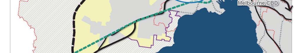
11 Figure 1 Metropolitan Context Map 1 : A m Monash National Employment & Innovation Cluster National Employment & Innovation Clusters urban growth boundary Melbourne CBD public open space Metropolitan Activity Centres freeways railway line Lockerbie 30km Melbourne Airport 20km Broadmeadows Epping Toolern 10km La Trobe Sunshine Sunshine Parkville Footscray Fishermans Bend Box Hill Ringwood Werribee Monash National Employment & Innovation Cluster Avalon Airport Port Phillip Bay Moorabbin Airport Dandenong Dandenong South Fountain Gate - Narre Warren Frankston Copyright, Victorian Planning Authority, 2017 The state of Victoria does not warrant the accuracy or completeness of information in this publication and any person using or relying upon such information does so on the basis that the State of Victoria shall bear no responsibility or liability whatsoever for any errors, faults, defects or omission in the information. 2 MONASH NATIONAL EMPLOYMENT AND INNOVATION CLUSTER - March 2017
12 Context The population of metropolitan Melbourne is forecast to grow to 7.9 million people by The state government s strategic planning policy, Plan Melbourne , provides directions to successfully navigate the challenges associated with this growth. It describes Melbourne as a city of centres linked to regional Victoria. The focus of which is to achieve a productive city that attracts investment, fosters innovation and creates jobs. Driving investment into areas with the potential to foster innovation and growth of the knowledge industries will help sustain an increase in jobs at pace with population growth The Monash Cluster is one of seven major agglomerations of health, education and employment Plan Melbourne. Focussing on these agglomerations and connecting them to bring jobs closer to where people live will help to reduce travel times, minimise greenhouse gas emissions and enable greater localisation of activities which contribute to enhanced livability. The Monash Cluster is located 20km south-east of to the national economy. It supports approximately 75,000 jobs across a diverse range of industries and contributes over $9.4 billion to the Victorian economy each year. It is anticipated that employment numbers within the Monash Cluster have the potential to double over the next 35 years. With the highest concentration of jobs outside the Melbourne Central Business District, nationally skilled local workforce, the Monash Cluster has all the ingredients for a successful modern business destination. Strategic investment in the economic precinct centred upon Monash University, Monash University Business Precinct, Australian Synchrotron, CSIRO, Monash Technology Precinct, Monash Children s Hospital and Monash Medical Centre will contribute to employment growth and ensure that the Monash Cluster has continued economic success. The attraction of the cluster as a middle-suburban destination on the Monash Freeway and the Cranbourne-Pakenham railway line has supported investment. However, increased road congestion, changing business needs and the expectations of a new breed of workers demands innovative approaches in planning for the cluster. The business and worker amenity is at risk of decline in some parts of the cluster. Consistent feedback on these issues have resulted in this cluster, implement public transport improvements, promote public realm enhancements and establish new business town centres as destinations that are home to restaurants, cafes, hotels and retail supporting key employment areas. The planning of the Monash cluster has been underway since The key outcomes and principles presented in this document, have been developed through research and diverse stakeholder enaggement. The plan has evolved from the earlier consultation on the key ideas in April 2016, engagement and subsequent stakeholder consultation have been incorporated in the framework plan. The framework plan aims to facilitate economic key commercial, education, research and health precincts. Unifying the existing world class facilities and enhancing the image and identity of the Monash Cluster as a globally competitive destination for the brightest minds and greatest innovations will support the vision for more jobs closer to where people live. Strategic sites, activity centres and neighbourhoods close to railway stations provide focal areas for addressing future housing shortages. This framework plan is the result of research and consultation over the past three years in collaboration with the Cities of Greater Dandenong, Kingston and Monash, as well as Monash University, research institutions, major businesses, representative organisations and the local community. These ongoing partnerships are an essential part of delivering the framework plan and will be instrumental in the ongoing success of the Monash National Employment and Innovation Cluster as it continues to prosper. MONASH NATIONAL EMPLOYMENT AND INNOVATION CLUSTER - March


13 Vision The Monash National Employment and Innovation Cluster will transform and modernise over the next three decades as a connected and exciting place for employment, education, innovation, leading-edge technology and research. It will be positioned as a globally competitive value-creating economy. The number of jobs will double over the next 35 years health, science and technology sectors. Through place-making, transformative transport projects and urban renewal investment the cluster will be further established as a highly desirable destination with the highest job density outside of a capital city CBD in Australia. Investment in world leading assets such as Monash University, the Monash Medical Centre, CSIRO and the Australian Synchrotron will attract new research institutions and an array of internationally recognised innovative businesses. Delivery of the Westall Road link to Monash Freeway, grade separation of the Cranbourne-Pakenham rail corridor and creation of the new linear parkland will also catalyse change. Employment areas will thrive with the development of new business town centres and the renewal of existing activity centres. This will increase local living and create a focal point for life within the cluster. Attractive and connected walking and cycling routes combined with a turn up and go public transport network will revolutionise access and provide connections to health, education and business destinations. Addressing investment barriers and selecting sites for strategic mixed use renewal will encourage private investment and catalyse changes in the amenity, image and function of these areas. These changes will support a viable 24 hour hub of activity serving the needs of the cluster s major businesses, as well as the worker and resident populations. 4 MONASH NATIONAL EMPLOYMENT AND INNOVATION CLUSTER - March 2017


14 Figure 2 Monash National Employment and Innovation Cluster Framework Plan HUNTINGDALE ROAD FERNTREE GULLY ROAD MONASH FWY Axxess Corporate Park Huntingdale PRINCES HWY NORTH ROAD Ferntree Business Monash Park Business Park Monash University Clayton CSIRO Clayton Monash University Business Park Australian Synchrotron Nexus Business Park MONASH FWY Monash Children s Hospital WELLINGTON ROAD Clayton Monash Medical Centre PMP NOVA core health, education and research precinct high density employment area Monash Technology Precinct supporting employment areas strategic sites: jobs, housing & servicing local needs cluster core and accessible residential areas CLAYTON ROAD CENTRE ROAD POLICE ROAD Jackson Green FAIRBANK ROAD Westall Clayton Business Park SPRINGVALE ROAD PRINCES HWY public open space and recreation focal point for intensification and high-capacity public transport Westall Road preferred freight route proposed Westall Road extension Mile Creek corridor upgrade WESTALL ROAD Springvale Sandown Park Sandown Racecourse investigate high capacity PT Cranbourne-Pakenham rail corridor upgrades and shared use path HEATHERTON ROAD PT modal interchange connect to key destinations Cranbourne-Pakenham linear parkland priority shared path new priority pedestrian and cyclist safe crossing point key destination activity centre - including supporting services, employment and housing enhanced / future activity centre future business town centre (indicative preferred location) existing road network m urban growth boundary MONASH NATIONAL EMPLOYMENT AND INNOVATION CLUSTER - March
15 Principles The following principles provide a common understanding on the foundation for all future activities required to implement the vision. The principles will be used by government organisations, investors, stakeholders and communities. They are also a reference tool supporting decision-making and managing change within the cluster. P1 A diverse economy with local community participation. P2 precincts. P3 Attractive, vibrant and high-quality urban environments attracting investment. P4 Easily recognisable destinations and activity centres where local elements are strongly connected to the broader Cluster s sense of place. P5 Integrated transport networks that support economic growth. P6 Affordable and diverse housing that are P7 Sustainable social infrastructure and open space that meets the needs of people living, working and visiting the Cluster. P8 Sustainable development with increased climate change resilience, integrated water 6 MONASH NATIONAL EMPLOYMENT AND INNOVATION CLUSTER - March 2017
16 Strategic Outcomes These strategic outcomes provide detailed actions to realise the vision for the Monash Cluster. The strategic outcomes below summarise the key activities that will be the focus of planning and investment in the coming decade. These are further detailed overleaf. STRATEGIC OUTCOME 1 Grow employment and innovation in the health, education and research precinct. STRATEGIC OUTCOME 2 employment areas with business town centres. STRATEGIC OUTCOME 3 Transform the transport network to support economic growth of the cluster. STRATEGIC OUTCOME 4 Develop public open space and community infrastructure. STRATEGIC OUTCOME 5 strategic sites. MONASH NATIONAL EMPLOYMENT AND INNOVATION CLUSTER - March
17
18 /07/2018 VC148 COMMERCIAL 2 ZONE Shown on the planning scheme map as B3Z, B4Z or C2Z. Purpose To implement the Municipal Planning Strategy and the Planning Policy Framework. To encourage commercial areas for offices, appropriate manufacturing and industries, bulky goods retailing, other retail uses, and associated business and commercial services. To ensure that uses do not affect the safety and amenity of adjacent, more sensitive uses /09/2018 VC150 Table of uses Section 1 - Permit not required Use Condition Art and craft centre Art gallery Cinema Cinema based entertainment facility Food and drink premises Industry (other than Materials recycling and Transfer station) The site must adjoin, or have access to, a road in a Road Zone. The site must adjoin, or have access to, a road in a Road Zone. The leasable floor area must not exceed 100 square metres. Must not be a purpose shown with a Note 1 or Note 2 in the table to Clause The land must be at least the following distances from land (not a road) which is in a residential zone, Commercial 1 Zone, Capital City Zone, Docklands Zone, land used for a hospital or an education centre or land in a Public Acquisition Overlay to be acquired for a hospital or an education centre: The threshold distance, for a purpose listed in the table to Clause metres, for a purpose not listed in the table to Clause Informal outdoor recreation Mail centre Museum Office Postal agency Railway Restricted retail premises Shop (other than Adult sex product shop, Restricted retail premises and Supermarket) Must adjoin, or be on the same land as, a supermarket when the use commences. The combined leasable floor area for all shops adjoining or on the same land as the supermarket must not exceed 500 square metres. The site must adjoin, or have access to, a road in a Road Zone. Page 1 of 7
19 Use Supermarket Condition The leasable floor area must not exceed 1800 square metres. The site must adjoin, or have access to, a road in a Road Zone. Must be on land within the City of Greater Geelong or within an urban growth boundary in metropolitan Melbourne. Trade supplies Tramway Warehouse (other than Mail centre) Must not be a purpose shown with a Note 1 or Note 2 in the table to Clause The land must be at least the following distances from land (not a road) which is in a residential zone, Commercial 1 Zone, Capital City Zone, Docklands Zone, land used for a hospital or an education centre or land in a Public Acquisition Overlay to be acquired for a hospital or an education centre: The threshold distance, for a purpose listed in the table to Clause metres, for a purpose not listed in the table to Clause Any use listed in Clause Must meet the requirements of Clause Section 2 - Permit required Use Adult sex product shop Condition Must be at least 200 metres (measured by the shortest route reasonably accessible on foot) from a residential zone, land used for a hospital, primary school or secondary school or land in a Public Acquisition Overlay to be acquired for a hospital, primary school or secondary school. Agriculture (other than Animal production and Apiculture) Caretaker's house Education centre Grazing animal production Leisure and recreation (other than Informal outdoor recreation, Major sports and recreation facility and Motor racing track) Materials recycling Motel Place of assembly (other than Art gallery, Carnival, Cinema and Circus and Museum) Residential hotel Page 2 of 7
20 Use Condition Retail premises (other than Food and drink premises, Postal agency, Restricted retail premises, Supermarket and Trade supplies) Supermarket if the section 1 conditions are not met The leasable floor area must not exceed 1800 square metres unless on land within the City of Greater Geelong or within an urban growth boundary in metropolitan Melbourne. The site must adjoin, or have access to, a road in a Road Zone. Transfer station The land must be at least 30 metres from land (not a road) which is in a residential zone, land used for a hospital or an education centre or land in a Public Acquisition Overlay to be acquired for a hospital or an education centre. Utility installation (other than Minor utility installation and Telecommunications facility) Any other use not in Section 1 or 3 Section 3 - Prohibited Use Accommodation (other than Caretaker's house, Motel and Residential hotel) Animal production (other than Grazing animal production) Hospital Major sports and recreation facility Motor racing track /07/2013 VC100 Use of land A use must not detrimentally affect the amenity of the neighbourhood, including through the: Transport of materials, goods or commodities to or from the land. Appearance of any building, works or materials. Emission of noise, artificial light, vibration, smell, fumes, smoke, vapour, steam, soot, ash, dust, waste water, waste products, grit or oil /07/2018 VC148 Subdivision A permit is required to subdivide land. VicSmart applications Subject to Clause 71.06, an application under this clause for a development specified in Column 1 is a class of VicSmart application and must be assessed against the provision specified in Column 2. Page 3 of 7
21 Class of application Subdivide land to realign the common boundary between 2 lots where: Information requirements and decision guidelines Clause The area of either lot is reduced by less than 15 percent. The general direction of the common boundary does not change. Subdivide land into lots each containing an existing building or car parking space where: Clause The buildings or car parking spaces have been constructed in accordance with the provisions of this scheme or a permit issued under this scheme. An occupancy permit or a certificate of final inspection has been issued under the Building Regulations in relation to the buildings within 5 years prior to the application for a permit for subdivision. Subdivide land into 2 lots if: Clause The construction of a building or the construction or carrying out of works on the land: Has been approved under this scheme or by a permit issued under this scheme and the permit has not expired. Has started lawfully. The subdivision does not create a vacant lot /07/2018 VC148 Buildings and works A permit is required to construct a building or construct or carry out works. This does not apply to: The installation of an automatic teller machine. An alteration to an existing building façade provided: The alteration does not include the installation of an external roller shutter. At least 80 per cent of the building facade at ground floor level is maintained as an entry or window with clear glazing. An awning that projects over a road if it is authorised by the relevant public land manager. VicSmart applications Subject to Clause 71.06, an application under this clause for a development specified in Column 1 is a class of VicSmart application and must be assessed against the provision specified in Column 2. Class of application Construct a building or construct or carry out works with an estimated cost of up to $500,000 where the land is not: Information requirements and decision guidelines Clause Within 30 metres of land (not a road) which is in a residential zone. Page 4 of 7
22 Class of application Information requirements and decision guidelines Used for a purpose listed in the table to Clause Used for a Brothel or Adult sex product shop. Maintenance All buildings and works must be maintained in good order and appearance to the satisfaction of the responsible authority /07/2018 VC148 Application requirements Use An application to use land must be accompanied by the following information, as appropriate: The purpose of the use and the types of activities which will be carried out. The likely effects, if any, on adjoining land, including noise levels, traffic, the hours of delivery and despatch of goods or materials, hours of operation and light spill, solar access and glare. The means of maintaining areas not required for immediate use. If an industry or warehouse: The type and quantity of goods to be stored, processed or produced. Whether a Works Approval, or Waste Discharge Licence is required from the Environment Protection Authority. Whether a notification under the Occupational Health and Safety Regulations 2017 is required, a licence under the Dangerous Goods Act 1995 is required, or a fire protection quantity under the Dangerous Goods (Storage and Handling) Regulations 2012 is exceeded. The likely effects on adjoining land, including air-borne emissions and emissions to land and water. Building and works An application to construct a building or construct or carry out works must be accompanied by the following information, as appropriate: A plan drawn to scale which shows: The boundaries and dimensions of the site. Adjoining roads. The location, height and purpose of buildings and works on adjoining land. Relevant ground levels. The layout of existing and proposed buildings and works. All driveway, car parking and loading areas. Proposed landscape areas. All external storage and waste treatment areas. Areas not required for immediate use. Elevation drawings to scale showing the colour and materials of all buildings and works. Construction details of all drainage works, driveways, vehicle parking and loading areas. Page 5 of 7
23 A landscape layout which includes the description of vegetation to be planted, the surfaces to be constructed, site works specification and method of preparing, draining, watering and maintaining the landscape area /07/2018 VC148 Exemption from notice and review An application to subdivide land or construct a building or construct or carry out works is exempt from the notice requirements of section 52(1)(a), (b) and (d), the decision requirements of section 64(1), (2) and (3) and the review rights of section 82(1) of the Act. This exemption does not apply to land within 30 metres of land (not a road) which is in a residential zone, land used for a hospital or an education centre or land in a Public Acquisition Overlay to be acquired for a hospital or an education centre /07/2018 VC148 Decision guidelines General Before deciding on an application, in addition to the decision guidelines in Clause 65, the responsible authority must consider, as appropriate: Use The Municipal Planning Strategy and the Planning Policy Framework. The interface with adjoining zones, especially the relationship with residential areas. The effect that existing uses may have on the proposed use. The drainage of the land. The availability of and connection to services. The effect of traffic to be generated on roads. The interim use of those parts of the land not required for the proposed use. If an industry or warehouse, the effect that the use may have on nearby existing or proposed residential areas or other uses which are sensitive to industrial off-site effects, having regard to any comments or directions of the referral authorities. Subdivision The effect the subdivision will have on the potential of the area to accommodate the uses which will maintain or enhance its competitive strengths. Any natural or cultural values on or near the land. Streetscape character. Landscape treatment. Building and works The movement of pedestrians and cyclists, and vehicles providing for supplies, waste removal, emergency services and public transport. The provision of car parking. The streetscape, including the conservation of buildings, the design of verandahs, access from the street front, protecting active frontages to pedestrian areas, the treatment of the fronts and backs of buildings and their appurtenances, illumination of buildings or their immediate spaces and landscaping of land adjoining a road. Defining the responsibility for the maintenance of buildings, landscaping and paved areas. The availability of and connection to services. Page 6 of 7
24 Any natural or cultural values on or nearby the land. Outdoor storage, lighting, and stormwater discharge. The design of buildings to provide for solar access /07/2018 VC148 Signs Sign requirements are at Clause This zone is in Category 1. Page 7 of 7
25 /07/2018 VC148 SPECIAL BUILDING OVERLAY Shown on the planning scheme map as SBO with a number (if shown). Purpose To implement the Municipal Planning Strategy and the Planning Policy Framework. To identify land in urban areas liable to inundation by overland flows from the urban drainage system as determined by, or in consultation with, the floodplain management authority. To ensure that development maintains the free passage and temporary storage of floodwaters, minimises flood damage, is compatible with the flood hazard and local drainage conditions and will not cause any significant rise in flood level or flow velocity. To protect water quality in accordance with the provisions of relevant State Environment Protection Policies, particularly in accordance with Clauses 33 and 35 of the State Environment Protection Policy (Waters of Victoria) /07/2018 VC148 Flooding management objectives and statement of risk A schedule to this overlay may contain: Flooding management objectives to be achieved. A statement of risk /07/2018 VC148 Buildings and works A permit is required to construct a building or to construct or carry out works, including: A fence. Roadworks, if the water flow path is redirected or obstructed. Bicycle pathways and trails. Public toilets. A domestic swimming pool or spa and associated mechanical and safety equipment if associated with one dwelling on a lot. A rainwater tank with a capacity of not more than 10,000 litres. A pergola or verandah, including an open-sided pergola or verandah to a dwelling with a finished floor level not more than 800mm above ground level and a maximum building height of 3 metres above ground level. A deck, including a deck to a dwelling with a finished floor level not more than 800mm above ground level. A non-domestic disabled access ramp. A dependent person s unit. This does not apply: If a schedule to this overlay specifically states that a permit is not required. To flood mitigation works carried out by the responsible authority or floodplain management authority. To the following works in accordance with plans prepared to the satisfaction of the responsible authority: The laying of underground sewerage, water and gas mains, oil pipelines, underground telephone lines and underground power lines provided they do not alter the topography of the land. Page 1 of 4
26 The erection of telephone or power lines provided they do not involve the construction of towers or poles designed to operate at more than 66,000 volts. To landscaping, driveways, vehicle cross overs, footpaths or bicycle paths if there is no significant change to existing surface levels, or if the relevant floodplain management authority has agreed in writing that the flowpath is not obstructed. To an extension of less than 20 square metres in floor area to an existing building (not including an out-building), where the floor levels are constructed to at least 300mm above the flood level or if the relevant floodplain management authority has agreed in writing that the flowpath is not obstructed. To an upper storey extension to an existing building. To an alteration to an existing building where the original building footprint remains the same and floor levels are constructed to at least 300mm above flood level. To an out-building (including replacement of an existing building) if the out-building is less than 10 square metres in floor area and constructed to at least 150mm above the flood level or the relevant floodplain management authority has agreed in writing that the flowpath is not obstructed. To a replacement building (not including an out-building) if it is constructed to at least 300mm above the flood level and the original building footprint remains the same. The responsible authority may require evidence of the existing building envelope. To fencing with at least 25% openings and with the plinth at least 300mm above the flood level. To a replacement fence in the same location and of the same type and materials as the existing fence. To a pergola or an open deck area with unenclosed foundations. To a carport constructed over an existing carspace. To an in-ground swimming pool and associated security fencing, where the perimeter edging of the pool is constructed at natural surface levels and excavated material is removed from the flowpath. To a tennis court at existing surface level with fencing designed to minimise obstruction to flows. To an aviary or other enclosure for a domestic animal if it is less than 10 square metres in floor area at ground level. To open sided verandahs, open sided picnic shelters, barbeques and park furniture (excluding playground equipment) if there is less than 30mm change to existing surface levels. To radio masts, light poles or signs on posts or attached to buildings. VicSmart applications Subject to Clause 71.06, an application under this clause for a development specified in Column 1 is a class of VicSmart application and must be assessed against the provision specified in Column 2. Class of application Construct a building or construct or carry out works. Information requirements and decision guidelines Clause /07/2018 VC148 Subdivision A permit is required to subdivide land. Page 2 of 4
27 VicSmart applications Subject to Clause 71.06, an application under this clause for a development specified in Column 1 is a class of VicSmart application and must be assessed against the provision specified in Column 2. Class of application Any of the following classes of subdivision: Information requirements and decision guidelines Clause Subdivide land to realign the common boundary between 2 lots where the area of either lot is reduced by less than 15 percent and the general direction of the common boundary does not change. Subdivide land into lots each containing an existing building or car parking space where: The buildings or car parking spaces have been constructed in accordance with the provisions of this scheme or a permit issued under this scheme. An occupancy permit or a certificate of final inspection has been issued under the Building Regulations in relation to the buildings within 5 years prior to the application for a permit for subdivision. Subdivide land into 2 lots if: The construction of a building or the construction or carrying out of works on the land is approved under this scheme or by a permit issued under this scheme and the permit has not expired. The construction or carrying out of the approved building or works on the land has started lawfully. The subdivision does not create a vacant lot /07/2018 VC148 Application requirements Unless otherwise agreed in writing by the relevant floodplain management authority, an application to construct a building or construct or carry out works must be accompanied by a site plan which shows, as appropriate: The boundaries and dimensions of the site. Relevant existing and proposed ground levels, to Australian Height Datum, taken by or under the direction or supervision of a licensed land surveyor. The layout, size and use of existing and proposed buildings and works, including vehicle parking areas. Floor levels of any existing and proposed buildings to Australian Height Datum. Cross sectional details of any basement entry ramps and other basement entries to Australian Height Datum, showing floor levels of entry and exit areas and drainage details. Any other application requirements specified in a schedule to this overlay. Local floodplain development plan If a local floodplain development plan has been developed for the area and has been incorporated into this scheme, an application must be consistent with the plan. Page 3 of 4
28 /07/2018 VC148 Exemption from notice and review An application under this overlay is exempt from the notice requirements of section 52(1)(a), (b) and (d), the decision requirements of section 64(1), (2) and (3) and the review rights of section 82(1) of the Act /07/2018 VC148 Referral of applications An application must be referred to the relevant floodplain management authority under Section 55 of the Act unless in the opinion of the responsible authority, the proposal satisfies requirements or conditions previously agreed to in writing between the responsible authority and the floodplain management authority /07/2018 VC148 Decision guidelines Before deciding on an application, in addition to the decision guidelines in Clause 65, the responsible authority must consider, as appropriate: The Municipal Planning Strategy and the Planning Policy Framework. Any local floodplain development plan. Any comments from the relevant floodplain management authority. The existing use and development of the land. Whether the proposed use or development could be located on flood-free land or land with a lesser flood hazard outside this overlay. The susceptibility of the development to flooding and flood damage. Flood risk factors to consider include: The frequency, duration, extent, depth and velocity of flooding of the site and accessway. The flood warning time available. The danger to the occupants of the development, other floodplain residents and emergency personnel if the site or accessway is flooded. The effect of the development on redirecting or obstructing floodwater, stormwater or drainage water and the effect of the development on reducing flood storage and increasing flood levels and flow velocities. Any other matters specified in a schedule to this overlay. Page 4 of 4
29 19/01/2006 VC37 SCHEDULE TO THE SPECIAL BUILDING OVERLAY Shown on the planning scheme map as SBO 1.0 Permit requirement 19/01/2006 VC37 None specified SPECIAL BUILDING OVERLAY SCHEDULE PAGE 1 OF 1
30
31 21.01 MUNICIPAL PROFILE 19/10/2017 C Locality and Regional Context 19/10/2017 C176 Hume City is located approximately 20 kilometres north-west of the Melbourne CBD and is one of Melbourne s seven growth area municipalities. It is defined by two existingurban areas: the Hume Corridor in the east, and the township of Sunbury to the west of the Hume Corridor (refer to Figure 1). These two urban areas both contain green-field development fronts, and are clearly separated by significant areas of non-urban land, the township of Bulla and Melbourne Airport. The City comprises an area of 504km² and is bound by the Merri Creek, Western Ring Road, Maribyrnong River, Calder Freeway and Jacksons Creek. Hume, together with Whittlesea and parts of Mitchell, forms the Northern Growth Corridor which plays a crucial role in meeting the demands of Melbourne s growing population. The Northern Growth Corridor will ultimately see the urban area of metropolitan Melbourne extended to encompass Beveridge and Wallan. Sunbury, along with Diggers Rest (in the City of Melton) forms part of the Sunbury/Diggers Rest Growth Corridor. Hume is a key gateway to the north of Melbourne and has excellent access to freeways and arterial roads, providing good accessibility to the Melbourne CBD, Melbourne Airport and the Port of Melbourne. Hume also has commuter rail links through the Upfield, Craigieburn and Sunbury lines, and freight links via the national rail line running from Melbourne to Sydney. The proposed Western Intermodal Freight Terminal and Beverage Intermodal Freight Terminal, whilst not located in Hume, will result in increased freight transport through the municipality. The proposed Outer Metropolitan Ring Road, when constructed, will run through Hume adjacent to the Hume Corridor. Hume s economy currently generates $27 billion worth of output and has a significant impact on Victoria s economic performance. Hume is home to a number of employment areas including large strategic employment hubs within and around the Melbourne Airport and along the Hume Highway, which cater for much of the manufacturing, transport and logistics demands of Melbourne. Sunbury provides a smaller, but important, role in providing employment and meeting the economic needs of the wider Macedon Region. Melbourne Airport is designated as a Transport Gateway and is one of Victoria s key strategic assets and economic drivers. Directly employing around 12,500 people, it is one of the largest employment generators in Melbourne. Broadmeadows and the future Donnybrook (Lockerbie) Town Centre are identified as Metropolitan Activity Centres. Broadmeadows is intended to strengthen its role as a key centre in the north, supporting the growing population of Hume and the wider Northern Subregion. Hume supports a rich natural heritage including significant landscape features, such as creeks, escarpments and hill tops, areas of native vegetation and biodiversity, and a number of significant aboriginal cultural features. MUNICIPAL STRATEGIC STATEMENT -CLAUSE PAGE 1 OF8


32 Figure 1: Regional Context Map MUNICIPAL STRATEGIC STATEMENT -CLAUSE PAGE 2 OF8
33 Key Issues and Influences 19/10/2017 C176 The key issues and influences facing Hume are: Population growth and changing demographics Hume s population is predicted to grow rapidly from about 198,500 in 2016 to 345,500 by 2041, and will ultimately be around 420,000 once all current growth area land is developed. Population growth will primarily be driven by greenfield development in the growth areas of Greenvale, Craigieburn, Merrifield, Lockerbie and Sunbury, but also the intensification of established suburbs such as Broadmeadows. Hume s demographic profile is becoming more diverse in terms of age, household size and structure, ethnicity and household income. The demographic profile of new growth areas will continue to be driven by young families, however established areas are aging and household sizes are shrinking. The southern end of the Hume Corridor experiences greater levels of disadvantage, with Broadmeadows and Dallas ranking among Victoria s most socially disadvantaged suburbs. Housing and infrastructure needs Changing demographics and economic factors are generating the need for more diverse forms of housing to ensure that Hume s residents have access to a range of appropriate and affordable housing that meets their housing needs as they change over time, and that they are able to remain and age in their local community. Demand for greater housing diversity will affect suburbs differently, with more pronounced effects at the southern end of the Hume Corridor and around the Sunbury Town Centre where there is a larger ageing population and a greater number of smaller households. A reduction in the average lot size in green-field development over the last decade is creating new suburbs with limited scope for future redevelopment opportunities. The rate and scale of the growth is generating greater demand for state and federal funding towards major infrastructure, including critical transport infrastructure and higher order health, education, leisure and sports facilities, and for its timely delivery. There is a need to ensure that development is sequenced to provide new communities with the timely access to local infrastructure. This includesthe provision of local employment and shopping opportunities, and local health, recreation and community service and facilities. There is a need to ensure that community infrastructure in established areas continues to meet the need of the community as the demographics change. Growing and diversifying the economy Hume s economy is dominated by the manufacturing, transport and logistics sectors, which together account for nearly half of Hume s employment base, with limited job opportunities in professional services. Lack of diversity and choice of jobs contributes to high levels of unemployment and results in large numbers of residents leaving the municipality to access work every day, especially from Sunbury. MUNICIPAL STRATEGIC STATEMENT -CLAUSE PAGE 3 OF8
34 It is critical that Hume s employment base expands and diversifies to accommodate the anticipated decline of the manufacturing section, and the municipalities growing population. Economic assessments identify an aspirational but realistic employment target for Hume of 150,000 jobs in the Hume Corridor and 30,000 jobs in Sunbury. Achieving this will require large areas of new employment land, as well as new large scale office, health and education precincts. It will also require significant investment from the State in improved transport infrastructure to maintain accessibility and connect people to businesses, and in improved educationand training facilities and services. Protecting the operation of Melbourne Airport The importance of the Melbourne Airport to the State s economy, and the accessibility of Melbourne to global markets, depends upon the continued curfew free operation of the airport. As the airport continues to grow it will attract significant demand for development in proximity to the airport. It will also generate an increase in traffic and increased aircraft noise. Council recognises the need to achieve a balanced approach that protects the curfew free status of the airport and supports economic growth and businesses, whilst at the same time minimising the impactsonexistingresidents. The airport is currently the largest trip generator outside the Melbourne CBD. However it suffers from limited public transport and road connectivity. As the airport continues to grow there will be an urgent need for better accessibility to the airport from both Sunbury and the Hume Corridor. Improving the transport network Population growth is exceeding the rate of improvement in the transport network and a number of arterial roads are operating above capacity. The arterial road and freeway network is crucial to the economic success and productivity of Hume s freight, transport and manufacturing businesses, particularly in the Hume Corridor. Maintaining the efficiency of the road network and improving east-west connectivity is crucial to maintaining Hume s productivity, and for growing and attracting new businesses. The lack of connectivity across Jacksons Creek and the rail line in Sunbury will become more problematic as Sunbury grows. Hume s community is highly car dependent, due to limited and infrequent public transport services, overcrowding on some train services, and limited walking and cycling opportunities. A combination of land use changes and increased capacity in the transport network and public transport services is needed to assist in accommodatingthe anticipated scale of growth within Hume. Protecting Hume s natural and cultural heritage There are many significant natural and cultural heritage features located throughout the municipality. A significant number are located within the Urban Growth Boundary, including in areas identified for future development in either existing or proposed Precinct Structure Plans. The future growth of Hume has significant implications for the retention and protection of biodiversity and landscape values, as well as the conservation of cultural heritage. MUNICIPAL STRATEGIC STATEMENT -CLAUSE PAGE 4 OF8
35 Hume s natural and cultural heritage needs to be carefully managed to ensure these assets are protected, whilst providing valuable opportunities for public access and leisure opportunities. Improving the image of the Hume Corridor The image and appearance of the Hume Corridor has been characterised by its industrial history which presents poor visual and amenity outcomes to long sections of the southern arterial road network and to key gateways into the municipality. Protecting Sunbury s character Sunbury s urban area is separated from Melbourne and the Hume corridor by non-urban areas. This physical separation, together with its rural setting, historic town centre, wide streets and generous public realm, assist in creating the sense that Sunbury is different and more like a regional town than a suburb of Melbourne. Sunbury s population is predicted to grow from over 35,000 currently to 80,000 by 2040, and ultimately will be over 100,000. While the opportunities presented by this change offer a benefit to the community in terms of infrastructure and employment opportunities, there is a need ensure that this growth is provided in a manner than maintains Sunbury s unique township character. Protecting non-urban land Hume s non-urban land is primarily zoned Green Wedge. This land provides a permanent break between the urban areas of the Hume Corridor and Sunbury, creates a distinct rural landscape character and outlook to the edge of the urban areas, and contains important conservation, natural resource and landscape features. It also helps protect the curfew free status of Melbourne Airport by limiting land uses that are affected by aircraft noise. Farming has traditionally been a major land use in the non-urban areas, however over time a number of factors have combined to reduce its feasibility and profitability, and as a result farming has declined through the majority ofthe municipality. There is a need to provide long term certainty for landownersto make investment in rural businesses and land management activities. The extent of non-urban land in Hume has reduced significantly in recent years as the Urban Growth Boundary has shifted. There is pressure for further expansion of the urban areas, particularly to the west of Mickleham Road. The Urban Growth Boundary is an important tool in providing certainty around zoning and future potential land uses, and security for the continued curfew free operation of the aircraft flight path over Hume s Green Wedge land. There is demand for uses that are more appropriately located in urban areas, such as independent schools to locate in the non-urban areas of Hume due to cheaper land prices. Global challenges Global issues such as peak oil, climate change and resource scarcity will continue to affect all cities into the future, and resilience to these impacts should be at the forefront of planning and urban development in Hume. MUNICIPAL STRATEGIC STATEMENT -CLAUSE PAGE 5 OF8
36 Vision and Strategic Framework Plan 19/10/2017 C176 Council and community vision Council has two important strategic plans, Hume Horizons 2040 (community plan) and the Hume Council Plan The Council Plan sets out the following Vision and Mission statements: Vision: Hume City Council will be recognised as a leader in achieving social, environmental and economic outcomes with a common goal of connecting our proud community and celebrating the diversity of Hume. Mission: To enhance the social, economic and environmental prosperity of our community through vision, leadership, excellence and inclusion. Council is committed to addressing the vision and mission through five strategic themes. These themes are central to both the Council Plan and Hume Horizons and reflect community expectations and aspirations captured during consultation. A well-educated and employed community A healthy and safe community A culturally vibrant and connected community A sustainably built and well-maintained City with an environmentally aware community A well-governed and engaged community Strategic planning aim To ensure that Council s planning and influence on land use and infrastructure provision appropriately manages change within the municipality and plays its role in addressing the previous five strategic themes, the Aim for land use and development in Hume City is: To ensure development in new and existing areas creates a highly liveable City, providing increased access and choice to a diverse range of housing, employment and regional facilities, and easy access to local everyday services and facilities. To ensure growth occurs in a logical and timely manner, and is supported by the necessary major and local infrastructure to maximise the benefits of change to the community. To ensure development creates a high quality built environment that is vibrant, visually interesting and sustainable, and is integrated with the natural environment in a manner that conserves and protects Hume s significant biodiversity and landscape values, and provides greater public access for the community to enjoy these spaces. Land use and development vision The land uses and development visions below, along with the objectives and strategies in the following clauses, seek to address Council s strategic planning Aim. The following land use and development visions reflect the Hume Corridor and Sunbury Hume Integrated Grown Area Plans (HIGAP). Both of these strategies seek to guide and manage growth and change within the municipality to The land use and development Vision for the Hume Corridor in 2040 is: The Hume Corridor Area has changed its image as a peripheral and industrial location to a highly regarded and desirable part of Melbourne to both work and live. New and existing residential areas offer not only affordable housing but affordable living with great amenity, a diversity of housing and easy access to local everyday services and facilities. MUNICIPAL STRATEGIC STATEMENT -CLAUSE PAGE 6 OF8
37 Broadmeadows is the focus for major office, retail and leisure development and together with new centres at Mickleham (Merrifield), Donnybrook (Lockerbie) and Craigieburn ensure residents throughout the Hume Corridor have a wide range of choices for shopping, employment, entertainment, health, education and cultural activities. Employment precincts along the Hume Highway, Donnybrook Road and around Melbourne Airport are home to global, national, regional and local businesses in a diverse range of industries employing local people across a range of trades and professions. Connecting residents and visitors throughout the north of Melbourne are regular and extended train services and numerous bus services many of which maximise the use of a dedicated busway along Aitken Boulevard. The landscape and biodiversity features of the Hume Corridors are protected in connected conservation reserves and parkland areas. The public reserve network provides high quality opportunities at local and regional scales for the community to exercise, relax and enjoy nature. The land use and development Vision for Sunbury in 2040 is: Sunbury is a unique township with a sense of community and familiarity. It is physically separate but well connected to Melbourne and the Hume Corridor by good transport links, including high frequency bus services and new train stations at Sunbury North and Sunbury South. An orbital link provides greater efficiency and connectivity within Sunbury. The vibrant town centre along with a new centre on Sunbury Road is the focus for major office, retail and leisure development. These centres are supported by a network of neighbourhood centres that provide local convenience needs, are the hubs of activity throughout the day and evening, and are connected to adjoining residential and employment areas by good walking, cycling and public transport routes. Access to a diverse range of jobs in employment areas along Vineyard Road and Sunbury Road, as well as a diversity of housing, and large and local scale health, education and leisure facilities, enable people to live and work in Sunbury throughout their lives. Sunbury s rural setting and natural and cultural heritage values are protected in connected conservation reserves and parkland areas. High levels of public access to these spaces are provided via walking and cycling paths around Sunbury s hilltops and along the length of the Jackson Creek and Emu Creek corridors. Strategic Framework Plan The future urban structure of Hume can be seen in the Strategic Framework Plan at Figure 2. The Strategic Framework Plan reflects spatially the land use and development visions for Hume. Key elements of the plan include: Existing and proposed land use; Areas of potential future urban growth; Significant hilltops, conservation and open space areas; Identification and hierarchy of activity centre network; Existing and proposed regional facilities; Existing and proposed major transport infrastructure; and Key gateway locations. MUNICIPAL STRATEGIC STATEMENT -CLAUSE PAGE 7 OF8

38 Figure 2: Strategic Framework Plan MUNICIPAL STRATEGIC STATEMENT -CLAUSE PAGE 8 OF8
39 21.02 URBAN STRUCTURE AND SETTLEMENT 08/11/2018 C Managing Growth and Increasing Choice 19/10/2017 C176 Growth Corridor Plans and Plan Melbourne have been developed at the metropolitan level which set the strategic direction for the future urban development of land within Melbourne s Urban Growth Boundary. In a local sense, the Sunbury HIGAP Spatial Strategy (2012) and the Hume Corridor Integrated Growth Area Plan (HIGAP) Spatial Strategy (2015) provide long term strategies and infrastructure delivery plans for the two main growth corridors in the municipality. The Growth Corridor plans and the two HIGAP strategies guide the preparation of more detailed precinct scale plans, including Precinct Structure Plans, structure plans and development plans. All these precinct scale plans confirm: the location of town centres and community facilities; estimated housing yields and the proposed location of higher density housing; employment areas; the detailed alignment of important roads; local bus routes and their connections with Principal Public Transport Network (PPTN) and arterial road network; land uses that best integrate with the transport network; open space networks, recreation facilities and shared paths; defining edges between urban development and areas of high biodiversity and cultural heritage significance, landscape or drainage significance; and major sites or easements required for public utilities. Precinct Structure Plans (PSPs) are being, or have been developed for all ofthegrowth areas within the Growth Corridor. Structure Plans and other precinct plansarebeing developed for some activity centres and other residential and employment areas. Key issues Managing significant population growth. Delivering higher density residential outcomes. Providing jobs near where people live, especially near new employment areas. Developing infrastructure in partnership with state and federal governments. Providing major infrastructure that is required to meet the needs of the community in a timely manner. Managing the impact of urban growth on the natural environment and heritage values. Objective 1 To facilitate large scale change that meets the needs of Hume s growing population and provides choice and equitable access to a range of housing, employment, transport, services and facilities. Strategies 1.1 Ensure planning for large scale green-field communities in both the Hume Corridor and Sunbury provides a range of housing options with high quality activity centres, schools, community facilities, leisure and recreationfacilities, road and public transport options. MUNICIPAL STRATEGIC STATEMENT -CLAUSE PAGE 1 OF9
40 1.2 Identify strategic development sites with good access to public transportthatcan accommodate increased dwelling densities and provide for smaller housing products. 1.3 Facilitate high density residential development within and around activity centres and train stations. 1.4 Facilitate the delivery of 150,000 jobs in the Hume Corridor and 30,000 jobs in the Sunbury area across a broad range of employment sectors, including new employment areas identified in Figure 2 in Clause Provide a hierarchy of activity centres in the locations shown in Figure 2in Clause that deliver a wider range of retail, office, entertainment, leisure, health, educational and cultural opportunities in both the Hume Corridor and Sunbury. 1.6 Provide a network of specialist bulky goods based centres that service aregional catchment in the locations shown in Figure 2 in Clause Ensure high quality walking and cycling infrastructure is provided to improve mode choice and reduce car dependency for local trips. 1.8 Ensure a range of open space opportunities are provided to meet the leisure and recreation needs of the community. Objective 2 To ensure that the planning for growth in Hume minimises the impact on the environment and heritage. Strategies 2.1 Ensure biodiversity, landscape, heritage and waterway values are appropriately considered during the planning process. 2.2 Ensure new development maximises the retention of biodiversity, including scattered trees. 2.3 Protect the significant waterways, conservation and open space areas identified in Figure 2 in Clause Ensure waterways, conservation and open space areas are well integrated within the built environment and provide for appropriate community access. Objective 3 To provide communities with access to critical transport infrastructure and regional facilities in step with growth. Strategies 3.1 Coordinate and sequence development and infrastructure. 3.2 Provide communities with access to critical transport infrastructure and regional facilities. 3.3 Facilitate the timely provision of high quality and diverse retail, health, entertainment and leisure options within all activity centres. 3.4 Ensure that the planning and funding of regional facilities takes into account growth and existing facilities beyond municipal boundaries. 3.5 Limit new development where it exceeds the capacity of existing infrastructure. Further strategic work Review and update approved Precinct Structure Plans where necessary to meet identified community needs. Monitor growth in jobs against the job targets for the Hume Corridor and Sunbury areas. Monitor the capacity of major transport, education and health infrastructure in the Hume Corridor and Sunbury areas. MUNICIPAL STRATEGIC STATEMENT -CLAUSE PAGE 2 OF9
41 Other actions Advocate for the timely delivery of upgrades to arterial roads and improved train and bus services to connect residents to employment areas, activity centres and other major destinations within and beyond Hume. Advocate for the timely delivery of the Outer Metropolitan Ring Road Hume Corridor 19/10/2017 C176 The land use and development vision for the Hume Corridor in 2040 is set out in Clause The proposed future urban structure of the Hume Corridor will support a significant increase in population, primarily located in the new growth areas of Greenvale, and Craigieburn in the middle of the corridor, and Mickleham (Merrifield) and Donnybrook (Lockerbie) at the northern end. In total these areas are anticipated to deliver over 40,000 new dwellings and 1,100 hectares of employment land, primarily located along the Hume Highway and Donnybrook Road. This equates to approximately 65 percent of the future growth in the Hume Corridor. Serving these new areas will be the Donnybrook (Lockerbie) Metropolitan Activity Centre and the Mickleham (Merrifield) Major Activity Centre, which will be the focus for higher order regional and sub-regional facilities, as well as an expanded Craigieburn Town Centre. These centres will be a focus for employment and will be connected to new bus services particularly via Aitken Boulevard and new train stations on the extended Craigieburn train line. The southern end of the Hume Corridor will also accommodate increased population through infill development in established suburbs and the redevelopment of strategic development sites. Broadmeadows is identified as a Metropolitan Activity Centre and is the focus for major change within the established area of the Hume Corridor and wider Northern Subregion. Existing employment land along the Hume Highway in Campbellfield and around the airport, and the existing intermodal freight terminal in Somerton continue to provide for and support the growth of Hume s manufacturing, transport and logistic sectors. The Attwood Connector, a potential new link between the Pascoe Vale Road and the airport, will facilitate greater east-west connection between these major employment precincts. New employment areas along the Hume Freeway and Donnybrook Road will form an extension to the State significant industrial precinct and provide for a range of employment and business opportunities. The Inter Urban Break continues to provide a permanent separation between the urban areas of Craigieburn and Mickleham. Supporting low density rural residential development, it provides for the ecological connectivity between the Mt Ridley Conservation Reserve and conservation and open space areas in Craigieburn. Significant biodiversity and landscape values that contribute to the corridor s character and natural heritage are protected in conservation, open space and waterway areas. This includes extensions to the regional parkland along the Merri Creek, increased parkland around Greenvale Reservoir, and extensions to parkland along a number of other waterways. Key issues Managing significant population growth in the Hume Corridor. Increasing the number and diversity of jobs in the Hume Corridor. Providing communities with greater access to higher order facilities. Protecting and promoting the operation of Melbourne Airport. Improving the Hume Corridor s transport network to increase east-west connectivity across the Hume Corridor and provide greater connectivity to the Melbourne Airport and the Melbourne CBD. MUNICIPAL STRATEGIC STATEMENT -CLAUSE PAGE 3 OF9
42 Protecting areas of significant environmental value and improving public access to these places. Objective 4 To plan for and enable large scale change within the Hume Corridor. Strategies 4.1 Facilitate new residential and employment areas shown in Figure 2 Clause that are supported by a network of activity centres and high order facilities. 4.2 Manage the outward expansion of the Hume Corridor. 4.3 Facilitate Transit Oriented Development around existing and future train stations at Broadmeadows, Craigieburn and Lockerbie, and along Craigieburn Road east of the Craigieburn Town Centre. 4.4 Maintain existing subdivision patterns and discourage development that would prejudice the planning of future Precinct Structure Plan areas. Objective 5 To increase the number and diversity of jobs in the Hume Corridor. Strategies 5.1 Promote Broadmeadows and Donnybrook (Lockerbie) as Metropolitan Activity Centres and facilitate the delivery of higher order retail, commercial, health, educational, entertainment, leisure, community and cultural activities. 5.2 Promote Broadmeadows as Hume's primary activity centre and the focus for new office and professional service businesses. 5.3 Promote Craigieburn, Mickleham (Merrifield) and Donnybrook (Lockerbie) activity centres as important locations for office and professional service businesses. 5.4 Promote the Merrifield Employment Area as a high quality business park suitable for businesses across a range of sectors. 5.5 Encourage business growth around the Melbourne Airport in transport and logistics, wholesale trade and other sectors that require immediate access to the airport. 5.6 Promote the employment land along the Hume Highway, Hume Freeway and Donnybrook Road as a major employment location for a range of transport and logistics and manufacturing uses. 5.7 Facilitate the development of multi-use intermodal terminals and designated freight precincts at Somerton. 5.8 Discourage the development of bulky goods retail premises in existing and future industrial areas outside of identified bulky goods centres shown infigure 2 in Clause Objective 6 To secure the delivery of higher order health, recreation and education facilities in the Hume Corridor. Strategies 6.1 Ensure land is identified for the delivery of a university and hospital or equivalent facilities in the Donnybrook (Lockerbie) Metropolitan Activity Centres. 6.2 Plan for expanded health facilities in Broadmeadows and Craigieburn. 6.3 Facilitate the development of a State scale sports and leisure hub at Merrifield Park. 6.4 Facilitate the extension of the Merri Creek Marran Baba Regional Park from Campbellfield to Lockerbie North. MUNICIPAL STRATEGIC STATEMENT -CLAUSE PAGE 4 OF9
43 6.5 Ensure development establishes a recreational loop around Greenvale Reservoir, that does not compromise the security of the drinking water quality. Objective 7 To reinforce the role of Melbourne Airport as one of Victoria s key economic assets. Strategies 7.1 Support land-use and development within the airport precinct that is consistent with its specialist function as a Transport Gateway. 7.2 Ensure that land use and development protects the airport s curfew free status and is compatible with the operation of Melbourne Airport in accordance with the Melbourne Airport Master Plan. Objective 8 To reinforce the role of the Inter Urban Break as a permanent separation and conservation and landscape buffer between conventional density development areas. Strategies 8.1 Maintain the Inter Urban Break for predominantly larger detached housing and low density rural residential development that supports the conservationof biodiversity and landscape values. 8.2 Facilitate the connectivity of conservation and open space areas through the Inter Urban Break. 8.3 Facilitate an additional north-south connector road through the Inter Urban Break between Mickleham Road and the future extension of Aitken Boulevard. Objective 9 To ensure that the growth of the Hume Corridor is supported by an improved transport network. Strategies 9.1 Facilitate the upgraded and extended arterial road and freeway networkinfigure 1 in Clause Ensure land is identified for the Attwood Connector to provide improved road and public transport access to Melbourne Airport. 9.3 Promote increased north-south and east-west connectivity by a range of transport modes. 9.4 Ensure land is identified for a new train station at Campbellfield and Lockerbie. 9.5 Facilitate timely extensions and improvements to the bus network to serve new development areas. Further strategic work Monitor the need for the development of the Attwood Land for a future business park. Monitor the need to develop the land identified for employment development either side of Gunns Gully Road. Investigate long term land uses for the closed Tullamarine landfill and associated buffer land. Prepare plans for the development of Maygar Barracks and the Ford site to enable their renewal and reuse for employment generating uses. Other actions Advocate for the timely delivery of the transport network and regional infrastructure shown on Figure 2 in Clause and Figure 1 in Clause MUNICIPAL STRATEGIC STATEMENT -CLAUSE PAGE 5 OF9
44 Sunbury 08/11/2018 C232 The land use and development vision for Sunbury in 2040 is set out in Clause The proposed future urban structure of Sunbury will see the outward expansion of the existing township to include new growth areas in Sunbury East, Sunbury South, Sunbury North and Sunbury West. These growth areas will accommodate significant residential growth, and include new employment areas along Sunbury Road and Vineyard Road which will provide for a range of regional and local businesses. The growth of Sunbury will be supported by an expanded Town Centre, a new activity centre in Sunbury South and a network of smaller activity centres throughout the growth areas. This growth, along with the potential for higher order regional facilities, will enable a greater level of self-containment for Sunbury s community in terms of retail, education, health, recreation, community services and employment. A new orbital road which provides connectivity across Jacksons Creek and the train line will enhance accessibility within the township, connect new activity centres with residential and employment areas, and minimise through traffic in the expanded Town Centre. The Bulla Bypass, upgrades to Sunbury Road, new train stations in Sunbury South and Sunbury North, and new train and bus services will increase connectivity to the Hume Corridor, the Melbourne Airport and inner areas of Melbourne. Diggers Rest in the City of Melton enjoys a close relationship with the township of Sunbury, due to its location and proximity to the Sunbury Town Centre and the services that Sunbury offers. Conservation and open space along Jacksons Creek and Emu Creek and their tributaries and escarpments as well as at Redstone Hill will protect areas of significant biodiversity and landscape value and contribute to the unique landscape and rural character of the Sunbury township. Key issues Managing significant population growth in Sunbury. Providing jobs and higher order facilities that reduce the need for the community to leave Sunbury. Improving Sunbury s transport network to better connect different areas within Sunbury, as well as providing greater connectivity to the Hume Corridor, Melbourne Airport and the Melbourne CBD. Protecting areas of significant environmental value and rural landscapes thatare visually prominent. Objective 10 To facilitate the growth of Sunbury while retaining its unique landscape and township qualities. Strategies 10.1 Facilitate new residential and employment areas that are supported byanetwork of activity centres and higher order facilities shown in Figure 2 in Clause Ensure that the planning of new areas within the Urban Growth Boundary considers the potential long term development of land between Watsons Road and the Outer Metropolitan Ring Road Support appropriately located higher density residential development in and around the Sunbury Town Centre and Sunbury train station Protect hilltops, escarpments, ridgelines and waterway corridors from development that could impact on the rural outlook and the landscape qualities of the township Ensure development proposals in the older parts of Sunbury sensitively integrate with the preferred neighborhood character. MUNICIPAL STRATEGIC STATEMENT -CLAUSE PAGE 6 OF9
45 10.6 Facilitate the planning of the former Victoria University Site at Jacksons Hill to recognise, protects and retains its historical and cultural significance Maintain existing subdivision patterns and discourage development that would prejudice the planning of future Precinct Structure Plan areas Facilitate complementary and compatible development that supports the continued operations of wineries in and around the Sunbury township. Objective 11 To provide new employment opportunities and major education, health, leisure and recreation facilities within Sunbury that support growth and provide for a greater level of self-containment of the town. Strategies 11.1 Promote the Sunbury Town Centre as a Regional Activity Centre with expanded higher order retail, commercial, entertainment, leisure, community and cultural activities Promote Sunbury Town Centre as an important office location and the preferred location for large scale professional service businesses Promote the Sunbury Town Centre as the preferred location for a hospital or equivalent and a tertiary education facility within the town Ensure the Victoria University Site at Jacksons Hill retains an educational role Safeguard land for a hospital or equivalent and a tertiary education facility in proximity to the proposed Sunbury North train Station Ensure land is identified for a regional sports facility in the vicinity of the proposed Sunbury North train station Ensure that planning for the major new employment area on Sunbury Road adjoining the Hi-Quality Quarry provides for a range of manufacturing, transport and logistics, and business service uses Facilitate the development of Sunbury Business Park on Vineyard Road for a range of industrial uses Facilitate a new bulky goods node and employment area along Vineyard Road adjoining the Calder Freeway Facilitate new regional parks along Jacksons Creek and Emu Creek, and at Redstone Hill and Mount Holden. Objective 12 To ensure that the growth of Sunbury is supported by an improved transport network. Strategies 12.1 Facilitate and safeguard the opportunity for the delivery of the transport network shown in Figure 1 in Clause Advocate for the funding and commitment for other elements of the network shown in Figure Facilitate good access and connectivity between areas within Sunburybyall modes of transport Provide for improved connections to Diggers Rest, the Hume Corridor, Melbourne Airport, Broadmeadows and inner areas of Melbourne Facilitate an orbital loop through Sunbury comprising Elizabeth Drive, the Northern and Southern Links across Jacksons Creek, Lancefield Road and Sunbury Road. Further strategic work Monitor the need for the development of the land between Watsons Road and the Outer Metropolitan Ring Road to meet employment needs. MUNICIPAL STRATEGIC STATEMENT -CLAUSE PAGE 7 OF9
46 Other actions Advocate for the timely delivery of the regional infrastructure in Figure 2in Clause Advocate for the timely delivery of the transport network in Figure 1 in Clause Work with Melton Shire Council to facilitate the delivery of a new employment area north of Diggers Rest-Coimadai Road. Work with VicTrack in designing walking and cycling links along the rail line to link residential areas of Sunbury and Diggers Rest with the train station, the neighbourhood activity centre and other facilities within this precinct. Work with VicRoads to extend the existing shared path along Vineyard Road to connect to (and over) the Calder Freeway Non-Urban Land 19/10/2017 C176 Hume s non-urban land (green wedge) will continue to provide clear separation and distinction between the urban areas of the Hume Corridor and Sunbury, providing improved connectivity via the Bulla Bypass, Outer Metropolitan Ring Road and the potential extension of Craigieburn Road to Lancefield Road. The green wedge will support land uses which provide for the sustainable and economically viable ongoing management of the land. Uses are to be compatible and sympathetic to the rural and landscape character of the land, and take into account the presence of the Melbourne Airport Environs Overlay and the need to maintain the airports curfew-free status. Key issues Maintaining the quality of environmental values in green wedge areas. Providing for appropriate land uses that maintain the sustainability and viability of green wedge areas. Erosion around Sunbury Objective 13 To protect the role and enhance the viability of Hume s non-urban areas. Strategies 13.1 Ensure the green wedge retains a physical separation between the Hume Corridor and Sunbury Support rural activities that provide for the sustainable and economical management of non-urban land Discourage the use of non-urban land for urban land uses that would be better located and supported within the Urban Growth Boundary Discourage small lot excisions and the construction of more than one house on allotments in the rural areas unless it can be demonstrated that there is a link with an established rural enterprise on the land Discourage small lot excisions and the construction of more than one house on allotments in the rural areas unless it will assist in the protection of biodiversity values or an identified heritage site Ensure any future planning of land north west of Sunbury recognises erosion and land management issues and the native vegetation and visual qualities of the area. Objective 14 To limit the expansion of the Bulla township. MUNICIPAL STRATEGIC STATEMENT -CLAUSE PAGE 8 OF9
47 Strategies 14.1 Contain the development of Bulla within the existing township boundary Encourage the consolidation of smaller allotments in accordance withthebulla Restructure Plan Support low density rural residential development within the Bulla township. Further strategic work Prepare a non-urban (rural) HIGAP spatial and delivery strategy Reference Documents 08/11/2018 C232 Healthy by Design: a planners guide to environments for active living, National Heart Foundation of Australia, 2004 Hume Corridor HIGAP Spatial Strategy and Delivery Strategy, Hume City Council, 2015 Hume Green Wedge: A Sustainable Lifestyle Landscape, Final Report for Phase One of the Hume Green Wedge Management Plan, Context Pty Ltd, 2007 Hume Integrated Land Use and Transport Strategy , Hume City Council, 2011 Hume Open Space Strategy , Hume City Council, 2010 Melbourne Airport Master Plan, Australia Pacific Airports Melbourne, 2013 Mt Ridley Local Structure Plan for Inter Urban Break Mickleham, Greenaway and Katz Pty Ltd, 1997 Sunbury HIGAP Spatial Strategy and Delivery Strategy, Hume City Council, 2012 Hume Land and Biodiversity Plan , 2015 Jacksons Hill Master Plan, Victorian Planning Authority, 2018 MUNICIPAL STRATEGIC STATEMENT -CLAUSE PAGE 9 OF9
48 21.04 BUILT ENVIRONMENT AND HERITAGE 08/11/2018 C Urban Design 19/10/2017 C176 Urban design is the practice of shaping the layout, appearance and functionofthebuilt environment. It seeks to ensure that development responds to its context and that buildings, streets and public spaces are designed to work together to create a liveable citythat supports a healthy, prosperous and sustainable community. The image and appearance of the Hume Corridor has been characterised by its industrial history which presents poor visual and amenity outcomes to long sections of the southern arterial road network and to key gateways into the municipality. It is important that investment in the public realm and the redevelopment of housing, industrial and commercial development achieves better urban design outcomes and improves the image and appearance of Hume. In addition, the scale of development in Hume s growth areas means that there are new neighbourhoods, employment precincts, activity centres, community and recreation facilities being developed regularly. This provides an opportunity to ensure that right from the start the design and layout of these new areas is of high quality and achieves the best urban design outcomes. Key issues Altering the perception of the Hume Corridor as a manufacturing and logistics area and peripheral employment location. Improving the interface of development to key roads particularly in industrial areas. Improving the design and appearance of built form in industrial and commercial areas. Balancing the tension in policy between urban consolidation objectives and the desire to respect residential amenity and neighbourhood character. Minimising the loss of backyard areas and established vegetation where this is a strong part of the neighbourhood or landscape character. Improving the design quality of infill development. Improving the diversity and character of new residential areas. Recognising the role of activity centres, particularly in new areas, in creating a sense of place and defining the character of an area. Ensuring the design of community facilities maximise their integration with adjoining compatible land uses and their contribution to the public realm. Objective 1 To improve the image and appearance of Hume Corridor s established areas and deliver high quality development in new growth areas across Hume. Strategies 1.1 Ensure development located at key gateways into and within the municipality shown in Figure 2 in Clause enhances the visual appearance of that location. 1.2 Ensure development adjacent to or visible from major roads and key transport routes is of a high quality and makes a positive contribution to the appearance, amenity and character of the area. 1.3 Ensure development addresses the street and provides an active interface to the public realm, including open space and creek corridors. MUNICIPAL STRATEGIC STATEMENT -CLAUSE PAGE 1 OF10
49 1.4 Ensure development is designed to follow the natural land form in areas with slope to minimise the need for cut and fill and the appearance of visual bulk. 1.5 Encourage built form to incorporate architectural treatments and use of colours, materials and finishes that are visually interesting and engaging, particularly for industrial, commercial and high density residential development and in areas with a high volume of pedestrian traffic. 1.6 Encourage signage to be innovative, add interest to the locality and where possible be incorporated with built form. 1.7 Encourage public art in public spaces which contribute to a sense of place. 1.8 Ensure car parking that is visible from the public realm is designed to positively contribute to the image and amenity of the area. 1.9 Establish and maintain boulevard treatments along the entire length of Aitken Boulevard, Donnybrook Road, Sunbury Road/Macedon Street, Riddell Road, Vineyard Road/Horne Street, Gap Road and Lancefield Road Ensure the widening of Mickleham Road and Craigieburn Road protects existing trees in the road reserve and provides space for additional planting. Objective 2 To enhance the amenity and appearance of industrial and commercial areas. Strategies 2.1 Ensure new business parks and industrial precincts are designed to attract investment and provide businesses and workers with a high quality working environment. 2.2 Ensure redevelopment proposals in business and industrial areas enhance the visual appearance of the area. 2.3 Ensure that development is designed to carefully manage residential interfaces to minimise the impacts of built form, noise, traffic congestion, safety and pollution. 2.4 Ensure that office components of industrial and warehouse development front the street. 2.5 Encourage front fencing that is low and/or permeable. 2.6 Encourage loading and service areas to be located at the rear of sites, screened from the street and the public realm. 2.7 Discourage car parking in site frontages and encourage car parking areas to be located at the rear, softening the visual appearance of these areas through landscaping treatments including canopy trees. 2.8 Ensure business and industrial parks incorporate a strong landscapingregimein the public realm. Objective 3 To enable well designed medium and higher density residential development thatprotects the amenity of existing residents and sensitively responds to identified preferred neighbourhood character. Strategies 3.1 Ensure development in Sunbury, Tullamarine and Westmeadows reflects the preferred neighbourhood character identified in Clause 22.13, Clause and Clause Ensure multi-level buildings are designed to provide an appropriate transition in scale to adjoining single storey building forms. 3.3 Encourage basement car parking in multi-level development where practical. 3.4 Ensure that buildings are sited and designed to follow the natural land form and minimise the need for cut and fill in areas of slope. MUNICIPAL STRATEGIC STATEMENT -CLAUSE PAGE 2 OF10
50 3.5 Encourage split level development on steep sloping land. 3.6 Encourage and support well designed infill residential development in areas characterised by single and double storey detached dwellings. 3.7 Encourage infill development to retain the backyard realm in areas characterised by large backyard spaces. 3.8 Encourage front fencing that is low and/or permeable. 3.9 Ensure the redevelopment of corner sites includes side fencing that is designed to achieve a balance between providing privacy and maintaining visual connections to the public realm. Objective 4 To create vibrant and attractive activity centres that contribute to the character of an area. Strategies 4.1 Ensure that activity centres are designed to protect the amenity of residential and open space interfaces. 4.2 Ensure new neighbourhood activity centres are designed to be predominantly street based and include opportunities for a range of small businesses to locate outside of the supermarket and specialty retail core. 4.3 Ensure that the first stages of development in new activity centres are designed to allow for the integration of future development on adjoining land parcels. 4.4 Ensure development provides active frontages to the public realm and incorporates a high level of glazing at the ground floor. 4.5 Ensure multi storey developments provide windows and balconies that overlook the public realm. 4.6 Encourage on-street dining and entertainment spaces which promote street edge activity and provide passive surveillance to the public realm. 4.7 Ensure entrances to buildings are clearly marked and are oriented towards the street. 4.8 Ensure that building facades incorporate design detailing and articulation which reflects a human scale at street level. 4.9 Ensure development presents a defined street wall and incorporates appropriate weather protection Ensure development minimises the adverse effects of wind down drafts and provides wind protection in public spaces Encourage a high quality public realm that is safe, accessible and encourages community interaction and activity Ensure public spaces are located to act as a focal point and benefit from a high level of pedestrian activity and passive surveillance from surrounding built form Ensure public spaces are functional, comfortable and convenient places for people to meet Ensure the design of new activity centres considers all road users and prioritises pedestrian and cycle access Ensure public transport stops and bicycle parking facilities are conveniently located to building entries and public spaces Ensure large scale loading and servicing areas are located at the rear of development and the vehicle access ways are separated from primary pedestrian and cycling routes Consolidate car parking in activity centres and ensure it is located to not dominate the visual appearance of the centre Ensure car parking areas incorporate landscaping to provide shade and visual relief. MUNICIPAL STRATEGIC STATEMENT -CLAUSE PAGE 3 OF10
51 4.19 Ensure there are clear pedestrian routes through car parking areas and car park entries/exits are clearly marked to avoid conflict between vehicle and pedestrian traffic. Objective 5 To provide accessible, functional, well-designed and innovative community buildings. Strategies 5.1 Ensure community centres are sited and oriented to best address the public realm and contribute to street activity. 5.2 Where a range of community infrastructure and open space is clustered together: Ensure the different building parcels are designed to create an integrated design outcome. Ensure built form addresses adjoining development and building entries are oriented to address each other. Encourage each development parcel to integrate into a shared public space. Ensure a safe and attractive path network links each building to each other and to the wider movement network. Encourage consolidated car parking. Provide a consistent landscaping regime that creates an attractive and cohesive visual appearance. 5.3 Require new, and upgraded community facilities to be designed using environmentally sustainable design and development principles. Objective 6 To provide a network of well-designed and connected open spaces and waterway corridors. Strategies 6.1 Ensure the design of new subdivisions achieves a continuous and connected open space network. 6.2 Encourage the use of green links between properties to facilitate direct pedestrian and cycle access to activity centres, schools and community facilities. 6.3 Ensure passive and active open spaces are integrated to maximise use of the space, connectivity and passive surveillance. 6.4 Ensure open spaces have street frontages to avoid dead interfaces, promote use, increase safety and facilitate cost effective maintenance. 6.5 Ensure maximum active and passive design outcomes are achieved where open space is directly adjoined by development. 6.6 Where street frontage is not possible, ensure residential, industrial and commercial development directly fronts open space areas, with car parking access provided at the rear of properties. 6.7 Ensure pedestrian crossings connect shared paths to open space areas and across arterial and connector roads. 6.8 Ensure walking and cycling routes through open space areas are clearly defined and connected to the wider walking and cycling network. 6.9 Encourage open space areas to include well-arranged seating, shelter and other public amenities Encourage open space areas to utilise water sensitive urban design and alternative water sources Encourage the incorporation of natural landscape features including remnant vegetation, scattered trees and geological features, into landscape design and public art. MUNICIPAL STRATEGIC STATEMENT -CLAUSE PAGE 4 OF10
52 6.12 Support opportunities for community gardens adjacent to community facilities and open space areas and ensure they do not compromise the active or passive function of the open space. Policy guidelines When deciding on an application for use, development or subdivision the following matters will be considered, as appropriate: Clause Industrial Clause Rural Land Character and Urban Design Clause Townships Clause Broadmeadows Transit City Clause Sunbury Town Centre Clause Advertising Signs Local Clause Macedon Street Office Area Clause Neighbourhood Shopping Centres Clause Roxburgh Park Activity Centre - South of Somerton Road Clause Residential Neighbourhood Character Sunbury Clause Residential Neighbourhood Character Tullamarine Clause Residential Neighbourhood Character Westmeadows Clause Horne Street and Gap Road, Sunbury Further strategic work Prepare a Housing Strategy to guide the future planning for housing growth and diversity, including the application of zones and overlays to facilitate preferred housing outcomes. Retain and supplement tree planting along Craigieburn Road and Mickleham Road Environmentally Sustainable Design and Development 19/10/2017 C176 Planning and building for sustainability and future climatic trends can help minimise the negative impacts of climate change and resource scarcity by enhancing liveability. There is significant opportunity to ensure that new buildings and development in Hume set high environmental standards and are designed to be more resilient to the impacts of climate change and more resource, energy and water efficient. This will also improve the long term affordability of housing in the region, particularly in light of anticipated increasing utility costs. Key issues Recognising the opportunity to implement precinct wide ESD outcomes in master planning and large scale development in new growth areas. Implementing ESD outcomes as standard practice. Maximising the use of existing water resources in the planning and design of new growth areas. Retaining permeable surfaces and reducing the Urban Heat Island effect associated with redevelopment in established areas and new development in growth areas. Objective 7 To encourage environmentally sustainable design and development. MUNICIPAL STRATEGIC STATEMENT -CLAUSE PAGE 5 OF10
53 Strategies 7.1 Ensure that Precinct Structure Plans, Development Plans, Structure Plans, Urban Design Frameworks and Design Guidelines include environmentally sustainable design principles. 7.2 Support development that encompasses environmentally sustainable design principles and operating practices. 7.3 Ensure the design of new subdivisions and the siting of buildings maximises passive solar design principles. 7.4 Encourage development that incorporates energy conservation, efficiency and generation. 7.5 Encourage development that incorporates water conservation and water sensitive urban design practices at both an individual site and precinct wide scale. 7.6 Encourage development to integrate waste management and recycling facilities and ensure appropriate design and access for waste and recycling collection. 7.7 Encourage the use of sustainable building materials including recycled materials. 7.8 Encourage the retention of buildings, or parts of buildings, that can be adapted to a variety of uses. 7.9 Support development that incorporates opportunities for local food production Ensure the design of public spaces considers future climatic conditions and demonstrates environmentally sustainable design excellence. Objective 8 To minimise the contribution of new development to the Urban Heat Island effect. Strategies 8.1 Encourage development to maximise the use of permeable surfaces. 8.2 Encourage development to protect existing vegetation and incorporate drought tolerant plants into landscape treatments. 8.3 Ensure new growth areas contribute towards an increase in canopy cover across Hume. 8.4 Ensure industrial development incorporates canopy tree planting in setbacks and car parking areas. 8.5 Encourage canopy tree planting in road reserves and open space areas Landscape Character 08/11/2018 C232 The rural landscape is a key characteristic of Hume s image and identity. It includeswide expanses of flat open woodland and grassland, cleared grazing land and natural features such as largely undeveloped hills and ridges, and very steep creek valleys. Thesefeatures are highly valued by the community and are often highly visible, providing an important backdrop to urban areas within the Hume Corridor and the Sunbury township. Development which is highly visible and insensitive to the surrounding landscape has the potential to diminish the visual qualities of these features and fundamentally change the rural landscape character of Hume. It is therefore important that development is appropriately sited and designed to manage any adverse visual impacts and integrate with the natural characteristics of the site and surrounding area. Key issues Managing the pressures to develop land in locations of high scenic value. Prioritising the protection of significant landscape values for character and community purposes and enjoyment. Protecting landscape values and features in new development areas and on nonurban land. MUNICIPAL STRATEGIC STATEMENT -CLAUSE PAGE 6 OF10
54 Protecting and reinforcing the landscape character of Hume s Inter Urban Break. Protecting and reinforcing the landscape charater of the former Victoria University site at Jacksons Hill. Recognising the value of a connected landscape. Improving the siting and design of buildings and landscaping in visually prominent areas to minimise the visual impact on the landscape character ofthe area. Improving the interface between development and waterways, landscape and conservation areas. Ensuring that landscaping in new growth areas complements the existing landscape character of Hume. Objective 9 To ensure development protects significant and unique landscape values which contribute to Hume s character and identity. Strategies 9.1 Ensure that development adjacent to waterways, conservation and open space areas is sited and designed to protect the conservation and landscape qualities of these spaces and considers the opportunity for improved community access. 9.2 Encourage infill development to retain and protect existing vegetation. 9.3 Design new subdivisions to maximise the retention of existing vegetation and consider the potential for community access and opportunities for passive recreation. 9.4 Incorporate and protect existing vegetation, including scattered trees within open space, road reserves and tree reserves and ensure these areas are linked through the subdivision and connected to the wider landscape. 9.5 Ensure the retention of existing vegetation incorporates the necessary buffers to appropriately manage its ongoing protection. 9.6 Conservation reserves must be bordered with road frontage wherever possible. 9.7 Ensure that development along the Merri Creek is planned in a manner that protects the creek environs and enables the creation of a linear regional park. 9.8 Ensure development incorporates landscaping which complements the landscape character of the area. Objective 10 To protect significant views and vistas of hilltops, escarpments, ridgelines, and creek valleys and waterways. Strategies 10.1 Restrict development on the upper slopes of Redstone Hill, Bald Hill, Mount Holden, Mount Ridley and Mount Aitken to maintain their visual prominence in the landscape Restrict development on the western side of Redstone Hill and the eastern side of Jacksons Hill to maintain a landscape and visual connection between Redstone Hill and Jacksons Creek when viewed from Jacksons Hill Facilitate open space connections to maintain view lines and physical connections from the Redstone Hill Town Centre to Redstone Hill and from Jacksons Creek to Redstone Hill Protect the deeply incised creek valleys and escarpments of Jacksons Creek, Emu Creek, Harpers Creek, Deep Creek and Merri Creek and their tributaries Ensure development is setback from escarpment edges in Sunbury to protect views from the creek valleys and accommodate needs for fire protection, passive open space and walking and cycling opportunities. MUNICIPAL STRATEGIC STATEMENT -CLAUSE PAGE 7 OF10
55 10.6 Locate and align local subdivision roads and open space areas to capture significant views Ensure landscaping is used to soften the visual appearance of development on hillsides Ensure that the siting and design development on hillsides responds to contours to minimise its visual impact on the landscape and avoid extensive earthworks which will substantially alter the natural landform. Objective 11 To protect significant vistas and long range views towards the Melbourne CBD and surrounding mountain ranges from Hume s hilltops, escarpments and ridgelines. Strategies 11.1 Ensure development maintains uninterrupted views in all directions from Redstone Hill, Jacksons Hill, Bald Hill, Mount Holden, Mount Ridley and Mount Aitken Ensure road frontage and walking and cycling paths as part of new development adjoining ridgelines and escarpments along Jacksons Creek and Emu Creek in Sunbury Maintain views to hilltops, escarpments, ridgelines and creek valleys through the alignment of local subdivision roads. Objective 12 To protect and encourage significant roadside vegetation that contributes to Hume s landscape character. Strategies 12.1 Ensure the widening and upgrade of Mickleham Road, Riddell Road, Gap Road and Macedon Street retains existing vegetation in the road reserve Ensure a strong landscaping treatment in the upgrade of Craigieburn Road, Donnybrook Road, Somerton Road, Sunbury Road, Lancefield Road and Vineyard Road Ensure a strong informal landscape treatment is established along the northsouth connector road through the western end of the Inter Urban Break that reflects a rural landscape character Ensure the upgrade on rural roads to an urban standard retains existing vegetation in the road reserve Establish new streetscape planting which enhances and reinforces Hume s landscape character. Policy guidelines When deciding on an application for use, development or subdivision the following matters will be considered, as appropriate: Clause Rural Land Character and Urban Design Clause Townships Further strategic work Prepare Precinct Structure Plans containing cross sections which enable boulevard treatments. Prepare Precinct Structure Plans which safeguards significant landscape features, maintain views, protect vegetation, and provide open space and landscape connectivity. MUNICIPAL STRATEGIC STATEMENT -CLAUSE PAGE 8 OF10
56 Heritage Update Council s Scenic Hilltops and Major Ridgelines Policy to identify and confirm significant view lines and areas of significant landscape value that warrant protection, and to determine the appropriate controls to achieve this. Prepare masterplans for Jacksons Creek and Emu Creek to facilitate a regional scale parkland outcome that enables public access whilst protecting the visual, environmental and landscape qualities of the creek corridors and tributaries. 19/10/2017 C176 Hume has a rich and very diverse cultural heritage that includes ceremonial rings, middens, scar trees, heritage bridges, ruins of bluestone cottages and flour mills, pastoral homesteads, the former Industrial School and Asylum, Emu Bottom Homestead, Rupertswood Mansion, wineries, sites reputedly associated with early explorers, and sites associated with community events of State and national significance. Thisheritageis integral to Hume s identity and constitutes a significant tourism and education resource. A large number of Hume s heritage places are of regional and State significance and any development within these places must ensure the conservation and protection of these heritage buildings and places. Key issues Protecting significant heritage places in areas of growth. Incorporating heritage assets into development in a way that optimises their long-term protection and conservation. Objective 13 To identify, recognise and protect places of heritage, cultural and social significance. Strategies 13.1 Recognise the importance of the City s heritage assets Ensure that new subdivisions do not compromise identified heritage values Ensure that the productive use of non-urban land does not compromise identified heritage values Ensure that new growth areas protect, and where possible integrate heritage sites into the design of subdivisions, particularly open space areas Encourage heritage buildings and places to be incorporated into new development in a manner that optimises their adaptive reuse where appropriate Ensure development maintains the visual prominence of historic buildings and local landmarks Ensure that additions, alterations and replacement buildings are sympathetic to the heritage place and surrounds Ensure that the use and development of heritage places and adjoining land is compatible with and does not adversely affect the significance of the place. Further strategic work Prepare Precinct Structure Plans which safeguard heritage features. Prepare a heritage local policy to guide the consideration of applications for use and development in areas covered by a heritage overlay Reference Documents 08/11/2018 C232 Guidelines for Development of Scenic Hilltops and Major Ridgelines Policy, Hume City Council, 1991 (amended 1995) MUNICIPAL STRATEGIC STATEMENT -CLAUSE PAGE 9 OF10
57 Healthy by Design: a planners guide to environments for active living, National Heart Foundation of Australia, 2004 Hume Biodiversity Planning Policy, Hume City Council, 2016 Hume Corridor HIGAP Spatial Strategy and Delivery Strategy, Hume City Council, 2015 Hume Open Space Strategy , Hume City Council, 2010 Hume Walking and Cycling Strategy , Hume City Council, 2012 Sunbury HIGAP Spatial Strategy and Delivery Strategy, Hume City Council, 2012 Hume Land and Biodiversity Plan , 2015 Jacksons Hill Master Plan, Victorian Planning Authority, 2018 MUNICIPAL STRATEGIC STATEMENT -CLAUSE PAGE 10 OF 10
58 21.05 ACTIVITY CENTRES 19/10/2017 C Activity Centres 19/10/2017 C176 Activity centres provide for a range of retail, commercial, entertainment and community services. The distribution of activity centres provides opportunities for a diverse range of activities to be integrated with housing in locations which are highly accessible by walking, cycling, public transport and road. With new development areas in Hume up to 40km from the Melbourne CBD, it is important that a hierarchy of activity centres is planned and managed to meet community needs. The location of activity centres is shown in Figure 2 in Clause (Municipal Profile) and include: Metropolitan Activity Centres (MAC) - Broadmeadows, Donnybrook (Lockerbie) Town Centre (future) Major Activity Centres - Sunbury Town Centre, Roxburgh Park Shopping Centre, Craigieburn Town Centre, Gladstone Park Shopping Centre, Mickleham (Merrifield) Town Centre (future), and Sunbury South Town Centre (future). Neighbourhood Centres - Campbellfield Plaza, Craigieburn Plaza, Meadow Heights, Greenvale, Westmeadows Village, Dallas, Olsen Place, Tullamarine, Upfield, Highlands Shopping Centre, Homestead Place and Gap Road (Sunbury). New Neighbourhood Centres planned in developing areas of the City. Key issues Protecting and maintaining the hierarchy of existing activity centres. Ensuring Sunbury Town Centre remains the primary activity centre in Sunbury. Preventing the loss of retail expenditure from Hume. Ensuring activity centres are the areas of focus for retail, health, entertainment and leisure activity and community. Providing and safeguarding opportunities for a range of non-retail businesses, employment opportunities and community uses in new and developing activity centres. Providing opportunity for local businesses and enterprises. Managing demand for out of centre retail, health and leisure development, particularly in significant industrial areas. Staging new centres to ensure timely and convenient access for residents. Ensuring activity centres provide a mix of uses that serve the changing needs of the community. Providing opportunity for residential development, particularly in the early phases on new activity centres. Providing activity centres that are a source of pride for the surrounding community. Objective 1 To facilitate new and expanding activity centres in the hierarchy of activity centres within Hume. Strategies 1.1 Facilitate retailing that complements and reinforces the hierarchy of activity centres (see Clause 21.02). MUNICIPAL STRATEGIC STATEMENT -CLAUSE PAGE 1 OF10
59 1.2 Facilitate activity centres which serve an appropriate catchment. 1.3 Facilitate a network of convenience (neighbourhood) based local activity centres, characterised by supermarket anchored mixed use centres. 1.4 Discourage retailing outside of Metropolitan Activity Centres, Major Activity Centres and identified specialised regional bulky goods centres. 1.5 Encourage bulky goods retailing to locate in activity centres, preferably in higher density urban formats. 1.6 Ensure activity centres develop along both primary and secondary streets. 1.7 Ensure that activity centres provide for a range of leisure activities and community spaces. 1.8 Ensure that land uses within the Melbourne Airport Transport Gateway do not adversely impact on the viability of nearby activity centres. Objective 2 To provide for an appropriate land supply for activity centre development and opportunities for a range of businesses. Strategies 2.1 Encourage expansion of existing centres where the scale of development isin accordance with its role within the activity centre hierarchy. 2.2 Ensure the expansion of existing activity centres does not adversely impact on the timely delivery of new centres or planned expansion of other existing centres. 2.3 Ensure planning and precinct structure plans provide for new activity centres to support new growth areas where there is sufficient catchment. 2.4 Encourage the establishment of retail activity as the basic building block and economic driver in activity centres unless there is a superior local land use or economic driver that can be used. 2.5 Facilitate the development of activity centres in locations that provide for multiple land ownership opportunities. 2.6 Encourage small scale activity centres within large employment areas that provide a range of convenience retailing services and facilities for the needs of the employees. 2.7 Support supermarkets in employment areas that have higher job densities where it is demonstrated that they will not adversely affect residential based centres. 2.8 Identify locations for office space to facilitate business and employment development as part of plans for new and existing centres. Objective 3 To reduce the loss of retail expenditure from Hume. Strategies 3.1 Ensure that new activity centres within the Sunbury and Hume Corridors are located, planned and staged to deliver retailing and other facilities in a timely manner. 3.2 Encourage and prioritise higher order retail development in Broadmeadows and the Sunbury and Craigieburn Town Centres in the short term, and over time in Mickleham (Merrifield) and Donnybrook (Lockerbie) Town Centres. 3.3 Ensure new activity centres offer a variety of retail opportunities and premises for a range of businesses and complementary uses. Application requirements - retail capacity and economic impact assessments Proposals for retailing and activity centres must be supported by a retail capacity and economic impact assessment if the amount of retail floorspace proposed will result in a MUNICIPAL STRATEGIC STATEMENT -CLAUSE PAGE 2 OF10
60 total retail floorspace in excess of that indicated in the relevant Precinct Structure Plan, Structure Plan or Development Plan or the Default Centre Profiles in the Hume City Retail Strategy, Final Report, 2009 where there is no relevant approved plan. The retail analysis must address: The primary catchment of the centre. Whether the primary catchment has sufficient population (residents and workers) to support the centre. Whether the centre negatively impacts on other existing centres or preclude the development of future centres identified within the Activity Centre Hierarchy or another planned centre within its catchment. Decision guidelines - retail development decision criteria Council will consider the following criteria (as appropriate) when assessing activity centre development proposals: The retail capacity of the catchment to support the proposed retail space without compromising the ability of other existing or planned centres to operate viably. The capacity of the centre/site (excluding regional bulky goods centres) to provide a suitable mix of non-retail uses including housing, offices and community facilities. The capacity of the centre/site to be serviced by an efficient transport network, including public transport. The provision of dedicated off-road walking and cycling facilities into centres and sites, from the surrounding catchment (excluding regional bulky goods centres and established areas). The capacity of the centre, other than single supermarket based centres, to be developed in multiple land ownership. How the proposal addresses the objectives and strategies in Clause Further strategic work Prepare plans for existing activity centres to manage and guide their ongoing change. Review the appropriateness of land use zoning to accommodate the identified bulky goods centres in Clause (Figure 2). Other actions Monitor the hierarchy of activity centres taking into account Plan Melbourne, changing transport infrastructure, current and future population growth, and existing and planned retail floor space. Work with State Government and the private sector to locate and integrate health and education facilities within or adjoining neighbourhood centres Metropolitan Activity Centres 19/10/2017 C176 Broadmeadows Broadmeadows is one of ten Metropolitan Activity Centres in Victoria and is planned to be one of the premier centres in the Northern Sub Region over the next years. It will be a regional hub for offices and services, supported by a mix of retail, leisure and transport facilities to accommodate the needs of the growing population in the Northern Sub Region. MUNICIPAL STRATEGIC STATEMENT -CLAUSE PAGE 3 OF10
61 Objective 4 To establish Broadmeadows Metropolitan Activity Centre as a premier activity centre in the Melbourne Northern Sub Region with a diverse range of retail, commercial, educational, cultural, community and leisure facilities. Strategies 4.1 Implement the Broadmeadows Structure Plan (March 2012). 4.2 Implement Hume Central: The Vision (September 2014). 4.3 Facilitate the expansion of the Broadmeadows Shopping Centre to realise the potential of Broadmeadows as a major entertainment and higher order retailing destination in the Melbourne Northern Sub Region. 4.4 Encourage existing bulky goods retailing to the north of the existing Broadmeadows Shopping Centre to be gradually replaced by more intensive retail, commercial, residential and leisure uses. 4.5 Facilitate the provision of office space to support the growth of jobs in government, community, and professional services. 4.6 Encourage a diverse mix of hospitality, entertainment and other leisure and cultural uses that result in more active streets and facilitate strong physical and visual connections between different areas. 4.7 Facilitate increased business, cultural and education opportunities east of the train line as identified in the Broadmeadows Structure Plan. 4.8 Facilitate the development and change identified in the Broadmeadows Structure Plan for the area east of the train line subject to detailed infrastructure capacity assessments. 4.9 Encourage improved street networks through subdivision and redevelopment of large land parcels and improvements to the pedestrian amenity of existing streets. Donnybrook (Lockerbie) Town Centre Donnybrook (Lockerbie) Town Centre is one of ten Metropolitan Activity Centres in Victoria. It will service a large area including the catchment of Lockerbie, Beveridge and the extensive growth area to the east of the train line in Whittlesea. The Lockerbie PSP (2012) provides a detailed framework for the centre. The centre will include a full mix of retail uses, as well as local and higher order office, health, education and civic services and facilities to service the large regional catchment. Objective 5 To establish Donnybrook (Lockerbie) as a vibrant mixed use and economic hub which provides a focal point for the northern part of the Melbourne Northern Sub Region. Strategies 5.1 Facilitate a diverse mix of higher order retail, entertainment, cultural, leisure and recreation uses. 5.2 Encourage major office development, small scale office/warehouse spaces and office/showroom spaces for a range of small, medium and large businesses 5.3 Safeguard land for a range of regional education, health, aged care and community services. 5.4 Encourage a range of higher density housing, including aged care, within and around the town centre. 5.5 Ensure that the design of the town centre is pedestrian friendly and accessible by all transport modes, including public transport. 5.6 Facilitate a fine grain town centre core that promotes walking, cyclingand public transport access with car dependent uses located on the edge of the centre. MUNICIPAL STRATEGIC STATEMENT -CLAUSE PAGE 4 OF10
62 5.7 Facilitate walking and cycling connections through the town centre and tothe future Lockerbie train station through a series of attractive, accessible andwellconnected streets and public spaces. 5.8 Encourage different public realm treatments to reinforce the street hierarchy and different open spaces. 5.9 Facilitate character precincts that contain a different mix of uses and activity, and have different built form and landscaping elements Ensure the town centre provides a sensitive interface to the adjoining natural landscape. Other actions For the Broadmeadows MAC: Advocate for new, and expanded integrated regional-level education, community and health services and facilities in Broadmeadows. Explore options to deliver an extension of Coleraine Street over Pascoe Vale Road and the railway line in Broadmeadows. Mitigate the east-west divide created by Pascoe Vale Road and the railway line, including improvements to the station underpass, and improved pedestrian crossings of Pascoe Vale Road. Advocate for the redevelopment of Broadmeadows Train Station and improved streetscape around the bus terminal and along Pascoe Vale Road. For the Lockerbie MAC: Major Activity Centres Advocate for the timely delivery of Lockerbie Train Station. 19/10/2017 C176 Sunbury Town Centre The growth in population in Sunbury and the wider region offers significant potential to increase self-containment of Sunbury for a range of needs and uses that are best located in Sunbury Town Centre. Objective 6 To maintain Sunbury Town Centre as the primary activity centre within the township, comprising a mixture of convenience and comparison retailing, commercial, entertainment, community and leisure facilities. Strategies 6.1 Ensure that all development reflects and enhances the historic and rural town character of the Centre. 6.2 Encourage a greater and more diverse provision of retailing uses to consolidate the Centre s role as the primary activity centre within the township. 6.3 Facilitate comparison retail developments that have large floor area requirements and are dependent on high exposure and vehicular access outside of the retail core (but within the Centre). 6.4 Ensure retail development outside the Sunbury Town Centre does not detract from and recognises and compliments the role and function of the centre. 6.5 Encourage above ground floor uses in the core of the town centre to intensify activity and increase apartment housing and opportunities for a range of businesses. 6.6 Encourage office development and medium density housing on the edge of the town centre. MUNICIPAL STRATEGIC STATEMENT -CLAUSE PAGE 5 OF10
63 6.7 Encourage redevelopment which activates and improves the amenity of laneways. CraigieburnTownCentre Craigieburn Town Centre is centrally located within the Hume Corridor adjacent to Aitken Boulevard. Its proximity to new residential areas makes it highly suitable for a range of local and regional facilities. It provides a significant opportunity to provideastrongsense of identity and a focal point for residents in the Craigieburn area. Objective 7 To promote the development of the Craigieburn Town Centre as an activity centre with a strong sense of place, providing a wide range of retail, commercial, entertainment and leisure facilities. Strategies 7.1 Facilitate the development and expansion of Craigieburn Central for a range of retail, commercial, entertainment, leisure services and facilities commensurate with the growing population. 7.2 Encourage a commercial, community, recreation and high density residential spine along Central Park Avenue to support a broader mix of uses. 7.3 Ensure improved pedestrian and cycling connections to and through the centre from surrounding residential areas. 7.4 Facilitate proposals for major office development, small scale office/warehouse spaces and office/showroom spaces on the western side of Aitken Boulevard. 7.5 Facilitate a medical and healthy living cluster of development in the vicinity of Lygon Drive and Craigieburn Road, including the land adjoining the Northern Health facility. 7.6 Encourage proposals for high density development that provides a diverse range of housing within and adjoining the centre. Gladstone Park Shopping Centre Gladstone Park Shopping Centre is a large internal shopping centre which has a number of community facilities adjoining it. It benefits from passing trade on Mickleham Road, a large local catchment and good proximity to Melbourne Airport and the large employment precinct to the west of Mickleham Road. Objective 8 To support the role of the Gladstone Park Shopping Centre as a sub-regional retail centre while promoting opportunities to improve its accessibility and appearance. Strategies 8.1 Encourage development that further enhances the scale and range of retail, including convenience and comparison retailing. 8.2 Encourage increased community services, medical and leisure facilities within the centre. 8.3 Discourage the conversion of housing fronting Mickleham Road in favour of purpose built facilities for such uses. 8.4 Ensure the amenity of the centre and its connections to the surrounding residential and employment areas are enhanced. 8.5 Ensure improved accessibility and connectivity between the Gladstone Park Shopping Centre and the education and community facilities, and residential areas to the east. MUNICIPAL STRATEGIC STATEMENT -CLAUSE PAGE 6 OF10
64 8.6 Facilitate improved integration of the centre with the public transport, cycling and pedestrian routes along Mickleham Road and employment area to the west of Mickleham Road. 8.7 Encourage improvements to the overall appearance and feel of the centre that: Improves the interface of the centre with Mickleham Road, Gladstone Park Drive and South-Circular Road. Improves the visibility of the centre from Mickleham Road to optimise usage of the centre. Facilitates revitalisation and investment in the building stock. Provides opportunities for outdoor spaces and opportunities for social interaction. Mickleham (Merrifield) Town Centre Mickleham (Merrifield) Town Centre has the potential to meet many of the retail, employment and service requirements of the residential and employment areas immediately surrounding it and to the north-west of Beveridge and up to Wallan. Its proximity to the potential Merrifield Park, its location on the proposed premium bus service Aitken Boulevard corridor, and its good access to the Hume Freeway, the existing Donnybrook Station and future Lockerbie Train Station make it well located for facilities servicing a sub-regional catchment, which may include tertiary education and health services. Objective 9 To promote the development of Mickleham (Merrifield) Town Centre as a vibrant and integrated, employment based activity centre. Strategies 9.1 Facilitate a wide range of retail, commercial, education, community, health and residential land uses in the centre. 9.2 Ensure uses and development at the northern interface promotes and facilities the delivery of Merrifield Park as a State scale sports and leisure hub. 9.3 Ensure the town centre is integrated with the residential areas to the west, the employment areas to the east and Merrifield Park to the north. 9.4 Encourage a mix of uses within precincts and buildings. 9.5 Facilitatetheprovisionofarecognisableheartinthetowncentrethatiswell connected and integrated with the retail core and commercial areas, Merrifield Park and the major transport routes. 9.6 Encourage the use of open space and changes in street widths and built form to create areas of different character and other points of interest. 9.7 Facilitate high levels of permeability and connectivity through the town centre for all modes of transport through a grid based movement network, through a range of measures that includes a fine grain network of streets. 9.8 Encourage active and safe streets by limiting the continuous length of internalised mall space, discouraging excessive blank walls and facilitating on street parking. 9.9 Ensure the servicing of larger shops and businesses is via service lanesand defined truck routes. Roxburgh Park Roxburgh Park Shopping Centre is a large shopping centre consisting of both internal and external shopping areas. It benefits from passing trade on Somerton Road and direct access from Roxburgh Park Station. MUNICIPAL STRATEGIC STATEMENT -CLAUSE PAGE 7 OF10
65 Objective 10 To promote Roxburgh Park as a vibrant, highly accessible and integrated activity centre and sub-regional retail centre. Strategies 10.1 Facilitate development that provides for an integrated centre, linking land uses and activity on both sides of Somerton Road Ensure the continued focus on conventional retailing and community services within and adjoining the Roxburgh Park Shopping Centre Ensure that development to the south of Somerton Road and east of the railway line complements these uses Encourage commercial and industrial development on the south side of Somerton Road for: Restricted retailing, other forms of highway retailing and offices along Somerton Road. Services such as a hotel, motel, restaurants, conference meeting and reception facilities, medical consultancies, offices and associated uses along Pascoe Vale Road and eastward. Well-presented industrial buildings and/or warehouses to the south-east Facilitate development which enhances the integration of the different buildings and public space, and overall sense of place of the centre Ensure further development of the Roxburgh Park Shopping Centre improves and prioritises pedestrian and cycle access Facilitate and encourage improved connections and interfaces between the Roxburgh Park Shopping Centre, the commercial area south of Somerton Road, Roxburgh Park Railway Station and the industrial areas to the East of the railway line, through: The development of strong gateway elements and design features. The creation and use of architectural and landscape themes. Improved pedestrian and cycling connections and vehicle circulation that enables direct and safe pedestrian and cycle movements. Sunbury South The Sunbury South Activity Centre will service the eastern development area of Sunbury. The centre will provide for retail and leisure land uses and opportunities for local businesses and community services. Its street and pedestrian network will provide easy access from adjoining residential areas and local community facilities to a main street that maximises views to Redstone Hill. Objective 11 To develop a vibrant and accessible Activity Centre and sub-regional retail centre that meets the needs of the growing population on the eastern side of Sunbury without impacting on the primacy and viability of the Sunbury Town Centre. Strategies 11.1 Ensure that the scale of retail and commercial development does not adversely impact on the viability of the Sunbury Town Centre or divert investment away from the Sunbury Town Centre Ensure that the staging of development initially meets the local retail, commercial and community needs in the south-east of Sunbury, and in the longer term, the needs of the wider community on the eastern side of Sunbury Encourage higher density residential development within and adjoining the activity centre. MUNICIPAL STRATEGIC STATEMENT -CLAUSE PAGE 8 OF10
66 11.4 Facilitate a range of retail, commercial and community uses within the activity centre and limit large format non supermarket floorspaces Encourage office development fronting Sunbury Road Encourage a main street and fine grain road network to achieve maximum accessibility from the surrounding residential areas and maximise the range of business opportunities Facilitate a suitably designed bus interchange within the centre that enables convenient change from local to regional bus services Ensure new bus ready connector roads with good cycling provision enable good accessibility to the centre Require an urban design framework or equivalent as part of preparationofa Precinct Structure Plan showing: A street based centre with active street frontages. The location and scale of retail, office, community, residential and other uses. The potential scale and height of building in different locations and how this helps provide legibility to the centre and the precinct. The road and public transport network and the parking approach and how this encourages a pedestrian and cyclist friendly activity centre. How residential development is integrated into the built form. Policy guidelines When deciding on an application for use, development or subdivision the following local policies will be considered, as appropriate: Clause Sunbury Town Centre. Clause Roxburgh Park Activity Centre - South of Somerton Road Neighbourhood and other local centres 19/10/2017 C176 Overview Neighbourhood Centres generally include a limited mix of uses aimed at meeting local convenience needs. They can be supermarket anchored centres as well as a collection of small shops. Neighbourhood Centres should be accessible to the local community by walking and cycling and provide public transport links to the other Activity Centres. Within Hume City Council there are at least twelve existing identified Neighbourhood Centres and a number of small convenience centres. Objective 12 To ensure that designated neighbourhood centres are distributed across the municipality. Strategies 12.1 Facilitate centres with a range of local food and convenience retailing, and small scale leisure and community services for existing and new communities Facilitate supermarket based neighbourhood centres to perform the role of primary food convenience centres for communities Encourage single supermarket based centres serving a catchment of approximately 11,000 people in preference to larger supermarket based centres Encourage single supermarket based centres to meet the needs of defined communities, preferably on connector roads rather than major arterial roads Ensure new centres provide for a range of opportunities outside of the supermarket core for local businesses and services. MUNICIPAL STRATEGIC STATEMENT -CLAUSE PAGE 9 OF10
67 12.6 Facilitate the integration of a diversity of higher density housing and community facilities in or adjoining neighbourhood activity centres, including supermarket based centres Encourage streetscape and built form improvements that make existingcentres more attractive and improve their function and viability. Policy guidelines When deciding on an application for use, development or subdivision the following local policies will be considered, as appropriate: Clause Roxburgh Park Activity Centre - South of Somerton Road Reference Documents 19/10/2017 C176 Broadmeadows Structure Plan, Hume City Council, 2012 Hume City Retail Strategy, Final Report, 2009 Hume Corridor HIGAP Spatial Strategy and Delivery Strategy, 2015 Sunbury HIGAP Spatial Strategy and Delivery Strategy, Hume City Council, 2012Hume Central: The Vision, 2014 MUNICIPAL STRATEGIC STATEMENT -CLAUSE PAGE 10 OF 10
68 21.06 ECONOMIC DEVELOPMENT 19/10/2017 C Economic Development 19/10/2017 C176 Hume s economy currently generates $27 billion worth of output and has a significant impact on Victoria s economic performance. Hume s employment and economic base is therefore of state significance. As the population of Hume and the Northern Sub Region grows, increasing the number and diversity of employment opportunities inhumeis critical. Plans are in place to enable the development of large areas of employment land north of Donnybrook Road, along the Hume Freeway, around Melbourne Airport andin parts of Sunbury. These will be capable of increasing employment in Hume to over 180,000 jobs. The majority of this growth is to be in transport and logistics, advanced manufacturing, healthcare, education, training, retail and professional services. Achieving this job target will be a significant challenge, particularly given the slowdown in new job creation within the Hume Corridor and the transition from large scale manufacturing to small niche manufacturing in recent years. It will rely on significant investment in attracting new businesses, including major investment and support from the State Government to duplicate and upgrade the major transport network and attract global and regional investment. Key issues Growing and diversifying the employment options in Hume. Promoting Hume as a place for business attraction and investment. Protecting industrial land from the establishment of non-industrial usesthatmay compromise the continued operation of existing industrial uses. Providing the necessary upgrades to State infrastructure to support economic growth. Objective 1 To facilitate economic growth and job diversity through the continued support of existing businesses and the attraction of new businesses. Strategies 1.1 Facilitate greater employment opportunities within activity centres. 1.2 Support existing employment areas with a large number of businesses in similar sectors. 1.3 Encourage site consolidation and integrated development on small sites within existing employment areas to improve their functionality. 1.4 Discourage community, leisure and health facilities and large supermarkets outside of identified activity centres. 1.5 Discourage the development of bulky goods retail premises in existing and future industrial areas outside of identified bulky goods centres. 1.6 Ensure adequate separation and buffer areas between sensitive land uses and high impact industries. Policy guidelines When deciding on an application for use, development or subdivision the following matters will be considered, as appropriate: Clause Industrial. Clause Broadmeadows Transit City. Clause Sunbury Town Centre. MUNICIPAL STRATEGIC STATEMENT -CLAUSE PAGE 1 OF2
69 Other actions Advocate for the timely delivery of freight and transport infrastructure upgrades critical to business efficiencies and growth Reference documents 19/10/2017 C176 Hume Corridor HIGAP Spatial Strategy and Delivery Strategy, 2015 Hume Economic Development Strategy 2030, Hume City Council, 2012 Sunbury HIGAP Spatial Strategy and Delivery Strategy, Hume City Council, 2012 MUNICIPAL STRATEGIC STATEMENT -CLAUSE PAGE 2 OF2
70 21.07 TRANSPORT CONNECTIVITY AND INFRASTRUCTURE 19/10/2017 C Connectivity and Choice 19/10/2017 C176 Transport connectivity and mode choice are critical to achieving productive, sustainable and socially just cities. Travel demand will increase as the municipality grows and increasing numbers of people seek to access work, retail, education, leisure, health and entertainment opportunities. New and upgraded roads will be critical to unlocking new development areas. However new train stations, train and bus services, and walking and cycling infrastructure will be required to provide the level of connectivity and mode choice required to manage this demand fully and sustainably. Improved connectivity and travel choice between residential areas, activity centres, employment areas and Melbourne Airport is particularly important. There are a number of creeks, train lines and freeways that present significant barriers to transport connectivity, notably in Sunbury and the southern and eastern areas of the Hume Corridor. Overcoming these barriers is expensive but necessary to connect communities, increase accessibility to jobs, and provide genuine travel choice Failure to deliver this transport connectivity and mode choice will lead to increased congestion, long and unreliable journeys, and increased pollution. This will impact the health and well-being of the community, the environment and businesses. Keeping congestion on roads to a minimum is particularly important for the Hume Corridor, given the large number of freight and manufacturing businesses reliant on good transport connectivity. Any increase in travel time will impact upon their competitiveness and productivity. The Strategic Transport Plan at Figure 1 identifies new and upgraded transport infrastructure required to support Hume s proposed future urban structure. Key issues Managing and responding to increases in travel demand. Increasing connectivity and travel choice, particularly between residential areas, activity centres, train stations, employment areas, and Melbourne Airport. Timing and funding of upgrades to arterial roads, public transport infrastructure and services, walking and cycling infrastructure. Addressing transport network barriers like creeks, train lines and freeways. Increasing the appeal and reliability of public transport. Provision of genuine public transport options to and from activity centres, employments nodes, residential areas and Melbourne Airport. Recognising the social and health benefits of reduced commuting times. Acknowledging the environmental, economic and public health benefits of alternative transport options. MUNICIPAL STRATEGIC STATEMENT -CLAUSE PAGE 1 OF7

71 Figure 1: Strategic Transport Plan MUNICIPAL STRATEGIC STATEMENT -CLAUSE PAGE 2 OF7
72 Objective 1 To improve the connectivity and capacity of the transport network. Strategies 1.1 Facilitate improved road and public transport linkages to Melbourne Airport from Sunbury and the Hume Corridor. 1.2 Ensure land is identified for the upgrade of existing arterial roads and the delivery of future arterial roads on Figure Ensure land is identified for the Attwood Connector between Barry Road and Melbourne Airport. 1.4 Ensure land is identified for the extension of Aitken Boulevard to the Western Ring Road in the south and northwards to Wallan. 1.5 Ensure land is identified for the extension of Craigieburn Road, Mount Ridley Road, Summerhill Road, Gunns Gully Road, English Street and Cameron Street overthehumefreeway,thetrainlineandmerricreek. 1.6 Confirm the need to safeguarded land to extend Coleraine Street over Pascoe Vale Road and the railway line in Broadmeadows. 1.7 Facilitate the delivery of crossings of the Jacksons Creek and train line in Sunbury. Objective 2 To provide genuine mode choice for travel within Hume, particularly to activity centres, train stations, major employment areas and Melbourne Airport. Strategies 2.1 Ensure that new and upgraded arterial roads leading to activity centres, train stations and employment areas make provision for bus priority at intersections. 2.2 Facilitate safe, direct and continuous networks of on and off-road pedestrian and cycling priority routes to suit different walking and cycling needs. 2.3 Ensure existing and proposed green corridors, waterways and road and rail corridors are used for direct and continuous walking and cycling links. 2.4 Encourage the provision of end-of-trip facilities (including bicycle parking, shower and changing facilities) and other cycling infrastructure in large scale commercial developments and at key destinations. 2.5 Encourage large scale residential, retail, commercial and industrial developments to provide Green Travel Plans. Objective 3 To maintain reliable journey times for businesses reliant on the road network, particularly freight companies. Strategies 3.1 Facilitate the development of intermodal freight terminals at Somerton. 3.2 Identify and monitor capacity constraints on arterial roads, particularly those on the Principal Freight Network. 3.3 Discourage non industrial uses in employment areas with immediate access to Principal Freight Network. Objective 4 To design high quality, well-connected neighbourhoods which promote sustainable modes of transport. MUNICIPAL STRATEGIC STATEMENT -CLAUSE PAGE 3 OF7
73 Strategies 4.1 Ensure the design of subdivisions provides a permeable and legible street network which allows safe and direct pedestrian and cycle access to local destinations and the major road network. 4.2 Ensure street layouts in new development areas connect into the existing movement network, including walking, cycling and public transport networks. 4.3 Ensure that gaps in the walking and cycling network are addressed in development applications to achieve a continuous network. 4.4 Ensure walking and cycling path networks incorporate shade, seating and directional signage, and provide safe access to activity centres, community and educational facilities, and open spaces. 4.5 Ensure pedestrian crossings are located along roads with heavy traffic volumes and at key destinations such as activity centres, schools and community facilities. 4.6 Ensure that crossing points are provided where the bicycle network crosses major roads. 4.7 Discourage areas of car parking that interrupt primary pedestrian and cyclist routes. 4.8 Ensure that all connector roads are bus ready prior to service commitments, and have high quality pedestrian access to stops. 4.9 Ensure public transport stops are located at the primary pedestrian activity points and close to key building entries. Policy guidelines When deciding on an application for use, development or subdivision the following local policies will be considered, as appropriate: Require transport and traffic impact assessments for all large scale developments. Further work Work with VicRoads to prepare functional layout plans for all arterial roads. Identify opportunities to improve transport connectivity in new structure plans and place frameworks, and through large scale redevelopments. Other actions Advocate for timely upgrades to the arterial road infrastructure within Hume in Figure 1. Advocate for the timely extension of the Upfield Train Line to Roxburgh Park, the electrified train services to Lockerbie in the Hume Corridor and the Lancefield Road north area of Sunbury. Advocate for the timely provision of new stations at Lockerbie, Sunbury South and Sunbury North. Advocate for the timely delivery of the Melbourne Airport Rail Link. Ensure that travel time benefits to businesses, and productivity and economic benefits to the Hume and Melbourne economy are recognised in the prioritisation of funding and preparation of business cases for upgrades to the transport network. Explore the potential for a new train station at Campbellfield. Plan and advocate for extensions to Hume s Principal Public Transport Network to enable good accessibility to direct, frequent and reliable bus services. MUNICIPAL STRATEGIC STATEMENT -CLAUSE PAGE 4 OF7
74 Advocate for timely extensions to the Metropolitan Trail Network and Principle Bicycle Network within Hume. Advocate for improved frequency, directness and reliability of bus services within Hume, particularly those leading to Melbourne Airport, activity centres and train stations. Advocate for better timetable integration between bus and train services. Advocate for bike parking infrastructure at train stations and other public transport interchanges Integrated Land Use and Transport 19/10/2017 C176 The integration of land use and transport provides opportunities to create sustainable and well-connected communities with a broad range of genuine travel mode choices. Concentrating high trip generating uses, employment opportunities, community uses and an increasing proportion of new housing close to activity centres and public transport corridors provides the greatest potential to reduce reliance on the private vehicle. The planning of the growth areas in Hume provides opportunities to achieve this land use and transport integration at the outset of new developments. Equally, the intensification of established areas and the upgrade of transport infrastructure offer significant opportunities to achieve this integration and higher density development within established areas. The quality of the transport infrastructure is vital to providing the amenity and level of access required to attract and support higher density and diverse land uses. It is also vital to the take up of sustainable modes. Key issues Increasing the number of public transport corridors capable of supportinghigher density development and activity. Improving the amenity around activity centres, along public transport corridors and around train stations to support and enable more intense development. Improving the amenity and quality of the walking and cycling infrastructure within and leading to activity centres and train stations to support less car dependent development. Ensuring that the design of roads, parking and walking and cycling infrastructure in activity centres supports an integration of land uses. Objective 5 To increase the number of transport corridors capable of supporting higher density development and increased integration of land uses. Strategies 5.1 Ensure Aitken Boulevard and Craigieburn Road are designed to support high frequency buses, walking and cycling and have high quality landscaping amenity. 5.2 Ensure new connector roads are designed with bus priority at intersections with arterial roads, high quality walking and cycling infrastructure, and good landscaping and amenity to support higher density development over time. 5.3 Identify and review opportunities to improve the bus priority infrastructure, walking and cycling infrastructure, landscaping and amenity along arterial and connector roads with high frequency bus routes. Objective 6 To ensure that the design of the transport infrastructure within and around activity centres and train stations supports and facilitates higher density development and activity. MUNICIPAL STRATEGIC STATEMENT -CLAUSE PAGE 5 OF7
75 Strategies 6.1 Encourage streetscape improvements that make existing activity centres more attractive and improve their function and viability. 6.2 Facilitate new activity centres in the locations shown in Figure 1 and discourage new activity centres on arterial roads. 6.3 Encourage the main street of new activity centres to be perpendicular to roads anticipated to experience high levels of through traffic. 6.4 Facilitate new activity centres with streets and parking arrangements capable of supporting development above ground floor uses, particularly residential and commercial development. 6.5 Ensure that roads within and leading to new activity centres and new train stations are direct and have high quality landscaping and walking and cycling infrastructure. 6.6 Ensure activated frontages are provided on the primary pedestrian and bicycle routes to and within activity centres. Further work Work with VicRoads to prepare functional layout plans for Craigieburn Road and Aitken Boulevard. Identify opportunities to improve transport infrastructure and amenity in existing areas in new structure plans and place frameworks, and through large scale redevelopments. Other actions Parking Advocate for delivery of high quality landscaping along all arterial roadsin Hume, particularly around activity centres and train stations. Work with VicRoads to ensure that the design of Macedon Street retains its historic qualities and supports the potential for redevelopment. 19/10/2017 C176 Streets provide for a diverse range of road users, including for vehicles to drivealongand to park. Effective planning, management and design of parking are critical to achieving high levels of amenity, good accessibility and long term sustainability. The benefits of car parking are that it facilitates easy access by car to residential, recreational and business activities, and to public transport. Provision of sufficient parking provides an economic benefit to businesses. However, the costs of car parking, including occupying large amounts of high value land, has the potential to generate demand for car travel causing congestion impacting on the environment and reducing local amenity. Given the costs and benefits of parking, it is desirable to optimise the amount and management of parking in order to provide just enough, and flexibility to providefor changing requirements over time. The demand for car parking varies between different land uses, and is dependent on the location of the use and the convenience and level of service of other transport modes. In areas with good public transport, or convenient walking and cycling access, the demand for car parking will be lower, therefore it is critical to locate development in areas where it will have a lower demand for access by private car, such as at activity centres that are well served by public transport. Key issues Balancing the need and demand for car parking with the needs of other uses. Encouraging the co-location and consolidation of parking. MUNICIPAL STRATEGIC STATEMENT -CLAUSE PAGE 6 OF7
76 Ensuring car parking does not impact on the amenity of activity centres or streets. Objective 7 To plan, design and manage parking so that the supply of parking is optimised and makes a positive contribution to the public realm. Strategies 7.1 Ensure the design of new activity centres identifies opportunities for development of car parking areas in response to increased sustainable travel. 7.2 Encourage the co-location of land uses which generate large parking demand, and the sharing of their parking requirements. 7.3 Encourage parking in activity centres to be located on the edge of the centre on appropriate access roads. 7.4 Ensure that parking incorporates environmentally sustainable designand development principles, including canopy tree cover and sustainable storm water management measures. Policy guidelines When deciding on an application for use, development or subdivision the following local policies will be considered, as appropriate: Apply Council s Parking Hierarchy to prioritise the needs of the various users across different areas to ensure that kerbside space is allocated in an appropriate, fair, consistent and transparent way across the city. Require car parking plans for new and expanding activity centres and other major trip generating uses to balance demand for car parking with sustainable travel. Other actions Advocate for increased car parking at Craigieburn and Sunbury Train Stations Reference Documents 19/10/2017 C176 Healthy by Design: a planners guide to environments for active living, National Heart Foundation of Australia, 2004 Hume Bicycle Network Plan, Hume City Council, 2015 Hume Corridor HIGAP Spatial Strategy and Delivery Strategy, Hume City Council, 2015 Hume Integrated Land Use and Transport Strategy , Hume City Council, 2011 Hume Parking Management Policy 2015, Hume City Council, 2015 Melbourne Airport Master Plan, Australia Pacific Airports Melbourne, 2013 Sunbury HIGAP Spatial Strategy and Delivery Strategy, Hume City Council, 2012 Walking and Cycling Strategy , Hume City Council, 2010 MUNICIPAL STRATEGIC STATEMENT -CLAUSE PAGE 7 OF7
77 22.09 ADVERTISING SIGNS LOCAL POLICY 19/01/2006 VC37 This policy applies to all land in the City. Policy Basis The City is an area of significant natural beauty and an important gateway to Melbourne. It contains many rural and urban landscapes and streetscapes that are visually unique and highly valued by the community. While there is a need for the effective identification of businesses, a proliferation of signs and signs which are poorly sited and designed, significantly detract from the attractiveness and amenity of the City s urban and rural environments and major approach roads. A clutter of signs also reduces the effectiveness of individual signs. It is important, therefore, that signs are displayed in a manner compatible with the character of the surrounding area and avoids visual clutter. Ensuring that signs do not detract from the amenity and appearance of the City and discouraging signs that are excessive, confusing or incompatible with the character of the surrounding area, are strategies of the MSS. Objectives Maintain and enhance the attractiveness and orderly appearance of the City through the siting and appropriate control of advertising signs. Ensure that signs do not detract from the amenity and character of the surrounding area. Encourage the display of signs based on themes appropriate to the scale and character of the surrounding area. Avoid or reduce sign clutter to maximise the effectiveness of individual identification signs. Policy It is policy that: (a) The size and height of signs is compatible with the scale of the building and/or site on which it is displayed; the surrounding streetscape/landscape character; and the size and nature of other signs in the area. (b) Effective and appropriate identification of businesses and other land uses be promoted through: encouragement of well designed, legible and appropriately located signs; and reduction or avoidance of sign clutter. (c) Signs are compatible with any sign or urban design theme that has been developed for the area by Council or local businesses. (d) Signs are compatible with the design and appearance of the buildings on which they are displayed. (e) Signs are displayed on buildings so as not to: cover up any important facades or parapets; protrude above the height of the building roofline; or obscure views of important landscapes, streetscapes or architectural features. LOCAL PLANNING POLICIES - CLAUSE PAGE 1 OF 3
78 (f) New developments requiring identification should be designed to consider the placement and quantity of signage. (g) Signs are generally located on the land to which they relate. (h) Signs, particularly in rural and residential areas, are limited in size and number to the minimum necessary to identify the premises. (i) All lighting should be located, directed and baffled to limit light spill beyond the site boundaries. Sunbury Town Centre Signs should not dominate the building facade or cover architectural features such as parapets. Signs should not protrude above the roof line of the building. Flashing and animated signs are discouraged. Signs should be sited and designed so as not to obscure views of the steam locomotive water towers, Sunbury Railway Station, Mt. Holden or surrounding hills. Neighbourhood Activity Centres The number of signs displayed by individual businesses should be equitable and the content of the signs limited to the name of the business. Promotion, animated, sky, floodlit, reflective and pole signs are discouraged. Freestanding Activity Centres The display of signs external to these centres should be limited to: the name of the centre; identification of the major tenancies or anchor businesses; and a brief description of minor tenancies (for example, 20 specialty shops ). Off-Site Estate Promotional Panel Signs Off-site estate promotional sites should not be more than six metres in width or height. The individual panel area should not be greater than eight square metres. There should an unobstructed area of two metres below the sign panel. These signs should be located at least 150 metres from any other subdivisional promotion sign and 250 metres from a sign advertising the same estate. The number of off-site estate signs promoting a particular subdivision should be limited to four. These signs should be located within four kilometres of the subdivision to which they relate. The display of off-site estate promotion signs along freeways and highways is discouraged. LOCAL PLANNING POLICIES - CLAUSE PAGE 2 OF 3
79 Under Verandah Signs Signs erected under a verandah ( under verandah signs) are at least 2.7 metres above the ground to ensure that adequate clearance from footpath level is provided. Pole Signs Pole signs should not be erected so as to overhang any part of a road reserve. Pole signs which are erected closer to a road than a distance equal to half the height of the sign are discouraged. Policy Reference: Hume City Council Planning Guidelines for Outdoor Advertising (1995). LOCAL PLANNING POLICIES - CLAUSE PAGE 3 OF 3
80 22.12 ROXBURGH PARK ACTIVITY CENTRE - SOUTH OF SOMERTON ROAD 27/09/2018 C218 This policy applies to land zoned Commercial 2 at the south-east corner of Somerton Road and Pascoe Vale Road, Coolaroo, being Lots 1-7 inclusive and Lot S3 on Plan of Subdivision A. Policy Basis The land comprising the former Melbourne Water reservoir site at Coolaroo is a key development site of approximately hectares that warrants clear strategic direction and guidance as to its future use and development. The land is surrounded by a diverse range of land use and built forms, including the established residential subdivisions of Meadow Heights to the west, the Melbourne-Sydney rail corridor and large-scale industry beyond to the east, the Roxburgh Park Shopping Centre to the north and vacant land to the south. A future AGL Electricity zone substation is to be constructed adjacent to the northeast corner of the site. The land is well positioned to provide for a range of uses and development opportunities including restricted retailing, smaller scale office type uses and light industry incorporating service components. The site's proximity to the Roxburgh Park Shopping Centre requires future use and development of the site to complement the core retail role of the Shopping Centre. It is important for Council to facilitate an appropriate mix of land uses and high quality development that is respectful of the residential interface to the west and which capitalises on the excellent exposure to Somerton Road and Pascoe Vale Road, while also being suitably buffered from any potential off-site amenity impacts from industry to the east. Objectives To facilitate the provision of a range of commercial and light industrial activities compatible with surrounding land use. To achieve land use and development that complements the core retail function of the Roxburgh Park Shopping Centre. To achieve land use and development that is respectful of residential amenity on the west side of Pascoe Vale Road and which forms an appropriate transition in terms of building scale, height, appearance and setbacks. To ensure land use and development is not adversely affected by off-site impacts of existing industrial land use on the east side of the Melbourne-Sydney corridor and the proposed electrical zone substation adjacent to the northeast corner of the site. To achieve quality development outcomes and high urban design standards. Policy It is policy to: consider land use and development proposals in relation to the conceptual land use pattern generally as shown on Map 5 in the report titled 'Somerton Road and Reservoir Drive, Coolaroo Strategic Analysis Report September Require that development proposals for restricted retailing with floor areas less than 1,000 square metres are accompanied by an assessment that demonstrates how the use will not undermine the core convenience retail role of the Roxburgh Park Shopping Centre. Require all applications for land use and development with frontage or sideage to Pascoe Vale Road be accompanied by an assessment that demonstrates there LOCAL PLANNING POLICIES -CLAUSE PAGE 1 OF 5
81 will be no unreasonable loss of amenity arising from such use or development on adjacent residential properties on the west side of Pascoe Vale Road. Require a site analysis and design response be prepared in advance of any design and submitted as part of all planning permit applications other than for minor extensions to existing buildings. Require that a stormwater management and water reuse plan be prepared as part of an overall site development plan. This plan should highlight consideration of specific Water Sensitive Urban Design (WSUD) measures that seek to address the stormwater quality objectives outlined in Urban Stormwater Best Practice Environmental Management Guidelines (BPEM Guidelines). Ensure that site development addressees the management of stormwater overland flows. Make maximum use of shared car parking facilities between developments as appropriate. Make maximum use of front building setback areas for landscaping purposes. Where practicable, ensure all buildings should be setback the following distances: 25 metres from Pascoe Vale Road; 10 metres from Somerton Road; 10 metres from Reservoir Drive. Locate land use and development that may be impacted upon by existing industrial development east of the Melbourne-Sydney rail corridor on those parts of the site where such impacts are negligible. Architecture Ensure all development is of a high standard of architectural design and development on Lots 1, 2, 3, 4 and 7. Development must visually address and provide active frontages on Pascoe Vale Road and Somerton Road respectively. Provide at least one active frontage containing a high proportion of clear glazing to building edges along side or rear car parks. Achieve a high standard of design for all buildings proposed for each site. Ensure outbuildings and/or ancillary installations are compatible with the design theme established by the primary buildings on each site. Ensure that plant and equipment is to be concealed or, in the case of freestanding structures, appropriately screened from view. Building materials and finishes Encourage the construction of buildings proposed for each site in masonry or other material suited to the type of building and its use. Require that office buildings be constructed primarily of masonry with appropriate use of glazing. Encourage that external walls be painted or finished with a quality textured coating except, where face brickwork is integral to the overall design and appearance of the building. Discourage the use of timber as a dominant building material. Encourage those parts of buildings having any frontage to a road to be constructed of concrete, masonry, glass or other high grade construction materials. LOCAL PLANNING POLICIES -CLAUSE PAGE 2 OF 5
82 Fencing Discourage the construction of fences along the frontage to each site. In the event, that fencing is required for security purposes, it is to be designed to have a high degree of transparency and be located beyond/behind the front landscape setback. Achieve fence and gate design that is integral to the design of buildings proposed for the site. Encourage side and rear boundary fences constructed of black plastic coated cyclone wire. Ensure that high security or screen fencing is setback from street frontages where possible, and screened with planting. External lighting Ensure all premises provide external lighting to ensure adequate site security. Provide all car parking areas with suitable lighting to ensure safety and security of users after dark. Ensure all lighting is located, directed and baffled to limit light spill beyond the site boundaries. Parking and loading Limit the visual impact of car parks by screening with planting or locating to the side or rear of buildings where appropriate. Break up large areas of parking with buildings or landscaping to reduce their visual prominence. Encourage the provision of landscape islands that allow the planting of shade trees and shrubs in large areas set aside for car parking. Ensure land uses generating regular truck movements provide designated truck parking in addition to spaces provided within loading bays. Encourage where possible, the design of loading and servicing areas as an integral part of the development on each site. It is preferable that loadingbays be entirely contained within buildings. Where it is not possible to internalise loading and servicing areas, external loading and servicing areas are to be adequately screened from view from the road. Encourage localised treatment of stormwater runoff from parking and loading areas, prior to its discharge into the stormwater drainage system. Landscaping Require an application to construct a building or construct or carry out works to be accompanied by a landscape plan which: recognises the themes already established in the major roads and open space; contributes to the creation of an attractive business environment; visually reduces the bulk of new development and enhances the appearance of new buildings; provides summer shade and windbreaks to areas used by pedestrians or occupied by car parking; minimises surface run-off; and is practical to implement and maintain. LOCAL PLANNING POLICIES -CLAUSE PAGE 3 OF 5
83 Ensure that where buildings are not built to side or rear property boundaries, provision is to be made for a landscape screen to be established along these boundaries. Pay particular attention to achieving a very high quality and appropriately scaled landscape in the front setback that extends the themes established in the streetscapes. Ensure the provision of automated watering systems to landscaped areas in the front setback and encourage their use in all other landscaped areas. Ensure that the location and choice of vegetation should take account of the existing landscape theme, as well as local soil conditions and prevailing weather. Encourage the selection of species to minimise long-term watering requirements. Encourage the use of fast growing screening species between properties (along side boundaries). However, species having a reputation for short lifespan, unstable structure or unruly habit are discouraged. Encourage the massed planting of single species rather than a mixture of various species. Directional signage Ensure each business provides appropriate directional signage to assist within the movement of pedestrian and vehicular traffic. In general, this signage should explain: site entries and exits; staff and visitor car parking; goods delivery and pick-up; and reception/office areas. Directional signage should be of a consistent type and style throughout the site. Business signage Encourage business signs that are sensitive to the style, scale and type of development. Visual clutter, created by too many or inappropriate sign types, is strongly discouraged. Ensure business signs fit within architectural forms and be integrated with building design. Logo, or corporate style signage is favoured. Ensure that where signs are intended or required to be illuminated, illumination should be concealed or integral with the sign by neon, or internally lit box or by sensitively designed spot-lighting. Storage and disposal of waste Require that goods and materials, including waste material and refuse, are stored in areas specifically designed for this purpose and are not visible from the front of the site. Where possible, achieve the provision of storage areas for waste materialsand refuse as an integral part of the design of buildings. Encourage the screening and design of storage areas that are external to buildings to prevent the proliferation of litter and other material withinand beyond the site. Ensure that effective stormwater management is considered as part of new development proposals. Policy Reference: LOCAL PLANNING POLICIES -CLAUSE PAGE 4 OF 5
84 The report 'Somerton Road and Reservoir Drive, Coolaroo Strategic Analysis Report' dated September LOCAL PLANNING POLICIES -CLAUSE PAGE 5 OF 5
85 22.20 LIQUOR LICENSING 19/10/2017 C176 This policy applies to all applications for new licensed premises and for the extension of the licensed area (including the extension of hours and the extension of patron numbers), where a permit is required pursuant to Clause Policy Basis 19/10/2017 C176 Council recognises that alcohol is an enjoyable part of Australian culture and that licensed premises have substantial economic, social and cultural benefits. Well managed licensed premises can contribute positively to the activity, appearance, character and image of an area. However inappropriate sale and consumption of alcohol can be associated with a range of social, economic and health harms, particularly for vulnerable groups and individuals. In addition, the concentrated location of licensed premises can have negative cumulative impacts on an area. The purpose of this policy is to provide guidance for new licensed premises and where existing licensed premises change their operation Objectives 19/10/2017 C176 To manage the appropriate locations, trading hours and patron numbers for licensed premises. To minimise amenity conflicts between licensed premises and other uses including cumulative impacts. To manage the impacts of licensed premises on the diversity of uses and economic viability of activity centres. To encourage an appropriate mix of licensed premises relative to other commercial, retail and residential uses within activity centres. To encourage daytime uses and active frontages within activity centres. To support reasonable commercial opportunities for the trading of licensed premises. To strongly encourage good venue design of licensed premises based on the Design Guidelines for Licensed Venues (Department of Justice) Policy 19/10/2017 C176 It is policy that: The operation of licensed premises should have no unreasonable impact on the amenity and safety of surrounding uses, in relation to noise, car parking, patron movement, traffic and other amenity issues. The location of the licenced premises, its use, nature of surrounding uses, its zoning and the zoning of surrounding land will be considered in the determination of the hours of operation of licensed premises to ensure minimal impact on neighbourhood amenity and alcohol related harms. Patron numbers are reasonable having regard to the size of the premises, its location, hours of operation and does not adversely affect the amenity of the surrounding area. Licenced premises should not be concentrated to the extent that there is an adverse cumulative effect on the area. Daytime uses and active street frontages are encouraged within activity centres. LOCAL PLANNING POLICIES -CLAUSE PAGE 1 OF 3
86 Application Requirements 19/10/2017 C176 All applications for new licensed premises and for the extension of a licensed area (including the extension of hours and the extension of patron numbers), where a permit is required under Clause 52.27, should include the following information as appropriate: Site and floor plans showing the: Existing site and any proposed new floor areas. Proposed use of all areas within the building and site including outdoor dining areas and areas adjacent to the boundaries of the site used in association with the licensed premises (i.e. outdoor seating, public spaces, kerbside dining, and car parking areas). Location of the proposed site in relation to adjoining uses, sensitive uses, other licensed premises and their hours of operation. Location of all external doors and windows. Location of waste storage areas. Identification of active areas queuing area, location of music performance areas or speakers. Maximum number of patrons allocated in identified areas. A written submission including the following information: A written description of the site context. A description of the proposed use including type of uses, hours of operation, and type of music/entertainment. An assessment by a registered building surveyor detailing the patron capacity of the licensed premises. Details of proposed management of the premises including external areas allocated for smokers, seating ratios inside the licensed premises, waste management plan, security, noise and complaints procedure. Any other measures to be undertaken to ensure minimal amenity impacts from the licensed premises (i.e. security, noise, complaints procedures). For applications where there is a clustering of licensed premises, a cumulative impact assessment is required. The cumulative impact assessment considers the likely impact of any existing licensed premises and the proposed licensed premises on the amenity of the surrounding area. Applications to expand the licensed area or extend the trading hours of existing licensed premises should provide relevant information including: any complaints and problems with the premises; breach of planning or liquor license permit conditions; the conditions of the existing liquor licence or planning permit controlling noise, security, patron numbers and hours of operation Decision Guidelines 19/10/2017 C176 Before deciding on an application, in addition to the decision guidelines of Clause 65, the responsible authority will consider, as appropriate: The zoning of the land and the zoning of surrounding land. The location of the proposed licensed premises and the nature of its use. The nature of surrounding uses and their hours of operation. The existing uses of the land. The proximity of the proposed licensed premises to residential uses and accommodation. LOCAL PLANNING POLICIES -CLAUSE PAGE 2 OF 3
87 If adjacent to a residential zone/use, the impact of the licensed premises after 11:00pm caused by the operation of the use including noise emissions, patrons leaving the premises and the availability and location of car parking. Lighting within the boundaries of the site, security lighting outside the licensed premises and any overspill of lighting. The impact of the proposed licensed premises on the mix of uses located within the activity centre and the vitality and viability of the activity centre during the day and at night. The impact of the proposed licensed premises on the function, operation and economic viability of the activity centre. The impact of the proposed licensed premises on the local traffic network and car parking availability in the area. The proximity of the proposed premises to sensitive uses. Any other relevant matter. Additional decision guidelines for applications to expand the licensed area or extend the trading hours of existing licensed premises The adequacy of existing management of the licensed premises having regard to: Reference Documents 19/10/2017 C176 Relevant information available to the responsible authority including records of attendances, complaints and/or problems with the premises, and breaches of planning permit or liquor licence conditions. The conditions of the existing liquor licence or planning permit controlling noise, security, patron numbers and hours of operation. Any other relevant matter. Hume City Liquor Licensing Referral Policy, 2013 LOCAL PLANNING POLICIES -CLAUSE PAGE 3 OF 3
88


")
89 Hume City Retail Strategy Final Report - 18 September 2009 (Version 2) Hume City Council

90 This report has been prepared for: This report has been prepared by: SGS Economics and Planning Pty. Ltd. ACN th Floor, 171 Latrobe Street, Melbourne Victoria 3000 phone: fax: sgsvic@sgsep.com.au web: Offices in Melbourne, Sydney, Brisbane, Hobart, Canberra, Perth In association with:
Kaufland supermarket and complementary uses, part 1550 Pascoe Vale Road, Coolaroo Incorporated Document (Insert date) 2019
 2019") Kaufland supermarket and complementary uses, part 1550 Pascoe Vale Road, Coolaroo Incorporated Document (Insert date) 2019 Page 1 of 7 Incorporated document pursuant to section 6(2)(j) of the Planning
Kaufland supermarket and complementary uses, part 1550 Pascoe Vale Road, Coolaroo Incorporated Document (Insert date) 2019 Page 1 of 7 Incorporated document pursuant to section 6(2)(j) of the Planning
I615. Westgate Precinct
 I615. Westgate Precinct I615.1. Precinct Description The Westgate Precinct is located approximately 18km west of the Auckland city centre. There are seven Sub-precincts in the Westgate Precinct: Sub-precinct
Section 5 (S5) - Sneydes Parade
 - Sneydes Parade") EAST WERRIBEE EMPLOYMENT PRECINCT PRECINCT STRUCTURE PLAN 15m High Large Canopy Tree encouraged 41.4 6.0 4.2 2.0 0.3 300mm Kerb 3 Lane incl. dedicated bus lane 6m median (Trees at 25m spacing) 3 Lane incl.
EAST WERRIBEE EMPLOYMENT PRECINCT PRECINCT STRUCTURE PLAN 15m High Large Canopy Tree encouraged 41.4 6.0 4.2 2.0 0.3 300mm Kerb 3 Lane incl. dedicated bus lane 6m median (Trees at 25m spacing) 3 Lane incl.
DAREBIN PLANNING SCHEME AMENDMENT C137
 Who is the planning authority? Planning and Environment Act 1987 DAREBIN PLANNING SCHEME AMENDMENT C137 EXPLANATORY REPORT This amendment has been prepared by the Darebin City Council, who is the planning
SCHEDULE 10 TO THE URBAN GROWTH ZONE. Shown on the planning scheme map as UGZ10. Truganina Precinct Structure Plan. 1.0 The Plan
 SCHEDULE 10 TO THE URBAN GROWTH ZONE Shown on the planning scheme map as UGZ10 Truganina Precinct Structure Plan 1.0 The Plan Map 1 shows the future urban structure proposed in the Truganina Precinct Structure
DRAFT PLANNING SCHEME AMENDMENT GC81
 Outline of changes proposes to the Melbourne and Port Phillip Planning Scheme Fishermans Bend Fishermans Bend is one of several priority precincts identified in Plan Melbourne and plays a central role
Public Open House. Overview of the Downtown Plan Official Plan Amendment April 23, 2018
 Public Open House Overview of the Downtown Plan Official Plan Amendment April 23, 2018 1 A 25-Year Plan for Downtown To ensure growth contributes positively to Toronto s Downtown as a great place to live,
Smart Growth Development Checklist
 2004 Smart Growth Development Checklist Smart Growth Development Checklist Corporation of the City of New Westminster Guide and manage growth in a manner which is consistent with the principles of sustainable
22.15 OUTDOOR ADVERTISING SIGNAGE POLICY
 22.15 OUTDOOR ADVERTISING SIGNAGE POLICY This policy applies to all land where a planning permit is required to construct or display a sign under the provisions of the Kingston Planning Scheme. 22.15-1
Appendix D: Rockbank Major Town Centre key design principles
 Appendix D: Rockbank Major Town Centre key design principles ATTRACTING INVESTMENT & SUPPORTING THE COMMUNITY Principle 1 Create a focal point for a diverse range of uses within the town centre that are
SCHEDULE 12 TO THE DESIGN AND DEVELOPMENT OVERLAY GLEN WAVERLEY ACTIVITY CENTRE STRUCTURE PLAN
 DD/MM/YY Proposed C120 SCHEDULE 12 TO THE DESIGN AND DEVELOPMENT OVERLAY Shown on the planning scheme map as DDO12. GLEN WAVERLEY ACTIVITY CENTRE STRUCTURE PLAN 1.0 Design objectives DD/MM/YY Proposed
Northern Territory Compact Urban Growth Policy
 Northern Territory Compact Urban Growth Policy A Reference Policy Document to clause 2.7 (Reference to Policy) of the NT Planning Scheme May 2015 Table of Contents 1 Policy Setting... 3 1.1 Context for
Keystone Business Park Precinct Structure Plan North East Industrial Precinct. Part 2 Design Principles
 Keystone Business Park Precinct Structure Plan North East Industrial Precinct Part 2 Design Principles Context Issues Services Landform Issues Geotech and contamination Ecology Traffic and access Issues
Our City Centre is a vibrant, creative and welcoming destination, with a modern business, cultural, shopping, leisure and residential offer
 3. Sheffield in 2034 Our City sits at the heart of a strong, distinctive and internationally successful City Region economy which supports innovation and enterprise Our City Centre is a vibrant, creative
FORMER CANADIAN FORCES BASE (CFB) ROCKCLIFFE SECONDARY PLAN. Official Plan Amendment XX to the Official Plan for the City of Ottawa
 ROCKCLIFFE SECONDARY PLAN. Official Plan Amendment XX to the Official Plan for the City of Ottawa") FORMER CANADIAN FORCES BASE (CFB) ROCKCLIFFE SECONDARY PLAN Official Plan Amendment XX to the Official Plan for the City of Ottawa 1 INDEX THE STATEMENT OF COMPONENTS PART A THE PREAMBLE PAGE Purpose...
FORMER CANADIAN FORCES BASE (CFB) ROCKCLIFFE SECONDARY PLAN Official Plan Amendment XX to the Official Plan for the City of Ottawa 1 INDEX THE STATEMENT OF COMPONENTS PART A THE PREAMBLE PAGE Purpose...
Contents of Part 6. Part 6 Zones
 Contents of Part 6 Part 6 Zones... 6-1 6.1 Preliminary... 6-1 6.2 Zone codes... 6-3 6.2.1 Low density residential zone code... 6-3 6.2.1.1 Application... 6-3 6.2.1.2 Purpose and overall outcomes... 6-3
Tāhuhu whakaruruhau ā-taone The sheltering ridge pole
 B2. Tāhuhu whakaruruhau ā-taone - Urban growth and form B2.1. Issues Tāhuhu whakaruruhau ā-taone The sheltering ridge pole Auckland s growing population increases demand for housing, employment, business,
DRAFT WESTERN CITY DISTRICT PLAN PLANNING PRIORITIES AND ACTIONS
 Greater Sydney Commission DRAFT WESTERN CITY DISTRICT PLAN PLANNING PRIORITIES AND ACTIONS Issued: 26 OCTOBER 2017 Version: 1 Subject: Greater Sydney Region and District Plans This information note is
... on the draft Arden Vision & Framework
 April 2017 Integrated world-class urban renewal Feedback... on the draft Arden Vision & Framework On 1 September 2016 the Victorian Planning Authority (VPA) released the draft Arden Vision & Framework
The Proposed Auckland Unitary Plan (notified 30 September 2013)
") 3 Business zones Introduction There are 10 business zones in the Unitary Plan: City Centre Metropolitan Centre Town Centre Local Centre Neighbourhood Centre Mixed Use General Business Business Park Light
3 Business zones Introduction There are 10 business zones in the Unitary Plan: City Centre Metropolitan Centre Town Centre Local Centre Neighbourhood Centre Mixed Use General Business Business Park Light
See the West Melbourne Transport and Access Study (Phillip Boyle and Associates) for more information on the proposed Spencer Street tram.
 for more information on the proposed Spencer Street tram.") West Melbourne Ideas Workshop - Saturday 18 February 2017 Issues, concerns, ideas and comments On Saturday 18 February, around 150 people attended an ideas workshop at the Angliss Conference Centre to
West Melbourne Ideas Workshop - Saturday 18 February 2017 Issues, concerns, ideas and comments On Saturday 18 February, around 150 people attended an ideas workshop at the Angliss Conference Centre to
RE: QUEENSLAND GOVERNMENT PLANNING POLICY REVIEW
 Planning Group Department of Infrastructure, Local Government and Planning PO Box 15009 CITY EAST QLD 4002 Via email: planningpolicy@dilgp.qld.gov.au 9 February 2017 Dear Sir/ Madam, RE: QUEENSLAND GOVERNMENT
Western City District What we heard
 What we heard Vision to 2056 and Priorities Governance and implementation Infrastructure and funding The protection of the natural landscape including biodiversity and the Metropolitan Rural Area for food
DRAFT GREATER SYDNEY REGION PLAN OBJECTIVES, STRATEGIES AND ACTIONS
 Greater Sydney Commission DRAFT GREATER SYDNEY REGION PLAN OBJECTIVES, STRATEGIES AND ACTIONS Issued: 26 OCTOBER 2017 Version: 1 Subject: Greater Sydney Region and District Plans This information note
Plan Modification to Chapter B2 of the Auckland Unitary Plan(AUP) Operative in part (15 November 2016)
 Operative in part (15 November 2016)") UNITARY PLAN UPDATE REQUEST MEMORANDUM TO FROM Phill Reid Linley Wilkinson DATE 25 September 2018 SUBJECT Plan Modification to Chapter B2 of the Auckland Unitary Plan(AUP) Operative in part (15 November
UNITARY PLAN UPDATE REQUEST MEMORANDUM TO FROM Phill Reid Linley Wilkinson DATE 25 September 2018 SUBJECT Plan Modification to Chapter B2 of the Auckland Unitary Plan(AUP) Operative in part (15 November
Appendix H: Easement cross sections
 Appendix H: Easement cross sections SHARED PATH 1.5m FOOTPATH NATURE STRIP 7.3m CARRIAGEWAY 2.7m NATURE STRIP EXISTING PIPELINE 150mm DIA 5.0m (approx.) LOCAL ACCESS ROAD EXISTING PIPELINE 500mm DIA 2.7m
Central City District What we heard
 What we heard Vision to 2056 and Priorities Governance and implementation Infrastructure and funding The vision for a metropolis of three cities, and the 30 minute city. Feedback requested: Clearer communication
Authority. any changes required as a result of the approved CHMP.
 PLANNING PERMIT Permit No. Planning Scheme Responsible Authority../2013 Greater Geelong Planning Scheme Greater Geelong City Council ADDRESS OF THE LAND 5, 15, 21, 23, 1/23, 25, 33, 40 and 50 Caddys Road;
Implementing sustainable water strategy through development industry engagement
 Implementing sustainable water strategy through development industry engagement Ian Director, Organica Engineering, Melbourne, Australia E-mail: iadams@organicaeng.com.au Edward Cotter Sustainability Leader,
TABLE OF CONTENTS. Human Habitats, 155 Dorcas St South Melbourne, Victoria 3205
 TARNEIT JUNCTION Town Planning Report DECEMBER 2013 TABLE OF CONTENTS Table of contents... 1 1 Introduction... 2 2 SIte context and surrounds... 4 2.1 Site Features... 4 2.2 Surrounding land uses... 4
Draft Eastern District Plan
 Draft Eastern District Plan Submission_id: 31238 Date of Lodgment: 13 Dec 2017 Origin of Submission: Online Organisation name: Turrulla Gardens Pty Ltd C/- Mecone Organisation type: Industry First name:
and services The protection and conservation of environmentally significant and sensitive natural heritage features and functions.
 6. Land Use 6.0 Preamble A healthy and livable city is one in which people can enjoy a vibrant economy and a sustainable healthy environment in safe, caring and diverse neighbourhoods. In order to ensure
Wetland Design Manual. A1: Vision, core outcomes and aspirational outcomes
 Wetland Design Manual A1: Vision, core outcomes and aspirational outcomes Table of contents Introduction 5 Vision 6 Core outcomes 7 Effective pollutant removal and flow management... 7 Community safety...
The Five Components of the McLoughlin Area Plan
 The Five Components of the McLoughlin Area Plan This documents contains the complete language of the five components of the McLoughlin Area Plan: The Vision Statement The Values The Guiding Principles
South Worcestershire Development Plan. South Worcestershire Design Guide Supplementary Planning Document
 South Worcestershire Development Plan South Worcestershire Design Guide Supplementary Planning Document Statement of Consultation: Early Engagement Scoping Paper February 2017 1. Introduction 1.1 This
GREENBANK DEVELOPMENT MASTERPLAN
 DEVELOPMENT MASTERPLAN POTENTIAL TRAIN STATION COMMUNITY CENTRE Greenbank will be a connected masterplanned community providing easy access to local and surrounding amenity. Affordable quality homes, green
WINCHESTER TOWN 3.1 LOCATION, CHARACTERISTICS & SETTING
 WINCHESTER TOWN 3.1 LOCATION, CHARACTERISTICS & SETTING 3.1.1 The area referred to by the City Council, as Winchester Town, consists of the Winchester Wards plus the adjoining built up areas of Badger
North District What we heard
 What we heard Vision to 2056 and Priorities Governance and implementation Infrastructure and funding The vision for a metropolis of three cities, and the 30 minute city. Feedback emphasised: That for the
Official Plan Review
 Official Plan Review Summary Report - The Built Environment August 2014 Part 1: Introduction Planning for a healthy, prosperous and sustainable community is an important goal for our municipality. From
DUBLIN DOCKLANDS MASTER PLAN AND RELATIONSHIP WITH OTHER PLANS
 .1 National Policy and Programmes.1.1 Sustainable Development A Strategy for Ireland, 1997.1.2 National Climate Change Strategy, 2007-2012.1. National Development Plan 2007-201.1.4 National Spatial Strategy,
I539. Smales 2 Precinct
 I539. Smales 2 Precinct I539.1. Precinct Description The Smales 2 Precinct applies to a 4.8 hectare block of land located on the southern side of Northcote Road and fronting Lake Pupuke, Takapuna. The
Draft Ada Street Cardiff Area Plan
 Draft Ada Street Cardiff Area Plan (Draft Amendment to Lake Macquarie Development Control Plan 2014) Exhibition: The draft Area Plan is on public exhibition from 29 February 2016 to 29 March 2016. Submissions:
therry, elizabeth, franklin and queen: BLOCK plan
 therry, elizabeth, franklin and queen: BLOCK plan INTRODUCTION Therry, Elizabeth, Franklin and Queen Street block Purpose & background The City of Melbourne has prepared this document for developers and
Plano Tomorrow Vision and Policies
 Plano Tomorrow Vision and Policies PLANO TOMORROW PILLARS The Built Environment The Social Environment The Natural Environment The Economic Environment Land Use and Urban Design Transportation Housing
Planning Proposal Charlestown Swim and Leisure Centre LEP Amendment
 Planning Proposal Charlestown Swim and Leisure Centre LEP Amendment Amendment No. 4 to Lake Macquarie Local Environmental Plan 2014 (PP_2014_LAKEM_005_00) Local Government Area: Name of Draft LEP: Lake
Eastern City District Plan
 OUR GREATER SYDNEY 2056 Revised Draft Eastern City District Plan OVERVIEW Bayside Burwood Canada Bay City of Sydney Inner West Randwick Strathfield Waverley Woollahra Snapshot of the Eastern City District
GREENVALE CENTRAL PRECINCT STRUCTURE PLAN
 76 Conservation area boundary. Low Fence to exclude vehicles but allow pedestrian access Front boundary of allotment 5.0m MINIMUM SETBACK Path providing public access to dwellings fronting Conservation
Visioning Statement and Guiding Principles
 Visioning Statement and Guiding Principles Planning for the Future The General Plan The General Plan represents Woodland's shared vision of the future and defines a path to lead the community toward its
PORT WHITBY COMMUNITY
 PORT WHITBY COMMUNITY SECONDARY PLAN UPDATE COMMUNITY IMPROVEMENT PLAN URBAN DESIGN GUIDELINES September 2015 DRAFT PROPOSED AMENDMENT NUMBER # to the Whitby Official Plan PURPOSE: The intent of this Amendment
Planning Proposal Toronto Road, Booragul. Amendment to Lake Macquarie Local Environmental Plan (LMLEP) 2014
 2014") Planning Proposal Toronto Road, Booragul Amendment to Lake Macquarie Local Environmental Plan (LMLEP) 2014 Local Government Area: Name of Draft LEP: Subject Land: Land Owner: Applicant: Folder Number:
Planning Proposal Toronto Road, Booragul Amendment to Lake Macquarie Local Environmental Plan (LMLEP) 2014 Local Government Area: Name of Draft LEP: Subject Land: Land Owner: Applicant: Folder Number:
Kaufland supermarket and complementary uses, part 1158 Nepean Highway, Mornington Incorporated Document (Insert date) 2019
 2019") Kaufland supermarket and complementary uses, part 1158 Nepean Highway, Mornington Incorporated Document (Insert date) 2019 Page 1 of 9 Incorporated document pursuant to section 6(2)(j) of the Planning
Kaufland supermarket and complementary uses, part 1158 Nepean Highway, Mornington Incorporated Document (Insert date) 2019 Page 1 of 9 Incorporated document pursuant to section 6(2)(j) of the Planning
CITY CLERK. Parkland Acquisition Strategic Directions Report (All Wards)
") CITY CLERK Clause embodied in Report No. 10 of the, as adopted by the Council of the City of Toronto at its meeting held on November 6, 7 and 8, 2001. 10 Parkland Acquisition Strategic Directions Report
CITY CLERK Clause embodied in Report No. 10 of the, as adopted by the Council of the City of Toronto at its meeting held on November 6, 7 and 8, 2001. 10 Parkland Acquisition Strategic Directions Report
11.3 SPECIAL CHARACTER ZONE HAWKE S BAY REGIONAL SPORTS PARK
 11.3 SPECIAL CHARACTER ZONE HAWKE S BAY REGIONAL SPORTS PARK 11.3.1 INTRODUCTION The availability of sports and recreation activities and facilities is important for the maintenance and enhancement of
COMMUNITY SUSTAINABILITY AND ENVIRONMENTAL MASTER PLAN IMPLEMENTATION UPDATE
 Attachment 1 COMMUNITY SUSTAINABILITY AND ENVIRONMENTAL MASTER PLAN IMPLEMENTATION UPDATE Priorities and Key Initiatives Committee May 2013 Page E-1 How we grow Goal 2: To ensure sustainable development
AOTEA SUPERMARKET ZONE. Zone Introduction
 C18 AOTEA SUPERMARKET ZONE Zone Introduction C18.1 Objective This zone identifies a specific area in Aotea for a stand alone supermarket. The zone is site specific and has a range of objectives, policies
Planning Proposal Concurrent DA/LEP Amendment for Belmont North Pharmacy Amendment No. 24 to Lake Macquarie Local Environmental Plan (LMLEP) 2014
 2014") Planning Proposal Concurrent DA/LEP Amendment for Belmont North Pharmacy Amendment No. 24 to Lake Macquarie Local Environmental Plan (LMLEP) 2014 Local Government Area: Name of Draft LEP: Subject Land:
Planning Proposal Concurrent DA/LEP Amendment for Belmont North Pharmacy Amendment No. 24 to Lake Macquarie Local Environmental Plan (LMLEP) 2014 Local Government Area: Name of Draft LEP: Subject Land:
Community Design Guidelines. Port Wallace DRAFT
 Community Design Guidelines Port Wallace DRAFT Energy 1 2 3 Nature Movement Connections Built Form DRAFT Layout Energy 1 Nature Community Design Guidelines GREAT COMMUNITIES PROTECT, CELEBRATE, AND CONSERVE
Description Details submitted pursuant to discharge of condition 5 (Design Code) attached to planning permission 13/01729/OUT.
 attached to planning permission 13/01729/OUT.") ITEM 9 Application Number: 18/00266/DISCON Description Details submitted pursuant to discharge of condition 5 (Design Code) attached to planning permission 13/01729/OUT. AT The Point, 602 Midsummer Boulevard,
ITEM 9 Application Number: 18/00266/DISCON Description Details submitted pursuant to discharge of condition 5 (Design Code) attached to planning permission 13/01729/OUT. AT The Point, 602 Midsummer Boulevard,
WATERLOO STATE SIGNIFICANT PRECINCT SUMMARY OF STUDIES
 WATERLOO STATE SIGNIFICANT PRECINCT SUMMARY OF STUDIES Technical studies will be undertaken to inform the master planning process for the Waterloo precinct to develop a Precinct Proposal to redevelop the
Urban Design Expert Evidence Leanne Hodyl
 Fishermans Bend GC81 Panel Hearing Urban Design Expert Evidence Leanne Hodyl 14 March 2018 1 Fishermans Bend GC81 Panel Hearing - Urban Design Expert Evidence Leanne Hodyl Overview 1. Role of the Urban
OUR GREATER SYDNEY A metropolis of three cities. OVERVIEW. connecting people. DRAFT Greater Sydney Region Plan
 OUR GREATER SYDNEY 2056. A metropolis of three cities. OVERVIEW. connecting people. DRAFT Greater Sydney Region Plan October 2017 This document is an overview of the draft Greater Sydney Region Plan. To
Welcome. Walk Around. Talk to Us. Write Down Your Comments
 Welcome This is an information meeting introducing the applications for proposed redevelopment of the Yorkdale Shopping Centre site at 3401 Dufferin Street and 1 Yorkdale Road over the next 20+ years,
West Gate Tunnel Project. Incorporated Document May Incorporated document pursuant to section 6(2)(j) of the Planning and Environment Act 1987.
(j) of the Planning and Environment Act 1987.") West Gate Tunnel Project Incorporated Document May 2017 Incorporated document pursuant to section 6(2)(j) of the Planning and Environment Act 1987. Drafting Note: The planning control contained in this
West Gate Tunnel Project Incorporated Document May 2017 Incorporated document pursuant to section 6(2)(j) of the Planning and Environment Act 1987. Drafting Note: The planning control contained in this
SCHEDULE THREE TO THE DEVELOPMENT PLAN OVERLAY EASTERN GOLF COURSE KEY REDEVELOPMENT SITE
 DD/MM/YY SCHEDULE THREE TO THE DEVELOPMENT PLAN OVERLAY Shown on the planning scheme map as DPO3 EASTERN GOLF COURSE KEY REDEVELOPMENT SITE 1.0 A permit may be granted before a development plan has been
Group Executive Liveability and Natural Assets
 Strategic policy Community Gardens Policy Corporate Plan reference: Endorsed by Council on: Policy Owner: A healthy environment Maintaining and enhancing the region s natural assets, liveability and environmental
Wollondilly Resilience Network (WReN) Inc. Comments on the Draft South West District Plan
 Inc. Comments on the Draft South West District Plan") Wollondilly Resilience Network (WReN) Inc. Comments on the Draft South West District Plan March 2017 About WReN Wollondilly Resilience Network (WReN) Inc. is a not for profit community association based
Wollondilly Resilience Network (WReN) Inc. Comments on the Draft South West District Plan March 2017 About WReN Wollondilly Resilience Network (WReN) Inc. is a not for profit community association based
NORTH EAST INDUSTRIAL ZONE
 SECTION 12A: NORTH EAST INDUSTRIAL ZONE CONTENTS 12A.1 Introduction 1 12A.2 Resource Management Issues 2 12A.3 Objectives and Policies 3 12A.4 Rules: Permitted Activities 8 R12A.4.1 Permitted Activities
North Oakville East Parks Facilities Distribution Plan. November, 2009
 North Oakville East November, 2009 POLICY CONTEXT 1) Purpose a) The purpose of this document is to be a guide for the location, configuration, design and development of the parks system for the North Oakville
PMP PRINTING SITE COMMUNITY ENGAGEMENT - PHASE 2
 PMP PRINTING SITE COMMUNITY ENGAGEMENT - PHASE 2 FEBRUARY 2019 0317-0511 - PMP Printng - M001 (8 -Floors) -Final date 14.11.2018 Vision: The PMP Printing site will be transformed into a contemporary mixed-use
Response to the London Bridge Area Vision and Site Allocations within the New Southwark Plan
 1 Melior Place London SE1 3SZ 020 7407 4701 teamlondonbridge.co.uk info@teamlondonbridge.co.uk 28 April 2017 Response to the London Bridge Area Vision and Site Allocations within the New Southwark Plan
Schedule of Planning Applications Committee Date: 23 May Reference: 06/17/0726/F Parish: Hemsby Officer: Mr J Beck Expiry Date:
 Schedule of Planning Applications Committee Date: 23 May 2018 Reference: 06/17/0726/F Parish: Hemsby Officer: Mr J Beck Expiry Date: 22-05-2018 Applicant: Proposal: Site: Mr Gillett Change of use to the
Concord Community Reuse Project Goals and Guiding Principles. Overarching Goals (OG)
") Concord Community Reuse Project Goals and Guiding Principles Overarching Goals (OG) No priority is implied by the order of presentation of the goals and guiding principles. Overarching goals for the Concord
Concord Community Reuse Project Goals and Guiding Principles Overarching Goals (OG) No priority is implied by the order of presentation of the goals and guiding principles. Overarching goals for the Concord
13 THORNHILL YONGE STREET STUDY IMPLEMENTATION CITY OF VAUGHAN OPA 669 AND TOWN OF MARKHAM OPA 154
 13 THORNHILL YONGE STREET STUDY IMPLEMENTATION CITY OF VAUGHAN OPA 669 AND TOWN OF MARKHAM OPA 154 The Planning and Economic Development Committee recommends the adoption of the recommendations contained
Appendix A. Planning Processes. Introduction
 1 Planning Processes Introduction This appendix outlines a number of planning processes which are used in the Auckland Region to support the effective management of development in the region s rural and
H14. Business General Business Zone
 H14. Business General Business Zone H14.1. Zone description The Business General Business Zone provides for business activities from light industrial to limited office, large format retail and trade suppliers.
The West Vaughan Employment Area Secondary Plan Policies
 Part 2: The West Vaughan Employment Area Secondary Plan Policies 2.1 General Policies It is the policy of Council: 2.1.1. That the West Vaughan Employment Area (the WVEA), identified on Schedule 1, will
Draft Western District Plan
 Powered by TCPDF (www.tcpdf.org) Draft Western District Plan Submission_id: 31440 Date of Lodgment: 15 Dec 2017 Origin of Submission: Online Organisation name: Goodman Property Services Australia Pty Ltd
2040 LUP is a part of the Comprehensive Plan and carries the same legal authority. Economic Challenges
 1.1. Guiding Anchorage s Growth Where will new residents settle over the next two decades? Where will people work, shop, and play? Will there be enough room to grow? How will Anchorage look? Will growth
Summary of strategic directions
 Summary of strategic directions The overall project has complexities of land use within the green wedge and industrial zones. Also, the local councils strategic vision is to develop more integrated open
THE GARDEN CITY PLAN. City of St. Catharines Official Plan. City of St. Catharines
 THE GARDEN CITY PLAN City of St. Catharines Official Plan City of St. Catharines August 2010 APPROVAL INFORMATION This Official Plan of the City of St. Catharines Planning Area, known as the Garden City
REVISED DRAFT NORTH DISTRICT PLAN PLANNING PRIORITIES AND ACTIONS
 Greater Sydney Commission REVISED DRAFT NORTH DISTRICT PLAN PLANNING PRIORITIES AND ACTIONS Issued: 26 OCTOBER 2017 Version: 1 Subject: Greater Sydney Region and District Plans This information note is
Urban Design Manual PLANNING AROUND RAPID TRANSIT STATIONS (PARTS) Introduction. Station Study Areas
 Introduction. Station Study Areas") 111111 PLANNING AROUND RAPID TRANSIT STATIONS (PARTS) Introduction The ION rapid transit system will link Waterloo, Kitchener and Cambridge through a central transit corridor (CTC). There are a number
111111 PLANNING AROUND RAPID TRANSIT STATIONS (PARTS) Introduction The ION rapid transit system will link Waterloo, Kitchener and Cambridge through a central transit corridor (CTC). There are a number
URBAN DESIGN BRIEF URBAN DESIGN BRIEF 721 FRANKLIN BLVD, CAMBRIDGE August 2018
 URBAN DESIGN BRIEF URBAN DESIGN BRIEF 721 FRANKLIN BLVD, CAMBRIDGE August 2018 DESIGN BRIEF CONTENTS PART A 1.0 INTRODUCTION 2.0 DESCRIPTION & ANALYSIS OF SITE CONTEXT 3.0 DESIGN CONSTRAINTS AND OPPORTUNITIES
Fishermans Bend Draft Framework. Submission to public consultation
 Fishermans Bend Draft Framework Submission to public consultation 14 December 2017 An opportunity for a world class innovation precinct The University of Melbourne welcomes the release of the Draft Fishermans
EAST VILLAGE STRATEGIC SITE NOVEMBER 2017
 EAST VILLAGE STRATEGIC SITE NOVEMBER 2017 East Village will be a sustainable, mixeduse precinct with a focus on innovative employment and education opportunities. Enhanced by green spaces and places for
S A C R A M E N T O C O U N T Y JACKSON HIGHWAY & GRANT LINE EAST VISIONING STUDY
 JACKSON HIGHWAY & GRANT LINE EAST S A C R A M E N T O C O U N T Y P L A N N I N G D E P A R T M E N T SUMMARY AND WORKBOOK November 19, 2008 History of the Visioning Study Sacramento County has two growth
Part 9 Specific Land Uses - Housing on Small and Narrow Lots
 19 HOUSING ON SMALL AND NARROW LOTS This section of the DCP applies where development for the purpose of a dwelling house, attached dwellings, or semi-detached dwellings is or are proposed in the R2 Low
I404 Beachlands 2 Precinct
 I404. Beachlands 2 I404.1. Precinct Description The Beachlands 2 precinct covers approximately 6 hectares of land at the corner of Beachlands and Whitford Maraetai Roads. Its purpose is to provide for
Planning and Growth Management Committee. Chief Planner and Executive Director, City Planning Division. Pg12013 (File No NNY 34 OZ)
") 865 York Mills Road Official Plan Amendment Application Preliminary Report STAFF REPORT ACTION REQUIRED Date: February 28, 2012 To: From: Wards: Reference Number: Planning and Growth Management Committee
865 York Mills Road Official Plan Amendment Application Preliminary Report STAFF REPORT ACTION REQUIRED Date: February 28, 2012 To: From: Wards: Reference Number: Planning and Growth Management Committee
Sawtell Town Centre Development Control Plan
 Sawtell Town Centre Development Control Plan ABN 79 126 214 487 CONTENTS INTRODUCTION... 1 PREAMBLE... 1 HOW TO USE THIS DCP... 1 LAND TO WHICH THIS PLAN APPLIES... 1 MASTERPLAN... 2 VISION... 2 CHARACTER
medium desnity housing
 This section updated September 2013 This part of the Plan sets out the assessment criteria for medium density housing. The criteria are designed to give designers and builders flexibility and to provide
CITY COUNCIL AGENDA REPORT
 CITY COUNCIL AGENDA REPORT Subject: COUNCIL MOTION LRT ALIGNMENT REMOVAL FROM THE TRANSPORTATION MASTER PLAN On February 10, 2016 Councillor Hughes provided notice in accordance with Section 23 of Procedure
CASEY PLANNING SCHEME AMENDMENT C188
 Who is the planning authority? Planning and Environment Act 1987 CASEY PLANNING SCHEME AMENDMENT C188 EXPLANATORY REPORT This amendment has been prepared by the Growth Areas Authority (now known as the
EAST WERRIBEE EMPLOYMENT PRECINCT PRECINCT STRUCTURE PLAN
 3.2 East Werribee Town Centre East Werribee Town Centre Vision The East Werribee Town Centre will complement the Werribee City Centre in providing an employment, service, retail and entertainment focus
4 RESIDENTIAL ZONE. 4.1 Background
 4 RESIDENTIAL ZONE 4.1 Background The residential areas within the City are characterised by mainly lowrise dwellings sited on individual allotments. Past architectural styles, settlement patterns and
Cape Cabarita (Formerly known as the Wellcome Site) Development Control Plan. Date of Adoption: 4 September 2007 Effective Date: 7 March 2008
 Development Control Plan. Date of Adoption: 4 September 2007 Effective Date: 7 March 2008") Cape Cabarita (Formerly known as the Wellcome Site) Development Control Plan Date of Adoption: 4 September 2007 Effective Date: 7 March 2008 Development Control Plan Index 1 INTRODUCTION...3 1.1 LAND TO
Cape Cabarita (Formerly known as the Wellcome Site) Development Control Plan Date of Adoption: 4 September 2007 Effective Date: 7 March 2008 Development Control Plan Index 1 INTRODUCTION...3 1.1 LAND TO
submission_details represented_by_who title age_bracket first_name last_name organisation position_in_organisation withhold_name address_1
 submission_details represented_by_who title age_bracket first_name last_name email organisation position_in_organisation withhold_name address_1 I am making a personal submission 50-59 X Targeting jobs
SAN RAFAEL GENERAL PLAN 2040 INTRODUCTION AND OVERVIEW
 SAN RAFAEL GENERAL PLAN 2040 INTRODUCTION AND OVERVIEW Steering Committee Presentation February 14, 2018 Purpose of General Plan Guide land use and development decisions Coordinate transportation, infrastructure,
Greater Geelong Planning Scheme Proposed Planning Scheme Amendment C and 5-19 Princes Highway, Norlane
 Greater Geelong Planning Scheme Proposed Planning Scheme Amendment C253 PLANNING SUBMISSION prepared for Bunnings Group Ltd by SJB Planning Pty Ltd Level 1, Building D 80 Dorcas Street SOUTHBANK VIC 3006
INCREMENTAL CHANGE AREA REVIEW March 2015 Page 1
 INCREMENTAL CHANGE AREA REVIEW March 2015 Page 1 Table of Contents Introduction... 3 Background to Review... 3 Comparison of the Schedules to the General Residential Zone... 7 Methodology... 7 Policy Context...