WATLINGTON DESIGN GUIDE 2017 WNDP 11
|
|
|
- Leo Gordon
- 6 years ago
- Views:
Transcription


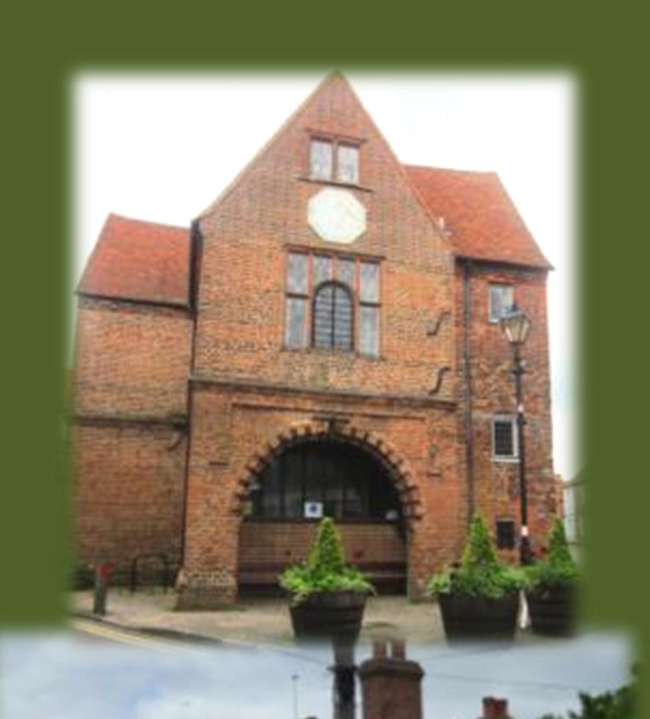


1 WATLINGTON DESIGN GUIDE 2017 WNDP 11 1

2 Foreword: This Design Guide has been prepared as part of Watlington s Neighbourhood Development Plan with the aim of securing the highest quality new development within the Parish. It is intended as a set of local guidelines to assist professionals, developers and householders to be used alongside the SODC Design Guide published 2016 to assist in the preparation of proposals for development. It has been prepared in accordance with the National Planning Policy Framework (NPPF) 2012 and the National Planning Practice Guidance for Design. We have also used the Chilterns Buildings Design Guides published by the Chilterns Conservation Board. Sustainable development is at the heart of the Watlington Neighbourhood Development Plan. The sustainability objectives are at Appendix A. Extract from National Planning Policy Framework Para 58: Local and neighbourhood plans should develop robust and comprehensive policies that set out the quality of development that will be expected for the area. Such policies should be based on stated objectives for the future of the area and an understanding and evaluation of its defining characteristics. Planning policies and decisions should aim to ensure that developments: will function well and add to the overall quality of the area, not just for the short term but over the lifetime of the development; establish a strong sense of place, using streetscapes and buildings to create attractive and comfortable places to live, work and visit; optimise the potential of the site to accommodate development, create and sustain an appropriate mix of uses (including incorporation of green and other public space as part of developments) and support local facilities and transport networks; respond to local character and history, and reflect the identity of local surroundings and materials, while not preventing or discouraging appropriate innovation; create safe and accessible environments where crime and disorder, and the fear of crime, do not undermine quality of life or community cohesion; and are visually attractive as a result of good architecture and appropriate landscaping. 1
3 Contents PAGE 1. FOREWORD 1 2. CONTENTS 2 3. INTRODUCTION 3 4. CONTEXTUAL ANALYSIS OF WATLINGTON 4 STREET SCENE PLOTS HOUSE TYPES WALLS ROOFS AND CHIMNEYS WINDOWS AND DORMERS DOORS & PORCHES BOUNDARIES CAR PARKING SOLUTIONS 5. IDENTIFYING DEVELOPMENT CONSTRAINTS AND OPPORTUNITIES RESPONDING TO THE SETTING ESTABLISHING THE STRUCTURE 10. LIGHTING LANDFORM, LANDSCAPE AND PLANTING SUSTAINABLE DEVELOPMENT AND RESOURCES APPENDIX A SUSTAINABILITY OBJECTIVES 18 All maps contain Crown Copyright data, Crown Copyright and Database Right [2012]and have been prepared by Watlington Parish Council under the PSMA agreement These maps may not be reproduced in any form without explicit approval from Ordnance Survey Limited and Watlington Parish Council. Note: All photographs credited to Terry Jackson unless otherwise stated. 2
4 Contents: Introduction: What is the Watlington Design Guide? A manual of design principles and practical advice for making a successful planning application created to support the SODC Design Guide but with special consideration for the locally important setting of Watlington Parish specifically, enabling applicants and developers to consider the views of the local community. Innovative designs are encouraged but will need to reflect local distinctiveness and integrate well with the natural, built and historic environment. In line with NPPF 63 support will be given to outstanding designs which help to raise the standard of design more generally in the area. As SODC 2016 Design Guide states It is important to identify and involve those groups and individuals affected by a proposed development in order to increase the understanding of the development proposals and local priorities. Applicants and developers should discuss proposals with neighbours in all cases before making a formal application and consult more extensively with the community for applications that are likely to have a wider effect. Why is the design guide important? Compliance with this design guide will help speed up the planning process by reducing the chance of objections due to poor design. The guide provides supporting information to the Watlington Neighbourhood Development Plan and, as such, is a material consideration in all planning decisions which involve building work in and adjacent to Watlington Parish. Who should read the design guide? Anyone considering carrying out new development including householders, agents, developers and statutory authorities. Relevant statutory authorities and council officers may be consulted to understand their policies, requirements and initial advice. Depending on the scale of a development, these can include the following: South Oxfordshire District Council: Development Management Officer. Conservation and Design Officer. Forestry Officer. Countryside Officer. Building Control Surveyor. Waste/recycling Officer. Environmental Services. Planning Policy Officer Urban Design Officer Accessibility Officer Sustainable Energy Office Other organisations which may include Oxfordshire County Council: highways, access, transport, rights of way. archaeology and cultural heritage, education, libraries, public health etc. Environment Agency: flooding, rivers and pollution Historic England Natural England Utility companies Police service: Police Liaison and Crime Prevention Officer. Fire service. Also, seeking professional help, eg. Architects or Planners, unless a proposal is very straightforward, is advised. 3


5 Contextual Analysis of Watlington Street Scene Street size, orientation and style should be widely varied to give opportunities for a good variety of journeys, experiences, situations, views and vistas. Rows of terraced cottages, integrated with larger houses on narrow residential streets. Network of footpaths interlinking different areas are an integral characteristic of Watlington. On- street high density houses (the High Street) also demonstrating the importance of street trees & planting. Chalk Streams are a precious habitat. Avoid hiding the precious chalk streams in culverts or including as part of a garden. Access off road to parking with homes arranged around the small access track.(high Street is through the arch) Homes facing each other around a central point create a sense of community, also demonstrating the importance of street trees and planting. Houses set in gardens set well back from edge road/wide street. 4 Barn style workshops/business units


6 Plots Some plots large enough to allow house to sit surrounded by garden in addition to being set well back from edge road. Plots to allow for moderate semi-detached houses with variable garden sizes. Some plots with little or no front garden either facing onto a small street or facing each other over a green space. House Types Small Detached cottage Generally cottage style homes with low ridge heights will best reflect the type and scale of buildings in Watlington with a few possible exceptions as shown. Terrace of cottages with no front garden Detached house Semi-detached Houses Larger focal building which could be divided into flats with a communal park or garden, could also incorporate interesting access with arches, gateways, paths. 5


7 Walls Walls in Watlington are predominantly orange/red to dark red brick with partially glazed or completely grey or grey/blue glazed headers available from a number of brick manufacturers. There are also a number of walls of plain render and small accent areas of weatherboarding. Although chalk walls are a feature developers would not be expected to attempt to replicate these. Roofs & Chimneys Roofs in Watlington are generally of slate or clay tile. Thatches are generally plain ridged not fancy and Chimneys generally reflect the building materials of the walls. Good honest design is encouraged if there s a chimney it should have a function and not be simply a decorative afterthought. Generally lower ridge heights are preferred. Suggested pitches: Thatch deg. Clay tile 35/40 50 deg. Slate generally for shallower pitches 6


8 Windows and Dormers In Watlington windows are generally sash or casement style and of painted timber. Dormers, with some exceptions, tend to have pitched roofs not flat. Dormers with an apex are either weatherboarded or use material to match the rest of the building. Examples of newer windows in newer builds and older buildings 7


9 The favoured style of door in Watlington is generally painted timber some being vertically slatted with a letter slot. They will sometimes have a small window as well. Porches are variable with some open, some enclosed and some little more than a canopy over the door. Enclosed porches will usually have a pitched roof. Doors and Porches Boundaries Boundaries in Watlington characteristically are either brick or brick and flint walls, hedges, picket fences, or black wrought iron railings often used in combination with a hedge. Close-board fencing can be used sparingly as a mix of boundary types is characteristic of Watlington. Walls of Brick, Flint, Chalk or a mix 8


10 Estate iron fences Laid hedge Picket Fences Iron Railing with hedge Flint and brick wall Wall with hedging An example of a long stretch of Closeboard fencing A comparison showing a hedgerow and a close-board fence on Letts Alley demonstrating that a hedge along a path offers as much privacy and is aesthetically more pleasing. 9


11 Parking solutions Parking is a major problem in Watlington due to its historic character because many houses have no garage and only on street parking. Where parking is not visually dominant and there is ample provision this works very well with the character of the town. L Parking created in an old barn at the back of a house works well In Lilacs Place the houses are built around a green with the parking areas adjacent to the development with a mix of open parking and barn style garages. Access is easy but visually attractive. Parking at Stonor Green 10


12 Parking spaces for SOHA housing in Pauls Way Provision for parking needs to be able to cope with peak demand without encouraging anti-social parking on footways, verges, or amenity areas. Parking solution in Spring Lane garages set well back with a long drive 11


13 Identifying Development Constraints and Opportunities The SODC 2016 Design Guide advises that local character, potential constraints, opportunities and the characteristics of a site and its setting with the surrounding neighbourhood and landscape that might influence design at all levels should be identified early in the process. The relationship of a site with its immediate neighbours and landscape setting should be examined and the planning history of the site reviewed. Designers should look beyond the boundary of the application site. Specifically to Watlington: Views to and from the Chilterns AONB especially Watlington Hill Rural nature of the town and its relationship to the surrounding landscape Access routes which maintain local rural character of existing routes i.e. predominantly hedge-lined and not too wide Retaining the character of having linking footpaths as in the Town Centre Any contributions that can be made to mitigate or improve poor air quality in the designated Watlington Air Quality Management Areas. Preserve and enhance bio-diversity in and around town. Preserve the town s Dark Skies i.e. avoid large expanses of windows, sky-lights, security lights, flood lights. Improve cycle access into and across the site from surrounding areas. Reflect the characteristic materials of the vernacular buildings. White Mark Viewed from location adjacent to Pyrton Lane 12


14 Responding to the Setting Building Materials Traditional building materials are typical of the Chilterns as whole, with a predominance of red and silver-grey brick and flint. Older houses were timberframed in oak. Plain tiles were the rule on the larger roofs, with thatch on cottages with some slate introduced in Victorian times. Farmsteads are often characterised by large timber-framed barns, typically clad with black horizontal weatherboarding with gable walls constructed out of brick and flint. SODC Landscape Character Assessment- Chilterns Escarpment Historic Townscape and Listed Buildings The centre of Watlington is designated as a Conservation Area and there are approximately 80 listed buildings in the parish. The Design Guide seeks to ensure that these heritage assets are both conserved and enhanced in line with the NPPF paragraph 132 and NPPG Conserving and enhancing the historic environment April Listed Building Consent is needed to alter or to extend a listed building in any way that affects its architectural or historic interest and any planning application in a Conservation Area is required to ensure that the proposals do not detract from its character. 13
15 Establishing the Structure In Watlington attention should be paid specifically to the traditional ambience such as is created at Lilacs Place, an excellent model of modern village architecture and structure of place. New areas of development need to work well as places where people want to live. They need to meet a diverse range of housing needs which are inclusive and easily accessible and where people feel confident and safe to move around. They need to have a good overall design where green spaces, streets and built areas are integrated in a way where each part of the development is an attractive space in itself but also contributes to an overall attractive design. Particular consideration should be given to how people will experience, use and move through the area. Lighting External lighting should be avoided on new buildings unless it is absolutely necessary for reasons of security and safety. This will ensure that bat activity within the local area around the building is not adversely affected by artificial lighting. If lighting is required, it should be kept minimal, at low level and at low intensity, with hoods and baffles used to direct the light to where it is required (Bat Conservation Trust 2008, Emery 2008). To minimise the impact on bats, the use of low pressured sodium lamps is recommended in preference to mercury or metal halide lamps which have a UV element that can affect the distribution of insects and attract bats to the area, affecting their natural behaviour (Bat Conservation Trust 2008). Lighting around any integrated bat roost features within the new development should be completely avoided. Light pollution has become one the most intrusive threats to our enjoyment of the countryside and its tranquillity at night. This was given prominence by a joint CPRE/British Astronomical Association campaign and report (2003) and subsequently by a star-count survey conducted jointly by CPRE and the Campaign for Dark Skies (CfDS). The CPRE have undertaken research on Night Blight in the South East of England caused by light beaming in an upward direction causing a pinky orange glow which lights up the night skies. In June 2016 the CPRE published new maps of England s light pollution and dark skies. These are far more detailed and are able to identify district, county, National Parks and AONBs. Watlington is one of the first Parishes to use these maps and our dark sky position in South Oxfordshire is illustrated below 14
.")

16 Light Pollution and Dark Skies Map, Oxfordshire(CPRE). CPRE Nightblight Map focusing on South Oxfordshire including Watlington CPRE Nightblight Map showing the Chilterns AONB (including Watlington) 15
17 Landform, Landscape and Planting The importance of landscape and planting The importance of this section is immense for Watlington and the public consultations bear out the degree to which people care about the environment and local landscape. The design of the public realm, landscape and external areas around buildings is at least as important as the design of the buildings themselves in defining the character and quality of places. Too frequently, however, these aspects are given much less attention. When the design of paving materials, boundaries and planting is done well it can make all the difference in creating a distinctive character for new places and integrating development with an existing settlement. Existing landscape features can be used to form the structure and character of new development and to create shelter and windbreaks, thereby limiting the effects of heat loss from buildings. They can also provide instant maturity and can be a valuable asset to a development site. Environmental Design Principles: Watlington Chalk Stream Trees at Willow Close Wherever possible within the design, retain existing landscape features such as trees, hedges and water bodies on the site and allow sufficient space for them to grow. Biodiversity should be promoted and opportunities taken to re-open culverts, reestablish watercourses and enhance the wildlife value of them. Opportunities should also be taken to provide links between existing habitats and the creation of new ones insuring a joined up network of green spaces. The Willow Pond View of town from Watlington Hill In Watlington extra care needs to be taken because of the general sloping nature from Watlington Hill towards Cuxham. In some places the initial general impression is that it is flat and the same level as adjoining areas but this can be deceptive. The area has a number chalk streams which being internationally rare, diligence is required in their treatment. Views from and of the AONB are highly regarded in Watlington and care should be taken not to have an adverse impact on these. 16
18 Sustainable Development and Resources Particular note should be taken of environmental sustainability. There have been issues locally with waste water in to of life, If we want to create a addition better quality flooding. The chalk nowepisodes and for of future generations, we need to streams are importantto and need this aim, build more sustainably. achieve protection. design needs to become more integrated. It needs to include factors such as resources, The allotments that already carbon emissions, waste, health, culture and exist in Watlington are popular habitat and how these work together to shape and so there is scope for further new developments. Many design decisions allotments, community are connected. For example providing public orchards, community farm transport can reduce polluting emissions. projects etc. to encourage local This improves air quality, makes walking food production. more desirable and requires less energy. Making a compact neighbourhood with attractive walking and cycling routes will provide better access and promote health. New planting can modify microclimate, create new habitats and provide recreational areas. The most resilient parts of a masterplan should be the streets and related infrastructure. These are long-term design decisions that can remain in place for generations. Within this infrastructure, buildings may be replaced over time, either in stages or all at once. Buildings that can change their use make more efficient use of resources. The built environment should allow for adaptive re-use. Food It is possible to grow a wide range of fruit and vegetables in quite small gardens or in pots where balconies or terraces have been provided. Community orchards are becoming more popular and can provide a community focus. A developer could leave a legacy of fruit trees in individual gardens or in a communal orchard. Design principles Include edible fruit species when planting trees and shrubs. Make land available for community orchards and allotments, in close proximity to residential developments. Pyrton Field Allotments 17
19 Appendix A # Sustainability Objective SO1 SO2 SO3 SO4 SO5 SO6 SO7 SO8 SO9 To help to provide a good mix of housing types to meet the identified needs of Watlington residents and to provide the opportunity for people to live in a decent home which is affordable within their means The help to create a safe environment through well designed development in which people can live and work and which is attractive and welcoming to visitors To enable everyone to contribute to decisions affecting the community and to support community initiatives that will benefit local residents To promote people's health and wellbeing by making sure that everyone has good access to local green spaces, to the countryside and to surrounding villages via attractive pedestrian and cycle routes To improve accessibility for people of all abilities to local services and facilities and to promote improved opportunities for public transport To reduce the negative impact of traffic on the environment caused by noise, vibration, and congestion by promoting effective traffic management strategies To support action to improve air quality To conserve and enhance biodiversity and geo-diversity, maximising opportunities for biodiversity within all new development, and paying particular attention to habitat linkage and wildlife corridors To protect and enhance the town's landscape setting and the countryside around it with special regard to the Chilterns AONB SO10 To protect the rural character of the parish by minimising light encroachment in order to preserve dark skies SO11 To protect and enhance the town's historic environment, Conservation Area and heritage features including archaeological sites SO12 To ensure that new development reflects the distinctiveness of the built form of Watlington by using high quality design and materials SO13 To ensure that the location and design of new development is resilient to the effects of climate change and to mitigate and adapt to climate change by securing sustainable building practices which conserve energy, water resources and materials SO14 To support energy generation projects from renewable sources SO15 To protect, enhance and manage the parish's watercourses, springs and ponds. To safeguard their margins and groundwater sources, restoring naturalised sections and creating wetland features where appropriate & improve water quality SO16 To reduce the risk of damaging groundwater or fluvial flooding by taking advantage of natural processes in the way flows are managed and ensuring that sustainable drainage systems are used on sites which are developed. SO17 To support the reduction of waste through recycling, composting and energy recovery SO18 To improve efficiency in land use through re-use of previously developed land and existing buildings and to protect minerals and other natural resources SO19 To safeguard and enhance opportunities for local food production by protecting the best and most versatile agricultural land, small holdings and allotments and facilitating other initiatives such as community orchards and gardens SO20 To promote the development of local businesses which are appropriate in scale to the rural context of Watlington and provide increased employment opportunity SO21 To support provision for home workers together with support networks for small businesses SO22 To support the growth of Watlington as a thriving commercial hub in maintaining and enhancing the vitality of our settlements within the Parish and other nearby communities From the Sustainability Appraisal Scoping Report 2017 (available on 18
Basic Conditions Statement
 Basic Conditions Statement Our Community Our Plan Document: WNDP 2 Watlington Parish Council October 2017 Watlington Town Hall Page 2 of 25 WNDP 2 Contents 1. INTRODUCTION AND BASIC CONDITIONS... 5 1.1
Our City Centre is a vibrant, creative and welcoming destination, with a modern business, cultural, shopping, leisure and residential offer
 3. Sheffield in 2034 Our City sits at the heart of a strong, distinctive and internationally successful City Region economy which supports innovation and enterprise Our City Centre is a vibrant, creative
Copyright Nigel Deeley and licensed for reuse under this Creative Commons Licence
 1 Copyright Nigel Deeley and licensed for reuse under this Creative Commons Licence Prepared by the Neighbourhood Plan Steering Group on behalf of Garway Parish Council with assistance from 2 Table of
Suffolk Coastal Local Plan Review Issues and Options, August 2017, Public Consultation
 Suffolk Coastal Local Plan Review Issues and Options, August 2017, Public Consultation Having reviewed the issues and options documents, the Society has made the following response: Part 1 - Strategic
Public Consultation. Land at Monks Farm, North Grove. Welcome
 Welcome Welcome to our public exhibition for development on Land at Monks Farm, orth Grove. Gallagher Estates and Gleeson Strategic Land are preparing an outline planning application for new homes, open
Neighbourhood Planning Local Green Spaces
 Neighbourhood Planning Local Green Spaces Introduction... 2 1. Why green space is important... 4 2. Neighbourhood plans and green space... 6 3. Evidence... 8 Statutory designations... 9 Green space audit...
6. Design and Architectural Guidance
 6. Design and Architectural Guidance The following Design Guidelines are proposed to apply to all areas of Haslemere. They are intended to enhance and maintain the character and scale of the area. Principles
DEVELOPMENT MANAGEMENT REPORT
 ITEM A08-1 DEVELOPMENT MANAGEMENT REPORT TO: BY: DATE: DEVELOPMENT: SITE: WARD: APPLICATION: APPLICANT: Development Management Committee Development Manager Proposed live/work unit in connection with existing
3. Neighbourhood Plans and Strategic Environmental Assessment
 1. Introduction This report sets out a draft Screening Determination for the Preston Parish Council s Neighbourhood Plan and has been prepared by rth Hertfordshire District Council. The purpose of the
MATURE SUBURBS RESIDENTIAL DEVELOPMENT GUIDELINES
 MATURE SUBURBS RESIDENTIAL DEVELOPMENT GUIDELINES DRAFT FEBRUARY 2005 BIRMINGHAM CITY COUNCIL 1 Introduction Mature Suburbs Residential Development Guidelines - Interim Supplementary Planning Advice -
DESIGN & ACCESS STATEMENT
 DESIGN & ACCESS STATEMENT January 2016 Contents Introduction section 1 Section 1 - Introduction Section 2 - Assessment Section 3 - Involvement Section 4 - Evaluation Section 5 - Design Section 6 - Layout
PROPOSED CARE HOME & ASSISTED LIVING DEVELOPMENT (C2), PYRTON LANE, WATLINGTON
, PYRTON LANE, WATLINGTON") Welcome - Meet the Team ABOUT BEECHCROFT Beechcroft has over 30 years experience of assisted living and retirement development and is one of the few house builders that specialise in this type of accommodation.
Welcome - Meet the Team ABOUT BEECHCROFT Beechcroft has over 30 years experience of assisted living and retirement development and is one of the few house builders that specialise in this type of accommodation.
Great Easton Neighbourhood Plan Statement of Basic Conditions
 Great Easton Neighbourhood Plan 2017-2031 Statement of Basic Conditions OCTOBER 2016 GREAT EASTON PARISH COUNCIL Contents 1.0 Introduction....Page 2 2.0 Summary of Submission Documents and Supporting Evidence..
Tāhuhu whakaruruhau ā-taone The sheltering ridge pole
 B2. Tāhuhu whakaruruhau ā-taone - Urban growth and form B2.1. Issues Tāhuhu whakaruruhau ā-taone The sheltering ridge pole Auckland s growing population increases demand for housing, employment, business,
Schedule of Planning Applications Committee Date: 23 May Reference: 06/17/0726/F Parish: Hemsby Officer: Mr J Beck Expiry Date:
 Schedule of Planning Applications Committee Date: 23 May 2018 Reference: 06/17/0726/F Parish: Hemsby Officer: Mr J Beck Expiry Date: 22-05-2018 Applicant: Proposal: Site: Mr Gillett Change of use to the
South Worcestershire Development Plan. South Worcestershire Design Guide Supplementary Planning Document
 South Worcestershire Development Plan South Worcestershire Design Guide Supplementary Planning Document Statement of Consultation: Early Engagement Scoping Paper February 2017 1. Introduction 1.1 This
Ipswich Issues and Options for the Ipswich Local Plan Review, August 2017, Public Consultation
 Ipswich Issues and Options for the Ipswich Local Plan Review, August 2017, Public Consultation Having reviewed the issues and options documents, the Society has made the following response: Part 1 Strategic
Rochford District Council Allocations Development Plan Document: Discussion and Consultation Document Sustainability Appraisal
 Option SWH1 Balanced Communities Option SWH1 1 To ensure the delivery of high quality sustainable communities where people want to live and work Will it ensure the phasing of infrastructure, including
PDP DESIGN & ACCESS STATEMENT
 PDP The Planning & Design Partnership Planning.. Architecture.. Interiors.. Landscape The Chicory Barn Studio, The Old Brickyards, Moor Lane, Stamford Bridge York, The East Riding Of Yorkshire, YO41 1HU.
Ensure that development within the Arrowtown Urban Growth Boundary provides:
 URBAN DEVELOPMENT 4 4.2.5.2 Ensure that development within the Arrowtown Urban Growth Boundary provides: an urban form that is sympathetic to the character of Arrowtown, including its scale, density, layout
Parish of Repton NEIGHBOURHOOD DEVELOPMENT PLAN
 Parish of Repton NEIGHBOURHOOD DEVELOPMENT PLAN BASIC CONDITIONS STATEMENT December 2018 CEF 4 Legal Requirements This statement has been produced by the NDP Working Group on behalf of Repton Parish Council
Welford-on-Avon Neighbourhood Plan Consultation Event Sunday, 6 April Your name Your address
 Welford-on-Avon Neighbourhood Plan Consultation Event Sunday, 6 April 2014 Your name Your email address Please either: - complete this feedback form and put it in the box before leaving the Memorial Hall
2014/0590 Reg Date 26/06/2014 Chobham
 2014/0590 Reg Date 26/06/2014 Chobham LOCATION: PROPOSAL: TYPE: APPLICANT: OFFICER: ASCOT PARK POLO CLUB, WESTCROFT PARK FARM, WINDLESHAM ROAD, CHOBHAM, WOKING, GU24 8SN Erection of a two storey detached
Briefing Document of CNP. June 2017
 Cholsey Parish Council Cholsey Neighbourhood Plan Briefing Document of CNP June 2017 Cholsey Neighbourhood Plan Page! 1 of! 8 Cholsey Plan Briefing v1.4 Page Left Intentionally Blank Cholsey Neighbourhood
Land Adj. 63 Sunny Bank Road, Sutton Coldfield, Birmingham, B73 5RJ
 Committee Date: 11/07/2013 Application Number: 2013/03520/PA Accepted: 20/05/2013 Application Type: Full Planning Target Date: 15/07/2013 Ward: Sutton Vesey Land Adj. 63 Sunny Bank Road, Sutton Coldfield,
PLANNING COMMITTEE. 14 October 2014
 AGENDA ITEM NO 8 PLANNING COMMITTEE 14 October 2014 APPLICATION NUMBER : CA//14/01744/FUL PROPOSAL : Extension and conversion of roof space of an existing detached bungalow together with enhanced parking
Settlement Boundaries Methodology North Northumberland Coast Neighbourhood Plan (August 2016)
") Introduction This background paper sets out a methodology for the definition of settlement boundaries in the North Northumberland Coast Neighbourhood Plan. The neighbourhood plan is planning positively
Introduction This background paper sets out a methodology for the definition of settlement boundaries in the North Northumberland Coast Neighbourhood Plan. The neighbourhood plan is planning positively
Statement of Community Involvement LAND OFF SOUTHDOWN ROAD HORNDEAN, HAMPSHIRE
 LAND OFF SOUTHDOWN ROAD HORNDEAN, HAMPSHIRE CONTENTS Page 1. Introduction 3 2. Pre-application Discussions 4 3. The Consultation Process 5 4. Consultation Feedback 7 5. Responses to Consultation Feedback
Planning and Sustainability Statement
 Land adjacent to Manor Farm, Catterick Village Pallett Hill Sand and Gravel Co Ltd Proposed 10 new dwellings, (6 No market dwellings and 4 No affordable dwellings) with access, associated car parking and
Ward: West Wittering. Proposal Change of use from public highway pavement to residential garden use.
 Parish: West Wittering Ward: West Wittering WW/17/03295/FUL Proposal Change of use from public highway pavement to residential garden use. Site Izora 1 Watersedge Gardens West Wittering PO20 8RA Map Ref
Land at Rampton Road. Cottenham
 Land at Rampton Road Cottenham Introduction TEP is preparing an outline planning application for 54 dwellings on 6.9 hectares of land adjacent to Rampton Road, Cottenham on behalf of the owners Cambridgeshire
DUNSFOLD NEIGHBOURHOOD PLAN Site Selection Policies
 DUNSFOLD NEIGHBOURHOOD PLAN Site Selection Policies The criteria for assessing sites for future housing and business development in Dunsfold are set out below. (Development criteria, covering what it is
Kibworth Harcourt. Introduction. Introduction
 Introduction Introduction Welcome to this public exhibition on the proposals for the delivery of new homes on land at The Kibworths. The purpose of today s exhibition is to give you the opportunity to
Plan Modification to Chapter B2 of the Auckland Unitary Plan(AUP) Operative in part (15 November 2016)
 Operative in part (15 November 2016)") UNITARY PLAN UPDATE REQUEST MEMORANDUM TO FROM Phill Reid Linley Wilkinson DATE 25 September 2018 SUBJECT Plan Modification to Chapter B2 of the Auckland Unitary Plan(AUP) Operative in part (15 November
UNITARY PLAN UPDATE REQUEST MEMORANDUM TO FROM Phill Reid Linley Wilkinson DATE 25 September 2018 SUBJECT Plan Modification to Chapter B2 of the Auckland Unitary Plan(AUP) Operative in part (15 November
DESIGN & ACCESS STATEMENT
 . DESIGN & ACCESS STATEMENT Site Adjacent to The Manor House, Upper Street,, Kingsdown, Deal, Kent. DESIGNS ARCHITECTURE + PLANNING CONTENTS Design and Access Statement Introduction Site and Location Planning
Camberwell Camberwell Area Vision Map
 Area Vision Map NSP23 Burgess Park Edmund Street NSP29 NSP30 NSP31 New Road Benhill Road NSP27 NSP33 Green Brunswick Park NSP22 station NSP24 Peckham Road NSP26 St Giles Church Lucas Gardens NSP28 NSP25
The Gwennap Parish Vision Statement
 QUICK GUIDE What is a Neighbourhood Development Plan? Ultimately it is a document used by developers or anyone wishing to submit a planning application that describes the vision, strategy, plans, regeneration,
Environmental and Landscape Mapping
 Environmental and Landscape Mapping In support of the Calveley Neighbourhood Plan November 2016 Project Name and Number: Calveley Neighbourhood Plan 16-025 Document Name and Revision: Environmental and
WELCOME GYPSY LANE. Wider Site Location plan. Proposals for the development of LAND OFF FOXLYDIATE LANE WEBHEATH. Proposals for the development of
 WELCOME The developers are preparing an outline planning application for a residential led development and need the community s views in order to develop the proposals further WHAT IS PROPOSED? A high
ROCHFORD LOCAL DEVELOPMENT FRAMEWORK: Sustainability Appraisal/ Strategic Environmental Assessment. Rochford Core Strategy Preferred Options Document
 ROCHFORD LOCAL DEVELOPMENT FRAMEWORK: Sustainability Appraisal/ Strategic Environmental Assessment Non Technical Summary Rochford Core Strategy Preferred Options Document October 2008 SUSTAINABILITY APPRAISAL
Effingham Neighbourhood Plan 1. Basic Conditions Statement
 Effingham Neighbourhood Plan 1 Basic Conditions Statement Effingham Neighbourhood Plan 2016: Basic Conditions Statement 2 Contents This statement has been prepared by Effingham Parish Council to accompany
Environment Agency Flood Risk Map for the Village of Bridge
 Environment Agency Flood Risk Map for the Village of Bridge December 2016 21 Objective F. Conserving and Enhancing the Natural Environment The National Planning Policy Framework states that the planning
STATEMENT OF OBJECTION TO THE PROPOSED DEVELOPMENT OF LAND AT CHURCH CLIFF DRIVE FILEY
 STATEMENT OF OBJECTION TO THE PROPOSED DEVELOPMENT OF LAND AT CHURCH CLIFF DRIVE FILEY You will be aware that Scarborough borough council have adopted a new local plan that includes land at Church Cliff
Replacement Golf Course Facilities and Residential Development, Churston. Environmental Statement Non-Technical Summary
 Replacement Golf Course Facilities and Residential Development, Churston Environmental Statement Non-Technical Summary July 2011 Reproduced from the Ordnance Survey s map with the permission of the Controller
Introduction. Welcome to this consultation regarding the draft redevelopment proposals for the former CeramTec factory on Sidmouth Road, Colyton.
 Introduction Welcome to this consultation regarding the draft redevelopment proposals for the former CeramTec factory on Sidmouth Road, Colyton. We are currently considering options for the mixed-use redevelopment
Sustainability Statement. Whitby Business Park Area Action Plan
 Sustainability Statement Whitby Business Park Area Action Plan November 2014 Contents Page 1. Introduction 1 2. Scoping 3 3. Sustainability Appraisal of Options 6 4. Assessment of Draft Area Action Plan
SETTLEMENT ASSESSMENT PROFORMA
 SETTLEMENT ASSESSMENT PROFORMA Surveyors(s):Clare Sheridan Character Area: Park Estate = Midland Rd, Severn Rd, Festival Rd, Park Rd, Willow Rd, Rylands Rd. Date: Feb Weather: cloudy Look through all the
EXTRACT FROM THE CUDDINGTON NEIGHBOURHOOD PLAN The Policies
 EXTRACT FROM THE CUDDINGTON NEIGHBOURHOOD PLAN The Policies Environment and Landscape Policy 1 - Landscape Setting Development should respect and wherever possible enhance the landscape setting of Cuddington
LONGDEN VILLAGE DEVELOPMENT STATEMENT
 LONGDEN VILLAGE DEVELOPMENT STATEMENT 2017-2027 1 Longden Development Statement 2017-2027 15/01/18 1. Background 1.1 Longden Village Longden village is a very rural and traditional community first mentioned
8.0 Design and Form of Development 43/
 42/ 8.0 Design and Form of Development 43/ Rothwells Farm, Golborne/ Development Statement Figure 7. Site Constraints Key 44/ Site Boundary 360 Bus Route/Stops Existing Trees Underground Water Pipe Sensitive
PLANNING DECISION NOTICE
 PLANNING DECISION NOTICE TOWN AND COUNTRY PLANNING ACT, 1990 Applicant WILLITON VILLAGE HALL STEERING COMM. C/O ALISON CALLOWWAY 54 NORTHCROFT WILLITON TAUNTON TA4 4RT Date Registered 11/08/2006 Application
01 Welcome. Why are we here?
 01 Welcome Why are we here? In July 2014 GreenSquare unveiled its plans for 1500 homes to the local community providing much needed houses during the first half of the Stroud District Local Plan period.
DEVELOPMENT MANAGEMENT REPORT
 ITEM A07-1 DEVELOPMENT MANAGEMENT REPORT TO: BY: Development Management Committee (South) Development Manager DATE: 21 June 2016 DEVELOPMENT: SITE: WARD: APPLICATION: APPLICANT: Outline application for
Plumpton Neighbourhood Development Plan Revised Pre Submission Document - Regulation 14 Consultation
 REPRESENTATIONS... Plumpton Parish Council Plumpton Neighbourhood Development Plan Revised Pre Submission Document - Regulation 14 Consultation Representations submitted on behalf of: Cala Homes (South
Welcome. Land adjacent Sandy Lane WALTHAM CHASE THE PROPOSED SITE
 Land adjacent Sandy Lane WALTHAM CHASE Existing Linden Homes developments Welcome Welcome to Linden Homes Southern s ( Linden ) public exhibition about its proposals for a range of high-quality homes for
ENVIRONMENTAL AND LANDSCAPE MAPPING
 APPENDIX IV : Environmental and Landscape Mapping ENVIRONMENTAL AND LANDSCAPE MAPPING Calveley Neighbourhood Plan November 2016 ENVIRONMENTAL AND LANDSCAPE MAPPING Calveley Neighbourhood Plan Calveley
ECOLOGICAL ADVICE SERVICE
 ECOLOGICAL ADVICE SERVICE TO: FROM: Guy Wilson Marie Thibault DATE: 11 th August 2016 SUBJECT: CA/16/01502/FUL / Land adjoining Goose Farm, Canterbury Thank you for requesting advice on this application
Chapter 5 Urban Design and Public Realm
 5.1 Introduction Public realm is all areas of the urban fabric to which the public have access. It is where physical interaction takes place between people. It therefore, includes buildings and their design,
4 RESIDENTIAL ZONE. 4.1 Background
 4 RESIDENTIAL ZONE 4.1 Background The residential areas within the City are characterised by mainly lowrise dwellings sited on individual allotments. Past architectural styles, settlement patterns and
Lancaster Conservation Area Appraisal. Character Area 8. Cathedral
 Lancaster Conservation Area Appraisal Character Area 8. Cathedral March 2013 118 3.8 Character Area 8. Cathedral 3.8.1. Definition of Special Interest "This character area is distinctive for the fine group
Neighbourhood Planning Site Assessment Pro-forma and Guide Version 2
 Neighbourhood Planning Site Assessment Pro-forma and Guide Version 2 September 2014 Site HNP 006 Land East of Stanbridge Road and North of Lower Road 1. Background information Site location and use Site
ALLERTHORPE NEIGHBOURHOOD PLAN
 Allerthorpe s Neighbourhood Plan sets out a vision for the Parish for the next 15 years (2018 2033) that builds on and reflects the opinions and views of parish residents. VISION In 2033 Allerthorpe will
Site ref: AS06 Site Name or Address: Murreys Court, Agates Lane
 Site ref: AS06 Site Name or Address: Murreys Court, Agates Lane Proposed Land Use: Total Site Area (Ha): Housing 1.85 Ha Description: It is understood that the owner has no plans to dispose of the site
Site Assessment Technical Document Appendix A: Glossary
 Central Bedfordshire Council www.centralbedfordshire.gov.uk Site Assessment Technical Document Appendix A: Glossary July 2017 1.1.11-1 - ii Appendix A: Glossary Term Agricultural Land Classification AONB
1.3 The following table presents a Statement of Compliance demonstrating how the Standish Neighbourhood Plan meets those requirements.
 1. Introduction 1.1 This Basic Condition Statement was prepared to accompany the draft Standish Neighbourhood Plan (2018). 1.2 Paragraph 8 of Schedule 4B of the Town and Country Planning Act 1990 requires
September A new neighbourhood at Kemsing Station. Concept Masterplan
 September 2018 A new neighbourhood at Kemsing Station Concept Masterplan 1 Kemsing Station Neighbourhood - Key Benefi ts Transport Hub Extra parking, station improvements and links across the district
Ashtead Neighbourhood Forum Site Assessment AS03 Lime Tree Lodge, Farm Lane. Site address: Lime Tree Lodge, Farm Lane. Proposed Land Use:
 Site ref: AS03 Site address: Lime Tree Lodge, Farm Lane Proposed Land Use: Total Site Area (Ha): Housing 1.25ha Description The site is located off Farm Lane at the junction with Park Lane. To the north
SUSTAINABLE MANAGEMENT
 . Sustainable Management.1 The Concept of Sustainable Management The concept of sustainable management recognises there are limits to the use of natural and physical resources and there is a need to balance
ABOUT CALA HOMES CALA HOMES
 WELCOME Welcome to this public consultation event for our proposed development on land to the east of Salisbury Road, in Hungerford. Thank you for taking the time to come along today. Homes and Wates Developments
STRENSALL RAILWAY BUILDINGS CONSERVATION AREA APPRAISAL. In association with Strensall with Towthorpe Parish Council
 STRENSALL RAILWAY BUILDINGS CONSERVATION AREA APPRAISAL In association with Strensall with Towthorpe Parish Council CONTENTS Page 1 Introduction 2 2 Location and Context 3 3 Topography and Setting 4 4
The Proposed Auckland Unitary Plan (notified 30 September 2013)
") 3 Business zones Introduction There are 10 business zones in the Unitary Plan: City Centre Metropolitan Centre Town Centre Local Centre Neighbourhood Centre Mixed Use General Business Business Park Light
3 Business zones Introduction There are 10 business zones in the Unitary Plan: City Centre Metropolitan Centre Town Centre Local Centre Neighbourhood Centre Mixed Use General Business Business Park Light
Vigo Neighbourhood Plan Basic Conditions Statement
 Vigo Neighbourhood Plan Basic Conditions Statement Plan Period: 2016 to 2028 Status: Submission Version Qualifying Body: Vigo Parish Council Glossary of Some Terms & Abbreviations Used in this Document
DRAFT STRATEGIC ENVIRONMENTAL ASSESSMENT REPORT
 DRAFT STRATEGIC ENVIRONMENTAL ASSESSMENT REPORT Published by Limpsfield Parish Council in accordance with EU Directive 2001/42 on Strategic Environmental Assessment and with the Environmental Assessment
Plumpton Neighbourhood Plan Site Assessment Report
 Plumpton Neighbourhood Plan Site Assessment Report May 2016 1 Contents 1. Introduction 3 2. Methodology 4 2.1 Identification of Potential Sites 4 2.2 Assessment Process 5 2.3 Assessment Criteria 6 2.4
Welcome to our public exhibition
 About our scheme Welcome to our public exhibition Taylor Wimpey East Anglia intends to submit a detailed planning application for a new residential development of 39 high-quality homes at the B&M Concrete
Appendix 1 Structure plan guidelines
 Appendix 1 Structure plan guidelines This appendix forms part of the regional policy statement [rps]. 1.1. Introduction Structure plans are an important method for establishing the pattern of land use
Housing Development at Balloonagh Tralee Co Kerry
 Design Statement Housing Development at Balloonagh Tralee Co Kerry Area of site 10,400m2 24 houses-12no 3 bed, 12no 2 bed and 4 single bed apartments total residential area of 2411m2 Open space provided
DRAFT CONSERVATION AREA APPRAISAL CHAILEY GREEN DESIGNATED
 DRAFT CONSERVATION AREA APPRAISAL CHAILEY GREEN DESIGNATED 16.06.76 DRAFT CHAILEY GREEN CONSERVATION AREA APPRAISAL 1 SUMMARY 1.1 Key Positive Characteristics 1.2 Recommendations 2 INTRODUCTION 2.1 The
QUEENSTOWN LAKES DISTRICT COUNCIL SUBDIVISION DESIGN GUIDELINES
 Attachment C: Draft QLDC Subdivision Design Guidelines QUEENSTOWN LAKES DISTRICT COUNCIL DESIGN GUIDELINES A DESIGN GUIDE FOR AND DEVELOPMENT IN THE URBAN ZONES QUEENSTOWN OFFICE 10 Gorge Road Queenstown
Meridian Water Phase 1 Application
 Meridian Water Phase 1 Application MW11 Environmental Statement Non-Technical Summary London Borough of Enfield March 2016 Contents 1 Introduction 1 2 The proposed development 2 3 Evolution of the proposed
University Park, Worcester Non Technical Summary December 2011
 University Park, Worcester Non Technical Summary December 2011 Introduction UW Wrenbridge LLP, a Joint Venture Company of the University of Worcester and Wrenbridge Land Ltd (the Applicants ) intend to
Change Paper / Date CAIRNGORMS NATIONAL PARK AUTHORITY
 Change Paper / Date CAIRNGORMS NATIONAL PARK AUTHORITY Title: Prepared by: REPORT ON CALLED-IN PLANNING APPLICATION FIONA MURPHY (PLANNING OFFICER DEVELOPMENT MANAGEMENT) DEVELOPMENT PROPOSED: REFERENCE:
Copyright Nigel Deeley and licensed for reuse under this Creative Commons Licence
 1 Copyright Nigel Deeley and licensed for reuse under this Creative Commons Licence Prepared by the Neighbourhood Plan Steering Group on behalf of Garway Parish Council with assistance from 2 Table of
7.1 Area 1: Haslemere Conservation Area
 7.1 Area 1: Haslemere Conservation Area Detailed map of Haslemere Town Conservation Area as of 2006 Crown copyright and database right 2011 Ordnance Survey LA100025451 27 The Conservation Area is characterised
BROADHEMBURY DESIGN STATEMENT
 BROADHEMBURY DESIGN STATEMENT As drawn up by Broadhembury Parish Council during the development of a Parish Plan and adopted at its meeting on 17 th May 2010 BROADHEMBURY DESIGN STATEMENT Contents Introduction
Former North Works, Lickey Road, Longbridge, Birmingham
 Committee Date: 14/11/2013 Application Number: 2013/06431/PA Accepted: 27/08/2013 Application Type: Full Planning Target Date: 26/11/2013 Ward: Longbridge Former North Works, Lickey Road, Longbridge, Birmingham
CALA Homes is preparing a planning application for a development of up to 36 new homes, including a mix of properties to meet local demand.
 WELCOME Welcome to this public consultation event for our proposed development on land to the south of Twelve Leys in Wingrave. Thank you for taking the time to come along today. Homes is preparing a planning
A payment of 1080 is due in this instance, for a meeting and follow up written response, and will be made by card over the phone.
 JPPC ref: AG/6002 18 th September 2014 Planning Services Vale of White Horse District Council Benson Lane Crowmarsh Gifford Wallingford OX10 8ED Dear Sir/Madam REQUEST FOR PRE-APPLICATION ADVICE RE: RESIDENTIAL
List of Policies. SESPlan. None applicable. Consolidated Scottish Borders Local Plan 2011: POLICY G1 - QUALITY STANDARDS FOR NEW DEVELOPMENT
 List of Policies Local Review Reference: 15/00021/RREF Planning Application Reference: 15/00616/FUL Development Proposal: Installation of 16no solar photovoltaic (PV) panels to roof Location: Raebank,
3 Abbey View Mill Hill London NW7 4PB
 Location 3 Abbey View Mill Hill London NW7 4PB Reference: 15/03203/HSE Received: 26th May 2015 Accepted: 16th June 2015 Ward: Mill Hill Expiry 11th August 2015 Applicant: Proposal: Mr Richard Benson Alterations
SITE ASSESSMENT CHECKLIST
 1. Site Details a. What is the site s name/reference? SITE ASSESSMENT CHECKLIST CR3NPWHY 3007 Gasometer Site Godstone Road CR3 0EG b. Where is the site located? Wyhteleafe; Godstone Road. Urban category1
INTRODUCTION CURRENT APPLICATION
 05/01805/FUL & 05/01807/LBC ERECTION OF A SINGLE DWELLING HOUSE WITH ANCILLARY ACCOMMODATION AT Flamingo Zoological Gardens, Olney Road, Weston Underwood FOR Mr A J Crowther (as amended by letter dated
Carterton Construction Ltd is bringing forward plans for up to 85 new family homes and extra care facilities on land east of Burford.
 Welcome Carterton Construction Ltd is bringing forward plans for up to 85 new family homes and extra care facilities on land east of. We are at the early stages of designing our proposals and have a number
Site Location Plan. Land on the North West of Epsom Road Waddon Croydon. 1 : A4 September The. Waddon. Waddon.
 138 140 44.3m MP 11.5 El Sub Sta EPSOM ROAD 13 Bank 1 to 5 154 Trough 19to21 1 to 5 156 The Waddon (PH) 23 FB Waddon Station 45.0m Posts 29to31 1 to 9 Stafford Court 39 37 Meridian Court 10 43 to 45 1
DESIGN & ACCESS STATEMENT
 DESIGN & ACCESS STATEMENT Land to the South East of the A495, Bronington Erection of 31 Dwellings (27 dwellings and 4 bungalows including 4 Affordable Dwellings), Realignment and Improvements to A495 (including
Welcome to our public exhibition
 About our development Welcome to our public exhibition This exhibition gives you the chance to view and comment on our proposals for a new residential development of 165 high-quality homes, along with
Warren Farm, Ampthill
 1 Welcome The developers of the Warren Farm site, Bloor Homes and Connolly Homes, are holding this exhibition on the emerging Design Codes for the development prior to their formal submission to Central
Derry City and Strabane District Council Planning Committee Report
 Derry City and Strabane District Council Planning Committee Report COMMITTEE DATE: 23 rd March 2016 APPLICATION No: APPLICATION TYPE: PROPOSAL: LOCATION: APPLICANT: LA11/2015/0395/F Residential Development
Urban Design Guidelines
 Urban Design Guidelines These Urban Design Guidelines comprise the Key Design Objectives below, the Roads Design Guidelines overleaf and Neighbourhood Framework Plans. Together with Section 3: Urban Design
Elderberry Walk. Developer HAB Housing
 Case studies Elderberry Walk Developer HAB Housing Development of 161 new homes on the former Dunmail Primary School site, focused around a central green street, with retained trees, new multifunctional