|
|
|
- Ralph Quinn
- 6 years ago
- Views:
Transcription
1
2
3
4
5
6
7
8 1. CHRONOLOGY TABLE OF CONTENTS 2. CITY COUNCIL PUBLIC HEARING NOTICE 3. MAILING LABELS 4. ORDINANCE 5. PLANNING COMMISSION 5.A. POSTMARK OF PLANNING COMMISSION NOTICE/AGENDA 5.B. FEBRUARY 12, 2014 PLANNING COMMISSION MEMORANDUM 5.C MARCH 12, 2014 PLANNING COMMISSION STAFF REPORT 5.D. PLANNING COMMISSION MINUTES 6. 9 LINE CORRIDOR MASTER PLAN
9 1. CHRONOLOGY
10 PROJECT CHRONOLOGY Petition: PLNPCM Line Corridor Master Plan July 19, 2012 October 18, 2012 March 1, 2013 March 19, 2013 April 24, 2013 May 17, 2013 May 30, 2013 June 1, 2013 June 4, 2013 June 12, 2013 June 22, 2013 July 20, 2013 July 29, 2013 July 29, 2013 August 15, 2013 A Request for Proposals was published seeking a consulting agency to help create the proposed master plan. CRSA was selected as the consulting agency. The contract was recorded between the City and CRSA agreeing to terms and scope of work. Initial meeting was held with consultants to discuss the process and public engagement A meeting was held with Eric Shaw, CED Director to discuss expectations of the consultants and the scope of work. Attended Bike Bonanza to receive public input. Attended CommUnity Festival held at the Sorenson Unity Center to receive public input. Attended Riverfest held at the Northwest Recreation Center to receive public input. The proposed master plan was presented to the public on Open City Hall. An update was given to the Planning Commission about the project and they initiated a petition for the project. Attended the People s Market at Jordan Park to receive public input. Attended the Glendale Sandlot Festival to receive public input. The Steering Committee met to discuss a draft of the proposed master plan. Attended the Groove in the Grove Festival held in Poplar Grove in order to receive public input. Attended a City Council Meeting to discuss the proposed scope of work.
11 August 20, 2013 The City Council passed a resolution stating that they approved of the scope of work. September 26, 2013 Attended the Central 9 th Open House which was presented by the RDA. September 28, 2013 Attended the West SLC Fest held in the Glendale neighborhood in order to receive public input. November 20, 2013 November 21, 2013 January 14, 2014 January 22, 2014 February 12, 2014 March 12, 2014 April 15, 2014 A completed draft plan was presented at an event in the Central 9 th neighborhood. The draft plan was made available on Open City Hall for final comments. Updated the City Council and presented a draft of the proposed master plan. The proposed master plan was presented at the Poplar Grove Community Council. Planning Commission held a public hearing, reviewed the proposed master plan and voted to table the matter to allow more time to review the document. Planning Commission again reviewed the proposed master plan and voted to forward a positive recommendation to the City Council. Transmittal was sent to the CED Director for review.
12 2. CITY COUNCIL PUBLIC HEARING NOTICE
13 NOTICE OF PUBLIC HEARING The Salt Lake City Council is considering Petition PLNPCM Line Corridor Master Plan- A request by Mayor Ralph Becker to create a master plan for the 9 Line Corridor. The Master Plan guides the future development of the 9 Line Corridor which is located at approximately 900 South from 200 West to approximately Redwood Road. The 9 Line Corridor Master Plan will include strategies and policies which will guide the eventual development of the spaces and amenities adjacent to the existing paved trail. It will also include an implementation plan to develop a framework on how this development should occur. The corridor is located in Council District 5 represented by Erin Mendenhall, Council District 4 represented by Luke Garrott and Council District 2 represented by Kyle LaMalfa (Staff contact: John Anderson at (801) or john.anderson@slcgov.com). As part of their study, the City Council is holding an advertised public hearing to receive comments regarding the petition. During this hearing, anyone desiring to address the City Council concerning this issue will be given an opportunity to speak. The hearing will be held: DATE: TIME: 7:00 p.m. PLACE: Room 315 City & County Building 451 South State Street Salt Lake City, Utah If you have any questions relating to this proposal or would like to review the file, please call John Anderson at between the hours of 8:00 a.m. and 5:00 p.m., Monday through Friday or via at john.anderson@slcgov.com. People with disabilities may make requests for reasonable accommodation no later than 48 hours in advance in order to attend this hearing. Accommodations may include alternate formats, interpreters, and other auxiliary aids. This is an accessible facility. For questions, requests, or additional information, please contact the Planning Division at (801) ; TDD (801)
14 3. MAILING LABELS
15
16
17 4. ORDINANCE
18
19
20 5. PLANNING COMMISSION
21 5.A. POSTMARK OF PLANNING COMMISSION NOTICE
22
23 5.B. FEBRUARY 12, 2014 PLANNING COMMISSION MEMORANDUM
24 MEMORANDUM PLANNING DIVISION COMMUNITY & ECONOMIC DEVELOPMENT To: From: Salt Lake City Planning Commission John Anderson, Principal Planner Date: February 4, 2014 Re: 9 Line Corridor Master Plan The purpose of this memo is to provide the Planning Commission with a copy of the draft version of the 9 Line Master Plan for review. The attached draft is complete and ready to begin the adoption phase with the Planning Commission and ultimately the City Council. The 9 Line Corridor Master Plan will dictate the future development of the 9 Line corridor. This corridor has the potential to be an amenity to the adjacent neighborhoods by creating an east to west transportation link but further its proposed design should create an asset that is much more than just a trail. Its location and design in conjunction with proposed improvements, activities and amenities will make it a city-wide or regional recreational amenity whether it is utilized as an active or passive environment. The draft plan is a product of months of work that has included studying the existing conditions, considering best practices, studying precedent plans, ensuring continuity with other master planning projects and a thorough public engagement process. Public Engagement The public engagement process was conducted generally through our attendance at local festivals and other activities in the neighborhood throughout the summer and early fall. Comments were accepted at 8 different locations and activities. The majority of these events were held in the west side communities of Poplar Grove and Glendale. Other events attended outside of the neighborhood were those that directly related to an activity where potential users of the 9 Line may attend, such as River Fest or Bike Bonanza. The public engagement process was furthered by utilizing online tools such as Open City Hall. The site received hundreds of visits and dozens of comments. Online users were not only able to read through the plan and leave comments but were able to place pins along the 9 Line to specifically point out issues, barriers or positive attributes. SALT LAKE CITY CORPORATION 451 SOUTH STATE STREET, ROOM PO BOX SALT LAKE CITY, UT TEL FAX
25 The public engagement process culminated with the West SLC Fest held on September 28, The festival included representatives from nearly all city divisions/departments and included other local organizations. This festival was held near the 9 Line route and was attended by hundreds of residents. The draft plan was presented to the public during an open house held 0n November 20, 2013 which was held in collaboration with the Planning and Transportation Divisions representing the Downtown Master Plan, Bike and Pedestrian Master Plan and the Downtown Streetcar Study. The open house was held near the current terminus of the study area adjacent to the 900 South TRAX Station. To complete the public engagement process the draft plan was made available at Open City Hall for the public to review and make comment. Dozens of comments were received and analyzed for the final draft document. Coordination The 9 Line Master Plan Team has been working with other city divisions/departments that are working on master planning activities to ensure continuity between projects including the West Salt Lake Master Plan, Downtown Master Plan, Bike and Pedestrian Master Plan and the RDA s vision for the Central 9 th neighborhood. The integration of those plans will be discussed in the outline section below. Plan Outline The draft plan begins with a brief history and some local context. It analyzes the existing conditions of the corridor including those portions where the trail already exists. It then describes a vision that outlines the 4 guiding principles or themes which were the foundation on which this draft of the 9 Line Master Plan has been based upon. These guiding principles are listed here: Culture Safety Equity Sustainability The plan also includes 5 objectives that were generated through comments received during the public engagement process and capture the direction of the program options presented in the plan: Destination Play Nature Connections Page 2
26 Art The plan follows the pattern of the draft West Salt Lake Plan which identifies specific nodes throughout the neighborhood. Nodes are commonly found at key intersections which present options for future connections and existing or future development. Those nodes outlined in the draft West Salt Lake Plan which are adjacent or near the 9 Line have been identified in this plan. The nodes identified in this draft plat are: Surplus Canal Redwood Road Navajo Street Oxbow at the Jordan River 900 South/900 West I-15 Gateway Central Ninth Gateway (900 South 200 West) These nodes are all unique and the draft plan embraces that quality in their proposed programming and eventual development. Surrounding neighborhoods were studied along with major destinations to ensure that the 9 Line is a series of connections to points in and outside of the neighborhood and not just a linear parkway. The plan not only indentifies nodes that are unique to this plan but also identifies those also outlined in the West Salt Lake Master Plan. By indentifying these nodes the connections to, through and from these nodes are enhanced. The plan will do more than ferry people through the neighborhood. It will act as a conduit creating links and connections to neighborhood nodes and because of its connection with the local transit system, to the entire region. The draft plan identifies not only the unique needs of each node but also makes recommendations that apply to the corridor as whole. The corridor changes drastically throughout the study area. It is simply bike lanes on the street from 200 West to Interstate 15, transitions to a paved off street trail to the Jordan River, west of the river the corridor is generally narrow and surrounded by low density residential uses, and finally west of Redwood Road there is no existing trail but the area has been analyzed and planned for eventual trail development which would link to the planned Surplus Canal trail. The draft plan recognizes this changing corridor by providing a series of corridor types. Other recommendations that identify needs of the corridor as a whole, include recommendations to beautify the corriodor with improved landscaping and create a trailway identity through the corridor with public art, branding and a wayfinding or signage plan. The draft plan gives potential examples of its design. The design plays off the railroad past for the corridor by proposing designs that are similar to commonly used railroad signage. Page 3
27 Further it also makes recommendations to increase safety for users primarily at intersections and in west portions of the study area where pedestrians and bicycle uses will interact directly with automobiles. These recommendations include increased signage, highly visible crosswalks and other means to help a pedestrian cross the street which may include HAWK signals at particularly busy intersections. Each node throughout the corridor was individually identified and analyzed. The draft plan demonstrates how each node can be unique in its design and amenities but also show commonalities and connections with other nodes along the route. Transportation connections, existing land uses and important points of interest are discussed for each. The plan then recommends specific components for each node. These components could consist of a use activating that portion of the corridor such as a community garden or it may recommend infrastructure needs such as a pedestrian bridge crossing Redwood Road. Finally, the plan proposes an implementation process to ensure that projects, improvements and amenities can be brought to fruition as well as a maintenance plan for existing and proposed infrastructure. The implementation process is not outlined in a specific calendar form but as a framework that measures beneficial significance against the barriers for implementation. Barriers include time, cost, scale, coordination and other factors that combined determine the complexity of specific implementation projects. The aim of the process is to identify projects that are: Low in cost and simple to accomplish High beneficial significance and bring the character of the 9 Line vision to life Championed by the community, City, private market or a combination The implementation section is currently missing the tools that will further explain how and when each project will be completed. Staff is working in conjunction with the those involved with West Salt Lake Master Plan to ensure that this is completed and added to the plan as soon as possible. It is essential that the implementation sections for this plan and the West Salt Lake Master Plan are completed in a similar fashion. Final Steps In our initial discussion with the Planning Commission about the 9 Line Master Plan, staff outlined a set of goals that would ensure that the city obtained a master plan for the 9 Line that met all of the following outcomes: A framework of community values in the form of a clear vision and supporting principles. A set of performance indicators that help us understand where we are, where we are going, and how far we are from where we want to be. Page 4
28 A set of goals that meet the needs of the eventual complete development of the 9 Line. Policies aligned to the specific goals outlined in the approved contract. A list of priority projects intended to implement these goals. An urban design framework that unifies but also respects the unique nature of adjacent neighborhoods. A process for evaluating our progress that tell us if we are moving towards where we want to be. Staff believes that the goals listed above have generally been met with this draft. Staff requests that the Planning Commission review the attached draft of the 9 Line Master Plan and provide commentary on whether or not the plan meets these goals. Staff will return after making any requested changes to the draft for an eventual recommendation to the City Council. Page 5
29 5.C. MARCH 12, 2014 PLANNING COMMISSION STAFF REPORT

30 PLANNING COMMISSION STAFF REPORT 9 Line Corridor Master Plan March 12, 2014 Petition #PLNPCM Planning Division Department of Community and Economic Development Applicant: Mayor Ralph Becker Staff: John Anderson, John.Anderson@slcgov.com Council District: Council District 2, represented by Kyle LaMalfa; Council District 4, represented by Luke Garrott; Council District 5, represented by Erin Mendenhall Community Councils: Glendale, Poplar Grove, Ballpark Attachments: A. 9 Line Corridor Master Plan B. Notes from Public Hearing held on February 12, 2014 Request A request by Salt Lake City Mayor Ralph Becker to create a master plan for the eventual complete development of the 9 Line Corridor. Recommendations Based on the findings of this staff report, staff recommends the following: 1. The Planning Commission forward a positive recommendation to the City Council to adopt the drafted 9 Line Corridor Master Plan; 2. That the Planning Commission initiates a petition to begin analysis of potentially amending the zoning on those properties in the 9 Line Corridor that are not currently located in the Open Space Zoning District. This recommendation is made based on the following: 1. The proposed 9 Line Corridor Master Plan is consistent with citywide policies found in the documents discussed in this staff report. 2. The proposed master plan is consistent with the feedback received during the public process from residents, property owners, business owners and other stakeholders of the community; 3. The proposed master plan includes best practices to guide development and policy decisions with regard to design, safety, recreation and transportation; 4. The proposed master plan furthers the purposes of Title 21A of City Code. Recommended Motion Based on the findings listed in the staff report as summarized in items 1 through 4 above, testimony and plans presented, I move that the Planning Commission: a. Transmit a favorable recommendation to the City Council relating to Petition PLNPCM , a request by Mayor Ralph Becker to create a master plan for the 9 Line Corridor; b. Initiate a petition for staff to begin analysis of potentially rezoning those areas in the 9 Line Corridor that are not currently zoned Open Space Zoning District.
31 Study Area Information The project area referred to as the 9 Line Corridor is generally defined as the 900 South corridor between 200 West and 900 West which includes the former railroad properties on the south side of the street, and the former railroad corridor between the Jordan River and the Surplus Canal. The project area is shown in the map above. Project Description Background Information In 2007, Salt Lake City and Union Pacific completed the realignment of railroad tracks in an area west of downtown known as Grant s Tower. With that realignment, the 900 South rail line was no longer deemed necessary and was abandoned by Union Pacific. After the line was abandoned, the City acquired the corridor with the intent of constructing a portion of the Transvalley Corridor identified in the 1992 Salt Lake City Open Space Plan. The purpose of the Transvalley Corridor trail is to connect two regional trails, the Jordan River Parkway and the Bonneville Shoreline Trail and to improve the connections between the communities on the east and west sides of I-15. In 2010 and 2011, a student group at the University of Utah began a school project to create a plan for the trail. The students named the project the 9 Line. The student project inspired the City to follow up on the project and the 9 Line name remained. Since acquiring the property, the City partnered with the local communities and local contractors to improve the corridor. The old rail bed was removed, the corridor cleaned up and a paved trail was installed. The 9 Line Master Plan project represents the next phase of the trail project. 9 Line Corridor Master Plan 2
32 The purpose of the 9 Line Master Plan is to: Identify ways to utilize the space within the corridor including development of currently vacant parcels adjacent to the trail. Create a unified theme for streetscape and urban design elements while identifying the unique attributes of each unique neighborhood. Plan for the continuation of the trail west to the Surplus Canal. Identify the important and necessary connections that must be made to connect the nearby neighborhoods, amenities, and activity nodes to the 9 Line Trail. Public Process The public engagement process was conducted generally through attendance at local festivals and other activities in the neighborhood throughout the summer and early fall. Comments were accepted at eight different locations and activities. The majority of these events were held in the west side communities of Poplar Grove and Glendale. Other events attended outside of the neighborhood were those that directly related to an activity where potential users of the 9 Line may attend, such as River Fest or Bike Bonanza. The public engagement process was furthered by utilizing online tools such as Open City Hall. The site received hundreds of visits and dozens of comments. Online users were not only able to read through the plan and leave comments but were able to place pins along the 9 Line to specifically point out issues, barriers or positive attributes. The public engagement process culminated with the West SLC Fest held on September 28, The festival included representatives from nearly all city divisions/departments and included other local organizations. This festival was held near the 9 Line Corridor and was attended by hundreds of residents. The draft plan was presented to the public during an open house held on November 20, 2013 which was held in collaboration with the Planning and Transportation Divisions representing the Downtown Master Plan, Bike and Pedestrian Master Plan and the Downtown Streetcar Study. The open house was held near the current terminus of the study area adjacent to the 900 South TRAX Station. The completed 9 Line Master Plan was discussed at the Planning Commission Meeting held on February 12, 2014 and a public hearing was held. The following items were brought up during that discussion and hearing: o What happens west of Redwood Road? o There needs to be focus on the gateway at I-15. o The old rail bridge in the Oxbow Node should be removed as it is a hazard for boaters. o Is there any zoning protecting the area especially from encroachments into the corridor as occurred with the construction of a new building for the Utah Paperbox Company. o There are dilapidated buildings west of Redwood Road that should be removed. o A bridge over Redwood Road would be very valuable. o There should be more landscaping and lighting. o There are safety concerns about the crossing at 900 South and 900 West. People are not stopping at the stop line at the trail but continuing up to the intersection. o Homeless shelters should not be uses adjacent to the 9 Line. The master plan already addresses the majority of the comments made above. The plan provides guidance for extending the existing trail west to the Surplus Canal and identifies the area underneath I-15 as a gateway; It further states that it should be a foundational project that should occur as one of the first areas of change. 9 Line Corridor Master Plan 3
33 Lighting and landscaping are listed as necessary improvements along the entirety of the corridor and safety improvements are recommended at intersections including changes to the 900 South 900 West intersection where it is clear that existing methods of crossing the street are not sufficient. The remainder of comments from the hearing refer to land uses and zoning along the corridor. This plan does not make land use recommendations for properties outside of the corridor. Staff does believe that there is merit to assessing whether or not all of the properties in the corridor should be located in the Open Space Zoning District. Currently properties in the corridor west of the Jordan River are zoned as R-1/5000 Single Family Residential District. It is recommended that the Planning Commission initiate a petition instructing staff to analyze whether or not those properties in the R-1/5000 zoning district are appropriately zoned. There were several comments and questions raised about the Oxbow reclamation project, specifically about the existing bridge and the proposed pedestrian trail that would meander through the Oxbow. The Parks and Public Lands Division of the City is managing the Oxbow Project. The Parks and Open Space Board has approval authority over the details in the construction plans for the Oxbow project. The role of the 9Line Master Plan is to identify the parameters and end goal of the Oxbow Project. The role of the 9Line Master Plan is not to identify the individual details, such as whether the bridge should be removed or not or the exact path of a pedestrian trail. Master Plan Summary The 9 Line Master Plan begins with a brief history and some local context. It analyzes the existing conditions of the corridor including those portions where the trail already exists. It then describes a vision that outlines the 4 guiding principles or themes which were the foundation on which this draft of the 9 Line Master Plan has been based upon. These guiding principles are listed here: o Culture o Safety o Equity o Sustainability The plan also includes 5 objectives that were generated through comments received during the public engagement process and capture the direction of the program options presented in the plan: o Destination o Play o Nature o Connections o Art The plan follows the pattern of the draft West Salt Lake Plan which identifies specific nodes throughout the neighborhood. Nodes are commonly found at key intersections which present options for future connections and creating points of interest intended to provide community amenities and encourage people to use the trail. The nodes identified in the 9Line Master Plan relate to those nodes identified in the West Salt Lake Master Plan. The goal is for the nodes in both plans to built on one another to create places where people gather, recreate, dine and shop. The nodes identified in this plan are: o Surplus Canal o Redwood Road o Navajo Street 9 Line Corridor Master Plan 4
34 o Oxbow at the Jordan River o 900 South/900 West o I-15 Gateway o Central Ninth Gateway (900 South 200 West) These nodes are all unique and the draft plan embraces that quality in their proposed amenities, programming and eventual development. Surrounding neighborhoods were studied along with major destinations to ensure that the 9 Line is a series of connections to points in and outside of the neighborhood and not just a linear parkway. The draft plan identifies also makes recommendations that apply to the corridor as whole. The corridor changes drastically throughout the study area: 1. It begins as simply bike lanes on the street from 200 West to Interstate Then it transitions to a paved off street trail to the Jordan River. 3. West of the river the corridor is generally narrow and surrounded by low density residential uses, 4. Finally west of Redwood Road there is no existing trail but the area has been analyzed and planned for eventual trail development which would link to the planned Surplus Canal trail. The master plan recognizes this changing corridor by providing a series of corridor types which dictate the proposed development of each segment. Other recommendations that identify the needs of the corridor as a whole include recommendations to beautify the corridor with improved landscaping and create a trailway identity throughout the corridor with public art, branding and a wayfinding or signage plan. The master plan gives potential examples of its design. The design plays off the railroad past for the corridor by proposing designs that are similar to commonly used railroad signage. Further it also makes recommendations to increase safety for users primarily at intersections and in west portions of the study area where pedestrians and bicycle uses will interact directly with automobiles. These recommendations include increased signage, highly visible crosswalks and other means to help a pedestrian cross the street which may include HAWK signals or eventual bridges at particularly busy intersections. Each node throughout the corridor was individually identified and analyzed. The draft plan demonstrates how each node can be unique in its design and amenities but also show commonalities and connections with other nodes along the route. Transportation connections, existing land uses and important points of interest are discussed for each. The plan then recommends specific components for each node. These components could consist of a use activating that portion of the corridor such as a community garden or it may recommend infrastructure needs such as a pedestrian bridge crossing Redwood Road. Finally, the plan proposes an implementation process to ensure that projects, improvements and amenities can be brought to fruition. This process is not outlined in a specific form but as a framework that measures beneficial significance against the barriers for implementation. Barriers include time, cost, scale, coordination and other factors that combined determine the complexity of specific implementation projects. The aim of the process is to identify projects that are: Low in cost and simple to accomplish; High beneficial significance and bring the character of the 9 Line vision to life; and Championed by the community, City, private market or a combination of the three. 9 Line Corridor Master Plan 5
35 The intent of the implementation section is to help decision makers allocate funding, stimulate innovation in community ownership of the corridor and allow consideration of not just the specific project, but the long term maintenance of the corridor as it is completed. Analysis and Findings Analysis Salt Lake City does not have specific standards for master plan amendments. The proposed 9 Line Corridor Master Plan was weighed against land use policies in the draft of the West Salt Lake Master Plan, the Bicycle and Pedestrian Plan and the City-wide Open Space Plan. West Salt Lake Master Plan The 9 Line Corridor Master Plan generally works as a small area plan for the West Salt Lake Plan as the majority of the corridor and opportunities for community building are within West Salt Lake. There are portions that extend east of I-15 located in the Downtown Master Plan. The opportunities for additional amenities east of I-15 are not as evident as they are in WSL. However, the Downtown Master Plan will consider the role that the 9Line plays in that area of Downtown and the importance of connections to the West Salt Lake area. The 9 Line Master Plan will help implement the vision of the West Salt Lake Master Plan with an emphasis on the following items: o Ensure that West Salt Lake is clearly connected to the rest of Salt Lake City through a variety of reliable transportation modes that give residents convenient options for getting around. o The area should be the primary destination in Salt Lake City for river recreation, active parks and a variety of public spaces. o West Salt Lake is home to distinct community and cultural assets that provide social services, employment opportunities of all types, and educational and recreational opportunities. The West Salt Lake Master Plan s Vision states, Above all, West Salt Lake will be a beautiful, safe and sustainable place for people to live, work and have fun. The 9 Line will be a tool to ensure that this vision comes to life. The beauty enhancements and recreational elements are clear but the 9 Line is more than just a trailway. It will be a destination to those in the neighborhood and as a regional asset. It is also a piece in a multimodal transportation network. By adding additional modes of transportation and ensuring easy connections with existing modes it will help get people around whether it is a quick connection to TRAX or a simple walk in the park. Bicycle and Pedestrian Master Plan The existing Bicycle and Pedestrian Master Plan was adopted by the City Council on September 14, The vision of the plan includes these items: o Enhance use of the bicycle for transportation and recreation, and walking for bicycling and walking. o Foster community respect for bicycling and walking. o Promote bicycling and walking as ways to enhance personal health and improve the community environment. 9 Line Corridor Master Plan 6
36 The 9 Line Corridor Master Plan will work to further and implement all of those goals through the full development of the corridor. Although the Bicycle and Pedestrian Master Plan provides a vision for the entirety of the city rather than just a small area like the 9 Line, the outreach for this plan found very similar themes as the 9 Line Corridor Master Plan outreach. Those that were similar include: o Equity between diversity of skills and abilities, o Connections and nodes, o Connections to other modes of transportation, o Provide support facilities, o Elimination of barriers, o New development opportunities, and; o Public education and innovation. The 9 Line Corridor Master Plan provides the vision and details to expand and transform an existing pedestrian and bicycle facility into a true regional amenity. This will further the goals of the existing Bicycle and Pedestrian Master Plan. Currently, the Transportation Division is developing an update to this plan. Staff has been coordinating with Transportation to ensure that the update and the 9 Line Corridor Master Plan will not have conflicting goals or intentions. Open Space Master Plan The Open Space Master Plan was approved by the city in It was initiated because, Presently an increasing awareness of the value of the City s natural resource systems, the mountains, the wetlands and adequate open space within the City has increased the concerns of many residents and public officials regarding the need for a city-wide open space plan to augment the community level plans. The 9 Line Corridor Master Plan will help to realize goals listed in the vision created in the Open Space Master Plan. These goals are: o Conserve the natural environment o Enhance open space amenities for all citizens o Connect the various parts of the city to natural environments o Educate the citizens on proper use of open space The 9 Line Corridor outlines similar goals and the implementation of the plan will further advance the goals stated above. The corridor has already been protected from development but now the space will be further improved and activated. Proposed amenities and recreational programming have been designed to be equitable and accessible to all citizens and users of the corridor. This plan is important for the transportation needs in and around neighborhoods adjacent to the trail but also makes connections to a much larger area, providing cycling and walking access to the regional transportation modes at the Jordan River Parkway and the UTA TRAX system. Education will also be a part of the 9 Line Corridor with informative signage along the trail with an emphasis on those segments that intersect with natural open space such as the Jordan River and wetlands area adjacent to the Surplus Canal and an outdoor classroom proposed at the Oxbow node. The Transvalley Corridor includes a goal of providing the opportunity to connect several existing open space amenities such as the Bonneville Shoreline Trail in the foothills, Liberty Park, the Jordan River Parkway, 9 Line Corridor Master Plan 7
37 Jordan Park, 9 th South Park and eventually further west to the Surplus Canal. It would link the east and west sides of the city across several physical barriers and start to make a more usable trail connection between the urban areas of the City, the foothills and the Jordan River. The Open Space Master Plan divides the Transvalley Corridor into three sections: foothills, urban and wetlands. The 9 Line Master Plan covers the urban section and portions of the wetlands section. In the urban section of the Transvalley Corridor one of the primary goals of acquiring railroad corridor when it is abandoned has been accomplished. The 9Line Plan will further the goals of establishing neighborhood parks along the Transvalley Corridor by connecting the existing parks in WSL and identifying the locations of other open space amenities along the corridor. In the Wetlands Section, the 9 Line Master Plan will implement various goals listed such as working to improve access to the Surplus Canal and to continue acquiring railroad corridor west of Redwood Road as it is abandoned. Initial Goals From the onset of this plan, staff outlined a set of goals that would ensure that the city obtained a master plan for the 9 Line that met a series of outcomes. These goals will be listed below along with how they have implemented into the plan. A framework of community values in the form of a clear vision and supporting principles. Through the public engagement process, the values and goals outlined by the public was transformed into the vision for the 9 Line. The vision is for the 9Line to serve as a means to connect people to places via multiple modes. The form and function of the corridor design will allow these connections to happen in a way that is safe, equitable, and sustainable while incorporating aspects that reflect the lifestyles and ethnic cultures of the surrounding community. The 9 Line corridor will function as an urban thoroughfare and public open space, helping people make connections, reduce barriers, promote healthy lifestyles, and protect and create built, natural, social, and cultural resources. A set of goals that meet the needs of the eventual complete development of the 9 Line. The 9 Line corridor exhibits different characteristics along its 3-mile length. These characteristics are distinctive and respond directly to adjacent land uses and history. The corridor widths also vary considerably with very narrow areas in the residential neighborhoods around the core, to the large expanses west of Redwood Road. Buildings, physical structures, and vegetation along the corridor contribute to the varying characteristics. Because of the unique nature of the corridor there are goals that apply specifically to a specific location and those that apply to the corridor as a whole. Improvements such as landscaping, signage, lighting and wayfinding details share common themes and design to ensure continuity along the corridor. Each of the nodes in the master plan are described and analyzed in detail, including proposals for improvements and future development, as well as some of the important destinations and landmarks with which they could connect. For each node, potential program components are presented. Specific safety recommendations were also made throughout the corridor responding to unique issues presented at different locations. Policies aligned to the specific goals outlined in the approved contract. 9 Line Corridor Master Plan 8
38 The vision and details provided in the master plan which were developed through an extensive public engagement process have been designed to implement those goals listed in the approved contract. Each goal listed below has been fulfilled in the master plan and have been discussed earlier in this report. These goals include: o Define principles and identify best practices for corridor, transportation and greenway plans. o Engage the community in formulating a vision statement and guiding principles for the 9 Line Corridor. o Develop strategies and action items that address the function of the corridor with regards to use, transportation, the I-15 Gateway and intersections. o Develop strategies and actions items that address the form of the corridor with regard to general urban design, streetscape, identity, gateways and intersections. A list of priority projects intended to implement these goals. In the implementation section of the master plan, a general framework is described that acts as a basis for categorizing projects for implementation based on their impacts and barriers. The master plan process has preliminarily identified three initial, foundational projects. These projects are considered necessary to implement initially in order to establish a strong foundation upon which other recommended projects can build. Without these in place, the success of other projects could be compromised, or short-lived. Thus, while some may be more costly than other projects, they are crucial to the long-term success of the overall vision for the 9 Line corridor. These initial projects include developing a maintenance plan, landscape installation and establishment and I-15 Gateway improvements. The remainder of the implementation section of the plan lists other proposed projects and improvements and a framework on how these should be accomplished is included in the description of each. The Implementation Section is intended not only to inform the decision making process by City officials, but also serve as a guide for community led projects when various community groups are looking for ways to improve their neighborhoods. By identifying projects of varying scales and difficulties, the Community can use the master plan to help acquire grants, organize service projects, etc. An urban design framework that unifies but also respects the unique nature of adjacent neighborhoods. The 9 Line Corridor Master Plan creates an identity and a brand. The 9 Line brand is unique in order to catch the eye of potential users, be informative and serve as a clear form of wayfinding for a diverse user group. The proposed brand or identity for the 9 Line is a rail & industry theme, utilizing similar signage frequently seen along rail lines today. This recalls and celebrates the corridor s historic usage as a rail line, as well as today s industrial, urban character along the corridor. This should also incorporate the 9 Line s unique and highly recognizable yellow and black logo, which has begun the process of branding and raising the visibility of this urban trail. As the rest of the Transvalley Corridor is established, the themes can changes to respect the nature and context of the surrounding areas, with different characteristics in the Foothills and Wetlands area. Though common branding is recommended throughout the corridor, each node in the plan should have a design that is unique and that has been fine tuned for its specific location and surroundings. Each node has proposed amenities, improvements and programming that ensure uniqueness for each and that celebrates the distinctive characteristics and advantages of each node while balancing that with the challenges of each. 9 Line Corridor Master Plan 9
39 A process for evaluating our progress that tell us if we are moving towards where we want to be. A set of performance indicators that help us understand where we are, where we are going, and how far we are from where we want to be. As a part of this plan, it has been recognized that a list of performance indicators are essential to ensure that the priorities and improvements proposed in the plan come to fruition. A list of possible performance indicators was shared with the City Council as an early draft of the plan was brought to that body. These indicators ranged greatly and included ideas such as general usage, safety measures, infrastructure improvements, and the amount of actual investment. Once the Planning Commission makes a recommendation to the City Council on the 9Line Master Plan, staff will work to tie the performance measures to the agreed upon goals as well as the implementation section. The performance indicators will be discussed with the Planning Commission prior to establishing them. It is not intended that the performance indicators be adopted as part of the Master Plan. While the performance indicators will not change, the value that they are measuring is going to be fluid. For example, if a performance measure is the dollar amount allocated to improvement within the 9Line corridor and the City Council allocates a certain amount of money, we would not want to waste time and effort processing a master plan amendment to indicate money has been allocated. 9 Line Corridor Master Plan 10
40 5.D. PLANNING COMMISSION MINUTES
41 Minutes from the Planning Commission Meeting on February 12, :08:04 PM 9 Line Corridor Master Plan - A request by Mayor Ralph Becker to create a master plan for the 9 Line Corridor. The Master Plan guides the future development of the 9 Line Corridor which is located at approximately 900 South from 200 West to approximately Redwood Road. The 9 Line Corridor Master Plan will include strategies and policies which will guide the eventual development of the spaces and amenities adjacent to the existing paved trail. It will also include an implementation plan to develop a framework on how this development should occur. The Planning Commission seeks public input on the draft master plan prior to making a recommendation to the City Council at a later date. The corridor is located in Council District 5 represented by Erin Mendenhall, Council District 4 represented by Luke Garrott and Council District 2 represented by Kyle LaMalfa (Staff contact: John Anderson at (801) or john.anderson@slcgov.com). Case number PLNPCM Mr. John Anderson, Principal Planner, reviewed the petition as presented in the Staff Report (located in the case file). He stated Staff was recommending the Planning Commission forward a favorable recommendation to the City Council regarding the petition. The Commission and Staff discussed what constituted a node, the area the plan covered and the possibility for future expansion. PUBLIC HEARING 7:27:17 PM Chairperson Drown opened the Public Hearing. Mr. Andrew Johnston, Popular Gove Community Council, stated the Community Council supported the plan. He stated the area under I-15 was concerning and asked what happened at the west end of Redwood Road as it was an unclear destination. Mr. Johnston stated there are zoning issues along the corridor that influenced the west side and asked how the plan would be compatible and help transportation in the area. The following individuals spoke to the petition: Mr. Jeff Salt, Ms. Kathryn Steffensen, Mr. Jeremy King, Mr. David Steffensen, Mr. Reid Steffensen, Mr. Robert Archuletta, Mr. Gene Patten and Mr. Erik Steffensen. The following comments were made:
42 Issues at the Oxbow node and the flow of traffic in that area. Rail Bridge in Oxbow node needed to be removed. Plan should provide zoning protection along the 9 Line Corridor and should be included in the West Salt Lake Master Plan. Plan should be implemented and up held to promote the areas along corridor. Planning Staff should be commended for a job well done on the design of the plan. Oxbow node design was ideal but old bridge should be removed to protect the wild life in the area. Bridge over Redwood Road was a great idea that should not be overlooked or forgotten as the process moves forward. Master Plan promoted connectivity and higher density along the corridor. Move quickly to get the plans approved and implemented then abide by them. Develop guidelines that address and define the concerns of the property owners in the area. Design of the paths and landscaping was wonderful. Planning needed to take into account the natural habit of animals along the river. Lighting was a necessity and important in the area. Safety needed to be the number one concern for the project. More serious things in the area then thorns and vermin. Want positive things in the area not a homeless shelter. Chairperson Drown read the following comments: Ms. Tuesday Allred- I am happy to see Redwood Road included in the plans. What needs to be addressed as soon as possible are the dilapidated buildings on the west side of Redwood Road at about 9 th South. These are also businesses from 8 th South to 11 th South that are not in good condition. It does no good to implement the 9 Line Corridor Plan if this is not addressed. Chairperson Drown closed the Public Hearing. DISCUSSION 7:49:46 PM The Commissioners discussed tabling the issues to allow Staff to address the public concerns. MOTION 7:50:43 PM Commissioner Fife moved to table the 9 Line Master Plan discussion. Motion died due to no second. The Commission stated they would like clarification on the following:
43 The lighting plan for the area Staff stated the lighting plan was included however; the specifics would not be available until the funding was complete. The oxbow bridge o Staff stated the bridge was under review by Parks and Open Space, who was managing the Oxbow project, and the Commission did not regulate the specifics of that project. The Commission and Staff discussed if there was a way for people to provide comments to Parks and Open Space. Staff stated parks reviewed the plan and approved what was presented and the specific details would be discussed as the plan moved forward. The funding for the plan and if expansion could be considered. o Staff explained the present version was a segment of a much larger plan that would be implemented in the future. Commission Woodhead stated the Staff Report did not ask for a motion to be made therefore, would it be appropriate to make a motion to approve it. Mr. Paul Nielson stated some action needed to be taken whether that was to table or approve the petition. MOTION 7:57:03 PM Commissioner Fife moved to forward a favorable recommendation to the City Council regarding the 9 Line Master Plan as presented. Commissioner Wirthlin seconded the motion. Commissioners Ruttinger, Hoskins, Fife and Wirthlin voted aye. Commissioner Dean, Flores-Sahagun, Gallegos, Woodhead and Taylor voted nay. The motion failed 4-5. The Commissioners stated they needed to review the plan with the comments made to determine if the concerns of the public were addressed. They asked for more documentation on the wetlands and asked for the Parks Department to present plans for the Oxbow corridor. Staff stated the details of the wetland park were not the Planning Commission s purview and having specific details in the Master Plan was not appropriate. The Commission and Staff discussed the role of the Planning Commission regarding the design of the park and if it was in their purview to oversee those aspects. The Commission and Staff discussed the role of the Planning Commission in implementing Master Plans and developing a base to work from. MOTION 8:05:49 PM
44 Commissioner Woodhead made a motion to table the 9 Line Master Plan to the March 12, 2014, Planning Commission meeting to give the Commission the opportunity to review the plan documents in light of the public comments and to close the Public Hearing. Commissioner Taylor seconded the motion. Commissioners Woodhead, Taylor, Hoskins, Dean, Flores-Sahagun and Gallegos voted aye. Commissioner Fife, Ruttinger and Wirthlin voted nay. The motion passed 6-3
45 Minutes from the Planning Commission Meeting on March 12, :11:25 PM 9 Line Corridor Master Plan - A request by Mayor Ralph Becker to create a master plan for the 9 Line Corridor. The Master Plan guides the future development of the 9 Line Corridor which is located at approximately 900 South from 200 West to approximately Redwood Road. The 9 Line Corridor Master Plan will include strategies and policies which will guide the eventual development of the spaces and amenities adjacent to the existing paved trail. It will also include an implementation plan to develop a framework on how this development should occur. The corridor is located in Council District 5 represented by Erin Mendenhall, Council District 4 represented by Luke Garrott and Council District 2 represented by Kyle LaMalfa (Staff contact: John Anderson at (801) or john.anderson@slcgov.com). Case number PLNPCM This is not a public hearing. The public hearing was closed by the Planning Commission on February 12, Mr. John Anderson, Principal Planner, reviewed the petition as presented in the Staff Report (located in the case file). He stated Staff was recommending that the Planning Commission approve the Master Plan as outlined in the Staff Report. The Commission and Staff discussed the following: Language regarding conflicts between Master Plans and how the City determined which plan had final authority. The need for the Commission to initiate a petition designating open spaces as recommended in the motion. MOTION 6:18:58 PM Commissioner Fife stated regarding the 9 Line Master Plan PLNPCM , based on the findings listed in the Staff Report, testimony and plans presented, he moved that the Planning Commission: a. Transmit a favorable recommendation to the City Council relating to Petition PLNPCM , a request by Mayor Ralph Becker to create a master plan for the 9 Line Corridor; b. Initiate a petition for Staff to begin analysis of potentially rezoning those areas in the 9 Line Corridor that are not currently zoned Open Space Zoning District. Commissioner Dean seconded the motion. The motion passed unanimously. Minutes from the February 12, 2014 Planning Commission Meeting 7:08:04 PM 9 Line Corridor Master Plan - A request by Mayor Ralph Becker to create a master plan for the 9 Line Corridor. The Master Plan guides the future development of the 9
46 Line Corridor which is located at approximately 900 South from 200 West to approximately Redwood Road. The 9 Line Corridor Master Plan will include strategies and policies which will guide the eventual development of the spaces and amenities adjacent to the existing paved trail. It will also include an implementation plan to develop a framework on how this development should occur. The Planning Commission seeks public input on the draft master plan prior to making a recommendation to the City Council at a later date. The corridor is located in Council District 5 represented by Erin Mendenhall, Council District 4 represented by Luke Garrott and Council District 2 represented by Kyle LaMalfa (Staff contact: John Anderson at (801) or john.anderson@slcgov.com). Case number PLNPCM Mr. John Anderson, Principal Planner, reviewed the petition as presented in the Staff Report (located in the case file). He stated Staff was recommending the Planning Commission forward a favorable recommendation to the City Council regarding the petition. The Commission and Staff discussed what constituted a node, the area the plan covered and the possibility for future expansion. PUBLIC HEARING 7:27:17 PM Chairperson Drown opened the Public Hearing. Mr. Andrew Johnston, Popular Gove Community Council, stated the Community Council supported the plan. He stated the area under I-15 was concerning and asked what happened at the west end of Redwood Road as it was an unclear destination. Mr. Johnston stated there are zoning issues along the corridor that influenced the west side and asked how the plan would be compatible and help transportation in the area. The following individuals spoke to the petition: Mr. Jeff Salt, Ms. Kathryn Steffensen, Mr. Jeremy King, Mr. David Steffensen, Mr. Reid Steffensen, Mr. Robert Archuletta, Mr. Gene Patten and Mr. Erik Steffensen. The following comments were made: Issues at the Oxbow node and the flow of traffic in that area. Rail Bridge in Oxbow node needed to be removed. Plan should provide zoning protection along the 9 Line Corridor and should be included in the West Salt Lake Master Plan. Plan should be implemented and up held to promote the areas along corridor.
47 Planning Staff should be commended for a job well done on the design of the plan. Oxbow node design was ideal but old bridge should be removed to protect the wild life in the area. Bridge over Redwood Road was a great idea that should not be overlooked or forgotten as the process moves forward. Master Plan promoted connectivity and higher density along the corridor. Move quickly to get the plans approved and implemented then abide by them. Develop guidelines that address and define the concerns of the property owners in the area. Design of the paths and landscaping was wonderful. Planning needed to take into account the natural habit of animals along the river. Lighting was a necessity and important in the area. Safety needed to be the number one concern for the project. More serious things in the area then thorns and vermin. Want positive things in the area not a homeless shelter. Chairperson Drown read the following comments: Ms. Tuesday Allred- I am happy to see Redwood Road included in the plans. What needs to be addressed as soon as possible are the dilapidated buildings on the west side of Redwood Road at about 9 th South. These are also businesses from 8 th South to 11 th South that are not in good condition. It does no good to implement the 9 Line Corridor Plan if this is not addressed. Chairperson Drown closed the Public Hearing. DISCUSSION 7:49:46 PM The Commissioners discussed tabling the issues to allow Staff to address the public concerns. MOTION 7:50:43 PM Commissioner Fife moved to table the 9 Line Master Plan discussion. Motion died due to no second. The Commission stated they would like clarification on the following: The lighting plan for the area Staff stated the lighting plan was included however; the specifics would not be available until the funding was complete. The oxbow bridge
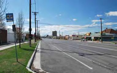
48 o Staff stated the bridge was under review by Parks and Open Space, who was managing the Oxbow project, and the Commission did not regulate the specifics of that project. The Commission and Staff discussed if there was a way for people to provide comments to Parks and Open Space. Staff stated parks reviewed the plan and approved what was presented and the specific details would be discussed as the plan moved forward. The funding for the plan and if expansion could be considered. o Staff explained the present version was a segment of a much larger plan that would be implemented in the future. Commission Woodhead stated the Staff Report did not ask for a motion to be made therefore, would it be appropriate to make a motion to approve it. Mr. Paul Nielson stated some action needed to be taken whether that was to table or approve the petition. MOTION 7:57:03 PM Commissioner Fife moved to forward a favorable recommendation to the City Council regarding the 9 Line Master Plan as presented. Commissioner Wirthlin seconded the motion. Commissioners Ruttinger, Hoskins, Fife and Wirthlin voted aye. Commissioner Dean, Flores-Sahagun, Gallegos, Woodhead and Taylor voted nay. The motion failed 4-5. The Commissioners stated they needed to review the plan with the comments made to determine if the concerns of the public were addressed. They asked for more documentation on the wetlands and asked for the Parks Department to present plans for the Oxbow corridor. Staff stated the details of the wetland park were not the Planning Commission s purview and having specific details in the Master Plan was not appropriate. The Commission and Staff discussed the role of the Planning Commission regarding the design of the park and if it was in their purview to oversee those aspects. The Commission and Staff discussed the role of the Planning Commission in implementing Master Plans and developing a base to work from. MOTION 8:05:49 PM Commissioner Woodhead made a motion to table the 9 Line Master Plan to the March 12, 2014, Planning Commission meeting to give the Commission the opportunity to review the plan documents in light of the public comments and to close the Public Hearing. Commissioner Taylor seconded the motion. Commissioners Woodhead, Taylor, Hoskins, Dean, Flores-Sahagun and Gallegos
49 voted aye. Commissioner Fife, Ruttinger and Wirthlin voted nay. The motion passed 6-3
50 6. 9 LINE CORRIDOR MASTER PLAN

51 9 LINE CORRIDOR MASTER PLAN February 2014
52 Mobil ity is more than about how we get around - it s also about cre at ing con nec tions between res i dents, busi nesses and vis i tors, relat ing neigh bor hoods with each other and down town and, most impor tantly, defin ing our sense of place to cre ate a uniquely Salt Lake City lifestyle... - Office of the Mayor, Salt Lake City


53 3 9LCMP BACKGROUND, LOCATION & CONTEXT... 4 A look at the physical and socio-cultural context of the 9 Line; a brief history as well as the background to the project. CORRIDOR VISION... 8 This section covers the overall vision for the future design of the 9 Line corridor, as well as the mission and objectives to implement the vision. DESIGN GUIDELINES This section begins by documenting the existing conditions of the corridor. Thereafter proposals for improvements to the form of the corridor including improvements to the physical infrastructure along the trailway and new amenities which will enhance the user experience. URBAN DESIGN This section focuses primarily on the function of the corridor by identifying its overall framework including key intersections, connections and points of interest. It identifies and analyzes several of the most important nodes along the corridor which provide opportunities for long-term development of new uses and recreational activities. This is accomplished by proposing several program components for each of these key locations. IMPLEMENTATION This section outlines the strategies for executing some of the ideas and projects discussed in the document. APPENDIX The appendix provides extra information on some of the resources and data that were used to help craft the corridor plan including analysis, public outreach, historic photos and research. Also relevant precedents are included which serve as examples of how program components may work together. TABLE OF CONTENTS


54 4 THE 9 LINE - BRIEF HISTORY & BACKGROUND 900 South & 900 West, Salt Lake City, circa Photo courtesy Utah State Historical Society BACKGROUND, LOCATION & CONTEXT The map shows the study area for the West Salt Lake Master Plan. The 9 Line corridor is highlighted on this map in the tan color. The 9 Line is an east to west corridor which runs from 200 West on the east to the surplus canal on the west. The 9 Line Trail is a linear parkway which currently runs approximately along 900 South between Redwood Road and 700 West, with buffered bike lanes extending the trail to 200 West. This corridor had been used historically as the railroad corridor for passenger train arrival to the Salt Lake City Union Depot. Union Pacific abandoned the use of this corridor in At that time, Salt Lake City acquired the former rail corridor, and its associated property, providing the opportunity to construct today s 9 Line Trail. This shared-use paved trail represents the first step in a greater vision to construct the Transvalley Corridor Trail, identified in the 1992 Salt Lake City Open Space Plan, which would connect the Jordan River Parkway and the Bonneville Shoreline Trail. Salt Lake City has recently completed a Master Plan for West Salt Lake, encompassing the Glendale and Poplar Grove neighborhoods. The 9 Line corridor was identified as one of the major community assets that could serve as a draw, and catalyst, to opening up other community points of interest and landmarks


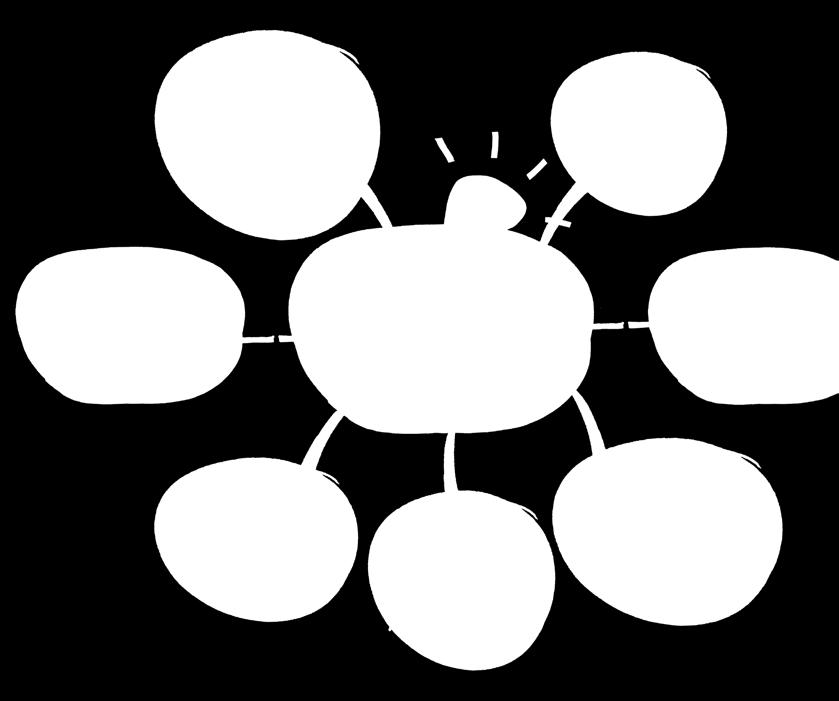
55 INTRODUCTION 5 The West Salt Lake Master Plan and other policy and vision documents produced for the City and region have identified the 9 Line corridor as a major east to west multi-modal transportation corridor with the potential of drawing attention to community assets, and spurring redevelopment in the neighborhoods it traverses. PHYSICAL & CULTURAL CONTEXT The 3-mile trip along today s 9 Line corridor passes through several neighborhoods with a wide range of land uses, including commercial, residential and industrial/manufacturing. Some of the neighborhoods are in transition, such as the Central Ninth neighborhood near the eastern gateway and areas adjacent to the Granary District. Others are more established single-family residential neighborhoods, such as those along the corridor between the Jordan River and Redwood Road. The neighborhoods along the 9 Line are the most ethnically diverse neighborhoods in Salt Lake City. The ethnic diversity contributes to the cultural characteristics of the neighborhoods. The culture of the area also includes one of activity, ranging from a culture of bicycling, walking and recreating, which are highlighted in the West Salt Lake Master Plan. Each of these cultures will use and experience public spaces differently. The 9 Line provides new areas for the various cultures to mix and opportunities to showcase how different cultures use public spaces. The 9 Line corridor is on of the major east to west corridors in the Salt Lake Valley, linking a number of parks and transportation networks. The corridor is highlighted in orange. Beginning with the railroad, continuing with industrial development, and finally with the construction of I-15, the City and its residents have had to address a concern identified by many residents as the east-west divide. The east-west divide connotates a negative reflection of the city, and many feel the concern has never been adequately addressed. While there are many aspects to the divide, connectivity is a major component of it. WHY THE 9 LINE CORRIDOR MASTER PLAN? The 9 Line Corridor provides an opportunity to begin to create meaningful, useful connections despite the barriers related to the east-west divide. Cityowned vacant land under the I-15 bridge and west of the bridge could be a unique gathering place with a mix of art, recreation, and transportation that reflects not only the culture of the neighborhoods, but the changing culture of the City as a whole. Actions such as this will not break down the east-west divide alone, but are a first major step towards doing so. With continuing growth and development in the surrounding areas, it became necessary to produce this Master Plan to direct development along the corridor and its immediate context, while assisting in crafting a vision for varying degrees of redevelopment expected at specific nodes in the vicinity of the corridor. Residents read information on the 9 Line public outreach boards at the Riverfest Event. June 1, 2013 BACKGROUND, LOCATION & CONTEXT


56 6 9 LINE TIMELINE 1892 Riverside School constructed, located on SW corner of 6th S & 9th W SP, LA & SL completes construction of new 3.61 mile passenger line along 900 South between Buena Vista and Salt Lake, including a bridge over Jordan River New Union Depot complete; 900 South tracks provide better access to north-south platforms for passenger trains SP, LA & SL name changed to LA & SL; route along 900 South called the Salt Lake Route Jordan Park established 1916 SP, LA & SL completes route between Los Angeles and Salt Lake City Jordan Park greenhouses constructed 1944 Construction approved for Grant s Tower; an automatic interlocking system located just w Union Pacific passenger depot, 700 Wes In 1952 BACKGROUND, LOCATION & CONTEXT Oregon Short Line railroad constructs 1 mile of track along 900 South, west from their main line on 400 West; called the Enamel Spur to serve an enameling company Oregon Short Line begins construction of a new standard gauge main line west of Salt Lake City, called the Leamington cut-off, c Construction begins on new Union Depot Construction begins of new passenger line along 900 South San Pedro, Los Angeles, & Salt Lake Railroad takes ownership of OSL tracks south and west of Salt Lake City, including 900 South tracks 1913 Sewer infrastructure installed along 900 South Roads paved; curb/gutter installed along 900 South 1917 Union Pacific acquires the LA & SL Consolidation of Union Pacific, Oregon Short Line, Oregon-Wash, LA & SL Small Arms Plant built west of Redwood Road to serve as ordnance depot for WWII; served by western portion of 900 South passenger rail line 1943 Small Arms Plant closed; becomes sub-depot to Ogden Arsenal 1948 Grant s Tower completed 1950


57 7 est of t/south Temple ternational Peace Gardens park on Jordan River dedicated 1969 Union Pacific works with Salt Lake City to develop the Centennial Business Park on the west side; served by 900 South line 1973 Jordan River Parkway Authority created; conceived as alternative to channelization for flood control 1983 Denver Rio Grande Western joins Amtrak 1986 Grant s Tower closed; Amtrak passenger service moves from Union Pacific Depot to Rio Grande Depot, including new tracks along 500 West 1992 Salt Lake City Open Space Plan completed; Transvalley Corridor identified, linking Bonneville Shoreline Trail and Jordan River Parkway along 800/900 South 1995 West Salt Lake Community Master Plan adopted; Plan includes recommendation to acquire 900 South rail corridor and construct a trail 1999 Last Union Pacific train operated on 400 West tracks; line is cut at 900 South & 400 West to allow construction of Gateway and reconfiguration of I-15 on/off ramps New Parkview Elementary School building completed adjacent to 900 South Line Salt Lake City communicates with Surface Transportation Board to pursue adverse abandonment of 900 South tracks by UP UP & SLC reach agreement to realign Grant s Tower, will allow for 900 South Line abandonment SLC Council approves $700K to create quiet zone on 900 South Line STB approves abandonment of 900 South Line after reconfiguration of Grant s Tower is complete Feb: UP & SLC sign agreement to transfer ownership of 900 South Line corridor to the city Nov: UP begins use of new Grant s Tower interchange Amtrak formed; takes over UP s remaining passenger service; 900 South line becomes freight line only 1989 Union Pacific and Salt Lake City develop franchise agreement regarding 50 street crossings within city 1996 UP announces intention to operate trains along 900 South line to avoid congested Grant s Tower interchange and save time Environmental clean up of American Barrel site, adjacent to Grant Tower interchange, is complete; The 2.2 acre site is made available for redevelopment as part of Gateway project UP operates first train of 36 cars on 900 South Line in January. Negotiations between UP & SLC begin; Quiet zone, other mitigation measures discussed to lessen impact on residents/neighborhood 2004 November: Quiet zone along 900 South Line goes into effect 2008 Tracks of 900 South Line removed in the summer U of U s SLC Workshop initiates the 9 Line visioning process; in the fall, a 10-foot asphalt multi-use trail is laid 2013 SLC engages in a formal 9 Line Master Plan process BACKGROUND, LOCATION & CONTEXT
58 VISION
59 9 9 LINE CORRIDOR MASTER PLAN VISION CORRIDOR VISION The vision for the 9 Line corridor is for it to serve as a means to connect people to places via multiple modes. The form and function of the corridor design will allow these connections to happen in a way that is safe, equitable, and sustainable while incorporating aspects that reflect the lifestyles and ethnic cultures of the surrounding community. The 9 Line corridor will function as an urban thoroughfare and public open space, helping people make connections, reduce barriers, promote healthy lifestyles, and protect and create built, natural, social, and cultural resources. It will do so by: VISION connecting people to places Connecting stable residential neighborhoods, growing commercial and neighborhood centers, and promoting thriving recreation locations; Embracing a diverse assemblage of people and user groups, providing the opportunity for enhancing their connections to the surrounding businesses and neighborhoods that form a unique and attractive community; Improving physical and cultural connections between the east and west sides of the City that in turn offer regional connections; Featuring retail, service, recreational, and educational options at key nodes along the 9 Line, as well as encouraging and facilitating connections to neighborhood nodes in the surrounding community; Facilitating the goal of West Salt Lake becoming the primary destination in Salt Lake City for river recreation and other types of parks and public spaces; Serving as a mechanism for the neighborhoods of West Salt Lake to celebrate their history and character by functioning as a community and cultural asset that connects people of all ages to services and educational opportunities; and Supporting connections to the West Salt Lake industrial business community, helping it continue to be a healthy and diverse growing employment and economic base for Salt Lake City. VISION
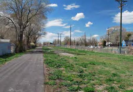
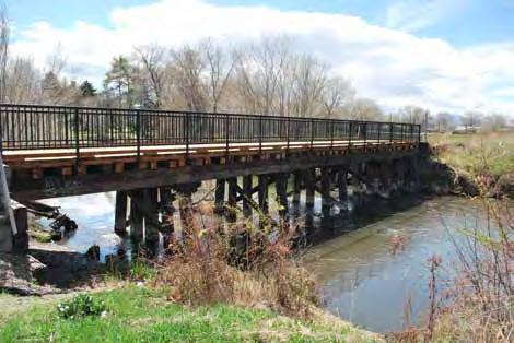
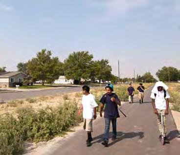
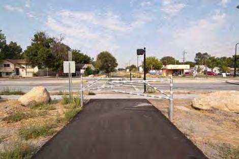
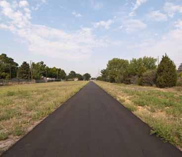
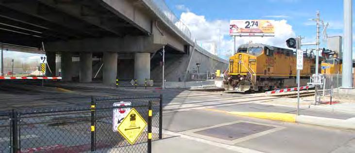
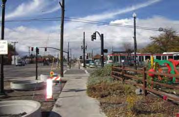
60 10 9 LINE CORRIDOR MASTER PLAN VISION MISSION OF THE MASTER PLAN The mission of the 9 Line Corridor Master Plan is to identify opportunities to develop improvements and activities that reflect the values and ideas of the community, as gathered during this process and the West Salt Lake Master Plan process, and outline strategies and action plans for implementing the vision. The vision and master plan are guided by four principles: Safety design the trail and its surroundings to create a corridor that is safe for pedestrians, cyclists, and other non-motorized users. Equity program the trail and its nodes to allow use by a range of user groups intergenerational, multiple non-motorized modes, and multiple speeds/uses. Whether it is a person strolling through to enjoy the landscaping and nature or a commuter passing through to their job, the trail will recognize and embrace this diversity. Sustainability best practices in regard to the built environment (solar powered lighting and repurposed materials), natural environment (use of native landscaping, creation/preservation of natural habitats), and social and cultural environments (encouraging/supporting diverse users groups, being a hub of activity, connecting people and place). 4 guiding principles culture equity safety sustainability Culture connections to the history of the area and the culture of the corridor and surrounding neighborhoods. Incorporating art, lighting, and including/programming areas that celebrate this culture (restaurants, cafes, and other gathering spaces). Creating layers of activity and experiences for all users. Stitch into surrounding neighborhoods, complement/enhance them. Enhance and enliven spaces along, adjacent to, and nearby the corridor. VISION
61 11 9 LINE CORRIDOR MASTER PLAN VISION OBJECTIVES 5 objectives The objectives for the master plan are a synthesis of the ideas generated by the community through an extensive public outreach process as well as analysis performed by the design team. Five objectives capture the direction of the program ideas presented in the master plan: Destination; The corridor master plan will seek to balance the needs of local users, as well as non-local users passing through as commuters, while creating lively spaces along the linear parkway where people congregate. destination play nature Play; The activities along the 9 Line corridor will be chosen to appeal to a variety of audiences of all ages, nationalities, and socioeconomic backgrounds to unify neighborhoods through recreation. Nature; Connecting with nature will be a point of emphasis for the 9 Line, including protecting and restoring native habitats, providing wildlife habitat for a variety of species, and supporting community gardens. connections art Connections; The 9 Line corridor will physically and culturally connect neighborhoods on the east and west sides of the City, via a regional transportation trail network. Art; Interactive artwork will be encouraged, allowing the corridor to act as a public space for free expression that is fluid, rather than static and conventional. VISION

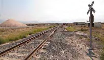
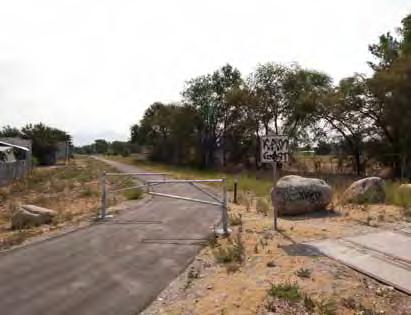
62 12 9 LINE CORRIDOR MASTER PLAN VISION INTRODUCTION The following sections of the master plan deal with the physical factors that will help to achieve the vision, mission and objectives discussed in the previous pages. Several interventions are proposed and range from extensive or minimal depending on the particular context of the trail. These sections are categorized into Design Guidelines and Urban Design portions of this plan. Existing conditions will first be addressed and the design interventions and concepts will follow. The diagram below highlights three zones that will be mentioned often within this master plan. These are the trailway, corridor, and adjacent land uses. Physical interventions will be proposed for any or all of these zones depending on the context. The distinctions between these zones are explained below: TRAILWAY The trailway describes the existing trail and its immediate context. This includes the 10-foot paved trail (in most areas), as well as the immediate landscaping and furnishings located along it within approximately a 10- foot zone to its north and south. To the east of 1-15, the trailway consists of sidewalks and bike lanes along 900 South. CORRIDOR The corridor describes the immediate areas next to the trailway. The corridor width is not uniform along the trail and varies considerably from especially narrow zones in the neighborhood core, to large expanses to the west of Redwood Road. The City owns some property within the corridor zone presenting opportunities for redevelopment and for creating a unique identity along the 9 Line. These are identified in the node plans. ADJACENT LAND USES & BUILDINGS Framing the 9 Line corridor are buildings and physical structures that exist, or are proposed, within a variety of land use contexts. Existing uses include residential, commercial, industrial and institutional uses such as churches and schools. A number of new developments as identified by the West Salt Lake Master Plan will happen at key intersections along the 9 Line. These will happen in areas termed as nodes, which will have the heaviest programming along the trail. A detailed description of these nodes can be found later in this master plan. Trailway Adjacent Land Uses & Buildings Corridor Corridor Adjacent Land Uses & Buildings VISION
63 connecting people to places VISION

64 DESIGN GUIDELINES

65 15 DESIGN GUIDELINES


66 16 EXISTING TRAILWAY & CORRIDOR CONDITIONS - PHOTOS DESIGN GUIDELINES


67 17 DESIGN GUIDELINES


68 18 EXISTING TRAILWAY & CORRIDOR CONDITIONS Section 1 - Between I-215 & Redwood Road Section 2 - Between Navajo Street & Concord Street DESIGN GUIDELINES Section 3 - Between 900 West & 800 West


69 EXISTING TRAILWAY & CORRIDOR CONDITIONS 19 OVERVIEW The 9 Line corridor exhibits different characteristics along its 3-mile length. These are distinctive and respond directly to adjacent land uses and history. The corridor widths also vary considerably with very narrow areas in the neighborhoods, around the core, to the large expanses west of Redwood Road. Buildings, physical structures, and vegetation along the corridor contribute to the varying characteristics. WEST END The west end of the corridor, from the Surplus Canal to Redwood Road, is not paved, is mostly loose gravel, and still has spots with the original railroad tracks in place. There is a conflict with Indiana Avenue that will need to be addressed. There are few trees in the corridor and the dominant vegetation is native sagebrush and grasses. Industrial buildings occur in this area but are not close to the corridor in most places. This creates a vastness and opportunities for views to open space and the Oquirrh mountains. I-215 crosses the corridor but is elevated and does not create a physical barrier. CENTRAL CORE The core of the 9 Line can be described as the area from Redwood Road on the west to I-15 on the east. The trail is paved within this zone with a 10-foot asphalt paving. Land uses along the corridor within this zone vary considerably including: residential, commercial, a school, and the Jordan River corridor. The area is relatively more vegetated with significant tree stands and shrubs in most areas. The corridor widths vary, with some large City-owned parcels adjacent to it. A 10-foot wide asphalt paved trail is currently in place from Redwood Road to 700 West serving both pedestrians and cyclists. Safety gates and pavement markings are provided at all road intersections. These safety gates are of concern to trail users as it creates an ease of use issue. EAST END The east end of the corridor is the area between I-15 and 200 West. The 9 Line corridor is mostly in the 900 South roadway at this point, occurring as a sidewalk and bike lanes. 6-foot buffered bike lanes have been striped on the road but sidewalks are not upgraded uniformly and current pedestrian flow is not adequate. Street trees and furnishings are also not uniformly present. Land uses along the corridor in this area include industrial (with iconic concrete silos), commercial, and residential. Conflicts to pedestrian and bicycle flow is present at the point where the Union Pacific and FrontRunner cross the corridor under I-15. Traffic signals and crosswalks are used to manage conflicts between pedestrians and vehicles. Section 4 - Between I-15 & 500 West DESIGN GUIDELINES

70 20 TYPICAL PROPOSED TRAILWAY CONDITIONS INTRODUCTION The design guidelines in this section are intended to implement the 5 objectives of the 9 Line Master Plan vision. They are: DESIGN GUIDELINES South Typical section through trailway North Destination; While balancing the needs of commuters and destination users, the typical proposed trailway conditions create a unique trailway in the Salt Lake Valley, which connects trailway users to a wide variety of destinations and landmarks. Play; One of the primary components of the 9 Line Corridor Master Plan is creating a wide variety of opportunities for recreational use and enjoyment for members of all ages and interests to connect community members throughout Salt Lake City. Nature; Establishment of an interesting, interactive and regionallyappropriate landscaping plan for the corridor is of crucial importance. Moreover, the plan seeks to create opportunities for users to interact with existing natural systems and landmarks. Connections; The typical proposed trailway conditions will enhance existing connections to neighborhoods and forms of public transportation by enhancing wayfinding, removing existing barriers and creating a desirable user experience. Art; Public art along the corridor will be emphasized, creating an interactive free expression canvas, intended to reinforce the rail and industrial character found throughout much of the corridor. ACCESSIBILITY The 9 Line Corridor Master Plan intends to connect community members across age, race, socioeconomic status, geographic location or any other barriers which may divide valley residents. While accessiblity and universal design are emphasized throughout the various components of plan, all trailways, intersections and recreational opportunities along the corridor should comply with locally adopted ADA codes, as well as AASHTO Bicycle Facilities Guidelines.
71 TYPICAL PROPOSED TRAILWAY CONDITIONS 21 ADDITIONAL TRAIL Currently there is a 10-foot wide asphalt trail through most of the corridor with no striping of any kind. It is mostly successful in accommodating all forms of movement along the trail, however there are occasional incidents between cyclists and pedestrians, as well as commuters and recreational users. In order to avoid these conflicts, and once future demand necessitates expansion, an additional trail and striping of the existing trail is proposed. In this proposal, the existing asphalt trail remains in place with a new stripe through the center to divide it into bi-directional bicycle traffic in a pair of 5-foot lanes. On the north side of the existing trail an additional 8-feet of pathway should be constructed with 36 inches of separation between the trails in the form of a rain garden. With no striping, this general use path is intended to serve the needs of all users besides cyclists along the trail. In order to distinguish this path from the cycling path, it should have a different color and texture, preferably some form of pervious paving to avoid increasing impermeable hardscape in this urban context. Any equity or access issues that could exist along the trail will be addressed by creating two pathways with sufficient capacity and signage. This provides equal access and utility to users of all ages and abilities by separating speeds, intended use and movement type. VEGETATION The existing state of the vegetation along the corridor leaves much to be desired. This is immediately obvious to any user of the existing trail, and was mentioned frequently by members of the local community. The existing vegetation does not provide much beautification along the trail, and in some cases puncturevine and other noxious weeds cause flat tires or other inconveniences to users of the trail forcing them to find alternative paths of travel. These should be completely removed and replaced with native and adaptive grasses, shrubs and forbs. Moreover the seed mix should emphasize several phases of seasonal growth and color creating a changing landscape throughout the growing season. This would enhance the visual impact along the trail, as well as provide useful recreation space, reduce the urban heat island effect, require little or no irrigation, and educate users about the native ecosystems along the 9 Line corridor. Another major opportunity to improve the user experience along the trail would be the installation of shade trees. These should be a variety of native or adaptive trees, with a wide canopy, preferably fast growth species in order to provide this amenity as soon as possible. Similar to the seed mix, tree selection should be studied in-depth to provide a variety of species with differing fall colors for an enhanced user experience. Moreover, the placement should be irregular depending on the corridor width, and adjacent uses providing a variety of experiences and/or screening as one moves along the trail. Consideration should be given to providing sufficient natural light on the trail in the wintertime which includes tree selection and placement. The overall intention is to achieve the environmental benefits of regenerative urban nature such as shade and clean air, while also cooling the trail by creating a microclimate below the tree canopy. Crime Prevention Through Environmental Design principles should be incorporated into this landscape design to avoid creating potential threats with the landscape design. REST AREAS In order to accommodate users of all ages and abilities, rest areas are proposed along the 3-mile corridor. Community members frequently requested these opportunities to rest as well as a few basic amenities including a small shaded seating area, wayfinding maps, lighting, trash and recycling receptacles, bike racks set amidst trailway landscaping. Consideration should be given to balance safety issues when determining the elements to include at rest areas. They may also include drinking fountains, restrooms, art, and interpretive signage. One such station per mile should be sufficient, and these facilities already exist at the centrally-located Jordan Park. Two additional areas should be constructed, one near each end of the corridor at destinations along the trail where cyclists are most likely to stop. Ingress and egress into rest areas should be carefully planned to avoid potential conflicts. Additionally, minor rest areas comprised of benches should be located every 1/2 mile along the trail primarily to provide an opportunity for pedestrians to rest at key points of interest. This standard has been successfully incorporated along recreational trails in cities such as San Jose and Portland. SIGNAGE For greatest effect, signage should be used sparingly. If signage becomes ubiquitous, it is easily overlooked. It will be important that signage along the trail is consistent, giving a unique, uniform appearance along the length of the corridor. It is proposed that signage evoke the historic and industrial nature of this corridor by utilizing rail-themed signage installations at key intersections only to avoid overuse. Another important issue regarding signage is utility for all users, as many of the area residents do not speak English as their native language. To address this issue and to make the signage as useful and intuitive as possible, it should be graphic and diagrammatic where possible, avoiding use of text except where required by regulation or common sense. LIGHTING Lighting is a powerful way to improve the safety and utility experienced by users of the 9 Line. It would extend the useful hours of the trail for commuters creating a 24- hour mobility option. If coupled with emergency call boxes, it would also improve the safety conditions real and perceived by current and potential users of the trail. However, the installation of lighting along the trail and at rest areas should not create a hardship for residents adjacent to the trail by installing illumination which will shine into their properties around the clock. This could also contribute to urban sky glow (light pollution) and could pose potential harm to small mammals inhabiting the corridor. In order to avoid these issues, as well as increased electricity costs, it is proposed that solarpowered, full-cutoff bollard style lighting be installed. No more than 36 inches in height, these should be placed in the 36 inches wide linear rain garden between the existing trail and the new proposed trail in order to further delineate these two distinct paths. The rill between should be a vegetated, rock-lined swale serving as a rain garden to capture surface run off from the paths. In order to meet AASHTO standards for lateral obstructions on shared use paths, the bollards should be placed 36 inches from the existing path adjacent to the new path. They should be placed at a regular interval to be determined with enough frequency to provide sufficient light along the trail enabling nighttime use. DESIGN GUIDELINES
72 22 TRAILWAY IDENTITY Typical examples of rail and industrial signage SIGNAGE The signage along the corridor is one of the key ways to carry forward the industrial aesthetic brand, by adapting commonly used rail signage such as overhead signs, pole mounted signals, lights and other typical rail signs. In order to have maximum effect, these should be reserved for key intersections only to avoid becoming banal and ubiquitous. They would likely use black and yellow extensively, as well as corten steel where possible for further emphasis of the trail s identity. Another way to carry this theme through the trailway is to use labels painted on the trail with street and neighborhood names in similar fashion as seen at rail crossing intersections. This idea should also extend to rest areas, interpretive signage, lighting and other fixed elements and amenities on the trail. All signage along the corridor should be coordinated with Parks and Public Lands signage standards. DESIGN GUIDELINES Gateway Gateway Major Intersection OVERVIEW Typical Intersection Potential signage alternatives to enhance the trailway s identity and brand The 9 Line passes many important intersections, landmarks and points of interest over its 3-mile length. It could easily be confused with these other resources, or simply overlooked. In order to increase its visibility, and by extension, increase use and activity, it should have a recognizable brand or consistent theme. To achieve this result, the brand should be unique to catch the eye of potential users, be informative and serve as a clear form of wayfinding for a diverse user group. The proposed brand or identity for the 9 Line is a rail & industry theme, utilizing similar signage frequently seen along rail lines today. This recalls and celebrates the corridor s historic usage as a rail line, as well as today s industrial, urban character along the corridor. This should also incorporate the 9 Line s unique and highly recognizable yellow and black logo, which has begun the process of branding and raising the visibility of this urban trail. Typical Intersection ARTWORK Public art along the corridor is another way to further emphasize this industrial brand, as well as provide recreational outlets. Rather than emphasizing static, delicate public art such as statues, the art along the corridor should be part of a living canvas as well as emphasize movement and motion through the corridor. This means that the art should allow for interactive use by local residents, to invite free expression. This creates opportunities for the diverse population of local residents and trail users to leave their mark on the place. This is intended to create a feeling of utility for all users, and reduce graffiti and vandalism by providing outlets for free expression such as chalkboards, murals, and free expression painting spaces. Any fixed or static art installed along the corridor should be placed at key intersections and may assist in wayfinding and identity of the corridor. It should also intend to further its industrial identity, emphasize biking or other recreational uses of the trail and may even include some of the rail components. Salt Lake City Parks and Public Lands has collected some of these components from the former rail corridor through Sugar House and South Salt Lake for the return of the streetcar. Creative use of these elements such as rail track and ties, will further the identity of the trail and connect today s users with the historical uses of the corridor. Grouping of art or other site features is desirable where feasible to avoid potential maintenance conflicts. LANDSCAPING The landscaping should be another recognizable element of the identity of the 9 Line. The primary component of this will be a seasonal, linear landscaped space winding its way through its urban context. Native and adaptive plant species should be selected, which will be hardy enough to withstand the semi-arid climate of extreme temperatures and require minimal or little irrigation and maintenance in order to succeed. It is understood that some irrigation will likely be required in order for the plants to establish themselves. The long term goals of the landscaping are: for the plants and grasses to be waterwise and conservative in their use; assist in remediating the damaged soil along the corridor; provide recreational space making this a linear parkway; reduce the urban heat island affect and express the variety of ecotypes found along the corridor.

73 SIGNAGE / WAYFINDING / ORIENTATION 23 WAYFINDING TO THE 9 LINE Because the 9 Line travels in a dedicated corridor throughout most of its length, it can be hard for potential users to stumble upon it unless they are looking for it. This means that at key gateways, signage and other design elements must be intentionally placed to attract their attention. This is covered in depth in the Gateways section of this document. Pole mounted signage should be placed at key locations in the immediate vicinity of the corridor, notifying riders and pedestrians of the location of the trail. For instance along the bike lane on 800 South and other such locations. The signage to be installed should follow the identity guidelines in this document using graphics and diagrams in place of text where possible. These signs should be map-like in nature, providing orientation to access the 9 Line and the destinations where it can take them. An action plan for signage should be prepared to identify other such opportunities to inform potential user groups. The trail should also be featured on City maps and documents available on the City s website. Additional signage, such as these signs by Walk Your City would serve to enhance wayfinding and user experience OVERVIEW One of the key issues raised by the community regarding the 9 Line is that it feels isolated and hard to find, despite its relative location to many important landmarks. Many cyclists report using nearby bike lanes because they are easier to locate and access. The lack of signage and a recognizable identity decreases the chances that passersby and area residents will use the trail. This has also become an equity issue, if area residents feel unclear about the nature of the trail and its destinations, then it will be underutilized. If the trail is underutilized, it may likely feel unsafe and local residents, as well as regional users, to feel unwelcome. The overall goal of the signage and wayfinding along the corridor is to provide accurate information at key locations for local residents and regional users, on bike and on foot. Moreover, that all users will be able to understand the signage to be able to properly orient themselves to use the 9 Line to its full potential connecting them to key destinations. Another important interface along the corridor is between local residential neighborhoods and the 9 Line Trail. Neighborhood residents frequently access the corridor on bike or on foot at local streets which terminate at the corridor. This is another opportunity to provide useful wayfinding signage which also reinforces the identity of the trail. Miniature 9 Line signs can be placed here, as well as signage pointing to major destinations in either direction. WAYFINDING FROM THE 9 LINE While the orientation of the existing trail is east to west, it can still be an integral part of helping connect people to place north and south as well. Travel through many sections of the corridor is faster because it is uninterrupted for the pedestrians and cyclists who use it. However, this same benefit can also be a detriment, e.g. blocking sightlines to destinations for those using the trail. This includes those who know where they are trying to go, as well as others who have no particular destination in mind. To inform and encourage the use of the 9 Line to reach other destinations, it is proposed that the Walk Your City approach be used. This includes using pole mounted signage with text stating how long it takes to walk (or bike) to potential destinations. The intention of this type of signage, is to connect people to places in new and exciting ways. DESIGN GUIDELINES

74 24 GATEWAYS MAJOR GATEWAY The major gateways, existing and potential, tend to include intersections with major transportation corridors, other modes of transit, and a high volume of passersby or potential users. These include the intersection with Trax at 200 West, passing underneath I-15, and the future intersections with Redwood Road and the Surplus Canal. The current intersection at 200 West, and the future intersection with the Surplus Canal (and its future trail) should be thought of as metaphorical bulkheads the eastern and western terminus of the trail on each end. Each of these gateways are unique and there is no single design solution for each of them. The end goal being that both first time and frequent users of the trailway feel welcome and experience a recognizable sense of arrival each time they use the trail. Each solution should be unique to the site and context, and the following suggestions should be thought of only as a potential kit of parts to use where appropriate. For a major gateway some of the potential recommendations include: overhead gateway signage celebrating the 9 Line and its industrial theme; branded intersection hardscapes using pavers or colored concrete; other types of pole-mounted welcome and identity signage; and public art such as murals, lights, as well as static displays such as sculptures which should further the industrial identity of the line. I-15 gateway, showing improvements for safety, wayfinding and enhanced user experience MINOR GATEWAY DESIGN GUIDELINES OVERVIEW The 9 Line enjoys an excellent relative location in the Salt Lake Valley, passing many important transportation corridors, neighborhood nodes, parks and other points of interest. Despite this proximity, it has not yet taken advantage of this opportunity by a high profile, highly visible identity or brand. Nowhere is this more obvious than at several of the major potential gateways to the corridor; places where the 9 Line intersects with important modes of transportation such as UTA Trax, or the Jordan River Parkway. In order to increase its visibility, and to welcome potential corridor users, these important intersections major and minor should be considered gateways, and provide the appropriate amenities and infrastructure to that end. Moreover, they should consider the needs of motorists, cyclists and pedestrians. Some of the minor gateways along the corridor include many local streets such as Navajo Street, Emery Street, 1100 West, 700 West as well as 900 West which is considered an arterial road. These will typically feature a smaller volume of passersby, and will include a wider variety of transportation modes such as cyclists and pedestrians from the Jordan River Parkway. These gateways will also be important, but may not require the same amount of visibility to catch the eye of potential users and may even allow for some installations to be more subtle in nature. This opens the door to a wider variety of solutions such as: landscape installations including landscape art; signage continuing the industrial theme of the corridor; public art large and small; interactive art potentially featuring water, lights, and sound art installations; and changes to hardscapes including grade profile, colors and materials.

75 TYPICAL INTERSECTIONS SAFETY Safety is of utmost importance at these intersections. Cycle barriers have been placed adjacent to the local street to slow riders to encourage them to look both ways before crossing. In addition, a yield sign reminds users (both pedestrians and cyclists) to yield to cars before crossing through the striped intersection. These elements seem to be effective in slowing riders before they enter the intersection. Currently, a 9 Line sign and two solid white stripes inform drivers of the intersection with the trail. Field observations and community feedback indicate that some cars don t slow at this intersection creating potentially dangerous situations. One way to further emphasize to drivers to pay special attention at this intersection is to change paving material, color and profile at the intersection with the trailway. Creating a slight profile or raised crossing is a proven solution to slowing vehicular traffic and could further enhance safety at these intersections as usage increases in the future. 25 Plan view of typical Intersection OVERVIEW The 9 Line passes through many important intersections over its 3-mile length. It also passes through several minor intersections, especially west of the Jordan River as it moves through residential neighborhoods. Those of greatest impact and significance will be covered in greater detail elsewhere in this plan. For those with similar characteristics, which do not exhibit the same potential or arouse similar concerns as some of the key intersections, will fall under these guidelines as typical intersections. These guidelines also intend to anticipate any future such intersections which may be constructed. The characteristics of the typical intersection are: the corridor intersects with a two-lane local street at-grade; multi-use paved trail exists on either side of the intersection; and no stop signs or traffic signals exist for vehicular traffic. IDENTITY At these key intersections, changes in signage, materials, colors, and existing barriers will carry the industrial identity of the corridor forward. There are also boulders at these intersections, which should remain intact to prevent unauthorized vehicular travel along the trail. The raised crossing could consist of pavers or scored concrete in order to create a change of material and slight change of grade to slow vehicular traffic. To further the identity of the corridor, it should in some way simulate train tracks which previously crossed at these intersections before being removed. However it should not use a material or scoring pattern which could create slick or bumpy surfaces which create inconveniences for riders using the trail. Pavement marking symbols or lettering will also warn drivers to slow down. USER EXPERIENCE The guidelines for the typical intersections should also serve to create a better user experience along the corridor. The existing barriers, while effective, cause riders to nearly stop while passing though forcing some to dismount and are very difficult to pass through with a bike trailer. If one gate were removed or permanently left open, this would no longer pose a problem. Riders of all ages and abilities could ride through the gates without dismounting, while still being slowed sufficiently to look both ways before crossing the roadway. The additional trail for pedestrians would remove any potential conflict between cyclists and pedestrians at typical intersections. Signage along the trail will not only enhance the feeling of connection with the past, but will also be strategically placed at key intersections to indicate streets, neighborhoods, as well as points of interest and how long to reach them on bike and on foot. This will be discussed in greater depth in the Signage and Wayfinding section of this plan. DESIGN GUIDELINES

76 26 DEPICTION OF PROPOSED TRAILWAY CONDITIONS The artist s illustration at right depicts the proposed trailway conditions if the primary elements of this master plan are implemented. The location is intended to be a typical intersection along the corridor. A Multi-programmed open space B Connection to existing transit service C Street crossing safety interventions D Rest area E Native plant exhibit F Rain garden/drainage median & light bollards G Art installations H Native grasses and landscaping DESIGN GUIDELINES I J Shared path for general use Dedicated two-way cycling path E

77 27 A B C J D G I F Looking east at typical intersection H DESIGN GUIDELINES
78 28 9 LINE CORRIDOR PLAN Moving through the 3-mile long existing corridor is a rich and diverse experience. Heading west from the eastern gateway at 200 West, the user notices changes in corridor width, landscapes, and a transition from urban commercial areas to residential neighborhoods then on to an industrial and manufacturing context near the Surplus Canal. Understanding the opportunities and constraints of the existing corridor and its varied context will be important in order to meet the goal of creating a unique east to west transportation link connecting multiple destinations. By analyzing the existing conditions opportunities will be identified to improve and enhance the form and function of the 9 Line corridor. The plan at right indicates corridor types between key nodes along the corridor which will be discussed in-depth in the Urban Design section of this plan. CORRIDOR TYPE A This area is characterized by manufacturing uses and vacant land. Original rail remains in place, and in some cases in use, thus no trailway has yet been established. Future connections via the Surplus Canal trail and views of the western portion of the Salt Lake Valley highlight potential opportunities in this section of the corridor. CORRIDOR TYPE B A compact street grid supports residential neighborhoods in this area, creating frequent intersections with the paved trailway in a narrow corridor. Access to the Jordan River Parkway, and a high volume of neighborhood users in this area create the greatest opportunities for future development. DESIGN GUIDELINES CORRIDOR TYPE C The corridor is widest in this area connecting users to regional parks and neighborhood commercial centers along the paved trailway. This area features a mixture of residential, commercial and light industrial uses. The neighborhood node at 900 South & 900 West presents a strong opportunity to catalyze future development. CORRIDOR TYPE D A neighborhood in transition, commercial & manufacturing uses are giving way to an eclectic urban residential neighborhood. Here the trail consists of onstreet buffered bike lanes and sidewalks.

79 29 DESIGN GUIDELINES

80 30 CORRIDOR TYPES CORRIDOR TYPE A The surrounding context of the baseline trailway will likely continue to be industrial in nature. This section offers the opportunity for a nearly uninterrupted connection between Redwood Road and the Surplus Canal. The focus of this corridor type is on providing that connection in a safe manner, with enhancement to the immediate corridor to counter the industrial context. Open views west to the Oquirrh Mountains will be supported by low landscaping and vegetation, which will also provide a sense of safety and buffering from the surrounding residential uses. Vegetation will be characterized to reflect the shift in ecosystems that includes wetland areas and playa mudflats. CORRIDOR TYPE B DESIGN GUIDELINES The surrounding context of this trailway is established residential neighborhoods. With limited right of way width, this section will primarily function as a connecting link between nearby nodes. Plantings and vegetation will reflect the residential nature through inclusion of shade trees interspersed with low native plants. The focus of this corridor type is to provide a serene and passive interaction with the trailway that offers safe passage between nodes. Landscape elevation changes through berming will assist in screening viewsheds from/to the corridor from adjacent residential neighborhoods where necessary.


81 31 CORRIDOR TYPE C The surrounding context of this trailway is mixed use in nature with room for opportunities to support the function of the trail. The focus of this corridor type is activity. A variation of residential, commercial, and light industrial uses provide the backdrop to a wide corridor right of way. The opportunities offered by this width will be capitalized upon through the installation of public art that is interactive in nature and small plazas for community gatherings, stopping to rest and or meeting for conversation with other trail users. Vegetation and plantings will be more interspersed rather than continuous. Small play areas for young children will occur along the trail to complement nearby active recreation uses for older children and adults. CORRIDOR TYPE D The context of this corridor type is characterized by its integration with the existing street and sidewalk infrastructure. With no separated trailway, users will make their connection to the 9 Line, transit, and other uses via bike lanes and sidewalks. The focus of this corridor type is on making clear, visual links to the users connection of choice. Clear, visible signage and wayfinding are the core elements of the corridor type and offer visual communication about where the users can go from here. This corridor type functions as a portal, and will lead to the primary gateway to the 9 Line Trail just to the west. Improvements to the existing streetscape such as landscaping, signage, and outdoor dining are some of the ways the user experience in this corridor type can be improved. DESIGN GUIDELINES
82 URBAN DESIGN

83 33 URBAN DESIGN

84 34 REGIONAL FRAMEWORK PLAN URBAN DESIGN

85 DESTINATIONS & POINTS OF INTEREST Existing & Future Neighborhood Commercial Centers - The West Salt Lake Plan identifies current and future neighborhood nodes and commercial centers, which can be seen at left. The 9 Line corridor provides convenient access for cyclists and pedestrians to and from many of these locations including nodes at Redwood Road, Navajo Street and 900 West. In this way, the 9 Line is more than a trailway, but a connector, connecting people to places. Parks - The 9 Line corridor proper provides access to several parks near the Jordan River including Jordan Park, 9th South Park and the International Peace Gardens, as well as the Jordan River Parkway itself. By heading further east along 900 South, users would access Liberty Park, which is a large regional park between East. Transit / Transportation Corridors - Several major transit corridors intersect with the trailway including UTA Trax at 200 West and UTA FrontRunner at I-15. However, the FrontRunner is not accessible to users of the 9 Line, and actually contributes to the creation of an unpleasant experience underneath I-15. Several bus routes intersect with the corridor as well at 300 West, 900 West, Navajo Street and Redwood Road. Land Uses - The existing land uses along the 9 Line corridor are extremely varied allowing the user to experience a full spectrum of uses in an urban transect. Heading west from the eastern gateway or bulkhead, the user will notice changes in corridor width, landscapes, and land uses. These include a transition from urban commercial and manufacturing areas to residential neighborhoods then on to an industrial/ manufacturing context with significant amounts of vacant land. There is also a significant presence of parks or open space near the Jordan River. 9 LINE KEY NODES After thorough analysis of the 9 Line corridor and surrounding context it became apparent that there were multiple major intersections or nodes along the corridor which presented opportunities for future connections and development. Seven of these intersections are of particular importance because of the transportation connections they provide, adjacent land uses and their unique potential for future development. In this framework plan these nodes have been identified: they are Surplus Canal, Redwood Road, Navajo Street, Oxbow, 900 West, I-15 Gateway and Central Ninth Gateway. 35 Bodies of Water - The 9 Line corridor is uniquely suited to providing access to watersports recreation with intersections to both the Jordan River and the Surplus Canal. These provide opportunities for kayaking, rowing, wildlife viewing and other forms of water-based recreation. REGIONAL FRAMEWORK PLAN The 9 Line Trail is a unique form of urban infrastructure in Salt Lake City s River District. It consists of a paved trailway which was built in 2011 between 700 West and Redwood Road in a former rail corridor. Beyond Redwood Road, the rail corridor is still owned by Union Pacific and sections of it are still actively being used. However, for the purposes of this study the connection from the existing western terminus at Redwood Road to the Surplus Canal will be included to plan for its future potential as part of a regional transportation network, Running east to west across the west side of the Salt Lake Valley as a portion of the Transvalley Corridor, it is a crucial link for pedestrians and cyclists between neighborhoods, employment centers, parks, commercial centers and other points of interest north and south of the corridor, seen in the map to the left. Some are located along or immediately adjacent to the corridor itself, while others are further afield. However, when viewed as part of a regional transportation network, the trailway increases mobility options to all of these points, and as such becomes a crucial connection from a regional perspective. Each of the nodes in the following section are described and analyzed in detail, including proposals for improvements and future development, as well as some of the important destinations and landmarks with which they could connect. For each node, potential program components are presented. These are designed to provide flexbility for Salt Lake City, being able to work together to create a multi-faceted public space. For example, in this image (above) an outdoor plaza, retail shops and landscaping provide amenities along an urban bike path. One example is shown in the image above, with an outdoor plaza, retail shops, and landscaping providing amenities along an urban bike path. For additional descriptions and examples of relevant precedents that show how multiple program components may be integrated along trails similar to the 9 Line, please refer to page 68 in the appendix of this plan. URBAN DESIGN
86 36 URBAN DESIGN 1 - SURPLUS CANAL NODE: ANALYSIS & POTENTIAL City-owned property NEIGHBORHOOD CONNECTIONS The Surplus Canal node of the 9 Line represents the western gateway to the trailway. Currently the 9 Line western terminus is at Redwood Road, however for the purposes of this plan, a design will be generated for the rail corridor between Redwood and the Surplus Canal. Once this connection is made, the current 9 Line corridor would be linked to additional employment centers, recreational opportunities and future transportation networks. In order to realize the more involved potential program options, additional property may need to be required by Salt Lake City. ADJACENT LAND USES Given the convenient access to the rail line, and the current access to major interstates and highways for shipping, the adjacent land uses are primarily industrial and manufacturing in nature, with much of the adjacent land which remains vacant or being utilized for storage. These uses can create sights, sounds and smells which are not ideal from a recreational use perspective. However these businesses represent significant employment centers. Providing mobility options for commuters seeking to access places of employment will be a major benefit once the connection is made from Redwood Road to the Surplus Canal. IMPORTANT NODES / POINTS OF INTEREST The intersection of the rail corridor with the Surplus Canal, represents a major opportunity from a recreational perspective. Access to a major body of water such as the Surplus Canal, is a unique opportunity in the Salt Lake Valley, and would represent the second water access point along the 9 Line corridor. Having access to the Jordan River and the Surplus Canal would situate the 9 Line as a crucial connection between these unique water-based recreational nodes. Currently the Surplus Canal is used frequently for training by rowing crews. However there are some barriers which could be removed to make this a more successful water sports recreational destination. Facilities such as a small parking lot, seating, restrooms, drinking fountains, a boat launch and storage would allow for expanded use of the Surplus Canal for rowing and kayaking. Also, once the rail corridor is abandoned here, investigating the removal of the rail bridge at this location should take place to create an unobstructed stretch of water. TRANSPORTATION CONNECTIONS Currently there are very few transportation connections at this node. However a planned north-south trail along the east side of the Surplus Canal presents a significant opportunity for future connections to be made. The proposed trail would connect the 9 Line s western gateway to key destinations such as the airport as well as other points of interest north and south. Moreover, a connection would be made to the east to west bike lane along Indiana Avenue providing access to additional employment centers to the west and Emigration Canyon to the east. These future connections will make this node a very significant bicycle regional crossroads and improvements should be planned to support this role.


87 37 PROGRAM COMPONENT 1A: RECREATIONAL MARINA A small marina or boat launch on the Surplus Canal could dramatically increase its recreational utility for rowing crews and kayakers. It would provide convenient access to a wide variety of user groups. This would include a dock and several small slips, as well as on-site parking. This may also include an outdoor pavilion, restrooms, on-site parking, boat storage house, drinking fountains, restrooms and interpretive signage about the heritage and purpose of the canal. For a relevant precedent of this type of component working in conjunction with other program components see Schuylkill River Trail on page 69. PROGRAM COMPONENT 1B: REST AREA & WAYFINDING STATION As the western gateway for the 9 Line Trail, and its crossroads with the bike lanes along 800 South and with the future Surplus Canal trail, a rest area could provide utility for users of the regional trail network. It would likely include a shade structure, seating, signage and wayfinding maps, trash and recycling receptacles, native landscaping and bike racks. It may also include a parking lot, water fountains, restrooms, solar powered lighting, vending machines, public art and interpretive or historic signage. For a relevant precedent of this type of component working in conjunction with other program components see Old Dominion Trail on page 69. PROGRAM COMPONENT 1C: PUBLIC ART PROGRAM COMPONENT 1D: WILDLIFE VIEWING Public art at this location could be utilized to denote the 9 Line s western gateway, as well as to celebrate the industrial heritage of the corridor. The intention of these elements would be to further the branding and identity of the corridor and could include historic rail components, as well as custom designed pieces of art. For a relevant precedent of this type of component working in conjunction with other program components see Bloomingdale Trail on page 68. The ecosystems near the Surplus Canal, are different from those further east along the corridor. Including wetland areas and playa mudflats, these areas could be restored and highlighted with interpretive signage along the eastern bank of the Surplus Canal adjacent to the future trail describing the wildlife, such as fowls and small mammals commonly seen in these areas. For a relevant precedent of this type of component working in conjunction with other program components see Old Dominion Trail on page 69. URBAN DESIGN
88 38 URBAN DESIGN 2 - REDWOOD NODE: ANALYSIS & POTENTIAL City-owned property NEIGHBORHOOD CONNECTIONS The intersection with Redwood Road is a vast departure from the serenity of the corridor elsewhere in this section. Hectic and busy with no easy crossing and lacking basic streetscape amenities, Redwood Road presents a significant barrier to the 9 Line Trail, which currently terminates here. Although currently owned by Union Pacific, for the purposes of this visioning process the section beyond Redwood Road will be considered a future extension of the corridor. While the roadway itself provides access to numerous destinations, its auto-oriented nature creates an unpleasant experience for pedestrians and cyclists. ADJACENT LAND USES An abrupt shift in land use occurs at Redwood Road where the 9 Line currently terminates. The neighborhoods to the east, are primarily residential in nature with several local retail and services businesses intermingled, while to the west the corridor is primarily surrounded by an industrial and manufacturing context. This bifurcated context creates very different opportunities for trailway design and programming on either side of Redwood Road. Unless a major shift occurs in the land use of the surrounding context, improving and enhancing the trailway design will be the main focus for this section. IMPORTANT NODES / POINTS OF INTEREST The West Salt Lake Plan calls for large-scale changes to take place at the intersection of Redwood Road and Indiana Avenue. Its relative location, transportation connections and high traffic volume create potential for further development of a commercial center at the intersection of Redwood Road and Indiana Avenue serving the adjacent neighborhoods. The 9 Line corridor should seek to connect to this future node through signage and streetscape improvements and amenities. TRANSPORTATION CONNECTIONS Redwood Road is a heavily traveled state highway, which runs northsouth on the west side of the Salt Lake Valley. With such heavy traffic this intersection has the potential to significantly increase the visibility of the 9 Line. Several UTA bus routes, 217 and 218 run along Redwood Road connecting riders to points north and south including Downtown Salt Lake and other employment centers. Also these routes provide connections to several UTA Trax routes allowing access to other destinations throughout the Salt Lake Valley. Once the trailway is connected further west to the Surplus Canal, the potential exists to connect to major north-south and east to west cycling trailways along the Surplus Canal and Indiana Avenue/800 South making the 9 Line an integral part of a regional cycling network.


89 39 PROGRAM COMPONENT 2A: STREETSCAPE IMPROVEMENTS In an effort to connect the 9 Line corridor to the future commercial node indicated in the West Salt Lake Plan at Indiana Avenue and Redwood Road, streetscape improvements are proposed to create a sense of arrival and connection between the two. This may include a landscaped median island, upgraded sidewalk hardscapes including pavers and colored concrete, decorative lighting, seating and landscaping. It may also include a gateway or other signage to create a sense of identity at this node. For a relevant precedent of this type of component working in conjunction with other program components see Dequindre Cut Greenway on page 69. PROGRAM COMPONENT 2B: ICONIC BRIDGE & VIEWING PAVILION When the connection is made between the 9 Line s current terminus at Redwood Road and the Surplus Canal, the challenges of making this crossing safe may require out of the box thinking. In order to address the high volume of traffic, vehicle speeds and skewed angle of the crossing a pedestrian and cycle bridge is one potential option. In order to maximize its utility it should be an iconic structure furthering the brand of the 9 Line, including an elevated viewing pavilion to provide opportunities to view the Great Salt Lake, as well as the Oquirrh and Wasatch Mountains. For a relevant precedent of this type of component working in conjunction with other program components see Midtown Greenway on page 68. PROGRAM COMPONENT 2C: INTERPRETIVE WETLANDS PROGRAM COMPONENT 2D: INTERACTIVE ART STATION A small native wetland exists immediately west of Redwood Road that provides an opportunity for a passive open space area with interpretive signage and seating calling attention to the shift in ecosystems at this area from uplands to playas and mudflats. For a relevant precedent of this type of component working in conjunction with other program components see Old Dominion Trail on page 69. With the long-term goal of developing a commercial center at Indiana Avenue and Redwood Road in mind, providing an interactive art station would promote recreational use for families who patronize this center. This may take the form of a chalk wall or a paintable rock, providing opportunities for free expression for users of all ages. For a relevant precedent of this type of component working in conjunction with other program components see Dequindre Cut Greenway on page 69. URBAN DESIGN
90 40 URBAN DESIGN 3 - NAVAJO NODE: ANALYSIS & POTENTIAL City-owned property NEIGHBORHOOD CONNECTIONS The Navajo Node of the 9 Line presents an excellent opportunity to provide a new resource while enhancing the connectivity enjoyed by local residents as well as regional users. This is because of the presence of a large Cityowned parcel available for development at Navajo Street, its adjacent land uses, transportation connections and relative location to several important destinations and landmarks. Navajo Street is a major community thoroughfare connecting residents and businesses from two sides of the neighborhood, and its intersection with the 9 Line corridor presents a significant opportunity for further development in connecting these neighborhoods. ADJACENT LAND USES While the immediate context of the trailway at this node is primarily residential, within a few minutes walk there are schools and churches, as well as several business nodes to the north and south of this location. To the north there is a small neighborhood commercial node which is currently growing and developing including several convenience stores and local businesses. To the south, the Glendale Shopping Plaza is both a local and regional draw with stores such as the Super Mercado, as well as a wide variety of small businesses. IMPORTANT NODES / POINTS OF INTEREST Within a 5-minute walk of the Navajo Node, there are several institutions, neighborhood commercial centers and points of interest. These include Parkview Elementary immediately adjacent to the trailway, Poplar Grove Park and two commercial centers identified in the West Salt Lake Plan. The first is the neighborhood commercial center at the intersection of Navajo Street and Indiana Avenue and the Glendale Shopping Plaza at the intersection of Navajo Street and Glendale Drive. TRANSPORTATION CONNECTIONS The corridor makes numerous connections into the residential neighborhoods at this node which provides excellent accessibility and utility for pedestrians and cyclists of all ages and abilities. For instance, Navajo Street is a preferred bicycling route identified on the Salt Lake City Bikeways Map. Moreover, on-street bike lanes along Indiana Avenue/800 south provide east to west connections between Redwood Road and 700 East and beyond. In addition, UTA bus route 516 runs along Navajo Street at this location connecting local residents to other activity centers and neighborhoods in the communities of Glendale and Poplar Grove.


91 41 PROGRAM COMPONENT 3A: NEIGHBORHOOD COMMERCIAL Navajo Street is an important north-south thoroughfare connecting two sides of the neighborhood bifurcated by the 9 Line corridor. It also features several small neighborhood commercial nodes. This location could also be appropriate for a small neighborhood retail opportunity. It should respond to the surrounding context in scale and character, while offering services to local residents and trailway users. It may include outdoor seating, shared restroom facilities, a bus shelter on Navajo Street, bike racks, public art and other amenities for residents and trailway users. For a relevant precedent of this type of component working in conjunction with other program components see Midtown Greenway on page 69. PROGRAM COMPONENT 3B: COMMUNITY GARDENS The size and orientation of the large City-owned parcel of land at Navajo Street easily lends itself to a large community garden of raised bed planters. Its location along the corridor, adjacent to residential neighborhoods presents opportunities for relationships between this garden and Wasatch Community Gardens and/or Parkview Elementary. This may also provide educational opportunities to teach school children about organic gardening and water use reduction. For a relevant precedent of this type of component working in conjunction with other program components see Midtown Greenway on page 68. PROGRAM COMPONENT 3C: TRAILWAY-ORIENTED PUBLIC ART The section of the corridor immediately west of Navajo Street begins to provide views both east and west, as well as several long, uninterrupted sections of the trail. One way to emphasize these unique conditions along this portion of the corridor is to create some form of public art or sculpture gardens which enhances the experience of movement or motion through the trailway which is part of the proposed corridor identity. For a relevant precedent of this type of component working in conjunction with other program components see Cherry Creek Trail on page 69. URBAN DESIGN
92 OXBOW NODE: ANALYSIS & POTENTIAL NEIGHBORHOOD CONNECTIONS 9TH SOUTH PARK Located in the heart of the central core of the corridor, this section balances providing destinations for regional users of the trailway, while enhancing the resources available to local residents. This section of the corridor travels through single-family residential neighborhoods, as well as several major activity centers including Parkview Elementary and the Jordan River Trail. Each of these are important trip generators for the 9 Line, which provides connectivity for walkers and cyclists. Despite the narrow width of the corridor acting as a limiting factor for development, several City-owned parcels of land adjacent to the trailway provide unique opportunities to further integrate neighborhoods and provide additional resources for the community. ADJACENT LAND USES URBAN DESIGN City-owned property The adjacent context to the Oxbow Node is comprised primarily of dense singlefamily residential neighborhoods, with the exception of Parkview Elementary School. There is also a significant amount of public open space along the Jordan River, comprised of several public parks and natural land areas. IMPORTANT NODES / POINTS OF INTEREST The Oxbow Node is at the heart of several major recreational points of interest including the International Peace Gardens, Jordan Park and 9th South Park. Also within a 5-minute walk, users can reach Parkview Elementary, Poplar Grove Park, as well as the neighborhood commercial node at 900 South & 900 West. Currently there are plans by Salt Lake City s Parks and Public Lands Department to redevelop the Jordan River Oxbow into an interpretive wetlands park, with commanding views to the Wasatch, which will become another recreational point of interest at this node. TRANSPORTATION CONNECTIONS Access to the Oxbow Node is well served for pedestrians and cyclists, with access from local streets, the 9 Line and the Jordan River Parkway. With regards to automobile access there are frequent intersections with local streets serving the adjacent residential neighborhoods. These intersections are disrupting to the flow of commuters using the trailway, however it does provide valuable intra-neighborhood connections for users of all ages and abilities. There are no bus routes or other public transportation connections adjacent to the Oxbow, however within a 5-minute walk of 900 West there is access to several bus routes.


93 43 PROGRAM COMPONENT 4A: COMMUNITY GARDENS The size and orientation of the large City-owned parcel of land at Emery Street easily lends itself to a large community garden of raised bed planters. Its location along the corridor adjacent to residential neighborhoods presents opportunities for relationships between this garden and Wasatch Community Gardens and/ or Parkview Elementary. For a relevant precedent of this type of component working in conjunction with other program components see Midtown Greenway on page 68. PROGRAM COMPONENT 4B: OUTDOOR CLASSROOM An outdoor classroom provides opportunities for community gatherings, educational instruction and small performances. The relative proximity to Parkview Elementary and residential neighborhoods, as well as near the Jordan River, makes this a logical location for an outdoor classroom or small amphitheater. For a relevant precedent of this type of component working in conjunction with other program components see Cherry Creek Trail on page 69. PROGRAM COMPONENT 4C: HILLSIDE PLAYSPACE PROGRAM COMPONENT 4D: KAYAKING The overall topography of the corridor is rather flat so finding opportunities for elevated viewing becomes important to allow users to take in views of the mountain ranges on both sides of the Salt Lake Valley. Located near residential neighborhoods and Parkview Elementary, a hillside playspace would be a year-round attraction for children to visit and play, while others enjoy views to the Jordan River and distant mountains. In the wintertime the hillside could become the neighborhood sledding hill. This could also include wildlife viewing. For a relevant precedent of this type of component working in conjunction with other program components see Bloomingdale Trail on page 69. One of the few opportunities in the Salt Lake Valley for watersports recreation exists at the Oxbow in the Jordan River. Local residents indicated overwhelmingly during public outreach that they would like to see expanded opportunities for kayaking at or near this location on the Jordan River. While not currently planned as part of the Oxbow Resotration project undeway, this may be as simple as a small boat launch and parking lot to more developed offerings such as a kayak rental shop offering training classes and tours. Local habitat, hydrology, bank slope and ease of access must each be considered when determining if any suitable access locations exist. For a relevant precedent of this type of component working in conjunction with other program components see Schuylkill River Trail on page 69. URBAN DESIGN
94 44 URBAN DESIGN WEST NODE: ANALYSIS & POTENTIAL City-owned property NEIGHBORHOOD CONNECTIONS The intersection of 900 South & 900 West is an important node along the 9 Line corridor as well as a neighborhood commercial center for the local community. Several local businesses are located at this intersection, as well as the Sunday Anderson Westside Senior Center. In addition to 9 Line, 800 South which is one block north of this intersection is a major continuous east to west route across the City. The 9 Line Trail passes immediately south of the intersection, representing the widest section of the corridor and presenting the greatest opportunity for programmed activities. There is also a significant presence of mature growth native plantings along 900 South installed over many years by neighborhood residents. ADJACENT LAND USES The immediate context at this node features of wide variety of land uses including single family residential neighborhoods, a variety of businesses including a grocery store, and open space and recreational uses at Jordan Park. To the east, several light manufacturing businesses exist south of the trailway. Because of this diversity of use, this intersection is active throughout the day with different users, causing it to be an important neighborhood node. Billboards on the northwest corner of this intersection could be removed providing another commercial opportunity in the future. Along the trailway just west of this intersection is the 900 South Stormwater Wetland Treatment Facility, which is currently being redeveloped and expanded by the City to include walkways and educational value to community members. IMPORTANT NODES / POINTS OF INTEREST The corner of 900 South & 900 West is itself an important neighborhood node for a variety of users. In the West Salt Lake Plan, this area is identified as a commercial corridor and neighborhood gateway, emphasizing the long term goal to connect the commercial uses between South. It should also celebrate a sense of arrival as a community gateway. Immediately west of this intersection is a major recreational node at the Jordan River including several parks and the Jordan River Parkway. TRANSPORTATION CONNECTIONS A high volume of traffic passes through this intersection along 900 West which is a major north-south vehicular corridor connecting to Downtown Salt Lake. This presents some challenges and safety concerns to trailway users. While most basic pedestrian infrastructure exists here, it could be improved to enhance the pedestrian experience. Cyclists enjoy access to a variety of trails and bike lanes including the Jordan River Parkway, the 9 Line, as well as bike lanes on 800 and 900 South. Several UTA bus routes provide service at this location making connections to Downtown Salt Lake, light rail, as well as other employment centers throughout the valley.


95 45 PROGRAM COMPONENT 5A: COMMUNITY MARKETS A community market at this node would help to achieve two goals: to support existing businesses by bringing more customers; and to provide an opportunity for community residents to gather and exchange goods, services and ideas. This may take the form of mobile kiosks (named track shacks by the U of U SLC Workshop) or event tents set up on grass or at a plaza with seating and other amenities. A more permanent alternative is to create affordable, micro-retail business incubator units available for short-term lease to create opportunities for local businesses to grow and launch. For a relevant precedent of this type of component working in conjunction with other program components see Dequindre Cut Greenway on page 69. PROGRAM COMPONENT 5B: LOW-RISE MIXED-USE DEVELOPMENT In order to further develop the neighborhood commercial node at this intersection, it is likely that additional housing will need to be developed in order to create a critical mass of potential patrons. A low-rise mixed-use development would help to meet this long-term goal indicated in the West Salt Lake Plan. A development here capitalizes on the large parcel of City-owned land at this intersection, and creates housing set in a location with many basic services and amenities within walking distance, as well as public transportation options. The design of the space and the commercial tenants should appropriately respond to area residents and proximity to the trailway. For a relevant precedent of this type of component working in conjunction with other program components see Cherry Creek Trail on page 69. PROGRAM COMPONENT 5C: ICONIC ART INSTALLATION PROGRAM COMPONENT 5D: FITNESS PARK One way to draw more visitors and potential customers to the neighborhood commercial node at this intersection is to provide a destination for them to visit. An iconic art installation or sculpture garden is one way to do this. It could be a permanent, fixed, exhibit or a rotating outdoor gallery which changes with the seasons. This could also be an overhead shade structure creating an open-air market space underneath for a community market as mentioned in program option 5A. For a relevant precedent of this type of component working in conjunction with other program components see Cherry Creek Trail on page 69. A fitness course along the trailway here is one potential use for the corridor. It would provide usefulness for local residents of all ages and abilities, and take advantage of the wide, linear corridor at this location. It also encourages trail users to live active and healthy lifestyles. For a relevant precedent of this type of component working in conjunction with other program components see Old Dominion Trail on page 69. URBAN DESIGN

96 I-15 NODE: ANALYSIS & POTENTIAL NEIGHBORHOOD CONNECTIONS The intersection of the trailway with I-15 presents significant physical barriers to comfortable travel and becomes unsafe, a nuisance and an overall negative experience. For many users of the 9 Line, this intersection will be the gateway through which they travel east to west because there are a limited number of through streets underneath the elevated I-15. Long waits, loud noises and safety issues are some of the concerns which must be improved. Immediately west of I-15, the corridor opens up and the dedicated trailway begins, offering connections to parkblocks along 800 West and the existing neighborhood commercial center along 900 West between South. ADJACENT LAND USES The 9 Line corridor changes dramatically between I-15 and 900 West. Adjacent land uses in this section of the corridor transition from commercial and light industrial on the eastern end to neighborhood commercial, single-family residential and open space on the west end. There is some vacant land and a new bike park adjacent to the Interstate which present opportunities for programmed activities and other trailway development. IMPORTANT NODES / POINTS OF INTEREST Several blocks west of I-15 is the intersection of 900 South & 900 West, which is an important neighborhood commercial node and gateway to the Jordan River Park recreational area. TRANSPORTATION CONNECTIONS Underneath I-15 UTA s FrontRunner and the Union Pacific Railroad share a corridor running north-south which cross the 9 Line corridor directly underneath I-15. This represents a major physical barrier that requires special attention, which can be found in the intersection analysis and design section of this document. URBAN DESIGN City-owned property On-street bike lanes and improved sidewalks exist in either direction of I-15, providing sufficient cycling and pedestrian access in this area. Safety concerns exist regarding riders moving through this intersection because on-street bike lanes disappear without warning riders to dismount or merge with vehicular traffic. Immediately west of I-15, the corridor opens up and the dedicated trailway begins, offering connections to parkblocks along 800 West and the existing neighborhood commercial center along 900 West between South. On-street bike lanes along 600 West provide access to destinations north of the corridor including UTA s Intermodal Hub and Downtown Salt Lake City.


97 47 PROGRAM COMPONENT 6A: NATIVE PLANTINGS The context of this node is primarily urban, with little or no parks or open space immediately available. One way to provide more open space into this context, without creating unnecessary water use involves, native or adaptive plantings along this section of the corridor which could be a useful amenity for area residents and trailway users. It would also create a greenway connection with the parkblocks along 800 West and the native plantings along 900 South. For a relevant precedent of this type of component working in conjunction with other program components see Cherry Creek Trail on page 69. PROGRAM COMPONENT 6B: ART INSTALLATIONS The area underneath I-15 is a safety concern, an unpleasant experience and overall a non-place. One way to combat this undesirable condition is to create a light art installation which could assist in making a beautiful and safe space for those utilizing the corridor at night. Another way to enhance the experience of trailway users as they pass underneath I-15 is to display murals and art on the support structure and freeway abutments. This would celebrate its role as an east to west gateway representing the diverse communities of the Salt Lake Valley and welcome visitors. For a relevant precedent of this type of component working in conjunction with other program components see Bloomingdale Trail on page 68. PROGRAM COMPONENT 6C: HISTORIC RAIL INTERPRETIVE PARK PROGRAM COMPONENT 6D: EXPANSION OF EXISTING BIKE PARK To connect corridor users with its industrial heritage, a historic rail interpretive park featuring rail cars or locomotive and other historic rail components is proposed. It may also feature seating, landscaping, bike racks and other components necessary to support events ranging from family picnics to community gatherings. For a relevant precedent of this type of component working in conjunction with other program components see Old Dominion Trail on page 69. A bike park has been installed in the area immediately west of I-15. This is a great amenity along the 9 Line corridor and has great community support. The WSL Master Plan also envisioned this space use at that location. This bike park area should be enhanced to become a destination and a recreation option for the youth and other bike enthusiasts in the community. This could include streetscape amenities such as landscaping, signage, seating, bike racks and other implements to further enhance this regional destination space. URBAN DESIGN
98 48 URBAN DESIGN 7 - CENTRAL NINTH NODE: ANALYSIS & POTENTIAL NEIGHBORHOOD CONNECTIONS The intersection of 900 South & 200 West is a significant gateway to the corridor because it is a major connection point to UTA TRAX and bus routes. It is also a key intersection in the heart of the Central Ninth neighborhood. Although there is no physically separated trailway in this location, buffered bike lines and sidewalks provide access for 9 Line users to connect from public transportation or other points further eastward to the corridor. General lack of signage / wayfinding, physical trail infrastructure and destination recreational uses negatively affect the number of potential users along the 9 Line at this node. ADJACENT LAND USES This node along the corridor is typified by a gritty urban context featuring a wide variety of land uses including all types of residential, neighborhood commercial and light industrial and manufacturing uses. Numerous surface parking and vacant lots present opportunities for future development. IMPORTANT NODES / POINTS OF INTEREST The 9 Line bisects two Redevelopment Agency Project areas at this location, the Granary District and the West Temple Gateway Redevelopment Areas. These project areas are neighborhoods in transition and feature an eclectic mix of housing, restaurants and creative businesses, as well as serving as an important southern gateway into Salt Lake City s downtown area. On the northeast corner of this node the People s Portable Garden adjacent to Local First Utah is an important community point of interest drawing in residents from the adjacent neighborhoods. This area is also known for a variety of ethnic restaurants and businesses. TRANSPORTATION CONNECTIONS This intersection is an important transportation node, providing connections to multiple UTA Trax lines and bus routes. From this point riders can access several modes of public transit providing mobility options to most major destinations throughout the Salt Lake Valley. Access to this intersection from the 9 Line corridor by pedestrians and cyclists is well served, with on-street buffered bike lanes and sidewalks between 200 West and I-15. Once reaching this point, users of the 9 Line can access the aforementioned public transportation options. However for those continuing further east to points such as Liberty Park and the neighborhood commercial center at 900 East & 900 South, the bike lanes turn north at 200 West to provide access to the east-west bike lanes along 800 South which serve much of the Salt Lake Valley. In order to continue east along 900 South, cyclists may proceed eastbound in a shared lane with cars.


99 49 PROGRAM COMPONENT 7A: BICYCLE RENTAL A cycle center at this node would accomplish two goals: to encourage commuting riders to park their bikes and access UTA Trax or bus lines at this location; and to allow for bike rental by visitors who wish to follow this portion of the Cycle the City route. This could be in conjunction with Salt Lake City s GREENbikes program or through private enterprise. For a relevant precedent of this type of component working in conjunction with other program components see Cherry Creek Trail on page 69. PROGRAM COMPONENT 7B: GATEWAY BRANDING The intersection of 200 West & 900 South is the 9 Line s eastern gateway for the purposes of this plan. With so many commuters passing by this location on public transportation or in their cars, capturing the attention of these potential users is a key priority at this location. An artistic, celebratory overhead gateway, provides the opportunity to create a sense of arrival and clearly denote this gateway and invite curious passersby to explore further. For a relevant precedent of this type of component working in conjunction with other program components see Bloomingdale Trail on page 68. PROGRAM COMPONENT 7C: BRANDED INTERSECTION PROGRAM COMPONENT 7D: OUTDOOR DINING The intersection of 200 West and 900 South is the 9 Line s eastern gateway in this plan. With so many commuters passing by this location on public transportation or in their cars, capturing their attention is a key priority at this location. A branded intersection and streetscape improvements clearly denote this gateway and invite curious passersby to explore. This may take the form of painting the street, using pavers or scored concrete or 9 Line logos could be painted in the buffered bike lines in this section between West to increase its visibility. For a relevant precedent of this type of component working in conjunction with other program components see Dequindre Cut Greenway on page 69. Provide incentive for the creation of outdoor dining for the existing and future dining establishments along the 9 Line. Between West there is a concentration of restaurants, featuring a wide variety of offerings. Creating an incentive and/or removing any regulatory barriers preventing the creation of outdoor dining or parklets in this area to create a lively streetscape experience at the eastern gateway of the 9 Line. This would serve to support existing local businesses, and catalyze additional future growth and development of similar enterprises. For a relevant precedent of this type of component working in conjunction with other program components see Cherry Creek Trail on page 69. URBAN DESIGN

100 50 INTERSECTION ANALYSIS & RECOMMENDATIONS INTERSECTION TYPES The following outlines barriers, as well as opportunities faced by the 9 Line Trail in terms of intersection crossings and major roadways. Intersections along the trail in the study area fall approximately into one of several categories: Type 1: Sections of on-street bike lanes on primarily four-lane roadway through signalized intersections, with existing sidewalks along the route (900 South & 200 West, 300 West) Type 2: Intersection of a two-lane roadway where bike lanes exist with a minor street offset from rail (900 South & Interstate 15) Type 3: at grade semi-signalized trail crossing on multi-lane arterial, short distance from signalized intersection with parallel sidewalks and bike lanes (900 West) Type 4: Redwood Road a major UDOT roadway with high traffic volumes and no existing trail crossing. The intersections below present greater than typical barriers and / or opportunities to trail users and will be analyzed in depth in the following pages. Redwood Road 900 West I West 200 West URBAN DESIGN

101 SOUTH & 200 WEST As the eastern gateway for the existing project boundary, this intersection is an important point of access and transfer for many potential users of the 9 Line. A UTA Trax station immediately north of 900 South, as well as several UTA bus route stops provide mobility to and from this intersection at 200 West. Buffered bike lanes exist along 900 South connecting 9 Line users between I-15 and 200 West. Here the bike lanes turn north to provide access to the east-west bike lanes along 800 South which serve much of the Salt Lake Valley. Existing sidewalks improvements and signals provide adequate access and crossing for pedestrians. Evaluation of continuing bike lanes or cycle track eastward should take place as this would potentially connect 9 Line users with destinations to the east including Liberty Park and 900 South & 900 East. This should be coordinated with the ongoing Bicycle and Pedestrian Master Plan effort. In the event bike lanes extend eastward, dashing of the lanes through the intersection increases visibility of the bike lanes and makes drivers aware of the potential presence of cyclists. Evaluate a two-stage left turn for cyclists to allow eastbound riders on 900 South to more easily make the left turn onto 200 West across several lanes of traffic and access the TRAX station. Striping high visibility crosswalks at this intersection could be particularly useful to increasing pedestrian and cyclist safety. Closure and installation of landscaping at any unnecessary/underutilized curb accesses would signal to pedestrians that they may safely proceed. URBAN DESIGN

102 52 INTERSECTION ANALYSIS & RECOMMENDATIONS 900 SOUTH & 300 WEST 300 West is a busy north-south vehicular arterial serving a variety of land uses. Existing sidewalk improvements at this location, as well as buffered bike lanes, both of which are along 900 South, meet the needs of pedestrians and cyclists connecting to the 9 Line along 900 South. Currently bike lanes do exist along 900 South at this intersection, however they are in need of repainting. The adjacent land uses have created a vehiclecentered physical environment which creates a visually unattractive environment, and poses potential safety threats to pedestrians and cyclists in the form of parking lot access, right turn pockets and the lack of refuge islands and medians. Potential solutions should seek to increase the overall visual appeal of the intersection, increase the visibility of the 9 Line along 900 South, and create a more walkable and safe environment for pedestrians and cyclists of all ages and abilities, including families. Striping high visibility crosswalks at this intersection could be particularly useful to increasing pedestrian and cyclist safety. Repaint existing bikelanes to increase their visibility. Evaluate eliminating right turn pockets along 300 West in order to accommodate a landscaped median and refuge for pedestrians. This would increase the safety and visual appeal of the intersection at 300 West with the 9 Line for pedestrians and cyclists. Evaluate potential road diet for 300 West which should be coordinated with the Salt Lake City Bicycle Master Plan to determine the potential opportunities for the creation of a complete street along 300 West. Investigation of revitalization for existing land uses which would create a more pedestrian-friendly and walkable streetscape. URBAN DESIGN

")
103 SOUTH & INTERSTATE 15 At this location, the existing bike lanes disappear on either side of the rail crossing and no shoulder is available for cyclists to use. The right-of-way at the rail crossing decreases from an available 80-feet near 600 West to approximately 35-feet at the rail crossing. In this location, bikes share the lane with vehicles where 900 South crosses the FrontRunner tracks. Pedestrian gates at the rail crossing are inadequate to accommodate cyclists pulling trailers multiple maneuvers are needed to navigate the offset gates, which could be intimidating (and hazardous) for cyclists pulling bike trailers across the tracks if a train is approaching. Bike lanes currently exist at 900 South and 600 West although they are in need of repainting. Taking a long-term view, if a streetcar were to be co-located in the trail corridor in this section, future effort should address desired cross-sections integrating the trail with the streetcar, and treatment of a joint streetcar/trail intersection on the cross streets north or south of 900 South. Options for improvement could include modifying gate dimensions to allow more space for cyclists and pedestrians to navigate the crossing. Added lighting in this section or increased maintenance and landscaping may enhance visibility of trail users and make it a more comfortable experience. On 900 South crosswalks on either side of the rail corridor are minimal or non-existent. The City should consider installing better mid-block crossings to access the new bicycle park immediately west of I-15. Crossing facilities are needed across 900 South at 700 West including alignment of curb ramps on opposing sides of the street. Design concepts should consider adding traffic calming elements to increase the visibility of trail crossings. Use dashed bike lane on both sides of the intersection approaching the bike lane terminus to transition to a sharrow in the center of the lane. Repair or replace pavement at train tracks to ease cyclist transition. Repaint bike lanes at 900 South and 600 West. URBAN DESIGN

104 54 INTERSECTION ANALYSIS & RECOMMENDATIONS 900 SOUTH & 900 WEST This location also has a spacing issue, with the existing trail crossing at a relatively short distance from the 900 South & 900 West intersection. Furthermore, while the pedestrian signal head with a push button in the median is a nice feature at the existing crossing, it presents some unexpected issues. The pedestrian signal is coordinated with the 900 South & 900 West signal, yet there is nothing to indicate to traffic on 900 West that they need to yield right-of-way to pedestrians in the crosswalk. Meanwhile, the pedestrian signal head presents a green walk signal without a corresponding red stop signal to oncoming traffic. This creates a false sense of security for trail users, and should be rectified as soon as possible. The existing crossing needs maintenance of pavement, curbing, and striping. Striping high visibility crosswalks at this intersection could be particularly useful to increasing pedestrian and cyclist safety. Re-use existing pedestrian signal poles and conduit to install rapid rectangular flashing beacons to alert drivers that trail users are present and have a walk signal to cross the road. URBAN DESIGN


105 55 REDWOOD ROAD The trail terminates at Redwood Road, but is planned to continue on the west side of Redwood to I-215 and beyond to the Surplus Canal. The intersection of the trail way with Redwood is at an awkward angle which presents challenges and constrains the alternatives for this crossing. There is an existing refuge island which presents an opportunity for redevelopment of the intersection. Given that Redwood Road is a four-lane major arterial with 45-mph posted speed limits in this location, an unsignalized crossing for the trail isn t recommended here. Basic sidewalks are missing on the west side of Redwood Road at this location causing cyclists and pedestrians to ride / walk in the gutter. Sidewalk infrastructure should be included in any proposals for redevelopment of this intersection to better connect trail users to Indiana Avenue, and also to intersections south of the trail. The preferred option would be to establish a signalized perpendicular crossing consisting of warning flashers at this location to facilitate the trail s westward expansion at this point. Salt Lake City s Transportation Division has discussed this option with UDOT. A HAWK beacon is likely the preferred long-term solution at this crossing. Routing trail users to a crossing at Indiana Avenue is not desirable because it is approximately 400-feet away from the trail at this point. This distance could lead to illegal crossing of Redwood Road at this location creating a potential safety hazard for pedestrians, cyclists and cars alike. A bridge at this location provides a safe crossing for pedestrians and cyclists without impeding vehicular traffic, however it could be costprohibitive, present sight obstructions, and could limit future development alternatives along Redwood Road (represented by dashed lines in diagram below). URBAN DESIGN
106 IMPLEMENTATION
107 57 IMPLEMENTATION
108 58 IMPLEMENTATION OVERVIEW TARGET ZONE Implementation describes the strategies by which projects (concepts) generated in this planning process can be brought to fruition in real life and not left on the shelves. Implementation is not a one-time event but rather an ongoing process (which could take several years) within which various projects are tackled incrementally as resources and circumstances become feasible to do so. ZONE A ZONE B ZONE C The aim of this implementation section is to identify projects that are: High Impact Low Barriers High Impact Mid Barriers High Impact High Barriers 1. Low cost and easy to do 2. High impact and bring the character of the 9 Line vision to life 3. Championed by the community, City, private market or a combination ZONE D ZONE E ZONE F Implementation also addresses maintenance and suggests strategies for the upkeep of the infrastructure. For the projects identified, information is offered that preliminarily identifies: IMPACT Mid Impact Low Barriers Mid Impact Mid Barriers Mid Impact High Barriers What are the details of the project? Why is the project important to the 9 Line and adjacent neighborhoods? Who is responsible, or should participate, in project implementation? How will the project be funded? ZONE G Low Impact Low Barriers ZONE H Low Impact Mid Barriers ZONE I Low Impact High Barriers IMPLEMENTATION FRAMEWORK In this section, a general framework is described that acts as a basis for categorizing projects for implementation based on their impacts and barriers. BARRIERS FOR IMPLEMENTATION IMPLEMENTATION Impacts capture benefits to the corridor and surrounding community, such as beautification of neighborhood facilities, improvements to existing transportation networks, improved access to parks and outdoor spaces, public gathering and recreational offerings, increased community pride, and generating new businesses and development. Barriers for Implementation refer to costs or funding requirements, regulatory restrictions which pose impediments, challenges presented by coordinating with multiple stakeholder groups, complexity of the undertaking as well as time-intensive projects. The matrix chart on this page depicts the general framework by which projects can be categorized for implementation using information about potential impacts and barriers. This flexible tool is intended to aid Salt Lake City in choosing which projects to undertake as resources become available and circumstances change. Projects can be grouped into the various zones depending on their impact on the overall character of the corridor and community, balanced against anticipated barriers for implementation. Zone A (High Impact/Low Barriers) is the Target Zone. Projects that fall in this zone are considered the most desirable and feasible, and are the focus of the recommended projects described in the following section. By contrast, if a suggested project is evaluated and falls in Zone I (Low Impact/High Barriers), then it would not be recommended for implementation. This plan does not describe any projects that fall in this category.
109 FOUNDATIONAL PROJECTS 59 The master plan process for the 9 Line corridor has preliminarily identified three initial, foundational projects. These projects are considered necessary to implement initially in order to establish a strong foundation upon which other recommended projects can build. Without these in place, the success of other projects could be compromised, or short-lived. Thus, while some may be more costly than other projects, they are crucial to the long-term success of the overall vision for the 9 Line corridor. These projects have been selected based on public input, research of best practices, and a study of nationwide precedents. They are: A. Maintenance Plan The maintenance plan should address short and long-term needs of the landscape in the corridor, including variations based on season. This includes provisions for clean-up at the end of the growing season, as well as snow and ice removal in the wintertime, to allow the trail to be used for commuting and recreational purposes year-round. It should be clear about which scope items fall under City or community responsibility. Funding sources should be identified to meet the stated goals of the maintenance plan. It should seek to incorporate sustainable features and practices throughout the landscaping and sitework, as well as signage, lighting and the trailway. When selecting materials or equipment, emphasis should be placed on local products that respond to a life-cycle assessment, not only first cost. B. Landscape Installation and Establishment One of the most frequently mentioned aspects of the existing corridor in need of improvement is the landscaping. In some cases, this is due to the obvious lack of improved landscaping. For the most part however, this is because of noxious weeds ( goat heads ) that have taken over the landscape. At certain times of the year, such as the fall, they make the trail almost unusable, causing some riders to opt for the bike lanes on 800 South. If the landscape is not installed, established and in some cases replaced, it will impede the ability to successfully implement most of the other recommendations in this master plan. The vision for the landscape is outlined in the Typical Proposed Trailway Conditions. It entails the creation of a water-wise, seasonal landscape featuring native or adaptive species and creating an interactive and pleasant experience for the users of the trail. In order to explore and implement the vision for the landscaping, detailed landscape drawings will need to be developed, including for the section yet to be acquired between Redwood Road and the Surplus Canal. This should be developed with cooperative efforts from the aforementioned maintenance plan to ensure the future success and viability of the 9 Line corridor; not only as a neighborhood amenity for local residents, but as a part of a regional trail network throughout the Salt Lake Valley. Overlapping areas such as consideration of how much effort the ongoing maintenance of the landscape will require, as well as providing maximum solar exposure for the trailway in the wintertime for passive snow melt. The maintenance plan should be developed in coordination with Salt Lake City Parks and Public Lands, as well as members of the local community to find opportunities for community ownership in the corridor. These may include small-scale maintenance, community gardening efforts and tactical improvements. They may also remain involved as detailed drawings are developed to ensure that designs reflect goals of this plan and culture and needs of the surrounding neighborhoods. The ongoing development of the S Line in the communities of Sugar House and South Salt Lake provides a prescient example of how the 9 Line Corridor Master Plan may potentially be implemented. A community organization, the Friends of the S Line, has formed and they have been instrumental throughout the design visioning process of the S Line Greenway, as well as the project delivery process. The intricate and detailed nature of the overall design of the greenway requires an involved upkeep plan in order to achieve full effect. By virtue of their close involvement in design development, the Friends of the S Line will be ideally suited to carry forward the design vision and ensure its continued success in the future. This doesn t imply that a new organization necessarily be formed for this purpose. There are many active members of the communities along the 9 Line corridor who are currently involved in improving their neighborhoods, such as the West Salt Lake Coordination Committee and many others who could potentially fill this role. There may also be organizations who may step forward to see that this master plan is implemented and properly maintained in order to realize its full potential. C. I-15 Gateway Improvements As the 9 Line passes underneath the bridge at I-15, it becomes an uncomfortable and unsafe experience. For many users of the trail, this is a major gateway or connection point for east to west travel or vice versa. However, in its current condition, it feels more like a barrier. Long waits, loud noises and safety issues are some of the concerns which must be improved to adequately address some of these concerns. The 9 Line Trail provides an opportunity to begin to create meaningful, useful connections despite these barriers. In addition, the City-owned vacant land under the I-15 bridge and west of the bridge could be a unique gathering place that mixes art, recreation, landscaping and transportation that reflects not only the culture of the neighborhoods, but the changing culture of the City as a whole. The City has taken some initiatives to beautify and increase pedestrian safety at the I-15 underpass. This should be continued by commissioning art installations (passive and interactive) and lighting on the columns and abutments of the overpass. Seating, landscaping and other pedestrian amenities should be installed to create some comfort for pedestrians as they wait; in cases where freight trains are crossing the corridor. The City should also investigate the widening of the sidewalk at the underpass to create more room for multiple users. The bike park installed close to this underpass will also add to the available activities. This should be enhanced to create a destination for users. IMPLEMENTATION

110 60 ACTION GROUPS Each project will be identified under the most likely project champion (or champions) who could successfully oversee its implementation. This approach was recommended by Salt Lake City because it has been successful in the past by making expectations clear to each of the groups what they should do if the vision for the corridor is to be successfully implemented. When all three action groups are working together to bring projects to fruition, they have the greatest chance for success. These recommendations are made on the basis of resources available to each group, knowledge and/or expertise, potential ability and willingness and likelihood for success. The action groups considered for the purposes of this implementation plan are: 1. Community-Sponsored: These projects can be implemented by Glendale or Poplar Grove Community Councils, community organizations, non-profit organizations, schools, neighborhoods, families, churches or other local groups. These projects create the most sense of ownership since they are championed by residents or community members and encourage grassroots participation. These projects are envisioned to have limited implementation barriers and may have a little or no cost, but usually require so-called sweat equity. 2. City-Sponsored: These project types would most likely be championed by Salt Lake City, Salt Lake County, SLC Redevelopment Agency or a consortium of several local public agencies. These projects need the authority and capacity of the City to bring to pass. The City can also provide the necessary incentives to encourage public-private partnerships, raise funds, coordinate with other agencies and attract investment. POTENTIAL TIMELINE FOR IMPLEMENTATION The recommended projects have been selected because of their high potential impact. In order to create as much flexibility as possible for decision makers regarding implementation of these projects, there is intentionally no particular schedule given. This means that no hard-and-fast implementation schedule is prescribed, but rather a rough approximation of time and effort anticipated for implementation based on known conditions such as level of difficulty or potential barriers once a project is undertaken. In some cases a project may be moved to a later phase because it requires a project in a previous phase as a pre-requisite to enable successful implementation. The estimated time frames are as follows: IMPLEMENTATION 3. Private Market-Sponsored: These projects fall in the category of private market because they would most likely be championed by local or regional businesses, start-up enterprises or cooperatives. Short-term: This type of project can be immediately implemented with high impact and low barriers such as cost or coordination. These will be the most quick and easy projects for implementation. Mid-term: These projects will have high potential impact and may have low or medium barriers of implementation. They are likely to be implemented without extensive advance planning and coordination efforts. Long-term: Projects in this category will have a high potential impact, but they likely have medium or high barriers for implementation which may require significant advance planning including funding or coordination. They may have low or medium barriers for implementation but require projects in prior phases in order for their success.
, planning best practices and precedents from similar projects.")
, as well as a potential timeline for implementation.")

111 RECOMMENDED PROJECTS 61 These projects have been selected based on analysis using the implementation framework, public input, recommendations from other studies (such as the West Salt Lake Master Plan), planning best practices and precedents from similar projects. This is not intended to be an exhaustive list, but rather a suggestion of the highest impact projects with the aforementioned implementation framework in mind. Each project will be discussed with the most likely action group or groups to act as project champion(s), as well as a potential timeline for implementation. Litter & Weed Control/Trash Removal: Community members should develop a litter and weed control program similar to adopt-a-trail to engage multiple demographic groups to participate in clean-up of litter and the removal of weeds and invasive plant species. These cleanup events can be held regularly and coordinated by neighborhood organizations who are corresponding with Salt Lake City Parks and Public Lands. Incentives and prizes can be used to encourage participation It is worth noting that the recommended projects list is envisioned to be an active working document that can be updated as time goes on. Projects can be introduced or removed based on further analysis, or as a result of changes in local circumstances. Signage, Wayfinding & Education: Community members can assist Salt Lake City in creating legibility for the corridor and the neighborhood. This should be achieved by creating signs and wayfinding amenities to local points of interest and also direct people to and from the 9 Line, while corresponding with Salt Lake City Parks and Public Lands. This project should be coordinated with the larger vision for the identity of the 9 Line as well as any City signage programs to prevent confusion. Multi-lingual local educational signage programs should also be undertaken to shed more light on the amenity, its use, safety, and long-term vision. This could begin with temporary tactical signs such as those used by the Walk Your City movement, and later be replaced with permanent fixed signage. Artwork and Cultural Expression: The residents in the adjacent neighborhoods can be encouraged to utilize the corridor as a canvas for art and expression. The community should champion the creation of multiple opportunities for art expression along the corridor. This could include permanent and rotating murals, paintings, graffiti, street labels, etc. and the utilization of open spaces for creation of local crafts, etc. A neighborhood committee should be set up to coordinate this effort with the Salt Lake City Arts Council. Neighborhood art expression Regular clean up efforts helps to create a sense of ownership among residents and to create a local culture around neighborhood pride. Interpretive/Historical Signage: Building on the previous signage program, the community can work with the City and the Parks and Public Lands department to continue to champion the creation of more signage and interpretive/historical pieces. This may include repurposing some of the historical rail equipment salvaged from the development of the Streetcar Greenway in Sugar House and South Salt Lake. These elements can help to strengthen the local identity of the corridor. Develop Community Gardens: A number of residents expressed interest in the creation of community gardens in the neighborhood. These can be established as places for community interaction while strengthening the identity of the corridor. This can be done in conjunction with established organizations like the Wasatch Community Gardens. Policy & Ordinance Review and Update: A major contribution to the realization of the vision for the 9 Line will be the appropriate policy framework within which it will operate. The City should therefore review plans, documents and studies to coordinate and streamline proposed and adopted policies, ordinances, zoning, land-use codes and guidelines for the district, neighborhoods and community within which the 9 Line corridor traverses. This will ensure that subsequent projects are implemented within the legal and accepted parameters. IMPLEMENTATION


112 62 Champion Identification: The City can spearhead an effort in the short term to coordinate with public agencies, neighborhood organizations, business community, residents and other stakeholders to identify champions for the various projects identified to be implemented. This is key to ensure that there is no duplication in efforts and that all stakeholders have complete knowledge on who is responsible for what. Bike Rental & Storage: Bike rental businesses should also be encouraged, especially in proximity to the bike park. This could be in conjunction with the Salt Lake City GREENbikes program or through private enterprise. Bike storage pods can also be introduced to encourage multi-modal transportation and support ease of transfer between modes. Rest Areas: The City should develop rest areas along the corridor to encourage use by multiple user groups. Some of these rest areas could be as minor as benches in the landscape with two more developed rest areas that could have restrooms, and other services like bike repair stations and vending stations. Kayak Rental & Storage: With a growing interest in kayaking on the Jordan River, the opportunity exists to introduce businesses that provide rental and storage of kayaks and kayaking equipment. Coordination would be required with Salt Lake City and the Jordan River Commission to determine the best location to encourage kayaking, including rental and instruction. Once the coordination has taken place, and barriers removed for this venture, the rental and storage could be publicly operated or run through a public-private partnership. Develop Final Design Plans: The 9 Line corridor primarily functions as a multi-modal transportation corridor. However there are several nodes identified along the corridor which have potential to become local destinations. To prevent ad hoc development of these nodes, the City should oversee the development of detailed design drawings to fund, construct and implement the ideas and guidelines outlined in this plan. Three (3) nodes that would likely make the most immediate impact are 900 South & 900 West, Navajo Street and Redwood Road nodes. Install Retail Units & Food Trucks: These are temporary structures that can be installed along the corridor with minimum barriers to implementation. They could be programmed for retail, to provide a service like bike repair or for wayfinding information. These can be installed and operated by private business entities and may be a local start-up or a satellite of a larger retail business. Salt Lake City should clarify regulations to make this possible and provide a streamlined process for approval of temporary or seasonal retail units. Food trucks should also be allowed into specific highactivity areas along the corridor such as at any of the nodes identified in this plan. IMPLEMENTATION Project Branding & Marketing: Private entities can be involved in creating a brand and marketing the project and amenity in the short term. The contracted enterprise can help to further develop the brand identified in this plan in order to be a more cohesive theme, and a marketable brand for the 9 Line. This branding effort should also include marketing the opportunities the corridor and the neighborhood offer for potential investors. This marketing effort can be ongoing through the life of the project and can be done in conjunction with the efforts of the City and neighborhood organizations. Temporary units ( track shacks ) can be installed at various places along the corridor. These can be used for retail or services Food trucks can be introduced at several points along the corridor


113 63 Typical Intersection Updates: The typical intersections should be continually improved with traffic calming measures to give pedestrians and cyclists the priority at intersections and the maximum safety. This can be done gradually over time as funds become available and as demand along the 9 Line Trail increases. Business Incubator Units: Business incubator units can be developed on property identified for future retail pads at various nodes. One typical example could be the 900 South & 900 West area. These business incubators can be a draw for local residents to explore business ideas and to assist new start-up businesses with inexpensive rental space. Improvements to the underpass at I-15 could allow it to continue developing as an active, artistic, creative gateway space, rather than the barrier it has been in the past. University of Utah students recently held a fashion show on a stage here transforming the unwelcoming space into a temporary runway. Photo credit Megan Brown. Rain Garden & Lighting of Corridor: In the mid-term, it will be necessary to implement the proposed 3-foot rain garden (rill) which is a necessary component of the trailway (refer to Design Guidelines section of this plan). The rain garden will serve as an runoff catchment channel for the corridor and will also be a zone for native landscaping. Light bollards should also be installed within the rain garden to light the trailway for safety and legibility at night. Ongoing Node Development: The private market should be involved in the development of the identified nodes most likely through publicprivate partnerships. Private market interventions could include the development of housing and mixed-use units as well as the provision of infrastructure and supporting amenities like playgrounds, interactive art displays, etc. Develop Neighborhood Commercial Nodes: Private market participation in the long-term can lead to private only or public-private initiatives that can fully implement the concepts for the development of the nodes identified in this project in conjunction with the West Salt Lake Master Plan. Typical Intersection Updates: The 9 Line crosses a number of intersections along its route. Some interventions have been identified for typical intersections as well as some for unique intersections. These interventions are to prevent vehicular/pedestrian/bike conflicts and for ease of use of the amenity. In the mid-term, the City can install signage, striping, and lights as necessary and recommended. Node Development: In the mid-term, ongoing efforts to create the nodes along the corridor should be developed. Baseline infrastructure that will support the development of these nodes should be put in place at this time. Additional Trail: To fully achieve the vision for the trailway, an 8-foot general use trailway should to be installed to the north of the proposed 3-foot rain garden. This will come when demand requires it to prevent conflicts between pedestrians and cyclists as the trailway gets more busy. When this happens, the existing trail should be striped in the middle to create two-way traffic for cyclists. Some community amenities like playgrounds and plazas could be provided at some of the nodes identified in the plan. Other developments could include housing and mixeduse units at the commercial nodes. IMPLEMENTATION
114 A P P E N D I X

115 65 APPENDIX
116 66 APPENDIX LIST OF ITEMS ACKNOWLEDGEMENTS Acknowledgements Sources Relevant Precedents Corridor Analysis Public Outreach Historic Photos MAYOR Ralph Becker COMMUNITY & ECONOMIC DEVELOPMENT Eric Shaw - CED Director SALT LAKE CITY PLANNING Wilf Sommerkorn - Planning Director Nick Norris - Planning Manager Nick Britton - Senior Planner John Anderson - Principal Planner STEERING COMMITTEE Arts Council Roni Thomas Economic Development Jordan River Commission Laura Hanson Parks & Open Space Leslie Chan Public Utilities Brad Stewart Redevelopment Agency Matthew Dahl SLC Planning Commission - Mary Woodhead Transportation Dan Bergenthal DESIGN TEAM CRSA Kelly Gillman CRSA Donald Buaku CRSA Susie Petheram CRSA Ryan Wallace Fehr & Peers Maria Vyas Fehr & Peers Brady Hale Bio-West Chris Sands APPENDIX THANK YOU TO ALL CITIZENS WHO HELPED TO MAKE THIS PLAN A REALITY
117 67 SOURCES Active Living by Design. Retrieved from American FactFinder. West Salt Lake demographic research. Retrieved from Blueprint Jordan River. Jordan River vision research. (2008) Retrieved from Crime Prevention Through Environmental Design (CPTED). Retrieved from Denver Bike Trails. Cherry Creek Trail research. Retrieved from Detroit RiverFront Conservancy. Dequindre Cut Greenway research. Retrieved from Friends of the Highline. Highline Park research. Retrieved from Friends of the Washington & Old Dominion Trail. Old Dominion Trail research. Retrieved from Guide for the Planning Design, and Operation of Bicycle Facilities. (2010 February). American Association of State Highway and Transportation Officials(AASHTO). Retrieved from Historical Images of San Pedro, Los Angeles and Salt Lake Railroad. Utah Division of State History. Retrieved from Midtown Greenway Coalition. Midtown Greenway research. Retrieved from Morgan, Sean. Building Connections and Inspiring Visions. (2012, April 23) University of Utah, Department of City & Metropolitan Planning, Graduate Thesis Project Portland Pedestrian Design Guide. (1998) City of Portland (OR) Office of Transportation, Engineering & Development, Pedestrian Transportation Program. Retrieved from Salt Lake City Workshop. University of Utah, Department of City & Metropolitan Planning. Retrieved from Smart, Christopher. Indiana Avenue- the Changing face of Salt Lake City s West Side. (2013, August 07) The Salt Lake Tribune. The 9 Line Corridor Plan. Retrieved from The 606 Park and Trail System. Bloomingdale Trail research. Retrieved from The Principles of Universal Design. Center for Universal Design, North Carolina State University. Retrieved from The Schuylkill River Trail. Schuylkill River Trail research. Retrieved from The West Salt Lake Master Plan. June 2012 DRAFT. The Salt Lake City Planning Division. Trail Design Guidelines. (2011) City of San Jose, Recreation and Neighborhood Services - Trail Program. Retrieved from Urban Bikeway Design Guide. National Association of City Transportation Officials (NACTO). Retrieved from Utah Community Data Project. West Salt Lake demographic research. Retrieved from Walk (Your City). Pedestrian wayfinding research. Retrieved from Wasatch Front Regional Council. Photo credit. Retreived from library APPENDIX

, hillside playspace (4C Oxbow) other: separated trailway APPENDIX Early in the process of imagining what the 9 Line could become, research of relevant precedents was undertaken to see how other")
118 68 RELEVANT PRECEDENTS Bloomingdale Trail - Chicago, IL unique neighborhood & street labels serve as wayfinding length: approx. 3-miles historical use: elevated urban rail line status: design complete, currently under construction recreational uses: cycling, walking, jogging, outdoor classrooms program components: public art (1C Surplus Canal & 3C Navajo), environmental remediation (6A I-15), interpretive environmental & historical elements (2C Redwood & 6C I-15), outdoor retail (5A 9th & 9th), art installations (6B I-15), hillside playspace (4C Oxbow) other: separated trailway APPENDIX Early in the process of imagining what the 9 Line could become, research of relevant precedents was undertaken to see how other communities have taken advantage of similar opportunities. Corridor precedents in cities across the United States were investigated, with an emphasis on programmed spaces with multiple components, former rail corridors, connections to transportation, greenways and open spaces, as well as similar land use context. It quickly became obvious that the 9 Line has a unique combination of characteristics. However, there are elements in many of these trailways which provide glimpses into what the future of the corridor could look like. Moreover, these have been analyzed to inform the development of urban design standards and best practices for the future of the 9 Line. General information about select precedents and potentially applicable program components are seen at right. In each precedent s program components section, a cross-reference is included for where similar components are included in the planned 9 Line nodes (pages 36 to 49). For example, public art is included as a program component in two node plans and is referenced by the component s node designation and the name of the node (1C Surplus Canal and 3C Navajo bicycle-oriented retail caters to the needs of trailway riders Midtown Greenway - Minneapolis, MN length: 5.5-miles historical use: sunken rail corridor status: completed - 4 phases b/n recreational uses: cycling, walking, jogging program components: public art (1C Surplus Canal & 3C Navajo), neighborhood commercial (3A Navajo & 5B 9th & 9th), community gardens (3B Navajo & 4A Oxbow) other: separated trailway, 24/7 access via winter plowing and nightime lighting, maintained by City in collaboration with Midtown Greenway Coalition

, outdoor classroom (4C Oxbow) other: urban revitalization (5B 9th & 9th), environmental remediation plazas at key intersections provide social spaces for community events length: 1.")
, interactive art (2D Redwood), interpretive historic elements (6C I-15), outdoor dining (7D Central Ninth) other: multi-use trailway Schuylkill River Trail -")
: heritage & conservation areas, abandoned rail lines status: complete recreational uses: cycling, walking,")
119 69 Cherry Creek Trail - Denver, CO Dequindre Cut Greenway - Detroit, MI this urban recreational path has assisted in catalyzing urban revitalization length: over 30-miles historical use: early settlement & mining status: complete, additional connections ongoing recreational uses: cycling, walking, jogging, linked to regional network program components: public art (1C Surplus Canal, 3C Navajo, 5C 9th & 9th & 6B I-15), interpretive & historical elements (2C Redwood & 6C I-15), wildlife viewing (1D Surplus Canal), kayaking (4D Oxbow), bike rental (7A Central Ninth), outdoor dining (7D Central Ninth), outdoor classroom (4C Oxbow) other: urban revitalization (5B 9th & 9th), environmental remediation plazas at key intersections provide social spaces for community events length: 1.35-miles historical use: urban rail corridor status: phase I complete, others ongoing recreational uses: cycling, walking, jogging, kayaking program components: community markets (5A 9th & 9th), branded intersection (7C Central Ninth), interactive art (2D Redwood), interpretive historic elements (6C I-15), outdoor dining (7D Central Ninth) other: multi-use trailway Schuylkill River Trail - Philadelphia, PA Old Dominion Trail - Washington, D.C. shade trees over the trailway provide a cool microclimate length: 27-miles historical use(s): heritage & conservation areas, abandoned rail lines status: complete recreational uses: cycling, walking, jogging, boating program components: public art (1C Surplus Canal & 3C Navajo), interpretive & historical elements (2C Redwood & 6C I-15), wildlife viewing (1D Surplus Canal), outdoor dining (7D Cental Ninth), kayaking (4D Oxbow), fishing, recreational marina (1A Surplus Canal) other: connections to regional trail network interpretive signage supports wildlife viewing length: 45-miles historical use: rail corridor status: complete recreational uses: cycling, walking, jogging, equestrian program components: historical and environmental interpretive elements (2C Redwood), rest areas (1B Surplus Canal), wildlife viewing (1D Surplus Canal), fitness park (5D 9th & 9th), playgrounds, historic rail interpretive park (6C I-15) other: separated trailway, connected to regional trail network APPENDIX


120 70 CORRIDOR ANALYSIS EXISTING CONDITIONS: CORRIDOR CONTEXT & SECTIONS Moving through the 3-mile long existing corridor is a rich and diverse experience. Heading west from the eastern trailhead, the user notices changes in corridor width, landscapes, and a transition from urban commercial areas to residential neighborhoods then on to an industrial/manufacturing context. Understanding the opportunities and constraints of the existing corridor rights-of-way in these diverse areas will be important in planning the relationship between the corridor and its varied context. Moreover, this will inform which types of uses and experiences can occur along the way, and where they are best suited. AREA A - This area is characterized by manufacturing uses and vacant land. Original rail remains in place, and in some cases in use, thus no trailway has yet been established. AREA B - A compact street grid supports residential neighborhoods in this area, creating frequent intersections with the paved trailway in a narrow corridor. AREA C - The corridor is widest in this area connecting users to regional parks and neighborhood commercial centers. This area features a mixture of residential and commercial uses. AREA D - A neighborhood in transition, commercial & manufacturing uses are giving way to an urban residential neighborhood. The trail is comprised of on street buffered bike lanes. LEGEND APPENDIX KEY INSTITUTION/ DESTINATION BODIES OF WATER 9 LINE TRAIL SECTION CUT Section A - 9 Line & Redwood Road Section B - 9 Line & Navajo Street

121 71 Section C West & 900 South Section D - I-15 & 900 South APPENDIX
122 72 CORRIDOR ANALYSIS EXISTING CONDITIONS: CONNECTIONS The 9 Line is intended to be a portion of the Transvalley Corridor, spanning across the Salt Lake Valley from east to west, however it has inherent potential to be more than just another trailway. By virtue of its proximity and connections to parks, commercial centers, and other trailways it has the opportunity to become a destination and resource for community members and regional users alike. The corridor provides mobility options for area residents to connect to public transportation, additional trailways, community institutions, open spaces and recreational uses. By understanding these relationships, the future plan will be able to integrate the corridor with adjacent neighborhoods through selection of uses, wayfinding and corridor improvements. Currently points of access are sufficient, but should be carefully controlled in the future plan in order to balance the needs of everyday commuters of all ages and abilities, while also attracting and supporting recreational users of the space. The legend below describes some of the assets and weaknesses of particular importance to the future planning of the corridor. LEGEND PARKS OR OPEN SPACE PUBLIC TRANSPORTATION KEY INTERSECTION TRANSIT ACCESS APPENDIX BODIES OF WATER UNION PACIFIC RAIL BICYCLE PATH / TRAIL 9 LINE TRAIL Opportunities and barriers of these important intersections have been analyzed in detail on the next page. Connection point between the 9 Line and Utah Transit Authority bus or rail routes.

123 73 COMMERCIAL CENTER NODES NEIGHBORHOOD ACCESS PARK ACCESS Coordination and integration of these neighborhood commercial centers with the corridor and with the vision of the West Salt Lake Plan. Street access from adjacent neighborhoods open to all users at this point. Access point to the 9 Line from park, greenway, trailway or open space. APPENDIX
124 74 CORRIDOR ANALYSIS EXISTING CONDITIONS: OPEN SPACE & NATURAL FEATURES As seen in the map below, the 9 Line provides important access to regenerative open spaces for residents and businesses in Glendale and Poplar Grove communities. The 9 Line is a portion of an east to west trail and open space connection whose purpose is to connect two regional trails, the Jordan River Parkway and Bonneville Shoreline Trail, which both run roughly north-south. Known as the Transvalley Corridor, this trail was identified in the 1992 Salt Lake City Open Space Plan and provides a crucial east to west connection in the form of a linear parkway and paved trail. The intention is to improve connections between the communities on the east and west sides of I-15 and provide residents throughout the Salt Lake Valley access to some of its best open spaces. LEGEND PARKS OR OPEN SPACE BODIES OF WATER GREENWAY OR TRAIL APPENDIX

125 75 APPENDIX


126 76 CORRIDOR ANALYSIS EXISTING CONDITIONS: IMPORTANT VIEWS As one moves through the corridor today, on foot or on bike, the user experiences excellent views of many of the natural resources in the Salt Lake Valley. These include not only the compelling views to both the Wasatch and Oquirrh Mountain ranges on the east and west ends of the valley, but also of the Jordan River when the 9 Line crosses it at Jordan Park near 900 South and 900 West. Moreover, the corridor affords several views of the adjacent context including residential neighborhoods and industrial infrastructure. While protecting and emphasizing these views will be an important consideration, finding opportunities to capitalize on new views will also be important. Providing seating and opportunities for elevated viewing at key locations is a unique opportunity which exists for the future of the corridor and will be carefully considered. Also signage and artwork may be used to educate and engage the user regarding viewsheds of ecological, geologic or historic importance enhancing their experience of the corridor. The numbered views to the right correspond with the symbols on the adjacent map. APPENDIX 1 2 3


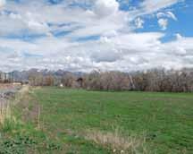
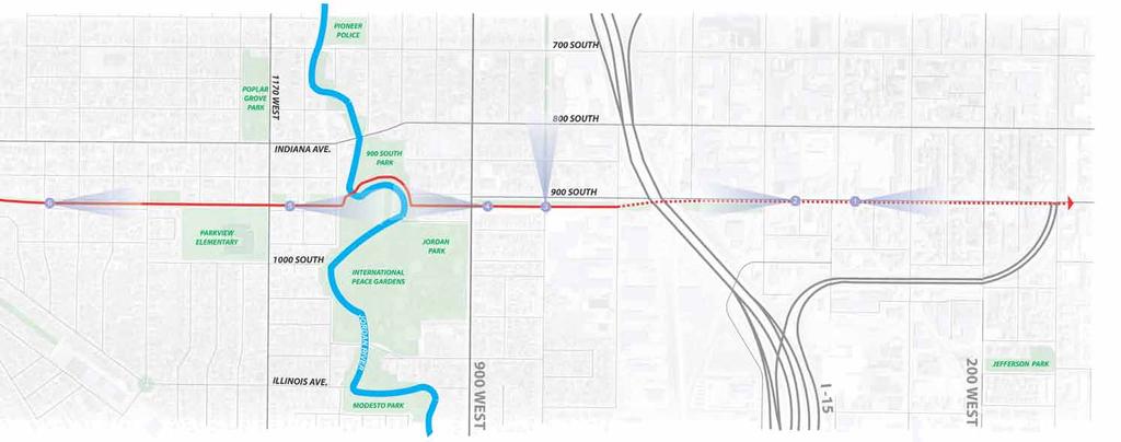
127 APPENDIX


128 78 PUBLIC OUTREACH PROJECT BRANDING A brand image and tag line was created for the outreach process. This is shown below. The aim was to create an identifiable image that was fresh and attractive and unique to the project. The image included an abstraction of a typical walk along the corridor (showing neighborhoods and landmarks) with the official logo of the 9 Line corridor represented as a setting sun in the distance, emphasizing the east to west alignment of the corridor. YOUTH ENGAGEMENT The public involvement process targeted kids and teenagers, as part of the general public, to obtain input on their specific needs for the corridor. The graphics on this page show coloring sheets that were prepared for kids to help them think about the landmarks along the corridor and for them to share their ideas for its future by drawing them. The tag line imagine my 9 line was created to allow people to take ownership of the visioning process and the eventual use of the corridor. The tagline was written in English and Spanish, allowing it to reach a greater population in the community. APPENDIX

129 79 INTERNET-BASED RESOURCES Community members were reached through Salt Lake City s Open City Hall web portal. Citizens were able to see latest updates to the project and were able to make contributions through the interactive map. The interactive map created an opportunity for community members to pinpoint specific areas of interest along the corridor, as well as provide suggestions for types of activities which should occur there. Additionally, other commenters were enabled to support by other members of the community allowing for a constructive virtual dialogue. A phone and address was made available to the public by which the planning and design team could be contacted for information, questions or concerns. APPENDIX


130 80 PUBLIC OUTREACH This map shows the community events that were attended by the project team to solicit public feedback about the future of the 9 Line. It includes the name of the event, date, as well as the relative location to the corridor itself, which is shown as the orange shaded region. Riverfest June 1, 2013 Northwest Rec Center Pictures of some of the events, community members and outreach materials are shown at right. Groove in the Grove July 29, W 7000 S UTA Bike Bonanza May 17, 2013 Gallivan Plaza WestSLC Fest September 28, 2013 Indiana Navajo Street People s Market June 22, 2013 Jordan park Glendale Sandlot Festival July 20, S Navajo St. Community Festival May 30, 2013 Sorenson Unity Center Central Ninth Open House September 26, S 200 W APPENDIX


131 81 Glendale Sandlot CommUNITY Groove Sandlot in Anniversary the Grove Riverfest VISUAL SUMMARY A visual summary of priorities from the public comments is represented in this word diagram. The larger font size represents the words most frequently used. APPENDIX


132 82 HISTORIC PHOTOS During the research and discovery phase of the corridor plan development process, numerous historic photos were collected from the Utah State Historical Society archives. Some of the photos are shown here to provide historic context of the development of communities in West Salt Lake including early examples of roads, housing, businesses and schools in the area of today s 9 Line Trail. Additional views include the development of the rail lines into the Salt Lake Valley for both shipping and passenger travel Grant Tower Hoffman Property 700 South 1000 West APPENDIX 900 South canal pipe sewer and track along 900 South Grant Tower


133 Enamel Brick 900 South 700 West 900 South 800 West Riverside School 8th Grade class Dr. Hampton House 800 South 1143 West South & 900 West Heaman Asphalt Plant 900 South 500 West APPENDIX


134 9 LINE CORRIDOR MASTER PLAN I-215 Jordan River 900 West I West 800 South 900 South Surplus Canal NORTH Redwood Road Navajo Street 200 West
DRAFT PLAN PRESENTATION
 DRAFT PLAN PRESENTATION 1.23.2018 AGENDA Process Project Schedule Results from Visioning Workshop Draft Plan Highlights Concept Plans Feedback Next Steps PROJECT SCHEDULE KICK-OFF WORKSHOP August 29 th
V. Vision and Guiding Principles
 V. Vision and Guiding Principles The Master Plan for the Powers Ferry Corridor seeks a foundation in the desires of the community. At times, various elements of the community offered opposing viewpoints,
East Bench Master Plan Update
 Community & Economic Development Office of the Director East Bench Master Plan Update To: From: Planning Commission Wayne Mills, Senior Planner Date: November 18, 2015 CC: Re: Nora Shepard, City Planning
CITY OF CHARLOTTESVILLE, VIRGINIA CITY COUNCIL AGENDA
 CITY OF CHARLOTTESVILLE, VIRGINIA CITY COUNCIL AGENDA Agenda Date: December 16, 2013 Action Required: Adoption of Resolution Presenter: Staff Contacts: Title: James E. Tolbert, AICP, Director of NDS James
REVIEW OF EXISTING STUDIES
 REVIEW OF EXISTING STUDIES The concept of the 9-Line Corridor (formerly referred to as the Transvalley Corridor) dates back almost 25 years to the 1992 Open Space Master Plan. The original vision sought
Corridor Vision. 1Pursue Minnehaha-Hiawatha Community Works Project. Mission of Hennepin County Community Works Program
 1Pursue Minnehaha-Hiawatha Community Works Project Minnehaha-Hiawatha Community Works is a project within the Hennepin Community Works (HCW) program. The mission of the HCW program is to enhance how the
Introduction. Chapter 1. Purpose of the Comprehensive Plan Plan Organization Planning Process & Community Input 1-1
 Chapter 1 Introduction Lakewood 2025: Moving Forward Together Purpose of the Comprehensive Plan Plan Organization Planning Process & Community Input 1-1 Purpose of the Comprehensive Plan The Comprehensive
REGIONAL ACTIVITY CENTER
 DRAFT REGIONAL ACTIVITY CENTER 70 EAST BENCH MASTER PLAN DRAFT 06 Introduction The East Bench Regional Activity center is comprised of large educational, research, medical, and employment centers. These
PLANNING COMMISSION STAFF REPORT
 PLANNING COMMISSION STAFF REPORT AMENDMENTS TO CHAPTER 21A.46.120 Proposal to Create a Localized Alternative Sign Overlay for Library Square Case # 25 April 2012 Planning and Zoning Division Department
Urban Planning and Land Use
 Urban Planning and Land Use 701 North 7 th Street, Room 423 Phone: (913) 573-5750 Kansas City, Kansas 66101 Fax: (913) 573-5796 Email: planninginfo@wycokck.org www.wycokck.org/planning To: From: City Planning
Public input has been an important part of the plan development process.
 Lakewood s Comprehensive Plan recognizes that transportation helps shape the community, and that the way the community provides for the safe and efficient movement of people affects the character of the
WELCOME TO THE CHOUTEAU GREENWAY DESIGN, DEVELOPMENT AND CONSTRUCTION WORKING GROUP!
 WELCOME TO THE CHOUTEAU GREENWAY DESIGN, DEVELOPMENT AND CONSTRUCTION WORKING GROUP! Chouteau Greenway Steering Committee and Working Groups Overview Overview January 9, 2019 Chouteau Greenway will transform
SUBJECT: Waterfront Hotel Planning Study Update TO: Planning and Development Committee FROM: Department of City Building. Recommendation: Purpose:
 Page 1 of Report PB-23-18 SUBJECT: Waterfront Hotel Planning Study Update TO: Planning and Development Committee FROM: Department of City Building Report Number: PB-23-18 Wards Affected: 2 File Numbers:
17.11 Establishment of Land Use Districts
 17.11 Establishment of Land Use Districts 17.11.010 Purpose. To promote the health, safety, and general welfare of City residents and those who come to South Salt Lake to work, exchange commerce and recreate.
PLNPCM Carl s Jr. Commercial Parking Lot at Redwood Road and 1700 South
 Staff Report PLANNING DIVISION COMMUNITY & NEIGHBORHOODS To: Salt Lake City Planning Commission From: Casey Stewart; 801-535-6260 Date: November 4, 2016 Re: PLNPCM2015-00874 Carl s Jr. Commercial Parking
CHAPTER 8 ISSUES, CONCERNS, CONSTRAINTS AND OPPORTUNITIES
 CHAPTER 8 ISSUES, CONCERNS, CONSTRAINTS AND OPPORTUNITIES Introduction This River Conservation Plan was developed during a time of tremendous activity and effort in planning the transformation of the Delaware
3. VISION AND GOALS. Vision Statement. Goals, Objectives and Policies
 Vision Statement Queen Creek s interconnected network of parks, trails, open spaces and recreation opportunities provide safe and diverse activities and programs that sustain its unique, small town, equestrian
WARM SPRINGS PARK MASTER PLAN
 TABLE OF CONTENTS page 1.0 Introduction and Overview 1 2.0 Information Gathering 2 3.0 Conceptual Alternative Development 8 4.0 Master Plan Development 14 5.0 Construction Cost Estimates 19 LIST OF FIGURES
DRAFT FOR PUBLIC REVIEW. Game Plan for a Healthy City
 DRAFT FOR PUBLIC REVIEW 2018 Game Plan for a Healthy City 2 Denveright. Parks & Recreation Game Plan Draft for Public Review Draft for Public Review Executive Summary Game Plan Overview Executive Summary
North Fair Oaks Community Plan Summary and Information
 North Fair Oaks Community Plan Summary and Information WHAT IS THE NORTH FAIR OAKS COMMUNITY PLAN? The North Fair Oaks Community Plan is part of the San Mateo County General Plan, and establishes policies
DOMINION BOULEVARD CORRIDOR STUDY AND ECONOMIC DEVELOPMENT STRATEGIC PLAN A MODEL FOR CHESAPEAKE S FUTURE
 DOMINION BOULEVARD CORRIDOR STUDY AND ECONOMIC DEVELOPMENT STRATEGIC PLAN A MODEL FOR CHESAPEAKE S FUTURE Overview I. Draft Plan Process II. Draft Plan Overview a. Market Analysis b. Master Land Use Plan
WELCOME TO THE CHOUTEAU GREENWAY EQUITY WORKING GROUP!
 WELCOME TO THE CHOUTEAU GREENWAY EQUITY WORKING GROUP! Chouteau Greenway Steering Committee and Working Groups Overview Overview January 9, 2019 Chouteau Greenway will transform St. Louis by connecting
RESOLUTION NO. R Refining the route, profile and stations for the Downtown Redmond Link Extension
 RESOLUTION NO. R2018-32 Refining the route, profile and stations for the Downtown Redmond Link Extension MEETING: DATE: TYPE OF ACTION: STAFF CONTACT: Capital Committee Board PROPOSED ACTION 09/13/2018
Honorable Mayor and Members of the City Council. Submitted by: Eric Angstadt, Director, Planning and Development
 Office of the City Manager ACTION CALENDAR January 29, 2013 To: From: Honorable Mayor and Members of the City Council Christine Daniel, City Manager Submitted by: Eric Angstadt, Director, Planning and
Ivywild On The Creek PRELIMINARY CREEK DISTRICT MASTER PLAN
 Ivywild On The Creek PRELIMINARY CREEK DISTRICT MASTER PLAN Introduction: Rejuvenating an extraordinary Creekside neighborhood THE CREEKSIDE DISTRICT The Ivywild On The Creek Neighborhood District Master
Official Plan Review: Draft Built Form Policies
 PG.30.1 REPORT FOR ACTION Official Plan Review: Draft Built Form Policies Date: May 15, 2018 To: Planning and Growth Management Committee From: Chief Planner and Executive Director, City Planning Division
A. Background Summary of Existing Challenges and Potential Possibilities. 1. Summary of Existing Assets and Potential Opportunities
 A. Background 1 A Main Street Master Plan Study was performed and completed in October of 2007. The study was initiated to review current land uses and development patterns along Main Street, from Parrish
ELK GROVE GENERAL PLAN VISION
 2-1 CHAPTER 2: 2-2 CREATING OUR The Community Vision for Elk Grove, expressed through a Vision Statement and a series of Supporting Principles, is a declaration of the kind of community that Elk Grove
CITY COUNCIL AGENDA REPORT
 CITY COUNCIL AGENDA REPORT Subject: COUNCIL MOTION LRT ALIGNMENT REMOVAL FROM THE TRANSPORTATION MASTER PLAN On February 10, 2016 Councillor Hughes provided notice in accordance with Section 23 of Procedure
A. WHAT IS A GENERAL PLAN?
 I. Introduction A. WHAT IS A GENERAL PLAN? A general plan is the planning guideline for the future of a city. It contains goals and policies which regulate urban development, the protection of the natural
The transportation system in a community is an
 7 TRANSPORTATION The transportation system in a community is an important factor contributing to the quality of life of the residents. Without a sound transportation system to bring both goods and patrons
City of Royalton Comprehensive Land Use Plan 2005 to Revision February 8, 2011
 City of Royalton Comprehensive Land Use Plan 2005 to 2015 2011 Revision February 8, 2011 PART ONE: INTRODUCTION TO THE COMPREHENSIVE PLAN 1.0 Purpose and Introduction The Comprehensive Land Use Plan provides
South Davis County COMMUNITY SPOTLIGHT
 South Davis County COMMUNITY SPOTLIGHT Davis/SLC Community Connector Bus Rapid Transit line connecting SLC & Davis County RTP Phase 1 Project Generate 3,100 average weekday riders Relieve congestion on
Scope of Services. River Oaks Boulevard (SH 183) Corridor Master Plan
 Corridor Master Plan") Scope of Services River Oaks Boulevard (SH 183) Corridor Master Plan PROJECT AREA The project area consists of the River Oaks Boulevard (SH 183) corridor bounded by SH 199 at the northern end and the Trinity
Scope of Services River Oaks Boulevard (SH 183) Corridor Master Plan PROJECT AREA The project area consists of the River Oaks Boulevard (SH 183) corridor bounded by SH 199 at the northern end and the Trinity
John M. Fleming Managing Director, Planning and City Planner. Old East Village Dundas Street Corridor Secondary Plan Draft Terms of Reference
 Report to Planning and Environment Committee To: From: Subject: Chair and Members Planning & Environment Committee John M. Fleming Managing Director, Planning and City Planner Old East Village Dundas Street
Parks, Open Space and Trails
 Introduction Parks have often been referred as the lungs of our cities, cleansing the air of pollutants and particulate matter. Parks are also gathering places for families and community. They offer spaces
PLAN ELEMENTS WORKSHOP. April 5, 2016
 PLAN ELEMENTS WORKSHOP April 5, 2016 needs more housing. But there is no one-size fits-all solution. Every neighborhood has its own character. In some places, density is not only appropriate it is badly
Date: April 10, 2017 City Council Work Session April 24, 2017: Status Report on the Comprehensive Plan Update and Transportation Master Plan
 AGENDA REPORT To: From: By: Honorable Mayor and City Council Members Warren Hutmacher, City Manager Sharon Ebert, Director Community Development Date: April 10, 2017 Agenda: City Council Work Session April
hermitage town center
 hermitage town center A Community Vision prepared by Strada for The City of Hermitage and The Mercer County Regional Planning Commission January 2007 table of contents introduction 3 design principles
CHAPTER 1. Ms. Guajardo s Class - Central Elementary CH 1 1
 INTRODUCTION CHAPTER 1 Ms. Guajardo s Class - Central Elementary CH 1 1 1.1 SETTING South Centre City is a linear corridor south of Downtown Escondido paralleling Centre City Parkway and South Escondido
1.0 Purpose of a Secondary Plan for the Masonville Transit Village
 Report to Planning and Environment Committee To: Chair and Members Planning & Environment Committee From: John M. Fleming Managing Director, Planning and City Planner Subject: Masonville Transit Village
Chapter 2: Vision, Goals and Strategies
 Chapter 2: Vision, Goals and Lake Elmo Today & Tomorrow Comprehensive Plan 2040 2 VISION, GOALS & STRATEGIES - DRAFT 4-6-2018 INTRODUCTION Comprehensive Plan Purpose Perhapse the most important objective
Chapter 3 Community Involvement
 Chapter 3 Community Involvement Public involvement has been a vital component of the planning process in the preparation of this master planning document. The purpose of this citizen-led effort was to
1INTRODUCTION. Purpose of the Truckee Railyard Master Plan
 1INTRODUCTION Purpose of the Truckee Railyard Master Plan The purpose of the Truckee Railyard Master Plan is to capture and describe the Town s vision for the Railyard Area and to guide its future redevelopment.
Animating the Rideau Canal December 2013
 Executive Summary Animating the Rideau Canal December 2013 Why study the Rideau Canal? The Rideau Canal has been an important part of Ottawa throughout its history, and has shaped and been shaped by the
2040 LUP is a part of the Comprehensive Plan and carries the same legal authority. Economic Challenges
 1.1. Guiding Anchorage s Growth Where will new residents settle over the next two decades? Where will people work, shop, and play? Will there be enough room to grow? How will Anchorage look? Will growth
Sheridan Boulevard S TAT I O N A R E A P L A N S H E R I D A N B O U L E VA R D S TAT I O N A R E A P L A N
 Sheridan Boulevard S TAT I O N A R E A P L A N 1 City of Lakewood Adopted November, 2006 S H E R I D A N B O U L E VA R D S TAT I O N A R E A P L A N The Vision The City of Lakewood s overall vision is
Staff Report to the North Ogden City Planning Commission
 Staff Report to the North Ogden City Planning Commission SYNOPSIS / APPLICATION INFORMATION Application Request: Concept review on a legislative application to rezone land located at approximately 1750
Edward R. Sajecki Commissioner of Planning and Building
 Corporate Report Clerk s Files Originator s Files CD.03.POR DATE: TO: FROM: SUBJECT: Chair and Members of Planning and Development Committee Meeting Date: February 27, 2012 Edward R. Sajecki Commissioner
Draft Memorandum #1: Goals and Vision for Revitalization
 Keizer Revitalization Plan Draft Memorandum #1: Goals and Vision for Revitalization Submitted to: City of Keizer April 12, 2018 (revised) Prepared By: Angelo Planning Group and Otak, Inc. Project No. 17482.A
City of Nogales General Plan
 Open Space, Parks, Recreation and Trails City of Nogales General Plan Residents of Nogales place a high priority in the development of a comprehensive system of open space, parks, recreation and trails
Downtown North Las Vegas Demonstration Site Project. Project Update
 Downtown North Las Vegas Demonstration Site Project Project Update 7.16.14 Presentation Overview Project Purpose and Process Planning Context Opportunities and Barriers Summary Community Input Preliminary
Technical Team Meeting MEETING SUMMARY
 Technical Team Meeting MEETING SUMMARY Monday, January 14, 2019, 3:00 PM Town Hall Room 3211 Technical Team Attendees: Jason Burdette, Town of Davidson Rich Hoffman, Iredell County Matthew Todd, Iredell
ADOPTION OF THE REVISED OPEN SPACE AND CONSERVATION ELEMENT OF THE GENERAL PLAN
 TO: FROM: SUBJECT: Honorable Mayor and City Council Planning Department ADOPTION OF THE REVISED OPEN SPACE AND CONSERVATION ELEMENT OF THE GENERAL PLAN RECOMMENDATION: It is recommended that the City Council:
CHAPTER 7: VISION AND ACTION STATEMENTS. Noble 2025 Vision Statement
 CHAPTER 7: VISION AND ACTION STATEMENTS This chapter presents the vision, policy and action statements that transform the comprehensive planning study, an analysis of Noble s past, future trends and community
Port Lavaca Future Land Use
 Port Lavaca Future Land Use Introduction The City of Port Lavaca is beginning to see sustained growth, after many years of relative stable population. New single family homes, apartments, and businesses
Don Mills Crossing Study and Celestica Lands Development Application Community Meeting, Open House, and Breakout Discussions
 Consultation Summary Don Mills Crossing Study and Celestica Lands Development Application Community Meeting, Open House, and Breakout Discussions This report is not intended to provide a verbatim transcript
ARLINGTON COUNTY, VIRGINIA
 ARLINGTON COUNTY, VIRGINIA County Board Agenda Item Meeting October 15, 2005 DATE: September 28, 2005 SUBJECT: Request to Advertise the adoption of the 2005 Clarendon Sector Plan C. M. RECOMMENDATION:
3. Endorse the LRT vision in transforming Surrey into Connected-Complete-Livable communities, and more specifically, the official vision statement:
 CORPORATE REPORT NO: R038 COUNCIL DATE: February 20, 2017 REGULAR COUNCIL TO: Mayor & Council DATE: February 16, 2017 FROM: General Manager, Engineering FILE: 8740-01 SUBJECT: Surrey Light Rail Transit
Potential Green Infrastructure Strategies May 6, 2015 Workshop
 Potential Green Infrastructure Strategies May 6, 2015 Workshop Background The City of Cortland is developing the Tioughnioga Urban Headwaters Green Infrastructure Action Plan with funding from the National
1 October Dear Citizens of Charlotte and Mecklenburg County,
 1 October 2011 Dear Citizens of Charlotte and Mecklenburg County, As co-chairs of the Center City 2020 Vision Plan Steering Committee, we are proud to present the Center City 2020 Vision Plan, which sets
Streets for People, Place-Making and Prosperity. #TOcompletestreets
 COMPLETE STREETS FOR TORONTO Streets for People, Place-Making and Prosperity COMPLETE STREETS: A NEW APPROACH A Complete Streets design approach considers the needs of all users people who walk, bicycle,
1999 Approval to replace World War I monument and relocate plaques Approval to rehabilitate the Chase Mill building and surrounding site
 Memorandum PLANNING DIVISION DEPARTMENT OF COMMUNITY AND NEIGHBORHOODS To: Historic Landmark Commission From: Katia Pace, Principal Planner Date: October 26, 2016 Re: Liberty Park Improvements The purpose
Route 1 Corridor Study
 Route 1 Corridor Study Westbrook, Connecticut A Vision for the Connecticut Shoreline Public Informational Meeting July 28, 2015 Lower Connecticut River Valley Council of Governments Fitzgerald & Halliday,
CHAPTER 7: Transportation, Mobility and Circulation
 AGLE AREA COMMUNITY Plan CHAPTER 7 CHAPTER 7: Transportation, Mobility and Circulation Transportation, Mobility and Circulation The purpose of the Transportation, Mobility and Circulation Chapter is to
Wasatch CHOICE for 2040
 Wasatch CHOICE for 2040 Economic Opportunities We Can Choose a Better Future We enjoy an unparalleled quality of life along the Wasatch Front. People from all over the world are drawn to our stunning scenery,
S A C R A M E N T O C O U N T Y JACKSON HIGHWAY & GRANT LINE EAST VISIONING STUDY
 JACKSON HIGHWAY & GRANT LINE EAST S A C R A M E N T O C O U N T Y P L A N N I N G D E P A R T M E N T SUMMARY AND WORKBOOK November 19, 2008 History of the Visioning Study Sacramento County has two growth
9/19/2018 TODAY S WEBINAR AGENDA CONTINUING EDUCATION UPCOMING TRAINING FROM APBP
 TODAY S WEBINAR AGENDA 3:00 pm: Introduction 3:05 pm: Presentation 3:45 pm: Questions 4:00 pm: Webinar Ends For technical assistance during the webinar: 1-800-263-6317 Choose these prompts: 1, 1, 1 CONTINUING
CITY OF PUYALLUP. Background. Development Services
 CITY OF PUYALLUP Development Services 333 South Meridian Puyallup WA 98371 To: City Council From: Katie Baker, AICP, Planning Division Re: South Hill Neighborhood Plan Adoption Date: (Meeting date: February
Plan Overview. Manhattan Area 2035 Reflections and Progress. Chapter 1: Introduction. Background
 Plan Overview The Manhattan Urban Area Comprehensive Plan (the Comprehensive Plan) is a joint planning initiative of the City of Manhattan, Pottawatomie County, and Riley County. The 2014 Comprehensive
Denton. A. Downtown Task Force
 2 Public Involvement Early and ongoing public involvement was solicited so that the public had ample opportunity to help direct the DTIP s concepts and implementation strategies. The residents of Denton
PARK AND RECREATION MASTER PLAN UPDATE
 PARK AND RECREATION MASTER PLAN UPDATE 2014-2018 Prepared for: Avon Parks, Recreation and Beautification Council (PRBC) and Town of Avon Prepared by: Lehman & Lehman, Inc. 24-Apr-14 Mission Statement The
ARLINGTON COUNTY, VIRGINIA. County Board Agenda Item Meeting of June 16, 2018
 ARLINGTON COUNTY, VIRGINIA County Board Agenda Item Meeting of June 16, 2018 DATE: June 7, 2018 SUBJECT: Z-2604-18-1 Rezoning from R-6 and R-5 Single Family Residential Districts to S-3A Special District
Official Plan Review
 Official Plan Review Summary Report - The Built Environment August 2014 Part 1: Introduction Planning for a healthy, prosperous and sustainable community is an important goal for our municipality. From
Parks Master Plan Implementation: Phase I Waterfront Use and Design REPORT #: September 7, 2016 File #
 0 'O DI Lan-171-14 1 - THE CORPORATION OF THE TOWN OF COBOURG..,. STAFF REPORT TO: FROM: Mayor and Members of Council Dean A. Hustwick, Director of Recreation and Culture DATE OF MEETING: Committee of
TOWN COUNCIL / PLANNING COMMISSION
 Workshop #3 TOWN COUNCIL / PLANNING COMMISSION January 20, 2011 Consultant Team In Attendance Tonight BMS Design Group Nevada City and San Francisco Michael Smiley, AICP, ASLA Partner-in-Charge Nancy L.
Implementation Guide Comprehensive Plan City of Allen
 Implementation Guide 2030 Comprehensive Plan City of Allen DRAFT 2015 Implementation Guide Allen 2030 Comprehensive Plan INTRODUCTION The Comprehensive Plan serves as a guide for the growth and development
2. AGENCY COORDINATION AND PUBLIC INVOLVMENT
 2. AGENCY COORDINATION AND PUBLIC INVOLVMENT This chapter discusses the process carried out for conducting agency coordination and public involvement activities. TECHNICAL ADVISORY COMMITTEE A Technical
Blueprint Denver Task Force Meeting #
 Blueprint Denver Task Force Meeting #1 6.23.16 1. Welcome and Introductions Your name and affiliation Name 1 thing you love about Denver Name 1 thing you d change about Denver All in 30 seconds! Ready,
Planned Manufacturing District Review
 Mayor Emanuel s Industrial Corridor Modernization Planned Manufacturing District Review North Branch Framework Implementation Chicago Plan Commission July 20, 2017 Rahm Emanuel, Mayor David Reifman, Commissioner
Gold Line Bus Rapid Transit Transit Oriented Development (BRTOD) Helmo Station Area Plan
 Helmo Station Area Plan") Appendix F Gold Line Bus Rapid Transit Transit Oriented Development (BRTOD) Helmo Station Area Plan Introduction and Purpose of the Plan The Gold Line Bus Rapid Transit facility is an eleven-mile dedicated
Appendix F Gold Line Bus Rapid Transit Transit Oriented Development (BRTOD) Helmo Station Area Plan Introduction and Purpose of the Plan The Gold Line Bus Rapid Transit facility is an eleven-mile dedicated
Table L-1 Summary Action Strategy. Action Item Timing Status Responsible Agency
 CHAPTER 4: CIRCULATION ELEMENT ISSUE #1: MAJOR THOROUFARES AND TRANSPORTATION ROUTES A balanced transportation system for Fontana is provided that meets the mobility needs of current and future residents
Mendota Heights 2040 Comprehensive Plan Draft Vers
 4 Parks and Trails The City of Mendota Heights boasts a variety of recreational and open space opportunities. Few cities can claim access to regional trails, riverside and lakeside parks, scenic bluffs
PLANNING COMMISSION STAFF REPORT Legislative Item
 PLANNING COMMISSION STAFF REPORT Legislative Item Manufacturing Districts Monument Sign Height Zoning Text Amendment PLNPCM2013-00197 Citywide August 28, 2013 Planning Division Department of Community
Toronto Parks Renaissance Strategy
 Toronto Parks Renaissance Strategy Overview, Emerging Themes and Directions Presentation to EDPC, May 4, 2006 Parks Renaissance Strategy Presentation Agenda Project Overview Emerging Themes and Directions
City of Tacoma Planning and Development Services
 Agenda Item E-1 City of Tacoma Planning and Development Services To: Planning Commission From: Elliott Barnett, Planning Services Division Subject: Tacoma Mall Regional Center Subarea Plan and EIS Meeting
County Board Meeting October 20, Request to Advertise Draft Area Plan
 County Board Meeting October 20, 2018 Request to Advertise Draft Area Plan Park & Recreation Commission Meeting October 23, 2018 Outline Study Area & Process Milestones Area Plan Elements Key Policy Recommendations
master plan of highways bus rapid transit amendment
 Scope of Work master plan of highways bus rapid transit amendment September 2011 Montgomery County Planning Department M-NCPPC MontgomeryPlanning.org 1 Scope of Work master plan of highways bus rapid transit
Downtown Streetscape Manual & Built Form Standards
 City of Guelph Downtown Streetscape Manual & Built Form Standards July 2014 Prepared by Brook McIlroy Inc. in association with Unterman McPhail Associates and McCormick Rankin Inc. City of Guelph Downtown
SAN RAFAEL GENERAL PLAN 2040 INTRODUCTION AND OVERVIEW
 SAN RAFAEL GENERAL PLAN 2040 INTRODUCTION AND OVERVIEW Steering Committee Presentation February 14, 2018 Purpose of General Plan Guide land use and development decisions Coordinate transportation, infrastructure,
Secrest Short Cut and Monroe Expressway Small Area Plan AUGUST 29, 2018
 Secrest Short Cut and Monroe Expressway Small Area Plan AUGUST 29, 2018 Background and Process Monroe Expressway will be open by the end of 2018 Union County and Indian Trail identified a need to revisit
9 LINE CORRIDOR MASTER PLAN. Adopted March 3, 2015
 9 LINE CORRIDOR MASTER PLAN Adopted March 3, 2015 Mobil ity is more than about how we get around - it s also about cre at ing con nec tions between res i dents, busi nesses and vis i tors, relat ing neigh
Welcome. Comprehensive Plan & Transportation Plan Open House November 7, 2012
 Welcome Comprehensive Plan & Transportation Plan Open House November 7, 2012 Agenda Proposed future land use plan Comprehensive Plan strategies Traffic forecasts Future traffic operations Possible future
City Council Special Meeting AGENDA ITEM NO. C.
 City Council Special Meeting AGENDA ITEM NO. C. DATE: 01/04/2019 TO: Honorable Mayor and City Council Members SUBJECT: Transit Villages Specific Plan project Study Session (Development Services Director
PUBLIC ENGAGEMENT & SIX THEMES OF THE PLAN
 Connecting the heart of Eagle to the soul of the river - Kathy Chandler-Henry, Commissioner Eagle County CHAPTER 1 PUBLIC ENGAGEMENT & SIX THEMES OF THE PLAN town of eagle - river corridor plan 1 PUBLIC
Maplewood Avenue Downtown Complete Street Project
 Maplewood Avenue Downtown Complete Street Project Second Public Meeting January 24, 2018 Welcome and Introduction of Project Team City Planning and Public Works Staff City of Portsmouth Juliet Walker Planning
WELCOME TO THE CHOUTEAU GREENWAY ECONOMIC DEVELOPMENT WORKING GROUP!
 WELCOME TO THE CHOUTEAU GREENWAY ECONOMIC DEVELOPMENT WORKING GROUP! Chouteau Greenway Steering Committee and Working Groups Overview Overview January 9, 2019 Chouteau Greenway will transform St. Louis
Summary of Action Strategies
 Strategic Action Plan 6 Summary of Action Strategies Action Strategy Categories: 1. Organization and Management 2. Implementation 3. Marketing and Promotion This chapter summarizes all of the action strategies
Wadsworth Boulevard S TAT I O N A R E A P L A N
 Wadsworth Boulevard S TAT I O N A R E A P L A N City of Lakewood Adopted November, 2006 The Vision The City of Lakewood s overall vision is to transform the area around the light rail station into a mixed-use
Summary Community Workshop #1 Fruitvale San Antonio Senior Center Monday, March 23, :00-9:00 p.m.
 Summary Community Workshop #1 Fruitvale San Antonio Senior Center Monday, March 23, 2009 7:00-9:00 p.m. Workshop Format and Process The City of Oakland is preparing a Specific Plan that will help define