Practices and Challenges in Adopting Esri Roads and Highways in the U.S.
|
|
|
- Pamela Copeland
- 6 years ago
- Views:
Transcription


1 Practices and Challenges in Adopting Esri Roads and Highways in the U.S. Xiao Qin, Zhaoxiang He, Zengwang Xu University of Wisconsin-Milwaukee Bo Guo Gistic Research Inc. Kelly Schieldt Wisconsin Department of Transportation GIS-T Phoenix, Arizona April 12,

2 Technology Evolvement Deprecation 2


3 Problem Statement Built 20+ years ago on then state-of-the-art technologies, WisDOT LCM still operates on the same technologies in STN Transaction Manager and LCM GeoTools. The deprecated technologies put the WisDOT business continuation in jeopardy. The explosive growth of GIS over the past four decades has brought forth more technological diversity, but it has also created inconsistencies and redundancies that challenges a unified digital infrastructure. 3

4 Integrate Enterprise Data Maintain Your LRS Analyze and Report 4
5 R&H Features Integrate Data: the measurements associated with data in external systems can be kept current and synchronized with the edits made to the LRS. Edit across the Web: create and edit event data from a map-centric experience. Simplify LRS Updates: Rule-based location management allows you to define how event measures and route associations should react to changes in the LRS. Analyze and Report Data When You Need It: Generate reports and produce data products and maps that support a variety of key functions. Coordinate and Track Work Throughout Your Organization: workflow management tools that provide visibility into day-to-day job progress. Automate Quality Control: Benefit from a complete QA/QC system with tools for automated and visual review processes. run automatically. Source: 5
6 Selected Use Cases Keep assets, pavement, traffic, and safety systems aligned with roadway changes Centralize roadway LRS management so business systems don't duplicate effort by managing multiple copies of an LRS. Publish web services that can be integrated with other business systems to keep measures in alignment with roadway edits. Produce information needed for federal aid funding Use configurable geoprocessing models to create the Highway Performance Monitoring System (HPMS) data products needed by the Federal Highway Administration (FHWA) for state federal aid funding. Run checks against your data finding errors. Use the Roadway Characteristic Editor to view and correct errors in your data. Source: 6
7 Objective Is R&H a good fit for Wisconsin DOT? 7
8 8


9 9

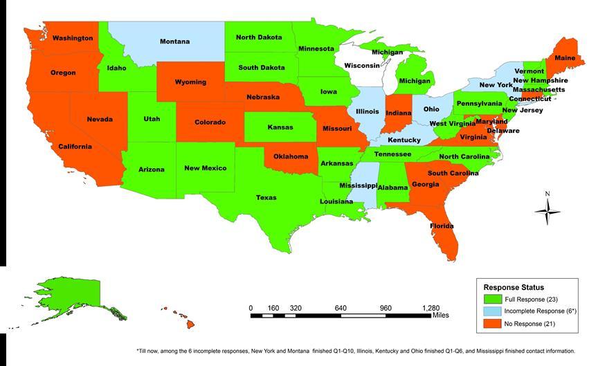
 Implemented (6) No Plan (3)")


10 Q1: At what stage, have you implemented the ESRI R&H? Wait and See (5) Under Implementation (11) Implemented (6) No Plan (3) Under Evaluation (3) Number of DOTs Esri R&H is the first choice among the state DOTs who replied, including 11 under implementation, 6 implemented, and 3 under evaluation. 10
11 Q2: How were your roadway linework data stored and maintained before adopting Esri R&H? Most DOTs (19/28, or 68%) use ArcGIS software to store and maintain roadway linework data; Others use software packages such as Intergraph Geomedia, Bentley AssetWise (Exor) SDO, Oracle Spatial. 11
12 Q6: What Linear Referencing Methods (LRMs) do you maintain? Most state DOTs (25/28, or 89%) use Route milepoint as their Linear Referencing Method (LRM); Others use such LRMs as Route milepost offset, Route reference point offset, Project stationing, Route X/Y. 12
13 Q7: Did you consider alternative software systems other than R&H and Why? About half of the state DOTs didn t consider alternative software systems other than Esri R&H. Among those who consider other options (e.g., Bentley, Intergraph solutions, Exor's products, MANDLI/ PMG, DTS/Transend), R&H is more appealing because of its promise of being able to integrate different linear referencing systems. Those who haven t decided believe R&H isn t ready yet. 13
14 Q8: What were your major motivating factors for adopting ESRI R&H Already familiar with Esri software, 14 Data model was ready for Esri R&H, 4 Easier to support multiple LRSs in the LRS 3 Organizational support, 5 Esri R&H facilitated DOT Business procedures, 7 Existing solution was too costly to maintain/enhance to meet the growing business needs, 10 Esri R&H provided necessary functions, 9 The promises of Esri R&H, 13 TOP THREE REASONS 1. Familiarity of Esri software; 2. Promises of R&H; and 3. Existing solutions are becoming costly to maintain. Other,
15 Q9: What are the major challenges in implementing R&H? Integrating business data, 12 Managing business and spatial data temporality, 11 Customizing R&H to support additional/specific needs, 6 Potential interruption or change to business procedure, 9 Converting roadway network, 10 Other,
16 Q10: What were the major challenges in migrating your existing data (roadway network/geometry, business data) to Esri R&H? 1. fixing data quality problem (e.g.: data cleaning up, editing the network within the confines of R&H), 2. change management (e.g.: from centerline to dual carriageway, converting existing data model, expanding road network from state roads to an all public road network), 3. retooling of the downstream applications that rely on the road centerline data, etc. 16
17 Q11: Did you migrate any historical data to Esri R&H? If you did, what were the major challenges? Most state DOTs didn t migrate their historical data to Esri R&H. North Carolina DOT tried but found R&H still does not support history so they had to move forward without it. Minnesota DOT, did but we decided early on to have a start date of all the events after the historical data. We also found early on that back dating centerline data didn't work. Iowa DOT only migrate the historical pavement information such as construction years without editing the network. 17
18 Q12: Did you rewrite existing software tools in order to use them with R&H? Can existing tools be easily integrated? Some state DOTs rewrote existing software tools in order to use them within Esri R&H. Kansas DOT states there are multiple options for asset management software that interfaces with ArcGIS server and Roads and Highways. For the easiness of the integration with R&H, Arizona DOT thinks It's easy if you have programming staff, harder and something I wouldn't recommend if you don't. While other state DOTs didn t do any customization. As Michigan DOT says have learned from other DOT agencies and Esri that the product works best without customization. 18
19 Q13: How did you manage the potential disruptions to DOT businesses during the implementation of Esri R&H? Most state DOTs run their existing system and R&H concurrently to avoid disruptions to business during the implementation of Esri R&H. Some froze their centerline and attribute data when implementing R&H. 19
20 Q14: Did you purchase premium Esri technical support during and/or after the R&H implementation? Most state DOTs didn t purchase the premium Esri technical support during and/or after the R&H Implementation. North Dakota thinks Esri support is not set up to handle RH support calls. Lack of consistent and strong technical support was also mentioned in the Letter of Concern by RHUG. 20
21 Q15: What is the current stage of your Esri R&H implementation? How long did each stage take? Pilot/Evaluation stage usually takes 1-24 months, Design/Implementation stage usually takes 1-36 months, Production/Maintenance stage usually takes 3-28 months. 21
22 Q16: If R&H is in production, what improvements have you seen? Improved data quality, 7 Better support to business systems, including HPMS and Safety, 5 Better support to asset management, 4 Enhanced overall system efficiency, 4 Other,
23 Q17: What future improvements would you like to see in R&H? Event synchronization, 9 Temporality management, 8 Event edit, 8 Reporting, 9 Route edit, 4 Other,
24 Q18: What functions do you use additional software to supplement R&H? Quality assurance and quality control, 7 Analysis and visualization, 8 Reporting, 7 Other, Consultants are often hired for many of these functions such as data mitigation, customization of R&H desktop and server, turn-key solution, and others because Esri R&H s current performance is inadequate. 24

25 DOT Time (Months) Pilot Imp Prod Iowa Notable Quotes No major challenges. Previous experience made it much easier. "Network was already in good shape. We did our own migration for the most part. Arizona 28 I would recommend you get someone at the top to say this is how it's going to all lay down and then just focus on the technical aspects of it. Minnesota 14 It seemed like we were testing their product for them and continually running into bugs that delayed our progress and pushed out our timelines. Alabama 23 Massachusetts West Virginia 12 25

26 DOT Time (Months) Pilot Imp. Prod Notable Quotes Louisiana 9 6 Kansas Alaska 6 12 Workflow Manager is a critical component of R&H but it is often overlooked during the planning process. Vermont 18 New Mexico 1 North Dakota 16 North Carolina RH is like any Esri software over-sold and under-deliver... but you will have to go through the growing pains of the software. Esri woefully underestimated the effort to migrate and then tired chasing a continuous changing data model due to workarounds and bug fixes in R&H itself. Michigan 18 Idaho
27 Notable Notes No DOTs converted historical data in their implementation. QA/QC and reporting capabilities can be enhanced. 27
28 Conclusions 1. WisDOT is facing several critical issues due to key deprecated technologies and a data model which may not be suitable for new requirements. 2. The survey of Esri R&H to 49 state DOTs and Washington DC show mixed results. 3. Esri R&H is the first choice among the agencies who responded because of their familiarity of Esri software and the promises of R&H. 4. The top three challenges of implementing R&H are integrating business data, temporality management, and converting roadway network. 5. The major challenge of migrating data to R&H is to fix the data quality problem but Esri may not fully recognize the significance of business applications associated with the network editing and business data integrated. 28

29 Thank you! Contact Information: Xiao (Shaw) Qin, PhD, P.E. Associate Professor Civil and Environmental Engineering University of Wisconsin-Milwaukee
Esri Roads and Highways & ArcGIS Platform
 Esri Roads and Highways & ArcGIS Platform Increasing efficiency and effectiveness through improved data quality, capture, accessibility, reporting and analytics to transportation agencies Esri Roads and
Esri Roads and Highways: Integrating and Developing LRS Business Systems
 Esri Roads and Highways: Integrating and Developing LRS Business Systems Tom Hill Esri UC 2014 Technical Workshop Overview: Esri Roads and Highways Esri UC 2014 Technical Workshop Esri Roads and Highways:
May U.S. Department of Transportation Federal Highway Administration
 May 1999 U.S. Department of Transportation Federal Highway Administration AN OVERVIEW LAND USE AND ECONOMIC DEVELOPMENT IN STATEWIDE TRANSPORTATION PLANNING Prepared for FEDERAL HIGHWAY ADMINISTRATION
- Residential Fire Sprinkler -
 - Residential Fire Sprinkler - Update as of September 15, 2014 The information provided is a state-by-state status of the 2009 IRC adoption and legislation activities as reported by HBA s. NAHB staff monitors
AVERAGE RADON CONCENTRATION: Test has met minimum EPA sampling duration.
 February 5, 2016 Test Number: 8401-12 Property Inspected: 623 Pine St, Macon, GA 31201 Licensed Radalink Radon Inspector: Test performed for: ACME Home Inspections William Jacobs John Harwell 943 Spring
Property Inspected: 623 Pine St, Macon, GA 31201
 February 5, 2016 Test Number: 8401-12 Property Inspected: 6 Pine St, Licensed Radalink Radon Inspector: ACME Home Inspections John Harwell 994 Magnolia St Phone: Fax: 770 555 1944 770 555 2105 Calibrated:
6. Results for the Wholesale and Retail Trade Sectors
 6. Results for the Wholesale and Retail Trade Sectors A total of seven sectors comprise the U.S. horticultural wholesale and retail trade industries: 1) wholesale flower, nursery stock & florist supply;
Property Inspected: 1228 Radcliffe Ave, Kingsport, TN 37664
 September 24, 2015 Test Number: 13-175 Property Inspected: 1228 Radcliffe Ave, Kingsport, TN 37664 Licensed Radalink Radon Inspector: Professional Home Inspections Kenneth Bartley Jr. 180 Kincheloe Road
Implementing a Funeral Home Emergency Action Plan
 Implementing a Funeral Home Emergency Action Plan According to Occupational Safety & Health Administration (OSHA) regulations, nearly every employer including funeral homes must have an Emergency Action
(94'*7 $*89 :2 '*7 ((.,$00 *;.3 *89*7'*7, "$ .3.8-*) &8*2 *39-4:78 ! / )+ $*89-&82 * :2! 8&2 51.3,):7&9.43
 &8*2 *39-4:78 ! / )+ $*89-&82 * :2! 8&2 51.3,):7&9.43") (94'*7 $*89 :2 '*7 ((.,$00 0./&026-1/&$2&% )$&-1&% "%"+)-* "%.--1/&$2.0 3)+%)-'-1/&$2).-1 )$("&+ &12&0#&0'.#&+)" 0)4& %#" 3)+%)-' -4)0.-,&-21 )-$)--"2) >HNMF/ 6BU/ *&(")%)",.., *&(",.("'.*.!1&(*) > 6FQNGWFYJI1
(94'*7 $*89 :2 '*7 ((.,$00 0./&026-1/&$2&% )$&-1&% "%"+)-* "%.--1/&$2.0 3)+%)-'-1/&$2).-1 )$("&+ &12&0#&0'.#&+)" 0)4& %#" 3)+%)-' -4)0.-,&-21 )-$)--"2) >HNMF/ 6BU/ *&(")%)",.., *&(",.("'.*.!1&(*) > 6FQNGWFYJI1
AVERAGE RADON CONCENTRATION:
 February 2, 2017 Test Number: 1703-142 Property Inspected: 804 425th street, Joice, IA 50446 Licensed Radalink Radon Inspector: Lupkes Inspections Myron and Jayne Lupkes 804 425th Street Joice, IA 50446
ArcGIS Data Reviewer. Planning and Deploying Data Quality Services. Edwin Waite & Shankar Chandrasekaran. Esri UC 2014 Technical Workshop
 ArcGIS Data Reviewer Planning and Deploying Data Quality Services Edwin Waite & Shankar Chandrasekaran Esri UC 2014 Technical Workshop A few examples of why data validation matters Esri UC 2014 Technical
User Advocacy Group. Rohit Gupta
 User Advocacy Group Rohit Gupta Agenda Introduction to User Advocacy Group (UAG) UAG Process User Communities Initiatives User Advocacy Group Mission To enhance the productivity of the user community by
Uses of NFIRS. The Many Uses of the National Fire Incident Reporting System
 FA 171 / June 1997 Uses of NFIRS The Many Uses of the National Fire Incident Reporting System Federal Emergency Management Agency United States Fire Administration National Fire Data Center USES OF NFIRS
2014 Bentley Systems, Incorporated. Bentley Map V8i SELECT series 4
 2014 Bentley Systems, Incorporated Bentley Map V8i SELECT series 4 Agenda Why Bentley Map V8i SELECT series 4 Map SELECT series 4 Workshop Tools Workflows Map SELECT series 4 Workshop Tools User Interfaces
What s New in Roundabout Design?
 Roundabouts: An Informational Guide, 2 nd ed. What s New in Roundabout Design? National and State Perspective Brian Walsh, WSDOT Lee Rodegerdts, Kittelson & Associates, Inc. Overview & Philosophy Chapter-by-Chapter
U.S. FIRE DEPARTMENT PROFILE THROUGH 2009
 U.S. FIRE DEPARTMENT PROFILE THROUGH 2009 Michael J. Karter, Jr. Gary P. Stein October 2010 National Fire Protection Association Fire Analysis and Research Division U.S. FIRE DEPARTMENT PROFILE THROUGH
ArcGIS Online at Philadelphia Water Department
 ArcGIS Online at Philadelphia Water Department ESRI Public Sector Conference December 2017 Jessica Gould, GISP Megan Clarkin, AICP, LEED Green Associate Tim Smith We provide the City with integrated water,
Continuing Education Units (CEU)
") CEUGuide Continuing Education Units (CEU) You are responsible for meeting any CEU requirements which may apply to your professional work in the low voltage industry. It is your responsibility to identify
CEUGuide Continuing Education Units (CEU) You are responsible for meeting any CEU requirements which may apply to your professional work in the low voltage industry. It is your responsibility to identify
Experience the difference.
 Experience the difference. discipline intensity collaboration laboration shared ownership solutions FOCUS ON YOU For more than eight decades, clients have chosen Wilson & Company to help them move from
City of Grand Forks Staff Report
 City of Grand Forks Staff Report Service/Safety Committee March 10, 2015 City Council March 16, 2015 Agenda Item: Sole Source Approval for Project #7348-2015 Siren Construction Submitted by: Engineering
Candidate APCO/CSAA ANS x: Alarm Monitoring Company to PSAP CAD External Alarm Interface Exchange
 Candidate APCO/CSAA ANS 2.101.1-200x: Alarm Monitoring Company to PSAP CAD External Alarm Interface Exchange Frequently Asked Questions published November 19, 2008 1. Are PSAPs required to adhere to the
13 Extending the Esri Enterprise Licence Agreement
 Clause 13 in Report No. 10 of Committee of the Whole was adopted, without amendment, by the Council of The Regional Municipality of York at its meeting held on May 21, 2015. 13 Extending the Esri Enterprise
Soybean Form B. Counts & Measurements
 Soybean Form B Counts & Measurements Components of Forecast Row Space Measurements Number of Plants Number of pods/plant Weight of Beans/Pod How is it used? This information + Form A information is used
AVERAGE RADON CONCENTRATION:
 November 23, 2011 Test Number: 1092-192 roperty Inspected: 190 Orchard Heights Drive, South Bend, IN 614 Licensed Radalink Radon Inspector: Certified Home Inspections Dawn Hatfield 19237 Edinburgh Drive
A fresh new offer in home improvement Tuesday 25 August
 A fresh new offer in home improvement Tuesday 25 August We are entering the $24 billion hardware sector The Australian hardware and home improvement sector is worth $24 billion 1 plus Woolworths believes
FHWA INVEST. And the Harbor Bridge Project
 FHWA INVEST And the Harbor Bridge Project FHWA s Sustainable Highways Initiative The Sustainable Highways Initiative supports programs and activities conducted across the Federal Highway Administration
The Illinois Department of Transportation and Lake County Division of Transportation. Route 173, including the Millburn Bypass
 The Illinois Department of Transportation and Lake County Division of Transportation welcome you to this Public Hearing for U.S. Route 45 from Illinois Route 132 to Illinois Route 173, including the Millburn
Overview of Southwestern Pennsylvania Commission s (SPC) 2040 Long Range Transportation Plan (LRTP)
 2040 Long Range Transportation Plan (LRTP)") Overview of Southwestern Pennsylvania Commission s (SPC) 2040 Long Range Transportation Plan (LRTP) Presented to Pennsylvania Agency Coordination Meeting May 27, 2015 Doug Smith & Ryan Gordon 1 Southwestern
Overview of Southwestern Pennsylvania Commission s (SPC) 2040 Long Range Transportation Plan (LRTP) Presented to Pennsylvania Agency Coordination Meeting May 27, 2015 Doug Smith & Ryan Gordon 1 Southwestern
2008 APWA Public Works Congress
 Reduce Street Cuts Use a Web Based Application for Utility Collaboration Presenters: City Of Newton, Massachusetts Dave Turocy Deputy Commissioner, Public Works City of Baltimore Margaret Martin Div. Chief,
AGI NI 2016 Building A Modern Day GIS For ESB Networks
 AGI NI 2016 Building A Modern Day GIS For ESB Networks Agenda IMGS ESB Networks GIS Requirements Project Team and Implementation Integration G/Technology Solution Lessons Learned Thank You We deliver innovative
USER APPROVAL OF SAFETY INSTRUMENTED SYSTEM DEVICES
 USER APPROVAL OF SAFETY INSTRUMENTED SYSTEM DEVICES Angela E. Summers, Ph.D., P.E, President Susan Wiley, Senior Consultant SIS-TECH Solutions, LP Process Plant Safety Symposium, 2006 Spring National Meeting,
A Citizen s Guide To Radon The Guide To Protecting Yourself And Your Family From Radon
 A Citizen s Guide To Radon The Guide To Protecting Yourself And Your Family From Radon Printed on Recycled Paper (50% Post-Consumer Content) www.epa.gov/radon/pubs/citguide.html EPA Recommends: Test your
Fire, Smoke, and Combination Fire Smoke Dampers
 Fire, Smoke, and Combination Fire Smoke Dampers Mark Belke Director Damper Products-Greenheck Chairman of Code Action Review Committee (CARC) California Building Code work group NFPA 80A, 90A, 92B, 101,
1.0 Circulation Element
 5/9/18 1.0 Circulation Element 1.1 Introduction As growth and development occur in Apache County, enhancements to its circulation system will be necessary. With time, more roads will be paved and air and
Legislative Review 2017
 Legislative Review 2017 Codes, Standards and Regulations in the U.S. and Canada This issue of Sprinkler Age features our 30th annual legislative review. This summary of legislation and codes offers a quick
COUNTY OF SAN DIEGO BOARD OF SUPERVISORS 1600 PACIFIC HIGHWAY, ROOM 335, SAN DIEGO, CALIFORNIA AGENDA ITEM
 COUNTY OF SAN DIEGO BOARD OF SUPERVISORS 1600 PACIFIC HIGHWAY, ROOM 335, SAN DIEGO, CALIFORNIA 92101-2470 AGENDA ITEM DATE: June 19, 2012 TO: Board of Supervisors 20 SUBJECT: SAY NO TO SACRAMENTO MOTORIST
AASHTO Board of Directors. Standing Committees (Functional Areas): Finance and Administration. Highway Traffic Safety. Performance.
: Finance and Administration. Highway Traffic Safety. Performance.") AASHTO Board of Directors Executive Committee Standing Committees (Modal): Aviation Standing Committees (Functional Areas): Environment Special Committees: Intermodal and Economic Expansion Highways Finance
AASHTO Board of Directors Executive Committee Standing Committees (Modal): Aviation Standing Committees (Functional Areas): Environment Special Committees: Intermodal and Economic Expansion Highways Finance
February 5, 2016 Test Number:
 February 5, 2016 Test Number: 8401-12 Property Inspected: 702 Henderson Ave., Columbus, OH 43214 Licensed Radalink Radon Inspector: ACME Home Inspections John Harwell 32 N. High St. Columbus, OH 43202
Glenborough at Easton Land Use Master Plan
 Implementation 114 9.0 IMPLEMENTATION 9.1 OVERVIEW This chapter summarizes the administrative procedures necessary to implement the proposed land use plan, infrastructure improvements, development standards,
February 15, Longworth House Office Building 1106 Longworth House Office Building Washington D.C Washington D.C.
 February 15, 2011 Chairman Dave Camp Ranking Member Sander Levin Committee on Ways and Means Committee on Ways and Means 1102 Longworth House Office Building 1106 Longworth House Office Building Washington
CURRICULUM VITAE. James J. Valenta, PE, MSCE, FITE 8463 Shield Road Dexter, MI (734)
") CURRICULUM VITAE James J. Valenta, PE, MSCE, FITE 8463 Shield Road Dexter, MI 48130 (734) 904-2652 Email: jvalenta@prodigy.net Areas of Expertise: Roadway Hydroplaning Analysis, Guardrail, Highway Design,
CURRICULUM VITAE James J. Valenta, PE, MSCE, FITE 8463 Shield Road Dexter, MI 48130 (734) 904-2652 Email: jvalenta@prodigy.net Areas of Expertise: Roadway Hydroplaning Analysis, Guardrail, Highway Design,
SEWRPC. Joint Meeting of the Advisory Committees on Regional Land Use Planning and Regional Transportation Planning APRIL 26, 2018
 SEWRPC Joint Meeting of the Advisory Committees on Regional Land Use Planning and Regional Transportation Planning APRIL 26, 2018 WISCONSIN DEPARTMENT OF TRANSPORTATION BRETT WALLACE, FOXCONN PROJECT DIRECTOR
A Better Way to Support Wildland Fire Suppression
 A Better Way to Support Wildland Fire Suppression John Varner USDA Forest Service jvarner@fs.fed.us FIRE INCIDENT MAPPING TOOLS PURPOSE To have a workable ArcGIS mapping extension that utilizes a personal
Chapter 14. Aesthetic Considerations in Transportation Systems Evaluation
 466 Chapter 14 Aesthetic Considerations in Transportation Systems Evaluation 467 Topics: Transportation Project Types that Typically Affect Aesthetic Quality, Topological Features of Transportation Systems
Bypass #16 - Bend Parkway (new alignment for US 97) (MP )
 (MP )") Bypass #16 - Bend Parkway (new alignment for US 97) (MP 134.76-141.83) Description: The Parkway is on new alignment for US 97 through Bend. US 97 is a Statewide Highway on the National Highway System that
Bypass #16 - Bend Parkway (new alignment for US 97) (MP 134.76-141.83) Description: The Parkway is on new alignment for US 97 through Bend. US 97 is a Statewide Highway on the National Highway System that
BRAND REPORT FOR THE 6 MONTH PERIOD ENDED JUNE 2015
 BRAND REPORT FOR THE 6 MONTH PERIOD ENDED JUNE 2015 No attempt has been made to rank the information contained in this report in order of importance, since BPA Worldwide believes this is a judgment which
Local Growth Planning in North Central Green Line Communities
 2018 April 30 Page 1 of 6 EXECUTIVE SUMMARY This report outlines a high-level scope for local growth planning for north central Green Line communities. The catalyst for this review is the significant investments
Imagine TM 6036, 3-piece including roof cap
 KEY BENEFITS COMMON OPTIONS Codes/Standards Applicable ANSI Z124.1.2 CSA B45 Series The MAAX IMAGINE series brings you a roomier shower chamber, a two-way included door, a more spacious shower seat, well-positioned
PROJECT BACKGROUND. Preliminary Design Scope and Tasks
 PROJECT BACKGROUND Preliminary Design Scope and Tasks The purpose of this Study is the development of preliminary designs for intersection improvements for Trunk Highway (TH) 36 at the intersections of
DC Clean Rivers Project - Green Infrastructure Program. ACEC What s New at DC Water?
 District of Columbia Water and Sewer Authority George S. Hawkins, General Manager Briefing on: DC Clean Rivers Project - Green Infrastructure Program Briefing for: ACEC What s New at DC Water? April 7,
WELCOME! 8 8:30 6: TH STREET IMPROVEMENTS. Open House. Presentation & Q&A
 WELCOME! 168 TH STREET IMPROVEMENTS 6:30 Open House 7 8 Presentation & Q&A 8 8:30 Open House WELCOME Todd Pfitzer City of Omaha Engineer Bob Stubbe City of Omaha Public Works Director Jon Meyer Project
Moving to the Cloud: The Potential of Hosted Central Station Services
 Moving to the Cloud: The Potential of Hosted Central Station Services Moving to the Cloud: The Potential of Hosted Central Station Services The global market for alarm monitoring services is expected to
South Central & Rocky Mountain Service Centers
 South Central & Rocky Mountain Service Centers Ryan T. Allaire, P. E. District Manager Dallas, TX / Englewood, CO 303-704-7718 rallaire@uis-usa.com EDUCATION: Colorado School of Mines Golden, Colorado
Corporate. Management. Line. Management. Plant. Manager HSSE. Maintenance Manager. (Plant. Operations Manager. Process Safety) Plant.
 Plant.") Corporate Management HSSE (Corporate Process Safety) Line Management Whiting Plant Manager Maintenance Manager HSSE (Plant Process Safety) Operations Manager Maintenance Workers Plant Operators Control
Corporate Management HSSE (Corporate Process Safety) Line Management Whiting Plant Manager Maintenance Manager HSSE (Plant Process Safety) Operations Manager Maintenance Workers Plant Operators Control
Fairfax County Community Services Board Emergency Response System: Notifier
 Lathan S. Dennis, MSc., GIS Analyst Fairfax County, Human Services 12011 Government Center Parkway, Suite 946, Fairfax, VA 22035 Voice (703) 324-5648 Fax (703) 324-7572 Email ldenni@fairfaxcounty.gov Jim
3. Additional driveways may be permitted where determined by the Planning Commission to adequately accommodate traffic or ensure public safety.
 ARTICLE 10 ACCESS MANAGEMENT Section 10.01 Purpose. The purpose of this Article is to protect the substantial public investment in the City s street system by preserving the traffic capacity of existing
SAFETY MANAGER SC Ensure safety, simplify operations and reduce lifecycle costs
 SAFETY MANAGER SC Ensure safety, simplify operations and reduce lifecycle costs Meet Today s Cost and Complexity Challenges Industrial process plants are trying to reduce their process control and safety
Organize your security with PSIM + software
 Organize your security with PSIM + software WHAT IS PSIM SOFTWARE? Functional scope of a Physical Security Information Management System Application In practice, the WinGuard platform is collecting all
Oil of OverLAY: Age Defying Secrets
 Partnerships for Progress in Transportation Session 15: Monday February 18, 2012 Oil of OverLAY: Age Defying Secrets Mark Chenevert / Simone Ardoin PAVEMENT PRESERVATION Stephen R. Mueller, P.E., MPA Pavement
A New Approach to ESB Migration Building a foundation for Digital Business
 A New Approach to ESB Migration Building a foundation for Digital Business Summary Traditional business models are being threatened by the digital economy. Having the ability to do business digitally is
Research Road Map. 4. Quiet Pavements
 Research Road Map Research Area 1. System 2. Smoothness 3. 4. Quiet s 5. Construction Practices 6. Mechanistic- Empirical Design 7. Long Life s 8. Sustainability Current Problem Statement Information data
The Esri Public Works Platform. More Than Mapping
 The Esri Public Works Platform More Than Mapping Intelligent Public Works Sustaining a safe, vibrant community requires a smart public works system. Esri created a platform that connects public works departments
Philadelphia Water Department, Green Infrastructure Implementation Graduate Internship Opportunities Summer 2017
 PHILADELPHIA WATER 1101 Market Street Philadelphia, Pennsylvania 19107-2994 Debra McCarty, Commissioner Philadelphia Water Department, Green Infrastructure Implementation Graduate Internship Opportunities
Award # 61 Nell Coe Award Color Our Canopy
 Award # 61 Nell Coe Award Color Our Canopy Guide to Writing Award #61 Nell Coe Award 2017-2019 Valerie Seinfeld, FFGC Awards Chair Win Big! Let s Begin: Award Number: (please double check every award for
Predictive Maintenance for Fire Sprinkler Systems. Jeffrey D. Gentry Sonic Inspection Corporation
 Predictive Maintenance for Fire Sprinkler Systems Jeffrey D. Gentry Sonic Inspection Corporation May 2005 Table of Contents TABLE OF CONTENTS...2 INTRODUCTION...3 Overview of Problem...3 Solution...3 FIRE
Supporting our communities. Bridges
 Supporting our communities Bridges 1,000+ We ve partnered with thousands of owners/clients to inspect, analyze, design, and manage their bridges, providing lasting community connections. We design bridges
ESB 2.0. Migration. egate IBM. WS Message Broker KBC. Warta. Java CSOB. Evolution. Standardization MQ K&H. Pilot case. Store & Forward. Web 2.
 KB K&H ESQL Software AG Request-Reply Web 2.0 CSOB Application Integration Java Warta Pilot case KBC IBM Store & Forward Migration ESB 2.0 WS Message Broker Java CAPS Monk Microsoft ICT Service Evolution
DynAMo Alarm & Operations Management
 Connected Plant DynAMo Alarm & Operations Management Solution Note Delivering operations integrity through better plant safety, availability and compliance across your entire enterprise Honeywell s DynAMo
Appendix E Preliminary Location Hydraulic Study
 Appendix E Prepared for: State of Alaska Department of Transportation and Public Facilities Prepared by: HDR Alaska, Inc. 2525 C Street, Suite 305 Anchorage, Alaska 99503 February 2014 This page intentionally
Endorsed Consultants Forum
 Endorsed Consultants Forum Wednesday 21 October 2015 ADAC - What, Why, How QUU reference TEM142 2015 Queensland Urban Utilities Agenda 1. Welcome Michael Smythe 2. Safety Ron Hyde, QUU Safety 3. Introduction
The Language of Geography. Health and Human Services
 The Language of Geography Health and Human Services Cover Points of Distribution: this Esri map shows population density in relation to vaccine distribution centers, helping health officials perform a
Toward a Robust Flood Emergency Evacuation Integration of 2-D Hydraulic Modeling and Dynamic Evacuation Routing
 Toward a Robust Flood Emergency Evacuation Integration of 2-D Hydraulic Modeling and Dynamic Evacuation Routing Esri User Conference 2016 Sheng Tan, GISP June 29, 2016 Presentation Overview Study purpose
MEETING NOTICE & AGENDA Iowa Fire Extinguishing & Alarm System Certification Advisory Board
 Terry E. Branstad Governor Kim Reynolds Lt. Governor Department of Public Safety Roxann M. Ryan Commissioner MEETING NOTICE & AGENDA Iowa Fire Extinguishing & Alarm System Certification Advisory Board
Facility Commander Wnx
 Facility Commander Wnx Integrated security management platform for Windows Seamless. Effective. Efficient. Integrate security applications on one versatile platform It s easy and efficient to seamlessly
1 Team Roles and lnvolvement; 2 - Phasing/Schedule;
 City of Bend i Oregon State University - Cascades Memorandum of Understanding Sho( Term 10 - Acre Project (Phase 1) The City of Bend and Oregon State University - Cascades are pleased to further higher
BRIDGING THE SAFE AUTOMATION GAP PART 1
 BRIDGING THE SAFE AUTOMATION GAP PART 1 Angela E. Summers, Ph.D., P.E, President, SIS-TECH Solutions, LP Bridging the Safe Automation Gap Part 1, Mary Kay O Conner Process Safety Center, Texas A&M University,
FIRE PROTECTION PROGRAM
 Fire Protection Program Page 1 of 13 FIRE PROTECTION PROGRAM 1.0 Objective The objective of this performance assessment is to evaluate the effectiveness of the laboratory's fire protection program as implemented
Evaluation of Strobe Lights in Red Lens of Traffic Signals
 36 TRANSPORTATION RESEARCH RECORD 1495 Evaluation of Strobe Lights in Red Lens of Traffic Signals BENJAMIN H. COTTRELL, JR. Strobe lights are used as a supplement to the red lens to draw the attention
Location-aware Mobile Devices & Landscape Reading
 DLA 2011 May 27th 2011 JOYE R. VERBEKEN J. HEYDE S. LIBBRECHT H. Location-aware Mobile Devices & Landscape Reading University College Ghent Dep. Bioscience and Landscape Architecture Brusselsesteenweg
Serving Fremont Employees with a One Stop Shop Enterprise Web App
 Serving Fremont Employees with a One Stop Shop Enterprise Web App Enterprise GIS: Lessons from the Trenches By John Leon and Christine Frost 2015 Esri international User Conference 1 Introduction Phases
DRAFT Subject to Modifications
 TREASURE COAST REGIONAL PLANNING COUNCIL M E M O R A N D U M To: Council Members AGENDA ITEM 8 From: Date: Subject: Staff May 19, 2017 Council Meeting Florida Department of Transportation Complete Streets
4.13 Security and System Safety
 4.13 4.13.1 Introduction This section describes the affected environment and environmental consequences related to security and system safety from operations of the NEPA Alternatives. Information regarding
Organize your security with PSIM + software
 Organize your security with PSIM + software WHAT IS PSIM SOFTWARE? Functional scope of a Physical Security Information Management System Application 1 2 4 5 In practice, the WinGuard platform is collecting
HAZARD MITIGATION GOALS AND OBJECTIVES
 SEWRPC Community Assistance Planning Report No. 282, 2nd Edition CITY OF MILWAUKEE ALL HAZARDS MITIGATION PLAN UPDATE Chapter IV HAZARD MITIGATION GOALS AND OBJECTIVES [NOTE: Throughout this plan update
FAQ S about Restoration Planning FROM THE Department of Ecology WEBSITE:
 FAQ S about Restoration Planning FROM THE Department of Ecology WEBSITE: http://www.ecy.wa.gov/programs/sea/sma/st_guide/smp/restoration/qanda.html Notations in parentheses are staff notes directing you
Eastern Band of Cherokee Indians Integrated Geographical Information System (IGIS)
") Eastern Band of Cherokee Indians Integrated Geographical Information System (IGIS) 1 Background The Eastern Band of Cherokee Indians (EBCI) is the only federally recognized Tribe in North Carolina. Historically
Eastern Band of Cherokee Indians Integrated Geographical Information System (IGIS) 1 Background The Eastern Band of Cherokee Indians (EBCI) is the only federally recognized Tribe in North Carolina. Historically
Before you install ProSeries Express Edition software for network use
 Before you install ProSeries Express Edition software for network use The following pages describe system requirements and other information you need to know before installing ProSeries Express Edition
Overall Map. Chicago. St. Louis. Summit. Joliet. Dwight. Pontiac. Bloomington-Normal Lincoln. Springfield. Carlinville. Alton EXPERIENCE IT YOURSELF.
 Overall Map Summit Chicago Bloomington-Normal Lincoln New Station Planned New Station Planned Dwight Pontiac Joliet Pedestrian overpass and second platform planned Higher speed service began in this section
GeoPlanner SM for ArcGIS : An Introduction
 GeoPlanner SM for ArcGIS : An Introduction Greg Pleiss Robert Stauder Esri UC 2014 Technical Workshop Agenda Application Overview Specific Capabilities - Configuration - Avaliable Data - Spatial Analysis
Issues Requiring Future Study
 Issues Requiring Future Study Transportation planning is an ongoing process that tends to identify new issues as it finds solutions for others. Some issues are so complex that a solution to one problem
Joseph LaCivita, Director, Planning and Economic Development. Ted Kolankowski, PE, Barton and Loguidice
 0 0 PLANNING BOARD TOWN OF COLONIE COUNTY OF ALBANY *************************************************** SIENA COLLEGE LOOP ROAD LOUDON ROAD APPLICATION FOR FINAL SITE PLAN APPROVAL ***************************************************
ArcelorMittal EDSGN 100, Section 20 Professor Etienne Courtney Elsasser, Kelly Kowalski, Stephen Lonati, Johnna Morales
 ArcelorMittal EDSGN 100, Section 20 Professor Etienne Courtney Elsasser, Kelly Kowalski, Stephen Lonati, Johnna Morales Table of Contents: Abstract...3 Introduction...3 Mission Statement...3 Customer Needs...4
Marine Solutions. Honeywell s Solution for LNG Vessels
 Marine Solutions Honeywell s Solution for LNG Vessels Integrated automation systems for LNG vessels. Honeywell is the leading supplier of Integrated Automation Systems (IAS) for LNG carriers and newer
Oracle Retail Management System Release Notes Release November 2007
 Oracle Retail Management System Release Notes Release 11.0.13 November 2007 Oracle Retail Management System Release Notes, Release 11.0.13 Copyright 2007, Oracle. All rights reserved. Primary Author: Rich
2007 Fhwa Geotechnical Technical Guidance Manual
 2007 Fhwa Geotechnical Technical Guidance Manual Highway Administration (FHWA) to identify research Guidance for the reuse of foundations is needed geotechnical issues in a holistic manner. Technical drivers.
P2000 and Metasys System Integration
 P2000 and Metasys System Integration Product Bulletin Code No. LIT-12012141 Software Release 3.14 SP1 Issued June 23, 2017 The Johnson Controls P2000 Security Management System supports the integration
Implementing a Combustible Dust Program. Presented by: Nick Miedema Amway EH&S For: Michigan Safety Conference
 Implementing a Combustible Dust Program Presented by: Nick Miedema Amway EH&S For: Michigan Safety Conference Presentation Outline Combustible Dust Overview Current Regulations, Standards and Statistics
A Citizen s Guide To Radon
 EPA 402/K-09/001 January 2009 www.epa.gov/radon A Citizen s Guide To Radon The Guide To Protecting Yourself And Your Family From Radon Indoor Air Quality (IAQ) EPA Recommends: Test your home for radon
A Guide to the Standardized Framework Project for Puget Sound Stormwater System Mapping
 A Guide to the Standardized Framework Project for Puget Sound Stormwater System Mapping Produced by with a grant from the Washington State Department of Ecology Stormwater Services Project Team: Mark Preszler,