ORIGINAL REPORT: STAGE 1 & 2 ARCHAEOLOGICAL ASSESSMENT PART OF LOT 9, CONCESSION 4, COUNTY OF WELLINGTON, NOW IN 233 JANEFIELD AVENUE, GUELPH, ONTARIO
|
|
|
- Charlotte Warren
- 6 years ago
- Views:
Transcription

1 ORIGINAL REPORT: STAGE 1 & 2 ARCHAEOLOGICAL ASSESSMENT PART OF LOT 9, CONCESSION 4, COUNTY OF WELLINGTON, NOW IN 233 JANEFIELD AVENUE, GUELPH, ONTARIO Submitted to: Rockwater Group PO Box King Street North Waterloo, Ontario N2J 4T9 AND THE ONTARIO MINISTRY OF TOURISM, CULTURE AND SPORT Submitted by: Amec Foster Wheeler Environment & Infrastructure a division of Amec Foster Wheeler Americas Limited County Road 42 Tecumseh, Ontario N8N 2M1 Ph: (519) , Fax: (519) Archaeological Consulting License # P348 (Slim) P.I.F. # P Amec Foster Wheeler Project # SWW April 2017 Distribution: Rockwater Group 1 Digital Copy Ontario Ministry of Tourism, Culture and Sport 1 Digital Copy Amec Foster Wheeler Environment & Infrastructure - 1 Digital Copy
2
3 EXECUTIVE SUMMARY Amec Foster Wheeler Environment & Infrastructure ( Amec Foster Wheeler ) was retained by Rockwater Group (the CLIENT) to conduct a Stage 1 and 2 archaeological assessment in support of future development of a condominium high rise. This archaeological assessment was triggered under the Planning Act and was conducted prior to development. The property is located at 233 Janefield Avenue, in Guelph, Ontario ( Study Area ). The Study Area was historically described as Part of Lot 9, Concession 4, Township of Guelph, County of Wellington, (Appendix A: Figures 1, 2 and 3). The subject property is owned by Bendetto Di Renzo and Mario Antionio Ri Renzo and is approximately 1.10 hectares (2.7 acres) in size. The Stage 1 and 2 archaeological assessment was carried out in accordance with the Ontario Ministry of Tourism, Culture and Sport s ( MTCS ) Standards and Guidelines for Consultant Archaeologists (2011), under an Ontario Professional Licence to Conduct Archaeological Fieldwork (P348) held by Barbara Slim, Senior Archaeologist at Amec Foster Wheeler. The project information was acknowledged by the MTCS on 28 March 2017 with the approval of PIF number P Permission to conduct the property inspection and property assessment was granted to Amec Foster Wheeler by the CLIENT on 21 March This permission extended to all required archaeological fieldwork activities, including the recovery and removal of artifacts. The Stage 1 property inspection was conducted by Luke Fischer (P219), Senior Archaeologist at Amec Foster Wheeler on 29 March The weather was sunny and warm and did not impede the inspection in any way. It should be noted that temperatures were also unseasonably warm for several days prior to 29 March 2017, ranging from 12 to 16 degrees Celsius. The Stage 2 test pit survey was conducted on 14 April 2017 under the direction of Luke Fischer (P219), with the assistance of Jason Seguin (P354). The weather during the Stage 2 test pit survey was overcast with an approximate temperature of 10 degrees Celsius, which did not impede the property assessment in any way. The Stage 1 background study indicated that undisturbed portions of the subject property have archaeological potential and warrant Stage 2 property assessment for two principal reasons: 1) the known presence of an archaeological site approximately 180 m to the southwest of the Study Area, providing direct evidence that this general area had been exploited by historic Euro-Canadian peoples; and, 2) the location of the Study Area within 100 m of historical transportation routes. A review of recent land use history and the Stage 1 property inspection, which included a cursory examination of soil conditions through exploratory judgemental interval test pitting, indicated that the majority of the Study Area has been subjected to extensive land grading, followed by the deposition of imported fill material containing concrete chunks and other Project Number SWW Page i
4 construction debris. The presence of buried concrete chunks and other building material meant that ploughing and pedestrian survey was not viable as a Stage 2 assessment strategy. Nevertheless, in order to confirm the extent of previous disturbance, further judgemental interval test pitting should be carried out in the areas suspected to have had original topsoil and archaeological potential removed. Elsewhere, it appeared from the Stage 1 property inspection that intact topsoil had been retained within small pockets in the eastern and western portions of the property. As each of these pockets measured less than 10 m by 10 m, 5-m interval test pit survey was recommended for the Stage 2 assessment. The Stage 2 assessment of previously graded and filled areas by means of judgemental interval test pits successfully confirmed the extent of previous disturbance and archaeological potential removal. Those small pockets of land that contained intact topsoil were subjected to regular 5-m interval test pit survey. The test pits within the Study Area were devoid of artifacts or cultural deposits and no new archaeological sites were encountered. In light of these results, the following recommendation is made, subject to the conditions outlined in Sections 4.0 and 5.0: 1) The Study Area requires no further archaeological assessment. The above recommendation is subject to Ministry of Tourism, Culture and Sport approval, and it is an offence to alter any of the Study Area without Ministry of Tourism, Culture, and Sport concurrence. No grading or other activities that may result in the destruction or disturbance of the Study Area is permitted until notice of Ministry of Tourism, Culture, and Sport approval has been received. Project Number SWW Page ii
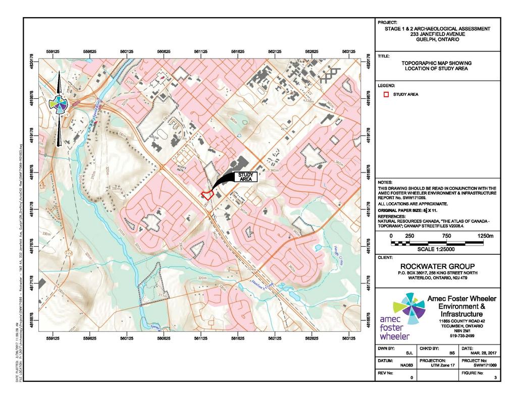
5 SECTION TABLE OF CONTENTS PAGE 1.0 PROJECT CONTEXT Development Context Scope of Work STAGE 1 BACKGROUND STUDY Archaeological Context Registered Archaeological Sites History of Archaeological Investigations Environmental Context Historical Context Review of Historical Records Additional Information Recent Land Use History Subsurface Conditions Stage 1 Property Inspection Methodology Results Stage 1 Analysis and Conclusions STAGE 2 PROPERTY ASSESSMENT Methodology Record of Finds Stage 2 Analysis and Conclusions RECOMMENDATIONS ADVICE WITH COMPLIANCE WITH LEGISLATION ASSESSOR QUALIFICATIONS CLOSURE BIBLIOGRAPHY LIST OF TABLES Table 1: Registered Archaeological Sites within a 1-km Radius... 4 Table 2: Inventory of Documentary Record LIST OF APPENDICES APPENDIX A: FIGURES Figure 1 Location of Study Area Figure 2 Aerial Photograph Showing Location of the Study Area and Borehole Locations from Geotechnical Investigations Completed by Dominion Soil (1998) and CVD (2014) Figure 3 Topographic Map Showing Location of the Study Area Figure Tremaine Map of the County of Wellington Project Number SWW Page iii
6 Figure 5 Figure 6 Figure Historical Atlas of the County of Wellington Stage 1 Results with Photograph Locations and Directions Stage 2 Results with Photograph Locations and Directions APPENDIX B: PHOTOGRAPHS APPENDIX C: ASSESSOR QUALIFICATIONS APPENDIX D: LIMITATIONS Project Number SWW Page iv
7 PROJECT PERSONNEL Project Director: Project Manager: Field Director Field Technician Report Preparation: Graphics: Report Reviewer: Barbara Slim, M.A. (P348) Barbara Slim, M.A. Luke Fischer, M.A. (P219) Jason Seguin, M.A. (P354) Barbara Slim, M.A. Stephen LaBute, CAD Dr. Shaun Austin, Ph.D. (P141) Project Number SWW Page v
8
9 1.0 PROJECT CONTEXT 1.1 Development Context Amec Foster Wheeler Environment & Infrastructure ( Amec Foster Wheeler ) was retained by Rockwater Group (the CLIENT) to conduct a Stage 1 and 2 archaeological assessment in support of future development of a condominium high rise. This archaeological assessment was triggered under the Planning Act and was conducted prior to development. The property is located at 233 Janefield Avenue, in Guelph, Ontario ( Study Area ). The Study Area was historically described as Part of Lot 9, Concession 4, Township of Guelph, County of Wellington, (Appendix A: Figures 1, 2 and 3). The subject property is owned by Bendetto Di Renzo and Mario Antionio Ri Renzo and is approximately 1.10 hectares (2.7 acres) in size. The Stage 1 and 2 archaeological assessment was carried out in accordance with the Ontario Ministry of Tourism, Culture and Sport s ( MTCS ) Standards and Guidelines for Consultant Archaeologists (2011), under an Ontario Professional Licence to Conduct Archaeological Fieldwork (P348) held by Barbara Slim, Senior Archaeologist at Amec Foster Wheeler. The project information was acknowledged by the MTCS on 28 March 2017 with the approval of PIF number P Permission to conduct the property inspection and property assessment was granted to Amec Foster Wheeler by the CLIENT on 21 March This permission extended to all required archaeological fieldwork activities, including the recovery and removal of artifacts. The Stage 1 property inspection was conducted by Luke Fischer (P219), Senior Archaeologist of Amec Foster Wheeler on 29 March The weather was sunny and warm and did not impede the inspection in any way. It should be noted that temperatures were also unseasonably warm for several days prior to 29 March 2017, ranging from 12 to 16 degrees Celsius. The Stage 2 test pit survey was conducted on 14 April 2017 under the direction of Luke Fischer (P219), with the assistance of Jason Seguin (P354). The weather during the Stage 2 test pit survey was overcast with an approximate temperature of 10 degrees Celsius, which not impede the property assessment in any way. This report presents the results of the Stage 1 background study and Stage 2 property assessment and makes pertinent recommendations. 1.2 Scope of Work This Stage 1 and 2 archaeological assessment was carried out in accordance with the Terms of Reference provided in Amec Foster Wheeler s work agreement dated 21 Feb A Stage 1 archaeological assessment is a systematic qualitative process executed in order to assess the archaeological potential of a property based on its historical use and Project Number SWW Page 1
10 its potential for early Euro-Canadian (early settler) and pre-contact Aboriginal occupation. The objectives of a Stage 1 background study are: 1) to provide information about the property s geography, history, previous archaeological fieldwork and current land condition; 2) to evaluate in detail the property s archaeological potential which will support recommendations for Stage 2 property assessment for all or parts of the property if warranted; and, 3) to recommend appropriate strategies for Stage 2 property assessment if warranted. The Stage 1 background study was conducted in accordance with the Standards and Guidelines for Consultant Archaeologists, 2011, set out by the MTCS, and with the Ontario Heritage Act, R.S.O. 1990, c The scope of work for the Stage 1 background study consisted of the following tasks: Contacting the MTCS to determine if recorded archaeological sites exist in the vicinity (one-kilometre [ km ] radius) of the property, through a search of the Ontario Archaeological Sites Database maintained by that Ministry; Contacting the MTCS to determine if there are any known reports of previous archaeological field work within a radius of 50 metres ( m ) around the Study Area; A desktop review of the Study Area s physical setting to determine its potential for both historic and pre-contact human occupation, including its topography, hydrology, soils, vegetation, and proximity to important resources and historic transportation routes; A review of the borehole logs from the 2014 geotechnical drilling programme (CDV Engineering 2014) to understand current conditions and the stratigraphy of the Study Area; A review of the 2014 Phase I Environmental Site Assessment report (MTE 2014) to understand recent land use on the property; A review of the potential for historic occupation as documented in historical atlases and other archival sources; A visual inspection of the Study Area and exploratory judgmental interval test pitting in order to gather first-hand and current evidence of the property s physical setting, and to aid in delineating areas where archaeological potential may have been impacted or removed by previous land-use practices. The scope of work for the Stage 2 archaeological assessment consisted of the following tasks: Project Number SWW Page 2
11 Organizing public underground utility locates. In addition, Amec Foster Wheeler retained a private utility locator to clear underground utilities; A test pit survey at appropriate intervals, employing strategies that adhere to the technical standards for Stage 2 archaeological assessments as prescribed by the MTCS (2011); Mapping, photographing and other relevant graphics; and, Preparing a report of findings with recommendations regarding the need for further archaeological work if deemed necessary. Sites discovered during a Stage 2 assessment that are determined to have cultural value or interest may be recommended for a Stage 3 site-specific assessment. The preferred option, however, is to avoid, and therefore protect, such sites wherever possible. Project Number SWW Page 3
12 2.0 STAGE 1 BACKGROUND STUDY As part of the Stage 1 archaeological assessment, Amec Foster Wheeler contacted MTCS to determine if archaeological sites have been registered within 1 km of the property (Section 2.1.1), and if previous archaeological assessments have been carried out within a 50-m radius (Section 2.1.2). Secondly, the principal determinants of archaeological potential proximity to water, topography, drainage, soils, vegetation, and proximity to important resources and historically significant transportation routes were examined in order to evaluate the property s overall archaeological potential (Sections 2.1, 2.1.3, 2.2, and 2.2.1). Thirdly, the specific potential for historic archaeological resources was assessed through an examination of available historical maps and other archival sources (Section 2.2). Finally, Amec Foster Wheeler performed a review of recent environmental investigations completed within the Study Area to document current land conditions and to supplement our desktop background investigation (Section 2.3). 2.1 Archaeological Context Registered Archaeological Sites Amec Foster Wheeler conducted the requisite Stage 1 background research. First, the MTCS was asked to search the Ontario Archaeological Sites Database in order to ascertain if previously registered archaeological sites have been identified in close proximity to the Study Area. In Ontario, information concerning archaeology sites is stored in the Ontario Archaeological Sites Database (OASD) maintained by the MTCS. This database contains archaeological registered sites within the Borden system. Under the Borden system, Canada has been divided into grid blocks based on longitude and latitude. A Borden block is approximately 13 km east to west, and approximately 18.5 km north to south. Each Borden block is referred to by a four letter designation and sites located within the block are numbered sequentially as they are found. The subject property is located within the AjHb Borden Block. On the basis of a search of the OASD (inquiries made to Mr. Rob von Bitter, Database Co-ordinator of MTCS), there is one registered archaeological site located within a 1-km radius. Table 1 provides a summary of this site: Borden Number Table 1: Registered Archaeological Sites within a 1-km Radius Site Name Cultural Affiliation Site Type Researcher AjHb-79 - Euro-Canadian Homestead Jacquie Fischer (2009) Project Number SWW Page 4
13 2.1.2 History of Archaeological Investigations A request for relevant reports within 50 m of the Study Area was also placed with MTCS on 05 April Enquiries to the MTCS indicated that no previous archaeological assessments have been conducted within 50 m of the subject lands. However, a Stage 1 to 3 archaeological assessment was completed on the right-of-way approximately 75 m to the southwest of the Study Area: 2010 Highway 6 (Hanlon Expressway) Intersection Improvements, City of Guelph and Puslinch Township, Wellington County, Ontario. Prepared for Dillon Consulting Limited, prepared by Fisher Archaeological Consulting, April 2010, (PIF P , P ). In 2009, Fischer Archaeological Consulting conducted a Stage 1 and 2 archaeological assessment on a number of intersections alongside Highway 6 (Hanlon Expressway) including Stone Road and Highway 6, which is located to the southwest of the Study Area. The Stage 2 test pit survey resulted in the identification of a newly discovered archaeological site, located approximately 180 m to the southwest of the Study Area. Archaeological site AjHb-79 consists of a Euro-Canadian homestead dating to the second quarter of the 19 th century. Following Stage 3 assessment, it was recommended that Stage 4 mitigation be conducted in the event that future construction activities were planned within the archaeological site and/or the buffer zone Environmental Context The Study Area (Appendix A: Figures 1 3) is situated in the Guelph Drumlin Field physiographic region of Ontario (Chapman and Putnam 1984: 113). The Guelph Drumlin physiographic region spans an area of approximately 82,880 hectares (204,799 acres) and includes portions of greater Hamilton, Wellington County, and the Regional Municipalities of Waterloo and Halton. The till is pale brown in colour, loamy and calcareous and contains fragments of the underlying red shale (Chapman and Putnam 1984: 137). It is underlain by dolostones of the Amabel and Guelph Formations. The landform pattern consists of drumlins fringed by gravel terraces and separated by swampy valleys with flowing tributaries; several gravel ridges or eskers cross the plain in the same general direction with meltwater spillways cutting through (Chapman and Putnam 1984: 138). The Speed and Eramosa Rivers are two big glacial spillways located within this physiographic region. The Study Area is situated within the Drumlin Field and located approximately 1,275 m southeast of the Speed River. Based on a review of CVD s (2014) geotechnical investigation, soil conditions consist of brown, compact to very dense sand with variable amounts of silt and gravel (CDV 2014: 2). The topography slopes downward towards the west with what appears to be a drainage ditch and/or dry swale transecting the Study Area. The majority of the Study Area was observed to have been stripped of topsoil and to contain imported fill within construction debris. A fill mound was observed on the Project Number SWW Page 5
14 southwestern portion of the Study Area. Where natural topsoils were observed they consisted of a medium brown compacted sandy silt. It is crucial to consider the proximity of water sources in any evaluation of archaeological potential because the availability of water is arguably the single most important determinant of human land use, past and present. The Standards and Guidelines for Consultant Archaeologists (MTCS 2011) lists proximity to water as one of the prime indicators of potential for the presence of archaeological sites. Distance from potable water has been one of the most commonly used variables for predictive modeling of site location. Water, both potable and non-potable, also facilitated the transportation of people and goods and served to focus animal and vegetable resources. According to the 2011 Standards and Guidelines for Consultant Archaeologists, lands within 300 metres of an extant or formerly mapped river or creek have potential for the presence of early Aboriginal and Euro-Canadian archaeological sites. Creeks and/or associated tributaries are not illustrated within 300 m of the Study Area; however, a dry swale or drainage ditch was observed transecting the Study Area. In summary, a review of the archaeological context supports a conclusion of overall archaeological potential and the need for a Stage 2 assessment. Although natural water sources are not located within 300 m of the Study Area, we have direct evidence that this general area had been exploited by historic Euro-Canadian peoples in that one archaeological site has been previously registered within a 1-km radius. 2.2 Historical Context The Study Area is located within the Township of Guelph, County of Wellington. Wellington County was named after Arthur Wellesley, Duke of Wellington born in 1769 (Ade n.d.). This area was settled and developed by John Galt, an employee of the Canada Company which was an organization designed to settle immigrants (Boyle 1991: 68). The City of Guelph was founded by John Galt on April 23, 1827 (Lloyd 1906: 3). Guelph was located approximately 2,300 m to the north of the Study Area. Between 1827 and 1828 the first sawmill and store were opened by David Gilkinson. By the 1830s, Guelph became the main agricultural centre in the area and contained a grist mill, sawmill, distillery, brewery, cooperage, metal shop, planning mill, woodworking shop, tannery, five Inns, four merchant shops, four blacksmith shops and three churches (Boyle 1991: 69). It was the fastest growing settlement for the Canada Company. In 1831 the City of Guelph consisted of 47,000 acres with a population of 1,050. By 1846 the population had increased to 1,350 (Lloyd 1906: 4). In 1851 Guelph received a village charter and the City of Guelph was incorporated in The population increased significantly during this time: 5,000 in 1856, over 6,000 in 1870, 8,000 in 1875, 10,000 in 1879 and 12,000 in 1906 (Lloyd 1906: 4). From its inception the City of Guelph was a prosperous manufacturing and commercial centre. Project Number SWW Page 6
15 2.2.1 Review of Historical Records Historical records and mapping were examined for evidence of early Euro-Canadian use of the Study Area. The Study Area was located on Part of Lot 9, Concession 4, Township of Guelph, Wellington County, Ontario (Tremaine, 1861). The 1861 Tremaine s Map of the County of Wellington (Figure 4) was examined in an effort to determine the potential for historic archaeological evidence within the Study Area, which at that time appears to be under the ownership of Jonathan Howitt (Appendix A: Figure 4). Historical features are not illustrated within the Study Area. Historical roadways are illustrated approximately 100 m southeast and southwest of the Study Area. In addition, the 1877 Illustrated Historical Atlas of the County of Wellington (Walker and Miles 1877; Appendix A: Figure 5) was examined. In 1877, the subject property was still under the ownership of Mr. Howitt. Roadways are depicted in the same positions to the southeast and southwest of the Study Area; a farmstead is illustrated on the northeastern portion of the parcel, to the northeast of the Study Area. In summary, a review of the historical context supports a conclusion of overall archaeological potential and the need for a Stage 2 assessment since the Study Area is located approximately 180 m northeast of a registered archaeological site and within 100 m of historical roadways as illustrated in the 1861 and 1871 historical maps. As per the MTCS s Standards and Guidelines for Consultant Archaeologists, any areas within 100 m of early historic transportation routes and 300 m of early Euro-Canadian settlement require Stage 2 property assessment prior to development. 2.3 Additional Information Recent Land Use History MTE Consultants Inc. completed a Phase I Environmental Site Assessment ( ESA ) Report in 2014 (MTE 2014), which describes the recent land use history of this property. Based on a review of the above-mentioned report, the Study Area in 2014 consisted of vacant undeveloped land with grass cover (MTE 2014: 11). A stockpile was reportedly present near the centre of the property and was comprised of the topsoil that was formerly stripped from the Study Area during a previous grading episode (MTE 2014: 11) Subsurface Conditions Geotechnical investigations of the Study Area were conducted in 2014 and Dominion Soil completed a geotechnical investigation in 1988 (Dominion Soil 1988). This investigation consisted of the advancement of seven boreholes ( BHs ) throughout the Study Area (Appendix A: Figure 2). Dominion Soil (1988: 3) indicated that the Study Area has been graded and the vast majority of the property consisted of fill material which Project Number SWW Page 7
16 extended to a depth of 1.4 to 2.3 m below grade. Surficial topsoil was encountered only in two of the advanced boreholes located on the eastern portion of the Study Area. Chung and Vander Doelen Engineering Ltd. (CVD) completed a geotechnical investigation in This investigation consisted of the advancement of three boreholes throughout the Study Area (Appendix A: Figure 2). CVD (2014: 2) indicated that the topsoil stockpile referenced in Dominion Soil s investigation in 1998 was removed prior to 27 August The subsurface conditions within the Study Area reportedly consisted of fill throughout. Subsoil reportedly consisted of sand and silt till layers. This review of the above-mentioned geotechnical reports concluded that grading has removed archaeological potential within the majority of the Study Area. A review of the borehole logs suggested that there were pockets of land where the original topsoil might still be present. 2.4 Stage 1 Property Inspection Methodology The Stage 1 property inspection was conducted by Luke Fischer (P219) of Amec Foster Wheeler on 29 March 2017 to confirm archaeological site potential and to determine the degree to which development and landscape alteration have affected that potential. The weather was sunny and warm and did not impede the inspection in any way. It should be noted that temperatures were also unseasonably warm for several days prior 29 March 2017, ranging from 12 to 16 degrees Celsius. The intent of the Stage 1 property inspection was to assess the extent of grading that had occurred within the Study Area in order to inform the Stage 2 methodology. The Stage 1 property inspection included a walk-through of the entire property as well as exploratory judgemental interval test pitting to determine which areas, if any, still retained original topsoil. The property inspection was thoroughly photo-documented. Field observations were recorded on aerial maps and field forms. All land conditions were recorded as shown in Appendix A: Figure 6 and Appendix B: Photographs Results The Study Area is currently covered by grassy vegetation which is occasionally cut down whenever it gets too long, leaving long lines of cut vegetation that may resemble plough furrows in aerial photographs (Appendix A: Photograph 5). The Study Area slopes downward towards the west. A stockpile of construction debris, consisting of sand, gravel and concrete chunks, was observed in the southern portion of the Study Area (Appendix B: Photograph 6). A review of recent land use history and the Stage 1 property inspection, which included a cursory examination of soil conditions through exploratory judgemental interval test pitting, Project Number SWW Page 8
17 indicated that the majority of the Study Area has been subjected to extensive land grading, followed by the deposition of imported fill material containing concrete chunks and other construction debris. Elsewhere, it appeared from the Stage 1 property inspection that intact topsoil had been retained within small pockets in the eastern and western portions of the property. 2.5 Stage 1 Analysis and Conclusions A review of historical records indicates that the Study Area was under the ownership of Mr. Howitt from 1861 until at least Historical features were not observed in the historical maps reviewed; however, historical roadways were depicted within 100 m to the southeast and southwest of the Study Area. The Stage 1 background study indicated that undisturbed portions of the subject property have archaeological potential and warrant Stage 2 property assessment for two principal reasons: 1) the known presence of an archaeological site approximately 180 m to the southwest, providing direct evidence that this general area had been exploited by historic Euro-Canadian peoples; and, 2) the location of the Study Area within 100 m of historical transportation routes. The presence of buried concrete chunks and other building material means that ploughing and pedestrian survey is not viable as a Stage 2 assessment strategy for the majority of this property. Nevertheless, it is recommended that further judgemental interval test pitting should be carried out in those areas suspected to have had original topsoil and archaeological potential comprehensively removed in order to confirm the extent of this previous disturbance. Where intact topsoil has been retained within small pockets in the eastern and western portions of the property (Appendix A: Figure 6), 5-m interval test pit survey should be conducted as each of these pockets measures less than 10 m by 10 m. Project Number SWW Page 9
18 3.0 STAGE 2 PROPERTY ASSESSMENT 3.1 Methodology The Stage 2 property assessment was conducted on 14 April 2017 under the direction of Luke Fischer (P219), with the assistance of Jason Seguin (P354). The weather during the Stage 2 test pit survey was overcast with an approximate temperature of 10 degrees Celsius, which did not impede the assessment in any way. Because of the presence of buried concrete chunks and other building material, ploughing and pedestrian survey was not viable as a Stage 2 assessment strategy for the majority of this property. Amec Foster Wheeler approached a ploughing company and was informed that without removing the construction debris (some of which is located below grade) this area could not be ploughed. Nevertheless, this area was subjected to judgemental interval test pitting to confirm the extent to which the original topsoil and archaeological potential had been comprehensively removed. All test pits in the disturbed area were dug to a depth of 35 cm and any soils encountered were screened for artifacts through six-millimetre ( mm ) mesh screens. The eastern and western portions of the property, where intact topsoil has been retained within small pockets measuring less than 10 m by 10 m each, were assessed by means of 5-m interval test pit survey (Appendix A: Figure 6). As per Amec Foster Wheeler s safety standards, test pits were not advanced within 1 m of any buried utility services; however, the Amec Foster Wheeler crew was able to conform to a 5-m interval grid within all areas of archaeological potential. All test pits were dug to a minimum diameter of 30 cm in diameter and to a minimum of five centimetres into the subsoil. Soil fills were screened through 6-mm mesh screens in order to facilitate artifact recovery. Test pit profiles were examined for cultural deposits prior to being backfilled. All test pits were completely backfilled. The Amec Foster Wheeler field crew photo-documented the assessment (Appendix A: Figure 7; and Appendix B: Photographs 10-15). 3.2 Record of Finds Soil conditions encountered during the test pit survey in the pockets where original topsoil remained consisted a medium brown compacted sandy silt loam (0-35 cm) overlaying a yellow sandy silt subsoil (Appendix B: Photograph 11). The topsoil depth varied from 30 to 35 cm. Conversely, within the disturbed portion the Study Area, the judgementally spaced test pits contained construction debris within a matrix of imported grey sand and gravel fill (Appendix B: Photographs 12 and 14). Project Number SWW Page 10
19 All test pits were devoid of artifacts or cultural deposits. The following table provides the inventory of documentary records accumulated as part of this assessment: Table 2: Inventory of Documentary Record Study Area Map and Photo(s) Field Notes Part of Lot 9, Concession 4, Township of Guelph, County of Wellington Copies of 2 historical maps, 15 Stage 1 and 2 photographs Stage 1 & 2 photo logs and field notes Documentation related to the archaeological assessment of this project will be curated by Amec Foster Wheeler until such time that arrangements for their ultimate transfer to Her Majesty the Queen in right of Ontario, or other public institution, can be made to the satisfaction of the project owner, the MTCS and any other legitimate interest groups. 3.3 Stage 2 Analysis and Conclusions The Stage 2 assessment of previously graded and filled areas by means of judgemental interval test pits successfully confirmed the extent of previous disturbance and archaeological potential removal. Those small pockets of land that contained intact topsoil in the east and west were subjected to regular 5-m interval test pit survey. The test pits within the Study Area were devoid of artifacts or cultural deposits and no new archaeological sites were encountered. Project Number SWW Page 11
20 4.0 RECOMMENDATIONS In light of the results presented above, the following recommendation is made, subject to the conditions outlined below and in Section 5.0: 1) The Study Area requires no further archaeological assessment. The above recommendation is subject to Ministry of Tourism, Culture and Sport approval, and it is an offence to alter any of the Study Area without Ministry of Tourism, Culture, and Sport concurrence. No grading or other activities that may result in the destruction or disturbance of the Study Area is permitted until notice of Ministry of Tourism, Culture, and Sport approval has been received. Project Number SWW Page 12
21 5.0 ADVICE WITH COMPLIANCE WITH LEGISLATION a) This report is submitted to the Minister of Tourism, Culture and Sport as a condition of licensing in accordance with Part IV of the Ontario Heritage Act, R.S.O. 1990, c The report is reviewed to ensure that it complies with the standards and guidelines that are issued by the Minister, and that the archaeological fieldwork and report recommendations ensure the conservation, protection and preservation of the cultural heritage of Ontario. When all matters relating to archaeological sites within the project area of a development proposal have been addressed to the satisfaction of the Ministry of Tourism, Culture and Sport, a letter will be issued by the ministry stating that there are no further concerns with regard to alterations to archaeological sites by the proposed development. b) It is an offence under Sections 48 and 69 of the Ontario Heritage Act for any party other than a licensed archaeologist to make any alteration to a known archaeological site or to remove any artifact or other physical evidence of past human use or activity from the site, until such a time as a licensed archaeologist has completed archaeological fieldwork on the site, submitted a report to the Minister stating that the site has no further cultural heritage value or interest, and the report has been filed in the Ontario Public Register of Archaeological Reports referred to in Section 65.1 of the Ontario Heritage Act. c) Should previously undocumented archaeological resources be discovered, they may be a new archaeological site and therefore subject to Section 48 (1) of the Ontario Heritage Act. The proponent or person discovering the archaeological resources must cease alteration of the site immediately and engage a licensed consultant archaeologist to carry out archaeological fieldwork, in compliance with Section 48 (1) of the Ontario Heritage Act. d) The Funeral, Burial and Cremation Services Act, 2002, S.O. 2002, c.33 requires that any person discovering human remains must notify the police or corner and the Registrar of Cemeteries at the Ministry of Consumer Services. Project Number SWW Page 13
22 6.0 ASSESSOR QUALIFICATIONS This report was prepared and reviewed by the undersigned, employees of Amec Foster Wheeler. Amec Foster Wheeler is one of North America s leading engineering firms, with more than 50 years of experience in the earth and environmental consulting industry. The qualifications of the assessors involved in the preparation of this report are provided in Appendix C. Project Number SWW Page 14
23 7.0 CLOSURE This report was prepared for the exclusive use of Rockwater Group and is intended to provide a Stage 1 & 2 archaeological assessment of the Study Area. The property is located at 233 Janefield Avenue, Guelph, Ontario. The property is legally described as Part of Lot 9, Concession 4, Township of Guelph, County of Wellington, Ontario. Any use which a third party makes of this report, or any reliance on or decisions to be made based on it, are the responsibility of the third party. Should additional parties require reliance on this report, written authorization from Amec Foster Wheeler will be required. With respect to third parties, Amec Foster Wheeler has no liability or responsibility for losses of any kind whatsoever, including direct or consequential financial effects on transactions or property values, or requirements for follow-up actions and costs. The report is based on data and information collected during the Stage 1 background study and Stage 2 property inspection conducted by Amec Foster Wheeler. It is based solely a review of historical information, a property reconnaissance conducted on 29 March 2017 & 12 April 2017 and data obtained by Amec Foster Wheeler as described in this report. Except as otherwise maybe specified, Amec Foster Wheeler disclaims any obligation to update this report for events taking place, or with respect to information that becomes available to Amec Foster Wheeler after the time during which Amec Foster Wheeler conducted the archaeological assessment. In evaluating the property, Amec Foster Wheeler has relied in good faith on information provided by other individuals noted in this report. Amec Foster Wheeler has assumed that the information provided is factual and accurate. In addition, the findings in this report are based, to a large degree, upon information provided by the current owner/occupant. Amec Foster Wheeler accepts no responsibility for any deficiency, misstatement or inaccuracy contained in this report as a result of omissions, misinterpretations or fraudulent acts of persons interviewed or contacted. Amec Foster Wheeler makes no other representations whatsoever, including those concerning the legal significance of its findings, or as to other legal matters touched on in this report, including, but not limited to, ownership of any property, or the application of any law to the facts set forth herein. With respect to regulatory compliance issues, regulatory statutes are subject to interpretation and change. Such interpretations and regulatory changes should be reviewed with legal counsel. This report is also subject to the further Standard Limitations contained in Appendix D. Project Number SWW Page 15
24 We trust that the information presented in this report meets your current requirements. Should you have any questions, or concerns, please do not hesitate to contact the undersigned. Respectfully Submitted, Amec Foster Wheeler Environment & Infrastructure a division of Amec Foster Wheeler Americas Limited Prepared by, Reviewed by, Barbara Slim, M.A. (P329) Senior Archaeologist Shaun Austin, Ph.D. (P141) Associate Archaeologist Project Number SWW Page 16
25 8.0 BIBLIOGRAPHY Ade, W.F. n.d. Pioneers. Scrap Book Guelph, Guelph Public Library (Ref SCR C.1) Chapman, L.J. and D. F. Putnam 1984 The Physiography of Southern Ontario. Second Edition. Ontario Geological Survey, Special Volume 2. Ontario Ministry of Natural Resources, Toronto University Press, Toronto. Chung & Vander Doelen Engineering Ltd Geotechnical Investigation: Proposed Townhouse Development, 233 Janefield Avenue, Guelph, Ontario. Prepared for Rockwater Group, dated 26 September 2014, Ref. No K05. Dominion Soil Investigation Inc Subsurface Investigation: Proposed Speed River House Co-Operative, Janefield Drive, Guelph, Ontario. Prepared for Waterloo-Wellington Non-Profit Homes c/o Fryett, Shifflett Associates, dated June 1988, Ref. No K1. Fischer Archaeological Consulting 2010 Highway 6 (Hanlon Expressway) Intersection Improvements, City of Guelph and Puslinch Township, Wellington County, Ontario. Prepared for Dillon Consulting Limited, prepared by Fisher Archaeological Consulting, April 2010, (PIF P , P ). Lloyd, Frank P Historical Atlas of Wellington County. Historical Atlas Publishing Company, Ontario. Ministry of Tourism, Culture and Sport 2011 Standards and Guidelines for Consultant Archaeologists, Ontario Ministry of Tourism, Culture and Sport, Toronto. MTE Consultants Inc Phase I Environmental Assessment: 233 Janefield Avenue, Guelph, ON. Prepared for Rockwater Holdings Inc., dated 25 August 2014, Ref. No Walker and Miles 1877 Historical Atlas of Wentworth and Wellington Counties, Walker and Miles Publishing Company, Toronto. Project Number SWW Page 17
26
27 APPENDIX A FIGURES Project Number SWW Appendix A
28
29 PIONEER TRAIL SJL NAD83 Amec Foster Wheeler Environment & Infrastructure COUNTY ROAD 42 TECUMSEH, ONTARIO N8N 2M CHK'D BY: BS DATE: MAR. 28, 2017 PROJECTION: PROJECT No: UTM Zone 17 SWW FIGURE No: 0 1 PROJECT: STAGE 1 & 2 ARCHAEOLOGICAL ASSESSMENT 233 JANEFIELD AVENUE GUELPH, ONTARIO HIGHWAY 124 WHITELAW ROAD Guelph Speed River WATER STREET MUNICIPAL STREET Centennial Park DEVERE DRIVE COLLEGE AVENUE WEST JANEFIELD AVENUE HANLON ROAD WOODLAND DEAN AVENUE PTARMIGAN DRIVE GLEN DRIVE SMITH LANE SCOTTSDALE DRIVE HANLON PARKWAY HAZELWOOD DRIVE GORDON STREET EDINGURGH ROAD SOUTH STONE ROAD WEST YOUNGMAN DRIVE IRONWOOD ROAD HARVARD ROAD RICKSON AVENUE KORTRIGHT ROAD WEST Preservation Park TITLE: LEGEND: NOTES: CLIENT: LOCATION OF STUDY AREA STUDY AREA THIS DRAWING SHOULD BE READ IN CONJUNCTION WITH THE AMEC FOSTER WHEELER ENVIRONMENT & INFRASTRUCTURE REPORT No. SWW ALL LOCATIONS ARE APPROXIMATE. ORIGINAL PAPER SIZE: X 11. REFERENCES: CANMAP STREETFILES V SCALE 1:25000 ROCKWATER GROUP P.O. BOX 38017, 256 KING STREET NORTH WATERLOO, ONTARIO, N2J 4T9 1250m NISKA ROAD DOWNEY ROAD DWN BY: DATUM: REV No:
30 SJL NAD83 CHK'D BY: BS DATE: MAR. 28, 2017 PROJECTION: PROJECT No: UTM Zone 17 SWW FIGURE No: 0 2 PROJECT: STAGE 1 & 2 ARCHAEOLOGICAL ASSESSMENT 233 JANEFIELD AVENUE GUELPH, ONTARIO TORCH LANE JANEFIELD AVENUE TITLE: LEGEND: NOTES: CLIENT: AERIAL PHOTOGRAPH SHOWING LOCATION OF STUDY AREA STUDY AREA THIS DRAWING SHOULD BE READ IN CONJUNCTION WITH THE AMEC FOSTER WHEELER ENVIRONMENT & INFRASTRUCTURE REPORT No. SWW ALL LOCATIONS ARE APPROXIMATE. MAP SHOWN AT BEST AVAILABLE RESOLUTION. ORIGINAL PAPER SIZE: X 11. REFERENCES: 2015 AERIAL PHOTOGRAPHS BY THE COUNTY OF WELLINGTON; CANMAP STREETFILES V SCALE 1:1000 ROCKWATER GROUP P.O. BOX 38017, 256 KING STREET NORTH WATERLOO, ONTARIO, N2J 4T9 50m Amec Foster Wheeler Environment & Infrastructure COUNTY ROAD 42 TECUMSEH, ONTARIO N8N 2M DWN BY: DATUM: REV No:
31

32 SJL NAD83 CHK'D BY: BS DATE: MAR. 28, 2017 PROJECTION: PROJECT No: UTM Zone 17 SWW FIGURE No: 0 4 PROJECT: STAGE 1 & 2 ARCHAEOLOGICAL ASSESSMENT 233 JANEFIELD AVENUE GUELPH, ONTARIO TITLE: 1861 TREMAINE MAP OF THE COUNTY OF WELLINGTON SHOWING LOCATION OF STUDY AREA LEGEND: NOTES: THIS DRAWING SHOULD BE READ IN CONJUNCTION WITH THE AMEC FOSTER WHEELER ENVIRONMENT & INFRASTRUCTURE REPORT No. SWW ALL LOCATIONS ARE APPROXIMATE. REFERENCES: CANMAP STREETFILES V CLIENT: STUDY AREA ORIGINAL PAPER SIZE: X SCALE 1:30000 ROCKWATER GROUP P.O. BOX 38017, 256 KING STREET NORTH WATERLOO, ONTARIO, N2J 4T9 1500m Amec Foster Wheeler Environment & Infrastructure COUNTY ROAD 42 TECUMSEH, ONTARIO N8N 2M DWN BY: DATUM: REV No:


33 SJL NAD83 CHK'D BY: BS DATE: MAR. 28, 2017 PROJECTION: PROJECT No: UTM Zone 17 SWW FIGURE No: 0 5 PROJECT: STAGE 1 & 2 ARCHAEOLOGICAL ASSESSMENT 233 JANEFIELD AVENUE GUELPH, ONTARIO TITLE: 1871 HISTORICAL ATLAS OF THE COUNTY OF WELLINGTON SHOWING LOCATION OF STUDY AREA LEGEND: NOTES: THIS DRAWING SHOULD BE READ IN CONJUNCTION WITH THE AMEC FOSTER WHEELER ENVIRONMENT & INFRASTRUCTURE REPORT No. SWW ALL LOCATIONS ARE APPROXIMATE. REFERENCES: WALKER & MILES, TORONTO; CANMAP STREETFILES V CLIENT: STUDY AREA ORIGINAL PAPER SIZE: X SCALE 1:30000 ROCKWATER GROUP P.O. BOX 38017, 256 KING STREET NORTH WATERLOO, ONTARIO, N2J 4T9 1500m Amec Foster Wheeler Environment & Infrastructure COUNTY ROAD 42 TECUMSEH, ONTARIO N8N 2M DWN BY: DATUM: REV No:
34 SJL NAD83 CHK'D BY: BS DATE: MAR. 28, 2017 PROJECTION: PROJECT No: UTM Zone 17 SWW FIGURE No: 0 6 PROJECT: STAGE 1 & 2 ARCHAEOLOGICAL ASSESSMENT 233 JANEFIELD AVENUE GUELPH, ONTARIO TORCH LANE JANEFIELD AVENUE TITLE: LEGEND: NOTES: CLIENT: STUDY AREA STAGE 1 RESULTS THIS DRAWING SHOULD BE READ IN CONJUNCTION WITH THE AMEC FOSTER WHEELER ENVIRONMENT & INFRASTRUCTURE REPORT No. SWW ALL LOCATIONS ARE APPROXIMATE. MAP SHOWN AT BEST AVAILABLE RESOLUTION. ORIGINAL PAPER SIZE: X 11. REFERENCES: 2015 AERIAL PHOTOGRAPHS BY THE COUNTY OF WELLINGTON; CANMAP STREETFILES V SCALE 1:1000 ROCKWATER GROUP P.O. BOX 38017, 256 KING STREET NORTH WATERLOO, ONTARIO, N2J 4T9 50m PHOTOGRAPH IDENTIFICATION, LOCATION, AND DIRECTION AREA OF UNKNOWN ARCHAEOLOGICAL POTENTIAL: PLOUGHING NOT VIABLE (ARCHAEOLOGICAL POTENTIAL TO BE CONFIRMED WITH STAGE 2 TEST PITTING) AREA OF NO ARCHAEOLOGICAL POTENTIAL: CONFIRMED TO BE DISTURBED (TOPSOIL REMOVED) FILL PILE Amec Foster Wheeler Environment & Infrastructure COUNTY ROAD 42 TECUMSEH, ONTARIO N8N 2M DWN BY: DATUM: REV No:

35 SJL NAD83 CHK'D BY: BS DATE: MAR. 28, 2017 PROJECTION: PROJECT No: UTM Zone 17 SWW FIGURE No: 0 7 PROJECT: STAGE 1 & 2 ARCHAEOLOGICAL ASSESSMENT 233 JANEFIELD AVENUE GUELPH, ONTARIO TORCH LANE JANEFIELD AVENUE TITLE: LEGEND: NOTES: CLIENT: STUDY AREA STAGE 2 RESULTS THIS DRAWING SHOULD BE READ IN CONJUNCTION WITH THE AMEC FOSTER WHEELER ENVIRONMENT & INFRASTRUCTURE REPORT No. SWW ALL LOCATIONS ARE APPROXIMATE. MAP SHOWN AT BEST AVAILABLE RESOLUTION. ORIGINAL PAPER SIZE: X 11. REFERENCES: 2015 AERIAL PHOTOGRAPHS BY THE COUNTY OF WELLINGTON; CANMAP STREETFILES V SCALE 1:1000 ROCKWATER GROUP P.O. BOX 38017, 256 KING STREET NORTH WATERLOO, ONTARIO, N2J 4T9 50m PHOTOGRAPH IDENTIFICATION, LOCATION, AND DIRECTION AREA OF ARCHAEOLOGICAL POTENTIAL REMOVED: JUDGEMENTALLY TEST PITTED TO CONFIRM DISTURBANCE POCKETS OF TOPSOIL REMAINING: ARCHAEOLOGICAL POTENTIAL (TEST PITTED AT 5m INTERVALS) FILL PILE Amec Foster Wheeler Environment & Infrastructure COUNTY ROAD 42 TECUMSEH, ONTARIO N8N 2M DWN BY: DATUM: REV No:
36
37 APPENDIX B PHOTOGRAPHS Project Number SWW Appendix B
38


39 APPENDIX B - PHOTOGRAPHIC RECORD PROJECT NO. SWW PROJECT LOCATION 233 Janefield Avenue, Guelph, Ontario PHOTOGRAPH 1 Description View of study area, facing southeast. Note: gravel conditions observed on foreground. PHOTOGRAPH 2 Description View of judgemental test-pitting being completed, facing southwest. Note: disturbed (gravel) conditions below the grassy areas.


40 APPENDIX B - PHOTOGRAPHIC RECORD PROJECT NO. SWW PROJECT LOCATION 233 Janefield Avenue, Guelph, Ontario PHOTOGRAPH 3 Description View of study area facing southeast. PHOTOGRAPH 4 Description View of field conditions facing down.

41 APPENDIX B - PHOTOGRAPHIC RECORD PROJECT NO. SWW PROJECT LOCATION 233 Janefield Avenue, Guelph, Ontario PHOTOGRAPH 5 Description View of study area facing southwest. Note: shrub present in foreground. PHOTOGRAPH 6 Description View of construction debris located within construction pile


42 APPENDIX B - PHOTOGRAPHIC RECORD PROJECT NO. SWW PROJECT LOCATION 233 Janefield Avenue, Guelph, Ontario PHOTOGRAPH 7 Description View of construction debris observed within study area, facing down. PHOTOGRAPH 8 Description View of test-pit showing construction debris, facing down.


43 APPENDIX B - PHOTOGRAPHIC RECORD PROJECT NO. SWW PROJECT LOCATION 233 Janefield Avenue, Guelph, Ontario PHOTOGRAPH 9 Description View of test-pit showing construction debris, facing down. PHOTOGRAPH 10 Description View of Amec Foster Wheeler archaeologist test-pitting in pocket of archaeological potential, facing southeast.


44 APPENDIX B - PHOTOGRAPHIC RECORD PROJECT NO. SWW PROJECT LOCATION 233 Janefield Avenue, Guelph, Ontario PHOTOGRAPH 11 Description View of representative test-pit in area of archaeological potential, showing original soil conditions, facing down. PHOTOGRAPH 12 Description View of respresentative test-pit showing disturbed conditions, facing down.


45 APPENDIX B - PHOTOGRAPHIC RECORD PROJECT NO. SWW PROJECT LOCATION 233 Janefield Avenue, Guelph, Ontario PHOTOGRAPH 13 Description View of Amec Foster Wheeler archaeologist test-pitting, facing northeast. PHOTOGRAPH 14 Description View of representative test-pit showing disturbed conditions, facing down.

46 APPENDIX B - PHOTOGRAPHIC RECORD PROJECT NO. SWW PROJECT LOCATION 233 Janefield Avenue, Guelph, Ontario PHOTOGRAPH 15 Description View of Amec Foster Wheeler archaeologist test-pitting, facing northwest.
47 APPENDIX C ASSESSOR QUALIFICATIONS Project Number SWW Appendix C
48
49 ASSESSOR QUALIFICATIONS Dr. Shaun Austin, Ph.D. Associate Archaeologist Dr. Austin is the leader of Amec Foster Wheeler s cultural heritage resources group and is based in the Amec Foster Wheeler s Hamilton Office. He has been working in Canadian archaeology and heritage since 1976 and as an archaeological and heritage consultant in Ontario since He is a dedicated cultural heritage consultant with repeated success guiding projects through to completion to the satisfaction of the development proponent, the cultural heritage community and all other stakeholder groups. His areas of interest and expertise include pre-contact Aboriginal lithics and ceramics. Dr. Austin holds a Professional Archaeology License (P141) issued by the Ontario Ministry of Tourism, Culture and Sport, is MTO RAQs certified in Archaeology/Heritage and is a member of the Ontario Association of Professional Archaeologists. Barbara Slim, M.A. Senior Archaeologist Ms. Slim is a Senior Archaeologist with more than 12 years of experience in the archaeological field and has participated in and directed numerous Stage 1 to 4 archaeological assessments in Ontario. As a founding member of the Amec Foster Wheeler s Ontario archaeology team, Ms. Slim has performed every aspect of project execution, from client relations, project design and First Nation s engagement to MTCS clearance. The majority of the above-mentioned projects have included First Nations involvement. In addition to her archaeological experience, Ms. Slim has several years of experience in conducting environmental investigations and occupational hygiene assessments. Furthermore, she currently serves as Health & Safety Coordinator for her office. Her diverse background with multidisciplinary projects has highlighted her abilities as an effective team member and innovator. Ms. Slim holds a Professional Archaeology License (P348) issued by the Ontario MTCS, is a member of the Ontario Association of Professional Archaeologists and Ontario Archaeological Association. Luke Fischer, M.A. Senior Archaeologist Mr. Fischer is a Senior Archaeologist at Amec Foster Wheeler with over 13 years of experience in Ontario archaeology. In addition to extensive experience as an Archaeological Field Director in Ontario Mr. Fischer has operated as a crew lead in the cultural resource management field on large infrastructure projects in Alberta, British Columbia, and Illinois. Mr. Fischer has successfully coordinated efforts; field directed and authored reports for Stage 1 to 4 archaeological investigations for multiple categories of development proponents. His expertise includes the archaeological prehistory and history of the Ontario Great Lakes region. Mr. Fischer s educational Project Number SWW171069
50 background includes the archaeological study of Euro-Canadian standing buildings as well as First Nations material culture. Mr. Fischer has been involved with First Nations participation on multiple projects. Mr. Fischer holds a Professional Archaeology License (P219) issued by the MTCS and is a member of the OAS. Jason Seguin, M.A. Senior Archaeologist Mr. Seguin has been engaged in archaeology since Mr. Seguin has conducted stage 1 to 4 archaeological assessments including background searches, field surveys, archaeological excavations, analysis of cultural artifacts, laboratory work and reporting. Mr. Seguin is involved in project management and supervision as well as being an archaeological laboratory director. Mr. Seguin has developed research and communication skills through editing field reports, teaching university level students in both lecture and seminar environments, as well as preparing and presenting presentations at academic conferences. Mr. Seguin s education and work experience have provided him with an extensive knowledge base, consisting of theoretical and practical experience in cultural resource management in Canada and Central America, as well as curatorial, archival and museum management experience. Mr. Seguin holds a Master s Degree in Anthropology from Trent University, and a Post-Graduate Certificate in Museum Management and Curatorship from Sir Sandford Fleming College. Mr. Seguin holds a Professional Archaeology License (License P354) issued by the Ontario Ministry of Tourism, Culture and Sport. Project Number SWW171069
51 APPENDIX D LIMITATIONS Project Number SWW Appendix D
52
 The Standard Terms and Conditions which form a part of our Professional Services")
53 LIMITATIONS 1. The work performed in the preparation of this report and the conclusions presented are subject to the following: (a) The Standard Terms and Conditions which form a part of our Professional Services Contract; (b) The Scope of Services; (c) Time and Budgetary limitations as described in our Contract; and, (d) The Limitations stated herein. 2. No other warranties or representations, either expressed or implied, are made as to the professional services provided under the terms of our Contract, or the conclusions presented. 3. The conclusions presented in this report were based, in part, on visual observations of the Study Area. Our conclusions cannot and are not extended to include those portions of the Study Area which were not reasonably available, in Amec Foster Wheeler Environment & Infrastructure s opinion, for direct observation. 4. The potential for archaeological resources, and any actual archaeological resources encountered, at the Study Area were assessed, within the limitations set out above, having due regard for applicable heritage regulations as of the date of the inspection. 5. Services including a background study and fieldwork were performed. Amec Foster Wheeler Environment & Infrastructure s work, including archival studies and fieldwork, were completed in a professional manner and in accordance with the Ministry of Tourism, Culture and Sport s guidelines. It is possible that unforeseen and undiscovered archaeological resources may be present at the Study Area. 6. The utilization of Amec Foster Wheeler Environment & Infrastructure s services during the implementation of any further archaeological work recommended will allow Amec Foster Wheeler Environment & Infrastructure to observe compliance with the conclusions and recommendations contained in the report. Amec Foster Wheeler Environment & Infrastructure s involvement will also allow for changes to be made as necessary to suit field conditions as they are encountered. 7. This report is for the sole use of the parties to whom it is addressed unless expressly stated otherwise in the report or contract. Any use which any third party makes of the report, in whole or in part, or any reliance thereon, or decisions made based on any information of conclusions in the report, is the sole responsibility of such third party. Amec Foster Wheeler Environment & Infrastructure accepts no responsibility whatsoever for damages or loss of any nature or kind suffered by any such third party as a result of actions taken or not taken or decisions made in reliance on the report or anything set out therein. 8. This report is not to be given over to any third-party other than a governmental entity, for any purpose whatsoever without the written permission of Amec Foster Wheeler Environment & Infrastructure, which shall not be unreasonably withheld. Project Number SWW171069
Original License Report. Submitted to: New Horizon Development Inc. 69 John Street South, Suite 304 Hamilton, Ontario L8N 2B9 Phone (905)
") STAGE 1 ARCHAEOLOGICAL ASSESSMENT OF 2480-2496 OLD BRONTE ROAD, PART OF LOT 31, CONCESSION 1 SOUTH OF DUNDAS STREET, GEOGRAPHIC TOWNSHIP OF TRAFALGAR, TOWN OF OAKVILLE, REGIONAL MUNICPALITY OF HALTON Original
STAGE 1 ARCHAEOLOGICAL ASSESSMENT OF 2480-2496 OLD BRONTE ROAD, PART OF LOT 31, CONCESSION 1 SOUTH OF DUNDAS STREET, GEOGRAPHIC TOWNSHIP OF TRAFALGAR, TOWN OF OAKVILLE, REGIONAL MUNICPALITY OF HALTON Original
Environmental Assessment for a New Landfill Footprint at the West Carleton Environmental Centre
 Waste Management of Canada Corporation Environmental Assessment for a New Landfill Footprint at the West Carleton Environmental Centre ARCHEOLOGY DETAILED IMPACT ASSESSMENT Prepared by: Archeoworks Inc.
Revised License Report
 STAGE 1 2 ARCHAEOLOGICAL ASSESSMENT OF THE EGLINTON CROSSTOWN LIGHT RAIL TRANSIT CORRIDOR, EGLINTON AVENUE FROM JANE STREET TO BRICKNELL STREET, CONCESSION 5, LOT 11, CONCESSION 6, LOT 41, YORK TOWNSHIP,
STAGE 1 2 ARCHAEOLOGICAL ASSESSMENT OF YONGE STREET SUBWAY EXTENSION, LOTS 37-41, CONCESSION EYS, TOWNSHIP OF MARKHAM, CITY OF TORONTO, YORK COUNTY
 STAGE 1 2 ARCHAEOLOGICAL ASSESSMENT OF YONGE STREET SUBWAY EXTENSION, LOTS 37-41, CONCESSION EYS, TOWNSHIP OF MARKHAM, CITY OF TORONTO, YORK COUNTY Original License Report Submitted to: Ecoplans Limited
APPENDIX 'D' Archaeological Investigation
 City of Peterborough Lansdowne Street West Our File: 6552 ENVIRONMENTAL STUDY REPORT ADDENDUM APPENDIX 'D' Archaeological Investigation March 2008 Lansdowne Street West Widening / Reconstruction Class
STAGE 1 ARCHAEOLOGICAL ASSESSMENT OF RATHBURN ROAD, FROM DUKE OF YORK BOULEVARD TO SHIPP DRIVE, CITY OF MISSISSAUGA. Submitted to:
 STAGE 1 ARCHAEOLOGICAL ASSESSMENT OF RATHBURN ROAD, FROM DUKE OF YORK BOULEVARD TO SHIPP DRIVE, CITY OF MISSISSAUGA Submitted to: McCormick Rankin Corporation 2655 North Sheridan Way, Suite 280 Mississauga,
Detritus Consulting Ltd.
 Archaeological Assessment (Stages 1, 2) Plan 55, Part Lot 18 RP 17R2952, Parts 1, 2, 3 and 4, Geographical Township of West Grey, Formerly Part of Lot 1 and 2, Concession 2, Historical Township of Bentick,
June 22, 2018 Project No /2100
 June 22, 2018 Project No. /2100 Riotrin Properties (Gloucester 3) Inc. c/o Riocan Management Inc. Riocan Yonge Eglinton Centre 2300 Yonge Street, Suite 500 Toronto, Ontario M4P 1E3 PHASE I ENVIRONMENTAL
Environmental Assessment for a New Landfill Footprint at the West Carleton Environmental Centre
 Waste Management of Canada Corporation Environmental Assessment for a New Landfill Footprint at the West Carleton Environmental Centre ARCHAEOLOGY EXISTING CONDITIONS REPORT Prepared by: Archaeological
Submitted: July 23, 2009
 Stage I and II Archaeological Assessment Jock River Estates Phase 2 PML Project No. 0801-01 Client: 773804 Ontario Inc. Lot 21, Concession 2 Geographic Township of Goulbourn City of Ottawa Submitted: July
ARCHEOWORKS INC. Project Number: Licence/CIF#: P June 2006
 ARCHEOWORKS INC. ADDENDUM to CIF# P029-088: Stage 2 Archaeological Assessment of Two parcels within Proposed Green Ginger Developments Subdivision: A) Fallow Field/Wooded Parcel (16.3-acres) & B) Holdout
Heritage Impact Assessment York Road Environmental Design Study City of Guelph, Ontario APPENDIX A FIGURES. Project Number TP115100
 Heritage Impact Assessment York Road Environmental Design Study City of Guelph, Ontario APPENDIX A FIGURES Project Number Appendix A 200 400 600 800 0 1000m C:\Users\cara.howell\Desktop\York.dwg(fig1)*cara.howell*
Appendix I. Stage 2 Archaeological Assessment Report
 Appendix I Stage 2 Archaeological Assessment Report Stage 2 Archaeological Assessment for: Region of Waterloo Rapid Transit Project Regional Municipality of Waterloo Ontario Transit Project Assessment
Cultural Heritage Resources
 Cultural Heritage Resources An Information Bulletin for Projects Subject to Ontario Regulation 359/09 - Renewable Energy Approvals Ministry of Tourism, Culture and Sport 2011 (updated August 2013) Disclaimer:
Ministère du Tourisme, de la Culture et du Sport
 APPENDIX B Page 1 of 1 Ministry of Tourism, Culture and Sport Culture Programs Unit Programs and Services Branch Culture Division 401 Bay Street, Suite 1700 Toronto ON M7A 0A7 ArchaeologyReports@ontario.ca
STAGE 1 ARCHAEOLOGICAL ASSESSMENT OF THE MISSISSAUGA BRT (EAST), CITY OF MISSISSAUGA. Submitted to:
, CITY OF MISSISSAUGA. Submitted to:") STAGE 1 ARCHAEOLOGICAL ASSESSMENT OF THE MISSISSAUGA BRT (EAST), CITY OF MISSISSAUGA Submitted to: Ecoplans Limited 2655 North Sheridan Way, Suite 280 Mississauga, Ontario L5K 2P8 Telephone (905) 823-4988
STAGE 1 ARCHAEOLOGICAL ASSESSMENT OF THE MISSISSAUGA BRT (EAST), CITY OF MISSISSAUGA Submitted to: Ecoplans Limited 2655 North Sheridan Way, Suite 280 Mississauga, Ontario L5K 2P8 Telephone (905) 823-4988
Submitted to. Armel Corporation Suite Spectrum Way, Mississauga, Ontario L4W 5N5 Telephone: Facsimile:
 The 2006 Stage 1-2 Archaeological Assessment of the Proposed Elmira West Development, Lot 6, Concession 1, B Division, Guelph Township, City of Guelph, Wellington County, Ontario Submitted to Armel Corporation
TOWN OF AURORA HERITAGE IMPACT ASSESSMENTS AND CONSERVATION PLANS GUIDE
 PLANNING AND DEVELOPMENT SERVICES Development Planning Division Heritage Planning Section Phone: 905-727-3123 ext. 4226 Fax: 905-726-4736 Email: planning@aurora.ca Town of Aurora 100 John West Way, Box
McKay Road Interchange and Salem / Lockhart Crossing
 McKay Road Interchange and Salem / Lockhart Crossing The McKay Road Interchange Class EA has two components: 1. A new MacKay Road Interchange at Highway 400; and 2. A new bridge crossing of Highway 400
AN ARCHAEOLOGICAL SURVEY FOR THE RICHARDS, TEXAS FARM-TO-MARKET ROAD 149 FIBER OPTIC CABLE PROJECT IN MONTGOMERY COUNTY, TEXAS
 AN ARCHAEOLOGICAL SURVEY FOR THE RICHARDS, TEXAS FARM-TO-MARKET ROAD 149 FIBER OPTIC CABLE PROJECT IN MONTGOMERY COUNTY, TEXAS Antiquities Permit 6097 By William E. Moore Brazos Valley Research Associates
SITE SUMMARY REPORT Arlington Dump NONCD Yadkin County
 SITE SUMMARY REPORT Arlington Dump NONCD 0000644 Yadkin County Hurricane Recovery Act of 2005 State of North Carolina State Contract N06009S Schnabel Project No. 06210002.15 July 31, 2009 Prepared for:
Ivol Buildings, Woodcote Road, South Stoke, Oxfordshire
 Ivol Buildings, Woodcote Road, South Stoke, Oxfordshire An Archaeological Watching Brief For Christ Church, Oxford by Pamela Jenkins Thames Valley Archaeological Services Ltd Site Code IBSS 04/03 March
Archaeological evaluation at Willowdene, Chelmsford Road, Felsted, Essex
 Archaeological evaluation at Willowdene, Chelmsford Road, Felsted, Essex August 2013 report prepared by Ben Holloway on behalf of Mr Anthony McGurren Planning reference: UTT/13/0235 CAT project ref.: 13/07g
PennDOT. single spann lanes and 3- mayy need to be to accommodate. any bridge. addition to III. Date: CRP 07/27/2015 CRP.
 (10/27/14) PennDOT Section 106 Field Assessments and Finding Combined Early tification/finding? Yes Concurrence required or requested: Yes MPMS: 51507 ER# (if consultation with PHMC required) ): County:
EVALUATION REPORT No. 300
 EVALUATION REPORT No. 300 Southwest of 2A Cloughey Road, Portaferry, Co. Down Licence No.: AE/135/85E Sapphire Mussen Report Date: 14 th May 2015 Site Specific Information Site Name: [Southwest of 2a]
APPENDIX 1: SCOPED ENVIRONMENTAL IMPACT STATEMENT (EIS) FORM
 FORM") APPENDIX 1: SCOPED ENVIRONMENTAL IMPACT STATEMENT (EIS) FORM This form is intended for use by applicants (primarily private landowners) who need to conduct a Scoped EIS in support of minor development
APPENDIX 1: SCOPED ENVIRONMENTAL IMPACT STATEMENT (EIS) FORM This form is intended for use by applicants (primarily private landowners) who need to conduct a Scoped EIS in support of minor development
APPENDIX H. Stage 1 Archaeological Assessment
 APPENDIX H Stage 1 Archaeological Assessment THE STAGE 1 ARCHAEOLOGICAL ASSESSMENT FOR THE MUNICIPAL CLASS EA FOR HARVIE ROAD/BIG BAY POINT ROAD/HIGHWAY 400, CITY OF BARRIE, SIMCOE COUNTY Prepared for
Station Street/Haig Road Extension Environmental Assessment (EA)Study. Welcome
Study. Welcome") Station Street/Haig Road Extension Environmental Assessment (EA)Study Welcome Welcome to this Public Information Centre (PIC) meeting. Please record your attendance and obtain a comment sheet at the registration
Station Street/Haig Road Extension Environmental Assessment (EA)Study Welcome Welcome to this Public Information Centre (PIC) meeting. Please record your attendance and obtain a comment sheet at the registration
Final Initial Study. Chalice Unitarian Universalist Congregation Conditional Use Permit
 5 Final Initial Study Chalice Unitarian Universalist Congregation Conditional Use Permit Appendix B Chalice Unitarian Universalist Congregation Cultural Resources Memorandum TRC 9685 Research Drive Irvine,
Spadina Subway Extension Downsview Station to Steeles Avenue Environmental Assessment
 Spadina Subway Extension Downsview Station to Steeles Avenue Environmental Assessment APPENDIX G ARCHAEOLOGICAL ASSESSMENT REPORT Spadina Subway Extension Downsview Station to Steeles Avenue Environmental
Phase One Archaeological Investigation Results, James Madison Park Master Development Plan Project, City of Madison, Dane County, Wisconsin
 Phase One Archaeological Investigation Results, James Madison Park Master Development Plan Project, City of Madison, Dane County, Wisconsin Prepared for the City of Madison Parks Department 28 January
1.0 PROJECT REPORT COVER PAGE
 1.0 PROJECT REPORT COVER PAGE LICENSEE INFORMATION: Contact Information: Licensee: Ontario Archaeology Licence: Michael B. Henry CD BA FRAI FRSA Marilyn E. Cornies BA CAHP Southwestern District Office
Newcombe House & Kensington Church Street
 Newcombe House & Kensington Church Street Archaeological Evaluation September 2017 Summary Site name: Newcombe House, Kensington Church Street, Notting Hill, London Grid reference: TQ 25318 80372 Site
THE REGIONAL MUNICIPALITY OF YORK BYLAW NO A bylaw to adopt Amendment No. 6 to the Official Plan for The Regional Municipality of York
 THE REGIONAL MUNICIPALITY OF YORK BILL NO. 13 BYLAW NO. 2014-13 A bylaw to adopt Amendment No. 6 to the Official Plan for The Regional Municipality of York WHEREAS the Planning Act, R.S.O. 1990, c.p.13,
AN ARCHAEOLOGICAL SURVEY FOR THE NAVIDAD RESOURCES, LLC FERGUSON STATE PRISON FARM UNIT PROJECT IN MADISON COUNTY, TEXAS
 AN ARCHAEOLOGICAL SURVEY FOR THE NAVIDAD RESOURCES, LLC FERGUSON STATE PRISON FARM UNIT PROJECT IN MADISON COUNTY, TEXAS Antiquities Permit 5714 By William E. Moore Brazos Valley Research Associates Contract
Land adjacent to Dingle Dock, Front Street, East Garston
 Land adjacent to Dingle Dock, Front Street, East Garston An Archaeological Watching Brief for Dr J Davies by Jo Pine Thames Valley Archaeological Services Site Code DEG99/82 January 2000 Summary Site name:
Ministère du Tourisme, de la Culture et du Sport
 Page 1 of 1 Ministry of Tourism, Culture and Sport Archaeology Programs Unit Programs and Services Branch Culture Division 401 Bay Street, Suite 1700 Toronto ON M7A 0A7 Archaeology@ontario.ca Ministère
Evaluation/monitoring Report No. 241 KING S CASTLE NURSING HOME ARDGLASS CO. DOWN AE/12/19 SARAH GORMLEY
 Evaluation/monitoring Report No. 241 KING S CASTLE NURSING HOME ARDGLASS CO. DOWN AE/12/19 SARAH GORMLEY 1 Site Specific Information Site Name: Townland: King s Castle Ardglass SMR No. : DOW 045:024 Status:
Chapter 6 cultural heritage
 6 Cultural Heritage 6.1 Protecting Vaughan s Cultural Heritage 165 6.1.1 Protecting Vaughan s Cultural Heritage 165 6.1.2 Maintaining a Heritage Inventory 166 6.1.3 Promoting Vaughan s Cultural Heritage
ENBRIDGE GAS DISTRIBUTION INC. Proposed Relocation for Ninth Line, Markham and Whitchurch-Stouffville. Environmental Screening Report
 Page 1 of 18 ENBRIDGE GAS DISTRIBUTION INC. Proposed Relocation for Ninth Line, Markham and Whitchurch-Stouffville Environmental Screening Report July 2011 Page 2 of 18 Table of Contents 1.0 INTRODUCTION
Garage Site, Foots Cray High Street, Sidcup, Kent, London Borough of Bexley
 Garage Site, Foots Cray High Street, Sidcup, Kent, London Borough of Bexley An Archaeological Evaluation for Mizen Design Build by Andy Taylor Thames Valley Archaeological Services Ltd FOC 07 September
Summary of Other State Archeological Guidelines
 Summary of Other State Archeological Guidelines This is a summary all guidelines for archeology from 17 other states. This information was gathered in order to see what type of guidelines other states
TRCA Field Staking Protocol December 2016
 Page 1 of 6 TRCA Field Staking Protocol December 2016 This Protocol describes TRCA staff s current practice for field staking the physical top of bank, the physical toe of slope, and the limit of existing
Archaeological Monitoring of Land at 29 Royal Pier Road, Gravesend, Kent
 Archaeological Monitoring of Land at 29 Royal Pier Road, Gravesend, Kent Site Code ROY/WB/15 Report for Dr Maxted Date of report 06/10/2015 SWAT ARCHAEOLOGY Swale and Thames Archaeological Survey Company
Municipal Obligations Archaeological Heritage Screening. Heritage Conservation Branch Ministry of Parks, Culture and Sport November 14, 2018
 Municipal Obligations Archaeological Heritage Screening Heritage Conservation Branch Ministry of Parks, Culture and Sport November 14, 2018 Legislative Authority: The Heritage Property Act, 1980 Impact
STAFF REPORT FOR STANDARD COASTAL DEVELOPMENT PERMIT #CDP FEBRUARY 26, 2015 CPA - 1 PO BOX 238 APTOS, CA 94001
 STAFF REPORT FOR STANDARD COASTAL DEVELOPMENT PERMIT #CDP 2014-0030 FEBRUARY 26, 2015 CPA - 1 OWNER/APPLICANT: AGENT: REQUEST: HANS HEIM PO BOX 238 APTOS, CA 94001 JAMES HAY PO BOX 762 MENDOCINO, CA 95460
Baby Point Heritage Conservation District Study. Kick-off Community Meeting March 27, 2017 Humbercrest United Church
 Baby Point Heritage Conservation District Study Kick-off Community Meeting March 27, 2017 Humbercrest United Church Agenda 7:00 Welcome 7:10 HCD Study Overview and Process 8:00 Interactive Discussion /
APPENDIX G. Historical Resources Overview Documentation
 APPENDIX G Historical Resources Overview Documentation Statement of Justification for Historical Resources Act Requirements for projects other than small-scale oil and gas This document contains sensitive
PUBLIC OPEN HOUSE SEPTEMBER 8 TH, 2010 CITY OF LETHBRIDGE DEVELOPMENT SERVICES
 PUBLIC OPEN HOUSE SEPTEMBER 8 TH, 2010 CITY OF LETHBRIDGE DEVELOPMENT SERVICES INTRODUCTION Why is the City creating the West Lethbridge Employment Centre Area Structure Plan? West Lethbridge Urbanization
Chapter 8: Cultural Heritage Assessment
 Chapter 8: Cultural Heritage Assessment Cultural Heritage Assessment 8. Cultural Heritage Assessment... 2 8.1 Introduction... 2 8.2 Baseline Assessment... 2 8.3 Results / Assessment Findings... 3 8.4 Mitigation...
VILLAGE OF BOLTON HERITAGE CONSERVATION DISTRICT PLAN
 Page 1 1. INTRODUCTION AND BACKGROUND 1.1 THE PROJECT VILLAGE OF BOLTON HERITAGE CONSERVATION DISTRICT PLAN TERMS OF REFERENCE The Town of Caledon (Town) is a large, predominantly rural municipality with
COUNTY OF LAMBTON OFFICIAL PLAN UPDATE BACKGROUND REPORT NO.
 COUNTY OF LAMBTON OFFICIAL PLAN UPDATE BACKGROUND REPORT NO. 7 TELECOMMUNICATIONS Image Source: (Word Clip Art Stock Photos, 2011) Date: May, 2015 PLANNING AND DEVELOPMENT SERVICES DEPARTMENT 789 Broadway
A. M. Archaeological Associates
 THE STAGE 1 AND 2 ARCHAEOLOGICAL ASSESSMENT OF THE 393 DUNDAS STREET WEST PROPERTY, TOWN OF OAKVILLE (PART LOT 19, CONCESSION 1, GEO. TWP. TRAFALGAR NORTH, HALTON COUNTY) Prepared for Emil Toma, Distrikt
City of Grande Prairie Development Services Department KENNEDY DEVELOPMENTS LTD. OUTLINE PLAN OP-09-01
 City of Grande Prairie Development Services Department KENNEDY DEVELOPMENTS LTD. OUTLINE PLAN OP-09-01 July 27, 2009 TABLE OF CONTENTS 1.0 Introduction... 1 1.1 Plan Area Location & Context... 1 1.2 Ownership
MONITORING REPORT: No. 283
 MONITORING REPORT: No. 283 Dunluce Castle Visitor Centre Option Site D Magheracross Co. Antrim AE/14/109E Dermot Redmond List of Contents Site Specific Information 1 Account of the Monitoring 2 Discussion
MUNICIPALITY OF NORTH GRENVILLE. PROPOSED WATERFRONT TRAILS AND PEDESTRIAN BRIDGE ON THE SOUTH BRANCH OF THE RIDEAU RIVER Kemptville, Ontario
 MUNICIPALITY OF NORTH GRENVILLE PROPOSED WATERFRONT TRAILS AND PEDESTRIAN BRIDGE ON THE SOUTH BRANCH OF THE RIDEAU RIVER Kemptville, Ontario MUNICIPAL CLASS ENVIRONMENTAL ASSESSMENT, SCHEDULE B Project
Archaeological Evaluation and Assessment of Land at Minnis Beeches, Canterbury Road, Swingfield, Dover, Kent
 Archaeological Evaluation and Assessment of Land at Minnis Beeches, Canterbury Road, Swingfield, Dover, Kent NGR: TQ 6307 1545 Site Code: MB-EV-10 (Planning Consent Y10/0311/SH) Report for Thorndene Ltd.
1.0 INTRODUCTION. 1.1 Purpose Of The Study
 1.0 INTRODUCTION 1.1 Purpose Of The Study Dillon Consulting Limited is working with the City of Windsor and the Windsor Detroit Tunnel Commission to identify development constraints associated with any
Chapter 4 - Preparation of Stormwater Site Plans
 Chapter 4 - Preparation of Stormwater Site Plans The Stormwater Site Plan is the comprehensive report containing all of the technical information and analysis necessary for the City to evaluate a proposed
Prepared for: Ontario Limited
 Application for Zoning By-law Amendment and Plan of Subdivision 1353 Scharfgate Drive Planning Rationale Report Prepared for: 1384341 Ontario Limited November 28, 2014 Revised August 18, 2015 Planning
F2. Draft Archaeological and Cultural Heritage Net Effects Analysis & Comparative Evaluation Report
 F2. Draft Archaeological and Cultural Heritage Net Effects Analysis & Comparative Evaluation Report Clean Harbors Canada Inc. Lambton Landfill Expansion Environmental Assessment Draft Archaeological and
SOIL EROSION AND SEDIMENT CONTROL
 SOIL EROSION AND SEDIMENT CONTROL SECTION 1: AUTHORITY, TITLE AND PURPOSE 11. STATUTORY AUTHORIZATION This ordinance is adopted pursuant to the provisions of the Federal Water Pollution Control Act 86
Archaeological Evaluation and Assessment of Land at Kent Cottage, 19 Chapel Street, Hythe, Kent
 Archaeological Evaluation and Assessment of Land at Kent Cottage, 19 Chapel Street, Hythe, Kent Planning Application Y13/0463/SH Date of Report: 29/04/2015 Report for Marc Carney SWAT. ARCHAEOLOGY Swale
STORM SEWER OUTFALLS AND CONNECTING OUTFALL CHANNELS. General Submission Requirements
 COMPLETE APPLICATION CHECKLIST Jan 2016 STORM SEWER OUTFALLS AND CONNECTING OUTFALL CHANNELS The following checklist has been compiled to assist the applicant in preparing their application for approval
Northbury Farm, Castle End Road, Ruscombe, Berkshire
 Northbury Farm, Castle End Road, Ruscombe, Berkshire An Archaeological Watching Brief For Sir Colin and Lady Southgate by Danielle Milbank Thames Valley Archaeological Services Ltd Site Code NFR 07/120
L 2-1 HERITAGE REPORT: REASONS FOR HERITAGE DESIGNATION. Cheyne Family Cemetery. Main Street South
 L 2-1 HERITAGE REPORT: REASONS FOR HERITAGE DESIGNATION Cheyne Family Cemetery Main Street South October 2013 L 2-2 PROFILE OF SUBJECT PROPERTY: Municipal Address Main Street South (Lot 14, Con 1, EHS)
Centre for Archaeological Fieldwork Evaluation/Monitoring Report No Monitoring Report No. 201
 Monitoring Report No. 201 Land adjacent to 58 Drumreagh Road Drumreagh Ballygowan Co. Down LICENCE NO.: AE/10/91E BRIAN SLOAN 1 Site Specific Information Site Name: Land adjacent to 58 Drumreagh Road,
Long Range Solid Waste Management Plan Environmental Assessment
 Appendix E - Cultural Heritage (Archaeological Assessment) August 2007 Archaeological Assessment - August 2007 TABLE OF CONTENTS Page 1.0 INTRODUCTION...E-1 1.1 Scope of the Stage 1 Archaeological Assessment...E-1
The MSII reports for the bridge indicate that the Annual Average Daily Traffic at the bridge is 100. The road can be considered a low volume road.
 Page 1 1 INTRODUCTION 1.1 Background The Bronk Road Bridge is located on Bronk Road about 0.2 km north of Thrasher Road and spans Parks Creek, a tributary of the Moira River. Bronk Road is the road allowance
Study Process / Planning Policy Issues
 Memorandum Date: March 13 th, 2009 To: From: Reference: Subject: Murray Thompson, URS Canada Tyler Drygas, Senior Environmental Planner, URS Canada Detroit River International Crossing Study Response to
Purpose of Report...1. Planning Framework Provincial Policy Statement Draft PPS...2. Ontario Heritage Act...3
 Cultural Heritage Policy Discussion Paper November 4 th, 2013 Table of Contents Purpose of Report...1 Planning Framework...1 2005 Provincial Policy Statement...1 2012 Draft PPS...2 Ontario Heritage Act...3
ONTARIO MUNICIPAL BOARD
 PL 120483 ONTARIO MUNICIPAL BOARD Applicant/Appellant: 2124123 Ontario Limited Subject: OPA, Rezoning and Draft Plan of Subdivision Municipal Address: 3940 Highway 7 East Municipality: City of Markham
MEMORANDUM OF BOG TURTLE HABITAT INVESTIGATION
 MEMORANDUM OF BOG TURTLE HABITAT INVESTIGATION 410-728-2900 Fax: 410-728-3160 www.rkk.com To: From: CC: U.S. Fish and Wildlife Service, Pennsylvania Fish and Boat Commission Jennifer A Ottenberg Miller,
Land at Downsview Avenue, Storrington, West Sussex
 Land at Downsview Avenue, Storrington, West Sussex An Archaeological Evaluation for Bellwinch Homes Limited by Andy Taylor Thames Valley Archaeological Services Ltd Site Code DAS 04/21 March 2004 Summary
Archaeological Investigation in advance of Development at 2 Palace Cottages, Charing Palace, Charing, Kent
 Archaeological Investigation in advance of Development at 2 Palace Cottages, Charing Palace, Charing, Kent Site Code CHAR-EV-14 NGR 95412 49439 Date of Report 18/12/2014 Swale and Thames Archaeological
a) buildings, structures and artifacts of historical significance;
 buildings, structures and artifacts of historical significance;") 12.3.2. Definition Heritage Resources: There are two classes of heritage resources: monumental or landmark heritage that is considered to reflect exemplary architecture and style of a particular area or
12.3.2. Definition Heritage Resources: There are two classes of heritage resources: monumental or landmark heritage that is considered to reflect exemplary architecture and style of a particular area or
Chitty Farmhouse Extension, Wall Lane, Silchester, Hampshire
 Chitty Farmhouse Extension, Wall Lane, Silchester, Hampshire An Archaeological Watching Brief For In Touch by Andrew Mundin Thames Valley Archaeological Services Ltd Site Code CFS 08/52 May 2008 Summary
New horse training area, Manor Farm, Great Kimble, Buckinghamshire
 New horse training area, Manor Farm, Great Kimble, Buckinghamshire An Archaeological Watching Brief For Redwing Structures (Marlow) Limited by Andy Taylor Thames Valley Archaeological Services Ltd Site
REQUEST FOR PROPOSALS. Preparation of National Register of Historic Places. Nominations for the following:
 REQUEST FOR PROPOSALS Preparation of National Register of Historic Places Nominations for the following: The Conner Swales Site, The Baumann Village Site, The Bird Point Heaven Village Site, The Wise Village
Aboriginal Heritage Due Diligence Report Proposed Residential Subdivision: Heidelberg Golf Club
 Aboriginal Heritage Due Diligence Report Proposed Residential Subdivision: Heidelberg Golf Club Cultural Heritage Advisor: Luke Falvey Heritage Insight P/L Date: December 03, 2013 Report prepared for Heidelberg
ARCHAEOLOGIX INC. 14 Oxford Street West, London ON N6H 1P9 ~ T: (519) F: (519) ~
 F: (519) ~") ARCHAEOLOGIX INC. 14 Oxford Street West, London ON N6H 1P9 ~ T: (519)642-7836 F: (519) 642-7733 ~ jimarch@rogers.com Archaeological Assessment (Stages 1, 2 & 3), Addendum Report Lowndes Holdings Corp.,
ARCHAEOLOGIX INC. 14 Oxford Street West, London ON N6H 1P9 ~ T: (519)642-7836 F: (519) 642-7733 ~ jimarch@rogers.com Archaeological Assessment (Stages 1, 2 & 3), Addendum Report Lowndes Holdings Corp.,
APPENDIX 9: Archaeological Assessment by Ken Phillips
 APPENDIX 9: Archaeological Assessment by Ken Phillips ARCHAEOLOGICAL ASSESSMENT PROPOSED SERVICE STATION DEVELOPMENT BRUCE ROAD, PAPAMOA TAURANGA Prepared by KEN PHILLIPS (MA HONS) MARCH 2016 ARCHAEOLOGY
MONITORING STRATEGY. CRM Lab Archaeological Services
 CRM Lab Archaeological Services MONITORING STRATEGY Archaeological Monitoring and Mitigation Strategy submitted to City Planning - for project 587-599 Yonge Street, 7 & 9 Gloucester Street, 4 Dundonald
7.0 SOCIAL, ECONOMIC, AND ENVIRONMENTAL ISSUES
 7.0 SOCIAL, ECONOMIC, AND ENVIRONMENTAL ISSUES The following list of social, economic, and environmental issues have been identified based on a preliminary inventory of resources in the project area, an
Glue Pot Farm, Edwards Lane, Bramfield, Suffolk. BMF 024
 Glue Pot Farm, Edwards Lane, Bramfield, Suffolk. BMF 024 Archaeological Evaluation Report SCCAS Report No. 2013/107 Client: Keith Frost Architectural Design Services Author: Linzi Everett August 2013 SCCAS
The Corporation of the TOWN OF MILTON
 Report to: From: Chair & Members of the Administration & Planning Standing Committee W.F. Mann, Director of Planning and Development Date: April 16, 2012 PD 022-12 (Z19/11) Subject: Technical Report Proposed
High Speed Rail (London- West Midlands)
") High Speed Rail (London- West Midlands) Draft Environmental Minimum Requirements Annex 3: Draft Heritage Memorandum November 2013 ESA 4.4 High Speed Rail (London- West Midlands) Draft Environmental Minimum
High Speed Rail (London- West Midlands) Draft Environmental Minimum Requirements Annex 3: Draft Heritage Memorandum November 2013 ESA 4.4 High Speed Rail (London- West Midlands) Draft Environmental Minimum
Section 1. Executive Summary
 Executive Summary (This page left blank intentionally) Executive Summary Background Economic growth in southern Leavenworth County over the past decade has been strong. As both the number of business and
The entire site supports grass on which sheep had been grazing recently.
 PHYSICAL CHARACTERISTICS REPORT FOR LAND AT HORSEHAY A^ Agricultural Land Classification of approximately 14 hectares of land to the southwest of Horsehay was undertaken in November 1989. The site lies
Garden District Heritage Conservation District Study
 Garden District Heritage Conservation District Study Community Consultation Meeting September 24 th, 2013 What is a Heritage Conservation District? A defined area of heritage significance and character
AGRICULTURAL LAND CLASSIFICATION
 AGRICULTURAL LAND CLASSIFICATION GOOLE/HOOK LOCAL PLAN SITES SURVEYED FOR BOOTHFERRY BOROUGH COUNCIL'S INDUSTRIAL LAND SUITABILITY STUDY ADAS February 1991 Leeds Regional Office 2FCS 5205 CONTENTS 1. Introduction
DESIGN CRITERIA PACKAGE
 RFQ: 17-C-00003 DESIGN-BUILD SERVICES FOR THE DESIGN CRITERIA PACKAGE PREPARED BY: JAMES E. JACKSON, JR. AIA CITY ARCHITECT CONTRACT ADMINISTRATION DEPARTMENT and INTERFLOW ENGINEERING, L.L.C DESIGN CRITERIA
Rapid Transit Implementation Working Group September 14, 2017
 Rapid Transit Implementation Working Group September 14, 2017 BACKGROUND Council approved the Rapid Transit Master Plan and Updated Business Case on July 25, 2017. Approval of the RTMP confirmed the BRT
DRAFT PLAN OF SUBDIVISION PLANNING RATIONALE 5100 KANATA AVENUE CITY OF OTTAWA. Hawthorn Retirement Group MALONE GIVEN PARSONS LTD.
 DRAFT PLAN OF SUBDIVISION PLANNING RATIONALE 5100 KANATA AVENUE CITY OF OTTAWA Prepared By: MALONE GIVEN PARSONS LTD. Prepared For: Hawthorn Retirement Group July 2015 Draft Plan of Subdivision 5100 Kanata
ARTICLE VI: SITE PLAN REVIEW
 Section 6.01 - Site Plan Review (All Districts) ARTICLE VI: SITE PLAN REVIEW Site plans give the Planning commission an opportunity to review development proposals in a concise and consistent manner. The
Appendix E Study Area Archaeological Assessment
 Appendix E Study Area Archaeological Assessment ARCHEOWORKS INC. Stage 1 Archaeological Assessment (AA): Proposed Zone 5 Sub-Transmission Main Preliminary Alternatives City of Brampton Regional Municipality
Municipal Heritage Bridges Cultural, Heritage and Archaeological Resources Assessment Checklist Revised April 11, 2014
 Municipal Heritage Bridges Cultural, Heritage and Archaeological Assessment Checklist Revised April 11, 2014 This checklist was prepared in March 2013 by the Municipal Engineers Association to assist with
C ity of Grande Prairie Development Services Department
 C ity of Grande Prairie Development Services Department FAIRWAY DEVELOPMENT OUTLINE PLAN OP 08 09 Approved April 6, 2009 Prepared by: Focus Corporation Table of Contents 1.0. Introduction 2 3 1.1. Plan
CITY OF VAUGHAN EXTRACT FROM COUNCIL MEETING MINUTES OF MAY 27, 2014
 CITY OF VAUGHAN EXTRACT FROM COUNCIL MEETING MINUTES OF MAY 27, 2014 Item 6, Report No. 21, of the Committee of the Whole, which was adopted without amendment by the Council of the City of Vaughan on May
Merrowdene, Earleydene, Sunninghill, Berkshire
 Merrowdene, Earleydene, Sunninghill, Berkshire An Archaeological Watching Brief For Mr and Mrs Jackson by Andy Taylor Thames Valley Archaeological Services Ltd Site Code MES 05/88 January 2006 Summary