Accessibility Improvement Study
|
|
|
- Barry Holland
- 6 years ago
- Views:
Transcription

1 Jersey City Redevelopment Agency Canal Crossing Redevelopment Project TASK 4 Accessibility Improvement Study for Garfield Avenue Light Rail Station FINAL February 28, 2013 Prepared by URS Corporation for T & M Associates
2 CANAL CROSSING REDEVELOPMENT PROJECT GARFIELD AVENUE HUDSON-BERGEN LIGHT RAIL STATION ACCESSIBILITY IMPROVEMENT STUDY TABLE OF CONTENTS SECTION PAGE 1.0 Executive Summary Introduction 2.1 Project Background Purpose of Study Study Basis Development of Accessibility Improvement Alternatives 3.1 Existing Site Conditions Description of Alternatives Analysis and Recommendations 4.1 Engineering Considerations Construction Impacts HBLR Operation Impacts Cost Considerations Conclusions References 11 FINAL February 28, 2013 Page i
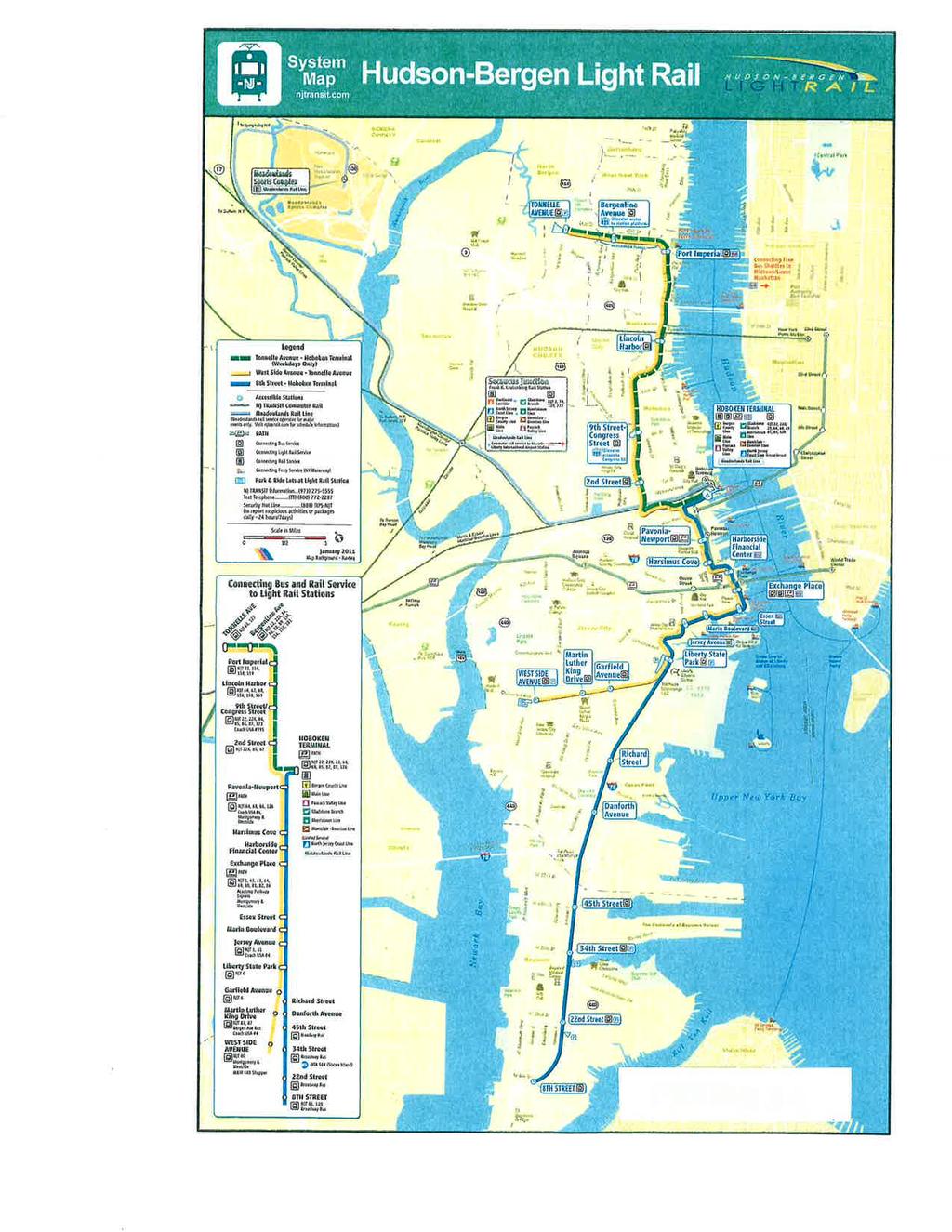
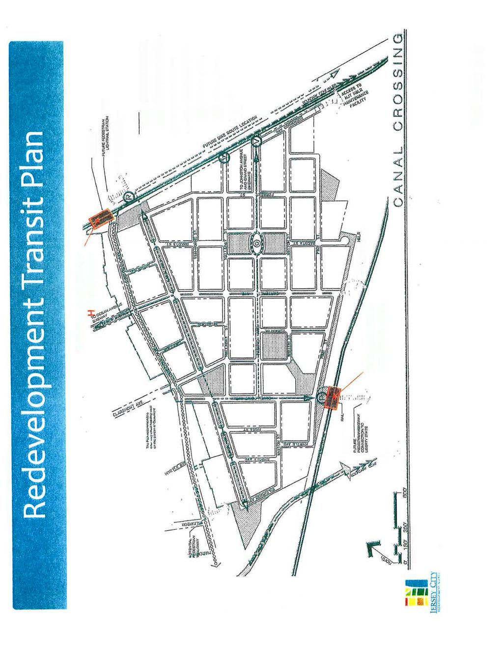
3 APPENDICES PAGE A Figures 2-1 Hudson-Bergen Light Rail System Map A Canal Crossing - Redevelopment Transit Plan A Proposed Garfield Avenue Station Access Improvements (Option 1) A Option 2 New Stair/Elevator Tower Only A Option 3 Existing Platforms with Pedestrian Bridge A-5 B Site Photos B-1 Garfield Ave. at HBLR Bridge Looking North B-1 B-2 Garfield Ave. at HBLR Bridge Looking South B-1 B-3 Garfield Ave. Station Looking East from Randolph Ave. B-2 B-4 Garfield Ave. Bridge Looking East from Station B-2 B-5 Garfield Ave. Bridge South Abutment Looking East B-3 B-6 Existing Elevator Plaza North Side Looking West B-3 B-7 HBLR ROW Looking East from Station Crosswalk B-4 B-8 Existing Catenary Pole & Anchor East of Station Crosswalk B-4 FINAL February 28, 2013 Page ii
4 1.0 EXECUTIVE SUMMARY In accordance with the requirements of Task 4 of the Canal Crossing Redevelopment Project Scope of Services, as revised on October 24, 2012, an assessment of the alternatives for improving passenger accessibility to the existing Garfield Avenue light rail station in the vicinity of the northern portion of the redevelopment area was performed. This assessment was based on projected ridership increases resulting from implementation of the Canal Crossing Redevelopment Project. It included development of proposed station platform modifications and additional circulation elements; an analysis of advantages and disadvantages of each alternative; and a discussion of associated engineering, construction, rail operations and capital cost impacts. This study considered several alternative modifications that would improve passenger accessibility to the existing light rail station to serve the additional ridership generated from the Canal Crossing Redevelopment Project. The structural modifications associated with each of the alternatives would result in varying levels of construction and operational impacts at a range of capital costs. After reviewing alternatives with the City of Jersey City and New Jersey Transit, it was agreed that Option 1 provided the greatest benefit to the redevelopment project and the Hudson-Bergen Light Rail System. 2.0 INTRODUCTION 2.1 Project Background Canal Crossing is a 111-acre Redevelopment Area in the southeastern section of the City of Jersey City characterized by industrial and vacant land use surrounded by a residential population of predominantly minority households with relatively high unemployment and poverty rates. Redevelopment of the area is hampered by outdated infrastructure, contaminated brownfields and insufficient pedestrian access to mass transit. The Canal Crossing Redevelopment Plan was adopted in 2009 following a collaboration of government agencies and local stakeholders incorporating the best principals of sustainable development including Smart Growth, New Urbanism and Green Building. To advance this plan, the Jersey City Redevelopment Agency (JCRA) was awarded a HUD Sustainable Communities Challenge Grant and a DOT TIGER II Infrastructure Planning Grant for the Canal Crossing Redevelopment Area. The grants obtained for the Canal Crossing Redevelopment Project require the implementation of sustainable concepts including the Six Livability Principles. The first of these principles is to provide more transportation choices. The project proposes to achieve this principle by capitalizing on its proximity to the Hudson-Bergen Light Rail System to provide access to local and regional transportation systems. FINAL February 28, 2013 Page 1
5 2.2 Purpose of Study The Hudson-Bergen Light Rail (HBLR) system runs along both the northern and the eastern borders of the redevelopment area. The West Side Avenue branch forms the northern border of the redevelopment area and the Garfield Avenue station is located at the northwest corner of the area. The Bayonne branch forms the eastern border of the redevelopment area. The HBLR Operations and Maintenance (O & M) Facility is located where these branches diverge at the northeastern portion of the site. Since the Canal Crossing Redevelopment Plan is transit-oriented, the plan suggests the addition of a new station on the Bayonne branch within the redevelopment site near the eastern terminus of Caven Point Avenue to provide an additional option for future residents to access the HBLR system and its connectivity to other regional transit modes. Included among the stated objectives of the redevelopment plan is to encourage pedestrian interconnection to the light rail stations. A map of the HBLR System is included as Figure 2-1. A planning and engineering study (Reference 1) was prepared by the Canal Crossing project team and submitted in July, 2012 to assess the need and evaluate the technical feasibility of constructing a new station at the selected location on the Bayonne branch in the vicinity of Caven Point Avenue. The study concluded that it is technically feasible to construct a new station but would result in significant construction and operational impacts and costs. Additionally, projected ridership modeling and analysis concluded that the need for a new station is not significant at that location until the development site build-out progresses beyond the initial phases. As a result, the project team was directed to re-focus task efforts toward evaluating opportunities to improve passenger accessibility at the existing Garfield Avenue light rail station to better serve the initial development units planned for the northern portion of the Canal Crossing site. The purpose of this study is to present alternatives that address station accessibility from the redevelopment site to the east end of the Garfield Avenue Station in the vicinity of the HBLR overpass at Garfield Avenue. 2.3 Study Basis The HBLR System has been designed in accordance with the criteria and requirements outlined in the New Jersey Transit Light Rail Manual of Design Criteria (MODC). The current edition is dated May, This document applies to all aspects of light rail infrastructure, systems and equipment. Chapter 9 establishes specific guidelines and standards for the design of stations including general design parameters, platform geometry and configuration, weather protection, amenities, lighting, pedestrian access, vehicular access and parking. The current edition of the MODC has been used as the principal reference document for station design criteria unless otherwise noted. FINAL February 28, 2013 Page 2
6 Any modification to the existing station must continue to handle patrons efficiently, economically, safely, conveniently and comfortably. This assessment considers anticipated growth of the Garfield Avenue Station and long-term life of the system. Ridership projections developed in conjunction with the proposed Caven Point Station Feasibility Study (Reference 1) have been considered, particularly with regard to the Canal Crossing Redevelopment Project. It is assumed that any station modifications would be functionally consistent with the HBLR system but coordinated with and reflective of the adjacent community. The MODC had guided the evaluation of station accessibility options. Dimensional requirements are normally established by the more stringent of fire/life safety requirements or the day-to-day patron loading criteria. Extension of current two-car platforms to accommodate future three-car consists were considered. In evaluating the station site accessibility, circulation elements consider pedestrian access by regular commuters, infrequent users and persons with disabilities. Access by pedestrians and bicyclists will be encouraged. Vertical circulation elements are considered in conjunction with grade separated structures where required for pedestrian safety. No park-and-ride facilities have been considered at this site but accommodations for kiss-and-ride patrons were evaluated. Vehicular access was assessed and impacts to adjacent streets included in the development plan will be minimized. FINAL February 28, 2013 Page 3
7 3.0 DEVELOPMENT OF ACCESSIBILITY IMPROVEMENT ALTERNATIVES 3.1 Existing Garfield Avenue Station Site Conditions The Garfield Avenue station is the easternmost of the three HBLR stations on the West Side Avenue branch and is located at the northern border of the Canal Crossing redevelopment site (See Figure 2-2). The station occupies the entire block between Randolph Avenue to the west and Garfield Avenue to the east and features two 185-foot long (two car) platforms. The railroad profile and station platforms were constructed on an ascending gradient from west to east. As a result, the two-track right-of-way crosses Randolph Avenue at grade but bridges over Garfield Avenue as it proceeds eastward along the redevelopment site s northern boundary. After cresting at Garfield Avenue, the HBLR alignment descends to the east crossing Halladay Street and Pacific Avenue at gated grade crossings. The structure that carries the HBLR over Garfield Avenue consists of four precast, prestressed concrete beams and a cast-in-place concrete deck spanning approximately 60 feet and skewed at approximately 35 degrees. Wing walls and embankment retaining walls at both abutments are primarily prefabricated, modular concrete structures. As a result of the bridge geometry and span, the sidewalk widths along Garfield Avenue are relatively narrow at the overpass ( feet). Several underground utility systems are present in the Garfield Avenue right-of-way. They include gas, water, sewer and electrical distribution systems. In addition, a 54-inch diameter sewer is present along the north side of the HBLR right-of-way with burial depths ranging from approximately 2-20 feet. Currently, accessibility to the west end of both station platforms at Randolph Avenue is provided by standard HBLR ramps. However, due to a lack of space, they are located along the back side of the platforms rather than at the traditional end location. Access to the east end of the station is limited to an elevator/stair tower northwest of the Garfield Avenue railroad overpass structure located in a plaza set back approximately 50 feet from the westerly curb line of Garfield Avenue. This facility provides direct access from the west sidewalk of Garfield Avenue to the outbound (railroad south) platform. To access the inbound (railroad north) platform, passengers must use the pedestrian crossing at track level opposite the elevator at the east end of the platform. The accessibility improvement study site is primarily focused on the east end of the existing station and the south side of the railroad overpass structure at Garfield Avenue. Photos of the site features within and adjacent to the HBLR right-of-way are included in Appendix B. FINAL February 28, 2013 Page 4
8 3.2 Description of Garfield Avenue Station Accessibility Alternatives In order to assess the feasibility of improving accessibility to the Garfield Avenue HBLR to serve the future Canal Crossing development ridership, several conceptual alternatives were developed. These alternatives include a no build option and three (3) station modification options. The following is a discussion of the options evaluated No Build Option Under this scenario, no station modifications would be constructed. As the Canal Crossing site is incrementally developed, passengers would utilize the existing Garfield Avenue Station as currently configured to access the HBLR. Figure 2-2 illustrates the location of the Garfield Avenue Station relative to the redevelopment site Option 1 This option features an eastward extension of both the inbound and outbound platforms from 185 feet to 270 feet to accommodate future 3-car trains. The platform extensions would require modifications to the existing HBLR bridge to accommodate the lengthened platforms which would end above Garfield Avenue. Walkways would be provided at the east end of the new platforms to extend further eastward to the existing bridge abutment area where a new pedestrian crossover would be provided to interconnect them. A new elevator/stair tower would be constructed southeast of the overpass, at the east end of the extended platforms, to allow accessibility to and from the Canal Crossing redevelopment site. This option is illustrated on Figure 3-1 in Appendix A Option 2 This option is limited to the addition of a new elevator/stair tower south of the station and west of Garfield Avenue. Demolition and reconfiguration of the existing retaining structures would be required to accommodate the new tower which would provide access to the inbound platform, complementing the existing access. Existing two-car platforms would remain unchanged. A sketch of this option is included as Figure Option 3 This option would include a new elevator/stair tower southeast of the railroad overpass, similar to Option 1. A new pedestrian bridge would span Garfield Avenue to provide access from the Canal Crossing redevelopment site to the existing HBLR station. Existing two-car platforms would remain unchanged. A sketch of this option is included as Figure 3-3. FINAL February 28, 2013 Page 5
9 4.0 ANALYSIS AND RECOMMENDATIONS All of the alternatives considered were evaluated in terms of a number of factors including benefits to future users as well as engineering, construction, HBLR operations and capital costs. A meeting was held with representatives of the City of Jersey City and NJ Transit to review comparative advantages and disadvantages of each of the alternatives considered. A summary of this comparison is included as Table 4-1. It was agreed that Option 1 provided the greatest benefit to the redevelopment project and the Hudson-Bergen Light Rail System and is therefore recommended for further consideration. Although this option is the most costly, it is the only one that would provide direct passenger access from the development site and extended platforms for future use by three-car trains. The following is a discussion of the key issues considered. 4.1 Engineering Considerations Several engineering issues associated with the recommended option were identified. As previously indicated, structural additions or modifications to the existing Garfield Avenue bridge would be required to accommodate the extended platforms and walkway. The challenge will be to construct two new spans on either side of the existing bridge to support the new platforms and walkways such that their relationship to the existing track structure maintains proper and precise clearances. In addition, there is a potential that foundations for the new structural supports on the north side of the bridge could interfere with the existing 54-inch diameter sanitary sewer that runs parallel to the light rail rightof-way. These supports would be required to bridge the sewer to avoid imposing any additional load on the pipe. The light rail track profile approaches the Garfield Avenue Station from the west at an ascending grade of 1.65 percent. The profile transitions to a descending gradient of 3.5 percent with a 260 foot vertical curve beginning forty feet beyond the east end of existing platform. Light rail design standards specified in the MODC require station platforms to be on tangent track both horizontally and vertically. Tangent track should extend at least 40 feet beyond station platforms (Ref. MODC Sect ). The recommended option would require the station platforms to extend more than 40 feet into the existing vertical curve violating that requirement. The Garfield Avenue bridge would limit realignment options. Therefore, a waiver of the MODC design requirements would be necessary and platform extension construction would have to consider surface profile adjustments to maintain all ADA access clearance and gap requirements. 4.2 Construction Impacts The recommended option would result in significant construction impacts complicated by its proximity to the active HBLR right-of-way. Issues to be addressed in construction planning include sequence of work and staging; work zone safety; work shift utilization and productivity; and scheduling impacts resulting from coordination with HBLR operations. FINAL February 28, 2013 Page 6
10 Construction associated with the new platforms would, by definition, be within fouling distance of existing operating track. Construction would have to be carefully staged to minimize service impacts. The use of precast elements may be required to expedite installation. In addition, two existing anchored catenary poles and associated hardware would have to be relocated either temporarily or permanently to accommodate the platform extensions (see Appendix B, Photos B-7 and B-8). There would also be significant construction impacts to Garfield Avenue in the vicinity of the HBLR overpass. Construction of the expanded bridge substructure and superstructure will require a phased maintenance and protection of traffic (MPT) plan that minimizes traffic disruption on Garfield Avenue. 4.3 HBLR Operations Impacts Construction impacts previously described must be addressed in the context of HBLR operational impacts. Operationally coordinated construction planning would be essential to minimize service disruptions and maintain Garfield Avenue station accessibility. The additional ridership projected from the Canal Crossing Redevelopment Project and other future system expansion to the west may require operational modifications in the vicinity of the Garfield Avenue Station. During discussions associated with this study, NJ Transit indicated that there may be a desire to add a train turnaround capability near Garfield Avenue to provide operational flexibility. As a result, several alternatives were examined. They include the addition of a new siding track between Randolph Avenue and Arlington Avenue west of the Garfield Avenue Station or a new siding track at the station itself. This would permit the turning of trains at Garfield Avenue and service modifications similar to those recently initiated on the Bayonne Branch. Our review indicated that both of these options are problematic. There is only about 250 feet of available track length between Randolph Avenue and Arlington Avenue. Therefore, after deducting the turnout and clearance length, only about one car length of potential storage space would remain on a siding. Earthwork and right-of-way issues may also be a liability. Constructing a new siding track at the Garfield Avenue Station would also be impractical. Assuming right-of-way is available, significant retaining walls and bridge structures, as well as modifications to the existing structures would be required to construct a new storage siding. In addition, the existing track gradients in this vicinity exceed the requirements for pocket or storage tracks. One possible configuration that may be viable is the addition of a siding track west of Halladay Street where the existing track gradient is approximately 0.5 percent. There appears to be enough space to achieve storage for three cars at this location. The existing interlocking east of Pacific Avenue could be used to facilitate train movements. This option would obviously require more analysis both physically and operationally to determine if it is feasible. FINAL February 28, 2013 Page 7
11 TABLE 4-1 COMPARISON OF GARFIELD AVE. STATION IMPROVEMENT ALTERNATIVES FACTOR NO BUILD OPTION 1 OPTION 2 OPTION 3 Engineering / Construction ADVANTAGES No impacts to Garfield Ave. station or site DISADVANTAGES None ADVANTAGES None DISADVANTAGES Significant Garfield Ave. bridge modifications required Track design issue related to vertical curve encroachment Potential conflict with existing sewer pipe north of bridge Construction impacts within HBLR & Garfield Ave. ROW ADVANTAGES No modifications to HBLR bridge Limited impacts to Garfield Ave. Does not preclude future platform extensions DISADVANTAGES Retaining wall demolition and reconfiguration required at bridge abutment ADVANTAGES Limited modifications to HBLR bridge DISADVANTAGES Construction impacts along Garfield Ave. Difficult to extend HBLR platforms in future HBLR Operations ADVANTAGES No impacts to West Side Ave. Branch operations DISADVANTAGES Two-car platforms & limited access from east end of station inhibit future growth ADVANTAGES Three-car platforms provide additional capacity for future expansion Improved station accessibility from Canal Crossing redevelopment site DISADVANTAGES Construction activities will impact rail operations ADVANTAGES Improves passenger accessibility to east end of existing inbound platforms DISADVANTAGES No platform expansion provided No station access east of Garfield Ave. provided ADVANTAGES Improves passenger accessibility to station from east side of Garfield Ave. DISADVANTAGES No platform expansion provided No benefit to future operations or capacity enhancements Capital Cost ADVANTAGES No capital cost expenditure for station modifications DISADVANTAGES None ADVANTAGES None DISADVANTAGES Most expensive option ADVANTAGES Least expensive option DISADVANTAGES Minimal improvement for required investment ADVANTAGES Less expensive than Option 1 DISADVANTAGES More expensive than Option 2 Limited improvement for required investment FINAL February 28, 2013 Page 8
12 4.4 Cost Considerations Although the options considered and rejected are less expensive, the stakeholder consensus agrees that the option recommended provides the best value to the development and the HBLR. We have developed rough order of magnitude (ROM) cost estimates based on the conceptual station modification options presented. In developing the estimates, we reviewed cost data developed by an NJ Transit consultant who evaluated platform extension concepts at Garfield Avenue Station and others in 2010 (Reference 2). We have added to this base assumption order of magnitude costs to address site conditions, an allowance to account for HBLR infrastructure modifications and impacts associated with staged construction in an operating environment. It should be noted that all of these factors are highly variable depending on site specific conditions, construction staging plans, operating constraints and market conditions. Therefore, it should be cautioned that the estimated costs represent an order of magnitude value and not a precise construction cost estimate. The estimate suggests that the improvements included in the recommended option could be constructed for approximately $7 million not including escalation or contingency assuming a construction midpoint of With the addition of engineering, construction management and other associated project soft costs, as well as an allowance for HBLRT infrastructure modifications, escalation and contingency, the total project cost could be in the range of $15-$16 million. Table 4-2 presents a comparative summary of the order of magnitude construction costs for the options considered assuming the station modifications would be constructed within the next several years. These costs would obviously require additional escalation to the midpoint year of construction if the station modifications are deferred beyond FINAL February 28, 2013 Page 9
13 TABLE 4-2 GARFIELD AVE. STATION IMPROVEMENTS COMPASISON OFROUGH ORDER OF MAGNITUDE (ROM) COSTS ($Million) DESCRIPTION OPTION Station Modifications (1) Associated Project Costs (2) Estimated ROM Costs Inflation (10%) & Contingency (20%) Total Estimated ROM Station Costs $ 13.5 $ 5.9 $ 9.2 HBLR Infrastructure Allowance (3) Associated Project Costs (2) Estimated ROM Costs Inflation (10%) & Contingency (20%) Total Estimated ROM HBLR Costs $ 2.0 $ 0.2 $ 0.5 GRAND TOTAL ROM COST $ 15.5 $ 6.1 $ 9.7 (1) Includes station construction and site development completed by 2016 (2) Includes engineering, construction mgmt., permitting (3) Includes allowance for any modifications to trackwork, OCS, traction power, signals & communications FINAL February 28, 2013 Page 10
14 5.0 CONCLUSIONS Option 1, illustrated in Figure 3-1, is recommended for further consideration. It provides the greatest benefit to the future light rail passengers from the Canal Crossing Redevelopment site in terms of accessibility and the best value for HBLRT operations and future system expansion. Project stakeholders previously discussed a phased implementation of station modifications. Option 1 could be implemented in stages by initially constructing the new elevator/stair tower and inbound platform extension followed by the outbound platform extension and new track crossover at a later date. This approach is not recommended for several reasons. First, an additional construction phase would add to the disruption to both HBLR operations and Garfield Ave. traffic. Second, an interim transition ramp to the existing track crossover would be required and would need to be subsequently reconfigured to accommodate the full platform extension in a later phase. Finally, associated costs would be increased with limited benefits. In order to address vehicular access for future passengers who may be arriving at the Garfield Avenue Station by car or shuttle bus, we recommend that a drop-off area be incorporated at or adjacent to the future intersection of Canal Way and Forrest Street. The drop-off area should respect the redevelopment themes, including an unencumbered plaza easily accessible to pedestrians and bicyclists while providing a functional kiss-and-ride or bus stop. Engineering and construction issues previously discussed must be addressed comprehensively but can be mitigated through careful planning and design. Potential track modifications in the vicinity of the Garfield Avenue Station are more problematic because of space constraints and gradient limitations. Depending on specific operational needs, there are some opportunities for expansion at adjacent sites. 6.0 REFERENCES 1. Feasibility Study for Proposed Caven Point Avenue Light Rail Station, prepared by URS for T&M Associates, July 31, HBLR Platform Extension Study Report, prepared by Clough Harbour & Associates for NJ Transit, July 2010 FINAL February 28, 2013 Page 11
15 APPENDIX A
16


17

18
19
20
21 APPENDIX B
")
")
22 Photo B-1 (Garfield Ave. at HBLR Bridge Looking North) Photo B-2 (Garfield Ave. at HBLR Bridge Looking South) Appendix B Page B-1

")
23 Photo B-3 (Garfield Ave. Station Looking East from Randolph Ave.) Photo B-4 (Garfield Ave. Bridge Looking East from Station) Appendix B Page B-2

")
24 Photo B-5 (Garfield Ave. Bridge South Abutment Looking East) Photo B-6 (Existing Elevator Plaza North Side Looking West) Appendix B Page B-3
 Photo B-8")
 Appendix")
25 Photo B-7 (HBLR ROW Looking East from Station Crosswalk) Photo B-8 (Existing Catenary Pole & Anchor East of Station Crosswalk) Appendix B Page B-4
East Corridor Final Environmental Impact Statement
 East Corridor Final Environmental Impact Statement Alternatives Considered Operating Plan The requirements for opening day operations versus year 2030 are based on ridership and operations. Opening day
Northern Branch Corridor SDEIS March 2017
 Northern Branch Corridor SDEIS March 2017 15. 15.1. Chapter Overview 15.1.1. Introduction This chapter discusses changes to the Preferred Alternative resulting in the potential for project improvements
Northwest Rail Corridor and US 36 BRT Development Oriented Transit Analysis 4.4 STATION AREA FINDINGS
 4.4 STATION AREA FINDINGS Each station is different, and each one requires a separate set of recommendations based on the vision for the site. This section outlines an initial TOD strategy and recommendations
1 INTRODUCTION Purpose Project Background PROJECT CONTEXT Background The Capital City Downtown Plan...
 Attachment 3 Contents CONTENTS 1 INTRODUCTION... 3 Purpose... 3 Project Background... 3 2 PROJECT CONTEXT... 9 Background... 9 The Capital City Downtown Plan... 9 The LRT Expansion Plan - LRT Downtown
Gold Line Bus Rapid Transit Transit Oriented Development (BRTOD) Helmo Station Area Plan
 Helmo Station Area Plan") Appendix F Gold Line Bus Rapid Transit Transit Oriented Development (BRTOD) Helmo Station Area Plan Introduction and Purpose of the Plan The Gold Line Bus Rapid Transit facility is an eleven-mile dedicated
Appendix F Gold Line Bus Rapid Transit Transit Oriented Development (BRTOD) Helmo Station Area Plan Introduction and Purpose of the Plan The Gold Line Bus Rapid Transit facility is an eleven-mile dedicated
APPENDIX D: Visual and Aesthetic Conditions for NCCU Station Refinement. Durham-Orange Light Rail Transit Project
 APPENDIX D: Visual and Aesthetic Conditions for NCCU Station Refinement Durham-Orange Light Rail Transit Project October 2016 1. Introduction The Combined FEIS/ROD summarizes the effects of the D-O LRT
Mississippi Skyway Preliminary Engineering Report
 EXECUTIVE SUMMARY Mississippi Skyway Preliminary Engineering Report CITY OF RAMSEY, MINNESOTA DECEMBER 2014 City of RAMSEY EXECUTIVE SUMMARY Project Need and Intent The Mississippi Skyway pedestrian bridge
Northern Branch Corridor SDEIS March 2017
 14. Water Quality 14.1. Chapter Overview 14.1.1. Introduction This section discusses changes to the potential for activities associated with the development and operation of the Preferred Alternative to
9IMPLEMENTATION AND PHASING
 9IMPLEMENTATION AND PHASING Purpose A key objective of the Railyard Master Plan is the integration of the public and private realm to provide a network of places that connect to and complement Commercial
6. Consistency with Local Plans
 6. Consistency with Local Plans 6.1. Chapter Overview 6.1.1. Introduction This section presents the goals, objectives and policies of municipal, county and state planning entities, as well as known development/redevelopment
DESIGN OF FOOTBRIDGES
 Civil Engineering Technical Requirement CIVIL-SR-006 DESIGN OF FOOTBRIDGES Revision: 9 Updated: 26/08/2015 Queensland Rail 2015 Reproduction by any means (including electronic, mechanical, photocopying,
Meeting Display Boards for Public Hearing on the Wilson Transfer Station Project held Tuesday, February 18, 2014.
 Meeting Display Boards for Public Hearing on the Wilson Transfer Station Project held Tuesday, February 18, 2014. Board 1: Welcome Welcome to the Wilson Transfer Station Project Public Hearing. The purpose
Phase I Redevelopment Plan. First Community Meeting
 Hoboken Terminal and Yard Phase I Redevelopment Plan First Community Meeting May 31, 2011 One Hudson Place Phase I Redevelopment Plan Redevelopment Plan First Community Meeting Agenda 1. Redevelopment
ANDERSON PROPERTY SITE ANALYSIS
 ANDERSON PROPERTY SITE ANALYSIS Introduction The Montgomery County Department of Transportation (MCDOT) initiated a feasibility study in the fall of 2012 to evaluate the need for transit service expansion
Chapter 1.0 Introduction
 Chapter 1.0 Introduction 1.1 Background The North Metro commuter rail line is part of the RTD FasTracks regional transit system expansion program to build more than 100 miles of rail transit throughout
Right-of-Way Acquisitions and Relocations Technical Memorandum
 Right-of-Way Acquisitions and Relocations Technical Memorandum Southeast Extension Project Lincoln Station to RidgeGate Parkway Prepared for: Federal Transit Administration Prepared by: Denver Regional
A. INTRODUCTION B. PROJECT LOCATION
 Chapter 1: Project Description A. INTRODUCTION The Lower Manhattan Development Corporation (LMDC), a subsidiary of the New York State Urban Development Corporation, doing business as the Empire State Development
SCARBOROUGH RAPID TRANSIT ENVIRONMENTAL PROJECT REPORT CHAPTER 2 PROJECT DESCRIPTION. Table 2-4: North Segment Alignment Analysis 2-21
 Table 2-4: North Segment Alignment Analysis 2-21 SCARBOROUGH RAPID TRANSIT Based on the above analysis (detailed analysis is contained in Appendix A-4), North Alignment 3 is preferred because it: Has the
112th Avenue Light Rail Options Concept Design Report JUNE 2010 PREPARED FOR PREPARED BY TBG PGH
 112th Avenue Light Rail Options Concept Design Report JUNE 2010 PREPARED FOR PREPARED BY TBG060310124909PGH C ontents Introduction 1 Project Overview 1 Public Involvement and Technical Coordination 4 Description
Humber Bay Shores Precinct Plan Final Report
 STAFF REPORT ACTION REQUIRED Humber Bay Shores Precinct Plan Final Report Date: May 21, 2010 To: From: Wards: Reference Number: Etobicoke York Community Council Director, Community Planning, Etobicoke
FDOT D4 Complete Streets
 FDOT D4 Complete Streets Context Sensitive Solutions Directs that complete street solutions will complement the context of the community. Collaborative approach to decision making, project development,
Metro Orange Line Extension Four Years Early and $61 Million Under Budget
 White Paper: Metro Orange Line Extension Four Years Early and $61 Million Under Budget July 2013 Innovation for better mobility Metro Orange Line Extension Iteris, Inc. was the prime consultant leading
Written Statement for Keizer Station Area B Amendment. Master Plan Amendment for Keizer Station Area B GENERAL INFORMATION
 Written Statement for Keizer Station Area B Amendment Applicant: City of Keizer Request: Master Plan Amendment for Keizer Station Area B DATE: June 2017 GENERAL INFORMATION A. OWNER: The City of Keizer
PROJECT BACKGROUND. Preliminary Design Scope and Tasks
 PROJECT BACKGROUND Preliminary Design Scope and Tasks The purpose of this Study is the development of preliminary designs for intersection improvements for Trunk Highway (TH) 36 at the intersections of
4/8/2015 Item #10D Page 1
 MEETING DATE: April 8, 2015 PREPARED BY: Christy Villa, Associate Civil Engineer DEPT. DIRECTOR: Glenn Pruim DEPARTMENT: Public Works CITY MANAGER: Larry Watt SUBJECT: NORTH COAST HIGHWAY 101 STREETSCAPE
Establish a network of streetscaped vehicle and pedestrian routes that connect within and outside the Plan area.
 This Plan s urban design goals are to create an urban scale, walkable community with connections to transit, parks, and services and with amenities and facilities for residents and employees. The 1992
COUNCIL ATTACHMENT 2 HIGHWAY 7 CORRIDOR AND VAUGHAN NORTH-SOUTH LINK
 COUNCIL ATTACHMENT 2 HIGHWAY 7 CORRIDOR AND VAUGHAN NORTH-SOUTH LINK Welcome! The purpose today is to: Present the Study Background; Describe Alignment Alternatives Analyzed; Present the Evaluation of
Clairtrell Area Context Plan
 Clairtrell Area Context Plan March 2005 Urban Development Services City Planning Contents 1. Introduction... 4 2. Development Structure... 6 2.1 Streets... 7 2.1.1 Sheppard Avenue and Bayview Avenue...
Northern Branch Corridor DEIS December 2011
 16 Floodplains 161 Chapter Overview 1611 Introduction The flowing chapter identifies floodplains found within the Northern Branch Corridor in accordance with Executive Order 11988, Floodplain Management
2290+ STADIUM VILLAGE STATION ABOVE FIELD) (T.O "
 (T.O") 1 + PROPOSED o.8 UROU 3 15 + 32+ 32 CROSS-OVER PROPOSED o.8 PROPOSED o.8 CROSS-OVER DOUBLE at H ia ha LR w 1:1 33 + 3 5+ 33 34 h:\projects\\hi-mu\layou\feasibiliy SUDY\Enhanced\_alignment_comparison.dgn
1 + PROPOSED o.8 UROU 3 15 + 32+ 32 CROSS-OVER PROPOSED o.8 PROPOSED o.8 CROSS-OVER DOUBLE at H ia ha LR w 1:1 33 + 3 5+ 33 34 h:\projects\\hi-mu\layou\feasibiliy SUDY\Enhanced\_alignment_comparison.dgn
Urban Design Manual PLANNING AROUND RAPID TRANSIT STATIONS (PARTS) Introduction. Station Study Areas
 Introduction. Station Study Areas") 111111 PLANNING AROUND RAPID TRANSIT STATIONS (PARTS) Introduction The ION rapid transit system will link Waterloo, Kitchener and Cambridge through a central transit corridor (CTC). There are a number
111111 PLANNING AROUND RAPID TRANSIT STATIONS (PARTS) Introduction The ION rapid transit system will link Waterloo, Kitchener and Cambridge through a central transit corridor (CTC). There are a number
Planning Districts INTRODUCTION
 INTRODUCTION To facilitate detailed examination of development prospects for all areas of the community, Delano has been divided into 14 planning districts. The location of these planning districts is
Appendix C: Interim Mixed-Use Evaluation Criteria
 Appendix C: Interim Mixed-Use Evaluation Criteria C-1 Appendix C: Interim Mixed-Use Evaluation Criteria PURPOSE: The implementation of numerous policies contained within the Master Plan hinges on the creation
Northern Branch Corridor SDEIS March Table of Contents
 Table of Contents Executive Summary... ES-1 ES.1 Introduction... ES-1 ES.2 Project Background... ES-1 ES.3 Purpose and Need... ES-5 ES.4 Alternatives... ES-6 ES.5 Operating Plan... ES-11 ES.6 Cost Analysis...
MONTGOMERY COUNTY PLANNING DEPARTMENT THE MARYLAND-NATIONAL CAPITAL PARK AND PLANNING COMMISSION
 MONTGOMERY COUNTY PLANNING DEPARTMENT THE MARYLAND-NATIONAL CAPITAL PARK AND PLANNING COMMISSION MCPB Item No. 6 Date: 7.22.13 Bethesda Purple Line Station Minor Master Plan Amendment, Scope of Work Elza
ROAD CONSTRUCTION. 36 June 2014 ROADS&BRIDGES
 ROAD CONSTRUCTION 36 June 2014 ROADS&BRIDGES Young is full of life Recent expansion completes continuous, multilane arterial By Donald Hammack, P.E. Contributing Author The Florida Department of Transportation
Illustration of Eastlake Farmer s Cooperative Grain Elevator. Chapter 5: implementation 5-1
 Illustration of Eastlake Farmer s Cooperative Grain Elevator Chapter 5: implementation 5-1 chapter 5: implementation Introduction The Eastlake Subarea Plan includes a wide range of recommendations intended
CITY OF PUYALLUP. Background. Development Services
 CITY OF PUYALLUP Development Services 333 South Meridian Puyallup WA 98371 To: City Council From: Katie Baker, AICP, Planning Division Re: South Hill Neighborhood Plan Adoption Date: (Meeting date: February
ROAD CLOSURE AND LAND USE AMENDMENT SILVER SPRINGS (WARD 1) NORTHEAST OF NOSEHILL DRIVE NW AND SILVER SPRINGS ROAD NW BYLAWS 2C2018 AND 29D2018
 NORTHEAST OF NOSEHILL DRIVE NW AND SILVER SPRINGS ROAD NW BYLAWS 2C2018 AND 29D2018") Page 1 of 19 EXECUTIVE SUMMARY This application proposes redesignating two parcels in the community of Silver Springs from Special Purpose Future Urban Development (S-FUD) District and undesignated road
Page 1 of 19 EXECUTIVE SUMMARY This application proposes redesignating two parcels in the community of Silver Springs from Special Purpose Future Urban Development (S-FUD) District and undesignated road
Transit-Oriented Development
 Transit-Oriented Development Path to Sustainability West Windsor February 22, 2007 George S. Hawkins Context for Presentation NJ Future is a non-partisan, 501(c)3 non-profit organization. Offer perspective,
26/Old Dominion Task Force
 26/Old Dominion Task Force Meeting #9: March 21, 2019 Study Area Overview Staff Name, Department (DEPT ACRONYM) Preferred Scenarios Outline 1. Task Force Feedback from 3/7 2. Refined Concepts 3. Implementation
This Review Is Divided Into Two Phases:
 Semiahmoo Town Centre Review The purpose of this review: To review the Semiahmoo Town Centre Concept Plan, originally approved in 1993, to ensure that this centre will continue to serve the needs of South
This application has been applied for with support of an Outline Plan to provide the technical details for the site s development.
 Page 1 of 13 EXECUTIVE SUMMARY This application consists of a Land Use Amendment application proposing redesignation from Special Purpose Future Urban Development (S-FUD) District to an assortment of multiresidential,
Overall Map. Chicago. St. Louis. Summit. Joliet. Dwight. Pontiac. Bloomington-Normal Lincoln. Springfield. Carlinville. Alton EXPERIENCE IT YOURSELF.
 Overall Map Summit Chicago Bloomington-Normal Lincoln New Station Planned New Station Planned Dwight Pontiac Joliet Pedestrian overpass and second platform planned Higher speed service began in this section
Midtown Corridor Alternatives Analysis. Appendix A - Initially Considered Alternatives Screening
 Midtown Corridor Alternatives Analysis Appendix A - Initially Considered Alternatives Screening Arterial BRT on Lake Street - Overall Rating: RATING Metropolitan Council recommendations stated in the Transportation
Hockessin Community Redevelopment Plan
 Hockessin Community Redevelopment Plan 3.1 Introduction The Community Redevelopment Plan for the Village of Hockessin is the result of the people s vision for a distinct village center that serves as the
Edmonton s LRT Setting the Stage for Heading Further South
 4 Capital Projects Project Updates Edmonton s LRT Setting the Stage for Heading Further South Art Washuta, P.Eng. AECOM Canada Ltd. Edmonton, Alberta Carole Cej, P.Eng. City of Edmonton Edmonton, Alberta
Chapter 22. Alternatives to the Proposed Project
 Page 22-1 Chapter 22. Alternatives to the Proposed Project Introduction This chapter assesses the potential environmental effects of alternatives to the Proposed Project. The alternatives analyzed include
ELMVALE ACRES SHOPPING CENTRE MASTER PLAN
 ELMVALE ACRES SHOPPING CENTRE MASTER PLAN Contents 1.0 INTRODUCTION... 2 2.0 LOCATION... 2 3.0 EXISTING CONTEXT... 2 4.0 VISION & GUIDING PRINCIPLES... 2 5.0 LAND USE AND BUILT FORM... 4 5.1 St. Laurent
Lake Hazel/Gowen Relocation Alignment Study Report
 Lake Hazel/Gowen Relocation Prepared for 3775 Adams Street Garden City, Idaho 83714 And City of Boise 150 North Capitol Blvd. Boise, Idaho 83702 Prepared by Parametrix 7761 W. Riverside Dr. Suite 201 Boise,
UAA School of Engineering Parking Garage Master Plan Amendment. 1. Purpose
 UAA School of Engineering Parking Garage Master Plan Amendment 1. Purpose Since the UAA campus master plan was drafted in 2003, adopted in 2004, and amended in 2009 a number of significant changes regarding
QUEEN-RIVER SECONDARY PLAN
 34 QUEEN-RIVER SECONDARY PLAN 34. QUEEN RIVER SECONDARY PLAN 1. INTRODUCTION The Queen-River area is approximately 6.4 hectares and is located at the eastern edge of the Downtown as shown on Map 34-1.
East Panorama Ridge Concept Plan Amendment
 Page 1 of 7 L003 : East Panorama Ridge Concept Plan Amendment Corporate NO: L003 Report COUNCIL DATE: March 4, 2002 REGULAR COUNCIL LAND USE TO: Mayor & Council DATE: February 27, 2002 FROM: General Manager,
PLANNING JUSTIFICATION REPORT
 PLANNING JUSTIFICATION REPORT 55 DELHI STREET CITY OF GUELPH PREPARED FOR: VESTERRA PROPERTY MANAGEMENT PREPARED BY: LABRECHE PATTERSON & ASSOCIATES INC. SCOTT PATTERSON, BA, CPT, MCIP, RPP PRINCIPAL,
Tysons Circulator Study: Process and Preliminary Results Summary. March 2012
 Tysons Circulator Study: Process and Preliminary Results Summary March 2012 Background: 1. The Comprehensive Plan for the Tysons Corner Urban Center calls for a System of Circulators in Tysons Corner to:
MAIN STREET ECONOMIC DEVELOPMENT STRATEGY
 MAIN STREET ECONOMIC DEVELOPMENT STRATEGY A PATHWAY TO A BETTER POUGHKEEPSIE DRAFT Working Paper #2: Planning Strategies Submitted December 1 st, 2015 to the City of Poughkeepsie LAND USE LAW CENTER PACE
11.0 TRANSPORTATION ELEMENT
 11.0 TRANSPORTATION ELEMENT Transit, Circulation and Parking Sub-Element: For all campuses, FIU's goal is to increase multimodal access. In combination with other measures - such as the development of
4.1.3 LAND USE CATEGORIES
 4.1.3 LAND USE CATEGORIES a. City Center District The City Center District incorporates the existing character and mix of uses in downtown Belmont to encourage redevelopment and new development in keeping
ARTICLE 6: Special and Planned Development Districts
 ARTICLE 6: Special and Planned Development Districts 6-10 Traditional Neighborhood Development (TND) District 6-10.10 Purpose and Intent The Traditional Neighborhood Development (TND) District provides
AGINCOURT SECONDARY PLAN
 1 AGINCOURT SECONDARY PLAN 1. AGINCOURT SECONDARY PLAN The following policies and principles apply to the area herein referred to as Agincourt, as outlined on Map 1-1. 1. GENERAL POLICIES 1.1 This Secondary
Developer s Program. The Station at East 54
 Developer s Program The Station at East 54 Existing Conditions The Station at East 54 is proposed for a 1.12 acre site at the northeast corner of Hamilton Road and Prestwick Road, tucked between the East
HELLO & WELCOME. Prior/Venables Replacement A NEW PLAN FOR THE FALSE CREEK FLATS PLANNING PROCESS OVERVIEW
 HELLO & WELCOME. A NEW PLAN FOR THE FALSE CREEK FLATS Since last May, City staff have been working with you to identify the key issues, desires and directions for the future of the False Creek Flats. Throughout
Appendix G Response to Comments
 Appendix G Response to Comments This appendix contains the comments received during the public circulation and comment period (May 27, 2008 to July 11, 2008). The comments have been numbered (Comment Set
Review of Opportunity Area C Draft Comprehensive Plan and Draft BOS Follow-On Motions. Special Working Group Meeting March 4, 2015
 Review of Opportunity Area C Draft Comprehensive Plan and Draft BOS Follow-On Motions Special Working Group Meeting March 4, 2015 The slides that follow identify where the draft Comprehensive Plan has
12 AMENDMENT NO. 149, TOWN OF MARKHAM HIGHWAY 404 NORTH SECONDARY PLAN
 12 AMENDMENT NO. 149, TOWN OF MARKHAM HIGHWAY 404 NORTH SECONDARY PLAN The Planning and Economic Development Committee recommends the adoption of the recommendation contained in the following report August
Hudson Group North America LLC
 Hudson Group North America LLC Mr. John Palmieri, Director Boston Redevelopment Authority One City Hall Square Boston, MA 02201 August 30, 2010 RE: 120 Kingston Street Development, Notice of Project Change
Animating the Rideau Canal December 2013
 Executive Summary Animating the Rideau Canal December 2013 Why study the Rideau Canal? The Rideau Canal has been an important part of Ottawa throughout its history, and has shaped and been shaped by the
Rezoning Transportation Analysis Petition Number: General Location Identifier:
 From: Kelsie Anderson, PE Kelsie.Anderson@charlottenc.gov 704-432-5492 Staff Reviewer: Kory Hedrick, PE, PMP Khedrick@charlottenc.gov 704-432-6511 CDOT s review of this rezoning petition is intended to
COLVER ROAD INDUSTRIAL CONCEPT PLAN
 COLVER ROAD INDUSTRIAL CONCEPT PLAN A CONCEPTUAL LAND USE AND TRANSPORTATION PLAN FOR TA-4 AN URBAN RESERVE AREA OF THE CITY TALENT City of Talent Adopted by City Council Resolution No., June, 2015 PART
Transportation. Strategies for Action
 Transportation A major priority for the Overlake Neighborhood is to develop a multimodal transportation system. To achieve this system, a balance has to be found among travel, circulation and access needs;
Regency Developments. Urban Design Brief. Holyrood DC2 Rezoning
 Regency Developments Urban Design Brief Holyrood DC2 Rezoning Stantec Consulting Ltd. 7-31-2017 1. Overview Regency Developments intends to rezone the lands located at 8510 and 8511 93 Avenue, within the
Visual and Aesthetic Resources
 Visual and Aesthetic Resources 7.1 INTRODUCTION This chapter evaluates the effects of the Modified Design on visual and aesthetic resources, in comparison to the effects of 2004 FEIS Design. The 2004 FEIS
Draft Evaluation of Alignment Alternatives Methodology and Results Report. 3 nd Draft. May 2011(rev June 17, 2011)
") Draft Evaluation of Alignment Alternatives Methodology and Results Report 3 nd Draft May 2011(rev June 17, 2011) Draft Evaluation of Alignment Alternatives Methodology and Results Report Table of Contents
Draft Evaluation of Alignment Alternatives Methodology and Results Report 3 nd Draft May 2011(rev June 17, 2011) Draft Evaluation of Alignment Alternatives Methodology and Results Report Table of Contents
WEST LOOP DESIGN GUIDELINES CHECKLIST
 WEST LOOP DESIGN GUIDELINES CHECKLIST Section 1.0 General Strategies 1.1 DESIGN EXCELLENCE: ENCOURAGE HIGH QUALITY AND INNOVATIVE DESIGN OF NEW BUILDINGS WITHIN THE WEST LOOP WITHOUT BEING PRESCRIPTIVE
A. INTRODUCTION B. NO ACTION ALTERNATIVE
 Chapter 19: Alternatives A. INTRODUCTION Over the years a variety of potential developments for the East River waterfront in Lower Manhattan have been considered. Some of these plans were very ambitious
Downtown Lead Revitalization Project Final Recommendations. Three Proposed Options for the Revitalization of Downtown Lead
 Downtown Lead Revitalization Project Final Recommendations Three Proposed Options for the Revitalization of Downtown Lead November 1, 2011 Three Proposed Options for the Revitalization of Downtown Lead
38 Queen s University Campus Master Plan Part 1
 38 Queen s University Campus Master Plan Part 1 46 The Campus at the City Scale Chapter 4 The Campus at the City Scale 39 Queen s is an urban University centrally located in Kingston. Decisions made by
RESOLUTION NO. R Refining the route, profile and stations for the Downtown Redmond Link Extension
 RESOLUTION NO. R2018-32 Refining the route, profile and stations for the Downtown Redmond Link Extension MEETING: DATE: TYPE OF ACTION: STAFF CONTACT: Capital Committee Board PROPOSED ACTION 09/13/2018
OP Council Resolution June 16, Planning and Development Services
 OP-08-01 Council Resolution June 16, 2008 Planning and Development Services Kingsgate Landing Outline Plan Table of Contents 1.0 Introduction 1 1.1 Purpose of Plan 1 1.2 Plan Area Location 1 1.3 Ownership
The transportation system in a community is an
 7 TRANSPORTATION The transportation system in a community is an important factor contributing to the quality of life of the residents. Without a sound transportation system to bring both goods and patrons
Executive Summary. NY 7 / NY 2 Corridor
 Executive Summary NY 7 / NY 2 Corridor Transportation and Land Use Study December 2005 Prepared for: Town of Colonie Capital District Transportation Committee Prepared by: Introduction: Land use decisions
SCARBOROUGH SUBWAY EXTENSION. Scarborough Subway Extension. Final Terms of Reference
 Scarborough Subway Extension Final Terms of Reference 1 1.0 Introduction and Background 1.1 Introduction Toronto City Council recently confirmed support for an extension of the Bloor-Danforth Subway from
Scope of Services. River Oaks Boulevard (SH 183) Corridor Master Plan
 Corridor Master Plan") Scope of Services River Oaks Boulevard (SH 183) Corridor Master Plan PROJECT AREA The project area consists of the River Oaks Boulevard (SH 183) corridor bounded by SH 199 at the northern end and the Trinity
Scope of Services River Oaks Boulevard (SH 183) Corridor Master Plan PROJECT AREA The project area consists of the River Oaks Boulevard (SH 183) corridor bounded by SH 199 at the northern end and the Trinity
Attachment 1 TOWN OF NEW TECUMSETH. Manual for the Preparation of an Urban Design Report
 Attachment 1 TOWN OF NEW TECUMSETH Manual for the Preparation of an Urban Design Report July 2010 TABLE OF CONTENTS Background, Policy Framework and the Preparation of Urban Design Reports 1. Introduction
3. Additional driveways may be permitted where determined by the Planning Commission to adequately accommodate traffic or ensure public safety.
 ARTICLE 10 ACCESS MANAGEMENT Section 10.01 Purpose. The purpose of this Article is to protect the substantial public investment in the City s street system by preserving the traffic capacity of existing
Alta Vista Transportation Corridor Environmental Study Report November 2005
 Alta Vista Transportation Corridor Environmental Study Report November 2005 6.0 ALTERNATIVE DESIGNS The Preferred Solution to providing additional transportation system capacity through the AVTC study
Land Use Amendment in Southwood (Ward 11) at and Elbow Drive SW, LOC
 at and Elbow Drive SW, LOC") 2018 November 15 Page 1 of 10 EXECUTIVE SUMMARY This land use amendment application was submitted by Rick Balbi Architect on 2017 August 31 on behalf of Sable Developments Ltd, and with authorization from
2018 November 15 Page 1 of 10 EXECUTIVE SUMMARY This land use amendment application was submitted by Rick Balbi Architect on 2017 August 31 on behalf of Sable Developments Ltd, and with authorization from
URBAN DESIGN BRIEF NORTHVIEW FUNERAL HOME HIGHBURY AVE N, LONDON, ON
 URBAN DESIGN BRIEF NORTHVIEW FUNERAL HOME - 1490 HIGHBURY AVE N, LONDON, ON 1.1Purpose The intent of the following report is to identify an opportunity for redevelopment of two residential properties within
Gas Works Site Land-Use Study
 City of New Westminster Background Context 2 Neighbourhood Context 3 Program Elements 4 Proposed Site Planning Approach 5 Design Rationale 10 Design Elements 11 Phasing 21 C o n t e n t s b a c k g r o
Downingtown Station Relocation Plan Site Selection Memo June 12, 2012
 Downingtown Station Relocation Plan Site Selection Memo 06.12.12 June 12, 2012 Background and Overview Downingtown is a borough in Chester County, Pennsylvania located approximately 32 miles west of Philadelphia
September 25th, 2018 $2000 fee pd CC
 2.7267 acres 2018I-00075 September 25th, 2018 $2000 fee pd CC Rezoning Review Criteria Analysis - Map Amendment Application Number: 2018I-00075 805 W. 38 th Avenue October 19, 2018 (amd.) September 17,
City of Hermosa Beach Administrative Policy #
 City of Hermosa Beach Administrative Policy # SUBJECT: Living Streets Policy Date: Approved by: City Council Authority: Public Works Department & Community Development Department Mayor, PURPOSE The City
PLAN ELEMENTS WORKSHOP. April 5, 2016
 PLAN ELEMENTS WORKSHOP April 5, 2016 needs more housing. But there is no one-size fits-all solution. Every neighborhood has its own character. In some places, density is not only appropriate it is badly
Kanata Light Rail Transit Planning and Environmental Assessment Study
 Kanata Light Rail Transit Planning and Environmental Assessment Study Public Open House #2 Transportation Services Department December 7, 2017 Agenda Review study progress Confirm the Preferred Corridor
Railyard Alternatives and I-280 Boulevard Feasibility Study. MTA Board Meeting May 6, 2014
 Railyard Alternatives and I-280 Boulevard Feasibility Study MTA Board Meeting May 6, 2014 Planned Infrastructure Major pieces of new infrastructure are planned including: Downtown Rail Extension (DTX)
7.4 Maintenance and Storage Facility
 Region of Waterloo Rapid Transit Project 7.4 Maintenance and Storage Facility A Maintenance and Storage Facility is required to support the LRT component of the RT system. These facilities typically include
ULI St. Louis Technical Assistance Panel
 ULI St. Louis Technical Assistance Panel ULI St. Louis Technical Assistance Panel Sponsored by: Citizens for Modern Transit in partnership with METRO ULI St. Louis Mission Statement The mission of the
ADMINISTRATION RECOMMENDATION(S) 2017 February 09. That Calgary Planning Commission recommends APPROVAL of the proposed Land Use Amendment.
 2017 February 09. That Calgary Planning Commission recommends APPROVAL of the proposed Land Use Amendment.") Page 1 of 10 EXECUTIVE SUMMARY This land use amendment application is to accommodate changes to the location of a stormwater retention pond and land use boundaries adjacent to Environmental Reserve in
Page 1 of 10 EXECUTIVE SUMMARY This land use amendment application is to accommodate changes to the location of a stormwater retention pond and land use boundaries adjacent to Environmental Reserve in
Pace University Land Use and Sustainable Development Conference Tensions and Opportunities in Urban Revitalization
 Pace University Land Use and Sustainable Development Conference Tensions and Opportunities in Urban Revitalization Ken Schwartz, Principal, VHB December 6, 1013 Pace University Land Use and Sustainable
[PLANNING RATIONALE] For Site Plan Control and Lifting of Holding Zone By-Law 101 Champagne Avenue. May 23, 2014
![[PLANNING RATIONALE] For Site Plan Control and Lifting of Holding Zone By-Law 101 Champagne Avenue. May 23, 2014](/thumbs/75/71599615.jpg "[PLANNING RATIONALE] For Site Plan Control and Lifting of Holding Zone By-Law 101 Champagne Avenue. May 23, 2014") [PLANNING RATIONALE] For Site Plan Control and Lifting of Holding Zone By-Law 101 Champagne Avenue May 23, 2014 Contents 1.0 Introduction... 2 2.0 Site Context... 2 2.1 Adjacent Uses... 2 Figure 1: Site
[PLANNING RATIONALE] For Site Plan Control and Lifting of Holding Zone By-Law 101 Champagne Avenue May 23, 2014 Contents 1.0 Introduction... 2 2.0 Site Context... 2 2.1 Adjacent Uses... 2 Figure 1: Site