Lawrence Avenue Transit-Oriented Development Study
|
|
|
- Justina Barrett
- 5 years ago
- Views:
Transcription


1 Lawrence Avenue Transit-Oriented Development Study MAY 2018 CHICAGO TRANSIT AUTHORITY
2 Preparation of this document was financed in part through a grant from the U.S. Department of Transportation, Federal Transit Administration, under the Federal Transit Act, and/or the Illinois Department of Transportation, Office of Intermodal Project Implementation. The contents do not necessarily reflect the official views or policy of the U.S. Department of Transportation, Federal Transit Administration or the Illinois Department of Transportation, Office of Intermodal Project Implementation. This report does not constitute a standard, specification or regulation. i
3 CONTENTS 1. Introduction The Study Area... 3 History and Context... 4 The Area Today Developing a Community Vision TOD Principles and Guidelines Transit-Supportive Land Uses Transit Stations and Connectivity Neighborhood Character Streetscape Experience ii
 is a planning concept that concentrates development around transit resources to capitalize on public transit investments, reduce auto dependency, and enable")
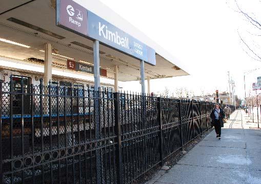
4 1. INTRODUCTION Transit is a vital component of life throughout Chicago, linking jobs, housing, recreation, and services. Transit-Oriented Development (TOD) is a planning concept that concentrates development around transit resources to capitalize on public transit investments, reduce auto dependency, and enable vibrant, healthy, and walkable neighborhoods. Understanding the history and important linkages between transit investments and communities, the Chicago Transit Authority conducted the Lawrence Avenue TOD Study to explore local preferences for TOD and/or transit-supportive design near the Brown Line terminal area. This study is intended to contribute to the larger community-wide discussion on the area s future and to complement other ongoing planning studies in Albany Park. Achieving development that meets local goals requires partnership among many stakeholders. CTA engaged with many partners in this effort, including the Chicago Department of Planning and Development (DPD), the 33 rd Ward and other aldermanic offices, the North River Commission (NRC), the Chicago Metropolitan Agency for Planning (CMAP), the Illinois Department of Transportation (IDOT), neighborhood organizations, and residents who participated in a series of advisory committee meetings in CTA met with these partners to gain a deeper understanding of the local vision for future development, which is documented in this report. These What is Transit-Oriented Development? Transit-Oriented Development (TOD) concentrates development around existing transit resources to maximize the relationship between land uses. Typically, TOD includes a dense mix of commercial, residential, office, and human services along an existing transit corridor. Focusing growth around transit capitalizes on public investments in transit and promotes walkable and vibrant neighborhoods. Kimball Station, looking south on Kimball Avenue. 1
5 efforts are only an initial step in implementing TOD and/or other transit-supportive improvements that realize the community s vision and expectations. This study is divided into the following major sections: Section 2 provides information on the history and context of the Brown Line and existing conditions in the study area. Section 3 summarizes the stakeholder outreach conducted as part of this study and identifies the neighborhood vision that was developed through the outreach process. Section 4 discusses TOD principles and guidelines for future development in the study area. The guidelines focus on four key topics: transit-supportive land uses, transit stations and connectivity, neighborhood character, and the streetscape experience. This section also documents specific development ideas that participants provided during the study. 2

6 2. THE STUDY AREA Lawrence Avenue TOD Study Area The study area is derived from the 2015 City of Chicago TOD Ordinance. It extends in a ¼ mile radius from the Kedzie and Kimball Brown Line stations. As Kedzie and Lawrence Avenues are designated Pedestrian Streets, the study area also extends ½ mile on these streets. Pedestrian Streets, or P-Streets, are segments of streets intended to preserve and enhance the character of streets and intersections that are widely recognized as Chicago's best examples of pedestrian-oriented shopping districts. The TOD Ordinance allows increased density for development as well as other provisions, such as reductions in parking requirements, to support TOD near existing transit stations. The study area represents the greatest opportunity in the Kimball terminal vicinity for future development that supports the integration of land use decisions with transit investments. What is a Pedestrian Street? The City of Chicago s Pedestrian Street designation is assigned to streets with a pedestrian-friendly character. The designation contains requirements concerning street frontage and building facades. Pedestrian Streets are streets with: A high concentration of existing stores and restaurants A right-of-way of 80 feet or less A continuous or mostly continuous pattern of buildings that are built abutting or very close to the sidewalk Doors and entrances abutting the sidewalk Many storefront windows abutting the sidewalk Few vacant stores 3
7 History and Context Understanding the area s legacy and its present-day conditions provides the context for its future. Albany Park, and specifically the Lawrence and Kedzie corridors, has had an interdependent relationship with transit over the past century. The TOD concept is not new and it has occurred organically over time as the Kimball and Kedzie L stations were built and the surrounding area developed. This section provides a brief history of the study area s transit resources and its present-day conditions. The Brown Line In 1900, the Northwestern Elevated Railroad Company completed its North Main Line that extended northward from the Loop to Wilson Avenue. In 1907, the company s Ravenswood Branch was extended northwest from Belmont Avenue to Albany Park, providing transit service to downtown Chicago. By 1908, the line s rail yard was operational. In this era, Albany Park was sparsely populated, yet residential real estate developers and local promoters sought transit improvements to ensure success for their projects. Rail transportation was a predominant mode from the late 1800s through the early years of the 20 th century. Decreasing ridership due in part to the Great Depression of the 1930s and World War II in the 1940s made Chicago s private transit operations unsustainable. CTA was created to ensure the survival of transit in Chicago and in 1947 the new entity assumed operation of the city s rail system from private companies. In 1949, CTA Kimball Yard, Chicago Transit Authority Collection. inaugurated the Ravenswood Service, today s Brown Line service. Changing lifestyles in the postwar era, aging infrastructure, the popularity of the automobile, and an exodus from Chicago to the suburbs led to financial difficulties in the 1970s and 1980s that left the CTA struggling to maintain its assets. 4

8 The tide began to turn in the late 1980s as North Side neighborhoods expanded in both population and appeal. Brown Line ridership started to rebound, increasing 30% from 1987 to 1998, and the rest of the L system followed suit in the late 1990s. In 1993, CTA rebranded its L lines from historical names to colors in part to help simplify navigation and capitalize upon Chicago s growing tourism market and the Brown Line was born. In 2001, Brown Line ridership reached 13.7 million annual station entries but remained stagnant through The Brown Line was at capacity and unable to accommodate passengers to and from downtown Chicago during peak travel times. To address this issue, CTA initiated the Brown Line Capacity Expansion Project in the mid-2000s, the largest capital improvement project of its era ever undertaken by CTA. Its primary goals were to increase capacity and provide Americans with Disabilities Act (ADA) upgrades. Under the project, Brown Line station platforms were reconstructed and expanded from six-car to eight-car trains to match much of the rest of the CTA system. The Brown Line Capacity Expansion Project was successful in increasing capacity and the line s ridership surged before construction was completed at the end of Use of the Brown Line has risen 37 percent in the past 15 years, which is a slightly greater increase than the capacity that was added through the Brown Line Capacity Expansion Project. Today, the Brown Line is CTA s third busiest rail line, with Kimball Station, Chicago Transit Authority Collection. segments operating at or over capacity during peak commuting hours. Kimball and Kedzie Stations Kimball Station was placed into service on December 14, Transit architect Arthur U. Gerber originally designed this station in the American Craftsman style. A 1913 map shows the property consisting of a stationhouse, rail yard, employee offices, and several small buildings with ancillary functions, including a workshop. In 1975, the station was updated with a contemporary building that was similar to other newer stations on the CTA system at that time. 5


9 Throughout the decades, the locations of the property s basic elements have remained relatively consistent, with stationhouse functions concentrated at the southeast corner of Kimball and Lawrence, platforms extending south along Kimball Avenue, and related uses and yard activities comprising the rest of the parcel. Arthur U. Gerber also designed the Kedzie Station, which was brought into service in the same time as the Kimball Station in It was used until January 1974, when the 1907 station house was demolished. A new station with an enclosed walkway constructed of a black steel framework with large Plexiglas windows and skylights housing the fare controls was built, opening for service on January 31, The Kedzie stationhouse and platforms were rebuilt in 2006 as part of the Brown Line Capacity Expansion Project to allow for 8-car platforms and enhanced ADA accessibility. The existing auxiliary exit at Spaulding Avenue was retained and upgraded to serve as an auxiliary entrance and a smaller version of the main station house. By 1929, this segment of Lawrence Avenue had transformed into a bustling commercial corridor with dense mixed-use retail and entertainment uses like the iconic Terminal Theatre. In the ensuing decades, the Kimball Station area lost some of its older, multi-story, mixed-used commercial buildings to demolition in lieu of new, one-story, single-use, commercial buildings with dedicated off-street parking lots. Kedzie Station, ca. 1970s. Chicago Transit Authority Collection. Lawrence Avenue Historically, commercial development in the study area along Lawrence between Kedzie Avenue on the east and Central Park Avenue on the west consisted primarily of dense, mixed-use buildings with retail uses on the first floor and residential or office space on upper floors. Although the Albany Park area was largely farmland when the line was constructed in 1907, the area around the Kimball Station developed quickly, creating a transit-oriented destination in Albany Park. Lawrence Avenue, ca. 1920s. Courtesy of Chicago Historical Society. 6


10 The Area Today This section discusses the study area s existing conditions, which served as the baseline for discussions at the project s advisory committee meetings (Section 3). Avenue. Another underutilized property is The Albany Bank & Trust Co. parking lot, located northwest of Kimball Station. Several additional single-story strip shopping centers with offstreet parking also exist in the study area. Land Uses Albany Park has a mix of land uses that contribute to its overall character. Land uses surrounding CTA s Kimball and Kedzie stations include single family residential, multi-story residential, institutional, and low-intensity commercial uses. Three- to fourstory courtyard apartment buildings and three- to six-flat apartments are common near Kimball Station. This area has one of the highest population densities along the Brown Line. These larger apartment buildings provide most of the neighborhood s affordable rental housing stock and are typically found on corner lots near Kedzie Station. Single family residences and three flats are common on neighborhood streets. Lawrence and Kimball Avenues, looking west. Commercial uses are concentrated on Lawrence and Kedzie Avenues, with some newer commercial development on Kimball Avenue near the terminal station. Among the commercial properties near Kimball, there are several vacant or underutilized parcels that could potentially support higherdensity commercial and mixed-use development. The Village Discount Thrift Store, for example, is a single-story building located east of Kimball Station on Lawrence with a large underutilized parking lot that occupies more than half of the parcel. Across the street, there is a 12,000 square-foot vacant parcel with roughly 80 feet of frontage on Lawrence Lawrence and Kedzie Avenues, looking northwest. 7

11 Vacant and Underutilized Parcels Identified by Participants 8

12 Transit Assets The Brown Line is the area s primary transit asset, with its stations and associated rail yard sited within commercial streets on Lawrence, Kimball, and Kedzie Avenues. As noted by study participants, the Brown Line is viewed positively and contributes to the neighborhood s character. The Brown Line s terminus at Kimball station is a connector to other modes of transportation including pedestrian, bus, bike, and automobile. Route 81 (Lawrence Ave); Route 82 (Kimball- Homan); and Route 93 (California/Dodge) serve this station. These routes are highly used in this area. In 2016, Route 82 (Kimball-Homan) provided approximately 5.7 million rides, Route 81 (Lawrence Ave) provided approximately 3.9 million rides, and Route 93 (California/Dodge) provided approximately 950,000 rides. Bicycle amenities are adjacent to Kimball station, including a Divvy bike share docking station, uncovered bike racks east of the station entrance, and a shared bike lane in each direction along Lawrence Avenue. For auto users, the station contains two off-street surface parking lots: a Park & Ride lot is adjacent to the station and the other is a combination lot located within the rail yard that contains additional commuter parking spaces and parking for CTA employees. Additional onstreet parking is available in the commercial districts along Lawrence and Kedzie. Most of these on-street spaces are regulated with parking meters and limited to 120 minutes. Kimball-bound train in the Loop. Kimball station has few passenger amenities. A Dunkin Donuts franchise is located in an area dedicated for concession uses within the stationhouse and an ATM is available for passenger use. Seating is provided on the primary platform for customers awaiting trains. Public art at the station consists of a pair of aluminum sculptures resembling architectural columns. An overhang covers the art, which is integrated with the stationhouse. The art provides shallow sidewalk seating for the public along Lawrence Avenue. Station overhangs offer outdoor shelter for passengers waiting for buses as well as overhead lighting. Security cameras are located throughout the entire property. 9


13 Kimball Yard, the Brown Line s rail yard and maintenance facility, occupies the northern terminus. Rail car storage, regular rail car inspections, periodic seasonal work and emergency checks, daily cleaning, traction power provision, employee training, and other operational duties necessary for operating the Brown Line occur at this yard and maintenance facility. Kimball Yard is currently at capacity and cannot accommodate the full number of trains required to operate the Brown Line s peak-hour service. The yard accommodates six-car train sets, not the eight-car train sets that CTA currently operates. Given this constraint and existing service demands, many of the Brown Line trains must be split into smaller segments to fit into the yard. Seven eight-car trains are also housed at Midway Yard each evening when not in use on the Brown Line because Kimball Yard cannot accommodate them. Even with the additional rail cars provided by Midway Yard, the Brown Line is limited in its ability to increase its current peak hour service given the lack of available trains. Kedzie Station is located less than one-half mile southeast of Kimball Station. Like Kimball, it is an at-grade station, with the main entrance on Kedzie Avenue and an auxiliary entrance on Spaulding Avenue. Kedzie Station has few amenities and transit connections. It has limited seating on the station platform, a few bike racks, and a share bike lane in each direction adjacent to it. A slight overhang also provides shelter outside the station. However, it has no concession area, bus connections, or parking. Kedzie Station, looking south. Kedzie Station platform. 10

14 Architectural Character Albany Park s architectural legacy adds to its unique character. Many older, high-quality multi-story buildings from the early 1900s exist along Lawrence and Kedzie Avenues. Participants throughout this study noted that the community prizes these buildings with their distinctive architectural styles. Typical design elements that establish the neighborhood vernacular include 45-degree or rounded corners at major intersections, visually dynamic and varied facades, and ground level features that differentiate ground-floor public space from private uses above. A few notable buildings on Lawrence Avenue are listed as Orange on the City of Chicago s Historic Resources Survey. This designation indicates that they possess significant architectural or historical features. For example, the Fish Furniture Building, a four-story Art Deco building from the 1930s, is located at 3324 West Lawrence Avenue near Christiana Avenue, and the Willis Building, a three-story mixed use Renaissance Revival building from the 1920s, still stands at 3225 West Lawrence Avenue, near Kimball Avenue. Today, high-quality older buildings and auto-centric single-story strip shopping centers coexist throughout the neighborhood. The abundance of commercial buildings with dedicated parking in front reduces the area s overall density and disrupts the quality of the pedestrian experience. Fish Furniture Building, 3324 W. Lawrence Avenue. 11


15 Lawrence Avenue Streetscape The study area supports a mix of vehicles, buses, bicyclists, pedestrians, and retail vendors who all share major streets and sidewalks. On Lawrence Avenue, there is one lane of traffic in each direction, with parallel on-street parking, and shared bike lanes in either direction. As study participants noted, most of the street markings, including crosswalks, are faded and not easily visible. Sidewalks are fairly narrow, causing pinch points at bus stops and intersections. On many blocks along Lawrence, streetlights are only provided along one side of the street and do not maintain consistent lighting levels at sidewalks. A predominance of curb cuts into off-street parking lots further encroaches on pedestrian safety and comfort. The pedestrian zone has an important social and economic role. During the study, several participants mentioned the study area s minimal street amenities and landscape plantings along main commercial streets. Small trees, street lighting, and sporadic bike racks are present in the pedestrian zone between buildings and the street. Kimball Station at Lawrence Avenue, looking south. Kimball Station, looking east along Lawrence Avenue. 12
16 3. DEVELOPING A COMMUNITY VISION During the study, participants input guided the creation of a vision statement (see insert, this page) and design guidelines (Section 4). With a goal to learn more about community preferences for TOD, input was received in a variety of ways. The primary method was through a Technical Advisory Committee (TAC) comprised of stakeholders and representative organizations with an interest in TOD. The TAC was created to gather input and to review recommendations that were generated throughout the study. CTA convened the TAC three times in August, October, and November Between the meetings, additional online feedback was also encouraged. At the first TAC meeting, participants completed a Visual Preferences Survey (VPS) by voting on design examples from other Chicago neighborhoods and rating their appropriateness for Albany Park. Preferences emerged with a high degree of consensus, including the following: A partially screened wall along Kimball to obscure views of the yard was preferred to a fully opaque wall (62% preferred). A station should be integrated with the streetscape, versus a freestanding property (74% preferred). Vision Statement The Lawrence, Kedzie, Kimball area will become the activity hub of Albany Park, with mixed-use retail and mixed-income housing that enhance the existing neighborhood character, and walkable streets with a public square where the culturally diverse community can gather. Multi-story mixed-use buildings were seen as more appropriate than single-story retail (58% preferred traditional multi-story mixed-use buildings with minimal setbacks from the street). Pedestrian amenities were viewed favorably, especially sidewalk cafes (73% preferred) and curb extensions (65% preferred). 13

17 preference for higher density was noted around transit stations and at primary intersections. Additionally, a well-defined intersection or landmark node at Lawrence/Kimball and Lawrence/Kedzie was of interest to study participants. Transit Connectivity: It was generally agreed that improving multimodal connections in the Kimball area is a priority. Adding a public plaza near the station was also viewed favorably, as was creating a unique connection to the transit facility and trains, such as a viewing spot for the rail yard or even a café or another type of rail-themed attraction. Using a decommissioned rail car for this purpose was recommended. Technical Advisory Committee workshop, With a general understanding of preferences from the Visual Preferences Survey exercise, the subsequent two Technical Advisory Committee meetings were conducted as discussionbased workshops. Using input from the first meeting as a guide, the workshops focused on transit-supportive land uses, transit stations and connectivity, neighborhood character, and the streetscape experience. These discussions provided essential input for developing the TOD principles and guidelines (Section 4) summarized below. Transit-Supportive Land Uses: While increasing density from current levels as a concept was generally viewed favorably, a Neighborhood Character: The study participants encouraged a mix of uses, specifically the adaptive reuse/repurposing of existing buildings. As one of the nation s most ethnically diverse neighborhoods, participants felt strongly that maintaining Albany Park s diversity with a variety of housing options, including affordable housing stock, was vital to the area s future. Preserving existing affordable housing and creating new affordable housing options, especially larger units for families, was also strongly supported as an essential factor in the neighborhood s continued vibrancy. In the study area, many study participants were interested in a central public space or plaza with amenities and the activation of main streets, like Lawrence Avenue, with widened sidewalks and additional pedestrian amenities, such as street furniture and sidewalk cafés. 14


18 Streetscape Experience: Study participants expressed an interest in public plazas, widened sidewalks, and green space along primary streets, in addition to a neighborhood identity marker or a distinctive community gateway. Preserving the neighborhood s existing character was identified as highly important. If the Kimball Station were to be redesigned in the future, study participants were interested in reducing intersection congestion and providing covered bike parking Study participants consistently raised the following themes: expanding affordable housing options, especially for families, immigrant populations, and the elderly; preservation of the neighborhood s older properties; and streetscape activation through new infill development and innovative design. These themes served as a basis for the TOD guidelines. During the two Technical Advisory Committee workshops, the study team presented the images in Section 4 to the study participants for initial feedback. The study team updated the TOD guidelines after each meeting to reflect the input they received. Technical Advisory Committee workshop, Kimball Station, looking east along Lawrence Avenue. 15

19 4. TOD PRINCIPLES AND GUIDELINES The following TOD principles and guidelines reflect the study participants future vision for the Kimball terminal area. The principles discussed below draw from core concepts in the Federal Transit Administration s Six Livability Principles, which were applied to the neighborhood. The guidelines contain specific recommendations for the Lawrence and Kedzie corridors and are illustrated through a combination of conceptual, representative illustrations. Among Chicago s many neighborhoods, Albany Park is exceptionally affordable and diverse with high quality housing stock and reliable access to economical transportation options. The vision identified in this study focuses on preserving this existing character while increasing local density and activity in selected areas. The resulting guidelines presented here support this vision by encouraging sustainable redevelopment and public way improvements that enhance pedestrian-friendly corridors. The broader principles of sustainability, affordability, diversity, and preservation are at the heart of these guidelines. Community mural near Kimball Station. TOD supports sustainability by encouraging transit use. Street design strategies incorporating sustainable elements such as permeable surfaces and plantings can further contribute to improved air quality, public health, and an enjoyable pedestrian experience. Green building guidelines, such as LEED, incentivize construction adjacent to transit as well as the reuse of existing buildings to reduce the environmental impacts of new development. Infill developments and restorations should support the neighborhood s affordability. Mixed-income housing is encouraged. Existing two- to six-flat residential buildings tend to be the most affordable family housing typology and should be maintained to support existing communities. New development can expand mixed-income housing options to encourage a diversity of ages, abilities, incomes, and ethnicities. Along with affordable housing, access to affordable transportation can reduce the cost of living (and environmental impact) through decreased reliance on personal vehicles and timely access to employment, education, and other human services and basic needs. 16
20 TOD and preservation are complementary and integral. Existing exemplary mixed-use buildings from the early 1900s should not only be preserved, but also looked to as a model for new development. Conservation and restoration of the existing built environment, along with contextually sensitive infill development, could activate the neighborhood while preserving places important to local history and culture. Six Livability Principles The Six Livability Principles were established by the Partnership on Sustainable Communities, an interagency collaboration between the U.S. Environmental Protection Agency (EPA), U.S. Department of Transportation (DOT) & U.S. Department of Housing and Urban Development (HUD). 1. Provide more transportation choices 2. Promote equitable, affordable housing 3. Enhance economic competitiveness 4. Support existing communities 5. Coordinate and leverage federal policies and investment 6. Value communities and neighborhoods 17
21 Transit-Supportive Land Uses Prioritizing higher density transit-supportive land uses can activate the Lawrence and Kedzie corridors. A variety of mixed-use infill developments can create a thriving community hub. Increased density encourages transit ridership, reduces environmental impact, provides convenient access to services and employment, promotes an economically vibrant community, and fosters redevelopment. Infill Development consisting of multi-story mixed-use buildings with a minimal setback can stitch together the streetscape. Mixed-use buildings may contain public functions such as retail and human services on the first floor, and residential or office uses above. Developers could be encouraged to explore options for designing ground floor spaces that would allow for greater flexibility between retail, residential, and other uses. Higher intensity uses, typically housed in taller buildings should be located near transit stations and major intersections, and should taper off towards the surrounding neighborhood. Several practical, operational, financial, and land use constraints present challenges for building above the existing station and rail yard. In the context of a project that addresses CTA s operational needs, the Park & Ride lot on Lawrence Avenue could potentially be utilized for a higher intensity use in the future. This could be accomplished through a joint Memorandum of Understanding (MOU) between CTA and the community. Other vacant and underutilized parcels in the area with ready access to transit provide opportunities for development. Pedestrian-Oriented Uses should activate the area, and make use of and/or be visible from the street. Outdoor plazas/seating areas can provide relief and foster a healthy and safe neighborhood. Family-friendly land uses reinforce a family-oriented, safe community. Automobile-oriented uses are discouraged. Local businesses and community-focused signage can reinforce neighborhood identity. For example, Kedzie Avenue should continue to grow as a hub for restaurants and grocery stores. Housing types in the area should complement, not displace, existing multi-family affordable housing stock. Multi-family affordable housing should be maintained or increased throughout the surrounding neighborhood. 18

22 19


23 Transit Stations and Connectivity Transit stations can serve as activity hubs for the neighborhood and interface with the surrounding community in many ways. They facilitate neighborhood connectivity by accommodating multiple modes of transportation including pedestrian, bike, bus, and cars, and their design can enhance the surrounding urban fabric. Transit Stations should be integrated with the streetscape where possible and may contain mixed-use or retail amenities. An adjacent public plaza could provide space for community uses and waiting for transit connections in a highly-visible location. Track screening should be partial, not solid, to maintain the transparency and visibility of public assets and investments. Track screening approaches may incorporate public art. Transit Connectivity Incorporating convenient and covered multimodal transfers can encourage transit connectivity. Bike-friendly improvements such as bikesharing stations and additional secure bike parking are encouraged to enhance connectivity and promote safe streets. The study area is a heavy bus corridor yet bus stops lack sufficient sidewalk width for a standard shelter and are often crowded. Future developments or improvements should prioritize relieving congestion with sufficient space for pedestrian flow that also allows for covered transit connections. If feasible, commuter parking could be integrated into mixeduse developments to prioritize the pedestrian experience. Dense, mixed income residential near the transit station maximizes access to transit. L Station Integrated with Streetscape Partial Track Screening Future improvements at Kimball and Kedzie stations could include additional real-time transfer information, neighborhood destination signage, covered and secure bike parking, and a designated auto pickup location to reduce street congestion. Future improvements could consider a stronger integration with the streetscape and sufficient space for pedestrians awaiting connections. 20

24 21


25 Neighborhood Character Successful urban design responds to the existing built environment and its historical and present-day context. Buildings should be accessible, sustainable, and pedestrian-oriented, drawing design elements from local examples of highquality buildings. The reuse and adaptation of existing buildings is encouraged to retain the neighborhood s unique character. Contextual Architecture reflects elements of visual interest from its surroundings and avoids large expanses of monolithic uniform facades. Gateway features such as angled or rounded corners at intersections denote a sense of arrival and significance and increase visibility at the street. Designs should encourage a high level of visibility at the street level through a transparent first floor and clearly marked visible entrances. The ground floor public realm is distinguished from the private areas above through architectural features such as a change in material, ornamentation, or depth. Taller buildings may step back at higher floors to minimize shadow impacts and reduce the canyon effect at street level. Typical Streetscape Typical Multi-family Reuse and Preservation of existing high-quality multi-story buildings should be prioritized. Many existing two- to six- flat multi-family residential buildings provide affordable housing options for the community. Community Identity is reinforced by street design features such as neighborhood markers and wayfinding signage. A well-defined intersection or exceptional building can serve as a landmark node for the community. Local artists and community members should be engaged to create a unique neighborhood identity marker. Future improvements could include sustainable design features. Improvements should celebrate the neighborhood s character through the incorporation of public art and placemaking. 22

26 23
27 Streetscape Experience An enjoyable pedestrian experience is an integral component of Transit-Oriented Development. Streets and sidewalks are not only organized to move vehicles and pedestrians and support other transportation modes, but also to organize social and economic activities. The pedestrian zone between building facades and the street has the potential to activate the streetscape and encourage pedestrian use. Pedestrian Zones should contain features that encourage pedestrian interaction. Pedestrian-oriented features at street level include transparent and welcoming storefronts, signage and awnings, and sidewalk amenities such as street furnishings, trash cans, street trees, landscaping. Consistent tree canopy coverage and minimizing impermeable surfaces can enhance aesthetics, improve air quality, support better stormwater infiltration, and contribute to public health improvements. The streetscape is currently activated by street vendors that support a vibrant streetscape environment and these vendors should be accommodated. There is some potential for additional sidewalk cafés along Kedzie Avenue or on side streets near Lawrence Avenue. Walkability is prioritized by minimizing or eliminating curb cuts that limit pedestrian space, reducing potential for pedestrian and vehicular conflicts, and providing sufficient space for pedestrians on accessible sidewalks. Existing sidewalk widths are challenging, particularly at major intersections with bus stops. Stakeholders should actively seek to reduce or minimize these conflicts. Small setbacks in new developments or the strategic reuse of parking spots could provide opportunities for relief. Traffic calming measures, such as curb extensions and textured/colored crosswalks, act to slow vehicular traffic, call attention to pedestrians, and increase safety. Public Plazas and parks can activate the area and foster a healthy and safe neighborhood. Open space allocated off-street can extend the pedestrian zone and allow room for people to congregate. These outdoor spaces should be flexible, allowing for a variety of public uses, and contain seating for people of all ages. A successful public space will include green space and engage locals to provide programming. Enhancing pedestrian connections expands access to transit services. Setbacks can extend the pedestrian zone and relieve congestion. Public art, plantings, seating, and other public amenities enhance the pedestrian experience and encourage transit use. 24

28 25
Table of Contents. Elm Avenue Improvement Plan City of Waco, Texas. Introduction 1. Existing Context 1 Figure 1 2.
 Table of Contents Introduction 1 Existing Context 1 Figure 1 2 Plan Guidelines 3 Future Urban Form 4 The West-End 4 Main Street 6 The East-End 7 Figure 2 9 Public Improvement Recommendations 7 General
Town Center (part of the Comprehensive Plan)
") Town Center (part of the Comprehensive Plan) Mercer Island Town Center Looking North (2014) In 1994, a year-long process culminated in a set of design guidelines and code requirements for the Town Center
Town Center (part of the Comprehensive Plan) Mercer Island Town Center Looking North (2014) In 1994, a year-long process culminated in a set of design guidelines and code requirements for the Town Center
WEST LOOP DESIGN GUIDELINES CHECKLIST
 WEST LOOP DESIGN GUIDELINES CHECKLIST Section 1.0 General Strategies 1.1 DESIGN EXCELLENCE: ENCOURAGE HIGH QUALITY AND INNOVATIVE DESIGN OF NEW BUILDINGS WITHIN THE WEST LOOP WITHOUT BEING PRESCRIPTIVE
The University District envisions, in its neighborhood
 Envisioning the University District Link Light Rail in Seattle s neighborhoods CIY OF SEALE CONCEP-LEVEL SAION AREA PLANNING RECOMMENDAION RESOLUION # 30165 EXHIBI L Vision 08.2000 he University District
Urban Design Manual PLANNING AROUND RAPID TRANSIT STATIONS (PARTS) Introduction. Station Study Areas
 Introduction. Station Study Areas") 111111 PLANNING AROUND RAPID TRANSIT STATIONS (PARTS) Introduction The ION rapid transit system will link Waterloo, Kitchener and Cambridge through a central transit corridor (CTC). There are a number
111111 PLANNING AROUND RAPID TRANSIT STATIONS (PARTS) Introduction The ION rapid transit system will link Waterloo, Kitchener and Cambridge through a central transit corridor (CTC). There are a number
PLAN ELEMENTS WORKSHOP. April 5, 2016
 PLAN ELEMENTS WORKSHOP April 5, 2016 needs more housing. But there is no one-size fits-all solution. Every neighborhood has its own character. In some places, density is not only appropriate it is badly
Hockessin Community Redevelopment Plan
 Hockessin Community Redevelopment Plan 3.1 Introduction The Community Redevelopment Plan for the Village of Hockessin is the result of the people s vision for a distinct village center that serves as the
Robbinsdale LRT Station. CDI Development Guidelines. August Overview
 Robbinsdale LRT Station August 2018 Overview The City of Robbinsdale may have the coolest opportunity site along the 13 mile stretch of the Bottineau LRT corridor / Blue Line extension. Located a block
Policies and Code Intent Sections Related to Town Center
 Policies and Code Intent Sections Related to Town Center The Town Center Vision is scattered throughout the Comprehensive Plan, development code and the 1994 Town Center Plan. What follows are sections
WELCOME and introduction
 1 WELCOME and introduction Mobility Hub Locations within Burlington STUDY OVERVIEW STUDY OBJECTIVES The City of Burlington is developing four Area Specific Plans, one for each of Burlington s Mobility
BROOKLYN PARK / 85TH AVE LRT STATION CDI DEVELOPMENT GUIDELINES DRAFT
 August 2018 Page intentionally left blank The Brooklyn Park Library adjacent to the 85th Ave LRT Station Area. OVERVIEW The Blue Line LRT Extension / Bottineau corridor offers a unique opportunity to leverage
ROBBINSDALE LRT STATION CDI DEVELOPMENT GUIDELINES
 August 2018 OVERVIEW The City of Robbinsdale has a prime-opportunity site in the middle of the 13 mile stretch of the Bottineau LRT corridor / Blue Line extension. Robbinsdale offers a prominent, vital,
Complete Neighbourhood Guidelines Review Tool
 Complete Neighbourhood Guidelines Review Tool Prepared By: City of Regina Planning Department October 2014 Page 1 of 14 Community Development Review Checklist for Secondary Plans and Concept Plans The
Executive Summary. NY 7 / NY 2 Corridor
 Executive Summary NY 7 / NY 2 Corridor Transportation and Land Use Study December 2005 Prepared for: Town of Colonie Capital District Transportation Committee Prepared by: Introduction: Land use decisions
4- PA - LD - LIVELY DOWNTOWN. LD - Background
 4- PA - LD - LIVELY DOWNTOWN LD - Background The downtown has been the service centre for the community since the city s inception and the area continues to supply people with their personal services,
Small Area Plan. South Gateway
 Small Area Plan Adopted May 12, 2008 South Gateway Purpose. The South Gateway Small Area Plan defines the City s expectations for the future of the southern entrance to the City at Interstate 85 and Highway
EXISTING COMPREHENSIVE PLAN
 EXISTING COMPREHENSIVE PLAN Town Center Land Use Element: V. LAND USE POLICIES Town Center Mercer Island's business district vision as described in "Your Mercer Island Citizen-Designed Downtown" was an
THEMES, VISION, + PRINCIPLES
 CHAPTER 2: THEMES, VISION, + PRINCIPLES This page intentionally left blank. 20 VISION DRAFT AUGUST 2018 2 2 THEMES, VISION, + GUIDING PRINCIPLES The Key Themes, Vision, and Guiding Principles presented
TOD 101 CREATING LIVABLE COMMUNITIES WITH TRANSIT
 1 CREATING LIVABLE COMMUNITIES WITH TRANSIT What are transit Centered Communities? Benefits of Partnerships to Support and Implement What You Will Learn Portland s Pearl District Your Trainers Today Catherine
Chapter 4. Linking Land Use with Transportation. Chapter 4
 Chapter 4 Linking Land Use with Transportation Chapter 4 59 Chapter 4 Linking Land Use with Transportation Community Design and Transportation Program Introduction Since the 1950s, the predominant development
Carlsbad Village Redevelopment Concept Summary of Features
 Carlsbad Village Redevelopment Concept Summary of Features Calthorpe Associates November 5, 2003 The Redevelopment Concept illustrates a vision for the future of Carlsbad Village. The overall vision of
ARLINGTON COUNTY, VIRGINIA
 ARLINGTON COUNTY, VIRGINIA County Board Agenda Item Meeting October 15, 2005 DATE: September 28, 2005 SUBJECT: Request to Advertise the adoption of the 2005 Clarendon Sector Plan C. M. RECOMMENDATION:
Future Five. Design/ Development Guidelines. January 2008 Amended June 08 per City Council motion
 Future Five Design/ Development Guidelines January 2008 Amended June 08 per City Council motion 5-Points Design Guidelines Table of Contents I. Introduction 3 II. Area boundaries 4 III. Review Process
Chicago Neighborhoods 2015: Assets, Plans and Trends A project of The Chicago Community Trust
 NORTHWEST SIDE Jefferson Park Milwaukee/Lawrence Corridor Study August 2008 Community Areas: Jefferson Park Department of Planning and Development, Skidmore, Owings & Merrill LLP, Applied Real Estate Analysis,
SLIDE TITLE TRANSIT-ORIENTED DEVELOPMENT PLAN RED-PURPLE BYPASS STUDY AREA PUBLIC MEETING #2 RED AND PURPLE MODERNIZATION. RPM TOD Plan Update
 SLIDE TITLE TRANSIT-ORIENTED DEVELOPMENT PLAN RED-PURPLE BYPASS STUDY AREA PUBLIC MEETING #2 RED AND PURPLE MODERNIZATION 1 SLIDE TITLE AGENDA Project Introduction TOD s and Development Trends Real Estate
ELMVALE ACRES SHOPPING CENTRE MASTER PLAN
 ELMVALE ACRES SHOPPING CENTRE MASTER PLAN Contents 1.0 INTRODUCTION... 2 2.0 LOCATION... 2 3.0 EXISTING CONTEXT... 2 4.0 VISION & GUIDING PRINCIPLES... 2 5.0 LAND USE AND BUILT FORM... 4 5.1 St. Laurent
TRANSIT-ORIENTED DEVELOPMENT POLICY DRAFT. City Planning and Development Department Kansas City, Missouri
 TRANSIT-ORIENTED DEVELOPMENT POLICY DRAFT City Planning and Development Department Kansas City, Missouri What is Transit Oriented Development (TOD)? Development that focuses land uses around a transit
Clairtrell Area Context Plan
 Clairtrell Area Context Plan March 2005 Urban Development Services City Planning Contents 1. Introduction... 4 2. Development Structure... 6 2.1 Streets... 7 2.1.1 Sheppard Avenue and Bayview Avenue...
4.1.3 LAND USE CATEGORIES
 4.1.3 LAND USE CATEGORIES a. City Center District The City Center District incorporates the existing character and mix of uses in downtown Belmont to encourage redevelopment and new development in keeping
URBAN DESIGN BRIEF URBAN DESIGN BRIEF 721 FRANKLIN BLVD, CAMBRIDGE August 2018
 URBAN DESIGN BRIEF URBAN DESIGN BRIEF 721 FRANKLIN BLVD, CAMBRIDGE August 2018 DESIGN BRIEF CONTENTS PART A 1.0 INTRODUCTION 2.0 DESCRIPTION & ANALYSIS OF SITE CONTEXT 3.0 DESIGN CONSTRAINTS AND OPPORTUNITIES
Corridor Vision. 1Pursue Minnehaha-Hiawatha Community Works Project. Mission of Hennepin County Community Works Program
 1Pursue Minnehaha-Hiawatha Community Works Project Minnehaha-Hiawatha Community Works is a project within the Hennepin Community Works (HCW) program. The mission of the HCW program is to enhance how the
East Central Area Plan
 East Central Area Plan Steering Committee Meeting March 8 th, 2018 CHUN Tears McFarlane House Vision Statement Development Opportunities Analysis Vision Elements 1. Equitable, Affordable and Inclusive
Chapter 1: Introduction
 Chapter 1: Introduction The Penn Avenue Community Works Corridor Vision and Implementation Framework presents an integrated communitybased vision and a coordinated, long-term implementation framework for
Highland Village Green Design Guidelines
 Highland Village Green Design Guidelines Publishing Information Title Highland Village Green Design Guidelins Author The City of Calgary Status DRAFT - Proposed document subject to changes Additional Copies
CHAPTER 3 VISION, GOALS, & PLANNING PRINCIPLES. City of Greensburg Comprehensive Plan. Introduction. Vision Statement. Growth Management Goals.
 CHAPTER 3 VISION, GOALS, & PLANNING PRINCIPLES Introduction The Greensburg Comprehensive Plan is intended as a working community document. A combination of long and short-term goals, this document is intended
6. DOWNTOWN. The Downtown Element focuses on supporting and expanding the vitality and enhancement of Downtown Chico as the City s central core.
 VISION In 2030, Downtown Chico is the heart of the community and the center of cultural activity. Engaging and active at the street level, it is a multi-story, mixed-use hub, with specialty retail, restaurants,
V. Vision and Guiding Principles
 V. Vision and Guiding Principles The Master Plan for the Powers Ferry Corridor seeks a foundation in the desires of the community. At times, various elements of the community offered opposing viewpoints,
Urban Design 9Identity
 Urban Design 9Identity URBAN DESIGN IDENTITY Urban design is about connecting people to their places through the built environment, nature, and overall urban form. Done well, it creates a memorable space
Welcome. Walk Around. Talk to Us. Write Down Your Comments
 Welcome This is an information meeting introducing the applications for proposed redevelopment of the Yorkdale Shopping Centre site at 3401 Dufferin Street and 1 Yorkdale Road over the next 20+ years,
The Five Components of the McLoughlin Area Plan
 The Five Components of the McLoughlin Area Plan This documents contains the complete language of the five components of the McLoughlin Area Plan: The Vision Statement The Values The Guiding Principles
ELK GROVE GENERAL PLAN VISION
 2-1 CHAPTER 2: 2-2 CREATING OUR The Community Vision for Elk Grove, expressed through a Vision Statement and a series of Supporting Principles, is a declaration of the kind of community that Elk Grove
Sheridan Boulevard S TAT I O N A R E A P L A N S H E R I D A N B O U L E VA R D S TAT I O N A R E A P L A N
 Sheridan Boulevard S TAT I O N A R E A P L A N 1 City of Lakewood Adopted November, 2006 S H E R I D A N B O U L E VA R D S TAT I O N A R E A P L A N The Vision The City of Lakewood s overall vision is
RESEDA - WEST VAN NUYS COMMUNITY PLAN
 RESEDA - WEST VAN NUYS COMMUNITY PLAN Executive Summary As part of the initial outreach effort, the Department of City Planning hosted two workshops for the Reseda-West Van Nuys Community Plan Area during
This Review Is Divided Into Two Phases:
 Semiahmoo Town Centre Review The purpose of this review: To review the Semiahmoo Town Centre Concept Plan, originally approved in 1993, to ensure that this centre will continue to serve the needs of South
Chapter 1.0 Introduction
 Chapter 1.0 Introduction 1.1 Background The North Metro commuter rail line is part of the RTD FasTracks regional transit system expansion program to build more than 100 miles of rail transit throughout
AMITY STATION Revised Concept Plan Review West Rosemary Street Chapel Hill, NC September 27, 2016
 AMITY STATION Revised Concept Plan Review West Rosemary Street Chapel Hill, NC September 27, 2016 DEVELOPER'S PROGRAM Introduction This is a request for review of a Revised Concept Plan by Chapel Hill
Ivywild On The Creek PRELIMINARY CREEK DISTRICT MASTER PLAN
 Ivywild On The Creek PRELIMINARY CREEK DISTRICT MASTER PLAN Introduction: Rejuvenating an extraordinary Creekside neighborhood THE CREEKSIDE DISTRICT The Ivywild On The Creek Neighborhood District Master
FRUITVALE TRANSIT VILLAGE (Phase 2) Residential Project
 Residential Project") FRUITVALE TRANSIT VILLAGE (Phase 2) Residential Project DEVELOPER: SIGNATURE PROPERTIES ARCHITECT: HKIT ARCHITECTS April 23, 2010 TABLE OF CONTENTS 3 Vision 4 Description of Site 5 Guiding Concepts 6
FRUITVALE TRANSIT VILLAGE (Phase 2) Residential Project DEVELOPER: SIGNATURE PROPERTIES ARCHITECT: HKIT ARCHITECTS April 23, 2010 TABLE OF CONTENTS 3 Vision 4 Description of Site 5 Guiding Concepts 6
City of Long Beach. creating vibrant and exciting places
 City of Long Beach creating vibrant and exciting places Land Use Element Urban Design Element Overview of the two draft General Plan elements Discuss areas of change Economic goals of the plans Case study
Regency Developments. Urban Design Brief. Holyrood DC2 Rezoning
 Regency Developments Urban Design Brief Holyrood DC2 Rezoning Stantec Consulting Ltd. 7-31-2017 1. Overview Regency Developments intends to rezone the lands located at 8510 and 8511 93 Avenue, within the
appendix and street interface guidelines
 appendix five: building and street interface guidelines appendix 5 building and street interface guidelines BOULEVARDS Boulevards are generally characterized by higher levels of traffic movement at higher
hermitage town center
 hermitage town center A Community Vision prepared by Strada for The City of Hermitage and The Mercer County Regional Planning Commission January 2007 table of contents introduction 3 design principles
A. Background Summary of Existing Challenges and Potential Possibilities. 1. Summary of Existing Assets and Potential Opportunities
 A. Background 1 A Main Street Master Plan Study was performed and completed in October of 2007. The study was initiated to review current land uses and development patterns along Main Street, from Parrish
PUBLIC RIGHT-OF-WAY IN THIS CHAPTER PUBLIC REALM
 PUBLIC RIGHT-OF-WAY This section provides design guidelines for improvements in the public right-of-way. The public right-of-way refers to streets, sidewalks, non-vehicular thoroughfares, parks and greenways
[PLANNING RATIONALE] For Site Plan Control and Lifting of Holding Zone By-Law 101 Champagne Avenue. May 23, 2014
![[PLANNING RATIONALE] For Site Plan Control and Lifting of Holding Zone By-Law 101 Champagne Avenue. May 23, 2014](/thumbs/75/71599615.jpg "[PLANNING RATIONALE] For Site Plan Control and Lifting of Holding Zone By-Law 101 Champagne Avenue. May 23, 2014") [PLANNING RATIONALE] For Site Plan Control and Lifting of Holding Zone By-Law 101 Champagne Avenue May 23, 2014 Contents 1.0 Introduction... 2 2.0 Site Context... 2 2.1 Adjacent Uses... 2 Figure 1: Site
[PLANNING RATIONALE] For Site Plan Control and Lifting of Holding Zone By-Law 101 Champagne Avenue May 23, 2014 Contents 1.0 Introduction... 2 2.0 Site Context... 2 2.1 Adjacent Uses... 2 Figure 1: Site
R STREET CORRIDOR NEIGHBORHOOD Site Plan and Design Review Supplemental Guidelines Checklist
 R STREET CORRIDOR NEIGHBORHOOD Site Plan and Design Review Supplemental Guidelines Checklist Applicant s Name: Project Address: Phone: Email: Applicant shall fill out the design guidelines checklist for
FUTURE LAND USE ELEMENT
 FUTURE LAND USE ELEMENT GOAL I: To create and sustain a great place to live, play, and prosper Objective 1: The City of Ocala shall incorporate the principles and strategies of the Ocala 2035 Vision into
CHAPTER 7: Transportation, Mobility and Circulation
 AGLE AREA COMMUNITY Plan CHAPTER 7 CHAPTER 7: Transportation, Mobility and Circulation Transportation, Mobility and Circulation The purpose of the Transportation, Mobility and Circulation Chapter is to
DRAFT City of Titusville 2040 Comprehensive Plan Future Land Use, Housing, and Transportation Elements April 16, 2018
 DRAFT City of Titusville 2040 Comprehensive Plan Future Land Use, Housing, and Transportation Elements April 16, 2018 Prepared by Canin Associates for the City of Titusville About the Comprehensive Plan:
Status Update (2006 vs. Now) Citizen s Advisory Committee February Plan for Prosperity
 Citizen s Advisory Committee February Plan for Prosperity") Status Update (2006 vs. Now) Citizen s Advisory Committee February 2018 Plan for Prosperity 2000 2017 2000 2017 Gardnerville Population 6,000 5,760 5746 5,500 5,000 5,067 5,550 5,165 5,394 5,412 5,250
Status Update (2006 vs. Now) Citizen s Advisory Committee February 2018 Plan for Prosperity 2000 2017 2000 2017 Gardnerville Population 6,000 5,760 5746 5,500 5,000 5,067 5,550 5,165 5,394 5,412 5,250
Equitable Growth Through TOD Planning
 Equitable Growth Through TOD Planning Community Meeting # 2 November 2017 Goals Objectives Extend investment from downtown Connect neighborhoods physically and economically Enhance places based on local
1 Adapted from the Statewide Transit-Oriented Development Study by CalTrans, 2006
 APPENDIX C: LAND USE PLANNING FOR ENHANCED RAIL SERVICE 72 BACKGROUND One of the consistent themes heard from localities in the Route 29 corridor Planning Forums was the need for expanding rail service
Transportation Working Team Duane Diggs, Co-Chair (VOICE Buffalo) Kelly Dixon, Co-Chair (GBNRTC) Paul Ray, Facilitator (UB Regional Institute)
 Kelly Dixon, Co-Chair (GBNRTC) Paul Ray, Facilitator (UB Regional Institute)") towards a more sustainable Buffalo Niagara Transportation Working Team Duane Diggs, Co-Chair (VOICE Buffalo) Kelly Dixon, Co-Chair (GBNRTC) Paul Ray, Facilitator (UB Regional Institute) Agenda Welcome,
towards a more sustainable Buffalo Niagara Transportation Working Team Duane Diggs, Co-Chair (VOICE Buffalo) Kelly Dixon, Co-Chair (GBNRTC) Paul Ray, Facilitator (UB Regional Institute) Agenda Welcome,
Transit-Oriented Development
 Transit-Oriented Development Path to Sustainability West Windsor February 22, 2007 George S. Hawkins Context for Presentation NJ Future is a non-partisan, 501(c)3 non-profit organization. Offer perspective,
Wadsworth Boulevard S TAT I O N A R E A P L A N
 Wadsworth Boulevard S TAT I O N A R E A P L A N City of Lakewood Adopted November, 2006 The Vision The City of Lakewood s overall vision is to transform the area around the light rail station into a mixed-use
SUBCHAPTER 4-B GUIDELINES FOR THE B-3 COMMERCIAL CHARACTER AREA
 1 SUBCHAPTER 4-B GUIDELINES FOR THE B-3 COMMERCIAL CHARACTER AREA Downtown Bozeman should be the location of buildings of greatest height and intensity in the community. The following guidelines apply
SECTION TWO: Urban Design Concepts
 SECTION TWO: Urban Design Concepts The Gardnerville Plan for Prosperity shapes economic opportunities presented by regional growth. The Urban Design Concepts provide policies and concepts for land use,
DRAFT Land Use Chapter
 Stevens Creek Urban Village DRAFT 1 18 17 Land Use Chapter INTRODUCTION This Land Use Chapter describes how the Stevens Creek Urban Village will accommodate the growth that is planned for it in the Envision
The transportation system in a community is an
 7 TRANSPORTATION The transportation system in a community is an important factor contributing to the quality of life of the residents. Without a sound transportation system to bring both goods and patrons
Land Use. Hardware Street Vendor Mixed-Use
 Land Use Definition Land Use is the way a piece of real estate is utilized. Existing, proposed, and adopted land uses all play a role in the planning process. Once a land use plan is adopted, the next
FLORIN ROAD CORRIDOR Site Plan and Design Review Guidelines Checklist
 FLORIN ROAD CORRIDOR Site Plan and Design Review Guidelines Checklist Applicant s Name: Project Address: Phone: Email: Applicant shall fill out the design guidelines checklist for all guidelines applicable
Developer s Program. The Station at East 54
 Developer s Program The Station at East 54 Existing Conditions The Station at East 54 is proposed for a 1.12 acre site at the northeast corner of Hamilton Road and Prestwick Road, tucked between the East
38 Queen s University Campus Master Plan Part 1
 38 Queen s University Campus Master Plan Part 1 46 The Campus at the City Scale Chapter 4 The Campus at the City Scale 39 Queen s is an urban University centrally located in Kingston. Decisions made by
Mark-up of the effect of the proposed Bronte Village Growth Area OPA No.18 on the text of section 24, Bronte Village, of the Livable Oakville Plan
 Mark-up of the effect of the proposed Bronte Village Growth Area OPA No.18 on the text of section 24, Bronte Village, of the Livable Oakville Plan Notes: This document is provided for information purposes
Create Policy Options Draft Plan Plan Approval. Public Consultation Events. Phase 2
 Background Grandview-Woodland Community Plan In the spring of 2012, the City of Vancouver embarked on a comprehensive community planning program in the Grandview-Woodland neighbourhood. The process has
Port Lavaca Future Land Use
 Port Lavaca Future Land Use Introduction The City of Port Lavaca is beginning to see sustained growth, after many years of relative stable population. New single family homes, apartments, and businesses
City of Farmington. Downtown Plan. Amendment to the 1998 Master Plan Adopted October 11, 2004
 City of Farmington Amendment to the 1998 Master Plan Adopted October 11, 2004 Introduction Planning Background 1 Scope and Components of the Plan Amendment 2 Concept Introduction 3 Plan Concepts 3 Conceptual
Stakeholders Advisory Working Groups (SAWGs) Smart Growth and TOD Land Use (#11) SAWG Meeting
 Smart Growth and TOD Land Use (#11) SAWG Meeting") Presentation - Part II Tappan Zee Bridge/I-287 Corridor Project July 21, 2010 Slide 1. David Kooris (Regional Plan Association) welcomed members of the Land Use Stakeholders Advisory Working Groups (SAWGs)
Presentation - Part II Tappan Zee Bridge/I-287 Corridor Project July 21, 2010 Slide 1. David Kooris (Regional Plan Association) welcomed members of the Land Use Stakeholders Advisory Working Groups (SAWGs)
North Fair Oaks Community Plan Summary and Information
 North Fair Oaks Community Plan Summary and Information WHAT IS THE NORTH FAIR OAKS COMMUNITY PLAN? The North Fair Oaks Community Plan is part of the San Mateo County General Plan, and establishes policies
VISION AND GUIDING DESIGN PRINCIPLES
 pleasure point commercial corridor VISION AND GUIDING DESIGN PRINCIPLES Public Draft November 26, 2018 County of Santa Cruz with assistance from MIG CONTENTS PART I: INTRODUCTION AND VISION... 3 Community
Planning Board Briefing
 Planning Board Briefing Why Now? The Sector Plan Implementation Chapter States: Before Stage 1 begins, the following must occur: Approval of the Sectional Map Amendment. Approval of the Greater Lyttonsville
Making Transit Oriented Development Work For Boonton, NJ
 Making Transit Oriented Development Work For Boonton, NJ Bloustein School of Planning and Public Policy Studio Dan Burton Loannie Dao Webster Slater Brandon Williams Ian Watson Maria Laham Nicola Mammes
2030 Comprehensive Plan VISION STATEMENT
 RESOURCE DOCUMENT for Steering Committee Meeting #2 July 12, 2017 2030 Comprehensive Plan VISION STATEMENT Steering Committee from 2008 Established the Lauderdale s Vision as: Creating a livable, lovable
About Momentum Midland
 About Momentum Midland Achieving a community s full potential in terms of economic development and quality of life is critically important to its long term sustainability. Core to achieving this is a vibrant
Courthouse Square Planning & Urban Design Study. Courthouse Square Working Group #13 October 15, 2014
 Courthouse Square Planning & Urban Design Study Courthouse Square Working Group #13 October 15, 2014 1 Courthouse Square Process Working Group Community Courthouse Square Advisory Groups & Civic Associations
URBAN DESIGN BRIEF REPORT
 URBAN DESIGN BRIEF REPORT PREPARED FOR 2568401 ONTARIO INC NEW GASBAR, CONVENIENCE STORE & CARWASH DEVELOPMENT @ 1509 FANSHAWE PARK ROAD WEST LONDON, ONTARIO GAMA ENGINEERING INC. PROJECT NUMBER 1669 PREPARED
Hopkins. Development Guidelines May Overview. Sponsored by: Blake Road Corridor Collaborative City of Hopkins
 Hopkins Blake Road LRT Station Area Development Guidelines May 2015 Sponsored by: Blake Road Corridor Collaborative City of Hopkins Overview Hopkins is a dynamic community of over 17,000 residents located
Uptown Rideau Street Secondary Plan [Amendment #166, January 12, 2016]
![Uptown Rideau Street Secondary Plan [Amendment #166, January 12, 2016]](/thumbs/76/73760497.jpg "Uptown Rideau Street Secondary Plan [Amendment #166, January 12, 2016]") [Amendment #166, January 12, 2016] The policies of this Secondary Plan are in effect, save and except for the property at 560 Rideau Street, for which there remains a site specific appeal to this Secondary
[Amendment #166, January 12, 2016] The policies of this Secondary Plan are in effect, save and except for the property at 560 Rideau Street, for which there remains a site specific appeal to this Secondary
CHAPTER 5: GUIDING PRINCIPLES
 CHAPTER 5: GUIDING PRINCIPLES The following 10 principles were developed based on public consultation, planning policy and the background analysis conducted during Phase 1. The Guiding Principles significantly
Transportation. Strategies for Action
 Transportation A major priority for the Overlake Neighborhood is to develop a multimodal transportation system. To achieve this system, a balance has to be found among travel, circulation and access needs;
PIKE PINE RENAISSANCE: ACT ONE. October 19, 2017
 PIKE PINE RENAISSANCE: ACT ONE October 19, 2017 WATERFRONT SEATTLE PROGRAM PROJECT INTRODUCTION Pike and Pine streets, between First and Melrose avenues Pedestrian and streetscape improvements Budget:
DRAFT Northeast Quadrant of Kipling Avenue and Highway 7 DRAFT AUGUST 29, Goals Land Use. The goals of this Plan are to:
 AUGUST 29, 2017 12.15 Northeast Quadrant of Kipling Avenue and Highway 7 12.15.1 Goals 12.15.2 Land Use The goals of this Plan are to: 12.15.2.1 General Provisions: a) Ensure the development of a compact
The Master Plan Framework
 The Master Plan Framework The East Harbour Master Plan advances the development of 60 acres of former industrial lands east of the Don River. The Master Plan outlines a vision for a vibrant, transit-oriented
7Page 91 CLEMMONS COMMUNITY COMPASS 7 COMMUNITY CHARACTER
 7 Community Character The beauty of Clemmons won t necessarily be a reflection of our past, but our future. This quote from Comprehensive Plan Steering Committee member Wayne Dodson captures the essence
The Auburn Plan Designing the Future of Auburn February 28, 2005
 The Auburn Plan Designing the Future of Auburn February 28, 2005 Block-by-Block Bicycle Tour Aerial survey Focus Group Meetings September 7 and 8 Design Workshops October 11, 14, and 21 Revitalization
VISION, GOALS & CONCEPT DIAGRAM 2.0
 CHAPTER 2.0 2.1 Vision Creation Process 2.2 City Center Vision Statement, Goals and Objectives 2.3 Individual Zone Visions 2.4 Steps in City Building 2.5 Urban Form Concept Diagram for City Center VISION,
Corridor-Level Approaches to Creating Transit-Oriented Districts
 Corridor-Level Approaches to Creating Transit-Oriented Districts Dena Belzer Strategic Economics and Center for Transit-Oriented Development August 2011 5-year old partnership dedicated to improving practice
2.0 THE PLATINUM TRIANGLE VISION
 2.0 THE PLATINUM TRIANGLE VISION The envisions an exciting future for the area surrounding Angel Stadium of Anaheim, the Honda Center and The Grove of Anaheim. 2.1 Planning Principles In order to further
Streets, Connectivity & Built Environment Working Group August 2, 2017
 Streets, Connectivity & Built Environment Working Group August 2, 2017 DOWNTOWN OAKLAND SPECIFIC PLAN WELCOME Streets, Connectivity & Built Environment Working Group Social Equity Meeting August 2, 2017
URBAN DESIGN BRIEF. 2136&2148 Trafalgar Road. Town of Oakville
 URBAN DESIGN BRIEF 2136&2148 Trafalgar Road Town of Oakville Prepared By: METROPOLITAN CONSULTING INC For 2500674 Ontario Inc November 2016 TABLE OF CONTENTS Page No. 1.0 Introduction/Description of Subject