Design Guidelines and Development Permit Areas
|
|
|
- Eugene Ford
- 5 years ago
- Views:
Transcription

1 Design Guidelines and Development Permit Areas Appendices A to V to Zoning Bylaw No. 300 Adopted: 16 Jun 08 Version 10 Updated: 8 Jan 18
2 Table of Contents Page Appendix A: Development Permit Area Guidelines... A Appendix B: Development Permit Area... B1 Appendix C: Business Park Development Permit Area Guidelines... C1 Appendix D: Guidelines for the Development of Olympic View... D1 Appendix E: Goldstream Meadows Area Plan... E1 Appendix F: General Industrial Development Permit Area Guidelines... F1 Appendix G: General Commercial Development Permit Area Guidelines... G1 Appendix H: General Multi-Family Residential Development Permit Area Guidelines... H1 Appendix I: Development Permit Area Guidelines for Two-Family (Duplex) Multi-Family Residential Development...I1 Appendix J: General Design Guidelines for Downtown Langford...J1 Appendix K: Design Guidelines for Hull s Field... K1 Appendix L: Design Guidelines for Intensive Residential Development... L1 Appendix M: Bear Mountain Estates Area Plan... M1 Appendix N: Development Permit Area Guidelines for Interface Fire Hazards... N Appendix O: Jacklin/Sooke Road Comprehensive Development Area Design Guidelines... O1 Appendix P: Westhills Green community Master Plan... P1 Appendix Q: Valley View Neighbourhood Area Plan... Q1 Appendix R: South Langford Neighbourhood Plan... R1 Appendix S: South Skirt Mountain... S1 Appendix T: Design Guidelines for Sooke Road Commercial Revitalization Development Permit Area T1 Appendix U: General Design Guidelines for Carriage Houses... U1 Appendix V: Langford City Centre... V1
3 List of Maps Map Description Follows 3.1 Westhills Green Community Land Use Concept Plan Page P Westhills Green Community Bike Paths & Trails Plan Page P Westhills Green Community Agricultural Plan Page P25 4A 200-Year Floodplain (Deleted by Bylaw No. 1350) Page A11 4B Steep Slopes (Deleted by Bylaw No. 1350) Map 4A 4C Drainage Concern (Deleted by Bylaw No. 1350) Map 4B 5A Riparian Zones (Deleted by Bylaw No. 1350) Map 4C 5B Sensitive Ecosystems (Deleted by Bylaw No. 1350) Map 5A 5C 3A Areas With Potential Habitat and Biodiversity Values (Deleted by Bylaw No. 1350) Development Permit Area Design Guidelines for Auto- Oriented Business Area (CanWest) Map 5B Page B7 D1 Olympic View Page D7 Goldstream Meadows Cottage Community Goldstream Meadows Land Use Plan Page E11 Page E12 E2 Goldstream Meadows Land Use Plan Map E13 J1 Downtown Pedestrian Commercial Area (Bylaw No. 1350) Page J22 K1 Hull's Field Page K4 7 Land Use Concept Plan (Bear Mountain Resort) Page M17 N1 Interface Fire Hazard Plan (Deleted by Bylaw No. 1350) Page N4 10 Valley View Land Use Neighbourhood Plan Page Q2 South Langford Neighbourhood Plan Page R17 A-1 South Skirt Mountain Neighbourhood Page S9
4 Appendix A Development Permit Area Guidelines Table of Contents Part 1 General Development Permit Area Regulations General Purpose Procedure Development Permit Application Submission Requirements Exemptions Design Assessment... 6 Part 2 Environmental Protection Development Permit Guidelines Environmentally Sensitive Area Guidelines General Objectives General Guidelines (for all DP areas) Riparian Guidelines Sensitive Ecosystems and Potential Habitat & Biodiversity Guidelines Part 3 Hazardous Area Development Permit Guidelines Hazardous Area Guidelines General Objective General Guidelines Steep Slopes Guidelines Floodplain Guidelines Drainage Concern Guidelines Part 4 Interface Fire Hazard Development Permit Guidelines Interface Fire Hazard Guidelines General Objective Interface Fire Hazards Guidelines Bylaw No V1 11 March 2014
5 Part 1 General Development Permit Area Regulations 1.0 General 1.1 Purpose Development Permit Areas designated by Official Community Plan Bylaw No are also designated as areas in which Development Approval Information pursuant to Section of the Local Government Act may be required. The justification for this designation is to ensure Council has the ability to secure necessary information for considering development applications in order that: a) Traffic and storm water runoff resulting from development are well-managed; b) Rare, endangered, or sensitive ecosystems, plants, and animals are identified and protected and development impacts mitigated; c) Development is protected from hazardous conditions; and d) The density, public realm, and form and character of new development are of high quality and best suited to both the surrounding properties and the vision of community established in the OCP. 1.2 Procedure Where land has been designated in the Official Community Plan as a "Development Permit Area", the landowner must obtain a Development Permit, authorized for issuance by a resolution of Council, before developing the land A Development Permit may not vary use, density or floodplain provisions. Where an area is designated as a Development Permit area, the following apply unless the owner first obtains a Development Permit: a) The land within the area shall not be subdivided; b) Construction of, or addition to, a building or structure shall not be commenced; c) Land must not be altered (including site clearing, tree/vegetation removal, blasting, and/or landscaping) when it is within an area designated for: i. Protection of the natural environment, its ecosystems and biological diversity; or ii. Protection of development from hazardous conditions; d) Land, or a building or structure, on a Provincial or municipal heritage site shall not be altered; and e) Land, or a building or structure on that land, must not be altered when it is within an area designated for: i. Revitalization of an area in which a commercial use is permitted; or ii. Establishment of objectives to promote: energy conservation, water conservation, or reduction of greenhouse gas emissions A Development Permit issued must be in accordance with the stated guidelines. However, all guidelines may not be applicable in every permit. In situations where a guideline is not appropriate to the particular circumstances, Council may deem the guideline not applicable. Council may also issue a Development Permit which varies or supplements a regulation of the Zoning Bylaw. Bylaw No A1 15 July 2013
6 1.3 Development Permit Application Submission Requirements Pursuant to the City of Langford Development Approval Information Bylaw, every application for a Development Permit should be accompanied by plans indicating the following, as applicable: a) Location of all buildings and structures; b) Siting of parking areas, driveways, and loading docks; c) Extent and nature of landscaping, including details of trees to be removed, retained or proposed to be planted in accordance with the City of Langford Landscape Policy; d) The exterior finish, materials, and colour of buildings and roofs; e) Location, number, and type of signage; f) Professional reports/studies prepared by the appropriate qualified professional; g) Lot grading plan; and h) Preliminary engineered frontage drawings Applicants are required to provide a checklist or statement to indicate how their proposal complies with these guidelines. Where some element of the design does not comply, a justification stating the divergence and reason shall be made. Council may diverge from these guidelines where a compelling rationale that preserves the qualitative intent of the guidelines is supplied The City may require security in accordance with Section 925 of the Local Government Act to ensure the installation and maintenance of landscaping or environmental restoration/compensation is in compliance with these guidelines. 1.4 Exemptions Notwithstanding the designation of an area as a Development Permit Area, the Local Government Act provides that conditions may be specified under which a Development Permit is not required. a) A Development Permit is not required for the subdivision of land, provided that the Approving Officer for the City of Langford and the Director of Planning are satisfied that there will be no alteration of the land associated with, or directly resulting from, the plan of subdivision unless a Development Permit is subsequently applied for and obtained; b) A Development Permit is not required for subdivisions that are lot line adjustments, subdivisions for park purposes, or for lot consolidation; c) A Development Permit is not required for road and utility works within highways (as defined by Traffic Bylaw No. 33) that are authorized by the Director of Engineering, provided that within the Riparian Development Permit area an environmental protection plan, approved in writing by the Director of Planning, is prepared and monitored by a qualified environmental professional, and that any necessary Provincial or Federal approvals are obtained; Bylaw No A2 15 July 2013
7 d) Native plant salvaging may occur prior to the issuance of a Development Permit, provided that: i. A complete Development Permit application has been submitted to the satisfaction of the Director of Planning; ii. Salvaging of plants occurs only within those lands proposed to be altered by the Development Permit application; iii. The plants are retained and transplanted as part of the landscape plan within the subject property or are transplanted to another suitable location at the discretion and approval of the Director of Planning in writing; and iv. The Director of Planning authorizes the native plant salvaging in writing. e) For any multi-family residential (including two-family), intensive residential, commercial, and industrial/business park use, a Development Permit is not required in the case of: i. Minor alterations to the exterior of a building or structure that do not change the form or character of the development; ii. Minor changes to landscaping; iii. Intensive Residential subdivisions where 3 or fewer lots smaller than 550 m 2 are created; iv. Intensive residential development of any land controlled by a Section 219 Covenant that regulates the form and character of the intensive residential development of the subject property. The Section 219 Covenant must be approved by the Director of Planning and registered in favour of the City of Langford; v. Minor accessory buildings (excluding Carriage Homes) and additions that are consistent with the architectural theme (form, character, materials, and colour scheme) of the proposed or existing building, provided that they are not in an Environmental Protection or Hazardous Area Development Permit Area (unless eligible for an exemption); vi. For the purpose of this Section, minor is defined as a change which does not do any of the following: Alter the site coverage by more than 5% of the approved amount (based on the site coverage of all buildings); Comprise more than 10% of the total gross floor area of all buildings on the site or more than m 2 (2,000 ft 2 ) of gross floor area, whichever is less; Change the colour scheme or materials of building exteriors; and Increase any bylaw non-conformities; vii. Propane tanks may be placed on properties with appropriate zoning provided that they are not located in required front yards and are screened with landscaping (designed and installed by landscaping company) or fencing from adjacent residential properties; viii. Temporary buildings or structures that are erected as offices for construction or marketing purposes for a period that is not expected to exceed the duration of such construction; ix. The erection of temporary tent structures, provided that the structure(s): Are not erected, or allowed to be standing on site before April 15 th or after September 15 th of any calendar year; That a building permit has been issued with respect to the tent structure; That the tent structure is accessory to a commercial, business park, or industrial use occurring on the same property; That the applicant has deposited with the City of Langford a bond, to the satisfaction of the Director of Planning, sufficient to allow for the removal of the structure; and That the structure does not remain in use for a period of more than 14 days. Bylaw No A3 15 July 2013
8 f) For areas designated within the Environmental Protection and Hazardous Area classifications, a Development Permit exemption may be issued for the trimming or removal of dead or hazardous trees in accordance with a recommendation from a qualified professional, provided that in the case of topping or removal of trees, replacement with site appropriate native species as outlined in Table 1 below (or as otherwise recommended in writing by a registered professional biologist) is completed in an approved location and security in accordance with Section 925 of the Local Government Act is provided: Table 1 Tree removal compensation Type of removal Removal of top of tree (maximum 1/3 of total tree height) Tree Replacement ratio (removed: replaced) Minimum height of new tree at time of planting 1:1 1.5m Shrub planting ratio (removed tree: new shrub) mm (6 ) dbh* 1:2 1.5m mm (12 ) dbh 1:2 2.0m 1: mm (18 ) dbh 1:3 2.0m 1: (24 ) dbh 1:4 2.0m 1:8 Biologist replanting plan >914 mm (36 ) dbh required *dbh is diameter of tree at breast height. g) For areas designated within the Sooke Road Commercial Revitalization Development Permit Area or the Downtown Pedestrian Commercial Development Permit Area, a Development Permit exemption may be issued for the trimming or removal of dead or hazardous trees in accordance with a recommendation from a qualified professional, provided that in the case of topping or removal of trees, a landscape plan prepared by a registered professional landscape architect is provided and/or security in accordance with Section 925 of the Local Government Act is provided, if deemed necessary by the Director of Planning. h) For areas designated within the Environmental Protection or Hazardous Area classifications, with the exception of Riparian areas, a Development Permit is not required under the following conditions: i. The reconstruction or repair of a permanent structure in accordance with Section 911 of the Local Government Act, if the structure remains on its existing footprint; ii. For the construction of accessory buildings, single-family dwellings or two-family dwellings on lots created by a plan of subdivision for which a Development Permit was previously issued by Council, in accordance with the terms of that Development Permit; iii. For accessory buildings not exceeding a gross floor area of 10 m 2 (107 ft 2 ); iv. Habitat improvement activities undertaken by the City of Langford or by Provincial or Federal agencies; v. Removal of invasive (non-indigenous, aggressive plant species) vegetation such as Gorse (Ulex spp.), Scotch Broom (Cytisus scoparius), Daphne (Daphne ss. primarily, Daphne Laureola), and other species recommended by the City of Langford and/or the Coastal Invasive Plant Committee under the direction of a qualified environmental professional and its immediate replacement with vegetation native to the surrounding ecosystem; vi. Trail and park projects undertaken by the City of Langford; vii. The trimming or removal of vegetation/trees within 3 m of driveways or fire accesses; - - Bylaw No A4 15 July 2013
9 viii. For minor additions to buildings or structures, provided that all of the following are met: There is no increase in any bylaw non-conformities; All zoning requirements are satisfied; There is no further encroachment in the designated Development Permit Area in a horizontal plane OR that no trees or vegetation will be removed or impacted; and Site coverage is not increased by more than 5% of the existing coverage. ix. Changes to the exterior cladding and roofs of existing buildings or structures; x. Existing land uses and buildings, provided that the area occupied by the land use is not increased or the area occupied by the building is not expanded; i) For areas designated within the Environmental Protection classification, with the exception of Riparian Areas, that have an area of less than 300m2 (3,229ft 2 ), no Development Permit is required if a registered professional biologist provides a letter that certifies that no sensitive or rare plants and ecosystems or significant habitat features are located within the area proposed to be altered and that the proposed alteration would not affect any environmentally sensitive features, as determined through a detailed field assessment in the appropriate season(s); j) For areas designated within the Riparian Development Permit Area, a Development Permit not required under the following conditions: i. The reconstruction or repair of a permanent structure in accordance with Section 911 of the Local Government Act, if the structure remains on its existing footprint; ii. For the construction of accessory buildings outside of the SPEA designated by a Development Permit previously issued by Council, in accordance with the terms of that Development Permit; iii. Changes to the exterior cladding and roofs of existing buildings or structures; iv. Removal of invasive (non-indigenous, aggressive plant species) vegetation such as Gorse (Ulex spp.), Scotch Broom (Cytisus scoparius), Daphne (Daphne ss. primarily, Daphne Laureola), and other species recommended by the City of Langford and/or the Coastal Invasive Plant Committee under the direction of a qualified environmental professional and its immediate replacement with vegetation native to the surrounding ecosystem; v. Agricultural activities on lands that are taxed as agricultural and are within the Agricultural Land Reserve; vi. Existing land uses and buildings, provided that the area occupied by the land use is not increased or the area occupied by the building is not expanded; vii. If the property owner submits a letter from a qualified environmental professional that certifies that the entire area proposed to be altered is located outside of the Riparian Development Permit Area, which is measured as 43 m (141 ft) from the natural boundary of any watercourse, to the satisfaction of the Director of Planning; and k) For areas designated within the 200-Year Floodplain Development Permit Area, a Development Permit is not required under the following conditions: i. Where a building is legally non-conforming in the designated floodplain, it may have a one-time only expansion/addition at the original floor elevation up to, but not exceeding, 25% of the non-conforming habitable area on the main floor of the building existing at the time of enactment of flood proofing requirements, provided that: There is no increase in non-conformity in respect to setback requirements; No fill is brought onto the site; The addition satisfies the floodplain elevation; and Bylaw No A5 15 July 2013
10 ii. The foundation allows flood waters to pass through. Where a building is legally non-conforming in the designated floodplain, it may have an expansion/addition in excess of 25% provided that: The existing building and the addition are raised and placed on a new foundation which satisfies the required floodplain elevation and allows flood waters to pass through; Any expansion or addition complies with all other zoning and building bylaw regulations; There is no increase in non-conformity in respect to zoning requirements; and No fill is brought onto the site. l) For areas designated within the Hazardous Area classification, a Development Permit is not re quired in cases where the work in question is geotech (P.Eng.) certified as part of the Building Permit or Subdivision process; m) For areas designated within the Hazardous Area or Interface Fire Hazard Area classifications, a Development Permit is not required if a qualified professional provides a letter that certifies that the designated Hazardous condition does not apply; n) For areas designated within the Interface Fire Hazard Development Permit Area, a Development Permit is not required under the following conditions: i. For minor additions (less than m 2 {500 ft 2 }) to an existing house; ii. For the removal of trees or vegetation, if no other Environmental Protection or Hazardous Area Development Permit Areas apply; iii. For lands identified as Moderate or Low on Map 19 of OCP Bylaw No. 1200; iv. Trail and park projects undertaken by the City of Langford; v. Removal of invasive (non-indigenous, aggressive plant species) vegetation such as Gorse (Ulex spp.), Scotch Broom (Cytisus scoparius), Daphne (Daphne ss. primarily, Daphne Laureola), and other species recommended by the City of Langford and/or the Coastal Invasive Plant Committee under the direction of a qualified environmental professional and its immediate replacement with fire resistive vegetation native to the surrounding ecosystem; or vi. If a Section 219 Covenant relating to interface fire hazard requirements and mitigation measures is already registered to title for the parcel(s) in question, to the satisfaction of the Director of Planning. 1.5 Design Assessment The City of Langford will assess designs through an approval process. The goal of this process is to compare the submitted design and consider the rationale documented in accordance with these guidelines. The assessment process is not the design process, which is the responsibility of the developer. Bylaw No A6 15 July 2013
11 Part 2 Environmental Protection Development Permit Guidelines 2.0 Environmentally Sensitive Area Guidelines The following guidelines apply to those lands identified on Map 13: Riparian Zones, Map 14: Sensitive Ecosystems, and Map 15: Areas with Potential Habitat & Biodiversity Values in OCP Bylaw No General Objectives Preserve and enhance sensitive ecosystems and natural topographic features of a site as much as possible; Preserve and enhance habitat, biodiversity, and ecosystem features and functions; Protect and conserve native species, including species at risk identified by the Canadian or British Columbia governments and the B.C. Conservation Data Centre; Protect fish habitat and riparian values in accordance with the Provincial Ministry of Environment s Riparian Areas Regulation enacted under the Fish Protection Act; and Prevent slope instability and erosion in areas adjacent to water bodies and sensitive ecosystems. Preserve existing sensitive areas Protect and enhance riparian areas Site and plan development to minimize disturbance to sensitive areas Bylaw No A7 15 July 2013

12 2.2 General Guidelines (for all DP areas) Pursuant to Section 920 of the Local Government Act, land and existing trees and vegetation may not be disturbed except as allowed in a Development Permit or Development Permit exemption issued by the City of Langford Before issuing a Development Permit, the City may require the applicant to provide, at his/her expense, an Environmental Impact Study (EIS) conducted in appropriate survey season(s) by a Registered Professional Biologist (R.P.Bio). An EIS identifies environmentally valuable features such as: sensitive ecosystems; rock outcroppings; wildlife species, habitat and corridors; rare, endangered or regionally significant species and ecosystems; aquatic and riparian areas; and other high value habitat, and recommends: a) Development patterns and servicing to minimize impact on the identified features; b) The designation of non-disturbance areas in which no development activity may occur and which may not be impacted by development; c) Buffers and/or building setbacks from the outside edge of the non-disturbance areas; and d) Protection, mitigation and enhancement strategies, which may include a tree replacement plan and a plan to remove non-native (or invasive) plant species. Guideline Environmental Impact Studies For more information: MP/bmpintro.html The EIS should be completed prior to the design of a site plan in order to maximize preservation of and minimize impact to environmentally valuable features The Director of Planning may request a peer review of an EIS at the expense of the applicant to confirm recommendations in the EIS Where applicable, the applicant will provide a B.C. Land Surveyor or R.P.Bio certified site plan that: a) Locates the proposed development relative to the Development Permit area boundaries and property lines; b) Locates the environmentally valuable features identified by an R.P.Bio; c) Delineates the top of bank (for creeks, streams and rivers) or natural boundary (for wetlands, ponds, lakes, and terrestrial sensitive ecosystems); d) Locates the applicable buffer or setback recommended by the R.P.Bio to separate the proposed development from the environmentally valuable feature; and Guideline The applicant must submit a plan that identifies environmentally valuable features and the proposed development. Bylaw No A8 15 July 2013

13 e) Identifies where soil or vegetation will be disturbed for construction of buildings, yards, driveways, patios, and walkways Prior to the issuance of a Development Permit that authorizes the alteration of land and removal of trees/vegetation, a site grading plan prepared by a professional engineer must be approved by the Director of Engineering unless one or more of the following circumstances have been met: a) The Director Engineering does not require a site grading plan; b) The proposed development is for the subdivision of land that will result in the creation of 2 or fewer new lots; c) The development activities will be screened from surrounding properties and roads to the satisfaction of the Director of Planning; or d) The applicant posts security in accordance with Section 925 of the Local Government Act prior to the issuance of the Development Permit in an amount necessary to establish a landscape screen, if deemed necessary by the Director of Planning Despite the maximum building envelope defined by the City of Langford Zoning Bylaw, the Development Permit may designate acceptable building footprint locations within the building envelope and/or limit the extent of clearing to the area strictly necessary to achieve the proposed use in order to protect identified environmentally valuable features or forested areas Prior to any development activity, the applicant will: a) Delineate non-disturbance areas and environmentally valuable features to be retained with temporary high visibility fencing; b) Delineate existing trees to be retained at the drip line with temporary high visibility fencing; c) The temporary high visibility fence should: i. Be a minimum height of 1.2m and supported by poles placed at 2.5m intervals; ii. Remain in place throughout clearing, site preparation, construction, and any other form of disturbance; iii. Allow appropriate opportunities for wildlife movement along the corridor; and iv. Be routinely inspected and repaired when necessary Within a non-disturbance area identified in the Development Permit, land must not be altered and trees and vegetation must not be trimmed, removed or otherwise damaged. Guideline Temporary high visibility fencing is required to delineate nondisturbance Bylaw No A9 15 July 2013
 To remove non-native (or invasive) plant species and/or to plant native species in accordance with a recommendation from an R.P.Bio; b) To remove or prune a dead or hazardous tree in accordance with a recommendation from a certified arborist.")
14 Despite Section 2.2.9, within a non-disturbance area identified in the Development Permit, land may be altered and trees or vegetation may be trimmed or removed under the following circumstances when approved in writing by the Director of Planning: a) To remove non-native (or invasive) plant species and/or to plant native species in accordance with a recommendation from an R.P.Bio; b) To remove or prune a dead or hazardous tree in accordance with a recommendation from a certified arborist To ensure development does not negatively impact nondisturbance areas identified in an EIS, a buffer area may be required to set back buildings and uses where recommended by an R.P.Bio. Guideline BC Conservation Data Centre For more information: Where replanting occurs, use of trees, shrubs, and ground cover native to the region, soil type, sun access constraints and groundwater conditions of the site is required Where environmental enhancement, restoration, or compensation works are required, the City may require the applicant to post security in accordance with Section 925 of the Local Government Act and the City of Langford Landscape Policy Development should not impact any species at risk identified by the BC Conservation Data Centre or the R.P.Bio Development should be in accordance with the mitigation and enhancement strategies recommended in the EIS An erosion and sediment control plan will form part of the Development Permit. Sediment containment and erosion control measures will be installed under the direct supervision of the R.P.Bio prior to land preparation and development Site clearing should be undertaken immediately prior to construction in order to minimize the amount of time that disturbed soils are exposed to weathering. If this is not possible, exposed soils should be re-vegetated, covered or otherwise protected from run-off erosion. Guideline Storm water source controls to maintain existing on-site drainage A site shall be developed in such a way that the existing drainage system and the quality and quantity of storm water run-off are maintained by: a) No increase in the volume of storm water discharge from the site; Bylaw No A10 15 July 2013
15 b) No increase in the sediment loadings of storm water discharge from the site; and c) Prevention of potential spills of hazardous materials, oils and other contaminants into the storm water discharge from the site Pollutants shall be prevented from entering lakes and watercourses through control of surrounding drainage Clustering development and use of strata lot averaging where permitted by the City of Langford Zoning Bylaw is encouraged where this can be demonstrated to protect sensitive ecosystems. Guideline Develop With Care For more information: opment/develope_care.htm An environmental monitoring program prepared by an R.P.Bio, or other qualified professional if applicable, may form part of the Development Permit to ensure protection of retained environmentally valuable features and non-disturbance areas, as well as compliance with other applicable conditions of the permit All developments are encouraged to incorporate the recommendations and guidelines contained in the Ministry of Environment s Develop with Care document Home sites shall be landscaped so as to preserve the integrity of protected areas by minimizing the invasion of domestic plantings, and selecting the location and composition of planting areas in accordance with the recommendations of a registered professional landscape architect or R.P.Bio The Director of Planning may consider issuing variances to the minimum setbacks and lot widths required by the Zoning Bylaw where the variance is being sought to preserve an environmentally valuable feature or minimize the impacts on an environmentally sensitive area. (Bylaw No. 1746) 2.3 Riparian Guidelines Minimum development setbacks will be 43 m from the high water mark of any watercourse unless otherwise permitted in a Development Permit issued by the City of Langford. 43m Riparian DP Watercourse (seasonal or permanent) 43m Riparian DP area Guideline Minimum development setback is 43m. Disturbance in this area is prohibited unless authorized by the City of Langford Any development occurring within the Riparian Development Permit Area is encouraged to exceed the minimum standards of the Riparian Areas Regulation. Bylaw No A11 15 July 2013
16 2.3.3 For any development within a Riparian Development Permit Area, the applicant, at their own expense, shall retain a Registered Professional Biologist (R.P.Bio) to prepare an assessment report pursuant to Section 4 of the Riparian Areas Regulation. The R.P.Bio must certify that s/he is qualified to carry out the assessment, that the assessment methods in the Schedule to the Riparian Areas Regulation were complied with, and further provide their professional opinion that: a) the development will not result in any harmful alteration, disruption or destruction of any natural features or functions that support fish life processes; or b) the streamside protection and enhancement area identified in the assessment report will be protected from the effects of the development by measures identified in the report, with the result that the development will not result in any harmful alteration, disruption or destruction of any natural features or functions that support fish life processes within the Riparian Development Permit Area. Guideline Riparian Areas Regulation For more information: bitat/fish_protection_act/ripa rian/riparian_areas.html The Director of Planning may issue a Development Permit authorizing development within the streamside protection and enhancement area (SPEA) if the Minister of Fisheries and Oceans issues an authorization for the work, and may approve the identification and protection of a SPEA that does not comply in every respect with the assessment methods under the Riparian Areas Regulation, provided that: a) The land uses and densities permitted on the parcel in question by Zoning Bylaw No. 300 cannot otherwise be developed; b) Variances to other conditions of development, such as setbacks to lot lines, have been considered as a first priority; c) The overall area of the SPEA is not reduced from the area it would have if identified and protected strictly in accordance with the assessment methods, and the SPEA forms a single contiguous area; d) No portion of the SPEA boundary is less than 10 m (32.8 ft) from the natural boundary of the watercourse; e) The qualified environmental professional has expressly considered the location, quality and function of existing riparian vegetation when determining the extent and location of the adjustment to the SPEA boundary. The adjustment of the SPEA boundary should not result in the loss of the only large trees in the portion of the parcel that lies within the Riparian Development Permit Area; f) Geotechnical stability is not likely to be compromised as a result of any development authorized by the Development Permit, and for this purpose a geotechnical assessment may be required at the applicant s expense; and Bylaw No A12 15 July 2013

17 g) The SPEA, including areas added to the SPEA using this approach, are planted with native vegetation The Development Permit shall not authorize any development activities within the SPEA designated in the assessment report, except as provided in Section The Development Permit may require development activities to be timed to occur outside of fish spawning periods, if recommended by the R.P.Bio Any measures recommended or required by the assessment report to preserve, protect, restore or enhance the SPEA may be included in the Development Permit as conditions The Development Permit may require the SPEA to be permanently delineated with a split-rail fence, or other type of fence recommended by the R.P.Bio and approved by the Director of Planning. As well, appropriate signage may be required in order to prevent encroachment into the SPEA. 2m Guideline A minimum setback of 2m (6.5ft) to 3m (9.8ft) from the streamside protection and enhancement area is required All new buildings (including projecting features) on singlefamily lots should be setback a minimum of 3m (9.8ft) from the SPEA to provide for useable yard space and all new buildings (including projecting features) on other lots should be setback a minimum of 2m (6.5ft) The Director of Planning may approve variances for the setback of a building from a watercourse otherwise required by the Zoning Bylaw in the Development Permit, if the R.P.Bio confirms that the variance would not result in any encroachment into or impact to the SPEA (including the SPEA defined by Section 2.3.4) Where not inconsistent with the environmental quality of the area, an emphasis shall be placed on providing public open space and public access to riparian areas and watercourses Council may require the dedication of water bodies as a condition of Development Permit approval. Bylaw No A13 15 July 2013

18 2.4 Sensitive Ecosystems and Potential Habitat & Biodiversity Guidelines Conserve snags and standing dead trees for wildlife where safe to do so within non-disturbance areas. As well, appropriate signage may be required in order to identify snags and standing dead trees as wildlife trees The preservation of wild flower communities and groups of vegetation along with their associated under-storey (rather than individual species) is strongly encouraged The preservation of wetlands, vernal pools and other seasonal watercourses is strongly encouraged in order to maintain habitat type diversity Drainage should not be altered in a way that increases or decreases the amount of surface or groundwater or the quality, timing or duration of water available to the sensitive ecosystem. Guideline Conserve snags and dead trees where safe, for habitat Appropriate native species should be planted in landscaping adjacent to the sensitive ecosystem Protection of nesting and denning sites from development encroachment and development activities is encouraged Where nests and/or denning sites are located on a property, construction should be timed such that it does not interfere with active nesting/denning seasons The Development Permit may require a non-disturbance area to be permanently delineated with a split-rail fence, or other type of fence recommended by the R.P.Bio and approved by the Director of Planning. As well, appropriate signage may be required in order to prevent encroachment into the nondisturbance area. Guideline Nesting and denning sites are encouraged to be protected from development encroachment and development activities. Bylaw No A14 15 July 2013
19 Part 3 Hazardous Area Development Permit Guidelines 3.0 Hazardous Area Guidelines The following guidelines apply to those lands identified on Map 16: 200 Year Floodplain, Map 17: Steep Slopes, and Map 18: Drainage Concerns in OCP Bylaw No General Objective Ensure people and property are safe from floodwaters; Ensure development in steep slope areas is designed and engineered to provide a high level of protection from ground instability and/or slope failure; and Ensure drainage is managed in a way that does not negatively impact the development, adjacent sites and the surrounding community. Existing vegetation maintained for slope stability Development engineered for 30% slope Bylaw No A15 15 July 2013
20 3.2 General Guidelines (for all DP Areas) Before issuing a Development Permit, the City may require the applicant to provide, at his/her expense, a report certified by a Professional Engineer (P.Eng) to assist in identifying: a) Hazardous conditions; b) Potential risk to new and existing residents; and c) Potential risk with respect to climate change adaptation. If the report identifies areas on the site that should be protected from development, development should be set back from the non-disturbance area and the report should make recommendations for appropriate setbacks Where applicable, the applicant will provide a B.C. Land Surveyor or P.Eng certified site plan that locates: a) The proposed development relative to the Development Permit area (steep slopes, floodplain, drainage concern areas) and property lines; b) The special characteristics of the Development Permit area as it relates to steep slopes, floodplains, and drainage concern areas; c) The applicable buffer or setback recommended by the P.Eng to separate the proposed development from hazard areas; and d) Where soil or vegetation will be disturbed for yards, driveways, patios, walkways, or stored due to construction activities, relative to the Development Permit area boundaries The Director of Planning may request a peer review of a report from a certified professional at the expense of the applicant to confirm recommendations with regards to hazardous conditions An erosion and sediment control plan will form part of the Development Permit. Sediment containment and erosion control measures will be installed by a qualified professional prior to land preparation and development Site clearing should be undertaken immediately prior to construction in order to minimize the amount of time that disturbed soils are exposed to weathering. If this is not possible, exposed soils should be re-vegetated, covered or otherwise protected from run-off erosion A site shall be developed in such a way that the existing drainage system and the quality and quantity of storm water run-off are maintained by: Bylaw No A16 15 July 2013
21 a) No increase in the volume of storm water discharge from the site; b) No increase in the sediment loadings of storm water discharge from the site; and c) Prevention of potential spills of hazardous materials, oils and other contaminants into the storm water discharge from the site. 3.3 Steep Slopes Guidelines When land is altered, due regard shall be given to maintaining the normal drainage system and regulating storm water runoff Exposed soil on steep slopes subject to erosion shall be revegetated, covered or otherwise protected from run-off erosion Rock slopes adjacent to building lots must be certified as safe for the intended use by a P.Eng (Geotechnical) prior to the issuance of a Building Permit Development will not be permitted on hillsides of 30% or greater slope with poor soil stability or susceptibility to erosion unless a P.Eng has been engaged to resolve the hazard. 3.4 Floodplain Guidelines flood fringe watercourse flood fringe The applicant will ensure that the proposed development: a) Does not negatively impact the floodplain; and b) Is flood-proofed in accordance with City of Langford standards Minimum habitable elevation levels will be the 1 in 200 year flood levels as defined by the Langford Storm Water Master Plan (prepared by Reid Crowther and Associates, or as amended by the City of Langford) plus 0.3 m (1 ft) for surge and 0.3 m (1 ft) freeboard along the main stem of creeks and tributaries and lakes/wetlands. Guideline Development should not impact the floodplain. 3.5 Drainage Concern Guidelines The applicant will ensure that the proposed development: a) Does not negatively impact the area of drainage concern; and b) Is flood-proofed in accordance with City of Langford s standards. Bylaw No A17 15 July 2013
22 Part 4 Interface Fire Hazard Development Permit Guidelines 4.0 Interface Fire Hazard Guidelines The following guidelines apply to those lands identified on Map 19: Interface Fire Hazard Areas in OCP Bylaw No General Objective Ensure development is managed in a way that minimizes the risk of damage to property or people; and Ensure development is managed in a way that mitigates the risk of interface fire hazards while still addressing environmental issues. Construction materials Interface firebreak Maintain natural areas Location of development Bylaw No A18 15 July 2013
 Location of all existing and proposed buildings and structures; b) Siting of parking areas and driveways; c) Extent and")
 prepared by a professional (Registered Professional Biologist, a Professional Engineer, or a Registered Professional Forester) that is")
23 4.2 Interface Fire Hazards Guidelines Within the areas identified as high and extreme interface fire hazard areas, the following Development Permit Guidelines apply: Every application for a Development Permit shall be accompanied by plans indicating the following: a) Location of all existing and proposed buildings and structures; b) Siting of parking areas and driveways; c) Extent and nature of existing and proposed landscaping, including details of trees and ground cover; and d) The exterior materials of existing and proposed buildings (siding and roofs) The Director of Planning may require one or more report(s) prepared by a professional (Registered Professional Biologist, a Professional Engineer, or a Registered Professional Forester) that is qualified to assess interface fire hazard. The report(s) shall provide recommendations for minimizing interface fire hazard risk to the development, as well as, where possible, recommendations to preserve sensitive ecosystems that may occur in close proximity to development. Guideline All buildings within 30m of fire hazard risk must include fire resistant construction materials All buildings within 30m of a high or extreme wildfire risk as identified by the report(s) must include fire resistant construction materials for exterior siding and roofing For developments that only have one access route, exterior sprinkler systems on dwellings for protection against exposure fires are encouraged For developments that have insufficient water service, as determined by the Fire Chief and Chief Building Inspector, exterior fire sprinklers may be required The interface fire hazard report may include recommendations for relaxations to restrictions on exterior building materials and sprinklers if the resulting development changes the actual level of risk from extreme or high to moderate or low. Guideline & Exterior sprinkler systems on dwellings may be required Clustering development and use of strata lot averaging where permitted by the City of Langford Zoning Bylaw is encouraged Bylaw No A19 15 July 2013
24 where this can be demonstrated to protect sensitive ecosystems or reduce the risk of fire spread The construction of a trail system around the development to accommodate fire vehicle access for fighting wildfire in interface areas may be required In designing new subdivisions and neighbourhoods, applicants shall consider incorporating fire breaks adjacent to residential areas, which may be in the form of cleared parkland, roads, or trails Because of the potential for interface wildfires to interfere with hydro service to developments, and thus interfere with residential sprinkler systems, all hydro servicing in new developments within high and extreme interface fire hazard areas is encouraged to be underground and is required for developments of four (4) or more lots of urban density (i.e., lots less than 1,000 m 2 ) A plan for the expedient removal of all land clearing debris (wood and vegetation) resulting from development must be submitted and complied with prior to the registration of any new subdivision plan. The approving officer may consider accepting security for the removal of the material within three (3) months of plan approval provided that the materials do not remain on site during high fire risk seasons The Director of Planning may require the applicant to provide a landscape plan and memo prepared in consultation with both a Registered Professional Biologist and a Registered Professional Forester. The memo will provide recommendations for ensuring minimal fuel loading within landscaped areas, ongoing protection from interface fire hazard, and the type and density of fire resistive plantings that may be incorporated within landscaped areas to help mitigate the interface fire hazard New developments should provide adequate fuel removal and reduction zones prior to any subdivision or building permit approval New developments should provide fuel removal and fuel reduction zones as necessary for adjacent existing developments where there is not sufficient room available on the adjacent property to establish full fuel removal and reduction areas. Bylaw No A20 15 July 2013
25 Fuel Removal Zone One: a distance of at least 10m and, depending on the surrounding environment, possibly up to 20m from the proposed building and projections. This distance depends upon and increases with the degree of aspect of slope and the surrounding fire risk. Within Fuel Removal Zone One: a) All trees, underbrush, dead limbs and debris piles which pose a fire risk are to be removed; b) Landscaping should consist of low combustible vegetation only plant deciduous trees to provide shade to cool the area around the dwelling and to enhance wildlife habitat; c) Underground automatic irrigation system to be installed and maintained; d) Bark mulch, wooden fencing or coniferous plant species are prohibited; and e) No outdoor storage of building material, landscape debris or combustible materials is permitted Fuel Reduced Zone Two: a distance of 20 m to 30 m from the proposed building and projections. Within Fuel Removal Zone Two: a) Low tree density to be provided and maintained by removing smaller trees and ensuring that the crowns of trees are separated by a minimum distance of 3 to 6 m; b) Mature trees to be maintained, but limbs to a height of 10 m (30 ft) are to be removed; c) High combustible bush and undergrowth to be removed; d) Only deciduous trees to be planted and maintained and should have a minimum separation distance of 3 to 6 m between crowns; and e) Deciduous trees to be planted and maintained to provide shade and enhance wildlife habitat In order to ensure the ongoing restriction on wood fuel adjacent to residences, the Director of Planning may require the applicant to post a security in accordance with Section 925 of the Local Government Act. In lieu of the bond, the Director of Planning may accept a Section 219 covenant requiring property owners to ensure the fuel restriction zone around houses and buildings is maintained and that if they are not maintained, they may be required to pay a rent charge of $1 000 per year A Section 219 covenant that prohibits any outdoor burning may be required. Bylaw 1201 A21 15 July 2013
26 Appendix B: Development Permit Area GENERAL Applicants are required to provide a checklist or statement indicating how their proposal complies with these guidelines. Where some element of the design does not comply with a guideline, a justification stating the divergence and the reason shall be made. Council may diverge from these guidelines where a compelling rationale which preserves the qualitative intent of the guidelines is supplied. DEVELOPMENT PERMIT AREA Lands in the vicinity of the Millstream Connector, Attree Avenue, Kelly Road, and Jacklin Road as set out in Map 3A. DESIGN GUIDELINES 1. Layout 1.1 Development shall present an active, attractive face to the exterior. Observers on the Millstream Connector, Kelly Road, Jacklin Road, and Attree Avenue should perceive fronts of commercial retail units, extensive landscaping, and entries to the interior. 1.2 The main entrance to the primary site, the CanWest Mall lands, shall be off Attree Avenue in alignment with Phipps Road. 1.3 Pedestrian access shall lead directly to well demarcated entries to buildings. Building entrances shall be visible to drivers entering the site. 1.4 Buildings shall be grouped and organized into a co-ordinated commercial village. 1.5 Significant building elements shall be located in close proximity to boundary roads. Setbacks shall be incorporated at vehicular entrances to facilitate appropriate traffic sightlines. 1.6 Buildings more than two storeys in height shall be set back from roads by a distance equal to at least twice their height. Where a proposed one- or two-storey building element at least 3 m (10 ft) high faces an external street, the setback of taller building elements can be reduced to a dimension equal to the height. 1.7 Service areas shall be screened from public view or shall incorporate materials, geometry, and features such as door canopies which are aesthetically integrated with more public areas. Service areas shall incorporate measures such as lights and view corridors which will discourage vandalism and criminal activity. 1.8 Generally, all utilities shall be underground along the extent of any fronting road and on the subject site. Kiosks, connection boxes, and meters shall be either underground or screened with landscaping to a degree which renders them indistinct, but functionally accessible. Bylaw No B1 16 June 2008
27 1.9 The Kelly Road/Millstream Connector intersection shall be emphasized as both an entry to Langford and to the Auto-Oriented Business Area. This should be done by special landscaping on all four corners, the use of a monument, symbol or sign and the opening of a vista as vehicles and pedestrians enter Langford. The Galloping Goose Regional Trail should be diverted to this intersection for both symbolic and safety reasons Building siting and design and the orientation of windows designed to allow visibility from the interior to the exterior should afford views of surrounding hills and mountains and the open horizons offered by lowlands. 2. Design 2.1 New development shall use materials such as bricks and coloured glass which distinguish present development. Materials shall be durable and of good quality. 2.2 All new developments are encouraged to incorporate river rock as a façade treatment, and as an element in freestanding signage. 2.3 Design shall reflect the heritage of Langford. Applicants are advised that Langford has a history which includes mining, logging, firewood cutting, farming, and transport. The use of materials, forms, and artifacts to provide a character reflecting the heritage of Langford is recommended. 2.4 Development within the Development Permit Area shall include at least one building mass such as a clock tower or spire which will be visible from a substantial distance on approaches to the subject Development Permit Area. Primary landmark shall be on the CanWest site with lesser landmarks visible at lesser distances on other commercial sites. 2.5 Intense colours shall be used sparingly and for architectural effect such as demarcating entrances. Continued use of warm tones and materials similar to those used in existing development which accept rain gracefully are encouraged. 2.6 Long horizontal elements such as canopies or parapets shall be interrupted by projections, changes of orientation or other such device. The spacing of these devices should relate to recesses, windows, buttresses, or other elements used to mitigate long wall planes as set out in item Extensive roof planes which are overlooked from the exterior of the site should be avoided. Roof visibility at the north east corner of the site from the Millstream Connector is likely. Use of gabled roofs or building height sufficient to obscure flat roofs from exterior grade is recommended. Height is subject to provisions of other guidelines. Applicants are encouraged to place active uses on large extents of flat roof such as plazas, sports facilities, and gardens. 2.8 Roof mounted and exterior mechanical units shall either be of architectural character or obscured from public view by architecturally integrated elements. Bylaw No B2 16 June 2008
28 2.9 Outdoor storage, loading bays, large refuse containers, and recycling facilities shall be screened from public view in accordance with item The City Planner may approve variances to allow signage constructed using tubular neon, provided that the signage is complimentary to the form and character of the commercial building, is in keeping with surrounding commercial development, and does not negatively impact neighbouring residential areas. 3. Scale 3.1 The overall character of the scale of development shall be horizontal building masses with entrances and other appropriate landmarks indicated by vertical elements. 3.2 Generally, development should be limited to two storeys in height. However, where building massing is architecturally related to lower elements, both in proportion and character of form and finishes, taller building elements may be used. Taller buildings shall incorporate soffit lines of surrounding one- or two-storey buildings as a three-dimensional architectural feature. 3.3 Development shall be expressed by individual building elements. Smaller elements shall be located toward the exterior of the site, larger elements toward the interior and partially obscured by the smaller elements. 3.4 Where the horizontal extent of any wall is more than three times its height, some architectural device such as a recess, window, or buttress shall be incorporated into the wall. 4. Traffic and Parking 4.1 Design shall accommodate all modes of customer and service movement. This includes domestic cars, delivery trucks, transit (buses, future LRT), pedestrians, wheeled devices such as bicycles, wheelchairs, and prams. 4.2 Vehicle lanes shall be clearly indicated. Access to and from bordering streets shall be designed to be visible and to provide adequate car stacking lanes. 4.3 Provision for pedestrian movement from the exterior of the site and from parking areas to entrances shall be clearly indicated. 4.4 Where muscle powered traffic and engine powered traffic cross, the continuum of paving materials shall emphasize pedestrian movements. The use of slightly elevated pavers is recommended to slow vehicles and provide positive drainage from paths. 4.5 Primary vehicular entrances to the site shall incorporate bicycle lanes. Bicycle lanes shall be designed to avoid conflict with other vehicles and shall be separated from pedestrian alignments. 4.6 Secure parking for bicycles shall be provided at each building entrance serving either several commercial retail units or any single commercial unit exceeding m 2 ( ft 2 ). Bylaw No B3 16 June 2008
29 4.7 Parking for vehicles shall be divided into units accommodating no more than 120 vehicles. Units shall be separated by either the mass of a building, a pedestrian open space, or a significant landscape screen consisting of both continuous planting between 0.6 and 1.0 m (2 to 3 ft) in height and trees at most 6 m (20 ft) on centre having a canopy at least 2 m (6 ft) high. 4.8 Provision should be made to encourage transit use to, from, and on the CanWest site. 4.9 In order to provide for efficient and safe vehicular access to properties and between properties, the design of parking areas and vehicle manoeuvring aisles shall allow for access to adjoining properties, and this access (to adjoining properties) shall be secured by way of a reciprocal access easement registered on title The City Planner may approve Development Permits with variances for parking standards, where the request for such variances are supported by a satisfactory study prepared for the City of Langford by a qualified professional. 5. Landscaping 5.1 The perimeter of the Development Permit Area shall be fully landscaped so as to present a pleasing aspect to the exterior. Landscaping design shall emphasis entrances. 5.2 Extensive landscaping shall be used to screen passive building elements (i.e., those which do not incorporate storefronts, extensive windows to publicly accessible interiors or publicly accessible entrances). Initial planting size shall be at least one-third of the height of the building element being screened. Plant material is preferred over fencing for screening. 5.3 Fences or free standing walls shall incorporate two distinct materials and shall include integrated planting. A fence or freestanding wall shall have a significant change in plane for any horizontal dimension which exceeds eight times its height. 5.4 Landscaping which is close to the perimeter of the site shall incorporate vegetation such as native or commonly used species which relate to the existing character of Langford. Faster growing species shall be used to provide interim planting where slow growing species are incorporated. 5.5 A registered Landscape Architect or Arborist shall prepare a plan which will incorporate plant species suitable for the particular microclimate. 5.6 Landscape design shall incorporate a variety of materials which will provide seasonal interest, pleasant fragrances, and colour highlights. 5.7 Landscape design shall incorporate either low maintenance provisions or appropriate measures, such as irrigation and maintenance undertakings, to ensure initial plantings will flourish. 5.8 Development permits shall incorporate means, such as bonding, by which the establishment of initial plantings is assured for at least one full growing season. 5.9 Street furniture such as benches, lamps, and refuse containers shall be incorporated in the Bylaw No B4 16 June 2008
30 landscape design. These shall be required to be consistent, similar, or identical in character to the architectural character of the development and identified by type and source in Development Permit documentation Open spaces acting as cross-roads or as sites of public assembly shall incorporate special landscape features such as fountains, floral displays, or monuments as focal elements Interim landscaping shall be provided, to the satisfaction of the City Planner, on every part of a commercial development site that is not immediately developed according to the ultimate landscape plan included with a Development Permit. 6. Open Spaces 6.1 Any building incorporating exterior access shall provide a pedestrian walk at least 2 m (6 ft) wide related to its frontage. 6.2 Where pedestrian traffic will be focused during seasonally busy periods, the shape and width of sidewalks should anticipate their usage. 6.3 Intersections of pedestrian walkways, other than simple corners, shall incorporate additional width. 6.4 Buildings or building complexes with floorplates exceeding m 2 ( ft 2 ) shall provide exterior open spaces suitable for public assembly, temporary markets and the presentation of entertainment equal to 10 percent of the area of the floorplate. If parking areas are used for this purpose, they shall be distinguished by special paving and planting from ordinary parking areas. Such open spaces may be associated with entries to buildings, but should be designed to allow for both external activities and unfettered access. 7. Signage and Lighting 7.1 Applications for Development Permit shall include a signage and lighting program. 7.2 Multi-tenant projects shall be identified by one large sign per frontage which emphasizes the name of the development. Where individual tenancies are identified on such a sign only the shape of the name lettering or logo shall be incorporated; all shall be of a uniform neutral colour and all shall occupy a field less than 20 percent of any aspect of the sign. 7.3 Individual tenancies shall be identified by one sign incorporated in the facade of the tenant building and visible from the exterior of the site. 7.4 Signage may be incorporated below the soffit of a roof or on a canopy, but not on both and not in any other location (such as above the soffit or parapet). 7.5 Provision for temporary signage shall be identified in the Development Permit. This includes any kind of non-permanent signage such as banners, portable signs, inflatables, lights, luminous projection, etc. The development permit shall identify mounting brackets, locations, and any Bylaw No B5 16 June 2008
31 other provision necessary to display temporary signs. Signs which do not comply with these provisions are not permitted. 7.6 Volumetric or three-dimensional signs incorporating the architectural theme and materials of the development and illuminated from the outside are encouraged. Any wall-mounted sign not incorporated in a pre-designed sign band shall use freestanding three-dimensional letters and logos. 7.7 Murals of artistic merit where commercial identification occupies less than 5 percent of the surface area are permitted. 7.8 Lighting fixtures co-ordinated with those currently used at CanWest Mall shall be used through the Development Permit Area. Illumination design shall ensure adequate visibility in vehicular and pedestrian areas. 7.9 Lighting suitable for proper functioning and security of service areas shall be installed Measures to prevent glare reaching the exterior of the site, including horizontally and vertically, shall be taken. 8. Acoustical Design 8.1 Sources of continuous or intermittent sound likely to cause a nuisance to lands beyond the site such as refrigeration units or unpacking areas shall be identified and mitigating measures incorporated in the design. 9. Unenclosed Storage 9.1 Setback Unenclosed storage is not permitted in any required front or exterior side yard setback. 9.2 Parking Commercial and business park developments are encouraged to identify, at the time of a Development Permit for the principal use building, areas on site that will be used for seasonal unenclosed storage. These areas should be available for parking when not in use for unenclosed storage. 9.3 Pedestrian and Vehicular Circulation Unenclosed storage should not impede either vehicular or pedestrian traffic; Unenclosed storage should be situated on a site in a manner that provides for safe and attractive pedestrian access between parking areas, unenclosed storage areas and the principal use building; and Unenclosed storage should not interfere with sight lines for either pedestrian or vehicular traffic. Bylaw No B6 16 June 2008
32 9.4 Screening All unenclosed storage must be screened from adjacent roads and residential properties, either by fencing or by landscaping; The use of chain link fencing is prohibited; and The use of temporary wire fencing is prohibited. 9.5 Storage of Combustible or Potentially Hazardous Material Storage areas for toxic, combustible or potentially hazardous material such as liquid petroleum products, fertilizers, herbicides and pesticides must not be sited outside buildings. 9.6 Landscaping Unenclosed storage is not permitted within any required landscape screening area; and Unenclosed storage is not permitted in any landscape area, unless integrated with the landscaping in a manner that is unobtrusive, does not deteriorate the plantings and landscape material within the landscaped area; and does not interfere with sight lines. Bylaw No B7 16 June 2008
33 Bylaw No B8 16 June 2008
34 Appendix C: Business Park Development Permit Area Guidelines GENERAL 01. Compliance or Justified Alternative Council regards the concepts presented in the Langford Business Park Design Guidelines as a starting point and welcomes the opportunity to review innovative or creative development that may not directly meet the design criteria noted in the guidelines. If the applicant does not comply with the Design Guidelines, a justification stating the reason for diverging from the Guidelines should be made. DESIGN GUIDELINES 1. Layout 1.1 Buffer Storage and Parking Outdoor storage areas and parking areas should be contained in a 5 m (16.4 ft) wide, 2 m (6.6 ft) high landscaping strip or solid decorative fence where development abuts or faces residential land uses or lands zoned or designated in the Official Community Plan (OCP) for residential use. Outdoor storage areas and parking areas should be contained in a 1.5 m (5 ft) wide, 2 m (6.6 ft) high landscaping strip or solid decorative fence where development abuts or faces commercial or service commercial land uses or lands zoned or designated in the OCP for commercial or service commercial uses. In addition, outdoor storage areas must be screened by fencing and landscaping in accordance with relevant guidelines. Buffers may be reduced or eliminated where deemed appropriate. 1.2 Parking and Loading Away From Front Where practical, outdoor parking and loading areas relating to operations of the business should be located to the sides and rear of buildings. Any parking visible from a fronting or flanking street should be screened with plants or fences at least 1 m (3.28 ft) high on a 3 m (9.8 ft) wide landscaped area (except pedestrian or vehicular crossings). Planting should be located so as to reduce the visual extent of a parking area. The City Planner may approve Development Permits with variances or parking standards, where the request for such variances are supported by a satisfactory study prepared for the City of Langford by a qualified professional. 1.3 Landscape Unused Space Any areas, such as setbacks, which may not be used for business purposes should be landscaped within the developed area. Bylaw No C1 16 June 2008
35 1.4 Outside Amenities Outdoor patios or amenity areas of adequate dimensions should be encouraged for people working on site. Suggested standards are 1 m 2 (10 ft 2 ) per employee or per 200 m 2 (2 153 ft 2 ) of building area, whichever is more. 1.5 Screen Garbage Containers Garbage containers and areas for assembly and garbage handling should be screened and gated. Screening should be constructed of a similar design, fashioned from similar materials and finished with similar colours to those used in the primary building. Garbage containers must be located behind the front face of the buildings. 2. Design 2.1 Contemporary Design Developers are encouraged to utilize contemporary designs. The design should express the intended use. Office areas, manufacturing areas, storage areas, and other building parts should be given distinctive expression by the use of appropriate scale; volumes which express internal activities; proportion of openings; and the choice of building materials, finishes, and signage. All blank walls (e.g. those walls without fenestration) are to be treated, either with cladding that is complimentary to the cladding of the building and adds interests to the look and texture of the wall and building, or with a painted mural or other artwork approved by Council, and that a sufficient setback be provided to enable some articulation of the wall, when the wall is likely to be exposed to public view. 2.2 Design Assessment Langford will assess designs through an approval process. The goal of this process is to compare the submitted design with these guidelines and to consider the rationale documented in accordance with Guideline 0.1. The assessment process is not the design process; which is the responsibility of the developer. 2.3 Use Appropriate Materials Structures should be constructed of durable materials. Materials should be chosen for ease of maintenance. Except where a visual accent is warranted, muted colours chosen from a palette representative of Langford s natural surroundings should be used. All new developments are encouraged to incorporate river rock as a façade treatment, and as an element in freestanding signage. Bylaw No C2 16 June 2008
36 2.4 Scale A human scale should be respected where buildings and other structures face a street. This is expressed in window size, sill heights, door shelters, and soffit height. Designs should capitalize on dramatic elements such as towers or mechanisms relating to use or processes associated with the business. 2.5 Screen Mechanical Units Ancillary mechanisms should be integrated in the design or screened from public view by structures relating to the building design. 2.6 Locate Utilities Discreetly Utilities, connections, junctions, and meters should be placed in underground vaults or screened from public view. 3. Access 3.1 Create Frontage Roads Minimize access to the main roads with such measures as frontage roads and shared driveways. 3.2 Appropriate Access Access should be designed to accommodate vehicles contemplated to service the business without obstructing flow of traffic on public roads. For example, lay-bys and room to turn trucks on-site should be provided where a business relies on semi-trailer trucks. 3.3 Pedestrian Accommodation Pedestrian access to site should be well marked. The connection between front doors and public streets should be made by paved sidewalks. 3.4 Bicycles Where warranted by number of employees and customers, bicycle parking should be provided on-site. 3.5 Reciprocal Access In order to provide for efficient and safe vehicular access to properties and between properties, the design of parking areas and vehicle manoeuvring aisles shall allow for access to adjoining properties, and this access (to adjoining properties) shall be secured by way of a reciprocal access easement registered on title. 4.1 Fences Chain link fencing should be screened from the street and non-industrial or Business Park uses. Bylaw No C3 16 June 2008
37 4.2 Fences and Landscaping Fences visible from the street should be set back and supplemented with landscape materials. The setbacks should be inversely proportional to the initial planting size of vegetation. Where vegetation is the same height as the fence, the fence should be setback 0.5 m (1.6 ft). 4.3 Fence Design Where fences are visible from the street or non-industrial neighbours, they should consist of two materials and be articulated by horizontal changes in line of at least 0.5 m (1.6 ft). Examples of different materials include brick piers with wood panels or wood panels with lath lattice along the top. The lesser used material should be used for at least 15 percent of the face of the fence visible from the street or nonindustrial neighbours. 5. Landscape 5.1 Perimeter Buffer The buffer referred to in Section 1.1 shall be landscaped. 5.2 Trees in Unused Parts Undeveloped areas should be left in a natural state, if there are substantial existing vegetation or landscaping. Substantial existing vegetation means a plantation of trees at least 2 m (6.5 ft) tall with under-storey forming a recognized ecological succession community. 5.3 Major Existing Trees Trees are a significant element of the character of Langford. By preserving or replacing these landmarks, developers can lessen the impact which new development often has. 5.4 Native Vegetation Landscaping which is close to the periphery of the site should incorporate vegetation such as native or commonly used species which relate to the existing character of Langford. Faster growing species should be used to provide interim planting where slow growing species are incorporated. 5.5 Visible Intersections Landscape design should accent intersections to improve visibility and assist with navigation. 5.6 Pavement and Planting Parking areas should be paved except as specifically exempted in the Development Permit and should incorporate landscape elements to provide breaks in rows of automobile parking stalls. A suggested standard for this is a landscaped area at least one half the width of a parking stall between each row of Bylaw No C4 16 June 2008
38 ten adjacent parking stalls. circumstances into account. In considering this guideline, Langford Council will take specific siting 5.7 Ease of Maintenance Maintenance should be considered in design. Means of irrigation, access by appropriate tools and disposal of waste should be included. 5.8 Height v. Setback As noted elsewhere, density, and height of initial planting may substitute for setback. 5.9 Interim Landscaping Interim landscaping shall be provided, to the satisfaction of the City Planner, on every part of a business park development site that is not immediately developed according to the ultimate landscape plan included within a Development Permit. 6. Signage And Lighting 6.1 No Roof Signs All signage should be located below the roof line. 6.2 Coordinated Signs Signage should be considered and coordinated in the design expressed in the Development Permit. Three types of signage are contemplated: Identification Sign One sign visible from any location outside a development which primarily identifies the development. This sign may be freestanding in a landscaped area or incorporated in the design of the building. It should be no higher than the first storey of the office portion of the primary building on the site it identifies. A freestanding sign should incorporate at least one material, finish, and colour of the main building Information Signs Signs occupying co-ordinated locations relating to each tenancy or providing directional information. These should be located on fascias no more than 1 m (3 ft) wide near or over doors and windows intended for public access. If awnings carry messages, no other signs are permitted Temporary Signs Provisions for temporary signage should be made in the Development Permit. No other temporary signs are permitted. Bylaw No C5 16 June 2008
39 6.3 Lighting Lighting should be designed to foster security, but not to shine onto adjoining lands. Entries should be illuminated and visible from the street. Security lighting should have armoured housings. 6.4 Lighted Entries Vehicular and pedestrian access to the site should be illuminated in a manner which facilitates visibility and entrance movements from the adjacent road. 6.5 No Glare On-site lighting and signs should not produce glare on neighbouring roads, properties, or the sky. 7. Acoustical Design 7.1 Avoid Nuisance Noises Processes likely to be the source of repetitious or very loud noises which will create a nuisance on adjacent properties and must be accommodated in the design of the development. 7.2 Obscure Noise Sources Outdoor work areas should be shielded from non-industrial neighbours by buildings or significant structures capable of attenuating incidental noise. 7.3 Sound Mitigation The City Planner may require a sound mitigation plan, prepared by a qualified acoustical engineer, and sound mitigation in accordance with any such plan, for any use that would likely generate noise that could be a nuisance to neighbouring residential uses. 8. Unenclosed Storage 8.1 Setback Unenclosed storage is not permitted in any required front or exterior side yard setback. 8.2 Parking Commercial and business park developments are encouraged to identify, at the time of a Development Permit for the principal use building, areas on site that will be used for seasonal unenclosed storage. These areas should be available as additional space for parking when not in use for unenclosed storage The City Planner may approve Development Permits with variances in off-street parking requirements, where the request for such variances is supported by a Parking Demand Study for Bylaw No C6 16 June 2008
40 the proposed use, prepared for the City of Langford by a qualified professional. The Parking Demand Study may consider proximity to bicycle routes and public transit as mitigating factors in determining the demand for off-street parking. 8.3 Pedestrian and Vehicular Circulation Unenclosed storage should not impede either vehicular or pedestrian traffic; Unenclosed storage should be situated on a site in a manner that provides for safe and attractive pedestrian access between parking areas, unenclosed storage areas and the principal use building; and Unenclosed storage should not interfere with sight lines for either pedestrian or vehicular traffic. 8.4 Screening All unenclosed storage must be screened from adjacent roads and residential properties, either by fencing or by landscaping; The use of chain link fencing is prohibited; and The use of temporary wire fencing is prohibited. 8.5 Storage of Combustible or Potentially Hazardous Material Storage areas for toxic, combustible or potentially hazardous material such as liquid petroleum products, fertilizers, herbicides and pesticides must not be sited outside buildings. 8.6 Landscaping Unenclosed storage is not permitted within any required landscape screening area; and Unenclosed storage is not permitted in any landscape area, unless integrated with the landscaping in a manner that is unobtrusive, does not deteriorate the plantings and landscape material within the landscaped area; and does not interfere with sight lines The City Planner may approve Development Permits with variances in the required width or depth of landscaping where appropriate landscaped separation and screening are provided between roads and buildings, including landscaping on a municipal boulevard. Bylaw No C7 16 June 2008
41 GUIDELINES FOR INDIVIDUAL AREAS 9. Millstream Road - North of the Trans Canada Highway In addition to the above general guidelines, developments in the Millstream Business Park area should: 9.1 Preserve significant trees especially on the western perimeter. 9.2 Enhance the entrance to the residential area at the north end. 9.3 Minimize accesses to Millstream Road by devices such as frontage roads. 9.4 Provide supplemental landscaping between buildings within the development. 10. Dunford Avenue - East of Langford Lake In addition to the above general guidelines, developments in the Dunford Business Park area should: 10.1 Use fences, hedges, and planting to screen open storage from adjacent residential areas Place buildings in a landscaped setting Provide an attractive entrance feature. 11. Business Park 1A Millstream Road East 11.1 Council s general Development Permit design guidelines for multi-family and intensive residential form and character apply to this area. In the event of a conflict between guidelines, the multifamily and intensive residential form and character design guidelines shall prevail for multi-family and intensive residential development, otherwise the business park design guidelines shall prevail. Bylaw No C8 16 June 2008
42 Appendix D: Guidelines for the Development of Olympic View 1. Olympic View Area Plan A new comprehensive development plan for the Olympic View area was submitted to the City in The plan was submitted by Bullock Baur Associates on behalf of the owners, GolfBC Ltd. The Olympic View lands straddle the Colwood-Langford border with approximately 56 ha (140 ac) in the City of Colwood and 52 ha (130 ac) in the City of Langford. OBJECTIVE WITH RESPECT TO LANDS WITHIN CITY OF COLWOOD As the proposed Olympic View neighbourhood includes lands in both Colwood and Langford and as the entire neighbourhood is accessed and serviced through Colwood, it is the objective of Langford to liaise with Colwood in the comprehensive planning for and creation of the new neighbourhood OLYMPIC VIEW CONCEPT DETAILS This plan proposes a new Olympic View neighbourhood, a mixed development which in Colwood would include up to 456 dwelling units, together with 25 hotel rooms, a village centre with 2250 m 2 (7382 ft) of commercial/office space, parks and open space in Langford. The total number of residential dwellings in both Colwood and Langford would total 917. Attached as Map D1 is the land use concept plan for the proposed development. In designing this new neighbourhood, it is proposed to preserve and augment the character of the landscape, and to give a strong social focal point in the form of the Village Centre. Residential densities will be consistent with the desire to retain and translate the natural character of the site into a diverse, lush and prestigious community. A mix of housing types and lot sizes is proposed. These will be influenced by the ability to provide access, neighbouring uses, and the topography, which ranges widely, with relatively level areas, low lying wetlands, moderately hilly areas, and steep and rocky outcrops. POLICIES The policies set out in this section pertain only to those portions of the Olympic View area that are within Langford. 1. This Area Plan is intended to give a conceptual picture of how the lands may be developed, provided that the necessary environmental and planning studies are satisfactorily completed and the necessary approvals are in place. Designation boundaries and numbers are necessarily approximate and will be refined by further studies and the subdivision approval process. Bylaw No D1 16 June 2008
43 2. Discussions are to be commenced with regard to an inter-municipal servicing agreement between the landowner, Langford, and Colwood. 3. An inter-municipal servicing plan (sewer, storm water, and roads) is to be prepared for the site with a technical and environmental approach to include guidelines for the protection and enhancement of Latoria Creek and other creeks and specific servicing standards are to be developed to apply to the project. 4. The need for off-site service infrastructure is to be reviewed together with means of implementation, to ensure that appropriate development cost charges or other means of implementation are in place. 5. Transport planning, together with the possibility of a transit exchange, will be considered in more detail within either future planning for the project, the subdivision process, or a Development Permit process. 2. Design Guidelines for Environmental Protection JUSTIFICATION The City of Langford has designated environmentally sensitive areas as development permit areas for the purpose of preserving and enhancing sensitive ecosystems wherever possible, and preserve and enhance general habitat, biodiversity and natural environment regimes across the entire Olympic View area. OBJECTIVE The objective of these Development Permit Guidelines for environmental protection area to supplement the Development Permit Area Guidelines found in Appendix A. These Development Permit Area Guidelines are also specifically for the development of the property commonly known as Olympic View. These design guidelines are intended to ensure that: 1. Environmentally sensitive areas are preserved and enhanced; 2. General habitat, biodiversity values and natural environment regimes are preserved and enhanced; and 3. That the majority of riparian values are preserved and enhanced, and that the slope instability and erosion are minimized in areas adjacent to water bodies. When there is a conflict between these guidelines and the general development permit area guidelines found in Appendix A of this Plan, these guidelines will supersede the General Development Permit Area Guidelines. OLY1. RIPARIAN AREAS 1.1 Although development within 43 m (141 ft) of water bodies and watercourses is discouraged, the City Planner may grant variances, through a Development Permit, for work within the riparian area, Bylaw No D2 16 June 2008
44 subject to the applicant providing, at their expense, an appropriate and acceptable report, prepared by a qualified biologist, that informs the City Planner of the riparian values that may be disturbed, damaged or destroyed by intrusion into the riparian area, and provides a plan for the mitigation of loss of, or damage to riparian values; 1.2 There shall be no development of any golf course in or around any riparian area until such time as an appropriate landscape and golf course management plan has been devised, and registered on title. This plan should include strategies for limiting incursion into the riparian areas, strategies for irrigation, and strategies to limit the potential hazard, to the riparian area, of leachates from pesticides, herbicides, fertilizers or landscape materials (e.g.: bark mulch, gravel). OLY2. SENSITIVE ECOSYSTEMS, WILDLIFE HABITAT AND BIODIVERSITY 2.1 Rock outcrops should be preserved and integrated into site design; 2.2 Every effort should be made to preserve veteran trees and snags, and to identify these in a conspicuous manner so that the public may be made aware of their present and future value, and the reason for their preservation; 2.3 The hardhack fen, identified on the concept plan found at the end of this appendix as Map D1, shall not be disturbed, damaged or destroyed, and a setback of 43 m (141 ft) shall be maintained from the edge of this fen area. The City Planner may grant variances for work within this setback area, subject to the applicant providing, at their expense, an appropriate and acceptable report, prepared by a qualified biologist, that informs the City Planner of the wildlife and habitat values of the hardhack fen area that may be disturbed, damaged or destroyed by intrusion into the prescribed setback. 3. Design Guidelines for Form and Character of the Olympic View Development JUSTIFICATION The City of Langford has designated all commercial and Multi-Family Residential Development as a Development Permit Area pursuant to the provisions of the Local Government Act. The justification of this designation is to ensure that Council has the ability to secure the necessary information and establish conditions on developments such that the form and character of new commercial and multi-family residential development are of a high quality, and best suited to both the surrounding properties and the vision of Langford as expressed in the Langford Plan. OBJECTIVE The objective of these Development Permit Guidelines is to supplement the General Development Permit Guidelines for Commercial an Multi-Family Residential Development (found in Appendix G and H respectively) specifically for the development of the property commonly known as Olympic View. These design guidelines are intended to ensure that development is: 1. Constructed to high standards, both material and aesthetic; 2. Complementary to the social and environmental goals of this plan; and Bylaw No D3 16 June 2008
45 3. Compatible with other surrounding land uses. The essential nature of the Olympic View development is a high quality mix of single- and multi-family residential and commercial uses. The form and character of the development and the design of the landscaping and pedestrian systems are an important means to achieving this. When there is a conflict between these guidelines and the general guidelines, these guidelines will supersede the General Design Guidelines. A concept plan showing Areas 1 and 2 may be found at the end of this appendix as Map D1. OLY3. STREETSCAPE 3.1 The overall character and appearance of the streetscape is to be developed through the harmonious inter-relationship of buildings. Individual buildings should complement both existing buildings and the streetscape as a whole. Buildings should not be identical, but should reflect a common architectural style, and should relate to the desired and existing residential character of the area in terms of: a) articulation and massing of the building; b) type and location of windows and openings; c) type and colour of building materials; d) setbacks e) porches and entry; and f) garages and carports. 3.2 Dwelling siting, window placement and landscaping should minimize visual impact or avoid acoustic impact on neighbouring windows or yards; 3.3 High walls that overshadow neighbouring yards should be avoided; and 3.4 Views in and out of neighbours property should be considered before cutting or planting trees. OLY4. BUILDING ORIENTATION AND SITING 4.1 Orientation and siting for any building should meet the following objectives: a) collect summer breezes; b) provide protection from winter wind and rain; c) work in harmony with the topography and minimize intrusive or radical site works; d) preserve, wherever possible, the natural vegetation, and in particular significant trees; e) take advantage of distant and local views; f) ensure maximum privacy; g) allow for usable yard space; h) allow access to site for construction and vehicles, while minimizing tree removal and rock blasting. Bylaw No D4 16 June 2008
46 OLY5. ENTRANCES 5.1 Entrances or routes to buildings should be clear and accessible from the street frontage; 5.2 The front entry of a building should be defined with adequate overhangs for weather protection; 5.3 The design of entrances or routes to buildings should not hinder sightlines for surveillance of visitors and intruders; and 5.4 Garage doors should not be the dominant feature of a building s front façade. Garage doors should be sited to one side, slightly behind, or at right angles to the main street frontage. OLY6. APPROPRIATE BUILDING STYLES 6.1 Appropriate building design is necessary to create and maintain the desired character of this neighbourhood; 6.2 Ideally, building design should be influenced by the natural setting, by climate, by strong relationships between indoor and outdoor living areas, and by the honest expression of structure and materials. The desired design approach is through a thoughtful response to site and landscape; and 6.3 The use of styles or elements of styles which are specific to another country, another climate or a largely urban street-based environment are discouraged. Log homes, pioneer buildings, and buildings which employ pastiche, revival, Tudor, Spanish or classical elements are discouraged in favour of a fresher, more inventive response to the local conditions. OLY7. MATERIALS AND COLOURS 7.1 Materials and colours should be selected that are compatible and reflect the surrounding natural landscape, textures, and colours; 7.2 Pastels, tropical colours, and brightly coloured roofs are not acceptable; 7.3 Desirable materials include stone walls, stained wood siding, cedar shakes, fibre-cement roof tiles in natural colours, metal roofs in natural colours, natural slate, river rock, and timber detailing; and 7.4 Materials will also be required to be of good quality suitable for damp conditions and the desired neighbourhood image. 7.5 All new developments are encouraged to incorporate river rock as a faced treatment and as an element in freestanding signage. Bylaw No D5 16 June 2008
47 OLY8. PARKING 8.1 Car parking for residential and non-residential lots alike is to be visually screened from sidewalks and neighbours, and prevented from dominating the streetscape; 8.2 In the resort village centre or cluster housing developments, parking lots should be broken into smaller areas with landscape dividers or other elements. Ideally, an unbroken parking area should be no larger than about 6 to 8 spaces in the village centre, and 4 spaces in residential areas; 8.3 The use of a consistent height of tree canopy throughout larger lots will help provide weather protection and visual screening for overlooking buildings; 8.4 Access driveways should be designed to use a minimum of paving. Desirable materials include brick, concrete pavers, gravel, or crushed cemented rock to complement the building materials requirements and natural environment; 8.5 Free-standing parkades will not be allowed except where they form a basement in the village centre or in a cluster housing development; and 8.6 Provisions for secure bicycle parking must be made in all public areas. OLY9. FENCES 9.1 In order to foster a safer, more community-oriented environment, tall fences that extend forward of the front building face are not encouraged; 9.2 If a fence is necessary for privacy or noise control, a partially voided, articulated fence in combination with planting and natural materials in keeping with the environment and the building, is encouraged; 9.3 Low rock walls and hedges are encouraged; and 9.4 Chain link fencing is strongly discouraged. OLY10. OUTDOOR AREAS 10.1 Buildings shall be sited and oriented to provide usable space for entertaining, utilities, storage, play areas, and views; 10.2 Unsightly storage and utility areas or kiosks shall be screened. Refuse containers, in particular, must be enclosed and fully-screened from the main streets and from other buildings; and 10.3 Accessibility from indoor areas, ability to capture sunlight and summer breezes, aural and visual privacy, and safety shall be considered when providing outdoor private or semi-private space. Bylaw No D6 16 June 2008
48 OLY11. ENERGY EFFICIENCY 11.1 Siting and orientation of buildings in a manner that will increase the energy efficiency and subsequently reduce the cost required for heating, cooling, and lighting is encouraged; 11.2 Where possible, main living/retail spaces and windows should be located on the south side for natural light, winter warmth and summer shade for energy cost savings. The south side should be the longest side of the building for greatest passive solar gain. Shade the south, east, and west windows with eaves and deciduous plants; 11.3 Openings on the west sides of the building to catch the westerly summer breezes and on the opposite side of the building to assist in cross ventilation area encouraged; and 11.4 Higher openings or roof ventilation designed to expel summer heat is encouraged. Bylaw No D7 16 June 2008
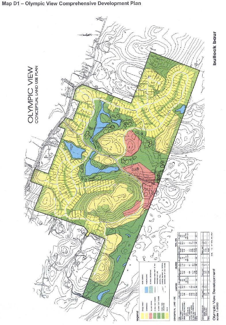
49
50 Appendix E: Goldstream Meadows Area Plan 1.0 GOLDSTREAM MEADOWS AREA PLAN A comprehensive development plan for the Goldstream Meadows area was submitted to the City in The Goldstream Meadows comprise approximately acres of land. This plan proposes a mixed business park and residential development which would include business park uses as well as townhouse, manufactured and modular housing, together with active recreation opportunities, trails, conservation areas, parks and open spaces. Attached as Map E-1 is the land use concept plan for the proposed development. 2.0 PLANNING PRINCIPLES AND POLICIES 2.1 The basic concept of the Goldstream Meadows neighbourhood includes multi-family townhouse, manufactured and modular housing at densities of between eight and ten units per acre, business park uses, active and passive recreation opportunities, trails, conservation areas, park and open spaces. 2.2 The comprehensive development plan is intended to give a conceptual picture of how the lands may be developed. Land use boundaries and numbers are approximate. 2.3 Greenways are to be provided and design criteria for all parks, open spaces and greenways are to be provided as a condition of development permit and subdivision. 2.4 The proposed parkland may include conservation areas, active recreation uses and passive recreation uses. 2.5 Public rights-of-ways or dedications for pedestrian trails shall be provided in the development in accordance with Map E The development of Goldstream Meadows must be serviced by sanitary sewers. 2.7 Storm drainage deposited directly to the lake shall not be permitted. Storm drainage to the glacial kettle located on the site shall not be permitted. 2.8 A 25 m right-of-way for West Shore Boulevard shall be protected. 2.9 Interim landscaping shall be provided, to the satisfaction of the City Planner; on that part of a comprehensive development site that is intended to be developed for commercial use, and is not immediately developed according to the ultimate landscape plan included within a Development Permit. Bylaw No E1 20 July 2009
51 3.0 DEVELOPMENT PERMIT AREAS AND GUIDELINES 3.1 Justification The Goldstream Meadows area includes certain sensitive ecosystems identified by the B Conservation Data Centre. Further, there are many wetland areas and areas which may have potentially significant environmental values which should be protected where possible. The Goldstream Meadows area also includes areas where business park commercial, multi-family residential, manufactured and modular intensive residential development may occur. The City of Langford has designated environmentally sensitive areas, as well as all business park, multi-family residential and all manufactured and modular housing within the Goldstream Meadows area as development permit areas, pursuant to provisions in the Local Government Act. The justification for this designation is to ensure that Council has the ability to secure the necessary information, and establish conditions on development within the Goldstream Meadows area such that the form and character of development is of a high quality, and best suited to both surrounding properties and the vision of Langford as expressed in the Langford Plan. The justification for this designation is also to ensure that Council is able to secure the necessary information and is able to establish conditions on development within the Goldstream Meadows area for the purpose of protecting the environment from development. 3.2 Objectives The objectives of the business park commercial development permit area designation is to ensure that business park development of Goldstream Meadows: (a) (b) (c) Is compatible with surrounding land uses; Complements the social and environmental goals of this plan; and Is constructed to high standards, both material and aesthetic. The objectives of the multi-family and intensive residential development permit area designation is to ensure that multi-family and intensive residential development of Goldstream Meadows: (a) (b) (c) (d) (e) (f) Provides a healthy, safe and liveable environment for residents; Minimizes the impact of development on the natural environment; Provides for vehicular as well as pedestrian needs in a safe manner; Is complementary to surrounding land uses; Complement the social and environmental goals of this plan; and Is constructed to high standards, both material and aesthetic. The objectives of the environmentally sensitive development permit area guideline is to ensure that the development of Goldstream Meadows occurs in such a manner that: (a) (b) (c) Significant environmentally sensitive areas are preserved and enhanced where possible; General habitat and biodiversity values and natural environment regimes are presented and enhanced; and Riparian areas are preserved and enhanced, or replaced with more valuable riparian area enhances the natural environment, its ecosystems and biological diversity. Bylaw No E2 20 July 2009
52 Council s general Development Permit Guidelines for environmental protection, commercial, business park, multi-family and intensive residential form and character apply to this area. In the event of a conflict between guidelines, the Goldstream Meadows guidelines shall prevail. The Goldstream Meadows Plan provides for business park commercial, multi-family residential, conservation and recreation land uses. Map E-1 (Land Use Concept for Goldstream Meadows) identifies the general layout of open spaces, residential, business park commercial uses. 3.0 ENVIRONMENTAL GUIDELINES 3.1 Riparian Guidelines No land clearing or development may occur within the lands until such time as the riparian areas have been identified, leave strips protected, and a development permit authorizing any alteration of land is granted. The City may grant variances to setbacks to watercourses if the majority of riparian values are retained in accordance with a report from a registered professional engineer or a professional biologist All natural wetlands are encouraged to remain in their current state unless specific plans are presented and accepted by the City of Langford for the relocation and enhancement of wetland areas. The goal is to have the overall value of riparian areas at a higher level than what they were prior to any site disturbance The City of Langford may require enhancements on-site may in order to mitigate any impact caused by the development of the lands and to enhance the values of those water bodies. 3.2 Wildlife Habitat and Biodiversity Guidelines Native planting should be used within private landscaping areas and municipal boulevards where appropriate Veteran trees and snags should be preserved where their presence does not constitute a hazard Natural features should be protected from infrastructure and the City may grant variances to road widths if such variances assist in preserving environmentally significant features Sidewalks should meander in order to avoid significant natural features and to add to the neighbourhood aesthetics. Prior to any land clearing or construction, detailed environmental inventories of significant features in areas proposed for development shall be conducted. Site development shall minimize impact on existing sensitive ecosystems. This can be done by either clustering of residential units, varying infrastructure standards, or preserving significant features by way of non-disturbance Section 219 covenants or parkland dedication. Bylaw No E3 20 July 2009
53 3.2.5 Habitat areas shall be provided with connectivity to allow for the natural migration of wildlife Prior to any land clearing or construction, a sediment and erosion control plan must be provided to the satisfaction of the City Engineer and security to ensure compliance may be required A wildlife corridor under West Shore Boulevard shall be provided. 4.0 BUSINESS PARK AND COMMERCIAL DESIGN GUIDELINES All commercial and business park developments shall be developed according to the following design guidelines, and in addition to either the City of Langford s commercial design guidelines (as found in Appendix G of this bylaw), or the City of Langford s business park design guidelines (as found in Appendix C of this bylaw), depending on the intended use of the property. Where there is a conflict between these guidelines and the general guidelines, these will prevail. 4.1 Developments should be designed so as to minimize the impact of lighting and sound to adjoining non-commercial or business park properties. The applicant for a Development Permit may be required to engage qualified professionals to provide a plan for controlling noise and light pollution from the site. The requirement for this plan shall be at the request of either the City Engineer or the City Planner, and shall be provided to the satisfaction of the City Engineer or the City Planner. Any recommendations of such a report may be included as required conditions of any development. 4.2 Exterior storage must be enclosed by a concrete panel fence of at least 2 m (6.6 ft) in height and not more than 3.5 m (11.5 ft) in height. Exterior storage may not exceed a height of 3.5 m (11.5 ft). 5.0 INTENSIVE RESIDENTIAL DESIGN GUIDELINES All intensive and multi-family residential development shall be developed according to the following design guidelines, and in addition to either the City of Langford s intensive residential design guidelines (as found in Appendix L of this bylaw) or the City of Langford s multi-family residential design guidelines (as found in Appendix H of this bylaw), depending on the intended use of the property. Where there is a conflict between these guidelines and the general guidelines, these will prevail. 5.1 Community Amenities Where practical, amenities, such as gardens, recreational facilities or restaurants, provided as part of an assisted living multi-family residential development, shall have a community focus, and be designed for by residents of the neighbouring community Community amenities shall be located in prominent locations, incorporating the basic principles of CPTED (Crime Prevention Through Environmental Design). 5.2 Height and Massing Bylaw No E4 20 July 2009
54 5.2.1 New MFR buildings, including assisted living apartment, may be more than one storey higher than the permitted maximum height of surrounding uses, provided than an 8 m (26 ft) buffer, including landscaping to the satisfaction of the City Planner, is provided, and provided that the building is stepped back from the front building plane of the ground storey at each successive storey. 5.3 Location of Parking Parking for multi-storey, multi-family residential development should not be directly adjacent to other residential uses (i.e., manufactured or modular housing, or townhouses) unless a 1.8 m (6 ft) high solid fence within a 2 m (6.6 ft) landscaping strip is provided to give effective screening. 5.4 Landscaping Landscaping should be provided with the objective of: (a) Providing landscape screening, where practical to protect the privacy of occupants of adjacent properties; (b) Providing low-height vegetation between adjacent driveways to mitigate the visual impact of paved surfaces; and (c) Providing some effective screening at the time of planting The use of drought resistant plant species is encouraged in all landscaping Street trees should be planted along internal drives and in the road frontage or right-ofway (to Bylaw No. 500 standards) after construction of house and driveway Development should, where practicable, provide a common green space for use by residents of the development A landscaped feature, integrated with signage (if required) shall be provided at every road or driveway entrance to the development permit area, unless the driveway entrance is intended to serve only a single dwelling Any common accessory buildings shall be either screened from public view, and only to the extent that screening does not compromise the principles of CPTED (Crime Prevention Through Environmental Design), or enhanced with landscaping that is effective at the time of planting. Bylaw No E5 20 July 2009

55 6.0 INTENSIVE RESIDENTIAL CLUSTER HOUSING DESIGN GUIDELINES (Bylaw No. 1215) In addition to Section Intensive Residential Design Guidelines, the following Intensive Residential guidelines apply to Area 3 Cluster Housing as defined by Schedule E to Zoning Bylaw No These guidelines are intended to ensure a degree of design continuity and neighbourhood cohesiveness, while allowing for some variation, over the build-out of the project. 6.1 Objectives To provide affordable home and land ownership; To provide a range of housing opportunities; To create a community that is visually attractive, appealing, engaging and safe for residents and visitors; To develop a network of pathways throughout the community, reducing the need for vehicular use; To develop a range of open spaces and pathways that encourage physical activity and social interaction among neighbours. 6.2 General Guidelines All development should be compatible with CPTED (Crime Prevention through Environmental Design); Each neighbourhood should have identification and directional signage to the satisfaction of the Fire Chief; Signage should be designed to be complementary to the form and character of the residential dwellings; The visual impact of utility boxes should be mitigated through careful planning and screening methods such as landscaping and fencing; Garbage and recycling should be in an area central to each neighbourhood and easily accessible for pick-up. All service areas should be appropriately screened; All dwellings should provide opportunities for storage, such as a crawlspace or an exterior storage structure; 6.3 Site Planning The overall site should be designed to create neighbourhood clusters of 4-12 dwellings. Dwellings within clusters should be varied in form, and may include attached and detached dwellings; Neighbourhood clusters should be configured in a manner that maximizes view opportunities from dwellings to neighbourhood open spaces and landscaped areas; Bylaw No E6 20 July 2009


56 6.3.3 All dwellings should have access to and front doors visible from the pedestrian pathway network; The design and layout of all neighbourhoods should be barrier-free to promote community accessibility; The privacy of each dwelling should be maximized through careful placement of windows and utilization of landscaping and screening; The size and configuration of lots within a plan of subdivision should be designed to accommodate buildings in a manner that: Ensures effective emergency access; Provides an appropriate setback between the building and access route based on road classification; Facilitates an active pedestrian oriented streetscape; Ensures an appropriate transition between neighbouring dwellings to maintain privacy and access to views; Creates usable private outdoor space; 6.4 Access and Parking Paved roads should be the minimum width feasible while still providing adequate access, parking, boulevards, and servicing to neighbourhoods to the satisfaction of the City Engineer; Where appropriate, parking areas, or portions thereof, should utilize alternative paving techniques, such as permeable, interlocking brick, textured, or coloured paving; Parking areas may be covered, provided the structure includes materials that are complementary to the form and character of the residential dwellings; Bylaw No E7 20 July 2009

57 6.4.4 Parking stalls designated for visitor parking should be provided throughout the neighbourhood; Emergency access should be provided to the satisfaction of the Fire Chief, and may incorporate grasscrete surfacing; On-street parking spaces may count towards the off-street parking requirement if: a. The on-street parking spaces are on an adjacent public street; b. The on-street parking spaces are immediately adjacent to the subject property, or in the case of on-street parking spaces located on Kettle Lake Drive, the parking spaces are located across the street from the subject property; c. The applicant has provided full frontage drawings, including the demarcation of the onstreet parking spaces, to the satisfaction of the City Engineer; 6.5 Form and Character All dwellings should incorporate an Arts and Crafts / West Coast design theme, which may include the following architectural elements: a. Use of heavy wood features and structural elements; b. Characteristic roof overhangs; c. Use of high quality and natural materials on building facades facing neighbourhood open spaces and roads; d. Use of masonry or approved alternate on chimneys and as an accent material; e. Large windows facing neighbourhood open spaces and roads with wide, articulated trim boards; All dwellings are encouraged to have covered front porches with a minimum area of 5.6 m 2 (60ft 2 ); Dwellings should orient front entrances and primary living spaces towards neighbourhood open spaces where possible; All building facades facing neighbourhood open spaces and roads should incorporate a high level of visual interest; Roof forms should be varied within neighbourhood clusters and predominantly consist of traditional forms such as gabled or hipped. Roof slopes should range between 3:12 12:12; Dwellings should utilize a West Coast colour palette, which consists of deep, rich hues for major colours with white or natural wood trim and accent features; Accessory buildings should be complementary to the form and character of the residential Bylaw No E8 20 July 2009

58 dwelling and should be located to minimize visual impact to surrounding dwellings; 6.6 Landscaping Plant species should: a. Be native; b. Require low water usage; c. Provide food and/or habitat for birds, small mammals, or other small wildlife species; The use of invasive, toxic or banned plant material is prohibited; All planted areas should be irrigated by hand or an automated system for at least one year, or until established; Tree species should be of a proportionate size to surrounding buildings. Where small scale buildings are constructed, small to medium ultimate growth size trees should be used; Private open spaces should: a. Be provided on the front and/or rear of the dwelling; b. Be a minimum of 3m deep; c. Be delineated with a permeable (i.e. picket, rail, lattice, or approved equivalent) fence approximately 1m (3.3ft) in height; d. Incorporate arbour or trellis e. features that have a design compatible with the form and character of the residential dwelling, where possible; The pathway to the front entrance of the dwelling should be paved with concrete or other higher quality surfacing material; 6.7 Neighbourhood Open Spaces Neighbourhood open spaces should: a. be provided in close proximity to neighbourhood clusters throughout the site; b. consist of a minimum area of 27.9 m 2 (300 ft 2 ) per dwelling unit; c. include some of the following features: multi-purpose lawn; community vegetable garden; Bylaw No E9 20 July 2009
59 community composting area; children s playground; arbours, gazebos, and/or trellises; benches and seating areas; Pedestrian pathways, sidewalks, and gathering spaces should be a minimum width of 1.8m (5.9ft) and paved with concrete or higher quality material such as stamped, coloured or exposed concrete, or brick unit pavers; Community mail boxes, newspaper boxes and/or notice board should be in a convenient location near the entrance to the neighbourhood and have associated pullout or visitor parking; 6.8 Lighting All pedestrian routes should be lit with bollard level lighting; All parking areas should be lit with pole mounted fixtures; All site lighting should comply with dark skies lighting principles; Bylaw No E10 20 July 2009


60 Bylaw No E11 20 July 2009

61 Bylaw No E12 20 July 2009

62 Bylaw No E13 20 July 2009
63 Bylaw No E14 20 July 2009
64 Appendix F: General Industrial Development Permit Area Guidelines Justification The City of Langford has designated all Industrial land as a Development Permit Area, pursuant to provisions in the Local Government Act. The justification for this designation is to ensure that Council has the ability to secure the necessary information, and establish conditions on developments such that the form and character of new industrial development are of high quality, and best suited to both the surrounding properties and the vision of Langford as expressed in the Langford Plan. Objective The objective of this Development Permit area designation is to ensure that new industrial development: 1. is compatible with surrounding land uses. 2. complements the social and environmental goals of this plan. 3. is constructed to high standards, both material and esthetic. Applicants should provide a checklist or statement indicating how their proposal complies with these guidelines. Where some element of the design does not comply with a guideline, a justification stating the divergence and the reason should be made. Council may diverge from the guidelines where a compelling rationale which preserves the intent of the guidelines is supplied. IND1. General Guidelines All new Industrial developments should: 1. be designed to be compatible with existing development with respect to the siting of buildings, exterior finish, design of buildings, landscaping and design of parking areas; 2. create an environment that is safe, user-friendly, and visually appealing from a pedestrian perspective; 3. provide safe and easily identified access for pedestrians, bicycles and vehicles; 4. ensure that architectural design and building materials are of a high standard in order to ensure a character of development that signifies quality, stability and permanence; 5. provide and/or upgrade sidewalks, pavements, street trees and street lighting; 6. ensure that all unenclosed storage is screened from public roads; 7. provide containers for garbage collection and recycling which will be screened from view, and located in a safe and convenient location on-site; and 8. where building elevations are visible from adjacent roads or properties, ensure that these elevations are finished and treated similarly to the front elevation. Bylaw No F1 16 June 2008
65 IND2. Integration with the Existing Area The orientation, scale, form, height, setback, materials and character of new Industrial developments are controlled by development permit areas to ensure compatibility with the surrounding community. Specifically, these controls include: 1. Height and Massing a) The design of new Industrial buildings should respect the scale and height of adjacent development. b) In areas of transition, Council will consider the proposed future uses of adjacent properties in assessing the compatibility of proposed developments in neighbourhoods. 2. Lighting Building and site lighting should: a) be sufficient to ensure pedestrian and vehicle safety; b) be designed to minimize the illumination of any adjacent residential properties; and c) be designed to minimize the affect of lighting on the night sky and adjacent properties, if residential (Outdoor lighting is the main source of light pollution. To minimize this impact, outdoor lighting should be regulated to control the quantity, the quality and the direction of night lighting). 3. Orientation New Industrial buildings should avoid impeding sunlight penetration and airspace to adjacent properties when those adjacent properties are planned to remain as residential. 4. Storm Water Management a) All Industrial developments shall incorporate Stormceptors, or equivalent approved equipment, to remove oil wastes and sediments from storm water. b) Storm water in all Industrial developments shall be managed in accordance with the City of Langford s Storm Water Management Guidelines attached to the Subdivision and Development Servicing Bylaw. 5. Form and Character a) Unsightly roof elements, including mechanical equipment and vents should be enclosed, where practically suitable, by roof parapets or other forms of screening. Bylaw No F2 16 June 2008
66 b) Site elements such as storage, shipping and loading areas, utility kiosks, transformers and meters, bay doors and garbage receptacles should be screened from adjacent roads. c) Unenclosed storage should be sited behind buildings or in the rear of the property, and away from adjacent land uses. d) The use of smooth surfaced, light coloured building materials, finished, painted and/or textured tilt-up concrete panels, acrylic stucco, glazing, brick, baked enamel finished metal siding or baked enamel metal panels is encouraged. e) The use of untreated or unfinished concrete, metal, or aluminium as a final building finish is discouraged. f) Building elevations fronting and visible to the street are encouraged to include offices, showrooms and decorative design elements. g) Building elevations fronting and visible to the street that include overhead bay doors are discouraged. h) All new developments are encouraged to incorporate river rock as a façade treatment and as an element in freestanding signage. i) All blank walls (e.g. those walls without fenestration) are to be treated, either with cladding that is complimentary to the cladding of the building and adds interests to the look and texture of the wall and building, or with a painted mural or other artwork approved by Council, and that a sufficient setback be provided to enable some articulation of the wall, when the wall is likely to be exposed to public view. 6. Landscaping a) Extensive parking areas should be screened by buildings, attractive screens of planting, or low walls. b) Landscaping should be provided with the objective of: i. providing screening to protect the privacy of occupants of adjacent properties; ii. providing an effective screen at the time of planting; iii. a minimum 7.5m setback, which may be landscaped, shall be provided to separate Industrial buildings or accessory buildings from adjacent land planned to remain in a single family residential use; iv. providing a landscape feature which is of a type and sufficient maturity to be hardy and resistant to abuse, including vandalism; and v. providing visual diversity to parking areas. vi. incorporating the principles of crime prevention through environmental design (CPTED). c) All landscaping should be serviced by an automatic watering system. d) The use of plant species which may be considered drought resistant is encouraged in all Bylaw No F3 16 June 2008
67 landscaping. e) A continuous landscaping strip of not less than 2.5 m (8 ft) wide should be provided along developed portions of each side of the lot which abuts a highway. This strip may be interrupted by boulevard crossings and pedestrian accesses. f) If fencing is provided, it should be on the inside of the landscaping strip. g) All adjacent municipal boulevards should be landscaped, irrigated and maintained by adjacent developments. h) The provision of space within the landscaping of the site for picnic/lunch areas for staff and customers, and/or play areas (in instances where on-site day-care is provided) is encouraged. 7. Reciprocal Access In order to provide for efficient and safe vehicular access to properties and between properties, the design of parking areas and vehicle maneuvering aisles shall allow for access to adjoining properties, and this access (to adjoining properties) shall be secured by way of a reciprocal access easement registered on title. IND3. Parking 1. New Industrial developments are expected to have accessible parking for visitors and employees which provide convenient access to building entries. 2. Parking should be screened from public view and curbed to protect pedestrian paths, building and landscape areas. 3. All parking spaces should be delineated with painted lines and finished in a concrete or asphalt surface. 4. Secure storage or parking should be provided for bicycles. 5. The City Planner may approve Development Permits with variances for parking standards, where the request for such variances are supported by a satisfactory study prepared for the City of Langford by a qualified professional. IND4. Storage: Enclosed and Unenclosed (Bylaw No. 1531) 1. Setback 1.1 Unenclosed storage is not permitted in any required front or exterior side yard setback. 2. Parking 2.1 Commercial and business park developments are encouraged to identify, at the time of a Development Permit for the principal use building, areas on site that will be used for seasonal Bylaw No F4 16 June 2008
68 unenclosed storage. These areas should be available as space for additional parking when not in use for unenclosed storage. 3. Pedestrian and Vehicular Circulation 3.1 Unenclosed storage should not impede either vehicular or pedestrian traffic; 3.2 Unenclosed storage should be situated on a site in a manner that provides for safe and attractive pedestrian access between parking areas, unenclosed storage areas and the principal use building; and 3.3 Unenclosed storage should not interfere with sight lines for either pedestrian or vehicular traffic. 4. Screening 4.1 All unenclosed storage must be screened from adjacent roads and residential properties, either by fencing or by landscaping; 4.2 The use of chain link fencing is prohibited; and 4.3 The use of temporary wire fencing is prohibited. 4.4 Where storage containers designed and constructed for shipping are permitted and used for onsite storage (whether permanent or temporary), the placement of the containers must comply with the setback requirements for accessory buildings, except when in proximity to a residential use. In those instances, storage containers are expected to be fully screened from the view of the residential use, and situated at least 6m (20ft) from a property boundary common to a residential use, and preferably separated further by a permanent building or structure. Storage containers should also not be stacked, unless the resulting stack is unobtrusive to adjacent properties and uses. (Bylaw No. 1531) 5. Storage of Combustible or Potentially Hazardous Material 5.1 Storage areas for toxic, combustible or potentially hazardous material such as liquid petroleum products, fertilizers, herbicides and pesticides must not be sited outside buildings. 6. Landscaping 6.1 Unenclosed storage is not permitted within any required landscape screening area; and 6.2 Unenclosed storage is not permitted in any landscape area, unless integrated with the landscaping in a manner that is unobtrusive, does not deteriorate the plantings and landscape material within the landscaped area; and does not interfere with sight lines. Bylaw No F5 16 June 2008
69 Appendix G: General Commercial Development Permit Area Guidelines Justification The City of Langford has designated all Commercial land as a Development Permit Area, pursuant to provisions in the Local Government Act. The justification for this designation is to ensure that Council has the ability to secure the necessary information, and establish conditions on developments such that the form and character of new commercial development are of high quality, and best suited to both surrounding properties and the vision of Langford as expressed in the Langford Plan. Objective The objective of this Development Permit area designation is to ensure that new commercial development: 1. is compatible with surrounding land uses. 2. complements the social and environmental goals of this plan. 3. is constructed to high standards, both material and esthetic. Applicants should provide a checklist or statement indicating how their proposal complies with these guidelines. Where some element of the design does not comply with a guideline, a justification stating the divergence and the reason should be made. Council may diverge from the guidelines where a compelling rationale that preserves the intent of the guidelines is supplied. COM1. General Guidelines All new Commercial developments should: 1. be designed to be compatible with existing development with respect to the siting of buildings, exterior finish, design of buildings, landscaping and design of parking areas; 2. create an environment that is safe, user-friendly, and visually appealing from a pedestrian perspective; 3. provide safe and easily identified access for pedestrians and vehicles; 4. create pedestrian links and public open space; 5. ensure that architectural design and building materials are of a high standard in order to ensure a character of development that signifies quality, stability and permanence; 6. provide full services on streets fronting and flanking the site, including the provision and/or upgrading of sidewalks, pavements, street trees and street lighting; 7. provide containers for garbage collection and recycling which will be screened from view, and located in a safe and convenient location on-site; and 8. where building elevations are visible from adjacent roads or properties, ensure that these elevations are finished and treated similarly to the front elevation. Bylaw No G1 17 October 2016
70 COM2. Integration with the Existing Area The orientation, scale, form, height, setback, materials and character of new Commercial developments are controlled by development permit areas to ensure compatibility with the surrounding community. Specifically, these controls include: 1.0 Height and Massing a) The design of new Commercial buildings should respect the scale and height of adjacent development. b) New Commercial buildings should not be more than one-storey higher than the permitted maximum height of surrounding existing buildings unless separated by a minimum 8 m (26 ft) buffer. c) New Commercial buildings should ensure that the horizontal dimension of transparent ground floor windows, excluding glass door components, does not exceed 60% of the building frontage at street level, avoid continuous façade frontages, and respect the rhythm of the existing streetscape. d) Ground floor windows should be a minimum of 0.6 m above the sidewalk elevation. e) New Commercial buildings should be massed to give the impression of small blocks and create visual interest by providing variations in height and massing. 2. Lighting Building and site lighting should: a) be sufficient to ensure pedestrian and vehicle safety; b) be designed to minimize the illumination of any adjacent residential properties; and c) be designed to minimize the affect of lighting on the night sky. Outdoor lighting is the main source of light pollution. To minimize this impact, outdoor lighting should be regulated to control the quantity, quality and direction of night lighting. 3. Orientation New Commercial buildings should: a) maintain and enhance existing views; b) ensure that developments are pedestrian oriented; and c) avoid impeding sunlight penetration and airspace to adjacent properties, when those adjacent properties are residential. Bylaw No G2 17 October 2016
71 4. Storm Water Management a) All Commercial developments shall incorporate Stormceptors, or equivalent approved equipment, to remove oil wastes and sediments from storm water. b) Storm water in all Commercial developments shall be managed in accordance with the City of Langford s Official Storm Water Management Guidelines attached to the Subdivision and Development Servicing Bylaw. 5. Form and Character a) The design of new Commercial buildings should utilize variations in the character of rooflines, sloping roof lines, gables and dormers. However, other interesting roof treatments will be considered. b) Unsightly roof elements, including mechanical equipment and vents should be enclosed by roof parapets or other forms of solid screening. c) Where possible, site elements such as storage, shipping and loading areas, transformers and meters, bay doors and garbage receptacles should be screened from adjacent roads. d) The exterior finish of buildings, excluding roof treatments are encouraged to be brick, finished concrete, architecturally faced block, stucco, or wood. e) Large expanses of any one material are not acceptable unless effective architectural details are used to break up the visual monotony. f) The use of untreated or unfinished concrete, metal, or aluminium as a final building finish is not encouraged. g) Multi-level parkades should be integrated within a structure. The exterior façade and site development of these structures should resemble non-parkade buildings typical. h) All new developments are encouraged to incorporate river rock as a façade treatment and as an element in freestanding signage. i) The City Planner may approve variances to allow signage constructed using tubular neon, provided that the signage is complimentary to the form and character of the commercial building, is in keeping with surrounding commercial development, and does not negatively impact neighbouring residential areas. j) All blank walls (e.g. those walls without fenestration) are to be treated, either with cladding that is complimentary to the cladding of the building and adds interests to the look and texture of the wall and building, or with a painted mural or other artwork approved by Council, and that a sufficient setback be provided to enable some articulation of the wall, when the wall is likely to be exposed to public view. Bylaw No G3 17 October 2016
72 6. Landscaping a) Landscaping should be provided with the objective of: i. provide screening for privacy and security; ii. providing an effective screen at the time of planting; and iii. a minimum 7.5 m setback, some of which shall include landscaping shall separate Commercial buildings or accessory buildings from adjacent land zoned for single family residential use. b) All landscaping shall be serviced by an automatic watering system. c) The use of plant species which may be considered drought resistant is encouraged in all landscaping. d) All adjacent municipal boulevards should be landscaped, irrigated and maintained by adjacent developments. e) Interim landscaping shall be provided, to the satisfaction of the City Planner, on every part of a commercial development site that is not immediately developed according to the ultimate landscape plan included with a Development Permit. 7. Setback New Commercial buildings should: a) be set back from fronting streets to a depth no less than 80% of the setback of buildings on adjoining properties; and b) on corner lots, buildings should be set back from both fronting streets to depths equivalent to setback of the buildings on adjoining properties. c) Variances for reductions in setbacks may be granted in all commercial zones within Development Permits by the City Planner when the variance being sought supports the objectives of design guidelines. 8. Areas of Transition In areas of transition, Council will consider the proposed future uses of adjacent properties in assessing the compatibility of proposed developments in neighbourhoods. 9. Safety Designs for commercial developments are expected to incorporate the basic principles of crime Bylaw No G4 17 October 2016
73 prevention through environmental design (CPTED). 10. Reciprocal Access In order to provide for efficient and safe vehicular access to commercial properties and between commercial properties, the design of parking areas and vehicle maneuvering aisles shall allow for access to adjoining properties, and this access (to adjoining properties) shall be secured by way of a reciprocal access easement registered on title. COM3. Vehicular Circulation New Commercial development should: 1. ensure safe and convenient access for cars to parking areas; 2. ensure that access for vehicles is separated from pedestrian walkways, provides safe separation distances from nearby road junctions and does not encourage left turns onto or from roads of a collector status or higher where alternatives are available; and 3. ensure that on-site roadways provide safe and convenient access for emergency and service vehicles. COM4. Parking 1. New Commercial developments are expected to have accessible parking for visitors and employees which provide convenient access to building entries. 2. Parking should be screened from public view and curbed to protect pedestrian paths, building and landscape areas. 3. Underground parking is to be well lighted and provide security measures. 4. Where it is considered to be important to develop and maintain a strong relationship between development, the street and pedestrian activities at the street level, parking between building and street is encouraged to be limited to short-term parking for pick-up and drop-off only, or accessible parking. 5. The City Planner may approve Development Permits with variances for reductions in off-street parking requirements, where the request for such variances is supported by a Parking Demand Study for the proposed use, prepared for the City of Langford by a qualified professional. The Parking Demand Study may consider proximity to bicycle routes and public transit as mitigating factors in determining the demand for off-street parking. 6. The City Planner may approve Development Permits with variances for parking standards, where the request for such variances are supported by a satisfactory study prepared for the City of Langford by a qualified professional. Bylaw No G5 17 October 2016
74 COM5. Storage: Enclosed and Unenclosed (Bylaw No. 1531) 1. Setback 1.1 Unenclosed storage is not permitted in any required front or exterior side yard setback. 1.2 Where storage containers designed and constructed for shipping are permitted and used for onsite storage (wither permanent or temporary), the placement of the containers must comply with the setback requirements for accessory buildings, except when in proximity to a residential use. In those instances, storage containers are expected to be fully screened from the view of the residential use, and situated at least 6m (20ft) from a property boundary common to a residential use, and preferably separated further by a permanent building or structure. Storage containers should also not be stacked, unless the resulting stack is unobtrusive to adjacent properties and uses. (Bylaw No. 1531) 2. Parking 2.1 Commercial and business park developments are encouraged to identify, at the time of a Development Permit for the principal use building, areas on site that will be used for seasonal unenclosed storage. These areas should be available as space for additional parking when not in use for unenclosed storage. 3. Pedestrian and Vehicular Circulation 3.1 Unenclosed storage should not impede either vehicular or pedestrian traffic; 3.2 Unenclosed storage should be situated on a site in a manner that provides for safe and attractive pedestrian access between parking areas, unenclosed storage areas and the principal use building; and 3.3 Unenclosed storage should not interfere with sight lines for either pedestrian or vehicular traffic. 4. Screening 4.1 All unenclosed storage must be screened from adjacent roads and residential properties, either by fencing or by landscaping; 4.2 The use of chain link fencing is prohibited; and 4.3 The use of temporary wire fencing is prohibited. 5. Storage of Combustible or Potentially Hazardous Material 5.1 Storage areas for toxic, combustible or potentially hazardous material such as liquid petroleum products, fertilizers, herbicides and pesticides must not be sited outside buildings. 6. Landscaping 6.1 Unenclosed storage is not permitted within any required landscape screening area; and Bylaw No G6 17 October 2016
75 6.2 Unenclosed storage is not permitted in any landscape area, unless integrated with the landscaping in a manner that is unobtrusive, does not deteriorate the plantings and landscape material within the landscaped area; and does not interfere with sight lines. Bylaw No G7 17 October 2016
76 Appendix H: General Multi-Family Residential Development Permit Area Guidelines Justification The City of Langford has designated all Multi-Family Residential land as a Development Permit Area, pursuant to provisions in the Local Government Act. The justification for this designation is to ensure that Council has the ability to secure the necessary information, and establish conditions on developments such that the form and character of new multi-family residential development are of high quality, and best suited to both surrounding properties and the vision of Langford as expressed in the Langford Plan. Objective The objective of this Development Permit area designation is to ensure that new Multi-Family Residential development: 1. provides a healthy, safe and livable environment for residents; 2. minimizes the effect on the local environment; 3. provides for vehicular as well as pedestrian needs in a safe manner; 4. is compatible with surrounding land uses. 5. complements the social and environmental goals of this plan. 6. is constructed to high standards, both material and esthetic. Applicants should provide a checklist or statement indicating how their proposal complies with these guidelines. Where some element of the design does not comply with a guideline, a justification stating the divergence and the reason should be made. Council may diverge from the guidelines where a compelling rationale which preserves the intent of the guidelines is supplied. MFR1. Services All sites should: 1. provide full services on streets fronting and flanking the site, including the provision and/or upgrading of sidewalks and pavements, street trees and street lighting; 2. provide all services by way of underground wiring (electrical, telephone and cable television); and 3. provide containers for garbage collection and recycling which will be screened from view, and located in a safe and convenient location on-site. MFR2. Integration with the Existing Area The orientation, scale, form, height, setback, materials, and character of new multi-family residential developments are controlled by development permit areas to ensure compatibility with existing neighbourhoods and the surrounding community. Specifically, these controls include: Bylaw No H1 2 Mar 2015
77 1. General The orientation, scale, form, height, setbacks and materials proposed for a MFR development should reflect characteristics consistent with the surrounding context. Sites in older neighbourhoods should be developed in a manner that improves the neighbourhood. 2. Height and Massing New MFR buildings should: a) not be more than one-storey higher than the permitted maximum height of surrounding existing buildings unless they are separated by a minimum 8 m (26 ft) buffer, in which case higher buildings may be acceptable; b) create visual interest by providing variations in height, rooflines and massing; c) avoid long continuous façade frontage and respect the rhythm of the existing streetscape; d) create articulation of building faces with features such as balconies, porticoes, bay windows, and changes in setback at upper storeys; and e) respect the scale and height of adjacent houses. 3. Lighting Building and site lighting should: a) be designed to minimize the illumination of adjacent properties; and b) be designed to minimize the affect of lighting on the night sky. Outdoor lighting is the main source of light pollution. To minimize this impact, outdoor lighting should be regulated to control the quantity, quality and direction of night lighting. 4. Environmental Impact a) New MFR buildings should try to minimize the impact on their environment by: i. siting buildings in such a way that, wherever possible, residential units are sited around, or in harmony with existing natural features such as mature trees and rock outcroppings; b) The City will consider variances where the siting of buildings can be shown to lessen environmental impact. 5. Stormwater Management a) All MFR developments shall incorporate Stormceptors, or equivalent approved equipment, to remove oil wastes and sediments from storm water. Bylaw No H2 2 Mar 2015
78 b) Storm water in all MFR developments shall be managed in accordance with the City of Langford s Official Storm Water Management Guidelines attached to the Subdivision and Development Servicing Bylaw. 6. Orientation New MFR buildings should: a) maintain and enhance existing views or vistas from the site; b) allow sunlight penetration; and c) ensure that units closest to the adjacent street have their façade facing the street. 7. Signage a) All signage should be architecturally compatible with the style, composition, materials, colours and details of the buildings within the MFR development as well as the residential buildings of the surrounding neighbourhood. b) Wood is the preferred material for signage for MFR developments. Only high-quality, exterior grade wood with suitable finishes should be used. c) Developments should ensure that some area is set aside for organized and co-ordinated signage for real estate sales and rentals. This signage should be in keeping with the other provision of this section. d) Internally illuminated signs are not permitted. However signs may be illuminated by means of an external light source (i.e.: a small flood light illuminating a wooden sign). e) Signs should be mounted so that the method of installation is hidden. Electrical service should also be hidden. f) Roof mounted signs are prohibited. g) The location and size of signs should be architecturally integrated with the overall design of the buildings and any theme that may be established within the MFR development. h) In addition to general signage for MFR developments, individual MFR units will be required to display a house number in accordance with Bylaw No. 91, Langford s House Numbering Bylaw, Form, Character, and Building Materials New MFR buildings should be of a residential character by utilizing: a) sloping roof lines, variations in the character of rooflines, shielded mechanical equipment, gables and dormers to achieve the effect of a residential building; and b) building materials and colours which are compatible with, and enhance surrounding development. c) All new developments are encouraged to incorporate river rock as a façade treatment and as an Bylaw No H3 2 Mar 2015
79 element in freestanding signage. d) All blank walls (e.g. those walls without fenestration) are to be treated, either with cladding that is complimentary to the cladding of the building and adds interests to the look and texture of the wall and building, or with a painted mural or other artwork approved by Council, and that a sufficient setback be provided to enable some articulation of the wall, when the wall is likely to be exposed to public view. e) Pedestrian entries facing the street; f) Parking at the rear of the buildings as much as possible; g) Staggered entries to create privacy between neighbouring units; and h) Shelter from the elements at the front entries. 9. Townhouse Developments (Replaced by Bylaw No. 1746) a) New townhouse developments are encouraged to cluster development on the site such that there are varying numbers of units per townhouse block. The preference is for the development to be primarily comprised of townhouse blocks with three or more attached units per block; however, townhouse blocks may be designed with two attached units per block provided that they appear and function as a single development (i.e. through complementary designs and colour schemes, shared private accesses and shared visitor parking areas). Townhouse developments may include single detached units provided that single detached units do not dominate the development. b) A plan showing the on- and off-street parking spaces provided for each unit and for the development as a whole shall be submitted as part of the required Development Permit. c) Those portions of a driveway located between the property line and the curb or boulevard shall be governed by the Subdivision and Development Servicing Bylaw No d) Driveways shall be set back a minimum of 1.0 m (3.3 ft) from any interior side lot line. e) Driveways shall be limited to a maximum width of: a. 6.0 m (19.7 ft) or 60% of the lot width, whichever is less, for lots with widths up to 12.0 m (39.4 ft); and b. 7.8 m (25.6 ft) for lots with widths over 12.0 m (39.4 ft). f) Wherever possible, lots and dwellings should be designed to allow for double car garages and driveways, provided that the garage does not visually dominate the façade of the dwelling, and provided that the driveway widths do not exceed those listed in Article e) above. g) The Director of Planning is authorized to approve Development Permits that vary the maximum width of a driveway where significant topographical or other site constraints warrant. h) The Director of Planning, with the consent of the Director of Engineering, is authorized to approve Development Permits that vary the minimum length of a required off-street parking space, where: a. The proposed parking space is perpendicular to a highway or access route in a bare land strata; b. Only one of the two required off-street parking spaces is located partially or entirely within that portion of the driveway in the road right-of-way; Bylaw No H4 2 Mar 2015
80 10. Landscaping c. The encroachment of the parking space onto the road right-of-way will not conflict with the use of sidewalks, utilities, boulevards or other frontage improvements; d. The full required length of the parking space is provided, partially within the property and partially within the road right-of-way, as measured either from the edge of the curb or the edge of the sidewalk, whichever is less; and e. Future road widening is not anticipated. a) Landscaping should be provided with the objective of: i. providing screening to protect the privacy of occupants of adjacent properties as well as the residents of the multi-family project; ii. providing an effective screen at the time of planting; and b) A minimum 7.5m setback which may be landscaped shall be provided to separate MFR buildings or accessory buildings from adjacent land zoned for single family residential use. c) The use of plant species which may be considered drought resistant is encouraged in all landscaping. d) All landscaping should be serviced by an automatic watering system. 11. Setback New MFR buildings should: a) be set back from fronting streets to a depth no less than 80% of the setback of buildings on adjoining properties; and b) on corner lots, buildings should be set back from both fronting streets to depths equivalent to setback of the buildings on adjoining properties. c) The City Planner may approve variances for reductions to front, side, and rear lot lines, as part of a Development Permit, and under the following circumstances: i. Where a reduction in a setback or setbacks would improve the relationship between a building and an access route or public road, or allow approved off-street parking, to municipal standards, to be sited between a dwelling and an access route, provided that in no circumstance the setback between a garage door and an access route or street is not less than 5.5 m (18 ft), and the setback between a house and an access route or street is not less than 4.5 m (15 ft); ii. Where a reduction in a setback or setbacks improves the orientation of the dwelling to an access route, or reduces the impact of development on surrounding lands, or avoid sensitive ecosystems or would result in the preservation of trees on site; and iii. Where the City Planner is satisfied that a reduction in a setback does not have significant impacts on adjacent properties (impacts may be mitigated through screening and grade Bylaw No H5 2 Mar 2015
81 differentiation). d) Strata driveways in detached townhouse developments are to be finished to a standard similar to municipal roads in Residential Small Lot zones, and shall include curbs, sidewalks, boulevards, and street trees. 12. Areas of Transition In areas of transition, Council will consider the proposed future uses of adjacent properties in assessing the compatibility of proposed developments in neighbourhoods. 13. Open Space MFR developments are expected to provide a certain amount of open space, on-site, which is intended to serve the needs of residents, while at the same time providing an opportunity to enjoy sunlight and views and creating a common focus for each development. This may be accomplished in a number of ways. a) Ground-oriented, townhouse-style MFR developments should ensure a minimum area of private outdoor space per unit which is not less than 3 m in width and not less than 10 m 2 in area. Notwithstanding this guideline, not less than 5 percent of a lot, in a ground-oriented development, shall be developed as useable open space. b) In family oriented of MFR developments, outdoor common amenity areas should average more than 3m 2 for each bedroom with a minimum of 100m 2 required for all MFR developments. c) All common space should connect to public walkways, be separated from both vehicular traffic and parking. d) All common space should be situated in an area which allows for sunlight penetration. e) All common space should be consolidated in one compact, non-linear and functional area, preferably in a central location and away from the periphery of the site. f) Notwithstanding guidelines MF4(a) through MF4(f), outdoor common areas should account for not less than 5 percent of the a lot. g) Where play equipment is provided in common areas, the equipment must conform to current safety standards. h) The primary private open space should, where feasible, be located on the sunny side of the building, either to the south or to the west. These guidelines discourage the location of private open space at grade on the front (street) side of a building, due to the potential conflict with the public nature of the street space. Bylaw No H6 2 Mar 2015
82 MFR3. Safety and Privacy 1. New MFR developments must provide for the safety and privacy for each residential unit. 2. Entries to each residential unit should be: a) visible to residents; b) made private by staggering or recessing them; c) units adjacent to public roads should have their doors visible and accessible from that road; d) exterior private use areas should be screened to provide for privacy; e) setback from arterial roads should be 12m, to allow for screening and berming; f) designs for multi-family residential developments are expected to incorporate the basic principles of crime prevention through environmental design (CPTED); and g) pedestrian circulation. 3. New MFR developments should: a) be designed to ensure safe and convenient routes for residents; b) provide a trail link between housing clusters within a project; c) provide trail links to the larger neighbourhood in a manner that does not compromise the safety and privacy of the development; d) provide on-site pedestrian circulation which forms a network connecting dwellings to parking and common areas; and e) provide pedestrian pathways that are constructed to a width and tread standard which meet the needs of the user. MFR4. Indoor Amenity Space New MFR development should provide a variety of recreational activity rooms, laundry facilities, storage, day care or workshop areas as appropriate to the development. MFR5. Vehicular Circulation New MFR development should: 1. ensure safe and convenient access for cars to central parking areas and dwelling units; 2. ensure that access for vehicles is separated from pedestrian walkways, provides safe separation distances from nearby road junctions and does not encourage left turns onto or from roads of a collector status or higher where alternatives are available; 3. ensure that access for vehicles is sited to cause the least disruption to other site uses; and Bylaw No H7 2 Mar 2015
83 4. ensure that on-site roadways provide safe and convenient access for emergency vehicles, moving vans and service vehicles. MFR6. Parking 1. New MFR developments are expected to have accessible parking for residents and visitors which provide convenient access to building entries. 2. Resident and visitor parking should be screened in a manner which limits their view from public roads. 3. Resident and visitor parking should be curbed to protect pedestrian paths, building and landscape areas. 4. Underground parking should be adequately illuminated and provide security measures. 5. Other than access to a parking structure, parking is only permitted on the ground level of any building provided that building area extends along the length of the front and exterior side yard setbacks and the parking is set behind these portions of the building. (Bylaw No. 1548) 6. If parking for recreational vehicles is to be provided, this should be in low traffic areas, preferably at the back of the development, and screened with natural materials such as cedar trees or hedges. 7. MFR developments are expected to provide safe and secure storage facilities for bicycles. 8. The City Planner may approve Development Permits with variances for reductions in off-street parking requirements, where the request for such variances is supported by a Parking Demand Study for the proposed use, prepared the City of Langford by a qualified professional. The Parking Demand Study may consider proximity to bicycle routes and public transit as mitigating factors in determining the demand for off-street parking. 9. The City Planner may approve variances for reductions in the number of required accessible parking spaces in multi-family residential developments where the building form is that of detached townhouses, and each individual dwelling unit has its own driveway and parking area. Bylaw No H8 2 Mar 2015
84 Appendix I: Development Permit Area Guidelines for Two-Family (Duplex) Multi-Family Residential Development Justification The City of Langford has designated all Two-Family (Duplex) Multi-Family Residential land as a Development Permit Area, pursuant to provisions in the Local Government Act. The justification for this designation is to ensure that Council has the ability to secure the necessary information, and establish conditions on development such that the form and character of two-family (duplex) residential development are of high quality, and best suited to both surrounding properties and the vision of Langford as expressed in the Langford Plan. Objective The objective of this Development Permit Area designation is to ensure that new two-family (duplex) development: 1. provides a healthy, safe and liveable environment for residents; 2. minimizes the effect on the local environment; 3. provides for vehicular as well as pedestrian needs in a safe manner; 4. is compatible with surrounding land uses; 5. complements the social and environmental goals of this plan; 6. is constructed to high standards, both material and aesthetic; Applicants should provide a checklist or statement indicating how their proposal complies with these guidelines. Where some element of the design does not comply with a guideline, a justification stating the divergence and the reason should be made. Council may diverge from the guidelines where a compelling rationale which preserves the intent of the guidelines is supplied. MFD1. ORIENTATION (a) (b) (c) Developments must ensure that both residential units face the street with a minimum 4.5 m (14.8 ft) habitable area of wall frontage. Where two buildings form part of the same building strata plan, and by definition constitute a twofamily dwelling, each unit within that building strata plan must be oriented toward the fronting street, and no part of a residential building within a building strata plan may be sited directly behind another residential building in the same building strata plan, as defined as within any part of a rectangular area that extends perpendicularly from the rear building face of a residential building to the rear lot line. Where two buildings form part of the same building strata plan, no part of a residential building within that strata plan may be sited within either triangular area bounded by a line Bylaw No I1 16 June 2008
85 extending 45 m (148 ft) perpendicularly from the rear building face of another building within the same building strata plan and a line extending 63.6 m (209 ft) along a 45 degree angle from the rear corner of another building within the same building strata plan, as illustrated in the figure below: 45 m Building in Strata Plan 45 degrees No build areas Rear Building Face (d) (e) (f) (g) (h) (i) (j) (k) (l) Notwithstanding subsection MFD1(b), a residential building that forms part of a building strata plan, or any part of that residential building, may be sited directly behind another residential building in the same building strata plan if the distance between the two residential buildings is greater than 45 m (148 ft). Where two buildings form part of the same building strata plan, the distance between the two residential buildings must not be less than 6 m (20 ft). Where a residential building forms part of a building strata plan on a property greater than 0.8 ha (2 acres) in area, the size of that building s footprint must not exceed 242 m 2 (2 600 ft 2 ) of gross floor area. Where a residential building forms part of a building strata plan on a property of 0.8 ha (2 acres) or less in area, the size of that building must not exceed 186 m 2 (2 000 ft 2 ) of gross floor area. Where two residential buildings form part of the same building strata plan, the gross floor area of one building may not be less than 85% of the gross floor area of the other building within that building strata plan. Where two buildings form part of the same building strata plan, no building that forms part of that strata plan may have a width or depth less than 9.7 m (32 ft). Where two buildings form part of the same building strata plan, both buildings shall not be identical, but shall exhibit a form and character that is complimentary. Each building should utilize the same or similar materials for siding, roofing and trim elements. The finish and colour of these materials should be complementary, and should not be identical. Buildings should utilize variations in rooflines, fenestration, and façades to establish the individual character of each building, while at all times maintaining a common architectural theme. Secondary suites are prohibited in any residential dwelling that form part of a building strata plan. Where the design guidelines, contained herein, that pertain to situations where two buildings for part of the same building strata plan are deemed to be in conflict with any other design guideline for two-family (duplex) multi-family residential development, those guidelines for detached duplexes shall supercede the design guidelines for attached duplexes. Bylaw No I2 16 June 2008
86 (m) Notwithstanding any other design guideline in this section, where two residential buildings form part of the same building strata plan on a lot of less than 0.8 ha (2 acres), the physical separation between the two buildings must be sufficient to allow a 3 m (10 ft) wide driveway to be located between the two buildings. (n) Where two residential buildings form part of the same building strata plan on a lot of less than 0.8 ha (2 acres), the setback from any interior side lot line may be reduced to 1.2 m (4 ft). (o) (p) (q) (r) Notwithstanding any other design guideline in this section, where two residential buildings form part of the same building strata plan on a lot of less than 0.8 ha (2 acres), the front width of any one building may not be less than 85% of the front width of the other building within that strata plan. For buildings that form part of the same building strata plan on a lot of less than 0.8 ha (2 acres), any provision of this section that pertains to building width or depth shall not apply. Provided that any attached two-family dwelling meets all of the guidelines pertaining to the form and character of two-family residential dwellings contained with this Appendix, the City Planner may, in the interest of good design, approve variances for reductions in lot width, building envelope width or side yard setback. All new developments are encouraged to incorporate river rock as a façade treatment and as an element in freestanding signage. MFD2. SETBACK (a) (b) Developments must provide a minimum 3.7 m (12 ft) side yard setback. The exceptions are in the case of corner lots, and when all parking is provided within the building. The City Planner may approve variances for reductions to front, side, and rear lot lines, as part of a Development Permit, and under the following circumstances: i. Where a reduction in a setback or setbacks would improve the relationship between a building and an access route or public road, or allow approved off-street parking, to municipal standards, to be sited between a dwelling and an access route, provided that in no circumstance the setback between a garage door and an access route or street is not less than 5.5 m (18 ft), and the setback between a house and an access route or street is not less than 4.5 m (15 ft); ii. Where a reduction in a setback or setbacks improves the orientation of the dwelling to an access route, or reduces the impact of development on surrounding lands, or avoid sensitive ecosystems or would result in the preservation of trees on site; and iii. Where the City Planner is satisfied that a reduction in a setback does not have significant impacts on adjacent properties (impacts may be mitigated through screening and grade differentiation). Bylaw No I3 16 June 2008
87 MFD3. PARKING At least three parking stalls must be provided for each dwelling unit and no more than two parking stalls per unit may be located in the front yard. MFD4. MASSING Mirror image duplexes are discouraged unless each unit has a significant amount of fenestration and architectural detail. MFD5. HEIGHT Buildings are limited to two storeys per dwelling unit. MFD6. DRIVEWAY Each dwelling unit should have its own separate driveway. Bylaw No I4 16 June 2008
88 Appendix J: General Design Guidelines for Downtown Langford JUSTIFICATION The City of Langford has designated all of Downtown Langford, as shown shaded in Map 21 of Bylaw No (Langford s OCP), as a Development Permit Area pursuant to the provisions of Section 879(1)(d) of the Local Government Act. The justification for this designation is to provide a design framework for the consistent development and redevelopment of the downtown, by establishing specific Design Guidelines. Design Guidelines provide guidance and direction for the conceptual design of structures, site amenities, landscaping and streetscaping. Guidelines provide a design context for site planning, building design and landscape plans. They provide a design context for all new development and set a design standard and image appropriate for the area. These Design Guidelines are intended to provide flexibility to allow for individual diversity but at the same time provide a comprehensive framework to promote a unique and identifiable character for Downtown Langford. (Bylaw No. 1307) OBJECTIVE The objective of this Development Permit Area designation is to ensure that all new development in Downtown Langford is consistent with the City s long-term vision for Downtown Langford. Downtown Langford is a special place that plays a critical role in a resident s and visitor's impression of the City. High quality planning and design is essential for Downtown Langford. The relationship of the remainder of Langford to the downtown and adjacent areas is also an important planning and design consideration. These Design Guidelines encourage consideration of wholeness (that is, an individual development s impact on others around it) and aesthetic attributes while being architecturally and technically sound. They encourage solutions that are complete and specific to the Downtown area, as well as specific sites. In particular, these Design Guidelines: Identify a preferred vision and development concept for the Downtown; Stimulate the development of a visually appealing and identifiable place; Ensure harmony or compatible design elements within a particular development and between different development areas; and Provide clear direction for site design, building character and orientation, signage, site landscaping, and open space. Applicants should provide a checklist or statement indicating how their proposal complies with these guidelines. Where some element of the design does not comply with a guideline, a justification stating the divergence and the reasons should be made. Council may diverge from the guidelines where a convincing or persuasive rationale that preserves the intent of the guidelines is supplied. Bylaw No J1 2 Mar 2015
89 D1. GENERAL GUIDELINES Objectives To promote Downtown Langford as a dynamic commercial, retail, office, residential, entertainment and civic function centre; To promote high quality building and landscape design; To integrate downtown development with surrounding areas; To promote a pedestrian environment and pedestrian-scale development in Downtown Langford; To encourage redevelopment of Downtown Langford into a more traditional downtown which includes street-oriented commercial and retail activities, traffic calming, cycling, civic uses and onstreet parking; To recognize the interrelationship of adjacent land uses; To encourage residential development in and near the downtown; To promote a safe and attractive downtown Site Development Intent To promote Downtown Langford as a dynamic and more traditional downtown community and civic centre, which is a focus for specialty retail, office, entertainment, restaurant and public services, and medium density residential uses. Guidelines a) Each development site should be examined to determine its potential impact upon the Downtown. b) Where a site is determined to have an effect upon the Downtown s role and function, the design solution for that site should identify clearly how the site integrates with the overall character of the Downtown. c) Each development should examine and identify its relationship to pedestrian use, street frontage and public spaces. d) All development shall have a street and pedestrian orientation. e) Development should have a pedestrian scale Responding to Site Conditions and Context Intent To promote high quality site planning which is sensitive to off-site and on-site features such as existing land use and views. Bylaw No J2 2 Mar 2015
90 Guidelines a) Prior to site design, a site analysis should be undertaken to identify significant on-site and off-site opportunities and constraints that might inform design. b) Site Planning and architectural design should also be responsive to built or natural systems surrounding the site in a manner that enhances the overall image of the Downtown. c) Views through to treed hillsides should be carefully incorporated into any new development Access, Circulation, and Parking Intent To ensure an effective and efficient pedestrian and vehicular circulation system, including bicycles, which enhances the image of Langford and which reduces conflicts between the pedestrian/ vehicular realm. Guidelines a) Goldstream Avenue should be redesigned into a Main Street with wide sidewalks, treed street edge, pedestrian crossings, on-street parking and vehicle movement lane. b) Pedestrian access to retail and commercial buildings or uses should be continuous along the façade of the building, at the same grade as the sidewalk. c) Modulation of building façades at ground level should be used to enable various alternative street activities, including browsing, outdoor cafes, street entertainment. d) Buildings should be sited in a manner that provides safe and attractive pedestrian networks that supplement the streetscape network. e) Public access to retail and commercial uses on the ground floor should occur directly from the sidewalk. f) Corner buildings should be sited in a manner that will be conducive to natural pedestrian movements at ground level. g) Shared driveway access between adjacent buildings is encouraged. h) Roads in the Downtown should be enhanced with the addition of landscape feature plantings to help define the pedestrian edge. i) Local streets should encourage on-street parking to reduce on-site parking requirements and reflect a more intimate character. j) The City Planner may approve Development Permits with variances for reductions in off-street parking requirements, where the request for such variances is supported by a Parking Demand Study for the proposed use, prepared for the City of Langford by a qualified professional. The Parking Demand Study may consider proximity to bicycle routes and public transit as mitigating factors in determining the demand for off-street parking. k) Public parking and employee or service vehicle access and pedestrian access from streets/sidewalks should be distinct and separate from one another. Bylaw No J3 2 Mar 2015
91 l) Other than access to a parking structure, parking is only permitted on the ground level of any building provided that building area extends along the length of the front and exterior side yard setbacks and the parking is set behind these portions of the building. (Bylaw No. 1548) m) Outdoor cafes should be encouraged adjacent to the public realm. n) Overhead elements should be provided over portions of the sidewalk for weather protection, to enhance pedestrian scale and modify microclimates. These should be individualized by building. o) While maintaining continuity in building façades, a network of mid-block pedestrian alleys should be provided to link adjacent activity areas and backyard parking to front street commercial development. p) Sidewalk development should be of a consistent character to reinforce a common design image throughout the Downtown. q) In order to provide for efficient and safe vehicular access to commercial properties and between commercial properties, the design of parking areas and vehicle maneuvering aisles shall allow for access to adjoining properties, and this access (to adjoining properties) shall be secured by way of a reciprocal access easement registered on title Unenclosed Storage Setback Unenclosed storage is not permitted in any required front or exterior side yard setback Parking Commercial and business park developments are encouraged to identify, at the time of a Development Permit for the principal use building, areas on site that will be used for seasonal unenclosed storage. These areas should be available as space for additional parking when not in use for unenclosed storage Pedestrian and Vehicular Circulation Unenclosed storage should not impede either vehicular or pedestrian traffic; Unenclosed storage should be situated on a site in a manner that provides for safe and attractive pedestrian access between parking areas, unenclosed storage areas and the principal use building; and Unenclosed storage should not interfere with sight lines for either pedestrian or vehicular traffic Screening All unenclosed storage must be screened from adjacent roads and residential properties, either by fencing or by landscaping; The use of chain link fencing is prohibited; and The use of temporary wire fencing is prohibited. Bylaw No J4 2 Mar 2015
92 1.4.5 Storage of Combustible or Potentially Hazardous Material Storage areas for toxic, combustible or potentially hazardous material such as liquid petroleum products, fertilizers, herbicides and pesticides must not be sited outside buildings; Landscaping Unenclosed storage is not permitted within any required landscape screening area; and Unenclosed storage is not permitted in any landscape area, unless integrated with the landscaping in a manner that is unobtrusive, does not deteriorate the plantings and landscape material within the landscaped area; and does not interfere with sight lines. D2. IMAGE MAKING Objectives To create signature entrance features at main roads that act as entries to the downtown; To encourage a pleasant pedestrian-friendly shopping and work area; To promote long term high quality development which is visually appealing; and To promote the downtown as a regional entertainment destination Sense of Entrance and Entrance Feature Intent To create a sense of transition as one enters or leaves the Downtown. This may be achieved through symbolic entrance features or dramatic changes in the streetscape image. At a smaller and site-specific scale, each building or property should have a strongly identified entrance as well. Guidelines a) A special entrance feature consisting of ornamental fencing and manicured landscaping should be created at Station Avenue, Atkins Avenue and Goldstream Avenue. b) Civic use located at the corner of Atkins Avenue and Goldstream Avenue should be treated as statement buildings that contribute to the Downtown s entrance image. c) Enhanced lighting, both in illumination and quality/quantity of light standards/fixtures, which meets safety standards, should be provided along all downtown streets. d) Enhanced landscaping should be provided along all downtown streets. e) Site design of corner lots should explore opportunities to provide landmarks and entrance features. Bylaw No J5 2 Mar 2015
93 2.2. Civic Uses Intent To create an attractive public realm by establishing engaging civic uses in key locations. Guidelines a) Civic uses will be located at key intersections and visually prominent positions. b) Civic buildings will be designed to set a high standard for all other Downtown development. c) Public art should be encouraged as a means of providing interest, civic identity and community pride. d) Public art should be encouraged as a desirable public amenity. e) Public art shall be carefully designed to fit the site context and Langford s Downtown Vision. f) Public plazas, with suitable public art, will be encouraged at all Civic building locations Pedestrian Environment Intent To establish a high quality, pleasant pedestrian area which creates a positive urban image. Guidelines a) Wide sidewalks [minimum of 3 metres (10 feet)] should extend throughout the Downtown. b) Pedestrian pathways should connect the Downtown to other parts of the City. c) New development in the Downtown shall have a pedestrian orientation rather than a vehicle orientation. d) New development should reflect a pedestrian scale by ensuring that buildings do not overwhelm adjacent pedestrian areas. D3. DEVELOPMENT PATTERN Objectives To establish a high quality downtown area through the use of high quality new development; To create visually appealing public spaces; To use approved landscaping features to highlight selected interesting commercial development, such as new development adjacent to public space; To create a pleasant integrated development pattern which stimulates pedestrian use, reduces land use and circulation conflicts and promotes cohesive development. Bylaw No J6 2 Mar 2015
94 3.1. Defining Edges and Connections Intent To establish clear distinctive edges to Downtown development areas and between public and private spaces. The streetscape should be well defined in an urban manner using formal standards for both hard and soft landscape materials. Guidelines a) A unified visual language for a characteristic streetscape should be established, including light standards, sign standards, feature site furnishings, pedestrian paving widths/patterns/materials. b) Streetscape elements on roads in the Downtown Core Area and Transition Area should be formal and include unit pavers and trees in hard surfaces with planters or tree grates. c) Streetscape elements on roads in the Residential, Live/Work, Community Use and Institutional Areas should be softer in character - boulevards should be planted with sod and trees. d) Width of sidewalks and rights-of-way should allow for the provision of street trees. e) Landscaping should define the edges of development areas while providing continuity between buildings within a development area. f) Entry points to the Downtown, particularly the Downtown Core Area, should be clearly defined as visual edges. g) Private and public spaces should be identifiable to local residents and visitors alike Visual Quality Intent To promote high quality visual images. The streetscape should be designed to ensure a formal and wellmaintained appearance that is aesthetically pleasing and provides a unifying green appearance. Guidelines a) All streets should be planted with formal plantings of street trees and, where appropriate, be complemented with low shrub plantings in planters and planting beds. b) Streets should be designed to a high quality standard, including formed curbs, in the Live/Work Area, Residential Area, Community Use Area and Institutional Area, and unit pavers in the Commercial Core Area and Mixed-use Transition Area. c) Overhead power lines and obtrusive utility boxes shall not be permitted for new development in the Downtown Area. d) Streetscape design should take into consideration the selection of materials that will ensure a lasting neat appearance, which is easily maintained. e) Fencing and planting materials should provide a visually softening effect, while still maintaining sight lines for safety. Bylaw No J7 2 Mar 2015
95 f) Residential uses should be buffered from industrial or public activities Screening Views Intent To protect important views and buffer views to parking areas and some commercial uses. Guidelines a) Vertical streetscape elements such as planting or decorative walls and fences should be used to screen adjacent less desirable views. b) Landscape elements should be used to screen residential areas from the rear of commercial uses or parking associated with commercial uses. c) Commercial waste containers should be screened from public view. d) Use of berms, shrub beds, low walls, and low, decorative fences should be considered to screen undesirable views, soften views of expansive architectural features, and to provide visual interest to expansive site features such as parking areas Street Lighting Intent To promote safety. On-site lighting should be sufficient to provide clear orientation and personal safety. Additional consideration should be given to enhancing special features or aesthetic qualities. Guidelines a) Lighting shall be provided for all walkways, driveways, parking areas, and loading areas to ensure personal safety and site security. b) Metal halide or equivalent white lighting may not be used. c) On site lighting shall minimize reflective impact on the night sky by being ground-oriented. d) Signage and special architectural or landscape amenities should be enhanced with additional feature lighting. e) Lighting fixtures should be concealed where possible or incorporated into the architecture of the building. f) Where lamp standards and fixtures are exposed, the aesthetic quality of these elements must be considered to ensure an overall positive image to the development. g) Continuous lighting should be provided along all walks and trails. h) Lighting design should take into account minimum photometric standards for safety. i) Lighting levels should be enhanced to highlight special features, intersections, and passenger loading zones. Bylaw No J8 2 Mar 2015
96 j) The scale of lamp standards and luminare height should relate to both the vehicular roadside scale as well as the sidewalk pedestrian scale. k) Street lighting (type and location) should accentuate the Downtown, especially during winter months, by illuminating key landmarks and landscape features. l) Decorative lighting should be used throughout the winter months, not only for the holiday season. Bylaw No J9 2 Mar 2015
97 3.5. Roads and Parking Intent To provide access and parking that is attractive and efficient. Guidelines a) Parking should be internalized, or provided at the back and side of new development. b) On street parking shall be permitted throughout all land use areas, except where street widths restrict space availability. c) The City Planner may approve Development Permits with variances for reductions in off-street parking requirements, where the request for such variances is supported by a Parking Demand Study for the proposed use, prepared for the City of Langford by a qualified professional. d) Shared driveways and parking areas should be encouraged for adjoining developments, to minimize street intersections. e) Large parking lots need to be divided into attractive parking areas through the use of landscaping, such as screened land use buffers and planted medians. f) Parking lots should be designed to minimize the ponding of surface water. g) Special street markings and signage should be considered to enhance identification and use of onstreet parking areas. h) Parking medians should be planted with trees for shade/wind protection. Consideration should be given to the use of conifers to reinforce the natural environment in Langford; i) Lines of sight should be preserved at corners of parking lots. j) Planting medians in parking lots should be a minimum of 3 metres wide to support shade tree rooting area. k) Parking lots shall be buffered with vegetation while permitting views into and through for safety purposes. l) All parking areas shall be paved, drained and appropriately screened. m) Where possible, access should be combined and parking should be shared for all land-use areas Streetscape Materials Intent To promote use of high quality street and landscaping materials Guidelines a) Streetscape materials should be selected based on the following criteria: Bylaw No J10 2 Mar 2015
98 Durability and performance; and Aesthetic appeal and timeless quality. b) Streetscape materials should be selected which establish a vibrant, high quality image along all streets. c) Interlocking pavers shall be used as sidewalk material throughout the downtown. d) Street trees shall be used at every opportunity on every street. e) Different varieties of trees should be used to add interest and distinguish one street from another. f) Paving materials should be used to mark pedestrian areas, set aside parking areas, and make walkways more distinctive from traffic lanes Public Open Space Intent To promote appropriate open space areas. Open space should not be thought of as "leftover" space. Rather, the intent of planning for open space should be to enhance the public image, and create meaningful recreational opportunities for the community. Guidelines a) Pedestrian related spaces shall be considered for all open space areas. b) All streets should incorporate wide and safe pedestrian/cyclist realms. c) Common open space areas may be located at grade or on top of a structure that is integrated into the design of the building. d) The Town Centre Pedestrian Commercial Area in particular should have a pedestrian focus. e) The Chamber of Commerce site should be designated and designed as a key open space, available for a range of community activities. f) Atkins Avenue and the E&N Railway should be developed as attractive open space entrance feature to the downtown. g) Open space should be extensively landscaped to enhance the visual, physical and environmental qualities of the downtown. h) Pedestrian paths and walks should be clearly delineated through the use of interlocking brick pavers. D4. LANDSCAPE DESIGN OF SPECIFIC PARCELS Objectives To establish a high quality landscape image which reflects the character of the area; To minimize maintenance costs; To reinforce the sense of place of the Downtown and the role of the Downtown as an important core commercial, residential and specialty area; Bylaw No J11 2 Mar 2015
99 To promote use of high quality plant materials. 4.1 Landscape Features Intent To promote high quality landscape design and create interest at a pedestrian scale. Guidelines a) Pedestrian surfaces should be emphasized by using unit pavers. b) Retaining walls and screening walls should be softened with the planting of vines or cascading shrubs. c) Chain link fences shall not be permitted. d) Wrought iron fence material is encouraged for highlight locations, such as plazas and entrance features. e) Entrances to the downtown, on public and private property, shall be of high quality landscape features which convey an image complementary to the Downtown Vision. f) Landscape detailing should create an interesting and positive pedestrian realm. g) Only low, fences that do not restrict sightlines (for safety purposes) are permitted at the interface of the private/public realm. h) Highlight site entries by landscape construction of arbours, archways, or pergolas. i) Use architectural elements in the landscape to provide shelter and create focal. j) Points. k) Street furnishings (lights, bollards, waste receptacles, bicycle stands, tree grates) shall follow an identified palette or kit of parts for the Downtown. l) Arbours, archways and pergolas should be used to highlight parking site entries. m) Where planters are used they should be of sufficient size to accommodate shrubs and masses of plants. n) Where possible, planters should be designed to accommodate seating for pedestrians. o) Interim landscaping shall be provided, to the satisfaction of the City Planner, on every part of a development site that is not immediately developed according to the ultimate landscape plan included within a Development Permit. 4.2 Plant Materials Intent To promote the use of high quality plant materials. Approved high quality plant material should be selected to reinforce a positive, green image. Bylaw No J12 2 Mar 2015
100 Guidelines a) Landscape design and development should enhance the overall character, and image of the Downtown. b) Plant materials selection should provide visual interest and variety throughout the year. c) Plant material, such as the use of specimen Douglas Fir at selected off-street sites, should reflect the character of the Langford locale where possible. d) Plant material selection should complement site use and scale of development. e) Plant material should provide year round appeal (colour, texture, form) through use of flowering shrubs, perennials, winter twig colour. f) Landmark planting should be encouraged at key intersections (Goldstream and Peatt, Goldstream and Bryn Maur, Goldstream and Jacobson) using a style that repeats signature elements at key intersections in Downtown (Goldstream and Millstream, Goldstream and Jacklin). g) Plant material should include a mix of deciduous and coniferous species using native plants were feasible. h) Plant material should take into account reduced water/maintenance requirements. i) Landscape design should provide an interesting mix of canopy and ground cover elements. j) Landscape material should be of pedestrian scale. k) Sight lines should be preserved for safety through landscape areas. D5. BUILDING FORM AND CHARACTER Objective To integrate all building and landscape development into a holistic commercial, residential and institutional area; To site buildings as part of a larger setting, complementing adjacent uses and buildings; To promote use of building materials that have a lasting quality; To encourage building form, type and character that is visually appealing, has pedestrian scale and is appropriate for the site and its broader context Architectural Character Intent To design and construct new buildings which reinforce Downtown Langford as a traditional downtown that is pedestrian oriented. Bylaw No J13 2 Mar 2015
101 Guidelines a) The character of the Downtown should be defined as a high quality environment that is distinguished by its organized, but varied façades with superior detailing and signage. b) Architectural form shall present modern forms and materials with clean lines. c) All primary buildings should be oriented to the street and should have a clear and positive pedestrian orientation (i.e., direct entrances to street). d) Architectural components shall be used to differentiate one face of the building from another. The design of structures should be architecturally compatible with other structures through the use of similar and complementary forms, materials and scale Architectural Features Intent To design and construct new buildings which have an interesting and appropriate building form. Guidelines a) The character of the Downtown should be defined as a high quality environment that is distinguished by its organized but varied façades with superior detailing and signage. b) Architectural features and details should articulate structure forms and modulate façades. c) Recesses, overhangs, canopies and sunscreens should be used to articulate the building façades. Monolithic building expression that results in box-like structures with little surficial articulation shall be discouraged. d) Individual tenancies shall be defined clearly with articulated entrances and consistent sign treatment. e) Repetitive elements, such as entrances, windows and signage should be organized to present modulated façades. f) The façades of multi-tenant buildings shall be organized to provide a strong and consistent rhythm to the streetscape. Flat, undifferentiated building faces shall be avoided. g) Architectural details and massing shall be expressed so that the base of the structure and its relationship to ground plane activity as well as the roof and its relationship to the skyline is expressed clearly. h) All new developments are encouraged to incorporate river rock as a façade treatment and as an element in freestanding signage. Bylaw No J14 2 Mar 2015
102 5.3. Façade Treatment Objective The future downtown will require careful attention to detail. In particular, building façades must be carefully designed to ensure that they relate in a positive fashion to the pedestrian environment Minimum Wall Articulation Intent To promote walls that express a variety of three-dimensional forms and prevent the construction of expansive blank walls. Guidelines a) No wall that faces a street or an open area on the same lot (such as a parking lot) shall have a blank, uninterrupted length exceeding 9 metres without including design details such as the following: change in plane, change in texture or masonry pattern, windows, a landscape device such as a trellis with vines or an equivalent element that subdivides the wall in human scale proportions. b) Side or rear walls that face walkways may include false windows and door openings defined by frames sills and lintels, or similarly proportioned modulations of the wall, only when actual doors and windows are not feasible because of the nature of the use of the building. c) The sides of the building that are not on a property line shall have materials that are similar or complementary to the material on the street side of the building. d) Materials should not dramatically change at the corners of buildings unless the corner is on a property line Building Façade Intent To promote a sense of public presence for all buildings. Attention must be paid to all faces of structures that have a public face (i.e. facing a street). Special attention should be given to the façades of buildings on corner sites where visibility is high. Guidelines a) Façades that face streets or pedestrian frontage shall be subdivided and proportioned using features such as windows, entrances, arcades, arbours, awnings, canopies, and trellises along no less than fifty percent of the façade. Bylaw No J15 2 Mar 2015
103 b) All solid walls of a façade shall have a recognizable base consisting of: i. Thicker walls, ledges, or sills; ii. Integrally textured materials such as stone, masonry, or concrete; iii. Integrally coloured and patterned materials such as smooth finished stone or tile; iv. Lighter or darker coloured materials; and v. Planters. c) All façades shall have a recognizable top consisting of (but not limited to): i. Three-dimensional cornice treatments that project the top of the building outwards. ii. A sloping roof with a minimum 40 cm overhang in concert with a cornice or a sloping roof with an overhang visually supported by brackets. iii. A parapet that is articulated. d) Flat faced canopies or roof overhangs are not permitted unless they are supported by columns and conform to the above. e) Sloping Roofs: i. Where sloping roofs are used they shall have a minimum slope of 5 in 12; ii. Canopy roofs on multiple storey buildings shall have a minimum slope of 5 in 12. f) All blank walls (e.g. those walls without fenestration) are to be treated, either with cladding that is complimentary to the cladding of the building and adds interests to the look and texture of the wall and building, or with a painted mural or other artwork approved by Council, and that a sufficient setback be provided to enable some articulation of the wall, when the wall is likely to be exposed to public view Entrances Intent To promote public entrances that are clearly identifiable and accessible. Guidelines a) Public entryways and public interface functions should be designed to express a pedestrian scale. b) Primary building entrances shall be clearly defined and shall have a sheltering element such as a canopy awning, arcade, or portico to provide protection from the weather. Bylaw No J16 2 Mar 2015
104 c) The primary entrance to a building shall be located along the front wall of the building unless otherwise required for handicapped access. Secondary entrances such as those for second floor apartments must be visible from a street or alley (for safety). d) Public entryways and public interface functions should be used as opportunities to enhance the building image. e) Individual entrances in multi-tenant buildings shall have clear identities, such as alcoves, varied doorway materials and varied compatible colours Encroachments Intent To encourage articulation of architectural features and provide protection from the elements for pedestrians. Guidelines a) Architectural features, such as bay windows, decorative roofs and canopies and entry features may project up to 1.25 metres into street rights-of-way, provided that they are not less than nine 2.75 metres above the sidewalk. b) Trellises, canopies and fabric awnings may encroach 1.8 metres onto the sidewalk. c) Canopies and awnings when provided must project a minimum of 1.5 metres from the building. d) Awnings less than 1.8 metres in length are permitted to have less depth Roofscapes Intent To promote interesting and varied roofs that address weather protection issues. Guidelines a) Long expanses of uninterrupted single-height flat roofs should be avoided. b) Roof forms should incorporate elements that create visual interest, such as cornices, gables and dormers. c) Functional elements, such as mechanical equipment and roof penetrations, shall be screened or integrated with the roof form in a manner consistent with the overall architecture of the building. d) Roof top equipment shall be located to minimize exposure to the street. Parapet height of flat roofs should be set to screen the view of vents and roof-top equipment from neighbouring streets and sites. e) Roof forms should reinforce the rhythm of street façades. Bylaw No J17 2 Mar 2015
105 5.7. Materials and Colours Intent To identify a colour palette for finishes that promotes harmony within and between developments. Guidelines a) Building design shall utilize a variety of materials and finishes used in combination to articulate the building components and differentiate expansive elevations. b) Vinyl siding is not an acceptable cladding material. c) Building materials shall be compatible with their context, including adjacent structures and surrounding landscape. Materials that might unnecessarily date the overall development or materials used in a non-contextural novelty fashion will be discouraged. d) Building colour schemes shall be balanced and shall be compatible with the surrounding landscape and adjacent structures. e) Façade colours shall be low reflectance, subtle, neutral or earth tone colours within a medium or moderately dark range of value. f) The use of high intensity colours, metallic colours, black or florescent colours shall be prohibited. g) Exterior building materials shall not include smooth faced concrete block (triple score acceptable), and smooth-faced tilt up concrete panels, or smooth concrete. h) Building trim and accent areas may feature brighter colours, including primary colours. i) Accent colours should identify public entrances to buildings. j) Exposed concrete (except for normal foundation projection above grade) must be heavily ribbed, textured, coloured, or bush hammered. k) All building materials are to be sufficiently durable and shall be built to withstand west coast climate. l) Reflective or heavily tinted glass is discouraged, except for detailing. m) Wherever possible, colours should be integral to the material and not applied Signage Intent To encourage a system of signs that complements the image of the Downtown. Guidelines a) Building signage shall be limited in scale and integrated with the design of the building façades. For single tenant buildings, one corporate I.D. sign will be permitted per building or view plane. b) Exterior neon signs may be permitted on commercial buildings in selected areas of high visibility. c) Façade mounted signs, projection or overhang signs and awning signs are encouraged. Bylaw No J18 2 Mar 2015
106 d) Building signage should reflect the character of the building function to assist in orientation and character. e) Building walls shall not be treated as billboards. f) Murals may be placed on building walls if they reflect an appropriate character and image compatible with Downtown redevelopment. g) Roof mounted signs are prohibited. h) For a multi-tenant building, the use of a sign box that is incorporated into the elevational treatment of the building is encouraged. i) Building and tenant identification signs should be organized as distinct architectural elements, reinforcing rhythm and character of the building façades. j) All façade signage shall be either externally illuminated sandblasted wood, externally illuminated metal, or of a composite type, illuminated only be exposed tubular neon. The use of internally illuminated fluorescent box signage is strongly discouraged. D6. AREA SPECIFIC GUIDELINES 6.1. Town Centre Pedestrian Commercial Area Massing and Building Height Intent To design and construct new buildings which have a mass and height appropriate for a pedestrian-scale Commercial Downtown Guidelines a) Buildings shall not exceed four stories in height. b) Buildings along Goldstream Avenue should not be less than two stories in height. c) Notwithstanding subsection 6.1.1(a), buildings along Peatt Road shall not exceed three stories in height. d) Where residential space is proposed over ground floor commercial, the fourth floor shall be stepped back to enhance light penetration to the street and provide variety to building form. e) Seventy five percent of the length of the street front façade shall be located no more than 1.5 metres from the property line along Goldstream Avenue. f) Avoid long, uninterrupted street façades; use plan articulation for doorways, retail windows, outdoor sitting spaces, etc. and use architectonic devices (articulation of structural elements like columns) to segment longer façades. g) Wherever possible, use fixed roof overhangs and canopies to cover at least 1.5 metres of pedestrian walking area along street front façades. Bylaw No J19 2 Mar 2015
107 h) Roof overhangs or canopies must not be more than 3 metres above the walking surface. i) Subtle articulation of building walls can be achieved by manipulating window placement in walls, casings and other trim details, resulting in various shadow lines. j) More pronounced articulation can be achieved by setting windows and entrances in or out from the wall Wall Articulation Intent To promote walls that express a variety of three-dimensional forms and prevent the construction of expansive blank walls. Guidelines a) Building Bays shall be a maximum of 9 metres in width. b) Visually, architectural features such as columns, pilasters, canopies, reveals, or horizontal offsets shall define bays Streetscaping Intent To create a very high quality pedestrian environment using quality landscape materials. Guidelines a) Brick pavers shall be used for all sidewalks; b) Formal landscaping along Goldstream Avenue shall include trees within tree grates, low shrub beds and use of wrought iron fencing in detailing; c) Public plazas should utilize materials, including brick pavers, that are complementary to adjacent public and private space; d) Street lighting shall be of a consistent type, colour and quality along Goldstream Avenue Mixed Use Transition Area Massing and Building Height Intent To permit a variety of buildings. Bylaw No J20 2 Mar 2015
108 Guidelines a) Where residential space is located over ground floor commercial, each additional floor shall be stepped back to enhance light penetration and provide variety to building form Streetscaping Intent To create a high quality pedestrian environment using quality landscape materials. Guidelines a) Unit pavers shall be used for all sidewalks in the Mixed Use Transition Area. b) Formal landscaping shall include trees within grassed boulevards and use of wrought iron fencing in detailing. c) Public and private plazas should utilize materials that are complementary to adjacent public and private space. d) Where buildings have a setback from the front lot line, significant landscaping will be required. e) Street lighting shall be of a consistent type, colour and quality within each Mixed Use Transition Area and should blend with adjacent other Areas Setbacks Intent To stimulate a strong relationship between commercial buildings and the pedestrian realm. Guidelines a) Varied setbacks will be permitted and will be related to site use. b) Building setbacks for commercial uses should be minimized to enhance the pedestrian environment. c) Residential development should have a landscaped setback. d) Parking is not allowed in the front yard. e) That the City Planner be permitted to, in conjunction with Mixed Use Transition Development Permits, issue variances for the front, rear, and side yard setbacks when the following conditions exist: (i) Building height does not exceed the height allowed for the land use zone for the neighbouring property; and (ii) Intensi8ve landscape screening is provided to mitigate impact. f) Storeys above the second floor should be set back at various distances from front and exterior side lot lines to accommodate features such as balconies, patios, decks, entrance features and sunlight penetration. Bylaw No J21 2 Mar 2015
109 6.3 Residential Area Massing and Building Height Intent To permit a variety of ground oriented housing which maintains a small town scale, distinct from nearby Victoria. Guidelines a) Building with four stories shall be stepped back in the fourth floor to permit light penetration to the street. b) Multi-unit buildings shall present the main entrances or an equivalent gateway to the principal frontage street. c) Private yards shall be clearly defined from public walkways. d) Ground floor units shall be raised above surrounding grade by at least.5 meter to ensure proper overlook of public areas such as sidewalks. e) Make available direct outside entry to ground floor units as well as common lobby/hallway entrances Streetscaping Intent To create a high quality pedestrian environment using quality landscape materials. Guidelines a) Brick pavers shall be used for all sidewalks in the Residential Area. b) Formal landscaping shall include trees within grassed boulevards. c) Private plazas should utilize materials that are complementary to adjacent public space. d) For ground-oriented townhouses, significant landscaping will be required. e) Street lighting shall be of a consistent type, colour and quality throughout the Residential Area. 6.4 Live/Work Studio Areas Massing and Building Height Intent To permit a variety of live/work studio space. Bylaw No J22 2 Mar 2015
110 Guidelines Buildings shall not exceed three stories Streetscaping Intent To create a high quality environment using quality landscape materials. Guidelines a) Brick pavers shall be used for all sidewalks in the Live/Work Studio Areas. b) Formal landscaping shall include trees within grassed boulevards. c) Private plazas should utilize materials that are complementary to adjacent public space. d) Street lighting shall be of a consistent type, colour and quality. Setbacks a) Maximum Building Setbacks should be: i. Front: 3m ii. Side: 2m iii. Rear: 10m (Bylaw No. 1350) Bylaw No J23 2 Mar 2015
 Bylaw No.")
111 (Map J1 replaced by Bylaw No. 1350) Bylaw No J24 2 Mar 2015
112 Appendix K: Design Guidelines for Hull's Field JUSTIFICATION The City of Langford has designated all Commercial and Multi-family Residential Development as a Development Permit Area pursuant to the provisions of the Local Government Act. The justification of this designation is to ensure that Council has the ability to secure the necessary information and establish conditions on developments such that the form and character of new commercial and multi-family residential development are of a high quality, and best suited to both the surrounding properties and the vision of Langford as expressed in the Langford Plan. OBJECTIVE The objective of these Development Permit Guidelines are to supplement the General Development Permit guidelines for Commercial and Multi-Family Residential Development (found in Appendix G and H respectively) specifically for the development of the property commonly known as Hull s Field. These design guidelines are intended to ensure that development is: 1. Constructed to high standards, both material and aesthetic; 2. Complements the social and environmental goals of this plan; and 3. Compatible with other surrounding land uses. The essential nature of this development is to meld the rural character of the amenity lands at the west end of the site with the proposed residential and commercial uses at the east end of the site. The design of the landscaping and pedestrian systems is an important means to achieving this. A concept plan showing the areas that are Parcels A, B, C, D, E and F, may be found at the end of this appendix as Map K1. When there is a conflict between these guidelines and the general guidelines, these will supercede. HUL1. Trail Along South Property Line 1. Existing trees should be retained wherever possible; 2. Dying, dead, diseased or hazardous trees may be removed, subject to an arborist s evaluation of the tree s health or situation, and upon approval by the City of Langford of an arborist s report; 3. New trees should be planted to maintain a landscape screen and the transition between residences on Jenkins Avenue, the townhouses in Parcel B and C and the commercial development in Parcel A ; 4. Commercial buildings should not face the trail but should present an attractive back to the community; Bylaw No K1 16 June 2008
113 5. The character of the residential buildings abutting the park trail should reflect the residential character of the community adjacent on Jenkins Avenue by incorporating the following design elements: a. Maximum two-storey height; b. Pitched roofs; 6. Roads should not adjoin or parallel the south boundary of Parcels A,or B, except for the intended connection to Rex Road; 7. Private patios within the amenity land trail in the statutory R.O.W. shall not interfere with the public character of the trail. Strong definition between public and private space should be created using landscape elements such as hedging, trees and shrubs. HUL2. Jacklin Road 1. Commercial building(s) adjacent to Jacklin Road should enhance the streetscape through high quality building and landscape design. This should be achieved by ensuring that the design of the building interacts visually with Jacklin Road with windows and a variety of surface textures, planes, colours and finishes; 2. Landscaping of an appropriate scale to the buildings should occupy the frontage and act as a visual balance; 3. The pedestrian entrance into the site should be initiated and highlighted with a physical presence on Jacklin Road; 4. Parking areas immediately adjacent to Jacklin Road should be screened by landscaping; 5. Small sitting areas should be created, at periodic intervals, adjacent to commercial uses; 6. A strong edge should define the Jacklin Road frontage. This could be in the form of a low stone wall, hedging or a decorative wood fence; 7. The massing and scale of buildings on Jacklin Road should be appropriate to the scale of activity on the street and should define and contain this edge. HUL3. Residential/Commercial Node 1. The node at the intersection of Parcels A, B, and C is the focus for the residential community, a play area for children, and a gathering and meeting place for adults. This node should also be the interface between the natural park trail and the more urban esplanade walkway; 2. The area adjacent to the commercial use should be hard surfaced with brick pavers and developed with landscaping, seating and gathering areas; Bylaw No K2 16 June 2008
114 3. The park trail portion should be developed with walking trails, a pond and tree planting as well as hard surfaced areas. HUL4. Pedestrian System 1. A trail, to municipal standards, which enhances the existing path should be developed along the south property line. This trail should extend westward through the site to Glen Lake road and the existing trail at the west end of Hull s Field, and also link to Hull s Road and the Residential/Commercial Node; 2. An Esplanade should be created to link Jacklin Road to the Residential Commercial node through Parcel A. This esplanade should be integrated with the landscape system, with a variety of paving textures, occasional benches and lighting; 3. The Esplanade should be continuous and linked from Jacklin Road to the Residential/Commercial node and be combined with a day lighted storm drainage system wherever practical; 4. Commercial or residential activity, or combined commercial and residential activity should reinforce the pedestrian activity on the walkway system, and in particular on the Esplanade. HUL5. Parking Lots 1. Landscaping should be introduced into parking areas to visually soften them. Within the parking areas, this landscaping should be located both in narrow strips and in periodic large landscape areas. The intent of the landscape areas is to provide sufficient width (between 15 and 30 cm) to provide space for plantings in sufficient depth to provide layered screening (e.g. trees and shrubs); 2. Parking areas should be screened from major arteries and from the residential community on Jenkins Road; 3. At points of intersection between the pedestrian system, roads, and/or parking lots, contrasting paving types and patterns should be used; 4. A reduction in parking standards may be given at the time of Development Permit application if a parking demand study is provided which indicates that the lower standard is sufficient to accommodate on-site parking demand. HUL6. Integration of Commercial and Residential 1. The residential uses should integrate with commercial uses so that they both enrich and reinforce the Esplanade in Parcel A ; 2. Residential uses in Parcel A can be positioned either beside or above commercial uses and should be situated directly on the pedestrian system without setback; Bylaw No K3 16 June 2008
115 HUL7. Storm Drainage 1. A portion of the storm drainage system should be day lighted carried in open swales and should act as both a visual amenity and a natural filtration system; 2. The day lighted system should reinforce and complement the pedestrian system and help highlight the integrated residential/commercial functions. A year-round pond should be developed at a point of emphasis such as the residential-commercial node and the cul-de-sac. HUL8. Setbacks 1. Landscape screening may be considered in reducing building and parking setbacks; 2. In all parcels which include multiple residential uses, some off-street parking may be located in any required setback from a front or exterior side lot line provided a landscape screen, effective at the time of planting, is installed, if applicable. HUL9. Interim Landscaping Interim landscaping shall be provided shall be provided, to the satisfaction of the City Planner, on that part of a comprehensive development site that is intended to be developed for commercial use, and is not immediately developed according to the ultimate landscape plan included within a Development Permit. Bylaw No K4 16 June 2008

116 Bylaw No K5 16 June 2008
117 Appendix L: Design Guidelines for Intensive Residential Development Justification The City of Langford has designated all Residential Small Lot land, and all land within subdivision plans created using the Strata Lot Averaging provisions of the Bare Land Strata Regulation under the Strata Property Act, for all lots under 550m 2, as an Intensive Residential Development Permit Area, pursuant to provisions in the Local Government Act. The justification for this designation is to ensure that Council has the ability to secure the necessary information, and establish conditions on developments such that the form and character of new residential development on smaller than average lots are of high quality, and best suited to both surrounding properties and the vision of Langford as expressed in the Langford Plan. Objective The objective of this Development Permit area designation is to ensure that new intensive residential development: 1. Provides a healthy, safe and livable environment for residents; 2. Minimizes its impact on the local environment; 3. Provides for vehicular as well as pedestrian needs in a safe manner; 4. Is compatible with surrounding land uses; 5. Complements the social and environmental goals of this plan; and 6. Is constructed to high standards, both materially and esthetically. Applicants should complete the provided checklist to indicate how their proposal complies with these guidelines. Where some element of the design does not comply with a guideline, a justification stating the divergence and the reason should be made. The City may diverge from the guidelines where a compelling rationale, which preserves the intent of the guidelines, is supplied. APPLICATION Development permit applications are required prior to subdivision approval and are to be for subdivisions rather than for individual properties. R1. INTEGRATION WITH THE EXISTING AREA The orientation, scale, form, height, setback, materials, and character of new intensive residential developments are controlled in development permit areas to ensure compatibility with existing neighbourhoods and the surrounding community. Bylaw No L1 16 June 2008
118 Specifically, these controls include: 1. General The orientation, scale, form, height, and materials proposed for an intensive residential development and/or individual dwellings within an intensive residential development should reflect characteristics that are consistent with the context of the surrounding neighbourhood. Sites in older neighbourhoods should be developed in a manner that improves the neighbourhood. The City Planner may approve Development Permits with variances, where the variance(s) being sought relate to the following: (replaced whole section with Bylaw No. 1427) (a) (b) (c) Required setbacks from front, rear, and/or side yard lot lines, where the intent of the variance is to create an improved building envelope, minimize environmental impact, create better relationship between buildings within an intensive residential development, or where a setback is adjacent to park land or existing uses where the impact of the variance would be minimal or minimized through screening or a significant change in elevation. The location and width of a pedestrian sidewalk or lighting requirements on private property; or Required lot width for lots less than 550m2 (5,920ft2) in area, provided that the variance does not decrease lot width by more than 25% of the required minimum prescribed by this bylaw. 2. Height and Massing New buildings should: a) Create visual interest by providing variations in height, rooflines and massing; and b) Avoid building plans that are repetitive. Houses on corner lots shall address each street frontage with an attractive building face, including elements that may project into side yard setbacks. The City Planner may approve variances for projections into setbacks where appropriate. 3. Environmental Impact a) New small lot buildings should minimize the impact on their environment, where practical, by siting buildings in such a way that residential units are sited around, or in harmony with existing natural features such as mature trees and rock outcroppings; and b) The City Planner may approve variances where the siting of buildings can be shown to lessen environmental impact. Bylaw No L2 16 June 2008
119 4. Orientation New intensive residential buildings should: a) Maintain and enhance existing views or vistas from the site; b) Allow sunlight penetration; and c) Ensure that units have their façade facing the street. If a building is on a corner lot, i.e. having two street frontages, the City Planner may designate which frontage is to be considered the front lot line and may approve variances appropriately. 5. Form, Character, and Building Materials New small lot buildings should be of a residential character, utilizing: a) Variations in the character of rooflines (e.g.: gables and dormers) to achieve design themes (e.g., traditional Victorian or Edwardian single-family residential buildings); b) Building materials that are compatible with, and enhance, surrounding development; c) Window trim or casings and details on the fascia of the building, such as belt-courses, to enhance visual interest. Adjacent houses should not be identical in form and character, but should be complementary to each other. A representative sample of building elevations to be used in the development shall be submitted as part of the application. 6. Storage a) Each lot must contain 10m 2 (100sqft) of space designated as storage space, inclusive of closets. This space may be provided within the house or in an accessory building to the rear of the house. b) Storage space contained within the house may be provided as a crawlspace, or alternatively, one half of a double garage may be designated as storage space. c) Storage space provided outside of the house may be provided in a shed to the rear of the house. In this case, setbacks from rear and side lot lines may be eliminated to allow the shed to be appropriately sited in the rear yard. 7. Landscaping a) Landscaping should be provided with the objective of: Bylaw No L3 16 June 2008
120 i. Providing some screening, where practical, to protect the privacy of occupants of properties adjacent to the intensive residential development; ii. iii. Providing low-height vegetation between adjacent driveways to mitigate the visual impact of paved surfaces; and Providing some effective screening at the time of planting. b) Rear yards are encouraged, where practicable, to be level; c) The use of plant species which may be considered drought resistant is encouraged in all landscaping; d) Street trees should be planted in the road frontage or right of way (to Bylaw 500 standards) after construction of house and driveway (spacing and variety of trees to the approval of the City Planner); and e) Small lot residential developments should, where practicable, provide a common green space for use by residents of the development. Funds to create this green space and any equipment associated with it shall be taken from the density bonusing, unless the equipment is gifted to the municipality. IR2. PARKING (Replaced by Bylaw No. 1746) 1. A plan showing the on- and off-street parking spaces provided for each unit and for the development as a whole shall be submitted as part of the required Development Permit. 2. Those portions of a driveway located between the property line and the curb or boulevard shall be governed by the Subdivision and Development Servicing Bylaw No Driveways shall be set back a minimum of 1.0 m (3.3) from any interior side lot line. 4. Driveways shall be limited to a maximum width of: a) 6.0 m (19.7 ft) or 60% of the lot width, whichever is less, for lots with widths up to 12.0 m (39.4ft); and b) 7.8 m (25.6 ft) for lots with widths over 12.0 m (39.4 ft). 5. Wherever possible, lots and dwellings should be designed to allow for double car garages and driveways, provided that the garage does not visually dominate the dwelling, and provided that the driveways widths do not exceed those listed in Article 4 above. 6. The Director of Planning is authorized to approve Development Permits that vary the maximum width of a driveway where significant topographical or other site constraints warrant. 7. The Director of Planning, with the consent of the Director of Engineering, is authorized to approve Development Permits that vary the minimum length of a required off-street parking space, where: a) The proposed parking space is perpendicular to a highway or access route in a bare land strata; Bylaw No L4 16 June 2008
121 b) Only one of the two required off-street parking spaces is located partially or entirely within that portion of the driveway in the road right-of-way; c) The encroachment of the parking space onto the road right-of-way will not conflict with the use of sidewalks, utilities, boulevards or other frontage improvements; d) The full required length of the parking is provided, partially within the property and partially within the road right-of-way, as measured from either the edge of the curb or the edge of the sidewalk, whichever is less; and e) Future road widening is not anticipated. EXEMPTIONS The following are exempted from a development permit application: 1. Residential R1 or R2 subdivision where three or fewer lots are smaller than 550 m 2 (achieved through lot averaging). 2. Changes to buildings in a small lot development which occur after completion provided the changes are consistent with the design theme. 3. Any aspect of colour on the buildings. 4. Landscaping in private yards (excluding street trees). 5. Residential subdivision or intensive residential development of any land controlled by a Section 219 covenant, approved by the City Planner, and registered in favour of the City of Langford, which controls the form and character of intensive residential development of the subject property. Bylaw No L5 16 June 2008
122 Appendix M: Bear Mountain Estates Area Plan 1.0 Bear Mountain Estates Area Plan A comprehensive development plan for the Bear Mountain Estates Area was submitted to the City of Langford in The Bear Mountain Estates Area comprises approximately 220 ha of land. The Bear Mountain Estates Plan proposes to develop the area shown on attached Map 7 as a new neighbourhood within the City of Langford. The neighbourhood is proposed to include a golf course resort, residential community, commercial, and institutional uses. In designing this new neighbourhood, the plan policies and development permit guidelines will encourage a development pattern that seeks to preserve and enhance existing landforms, wetlands, and vegetation wherever possible. In addition, comprehensive guidelines to protect the neighbourhood from interface fires will be followed. A mix of housing styles are proposed and will include attached housing, apartment, condominium, singlefamily residential, two-family residential, secondary suite, and granny flat units for a total of dwelling units (not including suites or granny flats). Higher densities will be associated with the proposed village centre. In addition, a comprehensive system of trails and parks will be dedicated and constructed by the owner of the lands. These parks will include linkage trails between neighbourhoods, a perimeter trail and trails connecting to the City of Langford trail network. There will be a combination of natural open space and developed, passive parklands and tot lots as well as a village green within the village centre. 2.0 Planning Principles and Policies Development of the Bear Mountain Estates Neighbourhood would be based on the following principles. 2.1 Development will include a distinct identity, based on an English Arts and Crafts architectural theme. 2.2 The neighbourhood will include a neighbourhood commercial centre, which has a distinct sense of place and opportunities for commercial activities and employment. 2.3 The neighbourhood will include a park and trail network that integrates with Langford's Trail Master Plan and Parks and Recreation Master Plan. 2.4 A comprehensive network of paths, sidewalks, and trails will link neighbourhoods, parks, open spaces, and commercial areas. 2.5 Linkages to existing and future neighbourhoods adjacent to the Bear Mountain Neighbourhood will be provided by way of roads and trails. 2.6 Development will be in accordance with strict environmental standards designed to integrate the development with the natural environment. 2.7 Environmental features will be respected and protected where possible during development and will be maintained. Development will be allowed to occur within a flexible zoning scheme; however, it will be regulated in accordance with development permit guidelines for the following Bylaw No M1 15 August 2016
123 purposes: Protection of the natural environment; Regulation of form and character of intensive residential, multi-family, and commercial development; Protection of development from hazardous conditions; i.e., wildfire and steep slopes. 2.8 Prior to proceeding with development, an overall environmental management plan shall be provided to the City of Langford. Subsequent to acceptance of an overall environmental management plan, each phase of development will require a development permit for form and character, environmental conservation, and protection from hazardous conditions. 2.9 Up to 400 single-family residential units (or up to 700 multi-family units) and an 18-hole golf course and clubhouse will be allowed to be developed with access and egress from Millstream Road. Once this development threshold has been achieved, no further development will be allowed until such time as a comprehensive traffic study with road alignments and interchanges with the Trans Canada Highway are provided to the satisfaction of the City of Langford The Bear Mountain neighbourhood shall be a complete community with opportunities for working, recreating, and living. The intent is to minimize the requirement for automobile trips outside of the neighbourhood and maximize opportunities for walking and cycling within the neighbourhood for many of the neighbourhood's daily requirements The neighbourhood will be subject to the City of Langford's Development Permit Guidelines for Interface Fire Hazards and Steep Slopes. 3.0 Development Permit Areas and Guidelines In accordance with Section of the Local Government Act, all of the lands identified within the Bear Mountain Estates Neighbourhood Plan are designated development permit areas for the following purposes. 3.1 Protection of the natural environment, its ecosystems and biological diversity. 3.2 Protection of development from hazardous conditions. 3.3 Establishment of objectives for the form and character of intensive residential developments. 3.4 Establishment of objectives for the form and character of commercial and multi-family residential developments. Council's general Development Permit Guidelines for environmental protection, commercial, and multifamily form and character and interface fire hazard protection apply to this area. In the event of a conflict between guidelines, the Bear Mountain Guidelines shall prevail. The Bear Mountain Neighbourhood Plan provides for multi-family, institutional, single-family, intensive residential, and commercial land uses. Map 7 (Land Use Concept Plan for Bear Mountain) identifies the general layout of open spaces, residential, commercial, and golf club uses. Within the residential designated areas, multi-family and intensive residential uses, in addition to single-family uses, may occur. Bylaw No M2 15 August 2016
124 Further, Map 7 will be established as a development permit guideline, which provides overall direction for the layout of land uses. While this layout is not intended to be inflexible, any deviation from the plan must be supported by substantial compliance with relevant development permit guidelines and an amended concept plan demonstrating that the overall layout concept meets the relevant guidelines and bylaws of the City of Langford. 4.0 Environmental Development Permit Guidelines 4.1 Justification The Bear Mountain area includes certain hazardous conditions (i.e.: steep slopes, interface fire hazard) as well as sensitive ecosystems identified by the BC Conservation Data Centre. Further, there are many wetland areas and areas which may have potentially significant environmental values which should be protected where possible. 4.2 Objectives The objectives of this designation are intended to ensure redevelopment will be allowed to occur in a manner that: Ensures that development in steep slope areas is designed and engineered to proved a high level of protection from ground instability and/or slope failure; Ensure that development within the interface fire hazard area is managed in a way that minimizes the risk of damage to property or people from interface fire hazards; and managed in a way that mitigates interface fire hazards while still addressing environmental issues Significant environmentally sensitive areas are preserved and enhanced where possible; General habitat and biodiversity values and natural environment regimes are preserved and enhanced; Riparian values are preserved and enhanced or replaced with more valuable riparian area. 4.3 Steep Slopes When land is altered, due regard shall be given to maintaining the normal drainage system and regulating storm water run-off. Exposed soil on steep slopes subject to erosion shall be re-vegetated or otherwise protected from run-off erosion Development will not be permitted on hillsides of 30% or greater with poor soil stability or susceptibility unless engineered to resolve the hazard. Bylaw No M3 15 August 2016
125 4.4 Riparian Guidelines No land clearing or development may occur within the lands until such time as the riparian areas have been identified, leave strips protected, and a development permit issuing any alteration of land is granted. The City may grant variances to setbacks to watercourses if the majority of riparian values are retained in accordance with a report from a registered professional engineer or a professional biologist Prior to the development of any golf course, an environmental management plan for the golf course, which ensures that the development and ongoing operation and maintenance of the golf course minimizes incursion and impact into riparian areas and other sensitive ecosystems must be provided to the City of Langford and if required by the City, a Section 219 covenant registered on the lands ensuring that ongoing environmental strategies are adhered to by the owners of the golf course and adjacent properties All natural wetlands are encouraged to remain in their current state unless specific plans are presented and accepted by the City of Langford for the relocation and enhancement of wetland areas. The goal is to have the overall value of riparian areas at a higher level than what they were prior to any site disturbance Although there are no fish bearing water bodies located on the Bear Mountain property, the watershed drains into fish bearing water bodies downstream. Accordingly, enhancements on-site may be required by the City in order to mitigate any impact caused by the development of the lands and to enhance the values of those water bodies. 4.5 Wildlife Habitat and Biodiversity Guidelines Rocky outcrops should be preserved and integrated into site design where possible Native planting should be used within private landscaping areas and municipal boulevards where appropriate Veteran trees and snags should be preserved where their presence does not constitute a hazard Natural features should be protected from infrastructure and the City may grant variances to road widths if such variances assist in preserving environmentally significant features Sidewalks should meander in order to avoid significant natural features and to add to the neighbourhood aesthetics. Prior to any land clearing or construction, detailed environmental inventories of significant features in areas proposed for development shall be conducted. Site development shall minimize impact on existing sensitive ecosystems. This can be done by either clustering of residential units, varying infrastructure standards, or preserving significant features by way of non-disturbance Section 219 covenants or parkland dedication. Bylaw No M4 15 August 2016
126 4.5.6 Habitat areas shall be provided with connectivity to allow for the natural migration of wildlife Prior to any land clearing or construction, a sediment and erosion control plan must be provided to the satisfaction of the Municipal Engineer and security to ensure compliance may be required. 5.0 Form and Character Development Permit Guidelines 5.1 Justification The City of Langford designates all commercial, multi-family residential, and intensive residential development areas within the Bear Mountain Estates Plan Area as a development permit area for the purposes of controlling form and character of development. Intensive residential is defined as any lot that is less than 550 m 2 in area. The purpose of this designation is to ensure that Council has the ability to secure the necessary information and establish conditions on development such that the form and character of new commercial, multi-family, and intensive residential developments are of a high quality and are well-suited to the surrounding properties and environment. 5.2 Objectives The objectives of the form and character development permit guidelines are to ensure that development is constructed to high standards in both material and aesthetic qualities, developed within an English Arts and Crafts architectural theme, and that development is compatible with surrounding land uses. Further, as the goal for the Bear Mountain Plan Area is to have a high quality mix of single- and multi-family and commercial uses, the form and character of the intensive residential, multi-family, and commercial areas must be compatible in design theme and site planning to ensure good integration of the mix of land uses. Multi-storey buildings, over five storeys in height, may depart from the English Arts and Crafts design theme, provided that some elements of English Arts and Crafts style architecture are retained, particularly at the first and second storeys. To facilitate the quality of development and integration of land uses the following guidelines will be used to supplement the City of Langford's general development permit guidelines for commercial and multifamily development. 6.0 Location and Distribution of Uses 6.1 The location and distribution of uses should be generally as illustrated on Map Residential density will be high around the resort village centre and country club area. 6.3 A multi-level residential complex may be developed in the eastern portion of the site. 6.4 Within the rest of the residential areas, a mix of attached and detached housing will be provided in a way that minimizes site clearing, road cuts, tree removal, and leaving, where possible, significant topographic and environmental features. Bylaw No M5 15 August 2016
127 6.5 The proposed hotel may be developed in or adjacent to the village centre. 7.0 Village Centre 7.1 The Village Centre shall be designed to include and encourage public gatherings. 7.2 Specific features should include an amphitheatre, plazas, and landscaped courtyards. 7.3 The Village Centre should include landscaped water features and have pedestrian only precincts. 7.4 The Village Centre will include a central pedestrian plaza that has a central water feature. 7.5 A mix of stand-alone commercial and mixed-use buildings will surround the plaza. 7.6 Buildings will be encouraged to have main entrances fronting onto the plaza and, where possible, onto adjacent roads. 7.7 Restaurants and cafes will be encouraged to have outdoor sidewalk dining areas. 7.8 Interim landscaping shall be provided, to the satisfaction of the City Planner, on that part of a comprehensive development site that is intended to be developed for commercial use, and is not immediately developed according to the ultimate landscape plan included within a Development Permit. 8.0 Traditional English Arts and Crafts Architectural Guidelines The overriding architectural theme of Bear Mountain Estates will be fashioned after an English "Arts and Crafts" style. This will apply to all multi-family residential, intensive residential, and commercial development. Victorian and Edwardian features may be used in adapting the Country theme into the more urban areas of the development. Multi-storey buildings, over five storeys in height, may depart from the Arts and Crafts architectural theme, provided that design elements that evoke the Arts and Crafts architecture theme are incorporated into the building design. Specific design elements will be as detailed in sections 8.1 to 8.4. Specific design guidelines for the form and character of multi-storey buildings over five storeys in height are as detailed in section Finishes In addition to glazing and doorways, a minimum of three exterior finishing treatments are required and may include: Stucco; Rock; Wood siding; Concrete composite siding; Bylaw No M6 15 August 2016
128 8.1.5 Wood shingle; or Brick. No one treatment may comprise more than 65% of any elevation (exclusive of roofing). 8.2 Roof 8.3 Form Rooflines shall have a minimum 6:12 pitch for major roof elements Minor roof elements may have a lesser pitch, but must not exceed 30% of the total roof mass Hidden gutter features are encouraged Roof materials may include: High quality fibreglass; Metal profile; Wood shingle (subject to wildfire interface guidelines); Slate; Concrete composite Articulations of building elevations and rooflines are encouraged and are the main architectural element sought by the design guidelines Dwelling space inside of articulated rooflines is encouraged Use of stone, cultured stone, or brick exterior chimneys is required. Exposed vent pipes for fireplaces or fuel-fired appliances shall only extend vertically from a chimney that is clad in stone, cultured stone, or brick. Chimney enclosures constructed of concrete composite siding, or stucco are not permitted. Lateral vent pipes, or through the wall vents for fireplaces and fuel-fired appliances are not permitted Use of fieldstones for accents is encouraged Use of over hanging eaves, and large front porches with pillars is encouraged Extensive use of dormers (gable, eyebrow, hipped, or shed) is encouraged. Bylaw No M7 15 August 2016


129 8.4 The images shown as figures M1 to M7 are visual guides showing the style of architecture to be used in all multi-family residential, intensive residential, and commercial development except for the golf clubhouse. Figure M1 Figure M2 Bylaw No M8 15 August 2016

130 Figure M3 Bylaw No M9 15 August 2016


131 Figure M4 Figure M5 Bylaw No M10 15 August 2016


132 Figure M6 Figure M7 Bylaw No M11 15 August 2016
133 9.0 Streetscape 9.1 The overall character of the development will reflect the natural environment and the golf course resort. 9.2 Individual buildings should complement existing building and the streetscape as a whole. 9.3 Buildings will not be identical and will reflect a style identified in the traditional English Arts and Crafts Guidelines. Buildings shall be encouraged to be located close to road frontages and incorporate verandas. Notwithstanding the close proximity to roads, building envelopes will be encouraged to be staggered or building façades will be encouraged to articulate in order to avoid a row housing appearance from the street. 9.4 High walls that overshadow neighbouring yards should be avoided. 9.5 Strata driveways in detached townhouse developments are to be finished to a standard similar to municipal roads in Residential Small Lot zones, and shall include curbs, sidewalks, boulevards, and street trees Building Orientation and Siting 10.1 Orientation and siting for any building should meet the following objectives: 10.2 Entrances Collect summer breezes Provide protection from winter wind and rain Incorporate natural topographic features and minimize intrusive or radical site works Preserve the natural vegetation and significant trees where these are not required to be removed due to wildfire hazard mitigation Take advantage of distant and local views Provide for maximum privacy Allow for some usable yard space Entrances or routes to buildings should be clear and accessible from the street frontage The front entry of a building should be defined with adequate overhangs for weather protection and wherever possible incorporate verandas The design of entrances or routes to buildings should not hinder sight lines or surveillance of visitors and intruders Where possible garage doors should not be the dominant feature of a building's front façade, but should be located to one side, slightly behind, or at right angles to the main street frontage. Bylaw No M12 15 August 2016
134 10.3 Parking 10.4 Fencing Where possible car parking for residential and non-residential lots is to be visually screened from sidewalks and neighbours and prevented from dominating the streetscape In a village centre or cluster housing developments, parking lots should be broken into smaller areas with landscape dividers or other developments. Ideally, an unbroken parking area should be no larger than about six to eight spaces in a village centre, four spaces in residential areas, and 20 spaces in the clubhouse area The use of a consistent height of evergreen tree canopy throughout the larger lots is encouraged to help provide weather protection and visual screening from overlooking buildings Access driveways should be designed to use a minimum of asphalt paving. Permeable surfaces will be considered Desirable materials include brick, concrete pavers, concrete, exposed aggregate, streetprint, asphalt, or combinations of the above to complement the building material requirements and the natural environment Estate lots may use gravel or crushed, cemented rock in driveway locations not visible from adjacent roads Freestanding parkades will not be allowed Provisions for secure bicycle parking must be made in all commercial and multi-family developments In order to foster a safer more community-oriented environment, fences, and walls in excess of 4 ft in height that extend forward from the front building face are not permitted If a fence or wall is necessary for privacy or noise control, a partially voided articulated fence or wall in combination with planting and natural materials in keeping with the environment and the building will be considered Low rock walls and evergreen hedges are encouraged Chain link fencing is prohibited unless required for safety along trails at the approval of the City Planner Outdoor Areas Buildings shall be sited and oriented to provide usable space for entertaining, utilities, storage, play areas, and views Unsightly storage and utility areas or kiosks shall be screened Garbage containers in particular, must be enclosed and fully screened Accessibility from indoor areas, ability to catch sunlight and summer breezes, audio and visual privacy, and safety shall be considered when providing outdoors, private, or semi-private space. Bylaw No M13 15 August 2016
135 10.6 Energy Efficiency Site and orientation of buildings should be done in a manner that will increase the energy efficiency and subsequently reduce the cost required for heating, cooling, and lighting Openings on the west sides of the buildings should be provided to catch the westerly summer breezes and on the opposite side of the buildings to assist in cross ventilation Higher openings or group roof ventilation designed to expel summer heat is encouraged Interface Fire Hazard Guidelines The development shall be designed in accordance with the City of Langford's Development Permit Guidelines for Interface Fire Hazards. In lieu of an professional engineer's report on Interface Fire Hazards, the City of Langford may accept a registered professional forester's report Multi-Storey Buildings Over Five Storeys in Height The following guidelines shall apply to all multi-storey buildings over five storeys in height General Form and Character Multi-storey buildings over five storeys in height are not required to be developed strictly within the arts and crafts architectural design theme of Bear Mountain Estates. In addition to the design guidelines contained within sections 8.1, 8.2, and 8.3, the following guidelines are intended to direct the design of multi-storey buildings over five storeys The overall architectural design of each building shall consist of heavy articulation, particularly at the main floor, battered foundation walls, dormers, rock or stone clad chimneys, large porches, window boxes and balconies, transomed windows, roofs with wide overhangs, multiple roof planes, trellised porches, columns and piers supporting roof elements and porches, and decorative railings and roof edges Buildings over five storeys should have a strong relationship to the street and, in particular, a human or pedestrian scale. This should be accomplished by: Including, at the ground level of each building, dwelling units or commercial units with direct pedestrian access to the street; Including covered arcades, towers, trellises, roof overhangs, dormers and chimneys into building design at a human scale; Using extensive stepping and terracing of the elevations and altering the massing of structures so that the heights of various portions of the building are staggered between two and eight storeys; Avoiding any massing or single material that rises vertically more than four storeys, unless the façade is punctuated by articulation, terraces, balconies with towers, pergolas or dormers; Bylaw No M14 15 August 2016
136 Including in the building façade dormers, shed roofs and balconies that break up vertical and horizontal planes; Including vaulted ceilings on top storeys and glazing in gable ends to add verticality to buildings; Ensuring that the majority of any eighth storey or any building is built within the roof gable; Limiting the access to underground parking to not more than one entrance per road frontage, and by siting driveways and/or garage doors in discreet ways so that they do not front directly onto the street; Buildings over five storeys in height are expected to exhibit an arts and crafts architectural theme within the first two storeys, and should exhibit a strong relationship to this architectural theme throughout the first four storeys. At storeys above the fourth storey, buildings should incorporate design elements which relate the architectural character of the arts and crafts architecture employed at the lower storeys. Figures M1 to M7 of this Appendix are intended to provide a visual guide to the arts and crafts architectural theme; The design of multi-storey buildings over five storeys shall ensure that there is appropriate transition between building levels. The seventh floor may be designed as a horizontal penthouse floor, provided that these dwelling units are multi-storey; Mechanical equipment shall be fully screened within the roofline of any building; Buildings over five storeys in height shall not be used as platforms for radio masts, cell phone towers or other telecommunication device, unless these structures are discreetly located within the roofline of the building; Buildings over five storeys in height may incorporate a single flag pole for one of each of the following: the Canadian Flag, the Province of British Columbia Flag; the City of Langford Flag; and a Bear Mountain Flag Roof and Finishes 12.3 Exemptions Roof design shall be as outlined in section 8.2; A variety of colours, materials, textures and forms shall be incorporated into the design of multi-storey buildings over five storeys for the purpose of breaking up the massing of the building, while accentuating building lines and patterns; In addition to the design guidelines contained within sections 8.1, 8.2, and 8.3, exterior finishing treatments may include any combination of smooth, exposed aggregate, scored or patterned concrete as one finishing treatment; and No one treatment may comprise more than 65% of any elevation (exclusive of roofing) The following are exempted from a development permit application. Residential subdivision or intensive residential development of any land controlled by a Section 219 covenant, approved by the City Planner, and registered in favour of the City of Bylaw No M15 15 August 2016
137 Langford, which controls the form and character of intensive residential development on the subject property Multi-Storey Design Guidelines In addition to the design guidelines contained with Appendix G and H (if applicable), the following guidelines are intended to direct the design of buildings over five storeys in the Bear Mountain Estates Plan Area The overall architectural design of each building shall feature varied articulation, particularly at the lower storeys, decorative railings and roof edges Buildings over 5 storeys in height should be clustered within the Bear Mountain Estates Plan Area to afford a minimum area occupied by streets and provide generous open space To make buildings over 5 storeys in height pedestrian friendly, the first two storeys of towers should be strongly articulated through the use of overhangs, signage and other means of stimulating visual interest. Where possible, upper storeys should actually be set back and recede or appear to recede; this can be accomplished by tiering the lower storeys of the tower (i.e., the second and third storeys) Balconies should be a minimum of 1 m 2 in area Units may include their own earth balcony capable of supporting planters with shrubs and small trees Each front entrance to ground-oriented units should be visually distinctive from its neighbours, or capable of becoming distinctive from its neighbours Each doorway and entrance should provide a combination of appropriate entrance transitions through the use of alcoves, seating, direction changes, level changes, and variation in materials In areas where multiple towers are constructed or anticipated, a central common area with intensive landscaping and open areas available for barbeques and picnics should be provided. These areas should be linked to the surrounding towers by pedestrian paths accessible to the disabled. The central common area should also be connected by pedestrian paths to other smaller common areas, service commercial amenities, adjacent parks and the greater neighbourhood trail system Terraced building articulations are encouraged; flat roofs and terraced areas should be accessible and roof-scaped with landscaping and patio style recreational amenities Buildings over five storeys in height should have a strong relationship to the street, and in particular should exhibit a human or pedestrian scale at the ground level. This should be accomplished by: Including, at the ground level of each building, dwelling units or commercial units with direct pedestrian access to the street Using extensive stepping and terracing of the elevations and altering the massing of structures so that the heights of various portions of the building are staggered between higher and lower storeys. Bylaw No M16 15 August 2016
138 Including in the building façade dormers, shed roofs and balconies that break up vertical and horizontal planes where practical; and Limiting the access to underground parking to not more than one entrance per road frontage, and by siting driveways and garage doors in discreet ways so that they do not front directly onto the street where practical Where practical, architectural elements such as intersecting gables and vaulted ceilings should be constructed on top storeys along with glazing in gable ends to add verticality to buildings The top storey of any building should be built within the roof gable where practical The design of buildings over five storeys in height should ensure that there is appropriate transition between building levels. The top floor may be designed as a penthouse floor provided that the penthouse is integrated into gables or peaked intersecting gables where possible Mechanical equipment should be fully screened within the roofline of any building Buildings over five storeys in height should not be used as platforms for radio masts, cell phone towers or other telecommunication devices, unless these structures are discreetly located with the roofline of the building or visually obstructed with architectural screening Buildings over 5 storeys in height should have a minimum 30 m separation from each other Nearby buildings over 5 storeys in height should be positioned in a manner that helps to define street edge definition while at the same time allowing for gaps in views and sunlight penetration to open spaces Development of buildings over 5 storeys in height should be positioned in a manner that helps to define street edge definition while at the same time allowing for gaps in views and sunlight penetration to open spaces All multi-storey development incorporation buildings with more than 5 storeys should incorporate Crime Prevention Through Environmental Design (CEPTED) design principles Semi-private exterior amenity spaces should be made accessible to a variety of user groups including the disabled Where possible, buildings over 5 storeys in height should have some setback from the boundaries of the lot to allow for ground level landscaped areas and semi-private outdoor space Rooftops that are visible from the windows and balconies of taller buildings should appear attractive and be designed to appear well maintained and attractive over time Rooftop mechanical equipment installed on roofs should be fully screened from the windows and balconies of taller buildings Where a minimum of 200 residential units are proposed within a single development, buildings within the development may create an architectural identify other than that required by the design guidelines of Appendix, H, and M, provided that the following provisions are met to the satisfaction of the City Planner: Bylaw No M17 15 August 2016
139 a) the buildings and landscaping are designed comprehensively with a unified theme; b) the buildings consist of high quality building materials; and c) public art is incorporated into the landscape plan Supplemental Guidelines (2016) (Bylaw No. 1623) In 2016 the principal land owners in the CD6 (Bear Mountain Comprehensive Development A) zone applied to rezone the remaining development lands in the CD6 Zone to a new CD6A Zone. The guidelines as set out in Appendix M apply in both the CD6 and CD6A zones, and the guidelines in this section are intended to take precedence in the CD6A zone. Notwithstanding the Bear Mountain Land Use Concept Plan (Map 7) the Bear Mountain Area Plan (Map 7A) shall applied to lands within the CD6A zone. Map 7A is a development permit guideline which provides overall direction for the layout of land uses. While this layout is not intended to be inflexible, and deviation from the plan must be supported by substantial compliance with relevant development permit guidelines and an amended concept plan demonstrating that the overall layout concept meets the relevant guidelines and bylaws of the City of Langford. In the event of any conflict between the guidelines contained within this section and any other guidelines, these guidelines shall prevail The overall form and character of development in the CD6A zone shall exhibit a blend of a traditional English Arts and Crafts or Craftsman style of architecture that is consistent with the early history of British Columbia and more Modern and Contemporary styles of architecture that have become synonymous with a West Coast style of architecture. Architectural types that reflect national types (such as: Swiss Chalet or Spanish Hacienda) that are not generally associated with the local climate, geography or architectural pattern of development are discouraged New development is expected to complement and enhance existing development in the Bear Mountain Comprehensive Development and meet the same standards, particularly with respect to finishes, roof and form as outlined in Sec In addition to the development of a complete community identified in Sec. 2.10, the Bear Mountain Comprehensive Development will work towards becoming a resort community also, wherein opportunities are created for tourism, active recreation, celebration and exploration Parking areas should be screened from any abutting residential or golf course use by a landscape screen not less than 3 m (9.8 ft) in width and 1.8 m (6 ft) in height, measured at the time of planting, and separated from roads and access routes by boulevards and street trees Landscaping in the form of grass, shrubs, ground cover, native plant communities, plants, trees, or flowers or a combination of them should be incorporated into and maintained in a total of not less than 10% of the site area. Bylaw No M18 15 August 2016

140 Map 7 Bylaw No M19 15 August 2016
 Bylaw No.")
141 Map 7A (Bylaw No. 1623) Bylaw No M20 15 August 2016
142 Appendix N: (Deleted by Bylaw No. 1350) Bylaw No N1 15 July 2013
143 Appendix O: Jacklin/Sooke Road Comprehensive Development Area Design Guidelines JUSTIFICATION The City of Langford has designated all areas in which Commercial and Multi-family Residential Development is permitted as a Development Permit Areas pursuant to the provisions of the Local Government Act. The justification of this designation is to ensure that Council has the ability to secure the necessary information and establish conditions on developments such that the form and character of new commercial and multi-family residential development are of a high quality, and best suited to both the surrounding properties and the vision of Langford as expressed in the Langford Plan. OBJECTIVE The objective of these Development Permit Guidelines is to supplement the General Development Permit guidelines for Commercial and Multi-Family Residential Development (found in Appendix G and H respectively) specifically for the development of the property that is within the Comprehensive Development 7 Sooke/Jacklin (CD7) Zone. These design guidelines are intended to ensure that development is: 1. Constructed to high standards, both material and aesthetic; 2. Complementary to the social and environmental goals of this plan; and 3. Compatible with other surrounding land uses. The nature of this development is to create a transition between commercial activities along Sooke Road and single family residential uses to the south by providing opportunities for a comprehensive mix of commercial and multi-family residential activities. A concept plan showing the areas that are Lot 1 and Lot 2, may be found at the end of this appendix as Map O1. When there is a conflict between these guidelines and the general guidelines, these will supersede. O1. SITE ORGANIZATION Intent To ensure that the siting and massing of new commercial buildings on this site is sympathetic to the local context. Guidelines 1. Parking and service areas should be screened from neighbouring properties and the public realm; Bylaw No O1 16 June 2008
144 2. Parking areas should be broken into smaller groupings and well screened with landscaping; 3. The siting and massing of new commercial buildings on this site should be massed in a manner that is sympathetic to the local context. Buildings over four stories are not considered appropriate; 4. Garbage, deliveries, loading, and other building utility areas should be screened from public view with enclosures or landscaping; and 5. If buildings are being considered for intrusion into landscape zones, they must be considered carefully to ensure screening from adjacent properties. O2. ENVIRONMENT Intent To ensure that development occurs in a coordinated manner that considers existing site conditions. Guidelines 1. Existing site conditions, such as grades should be fully investigated prior to considering landscape treatments; 2. Existing vegetation and drainage patterns should be accommodated, where possible and practical; and 3. Re-grading with new walls and terracing should shall be done in concert with existing grades so that wall heights are minimized. O3. SIGHT LINES Intent To ensure that the natural slope of the land is taken into consideration when designing buildings and their massing, and in particular that the impact of elevational differences between commercial and residential uses is considered. 1.0 All rooftop mechanical equipment shall be fully screened from view from adjacent buildings and public areas. O4. SITE LIGHTING Intent To provide clear orientation, enhance personal safety, special site features or aesthetic qualities, and ensure that site lighting is contained on-site, and does not illuminate adjoining properties or the night sky. Bylaw No O2 16 June 2008
145 Guidelines 1. Lighting shall be provided for all walkways, driveways, parking areas, and loading areas to ensure personal safety and site security. Lighting levels should be enhanced to highlight special features, drive aisles, intersections, and passenger loading zones; 2. Metal halide or equivalent white lighting may not be used; 3. On site lighting shall be fully downcast, and designed to minimize reflective impact on the night sky and to eliminate light pollution and glare to adjoining properties; 4. Lighting fixtures should be concealed where possible or incorporated into the architecture of the building. In particular, lighting fixtures should be of a type which shields the bulb from view, when viewed from adjoining properties or adjacent streets; 5. Signage and special architectural or landscape amenities should be enhanced with additional feature lighting; 6. Where lamp standards and fixtures are exposed, the aesthetic quality of these elements must be considered to ensure an overall positive image to the development; 7. Continuous lighting should be provided along all pedestrian paths and walkways; 8. Lighting design should take into account minimum photometric standards for safety; 9. The scale of lamp standards and luminare height should relate to both the vehicular roadside scale as well as the sidewalk pedestrian scale; and 10. Decorative lighting is encouraged throughout the winter months, not only for the holiday season. O5. HARD AND SOFT LANDSCAPING Intent To ensure that all hard and soft landscaping is of a high quality and/or constructed to a high material and aesthetic standard. Guidelines 1. General a) Private land should be clearly delineated from public road right-of-way using by using different types of landscape materials. Bylaw No O3 16 June 2008
146 2. Shrub and Groundcover Planting a) Planting schemes should be based on natural looking or native plants with reduced water and maintenance requirements wherever possible. No artificial turf shall be permitted. 3. Street Trees a) Where boulevard street trees are to be planted on private land, the species of trees shall be selected from City of Langford s approved urban street tree list; and b) A double row of street trees shall be planted along any internal roadway or driveway that serves and separates commercial uses from residential uses to buffer and screen the commercial site down slope and to the north of the proposed Jacklin Road housing development site. 4. Sidewalks a) Clear, delineation between vehicles and pedestrian zones is important and necessary for successful site design. The pedestrian circulation areas (sidewalks) should be well defined. 5. Retaining Walls a) Retaining walls that are visible within the public realm should be carefully designed with aesthetics and structural soundness considered. The style, materials, and colour should be compatible with the project design approach. b) Changes in grade from the public to private realm should be carefully landscaped to have low sections or terraces of walls no greater than 2 metres in height per wall. Retaining walls are to be constructed with textural finish and are to be planted with trailing shrubs or vines to soften their overall appearance. c) Retaining walls are to be constructed along Road A and Jacklin Road, as indicated on the plan. The Jacklin Road wall profile shall conform to the above guidelines in appearance and be approximately one metre in height. The wall construction shall undulate and vary with shrub foundation planting to break up its overall length. O6. SIGNAGE Intent To enhance safety by providing clear orientation, whether from a pedestrian or vehicular oriented perspective, and to recognize the importance of this site as an entrance to the City of Langford, and the Sooke Road commercial area. Bylaw No O4 16 June 2008
147 Guidelines At the intersection of Sooke Road and Jacklin Road an entry point will be marked with a Welcome to Langford sign on the south southwest quadrant. This sign feature will be further emphasized with bench seating, textured pavement, pedestrian scale lighting and flowering trees and shrubs in planting beds. Bylaw No O5 16 June 2008
148 Appendix P: Westhills Green Community Master Plan EXECUTIVE SUMMARY The Westhills Green Community located in the City of Langford, British Columbia will set a new standard for sustainable neighbourhood development in Canada. The Master Plan calls for the 210 hectare (517 acre) Westhills comprehensive development to meet Leadership in energy and Environmental Design (LEED) certification standards for neighbourhood development. Major guiding factors of the design and implementation of Westhills are considerations of location, alternative transportation modes, environmental preservation, community agriculture, water efficiency, energy and atmosphere, materials and resources, and indoor environmental quality. These characteristics are demonstrated in the creation of approximately 5,950 new residential units, supporting commercial, civic and educational uses, with approximately 84 ha (207 acres) of the subject property being designated as park and open space (equivalent to 40% of the total land area). A draft plan for the Westhills Green Community was devised through a charette process involving a variety of stakeholders and consultants including representatives from the University of British Columbia Design Centre for Sustainability, the BC Ministry of Community Services, Canada Green Building Council and the City of Langford. Through this planning process the City of Langford has been able to form a cohesive partnership with the owners of Westhills Land Corporation, with a commitment to excellence in environmental design. A significant amendment to the plan was made in 2007 resulting from negotiations with the School District on the location and layout of a school site, the addition of approximately 17 ha (44 acres) of land to the plan and an additional 950 dwelling units. Also, additional sustainability aspects were added to the concept plan including: trail network, bike network, use of energy efficient street lighting, solar powered traffic lights, community agriculture plan, a requirement for all single-family and townhouse buildings to comply with Built Green TM, the possibility of geothermal and hydroelectric energy generation, and the use of porous concrete pavers throughout the village centre roads and sidewalks. In addition to the new plan elements, the vision includes buildings that will accommodate both live and work spaces, a village centre, neighbourhood retail service centres, an internal commuter bus service, and a commuter rail station. High quality public spaces, mixed uses, cultural and educational facilities and residences will provide for a community available to all ages, and income levels. By valuing ecological processes, and following LEED standards, the Westhills Green Community will be a vibrant addition to the City of Langford and set a national precedent for socially and environmentally sustainable design. Bylaw No P1 16 June 2008

149 1.0 INTRODUCTION The City of Langford is a rapidly growing community of 22,000 people in the Westshore area of the Capital Regional District in British Columbia. The Regional District s Growth Strategy calls for approximately half of the growth in the Region to occur in the Westshore, predominantly in Langford and Colwood. The entire 210 hectare (517 acre) Westhills site is located within the Capital Regional District s Regional Urban Containment and Servicing Policy Area as designated in the Regional Growth Strategy. Adopted in 2003, this strategy contains eight strategic initiatives that form the bases for a 25- year plan for growth management in the Greater Victoria Region. The Westhills Master Plan addresses all eight strategic initiatives as described below: Keep Urban Settlement Compact. Approximately 75% of the residential units within Westhills will be contained within clustered medium and high density multi-family developments. Protect the Integrity of Rural Communities. All of the Westhills development is located within the designated Regional Urban Containment and Servicing Policy Area and not in designated rural residential or renewable lands. Map Map showing the relative location of the Westhills Plan Area relative to Greater Victoria Protect Regional Green and Blue Space. Approximately 40% of the Westhills site is designated as green space, while areas of protected forest will provide wildlife corridors and largely maintain natural viewscapes from across Langford Lake. Manage Natural Resources and the Environment Sustainability. The Westhills Master Plan calls for 100% of the commercial and high density multi-family development to meet LEED criteria for environmental sustainability. All single-family and townhouse development will comply with or exceed Built Green TM construction standards. Build Complete Communities. Westhills will be a truly comprehensive community containing a mixed use core area providing retail and service amenities within walking distance to residences. Improve Housing Affordability. In addition to supplying the region s housing market with much needed new homes, 150 rental units will be provided within the Westhills Master Plan as an affordable housing measure. Further, all single-family lots 550 m 2 in size or larger shall be built with secondary suites and small lots may include suites. Bylaw No P2 16 June 2008
150 Increase Transportation Choice. The backbone of the Westhills transportation network will be a commuter rail link to the region s employment centre in Victoria. Westhills will also have an integrated shuttle bus, transit, pedestrian and bicycle trail system between residential areas and the nearby mixed use core area. Strengthen the Regional Economy. Westhills will provide workplaces for hundreds of local residents upon completion of the multi-use service commercial core area which may include a learning commons. The land comprising the plan area has been under development application in the past; however, the City of Langford has been encouraging the development of a single comprehensive plan for the area as opposed to the piecemeal approaches previously proposed. Moreover, the City wishes to ensure that the lands are developed to the highest environmental standard and in the most sustainable manner. To achieve this, efforts were focused on working with the Canada Green Building Council to design the plan as the first LEED for Neighbourhood Development (LEED ND) neighbourhood demonstration project in Canada. LEED, which stands for Leadership in Energy and Environmental Design, evaluates developments on a broad range of criteria that deal with environmental and social issues. To achieve this goal the City of Langford has worked with the land owner in partnership with the Canada Green Buildings Council and the Ministry of Community Services and have collectively assembled a team of multi-disciplinary professionals to prepare the plan desired by the City. The team included: City of Langford staff Ministry of Community Services staff Quantity Surveyor Property owner s representatives Professional biologist Civil engineer Economist/rapid transit specialist Professional forester Planners LEED consultants Architects Landscape architects Land developer contractor Smart growth consultants Transportation engineer The plan is inspired and guided by LEED principles, and is written with the LEED criteria embedded in its policies. In addition to following the LEED model, the plan also includes a form based code for all multifamily and commercial development. In other words, zoning controls for multi-family and commercial development are limited to land use and density. While the siting, massing, height and other form and character controls are integrated into the development permit process. 1.1 Study Area The City of Langford s Official Community Plan identified the plan area for Westhills as a future neighbourhood. The land comprises approximately 210 hectares (517 acres) of undeveloped Greenfield land. It includes a variety of terrain including wetlands, streams, ponds, hills, forest and rocky outcrop areas. It is situated adjacent to existing neighbourhoods of Glen Lake, Raven s View, and the City core area. To the north across the E and N rail corridor is Langford Lake and a developing business park and residential area. Bylaw No P3 16 June 2008

151 The ownership of the Rail corridor has recently been transferred to a group called the Island Corridor Foundation. The mandate of the foundation is to preserve the rail corridor and to encourage the operation of freight and commuter rail service. At present there is no commuter rail or light rapid transit system in the Capital Region. Transit Service is provided by busses on a highway system that is significantly limited by topography and water bodies. This system is also becoming increasingly congested and will need expensive upgrades/expansions to accommodate the region s growth. Ultimately, expanded road systems only tend to facilitate additional costly low density suburban and rural sprawl and in a few years, previous congestion levels return. Map 1.2 Westhills Green Community Location Map (Not to Scale) 1.2 Process The planning process included the following stages: A. Pre-Public Activities A multi-disciplinary review was conducted on the Draft LEED ND criteria prepared by the United States Green Building Council (USGBC) which is the CaGBC s sister organization. These draft criteria were reviewed by the planning team and adapted to better suit the Canadian context. This process preserved the intent of the USGBC s draft guidelines while making changes that reflect the primarily Greenfield nature of local development. These draft guidelines outline pre-requisites and credits that are used as a measuring tool to evaluate the environmental performance of a development and award LEED certification. All pre-requisites must be met for a project to be certified. Projects can pick and choose which credits they will achieve and are awarded points according to their adherence to credit requirements. The criteria are divided into five main categories: Location Efficiency, Environmental Preservation, Compact, Complete and Connected Neighbourhoods, Innovative Design and Resource Efficiency. Depending on the number of points awarded, a project will be rated as Certified, Silver, Gold, or Platinum. Bylaw No P4 16 June 2008


152 A Charette design process was conducted with the team members and facilitated by the Design Centre for Sustainability (DCS) at UBC ( Smart Growth on the Ground group). The design exercise relied on a statement of project goals and the LEED ND criteria to guide design decisions. The design workshop produced a conceptual plan based on the discussion, drawing, and general agreement on the many planning issues related to green site development. The DCS is an academic leader in applying sustainability concepts to the development of land, cities, and communities. A charette is a means for applying leading-edge approaches to developing community and can ensure cross fertilization between researchers and professionals. Fig 1.1 LEED Design Charrette held at City Hall Following the preparation of a conceptual plan, a rigorous analysis of topographic and environmental limitations and service requirements was conducted in order to turn the conceptual plan into a more detailed land use site plan that could be physically achieved. This analysis and the product went through several iterations as input from the project s team members was received and addressed. An important part of the analysis of the proposal included an assessment of how the proposal rated against the draft LEED ND criteria. The results indicate that if all parts of the proposed development are achieved, a gold or platinum rating would be given under the proposed LEED criteria. The detailed site plan received the following assessment from the Design Centre for Sustainability at the University of British Columbia: Fig 1.2 Westhills Conceptual Plan created in the initial design Charrette Bylaw No P5 16 June 2008
153 We are pleased to note that the project team has clearly abided by the design instructions embedded in the concept plan. The Layout of the neighbourhoods is consistent with the concept plan, and achieves the balance between environmental, social and economic parameters that the charrette team worked so hard to achieve. We commend the team on its continuing adherence to green design principles. The Design Centre for Sustainability at UBC has been very pleased to help define a process and product for the Westhills project that transcends the normal approach to neighbourhood design and development. Elisa Campbell, Director B. Public Engagement Once the proposal had been prepared to the point that there was confidence in the technical aspects of the plan, the fast plan was brought to the public in the following ways: i. A large public open house was held to introduce the proposal to the public along with the team members and project partners. This open house included a significant educational component on LEED and the Canada Green Building Council. Over 3000 invitations went out to homes in the surrounding residential areas and newspaper advertisements were placed inviting attendance to the open house. Approximately 200 residents attended and of them, 93 completed questionnaires the night of the meeting. The results of the questionnaire showed strong support for the plan and the green/leed approach. ii. iii. Following the open house, a website was launched for the purpose of further engaging and informing the public as well as a means to receive further input on the plan. The public was informed of the website through community newspaper advertisements. In addition to these venues, the City of Langford also invited the public to its planning and zoning committee meeting (which is composed of citizen and Council representatives). This venue allowed for another opportunity to exchange information and views between the public, staff, the developer and committee members. 2.0 VISION AND PLANNING/DESIGN PRINCIPLES AND GOALS 2.1 The Vision The vision for this community is that all aspects of the neighbourhood will focus on sustainability. Buildings will accommodate both live and work spaces. The community will be anchored by one large village centre (a mixed use commercial core) and two smaller neighbourhood retail service centres. The village centre will be focused on a commuter rail station and the amenity of Langford Lake. The urban environment in the village centre will be comprised of high quality public spaces, mixed uses, cultural and educational facilities and populated with many residences A variety of housing including single-family homes, town homes, condominiums, and affordable rental properties will make the community available to people of all ages and income levels. Amenities will be located within easy walking distance of the neighbourhood core, while bike and bus routes and a commuter rail line to downtown Victoria will minimize traffic congestion. Bylaw No P6 16 June 2008
154 An emphasis on compact, high density development will conserve land: 40% of the area will be preserved as parkland and open space and 100% of wetlands and streams will be protected. All buildings will be environmentally sound. Features including energy-efficient and low pollution lighting, low-flow toilets, grey water irrigation systems, and pesticide-free landscaping will ensure that the entire neighbourhood is focused on facilitating an ecologically responsible lifestyle. The construction itself will also reflect the overall goal; locally produced and recycled materials will be used and construction waste will be carefully managed. Green areas will be used for ecological processes and where appropriate, recreation, passive parks and community agriculture. 2.2 Planning Goals The following goals were identified to guide the development of this site. These goals were kept in mind as a higher level framework for design decisions throughout the charette and subsequent design work: a) Create a healthy community that results in the optimum social, economic, and physical well-being of its people and the natural environment; b) Apply design principles for urbanization that respect the unique visual quality and rural history of the area; c) Use land efficiently; d) Protect and restore natural areas and ecological processes important to people, flora and fauna; e) Preserve clean and natural flow in area streams; f) Provide for a fair share of the region s new jobs; g) Improve air quality; h) Provide ample and affordable housing, schools, public infrastructure, facilities and transportation choices in the neighbourhood; and i) Preserve and create cultural opportunities throughout the community. Bylaw No P7 16 June 2008
 Integrated; b) Efficient c)")
155 Fig 2.1 Wildlife and green corridor connectivity 2.3 Neighbourhood Characteristics The following characteristics of sustainable neighbourhoods were also identified as being important to embed into the project design: a) Integrated; b) Efficient c) Responsive d) Adaptable; e) Permeable; f) Transparent; g) Productive; h) Multi-purpose; i) Low impact; j) Healthy; k) Affordable; and l) Inspirational. Bylaw No P8 16 June 2008

156 Fig 2.2 Paradise Park conceptual rendering Layered on to these goals were the LEED ND criteria which were reviewed and adapted where appropriate to reflect the Canadian context and in particular for other Greenfield developments in Canada. 2.4 Key Design Concepts A number of key concepts were derived from the project objectives and from site issues identified by the project team as they worked through the different stages of design. These concepts provided a general framework for the site planning: a. Preserve high value ecosystems; b. Maintain a network of open space; c. Concentrate development in buildable areas; d. Achieve desired number of residential units; e. Design street network to minimize slopes; f. Create a pedestrian-friendly environment; g. Place transit and commercial services at the core; and h. Connect to Langford community. Bylaw No P9 16 June 2008
157 3.0 PLAN ELEMENTS 3.1 Land Use The Westhills plan area is proposed to include a variety of land uses including: Single-family; Multi-family residential; Commercial; Institutional, Mixed use; and Park. The specific allotment of land area shared between these uses is shown on Table 3.1 and Map 3.1. Table 3.1 Land Use Summary Land Use Percentage %* Residential 36.5% Mixed use 7% Open space 40% Roads 15% School site 1% Business park 0.5% Total 100% *Approximate percentages Residential Mixed Use Openspace Roads School Site Business Park Fig 3.1 Land Use Graph showing percentage areas of designated land uses Bylaw No P10 16 June 2008

158 Map 3.1 Land Use Graph showing percentage areas of designated land uses Bylaw No P11 16 June 2008
159 The layout of the Westhills Green Community is approximate so that the location of land uses can be shifted to protect sensitive ecosystems provided that approximately 50% of the total area subject to the Westhills Master Plan is preserved as park or designated open space. The concept plan identifies a high density village centre ( a mixed use commercial core) adjacent to Langford Lake. An overall floor space ratio of 4 to 1 (development to land area) is contemplated for the village centre. To give effect to the plan, the zoning bylaw will permit a 4:1 density; however, Council may consider amending the zoning bylaw to transfer some of the density within the village centre from lower density site specific developments. 3.2 Transportation One of the objectives of the master plan is to employ alternative transportation strategies to significantly reduce reliance on automobiles. The layout and density of the Westhills plan is based on the provision of a commuter rail service and the use of alternative transportation modes. While the community will still function without the service in terms of road facilities, the plan s design is intended to work best with commuter rail. Commuter rail is intended to provide much of the transportation needs between this area to the rest of the City of Langford and other areas of the region. To support rail service, it is also proposed to provide an internal energy efficient shuttle bus service for residents wanting to go to the rail service or to the commercial areas in the plan area or adjacent to the plan area. The plan also calls for a full network of internal trails, sidewalks and bicycle lanes as shown on the plans labeled Map 3.2. Appropriate connections would be made to adjacent trails and sidewalks and in particular to the Trans Canada Trail and Galloping Goose Trail. Bylaw No P12 16 June 2008
160 Map 3.2 Westhills Bike Paths and Trails Plan Bylaw No P13 16 June 2008

161 Fig 3.2 Westhills Green Community Langford Parkway streetscape section concept By incorporating a fully multi-modal transportation plan including, commuter rail, shuttle busses, transit, bicycle and pedestrian networks, it is feasible for residents to greatly reduce their use of the automobile. Considerable attention has been given to appropriate road standards. These are attached as Figures 3.3 and 3.4. The goal of these standards is to minimize land dedicated to roads and incorporate green elements for storm water (bio swales) treatment and for aesthetics. In addition to these standards, the development will incorporate woonerf designed street sections to calm traffic and to make the street part of the public green space. Bylaw No P14 16 June 2008
162 Fig 3.3 Westhills Green Community commercial core streetscape section concept 3.3 Parks and Open Space Forty percent of the plan area is proposed as park land. This exceeds the provincial legislation entitlement of 5% at the time of subdivision by 35%. Most of the park land is contemplated to be kept in a natural state and is proposed to be improved through the removal of invasive species. Active recreation is accommodated in one planned sports field and also can be included in the proposed school site. Recreational trails throughout will provide the residents opportunities to walk and bicycle. One of the significant features of the plan is the provision of a public fishing pier and beach on Langford Lake. Bylaw No P15 16 June 2008
, for environmental protection and for protection of development")
163 Fig 3.4 Conceptual rendering of residential development in the Westhills Green Community 3.4 Design Guidelines The entire site is designated as a Development Permit Area for Form and Character (multi-family and commercial), for environmental protection and for protection of development from hazardous conditions (steep slopes and interface fire hazard). This is to ensure that the built environment is of a high quality and promotes security and also respects and protects natural areas proposed to be protected and retained and to ensure that the development is provided protection against hazardous conditions. Justification Achieving a quality urban environment through design is important to ensure that dense urban environments are attractive, inviting and ultimately successful places. It is the premise of the LEED program to ensure that environmentally sensitive areas are protected, therefore, the environmental Development Permit process is important to effect that goal. Given the existence of steep slope areas on the site and the dense tree cover, the Development Permit process for protecting development from these potential hazards, is important. Bylaw No P16 16 June 2008

164 3.4.1 Guidelines Development Permit guidelines contained in Langford s Zoning Bylaw are largely sufficient to guide form and character, protect the environment and protect development from hazards. Accordingly, the general guidelines for multi-family, commercial development apply to this area as do the guidelines for environmental protection and for protection of development from hazardous conditions. General Form and Character Guidelines The objective of these Development Permit Guidelines is to supplement the General Development Permits Guidelines for commercial and multi-family residential development (found in Appendix G and H respectively) specifically for the development of the property commonly known as the Westhills Green Community. These design guidelines are intended to ensure that development: 1. Is constructed to high standards, both material and aesthetic; 2. Complements the social and environmental goals integrated with the LEED standards contained within this plan; and 3. Is compatible with other surrounding land uses. Development in the own Centre area of the Westhills Green Community as shown in the Westhills Land Use Plan must also follow the General Design Guidelines for Downtown Langford (found in Appendix J). Where Downtown Langford Guidelines refer to arterial roads in the downtown area, these guidelines are understood to also be applicable to arterial roads in the Westhills Town Centre Area. When there is a conflict between these guidelines and the general guidelines, the following will supersede. Fig 3.5 Waterfront amenity conceptual drawing Bylaw No P17 16 June 2008
165 Location and Distribution of Development The location and distribution of uses should be generally as illustrated in the map contained within Map 3.1 (Westhills Land Use Concept Plan) The City Planner may approve variances to the layout on the map contained within Map 3.1 (Westhills Land Use Concept Plan), if in his/her opinion that: a) There is superior environmental protection with the variance and that this is corroborated with a report from a professional biologist; and/or; b) There is superior screening of the development from visitors from adjacent existing development with no significant net environmental loss and that this is corroborated by a professional biologist and/or; c) There is a reduction in site impact due to topographic conditions with the variance and that this is corroborated by a professional biologist or other appropriate professional Each phase of development shall be supported by an environmental impact mitigation and remedial plan to minimize the impact of servicing and development The two clusters of medium and high density development (West and South area of plan) are premised on the inclusion of neighbourhood commercial uses. Multi-Storey Residential and Multi-Use Buildings Over Five Storeys in Height In addition to the design guidelines contained within Appendix G and H and J (if applicable), the following guidelines are intended to direct the design of residential and multi-use buildings over five storeys in the Westhills Development Permit Area The overall architectural design of each building shall feature varied articulation, particularly at the lower storeys, decorative railings and roof edges Buildings over five storeys in height should be clustered within the Westhills community to afford a minimum area occupied by streets and provide generous open space To make buildings over five storeys in height pedestrian friendly, the first two storeys of towers should be strongly articulated through the use of overhangs, signage and other means of stimulating visual interest. Where possible, upper storeys should actually be set back and recede or appear to recede; this can be accomplished by tiering the lower storeys of the tower (i.e., the second and third storeys) Balconies should be a minimum of 1 m 2 in area Units may include their own earth balcony capable of supporting planters with shrubs Bylaw No P18 16 June 2008
166 and small trees Each front entrance to ground-oriented units should be visually distinctive from its neighbours, or capable of becoming distinctive from its neighbours Each doorway and entrance should provide a combination of appropriate entrance transitions through the use of alcoves, seating, direction changes, level changes, and variation in materials In areas where multiple towers are constructed or anticipated, a central common area with intensive landscaping and open areas available for barbeques and picnics should be provided. These areas should be linked to the surrounding towers by pedestrian paths accessible to the disabled. The central common area should also be connected by pedestrian paths to other smaller common areas, service commercial amenities, adjacent parks and the greater neighbourhood trail system Terraced building articulations are encouraged; flat roofs and terraced areas should be accessible and roofscaped with landscaping and patio-style recreational amenities Buildings over five storeys in height should have a strong relationship to the street, and in particular should exhibit a human or pedestrian scale at the ground level. This should be accomplished by: Including, at the ground level of each building, dwelling units or commercial units with direct pedestrian access to the street; Using extensive stepping and terracing of the elevations and altering the massing of structures so that the heights of various portions of building are staggered between higher and lower storeys; Including in the building façade dormers, shed roofs and balconies that break up vertical and horizontal planes where practical; and Limiting the access to underground parking to not more than one entrance per road frontage, and by siting driveways and garage doors in discreet ways so that they do not front directly onto the street where practical Where practical, architectural elements such as interesting gables and vaulted ceilings should be constructed on top storeys along with glazing in gable ends to add verticality to buildings The top storey of any building should be built within the roof gable where practical The design of buildings over five storeys in height should ensure that there is appropriate transition between building levels. The top floor may be designed as a penthouse floor provided that the penthouse is integrated into gables or peaked intersecting gables where possible Mechanical equipment should be fully screened within the roofline of any building. Bylaw No P19 16 June 2008
167 Buildings over five storeys in height should not be used as platforms for radio masts, cell phone towers or other telecommunication devices, unless these structures are discreetly located within the roofline of the building or visually obstructed with architectural screening Buildings over five storeys in height should have a minimum 30 m separation from each other Nearby buildings over five storeys in height should be positioned in a manner that helps to define street e dge definition while at the same time allowing for gaps in views and sunlight penetration to open spaces Development of buildings over five storeys in height should frame and preserve views, using a balance of higher and lower building heights rather than groups or large areas of buildings that are uniform in height All multi-storey development incorporating buildings with more than five storeys should incorporate Crime Prevention Through Environmental Design (CEPTED) design principles Semi-private exterior amenity spaces should be made accessible to a variety of user groups including the disabled Where possible, buildings over five storeys in height should have some setback from the boundaries of the lot to allow for ground level landscaped areas and semi-private outdoor space Rooftops that are visible from the windows and balconies of taller buildings should appear attractive and be designed to appear well-maintained and attractive over time Rooftop mechanical equipment installed on roofs should be fully screened from the windows and balconies of smaller buildings. All medium and high density developments must include landscape plans for all outdoor areas with the intent of creating interesting, pedestrian-friendly, accessible, landscaped, areas with areas for sitting, bicycle racks, and where appropriate, interaction and play. Bylaw No P20 16 June 2008


168 Woonerf Streets Where practical, woonerf streetscape design principles should be used to design new neighbourhood streets in the Westhills Green Community Area. Woonerf is a Dutch word that translates into English as street for living. Woonerfs are designed in such a way that the needs of automobile drivers are rectified with the needs of the users of the street as a whole; such users include pedestrians, bicyclists and playing children. Woonerfs therefore sustain lower traffic velocities through the utilization of integrated traffic calming devises and intensive landscaping. Figs. 3.6 and 3.7 Examples of Woonerf streetscapes / Dan Burden / Julia Thomas Bylaw No P21 16 June 2008

169 Fig. 3.8 Westhills Village Centre conceptual streetscape rendering 4.0 LEED BASED DEVELOPMENT OBJECTIVES The Westhills Community is intended to serve as a demonstration project for a new standard of green neighbourhood development. The project will include a wide variety of commercial, residential and mixed use building types. The community will be developed generally in accordance with guidelines that are being created by the Canadian Green Building Council (CaGBC). These guidelines, which are in the draft phase, will form a green building certification system called LEED for Neighbourhood Developments (LEED ND). The current LEED system (LEED for New Construction) assesses individual buildings, while the LEED ND system will look beyond individual buildings and assess entire neighbourhood developments. Each of the following plan objectives illustrate ways in which the Westhills Community may achieve leadership in energy and environmental design (LEED) and reach toward LEED ND certification. These policies are meant to be flexible to allow for development with the best possible likelihood of LEED certification. 4.1 Location Efficiency Objectives Transportation Efficiency: As the Westhills Community develops, extensive networks of pedestrian paths and cycling routes will be provided, including infrastructure for secure bike Bylaw No P22 16 June 2008

170 storage at appropriate locations (e.g. the rail station, commercial areas, etc.). These facilities are expected to provide connections within the Westhills Community, as well as connect to the wider network of pedestrian paths and cycling routes in Langford. The creation of a commuter rail service, one that will provide transportation to Victoria, as well as a shuttle bus service that will provide transport within the development are also goals of the Westhills Community. Together these initiatives are expected to increase transportation efficiency and choice. Fig. 4.1 Conceptual rendering of a parkway streetscape in the Westhills Green Community Water and Stormwater Infrastructure Efficiency: The Westhills Community is expected to create a stormwater management system based on maintaining pre-development run-off and ensuring water quality is maintained through bio-treatment on site Reduce Automobile Dependence: The Westhills Community will seek to reduce dependence on automobile use through a variety of initiatives, which should include the creation or establishment of: compact urban forms, commuter rail, shuttle bus service, a network of trails and bike paths, woonerf streets and other traffic calming measures, and including employment and recreational opportunities within the Westhills Community Contribution to Job-Housing Balance: The Westhills Community is expected to include both residences and employment. Proximity of the Westhills commercial core to Westshore Town Centre, downtown Langford and the Goldstream Meadows Business Park, and the creation of the commuter rail will aid in further integrating commercial and residential activities Schools: The Westhills Community should incorporate educational opportunities by providing land on the eastern portion of the property for a school site, and by allowing for educational facilities in the community core that may include early childhood education, higher learning and adult learning (e.g.: Learning Commons). Bylaw No P23 16 June 2008
.")
171 4.1.6 Access to Public Space: The Westhills Community is expected to create a number of public spaces. The community core area and Langford Lake foreshore area should be designed to include inviting public gathering areas (e.g. a public amphitheater and a pier). Approximately 40% of land base is intended to be public space, and parts of this area will include amenities such as public sports fields and neighbourhood parks. 4.2 Environmental Preservation Objectives Imperiled Species and Ecological Communities: The Westhills Community should protect imperiled species and ecological communities. Implementation of development should incorporate the guidance of biologists during site specific designs Parkland Preservation: The Westhills Community should preserve significant portions of the property as new parklands Stormwater Management: The Westhills Community will prepare a storm water management plan for the entire site to the satisfaction of the City of Langford. This plan should include the capture of waste water for reuse in landscaping. Waste water should be biologically treated to improve water quality. Bio-swales should be incorporated into road designs wherever possible, and porous concrete paving units will be incorporated in the village centre where feasible Wetland and Water Body Conservation and Management: The City of Langford will require a stormwater management plan to aid in the conservation of wetlands and water bodies. Wetlands within the Westhills development and habitat in wetland areas should be enhanced under the direction of qualified professionals. Fig. 4.2 Drawing showing the North Shore of Langford Lake after completion of the Westhills Green Community Erosion and Sediment Control: The Westhills Community should design a sediment and erosion control plan to the satisfaction of the City of Langford Farmland Protection. The Westhills Community intends to dedicate lands for community agriculture to the City of Langford. These lands will be planted with appropriate fruit trees and will be available for community allotment gardens in the areas shown on Map Support Off Site Land Conservation: The Westhills Community encompasses the lands commonly known as Parkdale hill. This area of significant sensitive ecosystem is entirely outside of the proposed development area for Westhills, and this site (Parkdale Hills) should be preserved with limited public access. Bylaw No P24 16 June 2008
172 4.2.8 Steep Slope Preservation/Erosion Protection: No building in the Westhills Community should occur on slopes greater than 30% and should also conform to City of Langford requirements for erosion control and slope stability Site Disturbance: The development of the Westhills Community should seek to minimize site disturbance during construction. This objective is furthered by the high density of the development, particularly in the commercial core and the large portion of land left as open/green space Outdoor Hazardous Waste Pollution Reduction: The Westhills Community should develop best practices for Integrated Pest Management, to the satisfaction of the City of Langford, that will be used on public lands. A covenant should be registered on title to control the use of pesticides and fertilizers on private lands. Bylaw No P25 16 June 2008
173 Map 4.1 Westhills Community Agricultural Plan Bylaw No P26 16 June 2008

174 Fig. 4.3 Conceptual rendering showing a multi-use residential streetscape in the Westhills Green Community 4.3 Compact, Complete and Connected Neighbourhood Objectives Open Community: The Westhills Community should be an open community, and not be gated Compact Development: The Westhills Community is intended to be a compact development with specific areas of high density and an interconnecting transportation system that will include commuter rail and shuttle busses, creating pedestrian-friendly streets with sidewalks and walking paths. Most of the development should be in close walking distance (within 400 m) to public transit. A community shuttle should provide service for all of the plan areas Density of Uses: The Westhills Community should provide a large variety of land uses (commercial, residential, institutional and service utilities) and these should be within ease walking distance of most residents Housing Diversity: The Westhills Community should include a wide variety of housing types, including small, medium, and large single-family lots, homes with mandatory secondary suites, live/work residences in the downtown core, condominium apartments and townhouses of various sizes, duplexes and assisted living facilities. Bylaw No P27 16 June 2008

175 4.3.5 Affordable Rental Housing: The Westhills Community will include a minimum of 150 rental apartment units and secondary suites should be mandatory in all single-family dwellings on all lots over 550 square meters in area, and permissive in single-family dwellings on smaller lots Affordable Market Housing: The Westhills Community should ensure that 5% of housing is affordable by providing one-third of its single-family dwellings on affordable small lots in addition to other forms of affordable multi-family units Reduced Parking Footprint: The Westhills Community will create woonerf streets with on-street parking as well as underground parking. All roads should be designed for some level of traffic calming and parking, as may be practical. Fig. 4.4 Conceptual rendering showing public amenity areas in the Westhills Green Community Village Centre Pedestrian Network and Walkable Streets: All buildings in the Westhills Community should be designed so that their shape, access, and adjacent streets meet Smart Growth principles and are pedestrian-oriented. He Westhills Community should provide direct and safe connections for local destinations and neighbourhood centers with continuous sidewalks along all streets within the project, as well as woonerf streets and footpaths. All streets should be punctuated with frequent pedestrian intersections Pedestrian Safety and Comfort: The Westhills Community should provide on-street and off-street parking. The allowable speed on these streets should conform to municipal requirements and pedestrian safety. Street trees should be provided along streets in the commercial core between Bylaw No P28 16 June 2008
176 the travel way and sidewalks at an interval of no less than 12 m. The ground floor of residential buildings should have a finished floor elevation of no less than 600 mm above the sidewalk grade Superior Pedestrian Experience: The Westhills Community should be designed and built with a minimum of 50% of the total number of office buildings including ground floor retail. All business and/or public service buildings should have public access off street sidewalks or plazas. Trees that are planted in the public realm should provide effective shade, when mature, to over half the sidewalks within the Commercial Core. All sidewalks in the commercial areas should be constructed with pavers and in the village centre the road surface should use concrete pavers, where feasible Affordable/Effective Transit: The Westhills Community is expected to provide three fuel efficient mini-buses that would provide service between the smaller neighbourhood commercial centers and the village centre (the mixed use commercial core). The cost for this bus ridership would be free to the users and paid for through a local special tax levy Transit Amenities: The Westhills Community should provide enclosed transit shelters, benches, wayfinding signs and transit information within the Commercial Core. In the residential areas the mini bus schedule should be posted at convenient locations Access to Nearby Communities: The Westhills Community should provide safe and direct connections for pedestrians and cyclists as well as automobiles to local destinations and neighbourhoods by allowing a through street every 270 m where topography and legal access allows. 4.4 Resource Efficiency Objectives Certified Green Buildings: All commercial and multi-family buildings in the Westhills Community will be registered and evaluated using the LEED NC methodology. These buildings will attain at least a Certified Rating. Single-family housing and townhouses will be constructed to meet or exceed the Built Green TM standard Energy Efficiency in Buildings: All buildings in the Westhills Community that exceed three storeys in height should attain a minimum of 10% better than the Model National energy code guideline. All buildings below three storeys should comply with Energy Star requirements Water Effiency in Buildings: All of the buildings in the Westhills Community should minimize potable water use by using low-flow fixtures Infrastructure Energy Efficiency: Common and public amenities in the Westhills Community should include energy efficient infrastructure On Site Power Generation: If possible, the Westhills Community should develop a district energy utility to supplement conventional energy sources. To this end the City will encourage geothermal energy, micro-hydroelectric generation, heat harvesting from local sewers and treatment centers for renewable energy. Bylaw No P29 16 June 2008

177 4.4.6 Irrigation Efficiency: The Westhills Community should incorporate high efficiency irrigation equipment Grey Water and Stormwater Reuse: The Westhills Community will attempt to capture and reuse the grey water and stormwater generated on site. Fig. 4.5 Conceptual rendering playing field community amenities in the Westhills Green Community Wastewater Management: The Westhills Community will attempt to treat and reuse the wastewater generated on site Recycled Content: The Westhills Community will attempt to use recycled materials for its common and public infrastructure Regionally Provided Materials: The Westhills Community should use locally available materials for its common and public infrastructure Construction Waste Management: The Westhills Community should promote efficiency in disposal of all construction and clearing waste by diverting up to 75% of construction waste materials from the landfill and by reusing up to 25% of the clearing material (tree fall) back on the site Comprehensive Waste Management: The Westhills Community should collect household recycling and provide an on-site composting facility that will allow residents to drop off composting materials. Bylaw No P30 16 June 2008
178 Light Pollution Reduction: The Westhills Community should design its public and common lighting infrastructure to reduce light pollution. All exterior luminaires with more than 1000 initial lamp lumens should be shielded and all luminaires with more than 3500 initial lamp lumens should meet the full cutoff IESNA Classification. Where possible, solar powered lighting and energy-efficient LED lighting should be used in public infrastructure. 4.5 Innovation and LEED Professional Objectives LEED Accredited Professional: The Westhills Community should retain a LEED accredited professional to assist in the overall site planning and documentation accumulation to allow the project to be evaluated for LEED certification Innovation: The Westhills Community should explore other innovative measures to further the general sustainability and green objectives of the plan. 5.0 Implementation and Monitoring The City should employ a number of implementation and monitoring tools. First, the Zoning Bylaw required to implement the plan will be written using the density bonusing provision of the Local Government Act to secure the amenities included in the proposed community such as: 40% open space; Commuter Rail contribution; Amenity fund; Land for a sports field; Village centre amphitheatre and cultural facility/building/ Rental housing; and Secondary suites mandatory in dwellings built on lots over 550 m 2 in size and permissive on smaller lots. The bylaw will also include the provisions for the mixed use and density allowances. Second, a Development Agreement will be written and registered on title to affect all of the non-land use development requirements such as, but not limited to: Erosion and stormwater control plan; Local commuter busses; Construction waste management plan; Participation in local commuter bus tax levy; Requirement for LEED certification of all multi-family and commercial buildings (exclusive of townhouses and single-family dwellings); Requirement for all single-family dwellings and townhouses to be constructed to at least a Bronze Built Green TM standard; Provision of rental units; Trail and bikeway construction in accordance with the Trail Plan and Bicycle Plan; and Bylaw No P31 16 June 2008
179 Use of efficient water appliances in buildings. Third, all relevant development approval processes in the City will be modified to effect the plan with its LEED requirements, and a protocol and monitoring agreement will be established to guide the relationship of the partners during the implementation of the project, and which lays out how LEED ND certification should be achieved and policy objectives satisfied. Fourth, Westhills in consultation with the City of Langford will explore the possibility of partnering with other organizations to help build trails, bicycle infrastructure as well as other recreational facilities and community amenities. Due to the scale of the Westhills project and the evolving nature of sustainable development planning and practice, the standards set out in this plan are guidelines that may be adjusted by the City in consultation with the landowner when appropriate. Monitoring and assessment will be done through the LEED certification process and in accordance with the protocol agreement. As this is a third party, rigorous and scientific process, there is confidence in accurate monitoring. Bylaw No P32 16 June 2008
180 Appendix Q: Valley View Neighbourhood Area Plan 1.0 Valley View Neighbourhood Area Plan A comprehensive development plan for the Valley View Neighbourhood Area was submitted to the District of Langford in The Valley View Neighbourhood Area comprises approximately 14 ha of land. The Valley View Neighbourhood Plan proposes to develop the area shown on attached Map 10 as a new neighbourhood within the District of Langford. The neighbourhood is proposed to include residential, limited commercial, and community recreational uses. In designing this new neighbourhood, the plan policies and development permit guidelines will encourage a development pattern that seeks to preserve and enhance existing landforms and vegetation wherever possible. In addition, comprehensive guidelines to protect the neighbourhood from interface fires will be followed. A mix of housing styles are proposed and will include single-family residential, two-family residential, and secondary suites for a total of 160 dwelling units (not including suites). In addition, a comprehensive system of trails and parks will be dedicated and constructed by the owner of the lands. These parks will include linkage trails between residential streets and trails connecting to the District of Langford trail network. There will be a combination of natural open space around riparian areas and developed recreational park. 2.0 Planning Principles and Policies Development of the Valley View Neighbourhood will be based on the following principles. 2.1 The development as a whole should exhibit an unified identity, achieved by similar and complimentary, but not identical architectural forms. 2.2 The neighbourhood will include a park and trail network that integrates with Langford's Trail Master Plan and Parks and Recreation Master Plan. 2.3 A comprehensive network of paths, sidewalks, and trails will link residential areas, parks, open spaces, and commercial areas. 2.4 Linkages to existing and future neighbourhoods adjacent to the Valley View Neighbourhood will be provided by way of roads and trails. 2.5 Development will be in accordance with environmental standards designed to integrate the development with the natural environment. 2.6 Environmental features will be respected and protected where possible during development and will be maintained. Development will be allowed to occur within a flexible zoning scheme; however, it will be regulated in accordance with development permit guidelines. Bylaw No Q1
181 3.0 Development Permit Areas and Guidelines In accordance with Section of the Local Government Act, all of the lands identified within the Valley View Neighbourhood Plan are designated development permit areas for the following purposes. 3.1 Protection of the natural environment, its ecosystems and biological diversity. 3.2 Protection of development from hazardous conditions. 3.3 Establishment of objectives for the form and character of intensive residential developments. 3.4 Establishment of objectives for the form and character of commercial and multi-family residential developments. Council's general Development Permit Guidelines for environmental protection, commercial, multi-family and intensive residential form and character and interface fire hazard protection apply to this area. The Valley View Neighbourhood Plan provides for multi-family, single-family, intensive residential, and commercial land uses. Map 10 (Land Use Concept Plan for Valley View Neighbourhood) identifies the general layout of open spaces, residential, and commercial uses. Within the residential designated areas, multi-family and intensive residential uses, in addition to single-family uses, may occur. Further, Map 10 will be applied as a development permit guideline, which provides overall direction for the layout of land uses. While this layout is not intended to be inflexible, any deviation from the plan must be supported by substantial compliance with relevant development permit guidelines and an amended concept plan demonstrating that the overall layout concept meets the relevant guidelines and bylaws of the City of Langford. 4.0 Exemptions 4.1 The following are exempted from a development permit application. Residential subdivision or intensive residential development of any land controlled by a section 219 covenant, approved by the City Planner, and registered in favour of the City of Langford, which controls the form and character of intensive residential development on the subject property. Bylaw No Q2

182 Bylaw No Q3
183 Appendix R: South Langford Neighbourhood Plan EXECUTIVE SUMMARY The South Langford Neighbourhood Plan is a new vision, a framework for shaping land use and density while preserving community values, in an area that may be defined as all those lands within the City of Langford that lie south of Highway No. 14 (Sooke Road). Drafted under the direction of an Adhoc Steering Committee of Council that included councillors, staff, stakeholders as well as community and neighbourhood leaders, the South Langford Neighbourhood Plan was informed by numerous public open houses, surveys, web-based feedback and informal discussion. The overall result of which was a clear choice for change. South Langford Neighbourhood Plan is intended to integrate fully with the City of Langford s Official Community Plan (OCP). 1.0 INTRODUCTION 1.1 PURPOSE OF THE SOUTH LANGFORD NEIGHBOURHOOD PLAN The expansion of municipal services into the South Langford Neighbourhood and subsequent development pressures prompted a need for a local plan specific to South Langford. The purpose of the South Langford Neighbourhood Plan is to: create a framework for shaping land use and density in South Langford; reflect community values; produce a strategy that will ensure the full implementation of the community s vision for South Langford; To this end, the City of Langford sought to bring together people from a wide range of backgrounds and interests both residents and land owners from across the South Langford area in order to build a vision for the future development of the South Langford community. 1.2 NEIGHBOURHOOD BOUNDARIES The South Langford Neighbourhood is a group of many smaller neighbourhoods that cover approximately 6.4 km 2 (2.5 miles 2 ) of land within the City of Langford. For the purpose of the planning process, the South Langford area was defined, approximately, as that portion of Langford that lies south of Highway No. 14 (Sooke Road) 1. The entire South Langford Neighbourhood is within the Capital Regional District s Regional Urban Containment and Servicing Policy Area as designated in the Regional Growth Strategy. Figure 1: Map showing the boundary of the South Langford Neighbourhood 1 There are some exceptions to this. Most notably the Sooke Road commercial core which includes lands on both the north and south side of Highway 14, and the Sunheights neighbourhood which was excluded as development there has largely been completed. Bylaw No R1 17 Dec 12
 calls for approximately half of all regional growth to occur in the west shore, and the majority of that growth to be in the City of")
184 1.3 REGIONAL AND CITY CONTEXT The City of Langford is a rapidly growing community of 22,000 people in the Westshore area of Capital Regional District in British Columbia. The Regional Growth Strategy (Capital Regional District 2003) calls for approximately half of all regional growth to occur in the west shore, and the majority of that growth to be in the City of Langford. 1.4 NEIGHBOURHOOD PROFILE The South Langford Neighbourhood offers a variety of landscapes, and is punctuated by areas of low elevation and steep slopes. The lower elevations are located in close proximity to the Bilston Creek watercourse and its tributaries. The areas that fall within the 200-year floodplain are particularly prominent in the southwest along Luxton Road and Logan Road. Bilston Creek has been identified as an Bylaw No R2 17 Dec 12
185 important environmental asset, both by residents of the South Langford Neighbourhood and residents of Langford in general. Steep slopes exist along the southwestern border of Langford (a border shared with the District of Metchosin) and atop Triangle Mountain. Most steep slope areas are undeveloped, although some are within large lots on Walfred Road (Triangle Mountain). A significant portion of South Langford has been identified (BC Conservation Data Centre and Langford s OCP) as areas with sensitive ecosystem and areas of wildlife habitat and biodiversity. Some of these areas fall within existing and proposed City-owned parks, many are in undeveloped large lots, while several ecologically significant lands fall within some of the developed areas of the valley, particularly in the Walfred Road and Klahanie Drive areas of South Langford. Much of South Langford is relatively rural and, as of September 2005, approximately 181 acres from South Langford fall within the Agricultural Land Reserve (ALR). Lands within the ALR are designated RURAL in the South Langford Neighbourhood Plan. The northern boundary of the South Langford Neighbourhood is marked by a commercial area that runs along Sooke Road, intermittently from Jacklin Road to Glen Lake Road. There is also a small commercial node on Happy Valley Road at Flatman Avenue. There is an area of business park/light industrial uses on the south side of Sooke Road west of Luxton Road. There are some areas of South Langford that have been developed to accommodate smaller lot residential developments. These are located mainly in the area north of Marwood Avenue, near to Happy Valley Road and Sooke Road. There are also denser areas of comprehensive residential development in the Olympic View Golf Course and Valley View (at the southern end of South Langford, adjoining the District of Metchosin) developments. 1.5 COMMUNITY VISION FOR SOUTH LANGFORD Over the course of the SLNP planning process, residents and land owners have built a collective vision to guide their land use and implementation decisions for the South Langford Neighbourhood Plan. The OCP anticipates that neighbourhood plans will be prepared from time to time (see Policy Section C) and that these plans will be appended to the OCP. To date, there have been local area plans created for areas such as Bear Mountain Estates and the Westhills neighbourhood. The concept plan presented in this plan is intended to replace the preceding land use concept as outlined in Maps 2 and 3 of Bylaw No. 150 (Langford s OCP). Bylaw No R3 17 Dec 12
186 2.0 PLANNING PRINCIPLES 2.1 TEN GOALS FOR THE SOUTH LANGFORD NEIGHBOURHOOD PLAN There are 10 goals that were originally proposed for the SLNP planning process, and presented to the South Langford community at a Public Workshop on July 7, 2005: 1. Ensure a high-quality, sustainable living environment that meets the needs and values of area residents. 2. Preserve the positive characteristics of Happy Valley. 3. Retain the Valley s environmentally sensitive areas and its viable agricultural land. 4. Create strategic greenbelts dedicated to wildlife corridors, recreation and trails. 5. Ensure that development patterns reflect the terrain of Happy Valley. 6. Share the market-valued financial benefits of development among all of the area s owners, by allowing transference of development rights between properties. 7. Include a vibrant commercial area along Sooke Road and within each neighbourhood. 8. Create a good network of transportation corridors, including connections for pedestrians, cyclists and motorists. 9. Incorporate a Happy Valley Safe Routes to School Plan. 10. Include a clearly-defined implementation strategy in the Happy Valley Plan. 3.0 PLANNING PROCESS 3.1 STEERING COMMITTEE On the authority of Council, the South Langford Neighbourhood Plan Ad Hoc Steering Committee was struck in July 2005, and met for the first time in August As per the Terms of Reference for the Committee, its mandate has been to provide stakeholder perspective on the SLNP planning process. The Committee s objectives have been: To oversee the City s dissemination of information to community residents and land owners on the SLNP process, land use options and implementation strategy options; To monitor progress of the development of the South Langford Neighbourhood Plan; and To develop recommendations for consideration by the Planning and Zoning Committee on the following issues, as they relate to the South Langford Neighbourhood Plan: o o o o o Planning principles Planning process Land use and density Commercial revitalization Implementation of the SLNP Bylaw No R4 17 Dec 12
187 3.2 PUBLIC WORKSHOP On July 7, 2005, the City of Langford hosted a public workshop for South Langford residents and land owners. It was attended by approximately 250 people. In addition to a presentation by staff and a question and answer period, workshop participants were also given the opportunity to provide their input on a number of themes: Land use and density Commercial development Environmentally sensitive areas and wildlife habitat Recreation and trails Heritage preservation Stormwater management and riparian protection Traffic management This feedback from South Langford residents was used to create the initial three development concept options that were considered by the community in September and October, A final public Open House was held on May 31 st, 2006 to review the entire South Langford Neighbourhood Plan process to date, and to seek broad public support for taking a blended neighbourhood concept plan forward for Council s consideration. On June 24 th, 2006, the Planning and Zoning Committee of Council endorsed the South Langford Neighbourhood Plan, and recommended that Council proceed to create a bylaw to enact this plan. As the South Langford Neighbourhood Plan has evolved, and as further information has been revealed, minor revisions to the plan and refinement of the plan has occurred since the public open house on May 31 st. 3.3 SURVEYS Two public surveys were conducted by the City of Langford during the South Langford Neighbourhood Planning Process. The first survey was an informal survey made available to attendees of the July 7 th, 2006 Public Workshop and via the City s website INITIAL SURVEY The main goal of the initial survey was to gauge support for the 10 proposed planning goals for the South Langford Neighbourhood planning process. Approximately 29 hard copies of this survey were completed and submitted by workshop participants in the month following the workshop. Another 25 surveys were completed online. While 54 completed surveys represent a small portion of the 250 workshop participants, and an even smaller portion of the hundreds of residents and land owners in South Langford, the survey results provided the City with good feedback on implementation options for the South Langford Neighbourhood Plan. Overall, the 54 completed informal surveys generally showed strong support for all of the proposed goals, except for the proposal for the use of transferable development rights (TDR). Survey participants also used the informal survey as an opportunity to ask insightful Bylaw No R5 17 Dec 12

188 questions about the potential development of a TDR program, and made useful suggestions in support of the SLNP planning process. Figure 2: Survey support for 10 SLNP Goals 1 - Ensure sustainable living environment 2 - Preserve positive characteristics 3 - Retain environment & viable agricultural lands 4 - Create strategic greenbelts 5 - Ensure development reflects terrain 6 - Share market-based financial benefits (TDRs) 7 - Include vibrant commercial areas Agree No Opinion Disagree No Answer 8 - Create good transportation/pedestrian network 9 - Incorporate Safe Routes to School Plan 10 - Include implementation strategy in SLNP 0% 20% 40% 60% 80% 100% Second Survey The second survey was a more formal appraisal of public opinion that involved the mailing of 811 surveys to residents and property owners in the South Langford Plan Area. The major goal of the second survey was to gather feedback on the three proposed land use options and the proposed Sooke Road Revitalization Plan. The list of survey recipients was taken from a list of all registered properties and property owners in the South Langford Plan Area, as compiled by the Land Title and Survey Authority of British Columbia in February, Of the 760 surveys that were mailed out, 266 (35%) completed surveys were submitted to City Staff and 41 (5%) were returned by the Post Office because of incorrect addressing as of May 5, A majority of respondents to the survey stated that they preferred Land Use Option 2 over the other options, giving it 136 preference votes (51%), while Option 1 was second with 75 preference votes (28%), Bylaw No R6 17 Dec 12
189 and Option 3 (status quo) was third, receiving 44 preference votes (8%). Eleven (4%) submitted surveys did not specify which land use option they preferred, or did not prefer any of the proposed land use options. Figure 3: Second Survey: Support for Development Concepts Which land use concept do you prefer? Option 1 Option 2 Option 3 No Preference The survey also asked respondents whether they supported the conceptual plan for the revitalization of Sooke Road between the intersections with Jacklin Road and Happy Valley Road. 193 (73%) respondents stated that they supported the revitalization plan, while 28 (10%) stated that they did not, and 45 (17%) respondents did not state whether they supported the Sooke Road Revitalization Plan as presented in the survey mail out. In addition to the quantitative results, the South Langford Neighbourhood Plan Survey also solicited a large amount of qualitative information from respondents as presented below. Survey respondents provided a diverse range of suggestions associated with the proposed land use concepts as well as a range of other issues making it difficult to summarize. However, the following recurring themes emerged from the respondents as suggestions for the future of the South Langford Neighbourhood: Proposed Luxton Road Light Industrial Area A number of survey respondents provided a negative opinion of the Light Industrial designation in Land Use Concepts 1 and 2, while only 1 respondent stated support. Development in the Walfred Road and Klahanie Road Large Lot Residential Areas Bylaw No R7 17 Dec 12
190 Written comments and suggestions were split between those who wanted to see increased development in the Walfred Road and Klahanie Road large lot residential areas and those who did not. Roughly half of the respondents who stated that they wanted increased opportunity for residential development in these areas stated that they wanted only a moderate increase in development that would not greatly change the rural residential character of the neighbourhood. A sizeable number of comments were received from residents living along Walfred Road that indicated that they were in favour of increased development potential. Several comments that were in support of increased development were also received from residents living along Willing Drive. However, comments from those who did not want increased development were also received from residents in these areas. Methods of Park Acquisition Several survey respondents suggested that parks should be purchased by the City at fair market value or through other means that protected the private property rights of the owners of the lands that were designated as parks in proposed land use concepts 1 and 2. Increased Density Near Happy Valley School Survey respondents have repeatedly suggested that increased density in the form of townhouses and condominiums be developed in areas adjacent to Happy Valley School. Environmental Protection The largest amount of comments and suggestions concerning the proposed land use concepts concerned the protection of the environment, green space and wildlife habitat. This suggests that a large proportion of the survey respondents felt that the South Langford Neighbourhood Plan should be designed in such a way that ecological resources and processes are preserved into the future. Opportunities for Development Many suggestions were made regarding the amount of development potential represented in the two new land use concepts and the status quo OCP designations. Comments regarding development potential were equally split between those that wanted much higher and moderately higher development potential and those who wanted lower development potential or no increased commercial development or residential densities beyond the current OCP designations. Smart, Sensitive Growth A number of respondents suggested that the South Langford Neighbourhood Plan should ensure that development take place in a manner that is sensitive to aspects of the local environment such as flood plains and that it positively impacts the liveability of the area through the provision of traffic calming, sidewalks, availability of transit and other services, good neighbourhood aesthetics and unique built environments. The second survey also asked respondents to check a box, which indicate whether or not they support the Sooke Road Revitalization concept. The survey then asked respondents to make suggestions regarding the proposed Sooke Road Revitalization Plan. Bylaw No R8 17 Dec 12
191 Figure 4: Second Survey: Support for Revitalization Concept Plan Do you support the Sooke Road Revitalization Concept Plan? Yes No Blank Strong Support for the Plan Many positive comments were made regarding this plan that reflected the overwhelming support it received when respondents were asked whether they supported the plan or not. Respondents repeatedly stated that improvements to the area s streetscape through the provision of sidewalks, trees, and trails, as well as redevelopment of fronting properties, traffic calming and a general clean-up of the neighbourhood. Concerns By far the most common negative comments regarding the Revitalization Plan for Sooke Road were those from people who do not want a traffic circle installed at the intersection of Sooke and Happy Valley Roads. Second most common were comments on the need to improve safety for pedestrians, motorists and bicyclists at the intersections between Sooke Road, the Galloping Goose Trail and Happy Valley Road. A large number of concerns relating to the potential for increased traffic congestion and traffic were also received from respondents. Several other respondents also voiced concerns regarding land expropriation, and the potential for increased pollution and noise. Support for Multi-storey Development Another common theme among a number of the comments was support for the construction of limited multi-storey residential and mixed use buildings along Sooke Road. Some respondents specified that they Bylaw No R9 17 Dec 12
192 would like to see high-rise type development, along Sooke Road. A small number of comments did not support high-rise multi-storey development along Sooke Road. Alternatives and Suggestions The last section of the survey asked respondents to provide any alternative suggestions for the future development of the South Langford Area. Fewer comments were made in this section than in others and responses were very diverse and in many cases generally reiterated the comments and suggestions that were left in other areas of the survey. Suggestions in this section included proposals for a small private plane airport, community care facility, a park and green corridor behind Happy Valley School, municipal support for small-scale agribusinesses, engineered solutions to allow floodplain development, a park at the top of the hill in the Walfred Road Area, larger tree and habitat protection areas, a traffic circle at the intersection of Walfred Road and Cuaulta Crescent, replacement of the gas station on Sooke Road, improvements to the road system and water mains, a walking trail in the Desmond Crescent and Latoria Road area. The majority of these issues can be addressed through rezoning, without making any significant changes at this time to the plan as proposed. As illustrated by the input outlined above, the second more formal survey provided a wealth of information regarding stakeholders opinions on future of the South Langford Neighbourhood. Much of this information was useful in guiding the final drafts of this plan. 3.4 WEBSITE The City of Langford has regularly used its homepage ( to give updates on the SLNP planning process. All of the information that has become available over the course of the planning process (including a Powerpoint presentation, a brochure, poster boards, and Word documents) has been made available for download from online. The City s website has also provided the public with an opportunity to respond to the survey and to give their input online for Frequently Asked Questions and on a discussion board. The discussion board was particularly useful in stimulating constructive deliberations on the three initial development concept options for the South Langford area. 3.5 UPDATES BY MAIL AND Residents and land owners in the South Langford area were notified by mail of the SLNP planning process and the public workshop to be held on July 7, A notice of this workshop was also made in the local newspaper, welcoming all interested participants. Once the three development concepts were drawn up and approved by the SLNP Steering Committee, these were also distributed by mail and by to all residents and land owners who had expressed interest in the planning process, and provided their contact information in person (at the workshop or at City Hall), by telephone, or online. Bylaw No R10 17 Dec 12
193 3.6 OCP AMENDMENT PROCESS The OCP amendment process was first set in motion by a Staff Report to the Planning and Zoning Committee on April 25, 2005, which set out the process, timeframe and budget for the SLNP. The OCP amendment process to support the adoption of the South Langford Neighbourhood Plan returned to Council on July 6 th, 2006 with the submission of a staff report to the Planning and Zoning Committee (dated July 24 th, 2006) and a recommendation from that Committee to proceed to bylaw. The South Langford Plan was reviewed for the first time in its entirety by Council in August, LAND USE AND DENSITY The overall development concept for the South Langford Neighbourhood is illustrated by the Growth Management and Land Use Strategy of the Official Community Plan, as amended by Map 1 attached to and forming part of this bylaw as Appendix A. This overall development concept provides a general indication of future land use and density. As with the Official Community Plan in general, the development concept illustrated by Map 1 is not intended to be implemented by amendments to Langford s zoning regulations immediately upon the adoption of this Plan, rather the timing of zoning decisions will depend on various factors including: the availability of services, public facilities such as schools and parks, transportation networks, the objectives of property owners and community opinion. Also, as with the OCP in general, it is anticipated that Council will, from time to time, adopt amendments to zoning regulations or revise the Zoning Bylaw in its entirety to improve the clarity and formability of the regulations. It is not the intention of this plan that such amendments will implement any or all of the land use designations set out in the development concept. The following are specific policies pertaining to the South Langford Neighbourhood area as defined by Figure 1 (see above). These policies in no way diminish or alter either other areas of Langford, or the effect of other policies contained within the Langford Official Community Plan which may have impact on, or relate to lands within the South Langford Neighbourhood area. 4.1 DEFINITIONS In brief, and in addition to the definitions found in Section 2.01 of Langford s OCP, the terminology used on the Concept Plan is defined as follows: Country Residential applies to that area adjacent to Walfred Road, south of Cuaulta Crescent, and that area bounded by Luxton, Marwood, Englewood and Hazelwood roads. Subject to the provision of sewer services, water, a road network and emergency access, the preservation of designated sensitive ecosystems, areas of steep slopes and the provision of a satisfactory interface fire hazard plan and archaeological impact assessment, a maximum density of 1 lot per 1 acre will be applicable. Clustering of density using density lot averaging may be considered by Council to minimize impact in this area; Large Lot Residential applies to areas where existing development patterns allow for limited infill development opportunities. A maximum density of 1 lot per 1000 m 2 (4 units per acre) is applicable. Bylaw No R11 17 Dec 12
194 Sub-Urban Residential applies to areas where the availability of municipal services allows for one- and two-family residential dwellings at densities that are similar to areas of existing, conventional (not small lot) residential development in Langford. A minimum lot size of 550 m 2 (5920 ft 2 ) is applicable. Comprehensive Development applies to areas where a mix of uses including detached, small lot, attached, townhousing and apartment type housing as well as some commercial and institutional uses may be considered. Density of development shall be determined by zoning. Neighbourhood Commercial defines an area that is intended to support commercial business activities that are focused on a local, neighbourhood market. Density of development shall be determined by zoning. Mixed Use Commercial defines an area that is intended to support principally multi-storey, multi-family residential development with ground oriented commercial activity. Uses that are either single-storey, wholly residential or wholly commercial may be considered. The use and mix of uses along with the density of development shall be determined by zoning. Rural with Heritage Values applies to areas where the traditional land use of a property is of significance to the history and culture of Langford. An average density of 1 lot per 12 ha (30 acres) applies to this designation. Council may support rezoning which supports the ongoing traditional use of lands within this designation. Urban Residential applies to areas where the availability of municipal services allows for a variety of residential development that is more intensive than suburban residential, and that may include singlefamily residential dwellings without secondary suites, townhousing, and attached housing. A maximum density of one unit per 200 m2 ( ft2) is applicable. 5.0 ECOSYSTEMS The protection of natural ecosystems and highly valued natural areas has been among the primary goals of the South Langford Neighbourhood Planning Process (see Section 2.1 above). To meet these objectives, studies were undertaken to identify important habitat and areas of environmental sensitivity, and this information was then used to designate areas of increased development potential in a manner that helps to ensure the protection of large areas of open space and important ecosystems. 5.1 GREENWAYS AND OPEN SPACE The opportunity to create wildlife corridors and natural greenways was given careful consideration in the preparation of this plan. Maintaining connectivity between Triangle Mountain and the southern end of the municipality for wildlife can be accomplished through the land use and density designations of lands on Triangle Mountain, along Latoria Road and in the Klahane Estates Council will continue to seek opportunities, as lands develop in accordance with this plan, to create greenways and preserve open spaces for both active and passive recreational uses and identified environmental needs; Bylaw No R12 17 Dec 12
195 5.1.2 All new development outside of the town centre area, as defined on Map 3, shall provide twenty-five percent (25%) open space and this may include lands up to 30% slope. This provision does not apply to any lands already zoned for R1 or R2 densities; 5.2 PROTECTION OF ENVIRONMENTALLY SENSITIVE AREAS The Langford Plan identifies and protects various sensitive ecosystems through the Development Permit process (see Part IV of Langford s Official Community Plan). Nothing contained within this plan is meant to contradict or diminish these existing protective measures. Those areas, designated as Country Residential and Large Lot Residential that are adjacent to Walfred Road, and south and east of Jacklin Road, are designated as an area of Potential Wildlife Habitat and Biodiversity and a Development Approval Information area, with the objective of preserving and enhancing sensitive ecosystems and wildlife habitat wherever possible and to cluster development away from these areas. A Development Permit, or specific exemption from the requirements of a development permit, is required before land within this designation is altered in any way. The justification and objective for this designation is to ensure that Council has the ability to secure the necessary information for considering development applications in order that development is well managed and that rare, endangered, or sensitive ecosystems, plants and animals are protected. 6.0 PARKS, RECREATION AND COMMUNITY SERVICES 6.1 SOUTH LANGFORD PARKS AND RECREATION FACILITIES South Langford offers an important recreational network for both the community and the region. There are a number of pedestrian trails that wind through the South Langford area, particularly in the steep slope areas that fall between Happy Valley Road and Walfred Road. The Galloping Goose Regional Trail acts as a central spine that holds the South Langford area together. The Olympic View Golf Course anchors the southeastern corner of South Langford. Since incorporation in 1993, the total area of City parks within South Langford has been increased by 31 acres to 36.7 acres In addition to meeting the objectives of Policy Section G, Council will consider accepting donations of park land off-site, through a transfer of development rights (ie: not part of the lands being considered for development) at a rate to be determined by Council; 6.2 CYCLING ROUTES Council will seek to identify and either obtain, construct or enhance cycling routes in the South Langford Area as part of an overall community network of trails and walking paths. Cycling routes may be either as identified in the City s Bicycle Plan, or in addition to those routes identified in the Bicycle Plan. Bylaw No R13 17 Dec 12
196 6.3 TRAIL NETWORK Council will seek to identify and either obtain, construct or enhance trails within in the South Langford Area as part of an overall community network of trails and walking paths. These trails and walking paths may be either as identified in the City s Trail Plan, or in addition to those routes identified in the Trail Plan. 6.4 HERITAGE Residents have identified certain areas within the South Langford Neighbourhood as areas with heritage value. These areas include: the Luxton Fairgrounds, the Lavender Farm on Happy Valley Road and the SVI Rangers complex. These sites are also noted on Map 11 with the designation Rural with Heritage Values. Developers should be aware that the Heritage Conservation Act prohibits the disturbance of any heritage site. If it is suspected that there are any heritage sites on a property, it is strongly recommended that a professional archaeologist be retained to assess the site. 6.5 COMMUNITY SERVICES Council will seek appropriate locations for community uses that have a relatively small service area and are closely associated with residential areas, such as churches, schools and group day care centres. These uses may occur anywhere within the area encompassed by the South Langford Neighbourhood Plan, as determined by rezoning; 7.0 COMMERCIAL DEVELOPMENT AND REVITALIZATION The following general principles were recurring themes in the public discussion that occurred during the preparation of this plan: Commercial development should be limited to the Sooke/Jacklin intersection and Sooke Road from Wilshire or Anders to Happy Valley Road; Commercial/Business Park/Industrial development should be limited first to the area west of Luxton Road, south of Sooke Road; There should be no other commercial areas in the South Langford Area; Commercial areas should be concentrated so that they are compact and vibrant/not spread out; Commercial development along Sooke Road should be mixed use (residential apartments over shops and offices); A streetscape similar to Goldstream Avenue is desirable; Council may consider some multi-storey buildings. Bylaw No R14 17 Dec 12
197 The following specific ideas were put forward by the public at meetings to discuss this plan: Access and egress from commercial properties is now unsafe. This should be addressed; Commercial area should have a pedestrian scale. Shops should be within walking distance of each other and should relate to the South Langford neighbourhood with pedestrian linkages. More walking areas and more sidewalks will make for healthier living; A pedestrian-oriented commercial area, similar to Mattick s Farm, with shopping, benches and a fountain is desirable. Strong support for a pedestrian-commercial axis running from Glen Lake to playing fields in Isabell/Walfred development. The concept of a pier at Glen Lake and a Park at Sooke/Walfred/Isabell as the two terminal points of this axis was viewed favourably; There should be more trees planted in the commercial area (along Sooke Road); Heavy industrial uses (steel mills, fabricating plants) should be excluded from the Sooke Road Industrial/Business Park area; Commercial uses in the Sooke Road Industrial/Business Park area should not have direct access from Luxton Road; Uses in the commercial area to be small retail shops and services with residential above; Frontage (backage) roads preferable to multiple driveway accesses onto Sooke Road. 7.1 SOOKE ROAD COMMERCIAL REVITALIZATION In 2002, City of Langford staff undertook a preliminary study of the Sooke Road Commercial Area, and possible opportunities for commercial development and revitalization of this area. This analysis included a design workshop with City staff and contracted designers that resulted in a conceptual plan for the revitalization of Sooke Road (see Schedule A attached). The open house held at the legion on July 7 th, 2005, offered residents of the South Langford Neighbourhood area an opportunity to discuss commercial development and/or revitalization in the south Langford area in general, and in particular to discuss the conceptual plan that had been prepared for the Sooke Road corridor. Comments with regards to commercial development were very positive. The public were generally supportive of the 2002 conceptual plan for the revitalization of Sooke Road Council will seek opportunities to create notable gateway features at both the eastern and western entrances to the Sooke Road commercial area; Council encourages mixed use commercial and multi-family residential development in the Sooke Road commercial area. Multi-storey, multi-family residential buildings with limited or no commercial uses may be considered at zoning Building height will be determined by rezoning. A maximum building height of four storeys is generally, but not exclusively, considered appropriate for the Sooke Road commercial area; Council will seek opportunities to create a streetscape similar to that which exists on Goldstream Avenue, complete with paver sidewalks, boulevard plantings, medians and where possible and practical underground wiring; Bylaw No R15 17 Dec 12

198 7.1.5 Council encourages development that reflects the rural/agrarian history of South Langford in general, and in particular Happy Valley and Luxton, through the use of architectural details, colours and materials. Towards this aim, Council may establish specific design guidelines for commercial development in the Sooke Road commercial revitalization area; In accordance with the conceptual plan for the revitalization of Sooke Road, Council will seek opportunities to create a pedestrian focused greenway and view corridors between Fisher s Field and the Sooke Road commercial area and to connect Glen Lake to the Galloping Goose Regional Trail and the Sooke Road commercial area; The redevelopment and revitalization of the Sooke Road commercial area will have a mixed commercial and residential focus, but will also embrace outdoor recreational opportunities. Council will seek opportunities to create a pavilion on the Trans-Canada Trail at or near the Sooke Road commercial area, and possibly integrate a pier on Glen Lake with an outdoor market, outdoor recreation, outdoor restaurants or an outdoor public plaza within the revitalization area; 7.2 LUXTON, MARWOOD, ENGLEWOOD AND HAZELWOOD NEIGHBOURHOOD (Section 7.2 Replaced by Bylaw No. 1262) The South Langford Neighbourhood Plan identifies the are bound by Luxton, Marwood, Englewood and Hazelwood presents as an opportunity to develop a comprehensively planned, neo-traditional neighbourhood The area bound by Luxton, Brown, Hazelwood, and Englewood is ideally suited for a neotraditional road network pattern consisting of roads and rear lanes, as presented in Figure 5. Any application for rezoning within this block shall be required to incorporate this road network into their development proposal, and dedicate the roads at the time of subdivision. Figure 5: Neo-Traditional Road Network Bylaw No R16 17 Dec 12
199 7.2.2 All lots with frontage along a laneway shall be required to establish their driveway access from the lane, and not from the road. Pedestrian access only will be permitted from the road The frontage improvements for the new roads shall be designed to alternate boulevard plantings and scallop parking spaces, such that the paved road surface is curvilinear and pedestrian oriented The land use shall primarily consist of one-family residential dwellings, which may include secondary suites within the one-family dwelling or within an accessory building Council may consider other land uses, such as commercial, multi-family residential, row housing, or mixed-use, in appropriate locations The permitted land use and density shall be determined at the time of rezoning. Bylaw No R17 17 Dec 12

200 (Bylaw No. 1419, replaced by Bylaw No. 1418) Bylaw No R18 17 Dec 12

201 Appendix S: South Skirt Mountain (Bylaw No. 1209, Replaced by Bylaw No. 1622) South Skirt Mountain Neighbourhood Design Guidelines 1.0 GENERAL JUSTIFICATION The City of Langford has designated all commercial, multi-family residential, and intensive residential development as a Development Permit Area pursuant to the provisions of the Local Government Act. The justification for this designation is to ensure that Council has the ability to secure the necessary information and estabilish conditions on development such that the form and character of new commercial, mulit-family residential and intensive residential development are of a high quality and best suited to both the surrounding land and the vision of Lanford as expressed in the Langford Plan. OBJECTIVE The objective of the South Skirt Mountain Design Guidelines is to supplement the Development Permit Guidelines for residential, multi-family, commercial, and hillside development within the City of Langford Development Permit Guidelines, specifically to guide development of properties identified as development areas within the South Skirt Mountain Neighbourhood Area Plan. These guidelines will ensure that the development: Bylaw No S1
202 a. encourages a development pattern that seeks to preserve and enhance existing landform, wetlands, and vegetation wherever possible, b. is constructed to high standards, both material and aesthetic, and c. is protected from hazardous conditions. The essential nature of the South Skirt Mountain development is a high-quality mix of single- and multifamily residential and commercial uses. The form and character of the development and the design of the landscaping and pedestrian systems are important means to achieving this. Where there is a conflict between these guidelines and the General Design Guidelines, the South Skirt Mountain Design Guidelines will take precedence. 1.1 The South Skirt Mountain Development Neighbourhood Area Plan provides for single family, multi-family, commercial, institutional and recreational land uses. Map A1 identifies the general layout of development sites, mid-high density clustered areas, and dedicated open space areas, which will provide overall direction for the layout of development as a development permit guideline. While this layout is not intended to be inflexible, any deviation from the plan must be supported by substantial compliance with relevant development permit guidelines and an amended concept plan demonstrating that the overall layout concept meets the relevant guidelines and bylaw of the City of Langford; 1.2 The Director of Planning may issue variances with respect to any setback requirement, where the variance being sought supports the objectives of the design guidelines, including but without being limited to the following: respecting existing topography, natural features, areas of sensitive ecosystems, provision of public amenities and special architectural features; 2.0 ENVIRONMENTAL PROTECTION DEVELOPMENT GUIDELINES 2.1 The South Skirt Mountain Neighbourhood Area Development Concept plan that forms part of these guidelines is based on the requirement that 40% of the lands within the CD12 (South Skirt Mountain Comprehensive Development) zone will be preserved either as covenanted open space, amenity land or dedicated park. The highest value sensitive ecosystems have been determined to be generally within the areas shown as Open Space on the map attached, but the true location of these ecosystems is to be determined, phase by phase, through the Development Permit process; 2.2 Land alteration is expected to occur only on a phase by phase basis, and must be preceded by a Development Permit that addresses, in particular: environmentally sensitive ecosystems, wildlife habitat and biodiversity, riparian areas, steep slopes and interface fire hazard, in accordance with the City s guidelines for environmentally sensitive and hazardous DP areas. 2.3 A Development Permit may limit the scope of land alteration for the sake of mitigating environmental impact, hazardous conditions or aesthetic considerations; 2.4 Development will also be guided by the recommendations within the South Skirt Mountain Wildfire Interface Assessment Plan dated January 29, 2008 prepared by Strathcona Forestry Ltd. Bylaw No S2
203 3.0 GENERAL FORM AND CHARACTER GUIDELINES 3.1 Site grading should incorporate natural topography where possible. Where topography is not affected by development, natural features should be retained; 3.2 Building setbacks, orientation, form, density and height, should be designed to minimize the impact of the proposed development on ecosystems and existing topography; 3.3 Natural features or existing trees between clusters of development on hillsides should be retained (where supported by the qualified professional with respect to Interface fire hazard or ecosystem preservation) so as to enhance or protect views from outside of the area and avoid the view of a solid built mass on the hillside. Where retention of trees is not possible, establishing new landscaping with the same purpose is encouraged; 3.4 Site lighting should be designed so as to minimize light pollution. Exterior lights shall be permitted, as required for safety and comfort when installed at a height and angle so as to minimize glare onto adjacent lands. The use of full cut-off and shielded fixtures is encouraged wherever practical; 3.5 Parking may be provided between building entrances and the street frontage in order to minimize disturbance to sensitive ecosystems or natural topography, provided it is screened with suitable landscaping to minimize impact from the street; 3.6 Structured parking above grade should be designed and finished in a manner that is consistent with the overall building character, and designed to create overall architectural interest; 3.7 Parkade structures below grade may extend to the property line, and may be excluded from setback requirements; 3.8 Overall, the form and character of development shall exhibit a blend of a traditional Arts and Crafts or Craftsman style of architecture that is consistent with the early history of British Columbia and more Modern and Contemporary styles of architecture that have become synonymous with a West Coast style of architecture. Architectural types that reflect national types (such as: Swiss Chalet or Spanish Hacienda) that are not generally associated with the local climate, geography or architectural pattern of development are discouraged. In order to achieve this design theme, individual buildings are encouraged to incorporate any or all of the following elements into their design: a) large timber framing at feature areas (where permitted from an interface fire hazard management perspective); b) Characteristic roof overhangs; c) Stepped building massing; d) Natural materials; 3.9 Buildings shall be constructed to a high material and architectural standard. Acceptable finishes include: a) Architectural concrete; b) Stucco; Bylaw No S3
204 c) Wood; d) Cementitious board; e) Architecturally finished block; f) Architectural composite metal panels and pre-finished metal siding; g) Natural stone; h) Brick; i) Cultured stone. 4.0 MULTI-FAMILY and MIXED-USE DESIGN GUIDELINES 4.1 Within multi-building developments, buildings should not be identical, but should exhibit a form and character that is complementary. Buildings should establish the individual character of each building, while maintaining a common architectural theme that is consistent with the overall architecture of the zone; 4.2 Within multi-building, multi-storey developments greater than three storeys, the distance between any 2 buildings should not be less than 3 meters or half the height of the taller building, whichever is less, unless buildings are separated by a firewall in a zero lot line configuration; 4.3 Where ground oriented multi-family development (eg: townhouses) are situated directly adjacent to single-family residential development, the height of multi-family development at the street level should be less than 3 full storeys in height; 4.4 Building massing should step at the parking podium; 4.5 For buildings over six stories in height, the podium should be strongly articulated through: a. architectural details at human scale, b. stepping and terracing of the elevations of the podium, and c. Use of different building massing and primary building materials to that of the upper stories. 4.6 The grade level of buildings should be activated wherever possible, including walk-up residential, commercial, or personal service uses. 4.7 Common amenity space may be provided in the form of common rooms, shared outdoor space, fitness, or other facilities. 4.8 Terraced building articulations are encouraged, wherever possible. 7.4 Articulated Podium 4.9 Separation between buildings or portions of buildings that are more than 6 stories in height should not be less than 25 meters, excluding parking structure and podiums. Bylaw No S4

 zone. Typical Mixed Use Core 5.2 A Mixed Use Core should be designed to include and encourage public gatherings; 5.")

205 5.0 MIXED USE CORE DESIGN GUIDELINES 5.1 In addition to the guidelines contained in this section, the development permit area guidelines for General Design Guidelines for Downtown Langford contained in Bylaw 300 shall also apply to any Mixed Use Core within the CD12 (South Skirt Mountain Comprehensive Development) zone. Typical Mixed Use Core 5.2 A Mixed Use Core should be designed to include and encourage public gatherings; 5.3 Specific features should include pedestrian friendly plazas and a landscaped courtyard with a central water feature. 5.4 Buildings surrounding the plaza should have main entrances fronting onto the plaza and, where possible, onto adjacent streets. 5.5 Restaurants and cafes should incorporate opportunities for outdoor sidewalk dining areas. Bylaw No S5
206 5.6 Store signage in the Mixed Use Core is permitted to have individually illuminated letters, providing they are designed to be consistent with the architectural character of the development. 6.0 COMMERCIAL DESIGN GUIDELINES 6.1 Store signage in the Mixed Use Core is permitted to have individually illuminated letters, providing they are designed to be consistent with the architectural character of the development. 6.2 New buildings should utilize variations in the character of rooflines, sloping roof lines, gables and dormers, or other interesting roof treatments that are complimentary to the design expressed in neighbouring buildings; 6.3 All portions of a site not covered by buildings, structures, and vehicle/pedestrian circulation space should either be retained in a natural condition or landscaped; 6.4 Setbacks from parking to a lot line adjoining a road can be reduced to 2 meters, provided the setback area includes an intensive landscape area adjacent to the street. 7.0 LANDSCAPING 7.1 Emphasize use of species present on-site for all natural areas and the interface to natural areas; 7.2 Trees and major shrub vegetation should be selected in consultation with a registered professional biologist to reflect the vegetation zone characteristics where it is situated i.e. Garry Oak/Rock Outcrop; Forest Upland; adjacent riparian zones, and the production and use of Garry Oak and Arbutus is encouraged. Bylaw No S6
207 7.3 Every effort should be made to reinforce, strengthen the edges of the adjacent natural areas. These edges should be blurred and allow the natural habitat to blend and extend into the development zones. 7.4 A limit of disturbance for each development zone shall be established with an evaluation and identification of vegetation areas for preservation. These areas shall be demarcated and protected prior to any clearing or disturbance of the site. 7.5 Ensure the protected and adjacent natural areas are protected from the adverse effects of rock removal, erosion, and changes in the hydrological ground conditions. Within the Garry Oak/ Rock Outcrop areas, evaluate trees and develop a rock removal plan strategy to an arborist s approval that ensures adverse effects to the protected trees are prevented. 7.6 Topsoil and overburden shall be reclaimed on site, where practical, for re-use and use in natural interface areas. 7.7 Landscape areas are encouraged to use native species for site interface and a mix of native and non-native plants for areas associated with buildings, parking and feature areas. 7.8 Plant material should be arranged to emphasize building entrances, pedestrian and vehicular circulation routes, as well as to soften the appearance of parking areas, mechanical systems, and service areas without blocking visibility of pedestrian and vehicular traffic. Plants should be used to complement the scale of the area or structure. 7.9 Where practical, with respect to interface fire hazard, coniferous trees should be used to screen mechanical equipment and service areas. Space should be provided to allow a natural tree screening as opposed to hedges Landscape islands are to be provided internal to parking areas Landscaping should be arranged in a natural pattern or geometric configurations as designed by a Landscape Architect. Bylaw No S7

208 MAP A1 Bylaw No S8
6Natural. Environment Development Permit Guidelines
 6Natural Bylaw 2600-2016, being "Official Community Plan Bylaw, 2016" Schedule "A" CITY OF ABBOTSFORD OFFICIAL COMMUNITY PLAN Environment Development Permit Guidelines Part V - 6-1 Area Subdivision or
DEVELOPMENT PERMIT SENSITIVE ECOSYSTEMS
 DEVELOPMENT PERMIT SENSITIVE ECOSYSTEMS What is the Sensitive Ecosystem Development Permit Area (SEDPA)? Surrey s SEDPA is made up of two distinct classifications of the natural environment: Streamside
TO BE COMPLETED BY APPLICANT
 Planning Division #200-2564 Shaughnessy Street Port Coquitlam BC V3C 3G4 Tel 604.927.5442 Fax 604.927.5404 Email planning@portcoquitlam.ca Application for Watercourse Development Permit Watercourse Development
Development Permit Application Form. Property Owner Information as Registered on Legal Title Property Owner Name: Phone:
 Development Application Requirements 1 1926 Tsawwassen Drive Tel: 604-943-2112 Tsawwassen, BC V4M 4G2 www.tsawwassenfirstnation.com Canada Development Permit Application Form Name of Applicant: Address:
Chapter 131 GENERAL REFERENCES
 Chapter 131 STREAM CORRIDOR PROTECTION ZONE 131-1. Objectives. 131-2. Definitions. 131-3. Establishment of the Stream Corridor Protection Zone. 131-4. Uses permitted. 131-5. Uses expressly prohibited.
4 Residential and Urban Living Zones
 4 Residential and Urban Living Zones Refer to Chapters 11 to 20 for additional rules that may apply to these zones. 4.1 OBJECTIVES AND POLICIES Objective Res1 Policy 1 Policy 2 Policy 3 Policy 4 Policy
STREAM BUFFERS
 88-415 STREAM BUFFERS 88-415-01 PURPOSE In the Kansas City region and throughout the nation, vegetated stream buffers have been clearly shown to protect stream stability and related infrastructure, improve
Rule D Wetland and Creek Buffers
 Rule D Wetland and Creek Buffers 1 Policy It is the policy of the Board of Managers to ensure the preservation of the natural resources, recreational, habitat, water treatment and water storage functions
TABLE OF CONTENTS 1.0 INTRODUCTION GENERAL OBJECTIVES LAND USE DESIGNATIONS, OBJECTIVES AND POLICIES 4
 Schedule I- Redstone Golf Course Resort Area Sector Plan 1 TABLE OF CONTENTS 1.0 INTRODUCTION 3 2.0 GENERAL OBJECTIVES 3 3.0 LAND USE DESIGNATIONS, OBJECTIVES AND POLICIES 4 4.0 TRANSPORTATION AND ROAD
DP-2 Development Permit Application
 Development Permit Application For Office Use Only Received By: Date: PROPOSED DEVELOPMENT: ITEM INFORMATION PROVIDED BY VAA PROVIDED (VAA USE ONLY) 1 LOCATION PLAN at a scale of 1:1250 or 1:2500 with
A Guide to Open Space Design Development in Halifax Regional Municipality
 A uide to Open Space Design Development in Halifax Regional Municipality May 2007 1 Introduction Pursuant to Section 3.5 of the Regional Municipal Planning Strategy (RMPS), subdivision of land may proceed
Environmental Protection Ordinances (Performance Zoning) Bedminster Township, Bucks County
 Bedminster Township, Bucks County") Environmental Protection Ordinances (Performance Zoning) Bedminster Township, Bucks County ARTICLE VI. PERFORMANCE STANDARDS Section 600 Compliance All uses, activities, subdivisions and/or land developments
Environmental Protection Ordinances (Performance Zoning) Bedminster Township, Bucks County ARTICLE VI. PERFORMANCE STANDARDS Section 600 Compliance All uses, activities, subdivisions and/or land developments
City of Shady Cove Riparian Ordinance Ordinance XXX
 1 Updated October 8, 2015 City of Shady Cove Riparian Ordinance Ordinance XXX This language is to be located in Chapter 155 of the Shady Cove Code of Ordinances. This will affect property inside city limits,
Zoning Ordinance Chapter 10
 CHAPTER 10 - WASHES SECTION 10.0 GENERAL: A. The purpose of this Ordinance is to establish standards for development in or near Major and Minor Washes as defined in Appendix A Glossary of Terms and Definitions
TERRESTRIAL NATURAL HERITAGE SYSTEM STRATEGY APPENDIX F: MODEL POLICIES FOR THE IMPLEMENTATION OF THE TARGET TERRESTRIAL NATURAL HERITAGE SYSTEM
 TERRESTRIAL NATURAL HERITAGE SYSTEM STRATEGY APPENDIX F: MODEL POLICIES FOR THE IMPLEMENTATION OF THE TARGET TERRESTRIAL NATURAL HERITAGE SYSTEM C H A P T E R 1 M O D E L P O L I C I E S F O R I M P L
AMENDMENT NO. 30 TO THE OFFICIAL PLAN OF THE TOWN OF MILTON
 AMENDMENT NO. 30 TO THE OFFICIAL PLAN OF THE TOWN OF MILTON Subject: Boyne Survey Secondary Plan and Related Official Plan Amendments The following text and schedules constitute Amendment No. 30 to the
What is the EDPA? The EDPA has three objectives: 1. Protect biodiversity. 2. Mitigate damage during development. 3. Restore degraded ecosystems
 What is the EDPA? Environmental Development Permit Areas are the best tool available to municipalities to protect ecosystems and habitat on private land. The EDPA has three objectives: 1. Protect biodiversity
FARMING PROTECTION. The Farming Protection Development Permit Guidelines are organized into five main categories:
 Development Permits Farming Protection DP4 DEVELOPMENT PERMIT GUIDELINES: FARMING PROTECTION The Farming Protection Development Permit Guidelines are organized into five main categories: General Single
Zoning Ordinance Article 3
 Article 3 Natural Resources Protection Section 301 Natural Resources Protection 301.1. Purpose - The following natural resources protection standards are established to protect the public health, safety
COUNTY COUNCIL OF PRINCE GEORGE'S COUNTY, MARYLAND SITTING AS THE DISTRICT COUNCIL 2010 Legislative Session. Council Members Dernoga and Olson
 DR- COUNTY COUNCIL OF PRINCE GEORGE'S COUNTY, MARYLAND SITTING AS THE DISTRICT COUNCIL 00 Legislative Session Bill No. CB--00 Chapter No. Proposed and Presented by Introduced by Co-Sponsors The Chairman
City of Langford Green Development Checklist
 City of Langford Green Development Checklist The following Green Development Checklist creates a sustainability standard for all comprehensive development within the City of Langford. The commitments made
APPENDIX F: EXTERNAL APPROVALS
 1.0 RESPONSIBILITIES When the City is constructing the Park or Open Space Development lands (OPTION I), after the subdivision construction process is completed by the Developer, Open Space Development
TOWNSHIP OF LOGAN SOIL & FILL IMPORTATION AND PLACEMENT APPLICATION SUBMITTAL CHECKLIST
 TOWNSHIP OF LOGAN SOIL & FILL IMPORTATION AND PLACEMENT APPLICATION SUBMITTAL CHECKLIST Applications: 5 copies of application - Applicant will reproduce the copies at his/her costs. The Township Clerk
I611. Swanson North Precinct
 I611. Swanson North Precinct I611.1. Precinct Description Swanson North is located in the north eastern foothills of the Waitakere Ranges. It is outside the Waitakere Ranges Heritage Area Act and the Waitakere
NATURAL ENVIRONMENT DPA 8
 District of design guidelines DPA 8 North Cowichan District of North Cowichan Planning Department For further information: Phone (250) 746 3100 7030 Trans Canada Highway P.O. Box 278, Duncan, B.C. V9L
ARTICLE IV: DEVELOPMENT STANDARDS 404 MASTER PLANNING
 IV 13 404 MASTER PLANNING Master Planning through the Site Analysis (Master Planning Site Analysis) or Planned Development (Master Planning Planned Development) is provided to encourage development which
City of Surrey PLANNING & DEVELOPMENT REPORT File:
 City of Surrey PLANNING & DEVELOPMENT REPORT File: 7916-0362-00 Planning Report Date: July 10, 2017 PROPOSAL: Development Permit Development Variance Permit to allow a truck/trailer staging area and to
Example Codes. City of Brentwood, Tennessee Brentwood Hillside Protection Overlay District Summary
 Example Codes City of Brentwood, Tennessee Brentwood Hillside Protection Overlay District Summary The City of Brentwood in July 2007 adopted a Hillside Protection (HP) Overlay District to address the problems
Exhibit A. 8:9 Scuffletown Rural Conservation District
 Exhibit A 8:9 Scuffletown Rural Conservation District 8:9.1 Intent and Purpose The Scuffletown Rural Conservation (SRC) District is intended to provide for residential development that supports the development
Environment and Sustainability. Environment and Sustainability
 4 Environment and Sustainability Environment and Sustainability ENVIRONMENT AND SUSTAINABILITY 4.1 CLIMATE CHANGE AND AIR QUALITY... 4-5 4.1.1 OBJECTIVES... 4-6 4.1.2 POLICIES... 4-6 4.2 NATURAL HERITAGE
Water Sensitive Urban Design Site Development Guidelines and Practice Notes. Appendix
 Water Sensitive Urban Design Site Development Guidelines and Practice Notes Appendix 108 Appendix A Water sensitive developments involve simple design and management practices that take natural site features
Article 6 Tree Protection
 Article 6 Tree Protection 8.1 Purpose 8.2 Applicability 8.2.1 General Provisions 8.2.2 Exemptions 8.3 Permitting Procedure 8.4 Planting Procedure 8.5 Performance Guarantee Required for Belated Planting
City of Kelowna Consolidated Zoning Bylaw No. 8000
 Section 7 Landscaping and Screening 7.1 Required Landscaping 7.1.1 The minimum level of landscaping required in each zone along all front, rear and side yards shall be determined from the Minimum Landscape
THE CITY OF VAUGHAN BY-LAW BY-LAW NUMBER
 THE CITY OF VAUGHAN BY-LAW BY-LAW NUMBER 123-2013 A By-law to designate the whole of the City of Vaughan as a Site Plan Control Area, and to adopt site development guidelines and rules of procedure for
BUFFERS, TREE PROTECTION AND LANDSCAPING. Sec Purpose and Intent.
 ARTICLE 20 BUFFERS, TREE PROTECTION AND LANDSCAPING Sec. 20.1. Purpose and Intent. Trees improve air and water quality, reduce soil erosion, reduce noise and glare, provide habitat for desirable wildlife,
Riparian Buffer on the Bushkill Creek. Policies
 Riparian Buffer on the Bushkill Creek Riparian buffers provide numerous benefits to landowners and the community by protecting groundwater recharge areas, providing flood control, providing stormwater
CITY OF KELOWNA MEMORANDUM. Date: June 20, 2001 File No.: Z City Manager Planning and Development Services Department
 CITY OF KELOWNA MEMORANDUM Date: June 20, 2001 File No.: Z00-1033 To: From: City Manager Planning and Development Services Department Subject: APPLICATION NO. Z00-1033 OWNER: ELDORADO RANCH LTD. AT: JIM
Planning a Development in the District of Summerland
 Planning a Development in the District of Summerland A Special Place Summerland enjoys beautiful lake views and abundant natural areas. As our valley s population grows, we want to maintain these natural
PARK CITY MUNICIPAL CODE TABLE OF CONTENTS TITLE 15 LAND MANAGEMENT CODE - CHAPTER 2.21
 PARK CITY MUNICIPAL CODE TABLE OF CONTENTS TITLE 15 LAND MANAGEMENT CODE - CHAPTER 2.21 TITLE 15 - LAND MANAGEMENT CODE CHAPTER 2.21 - SENSITIVE LAND OVERLAY ZONE (SLO) REGULATIONS 15-2.21-1. PURPOSE...1
BYLAW C A Bylaw of Rocky View County to amend Land Use Bylaw C
 BYLAW C-7720-2017 A Bylaw of Rocky View County to amend Land Use Bylaw C-4841-97. The Council of Rocky View County enacts as follows: PART 1 TITLE This Bylaw shall be known as Bylaw C-7720-2017. PART 2
The lands identified as Residential Areas on Schedule A1, Urban Structure, represent the areas that provide for stable residential communities.
 Livable Oakville Part D: Land Use Designations and Policies 11. RESIDENTIAL 11.1 General The lands identified as Residential Areas on Schedule A1, Urban Structure, represent the areas that provide for
Bylaw A Bylaw to amend Bylaw 12800, as amended, The Edmonton Zoning Bylaw Amendment No. 2239
 Bylaw 17672 A Bylaw to amend Bylaw 12800, as amended, The Edmonton Zoning Bylaw Amendment No. 2239 WHEREAS City Council at its meeting of February 22, 2001, gave third reading to Bylaw 12800, as amended;
Chapter 3: Natural Environment. Proposed Waikato District Plan Stage 1. (Notified version)
") Chapter 3: Natural Environment Proposed Waikato District Plan Stage 1 Page 2 of 7 Contents Chapter 3: Natural Environment... 3 3.1 Indigenous Vegetation and Habitats... 3 3.1.1 Objective Biodiversity and
Chapter 3: Natural Environment Proposed Waikato District Plan Stage 1 Page 2 of 7 Contents Chapter 3: Natural Environment... 3 3.1 Indigenous Vegetation and Habitats... 3 3.1.1 Objective Biodiversity and
Rezoning. Rezone from A-1 to RH to create 9 suburban single family residential lots. Approval to Proceed
 City of Surrey PLANNING & DEVELOPMENT REPORT Rezoning Proposal: Rezone from A-1 to RH to create 9 suburban single family residential lots. Recommendation: Approval to Proceed Location: 18712 and Portion
SOIL EROSION AND SEDIMENT CONTROL
 SOIL EROSION AND SEDIMENT CONTROL SECTION 1: AUTHORITY, TITLE AND PURPOSE 11. STATUTORY AUTHORIZATION This ordinance is adopted pursuant to the provisions of the Federal Water Pollution Control Act 86
City of Surrey PLANNING & DEVELOPMENT REPORT. OCP Amendment of a portion from Suburban to Urban
 City of Surrey PLANNING & DEVELOPMENT REPORT File: 7911-0119-00 Planning Report Date: November 7, 2011 PROPOSAL: OCP Amendment of a portion from Suburban to Urban Rezoning from RA to RH and RF in order
8 Oak Street - Official Plan and Zoning By-law Amendment Application - Preliminary Report
 STAFF REPORT ACTION REQUIRED 8 Oak Street - Official Plan and Zoning By-law Amendment Application - Preliminary Report Date: March 17, 2014 To: From: Wards: Reference Number: Planning and Growth Management
Section 12C Subdivision in the Rural Residential Zone
 Section 12C 12C Subdivision in the Rural Residential Zone The Rural Residential Zone provides part of the range of residential opportunities within the City. Land zoned rural residential is considered
Part 5. Environmental Protection Overlay District Regulations
 Part 5 Environmental Protection Overlay District Regulations Section 501. Statement of Intent. As established through the goals, objectives and policies of the Amity Township Comprehensive Plan, it is
ORDINANCE NO WHEREAS, the City of Kalama has many areas of timberland and open areas inside its City limits adjacent to residential areas;
 ORDINANCE NO. 1342 AN ORDINANCE OF THE CITY OF KALAMA, WASHINGTON ADOPTING A NEW KALAMA MUNICIPAL CODE CHAPTER 17.20 ESTATE LOT FLOATING ZONE TO PROVIDE TRANSITIONAL ZONING OPTIONS FOR RESIDENTIAL DEVELOPMENT
COMPLIANCE CHECKLIST HILLSIDE RESIDENTIAL DESIGN GUIDELINES MANUAL
 COMPLIANCE CHECKLIST HILLSIDE RESIDENTIAL DESIGN GUIDELINES MANUAL The following checklist summarizes development guidelines and standards. See the appropriate section for a complete explanation of the
4155 Yonge Street Official Plan Amendment and Rezoning Application Preliminary Report
 STAFF REPORT ACTION REQUIRED 4155 Yonge Street Official Plan Amendment and Rezoning Application Preliminary Report Date: May 5, 2011 To: From: Wards: Reference Number: North York Community Council Director,
CHESAPEAKE LANDSCAPE ORDINANCE
 CHESAPEAKE LANDSCAPE ORDINANCE CONSERVATION PRESERVATION CZO 19-600 Effective October 16, 2008 BUFFER YARD C PARKING LOT REFORESTATION YEAR 1 REFORESTATION YEAR 4 BUFFER YARD F CBPA REFORESTATION Page
Your town s subdivision or land use ordinance standards should reference the following street standards, for example:
 Your town s subdivision or land use ordinance standards should reference the following street standards, for example: Streets shall be designed to move traffic safely and in a way that minimizes environmental
E15. Vegetation management and biodiversity
 E15. management and biodiversity E15.1. Background contributes to a range of ecosystem services such as erosion and sediment control, reducing stormwater flows, protecting or enhancing water quality, amenity
6 PORT SYDNEY SETTLEMENT AREA
 Section 6 Port Sydney Page 61 6 PORT SYDNEY SETTLEMENT AREA 6.1 Basis and Principles Village of Port Sydney Waterfront Community Existing Services 6.1.1 Port Sydney is an historic settlement that has developed
BRAMPTON FLOWERTOWN SECONDARY PLAN Area 6
 BRAMPTON FLOWERTOWN SECONDARY PLAN Area 6 October 2018 EXPLANATORY NOTES Brampton Flowertown Secondary Plan Area 6 General i. Secondary plans form part of the Official Plan and are to be read in conjunction
APPENDIX A SIMPLIFIED APPROACH TO STORMWATER MANAGEMENT FOR SMALL PROJECTS. In West Sadsbury Township, Chester County, Pennsylvania
 APPENDIX A SIMPLIFIED APPROACH TO STORMWATER MANAGEMENT FOR SMALL PROJECTS In West Sadsbury Township, Chester County, Pennsylvania TABLE OF CONTENTS I. Introduction 3 II. Importance of Stormwater Management
APPLICATION BRIEFING Prepared For: Submitted by: Date: Subject:
 Planning & Development APPLICATION BRIEFING Prepared For: Submitted by: Date: Subject: Planning Advisory Committee Jason Fox, Director of Planning & Development Development Agreement application by Godfrey
ADMINISTRATIVE REPORT
 ADMINISTRATIVE REPORT TO: FROM: Board of Directors B. Newell, Chief Administrative Officer DATE: July 6, 2017 RE: Official Community Plan (OCP) Bylaw Amendment Electoral Area C Administrative Recommendation:
DRAFT Northeast Quadrant of Kipling Avenue and Highway 7 DRAFT AUGUST 29, Goals Land Use. The goals of this Plan are to:
 AUGUST 29, 2017 12.15 Northeast Quadrant of Kipling Avenue and Highway 7 12.15.1 Goals 12.15.2 Land Use The goals of this Plan are to: 12.15.2.1 General Provisions: a) Ensure the development of a compact
Appendix I. Checklists
 Appendix I Checklists Town of Greenwich Drainage Manual Department of Public Works - Engineering Division Town Hall - 101 Field Point Road, Greenwich, CT 06836-2540 Phone 203-622-7767 - Fax 203-622-7747
Minnesota Department of Natural Resource - Natural Resource Guidance Checklist Conserving Natural Resources through Density Bonuses
 Minnesota Department of Natural Resource - Natural Resource Guidance Checklist Conserving Natural Resources through Density Bonuses NRDB Why Use Density Bonuses & This Checklist Local units of government
December 11, December 10, 2015
 December 11, 2015 December 10, 2015 2 Welcome & Introductions Project Overview Discussion Questions Group Insights Key Takeaways Next Steps 3 4 5 6 7 8 9 Governed by multiple layers of policy UNESCO World
Nick Sigmund, Sr. Zoning Officer
 Nick Sigmund, Sr. Zoning Officer Wisconsin Department of Natural Resources Administrative Code NR 115 under the authority of Wisconsin Statute 59.692, establishes and provides that shoreland zoning regulations
SITE PLAN REVIEW ITEMS - REFERENCE CHECKLIST
 City of Seminole 9199 113 th Street N. Seminole, FL 33772 Ph: (727) 392-1966 Fx: (727) 319-6583 SITE PLAN REVIEW ITEMS - REFERENCE CHECKLIST Note: This checklist is designed to aid designers in the review
ARTICLE VI: SITE PLAN REVIEW
 Section 6.01 - Site Plan Review (All Districts) ARTICLE VI: SITE PLAN REVIEW Site plans give the Planning commission an opportunity to review development proposals in a concise and consistent manner. The
11.4 Highway 400 North Employment Lands Secondary Plan APPROVED BY THE ONTARIO MUNICIPAL BOARD ON NOVEMBER 21, 2011
 11.4 Highway 400 North Employment Lands Secondary Plan APPROVED BY THE ONTARIO MUNICIPAL BOARD ON NOVEMBER 21, 2011 11.4.1 General 11.4.1.1. as approved by the Ontario Municipal Board on November 21, 2011,
I511. Hatfields Precinct
 I511. Hatfields Precinct I511.1. Precinct Description The Hatfields Precinct is a contiguous 183.8 hectare block of rural land held in 8 freehold titles, located immediately to the north of Hatfields Beach.
F. The following uses in the HR District: attached single-family dwellings, condominiums, and institutional uses; and
 1102 DESIGN REVIEW 1102.01 PURPOSE AND APPLICABILITY Section 1102 is adopted to provide standards, criteria, and procedures under which design review may be approved. Design review is required for: A.
ST. MARY S SOIL CONSERVATION DISTRICT (SMSCD) AND DPW&T CONCEPT EROSION AND SEDIMENT CONTROL AND STORMWATER MANAGEMENT GUIDELINES AND CHECKLIST
 AND DPW&T CONCEPT EROSION AND SEDIMENT CONTROL AND STORMWATER MANAGEMENT GUIDELINES AND CHECKLIST") St. Mary s Soil Conservation District 26737 Radio Station Way, Suite B Leonardtown, MD 20650 Phone: 301-475-8402 ext. 3 Fax: 301-475-8391 www.stmarysscd.com St. Mary s County Government Department of Public
St. Mary s Soil Conservation District 26737 Radio Station Way, Suite B Leonardtown, MD 20650 Phone: 301-475-8402 ext. 3 Fax: 301-475-8391 www.stmarysscd.com St. Mary s County Government Department of Public
COLUMBIA COUNTY LAND DEVELOPMENT SERVICES COURTHOUSE 230 STRAND ST. HELENS, OREGON (503) General Application
 General Application") General Application COLUMBIA COUNTY LAND DEVELOPMENT SERVICES COURTHOUSE 230 STRAND ST. HELENS, OREGON 97051 (503) 397-1501 File No. GENERAL LAND USE PERMIT APPLICATION TYPE OF PERMIT: Zone Change Temporary
General Application COLUMBIA COUNTY LAND DEVELOPMENT SERVICES COURTHOUSE 230 STRAND ST. HELENS, OREGON 97051 (503) 397-1501 File No. GENERAL LAND USE PERMIT APPLICATION TYPE OF PERMIT: Zone Change Temporary
Rezoning. Rezone from C-4 and RA to RF-9C and RF-12C to allow subdivision into approximately 47 small single family lots in East Clayton.
 City of Surrey PLANNING & DEVELOPMENT REPORT File: 7903-0275-00 Rezoning Proposal: Rezone from C-4 and RA to RF-9C and RF-12C to allow subdivision into approximately 47 small single family lots in East
PRESENTED: April 15, 2008 FILE: DP No. 273/ Development Permit No Government Road Townhomes
 DISTRICT OF SQUAMISH REPORT TO: Council FOR: Regular PRESENTED: April 15, 2008 FILE: DP No. 273/2007-26 FROM: SUBJECT: Planning Department Development Permit No. 273 40126 Government Road Townhomes Recommendation
THE CORPORATION OF THE CITY OF WINDSOR Office of the City Solicitor Planning Department
 THE CORPORATION OF THE CITY OF WINDSOR Office of the City Solicitor Planning Department REPORT TO THE CITY OF WINDSOR PLANNING ADVISORY COMMITTEE DATE OF REPORT: August 19, 2010 SUBJECT: Official Plan
River Corridor Overlay Zone (RCOZ) Article 5
 Article 5") River Corridor Overlay Zone (RCOZ) Article 5 The site is in one of two designated districts. The first is the CBD (central business district) River District, which recognizes the urban character and unique
River Corridor Overlay Zone (RCOZ) Article 5 The site is in one of two designated districts. The first is the CBD (central business district) River District, which recognizes the urban character and unique
Township of Adjala-Tosorontio Official Plan Review. Natural Heritage
 Township of Adjala-Tosorontio Official Plan Review 13 Natural Heritage Introduction What is an Official Plan? An official plan is a municipal policy document which sets out the community s vision and strategies
LIST OF TABLES, FIGURES AND APPENDICES
 LIST OF TABLES, FIGURES AND APPENDICES Chapter Page 2 INTERPRETATION FIGURE 2.1 SAMPLE AWNING...2.8 FIGURE 2.2 SAMPLE LOW-RISE APARTMENT DESIGN...2.9 FIGURE 2.3 SAMPLE DUPLEX DESIGN...2.10 FIGURE 2.4 SAMPLE
Deb Grube, Sr. Zoning Officer
 Deb Grube, Sr. Zoning Officer Wisconsin Department of Natural Resources Administrative Code NR 115 under the authority of Wisconsin Statute 59.692, establishes and provides that shoreland zoning regulations
HURON COMMUNITY PLAN
 CITY OF KITCHENER DEPARTMENT OF DEVELOPMENT AND TECHNICAL SERVICES PD 94/7 HURON COMMUNITY PLAN Recommended by Planning and Economic Development Committee: October 31, 1994 Adopted by Kitchener City Council:
ADDENDUM TO BIOLOGICAL SCOPING SURVEY REPORT, BOTANICAL SURVEY AND WETLAND DELINEATION
 ADDENDUM TO BIOLOGICAL SCOPING SURVEY REPORT, BOTANICAL SURVEY AND WETLAND DELINEATION FOR AVALON INN (APN 069-241-27 & -04) 1201 & 1211 NORTH MAIN STREET FORT BRAGG, CA MENDOCINO COUNTY prepared for:
CITY OF KITCHENER CONDITIONS REQUIRED FOR ISSUANCE OF SITE PLAN APPROVAL
 CITY OF KITCHENER CONDITIONS REQUIRED FOR ISSUANCE OF SITE PLAN APPROVAL The following is a list of conditions requiring completion to the City s Satisfaction prior to Site Plan Approval being granted
APPENDIX 1: SCOPED ENVIRONMENTAL IMPACT STATEMENT (EIS) FORM
 FORM") APPENDIX 1: SCOPED ENVIRONMENTAL IMPACT STATEMENT (EIS) FORM This form is intended for use by applicants (primarily private landowners) who need to conduct a Scoped EIS in support of minor development
APPENDIX 1: SCOPED ENVIRONMENTAL IMPACT STATEMENT (EIS) FORM This form is intended for use by applicants (primarily private landowners) who need to conduct a Scoped EIS in support of minor development
APPENDIX A 6 CONCEPTUAL PRELIMINARY PLAN GUIDE AND CHECKLIST FOR MAJOR SUBDIVISIONS CARRBORO DEVELOPMENT GUIDE APPENDIX A
 6 CONCEPTUAL PRELIMINARY PLAN GUIDE AND CHECKLIST FOR MAJOR SUBDIVISIONS Conceptual Preliminary Guide/Checklist for Major Subdivisions Page 1 FORM: REVIEW DATE: CONCEPTUAL PLAN REVIEW 2000 REVIEWED BY:
Site Development Plan (SDP) Checklist
 Checklist") Development Services Department 100 N. Wilcox Street, Castle Rock CO 80104 303-660-1393 or CRGov.com Site Development Plan (SDP) Checklist A complete Site Development Plan (SDP) submittal will contain
Development Services Department 100 N. Wilcox Street, Castle Rock CO 80104 303-660-1393 or CRGov.com Site Development Plan (SDP) Checklist A complete Site Development Plan (SDP) submittal will contain
Planning & Development. Background. Subject Lands
 Planning & Development APPLICATION BRIEFING Prepared For: Planning Advisory Committee Submitted by: Jason Fox, Director of Planning & Development Date: Subject: Development Agreement Application by Brentwood
SECTION 7A: WHAKARONGO RESIDENTIAL AREA
 SECTION 7A: WHAKARONGO RESIDENTIAL AREA CONTENTS 7A.1 Introduction 1 7A.2 Resource Management Issues 1 7A.3 Objectives and Policies 1 7A.4 Methods 4 7A.5 Residential Zone 4 7A.5.1 Rules: Controlled Activities
Request for Decision. Recommendation. Presented: Monday, Jul 07, Report Date Friday, Jun 20, Type: Public Hearings
 Presented To: Planning Committee Request for Decision Application for rezoning in order to permit a place of worship on a vacant lot zoned for C1, Local Commercial uses, Cam Street, Sudbury Sitiri Investments
GENERAL LAND USE PLAN ELEMENT
 CITY OF Prepared by City of Medford Planning Department 200 South Ivy Street Medford, Oregon 97501 plnmed@ci.medford.or.us James E. Huber, AICP, Planning Director COMPREHENSIVE PLANNING SECTION John Adam,
ARTICLE 17 SITE PLAN REVIEW
 ARTICLE 17 SITE PLAN REVIEW 17.01 INTENT AND PURPOSE The intent of this section is to provide for consultation and cooperation between the applicant and the township planning commission so that the applicant
Section 3 Non-Structural BMPs
 3.1 Stream Buffers A stream buffer or stream setback is a designated area around a stream, lake, or wetland left in a natural, densely vegetated state so as to protect the receiving water quality and provide
North Oakville East Parks Facilities Distribution Plan. November, 2009
 North Oakville East November, 2009 POLICY CONTEXT 1) Purpose a) The purpose of this document is to be a guide for the location, configuration, design and development of the parks system for the North Oakville
SECTION E. Realizing the Plan
 SECTION E Realizing the Plan 60 DESIGN REGINA - OFFICIAL COMMUNITY PLAN SECTION E Realizing the Plan Design Regina has been an ambitious plan-making exercise, with a high level of community, stakeholder,
Article 10: Landscaping and Buffering
 10.01: Purpose Article 10: Landscaping 10.01: Purpose The purpose of this article is to: A) Promote and protect the interest of the public convenience, comfort, prosperity, or general welfare in accordance
Stormwater Standards. Clackamas County Service District No. 1. Planting Guide for Buffers
 Stormwater Standards Clackamas County Service District No. 1 APPENDIX B Planting Guide for Buffers Table of Contents Appendix B - Planting Guide for Buffers... Page B.1 General... 1 B.1.1 Introduction...
I403 Beachlands 1 Precinct
 I403. Beachlands 1 I403.1. Precinct Description Beachlands is a rural and coastal village located on the eastern side of Auckland, adjoining the Tamaki Strait coastline. The original Beachlands village
STREAM BUFFER PROTECTION AND MANAGEMENT
 ORDINANCE NO. 753 AN ORDINANCE AMENDING THE CODE OF ORDINANCES OF THE CITY OF PLEASANT HILL, IOWA 1998, BY ESTABLISHIING CHAPTER 104, STREAM BUFFER PROTECTION AND MANAGEMENT Be it enacted by the City of
Natural Heritage areas are characterized by one or more of the following values:
 SECTION 6: LAND USE POLICIES - NATURAL HERITAGE The Natural Heritage policies reference features and areas that provide ecological functions critical to the survival of all species - including humans.
CONSERVATION ELEMENT GOALS, OBJECTIVES, AND POLICIES
 CONSERVATION ELEMENT GOALS, OBJECTIVES, AND POLICIES Goal 4 To conserve, manage, appropriately use and protect the natural resources of the City ensuring continued resource availability and environmental
DRAFT SCOPE FOR THE DRAFT ENVIRONMENTAL IMPACT STATEMENT FOR HUDSON HIGHLANDS RESERVE TOWN OF PHILIPSTOWN, NEW YORK June 5, 2018
 DRAFT SCOPE FOR THE DRAFT ENVIRONMENTAL IMPACT STATEMENT FOR HUDSON HIGHLANDS RESERVE TOWN OF PHILIPSTOWN, NEW YORK June 5, 2018 Project Name: Project Location SEQRA Classification of Project: Lead Agency: