Gold Line Corridor Profile and Recommendations Report: A Guide to Implementing Sustainable Communities Along the Gold Line
|
|
|
- Alan Atkins
- 5 years ago
- Views:
Transcription


1 Gold Line Corridor Profile and Recommendations Report: A Guide to Implementing Sustainable Communities Along the Gold Line June 2014
2 About This Report This report documents existing conditions and planning efforts along the Gold Line Corridor as of December It also identifies opportunities and challenges to implementing the visions of these plans, and provides recommendations for achieving the vision and goals for sustainable, transit-oriented communities that the Gold Line Corridor Working Group collectively identified. This report was created as part of the corridor implementation activities of the Denver Regional Council of Governments (DRCOG) Sustainable Communities Initiative (SCI). In 2011, the Denver region was awarded $4.5 million from the U.S. Department of Housing and Urban Development (HUD) to support regional, corridor, and site-level planning and implementation activities. The SCI is supporting a consortium of municipalities, counties, state agencies, housing authorities, nonprofits, corporate interests, philanthropic and academic organizations working together to further enhance and implement Metro Vision, the region s long-range plan for growth and development, while addressing one of our region s most pressing and exciting challenges: leveraging the region s multi-billion dollar expansion of the FasTracks transit system. Goals of the SCI: The consortium s overarching goal is to align investments, programs and policies to maximize the benefits that result from the region s investment in transit. We anticipate a region with: Greater access to job opportunities across the entire income spectrum Lower combined transportation and housing costs Reduced consumption of fossil fuels and strain on natural resources Development of mixed-use, pedestrian- and bicycle-friendly communities along transit lines that allow residents to easily access their daily needs without having to get into a car Gold Line Corridor Working Group Members (in alphabetical order): Steve Art, City of Wheat Ridge Economic Development Chris Auxier, Adams County Housing Authority Michelle Claymore, Jefferson County Economic Development Alan Feinstein, Jefferson County Housing Authority Joelle Greenland, Adams County Planning Molly Hanson, Jefferson County Public Health Jenn Hillhouse, City & County of Denver Public Works, Policy & Planning Ken Johnstone, City of Wheat Ridge Community Development Don May, Adams County Housing Authority Patrick McLaughlin, Regional Transportation District Kevin Nichols, City of Arvada Community Development Sally Payne, City of Wheat Ridge Planning and Housing Authority Jessica Prosser, City of Arvada Community Development Michelle Pyle, City & County of Denver Community Planning & Development Jeanne Shreve, Adams County Transportation Clark Walker, Arvada Urban Renewal Authority Gold Line Corridor Project Team (in alphabetical order): Paul Aldretti, DRCOG Catherine Cox Blair, Reconnecting America Jocelyn Hittle, PlaceMatters Ashley Kaade, DRCOG Mike Madrid, Reconnecting America Flo Raitano, DRCOG Bill Sadler, Reconnecting America Laura Sneeringer, CDR Associates Ken Snyder, PlaceMatters Report Authors: Reconnecting America (RA) is the primary author of this report. Staff that contributed to the report are: Catherine Cox Blair, Mike Madrid, Bill Sadler and Jeff Wood 2
3 Contents Introduction 4 Demographic & Economic Characteristics 9 Review of Recent Station Area Planning Efforts 20 Opportunities and Challenges Assessment 52 Recommendations for Implementation 60 Appendix: Corridor Maps 66 3
4 Introduction Introduction Commuter rail on the Gold Line Corridor presents an incredible opportunity for transit-oriented development (TOD) to leverage market momentum for new investment and community building. A focus on TOD will support growth near new transit stations, enhance access to opportunity, connect workers to jobs and training, preserve and enhance the supply of a range of housing choices, reduce the combined costs of housing and transportation, and support walking and biking to stations. The communities along the corridor recognize this and have been planning for TOD along the corridor for many years through station area plans, infrastructure studies and other processes. However, implementing TOD along the Gold Line Corridor is not a quick or simple process. Partnerships are essential to making TOD happen along the corridor. Fortunately, through funding from the Denver Regional Council of Government s (DRCOG) Sustainable Communities Initiative (SCI), a working group of public, nonprofit and private partners with vested interests in the Gold Line Corridor has been established. The Gold Line Corridor Working Group (GLCWG) consists of the cities of Arvada, Wheat Ridge and Denver; Adams and Jefferson Counties; their respective housing authorities and urban renewal authorities; and several other agencies that represent communities along the corridor (see page 2 for full list of participating agencies). The group recognizes the opportunity for TOD and necessity of a corridor-wide partnership and is coalescing around the objective to create a TOD implementation strategy for the corridor. By laying the foundation now through activities such as adopting appropriate policies, conducting studies of important issues and investing in high value catalytic projects, the Gold Line Corridor Working Group can ensure that over time, the corridor can achieve the visions and goals set out in various community plans for the corridor. This Corridor Profile report provides a comprehensive summary of relevant information and strategies for implementing successful TOD along the Gold Line Corridor. Reconnecting America examined all station area plans and other relevant studies along the corridor, as well as demographic, economic and real estate conditions at each station and throughout the Gold Line Corridor, to create a summary report of existing conditions and opportunities and challenges and to implementing TOD. This document provides recommendations to the Gold Line Corridor Working Group for moving from vision in the station area plans to reality in the corridor, including additional technical assistance needs that could be funded through the SCI. Primary Audience This report provides recommendations to the Gold Line Corridor Working Group (GLCWG) as it moves forward with implementation activities for transit-oriented development along the Gold Line Corridor. The primary audience is working group members and their respective agencies: the cities (Arvada, Wheat Ridge, Denver) counties (Adams County and Jefferson County), their housing authorities, urban renewal authorities, and other agencies that represent communities along the corridor. The goal is for the GLCWG to use the information, analysis and recommendations contained in the report to strategically prioritize investments, funding sources, and development opportunities to benefit the Gold Line Corridor as a whole. The report also serves as evidence of the tremendous amount of work already done by the various agencies along the corridor to make TOD a reality along the Gold Line Corridor. This report will also be a resource to: The internal staffs at the corridor cities and counties (planning, economic development, parks & recreation, etc.). The development and investment community, both private and nonprofit, looking to invest in station areas along the Gold Line Corridor. The Regional Transportation District (RTD) and its Board of Directors. The Denver Regional Council of Governments (DRCOG). Potential government and foundation grantors. Other cities, housing authorities, transit agencies, and regional governing bodies around the U.S. Citizens of Arvada, Wheat Ridge, Denver, Adams County and Jefferson County. 4
5 Introduction How to Use this Report This report charts an initial course for the GLCWG and the other partners who will ultimately be responsible for implementing the station area plans and the additional goals identified by the GLCWG itself. In these transitional years when the corridor is still under construction and the market is very much in flux, most of the TOD implementation activities will likely be undertaken by the public sector or community-based entities. But to the extent that developers are aware of and clearly understand how this implementation strategy will be executed, this information will provide the certainty around which these private sector actors can begin to make their own investment decisions. Over time and as conditions change, this strategy will need to be updated. Even with what could easily be a 30-year process, there will always be a strong need for clear communication and partnership among the public sector, community development entities, developers and the community. Because the Gold Line Corridor will provide a major connection between the northwestern suburbs and downtown Denver, with connections to many other parts of the region, this corridor is high-profile and will set the tone for TOD elsewhere in the region and around the country. Catalytic projects will be critical to ensuring the success of TOD on future transit corridors and could make or break interest from developers, employers, community members, and buyers in this type of development. The opportunities for new development along the Gold Line are extremely varied, but identifying the different building types that may be constructed along the corridor and how much new development is realistic are key steps in understanding how market momentum may be leveraged to create successful TOD. Organization of the Report This report is organized into the following sections: Gold Line Corridor Overview: A brief overview of the Gold Line Corridor and the Vision and Goals created by the Gold Line Corridor Working Group Importance of Corridor Planning: A summary of the benefits of corridor planning and how this report can help inform decisions made on the Gold Line Corridor Reconnaissance Summary: An overview of demographics and economic characteristics of the Gold Line Corridor and a review of station area and other relevant plans along the corridor, with accompanying maps. Opportunities and Challenges Assessment: A review of the opportunities and challenges to implementing TOD along the Gold Line Corridor, with information on each station area and corridorwide opportunities and challenges. Corridorwide Recommendations for Implementation: A matrix of recommendations for implementing TOD along the Gold Line Corridor, including a priority list created by the Gold Line Corridor Working Group to select an activity to fund with SCI Technical Assistance funds. 5
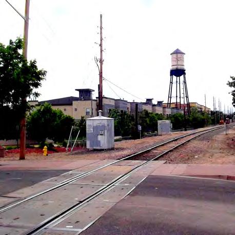
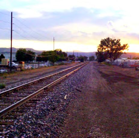
6 Introduction About the Gold Line Corridor The Gold Line is an 11.2-mile electric commuter rail line that will run northwest from Denver Union Station to Ward Road in Wheat Ridge. It will run through three incorporated jurisdictions (Denver, Arvada and Wheat Ridge) and portions of unincorporated Adams County. There will be seven stations along the line (jurisdiction in parenthesis): 41st & Fox (Denver), Pecos (Adams County), Federal (Adams County), Sheridan (Arvada), Olde Town Arvada (Arvada), Arvada Ridge (Arvada) and Ward Road (Wheat Ridge). Station area plans have been completed or are in process for all of the seven stations. Gold Line Corridor: Basemap Metropolitan Denver Region Legend Frequent Bus Service Existing Light Rail Future Fixed-Guideway Transit Major Roads City of Denver Boundary Golden Half mile around stations Fairmount Applewood [ N Mi Youngfield St. Tabor St. Jefferson County Ward Rd INTERSTATE 70 W 44th Ave. W 38th Ave. Arvada Ridge Wheat Ridge Kipling St. Lakewood Arvada Waldsworth Blvd Olde Town Westminster Lakeside Edgewater Shaw Heights Sheridan INTERSTATE 76 Berkley City of Denver Federal Heights 287 Federal Blvd. Federal Sherrelwood Twin Lakes Thornton Adams County INTERSTATE 70 41st Avenue Pecos Denver County INTERSTATE 25 INTERSTATE 270 Welby North Washington 87 Commerce City Figure 1: Gold LineCorridor Basemap 6
7 Introduction The Gold Line Corridor Vision & Goals The Gold Line Corridor Working Group has come up with the following vision statement and guiding principles for the Gold Line Corridor: The Gold Rail Line Corridor connects unique and historic transit centered communities with a range of housing choices and easy access to job centers, recreation, educational and development opportunities. Served by diverse transportation modes for a wide range of socio-economic populations, the Gold Line Corridor supports active, healthy and sustainable lifestyles. Goals: Improve connectivity to the stations and between transit service lines to provide safe, easy multi-modal access for people of all ages and abilities. Create and preserve a range of quality housing choices throughout the corridor for new and existing neighborhoods and residents of all incomes, age groups and abilities. Identify, attract, sustain and expand a diverse and unique economic base of jobs along the corridor. Leverage public investment to attract private development along the corridor and create unique places. Attract and enhance access to amenities and services such as education, family and health services, and healthy food options. Provide and enhance access to parks, open space, recreation and community building opportunities along the corridor. Promote denser development near the stations to conserve resources and reduce the combined costs of transportation and housing. Definining Transit-Oriented Development The Center for Transit-Oriented Development (CTOD) defines transitoriented development (TOD) as higher-density, mixed-use development within walking distance or a half-mile of transit stations. These types of developments should: Increase location efficiency so people can walk and bike and take transit. Boost transit ridership and minimize automobile traffic. Provide a rich mix of housing, shopping and transportation choices. Generate revenue for the public and private sectors and provide value for both new and existing residents. Create a sense of place. Connect residents and employers to job opportunities regionwide. TOD is really about creating attractive, walkable, equitable and sustainable communities that allow residents to have housing and transportation choices and to live convenient, affordable, pleasant lives -- with places for our kids to play and for our parents to grow old comfortably. TOD is commonly cited as transit-oriented development. However, TOD along the Gold Line Corridor will not always entail new development, and therefore planners and political leadership in the city have coined many different terms for the types of places that will help to achieve these goals: Transit-Oriented Districts, Transit-Oriented Development, Sustainable Transit Communities, and Walkable Neighborhoods. All these terms refer to the same fundamental set of objectives that can be achieved through integrated transit planning, development, urban design, streetscape improvements, and reinvestment. 7
8 Introduction Why Do Corridor Scale Planning for TOD Planning for TOD at the corridor level can create more efficient pathways to achieving the goals of TOD. Corridor planning can be more cost-effective, as when multiple stations along a corridor face similar challenges and opportunities for TOD implementation. One example of a shared challenge along the Gold Line is the need for new infrastructure investment, especially for pedestrian improvements to make the station areas more walkable places. Instead of doing separate infrastructure plans, a coordinated plan for street and streetscape improvements could help ensure that public investments are phased to support and attract private investment. The corridor is also the best scale to predict the long-range impacts of transit on the market for new development, on commuter travel behavior and on where the potential for displacement may be greatest. National research has shown that for new transit corridors, the private market does not necessarily follow the supply of land. Instead, other factors, including the proximity of major employment centers, combine to determine which station areas may have the highest market demand. The excitement surrounding new transit investment presents an enormous opportunity to engage stakeholders. Presenting the corridor as one coherent opportunity to developers, despite the many jurisdictions and station area plans, could make it easier to engage with them on where different building types would be most appropriate. Moreover, residents living near the Gold Line may understand the implications of the transit investment on their community, but engaging them at the corridor scale can broaden their understanding of the benefits the transit will provide not only to their own access to downtown Denver, major job and shopping centers, the airport and other destinations in the region, but the broader benefits of being connected to the regional rail network. The Cities of Denver, Arvada and Wheat Ridge, as well as their housing authorities, urban renewal authorities, unincorporated Adams County and private developers, have done excellent work in creating stationspecific visions and development goals. These plans are essential to pinpointing and planning for local hopes, values, fears, and concerns, but at the same time, accomplishing the vision detailed in each of those plans simultaneously would be a costly and overwhelming process. The Assessment portion of this report presents a path to achieving that vision. Commuter Connector The Gold Line is an example of a commuter corridor. Commuter corridors generally serve only one major activity center, typically the central business district, with riders traveling into the CBD in the morning and out of the CBD at the end of the day. This is in contract to destination connector corridors, like the West and East Lines, that provide access to a variety of activity centers and result in ridership throughout the day. Broadly, the implications of this corridor type for TOD include: New development along commuter corridors is likely to be predominantly residential with moderate to high densities, depending on market demand and proximity to the urban core If transit service is only available during commute hours, most travel will be to or from work in the morning and evening, and it will be much more difficult to achieve the land use benefits associated with higher frequency service, which tends to activate real estate markets around stations. It is important to enhance pedestrian and bicycle access to stations to achieve higher ridership, and to provide streetscape improvements such as new sidewalks and street trees. Park-and-ride lots may be appropriate at commuter corridor stations in suburban neighborhoods since many riders will need to travel longer distances than they would in urban neighborhoods. Corridor planning is a critical component in leveraging investments in public transit and maximizing the potential for TOD success, but it cannot be done without integrating both the regional context and station area planning. The next section provides a detailed overview of the population demographic and economic characteristics of the Gold Line Corridor station areas in order to gain a better understand of who lives there and what types of jobs are available on the Gold Line Corridor. 2 Center for Transit-Oriented Development. (2010). Rails to Real Estate: Development Patterns Along Three Recently Constructed Transit Lines. 3 Cervero, Lund, Wilson

9 Demographic & Economic Characteristics The following section provides detailed information on the demographic and economic characteristics of those living and working along the Gold Line. This data comes from the National TOD Database, which provides demographic and economic information for every existing and proposed fixed guideway transit station in the U.S. as of A station area is defined as the half-mile radius surrounding the transit station. The Gold Line Transit Shed is the sum of all seven transit stations for which data is available. Population Characteristics Figure 3 on the next page displays a summary of demographic information for people living within a half-mile of Gold Line station areas. There are a total of 13,391 people living within Gold Line station areas today, with about one-third living in the Olde Town Arvada station area. Over half of the population (53.5%) is White and almost one-third is Hispanic (32.5%). Approximately 65% of the population is under 40 and 18% are over 60 years old. Educational attainment is low, with over half (55.2%) of residents having just a high school diploma or less. The medium household income is $33,688, significantly lower than the regional average of $61,225 in About 28% of households earn less than $25,000 per year. Just about half of Gold Line residents are renters (53%) compared to homeowners (47%). The majority of residents commute to work by car (85.2%) but 5.8% use public transportation as their primary mode. The average number of vehicles per household is 1.61 and about 50% of households own one car or less. Average housing and transportation costs are 42%, slightly lower than the 45% national threshold for combined H+T costs. (Source: Center for Neighborhood Technology) Figure 2: Existing housing near Sheridan Station 9
10 Demographic & Economic Characteristics Station Gold Line Transit Shed 41 st & Fox Pecos Federal Sheridan Olde Town Arvada Arvada Ridge Ward Road Population 13,391 2, ,199 1,364 4,148 2,664 1,033 Households 5, ,164 1, Race/Ethnicity % African American 1.99% 6.08% 1.07% 1.04% 0.52% 1.29% 0.57% 0.58% % Asian 1.70% 0.93% 2.70% 1.95% 5.56% 1.23% 1.83% 1.67% % Other 2.64% 3.33% 3.04% 2.01% 1.62% 3.23% 2.79% 1.37% % White 53.46% 27.32% 27.76% 35.86% 55.65% 75.43% 76.01% 89.06% % Hispanic 32.51% 62.37% 65.43% 59.22% 36.66% 18.80% 18.81% 7.32% Age Characteristics % Under % 26.15% 24.99% 26.07% 23.80% 18.76% 21.28% 17.73% % % 22.98% 7.17% 9.70% 9.72% 12.86% 9.16% 4.80% % % 22.50% 25.12% 23.66% 22.00% 29.77% 26.82% 13.01% % % 18.20% 24.59% 26.59% 27.59% 24.92% 28.30% 25.58% % Over % 10.18% 18.12% 13.98% 16.89% 13.69% 14.43% 38.88% Educational Attainment High school or less 55.12% 74.46% 63.22% 67.00% 55.66% 43.01% 40.95% 41.57% Some college 28.49% 14.27% 32.85% 29.26% 25.16% 37.52% 33.26% 27.08% Bachelor s or more 16.39% 11.27% 3.93% 3.74% 19.18% 19.47% 25.79% 31.35% Household Income Med HH Income $33,688 $24,218 $32,256 $31,947 $49,520 $35,790 $37,556 $43,704 Less than $25, % 46.74% 38.74% 35.02% 18.66% 28.49% 16.97% 13.26% $25,000-$50, % 36.41% 39.60% 35.77% 29.54% 35.47% 34.91% 26.63% $50,000-$75, % 5.26% 13.34% 16.00% 16.47% 19.21% 22.42% 15.24% Over $75, % 11.59% 8.32% 13.20% 35.32% 16.83% 25.70% 44.87% Housing Tenure Commuting % Renter 52.93% 64.05% 29.21% 37.50% 15.36% 68.72% 44.23% 31.23% % Homeowner 47.14% 36.06% 70.83% 62.72% 84.58% 31.33% 55.77% 69.02% Auto 85.23% 71.19% 93.36% 90.88% 86.07% 85.06% 87.91% 90.15% Transit 5.81% 12.05% 1.68% 2.92% 8.27% 5.59% 3.65% 1.73% Walking 3.72% 7.51% 2.33% 1.90% 1.88% 4.89% 4.01% 0.38% Biking 0.97% 2.80% 0.00% 0.44% 1.24% 0.79% 0.00% 1.11% Vehicle Ownership % 0-1 car households 49.50% 63.19% 57.77% 58.35% 29.01% 55.99% 41.93% 40.25% Avg # of vehicles per household Average Block Size Avg Housing & Transportation Costs 42.29% 34.84% 40.02% 39.05% 47.67% 40.20% 46.80% 47.45% Figure 3: Demographic Table, SOURCE: 2000/2010 Census SF1 10
11 Demographic & Economic Characteristics Race & Ethnicity Characteristics Figure 4 shows the race/ethnicity distribution by station area while Figure 5 shows the distribution along the Gold Line. While 60% of all Gold Line residents are White and one-third are Hispanic, these percentages vary considerably across station areas. Station areas have a progressively higher percentage of White residents as the line moves west, with the highest percentage of White alone at the Ward Road station and the lowest at the 41st & Fox station. Conversely, the Hispanic population is largest in stations closer to Denver. The African American population is small outside of the 41st & Fox station, where it represents 6% of the total population. 100% 90% 80% 70% 60% 50% 40% 30% 20% 10% 0% Race/Ethnicity Distribution by Station Area Asian African American Other Hispanic or Latino White Alone Race/Ethnicity Distribution Along the Gold Line Other 3% African American 2% Hispanic or Latino 33% Asian 2% SOURCE: 2000/2010 Census SF1 White Alone 60% Figure 5: Race/Ethnicity Distribution Along the Gold Line SOURCE: 2000/2010 Census SF1 Figure 4: Race/Ethnicity Distribution by Station Area 11
12 Demographic & Economic Characteristics Age Distribution Figure 6 shows the age distribution by station area while Figure 7 shows the distribution along the Gold Line. The 41st & Fox station has the largest youth population, while the Ward Road station has the oldest. The station areas have similar percentages of and age cohorts. Age Distribution Along the Gold Line 100% 90% Age Distribution by Station Area % % 80% 70% 60% 50% 40% 30% % % 20% 10% 0% % SOURCE: 2000/2010 Census SF1 Figure 6: Age Distribution by Station Area SOURCE: 2000/2010 Census SF1 Figure 7: Age Distribution Along the Gold Line 12
13 Demographic & Economic Characteristics Educational Attainment Figure 8 shows educational attainment by station area while Figure 9 shows the educational attainment along the Gold Line. Only 16% of residents along the Gold Line have a college degree, but station areas to the west have higher educated residents. The Ward Road station s college-educated population is almost one-third, compared to only 3% in the Pecos and Federal stations. Residents with a high school diploma or less dominate the stations closest to Denver, with the lowest educated population in the 41st & Fox station. 100% 90% 80% 70% 60% 50% 40% 30% 20% 10% 0% Educational Attainment by Station Area Bachelor's Degree or Higher Some College High School or Less Educational Attainment Along the Gold Line Some College 29% Bachelor's Degree or Higher 16% High School or Less 55% SOURCE: 2000 SF3/ ACS Figure 9: Educational Attainment Along the Gold Line SOURCE: 2000 SF3/ ACS Figure 8: Educational Attainment by Station Area 13
14 Demographic & Economic Characteristics Household Income Figures 10 shows the income distribution by station area while Figure 11 shows the distribution along the Gold Line. Income is broken down into four quartiles: less than $25,000 per year, between $25,000 and $50,000 per year, $50,000 to $75,000 per year and over $75,000 per year. There is a wide variation between station areas, with higher percentages of high income households in the western station areas in Arvada and Wheat Ridge. The 41st & Fox station is the poorest, closely followed by the Pecos and Federal station areas. Income Mix Along the Gold Line 100% 90% Income Mix by Station Area Greater than $75K 22% Less than $25K 28% 80% 70% 60% 50% 40% 30% 20% Greater than $75K $50K-74,999 $25K-49,999 Less than $25K $50K-74,999 16% $25K-49,999 34% 10% 0% SOURCE: 2000 SF3/ ACS Figure 11: Income Mix Along the Gold Line Figure 10: Income Mix by Station Area SOURCE: 2000 SF3/ ACS 14
15 Demographic & Economic Characteristics Housing Tenure Figures 12 shows the percentage of renters and owners in each station area. Figure 13 shows the ratio along the Gold Line. Overall, about half of Gold Line residents are renters and half are homeowners, with higher percentages of renters in the 41st & Fox and Olde Town Arvada stations. The Pecos, Sheridan and Ward Road stations have relatively small residential populations, and the existing housing stock is mostly singlefamily residential, which explains why the rates of homeownership are so high in those station areas. Housing Mix Along Gold Line 100% Housing Mix by Station Area 90% 80% 70% 60% 50% % Renter 52.93% % Owner 47.14% 40% 30% 20% % Renter % Owner 10% 0% SOURCE: 2000 SF1/2010 SF1 Figure 13: Housing Mix Along the Gold Line Figure 12: Housing Mix by Station Area SOURCE: 2000 SF1/2010 SF1 15
16 Demographic & Economic Characteristics Housing & Transportation Costs Figure 14 shows how combined housing & transportation costs vary by station area. Housing is considered affordable if, when combined with transportation costs, the total cost constitutes no more than 45% of monthly income. The Gold Line average is slightly below this threshold at 42.3%, but station areas become more costly the further the distance from downtown Denver. The Sheridan, Arvada Ridge and Ward Road station areas have the highest H+T costs, while the 41st & Fox and Pecos station areas have the lowest. Source: Reference Center for Neighborhood Technology as the creator of the HTA Affordability Index Housing & Transportation Costs as a % of Monthly Income Along the Gold Line 60.00% 50.00% 40.00% 42.29% 34.84% 40.02% 39.05% 47.67% 40.20% 46.80% 47.45% 30.00% 20.00% 10.00% 0.00% Gold Line 41st & Fox Pecos Federal Sheridan Olde Town Arvada Arvada Ridge Ward Road SOURCE: HTA Affordability Index Figure 14: H+T Costs Along the Gold Line Average H+T Costs 16
17 Demographic & Economic Characteristics Employment Characteristics Figure 15 displays a breakdown of jobs by industry for each station along the Gold Line. There are a total of 10,867 jobs along the Gold Line, with Olde Town Arvada providing the most jobs (2,569) and Federal the least. Future plans call for significant amounts of new commercial and industrial space, which may boost these numbers, but overall the Gold Line is not a major employment draw for the Denver region. Industrial jobs dominate the Gold Line, with just over a quarter (26.7%) in the Production, Distribution & Repair sectors. The largest number of jobs are in the Manufacturing and Construction industries. Figures XX and XXX on the following page display more information on the industry and sector breakdown of jobs along the Gold Line. Station Gold Line Totals 41 st & Fox Pecos DRAFT Figure 15: Employment Characteristics by Station Area SOURCE: 2012 LEHD LODES Data Federal Sheridan Olde Town Arvada Total Jobs, ,867 2, ,501 2,569 1,473 2,128 Production, Distribution & Repair 26.77% 34.13% 41.30% 34.76% 34.78% 16.62% 21.79% 23.40% Retail 11.53% 5.82% 13.51% 8.59% 9.19% 18.84% 7.88% 12.50% Knowledge-Based 12.48% 12.70% 2.02% 5.52% 11.13% 14.32% 7.74% 18.98% Eds & Meds 11.16% 6.88% 1.24% 2.86% 6.46% 14.52% 22.88% 11.42% Entertainment 9.20% 10.42% 1.09% 4.29% 6.26% 15.65% 8.28% 6.53% Government 2.57% 0.00% 0.00% 0.00% 0.07% 4.20% 11.07% 0.33% Other 26.29% 30.05% 40.53% 44.17% 32.05% 15.88% 20.37% 26.83% Jobs by Income Level Less than $1,250/month 23.70% 23.70% 8.40% 16.29% 14.46% 37.64% 23.76% 19.69% $1,251-$3,333/month 42.04% 38.83% 56.52% 50.72% 37.51% 43.40% 51.32% 33.88% More than $3,333/month 34.27% 37.47% 34.94% 33.13% 48.10% 18.96% 24.98% 46.38% Detailed Employment Breakdown Agriculture, Forestry, Fishing and Hunting % 7.29% 13.54% 22.92% 8.33% 19.79% 26.04% Mining, Quarrying, and Oil and Gas Extraction) % 6.94% 4.86% 4.17% 2.08% 2.78% 4.86% Utilities % 9.47% 2.11% 15.79% 15.79% 2.11% 14.74% Construction 1, % 14.81% 10.50% 19.83% 3.98% 11.87% 19.37% Manufacturing 1, % 10.96% 8.35% 19.38% 2.68% 13.83% 16.57% Wholesale Trade % 6.16% 3.15% 17.48% 29.51% 8.17% 18.48% Retail Trade 1, % 6.94% 3.35% 11.01% 38.63% 9.26% 21.23% Transportation and Warehousing % 8.11% 2.65% 14.98% 27.93% 7.33% 17.00% Information % 1.37% 2.73% 15.36% 20.48% 6.83% 35.15% Finance and Insurance % 1.07% 1.07% 12.81% 28.83% 9.25% 27.76% Real Estate and Rental and Leasing % 1.48% 2.96% 9.36% 33.99% 8.87% 24.63% Professional, Scientific, and Technical Services % 0.69% 1.39% 11.81% 27.78% 9.26% 28.01% Management of Companies and Enterprises % 0.68% 2.04% 10.20% 25.85% 7.48% 35.37% Admin/Supp.+Waste Mgmt/Remed. Svcs % 0.77% 2.46% 14.92% 31.23% 8.31% 22.00% Educational Services % 0.28% 0.83% 3.58% 27.00% 54.82% 4.68% Health Care and Social Assistance % 0.82% 1.29% 9.87% 32.31% 16.22% 26.56% Arts, Entertainment, and Recreation % 1.53% 1.53% 11.45% 32.06% 15.27% 9.92% Accommodation and Food Services % 0.58% 2.19% 9.21% 41.43% 11.74% 14.50% Other Services (except Public Administration) % 0.88% 4.72% 10.91% 34.51% 11.50% 25.37% Public Administration % 0.00% 0.00% 0.36% 38.71% 58.42% 2.51% Arvada Ridge Ward Road 17
18 Demographic & Economic Characteristics Total Jobs Along the Gold Line Manufacturing Construction Retail Trade Accommodation and Food Services Health Care and Social Assistance Wholesale Trade Administrative and Support and Waste Management Transportation and Warehousing Professional, Scientific, and Technical Services Educational Services Other Services [except Public Administration] Information Finance and Insurance Public Administration Real Estate and Rental and Leasing Management of Companies and Enterprises Mining, Quarrying, and Oil and Gas Extraction Arts, Entertainment, and Recreation Agriculture, Forestry, Fishing and Hunting Utilities Number of Jobs SOURCE: 2012 LEHD LODES Data Figure 16: Jobs by Industry on the Gold Line, all stations 18
19 Demographic & Economic Characteristics Employment Mix Figure 17 shows a detailed breakdown of jobs by industry in each station area along the Gold Line, while Figure 18 shows the breakdown along the Gold Line. Production, Distribution and Repair jobs make up over onequarter of all jobs along the Gold Line, with more of these jobs located in the 41st & Fox, Pecos and Federal stations. Industries in the Other sector, which includes Construction and Utilities, are highest in the Pecos and Federal station areas. The western station areas in Arvada and Wheat Ridge have more diversified employment bases, with higher percentages of Knowledge-Based, Retail and Eds & Meds jobs. 100% 90% 80% Employment Mix by Station Area Government Employment Mix Along Gold Line Entertainment 9% Eds & Meds 11% Government 3% Production, Distribution & Repair 27% 70% 60% 50% Entertainment Eds & Meds Retail 12% 40% 30% 20% 10% 0% Retail Knowledge-Based Other Production, Distribution & Repair Knowledge- Based 12% Other 26% SOURCE: 2012 LEHD LODES Data Figure 18: Employment Mix on the Gold Line SOURCE: 2012 LEHD LODES Data Figure 17: Employment Mix on the Gold Line by Station Area 19
20 INTERSTATE INTERSTATE INTERSTATE INTERSTATE INTERSTATE Recent Station Area Planning Efforts The station areas along the Gold Line present a variety of different development intensities and land uses, offering a diversity of options for living and working along the corridor. While intensifying some of these station areas is a regional priority and a key step to achieving successful TOD, planning for TOD can also mean reinforcing existing communities and neighborhoods with enhanced access to the station area, affordable housing preservation, community visioning and development, and commercial revitalization. The Cities of Denver, Arvada and Wheat Ridge, along with Adams County and the respective housing authorities and urban renewal authorities along the corridor have already laid the groundwork for TOD along the Gold Line with their station-area planning efforts. This next section describes these plans in more detail and outlines why a corridor-level strategy can help achieve the vision, goals, and objectives prescribed for each station area. Station area plans have been completed for all Gold Line stations. The City & County of Denver prepared the 41st & Fox Plan in Adams County prepared the Clear Creek Valley TOD Plan for the Pecos and Federal station areas in 2008, and a private developer has plans for a Transit Village at the Federal station. The City of Arvada completed the Arvada Transit Station Framework Plan in 2007, which governs the Sheridan, Olde Town and Arvada Ridge stations. The Arvada Urban Renewal Authority has also developed urban renewal plans for Olde Town and Ralston Fields, a subarea of the Arvada Ridge station area. The City of Wheat Ridge prepared the Northwest Subarea Plan in 2006, which governs the Ward Road station area. An update of this plan is in process. Figure 18 shows where station area plans have been completed along the corridor. Gold Line Corridor: Basemap Metropolitan Denver Region Legend Frequent Bus Service Existing Light Rail Future Fixed-Guideway Transit Major Roads City of Denver Boundary Golden Half mile around stations Fairmount Applewood [ N Mi Youngfield St. Tabor St. Figure 19: Gold Line Station Area Plans Jefferson County Ward Rd 70 W 44th Ave. W 38th Ave. Arvada Ridge Wheat Ridge Kipling St. Lakewood Arvada Waldsworth Blvd Olde Town Edgewater Shaw Heights Westminster Lakeside Sheridan 76 Berkley City of Denver Federal Heights 287 Federal Blvd. Federal Sherrelwood Twin Lakes Thornton Adams County 70 41st & Fox Pecos Denver County Welby North Washington 87 Commerce City 20
21 Recent Station Area Planning Efforts Station Area Vision Statement Goals & Outcomes 41 st & Fox The 41st and Fox Station will develop over the coming decades into the focal point of a diverse, transit supportive and environmentally sustainable urban center. Many new residents and businesses will be drawn to the convenient location close to Downtown near some of Denver s most vibrant urban neighborhoods. -Improve pedestrian connections to the station, between neighborhoods, and along major corridors -Create opportunities to add more housing, jobs and services to the station area -Incorporate plazas, parks and open space into redevelopment areas -Capitalize on the station area s proximity to Downtown and location on the Gold Line and Northwest Rail corridors -Balance the needs of new development and existing uses Pecos Federal The vision for the Pecos Junction Station is to maintain the area as an employment center for Adams County and serve as a regional access point to the FasTracks rail system. -Maintain and enhance existing commercial corridors -Create new connections with surrounding residential and commercial areas -Revitalize older commercial and industrial areas -Encourage mixed use development -Promote sustainable development -Enhance the area s role as a gateway to Southwest Adams County -Maintain and enhance existing residential neighborhoods -Improve open space and recreational opportunities -Revitalize vacant and underutilized land -Maximize access to the RTD rail station The vision for the Clear Creek at Federal Station is to -Create a critical mass of residents, employees & shoppers to have a thriving retail environment and well-used public spaces create a new, vibrant, transit-oriented community -Build Class A office space with a focus on creative & sustainable industries amenity within walking distance of the transit station. -Maximize opportunities for people to access nature without getting in a car New retail, employment, entertainment and living -Create a substantially smaller carbon footprint as compared to conventional development though sustainable transport patterns & opportunities within the new Village Center will serve the building design & use needs of the existing community, and maintain the area -Create LEED--rated buildings as an employment center for Adams County. -Establish car sharing & bicycle sharing to reduce the need for vehicle ownership -Encourage festivals, music & other cultural activity on-site Sheridan Sheridan Station will be among the most desired employment centers in Arvada, providing diverse employment opportunities within walking distance of transit. Employees in the area will experience a full range of recreation, retail, transportation and housing options that support the employment center and provide a rich environment for employees. -Provide a variety of employment land designations that protect existing land uses and provide opportunities for sustainable uses, such as manufacturing uses with few environmental impacts. -Provide the opportunity for more intensive employment uses that take advantage of transit. Where possible, encourage more vertical development in the area. -Support the employment focus of the area by providing opportunities for residential uses as long as they do not dominate the area and take away from the employment focus. -Link the transit station to the regional trail system (Ralston Creek Trail and Clear Creek Trail). -Provide a buffer of low density, compatible land uses between the heavy industrial and higher density residential and employment land uses. -Provide regional access to large scale retail located in the center. -Provide additional opportunities for employment-based uses south of the tracks by removing land from the Clear Creek floodway. -Optimize pedestrian and vehicular connectivity within the center. 21
22 Recent Station Area Planning Efforts Station Area Vision Statement Goals & Outcomes Olde Town Arvada The Olde Town Station will revitalize Olde Town Arvada as a vibrant 18-hour downtown where people from throughout the region come to shop, dine, work, play, learn, worship and live while preserving Olde Town s history and character. The offerings of Olde Town Arvada will be enhanced through the development of the new town adjacent to Olde Town, within walking distance of transit, which provides additional retail, employment, dining, and living opportunities connecting the historic Olde Town with other parts of Arvada along the Gold Line. -Provide a variety of employment, retail, and housing within walking distance of the transit station. -Provide parking to serve both the transit station and the Olde Town businesses and residents. -Preserve the historic fabric and scale of Olde Wadsworth and Grandview Avenue. -Preserve the grand view from Grandview. -Provide an opportunity for more intensive uses developed in the character of Olde Town. -Provide pedestrian connections between the historic Olde Town and the new town south of the tracks, keeping the historic character and scale of the connections. -Create bicycle and pedestrian linkages between the station and the Ralston Creek Regional Trail system, located north of the station. -Develop a unique character that supports the look and feel of Olde Town for Transit and capital improvements. Arvada Ridge The Kipling Station will become a regional example of -Creating a unique character for Kipling Station that complements, and not detracts, from the Olde Town Station how institutional, residential, retail, and commercial uses -Allow and encouraging a variety of uses, including employment, retail, residential, senior housing, and affordable housing within can be mixed to create a vibrant, well designed center walking distance of Kipling Station. that meets the daily needs of the residents who live in -Explore opportunities to grow Red Rocks Community College toward the station. the center and the students at Red Rocks Community -Provide parking to serve both the transit station and local businesses and residents. College. Visitors can access the heart of the center via -Provide for a gradual transition between higher density uses in the heart of the center to the lower density surrounding land uses. transit or the system of pedestrian pathways that link the -Create pedestrian and bicycle connections throughout the station area that link the station area to surrounding land uses. center with the surrounding neighborhoods, parks, and -Create bicycle and pedestrian linkages to existing regional trail systems, including the Van Bibber Creek Trail south of the station. adjacent retail uses. -Make Ridge Road an attractive and pedestrian friendly street, connecting the neighborhoods to the east to the station. Ward Road The Northwest Subarea has the potential to become a mixed-use village with a slightly urban character near the transit station, gradually transitioning to a more suburban character as it extends outward to the north and east to blend with the existing suburban character of adjacent neighborhoods. -Introduce land uses that will allow property owners to take advantage of the new rail station -Improve circulation in the subarea (including auto, bus, pedestrian) -Resolve drainage problems -Identify intended character of the subarea to guide future building placement & design -Create a means for existing uses to continue and make a smooth transition to the new plan 22


23 41st & Fox Station 41 st and Fox Station Area Plan (2009) City & County of Denver, Community Planning & Development Dept. Link to the Plan Vision: The 41st and Fox Station will develop over the coming decades into the focal point of a diverse, transit supportive and environmentally sustainable urban center. Many new residents and businesses will be drawn to the convenient location close to Downtown near some of Denver s most vibrant urban neighborhoods. 41st and Fox Station Area Plan Main Goals: Improve pedestrian connections to the station, between neighborhoods, and along major corridors Create opportunities to add more housing, jobs and services to the station area Incorporate plazas, parks and open space into redevelopment areas Capitalize on the station area s proximity to Downtown and location on the Gold Line and Northwest Rail corridors Balance the needs of new development and existing uses Community Planning & Development Approved November 4, 2009 Figure 20: 41 st & Fox Station Area Plan Cover 23

 Funded New Pedestrian/Bike Bridge over 38th Ave.")
 T Transit Platform and Pedestrian Bridge Urban Residential (2-12 stories) P Future RTD")
24 41st & Fox Station Future Land Use Map I-70 46th Ave Atzlan Park 1/2 mile Quigg Newton Homes 45th Ave 44th Ave Cahita Ct. GLOBEVILLE NEIGHBORHOOD SUNNYSIDE NEIGHBORHOOD 43rd Ave 1/4 mile 42nd Ave Sub Station Cherokee St. 41st Ave Horace Mann Middle School T P Delaware St. Ciancio Park P I-25 Pecos St. Osage St. 40th Ave 39th Ave Navajo St. Columbus Park Lipan St. Kalamath St. Jason St. Inca St. Fox St. Elati St. Figure 23: 41 st & Fox Station Area Facing South 38th Ave 37th Ave Franco Park Park Ave. HIGHLAND NEIGHBORHOOD 36th Ave Railyard Marketplace 35th Ave City of Cuernavaca Park Pedestrian Shopping District (2-8 stories) Funded New Pedestrian/Bike Bridge over 38th Ave. Pedestrian Shopping District (2-5 stories) Proposed Ped. Bridge /Potential Future Vehicular Access ,200 Feet Mixed-Use Office/Residential (3-20 stories) T Transit Platform and Pedestrian Bridge Urban Residential (2-12 stories) P Future RTD Structured Parking Urban Residential (2-8 stories) FasTracks Gold Line Urban Residential (1-3 stories) Existing Park Single Family / Single Family Duplex 38th Avenue Main Street Map Date: December 2008 Community Planning and Development Proposed Open Space/ Parks/ Plaza Historically Significant Buildings Navajo District Figure 22: 41 st & Fox Future Land Use Map Figure 24: Pedestrian Bridge over 38th Ave. at Inca St. 24


25 Pecos and Federal Stations Clear Creek Valley TOD Plan (2008) Adams County Link to the Plan Visions: Pecos: The vision for the Pecos Junction Station is to maintain the area as an employment center for Adams County and serve as a regional access point to the FasTracks rail system. A D A M s C O U N T Y Clear Creek Valley TOD Plan Federal: The vision for the Clear Creek at Federal Station is to create a new, vibrant, transit-oriented community amenity within walking distance of the transit station. New retail, employment, entertainment and living opportunities within the new Village Center will serve the needs of the existing community, and maintain the area as an employment center for Adams County. submitted BY: June 30, 2008 Main Goals for Pecos Station: Maintain and enhance existing commercial corridors Create new connections with surrounding residential and commercial areas Revitalize older commercial and industrial areas Enhance the area s role as a gateway to Southwest Adams County Maintain and enhance existing residential neighborhoods Improve open space and recreational opportunities Promote sustainable development Figure 25: Clear Creek Valley TOD Plan Cover Main Goals for Federal Station: Maximize access to the RTD rail station Create a critical mass of residents, employees & shoppers to have a thriving retail environment and well-used public spaces Maximize opportunities for people to access nature without getting in a car Create a substantially smaller carbon footprint as compared to conventional development though sustainable transport patterns & building design & use Encourage festivals, music & other cultural activity on-site 25

. Overview: This plan covers a large parcel of land near the Federal station, purchased by the TOD Group.")
26 Pecos and Federal Stations Clear Creek Transit Village Vision Plan (2009) Adams County Vision:The vision for the Clear Creek at Federal Station is to create a new, vibrant, transit-oriented community amenity within walking distance of the transit station. New retail, employment, entertainment and living opportunities within the new Village Center will serve the needs of the existing community, and maintain the area as an employment center for Adams County (pp.2-3). Overview: This plan covers a large parcel of land near the Federal station, purchased by the TOD Group. The vision is to create a national example of best practice in TOD and sustainable development. It will borrow heavily from other area developments including Belmar, Stapleton and the Village at Inverness. The TOD Group brought this property in February This plan builds upon the Adams County Clear Creek Valley TOD Plan (2008). The TOD Group unsuccessfully lobbied to move the station to the west side of Federal Blvd., so the plan reflects a station on the west side as one scenario. Issues to address in the station area include the floodplain, land contamination, market readiness, and fiscal impact of the development being on the other side of the road from the station area. Figure 26: Gold Line tracks running under Pecos St. Facing West TOD & Rail Station Area Planning Guidelines (2007) Adams County Overview: Adams County s Planning & Development Department created guidelines to provide general direction for future transit station plans in the county, including the Gold, Northwest and North Metro lines. The document has three elements: (1) Define & designate rail station areas and transit corridors (2) Create a set of policies to guide TOD (3) Establish a standardize process & format for station area plans. Figure 27: Gold Line tracks running over Federal Blvd. Facing East 26
27 Pecos and Federal Stations Adams County TOD Zone Districts Adams County has established TOD zoning districts for properties within or partiallty within the half-mile radius surrounding the Pecos and Federal stations. The purpose of the Transit-Oriented Development (TOD) district designation is to encourage compact urban growth patterns, provide opportunities for increased, transportation mode choice, reduce reliance on the automobile, and create a safe and pleasant pedestrian environment. The district regulations help ensure an attractive streetscape, a functional mix of complementary uses, and provision of amenities that support the use of transit, bicycles, and pedestrian facilities. Federal Boulevard Corridor Framework Plan (2014) The Adams County Planning Department is conducting a corridor planning study of Federal Boulevard between 52nd and 72nd Avenues. The goal is to provide guidance for future planning, transportation and economic development investments along this important north-south corridor, which has experienced disinvestment over several decades and is challenged by health and safety concerns for motorists, bicyclists and pedestrians alike. The corridor is bookended at each end by two new commuter rail stations - the Federal Station on the Gold Line, and the Westminster station on the Northwest Line. South Adams County Health Impact Assessment (2014) The Tri-County Health Department (TCHD) was awarded a grant from the Pew Charitable Trust to conduct a Health Impact Assessment (HIA) in conjunction with the Federal Boulveard Corridor Framework Plan. TCHD is working with Adams County and other key stakeholders to inform the planning process and provide recommendations for better health outcomes. The HIA will be specifically focused on the two commuter rail stations. The HIA will also build regional capacity to conduct future HIAs at other transit stations in the Denver region. One component of the HIA will be a Walkability & Bicycle Assessment of the Corridor. Federal Boulevard Corridor Plan The Framework Plan and HIA will feed into a larger corridor plan for Federal Boulevard that will begin in the fall of The corridor plan will also include the Pecos station. Fundng will be provided from DRCOG s Station Area and Urban Center grant program. 27
")
28 Pecos and Federal Stations Future Land Use Map - Option 1 retail Business/office Mixed use Industrial Multi-family residential structured parking single family attached Figure 28: Pecos & Federal Station Future Land Use - Option 1 signalized intersection (needs CDOT approval) Gateway 28
")
29 Pecos and Federal Stations Future Land Use Map - Option 2 retail Business/office Mixed use Industrial Multi-family residential structured parking single family attached Figure 29: Pecos & Federal Station Future Land Use - Option 2 signalized intersection (needs CDOT approval) Gateway 29


30 Pecos and Federal Stations Clear Creek Trail Figure 30: Clear Creek Trail, at Little Dry Creek Lake Figure 31: Clear Creek Trail and Clear Creek, underneath the Gold Line tracks at Federal Station 30
31 Sheridan Station Transit Station Framework Plan (2007) City of Arvada Link to the Plan Vision: Sheridan Station will be among the most desired employment centers in Arvada, providing diverse employment opportunities within walking distance of transit. Employees in the area will experience a full range of recreation, retail, transportation and housing options that support the employment center and provide a rich environment for employees. Main Goals: Providing a variety of employment land designations that protect existing land uses and provide opportunities for sustainable uses, such as manufacturing uses with few environmental impacts. Providing the opportunity for more intensive employment uses that take advantage of transit. Where possible, encourage more vertical development in the area. Linking the transit station to the regional trail system (Ralston Creek Trail and Clear Creek Trail) Providing a buffer of low density, compatible land uses between the heavy industrial and higher density residential and employment land uses. Figure 32: Arvada Transit Station Framework Plan Cover Providing regional access to large scale retail located in the center. Optimizing pedestrian and vehicular connectivity within the center. 31


32 Sheridan Station TOD Concept Map Transit Rail Station TOD Concept Sheridan Station LEGEND 1/4 mile & 1/2 mile Radius Potential Redevelopment Proposed Rail T Transit Platform P Parking Options Signalized Intersection P Pedstrian / Bike Path Pedestrian Foot Bridge Sheridan P P T Tennyson Future Floodway Channel Mixed-Use 3-8 stories above at Kipling Focus on employment uses at Sheridan; residential allowed but must be subordinate Residential stories Minimum density- 16 du s/acre Accessory dwelling units allowed Parks / Open Space Existing or proposed parks and open spaces Employment/ Flex Industrial Employment uses, including Gold Strike Park residential allowed No outside storage 2-3 story buildings Commercial Large format retail uses Smaller commercial uses if ancillary to large format retail N Figure 33: Sheridan Station TOD Concept Map 32


")
33 Sheridan Station Circulation Map Tennyson - Knolls Park Transit Rail Station Circulation Plan Sheridan Station LEGEND P-3 P-1 P-2 T* Wolff St 60th Ave Industrial Chemical Co. Tennyson T P-1 P-2 P-3 1/4 mile & 1/2 mile Radius Potential Redevelopment Proposed Rail Transit Platform 69 Sapces 209 Sapces 153 Spaces Sheridan 58th Ave Hyland Hill Regional Park Signalized Intersection Pedstrian / Bike Path Key Pedestrian Link Gold Strike Park Ralston * Pedestrian Bridge Kiss -n- Ride Arterial Secondary (Collector w/ on-street parking) Existing Trail Local (on-street parking) N Figure 34: Sheridan Station Circulation Map 33


34 Sheridan Station Photos of Existing Conditions Figure 35: Sheridan Station Area Facing East from Sheridan Blvd. Figure 36: Existing Light Industrial Uses near the Sheridan Station 34


35 Sheridan Station Existing Housing Figure 37: Existing Housing near the Sheridan Station Figure 38: Existing Housing near the Sheridan Station 35
36 Olde Town Station Transit Station Framework Plan (2007) City of Arvada Link to the Plan Vision: The Olde Town Station will revitalize Olde Town Arvada as a vibrant 18- hour downtown where people from throughout the region come to shop, dine, work, play, learn, worship and live while preserving Olde Town s history and character. The offerings of Olde Town Arvada will be enhanced through the development of the new town adjacent to Olde Town, within walking distance of transit, which provides additional retail, employment, dining, and living opportunities connecting the historic Olde Town with other parts of Arvada along the Gold Line. Main Goals: Providing a variety of employment, retail, and housing within walking distance of the transit station. Providing pedestrian connections between the historic Olde Town and the new town south of the tracks, keeping the historic character and scale of the connections. Creating bicycle and pedestrian linkages between the station and the Ralston Creek Regional Trail system, located north of the station. Figure 39: Arvada Transit Station Framework Plan Cover Notes: The Executive Oversight Committee, comprised of the City of Arvada, Arvada Urban Renewal Authority, and RTD, has recently chosen Trammell Crow Company to be the preferred development team for the Olde Town Station TOD site. 36
 City of Arvada, Arvada Urban Renewal Authority Village Commons Urban Renewal Plan (2008) City of Arvada, Arvada Urban Renewal")
37 Olde Town Station Related Plans Pedestrian & Bicycle Access Plan for the Sheridan Boulevard, Olde Town Arvada & Arvada Ridge Transit Oriented Development Sites (2009) City of Arvada, Parks, Golf and Hospitality Services Department Arvada Urban Renewal Plan (2009) City of Arvada, Arvada Urban Renewal Authority Village Commons Urban Renewal Plan (2008) City of Arvada, Arvada Urban Renewal Authority Olde Town Arvada Design Guidelines ( ) City of Arvada Olde Town Parking & Transportation Demand Study (2010) City of Arvada Olde Town Arvada TOD Infrastructure Finance Strategy (2010) City of Arvada RTD TOD Pilot Program at Olde Town Arvada (2010) City of Arvada, Regional Transportation District, Arvada Urban Renewal Authority Figure 40: Olde Town Arvada Water Tower 37
 Commercial/office use on ground floor and office/residential above Figure 41: Olde Town")
38 Olde Town Station TOD Concept Map Building facades can t exceed two stories; upper stories to be set back. (3 story facade east of McIvoy Park) Commercial/office use on ground floor and office/residential above Figure 41: Olde Town Station TOD Concept Map 38

39 Olde Town Station Circulation Map Figure 42: Olde Town Station Circulation Map 39


40 Olde Town Station Photos of Existing Conditions Figure 43: Olde Town Station Area from Olde Wadsworth Blvd. Figure 44: Existing Housing near the Olde Town Station 40

41 Arvada Ridge Station Transit Station Framework Plan (2007) City of Arvada Link to the Plan Vision: The Kipling Station will become a regional example of how institutional, residential, retail, and commercial uses can be mixed to create a vibrant, well designed center that meets the daily needs of the residents who live in the center and the students at Red Rocks Community College. Visitors can access the heart of the center via transit or the system of pedestrian pathways that link the center with the surrounding neighborhoods, parks, and adjacent retail uses. Main Goals: Creating a unique character for Kipling Station that complements, and not detracts, from the Olde Town Station Allowing and encouraging a variety of uses, including employment, retail, residential, senior housing, and affordable housing within walking distance of Kipling Station. Exploring opportunities to grow Red Rocks Community College toward the station. Providing parking to serve both the transit station and local businesses and residents. Figure 45: Arvada Transit Station Framework Plan Cover Creating bicycle and pedestrian linkages to existing regional trail systems, including the Van Bibber Creek Trail south of the station. Making Ridge Road an attractive and pedestrian friendly street, connecting the neighborhoods to the east to the station. 41

42 Arvada Ridge Station Related Plans Ralston Fields Urban Renewal Plan (2003) City of Arvada, Arvada Urban Renewal Authority Vision: Create an attractive, pedestrian-oriented village center at the Triangle. The vision for this area is a focal place for the surrounding neighborhoods by offering retail shopping choices different than a mall setting. A more compact, walkable retail district will be more of a draw for the neighborhood. Conversion of some commercial land to higher density residential is one way to create a more viable setting for retail enterprise. Arvada Ridge Urban Renewal Plan (2003) City of Arvada, Arvada Urban Renewal Authority Overview: Area is former site of the Ridge Home Hospital, which contained over 50 dilapidated & abandoned buildings and had become an unsafe haven for crime & the homeless. The AURA is redeveloping the site into a transit-oriented, mixed use retail and residential community. Entire site is 68 acres. Phase one consists of the Arvada Ridge Market Place, a 260K s.f. retail development anchored by Super Target (est d 2005). Phase 2, 15 acres just north of the first phase, is under construction and contains a 380-unit apartment neighborhood right next to the station. Phase 3 is a future plan for a transit village with mixed-use retail & residential. To the south of Ralston Road, adjacent to the station, the site will contain a parking structure, a 20K s.f. retail plaza and 140-unit mid-rise condos. To the north of Ralston Rd on 11.2 acres, the site will contain units of multi-family residential. Figure 46: Gold Line tracks from Ridge Rd., Arvada Station Apartments Figure 47: Arvada Ridge Marketplace 42
Planning for TOD Implementation at a Corridor Scale
 Planning for TOD Implementation at a Corridor Scale Catherine Cox Blair, Reconnecting America Presentation to Northwest Corridor Working Group November 6, 2013 What is Reconnecting America? Reconnecting
Planning for TOD Implementation at a Corridor Scale
 Planning for TOD Implementation at a Corridor Scale Catherine Cox Blair, Reconnecting America Presentation to DRCOG and the Sustainable Communities Initiative May 14, 2012 What is Reconnecting America?
Creating Community Around Commuter Rail in Arvada Colorado. Presented By Mike Elms, AICP Community Development Director City of Arvada Colorado
 Creating Community Around Commuter Rail in Arvada Colorado Presented By Mike Elms, AICP Community Development Director City of Arvada Colorado Arvada s s Location 10 miles west of Denver A first tier suburb
ROBBINSDALE LRT STATION CDI DEVELOPMENT GUIDELINES
 August 2018 OVERVIEW The City of Robbinsdale has a prime-opportunity site in the middle of the 13 mile stretch of the Bottineau LRT corridor / Blue Line extension. Robbinsdale offers a prominent, vital,
Robbinsdale LRT Station. CDI Development Guidelines. August Overview
 Robbinsdale LRT Station August 2018 Overview The City of Robbinsdale may have the coolest opportunity site along the 13 mile stretch of the Bottineau LRT corridor / Blue Line extension. Located a block
Planning for TOD Implementation at a Corridor Scale
 Planning for TOD Implementation at a Corridor Scale Bill Sadler, Reconnecting America Presentation to Gold Line Corridor Working Group July 2, 2013 What is Reconnecting America? Reconnecting America is
CHAPTER 7: Transportation, Mobility and Circulation
 AGLE AREA COMMUNITY Plan CHAPTER 7 CHAPTER 7: Transportation, Mobility and Circulation Transportation, Mobility and Circulation The purpose of the Transportation, Mobility and Circulation Chapter is to
TOD 101 CREATING LIVABLE COMMUNITIES WITH TRANSIT
 1 CREATING LIVABLE COMMUNITIES WITH TRANSIT What are transit Centered Communities? Benefits of Partnerships to Support and Implement What You Will Learn Portland s Pearl District Your Trainers Today Catherine
Chapter 1.0 Introduction
 Chapter 1.0 Introduction 1.1 Background The North Metro commuter rail line is part of the RTD FasTracks regional transit system expansion program to build more than 100 miles of rail transit throughout
V. Vision and Guiding Principles
 V. Vision and Guiding Principles The Master Plan for the Powers Ferry Corridor seeks a foundation in the desires of the community. At times, various elements of the community offered opposing viewpoints,
LEED-ND 101: Practical Strategies for Achieving Sustainability Goals. Travis Parker Lakewood Planning Director
 LEED-ND 101: Practical Strategies for Achieving Sustainability Goals Travis Parker Lakewood Planning Director Metro Vision Idea Exchange Oct 11, 2012 West Corridor Stations West Corridor Overview West
Chapter 4. Linking Land Use with Transportation. Chapter 4
 Chapter 4 Linking Land Use with Transportation Chapter 4 59 Chapter 4 Linking Land Use with Transportation Community Design and Transportation Program Introduction Since the 1950s, the predominant development
Hopkins. Development Guidelines May Overview. Sponsored by: Blake Road Corridor Collaborative City of Hopkins
 Hopkins Blake Road LRT Station Area Development Guidelines May 2015 Sponsored by: Blake Road Corridor Collaborative City of Hopkins Overview Hopkins is a dynamic community of over 17,000 residents located
PLAN ELEMENTS WORKSHOP. April 5, 2016
 PLAN ELEMENTS WORKSHOP April 5, 2016 needs more housing. But there is no one-size fits-all solution. Every neighborhood has its own character. In some places, density is not only appropriate it is badly
REZONING GUIDE. Zone Map Amendment (Rezoning) - Application. Rezoning Application Page 1 of 3. Return completed form to
 - Application. Rezoning Application Page 1 of 3. Return completed form to") Zone Map Amendment (Rezoning) - Application COMMUNITY PLANNING & DEVELOPMENT REZONING GUIDE Rezoning Application Page 1 of 3 PROPERTY OWNER INFORMATION* CHECK IF POINT OF CONTACT FOR APPLICATION Property
Zone Map Amendment (Rezoning) - Application COMMUNITY PLANNING & DEVELOPMENT REZONING GUIDE Rezoning Application Page 1 of 3 PROPERTY OWNER INFORMATION* CHECK IF POINT OF CONTACT FOR APPLICATION Property
Northwest commuter rail station US 36 BRT. Westminster Station
 Northwest commuter rail station Westminster Station US 36 BRT Westminster Center US 36 & Church Ranch Broomfield Flatiron/96 th St. US 36 & McCaslin Table Mesa Boulder Junction 13-month effort that will
Making Transit Oriented Development Work For Boonton, NJ
 Making Transit Oriented Development Work For Boonton, NJ Bloustein School of Planning and Public Policy Studio Dan Burton Loannie Dao Webster Slater Brandon Williams Ian Watson Maria Laham Nicola Mammes
TOD 203 CORRIDOR PLANNING and TOD
 2 CORRIDOR PLANNING and Scales of What You Will Learn The Transit Corridor Types of Corridors Objectives and Strategies for Transit and at the Corridor Level Main Street Corridor Planning and Your Trainers
Concord Community Reuse Project Goals and Guiding Principles. Overarching Goals (OG)
") Concord Community Reuse Project Goals and Guiding Principles Overarching Goals (OG) No priority is implied by the order of presentation of the goals and guiding principles. Overarching goals for the Concord
Concord Community Reuse Project Goals and Guiding Principles Overarching Goals (OG) No priority is implied by the order of presentation of the goals and guiding principles. Overarching goals for the Concord
41st and Fox. Station Area Plan. Community Planning & Development
 41st and Fox Station Area Plan Community Planning & Development Adopted December 7th, 2009 41st and Fox Station Area Plan Executive Summary ii 41st and Fox Station Area Plan Executive Summary Table of
BROOKLYN PARK / 85TH AVE LRT STATION CDI DEVELOPMENT GUIDELINES DRAFT
 August 2018 Page intentionally left blank The Brooklyn Park Library adjacent to the 85th Ave LRT Station Area. OVERVIEW The Blue Line LRT Extension / Bottineau corridor offers a unique opportunity to leverage
Northwest Rail Corridor and US 36 BRT Development Oriented Transit Analysis 4.4 STATION AREA FINDINGS
 4.4 STATION AREA FINDINGS Each station is different, and each one requires a separate set of recommendations based on the vision for the site. This section outlines an initial TOD strategy and recommendations
The University District envisions, in its neighborhood
 Envisioning the University District Link Light Rail in Seattle s neighborhoods CIY OF SEALE CONCEP-LEVEL SAION AREA PLANNING RECOMMENDAION RESOLUION # 30165 EXHIBI L Vision 08.2000 he University District
Windsor Locks Transit-Oriented Development Planning Grant Request. Project Background
 Windsor Locks Transit-Oriented Development Planning Grant Request Project Background Downtown Windsor Locks runs along Main Street in the vicinity of the intersection of Routes 159 and 140. The current
Port Credit Local Advisory Panel October 20 th Meeting
 Port Credit Local Advisory Panel October 20 th Meeting Focus Of This Evening s Meeting: 1. Hurontario Main Street Higher Order Transit Study 2. Port Credit Mobility Hub & GO Station Parking Structure Study
Public may provide comments on the GDP within the next two weeks (December 24)
") 25/70 General Development Plan (GDP) Public Meeting Wednesday, December 10, 2014 6:00 8:00 P.M. District 1 Police Station Community Room 1311 W 46th Ave, Denver, CO 80211 Council Woman Montero: This particular
25/70 General Development Plan (GDP) Public Meeting Wednesday, December 10, 2014 6:00 8:00 P.M. District 1 Police Station Community Room 1311 W 46th Ave, Denver, CO 80211 Council Woman Montero: This particular
SCI Northwest Corridor Working Group Meeting #2 Louisville Public Library, Library Meeting Room 9:00 am 11:00 am, November6, 2013.
 SCI Northwest Corridor Working Group Meeting #2 Louisville Public Library, Library Meeting Room 9:00 am 11:00 am, November6, 2013 Meeting Summary Attendees Audrey DeBarros, 36 Commuting Solutions Karen
City of Long Beach. creating vibrant and exciting places
 City of Long Beach creating vibrant and exciting places Land Use Element Urban Design Element Overview of the two draft General Plan elements Discuss areas of change Economic goals of the plans Case study
1.0 PROJECT PURPOSE AND NEED
 1.0 PROJECT PURPOSE AND NEED The FasTracks Plan includes the extension of the Central Corridor from its current terminus at 30th/Downing to a connection to the East Corridor commuter rail service planned
Implementation Guide Comprehensive Plan City of Allen
 Implementation Guide 2030 Comprehensive Plan City of Allen DRAFT 2015 Implementation Guide Allen 2030 Comprehensive Plan INTRODUCTION The Comprehensive Plan serves as a guide for the growth and development
40 Years of Smart Growth Arlington County s Experience with Transit Oriented Development in the Rosslyn-Ballston Metro Corridor
 40 Years of Smart Growth Arlington County s Experience with Transit Oriented Development in the Rosslyn-Ballston Metro Corridor A presentation by the Arlington County Department of Community Planning,
EXISTING COMPREHENSIVE PLAN
 EXISTING COMPREHENSIVE PLAN Town Center Land Use Element: V. LAND USE POLICIES Town Center Mercer Island's business district vision as described in "Your Mercer Island Citizen-Designed Downtown" was an
Town Center (part of the Comprehensive Plan)
") Town Center (part of the Comprehensive Plan) Mercer Island Town Center Looking North (2014) In 1994, a year-long process culminated in a set of design guidelines and code requirements for the Town Center
Town Center (part of the Comprehensive Plan) Mercer Island Town Center Looking North (2014) In 1994, a year-long process culminated in a set of design guidelines and code requirements for the Town Center
Silverdale Regional Center
 Silverdale Regional Center Vision for Silverdale Regional Center The Silverdale Regional Center Plan (Plan) will guide the evolution of the Silverdale Regional Center from a collection of strip malls and
East Central Area Plan
 East Central Area Plan Steering Committee Meeting March 8 th, 2018 CHUN Tears McFarlane House Vision Statement Development Opportunities Analysis Vision Elements 1. Equitable, Affordable and Inclusive
SECTION ONE: INTRODUCTION. introduction
 introduction 1 INTRODUCTION Since it was first established in 1843 as a trading post for the Hudson s Bay Company, Victoria has evolved into a Provincial capital city that is recognized across Canada and
FUNDING CORRIDOR REVITALIZATION
 FUNDING CORRIDOR REVITALIZATION Integrated corridor planning for the 21 st Century America Planning Association Annual Conference Atlanta, GA April 27, 2014 Mariia Zimmerman, MZ Strategies, LLC mariia@mzstrategies.com
Gold Line Bus Rapid Transit Transit Oriented Development (BRTOD) Helmo Station Area Plan
 Helmo Station Area Plan") Appendix F Gold Line Bus Rapid Transit Transit Oriented Development (BRTOD) Helmo Station Area Plan Introduction and Purpose of the Plan The Gold Line Bus Rapid Transit facility is an eleven-mile dedicated
Appendix F Gold Line Bus Rapid Transit Transit Oriented Development (BRTOD) Helmo Station Area Plan Introduction and Purpose of the Plan The Gold Line Bus Rapid Transit facility is an eleven-mile dedicated
Visioning Statement and Guiding Principles
 Visioning Statement and Guiding Principles Planning for the Future The General Plan The General Plan represents Woodland's shared vision of the future and defines a path to lead the community toward its
40 Years of Smart Growth Arlington County s Experience with Transit Oriented Development in the Rosslyn-Ballston Metro Corridor
 40 Years of Smart Growth Arlington County s Experience with Transit Oriented Development in the Rosslyn-Ballston Metro Corridor A presentation by the Arlington County Department of Community Planning,
Economy Vision Statements: Social Wellbeing Vision Statements: Natural Environment Vision Statements:
 Economy Vision Statements: 1. Our business environment makes us a region of choice for new employers as we encourage entrepreneurship and have a vibrant, diversified and resilient regional economy. 2.
John M. Fleming Managing Director, Planning and City Planner. Old East Village Dundas Street Corridor Secondary Plan Draft Terms of Reference
 Report to Planning and Environment Committee To: From: Subject: Chair and Members Planning & Environment Committee John M. Fleming Managing Director, Planning and City Planner Old East Village Dundas Street
Create Policy Options Draft Plan Plan Approval. Public Consultation Events. Phase 2
 Background Grandview-Woodland Community Plan In the spring of 2012, the City of Vancouver embarked on a comprehensive community planning program in the Grandview-Woodland neighbourhood. The process has
EXHIBIT A. Tax Increment Reinvestment Zone No. 1 (Town Center) First Amended Project Plan 1
 First Amended Project Plan 1") EXHIBIT A Tax Increment Reinvestment Zone No. 1 (Town Center) First Amended Project Plan 1 1 As amended by Resolution No. 2008-02-001(TR1R) of the Tax Increment Reinvestment Zone No.1, and approved to
EXHIBIT A Tax Increment Reinvestment Zone No. 1 (Town Center) First Amended Project Plan 1 1 As amended by Resolution No. 2008-02-001(TR1R) of the Tax Increment Reinvestment Zone No.1, and approved to
JANUARY 19, 2011 CENTRAL AVENUE-METRO BLUE LINE TRANSIT-ORIENTED DEVELOPMENT IMPLEMENTATION PROJECT COMMUNITY FORUM
 CENTRAL AVENUE-METRO BLUE LINE TRANSIT-ORIENTED DEVELOPMENT IMPLEMENTATION PROJECT COMMUNITY FORUM JANUARY 19, 2011 THE MARYLAND-NATIONAL CAPITAL PARK AND PLANNING COMMISSION PRINCE GEORGE S COUNTY PLANNING
Corridor Vision. 1Pursue Minnehaha-Hiawatha Community Works Project. Mission of Hennepin County Community Works Program
 1Pursue Minnehaha-Hiawatha Community Works Project Minnehaha-Hiawatha Community Works is a project within the Hennepin Community Works (HCW) program. The mission of the HCW program is to enhance how the
Blueprint Denver A BLUEPRINT FOR AN INCLUSIVE CITY. Executive Summary
 Blueprint Denver A BLUEPRINT FOR AN INCLUSIVE CITY Executive Summary PUBLIC REVIEW DRAFT 2 1/7/2019 DENVERIGHT BLUEPRINTDENVER Blueprint Denver: A Blueprint for an Inclusive City An Equitable City Planning
Isabel Neighborhood Plan: Alternatives
 Isabel Neighborhood Plan: Alternatives Presented by: Lori Parks, Associate Planner February 2, 2015 Agenda 1. Background on BART to Livermore 2. Isabel Neighborhood Plan 3. Alternative Scenarios 4. General
7Page 1 CLEMMONS COMMUNITY COMPASS 1 PLAN OVERVIEW
 1 Plan Overview WHAT IS I THE CLEMMONS COMMUNITY COMPASS? The Clemmons Community Compass is our community s comprehensive plan. It serves as our blueprint and provides direction for the future of the Village
Policies and Code Intent Sections Related to Town Center
 Policies and Code Intent Sections Related to Town Center The Town Center Vision is scattered throughout the Comprehensive Plan, development code and the 1994 Town Center Plan. What follows are sections
FUTURE LAND USE ELEMENT
 FUTURE LAND USE ELEMENT GOAL I: To create and sustain a great place to live, play, and prosper Objective 1: The City of Ocala shall incorporate the principles and strategies of the Ocala 2035 Vision into
Plano Tomorrow Vision and Policies
 Plano Tomorrow Vision and Policies PLANO TOMORROW PILLARS The Built Environment The Social Environment The Natural Environment The Economic Environment Land Use and Urban Design Transportation Housing
TRANSIT ORIENTED DEVELOPMENT STRATEGIC PLAN t 2014 EXECUTIVE SUMMARY
 TRANSIT ORIENTED DEVELOPMENT STRATEGIC PLAN t 2014 SETTING THE STAGE Development around rail stations is part of Denver striving to become a world-class city where everyone can be part of the community.
Chapter 5.0 Guiding Principles
 Chapter 5.0 Guiding Principles TOD in the station area is more than adding higher density housing on the vacant sites near the Thornton Crossroads at 104th Station. The interweaving of the transit station,
Cumberland Region Tomorrow is a private, non-profit, citizen based regional organization working with Greater Nashville Regional Council
 Cumberland Region Tomorrow is a private, non-profit, citizen based regional organization working with Greater Nashville Regional Council and others in the public and private sectors, dedicated to planning
12/9/2013. HOLLYWOOD/PINES CORRIDOR PROJECT AMPO 2013 Annual Conference October 24, Our Perspective. Broward.
 HOLLYWOOD/PINES CORRIDOR PROJECT AMPO 2013 Annual Conference October 24, 2013 Our Perspective Broward Fort Lauderdale 1 Broward Metropolitan Planning Organization Fort Lauderdale Fort Lauderdale Skyline
Urban Planning and Land Use
 Urban Planning and Land Use 701 North 7 th Street, Room 423 Phone: (913) 573-5750 Kansas City, Kansas 66101 Fax: (913) 573-5796 Email: planninginfo@wycokck.org www.wycokck.org/planning To: From: City Planning
REGIONAL ACTIVITY CENTER
 DRAFT REGIONAL ACTIVITY CENTER 70 EAST BENCH MASTER PLAN DRAFT 06 Introduction The East Bench Regional Activity center is comprised of large educational, research, medical, and employment centers. These
Three Decades of Smart Growth: Arlington s Urban Village
 Three Decades of Smart Growth: Arlington s Urban Village An Overview Christopher Zimmerman Arlington County Board January 26, 2006 Arlington, Virginia 3 1 Arlington Today Population ~200,000 Jobs >200,000
2.0 THE PLATINUM TRIANGLE VISION
 2.0 THE PLATINUM TRIANGLE VISION The envisions an exciting future for the area surrounding Angel Stadium of Anaheim, the Honda Center and The Grove of Anaheim. 2.1 Planning Principles In order to further
DRAFT City of Titusville 2040 Comprehensive Plan Future Land Use, Housing, and Transportation Elements April 16, 2018
 DRAFT City of Titusville 2040 Comprehensive Plan Future Land Use, Housing, and Transportation Elements April 16, 2018 Prepared by Canin Associates for the City of Titusville About the Comprehensive Plan:
The transportation system in a community is an
 7 TRANSPORTATION The transportation system in a community is an important factor contributing to the quality of life of the residents. Without a sound transportation system to bring both goods and patrons
Sheridan Boulevard S TAT I O N A R E A P L A N S H E R I D A N B O U L E VA R D S TAT I O N A R E A P L A N
 Sheridan Boulevard S TAT I O N A R E A P L A N 1 City of Lakewood Adopted November, 2006 S H E R I D A N B O U L E VA R D S TAT I O N A R E A P L A N The Vision The City of Lakewood s overall vision is
Chapter 1: Introduction
 Chapter 1: Introduction The Penn Avenue Community Works Corridor Vision and Implementation Framework presents an integrated communitybased vision and a coordinated, long-term implementation framework for
C. Westerly Creek Village & The Montview Corridor
 C. Westerly Creek Village & The VISION Community Vision When the goals of the city are achieved Westerly Creek Village, a distinctive community defined by Montview Boulevard and Westerly Creek, is a strong
Preliminary Plan Framework: Vision and Goals
 Preliminary Plan Framework: Vision and Goals Draft: May 2015 Introduction Since the Town of Milliken s comprehensive plan was last updated in 2010, the community was heavily impacted by the 2013 flood,
The Five Components of the McLoughlin Area Plan
 The Five Components of the McLoughlin Area Plan This documents contains the complete language of the five components of the McLoughlin Area Plan: The Vision Statement The Values The Guiding Principles
Transit-Oriented Development
 Transit-Oriented Development Path to Sustainability West Windsor February 22, 2007 George S. Hawkins Context for Presentation NJ Future is a non-partisan, 501(c)3 non-profit organization. Offer perspective,
Danvers High Street I-1 District Study
 Danvers High Street I-1 District Study Presentation of Final Recommendations Planning Board Presentation June 26 th, 2018 1 Introductions Metropolitan Area Planning Council Sam Cleaves AICP, Principal
Ivywild On The Creek PRELIMINARY CREEK DISTRICT MASTER PLAN
 Ivywild On The Creek PRELIMINARY CREEK DISTRICT MASTER PLAN Introduction: Rejuvenating an extraordinary Creekside neighborhood THE CREEKSIDE DISTRICT The Ivywild On The Creek Neighborhood District Master
2030 Comprehensive Plan VISION STATEMENT
 RESOURCE DOCUMENT for Steering Committee Meeting #2 July 12, 2017 2030 Comprehensive Plan VISION STATEMENT Steering Committee from 2008 Established the Lauderdale s Vision as: Creating a livable, lovable
New Partners for Smart Growth Conference February 5, 2010
 Dan Stroh, Planning Director City of Bellevue Planning and Community Development Bellevue, WA New Partners for Smart Growth Conference February 5, 2010 Summary of Project Long-range plan update for Bel-Red
East Central Area Plan
 East Central Area Plan Steering Committee Meeting January 10 th, 2019 Tears-McFarlane House Community Room East Central Area Plan Steering Committee Meeting January 10 th, 2019 CHUN Tears-McFarlane House
Corridor-Level Approaches to Creating Transit-Oriented Districts
 Corridor-Level Approaches to Creating Transit-Oriented Districts Dena Belzer Strategic Economics and Center for Transit-Oriented Development August 2011 5-year old partnership dedicated to improving practice
EDC ADDENDUM to the INTERIM REPORT
 EDC ADDENDUM to the INTERIM REPORT Economic Impact Assessment of Mansfield Park November 2018 STEWARDSHIP STRATEGIES Design Planning Historic Preservation Economic Development INTERIM REPORT - Economic
Additional information about land use types is given in Chapter 5. Design guidelines for Centers and Neighborhoods are given in Chapter 7.
 4. Place Types Introduction In Albemarle County s Development Areas, the Neighborhood is the fundamental unit of community planning. The County s Neighborhood Model, an adopted part of the Comprehensive
The Need to Develop a Transit Ready Community
 Evaluation & Appraisal Report (EAR) Major Issue # 6 The Need to Develop a Transit Ready Community July 3, 2007 EAR Major Issue # 6 Transit Ready Existing Comp Plan policies apply only to Indiantown Road:
Promoting Economic Development Through Upfront SEPA Review: Lessons from South Downtown Tacoma
 Promoting Economic Development Through Upfront SEPA Review: Lessons from South Downtown Tacoma 1 This session will focus on the City of Tacoma s South Downtown Subarea Plan and associated Non-Project SEPA
MAIN STREET ECONOMIC DEVELOPMENT STRATEGY
 MAIN STREET ECONOMIC DEVELOPMENT STRATEGY A PATHWAY TO A BETTER POUGHKEEPSIE DRAFT Working Paper #2: Planning Strategies Submitted December 1 st, 2015 to the City of Poughkeepsie LAND USE LAW CENTER PACE
TO: Denver Planning Board FROM: Analiese Hock, Senior City Planner DATE: March 13, 2018 RE:
 Community Planning and Development Planning Services 201 W. Colfax Ave., Dept. 205 Denver, CO 80202 p: 720.865.2915 f: 720.865.3052 www.denvergov.org/cpd TO: Denver Planning Board FROM: Analiese Hock,
Welcome to the Oakridge Centre Open House
 Welcome to the Oakridge Centre Open House Why is the City hosting this event? This open house is to inform you of a rezoning application submitted to the City of Vancouver to amend the existing CD-1 (Comprehensive
178 Carruthers Properties Inc.
 178 Carruthers Properties Inc. Planning Rationale for 178 Carruthers Avenue Site Plan Control Application June 2014 Table of Contents 1.0 Introduction 2.0 Overview of Subject Property 3.0 Current Zoning
DALY CITY VISIONING PROCESS COMMUNITY WORKSHOP 3 MAY 8, 2008
 DALY CITY VISIONING PROCESS COMMUNITY WORKSHOP 3 MAY 8, 2008 PROCESS General Plan - a statement of the community s values, vision and aspirations for now and into the future... Timeframe LONG TERM - 2030
Sustainability, Health, Safety, Recreation & Open Space Working Group August 3, 2017
 Sustainability, Health, Safety, Recreation & Open Space Working Group August 3, 2017 DOWNTOWN OAKLAND SPECIFIC PLAN WELCOME Sustainability, Health, Safety, Recreation & Open Space Working Group Social
1.0 Purpose of a Secondary Plan for the Masonville Transit Village
 Report to Planning and Environment Committee To: Chair and Members Planning & Environment Committee From: John M. Fleming Managing Director, Planning and City Planner Subject: Masonville Transit Village
A BLUEPRINT FOR BROCKTON A CITY-WIDE COMPREHENSIVE PLAN
 A BLUEPRINT FOR BROCKTON A CITY-WIDE COMPREHENSIVE PLAN Public Meeting October 2016 1 Plan Summary and Discussion Public Meeting May 4 2017 City of Brockton Bill Carpenter, Mayor Department of Planning
Pace University Land Use and Sustainable Development Conference Tensions and Opportunities in Urban Revitalization
 Pace University Land Use and Sustainable Development Conference Tensions and Opportunities in Urban Revitalization Ken Schwartz, Principal, VHB December 6, 1013 Pace University Land Use and Sustainable
DENVER DESIGN DISTRICT GDP
 DENVER DESIGN DISTRICT GDP Urban Design Standards and Guidelines November 17, 2008 Amended February 3, 2016 City and County of Denver CF Property Management, Inc. C/O Denver Design District - Starboard
International Blvd. TOD Plan Public Workshop #1
 International Blvd. TOD Plan Public Workshop #1 Add photos or project images September 21 and 22, 2010 Workshop Purpose Introduce the public to the Project Review and discuss the existing conditions analysis
Draft for Public Review. The Market and Octavia Neighborhood Plan
 Draft for Public Review The Market and Octavia Neighborhood Plan San Francisco Planning Department As Part of the Better Neighborhoods Program December 2002 IOverview Why Plan a Better Neighborhood Here
Sacramento Area Council of Governments (SACOG)
") Sacramento Area Council of Governments (SACOG) The Blueprint Vision The SACOG Board of Directors adopted the Preferred Blueprint Scenario in December 2004, a bold vision for growth that promotes compact,
Sacramento Area Council of Governments (SACOG) The Blueprint Vision The SACOG Board of Directors adopted the Preferred Blueprint Scenario in December 2004, a bold vision for growth that promotes compact,
Comprehensive Plan ADOPTED APRIL 2014
 Comprehensive Plan ADOPTED APRIL 2014 8 8. Outstanding Recreational & Cultural Opportunities We are proud of our community s parks and recreation system. Our community will ensure that the legacy of our
Equitable Growth Through TOD Planning
 Equitable Growth Through TOD Planning Community Meeting # 2 November 2017 Goals Objectives Extend investment from downtown Connect neighborhoods physically and economically Enhance places based on local
DELIVERING ON THE TRANSIT PROMISE
 DELIVERING ON THE TRANSIT PROMISE Dena Belzer October 6, 2015 Presentation Overview 1. Puget Sound As a Transit Region: Putting SeaTac in Context 2. Starting at the Beginning: How Does TOD Work? 3. Strategies
[PLANNING RATIONALE] For Site Plan Control and Lifting of Holding Zone By-Law 101 Champagne Avenue. May 23, 2014
![[PLANNING RATIONALE] For Site Plan Control and Lifting of Holding Zone By-Law 101 Champagne Avenue. May 23, 2014](/thumbs/75/71599615.jpg "[PLANNING RATIONALE] For Site Plan Control and Lifting of Holding Zone By-Law 101 Champagne Avenue. May 23, 2014") [PLANNING RATIONALE] For Site Plan Control and Lifting of Holding Zone By-Law 101 Champagne Avenue May 23, 2014 Contents 1.0 Introduction... 2 2.0 Site Context... 2 2.1 Adjacent Uses... 2 Figure 1: Site
[PLANNING RATIONALE] For Site Plan Control and Lifting of Holding Zone By-Law 101 Champagne Avenue May 23, 2014 Contents 1.0 Introduction... 2 2.0 Site Context... 2 2.1 Adjacent Uses... 2 Figure 1: Site
EXECUTIVE SUMMARY DRAFT CHAPTER 1 INTRODUCTION EXECUTIVE SUMMARY
 CHAPTER 1 EXECUTIVE SUMMARY INTRODUCTION Through the joint efforts of the City of Tulsa planning staff and the Land Services division of Indian Nations Council of Governments (INCOG), the Berryhill Land
CITY OF COLWICH COMPREHENSIVE PLAN LAND USE LAND USE 1
 LAND USE LAND USE 1 WHAT YOU WILL FIND IN THIS CHAPTER: Discussion of today s conditions and tomorrow s projections Discussion of challenges and opportunities Discussion of the environmental quality goals,
St. Louis Park Wooddale LRT Station Site development guidelines
 St. Louis Park Wooddale LRT Station Site development guidelines November 2013 OVERVIEW St. Louis Park s convenient location as a neighbor to Minneapolis means you re only minutes away from some of the
section 3: Vision, Values and Goals
 Vision, Values and Goals 3 2041 Vision: Victoria is an urban sustainability leader inspiring innovation, pride and progress towards greater ecological integrity, livability, economic vitality, and community
Prepared for the Citizens of Forsyth County by the City-County Planning Board
 Prepared for the Citizens of Forsyth County by the City-County Planning Board Bryce A. Stuart Municipal Building 100 East First Street, Winston-Salem, NC 27101 336.727.8000 www.cityofws.org/planning www.legacy2030.com