APPENDIX K, PART 2. Historic Heritage Assessment (Clough & Associates)
|
|
|
- Rose White
- 5 years ago
- Views:
Transcription


1 APPENDIX K, PART 2 Historic Heritage Assessment (Clough & Associates)
2
 321 Forest Hill Rd, Waiatarua, Auckland 0612 Telephone: (09) 8141946 Mobile 0274 850 059 www.clough.co.")
3 Prepared for Oceana Gold (New Zealand) Ltd Final May 2018 By Adina Brown (MA, MSc), Zarah Burnett (MA Hons) and Rod Clough (PhD) 321 Forest Hill Rd, Waiatarua, Auckland 0612 Telephone: (09) Mobile
4 Contents Introduction... 1 Project Background... 1 Methodology... 2 Historical Research Results... 6 General Area Cambridge Road Bulltown Road William Street Historical Road Alignments Martha Pit Underground Workings Recorded Historic Heritage Investigation Results Project Martha MP4 Area William Street MP4 Road Realignment The Martha Underground (Including the Rex Orebody) Area Historic Heritage Assessment Summary of Results Maori Cultural Values Survey Limitations Archaeological Value and Heritage Significance Effects of the Proposal The Proposal Heritage Effects of the Proposal Statutory Requirements Resource Management Act 1991 Requirements Summary of Historic Heritage Requirements under the RMA Heritage New Zealand Pouhere Taonga Act 2014 Requirements Conclusions Recommendations Bibliography Appendix 1: Site Record Forms Appendix 2: HDP Historic Heritage Assessment Criteria i
5 Image on front cover: cropped 1942 aerial of the general Martha hill area (sourced from and licensed by LINZ CC-BY 3.0: ref SN229 Crown ) ii
6 INTRODUCTION Project Background Oceana Gold (New Zealand) Ltd (OGNZL) is proposing to extend the Waihi mine activities by developing additional resources. At current mining and processing rates the existing consented mineral resource for the Waihi operation will be exhausted in mid Ongoing exploration and mine optimisation has identified further mineral resources (Au and Ag) that can be economically recovered. Project Martha comprises two key components: The Martha Phase 4 pit (MP4); and, The Martha Underground Project, including the Rex orebody. The project schedule considers the mill capacity and aims to provide a steady supply of ore, with potential to add 0.7 Moz of profitable production over an 11-year period (ibid.). The components are linked and interact with each other to varying degrees, as follows: MP4 and Martha Underground will operate largely in parallel, with material mined from MP4 largely used for backfill for the underground mines Tailings from processing ore from MP4 and Martha Underground will be deposited in the existing Tailing Storage Facilities TSF1A and TSF2 (Figure 2); and, Material mined from MP4 and surplus to requirements for backfilling will be permanently stored in the Central and Eastern stockpiles, the existing Northern Stockpile located to the north of TSF2, and/or could be used to cap TSF1A and/or TSF2 (Figure 2). The proposed extension to the Waihi mine activities has the potential to impact on historic herit (NZAA) site record database, scheduled in the Hauraki District Plan, listed by Heritage New Zealand, or identified during recent fieldwork and research for Project Martha. These historic heritage sites largely relate to the extensive gold mining landscape in Waihi and the settlement that has developed around this. A heritage impact assessment was commissioned by OGNZL to establish whether the proposed work is likely to impact on historic heritage values. This report has been prepared as part of the required assessment of effects accompanying a resource consent application under the Resource Management Act 1991 (RMA) and for the purpose of an application for an Authority to modify archaeological sites under the Heritage New Zealand Pouhere Taonga Act 2014 (HNZPTA). Recommendations are made in accordance with statutory requirements. Due to the size and complexity of the project the heritage impact assessment has been divided into two parts: Part 1 historical and archaeological background outlining the historical background research for the general area; and, Part 2 historic heritage assessment identification of historic heritage places impacted by Project Martha; potential positive and adverse effects; and, mitigation of effects on historic heritage values within the project area. May 2018 Martha Project Historic Heritage Assessment 1
7 Methodology The NZAA site record database (ArchSite), the Hauraki District Plan schedule and the Heritage New Zealand Pouhere Taonga (Heritage NZ) New Zealand Heritage List were searched for information on sites recorded in the vicinity. Literature and archaeological reports relevant to the area were consulted. Plans, maps and photographs from collections such as the Sir George Grey Special Collections (Auckland Libraries), Auckland War Memorial Museum, Alexander Turnbull Library, Archives New Zealand, and Land Information New Zealand (LINZ) were searched for material relevant to the project area. Certificates of Title and Residence or Business Site Licenses were searched through LINZ and Archives New Zealand to establish ownership of potentially affected sites in the project area. Visual inspections of the project area were conducted on a number of occasions. The main fieldwork occurred during June 2017, when a study list for further research was compiled based on the fieldwork results, and in November 2017, when more detailed aspects of the proposal were being developed. The ground surface was examined for evidence of former mining activities in the vicinity of the proposed Phase 4 Pit. Exposed and disturbed soils were examined where encountered for evidence of earlier modification, and an understanding of the local stratigraphy. A survey of historic buildings in close proximity to the existing Martha pit and proposed road alignments on foot. Early cottages, villas or notable buildings were marked on plans of the area and these were then researched to establish their likely date and historical associations. Aerial photographs dating to 1942 and historical plans were also examined (and compared to present day aerials) to establish past activities and features within the project area that may no longer be extant. Archaeological sites beneath buildings and sealed surfaces (such as in Waihi town) can rarely be identified prior to being exposed in the course of redevelopment work, and the approach to archaeological assessment in these more urban environments is therefore to identify historically recorded activities on the site, and assess the potential for archaeological evidence to have survived on the basis of later modifications to the site. May 2018 Martha Project Historic Heritage Assessment 2
8 Region General Locale Figure 1. General location map showing the regional context for Project Martha (Google 2018) May 2018 Martha Project Historic Heritage Assessment 3
9
10
11 HISTORICAL RESEARCH RESULTS General Area The accompanying report Oceana Gold Project Martha, Waihi: Part 1 Historical and Archaeological Background provides the historical background for the general area (Brown, Burnett and Clough 2018). This includes research into key themes in the history and development of Waihi, such as early Maori settlement; gold mining; infrastructure (water races, tramways etc); early industry; the development of Waihi township and later history (relocation of heritage buildings, Akrad Radio Corporation Ltd, PYE (N.Z.) Ltd etc). The information provided here is supplementary to the main body of information provided in the Part 1 report. The Martha and Rex underground components of the project will not affect any properties at the surface. As part of the Martha Phase 4 proposed works, an area of land adjacent to the existing pit rim will be affected by lateral expansion of the mine Three houses will also be affected (two by road realignment and one by extended pit) and the property histories for these are summarised below. 12 Cambridge Road The property at 12 Cambridge Road, Lot 1 DP 88853, is part of Section 279 (previously Section 101, Bulltown) BLK XV Ohinemuri SD (Figure 4; Figure 5). Presently the site is occupied by a villa and several outbuildings. The earliest licence for a residence site was granted to Daniel McLennan (also referred to as McClennan), of Waihi (a carpenter) in The licence and application number was SA3C/51 & Application No. 140/20. It is possible that there is an earlier licence (given that the application files are not currently part of the Archives New Zealand digitised inventory), but no prior reference was listed on SA3C/51. Other application references may exist in one or more of several Waihi indexes and registers, including the Numerical Register of Applications, the Register of Applications by Hearing Date, and Indexes to Register of Applications. It is considered likely that the dwelling was constructed around the turn of the century and as a precautionary approach it should be treated as pre-1900 in date until further research is carried out. During the early 20th century the property was sold three times (up until 1920). The occupants included a local miner and battery hand. The full property history is summarised in Table 1. A 1942 aerial shows the dwelling and outbuildings in their present location (Figure 11). 1 Auckland Star, 12 July 1900, p.2. May 2018 Martha Project Historic Heritage Assessment 6
12 Figure 4. Plan showing the location of Section previously Section 101, Bulltown (source: SO Quickmap) Figure 5. Plan showing Section 101, dated 1909 (source: Sir George Grey Special Collections, Auckland Libraries, NZ Map 3604) May 2018 Martha Project Historic Heritage Assessment 7
13 Table Cambridge Road Property History Summary Date Event Source July 1900 Licence for a residence site for Section 101, Bulltown, granted to Daniel McLennan (also referred to as McClennan), of Waihi, carpenter 1904 Transfer of Section 101 from McLennan to Roderick Alexander McMillan of Waihi, miner 1908 Transfer of Section 101 from McMillan to Mary Ellen, of Waihi 18 June 1920 Licence for a residence site for Section 101, Town of Waihi, granted to Thomas Frederick Lawrence Monk of Waihi, a battery hand. Licence granted for a term of 42 years at 5 shillings per annum and Waihi Auckland Star, 12 July 1900, p.2. BAFV A540 6/1194, Archives New Zealand Same as above SA3C/51, LINZ Application No. 140/20 77 Bulltown Road The property at 77 Bulltown Road, Waihi, Lot 2 DPS is subdivided from part of earlier Sections 142 and 278. The portion of Lot 2 DPS situated over the former Section 142 primarily covers the original Section 80. Section 142 itself was formed from earlier Sections 53, 79 and 80 and Special Site No. 13 (Grand Junction) (see Figure 6). A licence for a Residence Site for Section 80, Bulltown, Waihi, was granted to Robert Lockhart in 1900 (see Table 2). It is likely that this part of the property was therefore occupied at least by February Section 278 was originally part of Section 98 Township of Waihi (Figure 7), and a licence for a Residence Site for this section was granted to Eliza Patty Jones in 1901 with a mortgage attached in Mortgages at this time were usually associated with a residence, which indicates there was a house constructed on the property at least by 1902, but the exact location is not determined. The earliest historical aerial located through research dates to 1942 (Figure 11), and indicates that the main dwelling which survives today at this address was not present, and was most likely built post However, a smaller structure visible in the 1942 aerial may be in the same location as the existing secondary building south of the main dwelling (Figure 11). It is possible that the original main residence constructed around the turn of the century has since been demolished or relocated elsewhere. May 2018 Martha Project Historic Heritage Assessment 8
14 Figure 6. Plan of Waihi Township shows Sections 53, 79, 80 and 98 surveyed. Also Special Site No. 13 (Grand Junction). (Source: SO Quickmap) Figure 7. Plan showing Section 98 and 80, dated 1909 (source: Sir George Grey Special Collections, Auckland Libraries, NZ Map 3604) May 2018 Martha Project Historic Heritage Assessment 9
15 Table Bulltown Road Property History Summary Date Event Source Original date unknown Plan of Waihi Township SO 42543, Quickmap shows Sections 53, 79, 80 and 98 surveyed. Also Special Site No. 13 (Grand Junction) 8 February 1900 Auckland Star 8 February grants a licence for Section 1900, p.5. 80, Bulltown, Waihi, to Robert Lockhart. 31 January 1901 Licence for a Residence Site for Section 98 Township of Waihi granted to Eliza Patty Jones for a term of 42 years 4 September 1902 Mortgage of Residence Site Section No. 98 Township of Waihi to Eliza Patty Jones 1909 Plan of Waihi Township shows Sections 53, 79, 80 and 98 surveyed. Also Special Site No. 13 (Grand Junction) June 1933 Plan of Section 142 BLK XV Ohinemuri District November 1937 Plan shows Section 142 with lessee A.H. Sparke identified and Section 98 with owner Leather identified 16 February 1938 Licence for Section 98 granted to Alice Leather for a term of 42 years BAFV A /100, Archives New Zealand, also see: New Zealand Herald, 1 February 1901, p.6 BAFV A /100, Archives New Zealand Sir George Grey Special Collections, Auckland Libraries, NZ Map 3604 SO 27174, Quickmap SO 29544, Quickmap SA3C/20, LINZ May 2018 Martha Project Historic Heritage Assessment 10
16 85 William Street 85 William Street is located near the existing Martha pit crest on Section 282 BLK XV Ohinemuri SD and the existing buildings appear to be modern (based on the visible external elevations). Section 282 amalgamated several original parcels including Section 580 over which the existing building is primarily sited (Figure 8). On 14 April 1900 the Thames Star ce for Section 580, Waihi to John Gerrand. 2 This may be the same Section 580 which is now part of Section 282. Today there is no evidence for this earlier dwelling, indicating it may have been demolished or relocated. The existing buildings are also possibly situated partly over Section 173 BLK XV Ohinemuri SD. According to Map SO 30700, dated 1940 (Figure 10), Section 173 was originally part of Ohinemuri Blocks 7 and 8 and was gazetted as Crown Land in Section 173 was originally Special Site No.11 for the Waihi Grand Junction Gold Company Ltd (Figure 9). It appears to have remained mining land until 1939, when it was leased to William Thomas Mancer, a farmer. It was possibly farmed until at least 1961 (see Table 3). Based on the evidence from the 1942 aerial the existing main dwelling was not present at this time, and therefore suggests post-1942 construction for the existing building (Figure 11). Table William Street Property History Summary Date Event Source Original date unknown Plan of Waihi Township shows SO 42543, Quickmap Special Site No. 11 (Grand Junction) and Section Plan of Special Site No. 11, Waihi, surveyed for the Waihi Grand Junction G. Co. Ltd. Also shows Section 580 SO 14436, Quickmap 1909 Plan of Waihi Township shows Sir George Grey Special Special Site No. 11 (Grand Collections, Auckland Junction) and Section 580 Libraries, NZ Map Plan of road to be closed SO 17181, Quickmap shows Special Site No. 11 (Grand Junction) and Section 580 (property of Waihi Grand Junction G. Co. Ltd.) 7 September 1939 Occupation lease for Section SA724/195, LINZ 173 granted to William Thomas Mancer, a farmer 12 May 1961 A licence for Section 173 is SA1789/44, LINZ transferred to Maurice Andrew Roycroft, a postal officer 2 Thames Star, 14 April 1900, p.1. May 2018 Martha Project Historic Heritage Assessment 11
17 Date Event Source 1965 Certificate by the SA1789/44, LINZ Commissioner of Crown Lands incorporating Section 282 within the licence for Section August 1972 Certificate of Title issued to Maurice Andrew Roycroft for Sections 173 and 282 SA14C/1149, LINZ Figure 8. Plan of Waihi Township shows Sections 580 surveyed (source: SO Quickmap) May 2018 Martha Project Historic Heritage Assessment 12
, dated 1909")
 Figure 10.")
18 Figure 9. Plan showing Special Site No.11 for the Waihi Grand Junction Gold Company Ltd (arrowed), dated 1909 (source: Sir George Grey Special Collections, Auckland Libraries, NZ Map 3604) Figure 10. NZ Map SO 30700, dated 1940 (source: Quickmap) May 2018 Martha Project Historic Heritage Assessment 13
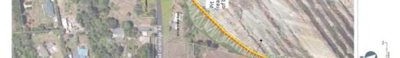
19 Figure aerial of the area (aerial sourced from and licensed by LINZ CC- BY 3.0: ref SN229 Crown ) Historical Road Alignments An Index Plan of Waihi Township, dated 1899/1901, shows most roads formed in the area by these dates (Figure 12). This includes Cambridge Road and Bulltown Road, indicating that these were constructed around the turn of the century. The 1909 plan also shows two roads orientated north south (Hamilton Road and Sentinel Road) running perpendicular to Cambridge Road and Oxford Road (Figure 13). Analysis of the 1942 aerial photograph shows that Cambridge Road is still on the original alignment. Hamilton and Sentinel Roads however, were not present by 1942 (Figure 14). Bulltown Road was apparently named after the Bull family (Ohinemuri Regional History Journal No.23, June 1979), but no source is given for Cambridge Road. The part of Bulltown Road running northeast from Cambridge Road (affected by the road change) has stayed on the same alignment since the turn of the century. However, the section to the southwest also visible in 1942 is now gone, due to the expansion of Martha pit in 1999 (Figure 15). An unnamed road was located west of 85 William Street and also present by 1899/1901. This appears to have been removed sometime in the early 1940s (Figure 10). Apparently there are some 28 street names no longer in usage since the early Borough maps and c.158 streets names still in use ( accessed 09/02/2018). May 2018 Martha Project Historic Heritage Assessment 14
20 Figure 12. An Index Plan of Waihi Township which shows most roads formed by 1899/1901 (source: SO 26502) Figure plan of the road layouts, showing Hamilton and Sentinel Roads, and the early alignment of Bulltown Road (source: Sir George Grey Special Collections, Auckland Libraries, NZ Map 3604) May 2018 Martha Project Historic Heritage Assessment 15
21 Figure aerial of the area with changes in nearby roads shown since the turn of the century (aerial sourced from and licensed by LINZ CC-BY 3.0: ref SN229 Crown ) May 2018 Martha Project Historic Heritage Assessment 16
 Martha Pit Underground Workings A summary of historical mining at the Martha Mine is provided in the")
22 Figure 15. Modern alignment of Bulltown Road and Cambridge Road (source: Googlemaps accessed 2018) Martha Pit Underground Workings A summary of historical mining at the Martha Mine is provided in the accompanying report Oceana Gold Project Martha, Waihi: Part 1 Historical and Archaeological Background (Brown, Burnett and Clough 2018). Early on ore was largely mined from an open cut on top of the Martha Hill, with an adit drive beneath the open cut, which was extended along the Martha reef (McAra 1988: 171). A considerable length of exploratory driving along the reef had been carried out by 1900 (ibid.). In these early days the underground workings themselves consisted of several levels first the Intermediate level was opened up, then the Smithy level and then the lower Adit level (McAra 1988:79). The early drives were generally timbered, measuring 6½ feet high and 4 5 feet wide or 7 by 5 feet if unsupported (McAra 1988: 59). The open face was worked with hand-steel (or hand hammer drill) and later a jumper bar and auger-drill. Explosives used were dynamite, safety-fuse and detonators (ibid.: 60). At first hand-trucks were used for mining and then horse-drawn trucks were employed (see Figure 16). Only a relatively small part of ore in the Waihi Mine was accessible from surface adits or horizontal tunnels so shaft-sinking was a very important aspect of mining and one requiring considerable skill and highly developed equipment for pumping, winding and construction (McAra1988: 173). No. 1, 2 and 3 shafts had been sunk by 1900, with various cross cuts or drives. No. 4 and 5 shafts were sunk in Shaft-sinking was continuous until 1933, when the bottom level had been established at No. 4 shaft 1880 feet from the surface. This bottom level was known as No.15 level (sometimes referred to as No. 16 level) (see Figure 17). The levels were driven from various shafts in the upper workings at intervals of 80 to a 110 feet apart vertically, and in the lower workings about 150 feet apart (McAra 1988: 190). May 2018 Martha Project Historic Heritage Assessment 17
23 As described above, the drives or tunnels were timbered, and done by hand-drilling until the first axial-water-fed hammer-drills were available in about 1910 (McAra1988: 185). In driving the levels, provision was usually made for risers and winzes to be constructed for access, ventilation and transfer of filling to the stopes (Figure 18). The following supplementary information is based on Oceana Gold company records on the historical workings at Martha Hill, provided by Charlotte Buxton-Blue, Resource Development Geologist, Oceana Gold: Rex The Rex ore lode was discovered in on level 7 in Royal Royal ore lode was discovered on level 4 in Edward The Edward lode was discovered on Level 7 in Empire The Empire Lode system was discovered in 1899 on level 4 in the southeast crosscut from the No. 2 Shaft. The Empire lode was developed along during 1899 and stoping on level 4 and above level commenced in Pre-1900 Mining The 1899 mine records report mining from level 4 and above on main lodes Martha and Welcome; and structures that sit between Welcome and Martha that are Magazine, Regina and Victoria. McAra describes the mining activity of Grand Junction Mining company mostly focussed on sinking Shafts in particular the Grand Junction No.1 shaft and a cross-cut at 500 level (Level 2) from the No 1. Shaft to Martha. May 2018 Martha Project Historic Heritage Assessment 18
24 Figure 16. Approximate development of the Martha mine c (source: McAra 1988:84) May 2018 Martha Project Historic Heritage Assessment 19
25 Figure 17. Cross-section through number two shaft (source: McAra 1988: 164) May 2018 Martha Project Historic Heritage Assessment 20
26 Figure 18. The shaft-sinking followed conventional practice, with all shafts being vertical and rectangular and using a general process as shown here (source: McAra 1988: 174) May 2018 Martha Project Historic Heritage Assessment 21
27 RECORDED HISTORIC HERITAGE There are no scheduled heritage features, items or areas in the Hauraki District Plan (2014) within the project area. The closest scheduled historic heritage site is the Category B PYE Building (DP ref 091) to the south at Moresby Avenue (Figure 19), but which is not within close proximity to the proposed mining activities. rero within the project area (Figure 20). The Martha Mine No.5 Pumphouse is the closest Heritage NZ listed property (NZ Heritage List ref. 134, Category 1), on the other side of the existing Martha pit, and is not affected by the proposed mining activities. Previously there had been no archaeological sites recorded within the project area (Figure 21). To the east of Bulltown Road, a small portion of the Grand Junction Mine Quarry is recorded as an archaeological site (T13/315). This is described as a group of pits and tunnels in the northeast corner of the Martha Pit, which is not within the project area. Also to the east of Bulltown Road, the routes of the historical high level water race and the Bulltown timber trackway are noted on the GIS viewer of the Ohinemuri regional history website ( Figure 22). As a result of this assessment the possible pre-1900 villa at 12 Cambridge Road has been recorded as an archaeological site on the NZAA ArchSite database as T13/928 (see Appendix 1). The below ground Martha Pit historical workings comprise an extensive complex of 19th and early 20th century drives, shafts, tailings and network of tunnels (Figure 23). The historical Martha Mine generally occupied the area between Bulltown Road in the north and Moresby Ave in the south, with Grey Street and Seddon Street to the east and Savage Road to the west. These historical workings have now been added to the NZAA ArchSite database as archaeological site T13/926 (see Appendix 1). Table 4 summarises the recorded historic heritage sites within the project area. 12 Cambridge Road (T13/928) and the relict underground features of the Martha Mine (T13/926) are the only historic heritage sites within the project area. In the vicinity of the Martha Pit, but unaffected by the proposal, are the following Hauraki District Plan scheduled heritage items, and recorded archaeological sites: Martha Mine No5. Pumphouse relocated in 2007 (recorded archaeological site T13/301, Heritage NZ listed 134, Cat 1 and scheduled HDP 001, Cat A); Waihi Poppet Head replica at Junction with Gilmour Road and Seddon Street (HDP 449, Cat C); Grand Junction boiler feeder dam (HDP 255, Cat C); Grand Junction mine refinery building and strongroom (T13/314; HDP 074, Cat B), as well as truck and girth gear; Grand Junction powerhouse and boiler house (T13/313; HDP 074, Cat B); 3 Hasza 1 Martha Street PYE factory (used as a laboratory for PYE radios and television) and currently the OGNZL Waihi office (HDP 091, Cat B); May 2018 Martha Project Historic Heritage Assessment 22
28 Waihi Gold Mining Company Tramways Martha to Victoria Battery ore tramway (HDP 264, Cat C). Remains of relocated concrete transformer house fragment opposite the Rugby club on the Rim walkway (T13/302); and, Grand Junction Mine Quarry (T13/315). There have been a number of previous archaeological surveys of the general area. The accompanying report Oceana Gold Project Martha, Waihi: Part 1 Historical and Archaeological Background provides a detailed summary of archaeological investigations within the project area and nearby (Brown, Burnett and Clough 2018). It is noted that despite previous research in the general area there is little recorded by way of pre-european archaeological sites in the vicinity of Cambridge Road, Bulltown Road and William Street. This could be because of gaps in knowledge, or more likely that such sites have already been destroyed by the European mining industry in Waihi, which has now removed most of Martha (Pukewa) Hill. Table 4. Historic heritage sites recorded within the proposed works and nearby (100m). Sites within the Project Martha are highlighted grey NZAA Site No. District Plan ref HNZ List ref Site Type Location NZTM Easting NZTM Northing Condition T13/928 N/A N/A Possible pre-1900 Villa T13/926 N/A N/A Martha Pit historical 19th century workings *viewed from street only 12 Cambridge Rd Moderate* Martha Pit Unknown May 2018 Martha Project Historic Heritage Assessment 23
29 Figure 19. Historic heritage sites recorded in the Hauraki District Plan (source: HDP 2014) May 2018 Martha Project Historic Heritage Assessment 24


30 Figure 20. Historic heritage sites included in the New Zealand Heritage vicinity of the project area (accessed February 2018) in the Figure 21. Archaeological sites recorded on the NZAA database (source: NZAA ArchSite 2017) May 2018 Martha Project Historic Heritage Assessment 25
31 Figure 22. Map showing historical shaft locations, tramways and water races within the Martha Pit (underground) project area (source: Figure plan showing historical mineshafts, reefs and other features associated with the Martha Mine (source: McAra 1988) May 2018 Martha Project Historic Heritage Assessment 26
32 INVESTIGATION RESULTS A number of visual site inspections of the Project Martha area were carried out by Rod Clough and Adina Brown in June and November This was generally in good weather conditions and visibility. The project area was inspected for historical buildings, historic heritage structures/ features and visible signs of archaeology. The details for this are set out below. The results of the site visit, showing key features (archaeological sites T13/928 and T13/926 recorded as part of this assessment) in relation to the proposed Martha Phase 4 pit (MP4) and new road alignment is summarised in Figure 24. Figure 24. Aerial showing archaeological sites T13/928 and T13/926 recorded as part of this assessment in relation to the proposed Martha Phase 4 pit component. An indicative road realignment is shown but refer to Figure 3 for a more accurate plan May 2018 Martha Project Historic Heritage Assessment 27
33 Project Martha MP4 Area Today the Martha Mine is an open pit; however, historically most of the mining was underground. Figure 25 is a 1942 aerial photograph showing how the old Martha and Grand Junction Mines looked prior to the large-scale open pit mining methods deployed from the late 1980s. Today the mine is a deep depression over 900m by 600m across with an oval rim (on a NE/SW axis) and the walls of the open pit are made up of batters and berms (Figure 26). The lowest point of the pit is over 100m below sea level. In 2016 a major rock fall took place, reported to have been about 2 million tonnes. 3 The collapse from the north wall upper ramp was visible at the site visit (Figure 27). Interim remedial work took place in 2017 and the Phase 4 component of Project Martha will continue that work to achieve stable and safe pit walls. Surrounding the Martha Pit itself are the town and residential suburbs of Waihi. The main built areas are to the south and west, and about one-third of the urban area to the northeast. In effect this creates an irregular ring, partly constrained by the Coromandel ranges to the west, and the path of the Ohinemuri River to the south. The above ground works for Project Martha MP4 will involve limited lateral expansion of the existing pit rim on the north wall and cutting down in this area to stabilise the slope and mine the ore. No above ground historic heritage sites were identified during the site visit to be affected by the pit expansion. The underground workings of Martha mine were not physically inspected for reasons of accessibility and health and safety. It is known, however, that some of the old underground workings may survive in places from the original Martha and Grand Junction Mines dating between the 1800s and 1952 (T13/926). This could include remnants of vertical shafts, the 175km long network of tunnels spread over many horizontal levels, as well as artefacts and remnant mining structures. Within the underground works there are likely to be traces of previous mining activity, including tool marks, quarry marks, graffiti or other markings, and buried artefacts or features associated with the mining process. There is a possibility of encountering underground archaeological remains associated with these historical workings during works (Figure 28). However, the workings would have been flooded when the pumps were turned off in 1952, which may have affected what has survived. Further research and modelling was carried out by Buxton-Blue, Resource Development Geologist, Oceana Gold, to determine the likely extent of pre-1900 underground workings. The results show that there is one level in the existing pit where possible pre-1900 historic workings are likely to be intercepted by Project Martha (pers. comm. 1/2/2018). This is in one location within the Project Martha MP4 pit shell at historic level 4 on the north wall stability cut back (Figure 29). This historic level has already been intercepted on the north wall of the current pit. The results also show that additional benches to the bottom of the phase 4 open pit will intercept level 6, level 6 sub level (main), level 7, level 7 sub level and level 8. Buxton- Blue concluded the historic workings at the bottom of the Phase 4 pit are post-1900 in date based on the following available information: Shaft yearly depth information state the depth of No. 1 shaft was 125m and the No. 2 shaft was 163m, which are both within the current pit shell (Figure 30). 3 Smallman. E. 26 April Martha Mine has major rockfall but mayor says there is no risk to public. May 2018 Martha Project Historic Heritage Assessment 28
34 The Waihi Gold Mining Company records state development on Level 6 commenced in 1902, on level 7 in 1904 and on Level 8 in Pre-1900 stoping is annotated on lode long sections from level 3 and above. Figure aerial showing Martha Pit (sourced from and licensed by LINZ CC- BY 3.0: ref SN229 Crown ) May 2018 Martha Project Historic Heritage Assessment 29
35 Figure 26. Martha Pit showing modern open-cast mining landscape with a deeply excavated sequence of berms and batters (photo: Brown 2017) Figure 27. Mine collapse from 2016 evident along the north rim of Martha Pit (photo: Brown 2017) May 2018 Martha Project Historic Heritage Assessment 30
36 Figure 28. Example of the pit wall intercepting historic workings (source: Oceana Gold Figure 29. Plan showing the pre-1900 historic workings (in green) that will be intercepted by the Martha Project (in red) (source: Buxton-Blue Feb 2018) May 2018 Martha Project Historic Heritage Assessment 31
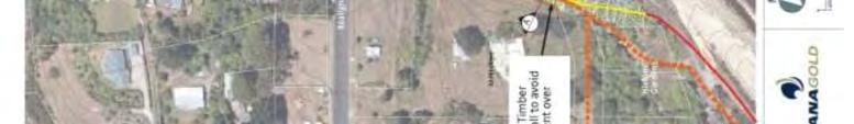
37 Figure 30. Plan showing 1917 and later levels (in green), with Shaft No. 1 and 2 depths at 1900 indicated in blue (source: Buxton-Blue Feb 2018) 85 William Street As part of the Project Martha MP4 proposed works, an area of land adjacent to the existing pit rim north wall will be affected by lateral expansion of the mine. Subsurface or near surface features relating to mining activities were not specifically identified during the site visit to this area, but access was restricted. Remains relating to mining activities are likely to be present within areas of undergrowth or topsoil and may be exposed during the mine expansion. The biggest impact of the pit works will be on 85 William Street, which falls entirely within the proposed new pit and would be destroyed. The property was not accessible at the time of the site visit; however, the aerials and Google street view show that it is occupied by several modern buildings, including a house and shed (Figure 31; Figure 32). Based on the photographs provided by Oceana Gold, the external physical characteristics of these buildings are late 20th century in date. The house is of brick clad masonry construction and the shed has metal sheathing, probably over a metal frame (Figure 33 Figure 35). The standing structures on 85 William Street are therefore not likely to be of historic heritage value. There may, however, have been a historical residence constructed on the site around the turn of the century, as indicated by the historical research. 4 Today there is no evidence for this earlier dwelling on aerial photographs, indicating it may have been demolished or relocated. It is possible that subsurface remains, such as domestic rubbish deposits found in other locations around the existing pit rim, may survive. At this stage it is uncertain if any such remains have survived, and if they have what date they would be; however, it is considered there is some/ low archaeological potential at this property. 4 On 14 April 1900 the Thames Star reported that th licence for Section 580, Waihi to John Gerrand. May 2018 Martha Project Historic Heritage Assessment 32
38 Figure 31. View of main dwelling at 85 William Street from the driveway (photo: Google Street Maps, accessed 19/02/2018) Figure 32. View of shed at 85 William Street from the driveway (photo: Google Street Maps, accessed 19/02/2018) May 2018 Martha Project Historic Heritage Assessment 33
39 Figure 33. Northern elevation of main house 85 William Street (photo: Oceana Gold March 2018) Figure 34. Western elevation of main house 85 William Street (photo: Oceana Gold March 2018) May 2018 Martha Project Historic Heritage Assessment 34
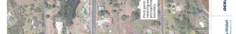
40 Figure William Street, west and south elevations (photo: Oceana Gold March 2018) MP4 Road Realignment The proposed realignment of Cambridge/ Bulltown Roads was inspected from the road. In addition to the carriageway itself, two residential properties will also be affected where the existing road will need to be realigned. 12 Cambridge Road is located on the north side of Cambridge Road, on the corner with Bulltown Road. During the site visit the building was identified as being possibly pre-1900 in date, based on its architectural characteristics a typical Late Victorian or Edwardian square fronted villa (Figure 36 Figure 38). The historical research carried out since the site visit was presented above (see historical research section). The villa was constructed sometime around the turn of the 20th century and is now recorded in the NZAA ArchSite database as T13/928, although further investigation is required to determine the exact date. The square-fronted villa has been modified in the past, with original bay windows replaced by French doors. The chimney appears to have been removed also and extensions made to the rear. A fair proportion of original fabric apparently survives, however. A detailed condition survey was not available at the time of inspection. Based on visual inspection from the public realm, the condition of the fabric is fair to moderate. Cambridge Road itself comprises modern road surfaces, kerbing and footpaths (Figure 39). The properties in the vicinity of the road realignment are all modern. The street appears to consist predominantly of mid late 20th century housing, with one other historical house at the western end of Cambridge Road (Figure 40). Therefore, although the roads were laid out at least by 1899/1901 and some houses are known to have been constructed around this May 2018 Martha Project Historic Heritage Assessment 35
41 time, Cambridge Road today does not have a strong historical character or a cohesive group of historical buildings that have survived. 77 Bulltown Road is north of 12 Cambridge Road, located on the west side of Bulltown Road. The property is occupied by several modern buildings, including a house and shed. The external physical characteristics of these buildings are mid late 20th century in date, consisting of timber framed and weatherboard construction (Figure 41). The standing structures on 77 Bulltown Road are therefore not likely to be of historic heritage value. There may, however, have been a historical residence constructed on the site around the turn of the century, as indicated by the historical research. 5 Today there is no evidence for this earlier dwelling on aerial photographs, indicating it may have been demolished or relocated. It is possible that subsurface remains may survive; however, it is uncertain at this stage if any such remains have survived and if so whether they would be pre-1900 in date. This part of Bulltown road has a semi-rural character, with sparsely spread housing, which is predominantly modern (Figure 42). It does not have a cohesive historical character or group of heritage buildings that would be affected by the road realignment or house demolitions. Figure 36. Villa at 12 Cambridge Road now recorded as T13/928 (photo: Brown 2017) 5 ed a licence for Section 80, Bulltown, Waihi, to Robert Lockhart. 31 January 1901 Licence for a Residence Site for Section 98 Township of Waihi granted to Eliza Patty Jones for a term of 42 years. May 2018 Martha Project Historic Heritage Assessment 36
42 Figure 37. View looking west along Cambridge Road, with villa at 12 Cambridge Road on the right (photo: Google Street Maps, accessed 19/03/2018) Figure 38. Corner of Cambridge Road, looking northeast towards where the new road will pass through 12 Cambridge Road (photo: Google Street Maps, accessed 19/03/2018) May 2018 Martha Project Historic Heritage Assessment 37
43 Figure 39. Cambridge Road looking east, showing modern properties to the west of 12 Cambridge Road, modern road surfaces, kerbing and footpaths (photo: Google Street Maps, accessed 19/03/2018) Figure 40. No. 2 Cambridge Road appears to be the only other historical house on the street (photo: Google Street Maps, accessed 19/02/2018) May 2018 Martha Project Historic Heritage Assessment 38
44 Figure Bulltown Road, view of house and shed from the road (photo: Google Street Maps, accessed 19/02/2018) Figure 42. Looking south down Bulltown Road towards the intersection of Cambridge Road (on right) (photo: Google Street Maps, accessed 19/02/2018) May 2018 Martha Project Historic Heritage Assessment 39
45 The Martha Underground (Including the Rex Orebody) Area The Martha and Rex underground components of the project will not affect any properties at the surface. In the area of the Martha underground project there are previously unmined ore blocks, as well as remnant mining blocks from the old Martha Mine under the existing pit, comprising either backfilled stopes or skins on unfilled voids. The proposed Martha underground component will extract the ore from both the virgin stopes and the remnant stopes (remnant ore skins and historical backfill) from under the existing Martha Pit and land to the east. There is a possibility of encountering underground archaeological remains associated with the old Martha Mine workings (T13/926) as part of the Martha underground component. Further research and modelling was carried out by Buxton-Blue, Resource Development Geologist, Oceana Gold to determine the likely extent of pre-1900 underground workings. Using the Oceana Gold archive development records stated in the mine records, Figure 43 shows a plan and isometric view of the recorded historic levels to reflect the extent of the development on levels 3 and 4 of the mine. Levels 2 and above do not have records of distance, on the level 2 and above. Based on this it is assumed that intersecting these lithologies would mark the extent of the development. The relationship of the proposed new works in relation to the pre-1900 historical workings are also shown in Figure 43. This is based on a 3D historic workings model and records of mine development from the Mine reports for Based on this analysis, the pre-1900 workings are likely to be present above, and generally further northeast of the proposed underground works. According to Buxton-Blue analysis, the majority of the pre-1900 historical workings have already been taken out by the current pit. The Rex orebody/ Martha Underground component will not intersect the pre-1900 historic workings and therefore is not likely to affect pre-1900 historical workings. However, there will be some interaction in the Martha Project MP4 pit where further cutting back of the pit edge will further impact on historical mining levels that have already been intersected on the current pit walls (as discussed above). May 2018 Martha Project Historic Heritage Assessment 40
46 Figure 43. The relationship of the proposed new Martha Underground works in relation to the pre historic workings, shown in green (source: Buxton-Blue Feb 2018) May 2018 Martha Project Historic Heritage Assessment 41
47 HISTORIC HERITAGE ASSESSMENT Summary of Results The historical research and site visit has established that Project Martha will impact on the following recorded historic heritage places: Possible pre-1900 dwelling identified at 12 Cambridge Road (Lot 1 DP 88853, part of Section 279 (previously Section 101) BLK XV Ohinemuri SD); and, Underground historical workings from the original Martha and Grand Junction Mines (T13/926); Furthermore, there is some/ low potential for archaeological remains within 77 Bulltown Road and 85 William Street, as there may have been historical residences on the properties in the past, which means that pre-1900 subsurface remains are possible. Other subsurface or near surface features relating to mining activities have not been specifically identified, but are likely to be present within areas of undergrowth or topsoil and may be exposed during the mine expansion. Maori Cultural Values This is an assessment of effects on archaeological values and does not include an assessment of effects on Maori cultural values. Such assessments should only be made by the tangata whenua. Maori cultural concerns may encompass a wider range of values than those associated with archaeological sites. The historical association of the general area with the tangata whenua is evident from the recorded sites, traditional histories and known Maori place names. There are no recorded sites of significance or value to Mana Whenua within the project area or nearby. Survey Limitations It should be noted that archaeological survey techniques (based on visual inspection and limited subsurface testing) cannot necessarily identify all sub-surface archaeological features, or detect wahi tapu and other sites of traditional significance to Maori, especially where these have no physical remains. Martha mine was active at the time of the site visit and although the project team was able to visit the previously recorded surface historic heritage places, the entire open pit was not investigated due to obvious health and safety considerations. Martha mine has, however, been well researched and archaeological investigations have been carried within the pit in the past. This enables a reasonable assessment of archaeological potential. The survey did not include a detailed site visit for the individual historical buildings identified. These buildings were identified from the public footpath based on their architectural style and were later researched to establish a likely date. No structural or condition surveys for the buildings were carried out. May 2018 Martha Project Historic Heritage Assessment 42
48 Archaeological Value and Heritage Significance Heritage NZ, has provided guidelines setting out criteria that are specific to archaeological sites (condition, rarity, contextual value, information potential, amenity value and cultural associations) (Heritage NZ 2006: 9-10). These criteria have been used to evaluate the value and significance of the archaeological sites below. The archaeological value of sites relates mainly to their information potential, that is, the extent to which they can provide evidence relating to local, regional and national history using archaeological investigation techniques, and the research questions to which the site could contribute. The surviving extent, complexity and condition of sites are the main factors in their ability to provide information through archaeological investigation. For example, generally pa are more complex sites and have higher information potential than small midden (unless of early date). Archaeological value also includes contextual (heritage landscape) value. Archaeological sites may also have other historic heritage values including historical, architectural, technological, cultural, aesthetic, scientific, social, spiritual, traditional and amenity values. The Hauraki District Plan (2014) contains a Schedule of Historic Heritage Inventory, 6 which is divided into Category A and B Heritage Features; Category C Heritage Items; and, Category A and B Heritage Areas in section 6.1. In Appendix 1 of the Hauraki District Plan ( ) the criteria for assessing heritage significance is grouped under historic, architectural, technological/scientific, archaeological, spiritual/cultural and context (see Appendix 2 of this report). The old Martha mine underground workings (T13/926) have not been scheduled for protection on the Hauraki District Plan. They are not listed by Heritage NZ in the New. Table 5 contains the assessment of the archaeological values of the Martha mine T13/926 based on the Heritage NZ criteria (Heritage NZ 2006: 9-10) and Table 6 assesses heritage values using the Hauraki District Plan criteria. Overall, site T13/926 (Martha mine), is considered to have moderate archaeological value based on the criteria discussed. It is likely that archaeological evidence of mining activity survives in places, but that much of the pre-1900 workings has now been destroyed by the change to open-pit mining activities (see the Buxton-Blue analysis above) and previous flooding of the underground workings. Any possible surviving remains would be of archaeological interest for their ability to provide information on mining techniques in the 19th century. However, it is noted that such techniques are also very well documented historically, so that archaeological investigation would typically confirm this documented history, rather than provide new information. The ability to access and enter historic workings is limited due to safety considerations. Notwithstanding this, it is expected that there will be opportunities to: Use laser scanning underground to accurately identify the extent of the old workings, From a safe position, photograph any pre-1900 workings that are intersected by the open pit, 6 There are also identified Areas of Significance of Maori, which are not covered by this report. May 2018 Martha Project Historic Heritage Assessment 43
49 Where it is safe to do so, retrieve items from the historic workings that might be useful for displays and interpretation, and carry out additional photography within the workings. The old Martha mine underground workings have moderate to high historic heritage value. Any surviving historical workings have strong contextual values in relation to the development of the Waihi Gold Mine and Waihi Town. The discovery of gold at Martha hill in 1878, early on in the New Zealand goldmining industry, is significant. The Martha Mine went on to be the largest and most profitable goldmine in New Zealand (Thornton 1982: 64). However, how much the underground workings reflect these historical aspects, past events and associations with important people/ companies, is probably limited by the inaccessible nature of the site and fragmentary survival of the remains themselves. The 19th/ early 20th century domestic villa (T13/928) identified during the site visit has not been recorded or evaluated previously. Table 7 contains the assessment of the archaeological values of the possible pre-1900 dwelling based on the Heritage NZ criteria (Heritage NZ 2006: 9-10). Table 8 contains the assessment of historic heritage values under the HDP. Overall, T13/928 is considered to have moderate historic heritage/ archaeological value based on the criteria discussed. This is because although villas are relatively common site types nationally and regionally, locally they are representative of the early development of Waihi as a township and together form a group of places representing this theme. The villa has potential to provide information on early inhabitants of the town through archaeological study of the building, associated subsurface features or artefacts that may be present. When compared to other places already included on the Hauraki District Plan heritage inventory, and without further information as to historical associations, the villa might be equivalent to a Category C item, but is unlikely to reach the threshold for higher categories. Other, so far unidentified, subsurface or near surface features relating to mining activities are likely to be present within areas of undergrowth or topsoil and may be exposed as part of Project Martha. These cannot be assessed for significance because the nature of any surviving features is unknown. However, as most of the significant sites and features within the project area have already been identified, it is likely that any previously unidentified features would have no more than a moderate contribution to our overall understanding of the mine and its historic operation. Similarly, any subsurface remains associated with 19th century domestic activities within the properties identified (77 Bulltown Road and 85 William Street) are likely to contribute moderately to our understanding of the development of Waihi town/ settlement. May 2018 Martha Project Historic Heritage Assessment 44
50 Table 5. Assessment of the archaeological values of the old Martha Mine underground workings T13/926 based on Heritage NZ criteria (Heritage NZ 2006: 9-10) Value Condition Rarity Contextual value Information potential Amenity value Cultural associations Other Archaeological Assessment It is likely that some of the old underground workings may survive in places from the original Martha Mine (1800s 1952). The pit has been greatly modified since this time, so a fair proportion of the original workings are unlikely to remain, but they will still survive in some places as evidenced by past archaeological investigations in the area. The historical underground workings are not rare locally, but nationally and regionally, mining activities from this date are relatively rare. The historical Martha Mine has considerable contextual value as one of a number of mining places in a much larger mining landscape in the Waihi area. It is associated with 19th and early 20th century mining in the region and other places operating in New Zealand at this time. The historical workings could include remnants of vertical shafts, the 175km long network of tunnels spread over many horizontal levels, as well as artefacts and remnant mining structures. Worked-out tunnels may show evidence of structural engineering, tool marks, quarry marks for identifying seams, or more informal evidence such as graffiti. The likelihood of encountering subsurface archaeological remains during works in this area is high (see the Buxton-Blue analysis above). This is of archaeological interest for its ability to provide information on mining techniques in the 19th and early 20th century. It is noted that such techniques are very well documented historically, but modern survey technology could offer new ways to investigate and display the archaeological values of the site. The workings are not visible at the surface, they are inaccessible to the public and in private ownership. There is no potential for amenity value to be enhanced through the proposal for operational reasons, and eventually the pit will be flooded at the completion of mining. The site at this depth is not known to have any specific associations with pre- European cultural groups. The site has European cultural associations, linked with European mining communities of the late 19th and early 20th century. The mine has historical value through its association with early mining companies in New Zealand, e.g. by the mid-1890s the Waihi Gold Mining Company was the largest producer of gold in New Zealand, and one of the largest in the world by the first decades of the 20th century. The mining history is strongly linked to the identity of Waihi so is likely to have public associations. The site has social interest with groups such as local historical societies, museums/ education centres and tourist operators. However, the historical mining activities are perhaps better represented by other places/ features that are more accessible and visible in the Waihi area. May 2018 Martha Project Historic Heritage Assessment 45
51 Table 6. Assessment of the historic heritage values of the Martha Mine old underground workings based on the Hauraki District Plan criteria (Section 6.1 Appendix 1: ) Value Historic Architectural Technological/ Scientific Archaeological Historic Heritage Assessment The discovery of gold at Martha Hill in Waihi in 1878, early on in the New Zealand goldmining industry, is significant. The Martha Mine went on to be the largest and most profitable goldmine in New Zealand (Thornton 1982: 64). The old mine began in 1879 and closed in 1952, during which time it produced 35,500,000 ounces of gold, worth 28,500,000 pounds at the time (ibid.). The underground workings themselves have largely been destroyed due to the substantial modern open-pit mining activities and it is unclear how much of these workings survive. It is therefore not possible to comment on whether it is a representative example of site type, age or other historical aspects. Martha mine is associated with many historical events, important people that have worked there, the mining companies themselves and the miners as a community. How much the underground workings physically reflect these historical aspects, commemorate or symbolise this past history is probably limited by the inaccessible nature of the site and fragmentary survival of the remains themselves. The various buildings and structures developed in the early Martha mine period consisted of drying kilns, stamper batteries, pumphouse, workshops, poppet heads, assay house, refinery building, water races and tramways. These were straightforward functional structures; however, No. 5 pump house at Waihi was one of the largest of its kind (along with Thames) and notable in this regard. The underground workings, where they survive, would be an example of the various methods of constructions for drives, adits, shafts etc. and their design was imported from England, which has an ancient metalmining tradition going back thousands of years. However, they are not buildings or visible structures, rather than utilitarian tunnels underground. Some of the big innovations in the industry (see Thornton 1982), such as pioneering the use of electricity in gold mining, the development of the gold dredge, and tremendous impact on gold production brought about by the advances in the cyanide process of gold extraction, are perhaps better represented at other sites locally (such as Union Hill, which has the largest reaming B & M tanks in New Zealand) and in New Zealand. Notwithstanding this, the particular local conditions and scale of mining (when at its height) did lead to the testing of new technology as it was developed and innovation in the mining process. According to McAra it was only by making use of scientific techniques in assaying, and persistent metallurgical experimentation that the Waihi Gold Mining Company achieved the success which led to the establishment of the Martha as one of the great mines of the world. The large stopes in the friable oxidised ore in the shallow workings of the mine also presented problems requiring new techniques. It is a testimonial to the skill and ingenuity of those concerned (1988: 170). Notwithstanding this, the underground workings are largely destroyed and the formation of these followed conventional practice, which is well documented, so there is probably limited opportunity for the site to be a representative example of engineering innovation. The site has potential to expand upon our knowledge of early mining activities through archaeological methods and meets the definition of an archaeological site for the pre-1900 underground workings. Due to the May 2018 Martha Project Historic Heritage Assessment 46
52 Value Spiritual/ Cultural Context Historic Heritage Assessment substantial modern open-pit mining activities it is unclear how much of the pre-1900 workings survive. It is therefore not possible to comment on whether it is a representative example of a site type, feature or activity. It is not a Heritage NZ listed archaeological site, but has been recorded as an archaeological site through this assessment. Given the long mining legacy and celebration of this history within Waihi today (such as display and interpretation of the pumphouse, poppet replica head, pit rim walk, interpretation panels and sculptures in the town) it is likely that the community does have some association with the site. Given that this aspect of mining is not publicly accessible or visible, this perhaps will limit the value of the site in terms of being a physical marker/ source of identity. historical mining landscape and a component of what physically survives today at Martha mine from the 19th and early 20th century. The Martha mine is also important within the context of the New Zealand industry as a whole. Gold was first recovered in the northern district of New Zealand in 1852 near the Coromandel (Thornton 1982). In the 1950s gold was found in Collingwood, various parts of Otago and the west coast of the South Island and Marlborough. However, according to Thornton, The real impact of goldminig as an industry was to follow the discovery of the quartz reefs, first in Thames from 1867 onwards, and then the Coromandel spreading to Karangahake, Waihi, Waikino, Waitekauri, Kuaotuna and many other places in the Coromandel and Ohinemuri districts (Thornton 1982: 64). The site is not in a listed historic area and the underground workings are not visible to the public, so do not have visual amenity/aesthetic value. May 2018 Martha Project Historic Heritage Assessment 47
53 Table 7. Assessment of the archaeological values of the possible pre-1900 dwelling 12 Cambridge Road T13/928; based on Heritage NZ criteria (Heritage NZ 2006: 9-10) Value Condition Rarity Contextual value Information potential Amenity value Cultural associations Other Archaeological Assessment The square-fronted villa has been modified in the past, with original bay windows replaced by French doors. The chimney appears to have been removed and an extension added to the rear. A fair proportion of original fabric apparently survives, however. A detailed condition survey was not available at the time of inspection. Based on visual inspection from the public realm, the condition of the fabric is fair. The square-fronted villa is not a rare form nationally or regionally, but is relatively rare in the local context. There is just one other villa identified on the street, despite Cambridge Road being laid out at the turn of the century. No. 12 Cambridge Road therefore has some value as a surviving example of a locally rare building typology. The square-fronted villa has contextual value as one of a group of locally surviving places associated with the former 19th and early 20th century mining/rural environment of the Waihi Township an example of an Edwardian mine The villa has some archaeological interest for its ability to provide information on construction techniques and traditional plan forms for modest dwellings of the late 19th and early 20th century. There may be surviving sub-surface features which could provide more information on the subject site during this period. The square-fronted villa has some amenity and landscape value as an example of late 19th or early 20th century vernacular domestic architecture. The building owned by OGNZL, but the exterior is visible from the public realm. The site is not known to have any specific associations with pre-european cultural groups. The site has European cultural associations, linked with European Waihi mining/farming communities of the late 19th and early 20th century. The earliest licence for a residence site that could be found was granted to Daniel McLennan (also referred to as McClennan), of Waihi (a carpenter) in 1900, but earlier records could exist. During the early 20th century the property was owned by a local miner and battery hand. May 2018 Martha Project Historic Heritage Assessment 48
54 Table 8. Assessment of the historic heritage values of 12 Cambridge Road based on the Hauraki District Plan criteria (Section 6.1 Appendix 1: ) Value Historic Architectural Historic Heritage Assessment The property records do not suggest that anyone nationally or regionally important has lived at the residence. The local significance of any historical associations is unknown at this stage; however, research to date does not indicate the residence is associated with any important historic event. 12 Cambridge Road relates to the first road formation and settlement in this area, around the turn of the century. Records suggest the property was been owned by a local carpenter, miner and battery hand in the past. The square-fronted villa has been modified over the years, although a fair proportion of original fabric apparently survives. The villa is not a rare form nationally or regionally, but is a typical example of Late Victorian/Edwardian period domestic architecture in the local context. Due to past changes to the building more intact examples are apparently evident within Waihi, which may be better examples of a villa typology (noting that a full inspection of the building by the author has not been carried out). The villa is not an important work of a notable architect, designer, engineer or builder. Technological/Scientific As seen from the public realm, the villa appears to have been constructed using standard techniques and materials available at the time. The interior was not examined. Archaeological The villa has some archaeological interest for its ability to provide information on construction techniques and traditional plan forms for domestic villas of the late 19th and early 20th century, as well as the inhabitants that once lived there. There may be surviving sub-surface features which could provide more information on the subject site during this period. Spiritual/Cultural Not assessed. To be determined by Mana Whenua and the local community. Context The square-fronted villa has contextual value as one of a number of locally surviving places associated with the former 19th and early 20th century mining/residential environment of the Waihi Township May 2018 Martha Project Historic Heritage Assessment 49
55 EFFECTS OF THE PROPOSAL The Proposal Project Martha comprises two key components: The Martha Phase 4 pit (MP4); and, The Martha Underground, including the Rex orebody. The MP4 cut back will be mined in a single top down sequence at the northern wall of the existing Martha pit. The conceptual plan of MP4 within the Project Area is shown in Figure 44. Points of note are that MP4 requires partial relocation / realignment of Bulltown Road; provides overburden to backfill the underground mine, and, requires noise bunds or fences to be constructed on the north wall. Once completed the pit area will be approximately 51 hectares, with a depth of approximately 275metres and the total volume will be approximately 43 million cubic metres. The earthworks for the road realignment are shown in Figure 3 (above). The total cut volume for these earthworks is approximately m 3, and the total fill volume is m 3. Areas of cut are predominantly to the west of Bulltown Road (pitside) which requires a maximum depth of excavation up to 1.12m. The east side of the road will require fill up to 1.34m above existing ground level, but there may be discrete locations of cut up to 1m in depth where localised deposits are unsuitable as a base for the fill. The total area of possible cut is not known at this stage. Construction of a noise bund or noise control fence is also required along the north-eastern and northern edge of the pit rim within OGNZL land (Figure 45). This will be achieved through raising fill along the perimeter of the pit edge. A 3m-wide pit rim walkway will then be re-established in this location. The construction of the bund may require some minor grading of the pit edge and driving of retaining walls at one location as indicated in the plan. The Martha Underground involves mining underneath the existing Martha pit and to the east (Figure 46). Ore sources comprise previously unmined blocks AVOCA stopes, remnant mining blocks either backfilled or skins on unfilled stopes and ore development. The earthworks are believed to be below the existing level of historical (i.e. pre-1900) workings. It is planned to place 490,000 cubic metres of backfill into the historic voids as part of the mining method in the Royal, the Empire, the Edward and the Martha. The Martha Underground Mine will utilise existing authorised surface and underground facilities, so there is a very limited surface expression of the project (Figure 47). Rex is included as part of the Martha Underground component of the project (Figure 48). This will extract 225,000 tonnes of ore. There will be no surface expression of the project and the historic stope will not be intersected. Following completion of the MP4 and Martha Underground mining works, rehabilitation activities will be undertaken including decommissioning of plant, spreading of soil and planting. In the case of the pit, flooding will be undertaken to create a recreational lake, with provision of some community facilities at the eastern end of the pit (within the current surface facilities area). May 2018 Martha Project Historic Heritage Assessment 50

56 Figure 44. Conceptual Plan of Martha Phase 4 Pit within the Project Area May 2018 Martha Project Historic Heritage Assessment 51

57
58 Figure 46. Conceptual plan of Martha underground mine within the project area Figure 47. Surface expression of the Martha Underground Project May 2018 Martha Project Historic Heritage Assessment 53
59 Figure 48. Plan of Rex Underground Mine within the Project Area May 2018 Martha Project Historic Heritage Assessment 54
60 Heritage Effects of the Proposal The nature and significance of the historic heritage places within the project area have been assessed above. The potential impact of the proposal on the identified places is now considered, particularly in relation to direct physical impacts, as well as setting and context. The likely adverse effect on historic heritage as a result of Project Martha is largely confined to the Martha Phase 4 pit (MP4) component. The proposed Martha Underground, including the Rex orebody, will have no direct physical impact on any historic heritage items recorded or protected within and adjacent to the Martha pit. The MP4 component will result in the following historic heritage effects: Demolition of one late 19th century/ early 20th century villa at 12 Cambridge Road (T13/928) Destruction or modification of possible 19th century archaeological underground mining workings (T13/926) arising from land disturbance, and eventual flooding of the mine Destruction or modification of possible unrecorded 19th century archaeological subsurface remains relating to settlement/ domestic dwellings or mining activities arising from land disturbance One historical house (late 19th or early 20th century) will need to be removed for the new road realignment at Cambridge/ Bulltown Road. Although this property is not scheduled, The building is possibly pre-1900 in date so there would potentially be a moderate impact on archaeological values as well. Oceana Gold have confirmed that they will relocate the building at 12 Cambridge Road, to an appropriate property in Waihi. Relocation options were still being considered at the time of this report. This recommended mitigation is based on a long-term consideration of cumulative effects on heritage and archaeology, for example if other historical buildings in Waihi may need to be relocated through future mining projects. Adverse effects should also be mitigated by the monitoring of earthworks within the property at 12 Cambridge Road (T13/928), in case pre-1900 archaeological remains are present. It is likely that the MP4 component will impact upon some of the old underground workings (T13/926) that may survive in places from the original Martha Mine ( ). Due to modern open-pit mining activities much of the old workings have been destroyed previously. It is likely that the effects on pre-1900 underground workings will be limited to the destruction of one historical workings level, which is already largely destroyed, at the existing northern pit wall. The underground remains are currently inaccessible to the public and their knowledge potential cannot be utilised in situ, but any archaeological investigations could be publicly disseminated. Although health and safety considerations will limit the techniques available it is possible that adverse effects on T13/926 can be appropriately mitigated through archaeological investigation consisting of laser scanning underground to accurately identify the extent of the old workings, photography and retrieval of items where it is possible to do so safely. This additional information will aid our understanding of early mining activities at Martha. May 2018 Martha Project Historic Heritage Assessment 55
61 Past archaeological investigation within and near the Martha pit have revealed numerous industrial features and foundations associated with early mining activity, as well as the remains of 19th and early 20th century domestic house sites, particularly the southeast and south sides of Martha Hill. The historical research indicates that two historical houses may have been present within the area of works which are now gone, but associated subsurface remains are still possible. It is possible that earlier 19th century road surfaces may survive under the base course of the existing Cambridge and Bulltown Roads. There is some potential for unrecorded subsurface remains to be uncovered during earthworks. There will be no effects on the setting and views of key historic heritage items or heritage landscapes as a result of any components of Project Martha. The impact of the Cambridge/ Bulltown Road realignment was considered in terms of the streetscape context and it was concluded that although the roads and housing in this area was developed around the turn of the century, there is very little of this historic character evident today. Furthermore, the majority of these streets will remain intact, with just a small section of road altered. The likely mitigation for any adverse effects on historic heritage as a result of Project Martha includes: Archaeological research and investigation of underground workings from the original Martha Mine (T13/926), 7 which will aid our understanding of early mining activities at Martha; Relocation or building recording of the late 19th century/ early 20th century villa at 12 Cambridge Road (T13/928) and archaeological monitoring of earthworks, which will aid our understanding of early residential settlement in Waihi and the mining communities that once lived in the area; An archaeological report (required as part of any archaeological investigations) will be provided to Heritage NZ, Hauraki District Council (Cultural Heritage Inventory), and the NZAA ArchSite database, which will further our understanding ; Subject to what is uncovered, new information could be included in future projects/ upgrades to the Martha Pit Rim Walkway heritage interpretation, which is a resource for visitors and the community; and, Further heritage interpretation, outreach and education opportunities for the local community (e.g. there is potential to do this through the Waihi Heritage Vision, Ohinemuri website, Martha Mine education centre, Gold Discovery centre/ Waihi Visitor centre, Oceana Gold website and/ or a booklet. Overall, the effects on historic heritage are likely to be of a minor adverse nature in relation to the proposed Project Martha and can be appropriately managed through the mitigation measures outlined (above). 7 The methodology for this is still to be confirmed with the Oceana Gold. This will necessarily be guided by historical interpretation of the 3D mapping of the filled and unfilled stopes, which will aid our understanding of early mining activities at Martha Hill May 2018 Martha Project Historic Heritage Assessment 56
62 STATUTORY REQUIREMENTS Resource Management Act 1991 Requirements Section 6 of the RMA recognises as matters of national importance: Maori and their culture and traditions with their ancestral lands, water, sites, waahi tapu, All persons exercising functions and powers under the RMA are required under Section 6 managing the use,. There is a duty to avoid, remedy, or mitigate any adverse effects on the environment arising from an activity (S17), including historic heritage. those natural and physical resources that contribute m any of the following qualities: (i) archaeological; (ii) architectural; (iii) cultural; (iv) structures, places, and areas; (ii) archaeological sites; (iii) sites of significance to Maori, including wahi tapu; (iv) surroundings associated with the natural and physical resources Regional, district and local plans contain sections that help to identify, protect and manage archaeological and other heritage sites. The plans are prepared under the rules of the RMA. The Waikato Regional Policy Statement (2016), Hauraki District Plan (2014) and Waikato Regional Plan (2012) are relevant to the proposed activity. Waikato Regional Policy Statement (RPS) Chapter 3 (objectives) of the Waikato RPS states that Sites, structures, landscapes, areas or places of historic and cultural heritage are protected, maintained or enhanced in order history and culture (3.18 Historic and cultural heritage). Policy 4.4 (on regionally significant industry and primary production, such as mining) aims to ensure: operation and development of regionally significant industry and primary production activities by: c) ensuring the adverse effects of regionally significant industry and primary production are avoided, remedied or mitigated; g) promoting positive environmental outcome Policy 6.1 (on the built environment) states that: Subdivision, use and development of the built environment, including transport, occurs in a planned and co-ordinated manner which: a) The General development principles in section 6A outline that: May 2018 Martha Project Historic Heritage Assessment 57
63 j) maintain or enhance landscape values and provide for the protection of historic and cultural heritage; The other policies in the RPS that are of most relevance to heritage and archaeology include: Policy 10.1 Managing historic and cultural heritage. Provide for the collaborative, consistent and integrated management of historic and cultural heritage resources. Improve understanding, information sharing and cooperative planning to manage or protect heritage resources across the region; ther taonga; Policy 10.3 Effects of development on historic and cultural heritage. Manage subdivision, use and development to give recognition to historic and cultural heritage and to integrate it with development where appropriate; and, Policy 12.3 Maintain and enhance areas of amenity value. Areas of amenity value are identified, and those values are maintained and enhanced. These may include:... b) ; This assessment addresses objective 3.18 of the Waikato Regional Policy and the above policies through the archaeological survey and research of the project area, to determine whether significant historic heritage places, or previously unidentified historic heritage, is affected by the proposal. The assessment has determined that two archaeological sites of moderate value (T13/926 and T13/928) will be affected, but that these effects can be mitigated through archaeological investigation and recording, and possibly by relocation of a heritage building. No significant historic heritage places (either those included in the Hauraki District Plan, or listed by Heritage New Zealand) will be affected. Hauraki District Plan (HDP) Section 6.1 of the HDP on Historic Heritage is relevant to all aspects and locations within the project area. Key objectives, policies and assessment criteria for the proposal are provided in the table below (Figure 49). There are no controlled or prohibited activities in Section 6.1. The HDP contains a Schedule of Historic Heritage Inventory, which is divided into Category A and B Heritage Features; Category C Heritage Items; and, Category A and B Heritage Areas. There are also identified Areas of Significance to Maori, which is not covered by this report. Under the exceptions ( ) of the Historic Heritage provisions are archaeological sites (1). This states (a) that: There are no rules applying in the District Plan with particular respect to archaeological sites. Where an archaeological site is included in the schedule of Historic Heritage Inventory as an Area of Significance to Maori, the rules in Sections apply. All other known archaeological sites are shown on the planning maps for information purposes only. May 2018 Martha Project Historic Heritage Assessment 58
64 The Advice Note to this exception states that: recording, protection and preservation of archaeological sites whether registered or not. (ii) If any land use activity (such as earthworks, fencing or the erection or removal of structures) is likely to damage, modify or destroy any pre-1900 archaeological Zealand must be obtained for the work to lawfully proceed. This applies to all sites, regardless of whether Building or Resource Consents have been granted or not. Heritage New Zealand should be contacted for further information on this The historic heritage provisions therefore relate to those places on the Schedule of Historic Heritage Inventory, with archaeological sites being managed though the Heritage New Zealand Pouhere Taonga Act 2014 (HNZPTA 2014). Policy A (iv) does provide for including (where appropriate) accidental discovery protocols, as a condition of resource consent and/or as advice notes with resource consents, advising developers and property owners of their obligations under the HNZPTA 2014 with regards to archaeology. Figure 49. Hauraki District Plan Section 6.1 Historic Heritage Objectives and Policies (1) OBJECTIVE 1 To protect a range of heritage items that reflect the past history of the Hauraki District from the adverse environmental effects of other activities. (a) Policies Objective 1 will be achieved by the implementation of the following policies: (i) Identify and afford protection to a representative range of historic heritage items of value to the community and the nation, recognising that it is not sustainable to protect all built heritage in the District and that some items have greater heritage value and deserve a higher level of protection than others. (ii) Minimise the effects of activities, subdivision and development which could damage or destroy the historic heritage values associated with scheduled historic items. (iii) Ensure the heritage and amenity values of the built heritage resource are not adversely affected by a change in context or physical location. (iv) Encourage the design of new buildings and structures and external alterations or additions to building facades to be compatible with the scale, detailing, style, materials and heritage character of the Waihi and Paeroa Town Centre pedestrian frontage areas. Note: The rules and guidelines are set out in section 5.11 Town Centre Zone. (v) Liaise with and seek advice from Heritage New Zealand on heritage planning generally and on all matters relating to sites listed by Heritage New Zealand, and consult with and seek advice from recognised local heritage groups on local heritage matters. May 2018 Martha Project Historic Heritage Assessment 59
65 (vi) Consult with and seek advice from the tangata whenua on all matters relating to identified waahi tapu sites, areas, and other features of significance to them. (vii) Draw to the attention of developers the requirements of the Heritage New Zealand Pouhere Taonga Act 2014, where the Council is of the view a proposed development may involve the destruction, or modification, of any archaeological site. (viii) Where it is appropriate to require them, have regard to cultural values assessments and/or cultural impact assessments, heritage assessments and conservation management plans. (2) OBJECTIVE 2 knowledge and appreciation of the past. (a) Policies Objective 2 will be achieved by the implementation of the following policies: (i) Identification and scheduling of archaeological sites with significant historic, cultural, scientific, heritage or visual amenity value. (ii) Ensure that subdivision, land use and development does not result in inappropriate damage or destruction of scheduled archaeological sites and their surrounds. (iii) Draw the attention of developers and property owners to the requirements of the Heritage New Zealand Pouhere Taonga Act 2014 where a proposed subdivision, land use or development may involve the destruction or modification of any archaeological site. (iv) Include where appropriate accidental discovery protocols, as a condition of resource consent and/or as advice notes with resource consents, advising developers and property owners of their obligations under the Heritage New Zealand Pouhere Taonga Act 2014 with regards to archaeology. (3) OBJECTIVE 3 To recognise and protect sites of significance to Maori. (a) Policies Objective 3 will be achieved by the implementation of the following policies: (i) Identification and protection, in consultation and partnership with local iwi, of sites of significance to Maori. (ii) Avoid a reduction of historical, cultural and spiritual values associated with sites of significance to Maori. (iii) Avoid, remedy or mitigate the adverse effects of subdivision, land use and development on identified Areas of Significance to Maori. (iv) Ensure that local iwi are consulted over the use, development or protection of sites of significance to Maori. (5) OBJECTIVE 5 Sustainable management of the built heritage resource by encouraging and promoting adaptive reuse of the built heritage features resource. May 2018 Martha Project Historic Heritage Assessment 60
66 (a) Policies Objective 5 will be achieved by the implementation of the following policies: (i) Encourage the continued use or adaptive reuse of scheduled heritage buildings, provided any adverse effects of the activity on the heritage values can be avoided, remedied or mitigated. (ii) Relaxation or waiving of parking requirements or bulk and location rules where this would encourage sustainable reuse and protection of heritage values ASSESSMENT CRITERIA FOR DISCRETIONARY ACTIVITIES (1) The following criteria will be used to assess any application for a Discretionary Activity: (a) Reasons for inclusion of the Heritage Item, and its significance, in the schedule of Historic Heritage Inventory. (b) The extent to which the heritage values are likely to be retained, protected and/or enhanced. (c) The reasons why the works are necessary and whether there are other means of achieving the same or similar ends with less adverse affects on the Heritage Item. (d) Degree of modification or alteration that will be caused to the Heritage Item, whether the modification is reversible and whether it will have cumulative adverse effects on the Heritage Item. (e) Design, materials and finish of proposed alterations or additions to the Heritage Item. (f) Impact on the cultural landscape or streetscape values from an amenity and heritage perspective. (g) Whether the relevant iwi have been consulted (for any Heritage Item which is significant to them) and whether the consultation supports the application. (h) The extent to which the works may adversely affect cultural and spiritual values. (i) Whether the proposal is consistent with the objectives of any current iwi management plan, current conservation management plan or heritage assessment relating to the Heritage Item, and more particularly the stated conservation policies and strategies they identify for the item. (j) Whether Heritage New Zealand has been consulted and whether the consultation supports the application. (k) Whether the conservation principles contained within the ICOMOS NZ Charter for the Conservation of Places of Cultural Heritage Value are applicable, and where applicable, have they been substantially adhered to. (l) The costs and technical feasibility of remediation and restoration. (m) In relation to an application for alteration or addition to a Heritage Building not in conformity with the zone development standards and/or the District wide performance standards: May 2018 Martha Project Historic Heritage Assessment 61
67 (i) whether conformity with the zone development standards would change the intrinsic value and character of the Heritage Building; (ii) whether the purpose of the addition or alteration is to accommodate an activity that will positively encourage the protection and preservation of the Heritage Building. (n) In relation to an application for the removal and relocation of a Heritage Feature: (i) The appropriateness of the proposed site, where relocation is proposed. (ii) The ability of the feature to withstand relocation from a structural perspective. (iii) The importance (if any) of the land or street setting surrounding the Heritage Feature in its present location. (iv) The extent to which the historical, cultural and community associations with the building will be reduced by the relocation. The assessment has determined that two previously unrecorded archaeological sites of moderate value (T13/926 and T13/928) will be affected by the project, but that these effects can be mitigated through archaeological investigation and recording, and possibly by relocation of a heritage building. This assessment has established that the likely heritage values of these sites are moderate overall as they relate to the HDP criteria for assessment. No significant historic heritage places (either those included in the Hauraki District Plan as heritage items, or those listed by Heritage New Zealand) will be affected. Place/ Zone Specific Provisions In addition to the objectives and policies above, there are a number of place or zone specific policies within the HDP which are also relevant to historic heritage. Waihi Objective 1 seeks To enable the people and community of Waihi to provide for its service town role to the surrounding rural area, as well as its role in the mining and tourist industries, at the same time as maintaining an attractive residential environment (5.6.4). Objective 1 will be achieved by implementation of the following policies (a): Recognise the significance of mining and the ongoing associated developments to the social and economic wellbeing of the residents of Waihi, subject to maintaining the amenity values of Waihi. (iii) Recognise and protect the Goldfields Steam Train complex, protect buildings and sites for their historic importance, and seek to retain and enhance Waihi Objective 2 seeks To enable and encourage development that responds to and enhances the distinctive natural and built character of Waihi (5.6.4). Objective 2 will be achieved by implementation of the following policies (a): (i) Enhance the mainstreet historic mining character of the central area in respect of the form, scale, bulk, location, heritage and architecture of buildings and infrastructure. May 2018 Martha Project Historic Heritage Assessment 62
68 (ii) Respect the existing townscape character of Waihi (street layout, existing residential character, cottages) in new development and encourage visual and physical linkages to local features such as the Pumphouse, Waitete Stream, Ohinemuri River, and hills of the Coromandel Range (to the north of Waihi). (iii) Enhance the presence of town centre heritage/character buildings and local landmarks through streetscape design and any redevelopment/development initiatives that may affect the viewing quality and appreciation of these (vi) Maintain and enhance the amenity of the residential environment in the Residential and Low Density Residential Zones. To maintain and enhance the historical style and scale of buildings which contribute to the attractive character of the town centres of Paeroa and Waihi implementation of the following policies (a): (i) Ensure new development and alterations and additions to the street façade in the pedestrian areas of the Paeroa and Waihi town centres are sympathetic to the character of the streetscape. The proposal supports the mining industry, which is a strong historical and community identity, and does not affect the historic town centre. Section of the HDP contains specific objectives and policies relating to the Martha To provide for the utilisation of the mineral resource in a sustainable manner. Objective 1 will be achieved by the implementation of the following policies: (i) Recognise the development of the mine and its processing areas, its ongoing rehabilitation and its longer term likely uses. (ii) Provide for the social, economic and cultural well-being of the people of the District and for their health and safety. (iii) Ensure that the amenity values of Waihi and the wider community are protected. (iv) Recognise that the risks associated with the historic underground working areas require a mixture of approaches to avoid, remedy or mitigate those hazards and provide for appropriate longer term land use activities The further working of the mine will remove some of the historic underground workings that still survive within the Martha mine pit. This would presumably meet the direction of policy (i), and policies (ii) and (iv) where they relate to historical mining hazards. The loss of these historical features can be mitigated to an acceptable level, through archaeological recording. Any information gained c - interpretation or any remains uncovered, and through making technical heritage reports accessible to the general public. May 2018 Martha Project Historic Heritage Assessment 63
69 Waikato Regional Plan (Waikato RP) The Waikato Regional Plan primarily considers matters of cultural heritage where they are identified as matters of significance to Maori. Most relevant to this project is Section 5 of licies on the management of soil erosion, and Section Policy 1 contains the following statement with regard to sites of importance to Tangata Whenua, including archaeological sites of Maori origin: Policy 1: Managing Activities that Cause or Have the Potential to Cause Accelerated Erosion and Encouraging Appropriate Land Management Practices Through permitted activities and non-regulatory methods manage activities that cause or have the potential to cause accelerated erosion, with particular regard to: e) the potential to adversely affect waahi tapu and archaeological sites or other identified sites of importance to tangata whenua as Kaitiaki It should be noted that although no sites of importance to tangata whenua have been recorded in the project area, there are archaeological sites of Maori origin recorded elsewhere in the region of Waihi. Accidental discovery protocols should be therefore be followed should any previously unidentified archaeological sites be revealed as a result of the proposed works. For any sites pre-dating 1900 this is a legal requirement under the HNZPTA 2014 (discussed in more detail in the following section). Summary of Historic Heritage Requirements under the RMA No resource consents will be required for historic heritage as no scheduled historic heritage items are affected by the proposal. Any consent granted should include accidental discovery protocols, as a condition of resource consent, advising OGNZL of their obligations under the Heritage New Zealand Pouhere Taonga Act 2014 with regards to archaeology. There is a general requirement under the Resource Management Act 1991 to protect historic heritage from inappropriate development (S6(f)) if unknown significant historic heritage items are uncovered during the proposed works. Heritage New Zealand Pouhere Taonga Act 2014 Requirements In addition to any requirements under the RMA, the HNZPTA protects all archaeological sites whether recorded or not, and they may not be damaged or destroyed unless an Authority to modify an archaeological site has been issued by Heritage NZ (Section 42). An archaeological site is defined by the HNZPTA Section 6 as follows: archaeological site means, subject to section 42(3), (a) any place in New Zealand, including any building or structure (or part of a building or structure) that (i) was associated with human activity that occurred before 1900 or is the site of the wreck of any vessel where the wreck occurred before 1900; and May 2018 Martha Project Historic Heritage Assessment 64
70 (ii) provides or may provide, through investigation by archaeological methods, evidence relating to the history of New Zealand; and (b) includes a site for which a declaration is made under section 43(1) 8 Under Section 42(3) an Authority is not required to permit work on a pre-1900 building unless the building is to be entirely demolished. Authorities to modify archaeological sites can be applied for either in respect to archaeological sites within a specified area of land (Section 44(a)), or to modify a specific archaeological site where the effects will be no more than minor (Section 44(b)), or for the purpose of conducting a scientific investigation (Section 44(c)). Applications that relate to sites of Maori interest require consultation with (and in the case of scientific investigations the consent of) the appropriate iwi or hapu and are subject to the recommendations of the Maori Heritage Council of Heritage NZ. In addition, an application may be made to carry out an exploratory investigation of any site or locality under Section 56, to confirm the presence, extent and nature of a site or suspected site. The likelihood of encountering subsurface archaeological remains related to former 19th century mining activities (T13/926) is high and they cannot be avoided. An Authority should therefore be obtained prior to works commencing. The conditions of the authority are likely to include the archaeological recording/investigation of any remains affected. If the development involves the total demolition of the potentially pre-1900 building (T13/928) at 12 Cambridge Road, an Authority must be obtained from Heritage NZ before any work can be carried out that may affect the site. The conditions of the authority are likely to include the archaeological recording and investigation of the building prior to and during demolition, if it is not feasible to relocate it. Given the moderate archaeological significance of the building the recommended level of recording is a Level III (based on Heritage NZ 2014 guidelines). This is consistent with the assessed archaeological significance of the building. If the building can be relocated rather than demolished, as OGNZL have confirmed, recording will not be necessary, but an authority would still be required as there is the potential for associated subsurface pre-1900 remains. While no other known archaeological sites will be affected by the proposed works, it is considered possible that unidentified subsurface archaeological remains may be exposed during development. To avoid any delays should unidentified subsurface features be exposed by the proposed works, consideration could be given to applying for an authority under Section 44(a) of the HNZPTA to cover all works undertaken for the MP4 project, as a precaution. This approach would have the advantage of allowing any archaeology uncovered during the development of the property to be dealt with immediately, avoiding delays while an Authority is applied for and processed. 8 Under Section 43(1) a place post-dating 1900 (including the site of a wreck that occurred after 1900) that significant evidence relating to the historical and cultural heritage of New Zealand declared by Heritage NZ to be an archaeological site. May 2018 Martha Project Historic Heritage Assessment 65
71 Conclusions The MP4 component of Project Martha will result in the following historic heritage effects: Realignment of Bulltown Road will result in the relocation of one late 19th century/ early 20th century villa at 12 Cambridge Road (T13/928); Realignment of Bulltown Road may also reveal or destroy unrecorded 19th century subsurface archaeological remains relating to settlement/ domestic dwellings or mining activities within the project area; There is a high probability that any pre-1900 subsurface archaeological features (T13/926) surviving in historical workings along the northeast edge of the Martha Mine pit will be destroyed by the pit expansion in this area. This cannot be avoided, but can be mitigated through archaeological techniques; and, Any findings from archaeological recording and analysis of the sites to be affected will add to the general knowledge of the historical mining community at Waihi, and this information can be interpreted or made accessible to the public. No resource consents will be required for historic heritage as no scheduled historic heritage items are affected by the proposal. However, two previously unrecorded archaeological sites (T13/926 and T13/928), have been identified as a result of field survey and research. Therefore any consent granted should, as a condition of resource consent, include accidental discovery protocols and an advice note advising OGNZL of their obligations under the Heritage New Zealand Pouhere Taonga Act 2014 with regards to archaeology. The proposal involves the removal of the building at 12 Cambridge Road, which is possibly pre-1900 in date. OGNZL have confirmed that the building will be relocated rather than demolished. However, any earthworks within the property are likely to disturb any surviving sub-surface archaeological features associated with the dwelling at 12 Cambridge Road, effects on which will also require an Authority under the HNZPTA, and there is some potential for similar deposits to be disturbed at 77 Bulltown Road. There is a lesser potential for such features to be revealed at 85 Williamson Street, but the possibility of surviving archaeological features of pre-1900 date cannot be discounted. May 2018 Martha Project Historic Heritage Assessment 66
72 RECOMMENDATIONS Any consent granted should, as a condition of resource consent, include accidental discovery protocols and an advice note advising OGNZL of their obligations under the Heritage New Zealand Pouhere Taonga Act 2014 with regards to archaeology. Since the proposal may involve the destruction of archaeological remains associated with a pre-1900 building at 12 Cambridge Road, and destruction of 19th century underground mining workings, an Authority must be applied for under Section 44(a) of the HNZPTA and granted by Heritage NZ prior to the start of any works that will affect the building or could impact on pre-1900 subsurface remains. (Note that this is a legal requirement). The conditions of the authority should include investigation and recording of any pre-1900 archaeological remains affected by project works. The conditions of the authority should include remote investigation and research using modern survey techniques to recover information about the underground mining workings. The Authority should include all earthworks within the MP4 area as a precaution so that potential delays can be avoided should other sites be exposed. Detailed recommendations for archaeological investigation and recording should be set out in the Archaeological Management Plan (AMP) that will accompany an application for an Authority to modify an archaeological site. The proposal should provide for permanent or temporary interpretative material, which is visible to the public, and explains the history of the Waihi Mine if access is limited to the pit rim walk during works. Information on the history of the site and any outcomes from the archaeological investigations should be made available to the public, including on the Oceana Gold website. May 2018 Martha Project Historic Heritage Assessment 67
73 BIBLIOGRAPHY Brown, A., Z. Burnett and R. Clough. May Oceana Gold Project Martha, Waihi: Part 1 Historical and Archaeological Background. Clough & Associates report prepared for Oceana Gold. Buxton-Blue, C. Feb Unpublished OGNZL Research McAra J. B Gold Mining at Waihi Martha Press, Waihi. Thornton, G New Zealand's Industrial Heritage. A.H. and A.W. Reed Ltd., Wellington May 2018 Martha Project Historic Heritage Assessment 68


74 APPENDIX 1: SITE RECORD FORMS I May 2018 Martha Project Historic Heritage Assessment 69


75 May 2018 Martha Project Historic Heritage Assessment 70
APPENDIX 9: Archaeological Assessment by Ken Phillips
 APPENDIX 9: Archaeological Assessment by Ken Phillips ARCHAEOLOGICAL ASSESSMENT PROPOSED SERVICE STATION DEVELOPMENT BRUCE ROAD, PAPAMOA TAURANGA Prepared by KEN PHILLIPS (MA HONS) MARCH 2016 ARCHAEOLOGY
TAKANINI STRUCTURE PLAN AREAS 6A & 6B: ARCHAEOLOGICAL ASSESSMENT
 TAKANINI STRUCTURE PLAN AREAS 6A & 6B: ARCHAEOLOGICAL ASSESSMENT Report prepared for Hosken & Associates Ltd By Barry Baquie (MA) Rod Clough (PhD) April 2006 Clough & Associates Ltd heritage@clough.co.nz
PART ONE: IDENTIFICATION
 CATEGOR A HISTORIC HERITAGE NRC ID 0008 PART ONE: IDENTIFICATION Place Name: BUTCHERS SHOP RAWENE Image: Site Address: Copyright: Bayleys Real Estate 016. Clendon Esplanade, Rawene Legal Description: GAZ55/44
LYTTELTON GRAVING DOCK PUMPHOUSE (M36/327), CYRUS WILLIAMS QUAY, LYTTELTON: REPORT ON ARCHAEOLOGICAL MONITORING
, CYRUS WILLIAMS QUAY, LYTTELTON: REPORT ON ARCHAEOLOGICAL MONITORING") LYTTELTON GRAVING DOCK PUMPHOUSE (M36/327), CYRUS WILLIAMS QUAY, LYTTELTON: REPORT ON ARCHAEOLOGICAL MONITORING HNZ AUTHORITY 2016/248EQ LUKE TREMLETT AND ANNTHALINA GIBSON UNDERGROUND OVERGROUND ARCHAEOLOGY
LYTTELTON GRAVING DOCK PUMPHOUSE (M36/327), CYRUS WILLIAMS QUAY, LYTTELTON: REPORT ON ARCHAEOLOGICAL MONITORING HNZ AUTHORITY 2016/248EQ LUKE TREMLETT AND ANNTHALINA GIBSON UNDERGROUND OVERGROUND ARCHAEOLOGY
Prepared by AUGUST 2016 ARCHAEOLOGY B.O.P. HERITAGE CONSULTANTS P O BOX NEWTON AUCKLAND 1145
 1 ARCHAEOLOGICAL ASSESSMENT PROPOSED REDEVELOPMENT 41 43 THE STRAND WHAKATANE Prepared by KEN PHILLIPS (MA HONS) AUGUST 2016 ARCHAEOLOGY B.O.P. HERITAGE CONSULTANTS P O BOX 68955 NEWTON AUCKLAND 1145 Mobile:
24. ARCHAEOLOGY & BUILT HERITAGE
 24. ARCHAEOLOGY & BUILT HERITAGE Overview There are no known archaeological or built heritage sites within or adjacent to the Project designation boundaries. There is a history of both Māori and European
Archaeological Evaluation and Assessment of Land at Kent Cottage, 19 Chapel Street, Hythe, Kent
 Archaeological Evaluation and Assessment of Land at Kent Cottage, 19 Chapel Street, Hythe, Kent Planning Application Y13/0463/SH Date of Report: 29/04/2015 Report for Marc Carney SWAT. ARCHAEOLOGY Swale
HERITAGE IMPACT ASSESSMENT - PROPOSED RE-DEVELOPMENT WHAKARIRE AVE GROYNE
 HERITAGE IMPACT ASSESSMENT - PROPOSED RE-DEVELOPMENT WHAKARIRE AVE GROYNE Prepared for Napier City Council Heritage Impact Assessment - Proposed Re-development Whakarire Ave Groyne Prepared By Opus International
Visual and Aesthetic Resources
 Visual and Aesthetic Resources 7.1 INTRODUCTION This chapter evaluates the effects of the Modified Design on visual and aesthetic resources, in comparison to the effects of 2004 FEIS Design. The 2004 FEIS
9.1 ISSUES OBJECTIVES RULES - Class B - Heritage Items RULES - Class C - Heritage Items RULES - Old Town Overlay Area 18
 9 HISTORIC HERITAGE 9.1 ISSUES 7 9.2 OBJECTIVES 7 9.3 POLICIES 8 9.4 RULES - Class A - Heritage Items 13 9.5 RULES - Class B - Heritage Items 15 9.6 RULES - Class C - Heritage Items 17 9.7 RULES - Old
National Character Area 70 Melbourne Parklands
 Summary The are a landscape of rolling farmland, parkland and woodland on the northern flanks of the ridge between Burton upon Trent and Swadlincote. The land slopes down to the River Trent, which borders
Historic Heritage Historic Heritage Explanatory Statement Significant Issues Objectives and Policies...
 Section Contents Historic Heritage... 2 7. Historic Heritage... 2 Explanatory Statement... 2 7.1 Significant Issues... 3 7.2 Objectives and Policies... 3 7.3 Activity Lists... 4 7.4 Matters of Control
TOWN OF AURORA HERITAGE IMPACT ASSESSMENTS AND CONSERVATION PLANS GUIDE
 PLANNING AND DEVELOPMENT SERVICES Development Planning Division Heritage Planning Section Phone: 905-727-3123 ext. 4226 Fax: 905-726-4736 Email: planning@aurora.ca Town of Aurora 100 John West Way, Box
Chapter 8: Cultural Heritage Assessment
 Chapter 8: Cultural Heritage Assessment Cultural Heritage Assessment 8. Cultural Heritage Assessment... 2 8.1 Introduction... 2 8.2 Baseline Assessment... 2 8.3 Results / Assessment Findings... 3 8.4 Mitigation...
Historic England Advice Report 26 August 2016
 Case Name: Kingsland Castle Case Number: 1435892 Background Historic England has been asked to review the scheduling for Kingsland Castle. The land on which the monument lies is understood to be for sale.
HISTORICAL AND SOCIAL SIGNIFICANCE PHOTOGRAPH: M.VAIR-PIOVA, 2014
 DISTRICT PLAN LISTED HERITAGE PLACE HERITAGE ASSESSMENT STATEMENT OF SIGNIFICANCE HERITAGE ITEM NUMBER 487 DWELLING AND SETTING, IRONSIDE HOUSE 381 MONTREAL STREET/32 SALISBURY STREET, CHRISTCHURCH PHOTOGRAPH:
I615. Westgate Precinct
 I615. Westgate Precinct I615.1. Precinct Description The Westgate Precinct is located approximately 18km west of the Auckland city centre. There are seven Sub-precincts in the Westgate Precinct: Sub-precinct
Commercial Building Cuba Street. Images: Charles Collins, Summary of heritage significance
 Commercial Building 221-225 Cuba Street Summary of heritage significance Images: Charles Collins, 2014 221-225 Cuba Street is the remnant façade of an 1896 row of three two-storey shop/dwellings and is
Ivol Buildings, Woodcote Road, South Stoke, Oxfordshire
 Ivol Buildings, Woodcote Road, South Stoke, Oxfordshire An Archaeological Watching Brief For Christ Church, Oxford by Pamela Jenkins Thames Valley Archaeological Services Ltd Site Code IBSS 04/03 March
XSW11, Plumstead Portal worksites, Interim Statement for NLBH. 1 Introduction Site Methodology and fieldwork objectives...4
 Contents 1 Introduction...4 2 Site Methodology and fieldwork objectives...4 2.1 NLBH Methodology... 4 2.2 NLBH Fieldwork Objectives... 5 3 Provisional Results...6 3.1 NLBH various features... 6 3.2 Shelter
Visual Effects Assessment Hapimana Street, Ōrākei. Prepared for Ngāti Whātua Ōrākei
 Xanthe White Design Ltd Studio 29, Level 2, St Kevin s Arcade, 179 Karangahape Rd PO Box 68658, Wellesley Street, Auckland 1141 (09) 300 7135 www.xwd.co.nz Visual Effects Assessment Hapimana Street, Ōrākei
D10. Outstanding Natural Features Overlay and Outstanding Natural Landscapes Overlay
 D10. Outstanding Natural Features Overlay and Outstanding Natural Landscapes Overlay D10.1. Background These provisions give effect to Policy 15(a) of the New Zealand Coastal Policy Statement 2010, and
Monitoring Report No. 166
 Monitoring Report No. 166 No. 2a Loughadian Road Poyntzpass County Down AE/08/189 Nick Beer Site Specific Information Site Address: 2a Loughadian Road, Poyntzpass. Townland: Loughadian SMR No.: DOW 033:034
Public Consultation. Land at Monks Farm, North Grove. Welcome
 Welcome Welcome to our public exhibition for development on Land at Monks Farm, orth Grove. Gallagher Estates and Gleeson Strategic Land are preparing an outline planning application for new homes, open
I539. Smales 2 Precinct
 I539. Smales 2 Precinct I539.1. Precinct Description The Smales 2 Precinct applies to a 4.8 hectare block of land located on the southern side of Northcote Road and fronting Lake Pupuke, Takapuna. The
GUILDFORD BOROUGH GREEN BELT AND COUNTRYSIDE STUDY
 GUILDFORD BOROUGH GREEN BELT AND COUNTRYSIDE STUDY Volume II - Addendum On behalf of Guildford Borough Council PPG Ref : BNL.0287 April 2014 COPYRIGHT The conents of this document must not be copied or
11.1 INTRODUCTION. The characteristics of these areas are briefly discussed below.
 SECTION 11 : HERITAGE PRECINCTS 11.1 INTRODUCTION This section applies to some areas within the Residential and Business Resource Areas. The significant resource management issues for this section are
9 Archaeology & Cultural Heritage
 High Clachaig Wind Farm Scoping Report Page 56 9 Archaeology & Cultural Heritage 9.1 Introduction Cultural heritage in this context means the above- and below-ground archaeological resources, built heritage,
EVALUATION REPORT No. 300
 EVALUATION REPORT No. 300 Southwest of 2A Cloughey Road, Portaferry, Co. Down Licence No.: AE/135/85E Sapphire Mussen Report Date: 14 th May 2015 Site Specific Information Site Name: [Southwest of 2a]
D10. Outstanding Natural Features Overlay and Outstanding Natural Landscapes Overlay
 D10. Outstanding Natural Features Overlay and Outstanding Natural Landscapes Overlay D10.1. Background These provisions give effect to Policy 15(a) of the New Zealand Coastal Policy Statement 2010, and
Site Option 3: Te Matai
 Site Option 3: Te Matai Location Napier Drain looking south east Description The Te Matai growth option is located between the existing residential boundary (Ruamahanga Crescent) Napier Road (State Highway
SOUTH CAMBRIDGESHIRE DISTRICT COUNCIL. Executive Director (Operational Services) Corporate Manager (Planning and New Communities)
 Corporate Manager (Planning and New Communities)") SOUTH CAMBRIDGESHIRE DISTRICT COUNCIL REPORT TO: Planning Committee 12 January 2011 AUTHOR/S: Executive Director (Operational Services) Corporate Manager (Planning and New Communities) Notes: S/1848/10
SOUTH CAMBRIDGESHIRE DISTRICT COUNCIL REPORT TO: Planning Committee 12 January 2011 AUTHOR/S: Executive Director (Operational Services) Corporate Manager (Planning and New Communities) Notes: S/1848/10
Architectural Inventory Form
 OAHP1403 Rev. 9/98 COLORADO CULTURAL RESOURCE SURVEY Architectural Inventory Form Official eligibility determination (OAHP use only) Date Initials Determined Eligible- NR Determined Not Eligible- NR Determined
Gryme s Dyke, Stanway Green
 Gryme s Dyke, Stanway Green A short assessment of the archaeological impact of contractor s groundworks at the southern end of the Gryme s Dyke Middle earthwork February 2000 Archive report on behalf of
Archaeological evaluation at Willowdene, Chelmsford Road, Felsted, Essex
 Archaeological evaluation at Willowdene, Chelmsford Road, Felsted, Essex August 2013 report prepared by Ben Holloway on behalf of Mr Anthony McGurren Planning reference: UTT/13/0235 CAT project ref.: 13/07g
Proposed Southland District Plan 2012 Appeal Version October 2016
 S e c t i o n 3. 5 - F i o r d l a n d / R a k i u r a Z o n e The Fiordland/Rakiura Zone encompasses the Fiordland and Rakiura National Parks and part of Mt Aspiring National Park. It also includes areas
14 Visual Amenity 14-1
 Visual Amenity 14 CONTENTS 14 Visual Amenity 14.1 14.1 Introduction Introduction 14.2 14.2 Project Setting Project Setting 14.3 14.3 Project Overview Project Overview 14.4 14.4 Viewing Locations Viewing
Meales Farm, Sulhamstead, West Berkshire
 Meales Farm, Sulhamstead, West Berkshire An Archaeological Watching Brief For Mr. Robert Astor by Steve Ford Thames Valley Archaeological Services Ltd Site Code CHH02/29 May 2002 Summary Site name: Meales
Centre for Archaeological Fieldwork Evaluation/Monitoring Report No Monitoring Report No. 201
 Monitoring Report No. 201 Land adjacent to 58 Drumreagh Road Drumreagh Ballygowan Co. Down LICENCE NO.: AE/10/91E BRIAN SLOAN 1 Site Specific Information Site Name: Land adjacent to 58 Drumreagh Road,
Archaeological Investigation in advance of Development at 2 Palace Cottages, Charing Palace, Charing, Kent
 Archaeological Investigation in advance of Development at 2 Palace Cottages, Charing Palace, Charing, Kent Site Code CHAR-EV-14 NGR 95412 49439 Date of Report 18/12/2014 Swale and Thames Archaeological
Replacement Golf Course Facilities and Residential Development, Churston. Environmental Statement Non-Technical Summary
 Replacement Golf Course Facilities and Residential Development, Churston Environmental Statement Non-Technical Summary July 2011 Reproduced from the Ordnance Survey s map with the permission of the Controller
Former North Works, Lickey Road, Longbridge, Birmingham
 Committee Date: 14/11/2013 Application Number: 2013/06431/PA Accepted: 27/08/2013 Application Type: Full Planning Target Date: 26/11/2013 Ward: Longbridge Former North Works, Lickey Road, Longbridge, Birmingham
Archaeology and Planning in Greater London. A Charter for the Greater London Archaeology Advisory Service
 Archaeology and Planning in Greater London A Charter for the Greater London Archaeology Advisory Service THE PURPOSE OF THE CHARTER This Charter sets out how English Heritage will provide archaeological
MONITORING REPORT: No. 283
 MONITORING REPORT: No. 283 Dunluce Castle Visitor Centre Option Site D Magheracross Co. Antrim AE/14/109E Dermot Redmond List of Contents Site Specific Information 1 Account of the Monitoring 2 Discussion
Land adjacent to Dingle Dock, Front Street, East Garston
 Land adjacent to Dingle Dock, Front Street, East Garston An Archaeological Watching Brief for Dr J Davies by Jo Pine Thames Valley Archaeological Services Site Code DEG99/82 January 2000 Summary Site name:
A Research Framework for the Archaeology of Wales Version 01, Final Paper Neolithic and Earlier Bronze Age
 NEOLITHIC AND EARLIER BRONZE AGE Introduction The introduction of farming around 4000 BC had a dramatic impact on the landscape of Wales and fundamentally changed they ways in which people lived and interacted.
Garage Site, Foots Cray High Street, Sidcup, Kent, London Borough of Bexley
 Garage Site, Foots Cray High Street, Sidcup, Kent, London Borough of Bexley An Archaeological Evaluation for Mizen Design Build by Andy Taylor Thames Valley Archaeological Services Ltd FOC 07 September
ARCHAEOLOGICAL SURVEY AND ASSESSMENT OF THE PROPOSED OYSTER RECLAMATION AREA, OPUA, BAY OF ISLANDS.
 NORTHERN ARCHAEOLOGICAL RESEARCH ARCHAEOLOGICAL SURVEY AND ASSESSMENT OF THE PROPOSED OYSTER RECLAMATION AREA, OPUA, BAY OF ISLANDS. Prepared for Bay of Islands Vintage Railway Trust/ Oyster Farmers Maritime
An Archaeological Evaluation at Granta Cottages, Newmarket Road, Great Chesterford, Essex. August 2015
 An Archaeological Evaluation at Granta Cottages, Newmarket Road, Great Chesterford, Essex August 2015 by Pip Parmenter and Ben Holloway on behalf of Mr G Elmer and Mrs L King CAT project ref.: 15/06a NGR:
Archaeological Monitoring of Land at 29 Royal Pier Road, Gravesend, Kent
 Archaeological Monitoring of Land at 29 Royal Pier Road, Gravesend, Kent Site Code ROY/WB/15 Report for Dr Maxted Date of report 06/10/2015 SWAT ARCHAEOLOGY Swale and Thames Archaeological Survey Company
Examination of South Cambridgeshire Local Plan
 Matter SC6A - Policy SS/5 Waterbeach New Town Historic England( formerly English Heritage) 874 Rep Nos 59748, 60250, 60253 Examination of South Cambridgeshire Local Plan Historic England, Hearing Statement
P art B 10 HERITAGE VALUES. Community Enablement and Physical Resources ISSUE
 10 HERITAGE VALUES ISSUE There is growing public concern within the District at the loss of heritage sites and places, and of the need for the recognition and protection of heritage and cultural values
Garden District Heritage Conservation District Study
 Garden District Heritage Conservation District Study Community Consultation Meeting September 24 th, 2013 What is a Heritage Conservation District? A defined area of heritage significance and character
Urban Design Brief Woodland Cemetery Funeral Home 493 Springbank Drive
 Urban Design Brief Woodland Cemetery Funeral Home The Incorporated Synod of the Diocese of Huron April 15, 2016 Urban Design Brief April 15, 2016 TABLE OF CONTENTS Page No. INTRODUCTION... 1 SECTION 1
Submitted: July 23, 2009
 Stage I and II Archaeological Assessment Jock River Estates Phase 2 PML Project No. 0801-01 Client: 773804 Ontario Inc. Lot 21, Concession 2 Geographic Township of Goulbourn City of Ottawa Submitted: July
CITY OF FREMANTLE LOCAL PLANNING SCHEME NO. 4 AMENDMENT NO. 68 SCHEME AMENDMENT REPORT
 CITY OF FREMANTLE LOCAL PLANNING SCHEME NO. 4 AMENDMENT NO. 68 SCHEME AMENDMENT REPORT CITY OF FREMANTLE PLANNING AND DEVELOPMENT SERVICES 8 WILLIAM STREET FREMANTLE WA 6160 PLANNING AND DEVELOPMENT ACT
Site ref: AS06 Site Name or Address: Murreys Court, Agates Lane
 Site ref: AS06 Site Name or Address: Murreys Court, Agates Lane Proposed Land Use: Total Site Area (Ha): Housing 1.85 Ha Description: It is understood that the owner has no plans to dispose of the site
VILLAGE OF BOLTON HERITAGE CONSERVATION DISTRICT PLAN
 Page 1 1. INTRODUCTION AND BACKGROUND 1.1 THE PROJECT VILLAGE OF BOLTON HERITAGE CONSERVATION DISTRICT PLAN TERMS OF REFERENCE The Town of Caledon (Town) is a large, predominantly rural municipality with
Theosophical Society Hall
 Theosophical Society Hall 19 Marion Street Image: Charles Collins, 2015 Summary of heritage significance This hall has been used continuously since its construction in 1918 by the Theosophical Society,
B4. Te tiaki taonga tuku iho - Natural heritage
 B4. Te tiaki taonga tuku iho - Natural heritage Tuia I runga, tuia i raro, tuia ki te waonui a Tiriwa Bind the life forces of heaven and earth to the great realm of Tiriwa B4.1. Issues Auckland s distinctive
19 July Introduction
 NOTICES OF REQUIREMENT IN RESPECT OF CENTRAL RAIL LINK. STATEMENT OF DUNCAN MCKENZIE IN SUPPORT OF SUBMISSION OF NEW ZEALAND HISTORIC PLACES TRUST/POUHERE TAONGA 19 July 2013 Introduction 1. 2. My name
PRELIMINARY ARCHAEOLOGICAL ASSESSMENT - NORTHERN INTERCEPTOR PROJECT: NOTICES OF REQUIREMENT
 PRELIMINARY ARCHAEOLOGICAL ASSESSMENT - NORTHERN INTERCEPTOR PROJECT: NOTICES OF REQUIREMENT Report prepared for Watercare Services Ltd By Charlotte Judge (MA Hons) Rod Clough (PhD) July 2016 Clough &
6: 2417 Fourth Line, Sixteen Hollow, Lion Valley Park
 1. Description of Property 6: 2417 Fourth Line, Sixteen Hollow, Lion Valley Park Municipal Address 2417 Fourth Line ame (if applicable) Sixteen Hollow, Lion Valley Park Legal Description CO 1 SDS PT LOTS
Section 3b: Objectives and Policies Rural Environment Updated 19 November 2010
 Page 1 of Section 3b 3b RURAL ENVIRONMENT 3b.1 Introduction The Rural Environment comprises all the land outside of the Residential, Town Centre and Industrial Environments. Most land within the District
CHAIR AND MEMBERS PLANNING & ENVIRONMENT COMMITTEE MEETING ON MONDAY AUGUST 28, 2017 JOHN M. FLEMING MANAGING DIRECTOR, PLANNING AND CITY PLANNER
 TO: FROM: SUBJECT: CHAIR AND MEMBERS PLANNING & ENVIRONMENT COMMITTEE MEETING ON MONDAY AUGUST 28, 2017 JOHN M. FLEMING MANAGING DIRECTOR, PLANNING AND CITY PLANNER REQUEST FOR DEMOLITION OF HERITAGE LISTED
INCREMENTAL CHANGE AREA REVIEW March 2015 Page 1
 INCREMENTAL CHANGE AREA REVIEW March 2015 Page 1 Table of Contents Introduction... 3 Background to Review... 3 Comparison of the Schedules to the General Residential Zone... 7 Methodology... 7 Policy Context...
Land at Downsview Avenue, Storrington, West Sussex
 Land at Downsview Avenue, Storrington, West Sussex An Archaeological Evaluation for Bellwinch Homes Limited by Andy Taylor Thames Valley Archaeological Services Ltd Site Code DAS 04/21 March 2004 Summary
PG: 82B , Nottingham School House, Nottingham Road
 Nottingham (82B-035) Located in southeastern Prince George s County, the community of Nottingham was established when the General Assembly of the Province of Maryland passed the Act for the Advancement
Eastern Golf Course, Doncaster Road, Doncaster
 , 463-535 Road, Heritage Assessment in accordance with Schedule to the Development Plan Overlay July 2013 bryce raworth conservation urban design 19 Victoria Street St Kilda Vic 3182 , 463-535 Road, Heritage
H7 Open Space zones. (a) provide for the needs of the wider community as well as the needs of the community in which they are located;
 provide for the needs of the wider community as well as the needs of the community in which they are located;") H7. Open Space zones H7.1. Background The majority of land zoned as open space is vested in the Council or is owned by the Crown. However some areas zoned open space are privately owned. While the open
H7. Open Space zones H7.1. Background The majority of land zoned as open space is vested in the Council or is owned by the Crown. However some areas zoned open space are privately owned. While the open
Hearing Topic: 058 Public Open Space. Primary Evidence: from Andrea Broughton
 Submitter: Andrea & Alex Broughton Submission Number: 5650-1 Hearing Topic: 058 Public Open Space Primary Evidence: from Andrea Broughton Date: 10 June 2015 1. Introduction My name is Andrea Broughton
REVIEW OF ENVIRONMENTAL FACTORS HUDSON LIBRARY FIT OUT FOR MERIDEN SCHOOL, STRATHFIELD NSW
 24 August 2018 Richard Arkell Head of Operations Meriden Anglican School 10-12 Redmyre Road Strathfield NSW 2135 REVIEW OF ENVIRONMENTAL FACTORS HUDSON LIBRARY FIT OUT FOR MERIDEN SCHOOL, STRATHFIELD NSW
Persimmon Homes Thames Valley Date received: 2 nd April week date(major): 2 nd July 2014 Ward: Nascot
: 2 nd July 2014 Ward: Nascot") PART A Report of: DEVELOPMENT MANAGEMENT SECTION HEAD Date of Committee: 26 th June 2014 Site address: Rounton, 28, Nascot Wood Road Reference Number: 14/00497/REM Description of Development: Reserved
PART A Report of: DEVELOPMENT MANAGEMENT SECTION HEAD Date of Committee: 26 th June 2014 Site address: Rounton, 28, Nascot Wood Road Reference Number: 14/00497/REM Description of Development: Reserved
SUE ROSEN ASSOCIATES. Re: DA DA/485/2016. Thank you etc
 Re: DA DA/485/2016 Thank you etc I m an Epping based heritage consultant commissioned by the Epping Civic Trust to comment on the heritage aspects of the proposed development and on the reportage associated
Visual Impact Assessment - December Figure 5.2: Viewshed analysis of the haul route.
 Visual Assessment - December 2014 Figure 5.2: Viewshed analysis of the haul route. 21 Baobab Resources (Pty) Ltd 5.1.3 Visual Exposure The following can be deduced from the Figure 5.1: the area to the
CITY OF NAPIER DISTRICT PLAN. The following resource management issues have been identified as significant:
 Chapter 56 HERITAGE 56.1 RESOURCE MANAGEMENT ISSUES The following resource management issues have been identified as significant: 56.1.1 The possibility of the loss of identified heritage features through
Appendix 1: Site Inventory Form
 Appendix 1: Site Inventory Form Wapsi Valley Archaeology, Inc. Anamosa, IA 56 X Cemetery Washington 83 24 2 NE X 1 5 approx. 200 approx. 201 unknown unknown Historic Resources Evaluation: 07A: Cemetery
open space environment
 This section updated August 09 GUIDELINE TO THE RULES The Open Space Environment Rules apply to activities on sites within the Open Space Environment as shown on the Human Environments Maps. Most of the
Proposals for the regeneration of Standard Quay, Faversham, Kent
 Proposals for the regeneration of Standard Quay, Faversham, Kent The purpose of this information is to explain the progress in regenerating Standard Quay and to outline proposals with indicative timescales
What is fieldwalking?
 Cambridge Archaeology Field Group May 2012 What is fieldwalking? Archaeological fieldwalking (or Surface Artefact Collection as it is sometimes known) is the systematic recovery and recording of artefacts
BREEDON NORTHERN LIMITED
 Non Technical Summary CONTENTS 1 INTRODUCTION... 1 2 SITE DESCRIPTION... 1 3 DESCRIPTION OF THE DEVELOPMENT... 6 4 NEED FOR THE DEVELOPMENT... 8 5 KEY ISSUES CONSIDERED IN THE ENVIRONMENTAL IMPACT ASSESSMENT...
Evaluation/Monitoring Report No. 243
 60m NORTH OF 64 BALLYGROOBANY ROAD BALLYNAHINCH RICHHILL COUNTY ARMAGH LICENCE NO.: AE/12/91E NAOMI CARVER 1 Site Specific Information Site Name: site 60m north of 64 Ballygroobany Road, Ballynahinch,
NON-TECHNICAL SUMMARY
 Proposed Sand and Gravel Extraction and Associated Processing Operations with Restoration to a Mixture of Agriculture and Nature Conservation including Areas of Shallow Water at Hedgeley, Northumberland
STAGE 1 ARCHAEOLOGICAL ASSESSMENT OF RATHBURN ROAD, FROM DUKE OF YORK BOULEVARD TO SHIPP DRIVE, CITY OF MISSISSAUGA. Submitted to:
 STAGE 1 ARCHAEOLOGICAL ASSESSMENT OF RATHBURN ROAD, FROM DUKE OF YORK BOULEVARD TO SHIPP DRIVE, CITY OF MISSISSAUGA Submitted to: McCormick Rankin Corporation 2655 North Sheridan Way, Suite 280 Mississauga,
2bPlanning Scheme. Appendix. Conservation - Removal of Structures. Grangegorman
 Appendix 2bPlanning Scheme Grangegorman Conservation - Removal of Structures Innovative Urban Quarter Contemporary Healthcare Facilities Modern Education Hub Accessible Public Spaces Appendix 2b: Purpose
Derry City and Strabane District Council Planning Committee Report
 Derry City and Strabane District Council Planning Committee Report COMMITTEE DATE: 23 rd March 2016 APPLICATION No: APPLICATION TYPE: PROPOSAL: LOCATION: APPLICANT: LA11/2015/0395/F Residential Development
8.3 Sector 4 Brooklyn Hills
 8.3 Sector 4 Brooklyn Hills Wellington Town Belt on the Brooklyn Hills between Mt Cook and Brooklyn 8.4.1 Character and use This sector extends around the city-facing slopes below Brooklyn, from Mortimer
Linden Homes Proposals for Havant Retail Park, Portsdown Hill Road, Bedhampton. Welcome
 Welcome Welcome to Linden Homes public exhibition in connection with its proposals for a range of high quality new open market, affordable homes and open space on the site of the Havant Retail Park. Today
2014/0590 Reg Date 26/06/2014 Chobham
 2014/0590 Reg Date 26/06/2014 Chobham LOCATION: PROPOSAL: TYPE: APPLICANT: OFFICER: ASCOT PARK POLO CLUB, WESTCROFT PARK FARM, WINDLESHAM ROAD, CHOBHAM, WOKING, GU24 8SN Erection of a two storey detached
SUSTAINABLE MANAGEMENT OF HISTORIC HERITAGE. Guide No. 8. Overseas Investment Act 2005
 SUSTAINABLE MANAGEMENT OF HISTORIC HERITAGE Guide No. 8 Overseas Investment Act 2005 3 August 2007 Contents INTRODUCTION: THE OVERSEAS INVESTMENT ACT 2005... 4 PROTECTING OR ENHANCING HISTORIC HERITAGE...
Centre for Archaeological Fieldwork, School of Archaeology and Palaeoecology, Queen s University Belfast.
 Centre for Archaeological Fieldwork, School of Archaeology and Palaeoecology, Queen s University Belfast. Monitoring Report No. 04 Duneight Motte and Bailey, May 2004. On behalf of Monitoring Report: Duneight
Part 7 Heritage. Diagrams and tables
 Part 7 Heritage Contents Page 7.1 Introduction... 3 7.2 Resource management issues... 3 7.3 Objective... 5 7.4 Resource management strategy... 5 7.5 Roles and responsibilities... 6 7.6 Notification requirements
DACORUM GOLDEN PARSONAGE Great Gaddesden Brief Description Principal Building: Approach: Stable block other utilitarian buildings: Walled Garden:
 HERTFORDSHIRE GARDENS TRUST LOCAL LIST: DACORUM Present Name of Site GOLDEN PARSONAGE Historic Name (if known) Parish/Town Great Gaddesden National Grid Reference of Principal Building: TL051 125 Present
Initial Heritage Assessment for Canterbury Earthquake Recovery Authority
 Initial Heritage Assessment for Canterbury Earthquake Recovery Authority WAINONI, AVONDALE AND BEXLEY RESIDENTIAL RED ZONES Heritage New Zealand File No. 33002-278 6 May 2015 The Canterbury Earthquake
Newcombe House & Kensington Church Street
 Newcombe House & Kensington Church Street Archaeological Evaluation September 2017 Summary Site name: Newcombe House, Kensington Church Street, Notting Hill, London Grid reference: TQ 25318 80372 Site
Prepared for the NZ Transport Agency (NZTA) Archaeological Assessment: Edendale SH1 Realignment Project
 Archaeological Assessment: Edendale SH1 Realignment Project") Prepared for the NZ Transport Agency (NZTA) Archaeological Assessment: Edendale SH1 Realignment Project Prepared for NZ Transport Agency Archaeological Assessment: Edendale SH1 Realignment Project Prepared
Prepared for the NZ Transport Agency (NZTA) Archaeological Assessment: Edendale SH1 Realignment Project Prepared for NZ Transport Agency Archaeological Assessment: Edendale SH1 Realignment Project Prepared
Appendix 1 Structure plan guidelines
 Appendix 1 Structure plan guidelines This appendix forms part of the regional policy statement [rps]. 1.1. Introduction Structure plans are an important method for establishing the pattern of land use
Monitoring of invasive groundworks ahead of the installation of a septic tank at 16a, 16b and 16c Donegore Hill Muckamore County Antrim
 Monitoring Report No. 177 Monitoring of invasive groundworks ahead of the installation of a septic tank at 16a, 16b and 16c Donegore Hill Muckamore County Antrim LICENCE NO.: AE/09/48 Brian Sloan 1 Site
Chapter 8: BEACH SOUTH OF ATLANTIC AVENUE NEIGHBORHOOD PLANNING AREA ANALYSIS
 Chapter 8: BEACH SOUTH OF ATLANTIC AVENUE NEIGHBORHOOD PLANNING AREA ANALYSIS The Beach South of Atlantic Avenue Neighborhood Planning Area includes the parcels adjacent to S Fletcher Avenue from Atlantic
Archaeological evaluation at Stables, Hatch Farm, Fen Lane, Bulphan, Essex, RM14 3RL
 Archaeological evaluation at Stables, Hatch Farm, Fen Lane, Bulphan, Essex, RM14 3RL November-December 2016 by Laura Pooley figures by Ben Holloway and Emma Holloway fieldwork by Ben Holloway and Alec