REAL ESTATE INVESTMENT PROPOSAL Castleberry Hills Historic Development Site 291 Walker Street Atlanta, Georgia 30313
|
|
|
- Joseph Garrett
- 5 years ago
- Views:
Transcription

 869-2605 Cell: (404) 428-2134 Email:")
1 REAL ESTATE INVESTMENT PROPOSAL Castleberry Hills Historic Development Site 291 Walker Street Atlanta, Georgia Presented By: Alan L. Joel, CCIM Phone: (404) Cell: (404) Dave Smith Phone: (404) Cell: (404)
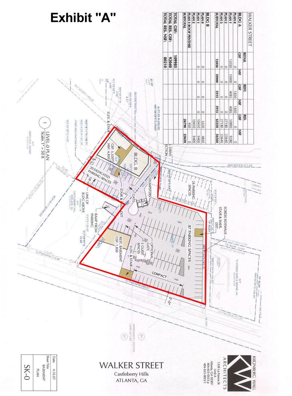
2 EXECUTIVE SUMMARY Castleberry Hills Historic Development Site 291 Walker Street Atlanta, Fulton County, Georgia Walker Street is a 58,123 sq. ft. site (1.33 acres) in the heart of the Castleberry Hills Landmark Historic District near downtown Atlanta. The site is bounded on the east by Walker Street and on the west by Larkin Place. The site is 100 yards northwest of the intersection of Walker Street and Peters Street. (The southern entrance into this landmark historic district.) Address: 291 Walker Street, Atlanta, Georgia Zoning: This site lies within the boundaries of the Castleberry Hill Landmark District and is divided into two sub-areas as follows: Sub-Area 1 - Historic Core Approximately.8 Acres Sub-Area 2 - Transitional Historic Areas Approximately.53 Acres See website Section Zoning for more details on development potential. Size: Price: 1.33 Acres $55 per square foot land price - All Cash at Closing Parcel: Land Lot 84 and 85 - District 14 - Fulton County - Atlanta GA Utilities: Topo: Frontage: Shape: Flood Plain: All utilities are available to the property Mostly level with a slight lower topographical change moving east to west feet along Walker Street 260 feet along Larkin Place Trapezoid and Square Not located in a Federal Flood Area Taxes: $6, NPU: NPU M Chair David Patton Neighborhood Association: Castleberry Hills Neighborhood Association - Schools: Elementary - CW Hill Jr. High - Inman ( High School - Grady (


3 Enhanced Site Map 291 Walker St Sw Atlanta, GA ESRI Prepared by Alan Joel July 25, 2007 On-demand reports and maps from Business Analyst Online. Order at or call Latitude: Longitude: Page 1 of 1
4

5

6
7
8 Neighborhood Contact Information Castleberry Hills Neighborhood Association P.O. Box Atlanta GA President Erica Pines NPU M Meets 4 th Monday of every 6:30 90 Boulevard, NE at the MLK Community Center Chair David Patton Castleberry Hills Main Land Use Links Page Castleberry Hill Master Plan PDF (33 Megs 94 Pages) Castleberry Hill Master Plan Matrix PDF (12 Megs 32 Pages) Castleberry Landmark District Map with 150 ft Buffer Castleberry MRC / District Overlay Map Castleberry Landmark District Map Castleberry Hills Landmark District Regulations (13 Pages) Proposed Castleberry Hill Map w/ MRC-2-C Boundaries ONLY Proposed Castleberry Hill Map w/ MRC-3-C Boundaries ONLY Urban Design Commission Karen Hubner - (404) The Commission meets on the second and fourth Wednesday of each month at 4:00 pm, in the Council Chambers at City Hall, 68 Mitchell Street, SW. The public is welcome to attend and is given the opportunity to speak in support of or in opposition to items on the agenda. City of Atlanta Atlanta Urban Design Commission (AUDC) 55 Trinity Avenue, Suite 3400 Atlanta, Georgia Tel: Fax: Karen Huebner Doug Young Viveka N. Bizzell Assistant Director Urban Planner, Principal Public Information Manager khuebner@atlantaga.gov dyoung@atlantaga.gov Tel: Fax: vnbizzell@atlantaga.gov
LAND USE AMENDMENT DOWNTOWN COMMERCIAL CORE (WARD 7) MACLEOD TRAIL SE AND 5 AVENUE SE BYLAW 254D2017
 MACLEOD TRAIL SE AND 5 AVENUE SE BYLAW 254D2017") Page 1 of 10 EXECUTIVE SUMMARY This Land Use Amendment application seeks to redesignate a full downtown block (currently the YWCA site) from a Direct Control based on the CM-2 District (Land Use Bylaw
Page 1 of 10 EXECUTIVE SUMMARY This Land Use Amendment application seeks to redesignate a full downtown block (currently the YWCA site) from a Direct Control based on the CM-2 District (Land Use Bylaw
COMPANY JERALD WINETROUB COMPANY
 LAKELINE PROPERTIES Austin & Cedar Park, Texas JOHN L COMPANY REAL ESTATE INVESTMENTS JOHN C. LEWIS PRESIDENT 1717 WEST 6TH STREET, SUITE390 AUSTIN, TEXAS 78703 TEL (512) 476-7011 CELL (512) 413-8100 john
The Atlanta BeltLine. Quarterly Briefing March @atlantabeltline. Reynoldstown Senior Affordable Housing
 The Atlanta BeltLine Quarterly Briefing March 30, 2017 @atlantabeltline @atlantabeltline @atlantabeltline Reynoldstown Senior Affordable Housing Framework for a multi-use and transit corridor in the heart
Planning Districts INTRODUCTION
 INTRODUCTION To facilitate detailed examination of development prospects for all areas of the community, Delano has been divided into 14 planning districts. The location of these planning districts is
D E S I G N R E V I E W B OA R D
 Agenda Report City of Great Falls D E S I G N R E V I E W B OA R D February 28, 2011 C O N T R A C T F L O O R I N G N EW B U I L D I N G Case Number DRB2011-2 Applicant Steve L Heureux (LPW Architects)
Atlanta BeltLine Subarea 3 Master Plan Update
 Atlanta BeltLine Subarea 3 Master Plan Update April 14, 2018 Workshop Meeting 1 22 miles, connecting 45 neighborhoods 22 MILES of transit 46 MILES of streetscapes and complete streets 33 MILES of urban
Public Workshop #2 Summary
 Public Workshop #2 Summary Project Number: Project Title: 2320.01 (R&M) MOA Parks and Recreation Muldoon Town Square Park Master Plan Subject: Muldoon Town Square Park Master Plan Public Workshop #2 Author:
CAMPUS MASTER PLAN 2016/17 PROCESS
 AGENDA Welcome and Introductions General update/schedule update Review of existing campus master plan, planned unit development and general downtown corridor Initial discussion regarding development agreement/standards/conditions
M E M O R A N D U M January 6, 2017
 Item #4 M E M O R A N D U M January 6, 2017 To: 2035 Corridor Planning Committee From: Kenneth Baker, Sr. Director of Planning and Development Services Subject: Item #4 Overview Fidelis Purpose: Review
NEIGHBORHOOD DESIGN ELEMENT
 NEIGHBORHOOD DESIGN ELEMENT INTRODUCTION The following recommendations constitute an urban design oriented "neighborhood analysis" of Plantation. It is an optional Comprehensive Plan Element. The five
Transit Implementation Strategy Westside Study Group Meeting
 Westside Study Group Meeting February 27, 2012 The Portland Streetcar Passing Through a Park Near Portland State University Westside Study Group Meeting February 27, 2012 1. TIA Update 2. TIS Process To-Date
City of Fairfax, Virginia City Council Work Session
 City of Fairfax, Virginia City Council Work Session Agenda Item # 12a City Council Meeting 5/8/2018 TO: FROM: SUBJECT: Honorable Mayor and Members of City Council Robert Sisson, City Manager Request of
City of Fontana Notice of Preparation and Notice of Public Scoping Meeting Fontana North Walmart Project
 Notice of Preparation and Notice of Public Scoping Meeting Fontana North Walmart Project Date: Monday, February 22, 2016 To: From: Subject: Public Agencies and Interested Parties Orlando Hernandez, Senior
ROLL CALL Member Anthony, Member Avdoulos, Member Greco, Member Lynch, Member Maday, Chair Pehrson
 CALL TO ORDER The meeting was called to order at 7:00 PM. PLANNING COMMISSION ACTION SUMMARY CITY OF NOVI Regular Meeting July 11, 2018 7:00 PM Council Chambers Novi Civic Center 45175 W. Ten Mile (248)
NOTICE OF PREPARATION
 NOTICE OF PREPARATION DATE: January 6, 2016 TO: LEAD AGENCY: Responsible Agencies, Organizations, and Interested Parties Contact: Tyler Barrington, Principal Planner Planning Department Community Development
Rezoning Petition Post-Hearing Staff Analysis July 31, 2018
 Rezoning Petition 2017-050 Post-Hearing Staff Analysis July 31, 2018 REQUEST LOCATION Current Zoning: B-1 (neighborhood business) and O-1 (office) Proposed Zoning: NS (neighborhood services) Approximately
NOTICE OF AVAILABILITY (NOA) OF A DRAFT ENVIRONMENTAL IMPACT REPORT AND NOTICE OF PUBLIC HEARING 2190 Shattuck Avenue Mixed-Use Project
 OF A DRAFT ENVIRONMENTAL IMPACT REPORT AND NOTICE OF PUBLIC HEARING 2190 Shattuck Avenue Mixed-Use Project") Planning and Development Department Land Use Planning Division NOTICE OF AVAILABILITY (NOA) OF A DRAFT ENVIRONMENTAL IMPACT REPORT AND NOTICE OF PUBLIC HEARING 2190 Shattuck Avenue Mixed-Use Project Notice
Planning and Development Department Land Use Planning Division NOTICE OF AVAILABILITY (NOA) OF A DRAFT ENVIRONMENTAL IMPACT REPORT AND NOTICE OF PUBLIC HEARING 2190 Shattuck Avenue Mixed-Use Project Notice
OCEANSIDE DEVELOPER S CONFERENCE. 1. 9:30-10:30 a.m. Proposed hotel on a 12,000 sq. ft. site at the northeast corner of Topeka St. and Tremont St.
 1 AGENDA OCEANSIDE DEVELOPER S CONFERENCE Wednesday, February 1st, 2017, 9:30 a.m. City Hall South, 1 st Floor, Guajome Room 1. 9:30-10:30 a.m. Proposed hotel on a 12,000 sq. ft. site at the northeast
Town of Portola Valley General Plan. Nathhorst Triangle Area Plan
 Town of Portola Valley General Plan Amended December 10, 1997 Table of Contents Introduction... 1 Planning Area... 1 Objectives... 2 Principles... 2 Standards... 4 Description... 4 Community Commercial...
Rezoning Petition Post-Hearing Staff Analysis February 5, 2019
 Rezoning Petition 2018-053 Post-Hearing Staff Analysis February 5, 2019 REQUEST Current Zoning: R-5 (single family), B-1 (neighborhood business), I-1 (light industrial), and I-2 (general industrial) Proposed
McDaniel Creek Master Plan
 McDaniel Creek Master Plan UNIVERSITY AVE., PITTSBURGH NEIGHBORHOOD AND THE MCDANIEL CREEK WATERSHED 60 ANSLEY MALL AND THE CLEAR CREEK GREENWAY 61 INTRODUCTION The BeltLine Subarea 6 site lies within
Reconnecting New Haven: Downtown Crossing
 Reconnecting New Haven: Downtown Crossing Phase 2 Update Introduction to Phase 3 November 16, 2017 City of New Haven, Connecticut Toni N. Harp, Mayor Reconnecting New Haven Introduction Project Overview
DRAFT. October Wheaton. Design Guidelines
 October 2011 DRAFT Wheaton Design Guidelines 2 Draft - Design Guidelines - Wheaton Sector Plan Contents 04 Section 1: Introduction 06 Section 2: Context 08 Section 3: Design Guidelines 09 Goal 1: Create
Mountain View & Old Dixie Master Plans DACC Meeting. July 10, 2018
 Mountain View & Old Dixie Master Plans DACC Meeting July 10, 2018 Agenda I. Project Schedule II. Goals III. Design Workshop Our Team Sizemore Group: Award-Winning Planning and Architecture Principal: Bill
Rezoning Petition Pre-Hearing Staff Analysis April 16, 2018
 Rezoning Petition 2017-177 Pre-Hearing Staff Analysis April 16, 2018 REQUEST LOCATION Current Zoning: O-2 (office) and MUDD-O (mixed use development, optional) Proposed Zoning: MUDD-O (mixed use development,
PRELIMINARY REPORT. HIGHWAY 18 CORRIDOR NEIGHBORHOOD PLAN VILLAGE OF DOUSMAN November, 2014
 PRELIMINARY REPORT HIGHWAY 18 CORRIDOR NEIGHBORHOOD PLAN VILLAGE OF DOUSMAN November, 2014 This preliminary report presents the initial recommendations for land use within the Highway 18 corridor along
General Location Annex, Rezone & Preliminary Plat Lansdowne Addition, Unit Three
 NEWFOUNDLAND I-5 Agricultural District Subject Site SUNDANCE ANDERSON Single Family Residential CHRISTY PUD Agricultural District Highway Business General Location Annex, Rezone & Preliminary Plat Lansdowne
RE-Imagining the Downtown Colorado Springs Master Plan
 RE-Imagining the Downtown Colorado Springs Master Plan 2016 APA Colorado State Conference October 25, 2016 Overview 8:00 Welcome, Introductions, and Overview 8:15 Downtown s Planning History 8:30 A Market
MEMORANDUM. I2 District Downtown Parking Overlay District 24,000 square feet /.55 acres. Industrial Employment District North Loop Small Area Plan
 Department of Community Planning & Economic Development 50 South 4th Street, Room 300 Minneapolis, MN 5545-385 MEMORANDUM To: City Planning Commission, Committee of the Whole Prepared By: Peter Crandall,
Department of Neighborhood & Development Services 1565 First Street, RM 301, Sarasota, Florida Phone: (941)
") City of Sarasota Department of Neighborhood & Development Services 1565 First Street, RM 301, Sarasota, Florida 34236 Phone: (941) 954-2612 Application No. 15-CW-13 To: Meeting Attendees Date: July 1,
City of Sarasota Department of Neighborhood & Development Services 1565 First Street, RM 301, Sarasota, Florida 34236 Phone: (941) 954-2612 Application No. 15-CW-13 To: Meeting Attendees Date: July 1,
Planning Commission April 4, 2013 BOCC Workshop Page 1
 Planning Commission April 4, 2013 BOCC Workshop Page 1 Planning Commission April 4, 2013 BOCC Workshop Page 2 Planning Commission April 4, 2013 BOCC Workshop Page 3 Planning Commission April 4, 2013 BOCC
Community Open House March 26 th, 2018
 Community Open House March 26 th, 2018 Open House Agenda 1. Overview of Planning Process What we heard 2. Future Land Use Policy 3. Priority Growth Areas 4. Plan Elements Making it happen What is a Comprehensive
OPEN SPACE TYPES. SIZE 8 acres. SIZE 20 acres. SIZE 1 acre
 TYPICAL CHARACTERISTICS OPEN SPACE TYPES OPEN SPACE TYPES The neighborhood contains an extensive variety of open space types. Most of these spaces incorporate multiple uses and activities, so that each
CHAPTER 1. Ms. Guajardo s Class - Central Elementary CH 1 1
 INTRODUCTION CHAPTER 1 Ms. Guajardo s Class - Central Elementary CH 1 1 1.1 SETTING South Centre City is a linear corridor south of Downtown Escondido paralleling Centre City Parkway and South Escondido
STAFF REPORT. April 30, 2018 May 9, 2018
 PATRICK J. SULLIVAN DIRECTOR City of New Bedford Department of Planning, Housing & Community Development 608 Pleasant St, New Bedford, Massachusetts 02740 Telephone: (508) 979.1500 Facsimile: (508) 979.1575
St. Kevin s Area Planning Collaborative
 Table of Contents page 2 EXECUTIVE SUMMARY 3 MISSION STATEMENT 4 NEIGHBORHOOD CONTEXT 6 STREET CHARACTER 7 SITE PARAMETERS 9 COMMUNITY CHARRETTE - VISIONING GROUP TABLE 1 11 GROUP TABLE 2 12 GROUP TABLE
CITY OF DAYTON Meeting Date: PLANNING COMMISSION
 CITY OF DAYTON Meeting Date: 3-8-18 PLANNING COMMISSION Item: B ITEM: Application by North Diamond Investment, LLC. for Concept Plan Review - Cloquet Island Estates APPLICANTS/PRESENTERS: North Diamond
The petition proposes to rezone 3.17 acres to allow all uses in the TOD-M (transit oriented development mixed-use) district.
 district.") Rezoning Petition 2018-053 Pre-Hearing Staff Analysis December 17, 2018 REQUEST Current Zoning: R-5 (single family), B-1 (neighborhood business), I-1 (light industrial), and I-2 (general industrial) Proposed
Rezoning Petition 2018-053 Pre-Hearing Staff Analysis December 17, 2018 REQUEST Current Zoning: R-5 (single family), B-1 (neighborhood business), I-1 (light industrial), and I-2 (general industrial) Proposed
Description of Preferred Alternative
 Chapter 2 Description of Preferred Alternative 2.1 Introduction This chapter of the programmatic Sammamish Town Center Sub-area Plan Final EIS provides a more detailed description of the Preferred Alternative
Town of Newmarket 395 Mulock Drive P.O. Box 328, Newmarket, Ontario, L3Y 4X7. Website: newmarket.ca Phone:
 Town of Newmarket 395 Mulock Drive P.O. Box 328, Newmarket, Ontario, L3Y 4X7 Email: info@newmarket.ca Website: newmarket.ca Phone: 905-895-5193 Natural Heritage System Boundary Refinement: Vacant Lot West
TECHNICAL SUPPLEMENT 1: LAND USE AND ZONING
 TECHNICAL SUPPLEMENT 1: Albuquerque Rapid Transit Project Prepared for: Prepared by: Parsons Brinckerhoff, Inc. August 2015 TABLE OF CONTENTS 1.0 Project Description... 1 1.1 General Description of Existing
ECR. el camino real master plan. settings and opportunities. The City of San Mateo SMWM. Adopted by the San Mateo City Council September 18, 2001
 ECR el camino real master plan settings and opportunities Adopted by the San Mateo City Council September 18, 2001 The City of San Mateo SMWM el camino real master plan settings and opportunities 1 executive
Rezoning Petition Post-Hearing Staff Analysis July 31, 2018
 Rezoning Petition 2018-044 Post-Hearing Staff Analysis July 31, 2018 REQUEST Current Zoning: R-3 (single family residential) Proposed Zoning: UR-2(CD) (urban residential, conditional) LOCATION Approximately
CITY PLANNING COMMISSION AGENDA. ITEM NO: 6.a 6.b STAFF: LONNA THELEN
 Page 156 CITY PLANNING COMMISSION AGENDA ITEM NO: 6.a 6.b STAFF: LONNA THELEN FILE NO(S): A. - CPC ZC 08-00069 QUASI-JUDICIAL B. - CPC CU 08-00070 QUASI-JUDICIAL PROJECT: APPLICANT: OWNER: PHIL LONG VALUCAR
Mycoskie McInnis Associates represented by Cliff Mycoskie. Rdw Rudy s Arlington and I-20/South Collins, Ltd represented by Robert Dorazil
 Case Information Applicant: Property Owner: Sector Plan: Mycoskie McInnis Associates represented by Cliff Mycoskie Rdw Rudy s Arlington and I-20/South Collins, Ltd represented by Robert Dorazil East Council
Pine Avenue Improvement Project
 Seaside Way to ocean Boulevard ocean Boulevard to 7 th Street 7 th Street to anaheim Street L O ng BeACh DeveLOpment ServiC e S Building a Better long Beach Pine Avenue Improvement Project Seaside Way
124 Subarea Visions. Vision Plan. A. Nelessen Associates, INC I Visioning I Planning I Urban Design
 Subareas 124 Subarea Visions The next seven sections describe specific recommendations tailored to each subarea. Each subarea is discussed separately except for certain aspects of 95th Street and Antioch
Land Use. Hardware Street Vendor Mixed-Use
 Land Use Definition Land Use is the way a piece of real estate is utilized. Existing, proposed, and adopted land uses all play a role in the planning process. Once a land use plan is adopted, the next
Executive Summary. Study Area Overview Plan Description Introduction Key Findings Recommendations Conclusions
 Executive Summary Study Area Overview Plan Description Introduction Key Findings Recommendations Conclusions v Executive Summary Study Area The project study area for the Southwest Neighborhood Redevelopment
2018 AMENDMENT TO THE COMPREHENSIVE PLAN
 2018 AMENDMENT TO THE COMPREHENSIVE PLAN AND LAND USE REGULATORY CODE Summary of Proposed Amendments A Plan or Code Amendment is the process through which the City considers changes, additions, and updates
To subscribe, unsubscribe or comment, send an message to
 Volume 18, Issue 07, To subscribe, unsubscribe or comment, send an email message to planning@clarington.net Inside this issue Page 1 Page 4 Page 6 Public Meetings Recent Approvals In the News Public Meetings
PLANNING COMMISSION REPORT Public Hearing Item FINAL DEVELOPMENT PLAN FOR BAUER FARM; XPRESS WELLNESS URGENT CARE; 4700 OVERLAND DR (MKM)
") PC Staff Report 06/22/15 FDP-15-00108 Item No. 6-1 PC Staff Report 06/22/2015 ITEM NO. 6 PLANNING COMMISSION REPORT Public Hearing Item FINAL DEVELOPMENT PLAN FOR BAUER FARM; XPRESS WELLNESS URGENT CARE;
PC Staff Report 06/22/15 FDP-15-00108 Item No. 6-1 PC Staff Report 06/22/2015 ITEM NO. 6 PLANNING COMMISSION REPORT Public Hearing Item FINAL DEVELOPMENT PLAN FOR BAUER FARM; XPRESS WELLNESS URGENT CARE;
Obey Creek July 17, Vicinity Map. Concept Plan Submittal. No
 15/501 Fordham Blvd. 15/501 By-Pass To Downtown Chapel Hill Vicinity Map 0 1000 2000 FT Arlen Park DR. Bennett Road Mt. Carmel Church Rd. Southern Village Parkside Circle Market St. 15/501 Founder's Ridge
TREASURE COAST REGIONAL PLANNING COUNCIL M E M O R A N D U M. To: Council Members AGENDA ITEM 3I
 TREASURE COAST REGIONAL PLANNING COUNCIL M E M O R A N D U M To: Council Members AGENDA ITEM 3I From: Date: Subject: Staff December 8, 2017 Council Meeting Local Government Comprehensive Plan Review Draft
Staff Report. Conditional Use PLANNING DIVISION COMMUNITY & ECONOMIC DEVELOPMENT. Salt Lake City Planning Commission
 Staff Report PLANNING DIVISION COMMUNITY & ECONOMIC DEVELOPMENT To: From: Salt Lake City Planning Commission Maryann Pickering, Principal Planner (801) 535-7660 Date: December 10, 2014 Re: Church of Scientology
Rezoning Petition Pre-Hearing Staff Analysis April 16, 2018
 Rezoning Petition 2018-015 Pre-Hearing Staff Analysis April 16, 2018 REQUEST LOCATION Current Zoning: R-4 (single family residential) and UR-2(CD) (urban residential, conditional) Proposed Zoning: UR-2(CD)
Rezoning Petition Pre-Hearing Staff Analysis July 16, 2018
 Rezoning Petition 2018-044 Pre-Hearing Staff Analysis July 16, 2018 REQUEST Current Zoning: R-3 (single family residential) Proposed Zoning: UR-2(CD) (urban residential, conditional) LOCATION Approximately
Stakeholders Advisory Working Groups (SAWGs) Smart Growth and TOD Land Use (#11) SAWG Meeting
 Smart Growth and TOD Land Use (#11) SAWG Meeting") Presentation - Part II Tappan Zee Bridge/I-287 Corridor Project July 21, 2010 Slide 1. David Kooris (Regional Plan Association) welcomed members of the Land Use Stakeholders Advisory Working Groups (SAWGs)
Presentation - Part II Tappan Zee Bridge/I-287 Corridor Project July 21, 2010 Slide 1. David Kooris (Regional Plan Association) welcomed members of the Land Use Stakeholders Advisory Working Groups (SAWGs)
Town of Hamburg Planning Board Meeting August 19, Town of Hamburg Planning Board Meeting August 19, 2015 Minutes
 Town of Hamburg Planning Board Meeting August 19, 2015 Minutes The Town of Hamburg Planning Board met for a Regular Meeting at 7:00 P.M. on Wednesday, August 19, 2015 in Room 7B of Hamburg Town Hall, 6100
17.11 Establishment of Land Use Districts
 17.11 Establishment of Land Use Districts 17.11.010 Purpose. To promote the health, safety, and general welfare of City residents and those who come to South Salt Lake to work, exchange commerce and recreate.
 I. Executive Summary The recommendations of the Atlanta BeltLine Master Plan for Subarea 4 are summarized in the following pages. The recommendations include brief sections on land use, design, mobility,
Planning Division Case Report
 Planning Division Case Report SE17-0006 Review Date: June 2, 2017 Property Owner: Applicant: SB-Vets-1, LLC SB-Vets-1, LLC Owner Address: 900 SW Pine Island Road, Suite 202 Cape Coral, FL 33991 Authorized
Summary of Planning Commission Votes Regular Meeting of the Aurora Colorado Planning Commission February 14, 2018
 Summary of Planning Commission Votes Regular Meeting of the Aurora Colorado Planning Commission February 14, 2018 Agenda Item # Item Description 5a. PROPOSED AMENDMENT TO THE AURORA COMPREHENSIVE PLAN
City of Sugar Hill Planning Staff Report RZ
 City of Sugar Hill Planning Staff Report RZ 18-006 DATE: TO: FROM: SUBJECT: October 31, 2018; Updated 1117/2018 Mayor and City Council Planning Director ltj( Reoning RZ 18-006, 360 Residential ILC, 1091
Draft Amendment Provides details regarding ROPA 47 s purpose and effect. Related Processes Highlights other ongoing processes of note in the area
 An Amendment to Address a Shortfall of Employment Lands in the Town of Halton Hills Premier Gateway Employment Area Public nformation Centre Wednesday November 1, 2017 6:30p.m. - 8:30p.m. Hillcrest United
Appendix B: C Line Station Plan Agency/ Organization Comments
 Appendix B: C Line Station Plan Agency/ Organization Comments C Line Public Engagement Plan Appendix B January 5, 2016 Scott Janowiak Metro Transit 560 Sixth Avenue North Minneapolis, MN 55411 Dear Mr.
LOS ANGELES CITY PLANNING DEPARTMENT STAFF REPORT
 LOS ANGELES CITY PLANNING DEPARTMENT STAFF REPORT LOS ANGELES CITY PLANNING COMMISSION CASE NO: CPC 2006-9374 CRA CEQA: Exempt DATE: December 21, 2006 Location: Valley Plaza and Laurel Plaza TIME: after
CITY OF MAPLE GROVE PLANNING COMMISSION AGENDA SEPTEMBER 12, :00 P.M.
 CITY OF MAPLE GROVE PLANNING COMMISSION AGENDA SEPTEMBER 12, 2016 7:00 P.M. 1. OPENING BUSINESS A. Call to Order B. Pledge of Allegiance C. Roll Call 2. ADDITIONS OR DELETIONS TO AGENDA Any Commissioner
BeltLine Corridor Environmental Study
 BeltLine Corridor Environmental Study Citywide Conversation on Transit and Trails April 2, 2009 Agenda & Introductions Introductions Environmental Study Process Overview of the BeltLine Project BeltLine
SOUTHEND REDEVELOPMENT OPPORTUNITY
 SOUTHEND REDEVELOPMENT OPPORTUNITY 511 & 527 W. TREMONT AVENUE 5.58 ACRES IN THE HEART OF SOUTHEND --LESTER E. OSBORN, CCIM, SIOR LOSBORN@PIEDMONTPROPERTIES.COM 704.375.1131 A. SCOTT HENSLEY, CCIM, SIOR
Rezoning Petition Pre-Hearing Staff Analysis May 21, 2018
 Rezoning Petition 2017-205 Pre-Hearing Staff Analysis May 21, 2018 REQUEST Current Zoning: MUDD-O (mixed use development district, optional) Proposed Zoning: MUDD-O SPA (mixed use development district,
Wadsworth Boulevard S TAT I O N A R E A P L A N
 Wadsworth Boulevard S TAT I O N A R E A P L A N City of Lakewood Adopted November, 2006 The Vision The City of Lakewood s overall vision is to transform the area around the light rail station into a mixed-use
DOCKET & STATUS UPDATE
 Annual Comprehensive Plan Amendment Process for 2018 DOCKET & STATUS UPDATE This document last updated: The have opened the annual Comprehensive Plan amendment process for 2018. See our Online Open House
Mitchell Ranch South MPUD Application for Master Planned Unit Development Approval Project Narrative. Introduction
 Mitchell Ranch South MPUD Application for Master Planned Unit Development Approval Project Narrative Introduction Mitchell Ranch South is a proposed single family (detached) residential development on
Rezoning Petition Final Staff Analysis October 2, 2018
 Rezoning Petition 2017-205 Final Staff Analysis October 2, 2018 REQUEST Current Zoning: MUDD-O (mixed use development district, optional) Proposed Zoning: MUDD-O SPA (mixed use development district, optional,
Workshop. Valley Vision Stanislaus. Our Schedule. Help Shape Our Region s Future! The Scenarios. Who is StanCOG? How Do I Select a Scenario?
 Valley Vision Stanislaus Workshop Help Shape Our Region s Future! Valley Vision Stanislaus is a long-range planning process that will link future land use with a framework for investment in roads, freeways,
Narcoossee Roadway Corridor
 Community Meeting Narcoossee Roadway Corridor April 5, 2012 Meeting Agenda Purpose of Meeting Continuation of Study Update Process (Previous Meetings Oct. & Nov., 2011) Tonight s Objective Review Proposals
Town of Bethlehem Development Planning Committee (DPC) Agenda Thursday, December, :00 AM Bethlehem Town Hall, Room 101
 Agenda Thursday, December, :00 AM Bethlehem Town Hall, Room 101") David VanLuven Town Supervisor Robert Leslie, AICP Director of Planning TOWN OF BETHLEHEM Albany County - New York ECONOMIC DEVELOPMENT AND PLANNING 445 DELAWARE AVENUE DELMAR, NEW YORK 12054 (518) 439-4955
David VanLuven Town Supervisor Robert Leslie, AICP Director of Planning TOWN OF BETHLEHEM Albany County - New York ECONOMIC DEVELOPMENT AND PLANNING 445 DELAWARE AVENUE DELMAR, NEW YORK 12054 (518) 439-4955
City of Ennis. Downtown Master Plan Catalyst Projects
 City of Ennis Downtown Master Plan Catalyst Projects Revised Framework Plan REVISED Project Types and Descriptions Project Types A. Visitor Attracting Projects: Projects in this category are intended to
Citizen Advisory Committee Meeting #3.2
 Citizen Advisory Committee Meeting #3.2 August 10, 2016, 7:00 p.m. to 9:00 p.m. Police Department Conference Room, 7301 Hanna Street, Gilroy, CA 95020 Meeting Summary I. Call to Order Members present:
Drexel, Barrell & Co.
 Drexel, Barrell & Co. June 18, 2018 Engineers/Surveyors Boulder Colorado Springs Greeley 3 South 7 th Street Colorado Springs, Colorado 80905-1501 719 260-0887 719 260-8352 Fax El Paso County Planning
Danvers High Street I-1 District Study
 Danvers High Street I-1 District Study Presentation of Final Recommendations Planning Board Presentation June 26 th, 2018 1 Introductions Metropolitan Area Planning Council Sam Cleaves AICP, Principal
THE NEIGHBORHOOD TODAY
 THE NEIGHBORHOOD TODAY CORE AREA VISION How are we Good Urbanism A Site s DNA thinking about Elements of great Unique elements urban communities embedded in a place the site and design? ELEMENTS LIKE:
A Vibrant Downtown. Chapter 5 Cary Public Art Opportunities 31
 A Vibrant Downtown Cary s vision for Downtown is a unique, vibrant, dynamic, pedestrian friendly location; a regional destination and a place to live, work, and recreate, according to the 2001 Town Center
WALTER RAND TRANSPORTATION CENTER
 WALTER RAND TRANSPORTATION CENTER PLANNING AND DESIGN STUDY Public Meeting May 25, 2017 TONIGHT S AGENDA Introduction and Welcome Project Objectives The Study Area: WRTC and its Context Circulation Assessment
Rezoning Petition Pre-Hearing Staff Analysis May 21, 2018
 Rezoning Petition 2018-018 Pre-Hearing Staff Analysis May 21, 2018 REQUEST Current Zoning: R-5 (single family residential), R-5 HD-O (single family residential, historic district overlay) and B-2(CD) HD-O
Gadsden County Planning Commission Agenda Request
 Date of Meeting: November 16, 2017 To: From: Through: Subject: Gadsden County Planning Commission Agenda Request Honorable Chairperson and Members of the Board Jill A. Jeglie, AICP, Senior Planner Clyde
AN ORDINANCE THE COUNCIL OF THE CITY OF PHILADELPHIA HEREBY ORDAINS:
 AN ORDINANCE Amending Title 14 of The Philadelphia Code, entitled Zoning and Planning, by amending Section 14-507, entitled /CDO, Central Delaware Riverfront Overlay District, under certain terms and conditions.
NOTICE OF PREPARATION OF AN ENVIRONMENTAL IMPACT REPORT AND SCOPING MEETING FOR THE LAND PARK COMMERCIAL CENTER PROJECT
 NOTICE OF PREPARATION OF AN ENVIRONMENTAL IMPACT REPORT AND SCOPING MEETING FOR THE LAND PARK COMMERCIAL CENTER PROJECT PUBLIC COMMENT PERIOD November 12, 2015 to December 14, 2015 INTRODUCTION The City
Drexel, Barrell & Co.
 Drexel, Barrell & Co. December 21, 2018 Engineers/Surveyors Boulder Colorado Springs Greeley 3 South 7 th Street Colorado Springs, Colorado 80905-1501 719 260-0887 719 260-8352 Fax El Paso County Planning
2.0 AREA PLANS. Lakeside Business District. Lakeside Business District Land Use Categories:
 Lakeside Business District Lakeside Business District Land Use Categories: Campus Commercial Campus Commercial means a mixture of uses which includes corporate offices, office parks, hotels, commercial,
3.0 LAND USE PLAN. 3.1 Regional Location. 3.2 Existing Conditions Existing Uses. Exhibit Regional Location Map
 3.0 LAND USE PLAN 3.1 Regional Location The Anaheim Resort Specific Plan (ARSP) area is located in the City of Anaheim, which is 35 miles southeast of downtown Los Angeles and 7 miles northwest of Santa
Fort McPherson Master Plan
 Fort McPherson Master Plan Fort McPherson In 1885, Fort McPherson became the first permanent Army installation in the Southeast. Located on 488 acres in the City of Atlanta halfway between the airport
M E M O R A N D U M. Chair and Members of North West Planning Advisory Committee
 Item 9.1.1 PO Box 1749 Halifax, Nova Scotia B3J 3A5 Canada M E M O R A N D U M TO: FROM: Chair and Members of North West Planning Advisory Committee Stephanie Salloum, Planner II DATE: June 26, 2017 SUBJECT:
Por favor, levanten la mano si necesita traduccion en espanol Please raise your hand if you need Spanish translation
 FEDERAL BOULEVARD CORRIDOR WIDE STUDY PUBLIC MEETING #1 APRIL 27, 2016 Por favor, levanten la mano si necesita traduccion en espanol Please raise your hand if you need Spanish translation HDR DESIGN WORKSHOP
NORTH BETHANY ELEMENTARY SCHOOL SITE ASSESSMENT
 NORTH BETHANY ELEMENTARY SCHOOL SITE ASSESSMENT Prepared for: Prepared by: October 10, 2014 Page 2 Introduction and Purpose This report provides an assessment of two potential sites for a new elementary
Sheridan Boulevard S TAT I O N A R E A P L A N S H E R I D A N B O U L E VA R D S TAT I O N A R E A P L A N
 Sheridan Boulevard S TAT I O N A R E A P L A N 1 City of Lakewood Adopted November, 2006 S H E R I D A N B O U L E VA R D S TAT I O N A R E A P L A N The Vision The City of Lakewood s overall vision is
AGENDA 07/14/11 PLANNING COMMISSION Meeting
 AGENDA 07/14/11 PLANNING COMMISSION Meeting MEETING DATE: Thursday, July 14, 2011 MEETING TIME: MEETING PLACE: VIDEO: 5:30 p.m. City Council Chambers, City Hall 350 Main Street El Segundo, California 90245-0989
CITY OF APPLE VALLEY PLANNING COMMISSION MINUTES SEPTEMBER 18, 2013
 PLANNING COMMISSION MINUTES SEPTEMBER 18, 2013 1. CALL TO ORDER The City of Apple Valley Planning Commission meeting was called to order by Chair Melander at 7:00 p.m. Members Present: Tom Melander, Ken
M E M O R A N D U M July 27, 2018
 M E M O R A N D U M July 27, 2018 To: Southlake 2035 Corridor Planning Committee From: Kenneth Baker, Sr. Director of Planning and Development Services Subject: Item #6 First National Bank Purpose Review,