COMPANY JERALD WINETROUB COMPANY
|
|
|
- Eustace Jenkins
- 6 years ago
- Views:
Transcription
 476-7011 CELL")

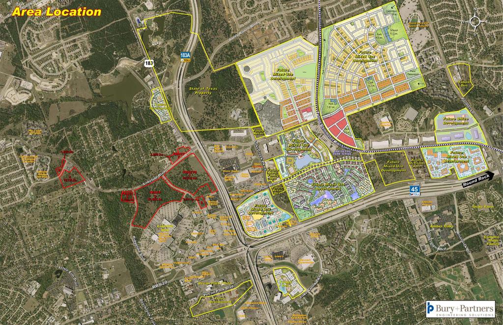
1 LAKELINE PROPERTIES Austin & Cedar Park, Texas JOHN L COMPANY REAL ESTATE INVESTMENTS JOHN C. LEWIS PRESIDENT 1717 WEST 6TH STREET, SUITE390 AUSTIN, TEXAS TEL (512) CELL (512) EWIS JERALD WINETROUB COMPANY Jerry Winetroub President 515 Congress Ave., Suite 1790 Austin, Texas TEL (512) CELL (512) jw@jwcre.com
2 LAKELINE PROPERTIES Location: Utilities: Environmental: Overview: Zoning: School District: Located immediately north of Lakeline Mall in northwest Austin, these quality, platted and zoned properties are ready for development. These seven tracts are for sale to multi-family, single tenant, assisted living, pad users, and retail shopping center developers. 112 acres are available and located at the intersection of Highway 183 and Lakeline Boulevard. Numerous water and wastewater lines run throughout the immediate area, as well as electric and natural gas. See exact locations on maps provided. Phase I studies have been conducted on the properties and no adverse environmental conditions were found to be present with the exception of two small cave features that may require a 150 foot setback from each. The proposed setbacks have been shown on enclosed maps for prospective purchasers to review. Seven different tracts located on the northern boundary of the Simon Property Group owned Lakeline Mall. With these properties shovel ready this is a great opportunity for users to located on properties that haven t been realistically available before now. The immediately surrounding area has tremendous existing single family residential density, mixed with apartments, retail, and office buildings in the midst of a large high-tech community. Concordia University is located along Ranch Road 620 within 5 miles of the properties. Because of this unique location, these properties can draw local and regional traffic due to its convenience, visibility and accessibility. Properties are located in the City of Austin and the City of Cedar Park with some portions in both cities. See attached maps for more detailed location information. Round Rock Independent School District Roads and Infrastructure: Located just north of the major intersections of Highway 183, Toll Road 183A, Ranch Road 620 and Toll Road SH45, these properties have frontage on four-lane divided Lakeline Boulevard and Highways 183 and 183A. Pecan Park Boulevard, Ridgeline Boulevard and Old Mill Road also provide frontage and access.
3
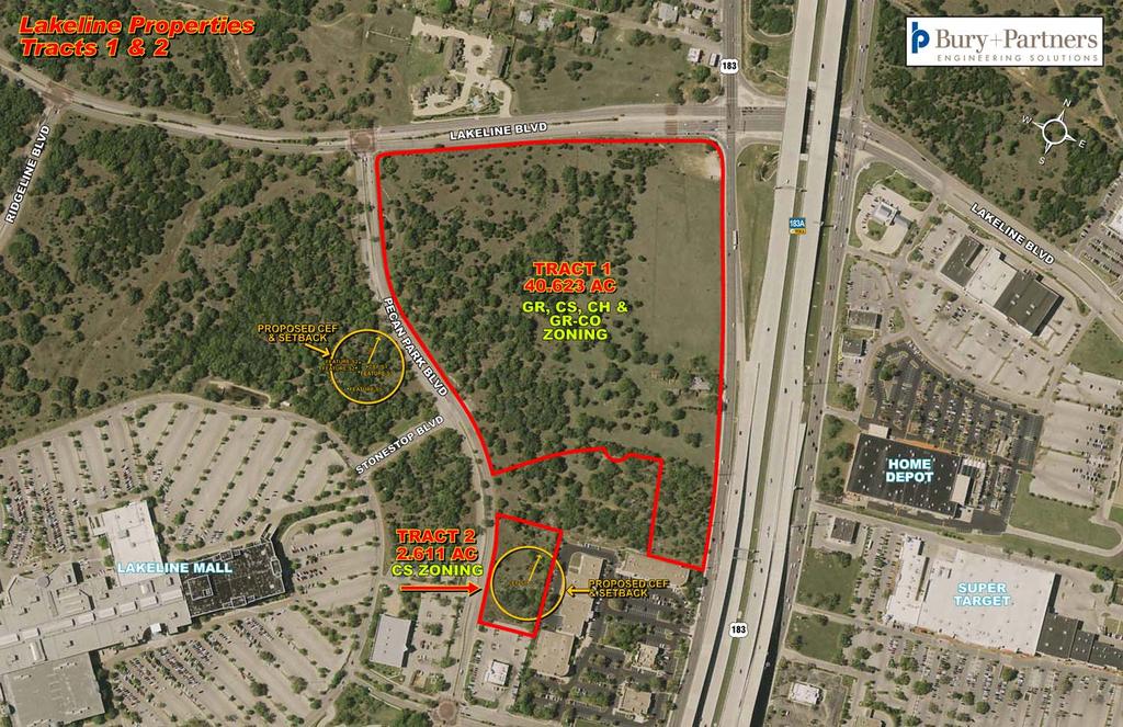
4 Tract One Acres Highway 183, 183A and Lakeline Boulevard Austin, Texas Location: Size: SW corner of Highway 183 and Lakeline Boulevard, Austin, Texas acres Zoning: GR General Retail, CS Commercial Services and GR-CO General Retail with Conditional Overlay Topography: Utilities: Environmental: Impervious Cover: Relatively flat with scattered oaks throughout the property. City of Austin water, wastewater and electric to the site as shown on the enclosed maps. No limitations to development are known and environmental assessments have been conducted. 65% for commercial development.
5
6
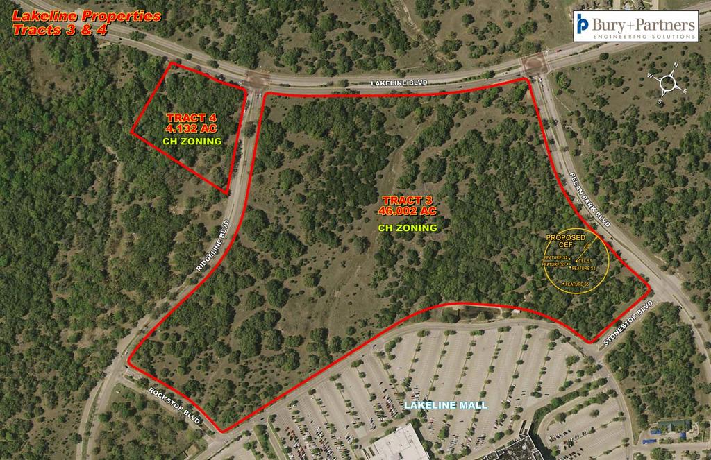
7 Tract Three 46 Acres Lakeline Boulevard, Pecan Park Boulevard and Ridgeline Boulevard Austin, Texas Location: SW corner of Pecan Park Boulevard and Lakeline Boulevard and extends to the eastern edge of Ridgeline Boulevard in Austin, Texas. Size: 46 acres, divided by a dry creek bed into two tracts 22 and 24 acres Zoning: Topography: Utilities: Environmental: Impervious Cover: CH Commercial Highway Relatively flat with beautiful oaks located throughout both tracts. City of Austin water, wastewater and electric are available to the site, but a lift station that is under design will be required. The lift station should be completed in 18 months and paid for by the City of Austin. One small critical environmental feature without species is located on the 22 acre tract and may require up to a 150 foot setback as shown on the enclosed maps. Numerous studies show no other concerns. 60% for multi-family and 65% for commercial development.
8 Tract Four Acres Lakeline Boulevard and Ridgeline Boulevard Austin, Texas Location: Size: Zoning: Topography: Utilities: Environmental: Impervious Cover: SW corner of Lakeline Boulevard and Ridgeline Boulevard, Austin, Texas acres CH Commercial Highway Relatively flat with numerous oaks located throughout the property. City of Austin water, wastewater and electric are available to the site as shown on the enclosed maps. No known issues. 65% for commercial development.
9
10
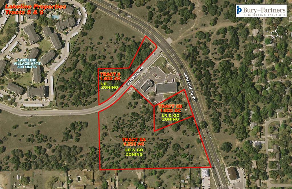
11 Tract Five Acres Lakeline Boulevard and Old Mill Road Cedar Park, Texas Location: Size: Zoning: Topography: Utilities: Environmental: Impervious Cover: SE corner of Lakeline Boulevard and Old Mill Road, wrapping around a small office/retail project on the hard corner. Two adjoining tracts 1.5 acres and acres. LR Local Retail with conditions and GO General Office; City of Cedar Park Relatively flat with scattered oaks. Water, wastewater and electric are available to the site as shown on the enclosed maps. No known issues. Determined by meeting landscape & tree protection requirements.
12 Tract Six Acres Lakeline Boulevard and Old Mill Road Cedar Park, Texas Location: Size: Zoning: Topography: Utilities: Environmental: Impervious Cover: SW corner of Lakeline Boulevard and Old Mill Road, Cedar Park, Texas acres. LR Local Retail Relatively flat with abundant oaks. Water, wastewater and electric are available to the site as shown on the enclosed maps. No known issues. Determined by meeting landscape & tree protection requirements.
13
14
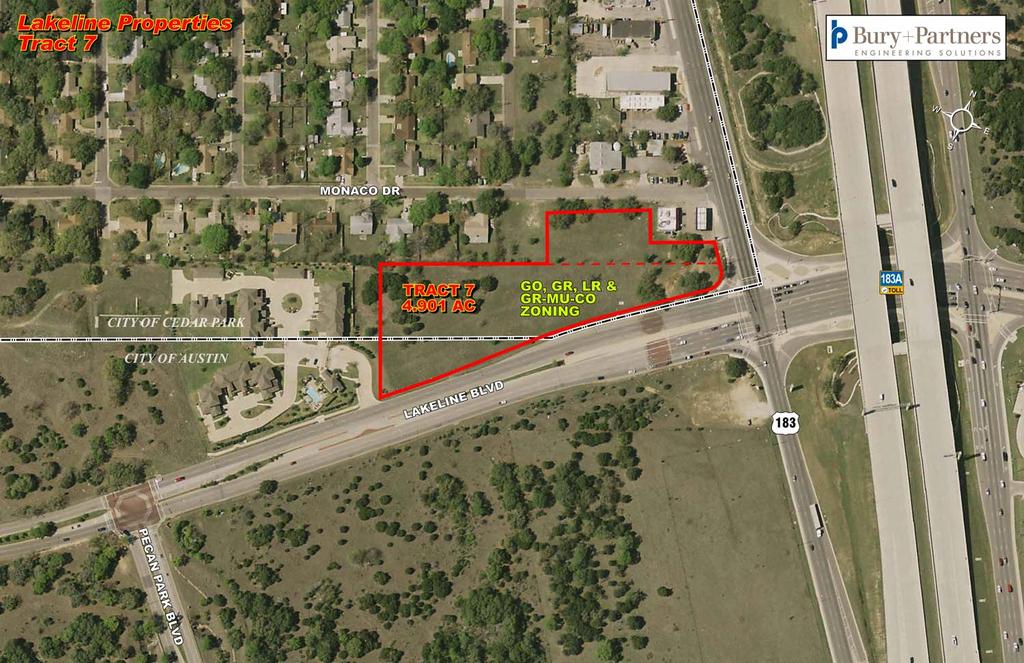
15 Tract Seven Acres Highway 183/183A and Lakeline Boulevard Austin and Cedar Park, Texas Location: Size: Zoning: Topography: Utilities: Environmental: Impervious Cover: NW corner of Highway 183/183A and Lakeline Boulevard, Austin and Cedar Park, Texas. The front of this tract, as shown on the map, lies within the City of Austin s jurisdiction acres. LR Local Retail, GO General Office, GR General Retail and GR-MU-CO General Retail and Mixed Use with conditional overlay. Relatively flat with a few scattered oaks. Water, wastewater and electric are available to the site as shown on the enclosed maps. No known issues. Determined by meeting landscape & tree protection requirements.
16
17
GENERAL PLAN CONSISTENCY ANALYSIS
 GENERAL PLAN CONSISTENCY ANALYSIS Prepared by Planning Staff 10/28/2013 APPLICABLE GOALS, POLICIES AND PROGRAMS FROM the LAND USE CHAPTER Goal LU-1 Policy LU-1.1 Policy LU-1.2 Goal LU-2 Protect the character
M E M O R A N D U M January 6, 2017
 Item #4 M E M O R A N D U M January 6, 2017 To: 2035 Corridor Planning Committee From: Kenneth Baker, Sr. Director of Planning and Development Services Subject: Item #4 Overview Fidelis Purpose: Review
4.500 Preston Road Overlay District
 Section 4.500 Preston Road Overlay District 2004 Zoning Ordinance 4.500 Preston Road Overlay District (ZC 98-29; Ordinance No. 98-9-12) 4.501 Purpose To provide appropriate design standards for the use
M E M O R A N D U M July 27, 2018
 M E M O R A N D U M July 27, 2018 To: Southlake 2035 Corridor Planning Committee From: Kenneth Baker, Sr. Director of Planning and Development Services Subject: Item #6 First National Bank Purpose Review,
Appendix L SH 360 OVERLAY DISTRICT. LAST UPDATE: December 10, 2013 CASE NUMBER: TA ORDINANCE NO
 Appendix L SH 360 OVERLAY DISTRICT LAST UPDATE: December 10, 2013 CASE NUMBER: TA131201 ORDINANCE NO. 9655 2013 Unified Development Code Grand Prairie, Texas Planning Department APPENDIX L: SH 360 OVERLAY
Public Meeting. Public Meeting May 17, /17/2016 PB File #520-01/16 Delegation presentation
 PB-40-16 File #520-01/16 Delegation presentation Public Meeting Choice Properties REIT Proposed Commercial Development 2025 Guelph Line May 17 th, 2016 Public Meeting May 17, 2016 Introductions Site Context
2900 Steeles Avenue East at Don Mills Road in the Town of Markham
 STAFF REPORT INFORMATION ONLY 2900 Steeles Avenue East at Don Mills Road in the Town of Markham Date: January 23, 2008 To: From: Wards: Reference Number: North York Community Council Director, Community
Planning & Zoning Commission Planning & Development Department February 17, 2014
 Request Applicant Owner Zoning Location Attachments Subdivision of 2.79 acres of currently vacant property to create 27 town home lots and 6 restricted reserves for the use of HOA Parks. John English;
Drexel, Barrell & Co.
 Drexel, Barrell & Co. December 21, 2018 Engineers/Surveyors Boulder Colorado Springs Greeley 3 South 7 th Street Colorado Springs, Colorado 80905-1501 719 260-0887 719 260-8352 Fax El Paso County Planning
Planning Districts INTRODUCTION
 INTRODUCTION To facilitate detailed examination of development prospects for all areas of the community, Delano has been divided into 14 planning districts. The location of these planning districts is
Suited for Light Industrial & Manufacturing ± 343 Acres in Denton High Traffic Counts & Visibility
 Light Industrial / Manufacturing Masch Branch & Hampton Rd Suited for Light Industrial & Manufacturing ± 343 Acres in Denton High Traffic Counts & Visibility 1400 Dallas Dr. 940.390.1927 jimmy.terrell@sbpcommercial.com
Planning & Zoning Commission Meeting Date: June 04, 2012
 Meeting Date: June 04, 2012 Request Applicant Owner Zoning Preliminary/Final Plat of 24.114 acres of unplatted property into one lot with one reserve for landscape/open space. Extension of infrastructure
SUSSEX COUNTY COMPREHENSIVE PLAN COUNTY PLANNING AND ZONING COMMISSION WORKSHOP
 SUSSEX COUNTY COMPREHENSIVE PLAN COUNTY PLANNING AND ZONING COMMISSION WORKSHOP August 21, 2017 TODAY S WORKSHOP Public Comment Utilities Update Economic Development Update Future Land Use Discussion Public
REAL ESTATE INVESTMENT PROPOSAL Castleberry Hills Historic Development Site 291 Walker Street Atlanta, Georgia 30313
 REAL ESTATE INVESTMENT PROPOSAL Castleberry Hills Historic Development Site 291 Walker Street Atlanta, Georgia 30313 Presented By: Alan L. Joel, CCIM Phone: (404) 869-2602 Cell: (404) 210-1700 Email: ajoel@alanjoelpartners.com
2.0 AREA PLANS. Lakeside Business District. Lakeside Business District Land Use Categories:
 Lakeside Business District Lakeside Business District Land Use Categories: Campus Commercial Campus Commercial means a mixture of uses which includes corporate offices, office parks, hotels, commercial,
MODEL ACCESS MANAGEMENT PLAN MINNESOTA TRUNK HIGHWAY 7 COMPREHENSIVE PLAN AMENDMENT (HUTCHINSON SEGMENT)
") MODEL ACCESS MANAGEMENT PLAN MINNESOTA TRUNK HIGHWAY 7 (HUTCHINSON SEGMENT) COMPREHENSIVE PLAN AMENDMENT INTRODUCTION. The purpose of this plan is to provide consistent access management in the Trunk
MODEL ACCESS MANAGEMENT PLAN MINNESOTA TRUNK HIGHWAY 7 (HUTCHINSON SEGMENT) COMPREHENSIVE PLAN AMENDMENT INTRODUCTION. The purpose of this plan is to provide consistent access management in the Trunk
Drexel, Barrell & Co.
 Drexel, Barrell & Co. June 18, 2018 Engineers/Surveyors Boulder Colorado Springs Greeley 3 South 7 th Street Colorado Springs, Colorado 80905-1501 719 260-0887 719 260-8352 Fax El Paso County Planning
Urban Development Areas Bedford County
 5 Urban Development Areas Bedford County UDA Needs Profile: All UDAs Bedford County has designated two UDAs: areas just outside the Bedford City Limits (generally to the south and east of the city) and
4.0 INTRODUCTION TO THE ENVIRONMENTAL ANALYSIS AND ASSUMPTIONS USED
 The following is an introduction to the environmental analysis of project-specific and cumulative impacts and general assumptions used in the analysis. The reader is referred to the individual technical
Sam Furr and McCord Road Huntersville, North Carolina
 108± Acres of Sam Furr and McCord Road Huntersville, North Carolina NorthCross Shopping Center Land for Sale 108 Acres located in northeast Huntersville wth extensive frontage along both Sam Furr Road
City of Yelm. Tahoma Terra Final Master Plan Development Guidelines. Table of Contents
 City of Yelm Tahoma Terra Final Master Plan Development Guidelines Table of Contents Table of Contents... 1 Purpose... 2 Low Density Residential (R4-6)... 3 Moderate Density Residential (R6-10)... 5 Neighborhood
PRELIMINARY REPORT. HIGHWAY 18 CORRIDOR NEIGHBORHOOD PLAN VILLAGE OF DOUSMAN November, 2014
 PRELIMINARY REPORT HIGHWAY 18 CORRIDOR NEIGHBORHOOD PLAN VILLAGE OF DOUSMAN November, 2014 This preliminary report presents the initial recommendations for land use within the Highway 18 corridor along
CITY OF DEERFIELD BEACH Request for City Commission Agenda
 Item: CITY OF DEERFIELD BEACH Request for City Commission Agenda Agenda Date Requested: April 2, 2013 Contact Person: Gerald R. Ferguson, Director of Planning & Development Services Description: 3317,
Beatties Ford Road & Mt. Holly-Huntersville Road Small Area Plan
 Beatties Ford Road & Mt. Holly-Huntersville Road Small Area Plan Town of Huntersville October 2005 Town of Huntersville Planning Department 101 Huntersville Concord Road Post Office Box 664 Huntersville,
Mitchell Ranch South MPUD Application for Master Planned Unit Development Approval Project Narrative. Introduction
 Mitchell Ranch South MPUD Application for Master Planned Unit Development Approval Project Narrative Introduction Mitchell Ranch South is a proposed single family (detached) residential development on
Prepared by: Casey Kempenaar, Senior Planner
 CITY OF CITRUS HEIGHTS PLANNING DIVISION STAFF REPORT PLANNING COMMISSION MEETING September 13, 2017 Prepared by: Casey Kempenaar, Senior Planner REQUEST The applicant requests a Design Review Permit Modification
Ten Mile Creek Planning Area
 PLANNING AREA POLICIES TEN MILE CREEK Ten Mile Creek Planning Area Location and Context The Ten Mile Creek Planning Area ( Ten Mile Creek area ) is located south of the current Boise AOCI, generally south
1.0 Introduction. Purpose and Basis for Updating the TMP. Introduction 1
 1.0 Introduction The Town of Castle Rock is situated between the metropolitan areas of Denver and Colorado Springs, amidst a unique terrain of rolling hills, mesas, ravines, and waterways. Like many Front
II. Background and Existing Conditions. A. The Georgetown Area Context
 A. The Georgetown Area Context Georgetown, Texas is located approximately 25 miles north of Austin along Interstate 35, the major highway between Austin and Dallas. It is the County seat of Williamson
M E M O R A N D U M July 27, 2018
 Item #7 M E M O R A N D U M July 27, 2018 To: 2035 Corridor Planning Committee From: Kenneth Baker, Sr. Director of Planning and Development Services Subject: Item #7 Overview Michael Drive Purpose: Review
CITY PLANNING COMMISSION AGENDA
 Page 22 CITY PLANNING COMMISSION AGENDA ITEM: C STAFF: STEVE TUCK FILE NO: CPC CU 11-00080 QUASI-JUDICIAL PROJECT: FIRST & MAIN APARTMENTS PHASE 1 APPLICANT: OWNER: NASS DESIGN ASSOCIATES FIRST & MAIN
2 PLANNING AREA DESCRIPTION
 2 PLANNING AREA DESCRIPTION 2.1 LOCATION Hecker Pass is located within the City of Gilroy near the western city limit. Figure 2-1 illustrates the regional location of the Hecker Pass Area. Figure 2-1:
M E M O R A N D U M November 9, 2018
 M E M O R A N D U M November 9, 2018 To: Southlake 2035 Corridor Planning Committee From: Kenneth Baker, Sr. Director of Planning and Development Services Subject: Item #8 Up to thirteen (13) residential
01 PROJECT DESCRIPTION
 01 PROJECT DESCRIPTION PROJECT LOCATION The proposed Barrett Ranch East project (the Project) site is in northern Sacramento County in the Antelope community, north of the intersection of Don Julio Boulevard
SHEFFIELD PARK Paulding County, GA DRI #588
 SHEFFIELD PARK Paulding County, GA DRI #588 Supplemental Information for RDC s DRI (Form 2) Review August 16, 2004 Prepared for: Mr. David Howerin Coosa Valley RDC 1 Jackson Hill Drive Rome, GA 30161 P.O.
Planning Division Case Report
 Planning Division Case Report SE17-0006 Review Date: June 2, 2017 Property Owner: Applicant: SB-Vets-1, LLC SB-Vets-1, LLC Owner Address: 900 SW Pine Island Road, Suite 202 Cape Coral, FL 33991 Authorized
Baumgarten MPUD. Exhibit 3 Evaluation Criteria
 Pursuant to LDC subsections 10.02.13 B, 10.02.08 F and Chapter 3 G. of the Administrative Code, staff s analysis and recommendation to the Planning Commission, and the Planning Commission s recommendation
UNIVERSITY OF MICHIGAN:
 Chapter Eight UNIVERSITY OF MICHIGAN: North Campus I. Introduction The University of Michigan currently owns approximately 800 acres of land in the northeast section of Ann Arbor. North Campus refers to
Planning & Zoning Commission Staff Report
 Planning & Zoning Commission Staff Report Meeting Date: May 26, 2015 Drafted by: Katherine Harrison-Rogers CASE # Z2886 PROJECT NAME: APPLICANT/ REPRESENTATIVE: Shawna Runyan PROPERTY OWNER: 1840 (previously
Mollers Lane, Leopold, Victoria Significant Landscape Overlay Re-assessment
 XURBAN Mollers Lane, Leopold, Victoria Significant Landscape Overlay Re-assessment For: TGM Group November 2016 Final Mollers Lane, Leopold, Victoria Significant Landscape Overlay Re-assessment Client
MASTER PLAN. 201 Planning Concepts. Chapter 2
 Chapter 2 MASTER PLAN 201 Planning Concepts 202 Master Land Use Plan 203 Affordable Housing Program 204 Parks, Open Space, and Recreation Trails 205 Grading Concept 206 Circulation Plan 207 Landscape Concept
13. PRELIMINARY PLAT NO MILLS FARM - Vicinity of the southeast corner of 159 th Street and Quivira Road
 13. corner of 159 th Street and Quivira Road 1. APPLICANT: HNTB Corporation is the applicant for this request. 2. REQUESTED ACTION: The applicant is requesting approval of a preliminary plat for a 383-lot
PLANNED UNIT DEVELOPMENT PUD For The Proposed Antietam Subdivision Escambia County, Florida. Introduction
 PLANNED UNIT DEVELOPMENT PUD For The Proposed Antietam Subdivision Escambia County, Florida Introduction The project is located in Escambia County approximately 0.75 + miles north of the US Highway 90,
ARTICLE 13 STREETS General
 ARTICLE 13 STREETS 13.1 General Streets shall be designed to suit their functions. Many streets have purposes other than vehicular traffic. As an alternative to current N.C. Department of Transportation
CITY OF NORCROSS LILLIAN WEBB PARK REDEVELOPMENT AREAS
 7/2/2016 CITY OF NORCROSS LILLIAN WEBB PARK REDEVELOPMENT AREAS 2016 Potential Development Around Lillian Webb Park The Lillian Webb Park Development Project is located north of Buford Highway; east of
Northwest Rail Corridor and US 36 BRT Development Oriented Transit Analysis 4.4 STATION AREA FINDINGS
 4.4 STATION AREA FINDINGS Each station is different, and each one requires a separate set of recommendations based on the vision for the site. This section outlines an initial TOD strategy and recommendations
Application Number: SD Project Name: Walton Farms Preliminary Subdivision (acting as Master Plan)
") STAFF REPORT Town of Clayton Planning Department 111 E. Second Street, Clayton, NC 27520 P.O. Box 879, Clayton, NC 27528 Phone: 919-553-5002 Fax: 919-553-1720 Planning Board May 22, 2017 Application Number:
STAFF REPORT Town of Clayton Planning Department 111 E. Second Street, Clayton, NC 27520 P.O. Box 879, Clayton, NC 27528 Phone: 919-553-5002 Fax: 919-553-1720 Planning Board May 22, 2017 Application Number:
Stephanie Eyestone-Jones l President Matrix Environmental l 17 September 2013
 Stephanie Eyestone-Jones l President Matrix Environmental l 17 September 2013 Manhattan Beach Shopping Center Enhancement Project l City of Manhattan Beach Overview of Matrix Environmental Qualifications
DRAFT Subject to Modifications
 TREASURE COAST REGIONAL PLANNING COUNCIL M E M O R A N D U M To: Council Members AGENDA ITEM 5P From: Date: Subject: Staff February 20, 2009 Council Meeting Local Government Comprehensive Plan Review Draft
A New Vision For Highland
 A New Vision For Highland ULI Austin Breakfast Wednesday April 24, 2013 Dr. Richard Rhodes President/CEO Austin Community College Panelists: Chris Riley Councilmember Place 1 City of Austin Matt Whelan
Gold Line Bus Rapid Transit Transit Oriented Development (BRTOD) Helmo Station Area Plan
 Helmo Station Area Plan") Appendix F Gold Line Bus Rapid Transit Transit Oriented Development (BRTOD) Helmo Station Area Plan Introduction and Purpose of the Plan The Gold Line Bus Rapid Transit facility is an eleven-mile dedicated
Appendix F Gold Line Bus Rapid Transit Transit Oriented Development (BRTOD) Helmo Station Area Plan Introduction and Purpose of the Plan The Gold Line Bus Rapid Transit facility is an eleven-mile dedicated
KNOXVILLE/KNOX COUNTY METROPOLITAN PLANNING COMMISSION SUBDIVISION REPORT - CONCEPT/USE ON REVIEW
 KNOXVILLE/KNOX COUNTY METROPOLITAN PLANNING COMMISSION SUBDIVISION REPORT - CONCEPT/USE ON REVIEW FILE #: 10-SF-17-C 10-I-17-UR AGENDA ITEM #: 12 AGENDA DATE: 11/9/2017 POSTPONEMENT(S): 10/12/2017 SUBDIVISION:
Project Overview. Washington s Most Exciting New Destination for Office and Retail PROPERTY GROUP PARTNERS
 Washington s Most Exciting New Destination for Office and Retail PROPERTY GROUP PARTNERS Washington s Most Exciting New Destination for Office and Retail 2.2 Million Square Feet 3 New City Blocks on a
Yates Cattle & Conservation Ranch
 Yates Cattle & Conservation Ranch Yates Cattle and Conservation Ranch 385 +/- acres Hays & Travis Counties, Texas James King, Agent Office 432.426.2024 James@KingLandWater.com Location There is a property
Issues Requiring Future Study
 Issues Requiring Future Study Transportation planning is an ongoing process that tends to identify new issues as it finds solutions for others. Some issues are so complex that a solution to one problem
III. PROJECT DESCRIPTION
 III. PROJECT DESCRIPTION A. PROJECT LOCATION Regional Setting The project site is located in the southeast quadrant of the City of Chico in Butte County, California and is comprised of four parcels totaling
DRAFT. Urban Development Areas Fairfax County. UDA Needs Profile: Tysons Corner 13% Location Characteristics. Socio-Economic Characteristics
 14 Urban Development Areas Fairfax County UDA Needs Profile: Tysons Corner Tysons Corner is located in Fairfax County, surrounded by the town of McLean to the east and Vienna on the west along I-495, the
KASPER. City of Georgetown, Texas PUD Planned Unit Development. December 30, 2015 Revised January 27, 2016
 KASPER City of Georgetown, Texas PUD Planned Unit Development December 30, 2015 Revised January 27, 2016 Applicant: Sentinel Land Company, LLC 4910 Campus Drive Newport Beach, CA Prepared by: SEC Planning
Port Lavaca Future Land Use
 Port Lavaca Future Land Use Introduction The City of Port Lavaca is beginning to see sustained growth, after many years of relative stable population. New single family homes, apartments, and businesses
2.0 Hi s t o r y & Existing Co n d i t i o n s
 2.0 Hi s t o r y & Existing Co n d i t i o n s 2.1 Plan Area History The Lincoln East Specific Plan (Specific Plan) area is a significant part of the history of Sutter County. A 48,000 acre land grant
Tyvola & Archdale Transit Station Area Plan. June 5, 2008
 Tyvola & Archdale Transit Station Area Plan Second Public Meeting June 5, 2008 Presentation Outline 1. Purpose and Process 2. Station Area Overview 3. Plan Recommendations 4. Comments Received and Proposed
Zoning Ordinance Section 1.100
 4.800 (ZC 98-45; Ordinance No. 98-9-13) 4.801 Purpose To provide appropriate design standards for the development of properties within the State Highway 121 corridor. These standards recognize the significance
DEVELOPMENT FRAMEWORK POST 2030 LAND USE PLAN INTRODUCTION
 INTRODUCTION Oak Grove s Comprehensive Plan identifies a future Metropolitan Urban Service Area (MUSA). The Metropolitan Council does not anticipate extending utilities to this area prior to 2030. The
Section 1. Executive Summary
 Executive Summary (This page left blank intentionally) Executive Summary Background Economic growth in southern Leavenworth County over the past decade has been strong. As both the number of business and
Development Agreement Public Meeting. June 26, 2013
 Development Agreement Public Meeting June 26, 2013 Process 2007 2008 2009 2010 2011 2012 2013 Neighborhood Conservation District Petition Process Original Master Plan presented Community Forum Glen Lennox
PLANNED UNIT DEVELOPMENT & SUBDIVISION STAFF REPORT Date: May 18, 2017
 & PUD-0000102-2017 PLANNED UNIT DEVELOPMENT & SUBDIVISION STAFF REPORT Date: May 18, 2017 NAME SUBDIVISION NAME Dauphin Creek Estates Subdivision Dauphin Creek Estates Subdivision LOCATION CITY COUNCIL
Burton Station Village Community Meeting February 26, 2014
 February 26, 2014 SGA Plan Overview Recent announcements by the City of Norfolk regarding the closure of Lake Wright Golf Course and retail development proposals Update on infrastructure improvement plans
Description of Preferred Alternative
 Chapter 2 Description of Preferred Alternative 2.1 Introduction This chapter of the programmatic Sammamish Town Center Sub-area Plan Final EIS provides a more detailed description of the Preferred Alternative
CASE NUMBER: 16SN0565 (AMENDED) APPLICANT: C.A.H. Investments, LLC
 APPLICANT: C.A.H. Investments, LLC") CASE NUMBER: 16SN0565 (AMENDED) APPLICANT: C.A.H. Investments, LLC STAFF S ANALYSIS AND RECOMMENDATION Board of Supervisors (BOS) Public Hearing Date: JUNE 22, 2016 BOS Time Remaining: 365 DAYS Applicant
CASE NUMBER: 16SN0565 (AMENDED) APPLICANT: C.A.H. Investments, LLC STAFF S ANALYSIS AND RECOMMENDATION Board of Supervisors (BOS) Public Hearing Date: JUNE 22, 2016 BOS Time Remaining: 365 DAYS Applicant
Colerain Township report to. Hamilton County Regional Planning Commission. December 2, 2010, 1:00PM. t a f f r e p o r t
 Colerain Township report to Hamilton County Regional Planning Commission December 2, 2010, 1:00PM Preliminary Plan: Case No.: ZA2001-04, Forevergreen Prepared By: Amy Bancroft, Land Use Planner t a f f
This Review Is Divided Into Two Phases:
 Semiahmoo Town Centre Review The purpose of this review: To review the Semiahmoo Town Centre Concept Plan, originally approved in 1993, to ensure that this centre will continue to serve the needs of South
Venice Pumping Plant Dual Force Main Project Draft EIR
 City of Los Angeles 5.9 LAND USE PLANS 5.9.1 Environmental Setting Venice Pumping Plant Dual Force Main Project Draft EIR The Project lies within the bounds of Los Angeles County and the City of Los Angeles.
PG&E WINTERS GAS OPERATIONS AND TECHNICAL TRAINING CENTER
 PG&E WINTERS GAS OPERATIONS AND TECHNICAL TRAINING CENTER CEQA scoping Meeting March 19 th, 2014 Winters City Council Chambers - 6:30 pm AGENDA FOR THE MEETING 6:30 Welcome (John Donlevy) 6:40 Overview
BUILDER LOTS FOR SALE
 BUILDER LOTS FOR SALE NORTHERN CULPEPER - 135 ACRES RESIDENTIAL DEVELOPMENT 1256 Old Bridge Road, Amissville, VA 20106 SALE PRICE: $995,000 LOT SIZE: 135+ Acres APN #: Tax Map 2 Parcel 23 ZONING: R-1 ACCESS:
Mycoskie McInnis Associates represented by Cliff Mycoskie. Rdw Rudy s Arlington and I-20/South Collins, Ltd represented by Robert Dorazil
 Case Information Applicant: Property Owner: Sector Plan: Mycoskie McInnis Associates represented by Cliff Mycoskie Rdw Rudy s Arlington and I-20/South Collins, Ltd represented by Robert Dorazil East Council
Subarea 4 Indian Creek. Vision The combination of park networks and transportation amenities make Subarea 4 the greenest hub in the Corridor.
 indian creek 180 extends south from 101st Street to I-435. The I-435 and Metcalf intersection is one of the primary intersections in the Kansas City Metro Area. The area includes several residential neighborhoods
3.10 LAND USE SETTING PROJECT SITE EXISTING LAND USE DESIGNATIONS AND ZONING. General Plan Land Use Designations.
 This section of the Draft EIR addresses the existing land uses on and adjacent to the project site and discusses the potential impacts of the proposed project on existing land uses. Key issues addressed
RESOLUTION NO R
 e e RESOLUTION NO R04 0054 BE IT RESOLVED by the Mayor and City Council ofthe City ofpapillion that The Papillion Comprehensive Plan is hereby amended to incorporate the Option A Future Land Use Map Transportation
Memorandum CITY OF DALLAS. Riverfront Boulevard Design From Continental Avenue to Cadiz Street
 Memorandum DATE November 10, 2011 CITY OF DALLAS TO Trinity River Corridor Project Committee Members: Vonciel Jones Hill (Chair) Linda Koop (Vice Chair), Monica Alonzo, Scott Griggs, Angela Hunt, and Delia
Edmond Plan IV Update 2016, Descriptions and Recommendations for future Land Use for the Far Northeast Neighborhoods.
 TO: FROM: Edmond Planning Commission Robert L. Schiermeyer, City Planner DATE: October 2016 RE: Edmond Plan IV Update 2016, Descriptions and Recommendations for future Land Use for the Far Northeast Neighborhoods.
124 Subarea Visions. Vision Plan. A. Nelessen Associates, INC I Visioning I Planning I Urban Design
 Subareas 124 Subarea Visions The next seven sections describe specific recommendations tailored to each subarea. Each subarea is discussed separately except for certain aspects of 95th Street and Antioch
SECTION 2.0 INTRODUCTION
 SECTION 2.0 INTRODUCTION 2.1 PURPOSE AND SCOPE OF THE EIR Environmental Impact Reports (EIR) are informational documents which wil inform public agency decision-makers and the public generally of the significant
Page 1 of 19 URBAN DESIGN FRAMEWORK FOR BOLTON STREET WATERFORD
 Page 1 of 19 URBAN DESIGN FRAMEWORK FOR BOLTON STREET WATERFORD 1.0 Introduction: The relocation of the City Council stores and depot from Bolton Street creates an exciting opportunity for development
2 Project Description
 Project Description 2 Project Description The proposed project would involve the demolition of the existing church and the construction of 40 twostory single family residences. The residential lots would
Gruene River Place PDD CONCEPT PLAN AND DEVELOPMENT STANDARDS
 Gruene River Place PDD CONCEPT PLAN AND DEVELOPMENT STANDARDS GRUENE RIVER PLACE PLANNED DEVELOPMENT DISTRICT As per Section 3.5, Chapter 144 of the City s Zoning Ordinance To: The Planning & Zoning Commission
Easton. Smart Growth Through Innovation. Easton
 Hazel Ave. Sunrise Blvd. Prairie City Rd. Smart Growth Through Innovation offers a unique opportunity to meet the region s future need for jobs and housing. It embodies smart growth principles advocated
Offering Memorandum Commercial Opportunity Acre Parcel Zoned MU-OI-1/R-3
 Offering Memorandum Commercial Opportunity 44.78-Acre Parcel Zoned MU-OI-1/R-3 North Chapel Hill off Weaver Dairy Road CH North Shopping Center Perkins Dr Chapel Hill North Apartments ABC Store Synergy
Zoning Docket from April 16, 2018 Public Hearing CC DIST. STAFF REC. 21 Approval
 Zoning Docket from April 16, 2018 Public Hearing Docket Number CZ-2018-30 Public Comments Staff Report Applicant Matthew Clayton Driggers for Smith Road Investments and Thomas P. Hartness Revocable Trust
Amendment to the Elderberry Neighborhood Development Plan
 Amendment to the Elderberry Neighborhood Development Plan Recommendations for Land Use, Transportation and Development July 13, 2018 City of Madison, Wisconsin Department of Planning and Community and
CHAPTER 4 COMMUNITY DEVELOPMENT AND DESIGN
 CHAPTER 4 COMMUNITY DEVELOPMENT AND DESIGN The Community Development and Design Chapter is extremely important because it, together with the Transportation and Circulation Chapter, provides the foundation
Reconnecting New Haven: Downtown Crossing
 Reconnecting New Haven: Downtown Crossing Phase 2 Update Introduction to Phase 3 November 16, 2017 City of New Haven, Connecticut Toni N. Harp, Mayor Reconnecting New Haven Introduction Project Overview
Glenborough at Easton Land Use Master Plan
 Vision Statement Sunrise Blvd. Hazel Ave. Prairie City Rd. Gencorp Property Lincoln Regional Airport 1.0 VISION STATEMENT The identifies City of the principles, goals, policies, and standards Lincoln that
ARTICLE 13 STREETS General
 ARTICLE 13 STREETS 13.1 General Streets shall be designed to suit their functions. Many streets have purposes other than vehicular traffic. As an alternative to current N.C. Department of Transportation
IH35 Corridor Plan Amendment to the Comprehensive Plan
 IH35 Corridor Plan Amendment to the Comprehensive Plan Background The corridor plan for the IH35 corridor is an amendment to the Burleson comprehensive plan. Generally, the purpose of a corridor plan is
Presentation of the Staff Draft. July 17, 2014 SSRVP Team, Area 3
 Presentation of the Staff Draft July 17, 2014 SSRVP Team, Area 3 Presentation Overview Introduction Plan Framework Plan Recommendations Implementation Next Steps and Request for Public Hearing on September
Mini Technical Assistance Panel. Rock Spring Park
 Mini Technical Assistance Panel Rock Spring Park May 22, 2013 The Team Jason Bonnet, Forest City Washington Matthew Flis, Town of Vienna William Herbig, National Capital Planning Commission Sophie Lambert,
Tucson Koi & Water Gardens
 OV113-031 Tucson Koi & Water Gardens CONDITIONAL USE PERMIT SITE ANALYSIS 05.22.2014 Property Owners Walter & Jane Wong Family Investments, LLP 5437 East 3rd Street Tucson, Arizona 85711 Tucson Koi and
SH 199 Corridor Master Plan. Community Meeting No. 2 May 31, 2017
 Community Meeting No. 2 May 31, 2017 Transportation Projects On or Near SH 199 SH 199 from 0.3 miles south of FM 1886 to south end of Lake Worth bridge Construct freeway mainlanes and frontage roads 10-Year
University Parkway Corridor Plan. Public Workshop Sept. 18, 2017
 University Parkway Corridor Plan Public Workshop Sept. 18, 2017 AGENDA 1. Overview of Process 2. Study Area 3. Components of the Plan 4. What We Know 5. What We Have Heard 6. Tonight s Input 7. Next Steps
Town of Castle Rock DRCOG 2013 Annual Growth and Development Report. Introduction. Section 1 Metro Vision 2035
 Town of Castle Rock DRCOG 2013 Annual Growth and Development Report Introduction This is the Town of Castle Rock s sixth annual report to the Denver Regional Council of Governments (DRCOG) reporting on