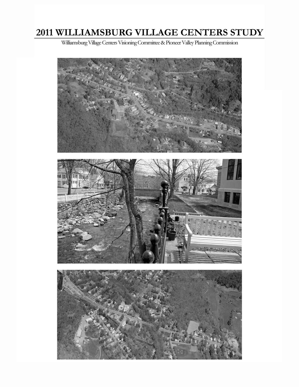
2011 WILLIAMSBURG VILLAGE CENTERS STUDY
|
|
|
- Toby George
- 5 years ago
- Views:
Transcription
1

2 2011 WILLIAMSBURG VILLAGE CENTERS STUDY Analysis & Recommendations, December 13, 2011 Williamsburg Village Centers Visioning Committee & Pioneer Valley Planning Commission Executive Summary This study assesses zoning and other strategies to promote vibrant, mixed-use village centers in Williamsburg and Haydenville. These are findings from an analysis of the town s zoning regulations: Our zoning regulations prevent new developments that are similar to what we already have in our village centers. Many of the differences between newer commercial developments and the traditional development in our village centers result from our zoning regulations. Most of the key zoning requirements that govern lot and building characteristics in the Village Mixed Use District do not match the actual conditions in our village centers. This is an indicator that the current zoning requirements do not allow or encourage the same types of compact, pedestrian friendly development that were built in the past and that give unique character to our village centers. Despite the fact that the zoning regulations allow both commercial and mixed-use properties by right in the Village Mixed Use District, the dimensional requirements in the zoning regulations largely prevent conversion of properties in the village centers to these uses. This limits transformation of properties to new uses over time. The Big Mamou property, a typical village lot, is less than 9,000 square feet, while the minimum lot size requirement is 65,000 square feet. The Williamsburg Market property has approximately 60 feet of frontage. This does not meet the 200 foot frontage requirement. The Brewmaster s Tavern property is set back approximately 30 feet from the street, falling short of the 40 foot setback requirement. Note: These properties were built before the zoning was implemented, so they are grandfathered (i.e. they may legally continue in their pre-existing form and use). However, the current zoning can hinder reuse of these types of properties and prevent new development from looking like these examples, which have been found to be visually appealing to Williamsburg residents. Significant public input was sought to inform this study. A public visioning forum and communitywide survey yielded the following results: Residents want the village centers to become more vibrant while retaining their small-town, rural feel. Residents want the village centers to have more destinations, to be more vibrant and walkable, and to foster a sense of community. Pedestrian safety and vehicle parking are important. Residents support traffic calming, shared parking and public lots. Open space and greater use of the river are important. Residents want central green spaces for community gathering. Residents support a non-motorized connection between the village centers. Residents like the traditional development pattern in the village centers and support new development that is similar. Residents support mixed-use buildings, local businesses, and maintenance and reuse of existing buildings. 1
3 Residents do not want new development that is out of character with the village centers, including strip commercial development, large commercial buildings, and heavy industrial uses. The following goals were first drafted at the community forum and have been refined by the Village Centers Visioning Committee: 1. Improve and preserve the character of our village centers 2. Maintain and improve walkability within our village centers, and create better pedestrian access to and between the village centers 3. Encourage community interaction in the village centers 4. Create more publicly accessible green space for community gatherings in both village centers 5. Take advantage of the Mill River to unite the village centers, and feature the Mill River as a town centerpiece that promotes vibrancy, a healthy ecosystem, recreation, and economic development 6. Encourage a diverse mix of uses (commercial, civic, shared uses, housing options, flexible transition of uses, home business) Key short-term zoning recommendations of this study are to: Amend the boundaries of the Village Mixed Use Zoning District to include only the existing and desirable future expansion areas for the village centers. Revise the Use Table for the Village Mixed Use Zoning District to allow uses that promote the identity and goals of the village centers, and to prohibit uses that undercut this identity. Amend the dimensional standards and supporting regulations for the Village Mixed Use District to reflect the community s desire to support and promote a traditional village center development pattern, including smaller lot size, frontage, setback and coverage standards. Create site plan review provisions that ensure that all proposed developments within the Village Mixed Use District are reviewed for their compatibility with the village centers and the town goals established by this study. Allow only one curb cut and promote new parking that is located behind or to the side of buildings when feasible, and that does not obstruct access to or enjoyment of the Mill River. Key short-term non-zoning recommendations of this study are to: Capitalize on the current school planning effort to identify opportunities for public, sharedparking lots that serve the village centers. Establish a committee to address walkability and traffic calming in the village centers. Create a mixed-use recreation corridor between the Williamsburg and Haydenville centers. Establish a village centers business association to promote pedestrian activity and economic development. Explore potential funding and strategies for historic preservation and maintenance of the town s historic buildings and cultural areas. Additional medium and long-term recommendations include: Review home occupations provisions with the goal of promoting home businesses and cottage industries. Establish a Stormwater Bylaw to protect water quality in the Mill River and its tributaries throughout the Town of Williamsburg. After completion of a parking study and/or provision of additional public parking options at the school parking lots, revisit the town s off-street parking standards to consider potential reductions in the village centers. 2
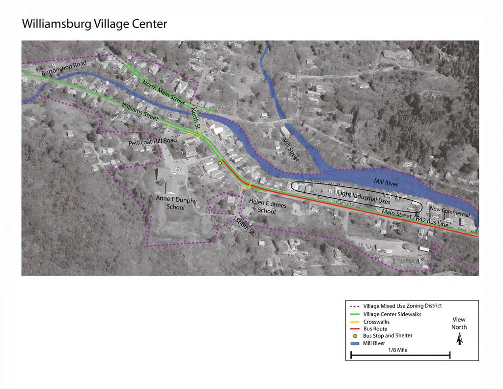
4 Background This study was born out of the 2010 Open Space and Recreation Plan (OSRP) Update. The plan established goals to: Encourage vibrant mixed-use village centers Focus growth near the village centers in order to promote open space preservation Promote land uses that showcase the Mill River as a scenic, ecological and recreational resource Make open space connections and connect the village centers with a multi-use recreation corridor The study assesses whether zoning regulations and other strategies can help the town achieve these goals. The study also has a significant community input component. The main tasks were to: Compare the current zoning requirements to existing properties in the village centers Find out what kinds of village center development 1 residents want to see Assess whether zoning allows the types of development the community wants Propose zoning amendments to meet community goals Recommend other appropriate strategies to meet community goals Activities included an initial zoning and site analysis, a community forum, a community survey, an analysis with recommendations, and draft zoning amendments. In 2012, the Village Centers Visioning Committee may discuss the final results with the Planning Board, conduct additional public outreach, consider bringing the proposed zoning amendments to Town Meeting for voter approval, and plan next steps to move forward with non-zoning strategies to strengthen our village centers. Context Williamsburg, sometimes termed the Capital of the Hilltowns, is a small, vibrant New England town with two village centers: Williamsburg center and Haydenville center. The town has less than 2,500 residents (U.S. Census 2010), and many residents of neighboring towns, particularly the nearby hilltowns, also frequent Williamsburg center. Significant downtown destinations for locals and nearby hilltown residents and tourists include stores, banks, libraries (and the farmer s market held on the Meekins Library lawn), restaurants and cafés, and the three elementary. Williamsburg center is also a tourist destination for the more populated areas to the east, including Northampton and Florence (a village of Northampton), and for tourists traveling west along Route 9 from Northampton to the Hilltowns and Berkshires. Williamsburg s village centers enjoy access to public transit (the PVTA R42 bus line ends in Williamsburg center), as well as sidewalks that make it possible to walk from one end to the other. These are shown below on the site analysis maps for each of the village centers. Existing crosswalks are also noted on these maps. As shown on the maps, the Mill River flows through both village centers. The maps also delineate the current village mixed-use zoning district boundaries (purple boundary. 1 For the purposes of this study, the Village Centers Visioning Committee has defined the term development comprehensively. Development is improvement of the landscape in various ways. It can address the mix of different land uses in a community, how private properties are developed, creation of public amenities like parks, trails and street trees, etc. 3
5 Williamsburg Center Downtown Williamsburg is home to most of the town s commercial services and civic life, with two schools, the main town library, a post office, and a number of basic commercial services and restaurants located along Route 9. Route 9 has significant vehicle traffic, and there is significant pedestrian activity near the intersection of Williams Street, North Street and Petticoat Hill Road. The river runs next to the library, one of the few places in town with public access to the river. The river can also be seen from the bridge over North Street (at the intersection of North Street and North Main Street). The river crosses Route 9 near Buttonshop Road and runs along the back of the properties on the northern side of Route 9. At the end of the village center, to the east, there is a large area that hosts light industrial uses and newer, more auto-oriented commercial services. Haydenville Center Notably, Haydenville is home to the Williamsburg Town Hall and the Brassworks building, which houses the Hilltown Charter School and other businesses. There is also a small library extension with limited hours in Haydenville, as well as a post office. There are some commercial services along Route 9 in the Haydenville center, including a café and a bank, as well as several homes that have been converted to businesses. However, unlike Williamsburg Center, Route 9 in Haydenville is less pedestrian oriented. There are sidewalks, but on one side of the street the homes are set back a distance from the street, and the landscaping in some cases creates a screen between the sidewalk and the properties. At the village center s main intersection (Route 9 and Bridge/High Street), a church, the Town Hall and a café on the north side are faced by a gas station, a UHaul business, and a drive through bank on the south side. However, Haydenville s side streets offer a pleasant pedestrian experience along Bridge Street and South Main Street. Although there are just a few commercial and civic services dotted in this area, there is little traffic and there are beautiful views of the river. Near the end of South Main Street, there are several shops, including a bicycle shop. Connector Areas The areas along Route 9 that are not within the village centers are referred to as connector areas in this study. For example, these areas connect Florence to Haydenville, and Haydenville to Williamsburg Center. Between Florence and Haydenville, this area hosts some commercial services (most notably, Bread Euphoria), the golf course, and a number of residential properties. Between Haydvenville and the Williamsburg Center, the connector area hosts a mix of residential, commercial and industrial properties. The Mill River runs along a significant portion of this segment of Route 9. There are no sidewalks or bike lanes/paths along Route 9 (or the Mill River) within the connector areas. 4
6

7 Mill River Haydenville Village Center Brassworks and Hilltown Charter School Town Hall High Street South Main Street Bridge Street Main Street / R42 Bus Line Golf Course Myrtle St Village Mixed Use Zoning District Village Center Sidewalks Crosswalks Bus Route Bus Stop and Shelter Mill River 1/8 Mile View North
8 Zoning Analysis An analysis was conducted to examine how well the current zoning matches the characteristics of Williamsburg s traditional village centers. This analysis was conducted using Pictometry, a software program that allows distance, height and other measurements to be accurately estimated using high quality oblique aerial photographs. Assessor s Data also used in this analysis was provided by the Town of Williamsburg. This analysis is summarized in the appendix of this study in the Village Centers Zoning Analysis Table, which also includes recommendations provided in the 2009 New Urbanism Best Practices Guide as well as recommendations provided at a 2011 Downtown Zoning Repair Workshop held at the National Conference of the American Planning Association. Existing Zoning The existing Village Mixed Use Zoning District runs along the entirety of Route 9 from one end of town to the other. It encompasses both village centers, as well as the connector areas. The requirements of this zoning district are: Minimum lot size: 65,000 square feet (approximately 1.5 acres) Additional units require an additional area 10 percent greater than required for the previous number of dwelling units (e.g. a property with a second unit requires a total of 71,500 square feet, a property with a third unit requires a total of 789,650 square feet, etc.) Minimum lot size requirements do not apply to Accessory Apartments Minimum frontage: 200 feet Maximum building height: 40 feet Minimum front setback: 40 feet Minimum side setback: 15 feet Minimum rear setback: 15 feet Minimum residential parking requirements: 2 spaces per dwelling unit This requirement of 2 spaces per unit also applies to accessory apartments Minimum commercial parking requirements: Varies Office, business, services, clinic or store: 1 space per 250 sq. ft. leasable area Restaurant and public meeting space: 1 space per every 4 seats All other uses: Determined by Zoning Board of Appeals (ZBA) There is a flexible parking provision that allows waivers to be issued within the Village Mixed Use District where provision of on-site parking is impractical, or if the property owner demonstrates that actual demand for the specific use will be less than required or that off-site, on-street or shared parking can feasibly meet the need. Maximum lot coverage (coverage includes buildings plus paved area): 50 percent, and no combination of structures may have a footprint over 10,000 square feet. Residential uses permitted By Right with Site Plan Review (i.e. do not require a Special Permit): Single family, two-family, upper floor apartments in mixed-use buildings Accessory Residential Units are allowed by Special Permit from the ZBA Maximum floor area of 750 square feet or one-third of total livable area of the dwelling unit, whichever is greater 2 additional parking spaces required for an Accessory Residential Unit Commercial and civic uses permitted By Right or By Right with Site Plan Review: Agriculture, auto repair, bank, home occupation, professional office, restaurant, retail, service, veterinary hospital, day care, church, school Mixed-use buildings (e.g. commercial on ground floor with residential above) are permitted By Right with Site Plan Review There are no design standards 7
9 Several key dimensional requirements listed above (minimum lot size, frontage, etc.) were compared to actual properties in the village centers and connector areas. The results are summarized below. Analysis of Existing Dimensional Standards Minimum Lot Size In Williamsburg center along Route 9, no properties except for the Helen E James School meet the minimum lot size requirement of 65,000 square feet. Excluding the three acre school property, lot sizes range from 3,132 square feet (.07 acres) to 38,192 square feet (.88 acres). In Haydvenville center, our analysis excluded the Brassworks property, as it is an atypically large lot. Of the remaining properties, only two (just over 3 percent) meet the minimum lot size requirement of 65,000 square feet. Excluding the Brassworks, lot sizes range from 5,916 square feet (.14 acres) to 98,548 square feet (2.26 acres) in Haydenville center. In the connector areas, less than 31 percent of properties meet the minimum lot size requirement. Properties range in size from 9,487 square feet (.22 acres) to 335,908 square feet (7.7 acres). Based on the Assessor s Data provided for the entire Route 9 corridor (the previous information was based on Pictometry analysis), only 26 percent of all properties in the village centers and connector areas combined meet the Village Mixed Use District s minimum lot size requirements. Minimum Frontage In Williamsburg center, less than 4 percent of all properties meet the 200 foot minimum frontage requirement. Actual frontages of properties in the village center area range from 35 feet to just over 210 feet (excluding the Helen E James School, which has 411 feet of frontage). In Haydvenville center, less than 6 percent of properties meet the frontage requirement. Again, please note that the Brassworks was excluded from the analysis. The frontages of village center properties range from 34 feet to 284 feet. In the connector areas, just over 47 percent of properties meet the frontage requirement, and actual frontage distances range from 53 feet to 1,063 feet. Building Height A sampling of Williamsburg center properties estimated building heights between 19 and 36 feet, and a sampling of Haydenville center properties estimated building heights between 24 and 35 feet. All properties measured met the 40 foot maximum building height requirement. Minimum Front Setback In Williamsburg Center, just under 34 percent of all properties conform to the 40 foot minimum setback requirement. Setback distances range from 12 feet to 122 feet. In Haydvenville (not including the Brassworks), just over 43 percent of properties meet the requirement, and setback distances range from 5 feet to 131 feet. In the connector areas, nearly 65 percent of properties meet the setback requirement, and actual setback distances range from 9 feet to 273 feet. Minimum Side Setback and Maximum Lot Coverage Base on the distance between buildings, a sampling of Williamsburg center properties estimated side setback distances between 4 and 25 feet. In Haydvenville, a sampling of properties estimated side setback distances between 3 and 16 feet. Only some of the measured properties met the 15 foot minimum side setback requirement. 8
10 Maximum lot coverage (the developed area, defined as buildings plus paved area) was not measured, but based on a visual analysis of aerial images, some lots in both village centers appear to have greater than 50 percent lot coverage (50 percent is the maximum coverage allowed). Dimensional Standards Analysis Summary The following points summarize the number of properties along Route 9 that meet the current requirements in the Village Mixed Use Zoning District: Minimum lot size requirement: 65,000 square feet (approximately 1.5 acres) Williamsburg Center: Only the Helen E James School meets requirement Haydenville Center: Only the Brasworks and two other properties meet requirement Connector Areas: Approximately 31 percent of all properties meet requirement Minimum frontage requirement: 200 feet Williamsburg Center: Approximately 4 percent of all properties meet requirement Haydenville Center: Approximately 6 percent of all properties meet requirement Connector Areas: Approximately 47 percent of all properties meet requirement Maximum building height requirement: 40 feet All properties sampled meet requirement Minimum front setback requirement: 40 feet Williamsburg Center: Approximately 34 percent of all properties meet requirement Haydenville Center: Approximately 43 percent of properties meet requirement Connector Areas: Approximately 65 percent of properties meet requirement Minimum side setback requirement: 15 feet Only some of the sampled properties met requirement Williamsburg Center: Sampled properties side setbacks between 4 and 25 feet Haydenville Center: Sampled properties had side setbacks between 3 and 16 feet Maximum lot coverage requirement: 50 percent or 10,000 square feet Some lots in both village centers have greater than 50 percent lot coverage Zoning Analysis Findings and Discussion Our villages were built prior to the existence of zoning. They were compact and walkable because, prior to the automobile, they had to be. In the 1920s, Los Angeles created a new zoning code that provided a nationwide framework for separating different land uses into different zones (e.g. singlefamily only zones, commercial zones, industrial zones, etc.), and following World War II, many communities across the country began to adopt their first zoning ordinances, which combined separate zones for each land use with large lot requirements, reflecting the post-war preference for suburban development patterns. In places like Williamsburg that were built prior to the new zoning laws, these new requirements were sometimes adopted without regard to the existing conditions. In these cases, when the new zoning laws were adopted, most of the older, traditional developments became nonconforming. In some communities, amendments to these original zoning laws have been made over time, but in many, the zoning regulations continue to reflect a preference for suburban development patterns. This is the case in Williamsburg as well. In 2004, the town completed a major overhaul of its zoning regulations. While this overhaul did much to improve the zoning regulations, including making their intent and requirements more clear, the regulations continue to express a preference for large-lot, auto-oriented development, even within and near the town s traditional village centers. For example, compare the town s relatively recent commercial developments, on large lots and with parking lots in front of the buildings, to the traditional commercial properties in our village centers. Many of the differences between these new commercial developments and the traditional development in our village centers are the result of our zoning regulations. In fact, if you wanted to build 9
11 something similar today to what we already have in our village centers, our zoning regulations would prevent you from doing so. This zoning analysis has found that most of the key zoning requirements that govern lot and building characteristics in the Village Mixed Use District do not match the actual conditions in Williamsburg s village centers. This is largely because traditional village center properties tend to be small and buildings tend to be placed near the sidewalk. When a property does not meet zoning requirements due to a preexisting condition that was in place prior to the date that the current zoning went into effect, that property is said to be nonconforming. The very high rates of nonconforming properties in the village centers are an indicator that the current zoning requirements do not allow or encourage the same types of compact, pedestrian friendly development that were built in the past and that give unique character to our village centers. While a nonconforming use can be maintained indefinitely, and can in some circumstances be extended in scope, it cannot be changed. Under Massachusetts law, variances can only be issued in very limited circumstances. However, many municipalities have developed local procedures (that may not conform to state law) for granting variances or findings (through Zoning Board of Appeals proceedings) in order to accommodate requests to alter or change the use of a nonconforming property. When a property is nonconforming, its possibilities for transformation to new uses over time are more limited. Despite the fact that the town s zoning regulations allow both commercial and mixed-use properties by right in the Village Mixed Use District, the dimensional requirements in the zoning regulations largely prevent conversion of properties in the village centers to these uses. For example, the zoning would not allow for a commercial property that does not meet the minimum lot size requirement to be converted to a mixed-use commercial property with a new residential unit above. Similarly, a residential property near the village center that does not meet the large frontage requirement could not be converted to a business. There are many cases in which a change of use or alteration to a nonconforming property cannot be granted if the dimensional requirements are not met. In this way, the town s zoning regulations discourage conversion of village center properties to commercial or mixed-uses. Village Centers Visioning Forum A visioning forum was held on June 14 th to collect community input on the village centers. Forum questions were framed to help assess the village center zoning regulations and other possible strategies aimed at strengthening the village centers. Approximately 25 participants attended, forming three small group discussion tables. After the small group discussions, everyone participated in a group goal setting activity for the village centers. The forum handout (including agenda), presentation, and unabridged results are included in the appendix of this study. Small Group Discussions Participants were first asked, What do you like about our village centers? Multiple discussion tables liked that the village centers have a small town character and a nice scale, are walkable, have plentiful parking, have historic buildings and have nice landscaping. Likes mentioned by just one discussion table included the village center public spaces and that the villages have a good mix of residential, business and civic uses. When asked about what could be improved about the village centers, multiple discussion groups felt that it is important to improve public parking and address the lack of non-motorized access between the village centers. One group thought it was important to assess pedestrian crosswalks, another mentioned that more services are needed in Haydenville. One resident suggested that there should be an additional crosswalk on South Street at the informal crossing point for school children between 10
12 the Helen E James School and the pedestrian path that connects to the Dunphy School. One group did not like the existing industrial frontage along Route 9 near the Williamsburg center. The small group discussion tables were also asked about opportunities for the future, and all groups thought that the Mill River (and the back lots abutting the river) presented a significant opportunity to view and access the river within the village centers. One group noted that there is a particularly beautiful section of river in Haydenville. Multiple groups also noted that there is an opportunity for shared parking in the village centers, and the use of public facilities (Dunphy School, center post office) for after hours parking. One group noted that the current planning efforts for the town s schools may present an opportunity for improving the village centers. Another group thought that, like South Main Street in Haydenville, North Main Street in Williamsburg has potential for future destination development (through reuse of existing properties, e.g. converting a residential property to a restaurant overlooking the river) because it has less vehicular traffic than Route 9. Several participants also submitted hand written notes after the forum. Goals for our Village Centers Following the small group discussions, all participants reconvened for a goal setting session. The purpose of this exercise was to identify and synthesize the points of consensus emerging from the small group discussions. The following goals, which have been refined by the Village Centers Visioning Committee, were agreed upon: 1. Improve and preserve the character of our village centers 2. Maintain and improve walkability within our village centers, and create better pedestrian access to and between the village centers 3. Encourage community interaction in the village centers 4. Create more publicly accessible green space for community gatherings in both village centers 5. Take advantage of the Mill River to unite the village centers, and feature the Mill River as a town centerpiece that promotes vibrancy, a healthy ecosystem, recreation, and economic development 6. Encourage a diverse mix of uses Commercial, civic, shared uses, housing options Town as campus Encourage flexible transition of uses Encourage home businesses Village Centers Survey Additional community input was collected through a web-based visual preferences survey. This survey was launched on June 6 th and was open through July 6 th, with responses collected for one full month. The survey was developed to collect input on the types of development residents would like to see in and near the village centers in the future. In addition to the village centers, some questions related to the areas along Route 9 that are outside the village centers (connector areas). Residents without an internet connection were encouraged to visit the Meekins Library computers to take the survey. A copy of the Williamsburg-Haydenville Village Centers Survey and a complete summary of responses are included in the appendix of this study. 11
13 Eighty-one respondents began the survey, and 66 respondents (82 percent) completed the survey. For many of the survey questions, respondents were asked to rank images based on the 5 point scale shown below (respondent answers are above, and corresponding scores are shown below): Strongly Dislike Dislike Neutral Like Like Quite a Bit Score = 1 Score = 2 Score = 3 Score = 4 Score = 5 In the first set of images shown (see images below), most respondents indicated a strong preference for parking that is not located in front of buildings, and for an image of a traditional 2.5 story woodframe, mixed-use building with a front porch abutting a large plaza with seating (Image A). Most residents preferred the taller buildings shown (2.5 3 stories) with the short axis facing the street (a more traditional building orientation) to an image of a shorter (2 story) building with the long axis facing the street. Based on the comments offered, most respondents prefer parking that is not located in front of a building and a site layout that is oriented towards pedestrians. However, a few respondents did not mind parking in front of the buildings. A few respondents noted that a side parking lot is safer than designs that require cars to back directly into the street. In the third image (C), some respondents did not like the newer style architecture, the grassy front yard, the parking in front, or the large setback of the building. However, a few respondents liked the grassy area and a few thought the parking lot was acceptable. Respondents seemed to prefer the more intense use of Image A (hardscaped plaza with tables) to the grassy front yard in Image C. A B C 74% (60 Respondents) Liked Image A Best. Overall Rating: 4.45 / 5 Like Quite a Bit 62% (49 Respondents) Liked Image B Second Best. Overall Rating 3.96 / 5 Like 71% (56 Respondents) Liked Image C Least. Overall Rating: 2.84 / 5 Neutral In the remaining village center images, respondents liked (based on the average rating for each image): A large, 2.5 story home with traditional architecture converted for commercial use (#8: Overall rating 4.01 / 5). Great care is taken in the upkeep of the property, including detailed painting upgrades and landscaping in front. Parking is located behind the building (driveway is visible). An image of a landscaped courtyard shared by two commercial buildings (#11: Overall rating 3.90 / 5). The image includes a wide brick walkway, mature trees, and a grassy area. Both commercial entryways are visible, and the building at the back of the courtyard is partially obscured by trees. 12
14 Respondents felt neutral (based on the average rating for each image) about images showing: A small scale, 2 story brick commercial building (part of a continuous block face) that is broken into a number of smaller storefronts (#13: Overall rating 3.45 / 5). The building is set on the sidewalk and there is diagonal on-street parking in front. The building is new construction with a number of carefully planned architectural details, including awnings, flower boxes and traditional looking lighting. A long 2+ story commercial building with an adjacent courtyard plaza in the foreground (to the side of the building)(#14: Overall rating 3.39 / 5). The building is set back from the sidewalk behind a landscaped strip with a row of street trees (there is a second walkway next to the building). # neutral to like, newer looking development, courtyard with seating in foreground, buildings set back farther / not right on street (partially obscured by row of trees), 2 story brick commercial building A more urban downtown (similar to Northampton) with a continuous block face created by larger, brick mixed-use commercial buildings (#5: Overall rating 3.33 / 5). A 1.5 story brick commercial building with a large sidewalk and picnic tables in front (#12: Overall rating 3.07 / 5). The image shows minimal landscaping and a parking lot to the side of the structure. Respondents did not like (based on the average rating for each image): Contemporary small format strip commercial development, including a single story commercial building with the long axis parallel to the street, significant frontage, and a parking lot in front (#6: Overall rating 1.56 / 5) Contemporary large format strip commercial development, including a large parking lot in front (#7: Overall rating 1.09 / 5) Contemporary small format strip commercial development similar to more recent commercial developments in Williamsburg (#9: Overall rating: 1.67 / 5). This image includes a green strip adjacent to the sidewalk, followed by a two-row parking lot, and then a building (set back from the street). The building is a 1.5 story structure with significant frontage and the long axis parallel to the street. A contemporary chain restaurant in a downtown setting (#10: 1.86 / 5). This image shows a single story bricked commercial building with significant frontage (long axis parallel to street). The building is adjacent to the sidewalk and there is minimal landscaping. Respondents were asked what they like and do not like about their village centers. Some residents liked: The architecture and scale The landscaping The mix of uses and walkability Parking once to access multiple destinations The good parking and accessibility The rural, quiet feel and sense of community Locally owned shops and essential civic and commercial services Small parks and green spaces The river Respondents were asked what they do not like about the village centers, and what needs work. Many respondents said they would like to see: More development in the Haydenville center 13
15 Fewer run down and vacant properties More alternative transportation options (biking, walking) and an alternative transportation connection between the village centers More street culture and pedestrian-oriented features that make the village centers more walkable, including: Better sidewalks Traffic calming measures Parking behind buildings Greater density of commercial options Outdoor seating / dining A greater variety commercial services A green gathering space for the community Improvements that take better advantage of the river Parking improvements One respondent said that future development should include more affordable every day services, and one respondent suggested that on-street parking would be helpful. Some respondents indicated that they do not want to see: Large commercial buildings Industrial uses Newer development that is out of character with the village centers (examples included Cumberland Farms and the brewery) Some respondents want to promote local businesses and retain the small town feel, and some respondents indicated a desire for more apartments downtown. A few respondents said that the village centers do not need any improvements. One respondent wanted to see better use made of the Brassworks building. Overall, respondents liked (based on the average rating for each image) all images suggesting greater use of the Mill River, including a dining area on an elevated deck overlooking a river (the building is directly adjacent to river), dining in an outdoor patio area next to a river (the building is set back from the river, and the seating area is in front), picnic tables in a natural area next to a river, and a pathway along a river. Nearly 82 percent of respondents (54/66) indicated that future development should face and be more oriented towards the Mill River, rather than facing its back to the river. Respondents also supported additional uses of the Mill River, including new businesses, public spaces, and pathways along the river. 14


16 In the comments, many respondents again indicated strong support for a pathway along the river that connects the village centers. Some respondents thought it would be difficult to achieve. One respondent suggested creating a pathway along the old railway corridor. Most respondents indicated that they would like to see the river be a more prominent feature of the village centers. However, one respondent indicated that the river should be left alone as it is. Finally, survey respondents were shown a series of images of commercial developments that might be located in the areas outside the village centers. Overall, respondents did not like these images (based on the average rating for each image), though one image (shown below) did receive a 15
17 neutral rating, and another (also shown below) received a nearly neutral rating. Images showing industrial uses and large format and strip commercial development were unpopular. This image received an average rating of 3.04 / 5 ( neutral ) for areas outside the village centers. This image received an average rating of 2.42 / 5 (between dislike and neutral ) for areas located outside the village centers. Comments about development in the areas outside the village centers indicated that some residents do not support: Strip commercial development Developments that customers away from community retailers to nearby chain stores Big box development or develompent similar to Route 9 in Hadley Some residents would like to see development that: Is proportional in scale to traditional development Is small scale Has nice landscaping A few respondents said that: Some standard commercial or industrial develompent is necessary / desirable They would like to see more locally-owned small businesses, small industries and artisans Green space should be a priority Industrial facilities are ugly and not desirable One respondent suggested that industrial facilities detract from town as a gateway to the Berkshires Summary and Analysis of Public Input (Forum and Survey) The following section is a summary and interpretation of the results from the public forum and survey. Village Centers Residents want the village centers to become more vibrant while retaining their small town, rural feel. Some residents expressed a particular desire to see greater development of the Haydenville center. Residents want the village centers to have more street culture, to be more walkable, and to foster a sense of community. They want to continue to be able to park once and walk to multiple services. Also, residents want: More destinations, including businesses and public gathering spaces Restaurants Basic retail services (groceries, hardware, etc.) Publicly accessible green spaces, possibly including village greens Traffic calming 16
18 Improved crosswalks Greater use of the river By businesses (outdoor dining) Public access (trail along river, picnic tables) A non-motorized connection between the village centers Residents support: Mixed-use buildings with commercial below and residential uses above Local businesses Maintenance and reuse / redevelopment of existing buildings Flexible conversion of buildings Shared parking, including public lots and private lots behind or next to buildings Landscaping and green spaces Some residents expressed support for apartments and affordable living options in the village centers. With regard to site design and architecture, residents like: The traditional development in the village centers (small lots, frontage, and setbacks, etc.) Older buildings and traditional architecture New buildings that are similar in scale to existing buildings Stick-built buildings and smaller scale brick buildings Parking behind or next to buildings (not in front) Traditional building orientation with the short axis parallel and the long axis perpendicular to street Private courtyards (hardscaped plazas or green spaces) that create quasi-public open space Residents do not like or want the following in the village centers: Strip commercial development (including small and large format strip commercial) Large commercial buildings Industrial uses New development that is out of character with the village centers Outside the Village Centers (Connector Areas) Compared to the village centers, resident preferences for the areas outside the village centers are somewhat less clear. Residents support home businesses, and some residents expressed support for new businesses that create jobs and for some standard commercial and industrial development. On the other hand, some residents said that they do not want to promote commercial sprawl or to detract from the commercial services in the village centers. In the visual preferences survey, respondents did not like any of the images shown for commercial development in the areas outside the village centers. However, respondents did feel neutral about the two images shown below. Both of these images show small scale commercial uses with a small parking lot and a relatively small building setback (for connector areas ). Based on comments received about the first image (to the left), the building architecture and minimal landscaping shown in these images may be less appealing. Comments about development in the areas outside the village centers indicated that residents would like to see development that is small scale (in proportion with traditional development) and that has nice landscaping. Residents support small businesses, small industries and artisans. On the other hand, residents do not do not supprt: Strip commercial development 17
19 Chain stores that take customers away from community retailers Big box development Some residents support industrial developoment (it creates jobs and tax base) while others do not (it is ugly and detracts from town as gateway to the Berkshires). Recommendations for the Village Centers Short Term Zoning Recommendations for the Village Centers Draft zoning amendments to implement these short term zoning recommendations are provided in the appendix of this study. 1. Amend the Village Mixed Use Zoning District to include a much smaller geographic area that encompasses the existing and desirable future expansion area for the village centers. Move the remaining area left outside the Village Mixed Use Zoning District into the Rural District, which allows most commercial uses by Special Permit (Also see Recommendations for the Connector Areas below). 2. Amend the Use Table regulations for the Village Mixed Use District to allow uses that promote the identity and goals for the village centers. a. Allow the following uses by right in this district: Bed & Breakfasts and lodging facilities Common driveways Multi-family dwellings up to 4 units Accessory apartments b. Allow the following uses by Special Permit in this district: More than 4 upper-floor dwelling units in mixed use buildings 2 3. Amend the Use Table regulations for the Village Mixed Use District to prohibit uses that undercut the brand identify of the village centers. a. Change automobile service and repair from a use that is allowed by right in the district to a use that is allowed by Special Permit. b. Change soil mining from a use that is allowed by Special Permit to a use that is not allowed in the district. 4. Amend the Dimensional Table standards and supporting regulations for the Village Mixed Use District to reflect the community s desire to support and promote a traditional village center development pattern, including smaller lot size, frontage, setback and coverage standards. a. Set lot size, frontage and setback requirements that bring most (for example, 80 to 90 percent) of the traditional village center properties into conformance with zoning requirements, consistent with the development characteristics that are desirable within the village centers. This would allow flexibility for the newly conforming properties to change or add uses over time and would promote new development that is consistent with existing development in the village centers. 2 This provision would accommodate flexible reuse of larger buildings, such as mill buildings, within the district. 18
20 b. Create a Village Centers Special Permit to accommodate consideration of changes to the remainder of nonconforming village center properties. For those existing properties that do not meet the new dimensional requirements, this provision would establish criteria to judge whether a Special Permit should be granted for proposed changes to these properties. Criteria for consideration may include whether the proposed use can be accommodated on the property, whether the proposal respects historic uses or buildings on the property, and whether the proposal meets other site plan review criteria established for the village centers (see Village Centers Site Plan Review Criteria under item #9 below). c. Replace setback requirements, which provide a minimum distance that a building must be located from the property line, with a build-to range, which provides both a minimum and a maximum distance that building may be located from the property line. This would prohibit buildings from being set either too close or too far back from the street in the village centers, ensuring development that is compatible with a walkable downtown area and the existing conditions in the village centers. The build-to range is based on prevailing minimum and maximum historical setbacks for village center commercial uses, and should apply to commercial and residential uses, but not to civic, religious or community center buildings (which should be allowed to be set farther back from the street). These and other reasonable exemptions (e.g. for properties wishing to set a building farther back in order to create a courtyard with semi-public open space) could be provided through Village Centers Site Plan Review Criteria (see #9 below). d. Create site plan review criteria (see #9 below) that allow lot coverage limits to be reduced in the Village Mixed Use District if specified stormwater management standards that protect the Mill River are met. 5. Create site plan review provisions that ensure that all proposed developments within the Village Mixed Use District are reviewed for their compatibility with the village centers and the town goals established by this study. a. Establish Minor Site Plan Review provisions that apply to small projects in the village centers that are not subject to Section 6 Site Plan Review 3. b. Develop Village Centers Site Plan Review Criteria that apply to all developments within the village centers (criteria would be apply to both Site Plan Review and Minor Site Plan Review). Site Plan Review Criteria may include the following considerations: Whether the development is compatible with the village centers and consistent with the village centers goals established by this study (preserves village center character, improves walkability, etc.) Whether the development protects, highlights, and enhances awareness, access to, and enjoyment of the Mill River 3 Current Site Plan Review provisions apply only to projects requiring a Special Permit or building permit for a nonresidential structure or structures which have a footprint exceeding 5,000 square feet. 19
21 Whether the proposed site design includes adequate landscaping for parking lots, for the portion of a property facing the street (to promote development that supports a lively street culture) and for the portion of a property facing the Mill River (to promote development that features the Mill River as a downtown amenity) Whether the proposed development adequately protects water quality in the Mill River 6. Allow only one curb cut and, through site plan review, promote new parking that is located behind or to the side of buildings when feasible, and that do not obstruct access to and enjoyment of the Mill River. On properties adjacent to the Mill River, encourage developments that site parking in the locations(s) that allow for the greatest enhancement to the pedestrian and outdoor experience on the property. 7. Keep current off-street parking standards the same. There is currently a flexible parking provision that allows for waivers to be issued within the Village Mixed Use District where provision of on-site parking is impractical, or if the property owner demonstrates that actual demand for the specific use will be less than required or that off-site, on-street or shared parking can feasibly meet the need. Consider adding the provision of bicycle parking to this list of considerations for flexible parking waivers. Short and Medium Term Non-Zoning Recommendations for the Village Centers 1. Capitalize on the current school planning effort to identify opportunities for public, shared-parking lots that serve the village centers. Parking management approaches should be employed in tandem with this strategy. The Pioneer Valley Planning Commission (PVPC) parking study (see #2 below) should suggest appropriate parking management approaches. Pursue written agreements that allow public shared-use of appropriate school lots. 2. Establish or identify an existing town committee to address walkability and traffic calming in the village centers. This committee should: Work with the Pioneer Valley Planning Commission throughout its FY2012 Traffic Calming Study, which will include an analysis of crosswalks and the need for traffic lights at selected locations Work to implement the Study s traffic calming recommendations Request a Pioneer Valley Planning Commission Parking Study for the village centers in FY2013, and work with PVPC to identify opportunities for on-street parking and strategies for parking management Create a plan for improving pedestrian connections from the neighborhoods to the village centers, including identifying priority areas for new sidewalks and funding options Continue to monitor and take action as needed on walkability and traffic calming issues This committee could also continue to work on parking, zoning and other strategies to support and improve the village centers, as detailed in this report. 3. Work with the Mill River Greenway Initiative 4 to establish a mixed-use recreation corridor between the Williamsburg and Haydenville village centers. Next steps may include: Identify or establish a town committee for the project 4 Visit for more information. 20
22 Meet with the Mill River Greenway Initiative Pursue funds for project planning to: Map and study possible pathway routes and connections Identify land ownership along possible routes Develop and execute an implementation strategy Develop zoning and other incentives to encourage private property owners to donate easements to allow for development of the greenway 4. Establish a village centers business association to promote pedestrian activity and economic development. Possible activities include: Marketing of the village centers and promotion of downtown businesses Planning and promotion of special events Small business support (counseling, loans, etc.) Working with the town on joint efforts to support and improve the village centers Landscaping and streetscape improvements Design guidance and historic preservation information Guidance and/or regulatory amendments to promote compatible signs 5. Explore potential funding and strategies for historic preservation and maintenance of the town s historic buildings and cultural areas. Potential resources and strategies include: Adoption of the Community The Community Preservation Act (CPA) Green Communities and other grant funding Historic districts and use of the historic registers Historic preservation-based tourism Medium-Term Zoning Recommendations for the Village Centers 1. After completion of the PVPC Parking Study and/or provision of additional public parking options at the school parking lots, revisit the town s off-street parking standards to consider potential reductions or even elimination of commercial off-street parking requirements in the village centers. Reducing the number of small off-street parking lots and curb cuts helps to reduce interruption of commercial uses and pedestrian activity along a primary retail street, creating a more pedestrian-oriented and less car-dominated environment. 2. Consider additional changes to the Use Table that strengthen the brand identity of the village centers by discouraging or prohibiting automobile oriented, heavy industrial or other land uses that are incompatible with the goal of promoting vibrant, walkable village centers. 3. Review and revise home occupations provisions with the goal of promoting home businesses and cottage industries. 4. Develop a Stormwater Bylaw to establish additional water quality protection for the Mill River and its tributaries. Review the Village Centers Site Plan Review Criteria for consistency with any new Stormwater Bylaw. Recommendations for the Connector Areas Short Term: 1. In the short-term, it is recommended that the connector areas outside the village center zones be placed into the Rural District (allowing most commercial uses by Special Permit). 21
23 Medium Term: 1. More information needs to be collected to determine what types of developments and site designs the community wants to promote in the connector areas. This information should be used to establish community goals for these areas. As was the case in this village centers study, a community forum and goal setting session would be a helpful next step. Zoning Strategies: If the community wants to limit commercial development in the connector areas, these areas could be placed in the Village Residential District (or a new residential district) 5. If the community wants to continue to allow commercial development in the connector areas, it may consider: Revising the Rural District to accommodate goals established for the connector areas; or Creating a new zoning district that meets the goals established for the connector areas 2. Home occupations provisions should be reviewed and revised with the goal of encouraging home businesses and cottage industries. 3. Establish a Stormwater Bylaw to protect water quality in the Mill River and its tributaries throughout the Town of Williamsburg. 5 Placing these areas in the Village Residential District would promote residential uses and limit commercial development. To meet town goals, such a change would need to be coupled with changes that promote home businesses and cottage industries in addition to residential uses along the corridor (see #2). 22
24 APPENDIX 2011 W ILLIAMSBURG VILLAGE CENTERS STUDY 1. Draft Zoning Revisions to Implement the Goals of the 2011 Village Centers Study 2. Village Centers Zoning Analysis Table 3. Williamsburg-Haydenville Village Centers Survey Open from June 6 th through July 6 th 2011 Copy of Survey Unabridged Survey Results 4. Williamsburg-Haydenville Village Centers Visioning Forum June 14 th 2011 Forum Handout (with agenda) Forum Presentation Unabridged Forum Notes
25 Draft Zoning Revisions to Implement The Goals of the 2011 Village Centers Study Summary of Proposed Zoning Revisions Williamsburg Village Centers Visioning Committee and Pioneer Valley Planning Commission December 13, New Zoning Map with Revised Village Mixed Use, Village Residential and Rural District Boundaries The new map establishes a much smaller Village Mixed Use District that includes existing and desirable expansion areas for the village centers. Most of the areas removed from the Village Mixed Use District have been placed in the Rural District, which allows most commercial uses by Special Permit. Supporting Changes Revise narrative descriptions of zoning district locations in Section 19 - Attachments Change Village Mixed District to Village Mixed Use District throughout the zoning bylaws 2. Revisions to use regulations in the Village Mixed Use District, as set forth in Section 3.0 Use Table These amendments promote uses that are compatible with the village centers, while discouraging uses that are not compatible with the village centers. Supporting Changes Delete narrative provisions in the zoning bylaws that are redundant with the information presented in the Use Table (e.g. see Accessory Apartments, Common Driveways). Edit Common Driveways to remove redundancy and make consistent with revised Use Table, and to provide alternative procedural requirements where common driveways are now allowed by right 3. Addition of a Table of Dimensional Requirements to Section 9, and revisions to the Village Mixed Use District dimensional requirements The revised dimensional standards promote development that is compatible and consistent with the existing village centers. Supporting Changes Delete narrative dimensional regulations in Section New Provisions for a Village Centers Special Permit This Special Permit option is created to allow redevelopment of the remaining properties that continue to be non-conforming after the new dimensional requirements take effect. Although this zoning revision effort does not seek to promote the creation of new development that possesses these dimensional 1
26 characteristics, the purpose of this section is to allow sufficient flexibility for these pre-existing nonconforming properties to be reused and redeveloped over time. 5. New Provisions for Village Centers Minor Site Plan Review Site plan review for all developments within the village centers will ensure that new development is compatible with the village centers and meets the goals of the 2011 Williamsburg Village Centers Study. However, Section 6 Site Plan Review, applies to larger projects with a building footprint exceeding 5,000 square feet. This section is added to establish, for smaller projects within the village centers, site plan review requirements that are less burdensome to the applicant than the requirements under Section 6 Site Plan Review. 6. New Village Centers Site Plan Review Criteria These new site plan review criteria for the village centers will ensure that development within the Village Mixed Use Zoning District is compatible with the village centers and meets the town goals established in the 2011 Williamsburg Village Centers Study. The criteria may be used to review site plans for developments subject to either Section 6 Site Plan Review OR Section X Village Centers Minor Site Plan Review, depending on the size of the proposed development project within the Village Mixed Use Zoning District. Supporting Changes Clarification and cross-referencing in Lot Coverage provisions (Section 9.3 in existing bylaw, Section 9.4 in revised bylaw), for consistency with the Village Centers Site Plan Review Criteria 7. Additional Miscellaneous Revisions A waiver of up to one off-street parking space where the development provides parking for four bicycles (Section 9.6 Parking Standards, in existing bylaw, Section 9.7 in revised bylaw) 2

27 Decision Map Showing How Proposed Revisions Apply to Specific Projects 3


28 WESTHAMPTON NORTHAMPTON NORTH STREET KENNEDY ROAD Day Brook E AVENUE HAYDENVILLE ROAD iver ill Brook LAUREL MOUNTAIN ROAD OLD GOSHEN ROAD MENWAY ROAD ICE ROAD Potash Brook ROAD!( 9 HYDE HILL ROAD GOSHEN ASHFIELD NASH HILL ROAD DEPOT ROAD GRASS HILL ROAD ROAD ONEIL ROAD VILLAGE HILL ADAMS ROAD ROAD CHESTERFIELD HILL ROAD GEER ROAD UV 143 PETTICOAT HILL ROAD VILLAGE HILL AVENUE BUTTON SHOP ROAD NORTH MAIN WILLIAMS STREET BULLARD ROAD STREET MILL STREET VALLEY VIEW EASTERN AVENUE ROAD RIVER ROAD DEPOT ROAD Jo e Wright Brook Nungee Brook Nungee Swamp Grass H ill Brook KELLOGG ROAD M i l l R i v e r MOUNTAIN STREET DEWEY STR MAIN STREET LAUREL ROAD!( 9 UNQUOMONK ROAD STREET SOUTH Unquomonk Brook PONDVIEW DRIVE WALPOLE ROAD HATFIELD ROAD MAPLE STREET EDWARDS STREET SOUTH MAIN STREET PINESTREET HIGH STREET DEER HAVEN DRIVE FORT HILLROAD MYRTLE AVENUE FAIRFIELD AVENUE Beave r Brook UNNAMED ROAD SANITORIUMROAD RIVER ROAD Mill River AUDUBON ROAD Clark Br RANGE ROAD POND ROAD These proposed boundaries represent a new, smaller Village Mixed Use Zoning District based on the location of the existing village centers and possible future expansion areas for these centers. These map changes accompany proposed changes to the requirements of the Village Mixed Use Zoning District that would promote the identity and goals for the village centers, support and promote a traditional village center development pattern, and allow more flexible transformation of village center properties to new uses over time. These proposed boundaries are based on the existing village centers (areas with small lots, setbacks and frontages, etc. along the main commercial streets), as well as the presence of sidewalks, commercial uses, and potential nearby expansion areas suitable for village center development or redevelopment. In this proposal, most of the areas removed from the Village Mixed Use Zoning District have been placed in the Rural District, which allows most commercial uses by Special Permit. Williamsburg, Massachusetts Proposed Village Mixed Use Zoning District Boundaries Miles North December 14, 2011 GOSHEN CHESTERFIELD WILLIAMSBURG NORTHAMPTON WHATELY HAT FIELD Proposed Zoning Districts Rural Village Mixed Use Village Residential
29 Zoning Map Revisions The Proposed Village Mixed Use Zoning District Boundaries map suggests new zoning district boundaries. Section 19 Attachments within the Zoning Bylaws should be updated to reflect new zoning district boundaries and to refer to the Village Mixed Use District instead of the Village Mixed District. In Haydenville, the Village Mixed Use District includes properties abutting Route 9 beginning near the intersection of Route 9 and Myrtle Avenue. At the center of Haydenville, the district expands to include properties along Bridge Street and South Main Street. The district continues along Route 9 and extends just beyond the Brassworks to Hatfield Road. In downtown Williamsburg, the district includes properties abutting Route 9 beginning at the intersection of Route 9 and River Road. At the center of town, the district expands to include additional properties along South Street, Petticoat Hill Road, North Street, North Main Street, and Buttonshop Road. The district extends along Route 9 a short distance beyond Buttonshop Road. The proposed boundaries for a revised Village Mixed Use Zoning District were determined based on: The location of existing traditional village center development (based on identified areas that possess small lots, setbacks and frontages along Route 9 and other downtown commercial streets.) The presence of sidewalks The presence of commercial uses or other intensive development near the village centers These draft boundaries will need to be reviewed in detail by the Planning Board to make final assessments as to which properties are appropriate for inclusion within a smaller Village Mixed Use District. 4
30 Zoning Bylaw Revisions The following portion of this document includes existing zoning language with suggested revisions and additions highlighted. Language suggested for deletion is shown crossed out. SECTION 2 - ZONING DISTRICTS 2.2 VM - The Village Mixed Use Zone The intention of this zone is to follow the traditional mixed use pattern of business and residential uses along Route 9 and in the village centers. SECTION 3 - SCHEDULE OF USE REGULATIONS 3.0 USE TABLE Any use not specifically set forth in this Use Table shall be prohibited, unless otherwise exempt from municipal zoning regulations as set forth in M.G.L. Chapter 40A (The Zoning Act). Abbreviations in the Use Table: VR. Village Residential District VM. Village Mixed Use District RU. Rural District P. A Permitted Use within a district. N. Not Permitted within a district SP. A Special Permit is required for that use. SPR. Requires Site Plan Review by the Planning Board. Section Use VR VM RU Notes 3.1 Residential Uses Single-family dwelling P P P Two-family dwelling P P P Multi-family dwelling (up to 4 dwelling units) SP P SP SP Accessory apartment SP P SP SP See Section 9.0 Upper-floor apartments dwelling units in Mixed Use buildings P P SP More than 4 upper-floor dwelling units in Mixed Use buildings N SP N 3.2 Business Uses See Section 9. Limited to a maximum of 3 residential dwelling units per structure [To accommodate flexible reuse of larger buildings, such as mill buildings] Adult Uses N SP/SPR N See section 4.2 Agriculture, horticulture, floriculture N P SP Automobile sales, rental, leasing N SP SP Automobile service and repair SP SP P SP Including auto body repairs Bank N P SP Bed & Breakfast inn (4 units or less) SP P SP P Business with a drive-through N SP/SPR N See Definitions, Section 19 Commercial, non-residential uses exceeding 5,000 sq. ft. (building footprint) N SP/SPR SP/SPR 5
31 Funeral establishment SP SP SP Gasoline sales N SP N Home occupation P P P See Section 9.11 Section Use VR VM RU Notes Industrial/manufacturing/sawmills N SP/SPR SP/SPR Kennel N SP SP See Definitions, Section 19 Light industry N SP SP Lodging facility SP PSP SP Professional office SP P SP Recreational business SP SP SP Restaurant N P SP Retail business SP P SP Riding academy N N P Service business SP P SP Soil mining N N SP/SPR SP/SPR See Section 9.6 Trucking/heavy equipment storage N SP SP Utility facility SP SP SP Veterinary hospital N P SP Warehouse N SP SP Wireless communications facility SP SP SP See section Community Uses Cemetery SP SP SP Day care center (includes 'Day Care-Home') P P P Health care facility N SP SP Membership club SP SP SP Municipal uses SP/SPR SP/SPR SP/SPR Municipal uses of the Town of Williamsburg shall be exempted from the requirements for frontage, front setbacks, lot coverage, and parking 3.4 Exempted Uses VR VM RU Notes Agriculture, horticulture, floriculture on parcels of more than 5 acres in size P P P Church, or other religious use P P P School, or other educational use P P P Temporary mobile home P P P As allowed by MGL Chap. 40A 3.5 Accessory Uses Accessory structures P P P See Section 9 Common driveway SP P SP SP See Section 10.7 Parking of one (1) trailer, mobile home, or recreational vehicle on any tract, parcel or lot (1A). Must conform to the requirements of sec. 9. (1B). A maximum of three residences. P P P On parcel serving as legal parking area for multi-family dwelling, the limit shall be one (1) trailer, mobile home, or recreational vehicle per dwelling unit 6
32 SECTION 9 - DISTRICT LOCATIONS AND AREA PROVISIONS The following additions replace the area provisions deleted below with a Table of Dimensional Requirements containing different dimensional standards for each zoning district. Proposed regulatory changes are highlighted within the table. 9.0 Table of Dimensional Standards 9.0 General VM. Village Mixed Use District VR. Village Residential District RU. Rural District Minimum Lot Area* and Frontage Min. Front Setback / Setback Range Minimum Side / Rear Setback Side Rear Maximum Height Maximum Lot Coverage Zone square feet feet feet feet feet feet % square feet VM 7,000 A 55 B C 5 D ,000 Proposed VM 65,000** ,000 Existing VR 65,000** ,000 RU 65,000** ,000 *Minimum lot size requirements do not apply to accessory apartments. **In this district, additional units beyond one require an additional area 10% greater than required for the previous number of dwelling units, e.g. a property with a second unit requires a total area of 71,500 square feet, a property with a third unit requires a total of 78,650 square feet, etc. NOTES (FOR DISCUSSION PURPOSES AND NOT TO BE INCLUDED IN BYLAW) A. A 7,000 square foot minimum lot size requirement would bring approximately 87 percent of existing properties in the village centers into conformance with zoning requirements, leaving 15 nonconforming properties for which a Village Centers Special Permit would be required to make changes to the use of the property. B. A 55 foot minimum frontage requirement would bring approximately 87 percent of existing properties in the village centers into conformance with zoning requirements, leaving approximately 15 nonconforming properties. C. A 10 foot minimum setback would bring approximately 90 percent of existing properties in the village centers into conformance, and would leave room for a wider sidewalk or a sidewalk and landscaping. A 25 foot maximum setback would ensure that new developments are compatible with the village centers by not being set too far back from the street. The 25 foot maximum would allow, where parking cannot be accommodated elsewhere (See parking provisions under Village Centers Site Plan Review Criteria), a sidewalk (5 feet), parking space (16-18 feet), and several additional feet to the building. Also, note that the Site Plan Review Criteria allow an exception to this maximum setback range in appropriate circumstances. D. The village centers study did not include a comprehensive review of side setbacks, but spot measurements ranged from 3 feet to 25 feet. A five foot minimum would allow development that is compatible with existing village center development. 7
33 9.1 General Provisions a. No building or structure or any part thereof shall be located within forty (40) feet of the property line along a public way nor within fifteen (15) feet of the side lot line or rear lot line. The setbacks established in the Table of Dimensional Standards This subsection (a) shall not apply to stone walls four (4) feet or less in height, retaining walls that retain four (4) feet or less of unbalanced fill and fences six (6) feet or less in height which do not impair visibility at intersections in a manner which endangers traffic or pedestrian safety. All walls and fences within ten (10) feet of a public road must allow sufficient room for snow removal. This exemption does not remove the requirement for a building permit. b. A building lot shall have a minimum frontage of not less than two hundred (200) feet contiguous along a public way and shall contain not less than 65,000 square feet of area. c. Every principal structure, other than buildings used for agricultural purposes, shall be constructed on a building lot, and no more than one such principal structure shall be permitted per lot. d. No structure shall be constructed or modified for human habitation into more than one dwelling unit unless the lot upon which that structure is situated contains for each additional dwelling unit a minimum area 10% greater than that required for the previous number of dwelling units (i.e., for two dwelling units: the minimum lot area required for a single family dwelling in that zone plus 10%; for three dwelling units: the minimum lot area required for two dwelling units in that zone plus 10%, and so on. e. Primary access to a building lot shall be through the lot frontage unless a Special Permit has been issued by the Zoning Board of Appeals Accessory Apartments a. An accessory apartment shall be defined as a dwelling unit containing a kitchen and bath within an existing single family dwelling. b. Accessory apartments may be allowed only by Special Permit issued by the Zoning Board of Appeals. [Note: Situations permitted by right and by Special Permit are set forth in Section 3.0 Use Table]. c. Accessory apartments shall only be allowed in an owner-occupied dwelling. d. Total floor space of the accessory apartment shall not exceed 750 square feet or one-third of the total livable square footage of the dwelling, whichever is greater. e. The accessory apartment may not be occupied by more than three persons. f. The applicant for a Special Permit for an accessory apartment must present to the Board of Appeals sufficient guarantees of a covenant which will be filed with the Registry of Deeds stating the conditions of use for the accessory apartment as established by the Zoning Board of Appeals. g. The accessory apartment must comply with the parking requirements and all other sections of this Bylaw Lot Coverage The maximum aggregate coverage of a building lot shall be 50% in the Village and Village Mixed Zones and 25% in the rural zone. Coverage shall include the footprint and impervious surfaces. Maximum lot coverage requirements apply to pre-existing, non-conforming properties seeking a new building permit, driveway permit or Special Permit. Changes to pre-existing nonconforming structures may exceed this amount upon the granting of a Special Permit by the Zoning Board of Appeals. Also, Section XX for Village Centers Minor Site Plan Review waiver criteria. 8
34 Off-street Parking All uses shall provide adequate off-street parking, which shall be determined at the time of Special Permit, Site Plan or building permit approval. The Zoning Board of Appeals may establish specific schedules of parking requirements for specific uses from time to time as it deems necessary. Waivers from requirements for on-site parking may be granted by the Zoning Board of Appeals for lots within the Village Residential and Village Mixed Use zones where provision of on-site parking is impractical. A waiver of up to one (1) required commercial parking space may be granted in the Village Mixed Use zone where parking for four (4) bicycles is provided. Waivers may also be granted in any district if the property owner can demonstrate that actual parking demand for the specific use will be less than required and/or that off-site, on-street, or shared parking can feasibly meet the need. An initial list of specific minimum requirements is as follows: a. Residential use: two (2) spaces per dwelling unit. b. Office, business, service, clinic or store: one (1) space per 250 square feet of gross leaseable area. c. Restaurant and public meeting space: one (1) space for every four (4) seats. d. Parking for uses not listed shall be determined by the Zoning Board of Appeals Common Driveways Common driveways may be allowed by Special Permit only. The Zoning Board of Appeals may issue the Special Permit for Aa common driveway may not serve ing not more than three (3) lots containing not more than six (6) dwelling units. Where a Special Permit is required, tthe applicant must provide the following: a. Evidence of deeded covenants binding each of the lots served by the common driveway, which will be filed at the Registry of Deeds, that include provisions for continued maintenance, which are adequate in the opinion of the Zoning Board of Appeals. b. A plan for the common driveway, acceptable by the Zoning Board of Appeals, showing grades, subsurface preparation, drainage, and surface materials. Where a common driveway is allowed by right, the applicant shall meet all applicable requirements under Section 10 Driveway Standards, and shall file with the Registry of Deeds evidence of deeded covenants binding each of the lots served by the common driveway, including provisions for continued maintenance The common driveway must be designed to safely handle the proposed traffic and must conform to all other provisions of this Bylaw Where applicable, Special Permits for the common driveway may be issued by the Zoning Board of Appeals if one or more of the following conditions are met: a. The common driveway will lessen the adverse impact upon wetlands located within the lots or will otherwise lessen environmental degradation. b. The common driveway will allow reasonable, safer and less environmentally damaging access to lots in locations with steep slopes or similar environmental conditions. 9
35 c. The common driveway will result in the preservation of the rural quality of the area, such as: the reduction in access ways, increase in front yard setbacks, or the preservation of the existing vegetative and topographic conditions. SECTION 18 DEFINITIONS Update this section to include new terms used in the proposed village centers bylaws below. The remainder of this document provides new zoning language consistent with the recommendations of the 2011 Village Centers Study. SECTION XX VILLAGE CENTERS SPECIAL PERMIT XX.1 Purpose In order to meet town goals for the village centers established in the 2011 Williamsburg Village Centers Study, the purpose of this Section is to provide a means to allow compatible reuse or redevelopment of existing village properties that do not meet the dimensional requirements of the Village Mixed Use zoning district. XX.2 Applicability The provisions of this section shall apply in the Village Mixed Use zoning district. A Special Permit may be granted that modifies otherwise applicable dimensional regulations in order to permit a change of use at an existing property to any use that is allowed in the Village Mixed Use zoning district. The change of use may take place entirely within an existing structure or may involve new construction. XX.3. Approval Criteria XX.3.1. A Special Permit granted under this section shall comply with all standards contained in Section 5 - Special Permits and Section XX - Village Centers Site Plan Review Criteria. XX.3.2. The Special Permit granting authority must find that the proposed use can be accommodated on the property. XX.3.3. Historic uses of a property may be considered. If the Special Permit granting authority finds that the proposed development would replace a sound structure of historic or architectural value to the community, the Special Permit may be denied. XX.4. Procedure XX.4.1. Before filing an application for a Village Centers Special Permit, the applicant shall notify and make a good faith effort to meet with owners of adjoining properties to discuss plans for the proposed development. XX.4.2. All other procedures shall otherwise be the same as required for any other Special Permit. 10
36 SECTION XX VILLAGE CENTERS MINOR SITE PLAN REVIEW XX.1 Purpose The purposes of this Section are: 1. To ensure that development within the Village Mixed Use Zoning District is compatible with the village centers and meets the town goals established in the 2011 Williamsburg Village Centers Study. 2. To establish Minor Site Plan Review provisions for small projects within the Village Mixed Use Zoning District. These Minor Site Plan Review requirements are intended to be less burdensome to the permit applicant than full Site Plan Review requirements (as detailed in Section 6 Site Plan Review). Minor Site Plan Review applications are not required to be prepared by a licensed professional, do not require a public hearing, and are subject to simplified Site Plan Content submission requirements. XX.2 Applicability The provisions of this Section shall apply to any construction or excavation activity within the Village Mixed Use Zoning District that requires a building permit, a driveway permit, or a Special Permit and is not subject to Section 6 Site Plan Review (Section 6 provisions apply to any Special Permit or building permit for any non-residential structure or structures which have a footprint exceeding 5,000 square feet). XX.3. Required Site Plan Content A Site Plan shall be prepared at a sufficient scale to show: 1. The location and boundaries of the lot, adjacent streets or ways, and the location and owners names of all adjacent properties 2. The location of wetlands and water bodies, drainage swales, areas subject to flooding, unique natural land features, and significant trees with a circumference of 60 inches at breast height (4.5 feet above ground) 3. Existing and proposed structures, including dimensions. Elevations may be requested at the discretion of the Planning Board. 4. The location of existing and proposed parking and loading areas, driveways, walkways, access and egress points 5. The location and description of all existing and proposed septic systems, water supplies, storm drainage systems, utilities, and refuse and other waste disposal methods 6. Proposed landscape features including the location and a description of screening, fencing and plantings 7. The location, dimensions, height, and characteristics of proposed signs and lighting 8. The location and a description of proposed open space or recreation areas 9. The Planning Board may request any additional information it judges to be necessary or convenient, or waive any information requirements it finds unnecessary, for the review of a particular plan. 11
37 XX.4. Site Plan Review Criteria Developments within the Village Mixed Use Zoning District that are subject to Minor Site Plan Review under this Section shall be reviewed based on the criteria established in Section XX - Village Centers Site Plan Review Criteria. XX.5. Procedures XX.5.1. The following portions of Section 6 Site Plan Review, apply to this Section: 6.2 Application 6.4 Procedures for Site Plan Review XX.5.2. A public hearing is not required for Minor Site Plan Review unless a Special Permit is required. XX.6. Finding XX.6.1. The Planning Board's finding shall consist of: 1. A written denial of the application, stating that the plan fails to provide adequate information for the Planning Board to make a determination of whether the development satisfies decisional criteria set forth in this section; 2. A finding that the project will constitute a suitable development subject to any conditions, modifications, and restrictions the Planning Board may deem necessary or appropriate; or 3. A finding that the proposed project does not constitute a suitable development in that it does not meet the criteria set forth in Section XX Village Centers Site Plan Review Criteria. XX.6.2. The Planning Board may periodically amend or add rules and regulations relating to the procedures and administration of this section. SECTION XX VILLAGE CENTERS SITE PLAN REVIEW CRITERIA XX.1. Purpose The purpose of this Section is to ensure that development within the Village Mixed Use Zoning District is compatible with the village centers and meets the town goals established in the 2011 Williamsburg Village Centers Study. XX.2. Applicability The provisions of this Section shall apply to any construction or excavation activity within the Village Mixed Use Zoning District that requires a building permit, driveway permit, or Special Permit, including developments subject to Section 6 Site Plan Review and Section XX Village Centers Minor Site Plan Review. Developments subject to Section 6 Site Plan Review must meet the provisions of this Section in addition to the Site Plan Review Criteria in Section 6.5. The Planning Board may attach to any approval appropriate conditions that relate to architectural and landscape design, lighting, parking location, environmental protection, improvements to the facades of 12
38 existing buildings, etc. to ensure that development will enhance the character of the village centers, consistent with the Review Criteria herein. XX.3. Review Criteria The following criteria shall be considered by the Planning Board in the review and evaluation of a Site Plan within the Village Mixed Use Zoning District, consistent with a reasonable use of the site for the purposes permitted: XX.3.1 The development shall be consistent with the town goals for the village centers established in the 2011 Williamsburg Village Centers Study, as follows: 1. Improve and preserve the character of our village centers 2. Maintain and improve walkability within our village centers, and create better pedestrian access to and between the village centers 3. Encourage community interaction in the village centers 4. Create more publicly accessible green space for community gatherings in both village centers 5. Take advantage of the Mill River to unite the village centers, and feature the Mill River as a town centerpiece that promotes vibrancy, a healthy ecosystem, recreation, and economic development 6. Encourage a diverse mix of uses Commercial, civic, shared uses, housing options Town as campus Encourage flexible transition of uses Encourage home businesses XX.3.2 The development shall be integrated into the existing terrain and surrounding landscape, and shall be designed to protect abutting properties and community amenities. Development and construction practices shall, to the extent feasible: 1. Minimize impact on wetlands, water bodies, steep slopes, flood plains, and hilltops; 2. Preserve unique natural or historical features; 3. Minimize tree, vegetation and soil removal and grade changes; 4. Preserve healthy, mature trees with a circumference of 60 inches at breast height (4.5 feet above ground). 5. Screen objectionable features from neighboring properties and roadways. XX.3.3 The development shall prioritize pedestrian access and movement, while ensuring safe vehicular access and movement where applicable. XX.3.4 Each property is permitted a maximum of one curb cut, and curb cuts shall be designed to prioritize pedestrian safety over vehicular speed. XX.3.5 The development shall be designed to be architecturally compatible with the village area in which it is located in terms of scale, massing, building orientation, garage location (if any), and architectural character and detail. XX.3.6 The development shall, to the extent feasible, include a pedestrian pathway from the sidewalk to the front door of the building. Parking waivers under Section 9.6 may be granted for this purpose. Further, to the extent feasible, the development shall not locate any parking between the sidewalk and the front of 13
39 a building (See XX.3.9 Parking below for further guidance), and shall instead prioritize pedestrian access and design features that support public enjoyment and a lively street culture, including landscaping, passive uses (benches, open space) or commercial uses (outdoor seating, sidewalk sales). XX.3.7 If the property abuts the Mill River, the development shall, to the extent feasible, highlight and improve access to the River in order to strengthen the role of the River as an asset to the village centers. To the extent feasible, and consistent with the Massachusetts Rivers Protection Act (M.G.L. Ch. 131, Section 40 Also, see Conservation Commission Rules and Regulations), the development shall: 1. Provide a pathway for users of the property to access any planned or existing public pathway along the Mill River, consistent with any applicable town plans 2. Preserve or create views from the building and any outdoor seating areas to the Mill River 3. Minimize obstruction of scenic views from publicly accessible locations 4. Limit the use of fences, walls and screening between the building and the Mill River 5. Include landscaping and other features that enhance awareness, use and enjoyment of the Mill River, including but not limited to appropriately located seating areas (decks, patios), lighting, benches, etc. 6. Maintain a larger rear setback (than otherwise required in the Village Mixed Use District) of 30 feet between the primary building and the top of the river bank or a bulkhead or other vertical engineered structure. 7. Avoid siting parking areas between the building and the Mill River. (See XX.3.9 Parking or further guidance). 8. Avoid locating dumpsters or unsightly equipment between the building and the Mill River. Where possible, locate these to the side of the building instead. Screen any dumpsters or unsightly equipment from view from the Mill River. XX.3.8 If the property abuts the Mill River, the development shall, to the extent feasible, take the following measures in the areas between the building and the Mill River, particularly on or near the riverbank or steep slopes: 1. Preserve existing vegetation 2. Include native vegetation within new landscaping 3. Maintain a vegetated buffer, including native vegetation adapted to the riparian zone, of at least 15 feet along any natural riverbank area (does not apply to areas adjacent to bulkheads or other vertical engineered structures). When feasible, grassed areas (e.g. versus paved areas) are encouraged in the area 15 feet of vertical engineered structures. 4. Minimize soil erosion on the banks and sedimentation in the water by ensuring that banks and steep areas are planted so that there are no bare areas. 5. Stabilize steep slopes as necessary with erosion control blankets, geotextile reinforcement or other measures 14
40 6. Where waterline erosion is occurring, consider bank stabilization strategies to reduce scouring XX.3.9 Parking XX For Properties Not Adjacent to the Mill River: 1. Parking shall be located, to the extent feasible, behind the building, or if more practical, then to the side of the building. 2. Every effort shall be made to locate large parking lots (versus parking areas with only a few spaces) behind buildings. 3. If parking to the rear or side of the building is not feasible, the applicant is strongly encouraged, where applicable, to seek a waiver of on-site parking requirements under Section As a least favored option, parking may be located in front of the building. In these cases, the applicant shall, if feasible, locate parking to one side of the property, leaving the other side open for other uses such as landscaping, passive uses (benches, open space), commercial uses (outdoor seating, sidewalk sales), and the establishment of a strong pedestrian connection between the sidewalk and the building. XX For Properties Adjacent to the Mill River: 1. Parking shall be located, to the extent feasible, to the side of the building. 2. If parking to the side of the building is not feasible, the applicant is strongly encouraged, where applicable, to seek a waiver of on-site parking requirements under Section As a least favored option, parking may be located in front or to the rear of the building. In these cases, it shall be sited, consistent with the purposes of the development, in the location(s) that allow for the greatest enhancement to the pedestrian and outdoor experience on the property. To the extent feasible, parking may not obstruct access to or enjoyment of the Mill River. 4. When parking must be located in front of the building, the applicant shall, if feasible, locate parking to one side of the property, leaving the other side open for other uses such as landscaping, passive uses (benches, open space), commercial uses (outdoor seating, sidewalk sales), and the establishment of a strong pedestrian connection between the sidewalk and the building. 5. When parking must be located to the rear of the building, the applicant shall, if feasible, locate parking to one side of the property, leaving the other side open for other uses such as landscaping, passive uses (benches, open space), commercial uses (outdoor seating, outdoor sales), and the establishment of a strong pedestrian connection between the building and any planned or existing public pathway along the Mill River, consistent with any applicable town plans. XX To the extent feasible, parking areas shall include landscaping, including trees, at their perimeter and between rows of parking, and landscaping shall be used to shade parking areas. XX The maximum front setback requirement may be waived, at the discretion of the Planning Board, for civic, religious and community center buildings, particularly when the augmented front setback area will be used as open space. Likewise, for commercial uses such as retail or service businesses, bed & breakfasts, etc., the Planning Board may, at its discretion, waive the maximum front setback requirement 15
41 when an applicant proposes to create a courtyard or other open space in the augmented front setback area, provided that the proposal is consistent with the character of the village centers. XX.3.10 Stormwater Management and Erosion Control XX For all developments within the Village Mixed Use District: 1. Maximum lot coverage requirements apply to pre-existing, non-conforming properties seeking a new building permit, driveway permit, or Special Permit. A reduction may be granted based on site plan review waiver criteria in XX or XX below. Otherwise, changes to pre-existing nonconforming properties in the Village Mixed Use district may apply for a Special Permit under Section 9.4 Lot Coverage to exceed the maximum coverage limit only if the applicant demonstrates that it is infeasible for the project to meet the waiver criteria in XX or XX below, as applicable. 2. No new stormwater conveyances (e.g. outfalls) may discharge untreated stormwater directly to or cause erosion in wetlands or water bodies, including the Mill River. 3. Erosion and sediment control measures (e.g. silt socks, silt fences, etc.) shall be implemented, to the extent feasible, to prevent stormwater impacts during soil disturbance and construction. 4. Any surface runoff to the Mill River must pass through the 15 foot minimum vegetated buffer strip along the riverbank (See XX.3.8 (3)). 5. The development shall, to the extent feasible, detain, treat and infiltrate stormwater on site, using low impact development (LID) measures when possible. Reclamation and reuse of captured stormwater ( greywater ) for building or landscape uses is encouraged. 6. No runoff shall be discharged upon a sidewalk. To the maximum extent feasible, stormwater runoff from parking areas shall be directed to landscaped areas rather than the street. 7. For properties abutting the Mill River, parking lots may not be located within 10 feet of the riverbank. 8. For all parking areas within 100 feet of the Mill River, vegetated swales or other Best Management Practices (BMPs) described in the Massachusetts Stormwater Handbook shall be used to detain surface runoff XX The coverage requirements within the Village Mixed Use District may be reduced subject to the provisions set forth in XX or XX below. If a coverage reduction is requested, the Site Plan Content submitted to the Planning Board shall include a Stormwater Management Plan with the following additional documentation: 1. Map showing the location of erosion and sediment control measures to be employed during construction (i.e. identify where dirt will be stockpiled, how dirt piles will be covered, etc.) and the proposed limits of site disturbance for construction activities; 2. Description of erosion and sediment control measures to be employed during construction; 3. Estimate of the total area expected to be disturbed by construction activities; 4. Description (type, size, etc.) and location of existing stormwater management devices or strategies, as well as wetlands on or adjacent to the site or into which stormwater flows. 16
42 5. Map identifying: a. Location of Low Impact Development (LID) and other stormwater management measures (e.g. locations of rain barrels, infiltration trenches, rain gardens, etc.) b. Location of sources of runoff (e.g. downspouts, parking areas) c. Types of groundcover, including lawn, impervious surfaces, etc. d. Location of storm drains e. Where stormwater runoff streams are leaving the site 6. Description of how the site plan minimizes pavement and lawn area. 7. Description of the proposed stormwater management systems for runoff from impervious surfaces, including roofs and parking areas. 8. Description of how the stormwater management systems will be maintained. 9. Any other documentation required to demonstrate compliance with the provisions set forth in XX or XX below, as applicable. XX For developments subject to Section XX Village Centers Minor Site Plan Review, the coverage requirements within the Village Mixed Use District may, at the discretion of the Planning Board, be reduced if the following stormwater management provisions are met: 1. The Stormwater Management Plan demonstrates that the applicant has, to the maximum extent feasible, integrated the following techniques into the site design to reduce stormwater environmental impacts, including but not limited to: a. Rain gardens, vegetated swales or comparable detention strategies b. Use of amended soils that will store, filter and infiltrate runoff c. Use of rain barrels or cisterns to provide additional stormwater storage and to irrigate landscaping, and/or storage and reuse of captured stormwater ( greywater ) for uses within the building. d. Minimizing the total paved area and/or using permeable pavements or green roofs. e. Implementing other Stormwater Best Management Practices (BMPs) described in the Massachusetts Stormwater Handbook or other stormwater management resources 2. The applicant commits to maintaining all stormwater management measures as needed. 3. When the proposed discharge may have an impact upon a sensitive receptor, including streams, wetlands, vernal pools, or storm sewers, the Planning Board may require an increase in these minimum requirements. 17
43 XX For developments subject to Section 6 Site Plan Review, the coverage requirements within the Village Mixed Use District may, at the discretion of the Planning Board, be reduced if the following stormwater management provisions are met: 1. On sites that have been previously developed, stormwater management systems are designed so that post-development peak discharge rates achieve a 25% reduction from pre-development peak discharge rates. 2. On sites that have not been previously developed (sites that have not been previously improved with buildings or impervious surfaces), stormwater management systems are designed so that postdevelopment peak discharge rates do not exceed pre-development peak discharge rates. 3. Stormwater infiltration strategies are employed where appropriate, and at least 44 percent removal of the average annual pollutant load of total suspended solids (TSS) (post-development conditions) is achieved prior to introduction of stormwater into any infiltration BMP. 4. All stormwater management and erosion control measures have an Operation and Maintenance Plan to ensure that systems function as designed. Operation and Maintenance procedures shall include periodic performance testing and the keeping of a log of all maintenance activities and performance tests. 5. Best management practices are employed to minimize pollutants in stormwater runoff prior to discharge. 6. When a proposed discharge may have an impact upon a sensitive receptor, including streams, wetlands, vernal pools, or storm sewers, the Planning Board may require an increase in these minimum requirements. 18
44 VILLAGE CENTERS ZONING ANALYSIS TABLE WILLIAMSBURG, MA Prepared by the Pioneer Valley Planning Commission Min. Lot Size Existing Requirements in Village Mixed Use District Existing Conditions in Village Centers 1 New Urbanism Best Practices Guide 2 (2009) and Downtown Zoning Repair Workshop at the National Conference of the American Planning Association (2011) 65,000 sq. ft (~1.5 acres). Additional units require an Downtown Haydenville: 3 5,916 sq. ft (.14 acres) to 98,548 sq. ft (2.26 acres). Only two properties (just over 3 percent) conform to the zoning No minimum lot sizes in commercial districts. additional area 10% greater than required for the previous requirement Lots in smart growth residential zones typically number of dwelling units (e.g. a property with a 2 nd unit 4 range from 3,000 to 5,000 sq. ft requires a total of 71,500 sf, a property with a third unit Downtown Williamsburg: 3,132 sq. ft (.07 acres) to 38,192 (.88 acres) (range excludes the 3 acre school property). No properties except for the school meet the minimum lot size requirement (including the school, less than 2% conform to current zoning) APA Workshop: In general, use the low end of requires a total of 78,650 sq. ft, etc.). Minimum Lot Size does not apply to Accessory Apartments. 5 prevailing lot sizes in the district as the Connector Areas: 9,487 sq. ft (.22 acres) to 335,908 sq. ft (7.7 acres) (excludes golf club). Less than 31% of properties conform to current minimum; allow homes on lots as small as 3,000 zoning sq. ft, but fit the standards to neighborhood Across the entire Rt. 9 Corridor, only 26% of properties conform to lot size requirements, based on data provided by Town Assessor needs Min. Frontage 200 ft Downtown Haydenville: 34 ft to 284 ft. Less than 7% conform to zoning Downtown Williamsburg: 35 ft to 210 ft (excludes school, which has 411 ft of frontage).less than 4% conform to zoning Connector Areas: 53 ft to 1063 ft. Just over 47 percent conform to zoning Max. Building Height 40 ft Haydenville Sampling: 24 ft 35 ft Williamsburg Sampling: 19 ft to 36 ft Front Setback 40 ft Downtown Haydenville: 5 ft 131 ft. Just over 43% conform to zoning Downtown Williamsburg : 12 ft to 122 ft. Just under 34% conform Connector Areas: 9 ft to 273 ft. Nearly 65% conform Min. Side Setback 15 ft Haydenville Sampling: Est ft (8 ft 50 ft between buildings) Williamsburg Sampling: Est. 3 ft 16 ft (6 ft to 32 ft between buildings) No requirement in commercial districts. Residential: ft for a 1-family home lot 6 APA Workshop: Use the low end of prevailing frontages as the minimum Residential: 2.5 stories or 30 ft maximum APA Workshop: Not taller than iconic town buildings 5-25 ft. Identify a build-to line, not a front setback requirement, and no different setbacks for commercial versus residential buildings APA Workshop: For commercial uses, use front lot line as build-to line. For residential uses, measure minimum and maximum prevailing historical setbacks, and set those as the minimum and maximum build to lines In one example, the required setback was 4 ft on one side and 8 ft on the other. In addition, the minimum distance between two buildings was set at 10 ft Min. Rear Setback 15 ft Unable to estimate Varies 1 Rough estimates determined using Pictometry oblique images and distance measurement tools 2 New Urbanism Best Practices Guide (2009) recommendations are based partially on the Transect 4 Urban Neighborhood (or General Urban) Zone, a zone that is primarily residential, but still relatively urban in character. This zone has strongly identifiable neighborhoods, each with their own center that you can walk to in 5 minutes or less. Ideally, the streets have 5 wide sidewalks on both sides, as well as raised curbs. Housing consists mostly of single family homes, duplexes, townhouses and accessory units. Businesses such as corner stores and cafes are appropriate in this zone, as well as institutions such as churches, schools and other civic buildings. Net residential densities range from 6 20 dwelling units per acre. 3 Area includes Main Street from approximately Myrtle Street to Brass Works, South Main Street from Walpole Road to Bridge Street, all of Bridge Street, and the portion of High Street in the Village Mixed Use District 4 Area includes Route 9 from the James School to Buttonshop Road, and the portions of North Street and Village Hill Road in the Village Mixed Use District 5 Includes areas along Route 9 from the eastern town line to Myrtle Street, between Brass Works to the James School, and from Buttonshop Road west to the town line. Also includes portion of Depot Road in the Village Mixed Use District 6 Based on the Transect 4 General Urban Zone. These recommendations are based on lot width ranges for regular shaped lots. Lot depths range from 80 to 130.
45 Parking Requirements Existing Requirements in Village Mixed Use District Existing Conditions in District Best Practices Guide & APA Workshop 2 spaces per dwelling unit (includes accessory units). Office, Not assessed Varies, but often reduced greatly from business, services, clinic or store: 1 space per 250 sq. ft conventional zoning codes leasable area. Restaurant and public meeting space: 1 space per every 4 seats. Otherwise, determined by ZBA. There is a APA Workshop: No off-street parking flexible parking provision that allows waivers to be issued requirement for individual downtown uses and within the Village Mixed Use District where provision of onsite parking is impractical, or if the property owner sites. Exhaust parking management approaches before developing a downtown parking lot, and demonstrates that actual demand for the specific use will be then only when it will not interrupt the primary less than required or that off-site, on-street or shared retail street parking can feasibly meet the need Accessory Residential Units Allowed by ZBA Special Permit. 750 sq. ft or 1/3 rd of total livable area of the dwelling unit, whichever is greater Accessory units are common as both additions and detached structures Max. Lot Coverage 7 50% and no combination of structures may have a footprint over 10,000 square feet Some lots in both villages appear to have greater than 50% coverage based on visual analysis of the aerial images APA Workshop: For commercial, allow 100% lot coverage except for rights-of-way (e.g. alleyways). For downtown residential, no fixed percentage: allow setbacks to determine coverage Residential Uses Permitted by right or by right with SPR Single Family, Two-Family, Upper Floor Apartments in Mixed- Use Buildings Decrease emphasis on use and use-separation, more emphasis on building form Commercial and Civic Uses Permitted by right or by right with SPR Agriculture, Auto Repair, Bank, Home Occupation, Professional Office, Restaurant, Retail, Service, Veterinary Hospital, Day Care, Church, School Decrease emphasis on use and use-separation, more emphasis on building form APA Workshop: Bed & Breakfasts and other compatible uses allowed. Prohibit uses that undercut the downtown s brand identity as a pedestrian place, e.g. automotive orientation or service; drive-ins; standalone parking; uses that are unsightly or generate unwanted side effects; avoid non-retail uses on the ground floor of the prime retail street face Mixed-Use Permitted by right or by right with SPR Yes Encouraged / Allow Design Standards None. Some sign restrictions Residential: Front porches should be allowed to encroach into the front setback zone APA Workshop: No suburban-style buffering between different uses; screen utility and vehicular areas; No landscaping requirements for individual sites but town should install planters, flowerboxes and street trees in the public space; No monument signs except special/civic sites; Okay sign types include pole, wall-mounted, window lettering, shingle, A-frame signboards on sidewalks Additional Notes: The town does not have a Table of Dimensional Standards. The Village Residential, Village Mixed Use and Rural Districts have the same dimensional requirements, except Lot Coverage. Age Restricted Housing Community Overlay District (55+) has its own dimensional and parking requirements. 7 Lot Coverage indicates Developed Area, defined as buildings plus paved area
46 Williamsburg-Haydenville Village Centers Survey 1. Welcome! Welcome to the Williamsburg Haydenville Village Centers Survey! This survey is being conducted by the Village Centers Visioning Committee, with the help of the Pioneer Valley Planning Commission, to get community input on the types of development we would like to see in and near our village centers in the future. In addition to the Village Centers, we are also looking at the areas along Route 9 that are outside of our village centers. Please note that we are not endorsing any of the images shown in this survey. We are showing a range of images to find out what types of development residents like and don't like. Also, we encourage you to think of "development" comprehensively: Development is improvement of the landscape in various ways, and can refer to the mix of different land uses in a community, how private properties are developed, the creation of public amenities like parks, trails and street trees, etc. Your answers are entirely anonymous. Your input will be used to assess our village center zoning regulations and other strategies to strengthen our village centers. This survey takes about 20 minutes to complete. The survey will be open through Wednesday, July 6th. Thank you for your time and input! Page 1

47 Williamsburg-Haydenville Village Centers Survey These images show residential structures converted to mixed use buildings with retail commercial on the ground floor and residential above. Image A This store has a porch and outdoor seating in the front. There is a small parking lot to the right side of the building. Image B This store has a porch but no outdoor seating in the front. Parking is in front and to the side of the building. Page 2
48 Williamsburg-Haydenville Village Centers Survey Image C This store has a porch and a grassy area with a bench in front. The building is set back farther from the street to accomodate a small parking lot and the grassed area in front. Please rank the images shown above from 1 to 3, based on which you would like most to least in or near our village centers. 1 (Like Best) 2 3 (Like Least) Image A nmlkj nmlkj nmlkj Image B nmlkj nmlkj nmlkj Image C nmlkj nmlkj nmlkj Page 3
49 Williamsburg-Haydenville Village Centers Survey This is an image of a residential structure converted to a mixed use building with retail commercial on the ground floor and residential above. This store has a porch and outdoor seating in the front. There is a small parking lot to the right side of the building. Imagine the property above in one of our village centers. Please rate this image, using the criteria below, based on how well you like this type of development. Strongly Dislike Dislike Neutral Like Like Quite a Bit 1. Overall nmlkj nmlkj nmlkj nmlkj nmlkj 2. Inviting Place to Shop nmlkj nmlkj nmlkj nmlkj nmlkj 3. Inviting Place to Hang nmlkj nmlkj nmlkj nmlkj nmlkj Out 4. Location of Parking nmlkj nmlkj nmlkj nmlkj nmlkj 5. Size of Building nmlkj nmlkj nmlkj nmlkj nmlkj 6. Architecture nmlkj nmlkj nmlkj nmlkj nmlkj What features do you like or dislike in this photo? 5 6 Page 4
50 Williamsburg-Haydenville Village Centers Survey 3. This is an image of a residential structure converted to a mixed use building with retail commercial on the ground floor and residential above. This store has a porch but no outdoor seating in the front. Parking is in front and to the side of the building. Imagine the property above in one of our village centers. Please rate this image, using the criteria below, based on how well you like this type of development. Strongly Dislike Dislike Neutral Like Like Quite a Bit 1. Overall nmlkj nmlkj nmlkj nmlkj nmlkj 2. Inviting Place to Shop nmlkj nmlkj nmlkj nmlkj nmlkj 3. Inviting Place to Hang nmlkj nmlkj nmlkj nmlkj nmlkj Out 4. Location of Parking nmlkj nmlkj nmlkj nmlkj nmlkj 5. Size of Building nmlkj nmlkj nmlkj nmlkj nmlkj 6. Architecture nmlkj nmlkj nmlkj nmlkj nmlkj What features do you like or dislike in this photo? Page 5
51 Williamsburg-Haydenville Village Centers Survey This is an image of a residential structure converted to a mixed use building with retail commercial on the ground floor and residential above. This store has a porch and a grassy area with a bench in front. The building is set back farther from the street to accomodate a small parking lot and the grassed area in front. Imagine the property above in one of our village centers. Please rate this image, using the criteria below, based on how well you like this type of development. Strongly Dislike Dislike Neutral Like Like Quite a Bit 1. Overall nmlkj nmlkj nmlkj nmlkj nmlkj 2. Inviting Place to Shop nmlkj nmlkj nmlkj nmlkj nmlkj 3. Inviting Place to Hang nmlkj nmlkj nmlkj nmlkj nmlkj Out 4. Location of Parking nmlkj nmlkj nmlkj nmlkj nmlkj 5. Size of Building nmlkj nmlkj nmlkj nmlkj nmlkj 6. Architecture nmlkj nmlkj nmlkj nmlkj nmlkj What features do you like or dislike in this photo? 5 6 Page 6

52 Williamsburg-Haydenville Village Centers Survey 4. Imagine these commercial buildings in or near the Williamsburg or Haydenville village centers. Please rate each image based on whether you would like to see this type of development in or near our village centers. 5. Rate how well you would like this type of development in or near our village centers. Strongly Dislike Dislike Neutral Like Like Quite a Bit Rating nmlkj nmlkj nmlkj nmlkj nmlkj 6. Rate how well you would like this type of development in or near our village centers. Strongly Dislike Dislike Neutral Like Like Quite a Bit Rating nmlkj nmlkj nmlkj nmlkj nmlkj Page 7
53 Williamsburg-Haydenville Village Centers Survey 7. Rate how well you would like this type of development in or near our village centers. Strongly Dislike Dislike Neutral Like Like Quite a Bit Rating nmlkj nmlkj nmlkj nmlkj nmlkj 8. Rate how well you would like this type of development in or near our village centers. Strongly Dislike Dislike Neutral Like Like Quite a Bit Rating nmlkj nmlkj nmlkj nmlkj nmlkj 9. Page 8

54 Williamsburg-Haydenville Village Centers Survey Rate how well you would like this type of development in or near our village centers. Strongly Dislike Dislike Neutral Like Like Quite a Bit Rating nmlkj nmlkj nmlkj nmlkj nmlkj 10. Rate how well you would like this type of development in or near our village centers. Strongly Dislike Dislike Neutral Like Like Quite a Bit Rating nmlkj nmlkj nmlkj nmlkj nmlkj 11. Rate how well you would like this type of development in or near our village centers. Strongly Dislike Dislike Neutral Like Like Quite a Bit Rating nmlkj nmlkj nmlkj nmlkj nmlkj Page 9
55 Williamsburg-Haydenville Village Centers Survey 12. Rate how well you would like this type of development in or near our village centers. Strongly Dislike Dislike Neutral Like Like Quite a Bit Rating nmlkj nmlkj nmlkj nmlkj nmlkj 13. Rate how well you would like this type of development in or near our village centers. Strongly Dislike Dislike Neutral Like Like Quite a Bit Rating nmlkj nmlkj nmlkj nmlkj nmlkj 14. Page 10
56 Williamsburg-Haydenville Village Centers Survey Rate how well you would like this type of development in or near our village centers. Strongly Dislike Dislike Neutral Like Like Quite a Bit Rating nmlkj nmlkj nmlkj nmlkj nmlkj 15. Rate how well you would like this type of development in or near our village centers. Strongly Dislike Dislike Neutral Like Like Quite a Bit Rating nmlkj nmlkj nmlkj nmlkj nmlkj Page 11
57 Williamsburg-Haydenville Village Centers Survey What do you like best about our village centers? What do you like least about our village centers? What needs work? What types of development or development features would you like to see in the village centers in the future? Page 12

58 Williamsburg-Haydenville Village Centers Survey 6. Imagine these images next to the Mill River behind the Williamsburg or Haydenville village centers. Please rate each image based on whether you would like to see this type of development in or near our village centers. 19. Rate how well you would like this type of development next the river in or near our village centers. Strongly Dislike Dislike Neutral Like Like Quite a Bit Rating nmlkj nmlkj nmlkj nmlkj nmlkj 20. Rate how well you would like this type of development next to the river in or near our village centers. Strongly Dislike Dislike Neutral Like Like Quite a Bit Rating nmlkj nmlkj nmlkj nmlkj nmlkj Page 13

59 Williamsburg-Haydenville Village Centers Survey 21. Rate how well you would like this type of development next to the river in or near our village centers. Strongly Dislike Dislike Neutral Like Like Quite a Bit Rating nmlkj nmlkj nmlkj nmlkj nmlkj 22. Rate how well you would like this type of development next to the river in or near our village centers. Strongly Dislike Dislike Neutral Like Like Quite a Bit Rating nmlkj nmlkj nmlkj nmlkj nmlkj 23. How would you like to see future development in our village centers relate to the Mill River? nmlkj Development along the river is fine the way it is. It should stay the same or have a similar relationship to the river as it has today. nmlkj Future development should face and be more oriented towards the Mill River, rather than facing its back to the river. Page 14
60 Williamsburg-Haydenville Village Centers Survey 24. In the future, which of these would you like to see along the Mill River in our village centers? (Check all that apply) gfedc New businesses that use the river, such as restaurants or cafes with outdoor dining gfedc Public spaces where people can hang out near the river, including benches and picnic tables gfedc A pathway along the river that is open to the public gfedc A pathway along the river the connects our two village centers Comments 5 6 Page 15

61 Williamsburg-Haydenville Village Centers Survey 7. Imagine these images along Route 9 in the areas outside of our village centers. Please rate each image based on whether you would be like to see this type of development along Route 9. Some of these images are repeats of images previously shown. Earlier, you were asked how well you would like to see these types of developments in or near the village centers. This page asks how well you would like to see these types of developments in areas that are also along Route 9, but are well outside our village centers. 25. Rate how well you would like this type of development along Route 9 outside the village centers. Strongly Dislike Dislike Neutral Like Like Quite a Bit Rating nmlkj nmlkj nmlkj nmlkj nmlkj 26. Rate how well you would like this type of development along Route 9 outside the village centers. Strongly Dislike Dislike Neutral Like Like Quite a Bit Rating nmlkj nmlkj nmlkj nmlkj nmlkj Page 16

62 Williamsburg-Haydenville Village Centers Survey 27. Rate how well you would like this type of development along Route 9 outside the village centers. Strongly Dislike Dislike Neutral Like Like Quite a Bit Rating nmlkj nmlkj nmlkj nmlkj nmlkj 28. Rate how well you would like this type of development along Route 9 outside the village centers. Strongly Dislike Dislike Neutral Like Like Quite a Bit Rating nmlkj nmlkj nmlkj nmlkj nmlkj Page 17
63 Williamsburg-Haydenville Village Centers Survey 29. Rate how well you would like this type of development along Route 9 outside the village centers. Strongly Dislike Dislike Neutral Like Like Quite a Bit Rating nmlkj nmlkj nmlkj nmlkj nmlkj 30. Rate how well you would like this type of development along Route 9 outside the village centers. Strongly Dislike Dislike Neutral Like Like Quite a Bit Rating nmlkj nmlkj nmlkj nmlkj nmlkj Page 18
64 Williamsburg-Haydenville Village Centers Survey 31. Rate how well you would like this type of development along Route 9 outside the village centers. Strongly Dislike Dislike Neutral Like Like Quite a Bit Rating nmlkj nmlkj nmlkj nmlkj nmlkj 32. Additional Comments on the types of development or development features you would like to see in areas that are along Route 9 and outside of our village centers. 5 6 Page 19
65 Williamsburg-Haydenville Village Centers Survey 8. Thank You! Thank you for taking our survey. Also, please mark your calendar the Village Centers Visioning Forum will be taking place soon! This is another way for us to get community input on types of development we would like to see in the future. We hope to see you there! When? Tuesday June 14th from 7 p.m. to 9 p.m. Where? Williamsburg Town Hall Auditorium at 141 Main Street in Haydenville Agenda: Introduction Likes, Dislikes, Opportunities & Constraints Setting Goals for Our Village Centers For more information, contact the Village Centers Visioning Committee (townadmin@burgy.org) or Danielle McKahn at the Pioneer Valley Planning Commission (djkahn@pvpc.org). Page 20
66 Williamsburg-Haydenville Village Centers Survey Results The village centers web survey was available on Survey Monkey from June 1 st through July 6 th respondents began the survey (answered the first question), and 66 respondents (80 percent) completed the survey (answered the last question prior to the space provided for final comments). Response counts are included for each question in this results summary. 1. Rank these images from 1 to 3, based on which you would like most to least in or near our village centers. A B C 74% (60 Respondents) Liked Image A Best. 62% (49 Respondents) Liked Image B Second Best. 71% (56 Respondents) Liked Image C Least. Response Count: 83 For most of the remaining questions, respondents were asked to rank images based on the 5 point scale shown below (respondent answers are above, and corresponding scores are shown below): Strongly Dislike Dislike Neutral Like Like Quite a Bit Score = 1 Score = 2 Score = 3 Score = 4 Score = 5 In the results summary below, the most frequent answer is reported first. Note that percentages are based on the total number of respondents to that question. Underneath the percentage, the total number of responses is noted in parentheses. Next, the average score is reported based on all 1
67 responses. For example, a score of 4.5 means that all responses resulted in an average score half way in between Like and Like Quite a Bit. 2. Imagine this property in one of our village centers. Please rate this image, using the criteria below, based on how well you like this type of development. Summary of Responses Strongly Dislike (1) 1. Overall 1.4% (1) 2. Inviting Place 0.0% to Shop (0) 3. Inviting Place 2.8% to hang out (2) 4. Location of 0.0% Parking (0) 5. Size of building 0.0% (0) 6. Architecture 0.0% Question Response Count (Total) (0) Dislik e (2) 0.0% (0) 1.4% (1) 2.8% (2) 4.3% (3) 2.9% (2) 1.4% (1) Neutra l (3) 7.0% (5) 14.1% (10) 12.7% (9) 17.1% (12) 15.7% (11) 10.0% (7) Like (4) 35.2% (25) 28.2% (20) 35.2% (25) 37.1% (26) 40% (28) 48.6% (34) Like Quite a Bit (5) 56.3% (40) 56.3% (40) 46.5% (33) 41.4% (29) 41.4% (29) 40.0% (28) Rating Average Respons e Count Average Rating Graph 2
68 All Comments (32) like the porch. Do not like the tables by the road, which I know is not apparent from the photo, but I know this place and I know they are right by the road. Like the parking to the side and the architecture. how would the residential part be handicapped accessible? The bow window in the front doesn t go with the building style. Better landscaping around the seating out front is needed to make it more inviting. I like that the parking is not in front. Outdoor seating makes a lively community. Could be spruced up a bit. Needs a paint job. However, we love Elmer s and would love to see something like it on Burgy I like that the parking is on the side so there are no comings/goings of cars right in front of the outdoor seating area. I also like the porches on the first and second floors. The architecture seems fitting for a small New England town. I like the fact that the parking isn t right in front of it. I like the historic character of the architecture. That there is no parking lot in the front. Parking in front is bad for making a place seem walkable. need more parking space It is tastefully and regionally decorated. Inviting colors and landscaping make it a place that I would want to go into. the colors are a bit dull but I like the country feel, the seating, the porch. Probably not enough parking, though it s hard to tell from the picture and the description. residential part is both private and public. Parking not so visible. Is obviously a business but does not look so commercial. no litter, building well cared for, places to sit. Planters are ugly mixed use, balcony, porch, parking out of sight I like everything about it. Classic older New England building. Building has character. Nice place to hang out in pleasant weather. Like the screened porch. Outdoor seating, wide walkable space in front. This looks like a place where people could comfortably gather and community could happen organically. No cars are visible is a big plus. Focus is on storefront/seating and pedestrians. Cars are off to the side. (Like) requires a ramp on the side of the building for ADA Inviting, cheerful, not dominated by parking It s authentic rural charm. Plus, it s Elmer s! What s not to like??? the scale, character and detailing of the building lends interest and draws one in.variety in planes of the building I requires the casual observer to look more closely to figure out what is actually going on. A play on solids and voids complemented by architectural brackets and railings. I like the friendly colors of the building and the planters near the seating area. Love the second floor porch too. parking in front like: seating out front, not blocked by cars. Front porch provides inside-outside connection. like outdoor seating and set back from street. Parking lot may be too small to I shoppers side parking lots area easier to get in and out of, as opposed to those where one has to back out onto a street porches above and below make the building more porous, inviting, less monolithic I don t like the bay window on the left. I like the porch and I like the scale. I like the fact that the supports have a detail at the top of each. 3
 1. Overall 0.0% (0) 2. Inviting Place 0.")
69 open porch in front, parking out of way of visability of building and access for pedestrians, outside seating 3. Imagine this property in one of our village centers. Please rate this image, using the criteria below, based on how well you like this type of development. Summary of Responses Strongly Dislike (1) 1. Overall 0.0% (0) 2. Inviting Place 0.0% to Shop (0) 3. Inviting Place 1.5% to hang out (1) 4. Location of 5.7% Parking (4) 5. Size of building 1.4% (1) 6. Architecture 0.0% Question Response Count (Total) (0) Dislik e (2) 2.9% (2) 0.0% (0) 14.7% (10) 31.4% (22) 1.4% (1) 7.1% (5) Neutra l (3) 18.6% (13) 17.1% (12) 36.8% (25) 25.7% (18) 32.9% (23) 24.3% (17) Like (4) 58.6% (41) 55.7% (39) 30.9% (21) 21.4% (15) 45.7% (32) 47.1% (33) Like Quite a Bit (5) 20% (14) 27.1% (19) 16.2% (11) 15.7% (11) 18.6% (13) 21.4% (15) Rating Average Respons e Count Average Rating Graph 4
70 All Comments (29) don t like the parking in front, makes front seem crowded and uninviting.architectural character is in keeping with an old town center. Needs outdoor seating space. Jun 27, :27 AM Looks unique and historic not commercial I like the style of the building but don t like the location of the parking as much as in the photo above. This seems more like a retail store where you might run in but not stay to hang out. Cars too close to porch. dislike front parking I dislike the parking in front. On-street parking slows traffic, but it s good to have a parking lot as well. I do not like the parking right in front of the building. It makes it less inviting. I would not want to hang out because I would feel like I was sitting in the parking lot. there doesn t seem to be a place to hang out Don t like the idea of no outdoor seating. I don t mind the parking so much..but it would be preferable to have it more to the side. It blocks the view of the building and view of people hanging out to the street. The parking does make it more obvious that this building has a commercial use though. looks like a hardware store, my favorite kind of store. Seems to have several apartments, like the old fashioned parking. Think the flat roof is a mistake. TREES, classic architecture, balcony-like dislike cars in front of building, nowhere to sit This all works for me. Parking in the front is fine. Traffic in our small towns should be kept at 25 or 30 mph. Seems to fit fairly well with New England village centers. Parking is kind of close to the porch. Upstairs porch looks like a nice place to sit. This looks like it belongs in town. I don t mind the parking right in front if there is clear space for pedestrians. parking in front is not so attractive makes it look more commercial. Large size of building not so small town looking. However it is attractive and inviting for shopping. This architecture isn t totally right for New England has a New Orleans look that seems out of place. orientation of the parking makes the porch less inviting crowed porch while i don t dislike the parking, it is convenient and sometimes necessary, it does interrupt the space for people. Also, this parking is not that practical along rt 9- cars cannot safely back into rt 9. don t like the parking in front of the building, architecture lends a country atmosphere which is very inviting. difficult to back out onto the street unsafe parking in front more convenient but also puts cars up front Parking in front like this right off main road is a azard for pedestrians, particularly kids. Seating on the front porch or somewhere in front would be nice too. I don t like the flatness of the roof but other than that it s fine. parking in front makes it less inviting to hang out, harder to access when walking/biking; architecture OK, but could have more character 5
71 4. Imagine this property in one of our village centers. Please rate this image, using the criteria below, based on how well you like this type of development. Summary of Responses Strongly Dislike (1) 1. Overall 11.4% (8) 2. Inviting Place 8.5% to Shop (6) 3. Inviting Place 7.1% to hang out (5) 4. Location of 8.5% Parking (6) 5. Size of building 4.3% (3) 6. Architecture 15.7% Question Response Count (Total) (11) Dislik e (2) 24.3% (17) 32.4% (23) 37.1% (26) 33.8% (24) 2.9% (2) 40% (28) Neutra l (3) 37.1% (26) 32.4% (23) 35.7% (25) 28.2% (20) 40.0% (28) 31.4% (22) Like (4) 22.9% (16) 21.1% (15) 15.7% (11) 25.4% (18) 45.7% (32) 5.7% (4) Like Quite a Bit (5) 4.3% (3) 5.6% (4) 4.3% (3) 4.2% (3) 7.1% (5) 7.1% (5) Rating Average Respons e Count Average Rating Graph 6
72 All Comments (29) architecture seems too stark. so does the area in front of the building. the open space is nice, as is the porch, but it needs some features to make it more inviting. Not the right look for our towns...to modern. Ugly house with ugly porch Looks like a residential subdivision. Looks too modern I like the porch on the building but don't like the newer style architecture. I also prefer parking in the rear or side of the building. The grass and the architecture seem suburban and inappropriate for our historic town centers. No real landscaping, so seems sterile. removed from street, difficult to assess type of business. Much too much parking in front. Set too far back. Looks like a house (instead of a business with residential above). The building does not have any regional character. It could be anywhere. The parking is too close to the building. boring architecture and colors. i prefer plantings to grass and white picket fenceis bare. looks like feaux country. this building does not "talk to the street" it does not look like it fits in to a downtown area because it is so far from the street..does not look like part of a community. it looks too residential for an in-town building. looks "chopped up" with the parking on the side. Like the grass. like the grassy area, green space, porch with seating don't like the visible parking area 15 The parking would be better for flow back on to rt9. Doesn't look like an old New England building to me. I do like having some lawn available, but it doesn't seem inviting. Building has no personality. Setback from street means the building has no interaction with pedestrians (it only works as a "destination") too far from the street Parking in front makes it look more commercial, but being set back makes it feel more residential. Not very inviting for shopping as it stands. Not very exciting architecture. This looks like an ugly pre-fab house. Tacky. Does not look like old New England at all. lacking character. nice that there is a lawn in front of the building, however being more distant from the street edge makes the building somewhat off-putting. I strongly dislike the chem-lawn look. Very sterile and boring looking landscape. lack of outside seating very stark, generic landscaping. architecture is not horrible, but again feels generic. parking in front is a detraction from the overall look, but at best, one would know there is parking available. This is my favorite property of all. doesn't look like a store to me--looks like a house long set back makes it less accessible; architecture more self-contained, less open to the street It looks like it has vinyl siding instead of wooden clapboards. I like wood. I don't like the placement of the upstairs windows or the relationship between the windows and the roof. set back seems too far back for our village centers; do like that parking is to the side, allowing space for hanging out on grass outside, sidewalk to entrance; overall appearance lacks character 7


73 Average Ratings for Village Centers Images Rate how well you would like this type of development in or near our village centers. Strongly Dislike Dislike Neutral Like Like Quite a Bit Score = 1 Score = 2 Score = 3 Score = 4 Score = 5 Rating Average Response Questio Count n


 #5 I like trees, but")

74 All Comments (Note: same respondent commented on all images, and no other respondents commented) #5 I like trees, but store fronts seem too urban, no landscaping or difference among stores to add character 9
75 #6 no sidewalk apparent, does not seem pedestian focused #7 too much pavement, big plaza seems like it could be anywhere #8 architecture similar to houses in Haydenville, set back and scale also seems to fit our village centers #9 too much parking in front; sidewalk not maintained, no landscaping; don't like architecture #10 size of building seems large for our village centers; not enough green #11 I like landscaping & trees, brick sidewalk; although seems set back kindof far (is this a commercial complex? where are cars parked?) #12 I like that cars are on side, room in front for sitting & large sidewalks; would like more landscaping #13 I like awnings, architecture nice, but parking seems too close to buildings, needs landscaping and more pedestrian space #14 Nice trees, lamp posts, parking seems out of way, but 2 sidwalks makes it seem bigger than what would be needed in our village centers 16. What do you like best about our village centers? (All Comments - 58) charming old houses and buildings. open grassy space. They have personality. The local flavor is apparent in Williamsburg and I'd like to see more of that Character in Haydenville. Also, more can be done with the existing buildings in both towns to make that character shine! Adding green space, flowers and moving the parking to lots behind buildings. like the old buildings Williamsburg OK Haydenville less so. The historic buildings not too much disturbed from the late 19th century. Small scale retail. Authentic architecture, mostly. Range of shopping/dining. Small, neighborhood feel. For Williamsburg: small-town, intimate feeling, nice buildings, beautiful landscaping Like having library, bank, post office, market I like the mixed use of the Williamsburg village center - i.e. library, food stores, novelty stores, gas stations, etc. I also like that the architecture is true to New England so maintains a village center feel. 10
76 They are walkable and open, with lovely perennial beds. Most of all, they have historic architecture, which is crucial. Community feeling. Jun 15, :38 PM architecture, landscaping in Wmsbrg, size of structures, historic structures preserved Parts of our village centers feel more walkable when our buildings are generally close to the street. They're small. Proximity of locations where I can or my family can easily meet it's needs (i.e., bank, library, PO, schools, etc). Jun 15, :04 AM Historical and architectural character, pedestrian flow, inviting storefronts, locally-owned shops. I like the look of the 2 markets but wish there was food in there that I eat on a daily basishealthy and not so overpriced. Historic architecture. Plantings (Williamsburg Center). 25 mph speed zone (Williamsburg) comfortable, quaint, quiet but inviting. Quiet, friendly, mostly local people, can get in & out easily, good parking, easy to walk from one place to another after parking feels like a small town, only the essential businesses are there and are mixed up with the town buildings. NO large commercial buildings creating a more urbanlike store front row. walking distance betwn library, bank, market & post office. Like Brewmaster's & MacFaddens. Like the Sunoco, B.Bird & Mango & Williamsburg Blacksmith. Love the pharmacy w hardware. Bank is very supportive of community, library is fantastic. The landscaping/flowers in W'burg are unbelievable. convenience of local shops; grocery, pharmacy, general store, bank and post office and lack of congestion. small town, feels very accessible, people oriented, beautiful scenery & buildings, green space, areas to hang out I like that there is a push to have the farmer's market and Burgy Thursdays to bring a sense of community. gardens and architecture, off street parking such as the Dunphy School lot where bikers and hikers and pedestrians can park for a day, room for special events, welcoming "small town" feel, places outside to sit and gather. The feeling of intimacy, history, scale, individuality, accessibility. The fact that there's hardly any center, and very little of it is retail space. I like the walking connectivity in Williamsburg. Cleaning up along the river and adding benches at the library is great. Plenty of places to sit and enjoy. I really like the new Farmers Market Thursday Farmers Market, especially because it is outdoors, nice park atmosphere for kids, promotes social hang-out/visiting, supports local farmers - New businesses in last few years: Bread Euphoria, Blue House Cafe, Brewmasters Tavern, Chef Wayne Big Mamou - Williamsburg Library Small garden behind Historical Society; garden at Anne T Dunphy School; small park by Mill River at Williamsburg library - Revitalization of playground behind Town Hall - Convenience of Post offices Nice mix of town buildings, church, Grange, stores, restaurants, etc., with beautiful plantings, trees and green space. In Burgy, I can park one place and go to the bank, library, and market (and now Farmer's Market on Thursdays!) without crossing a really busy street. (The parking once and not crossing busy street is important with small kids.) Addition of Blue House Cafe to Haydenville center was a big plus someplace I can walk to! Like improvements to playground behind town offices. owner operated 11
77 They feel authentic and pay proper homage to our past. Newer development does not seem to jarring compared to what has long been there. Williamsburg has good mix of shops & services.can walk to most. Historic Buildings. Gardens A number of places to do business and see friends and neighbors- friendly people library, store, restaurants, garage, post office SCALE & the River Small town feel, easy walking from one place to another. Parking is adequate. Spacious feel. Our flowers unify Williamsburg center, thanks Nick!!! Space between buildings is attractive. Rural charm, family owned businesses. architectural character and scale of historic buildings The beautiful gardens and the overall friendly feel. Nick dines flower gardens!!!!! green spaces, flowers, shops, restaurants, overall beauty rural feel, old architecture,open space, minimal industry quaintness, lack of large crowds green spaces (gardens, trees/tree belts, small parks), sidewalks, walkability to important amenities (p.o., library, market, bank, hardware, cafe), generally cohesive scale of architecture, historic buildings (grange, historical society, old high school, homes), the river runs through it. the original small footprints of each village the center of williamsburg has some unique shopping, restaurants. There does not appear to be much in haydenville. Plantings Jun 11, :17 AM I like the fact that the library, post office, bank, market, and general store are within a block of each other. It's very convenient. small, easy to walk to each place such as market to bank to post office the mix of buildings and uses their charm their quaintess their size That they are walkable, parking is easy, they have character. They're rural. The architecture is historic. They are built on a small scale. Except for Cumberland farms there are no chain stores. The businesses are all small. sidewalks/pedestrian & bike friendly, village center attractions located close together, wellmaintained landscaping, not a lot of extra pavement for cars/parking 17. What do you like least about our village centers? What needs Work? (All Comments 57) rundown old houses and buildings. Does the Town of Williamsburg have a Zero Waste plan? If not, we need a Zero Waste Resolution followed by a Zero Waste plan. We also need to support a state Extended Producer Responsibility (EPR) law. I would urge Town of Williamsburg to join the Massachusetts Product Stewardship Council (MAPSC). Accessibility...if both town centers were on the "bike path" the numbers of people enjoying the small town business, etc. would soar. While riding out the bike trail last Sunday - we came to the end in Leeds. It was almost lunch time and we would have loved to grab a bite to eat in Haydenville or Williamsburg. BUT we were not going to ride our bikes on Rt. 9. We turned around and ate in Florence. more sidewalks There is NO centr in Haydenville 12
78 Traffic through the villages needs to be slowed down, but not stopped w/ traffic signals, which create driver frustration. Better continuous sidewalks would also help make them more inviting. It would be good if one could be built to link the two (though the bend by McFaddens would be a challenge!). Likewise for a safe bike lane least a wider shoulder as there is on the approach to Williamsburg village from the East. Williamsburg and Haydenville are cut off from each other. Can neither walk nor bike safely between them (thanks, bike path opponents). Would like to see more retail development in Haydenville. They need to be more pedestrian-friendly. For Haydenville: doesn't really have a village center feeling, traffic too fast on Rte. 9, not pleasantly walkable Route 9 making it difficult to walk comfortably from place to place. Need a better restaurant, particularly a breakfast lace like elmer's think Route 9 passing through the center of both Haydenville and Williamsburg tends to promote a disconnect between those living on one side and the other. It would be great to have more pedestrian-friendly crossings, bike lanes, etc. (And also a traffic light where High St. in Haydenville intersects Rte.9!!) The brewery in Williamsburg Center is a catastrophe. We must find ways to prevent this type of inappropriate construction in the middle of our town centers. Separated from the other village. Haydenville used car lots, empty stores (Cumberland) storage areas (lashway) Traffic on Route 9 moves too fast to consider feel safe walking on the sidewalks. They're not very bicycle friendly. It would be great to be able to bicycle between Haydenville and Williamsburg more easily--i would take more advantage of the Snack Shack (and ice cream stand), the Pharmacy, the library, the General Store, and the Market if I felt I could get to them safely without taking the car. Connecting to the Northampton bike path is a lower priority for me (I don't mind riding on River Road in Haydenville and Leeds), but it would also be great. Empty building (for the entire time we've lived in town) adjacent to the gas station. Impediments to pedestrian and non-motorized traffic, lack of green space, lack of a town common, green, or community center. i wish there were places to congregate- right in the center(s) that you can walk to. I wish there was a natural foods store like a coop so we don't have to go to northampton for organic food. there are nice plantings, and it looks country. The grange is a great place to have events but it is dark and cold and depressing in the basement. the upstairs needs improvement as well. our library is awesome. In adequate sidewalks (especially in Haydnville). Traffic speed, Haydenville. There is not much there. You have to drive from place to place because they are not close enough to walk between for the most part. Wish we had a breakfast & lunch place, affordable, without waitress service, or at least a bakery/coffee shop within walking distance of the bank/market/library/postoffice area in WMsbrg Ctr. parking is limited, not much business, barely takes advantage of its beautiful location next to a river. Would like to see something in Haydenville Center. Need more signage for pedestrian crossings in Burghy center poor traffic flow at grocery and bank need more variety of businesses, maybe a bookstore or thrift store I feel like there is a lack of street culture in our village. I would like there to be sidewalks with shops and restaurants. More festive shop fronts and signs would make it feel more exciting. 13
79 More open space and outdoor eating places. I think there needs to be a good coffee shop/bakery where people can sit and eat. A more lively town center would be lovely. Traffic on Rt 9 discourages pedestrian use somewhat. 29 Rte. 9 traffic, access across Rte. 9, some commercial development such as Lashway logging look, modern styling such as Cumberland Farms. Haydenville - there's not really any place to pause - it's just a corridor to pass through. I don't like that there isn't a sidewalk or walking trail connecting Haydenville and Williamsburg. We need additional off rt9 parking if at all possble. More enforcement of our traffic laws. People fly through town, don't stop at stop signs and don't always stop for pedesterians crossing at cross walks. Enforcing speed laws on all of roads must be improved. Would like to have more sidewalks, making our community safer for kids and family bicycling. In particular: 1) connecting High Street to Laurel Road in Haydenville, and 2) extending the short sidewalk along Route 9 to connect to Bread Euphoria - Would like to have more outdoor social spaces in shaded spaces with public benches/seating to promote more connecting with neighbors and community members Seems like traffic goes too fast much of the time. Haydenville center doesn't feel very much like a center to me, despite town offices. They aren't very friendly to non-car travel. The river feels like an afterthought in most places which is truly a shame. Rt. 9 traffic. Needs calming. Haydenville needs more shops/services for pedestrians & village residents. Lack of open common space. SPEED OF TRAFFIC complete lack of pedestrian connectedness between Haydenville and Williamsburg Disparity among buildings -- some attractive, some not Some of the buildings are not well used or in good repair. (Haydenville has some beautiful houses that are so needing repair.) You can't get a decent cup of coffee in Williamsburg proper! No great coffee shop to sit and have a truly delicious baked good. Haydenville is different with The Blue House Cafe--great food, great coffee. The interior and friendliness of the owner could use a polish, but overall great. main traffic artery. newer development not sympathetic to towns character. The fact that I can't bike safely there and have to use route 9 which is quite narrow in some spots. parking, flow of traffic around bank and market. should have one way sign pointing into and around bank as to not cause traffic jam of incomming traffic from rt 9 In Haydenville there is no center.the vacant lot next to the Sunoco station should have been taken by the town when the bldg. on it burned in the 60s to be used as a village focal point/park. That opertunity was lost to history.then Adair's store was converted (inappropriately) into a residence further undermining the village center. The businesses that remain struggle and suffer because of this lack of center!! This is the travesty I would most like to see changed. no village park and garden, we need more sidewalks. there is no easy pedestrian connectivity between haydenville/burgy centers, and there is little connectivity from homes/businesses along rt 9 to the village centers. we need more traffic calming/enforcement along the length of rt 9, from pat's to bread euphoria. i know it is a trucking rt, but trucks barreling through residential neighborhoods and town centers, screeching brakes and revving engines is a significant detriment to quality of life and safety/walkability. there is little to no connection to the beautiful river. Rt. going directly through each one 14
80 Haydenville center does not encourage walkers to be about. Other than the library and the small cafe, there is not much to do. It would be wonderful if the riverfront areas could be developed somehow to offer family entertainment. Walking trails would be nice, calming traffic racing through center of Haydenville. LASHWAY'S UGLY JUNK AND MESSY FRONT,EMPTY LOT FILLED WITH BROKEN DOWN RUSTY CONTAINERS I'd like to see a diner, a cafe, and perhaps another inexpensive restaurant, along the lines of Miss Flo's or the Look Diner. I've never been impressed with the tavern, in all its incarnations and Chef Wayne's, though good, is one specific type of food. We need a variety of restaurants here. The run down rental houses and the speed of traffic route 9 going through; little malls don't link up into a continuous fabric; empty mall we need to do something wtih the old cumberland farms space. such an eyesore. Haydenville could use more businesses. It is better with Blue House and Bread Euphoria at least offering a place to eat. I don't like the strip between James School and Pharmacy though pharmacy shops are nice. I don't like the commercial look of the Cumberland Farms. I don't like the lights there at night. I wish there were a sidewalk that went from Williamsburg center to Haydenville center and possibly to Bread Euphoria. But I don't insist. sidewalks should extend further into residential areas adjacent to centers; more access to river views, outdoor seating, pedestrian connection needed between centers 18. What types of development or development features would you like to see in the village centers in the future? (All Comments 56) a green open area, with shade, that works as a gathering space for both adults and children. a cafe with outdoor seating in the shade. a bike path. 2 see response to 17 above. It is an absolute must that both towns be connected to the bike path. The number of citizens using the bike path is growing daily. Bike paths create easy walking and biking paths for all to enjoy. They allow access for people living in the towns to get from one area to another without walking on the streets It's a way to safely move around an area and it encourages people to walk and ride bikes. This in turn encourages better health in our communities. small local buisnesses - no box stores Work on Williamsburg center first it is farther along. Not too much commercial. There are already enough empty commercial spaces, which suggests that the opportunities for retail their limit, and other than the Brassworks building, there aren't many that would lend themselves to office space. There are a few empty office-type spaces, too, so that may also be near its peak Plans that emphasize people over cars. other than on-street parking, lots should be place behind structures. Renovate existing older structures into retail space. Would love to see landscaped walkways/bike paths that connect shopping areas to each other, creating a community feeling. Replace the old Subway shop with architecture that mimics the historic feel of the area. Doesn't have to be precious, cutesy. Retain historic architecture and develop new buildings to blend in. Greens would be terrific, especially in Haydenvile. Only limited commercial development. Pedestrian walkways. Bike path coming into town It would be great to see a greater diversity of restaurants and locally-owned businesses in both village centers. Restaurants. 15
81 I would like to see both Williamsburg and Haydenville become a community, not as separate communities. Small, individually run, retail stores, professional offices. Roads widened to make room for angled on-street parking where density is highest (will slow cars down and provide buffer for walkers on sidewalk). An Asian noodle shop? Small business opportunities and emphasis on local. Those that retain (or enhance) the existing historical and architectural character. Those that encourage people to shop, dine, and obtain services locally, but will also attract people from outside of town to come into town or stop when passing through. bookstore, natural foods cafe with outdoor seating, art gallery. haydenville has such great potential to be a cute center... but nothings happening. a nice neighborhood bar with good food and bands playing. a cozy coffee place with lots of light and outdoor seating, overlooking the river maybe?? Better pedestrian and bicycle options in and between village centers, including sidewalks, bike paths, etc. More restaurants. See above any type of business but some small retail, a coffee shop Like to see some light industry along Rt 9 corridor. Would like a sidewalk/bike path/walkway between village centers. support of development of a food coop to create greater access to healthy affordable foods renovation of old historic buildings such as the grange to make them more energy efficient and usable See above. walking/bike path between villages, Inimate spaces concept with the possiblity of discovery by walking in protected walkways. I don't like modern housing developments as they look sterile, unfriendly, and unimaginative. Generally, very little. I'd like to see our small town remain a small town. We need a Lunch Box restaurant in town. A place for breakfast and lunch year round. We need to connect Haydenville and Williamsburg. Would like to have more sidewalks, making our community safer for kids and family bicycling. In particular: 1) connecting High Street to Laurel Road in Haydenville, and 2) extending the short sidewalk along Route 9 to connect to Bread Euphoria - Extend Rail Trail bicycle path from Leeds to Haydenville center to enable safer family bicycling to Look Park, Northampton and beyond and to promote more outdoor activity in our community - Develop bike path from Haydenville to Williamsburg - Parks or trails along the Mill River. Could there, for example, be some development of this along Mill River near brassworks? Maybe some screened residential units near the village center. Improved use of Grange Hall and Town Hall. People need to be more invited to stop and enjoy our town center. Easier access to bike/walking paths, sidewalks more eateries They need to be more walkable. The river needs to be more accessible and featured more prominently, the new park at the Library is a great start. Businesses could/should make better use of the river. There should be traffic calming raised crosswalks, especially across Rt. 9 in Burgy. There needs to be better bicycle access and safer ways for our kids to get around the villages/town -- Burgy kids shouldn't have to get in a car or risk Rt. 9 to see their friends in Haydenville. There should be a walk/bike path the connects the two village centers, and the recreation fields in Haydenville. 16
82 Places to sit, stroll, hang out. Quiet areas away from Rt. 9 traffic. Riverfront development for public use. Attractive concentrated commercial area instead of sprawl. mulit-use some of the homes are for sale - they might be well used as store/apartments I believe we need to allow for more village uses Im not sure what would be best but a walkable town would be a good start Retain small town feel. Make buildings more attractive. Keep and enhance the garden-like setting -- maybe extend it up and down the road further in Williamsubrg, maybe do the same thing in Haydenville? Retain the green look, not too much pavement. Keep the buildings back from the street and on-street parking so it doesn't feel congested. Maybe make more parking behind buildings so cars are not in view when you look down the street. Trees!! Anything tasteful and gorgeous continued improvement of sidewalks and open green spaces I would love to be able to bike safely from Haydenville to Williamsburg. I would also love to be able to bike safely to Bread Euphoria from Haydenville. I'd love for the bike trail (now ending in Leeds) to connect to Haydenville/Williamsburg. Also, I'd enjoy having more small, local businesses and restaurants in our village centers. landry mat, car wash, dentist. shops, resturants, independently owned/local businesses, etc More open/park type areas to attract people to stores and other businesses, and a public use structure such as a bandstand (like Easthampton or South Hadley) to attract people to village ctr.. Haydenville is worse off than Williamsburg ctr in this regard; you blink your eyes and are past it!! effeciency garden apartments with easy access to grocery store more sidewalks and access to the river. safe routes to schools- all kids in burgy centers should be able to walk or bike safely to our lovely school(s). nothing Small shops offering local crafts, fresh produce. Family style restaurant, park like areas for gathering and visiting. walkways and other inviting areas I love the landscaping around town and wouldn't change that. I'd like to see a few more stores and restaurants, but please, no big architectural changes. Keep it "sweet and small town." serious hardware store, traffic light in Wmsbg center. better restaurants. More planting like that around the market I'd love to see better use of Brassworks. I'm not sure how much available space we have there (maybe none) but if the school should ever relocate, i'd love to see that space into retail/dining/services that could be better utilized by all residents. Outdoor seating at restaurants, good sidewalks, mixed use residential space. I wouldn't like to see any further development. Except possibly a sidewalk between Williamsburg and Haydenville. I'd like a little diner like the Lunch Box in Williamsburg again, or a coffedd place, but it's not crucial. 17


83 Average Ratings for River Images Rate how well you would like this type of development next to the river in or near our village centers. Strongly Dislike Dislike Neutral Like Like Quite a Bit Score = 1 Score = 2 Score = 3 Score = 4 Score = 5 Rating Average Response Count Question #

84 All Comments (Note: same respondent commented on all images, and no other respondents commented) #19 This would be perfect, we need more outdoor seating with views of the river! May 22, :22 PM #20 hard to tell how close this is to the river, but if the chairs overlooked the river, with some green space, then I like it #21 access to quieter areas of the river important - as this shows - to picnic, enjoy nature. #22 Paths for walking along river would be great % of respondents (54) indicated that future development should face and be more oriented towards the Mill River, rather than facing its back to the river. Response Count = 66 19

85 24. In the future, which of these would you like to see along the Mill River in our village centers? (Check all that apply) Response Count: 69 All Comments (30) i did not answer question 23. because i couldn't choose both. i would love to see the towns' development to include the river, and for future development to take that into account, but not to deter the right sort of development along the main streets. a park by the river with access to the river would be wonderful. I support the six major goals as articulated at the PVPC meeting. Lets not exclude access to our towns by only connecting the two towns... We need the support of people living in nearby communities so that our towns with prosper. IT IS TIME THAT WE, AS A COMMUNITY, REVISIT THE NEED TO CONNECT WITH THE EXISTING PATHS THAT HAVE ALREADY CONNECTED MANY COMMUNITIES AROUND US. Let's look at the facts of having a bike path in our towns and NOT at the myths used to defeat the bike path a few years ago. any pathway would have to be VERY well lit Apathway along the river connecting the 2 villages is nearly impossible. Private property has rights. Remember the Bike Path fiasco. The pathway should be usable by both pedestrians and bicyclists. but doesn't necessarily need to be paved; in fact, 'stone dust' would encourage bicyclists to go a bit more slowly & discourage use by those who like to race. Right now, we treat this lovely river as if it were something to be ashamed of. We should celebrate it! The Mill is definitely under-appreciated and could be more of a gathering place. The old railway along the Mill River that parallels River Rd. in Haydenville is such a great town amenity and its intersection with the bike path is so great. Too bad that there was so much controversy in linking these paths and that there's not an easier access point. These are all great ideas. The pathway should be large enough for bicyclists and walkers to comfortably utilize at the same time. 20
86 A non-motorized greenway connecting the two village centers is essential. The town cannot allow a handful of self-centered abutters to dictate community standards. Legal decisions are meant to be appealed in higher courts. I especially like the idea of a pathway along the river conntecting the village centers. All these are great ideas, esp #2,3,& 4. If restaurants or cafes face the river with outdoor seating it should be up above the ground level so a walking path can continue on past it without interference. bike path along the old RR corridor could be excellent if we could find the money. a bike path that extends from the existing leeds path all the way out to williamsburg a safe sidewalk along Mountain St / High St extending up to the transfer station All of #24 is exactly what we need. Pathways that open the river to public would tend to change the nature of the river and what people are drawn to. love outdoor dining and like the idea of restaurant cafes along the river, but I wouldn't want to lose access to the river or too much natural area. I really like the idea of a pathway that connects village centers. I find walking/biking challenging in town because there are too many places where I just don't feel comfortable (road is too tight/not made for it). I'd like to make sure there is still easy access for wading/swimming. we need a connecting route for bikes and walking between the two towns Great Barrington has done a great job including a river into their downtown we could do well to follow their lead. The river absolutely must be a prominent feature in the future of the village centers. A pathway / greenway / bikeway that connects the two villages should be a priority. This is a great idea, although it depends on owners' preferences. In the future it sure would be an asset to our town. Wow! The thought of a public pathway along the river that connects the two village centers is incredibly exciting to me! And I love the idea of having open public spaces along the river where families can enjoy and be in nature. Quality outdoor dining on the river would be absolutely lovely and, I imagine, a very big draw to the area. I highly support all these ideas. a bike path would be nice! would very much like the bikepath to extend from Williamsburg center to Florence A pathway connecting our town ctrs. would be inappropriate since the centers are over 2 miles apart! Would like to see a quiet, natural development along the river, geared to provide somewhat of an escape from hustle and bustle of our fast paced society with easy access to our basic needs and spirituality. The river should be left alone as it is, especially not upsetting the eco-system. Swimming will become an issue as well as trash. Businesses are one thing, they will be responsible for their own properties. Isn't the river all private property anyway? having walking paths along the river would be a dream come true. The river is so beautiful and we cannot enjoy it's beauty as it stands now. A pathway to connect the two villages with maybe some benches along the way!!! This is the best idea yet!!! great ideas---i didn't even think of the river when thinking about centers It would be great to be able to safely get from Haydenville to Williamsburg walking or on a bike. I would like to see more celebration of the river and featuring of the river in the town centers. I'd like a pathway between the villages, but it doesn't have to be along the river. I'm VERY concerned about houses along the river being disturbed by traffic, noise, parties. I'm on the whole against developing the river. A restaurant with a deck on the river is only okay if the neighbors agree to it. 21

87 Access to, views of the river, and recreational paths that run alongside the river connecting the centers would be welcome additions and should be goals for new businesses in existing buildings as well as new development. Average Ratings for Areas Outside the Village Centers Images 25 31: Rate how well you would like this type of development along Route 9 outside the village centers. Strongly Dislike Dislike Neutral Like Like Quite a Bit Score = 1 Score = 2 Score = 3 Score = 4 Score = 5 Rating Average Response Count Question #
 (Note: same respondent commented on all images, and no other respondents commented) #25 unclear as to what type of activity this is, but seems industrial, so")
88 Additional Comments (All 31 Comments) (Note: same respondent commented on all images, and no other respondents commented) #25 unclear as to what type of activity this is, but seems industrial, so wouldn't want it located too close to village centers #28 too much parking, would like new development to be closer to road, keep small scale feel of centers in adjacent areas #29 Too much pavement & parking; set too far back from road #30 too far from road; sidewalk not maintained & too narrow; don't like architecture #31 seems too industrial, building has no character 23
89 32. Additional Comments on the types of development or development features you would like to see in areas that are along Route 9 and outside of our village centers. (All Comments 31) Zero Waste Plan, enforcement of an EPR. no ugly box buildings!!! There are properties along Rt 9 that will have great difficuly in being sold. No clear title is readily available. Such development needs to be kept proportional to the scale of what is in or near the village centers and in a style of architecture that blends w/, if not matches structures there. Most of these don't fit those criteria; one (# 26) might w/ some modifications to its exterior. # 30 is not unlike the Wmsburg Pharmacy & Hardware bldg, but larger, so the scale doesn't fit well. We don't want to pull customers away from our community retailers to nearby chain stores. I think it would be great to have a bike path and/or park-like open space as one of the photo options here. It seems like commercial development along Rte. 9 like in Hadley isn't necessary here too. It's great that we're close to those amenities but that they don't exist on Rte.9 between Haydenville and W'burg. Some standard commercial or industrial development is necessary (even desired), as long as it is kept outside of the village centers. I'm assuming that "well outside our village centers" rules out pretty much all of Route 9 between Williamsburg and Haydenville (and, for that matter, to the Northampton border). In general, I prefer woods and other natural areas to any of these, but I understand it's not possible to oppose all development. I don't mind having businesses like Lashway Lumber between Haydenville and Williamsburg, and I although I'd be happier with no further development beyond downtown Williamsburg, I would not outright oppose most of these. Two jewels connected by garbage are no longer jewels. We should learn from the "Hadley Experience" what not to do or allow to happen over time. natural foods market is essential to me organic food cafe and bookstore would be awesome, esp. with view of the river i don't want any "big box" chain retailers. If there is a private business that is unappealing to look at from the street, it might be nice to have it hidden a little by trees or have some sort of way to make it more appealing to look at (but not such a strict rule that it inhibits business development) Hard to say without more thought. I'd rather see unique small operator-owned small businesses that directly serve the residents rather than the big clothing & food stores & esp chain store businesses of Northampton & Hadley. I would like to connect to the bike trail from Williamsburg center. More intimate site lines than pictured here. A sense of discovery to beckon one into the area. A better sense of rural New England architecture (Big house, little house, backyard, barn). Nothing in particular. I don't think we should discourage economic development in our area. We need to encourage small bussiness growth. Locally owned businesses, parking behind businesses or on side, integration of natural environment with business landscaping, benches or parklike area outside where possible (ie. Snack Shack / ice cream shop is nice how it promotes socializing and has a playground)... outside the village centers integration with Mill River could be possible... would like to see more ability to walk or bike to businesses along Route 9... would like to see revitalization of community center / Grange to maybe have film nights or a rec center (think: ping pong / table tennis, lounge area, reading nook with donated books, etc) I think ours is a town well-suited for small industry like the Blacksmith Shop and artisans like Andy and tasteful retail. Prefer not big, boxy type development 24
90 I don't think there is much room for additional development along rt. 9 between and beyond the centers. I don't feel like there should be any new development that isn't reusing an existing developed space/structures. I think green space, particularly along the river, should be the priorities along Rt.9 in Williamsburg. well- we need a bigger tax base- we need to encourage business... I'd rather industrial looking development would take place on side roads, to preserve the small town, green center feeling of Williamsburg and Haydenville. I'd like to see a continuation of friendly looking, nicely landscaped, smaller developments. I strongly dislike "big box" looking developments with lots of pavement/concrete/fencing. no big box chain stores This town is known as a bedroom community and is also on the Rt. 9 corridor which is heavily used by tourists.as a gateway to the Birkshires.. It would be wise to tap more into the constant flow or tourists through our town. For this reason ugly industrial facilities should be well hidden or sent packing!! scaled down business with more trees we need/have a history of a working/industrial base. i am fine with that. however, property owners should be encouraged to adhere to some guidelines like a green buffer along the street side of their business. helps with traffic calming, village cohesiveness, and business image. I would not want to see "strip malls" but convenient shopping closer to town would be nice. No big box stores, would distract from the country environment. Any development would be consistant with village centers. go to website for Greenville, S. C. and look at how they have capitalized on the river running through their city. I realize we could not build on their scale but the walk along the river is so peaceful and pleasant. That is what I would like to see along the river. COVER UP ALL OF LASHWAY'S MESS AND EQUIPMENT Please, keep us looking like the small, sweet, friendly town we are. No big box stores!!! although number 31 isn't particulary attractive, if it would support jobs for town residents, i would support that. PLEASE no industrial warehouses or giant commercial shopping centers NO NO NO. 25
91 WILLIAMSBURG-HAYDENVILLE VILLAGE CENTER VISIONING FORUM Sponsored by the Village Centers Visioning Committee AGENDA 7:00 p.m. Introduction 7:20 p.m. Opportunities & Constraints Roundtable: Small Group Discussions 7:55 p.m. Report Back to the Larger Group: Summary of Group Discussions 8:30 p.m. Setting Goals for Our Village Centers 8:55 p.m. Wrap Up & Next Steps Take the Village Centers Survey at INTRODUCTION Introduction Welcome: History and Purpose of the Village Centers Visioning Project (Village Centers Visioning Committee) Site Analysis and What We ve Learned So Far (Pioneer Valley Planning Commission) Purpose of Forum (Pioneer Valley Planning Commission) What is Visioning? We will be talking about what we want our village centers to be in 20 years. Visioning forums are dynamic public meetings in which community members discuss basic values and goals, as well as major issues. We will set goals based on shared community values, and these goals will guide town decision-making. What is Development? We will be talking about the types of development we would like to see in and near our village centers as well as in the areas along Route 9 that are outside our village centers. We encourage you to think about development comprehensively: Development is improvement of the landscape in various ways, and can refer to the mix of different land uses in a community, how private properties are developed, the creation of public amenities like parks, trails and street trees, etc. OPPORTUNITIES & CONSTRAINTS ROUNDTABLE: SMALL GROUP DISCUSSIONS What do you like about our village centers and what are the opportunities? Are there special places? What would you improve about our village centers? Are there places with conflicts? What types of development should we encourage in our village centers? o We have housing, retail, office space and civic and community uses in our village centers. Should our village centers have more or less of any of these? o Should the town promote mixed-use development (e.g. residential above retail, office or other commercial uses) in the village centers? o What qualities or features should development (including new development and redevelopment) have? What types of development should we encourage along Route 9 outside of the village centers? 1

92 SUMMARY & TAKEAWAY POINTS 2 VILLAGE CENTERS ANALYSIS The Pioneer Valley Planning Commission (PVPC) reviewed our existing Village Mixed Use District zoning requirements and compared these to the characteristics of different properties in and near our Williamsburg and Haydenville village centers. PVPC also conducted a site analysis to identify opportunities and constraints in the village centers. A summary of what was learned from this analysis is provided below. 1. Our zoning requirements do not match the actual characteristics of our village center properties. Minimum lot size, frontage, setback and other requirements are much greater than actual properties in our village centers. Almost none of the properties in our village centers meet the minimum lot size requirement of 65,000 square feet (approximately 1.5 acres) o E.g. the Big Mamou property, a typical village lot, is just 8,712 square feet. Very few of our village center properties meet the 200 foot frontage requirement. o E.g. the Williamsburg Market property has approximately 60 ft of frontage. The majority of properties in our village centers do not meet the front setback requirement of 40 feet. o E.g. the Brewmaster s Tavern setbacks of approximately 30 feet do not meet the town s 40 foot requirement. Similarly, our minimum side setback and maximum coverage requirements are also larger than the actual conditions at many downtown properties. 2. Many small parking lots and curb cuts can make it challenging or unpleasant for pedestrians to walk around the village center at times when there is a lot of traffic. 3. In many cases, our zoning regulations prevent or hinder commercial and mixed-use redevelopment of properties in our village centers. For example, converting an existing home to a mixed-use property with retail on the ground floor and a residential unit above would not be possible on a property that does not meet our large lot size, frontage and other requirements. 4. Our regulations do not allow for the creation of new lots and new developments in and near our village centers that are compatible with the character of our existing village centers. For example, our zoning requires large lot sizes, front setbacks and frontages, which are not typical in the village centers. 5. Although there are many downtown properties along the river, most of these properties do not face or make use of the river. Many properties have parking lots or outdoor storage facing the river. 6. There are sidewalks in the village centers, but some residential streets leading to the village centers do not have sidewalks. 7. The PVTA R42 bus line runs from Northampton/Florence to Williamsburg. Haydenville and Williamsburg both have bus stops with shelters. 8. There is no non-motorized connection for pedestrians and cyclists between our village centers.

93 Welcome! Williamsburg and Haydenville Village Centers Visioning Forum

94 Village Centers Visioning Forum History of Project Born out of the 2010 Open Space and Recreation Plan (OSRP) Update The Plan established goals to: Encourage vibrant mixed-use village centers Focus growth near village centers in order to promote open space preservation Ensure that development is respectful of the Mill River as a scenic and recreational resource Make open space connections and connect the village centers with a multi-use corridor
95 Village Centers Visioning Forum Purpose of Project Find out what kinds of village center development the community wants to see Assess whether our zoning allows the types of development the community wants Propose zoning amendments to meet community goals Recommend other appropriate strategies to meet community goals A Note About Development We encourage you to think about development comprehensively Development is improvement of the landscape in various ways: Mix of different land uses in a community How private properties are developed Creation of public amenities like parks, trails and street trees, etc.

96 Williamsburg Village Center

97 Haydenville Village Center
 E.g.")
98 What We ve Learned So Far Our zoning requirements do not match the actual characteristics of our village center properties Almost none of the properties in our village centers meet the minimum lot size requirement of 65,000 square feet (approximately 1.5 acres) E.g. the Big Mamou property, a typical village lot, is just 8,712 square feet.
99 What We ve Learned So Far Our zoning requirements do not match the actual characteristics of our village center properties Very few of our village center properties meet the 200 foot frontage requirement. E.g. the Williamsburg Market property has approximately 60 ft of frontage.
100 What We ve Learned So Far Our zoning requirements do not match the actual characteristics of our village center properties The majority of properties in our village centers do not meet the front setback requirement of 40 feet. E.g. the Brewmaster s Tavern setbacks of approximately 30 feet do not meet the town s 40 foot requirement.

101 What We ve Learned So Far Why does it matter that our zoning requirements do not match the actual characteristics of our village center properties? In many cases, our zoning regulations prevent or hinder commercial and mixeduse development in our village centers. Our regulations are not based on good village design We are requiring new developments to be out of character with our traditional village centers


102 What We ve Learned So Far Many small parking lots and curb cuts can make it challenging or unpleasant for pedestrians to walk around the village center when there is a lot of traffic Every property is required to have its own parking lot Most properties do not face or make use of the river There is no non-motorized connection for pedestrians and cyclists between our village centers
City of Farmington. Downtown Plan. Amendment to the 1998 Master Plan Adopted October 11, 2004
 City of Farmington Amendment to the 1998 Master Plan Adopted October 11, 2004 Introduction Planning Background 1 Scope and Components of the Plan Amendment 2 Concept Introduction 3 Plan Concepts 3 Conceptual
4.1.3 LAND USE CATEGORIES
 4.1.3 LAND USE CATEGORIES a. City Center District The City Center District incorporates the existing character and mix of uses in downtown Belmont to encourage redevelopment and new development in keeping
PINE CURVE REZONING. BACKGROUND Purchased as two parcels in 2001 and 2002
 BACKGROUND Purchased as two parcels in 2001 and 2002 WHAT THE PROJECT IS AND IS NOT A Rezoning establishes the land use standards for Annexed and Zoned Greater Downtown District Historic Center September
PINE CURVE REZONING. Property does not meet criteria for open space preservation and is not a candidate for a park
 PINE CURVE REZONING BACKGROUND Purchased as two parcels in 2001 and 2002 Annexed and Zoned Greater Downtown District Historic Center September 25, 2002 and October 7, 2002 WHAT THE PROJECT IS AND IS NOT
Planning Board Briefing
 Planning Board Briefing Why Now? The Sector Plan Implementation Chapter States: Before Stage 1 begins, the following must occur: Approval of the Sectional Map Amendment. Approval of the Greater Lyttonsville
The Vision. Photo provided by The Minervini Group. 46 Vision, Objectives & Strategies
 Vision, Objectives & Strategies The is the public framework and guide for future development of the Grand Traverse Commons. The establishes public polices for infrastructure, the preservation of natural
Mark-up of the effect of the proposed Bronte Village Growth Area OPA No.18 on the text of section 24, Bronte Village, of the Livable Oakville Plan
 Mark-up of the effect of the proposed Bronte Village Growth Area OPA No.18 on the text of section 24, Bronte Village, of the Livable Oakville Plan Notes: This document is provided for information purposes
RESEDA - WEST VAN NUYS COMMUNITY PLAN
 RESEDA - WEST VAN NUYS COMMUNITY PLAN Executive Summary As part of the initial outreach effort, the Department of City Planning hosted two workshops for the Reseda-West Van Nuys Community Plan Area during
Executive Summary. NY 7 / NY 2 Corridor
 Executive Summary NY 7 / NY 2 Corridor Transportation and Land Use Study December 2005 Prepared for: Town of Colonie Capital District Transportation Committee Prepared by: Introduction: Land use decisions
B L A C K D I A M O N D D E S I G N G U I D E L I N E S for Multi-family Development
 B L A C K D I A M O N D D E S I G N G U I D E L I N E S for Multi-family Development Adopted June 18, 2009 This section of the Design and focuses on site planning and design guidance for new multi-family
Zoning Code Issues Prioritization
 City of Streetsboro The City of Streetsboro has begun the process of updating its Zoning Code. The new Zoning Code will be based on the recently adopted Comprehensive Plan, which establishes the overall
PLANNING JUSTIFICATION REPORT
 PLANNING JUSTIFICATION REPORT 55 DELHI STREET CITY OF GUELPH PREPARED FOR: VESTERRA PROPERTY MANAGEMENT PREPARED BY: LABRECHE PATTERSON & ASSOCIATES INC. SCOTT PATTERSON, BA, CPT, MCIP, RPP PRINCIPAL,
DRAFT PLAN PRESENTATION
 DRAFT PLAN PRESENTATION 1.23.2018 AGENDA Process Project Schedule Results from Visioning Workshop Draft Plan Highlights Concept Plans Feedback Next Steps PROJECT SCHEDULE KICK-OFF WORKSHOP August 29 th
East Central Area Plan
 East Central Area Plan Steering Committee Meeting March 8 th, 2018 CHUN Tears McFarlane House Vision Statement Development Opportunities Analysis Vision Elements 1. Equitable, Affordable and Inclusive
K. SMART ASSOCIATES LIMITED
 Planning Justification Report Zoning By-Law Amendment 185 King Street North Waterloo, Ontario April 7th, 2017 Project Reference Number 16-245 K. SMART ASSOCIATES LIMITED CONSULTING ENGINEERS AND PLANNERS
4 C OMMUNITY D ISTRICTS
 4 C OMMUNITY D ISTRICTS N ew development in the Area will include many different types of land uses, including a destination retail area that attracts people from all over the region; recreation opportunities
INSTITUTIONAL USE DESIGN COMPATIBILITY TECHNIQUES
 INSTITUTIONAL USE DESIGN COMPATIBILITY TECHNIQUES INTRODUCTION Community institutions are an important part of the character and vitality of neighborhoods in Forsyth County. Institutional uses include
II. SINGLE FAMILY RESIDENTIAL
 II. SINGLE FAMILY RESIDENTIAL Castle Rock is made up of numerous individually built houses and subdivision tracts that have been developed during the past century. Some of the tracts are diverse in architectural
DRAFT. 10% Common Open Space
 % OF CHARLOTTE IS CATEGORIZED AS A. LAND USES : Placeholder map displaying location of Place Type GOALS: Accommodate XX% of future growth. Provide a concentration of primarily commercial and civic activity
Chapter 1 - General Design Guidelines CHAPTER 1 GENERAL DESIGN GUIDELINES
 CHAPTER 1 GENERAL DESIGN GUIDELINES 1.0 INTRODUCTION This Publication has been developed to provide current, uniform procedures and guidelines for the application and design of safe, convenient, efficient
Public input has been an important part of the plan development process.
 Lakewood s Comprehensive Plan recognizes that transportation helps shape the community, and that the way the community provides for the safe and efficient movement of people affects the character of the
Village Center Zoning. Town of Sutton, MA June 15, 2016
 Village Center Zoning Town of Sutton, MA June 15, 2016 Village Center Zoning Project Phase 1 was the development of the new Model Bylaw Phase 2 sought communities to work with to update existing or create
ESTABLISH AN EFFICIENT TOWN CENTER
 ESTABLISH AN EFFICIENT TOWN CENTER 4 Overview Lisbon residents are proud of the history of Newent and at the same time recognize its current importance as a centralized location for a variety of municipal
Presentation of the Staff Draft. July 17, 2014 SSRVP Team, Area 3
 Presentation of the Staff Draft July 17, 2014 SSRVP Team, Area 3 Presentation Overview Introduction Plan Framework Plan Recommendations Implementation Next Steps and Request for Public Hearing on September
EXISTING COMPREHENSIVE PLAN
 EXISTING COMPREHENSIVE PLAN Town Center Land Use Element: V. LAND USE POLICIES Town Center Mercer Island's business district vision as described in "Your Mercer Island Citizen-Designed Downtown" was an
Welcome. Walk Around. Talk to Us. Write Down Your Comments
 Welcome This is an information meeting introducing the applications for proposed redevelopment of the Yorkdale Shopping Centre site at 3401 Dufferin Street and 1 Yorkdale Road over the next 20+ years,
Silver Line CPAM UPDATE. Transportation and Land Use Committee October 14, 2016
 Silver Line CPAM UPDATE Transportation and Land Use Committee October 14, 2016 Purpose Recap Project History and Map Changes Provide Overview of CPAM Components Discuss Transportation Impacts Discuss Fiscal
MIXED-USE VILLAGE OVERLAY FLOATING DISTRICT
 MIXED-USE VILLAGE OVERLAY FLOATING DISTRICT Zoning regulations developed by committee to the Planning Board for the Town of DeWitt, NY Issue date: 13 July 2017 revised 3/12/2018, revised 4/26/2018, 5/9/2018
Urban Design 9Identity
 Urban Design 9Identity URBAN DESIGN IDENTITY Urban design is about connecting people to their places through the built environment, nature, and overall urban form. Done well, it creates a memorable space
Metro. Activity Center Design Guidelines. Recommendations For Developing Focused, Mixed-Use Commercial/Residential Centers
 Metro Activity Center Design Guidelines Recommendations For Developing Focused, Mixed-Use Commercial/Residential Centers Metro Activity Centers What is a MAC? Legacy, the adopted guide for the future growth
13 THORNHILL YONGE STREET STUDY IMPLEMENTATION CITY OF VAUGHAN OPA 669 AND TOWN OF MARKHAM OPA 154
 13 THORNHILL YONGE STREET STUDY IMPLEMENTATION CITY OF VAUGHAN OPA 669 AND TOWN OF MARKHAM OPA 154 The Planning and Economic Development Committee recommends the adoption of the recommendations contained
Gold Line Bus Rapid Transit Transit Oriented Development (BRTOD) Helmo Station Area Plan
 Helmo Station Area Plan") Appendix F Gold Line Bus Rapid Transit Transit Oriented Development (BRTOD) Helmo Station Area Plan Introduction and Purpose of the Plan The Gold Line Bus Rapid Transit facility is an eleven-mile dedicated
Appendix F Gold Line Bus Rapid Transit Transit Oriented Development (BRTOD) Helmo Station Area Plan Introduction and Purpose of the Plan The Gold Line Bus Rapid Transit facility is an eleven-mile dedicated
SECTION TWO: Overall Design Guidelines
 SECTION TWO: Overall Design Guidelines This section provides overall design principles and guidelines for the Gardnerville Mixed-use Overlay. They provide criteria for mixed-use places consisting of residential,
CHAPTER 3 VISION, GOALS, & PLANNING PRINCIPLES. City of Greensburg Comprehensive Plan. Introduction. Vision Statement. Growth Management Goals.
 CHAPTER 3 VISION, GOALS, & PLANNING PRINCIPLES Introduction The Greensburg Comprehensive Plan is intended as a working community document. A combination of long and short-term goals, this document is intended
Status Update (2006 vs. Now) Citizen s Advisory Committee February Plan for Prosperity
 Citizen s Advisory Committee February Plan for Prosperity") Status Update (2006 vs. Now) Citizen s Advisory Committee February 2018 Plan for Prosperity 2000 2017 2000 2017 Gardnerville Population 6,000 5,760 5746 5,500 5,000 5,067 5,550 5,165 5,394 5,412 5,250
Status Update (2006 vs. Now) Citizen s Advisory Committee February 2018 Plan for Prosperity 2000 2017 2000 2017 Gardnerville Population 6,000 5,760 5746 5,500 5,000 5,067 5,550 5,165 5,394 5,412 5,250
ELMVALE ACRES SHOPPING CENTRE MASTER PLAN
 ELMVALE ACRES SHOPPING CENTRE MASTER PLAN Contents 1.0 INTRODUCTION... 2 2.0 LOCATION... 2 3.0 EXISTING CONTEXT... 2 4.0 VISION & GUIDING PRINCIPLES... 2 5.0 LAND USE AND BUILT FORM... 4 5.1 St. Laurent
URBAN DESIGN BRIEF. 2136&2148 Trafalgar Road. Town of Oakville
 URBAN DESIGN BRIEF 2136&2148 Trafalgar Road Town of Oakville Prepared By: METROPOLITAN CONSULTING INC For 2500674 Ontario Inc November 2016 TABLE OF CONTENTS Page No. 1.0 Introduction/Description of Subject
Sheridan Boulevard S TAT I O N A R E A P L A N S H E R I D A N B O U L E VA R D S TAT I O N A R E A P L A N
 Sheridan Boulevard S TAT I O N A R E A P L A N 1 City of Lakewood Adopted November, 2006 S H E R I D A N B O U L E VA R D S TAT I O N A R E A P L A N The Vision The City of Lakewood s overall vision is
Draft Memorandum #1: Goals and Vision for Revitalization
 Keizer Revitalization Plan Draft Memorandum #1: Goals and Vision for Revitalization Submitted to: City of Keizer April 12, 2018 (revised) Prepared By: Angelo Planning Group and Otak, Inc. Project No. 17482.A
WATERFORD Plan of Preservation, Conservation and Development Supplement Part 1 - Policy Element
 WATERFORD 2012 Plan of Preservation, Conservation and Development 2015 Supplement Part 1 - Policy Element Effective June 11, 2015 2015 Plan Update GOAL To respond to the evolving land use needs and continually
Atlanta BeltLine Subarea 3 Master Plan Update
 Atlanta BeltLine Subarea 3 Master Plan Update April 14, 2018 Workshop Meeting 1 22 miles, connecting 45 neighborhoods 22 MILES of transit 46 MILES of streetscapes and complete streets 33 MILES of urban
Bethesda Downtown Plan
 Bethesda Downtown Plan Planning Board Update Connecticut Avenue Location Economic Sustainability Social Environmental Scope Coming Soon! Team Listening, Twitter Outreach We Are Here Engagement Challenge
Zoning Technical Review Presented by Camiros. November 10, 2015
 Zoning Technical Review Presented by Camiros November 10, 2015 TECHNICAL REVIEW OVERVIEW Purpose of this Report Outline issues with current Ordinance Present preliminary approaches for revisions Set drafting
BROOKHILL NEIGHBORHOOD MODEL ZONING MAP AMENDMENT PREFACE TO APPLICATION
 BROOKHILL NEIGHBORHOOD MODEL ZONING MAP AMENDMENT PREFACE TO APPLICATION June 15, 2015 Revised: August 1, 2016 I. VISION Brookhill is a proposed community based upon the principles of Albemarle County
A. Background Summary of Existing Challenges and Potential Possibilities. 1. Summary of Existing Assets and Potential Opportunities
 A. Background 1 A Main Street Master Plan Study was performed and completed in October of 2007. The study was initiated to review current land uses and development patterns along Main Street, from Parrish
AMITY STATION Revised Concept Plan Review West Rosemary Street Chapel Hill, NC September 27, 2016
 AMITY STATION Revised Concept Plan Review West Rosemary Street Chapel Hill, NC September 27, 2016 DEVELOPER'S PROGRAM Introduction This is a request for review of a Revised Concept Plan by Chapel Hill
Transit-Oriented Development
 Transit-Oriented Development Path to Sustainability West Windsor February 22, 2007 George S. Hawkins Context for Presentation NJ Future is a non-partisan, 501(c)3 non-profit organization. Offer perspective,
The broad range of permitted and special uses allowed in the district remain, but some descriptions have been clarified.
 Memorandum To: Emily Fultz, AICP City Planner, City of Edwardsville From: Michael Blue, FAICP Principal, Teska Associates Date: January 24, 2019 RE: B-1 Zoning District Update A draft, updated B-1 Central
Town Center (part of the Comprehensive Plan)
") Town Center (part of the Comprehensive Plan) Mercer Island Town Center Looking North (2014) In 1994, a year-long process culminated in a set of design guidelines and code requirements for the Town Center
Town Center (part of the Comprehensive Plan) Mercer Island Town Center Looking North (2014) In 1994, a year-long process culminated in a set of design guidelines and code requirements for the Town Center
Policies and Code Intent Sections Related to Town Center
 Policies and Code Intent Sections Related to Town Center The Town Center Vision is scattered throughout the Comprehensive Plan, development code and the 1994 Town Center Plan. What follows are sections
Route 1 Corridor Study
 Route 1 Corridor Study Westbrook, Connecticut A Vision for the Connecticut Shoreline Public Informational Meeting July 28, 2015 Lower Connecticut River Valley Council of Governments Fitzgerald & Halliday,
V. Vision and Guiding Principles
 V. Vision and Guiding Principles The Master Plan for the Powers Ferry Corridor seeks a foundation in the desires of the community. At times, various elements of the community offered opposing viewpoints,
Urban Planning and Land Use
 Urban Planning and Land Use 701 North 7 th Street, Room 423 Phone: (913) 573-5750 Kansas City, Kansas 66101 Fax: (913) 573-5796 Email: planninginfo@wycokck.org www.wycokck.org/planning To: From: City Planning
Seneca Meadows. Block 4 Locate office, technology, and medical development adjacent to I Screen views of garage structures from I-270.
 Seneca Meadows Seneca Meadows has an industrial park in its southern end and a mixed-use employment area planned for the north end. The district benefits from extensive I-270 visibility, stream valley
3. VISION AND GOALS. Vision Statement. Goals, Objectives and Policies
 Vision Statement Queen Creek s interconnected network of parks, trails, open spaces and recreation opportunities provide safe and diverse activities and programs that sustain its unique, small town, equestrian
QUEEN-RIVER SECONDARY PLAN
 34 QUEEN-RIVER SECONDARY PLAN 34. QUEEN RIVER SECONDARY PLAN 1. INTRODUCTION The Queen-River area is approximately 6.4 hectares and is located at the eastern edge of the Downtown as shown on Map 34-1.
Danvers High Street I-1 District Study
 Danvers High Street I-1 District Study Presentation of Final Recommendations Planning Board Presentation June 26 th, 2018 1 Introductions Metropolitan Area Planning Council Sam Cleaves AICP, Principal
PLAN ELEMENTS WORKSHOP. April 5, 2016
 PLAN ELEMENTS WORKSHOP April 5, 2016 needs more housing. But there is no one-size fits-all solution. Every neighborhood has its own character. In some places, density is not only appropriate it is badly
Town of Peru Comprehensive Plan Executive Summary
 Town of Peru Comprehensive Plan Executive Communities that plan grow by choice, not by chance. A plan makes growth thoughtful, understandable, and predictable. A plan shows that a community is managing
North Downtown Specific Plan MEMORANDUM
 North Downtown Specific Plan MEMORANDUM MEETING DATE: November 13, 2017 TO: Members of the North Downtown Specific Plan Advisory Committee FROM: Jeanine Cavalli, Senior Planner SUBJECT: Materials for the
2.0 THE PLATINUM TRIANGLE VISION
 2.0 THE PLATINUM TRIANGLE VISION The envisions an exciting future for the area surrounding Angel Stadium of Anaheim, the Honda Center and The Grove of Anaheim. 2.1 Planning Principles In order to further
Realities and Assets in an In-Town Shopping Center
 SUSTAIN SOUTHERN MAINE MILL CREEK PILOT LESSONS LEARNED April 15, 2013 Realities and Assets in an In-Town Shopping Center 1. An older shopping district that was laid out in a low-density, strip center
Draft Cary Community Plan Review Part 3: Shop, Engage, Serve, Special Area Plans, Other Updates. October 27, 2015 Police Department Training Room
 Draft Cary Community Plan Review Part 3: Shop, Engage, Serve, Special Area Plans, Other Updates Committee for the Future October 27, 2015 Police Department Training Room AGENDA 1. Welcome and Call to Order
Living in Albemarle County s Urban Places
 Living in Albemarle County s Urban Places ALBEMARLE COUNTY, VIRGINIA A Closer Look at Albemarle s Approach to Managing Growth and Creating Quality Urban Environments www.albemarle.org Page 2 Living in
SECTION TWO: Urban Design Concepts
 SECTION TWO: Urban Design Concepts The Gardnerville Plan for Prosperity shapes economic opportunities presented by regional growth. The Urban Design Concepts provide policies and concepts for land use,
ELK GROVE GENERAL PLAN VISION
 2-1 CHAPTER 2: 2-2 CREATING OUR The Community Vision for Elk Grove, expressed through a Vision Statement and a series of Supporting Principles, is a declaration of the kind of community that Elk Grove
Comprehensive Plan Advisory Panel Meeting #3
 Comprehensive Plan Advisory Panel Meeting #3 November 7, 2016 Agenda 1. September 19 th Meeting Notes 2. Summary of Focus Areas Charrette 3. Heart of the City Focus Area a. HOC2/Station Areas Concept &
TEAM INPUT SUMMARY. Postcard Image?
 DOWNTOWN MAULDIN TEAM PUBLIC INPUT TEAM INPUT SUMMARY Postcard Image? A nice neighborhood The main city center with government buildings Mauldin entry sign, high school, Cultural Center, Sunset Park, Hall
Lehigh Acres Land Development Regulations Community Planning Project
 Lehigh Acres Land Development Regulations Planning Effort Summary In July, 2010 Commissioner Frank Mann invited the Lehigh Acres community to start discussing how to achieve their recently adopted community
Future Land Use SAMPLE RECOMMENDATIONS
 SAMPLE RECOMMENDATIONS Future Land Use The Future Land Use Chapter of the Master Plan builds upon prior chapters examining the existing conditions in their respective topic areas to present a comprehensive
Workshop 3. City of Burlington Waterfront Hotel Planning Study. September 14, The Planning Partnership
 Workshop 3 City of Burlington Waterfront Hotel Planning Study September 14, 2017 The Planning Partnership The Waterfront Hotel Planning Study 01 The Brant & Lakeshore Planning Study will establish a Strategic
FLORIN ROAD CORRIDOR Site Plan and Design Review Guidelines Checklist
 FLORIN ROAD CORRIDOR Site Plan and Design Review Guidelines Checklist Applicant s Name: Project Address: Phone: Email: Applicant shall fill out the design guidelines checklist for all guidelines applicable
LAND USE AMENDMENT DOWNTOWN COMMERCIAL CORE (WARD 7) MACLEOD TRAIL SE AND 5 AVENUE SE BYLAW 254D2017
 MACLEOD TRAIL SE AND 5 AVENUE SE BYLAW 254D2017") Page 1 of 10 EXECUTIVE SUMMARY This Land Use Amendment application seeks to redesignate a full downtown block (currently the YWCA site) from a Direct Control based on the CM-2 District (Land Use Bylaw
Page 1 of 10 EXECUTIVE SUMMARY This Land Use Amendment application seeks to redesignate a full downtown block (currently the YWCA site) from a Direct Control based on the CM-2 District (Land Use Bylaw
Regency Developments. Urban Design Brief. Holyrood DC2 Rezoning
 Regency Developments Urban Design Brief Holyrood DC2 Rezoning Stantec Consulting Ltd. 7-31-2017 1. Overview Regency Developments intends to rezone the lands located at 8510 and 8511 93 Avenue, within the
LOW DENSITY RESIDENTIAL
 LOW DENSITY RESIDENTIAL Corner lots with coach houses to increase diversity, provide unity to the streetscape and increase eyes on the street. Garages and ancillary units accessed via rear lanes. Parking
Secrest Short Cut and Monroe Expressway Small Area Plan AUGUST 29, 2018
 Secrest Short Cut and Monroe Expressway Small Area Plan AUGUST 29, 2018 Background and Process Monroe Expressway will be open by the end of 2018 Union County and Indian Trail identified a need to revisit
FUTURE LAND USE ELEMENT
 FUTURE LAND USE ELEMENT GOAL I: To create and sustain a great place to live, play, and prosper Objective 1: The City of Ocala shall incorporate the principles and strategies of the Ocala 2035 Vision into
ARTICLE 6: Special and Planned Development Districts
 ARTICLE 6: Special and Planned Development Districts 6-10 Traditional Neighborhood Development (TND) District 6-10.10 Purpose and Intent The Traditional Neighborhood Development (TND) District provides
MAIN STREET ECONOMIC DEVELOPMENT STRATEGY
 MAIN STREET ECONOMIC DEVELOPMENT STRATEGY A PATHWAY TO A BETTER POUGHKEEPSIE DRAFT Working Paper #2: Planning Strategies Submitted December 1 st, 2015 to the City of Poughkeepsie LAND USE LAW CENTER PACE
REQUEST Current Zoning: O-15(CD) (office) Proposed Zoning: TOD-M(CD) (transit oriented development mixed-use, conditional)
 (office) Proposed Zoning: TOD-M(CD) (transit oriented development mixed-use, conditional)") Rezoning Petition 2016-117 Zoning Committee Recommendation January 4, 2017 REQUEST Current Zoning: O-15(CD) (office) Proposed Zoning: TOD-M(CD) (transit oriented development mixed-use, conditional) LOCATION
Rezoning Petition 2016-117 Zoning Committee Recommendation January 4, 2017 REQUEST Current Zoning: O-15(CD) (office) Proposed Zoning: TOD-M(CD) (transit oriented development mixed-use, conditional) LOCATION
Ivywild On The Creek PRELIMINARY CREEK DISTRICT MASTER PLAN
 Ivywild On The Creek PRELIMINARY CREEK DISTRICT MASTER PLAN Introduction: Rejuvenating an extraordinary Creekside neighborhood THE CREEKSIDE DISTRICT The Ivywild On The Creek Neighborhood District Master
Dyersville Downtown Plan. Open House October 24, 2017
 Dyersville Downtown Plan Open House October 24, 2017 What is a Comprehensive Plan? - Vision - Guidance for decisions - Basis for regulations What is a Downtown Plan? - Understand priorities - Identify
Section 9 NEIGHBORHOOD DESIGN
 Section 9 NEIGHBORHOOD DESIGN City of Lancaster Comprehensive Plan D u n k i n, S e f k o & A s s o c i a t e s, I n c. NEIGHBORHOOD DESIGN INTRODUCTION There are many ways in which a neighborhood can
DENVER DESIGN DISTRICT GDP
 DENVER DESIGN DISTRICT GDP Urban Design Standards and Guidelines November 17, 2008 Amended February 3, 2016 City and County of Denver CF Property Management, Inc. C/O Denver Design District - Starboard
2010 Plan of Conservation and Development
 2010 Plan of Conservation and Development Wilton Planning and Zoning Commission Adopted November 2, 2009 Effective January 1, 2010 WILTON 2010 PLAN OF CONSERVATION & DEVELOPMENT PARTICIPANTS Planning &
Denton. A. Downtown Task Force
 2 Public Involvement Early and ongoing public involvement was solicited so that the public had ample opportunity to help direct the DTIP s concepts and implementation strategies. The residents of Denton
Cobb County Design Guidelines Mableton Parkway & Veterans Memorial Highway Community Design Workshop January 12, 2017
 Community Design Workshop January 12, 2017 Agenda Opening Remarks / Introductions Scope of Work Existing Conditions Key Issues / Opportunities VPS Summary Draft Vision & Goal Statement Implementation Concepts
Town Center. Block 5 Existing multifamily residential units are expected to remain.
 Area Guidelines Germantown s districts should be developed as distinct communities with unique features that are supported through the guidelines. The guidelines not only help distinguish these districts
DOWNTOWN GEORGETOWN PLANNING STUDY
 DOWNTOWN GEORGETOWN PLANNING STUDY Community Workshop #3 Thursday, May 4, 08 The Planning Partnership OVERVIEW OF STUDY, PROCESS & MILESTONES We are here PURPOSE OF THE STUDY To develop a clear vision
LAND USE OVERVIEW WHAT YOU WILL FIND IN THIS CHAPTER
 LAND USE WHAT YOU WILL FIND IN THIS CHAPTER Information about the City s expected population and employment growth. Description and capacity of existing and future land use designations. Policies that
North Oakville East Parks Facilities Distribution Plan. November, 2009
 North Oakville East November, 2009 POLICY CONTEXT 1) Purpose a) The purpose of this document is to be a guide for the location, configuration, design and development of the parks system for the North Oakville
FORMER CANADIAN FORCES BASE (CFB) ROCKCLIFFE SECONDARY PLAN. Official Plan Amendment XX to the Official Plan for the City of Ottawa
 ROCKCLIFFE SECONDARY PLAN. Official Plan Amendment XX to the Official Plan for the City of Ottawa") FORMER CANADIAN FORCES BASE (CFB) ROCKCLIFFE SECONDARY PLAN Official Plan Amendment XX to the Official Plan for the City of Ottawa 1 INDEX THE STATEMENT OF COMPONENTS PART A THE PREAMBLE PAGE Purpose...
FORMER CANADIAN FORCES BASE (CFB) ROCKCLIFFE SECONDARY PLAN Official Plan Amendment XX to the Official Plan for the City of Ottawa 1 INDEX THE STATEMENT OF COMPONENTS PART A THE PREAMBLE PAGE Purpose...
Standards (R-3) Figure B-11: R-3 Residential Standards Exhibit
 Figure B-11: R-3 Residential Standards Exhibit") Avila Ranch Avila Ranch Specific Plan Development Standards High Medium Density - High Residential Density Residential Lot and Building Lot and Standards Building (R-3) Standards (R-3) EXAMPLES These sketches
Avila Ranch Avila Ranch Specific Plan Development Standards High Medium Density - High Residential Density Residential Lot and Building Lot and Standards Building (R-3) Standards (R-3) EXAMPLES These sketches
VEHICULAR AND PEDESTRIAN CIRCULATION
 This perspective sketch communicates the intended character and quality of a proposed streetscape design. Locate benches near a major intersection where people tend to gather. Seating and lighting provide
MIDTOWN MIXED-USE VILLAGE. TECHNICAL DATA SHEET COMPONENT C-1 FOR PUBLIC HEARING - PETITION NUMBER Project No RZ1.1. Issued.
 N MIDTOWN MIXED-USE VILLAGE TECHNICAL DATA SHEET COMPONENT C- FOR PUBLIC HEARING - PETITION NUMBER 04-00 Project No. 496 Issued Revised SCALE: " = 0' N 0 0 0 40 RZ. c GENERAL PROVISIONS: a. SITE LOCATION.
Envision Front Royal Workshop 1 of 2
 Envision Front Royal Workshop 1 of 2 September 12, 2013 Summary The Envision Front Royal project held the first of two public workshops on September 12, 2013. The purpose of the workshop was to evaluate
This Review Is Divided Into Two Phases:
 Semiahmoo Town Centre Review The purpose of this review: To review the Semiahmoo Town Centre Concept Plan, originally approved in 1993, to ensure that this centre will continue to serve the needs of South
TO: Denver Planning Board FROM: Analiese Hock, Senior City Planner DATE: March 13, 2018 RE:
 Community Planning and Development Planning Services 201 W. Colfax Ave., Dept. 205 Denver, CO 80202 p: 720.865.2915 f: 720.865.3052 www.denvergov.org/cpd TO: Denver Planning Board FROM: Analiese Hock,
KANATA CENTRUM 255 KANATA AVENUE OFFICIAL PLAN AMENDMENT ZONING BY-LAW AMENDMENT
 KANATA CENTRUM 255 KANATA AVENUE OFFICIAL PLAN AMENDMENT ZONING BY-LAW AMENDMENT JUNE 2015 PREPARED BY: FOTENN Consultants Inc. 223 Mcleod Street Ottawa, ON K2P OZ8 (613) 730-5709 PREPARED FOR: Kanata
E. RURAL COMMERCIAL/INDUSTRIAL PARK MODEL
 E. RURAL COMMERCIAL/INDUSTRIAL PARK MODEL 1. PURPOSE The purpose of the Rural Commerce/Industrial Park Model is to provide parameters within which a grouping of business buildings with parking, loading