Chapter 11 Cultural Heritage
|
|
|
- Jesse Benson
- 5 years ago
- Views:
Transcription
1 Chapter 11 Cultural
2 Cultural Introduction and Methodology 11.1 This chapter assesses the cultural heritage baseline context associated with the site and its wider context rthern Ireland has a rich cultural heritage with evidence of circa 9000 years of human activity having been found scattered across the region. This evidence manifests itself as archaeological and historic features such as tombs, forts (typically known as raths) and castles, churches, townhouses and farmhouses, industrial features and planned parklands A number of these known sites are in the general vicinity of the application site and it is likely that the wider area has been inhabited and utilised, both permanently and transiently, at all periods of human activity in Ireland There have also been numerous artefact finds which provide evidence of the day to day activity of people s lives, as well as more high status items. There are also, of course, likely to be many unknown artefacts still to be identified For the purposes of the assessment, cultural heritage includes known and unknown archaeology, buildings of historic and archaeological interest (including those listed by DoE Planning Service), Conservation Areas and industrial archaeology. Method of Assessment 11.6 A number of cultural heritage studies of the general area around the proposed development have been carried out previously. These studies include the following: Environmental Statement into a proposed extension to the quarry carried out by EDAW on behalf of Wimpey Minerals Ltd, February 1995; and EIA Baseline Report of the proposed MBT Facility Hightown, carried out by John Cronin & Associates on behalf of RPS Planning & Environment, May The EIA Baseline Report of May 2009 carried out by John Cronin / RPS is a comprehensive and thorough study into known cultural heritage features and includes a walkover survey of the general area by a licensed archaeologist. The report carried out by EDAW on behalf of Wimpey Minerals Ltd in February 1995 is of limited value for this assessment, though its contents have been noted It is recognised that unknown features of cultural heritage significance can be uncovered at any time, or that databases can be updated. Therefore the databases held by Monuments and Buildings Record ( MBR) have been revisited. Searches of the following databases were undertaken in October 2012:
3 306 Sites and Monuments Record (SMR): The locations of all known archaeological sites, whether upstanding or sub-surface are held on Ordnance Survey maps (this database also includes information on known Wedge, Passage and Portal Tombs); Historic Buildings Record (HBR): Buildings throughout the area have been inspected by DoE (NI) in order to list those having special architectural or historic merit. Files are held on all such listed buildings, as are records of other buildings which were inspected but not listed; Industrial Archaeology Record (IAR): All industrial sites cited on OS maps from the 1830 s first edition onwards are recorded in this archive; Register of Historic Parks, Gardens and Demesnes: A record of historic parks and gardens in rthern Ireland. The areas delineated identify cores, usually in the vicinity of the main houses with remaining interesting layout and planting, which retain historical value as planned landscapes; Defence Record: A record of structures and sites related to WWI, WWII and Cold war defences within N. Ireland, including pill boxes, airfields and communication centres; Areas of Significant Archaeological Interest: Areas of Significant Archaeological Interest identify particularly distinctive areas of the historic landscape in rthern Ireland. They are likely to include a number of individual and related sites and monuments and may also be distinguished by their landscape character and topography; Scheduled Areas: A record of the area defined around a particular monument, protecting it under the Historic Monuments and Archaeological Objects (NI) Order The above databases can be examined at the following weblink: data/online_maps.htm Due to findings made as part of the above review of the databases and following consultation with, a specialist industrial archaeologist consultant (Fred Hamond) was appointed to examine the heritage value of a bridge and culvert located on Boghill Road and produce an appropriate Industrial Assessment. The findings of this Industrial Assessment are detailed below and are provided in full in Appendix The National Museums of rthern Ireland (NMNI) has also been contacted regarding the Find Spots Register which they hold. This register (and associated Collection Management System) holds details of artefacts held by NMNI, as well as details of objects reported to NMNI under the terms of the Historic Monuments and Archaeological Objects Order, but have since gone back to private hands. NMNI confirmed that they held no record of any artefacts found in the following areas (which cover the red line application site boundary and beyond): Mallusk;
4 307 Boghill (Road); Flush (Road); Aughnabrack (Road); Sealstown (Road); Bernice (Road); Shanboy; Hillcrest; and Lakeview This chapter includes advice / information from, as well as the general advice given in Planning Policy Statement 6 Planning, Archaeology and the Built, published in This PPS sets out planning policies for the protection and conservation of archaeological remains and features of the built heritage and advises on the treatment of these issues in development plans The chapter has also considered the terms of The Historic Monuments and Archaeological Objects (NI) Order 1985, which protects historic monuments and buildings, archaeological objects and wrecks and which requires the reporting of the discovery of any archaeological object Within this chapter, predicted environmental impacts are identified and appropriate mitigation for each of the identified impacts is proposed. Mitigation can be applied at both the operational stage and during the construction phase of the proposals In order to assess the significance of environmental impacts (after mitigation) the following criteria have been used: Neutral: where there will be no overall impact; Slight: where impacts will be observable but where the scale of the impact is unlikely to be of material significance in the locality; Moderate: where impacts could occur which will have effects on factors recognised as being of local importance or implication; Substantial: where impacts could occur which have implications for factors which are of recognised regional importance; and Severe: where the potential impact is likely to affect a factor of recognised national or international importance, or affect a recognised national or international guideline or
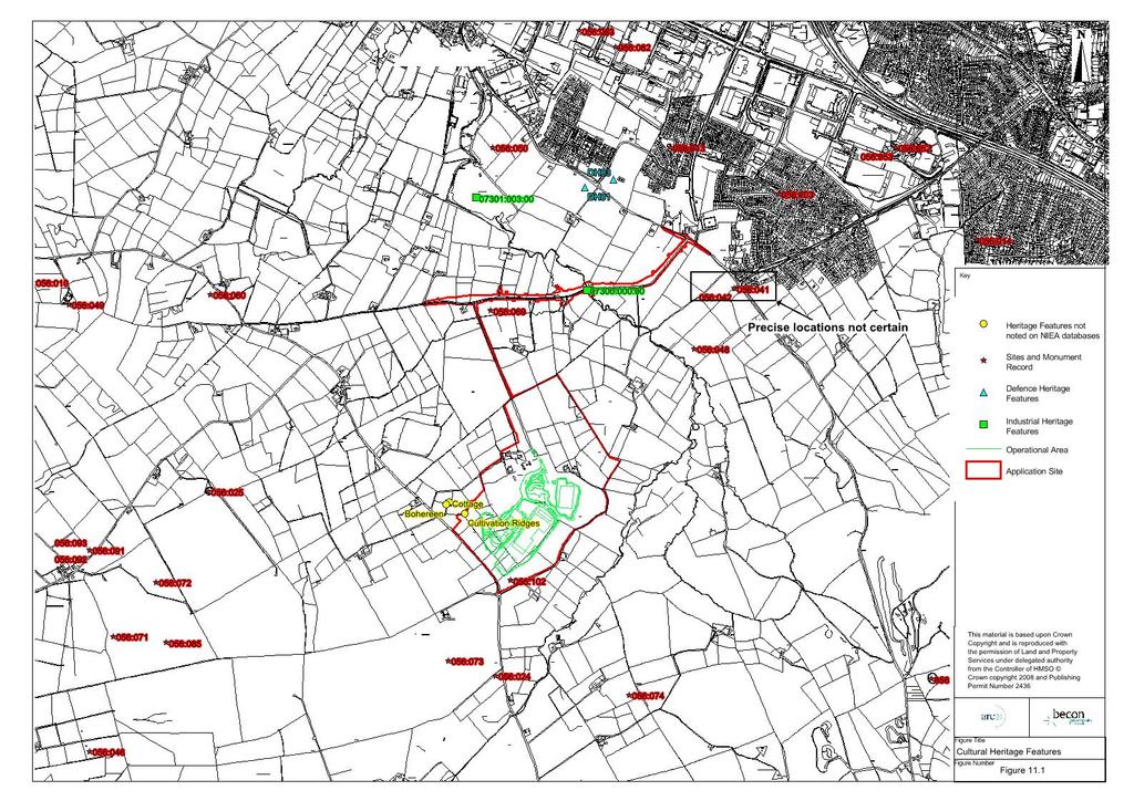
5 308 standard, or to be of major implication to the character or context of the area in which the feature or factor is located As part of this cultural heritage assessment, indirect impacts, cumulative impacts and impact interactions have also been considered. Explanation of Baseline Conditions From the databases that have been reviewed (as described above) there are a number of different known features of cultural heritage interest which provide evidence that the general area of the proposed development has been utilised over a wide range of periods of human activity Table 11.1 and associated Figure 11.1 provide details on these features (within a 1km radius of the development site):
6 309
7 310 Table 11.1 Known features of Cultural Interest (Yes/) 07300:000:00 Industrial Bridge This bridge (known as Blacks Bridge) has been the subject of a specific industrial heritage assessment undertaken by industrial archaeological consultant Fred Hamond who determined that it is a single arched basalt rubble structure of later 18 th Century / early 19 th Century date. This bridge is of local industrial heritage merit, primarily on account of its age, but is a typical example of hundreds of such structures erected in the 18 th / 19 th Centuries in Co. Antrim and beyond. Although this bridge is included in the database, it is Yes Yes This bridge and nearby culvert will be demolished due to the need to upgrade the Boghill Road as part of the proposed development neither Scheduled nor Listed as being of special architectural or historical significance. The bridge s lack of embellishment and relatively small scale make it of no particular architectural merit. The assessment report forms Appendix 11.2 to this chapter and should be referenced accordingly. te that a culvert (located along Boghill Road over a tributary of the Flush River) of similar construction and date to Blacks Bridge was also examined. This culvert is not detailed in the database and is not scheduled or listed and is of no particular architectural or
8 311 (Yes/) historic merit at a local, regional or national scale :003:00 Industrial Mill Pond / Hydepark Dam ne likely DH01 Defence Site of a Heavy Anti-Aircraft Battery ne likely DH02 Defence Small Arms Range ne likely DH03 Defence Site of a Radar Platform ne likely 056:069 Archaeological (Circular Cropmark) On reasonably level ground in a slight hollow, with good views E & S. A small, dark complete circular cropmark 25m in diam. was seen on Aerial Photographs (APs) There are one or two undulations in this area of the field. A small bump, which seems to lie slightly NW of the location shown on the maps, may be natural. It is very approx. 19m N- S x 17m E-W. The other visible feature is a faintly discernible ridge running N-S which would seem to relate to an old lane, shown on the 6" map, on the E side of the field. The land-owner did not know of ne is considered likely as this site is outside the red line boundary, and will not be subject to construction activity. It is noted though that it is in close proximity to the boundary as
9 312 (Yes/) anything in this field, but said that the ground is quite wet. such close attention will be paid to this potential archaeological site during the construction period. 056:102 Archaeological (Booley Huts) Excavations in 1996, prior to extension of a quarry here, uncovered the remains of 2 small, sub-circular huts. Both were c.2m in diameter & defined by double rows of small stones, which probably functioned as footings. The footing was better defined in Hut 1, which also had a thin smear of clay around the stones, probably the remains of walling material, possibly sods. A similar clay could be seen on the N side of Hut 2. There was a suggestion in both huts of a central partition. In Hut 1, this consisted of a line of small pebbles running through the middle of the hut and this line was repeated in Hut 2, with slightly larger stones. archaeological finds were associated with either hut. Further topsoil stripping in and around the quarry in subsequent years (1998 & 2000) did not reveal anything more of archaeological significance. Yes impact is considered likely as although within the red line boundary, this site is at the top of the quarry face and will not be subject to any construction activities (though it should be noted that the quarry wall may be subject to stabilisation activities). Careful
10 313 (Yes/) attention will be paid to this site during the construction period. 056:073 Archaeological This site was picked up on APs as an enclosure consisting of an ne likely upstanding bank, defining an irregular area, 110m x 55m. further (Prehistoric details available at present. Settlement Complex) 056:024 Archaeological Part of the forecourt of this court tomb was excavated in 1937, ne likely revealing some Neolithic pottery, a flint scraper & some Iron Age (or (Megalithic Medieval?) pottery. The site consists of a roughly semi-circular court Tomb) formed by at least 8 possible stones, some very large, 2 portal stones with a sill between them & 4 recumbent stones lying further down the slope along the estimated line of the gallery. The entrance to the tomb faces approx. NNW. A wall, which was rebuilt after excavation, runs across the N side, closing off the court. The portal stones are 1.09 & 1.02m high & stand 0.42m apart (0.51m at the base). The furthest gallery stone stretches to c.10.7m out to SSE from the portals.
11 314 (Yes/) 056:074 Archaeological In the SE part of what is now 4 fields made into one, on damp pasture ne likely which rises to the top of Squires Hill at SE. Views to NW & SW are (Circular good & fair to W. Higher ground obscures the outlook at N. There are Cropmark) several faint dips, presumably drainage channels, in the field. A dark circular cropmark 28m in diam., with a gap at NNW was seen on APs. There are apparent traces of lazy-bedding, especially at the NE side of the field, but no archaeological features could be discerned at the location of the cropmark. 056:019 Archaeological On the W slopes of Cave Hill, this cashel has a magnificent view S ne Likely (Early over Belfast. The site consists of a wall of tumbled stones, 2.5m thick, Christian 0.3m high externally & 0.6m above the interior, which is 44m N-S x Cashel) 46m E-W. The wall is not particularly wide, but has the appearance of reasonable antiquity. The remains of a rectangular structure 8.8m x 12.1m, of similar construction lie just along the perimeter at W, straddling the wall - apparently a later feature. The wall has been removed along the E & many stones have been re-deposited around an old thorn tree at SE. 056:042 Archaeological Late Medieval Castle (Site has not been located precisely) and other impact considered most probable
12 315 (Yes/) (Castle) sources outcome but have mitigation measures tentatively proposed will ensure placed this that if the remains of site well this castle are outside the discovered, these Red Line of can be properly addressed. Site and therefore it is considered very unlikely but as the precise location of this castle has not been identified, the possibility
13 316 (Yes/) cannot be discounted entirely. 056:103 Archaeological An archaeological excavation was carried out after monitoring of ne likely topsoil stripping on the site revealed areas of potential archaeology. A (Prehistoric curving gully filled with charcoal rich soil and containing Middle Bronze Age Bronze Age Pottery and worked flint was excavated in Phase 1. Occupation During Phase 2, an area of charcoal and heat shattered stone was Site) uncovered. This proved to be the truncated remains of a burnt mound or Fulacht Fiadh. A large pit was found under this deposit and has been interpreted as a trough [ADS, 1999]. Futher work in the fields to N revealed two more areas of potential archaeology. These were excavated and found to be fulachta fiadh or cooking places. The first comprised a layer of burnt mound material, under which were found 3 troughs. The first trough was 2m x 1.6m x 0.5m deep, filled with charcoal rich clay and heat shattered stone. A number of small stakeholes were cut into its base. Trough 2 was 2.2m x 1m x 0.6m deep and was cut to the W by trough 3, which in turn was 1.15m in diam., & 0.35m deep. A random scattering of
14 317 (Yes/) stakeholes was found around troughs 2 & 3. The 2nd burnt mound, to SE, measured 7.5m x 4.75m across and covered 2 troughs. Trough 1 was oval, 2m x 1.2m x 0.45m deep; the 2nd was also oval, 0.75m x 1.15m x 0.55m deep. artefacts were recovered from either site [ADS, 2001]. 056:014 Archaeological This rath, which was excavated prior to destruction, consisted of a ne likely (Rath) platform 39.7m x 35.7m across, enclosed by a denuded perimeter bank & an outer ditch 4.3m wide & 0.2m deep. The platform stood 0.8-1m above the ditch. The site was bisected by a hedge boundary. The W portion of the site was excavated first, revealing a series of curvilinear gullies & shallow postholes, but no firm structural traces. Finds were few, consisting only of shreds of souterrain ware. The E half was then excavated & also revealed curvilinear gullies, but no hearths or occupation material. 056:025 Archaeological On a small E-W ridge, with excellent views W, NW, NE & E. The site ne likely (Rath) straddles the ridge, created a domed interior, 33m x 35m across, enclosed by a bank & outer ditch. The bank is 4.5m wide, 0.25m high internally & 0.9m above the ditch, which is 2.4m wide & 0.35m deep. At the centre of the rath, a raised circular feature may be the remains
15 318 (Yes/) of a mound with the centre quarried out - or may be a circular structure. There is no visible stone. Along the W, the ditch has been recut to create a field fence. 056:072 Archaeological On a NW-facing slope with excellent views W & NW. The land is ne likely rough rocky pasture with weeds, extremely wet & marshy in places. A (Enclosure) roughly D-shaped enclosure, 65m E-W x 55m N-S, consisting of a bank & outer ditch, was picked up on APs. It is visible on the ground as a grass-covered bank forming a sub-circular enclosure which is open on the S-SW side. The enclosure is 67.4m NNW-SSE & the bank stands 0.4m high at N. An area of dark wet churned up ground with some rushes growing, on the outer NE, E & SE sides especially, seems to represent the ditch, which is c.2.6m wide at NE. The outer side is not very well defined. 056:085 Archaeological Linked to ANT 056:071 by old field system. This site was first noted ne likely (Early from APs; excavations revealed an extensive complex of enclosures, Christian some containing the remains of small houses. The total excavation of Settlement Site) one house revealed a succession of occupations defined by a series of hearths, providing material for C14 dating. Four phases of occupation were uncovered, all associated with souterrain ware,
16 319 (Yes/) suggesting an Early Christian date which was confirmed by the C14 dates. There are up to 23 houses on the site & this may be a village type settlement. A 2nd site nearby was also excavated, consisting of a small enclosure attached to 2 circular house foundations, which was radiocarbon dated to the Late Bronze Age. 056:070 Archaeological On the N side of a small valley with good views S, W & N. A slightly ne likely upstanding enclosure, defined by a bank & ditch, 40m in diam. & (Circular overgrown at the NW side, was visible on APs. The layout of the area Enclosure) has changed; a new lane has been constructed, meandering along the edges of fields. The location is difficult to pinpoint, as the field boundaries to W do not seem to tally with those on the IG map. The site location would appear to lie E of the boundary which runs directly down the valley. As this location is a slightly higher area of ground, like a small rise or platform c.33-35m across N-S. This could be natural, but is uncertain. 056:048 Archaeological (Enclosure) This site, described by O'Laverty as a rath formerly 1.5 furlongs SSE of the Castle (Ant 056:041), cannot now be located & there is no local knowledge of the site. ne thought likely though it should be noted that the precise location of this
17 320 (Yes/) feature is unknown. Mitigation measures proposed will ensure that if the remains of this site are discovered, these can be properly addressed. 056:060 Archaeological This site, thought to be an antiquity from APs, is in fact a drainage ne likely (n- feature. Antiquity Drainage ) 056:050 Archaeological s (Fortified House and Earthwork Defences) This site was described in 1611 "upon a hill side, a large house with chimneys, which is enclosed by a rampart of earth sods & flankered..." local tradition of the site survives & the site cannot now be located. ne thought likely though it should be noted that the precise location of this feature is unknown. Mitigation measures
18 321 (Yes/) proposed will ensure that if the remains of this site are discovered 056:047 Archaeological s (AP Site Cropmarks) This site cannot be precisely located. ne thought likely though it should be noted that the precise location of this feature is unknown. Mitigation measures proposed will ensure that if the remains of this site are discovered 056:052 Archaeological (Souterrain) This site cannot be precisely located. ne thought likely though it should be noted that the precise location of this feature is unknown. Mitigation measures
19 322 (Yes/) proposed will ensure that if the remains of this site are discovered 056:013 Archaeological On the N-facing slope at the edge of a ridge, with land rising to S. The ne likely site consists of a low, flat topped mound, 1.5m high & 13m x 15m (Mound) across, built of earth, with some large stones in its make-up. The scarp has been eroded in some places by cattle & a steel box has been built into the N face. Topsoil stripping was carried out on an area W of the mound under archaeological supervision (AE/03/58), prior to development. An area approx. 150m E-W x 40m N-S was stripped. finds or features of archaeological significance were uncovered [ADS, Aug. 2003]. Groundworks for the final phase of development at Mayfield Village were carried out under archaeological supervision. Previous excavations in the area had uncovered a Fulacht Fiadah (cf ANT 056:103, AE/01/25) & a prehistoric occupation site (cf AE/02/45). During this phase, topsoil stripping uncovered a number of shallow linear features and 2 pits, but no datable evidence was recovered
20 323 (Yes/) from any of them - the linear features are most likely the remains of plough furrows [ADS, 2004].
21 As demonstrated in Table 11.1 and noted in the archaeological report produced by John Cronin & Associates in May 2009 (contained within Appendix 11.1), there is evidence of utilisation of this region for over 6,000 years. In addition to the features noted in the database, a walkover survey noted evidence of ridge and furrow cultivation (lazy beds) and a ruined cottage and associated bohereen (laneway) in the vicinity of the quarry site. See Figure 11.1 for the location of these features It should be noted that no features were recorded on the site or in its vicinity in relation to the following databases: Areas of Significant Archaeological Interest; Register of Historic Parks and Gardens; Listed Buildings; and Scheduled Areas In addition no objects / features were noted by NMNI in any of their databases (e.g. Find Spots Register) for the study area. Predicted environmental effects and their significance (construction and operational) Potential Impacts - Construction There are a number of known sites of cultural heritage interest in the area around the proposed development site. It is likely, therefore, that the site and nearby areas, would have been utilised in the past and, as such, it is likely that remains are present in this area However, the application site is located, for the most part, in a working quarry where any archaeological remains are most likely to have been displaced by past operations. During Tarmac s tenure of the site topsoil stripping has been carried out in consultation with and relevant heritage legislation has been adhered to In addition the majority of the known sites listed in Table 11.1 will not be directly or indirectly affected by the construction or operation of the proposed scheme In their consultation response made specific reference to the terms of Planning Policy 6 Planning, Archaeology and Built in particular Policy BH2. This policy states Development proposals which would adversely affect archaeological sites or monuments which are of local importance or their settings will only be permitted where the Department considers the importance of the proposed development or other material considerations outweigh the value of the remains in question There are three known sites (see Figure 11.1) of archaeological interest within, or in very close proximity to, the application site boundary as follows:
22 325 Site 056:102, which is the site of Booley Huts excavated in 1996 (see Table 11.1 above for a full description). As noted by, excavations in 1996, prior to extension of a quarry here, uncovered the remains of two small, sub-circular huts. Both were c.2m in diameter & defined by double rows of small stones, which probably functioned as footings. The footing was better defined in Hut 1, which also had a thin smear of clay around the stones, probably the remains of walling material, possibly sods. A similar clay could be seen on the N side of Hut 2. There was a suggestion in both huts of a central partition. In Hut 1, this consisted of a line of small pebbles running through the middle of the hut and this line was repeated in Hut 2, with slightly larger stones. archaeological finds were associated with either hut. Further topsoil stripping in and around the quarry in subsequent years (1998 & 2000) did not reveal anything more of archaeological significance. Although located within the application site these huts will not be disturbed by the proposed development. Site 056:069, which is located outside but in very close proximity to the application site (within a field adjacent to the boundary), is described by as a circular crop mark (of c.25m diameter). It is shown on aerial photographs and is on reasonably level ground in a slight hollow, with good views E & S. There are one or two undulations in this area of the field. A small bump, which seems to lie slightly NW of the location shown on the maps, may be natural. It is very approximately 19m N-S x 17m E-W. The other visible feature is a faintly discernible ridge running N-S which would seems to relate to an old lane, shown on the 6" map, on the E side of the field. It is noted by that the landowner did not know of anything in this field, but said that the ground is quite wet. Industrial Site 07300:000:00. This site (known as Blacks Bridge) on the Boghill Road will be directly impacted by the proposed development which will result in this feature being removed and replaced with a modern bridge as part of the upgrading of this access route. There is also a small culvert located along the Boghill Road (across a tributary of Flush River) which will also be demolished and replaced with a modern structure. stated in their consultation response that if Blacks Bridge cannot be retained then as per Policy BH4 of PPS 6, discussion regarding the appropriate mitigation required to record the bridge prior to development would be necessary A licensed Industrial Archaeologist has carried out a detailed survey of this bridge (see report in Appendix 11.2). This survey determined that the bridge is a single arched basalt rubble structure of later 18 th Century / early 19 th Century date. It is of local industrial heritage merit, primarily on account of its age, but is a typical example of hundreds of such structures erected in the 18 th / 19 th Centuries in Co. Antrim and beyond. Although this bridge is included in the database, it is neither Scheduled nor Listed as being of special architectural or historical significance. The bridge s lack of embellishment and relatively small scale make it of no particular architectural merit As with the site of the Booley Huts, there are other aspects to the proposed scheme that will involve disturbance to areas not previously impacted by the quarrying operations. For example, Boghill Road will be widened into areas which are currently in agricultural use. It is quite
23 326 possible that these areas will have unknown features of cultural heritage present and these features could be disturbed / destroyed by activities connected to upgrading these routes. These activities will include stripping of the topsoil (the layer in which most archaeological artefacts would be present) There are also two important features detailed in the archaeological heritage database, the locations of which are known to have been in the general area of the application site but which have not been accurately identified. These features are the Chapel of Westone and the site of a Late Medieval Castle. The report carried out by EDAW on behalf of Wimpey Minerals Ltd (see Appendix 11.3) suggests tentatively that these features may have been located at an area known as Hightown Terrace, due to documentary evidence dating from It is possible that these sites, or features associated with them, could be uncovered during construction of the proposed development (most likely during construction of Boghill Road widening) It should be noted that a culvert (located along Boghill Road over a tributary of the Flush River) of similar construction and date to Blacks Bridge was also examined. This culvert is not detailed in the database and is not scheduled or listed and is of no particular architectural or historic merit at a local, regional or national scale. Potential Impacts - Operation The operation of the proposed facilities will have no impact on the cultural heritage of the area. Any features which are undisturbed by the construction phase will remain so. of proposed mitigation measures (construction and operational) Mitigation Construction Due to the potential for unknown items of cultural heritage to exist in the general area of the proposed development (in particular areas adjacent to Boghill Road), a licensed archaeologist will be appointed to carry out a watching brief of topsoil stripping (not including the removal of overburden from the quarry area) Prior to construction, the archaeologist will agree a programme of works with. In addition to any requirements from, the following measures will be undertaken as part of these works and are included within the Construction Management Plan, located at Appendix 3.1: A licensed archaeologist is to be present during topsoil stripping along Boghill Road in order to monitor disturbance. The potential for archaeological excavation is to be taken into account in the construction timetable and contract, with the appointed contractor to be made aware of the need to work with the archaeologist and the potential for the use of new working methods to accommodate the archaeologist s requirements. Any test trenches required by the archaeologist are to be excavated using a smooth edged bucket on a back acting mechanical excavator.
24 327 Each excavating machine is to be observed by an archaeologist. The relevant case officer will be kept informed at all stages of the works and will be consulted to agree the appropriate course of action in the event of the discovery and identification of any archaeological remains. Excavation may be required and the agreement for this or other preservation methodology will be made between project promoter and. If required, the archaeologist will undertake post excavation works and complete a full report on the artefact finds and all other aspects of their role in the project. This report will be submitted to for approval and subsequent inclusion in relevant databases In relation to the site of Booley Huts, whilst there is no proposal for it to be disturbed, should it become necessary for any earth movement or other works to take place in relative proximity to this area, close monitoring by a licensed archaeologist will be undertaken (due to the potential that other Booley huts remain undiscovered) Details of both Blacks Bridge and the small culvert over the tributary of Flush River are contained in the report by specialist archaeologist, Fred Hamond, provided within Appendix 11.2 This report met the requirements of in relation to Policy BH4 of PPS 6 and, as required with any archaeological reports, it has been submitted to for subsequent inclusion in relevant databases. noted that Black's Bridge has now been comprehensively surveyed both photographically and by way of a measured survey and agree with the report s finding that the bridge is of local heritage interest. They note that the bridge is one of hundreds of similarly designed bridges built throughout Co. Antrim in the 18th and 19th century. Taking this into consideration : Historic Monuments Unit have confirmed they have no objection to the bridge being removed as part of the proposed development It should be noted that under the terms of The Historic Monuments and Archaeological Objects (NI) Order 1995, it is a requirement to report the discovery of any archaeological object to the statutory body. Any appointed contractor and their staff working on this scheme will be made aware of the possibility of uncovering unknown artefacts or other features and will be advised of their responsibilities under this legislation. Mitigation Operation As the proposed development will have no impact on the cultural heritage of the area no mitigation measures are required for the operational period. of Residual effects and their significance taking mitigation into account (construction and operational) The effect on the cultural heritage of an area can be one of the most uncertain areas of a development as it is always possible that not all features are recorded in written archives. While the majority of the known archaeological features are not located near to the proposed development and the area of the proposed development will for the most part be on areas that
25 328 were previously disturbed, the known archaeological record and the nature of the surrounding area suggests that there is a potential for the occurrence of previously unknown cultural heritage resources It is considered that the proposed mitigation measures of having an archaeologist present during any topsoil stripping and the requirement for all staff working on the project to be made aware of the possibility of unknown artefacts and of their responsibilities if a feature is uncovered. This, alongside the requirement to agree (with ) suitable recording, excavation and (if applicable) preservation of any found features of interest, will mitigate successfully for the most part the impact on cultural heritage There will be a permanent impact due to the demolition of Blacks Bridge which, although of very limited cultural heritage interest, will give rise to a Moderate Negative Impact at a local level during the construction phase During the operational phase there will be no impact on the cultural heritage of the area As part of this heritage assessment, indirect impacts, cumulative impacts and impact interactions have been considered In terms of indirect impacts it is considered that impacts on a feature of cultural heritage i.e. the demolition of Black s Bridge could potentially have indirect impacts on the Water Environment. The mitigation measures relating to this are further described in Chapter 7: The Water Environment and should be referenced accordingly. It is considered that these are sufficiently robust to ensure that there will be no indirect impacts on the water environment Cumulative Impacts are impacts that result from incremental changes caused by other past, present or reasonably foreseeable actions together with the project under consideration. cumulative impacts in terms of Cultural have been identified Impact interactions are the impacts of the various stages of the project, during construction and the operational stage of the proposed development. It is considered that with the implementation of the appropriate mitigation there will be no impact interactions during the construction and operational stages.
MONITORING REPORT: No. 283
 MONITORING REPORT: No. 283 Dunluce Castle Visitor Centre Option Site D Magheracross Co. Antrim AE/14/109E Dermot Redmond List of Contents Site Specific Information 1 Account of the Monitoring 2 Discussion
Historic England Advice Report 26 August 2016
 Case Name: Kingsland Castle Case Number: 1435892 Background Historic England has been asked to review the scheduling for Kingsland Castle. The land on which the monument lies is understood to be for sale.
Archaeological Evaluation and Assessment of Land at Kent Cottage, 19 Chapel Street, Hythe, Kent
 Archaeological Evaluation and Assessment of Land at Kent Cottage, 19 Chapel Street, Hythe, Kent Planning Application Y13/0463/SH Date of Report: 29/04/2015 Report for Marc Carney SWAT. ARCHAEOLOGY Swale
9 Archaeology & Cultural Heritage
 High Clachaig Wind Farm Scoping Report Page 56 9 Archaeology & Cultural Heritage 9.1 Introduction Cultural heritage in this context means the above- and below-ground archaeological resources, built heritage,
EVALUATION REPORT No. 300
 EVALUATION REPORT No. 300 Southwest of 2A Cloughey Road, Portaferry, Co. Down Licence No.: AE/135/85E Sapphire Mussen Report Date: 14 th May 2015 Site Specific Information Site Name: [Southwest of 2a]
Chitty Farmhouse Extension, Wall Lane, Silchester, Hampshire
 Chitty Farmhouse Extension, Wall Lane, Silchester, Hampshire An Archaeological Watching Brief For In Touch by Andrew Mundin Thames Valley Archaeological Services Ltd Site Code CFS 08/52 May 2008 Summary
Land adjacent to Dingle Dock, Front Street, East Garston
 Land adjacent to Dingle Dock, Front Street, East Garston An Archaeological Watching Brief for Dr J Davies by Jo Pine Thames Valley Archaeological Services Site Code DEG99/82 January 2000 Summary Site name:
MONITORING REPORT: No. 276
 MONITORING REPORT: No. 276 Between 51 and 53 Castor Bay Road Lurgan Co. Armagh AE/13/214 Dermot Redmond Site Specific Information Site Name: Between 51 and 53 Castor Bay Road, Lurgan, Co. Armagh Townland:
Evaluation/Monitoring Report No. 243
 60m NORTH OF 64 BALLYGROOBANY ROAD BALLYNAHINCH RICHHILL COUNTY ARMAGH LICENCE NO.: AE/12/91E NAOMI CARVER 1 Site Specific Information Site Name: site 60m north of 64 Ballygroobany Road, Ballynahinch,
Monitoring of invasive groundworks ahead of the installation of a septic tank at 16a, 16b and 16c Donegore Hill Muckamore County Antrim
 Monitoring Report No. 177 Monitoring of invasive groundworks ahead of the installation of a septic tank at 16a, 16b and 16c Donegore Hill Muckamore County Antrim LICENCE NO.: AE/09/48 Brian Sloan 1 Site
Archaeological Evaluation and Assessment of Land at Minnis Beeches, Canterbury Road, Swingfield, Dover, Kent
 Archaeological Evaluation and Assessment of Land at Minnis Beeches, Canterbury Road, Swingfield, Dover, Kent NGR: TQ 6307 1545 Site Code: MB-EV-10 (Planning Consent Y10/0311/SH) Report for Thorndene Ltd.
Centre for Archaeological Fieldwork Evaluation/Monitoring Report No Monitoring Report No. 201
 Monitoring Report No. 201 Land adjacent to 58 Drumreagh Road Drumreagh Ballygowan Co. Down LICENCE NO.: AE/10/91E BRIAN SLOAN 1 Site Specific Information Site Name: Land adjacent to 58 Drumreagh Road,
Evaluation/monitoring Report No. 241 KING S CASTLE NURSING HOME ARDGLASS CO. DOWN AE/12/19 SARAH GORMLEY
 Evaluation/monitoring Report No. 241 KING S CASTLE NURSING HOME ARDGLASS CO. DOWN AE/12/19 SARAH GORMLEY 1 Site Specific Information Site Name: Townland: King s Castle Ardglass SMR No. : DOW 045:024 Status:
Archaeological evaluation at Willowdene, Chelmsford Road, Felsted, Essex
 Archaeological evaluation at Willowdene, Chelmsford Road, Felsted, Essex August 2013 report prepared by Ben Holloway on behalf of Mr Anthony McGurren Planning reference: UTT/13/0235 CAT project ref.: 13/07g
Archaeology and Planning in Greater London. A Charter for the Greater London Archaeology Advisory Service
 Archaeology and Planning in Greater London A Charter for the Greater London Archaeology Advisory Service THE PURPOSE OF THE CHARTER This Charter sets out how English Heritage will provide archaeological
Gryme s Dyke, Stanway Green
 Gryme s Dyke, Stanway Green A short assessment of the archaeological impact of contractor s groundworks at the southern end of the Gryme s Dyke Middle earthwork February 2000 Archive report on behalf of
Archaeological trial-trenching evaluation: New Hall School, The Avenue, Boreham, Essex. July 2015
 Archaeological trial-trenching evaluation: New Hall School, The Avenue, Boreham, Essex report prepared by Ben Holloway on behalf of New Hall School Planning reference: 14/01846/FUL CAT project ref.: 15/04i
How we find the sites
 How we find the sites Many of the archaeological sites mapped by aerial archaeologists have been levelled by ploughing and are identified from the photos as cropmarks or soilmarks. Archaeological sites
1. ARCHAEOLOGICAL IMPACT ASSESSMENT
 1. ARCHAEOLOGICAL IMPACT ASSESSMENT 1.1 Introduction. 1.2 Methodology 1.3 Receiving Environment 1.4 Archaeological and Historical Background 1.5 Recorded archaeological sites in the vicinity of the proposed
Centre for Archaeological Fieldwork, School of Archaeology and Palaeoecology, Queen s University Belfast.
 Centre for Archaeological Fieldwork, School of Archaeology and Palaeoecology, Queen s University Belfast. Monitoring Report No. 04 Duneight Motte and Bailey, May 2004. On behalf of Monitoring Report: Duneight
New horse training area, Manor Farm, Great Kimble, Buckinghamshire
 New horse training area, Manor Farm, Great Kimble, Buckinghamshire An Archaeological Watching Brief For Redwing Structures (Marlow) Limited by Andy Taylor Thames Valley Archaeological Services Ltd Site
Ivol Buildings, Woodcote Road, South Stoke, Oxfordshire
 Ivol Buildings, Woodcote Road, South Stoke, Oxfordshire An Archaeological Watching Brief For Christ Church, Oxford by Pamela Jenkins Thames Valley Archaeological Services Ltd Site Code IBSS 04/03 March
North East Region TYNE & WEAR 1 /315 (B ) NZ
 NZ") TYNE & WEAR Newcastle Upon Tyne 1 /315 (B.05.6311) NZ 28016514 138 FOSSWAY, WALKER An Archaeological Desk-Based Assessment for a Proposed Development at 138 Fossway, Walker GeoQuest Associates Consett
TYNE & WEAR Newcastle Upon Tyne 1 /315 (B.05.6311) NZ 28016514 138 FOSSWAY, WALKER An Archaeological Desk-Based Assessment for a Proposed Development at 138 Fossway, Walker GeoQuest Associates Consett
Garage Site, Foots Cray High Street, Sidcup, Kent, London Borough of Bexley
 Garage Site, Foots Cray High Street, Sidcup, Kent, London Borough of Bexley An Archaeological Evaluation for Mizen Design Build by Andy Taylor Thames Valley Archaeological Services Ltd FOC 07 September
An Archaeological Evaluation at Granta Cottages, Newmarket Road, Great Chesterford, Essex. August 2015
 An Archaeological Evaluation at Granta Cottages, Newmarket Road, Great Chesterford, Essex August 2015 by Pip Parmenter and Ben Holloway on behalf of Mr G Elmer and Mrs L King CAT project ref.: 15/06a NGR:
Monitoring Report No. 166
 Monitoring Report No. 166 No. 2a Loughadian Road Poyntzpass County Down AE/08/189 Nick Beer Site Specific Information Site Address: 2a Loughadian Road, Poyntzpass. Townland: Loughadian SMR No.: DOW 033:034
What is fieldwalking?
 Cambridge Archaeology Field Group May 2012 What is fieldwalking? Archaeological fieldwalking (or Surface Artefact Collection as it is sometimes known) is the systematic recovery and recording of artefacts
Appletree, Thames Street, Sonning Berkshire
 Appletree, Thames Street, Sonning Berkshire An Archaeological Watching Brief for Mr and Mrs A Popham by Sian Anthony Thames Valley Archaeological Services Ltd Site Code ATS 02/83 October 2002 Summary Site
Meales Farm, Sulhamstead, West Berkshire
 Meales Farm, Sulhamstead, West Berkshire An Archaeological Watching Brief For Mr. Robert Astor by Steve Ford Thames Valley Archaeological Services Ltd Site Code CHH02/29 May 2002 Summary Site name: Meales
Pinnocks Wood Equestrian Centre, Burchett s Green, Maidenhead, Berkshire
 Pinnocks Wood Equestrian Centre, Burchett s Green, Maidenhead, Berkshire An Archaeological Watching Brief For Mr David Eyles by Andrew Mundin Thames Valley Archaeological Services Ltd Site Code POB 08/69
Bridge House, Ham Island, Old Windsor, Berkshire
 Bridge House, Ham Island, Old Windsor, Berkshire An Archaeological Watching Brief for Mr A Chadwick by Alan Ford Thames Valley Archaeological Services Site Code BHHI98/55 August 1998 Bridge House, Ham
Billington Parish Green Infrastructure Plan
 Billington Billington Parish Green Infrastructure Plan Methodology Following a presentation to the Annual Parish Meeting, The Greensand Trust was invited to attend the next Parish Council Meeting. The
Examination of South Cambridgeshire Local Plan
 Matter SC6A - Policy SS/5 Waterbeach New Town Historic England( formerly English Heritage) 874 Rep Nos 59748, 60250, 60253 Examination of South Cambridgeshire Local Plan Historic England, Hearing Statement
Barvills Solar Farm Environmental Statement Non-Technical Summary
 Barvills Solar Farm Environmental Statement Non-Technical Summary 13 March 2015 Produced for Prepared by St John s House Queen Street, Manchester M2 5JB Contents Contents... 2 1 Introduction... 3 1.1 Development
Archaeological Monitoring of Land at 29 Royal Pier Road, Gravesend, Kent
 Archaeological Monitoring of Land at 29 Royal Pier Road, Gravesend, Kent Site Code ROY/WB/15 Report for Dr Maxted Date of report 06/10/2015 SWAT ARCHAEOLOGY Swale and Thames Archaeological Survey Company
A Research Framework for the Archaeology of Wales Version 01, Final Paper Neolithic and Earlier Bronze Age
 NEOLITHIC AND EARLIER BRONZE AGE Introduction The introduction of farming around 4000 BC had a dramatic impact on the landscape of Wales and fundamentally changed they ways in which people lived and interacted.
PHASE 1 ARCHAEOLOGICAL IMPACT ASSESSMENT PROPOSED DEVELOPMENT ERF 3 ROBERTSON WESTERN CAPE PROVINCE
 PHASE 1 ARCHAEOLOGICAL IMPACT ASSESSMENT PROPOSED DEVELOPMENT ERF 3 ROBERTSON WESTERN CAPE PROVINCE Prepared for BOLAND ENVIRO Att: Mr Nik Wullschleger PO Box 250 Worcester 6849 Fax: (023) 347 0336 By
Archaeological Investigation in advance of Development at 2 Palace Cottages, Charing Palace, Charing, Kent
 Archaeological Investigation in advance of Development at 2 Palace Cottages, Charing Palace, Charing, Kent Site Code CHAR-EV-14 NGR 95412 49439 Date of Report 18/12/2014 Swale and Thames Archaeological
13.0 ARCHAEOLOGY AND CULTURAL HERITAGE
 13.0 ARCHAEOLOGY AND CULTURAL HERITAGE Introduction 13.1 This chapter of the ES assesses the likely significant effects of the Overall Development in terms of archaeology and cultural heritage and is supported
Northbury Farm, Castle End Road, Ruscombe, Berkshire
 Northbury Farm, Castle End Road, Ruscombe, Berkshire An Archaeological Watching Brief For Sir Colin and Lady Southgate by Danielle Milbank Thames Valley Archaeological Services Ltd Site Code NFR 07/120
NON-TECHNICAL SUMMARY
 Proposed Sand and Gravel Extraction and Associated Processing Operations with Restoration to a Mixture of Agriculture and Nature Conservation including Areas of Shallow Water at Hedgeley, Northumberland
69 DRUMLOUGH ROAD, DRUMGATH, COUNTY DOWN
 MONITORING REPORT NO. 223 69 DRUMLOUGH ROAD, DRUMGATH, COUNTY DOWN LICENCE NO. EMILY MURRAY Report Date: 13 th April 2011 Site Specific Information Site name: Townland: SMR No. : Grid ref.: County: Excavation
MONITORING REPORT: No. 289
 MONITORING REPORT: No. 289 21 Ballynarrig Road Ballydarrog Co. Derry AE/14/213E Dermot Redmond Site Specific Information Site Name: 21 Ballynarrig Road, Limavady Townland: Ballydarrog SMR No. : LDY 016:004
Merrowdene, Earleydene, Sunninghill, Berkshire
 Merrowdene, Earleydene, Sunninghill, Berkshire An Archaeological Watching Brief For Mr and Mrs Jackson by Andy Taylor Thames Valley Archaeological Services Ltd Site Code MES 05/88 January 2006 Summary
Downton Manor, Downton, near Lymington, Hampshire
 Downton Manor, Downton, near Lymington, Hampshire An Archaeological Evaluation for New Milton Sand and Gravel by Sian Anthony Thames Valley Archaeological Services Ltd Site Code DMD03/20 May 2003 Summary
New Swimming Pool,West Meon House, West Meon, Hampshire
 New Swimming Pool,West Meon House, West Meon, Hampshire An Archaeological watching brief and building recording for Mr and Mrs Younger by Danielle Milbank Thames Valley Archaeological Services Ltd Site
Chapter 8: Cultural Heritage Assessment
 Chapter 8: Cultural Heritage Assessment Cultural Heritage Assessment 8. Cultural Heritage Assessment... 2 8.1 Introduction... 2 8.2 Baseline Assessment... 2 8.3 Results / Assessment Findings... 3 8.4 Mitigation...
SITE VISIT OFFICE MEETING TELEPHONE NOTES
 SITE VISIT OFFICE MEETING TELEPHONE NOTES Our Reference: Assigned to HB12 15 012 Date of meeting and site visit: 03/11/2016 Present: Edith Logue: HM Development and Change Branch Terence Reeves Smyth:
ARCHAEOLOGICAL S E R V I C E S. Land north of Orchard Close, Hallow, Worcestershire. Archaeological Evaluation. by Kyle Beaverstock
 T H A M E S V A L L E Y ARCHAEOLOGICAL S E R V I C E S Land north of Orchard Close, Hallow, Worcestershire Archaeological Evaluation by Kyle Beaverstock Site Code: OCW15/224 (SO 8285 5848) Land north of
Monitoring Report No. 168
 Monitoring Report No. 168 Loughgall Presbyterian Church Cloven Eden Loughgall County Armagh AE/08/203 Nick Beer Site Specific Information Site Address: Loughgall Presbyterian Church, 100 Cloven Eden Road,
National Character Area 70 Melbourne Parklands
 Summary The are a landscape of rolling farmland, parkland and woodland on the northern flanks of the ridge between Burton upon Trent and Swadlincote. The land slopes down to the River Trent, which borders
ARCHAEOLOGICAL S E R V I C E S. Manor Farm, Launton, Bicester, Oxfordshire. Archaeological Watching Brief. by Aiji Castle. Site Code: LBO13/220
 T H A M E S V A L L E Y ARCHAEOLOGICAL S E R V I C E S Manor Farm, Launton, Bicester, Oxfordshire Archaeological Watching Brief by Aiji Castle Site Code: LBO13/220 (SP 6035 2285) Manor Farm, Launton, Bicester,
Foreword. Síle de Valera, TD, Minister for Arts, Heritage, Gaeltacht and the Islands
 Foreword This Code of Practice is a significant milestone in the protection of the archaeological heritage. It marks an agreement between my Department and the National Roads Authority, one of the largest
Greater London. Greater London 6/42 (D.01.M001) TQ
 TQ") Authority 6/42 (D.01.M001) TQ 54207390 ST. JAME'S INVESTMENTS, LOWFIELD STREET AND MARKET STREET, DARTFORD Environmental Statement. Archaeology. Volume 9 of 10 AOC Archaeology Group Twickenham : AOC Archaeology
Authority 6/42 (D.01.M001) TQ 54207390 ST. JAME'S INVESTMENTS, LOWFIELD STREET AND MARKET STREET, DARTFORD Environmental Statement. Archaeology. Volume 9 of 10 AOC Archaeology Group Twickenham : AOC Archaeology
Archaeological evaluation at Redbank, Bury Water Lane, Newport, Essex, CB11 3TZ
 Archaeological evaluation at Redbank, Bury Water Lane, Newport, Essex, CB11 3TZ March 2017 by Laura Pooley figures by Ben Holloway and Emma Holloway fieldwork by Ben Holloway with Harvey Furniss and Elliott
The Place Solar Farm
 The Place Solar Farm Environmental Statement Non-Technical Summary 28 August 2014 Produced for Prepared by St John s House Queen Street, Manchester M2 5JB Contents Contents... 2 1 Introduction... 3 1.1
APPENDIX 9: Archaeological Assessment by Ken Phillips
 APPENDIX 9: Archaeological Assessment by Ken Phillips ARCHAEOLOGICAL ASSESSMENT PROPOSED SERVICE STATION DEVELOPMENT BRUCE ROAD, PAPAMOA TAURANGA Prepared by KEN PHILLIPS (MA HONS) MARCH 2016 ARCHAEOLOGY
Archaeological evaluation on land at Mersea Fleet Way, Chelmer Road, Braintree, Essex, CM7 3PZ
 Archaeological evaluation on land at Mersea Fleet Way, Chelmer Road, Braintree, Essex, CM7 3PZ by Laura Pooley figures by Ben Holloway and Emma Holloway fieldwork by Ben Holloway, Robin Mathieson, Nigel
ARCHAEOLOGICAL EVALUATION AT THE FORMER WATTON GARDEN CENTRE, NORWICH ROAD, WATTON, NORFOLK OCTOBER 2003 (Accession number WAT)
") NORTHAMPTONSHIRE ARCHAEOLOGY NORTHAMPTONSHIRE COUNTY COUNCIL NOVEMBER 2003 (Planning Application No: 3PL/1997/048/0 ARCHAEOLOGICAL EVALUATION AT THE FORMER WATTON GARDEN CENTRE, NORWICH ROAD, WATTON, NORFOLK
NORTHAMPTONSHIRE ARCHAEOLOGY NORTHAMPTONSHIRE COUNTY COUNCIL NOVEMBER 2003 (Planning Application No: 3PL/1997/048/0 ARCHAEOLOGICAL EVALUATION AT THE FORMER WATTON GARDEN CENTRE, NORWICH ROAD, WATTON, NORFOLK
05/04/2016. Who are archaeologists and what do we do? Archaeology and the Planning Process and Some Helpful Tips
 Archaeology and the Planning Process and Some Helpful Tips Who are archaeologists and what do we do? Curators (local authorities, HS, RCAHMS) Consultants Contractors Academics (Higher Education) Community
PROPOSED DEVELOPMENT AT BRITANNIA PARK, BANGOR
 PROPOSED DEVELOPMENT AT BRITANNIA PARK, BANGOR ARCHAEOLOGICAL MITIGATION WORK Report No. 446 [08] [04] [06] [08] [06] [04] Prepared for Watkins Jones Construction March 2002 By J. Kenney Ymddiriedolaeth
Land at Downsview Avenue, Storrington, West Sussex
 Land at Downsview Avenue, Storrington, West Sussex An Archaeological Evaluation for Bellwinch Homes Limited by Andy Taylor Thames Valley Archaeological Services Ltd Site Code DAS 04/21 March 2004 Summary
Derry City and Strabane District Council Planning Committee Report
 Derry City and Strabane District Council Planning Committee Report COMMITTEE DATE: 23 rd March 2016 APPLICATION No: APPLICATION TYPE: PROPOSAL: LOCATION: APPLICANT: LA11/2015/0395/F Residential Development
Archaeological evaluation at Stables, Hatch Farm, Fen Lane, Bulphan, Essex, RM14 3RL
 Archaeological evaluation at Stables, Hatch Farm, Fen Lane, Bulphan, Essex, RM14 3RL November-December 2016 by Laura Pooley figures by Ben Holloway and Emma Holloway fieldwork by Ben Holloway and Alec
Archaeological evaluation on land at Unit 1, Waltham Hall, Bambers Green Road, Takeley, Essex, CM22 6PF
 Archaeological evaluation on land at Unit 1, Waltham Hall, Bambers Green Road, Takeley, Essex, CM22 6PF by Laura Pooley figures by Ben Holloway and Emma Holloway fieldwork by Ben Holloway with Jane Roberts
ENVIRONMENTAL INVENTORY
 Hungarton Neighbourhood Plan ENVIRONMENTAL INVENTORY Sites scoring 25/36 or more (70%) are judged to be the most important environmental and community sites and are proposed as Local Green Space. Other
MANAGING CHANGE IN THE HISTORIC ENVIRONMENT. Historic Battlefields August 2016
 MANAGING CHANGE IN THE HISTORIC ENVIRONMENT Historic Battlefields August 2016 Above: Most of Culloden battlefield lay under forestry until clearance by the National Trust for Scotland in the 1980s. While
Old Town Hall, Market Place, Faringdon, Oxfordshire
 Old Town Hall, Market Place, Faringdon, Oxfordshire Building Recording and Archaeological Watching Brief for Great Faringdon War Memorial Trust by Jamie Preston and Steve Ford Thames Valley Archaeological
3.1 This evidence is based on the landscape and visual impact assessment included in Chapter 10 and Appendix I of the EIS.
 LANDSCAPE & VISUAL 1 QUALIFICATIONS AND EXPERIENCE 1.1 My name is Raymond Holbeach and I am a Regional Director for RPS Planning & Environment with full responsibility for management of the RPS Belfast
METHODOLOGY FOR IMPACT ASSESSMENT ON HERITAGE ASSETS IDENTIFICATION OF THE RECEPTOR ASSESSMENT OF THE RECEPTOR S IMPORTANCE
 METHODOLOGY FOR IMPACT ASSESSMENT ON HERITAGE ASSETS The determination of impacts on heritage assets follows the standard procedures applied to all Environmental Impact Assessment. This entails the identification
volume 11 environmental assessment section 2 environmental impact assessment Part 7 ha 218/08
 DESIGN MANUAL FOR ROADS AND BRIDGES volume 11 environmental assessment section 2 environmental impact assessment Part 7 ha 218/08 glossary of terms Used in DMRB Volume 11, Sections 1 and 2 SUMMARY This
Environmental Impact Assessment
 Environmental Impact Assessment Environmental impact assessment (EIA) is the process of systematically drawing together an assessment of the likely significant environmental effects of a development project.
APPENDIX 10 UNESCO WORLD HERITAGE SITE
 APPENDIX 10 UNESCO WORLD HERITAGE SITE The Convention Concerning the Protection of the World Cultural and Natural Heritage - The World Heritage Convention 1972 The World Heritage Convention was ratified
Archaeological evaluation at New Hall School, The Avenue, Boreham, Chelmsford, Essex, CM3 3HS
 Archaeological evaluation at New Hall School, The Avenue, Boreham, Chelmsford, Essex, CM3 3HS December 2016 by Laura Pooley with contributions by Stephen Benfield figures by Ben Holloway and Emma Holloway
Appendix F. Archaeology and Architectural Heritage Report
 Appendix F Archaeology and Architectural Heritage Report Commercial-in-Confidence Report No. 14164/R02 September 2007 SALLINS, COUNTY KILDARE PROPOSED BYPASS AT SALLINS, COUNTY KILDARE: ROUTE CORRIDOR
M7 Naas to Newbridge Bypass Upgrade Scheme. Landscape and Visual Impact Assessment Brief of Evidence
 M7 Naas to Newbridge Bypass Upgrade Scheme Landscape and Visual Impact Assessment Brief of Evidence Presented by Richard Butler, Cunnane Stratton Reynolds Landscape Architect: BL Arch (University of Pretoria,
DACORUM GOLDEN PARSONAGE Great Gaddesden Brief Description Principal Building: Approach: Stable block other utilitarian buildings: Walled Garden:
 HERTFORDSHIRE GARDENS TRUST LOCAL LIST: DACORUM Present Name of Site GOLDEN PARSONAGE Historic Name (if known) Parish/Town Great Gaddesden National Grid Reference of Principal Building: TL051 125 Present
Longmore House Salisbury Place Edinburgh EH9 1SH. 18 January 2008
 We safeguard the nation s historic environment and promote its understanding and enjoyment Martin Dean Access and Countryside Projects Officer Development and Environmental Services Clackmannanshire Council
Archaeological evaluation: land to the rear of Clare Road, Braintree, Essex
 Archaeological evaluation: land to the rear of 41-45 Clare Road, Braintree, Essex March 2014 commissioned by Mr Mark Plummer report prepared by Ben Holloway and Howard Brooks Planning reference: 13/000585/FUL,
Greenbank, Fraserburgh AB43 7AB
 Greenbank, Fraserburgh AB43 7AB 10 November 2010 Greenbank, Fraserburgh, AB43 7AB SUMMARY attended the site at Greenbank, Fraserburgh, AB43 7AB on 9 November 2010. An archaeological evaluation was carried
PANSHANGER QUARRY, Hertfordshire
 PANSHANGER QUARRY, Hertfordshire Proposed enhanced restoration of Phases F & H Briefing Note 1 March 2015 INERT (INACTIVE) RESTORATION MATERIALS, CONTROLS AND OPERATIONS 1 Introduction This briefing note
Elm Park, Station Road, Ardleigh, Essex, CO7 7RT: archaeological watching brief on installation of new water pipe
 Elm Park, Station Road, Ardleigh, Essex, CO7 7RT: archaeological watching brief on installation of new water pipe November 2015 report prepared by Howard Brooks BA FSA MCIfA on behalf of Partnerships in
Heritage Action Zone. Explanatory Notes and Guidance
 Heritage Action Zone Explanatory Notes and Guidance Contents What is a Heritage Action Zone?...2 What support can Historic England offer to a Heritage Action Zone?...2 What could a Heritage Action Zone
Mapping produced by the Bedfordshire and Luton Biodiversity Recording and Monitoring Centre
 Mapping produced by the Bedfordshire and Luton Biodiversity Recording and Monitoring Centre Chalton Parish Green Infrastructure Plan Methodology In April 2007 Chalton Parish Council were approached with
Derry City and Strabane District Council Planning Committee Report. Amended layout from approval A/2004/0462/F with reduction from 166 units
 Derry City and Strabane District Council Planning Committee Report COMMITTEE DATE: 1 st February 2017 APPLICATION No: APPLICATION TYPE: PROPOSAL: LOCATION: APPLICANT: AGENT: Full Planning application Amended
Link to author version on UHI Research Database
 UHI Research Database pdf download summary Walking in-between: Field Walking in the Heart of Neolithic Orkney World Heritage Site buffer zone at Maeshowe and Brodgar Lee, Daniel Published in: Publication
APPENDIX 10 UNESCO WORLD HERITAGE SITE
 APPENDIX 10 UNESCO WORLD HERITAGE SITE The Convention Concerning the Protection of the World Cultural and Natural Heritage - The World Heritage Convention 1972 The World Heritage Convention was ratified
High Speed Rail (London- West Midlands)
") High Speed Rail (London- West Midlands) Draft Environmental Minimum Requirements Annex 3: Draft Heritage Memorandum November 2013 ESA 4.4 High Speed Rail (London- West Midlands) Draft Environmental Minimum
High Speed Rail (London- West Midlands) Draft Environmental Minimum Requirements Annex 3: Draft Heritage Memorandum November 2013 ESA 4.4 High Speed Rail (London- West Midlands) Draft Environmental Minimum
PENRHYN QUARRY BETHESDA GWYNEDD. Proposed Inert Recycling Facility DESIGN AND ACCESS STATEMENT
 PENRHYN QUARRY BETHESDA GWYNEDD Proposed Inert Recycling Facility DESIGN AND ACCESS STATEMENT September 2010 PENRHYN QUARRY, BETHESDA, GWYNEDD Proposed development of an Inert Waste Recycling Facility
BREEDON NORTHERN LIMITED
 Non Technical Summary CONTENTS 1 INTRODUCTION... 1 2 SITE DESCRIPTION... 1 3 DESCRIPTION OF THE DEVELOPMENT... 6 4 NEED FOR THE DEVELOPMENT... 8 5 KEY ISSUES CONSIDERED IN THE ENVIRONMENTAL IMPACT ASSESSMENT...
Dear Ms Blewett. By to: Longmore House Salisbury Place Edinburgh EH9 1SH
 By email to: Jo.Blewett@transport.gov.uk Ms Jo Blewett A9 Dualling Team Transport Scotland Buchanan House 58 Port Dundas Road Glasgow G4 0HF Longmore House Salisbury Place Edinburgh EH9 1SH Adele.Shaw@hes.scot
Lancaster Conservation Area Appraisal. Character Area 8. Cathedral
 Lancaster Conservation Area Appraisal Character Area 8. Cathedral March 2013 118 3.8 Character Area 8. Cathedral 3.8.1. Definition of Special Interest "This character area is distinctive for the fine group
STAGE 1 ARCHAEOLOGICAL ASSESSMENT OF RATHBURN ROAD, FROM DUKE OF YORK BOULEVARD TO SHIPP DRIVE, CITY OF MISSISSAUGA. Submitted to:
 STAGE 1 ARCHAEOLOGICAL ASSESSMENT OF RATHBURN ROAD, FROM DUKE OF YORK BOULEVARD TO SHIPP DRIVE, CITY OF MISSISSAUGA Submitted to: McCormick Rankin Corporation 2655 North Sheridan Way, Suite 280 Mississauga,
Newcombe House & Kensington Church Street
 Newcombe House & Kensington Church Street Archaeological Evaluation September 2017 Summary Site name: Newcombe House, Kensington Church Street, Notting Hill, London Grid reference: TQ 25318 80372 Site
Cotswolds AONB Landscape Strategy and Guidelines. June 2016
 Cotswolds AONB Landscape Strategy and Guidelines June 2016 Cotswolds AONB Landscape Strategy and Guidelines Introduction The evolution of the landscape of the Cotswolds AONB is a result of the interaction
2.1.8 Cultural Resources Regulatory Setting. Affected Environment, Environmental
 REVISED DRAFT ENVIRONMENTAL IMPACT REPORT/ Affected Environment, Environmental 2.1.8 Cultural Resources This section evaluates the potential for historical and archaeological resources within the proposed
With a World of Heritage So Rich
 With a World of Heritage So Rich Lessons from Across the Globe for U.S. Historic Preservation in its Second 50 Years The steps to prioritizing and undertaking action at sites threatened by climate change
CASE STUDY 5. MORVICH FARM, ROGART SUTHERLAND Regenerating woodland in a historic landscape. Situation
 MORVICH FARM, ROGART SUTHERLAND Regenerating woodland in a historic landscape Flint tools found during a field walking survey. Situation Morvich Farm is situated on land raising steeply from the valley
11/04/2016. NPPF Paragraph 128. NPPF Paragraph 128. NPPF Paragraph 128. NPPF Paragraph 128. NPPF Paragraph 128
 Good practice in the preparation and understanding of NPPF-compliant heritage assessments/statements Stephen Bond, Heritage Places 1 NPPF Paragraphs 133-135 133: Where a proposed development will lead
Conistone Keld/Well/Troughs Project
 CONISTONE KELD PROJECT 2018 Conistone Keld/Well/Troughs Project Location Conistone Keld is the local name for an area where a spring feeds into three troughs.(the name derives from the Viking word Kelda