Appendix 1. Maps. Map 1:
|
|
|
- Mervin Williams
- 5 years ago
- Views:
Transcription

1 Appendix 1. Maps Map 1:
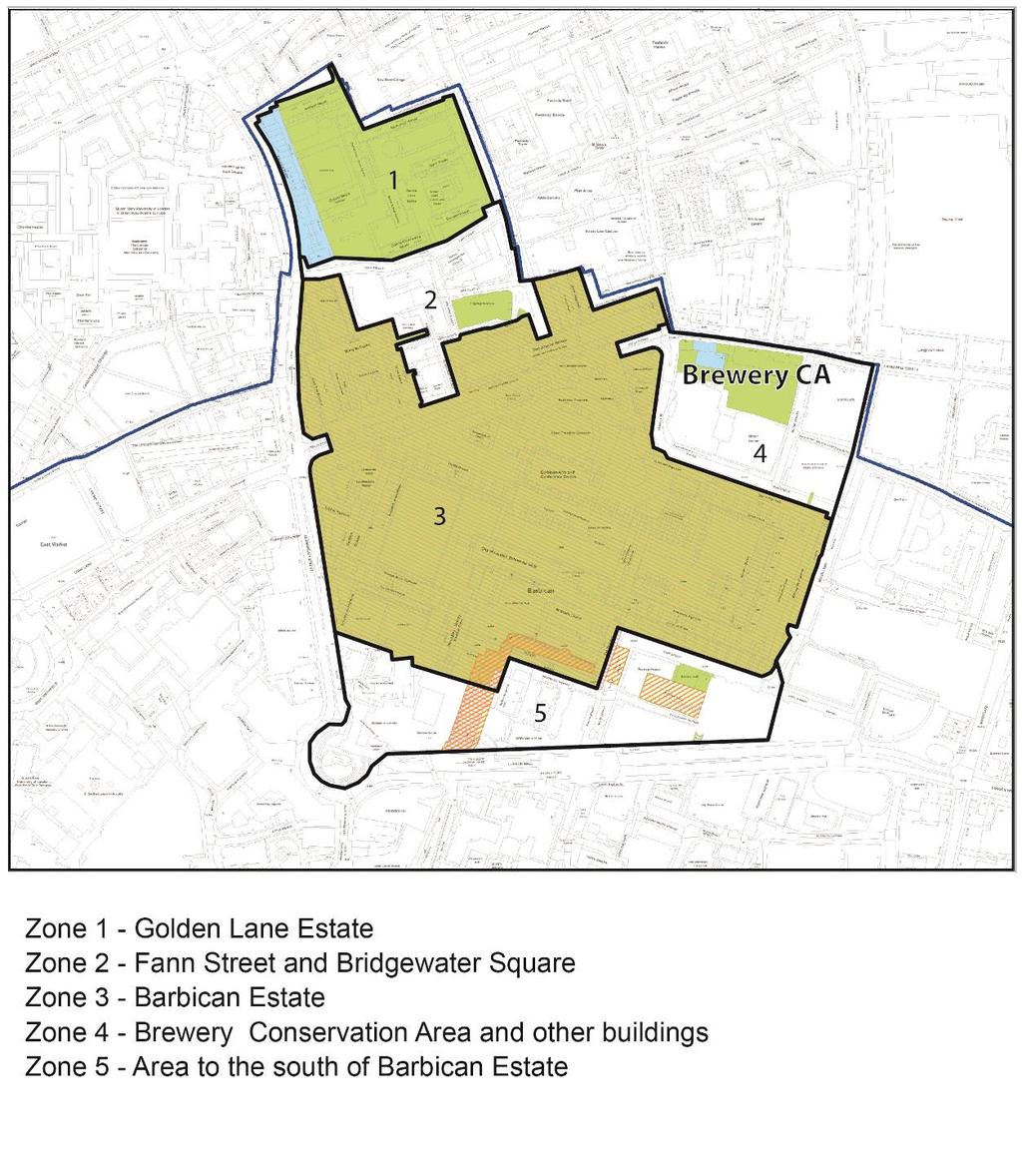
2 Map 2: Characterisation Zones

3 Map 3: Designated Heritage Assets

4 Map 4: Proposed Conservation Areas
5 Appendix 2. Characterisation of Zones Historic England advises that discernible character areas or zones are often evident in larger conservation areas. In the proposed area 5 separate character zones have been identified. Zone 1 Golden Lane Estate Zone 2 Fann Street, Bridgewater Square the area between the two listed estates Zone 3 Barbican Estate Zone 4 Brewery Conservation Area and other buildings Zone 5 Area to the south of the Barbican Estate, bounded by London Wall and Aldersgate Zone 1 Golden Lane Estate The Historic England list entry states; At the end of WW2 the area between St Paul's and the City lay devastated. The County of London Plan decided on mixed commercial use with some housing for the small number of people who worked in the City. The brief was for 940 one, two, three or four room flats at the maximum possible density of 200 persons to the acre. To achieve this many of the smaller flats had to be in a high tower. Great Arthur House was built in from reinforced concrete. The 17 floor building was the first to break the London County Council's 100 ft height restriction and was briefly the tallest inhabited building in England. The flats were designed for single people and couples such as nurses and policemen who had to live near their work. The architects for the estate were Chamberlin, Powell and Bon. They saw it as a purely urban scheme, formal in layout but creating a sense of place by using colour. Their philosophy was to use every inch of space and provide a wide range of facilities on the site, also to separate pedestrians from traffic. They based this vision on the work of Le Corbusier. The Golden Lane estate eventually contained 1400 flats and maisonettes, a swimming pool, badminton court, bowling green, nursery, playground, community centre, shops and a pub. The estate was popular with professionals such as doctors and is still a self-sufficient urban village. It is seen as the most successful of England's housing developments from the early 1950s. The original design intent is intact in the layout and form of the estate which remains largely as originally built. In general the blocks look inward to the landscaping and open spaces of the estate, giving the estate a semi-private feel. There have been minimal alterations to the external appearance of the estate, except for addition of ramps at the entries to residential blocks and a ramp to provide equal access to the Leisure Centre. Zone 2 Fann Street, Bridgewater Square area The area between the 2 iconic post war listed estates, developed from 1688 after an early 16 th century mansion owned by the Earl of Bridgewater burned down. Christopher Wren
6 was a partner in the development, and many of his colleagues and craftsmen (Hawksmoor, W.Emmett, E.Strong Sen, and H.Doogood) took building leases. The square and garden from the original estate survive, merged on the rth side with a larger garden facing Fann Street (Fann Street Wildlife Garden). The area now comprises a small network of streets and spaces, bounded on the north by Fann Street, Golden Lane on the East, and the Barbican Estate on the South and West. Buildings of interest in this area are: Remains of the former Cripplegate institute, founded from parochial charities in 1891, and built The building is in red brick and stone in a free Jacobean style an extension was constructed behind a retained façade. The original frontage is listed grade II, the new addition is not contextual in design. w in commercial office use. Jewin Welsh Church, Fann Street, by Caroe and Partners, It is a solid brick rectangle with square south-west tower and a pitched copper-clad roof. On the tower a pyramidal copper roof with a big square-urn finial. There is a gothic west window with triangular head and tracery in diagonal lines. The building is an undesignated heritage asset. The remaining buildings in this zone represent a mixture of office, residential and commercial uses. Bernard Morgan House has planning permission for redevelopment into a residential building. 35 Fann Street rises to 5 stories on the corner of Viscount Street with a curving, balcony at the corner. The building references the nearby Golden Lane Estate through the use of colour, overhangs and pillars Bridgewater Square also occupies the Viscount Street frontage and rises to 7 stories on the Bridgewater Square side of the building. Construction is in brick above the ground floor, rising to 6 stories on Viscount Street. Bridgewater House, 6-9 Bridgewater Square offices built originally in 1926, now residential with tall round headed windows and coloured brickwork by Prudential Architects c The Central Point building on Bridgewater Street comprises a six storey office building in Portland stone. A horizontal slab style block somewhat reminiscent of the Barbican residential slab blocks Bridgwater Square itself remains an open space, with a children s nursery and playground using the Square. Buildings to the east and south represent recent office and residential developments that are not contextual with the Barbican Estate that rises to the west of the square.
7 Zone 3 Barbican Estate The Historic England List entry states; Estate of flats, maisonettes and terraced houses, hostel, girls' school, school of music and drama, and arts centre (with concert hall, theatre, studio theatre, cinemas, library, art gallery, conservatory, restaurants and offices), with underground car parking, pedestrian walks and canal. Designed , arts centre element redesigned ; built with modifications in to the designs of Chamberlin, Powell and Bon (subsequently Chamberlin, Powell and Bon (Barbican)) for the Corporation of the City of London; engineers, Ove Arup and Partners. Poured in situ reinforced concrete with exposed surfaces largely pick hammered and with smaller areas bush hammered, exposing Pen Lee granite aggregate, with glazed engineering brick cladding to City of London School for Girls, the Guildhall School of Music and Drama, Wallside, the Postern and plinths to lakeside blocks and water features. Flat asphalted roofs, paved with concrete tiles in keeping with the wall finishes. The main blocks are supported by concrete columns forming an extension to the bored piles sunk up to 60ft deep. The tower blocks' main structure is formed by a central lift shaft and stairwells with a peripheral framework of beams and split piers rising from exposed columns; the structure of the terrace blocks is based in concrete cross-walls supported on columns with floor slabs spanning between the cross-walls and the balcony edge beams. Podium and the tower blocks have thick upswept concrete balustrades developed by Ove Arup and Partners in consultation with the architects in The Barbican Estate is the result of the planned redevelopment of a large 2 nd World War bomb damaged site. The aim was to provide a mixture of uses on the same site. The podium and highwalk allowed the separation of pedestrians from traffic. The intention was that the highwalk would connect to others across the City of London, resulting in a more extensive network of pedestrian routes. This was never fully realised and the Barbican Highwalk remains the only surviving element of this design ambition. However, the estate s continued connection beyond its boundaries via bridges, stairs, ramps and lifts remains a vital element of the Barbican s continued success and special interest. The strength of the design and the materials used form an important element of the significance of the Barbican Estate. The inward looking, semi-private nature of the estate as originally planned by the architects and the Brutalist architecture survives to a great degree. There have been some alterations, and repairs have been necessary in many places. Some later insertions have caused damage to the significance of the estate. However since listing, and the adoption of the Listed Building Management Guidelines (adopted 2005, revised 2012), stakeholders continue to ensure that repairs and alterations are carefully considered and do not cause harm to the significance of the estate. Zone 4 Brewery Conservation Area Brewery Conservation Area was designated in This adjoins Chiswell Street Conservation Area in Islington. The character of the area has been summarised as; Important complex of buildings critical to the history of the brewing industry in and around the City of London.
8 The main roads of the area and overall pattern of streets remain largely unaltered since they were established in the medieval period. A brewery designed specifically for the mass production of porter was completed by 1750, and as the scale of operation increased, further development took place. By 1800 the brewery had extended to both sides of Chiswell Street and throughout the 19 th century both sites continued to expand with further technological improvements being made. Brewing at Chiswell Street ceased in 1976 and two acres of brewery buildings to the south of the Porter Tun Room including the malt store were demolished and redeveloped for office use. Parts of the retained buildings on the south side of Chiswell Street were modified as banqueting and reception rooms, exhibition space, conference facilities and offices for Whitbread s corporate activities. Brewery Conservation Area is characterised by a close-grained townscape; a small number of modestly scaled, 18 th century buildings is set around a paved court. These relatively simple buildings are of red and brown stock brick, with cornices and storey bands providing surface modelling and decoration and almost all have sash windows. The most elaborate facades are those containing the two public houses and the arched entrance to the yard itself. The area now provides pleasant respite from the traffic along Chiswell Street. Although brewing no longer takes place at Chiswell Street, the character of the area is now enlivened by the variety of uses located here. To the South of Brewery Conservation Area and to the rth of the Barbican Estate lies a strip of modern buildings. These buildings line the north side of Silk Street and the west side of Moor Lane and include the recently completed Milton Court, Guildhall School of Music and Drama. Glass facades, with minimal modelling, and 1990s post-modern office buildings characterise this area. These buildings provide a buffer between the contrasting characters of Brewery Conservation Area and the Barbican Estate, keeping them firmly apart. Zone 5 Area to the south of the Barbican Estate, bounded on the south by London Wall The west end of London Wall is the product of compulsory purchase and post-war replanning. The present layout follows the LCC-City scheme announced in September A new main road (then called Route XI) was planned with an integrated sequence of 6 office towers. Bulk, heights and module of the new buildings were determined, though the final designs were by private architects. The scheme was important as it was the first in England to provide a pedestrian upper walkway throughout, with stairs to street level and bridges connecting the Barbican Estate with other areas of the City. Of the planned 6 towers, only one remains. They were 18 to 20 storeys, similar but not identical, spaced equidistantly at an oblique angle to the street, 4 on the north and 2 on the south. These tall towers were to have smaller (8 storey) buildings dotted around them. Shops and the building entrances were located on the highwalk, with the ground floor reserved for vehicles and servicing. London Wall was a dual carriageway, with pavements, but almost exclusively used by vehicles. Beneath London Wall lies an underground car park. The plan was completed in the mid-1970s with the Museum of London with its Bastion, roundabout and Bastion House. In the 28 acres of the plan there was generous provision for
9 gardens and open spaces, and incorporating stretches of the Roman and Medieval City walls. The intended use of the highwalks by pedestrians and its extension across the city was only partially realised. Since the inception of the London Wall development the majority of the buildings have been demolished and replaced with buildings that do not contribute to the original coherent design either in height, mass, design or oblique alignment. A major alteration since the original redevelopment of the area is the large Alban Gate development ( ). The development forms a huge segmental arch over the top of London Wall bisecting the views along its length. A further characteristic of the area has been the incorporation of several 20 th century Livery Company Halls in amongst the post-war urban development. Salters Hall, Barber Surgeons Hall and Ironmongers Hall are located at street level. The London Wall Place development currently under construction incorporates new office and mixed use development with an extended open space at ground level and incorporating north-south and east-west highwalk links.
10 Appendix 3: Criteria for the assessment of the potential of the Conservation Area. The proposed area has been assessed in accordance with current guidance as set out in the NPPF and by Historic England (Conservation Area Designation, Appraisal and Management, Historic England Advice te 1). Each zone has been assessed against the criteria below (1-12). A yes/no response has been recorded, with a brief justification for each. 1. Is it the work of a particular architect or designer of regional or local note? 2. Does it have landmark quality? 3. Does it reflect a substantial number of other elements in the conservation area in age, style, materials, form or other characteristics? 4. Does it relate to adjacent designated heritage assets in age, materials or in any other historically significant way? 5. Does it contribute positively to the setting of adjacent designated heritage assets? 6. Does it contribute to the quality of recognisable spaces including exteriors or open spaces within a complex of public buildings? 7. Is it associated with a designed landscape, e.g. a significant wall, terracing or a garden building? 8. Does it individually, or as part of a group, illustrate the development of the settlement in which it stands? 9. Does it have significant historic associations with features such as the historic road layout, burgage plots, a town park or a landscape feature? 10. Does it have historic associations with local people or past events? 11. Does it reflect the traditional functional character or former uses in the area? 12. Does its use contribute to the character or appearance of the area? Other themes have also been taken into account in the assessment of the Zone. Areas with a high number of nationally designated heritage assets and a variety of architectural styles and historic associations Those linked to a particular industry or individual with a particular local interest. Where an earlier, historically significant, layout is visible in the modern street plan. Where a particular style of architecture or traditional building materials predominate. Areas designated because of the quality of the public realm or a spatial element, such as a design form or settlement pattern, green spaces which are an essential component of a wider historic area, and historic parks and gardens and other designated landscapes, including those on the Historic England Register of parks and gardens of special historic interest. Conclusion - The analysis of each zone will be tabulated and a final assessment of the zones and the entire area will be made.
11 Appendix 4: Proposed Conservation Area Assessment and Recommendations The zones have been assessed against the criteria, followed by a summary of the assessment for each zone. A concluding section will draw together the findings and make a recommendation. Zone 1 Golden Lane Estate # Criteria / tes 1. Is it the work of a particular architect The Estate is designed by or designer of regional or local note? Chamberlin, Powell and Bon 2. Does it have landmark quality? The estate is a highly designed group of buildings and open spaces. 3. Does it reflect a substantial number of other elements in the conservation area in age, style, materials, from or other characteristics? 4. Does it relate to adjacent designated heritage assets in age, materials or in any other historically significant way? 5. Does it contribute positively to the setting of adjacent designated heritage assets? 6. Does it contribute to the quality of recognisable spaces including exteriors or open spaces within a complex of public buildings? 7. Is it associated with a designed landscape, e.g. a significant wall, terracing or a garden building? 8. Does it individually, or as part of a group, illustrate the development of the settlement in which it stands? Golden Lane estate was designed as a whole, set-piece. It relates to the later Barbican Estate as it was designed by the same architects and has a strong relationship in design terms. It contributes to the setting of the Barbican Estate. Golden Lane incorporates within it large areas of designed open space. Large areas of open space are an integrated part of the design. Golden Lane represents a point in time of post-war redevelopment and design. Modern materials and design philosophy were used to provide much needed high density housing in a designed landscape. The mixed residential and amenity provision within the estate was an important aspect of the design. 9. Does it have significant historic Prior historic buildings and roads
12 associations with features such as the historic road layout, burgage plots, a town park or a landscape feature? 10. Does it have historic associations with local people or past events? 11. Does it reflect the traditional functional character or former uses in the area? 12. Does its use contribute to the character or appearance of the area? were destroyed by second world war bombing and post-war clearance. The area was levelled to basement level, and the layout of Golden Lane does not make reference to previous features or road layouts. The 20 th century estate makes no reference to previous associations or events. The area was severely damaged by bombing and a wholly new estate built. However the sunken areas of the estate do make use of former basements. The residential character of the estate with the leisure and community facilities interwoven into the design is of great benefit to the character of the area. The appearance of the area is enhanced by the coherence of the estate which was designed as a setpiece, with consistent design running through the building and landscape elements. Zone 1 satisfies 10/12 of the criteria for designation as a conservation area. Golden Lane Estate is a designated heritage asset Listed Grade II, with Crescent House Listed Grade II*. In the assessment it has been relevant to examine the additional protections that would be gained from designating it as a conservation area. Listed below are the protections that are afforded to areas that have been designated as conservation areas (Historic England). Each point is followed by a comparison with listed building protection(italics). The requirement in legislation and national planning policies to preserve and/or enhance. Listed building consent is required for alterations or extensions which would affect its character as a building of special architectural or historic interest. The more important the asset the greater weight should be given to its conservation. A listed building is a more significant heritage asset than a conservation area. Local planning policies which pay special attention to the desirability of preserving or enhancing the character or appearance of the area.
13 Listed buildings have protection in National Policy and legislation where alterations are proposed, and where harm or substantial harm to the significance of the heritage asset would be caused by the proposed works. This is afforded by the duty in s.66 LBA Setting of a heritage asset is a material consideration which applies to listed buildings and conservation areas. Control over demolition of unlisted buildings. As the entire Golden Lane Estate is listed, this would not apply Control over works to any trees. The City Corporation controls works to trees on the estate and seeks to retain or replace trees wherever possible. There are no TPOs in the area. Fewer types of advertisements which can be displayed with deemed consent The effect that advertisements have on the appearance of the estate would be assessed against the harm or substantial harm that may be caused to the listed building. Restriction on the types of development which can be carried out without the need for planning permission (permitted development rights). As a listed building, alterations, repairs and development on Golden Lane Estate is more strictly controlled than in conservation areas. All works on the estate are potentially subject to listed building consent requirements and controls. Zone 1 Summary and Conclusions Golden Lane Estate satisfies the criteria for designation as a conservation area. The estate is listed, and the architectural and historic significance of the estate is protected by virtue of the statutory protections provided to listed buildings. As such, conservation area designation would not significantly alter the material considerations in the planning process. The criteria and assessment carried out indicate that the area is of sufficient significance to be considered for designation as a conservation area. Zone 1 - Designation as a conservation area is recommended.
14 Zone 2 Fann Street, Bridgewater Square the area between the two listed estates # Criteria / tes 1. Is it the work of a particular architect or designer of regional or local note? The buildings in this area represent a variety of architects, building ages and styles. 2. Does it have landmark quality? There is no coherent plan to the landscape that would give it landmark quality. 3. Does it reflect a substantial number of other elements in the conservation area in age, style, materials, form or other characteristics? There is no defined character for this area, whether through a group of buildings of similar age, or style. 4. Does it relate to adjacent designated The development of Bridgewater heritage assets in age, materials or in Square pre-dates the adjacent any other historically significant Barbican and Golden Lane 20 th way? century estates. The ephemeral remains of the original plan form do not relate to adjacent designated heritage assets. 5. Does it contribute positively to the The buildings of the area make a setting of adjacent designated neutral contribution to adjacent heritage asset? designated heritage assets. They neither detract, nor do they contribute positively. 6. Does it contribute to the quality of Bridgewater Square is a recognisable spaces including recognisable open space in this exteriors or open spaces within a zone, however there are no complex of public buildings? elements remaining that mark it out as significant, and the surrounding buildings do not contribute to its character as an open space. 7. Is it associated with a designed Whilst Bridgewater Square and landscape, e.g. a significant wall, Fann Street garden are both terracing or a garden building? historic elements of the landscape, their current layout, boundary and quality of materials do not qualify them as designed landscapes. 8. Does it individually, or as part of a group, illustrate the development of the settlement in which it stands? The buildings in this zone chart the development of the area from the first world war onwards, based on a historic plan form. 9. Does it have significant historic Some of the original plan form of
15 associations with features such as the historic road layout, burgage plots, a town park or a landscape feature? 10. Does it have historic associations with local people or past events? 11. Does it reflect the traditional functional character or former uses in the area? 12. Does its use contribute to the character or appearance of the area? the Bridgewater estate survives in the form of the square and the garden. There is an association with the Bridgewater estate. The area has significantly altered over the past century and no longer reflects the original estate. The area is now of mixed residential and commercial use, without buildings of standout merit to contribute to the character or appearance of the area. Zone 2 satisfies 3/12 of the criteria for designation as a conservation area. Zone 2: Summary and Conclusions Fann Street/ Bridgewater Square area has developed over the last century into a network of streets and open spaces with a variety of building types. It is an area with historical associations from the 18 th century; however the evidence that survives in the plan form is not of sufficiently high quality and defined character. Buildings of merit in the area are the Welsh Church and the Cripplegate Institute. Other buildings in the zone do not contribute sufficiently to the character of the area. Zone 2 - Designation as a conservation area is NOT recommended.
16 Zone 3 Barbican Estate # Criteria / tes 1. Is it the work of a particular architect or designer of regional or local note? The Estate was designed by the architects Chamberlin, Powell and Bon 2. Does it have landmark quality? The Barbican is a high quality estate with high quality designed spaces. It is a tourist destination in its own right, by virtue of its design and use of materials. 3. Does it reflect a substantial number of other elements in the conservation area in age, style, materials, form or other characteristics? 4. Does it relate to adjacent designated heritage assets in age, materials or in any other historically significant way? 5. Does it contribute positively to the setting of adjacent designated heritage assets? 6. Does it contribute to the quality of recognisable spaces including exteriors or open spaces within a complex of public buildings? The estate is a set-piece design that was fully realised as intended and with minimal alterations since completion. Material, design and scale are consistent throughout the estate reinforcing its character and quality. It has successfully incorporated heritage assets within its boundaries. It relates to the adjacent Golden Lane Estate, designed by the same architects. Barbican and Golden Lane show the progression of technology and design by these architects through the post-war period. The Barbican estate accommodates St Giles Church (Grade I) and the Fort Wall (SAM) within its boundaries. These have been included and celebrated by the landscaping and whilst they are of contrasting styles they provide for a complex of multi-period heritage assets. The Barbican Estate is a complex of buildings and open spaces. The open spaces play an important part in the design, use and enjoyment of the estate by residents and members of the public. 7. Is it associated with a designed landscape, e.g. a significant wall, terracing or a garden building? The Scheduled Ancient Monument lies within the boundary of the estate. 8. Does it individually, or as part of a Barbican Estate is a nationally
17 group, illustrate the development of the settlement in which it stands? 9. Does it have significant historic associations with features such as the historic road layout, burgage plots, a town park or a landscape feature? 10. Does it have historic associations with local people or past events? 11. Does it reflect the traditional functional character or former uses in the area? 12. Does its use contribute to the character or appearance of the area? significant example of post-war planning and design. Modern materials and design philosophy were used to provide much needed high density housing in a designed landscape. The mixed residential and education and arts provision was an important aspect of the design. The design has utilised below ground levels that were the basements buildings destroyed during the 2 nd world war. Frobisher crescent reflects a previous road layout. The establishment and long history of St Giles Church has played an important part in local history. The area has altered significantly from the pre-war use which was crossed by the railway, roads, some residential but mostly commercial uses Mixed use residential, amenity and education enlivens the area in a variety of ways Zone 1 satisfies 11/12 of the criteria for designation as a conservation area. Barbican Estate is a designated heritage asset Listed at Grade II. In the assessment it has been relevant to examine the additional protections that would be gained from designating it as a conservation area. See above (Zone 1 Golden Lane) for the relevant protections, which are the same for the Barbican Estate. Zone 3 Summary and Conclusions The estate is listed, and the architectural and historic significance of the estate is protected by virtue of the statutory protections provided to listed buildings. As such, conservation area designation would not significantly alter the material considerations in the planning process. The criteria and assessment carried out indicate that the area is of sufficient significance to be considered for designation as a conservation area. Zone 3 - Designation as a conservation area is recommended.
18 Zone 4 Brewery Conservation Area # Criteria / tes 1. Is it the work of a particular architect or designer of regional or local note? Whilst the majority of buildings were constructed for one particular purpose and a specific company (Whitbread), they developed as a complex of buildings over time. The remaining modern buildings are not representative of a particular architect. 2. Does it have landmark quality? The Brewery part of the area has landmark quality; the modern buildings on Silk Street and Milton Street do not. 3. Does it reflect a substantial number of other elements in the conservation area in age, style, materials, form or other characteristics? 4. Does it relate to adjacent designated heritage assets in age, materials or in any other historically significant way? 5. Does it contribute positively to the setting of adjacent designated heritage assets? 6. Does it contribute to the quality of recognisable spaces including exteriors or open spaces within a complex of public buildings? 7. Is it associated with a designed landscape, e.g. a significant wall, terracing or a garden building? 8. Does it individually, or as part of a group, illustrate the development of the settlement in which it stands? 9. Does it have significant historic associations with features such as There is a distinctive split in the character of this zone. The Brewery buildings represent a particular function and character. The remaining office/residential buildings reflect the era of modern developments. The Brewery buildings relate strongly to one another as a complex of buildings designed and constructed for one purpose. The modern buildings do not relate to adjacent designated heritage assets. The Brewery buildings form a strong group with a positive character. The Brewery buildings are grouped around an open yard which contributes positively to the area. The area is distinctly urban in character with little planned open space except hard surfaces and yard areas. The Brewery buildings reflect the past use of the area. Brewing was a significant element of the area s historic character. The Brewery buildings retain the original street layout of the area
19 the historic road layout, burgage plots, a town park or a landscape feature? 10. Does it have historic associations with local people or past events? 11. Does it reflect the traditional functional character or former uses in the area? 12. Does its use contribute to the character or appearance of the area? The Brewery buildings are associated with the brewing industry in the City of London, and particularly the Whitbread Brewery It reflects the traditional brewing function of the area The use of the Brewery buildings does not contribute to the character or appearance of the area, as the buildings are no longer in their traditional use. Zone 4 satisfies 8/12 of the criteria for designation as a conservation area. The Brewery complex of buildings is already a conservation area, designated by the City of London Corporation. Many of the buildings are also listed. Brewery Conservation Area has its own distinctive character which does not sit comfortably with the adjacent new buildings on Silk Street and Milton Street, also in Zone 4. The adjacent Zone 3 (Barbican Estate) has a strong 20 th century character of its own, which is different from Brewery Conservation Area. Zone 4 Summary and Conclusions The Brewery complex of buildings satisfies the criteria for designation as a conservation area by virtue of the contribution of the historic brewery buildings. The character of the Brewery Conservation Area is such that it should remain a conservation area in its own right, and not be merged with a new larger area, which would dilute the strength of the area s character. The 4 new buildings on Silk Street and Milton Street would not, alone, satisfy the criteria for designation as a conservation area. Zone 4 - Brewery Conservation Area re-designation as a new larger conservation area to include the Barbican and Golden Lane Estates and other areas is NOT recommended. Zone 4 Modern buildings on Silk Street and Milton Street designation as a conservation area is NOT recommended.
20 Zone 5 Area to the south of the Barbican Estate, bounded on the south by London Wall Criteria / tes Is it the work of a particular The existing buildings are by different architects architect or designer of and no longer sufficiently reflect the original regional or local note? town planning intent of the area. Does it have landmark The landmark quality of the original design has quality? Does it reflect a substantial number of other elements in the conservation area in age, style, materials, form or other characteristics? Does it relate to adjacent designated heritage assets in age, materials or in any other historically significant way? Does it contribute positively to the setting of adjacent designated heritage assets? Does it contribute to the quality of recognisable spaces including exteriors or open spaces within a complex of public buildings? Is it associated with a designed landscape, e.g. a significant wall, terracing or a garden building? Does it individually, or as part of a group, illustrate the development of the settlement in which it stands? Does it have significant historic associations with features such as the historic road layout, burgage plots, a town park or a landscape feature? Does it have historic associations with local been extensively altered to its detriment. The buildings are of different styles and periods The design of the area has allowed space for the designated heritage assets, but does not refer to them in design or choice of materials. The designated heritage assets in this zone all sit at ground level, with much of the remaining element above at highwalk level The designed highwalk that was an extension of the Barbican podium level walkways, creates a series of important routes and spaces separated from vehicle level routes. Scheduled Ancient Monuments in St Alphage Gardens and adjacent to the Barber Surgeons Hall. The long history of the area is reflected in the surviving designated heritage assets of the Scheduled Ancient Monuments, St Alphage Tower and the more recent Salters Hall. The conscious design of the area in the post-war era also reflects an important period in the development of the City of London. London Wall marks the location of the Roman and medieval city wall. This survives as a Scheduled Ancient Monument in the car park beneath London Wall, and as buried archaeological remains beneath the road The Post war planning and re-development of the area makes not reference to previous plan
21 people or past events? Does it reflect the traditional functional character or former uses in the area? Does its use contribute to the character or appearance of the area? form except in the accommodation of the Scheduled Ancient Monuments and Livery Halls which reflect previous land uses. The large buildings and highwalk have largely removed all physical references to previous uses and functions. The use is largely commercial, with some amenity facilities (Museum of London). However the design of the buildings does not contribute positively to the character or appearance of the area. Zone 5 satisfies 4/12 of the criteria for designation as a conservation area. Zone 5 Summary and Conclusions The area to the south of the Barbican Estate, bounded on the south by London Wall does not sufficiently satisfy the criteria for designation as a conservation area. Whilst the area has significant designated heritage assets within it, the original design intent of this commercial fringe has been dramatically altered over time, and has lost much of its original character. Zone 5 - The area to the south of the Barbican Estate, bounded on the south by London Wall designation as a conservation area is NOT recommended.
22 Conclusion The table below summarises the assessment of the proposed conservation area against the agreed criteria. Zone Recommended for Reason designation? Zone 1 Golden Lane Estate Strongly defined and unified character already contains designated heritage assets within it. Zone 2 Fann Street and Did not satisfy the criteria. Bridgewater Square Zone 3 Barbican Estate Strongly defined and unified character already contains designated heritage assets within it. Zone 4 Brewery Conservation Area and other buildings Part is already a conservation area with its own character. Part did not satisfy the criteria. Zone 5 Area to the south of Barbican Estate Did not satisfy the criteria. Two of the five areas meet the criteria for conservation area designation. The majority of the areas (3 out of 5 zones) do not meet the criteria for designation as a conservation area. Therefore, the proposed area as a whole is not recommended for conservation area designation. Two zones do satisfy the criteria for conservation area designation. It is proposed that the Barbican Estate and Golden Lane Estate be taken forward as 2 new proposed conservation areas. Zone 4 is partly an existing conservation area (Brewery Conservation Area) and partly undesignated. Brewery Conservation Area will remain a conservation area as currently designated. The remaining buildings in Zone 4 are not recommended for designation as a conservation area. The remaining zones 2 and 5 are not recommended for conservation area designation.
23 Appendix 5. Background Information Existing controls and guidance are in place for some of the buildings or groups of buildings in the proposed area. These are identified below, and relevant issues are summarised as background information for the assessment of the potential significance of the proposed conservation area. Designated Heritage Asset Golden Lane Estate Barbican Estate St Giles Church Brewery Whitbread s Brewery, Room Number 1 Partner s House, Whitbread s Brewery and attached railings Entrance Wing, Whitbread s Brewery (South Side) Sugar Room, Whitbread s Brewery (South Side) Bridge over the yard, Whitbread s Brewery (South Side) Thirteen Bollards in the yard, Whitbread s Brewery (South Side) Whitbread s Brewery Building, next to the King s Head Public House Salters Hall, Fore Street Cripplegate Institute London Wall: section of Roman and medieval wall and bastions, west and north of Monkwell Square. London Wall: site of the Roman and medieval gateway of Cripple Gate. Designation/Guidance Listed Grade II & II* Listed Building Management Guidelines Listed Grade II Register of Historic Parks and Gardens of special historic interest in England Listed Building Management Guidelines Vols I, II, IV and Volume III in partial preparation Listed Grade I Conservation Area Listed Grade II Listed Grade II* Listed - Grade II Listed Grade II Listed Grade II Listed Grade II Listed Grade II Listed Grade II Listed Grade II (Façade retention) Scheduled Ancient Monument Scheduled Ancient Monument
24 London Wall: section of Scheduled Ancient Monument Roman and medieval wall at St Alphage Garden, incorporating the remains of St Alphage Church. Remains of Tower to former Listed - Grade II. Church of St Alphage 56 Chiswell Street Listed - Grade II. 53, 54 and 55 Chiswell Street Listed - Grade II. The King s Head Public Listed - Grade II. House Museum of London Bastion House Bernard Morgan House Ironmongers Hall Brewery A Certificate of Immunity was issued under the Planning (Listed Buildings and Conservation Areas) Act 1990 as amended, as the Secretary of State does not intend to list this building. The certificate was issued on 22nd July 2015 and will expire on 21st July A Certificate of Immunity was issued under the Planning (Listed Buildings and Conservation Areas) Act 1990 as amended, as the Secretary of State does not intend to list this building. The certificate was issued on 22nd July 2015 and will expire on 21st July The building was assessed for listed, but not listed. Planning permission for re-development has been granted. Undesignated Heritage Asset Conservation Area
25 Appendix 6: Policy Context Conservation areas are designated heritage assets protected by legislation. The City Corporation has a statutory duty under section 69(1) of the Planning (Listed Buildings and Conservation Areas) Act 1990 to consider whether it should designate conservation areas which are defined as areas of special architectural or historic interest, the character of which it is desirable to preserve of enhance. There are 26 conservation areas in the City which cover 35.8% of the area. Section 69(2) of the Planning (Listed Buildings and Conservation Areas) Act 1990 states that It shall be the duty of a local planning authority from time to time to review the past exercise of functions under this Section and to determine whether any parts or further parts of their area shall be designated as conservation areas; and if they so determine, they shall designate those parts accordingly. National Legislation, Policy and Guidance Planning (Listed Buildings and Conservation Areas) Act Sections control the designation, assessment and control of development within conservation areas. NPPF Section 12, paragraphs provides guidance on the treatment of Heritage Assets and the Historic Environment within the planning framework. Historic England Guidance Historic England provides guidance to local authorities regarding their responsibilities to designate and manage conservation areas in their document Conservation Area Designation Appraisal and Management, published 25 th February 2016 London Plan The London Plan sets out broader strategies and expectations as regards the Historic Environment. City of London Local Plan The City of London Local Plan, paragraph , sets out the City Corporation s commitment to managing and enhancing the historic environment. It says: The City s unique townscape of historic buildings, streets and open spaces juxtaposed with contemporary modern buildings creates a varied, attractive and lively environment which attracts companies and visitors who support the services which contribute to its cultural vibrancy. The City contains a large number of heritage assets which include over 600 listed buildings, 26 conservation areas, 48 scheduled ancient monuments and 4 historic parks and gardens. There are many protected trees in conservation areas and with Tree Preservation Orders. Historic
26 buildings characteristic of the City include notable buildings such as Mansion House, Guildhall and St Paul s Cathedral, livery company halls and a large number of places of worship. In addition, the Tower of London, which lies just outside the City boundary, is inscribed by UNESCO as a World Heritage Site of outstanding universal value and its protection includes a defined local setting which is partly within the City. The Mayor s Supplementary Planning Guidance World Heritage Sites Guidance on Settings provides guidance on how the setting of the World Heritage Site can be positively managed, protecting heritage while encouraging change, in accordance with the NPPF. The Local Plan Policy DM12.2 states: 1. Development in conservation areas will only be permitted if it preserves and enhances the character or appearance of the conservation area. 2. The loss of heritage assets that make a positive contribution to the character or appearance of a conservation area will be resisted. 3. Where permission is granted for the demolition of a building in a conservation area, conditions will be imposed preventing demolition commencing prior to the approval of detailed plans of any replacement building, and ensuring that the developer has secured the implementation of the construction of the replacement building. The designation of a conservation area carries with it the statutory duty to consider how an area or areas can be preserved and enhanced. Conservation areas are defined as designated heritage assets within the NPPF and therefore the settings and significance of conservation areas should be sustained and enhanced. The City Corporation will take the opportunity presented by development proposals within a conservation area to strengthen the special character of that conservation area and its setting. Planning permission is required to demolish unlisted buildings in a conservation area. A significant number of buildings in conservation areas, whilst not being listed, contribute positively to the character of these areas. Any application to demolish a building in a conservation area will be considered in terms of the contribution the building makes to the character or appearance of the area concerned. The boundaries of the City s conservation areas will be kept under review.
Lancaster Conservation Area Appraisal. Character Area 8. Cathedral
 Lancaster Conservation Area Appraisal Character Area 8. Cathedral March 2013 118 3.8 Character Area 8. Cathedral 3.8.1. Definition of Special Interest "This character area is distinctive for the fine group
PLANNING STATEMENT. Market House Market Place Kingston upon Thames KT1 1JS
 PLANNING STATEMENT To support planning and listed building consent applications for change of use from Class A1 shop and Class A3 cafe to Class A3 restaurant at: Market House Market Place Kingston upon
WINDSOR GLEN DESIGN GUIDELINES
 WINDSOR GLEN DESIGN GUIDELINES Adopted by Council, 2006 WINDSOR GLEN REDEVELOPMENT DESIGN GUIDELINES August 2006 1.0 Master Plan Organization For this area of the Coquitlam Town Centre, a mix of high,
UPPER GORDON ROAD TO CHURCH HILL, CAMBERLEY CONSERVATION AREA
 Introduction This leaflet explains the purpose of conservation areas and the implication of their designation for residents, property owners and the Council. It provides you with a plan of the area and
TOWN AND COUNTRY PLANNING ACT SECTION 79 AND TOWN AND COUNTRY PLANNING (INQUIRIES PROCEDURE) (ENGLAND) RULES 2000 STATEMENT OF CASE OF
 (ENGLAND) RULES 2000 STATEMENT OF CASE OF") TOWN AND COUNTRY PLANNING ACT 1990 - SECTION 79 AND TOWN AND COUNTRY PLANNING (INQUIRIES PROCEDURE) (ENGLAND) RULES 2000 STATEMENT OF CASE OF HISTORIC BUILDINGS AND MONUMENTS COMMISSION FOR ENGLAND (HISTORIC
TOWN AND COUNTRY PLANNING ACT 1990 - SECTION 79 AND TOWN AND COUNTRY PLANNING (INQUIRIES PROCEDURE) (ENGLAND) RULES 2000 STATEMENT OF CASE OF HISTORIC BUILDINGS AND MONUMENTS COMMISSION FOR ENGLAND (HISTORIC
INTRODUCTION CURRENT APPLICATION
 05/01805/FUL & 05/01807/LBC ERECTION OF A SINGLE DWELLING HOUSE WITH ANCILLARY ACCOMMODATION AT Flamingo Zoological Gardens, Olney Road, Weston Underwood FOR Mr A J Crowther (as amended by letter dated
Reference: 16/1447/FUL Received: 7th March 2016 Accepted: 7th March 2016 Ward: East Finchley Expiry 2nd May 2016
 Location 374B Long Lane London N2 8JX Reference: 16/1447/FUL Received: 7th March 2016 Accepted: 7th March 2016 Ward: East Finchley Expiry 2nd May 2016 Applicant: Ms Katrin Hirsig Proposal: Single storey
Designations protecting the historic designed landscape
 Historic Landscape Project Designations protecting the historic designed landscape A. Key national designations affecting the historic environment: 1. Listed buildings 2. Scheduled Monuments (generally
Conservation Area Designation, amendments and Review
 Conservation Area Designation, amendments and Review Location: No.s 37-49 (odd) Twickenham Road Date Assessed: January 2018 Adjacent Conservation Area Significance: Teddington Lock CA. The Teddington Lock
16. Peckham Peckham Area Vision
 16. 16.1. Area Vision 16.1.1. is: A lively town centre providing a range of daytime and night time activities on Rye Lane including a Library, a Leisure Centre and many independent retailers which specialise
EAST OF ENGLAND OFFICE
 Mr Philip Isbell Direct Dial: 01223 582751 Mid Suffolk District Council 131 high Street Our ref: P00524468 Needham Market Ipswich Suffolk IP6 8DL 18 January 2017 Dear Mr Isbell T&CP (Development Management
Commenting on Planning Applications: MHPRA Policy
 Commenting on Planning Applications: MHPRA Policy millhillparkacton.org Our Area The Mill Hill Park Residents Association covers the Mill Hill Park Conservation Area in Acton, W3. Objectives We aim to
DESIGN & ACCESS STATEMENT
 . DESIGN & ACCESS STATEMENT Site Adjacent to The Manor House, Upper Street,, Kingsdown, Deal, Kent. DESIGNS ARCHITECTURE + PLANNING CONTENTS Design and Access Statement Introduction Site and Location Planning
Colchester Northern Gateway Master Plan Vision Review Draft. July 2016
 Colchester Northern Gateway Master Plan Vision Review Draft July 2016 Contents Introduction 4 Context 8 Purpose of the Report 8 Strategic Position 9 Overview of the Process 11 2012 Master Plan Vision 12
5 Gratton Terrace London NW2 6QE. Reference: 17/5094/HSE Received: 4th August 2017 Accepted: 7th August 2017 Ward: Childs Hill Expiry 2nd October 2017
 Location 5 Gratton Terrace London NW2 6QE Reference: 17/5094/HSE Received: 4th August 2017 Accepted: 7th August 2017 Ward: Childs Hill Expiry 2nd October 2017 Applicant: WSD (Gratton) Ltd Proposal: The
YMCA Erdington (Phase 2), 300 Reservoir Road, Erdington, Birmingham, B23 6DB
, 300 Reservoir Road, Erdington, Birmingham, B23 6DB") Committee Date: 13/06/2013 Application Number: 2013/03011/PA Accepted: 30/04/2013 Application Type: Full Planning Target Date: 30/07/2013 Ward: Stockland Green YMCA Erdington (Phase 2), 300 Reservoir Road,
Committee Date: 13/06/2013 Application Number: 2013/03011/PA Accepted: 30/04/2013 Application Type: Full Planning Target Date: 30/07/2013 Ward: Stockland Green YMCA Erdington (Phase 2), 300 Reservoir Road,
1 The development hereby permitted shall be carried out in accordance with the following approved plans:
 Location 59 Greenway Close London N20 8ES Reference: 16/00011/HSE Received: 30th December 2015 Accepted: 7th January 2016 Ward: Totteridge Expiry 3rd March 2016 Applicant: Mr Ankit Shah Proposal: Part
5. Bankside and The Borough 5.1. Bankside and The Borough Area Vision
 5. 5.1. Area Vision 5.1.1. are: A globally significant central London business district which is home to international business headquarters; At the heart of the commercial and cultural life of the capital
REFERENCE: B/00601/12 Received: 11 February 2012 Accepted: 21 February 2012 WARD(S): High Barnet Expiry: 17 April 2012
: High Barnet Expiry: 17 April 2012") LOCATION: 37 Kings Road, Barnet, Herts, EN5 4EG REFERENCE: B/00601/12 Received: 11 February 2012 Accepted: 21 February 2012 WARD(S): High Barnet Expiry: 17 April 2012 Final Revisions: APPLICANT: PROPOSAL:
LOCATION: 37 Kings Road, Barnet, Herts, EN5 4EG REFERENCE: B/00601/12 Received: 11 February 2012 Accepted: 21 February 2012 WARD(S): High Barnet Expiry: 17 April 2012 Final Revisions: APPLICANT: PROPOSAL:
6. Bermondsey 6.1. Bermondsey Area Vision
 6. 6.1. Area Vision 6.1.1. is: An inner-london neighbourhood characterised by modest worker ho associated with the historic Rotherhithe docks and local manufacturing industries such as biscuits, jam, vinegar
11. ISLINGTON ROUTE SECTION ENVIRONMENTAL BASELINE AND ASSESSMENT OF IMPACTS OVERVIEW OF ISLINGTON ROUTE SECTION... 2
 11. ISLINGTON ROUTE SECTION ENVIRONMENTAL BASELINE AND ASSESSMENT OF IMPACTS... 2 11.1 OVERVIEW OF ISLINGTON ROUTE SECTION... 2 11.2 POLICIES RELEVANT TO ALL WORKSITES IN ISLINGTON... 3 11.3 FARRINGDON
HERITAGE COUNTS 2017 East of England
 HERITAGE COUNTS 2017 East of England Introduction Heritage Counts 2017 is the sixteenth annual survey of the state of England s historic environment. This Regional Report is prepared by Historic England
CHAIR AND MEMBERS PLANNING & ENVIRONMENT COMMITTEE MEETING ON MONDAY AUGUST 28, 2017 JOHN M. FLEMING MANAGING DIRECTOR, PLANNING AND CITY PLANNER
 TO: FROM: SUBJECT: CHAIR AND MEMBERS PLANNING & ENVIRONMENT COMMITTEE MEETING ON MONDAY AUGUST 28, 2017 JOHN M. FLEMING MANAGING DIRECTOR, PLANNING AND CITY PLANNER REQUEST FOR DEMOLITION OF HERITAGE LISTED
MATURE SUBURBS RESIDENTIAL DEVELOPMENT GUIDELINES
 MATURE SUBURBS RESIDENTIAL DEVELOPMENT GUIDELINES DRAFT FEBRUARY 2005 BIRMINGHAM CITY COUNCIL 1 Introduction Mature Suburbs Residential Development Guidelines - Interim Supplementary Planning Advice -
STATEMENT OF OBJECTION TO THE PROPOSED DEVELOPMENT OF LAND AT CHURCH CLIFF DRIVE FILEY
 STATEMENT OF OBJECTION TO THE PROPOSED DEVELOPMENT OF LAND AT CHURCH CLIFF DRIVE FILEY You will be aware that Scarborough borough council have adopted a new local plan that includes land at Church Cliff
Report Author/Case Officer: Joanne Horner Contact Details:
 APP 04 Application Number: 16/00140/FUL Other Two storey side extension to existing dwelling and formation of hard standing to provide parking for number 54 (Resubmission of withdrawn application 15/02852/FUL)
Persimmon Homes Thames Valley Date received: 2 nd April week date(major): 2 nd July 2014 Ward: Nascot
: 2 nd July 2014 Ward: Nascot") PART A Report of: DEVELOPMENT MANAGEMENT SECTION HEAD Date of Committee: 26 th June 2014 Site address: Rounton, 28, Nascot Wood Road Reference Number: 14/00497/REM Description of Development: Reserved
PART A Report of: DEVELOPMENT MANAGEMENT SECTION HEAD Date of Committee: 26 th June 2014 Site address: Rounton, 28, Nascot Wood Road Reference Number: 14/00497/REM Description of Development: Reserved
13. London Bridge London Bridge Area Vision
 13. 13.1. Area Vision 13.1.1. is: A globally significant central London business district which is home to international business headquarters; Internationally renowned for its prominent riverfront location
COURTHOUSE CAMPUS BARNSLEY Executive Summary March 2010
 COURTHOUSE CAMPUS BARNSLEY Executive Summary March 2010 Estell Warren Cartwright Pickard Buro Happold King Sturge BWA Barnsley Metropolitan Borough Council introduction Courthouse Campus is the last major
STRENSALL RAILWAY BUILDINGS CONSERVATION AREA APPRAISAL. In association with Strensall with Towthorpe Parish Council
 STRENSALL RAILWAY BUILDINGS CONSERVATION AREA APPRAISAL In association with Strensall with Towthorpe Parish Council CONTENTS Page 1 Introduction 2 2 Location and Context 3 3 Topography and Setting 4 4
BLETCHLEY PARK AREA - DEVELOPMENT FRAMEWORK
 ANNEX A To Item 9 REVISED TEXT: additions shown bold and underlined, deletions in (brackets and in italics). BLETCHLEY PARK AREA - DEVELOPMENT FRAMEWORK This framework sets out the key objectives and requirements
GREENFORD HALL & ADJOINING LAND
 GREENFORD HALL & ADJOINING LAND CONTENTS 1. Introduction 1. Introduction 2. Urban Context 2.1 The Site and Surroundings 2.2 Urban Context Map 2.3 Access and Movement 3. Planning Context 3.1 Planning History
Garages To Rear Of The Willows 1025 High Road London N20 0QE
 Location Garages To Rear Of The Willows 1025 High Road London N20 0QE Reference: 15/03944/FUL Received: 25th June 2015 Accepted: 2nd July 2015 Ward: Totteridge Expiry 27th August 2015 Applicant: Mr Alex
Derry City and Strabane District Council Planning Committee Report
 Derry City and Strabane District Council Planning Committee Report COMMITTEE DATE: 23 rd March 2016 APPLICATION No: APPLICATION TYPE: PROPOSAL: LOCATION: APPLICANT: LA11/2015/0395/F Residential Development
PLANNING COMMITTEE DATE: 07/09/2015 REPORT OF THE SENIOR MANAGER PLANNING AND ENVIRONMENT SERVICE CAERNARFON. Number: 4
 Number: 4 Application Number: C15/0034/37/LL Date Registered: 21/05/2015 Application Type: Full - Planning Community: Llanaelhaearn Ward: Llanaelhaearn Proposal: Location: Summary of the Recommendation:
Tennis Court Rear Of 3-5 Corringway London NW11 7ED
 Location Tennis Court Rear Of 3-5 Corringway London NW11 7ED Reference: 18/4122/FUL Received: 3rd July 2018 Accepted: 3rd July 2018 Ward: Garden Suburb Expiry 28th August 2018 Applicant: Ms Sarah Robinson
PLANNING COMMITTEE. 14 October 2014
 AGENDA ITEM NO 8 PLANNING COMMITTEE 14 October 2014 APPLICATION NUMBER : CA//14/01744/FUL PROPOSAL : Extension and conversion of roof space of an existing detached bungalow together with enhanced parking
HERITAGE STATEMENT AND IMPACT ASSESSMENT HILLBARK FARMHOUSE FRANKBY
 HILLBARK FARMHOUSE HERITAGE STATEMENT AND IMPACT ASSESSMENT HILLBARK FARMHOUSE FRONT ENTRANCE CONTENTS Executive summary 1.0 INTRODUCTION 1.1. Background to the report 1.2. Purpose of the Report 2.0 SIGNIFICANCE
Conservation Area Designation, amendments and Review
 Conservation Area Designation, amendments and Review Location: Any area largely confined to Park Road and St. James Avenue which includes the following properties: St. James Church, St. James Road; No.
Lincoln Townscape Assessment. Boultham Park Inherited Character Area Statement
 Lincoln Townscape Assessment Boultham Park Inherited Character Area Statement January 2008 Page 2 of 12 Table of Contents Page Overview 2 Historical Development 2 Urban form 3 Views 5 Condition of Buildings
8. Camberwell 8.1. Camberwell Area Vision
 8. 8.1. Area Vision 8.1.1. is: Centred on a medieval village centre which has become a thriving modern town centre surrounded by residential streets laid out in the Georgian era; Linked by rail to central
Derry City and Strabane District Council Planning Committee Report. Plinth restoration to include steam cleaning of ashlar walling and
 Derry City and Strabane District Council Planning Committee Report COMMITTEE DATE: 5 th September 2018 APPLICATION No: APPLICATION TYPE: PROPOSAL: LA11/2018/0477/F Full Application Plinth restoration to
Reference: 16/1234/HSE Received: 25th February 2016 Accepted: 2nd March 2016 Ward: High Barnet Expiry 27th April 2016
 Location 7 Sunset View Barnet EN5 4LB Reference: 16/1234/HSE Received: 25th February 2016 Accepted: 2nd March 2016 Ward: High Barnet Expiry 27th April 2016 Applicant: Proposal: Mr & Mrs Peter & Anny Woodhams
Former Temple Cowley Pools, Oxford TEMPLE COWLEY LIBRARY * ELEVATION SHOWN IS INDICATIVE AND SUBJECT TO FINAL DESIGN AND AGREEMENT.
 OPEN SPACE TEMPLE COWLEY LIBRARY library beyond Proposed apartments Proposed apartments Proposed houses Temple Road * ELEVATION SHOWN IS INDICATIVE AND SUBJECT TO FINAL DESIGN AND AGREEMENT. * Welcome
Ipswich Issues and Options for the Ipswich Local Plan Review, August 2017, Public Consultation
 Ipswich Issues and Options for the Ipswich Local Plan Review, August 2017, Public Consultation Having reviewed the issues and options documents, the Society has made the following response: Part 1 Strategic
2014/0590 Reg Date 26/06/2014 Chobham
 2014/0590 Reg Date 26/06/2014 Chobham LOCATION: PROPOSAL: TYPE: APPLICANT: OFFICER: ASCOT PARK POLO CLUB, WESTCROFT PARK FARM, WINDLESHAM ROAD, CHOBHAM, WOKING, GU24 8SN Erection of a two storey detached
Urban Design Brief Woodland Cemetery Funeral Home 493 Springbank Drive
 Urban Design Brief Woodland Cemetery Funeral Home The Incorporated Synod of the Diocese of Huron April 15, 2016 Urban Design Brief April 15, 2016 TABLE OF CONTENTS Page No. INTRODUCTION... 1 SECTION 1
Newcourt Masterplan. November Exeter Local Development Framework
 Newcourt Masterplan November 2010 Exeter Local Development Framework Background The Exeter Core Strategy Proposed Submission sets out the vision, objectives and strategy for the development of Exeter up
ROYAL MINT COURT SECURES PLANNING CONSENT FOR 600,000 SQ. FT. COMMERCIAL SCHEME FOR OVER 6,000 LONDON WORKERS
 PAGE 1 OF 5 ROYAL MINT COURT SECURES PLANNING CONSENT FOR 600,000 SQ. FT. COMMERCIAL SCHEME FOR OVER 6,000 LONDON WORKERS JULY 2016 Approved plans will transform the historic 5.2 acre central London site
DEVELOPMENT CONTROL COMMITTEE. 22 June 2010
 DEVELOPMENT CONTROL COMMITTEE Agenda Item 9 22 June 2010 APPLICATION NUMBER : CA//10/00241/VAR PROPOSAL : Removal of conditions 13 and 14 of planning permission CA/08/0158/CAN relating to landscaping and
Elephant and Castle. Elephant and Castle Area Vision Map. Elephant and Castle. 216 New Southwark Plan Proposed Submission Version NSP42 NSP49 NSP44
 Area Vision Map Lamberth North Station Waterloo Road Southwark Station NSP49 NSP43 Blackfriars Rd St George s Road Borough Road NSP48 Great Suffolk Street NSP42 NSP44 NSP45 Borough Station Newington Gardens
Proposed Student Accommodation Development
 Statement of Response to the Notice of Pre- Application Consultation Opinion Former "Matts of Cabra" public house and lands to the rear, Fassaugh Avenue, Cabra, Dublin 7 Proposed Student Accommodation
WELCOME. Welcome to our second public exhibition on proposals for the redevelopment of the Paddington Central Management Office.
 WELCOME Management Office Paddington Central Welcome to our second public exhibition on proposals for the redevelopment of the Paddington Central Management Office. Following feedback from meetings with
APPENDIX MATAKANA COMMERCIAL URBAN DESIGN GUIDELINES
 APPENDIX MATAKANA COMMERCIAL URBAN DESIGN GUIDELINES 1.0 INTRODUCTION The following urban design guidelines are to be utilised by landowners, planners and other persons involved in development at early
an Inspector appointed by the Secretary of State for Communities and Local Government
 Appeal Decision Site visit made on 21 October 2014 by Jacqueline Wilkinson Reg. Architect IHBC an Inspector appointed by the Secretary of State for Communities and Local Government Decision date: 29 October
Camberwell Camberwell Area Vision Map
 Area Vision Map NSP23 Burgess Park Edmund Street NSP29 NSP30 NSP31 New Road Benhill Road NSP27 NSP33 Green Brunswick Park NSP22 station NSP24 Peckham Road NSP26 St Giles Church Lucas Gardens NSP28 NSP25
PART AOTEA PRECINCT
 CONTENTS... PAGE AOTEA PRECINCT...4 14.5.1 INTRODUCTION...4 14.5.2 RESOURCE MANAGEMENT ISSUES...4 14.5.3 RESOURCE MANAGEMENT OBJECTIVES AND POLICIES... 4 14.5.4 RESOURCE MANAGEMENT STRATEGY...5 14.5.5
Welcome. Who are we? The Site. ZM Land and Capital and Plutus Estates (WGC) Ltd. Metropolitan
 Ltd. Metropolitan") Welcome Welcome to today s exhibition regarding the former Shredded Wheat Factory. Please take a look at the information we have provided on these exhibition boards and speak with a member of the team,
Welcome Welcome to today s exhibition regarding the former Shredded Wheat Factory. Please take a look at the information we have provided on these exhibition boards and speak with a member of the team,
ST. LUKE'S. planning consent will not be given for residential uses of ground floor and basement premises currently in non-residential use;
 CA SIXTEEN ST. LUKE'S 16.1 The Council will operate special policies in the St. Luke s Conservation Area in order to preserve and enhance the special character and appearance of the area. 16.2 Lying in
2bPlanning Scheme. Appendix. Conservation - Removal of Structures. Grangegorman
 Appendix 2bPlanning Scheme Grangegorman Conservation - Removal of Structures Innovative Urban Quarter Contemporary Healthcare Facilities Modern Education Hub Accessible Public Spaces Appendix 2b: Purpose
2. The application, which is a full plans application, is for a commercial development comprising B1, D1, D2 and A3 uses.
 Former Taff Vale Shopping Centre, Taff Street, Pontypridd, CF37 4TR PLANNING APPLICATION SUPPORTING STATEMENT May 2017 Ref.11431/1 INTRODUCTION AND APPLICATION CONTEXT 1. This planning application statement
DESIGN & ACCESS STATEMENT. REVISION A Residential Development, Neon Social Club, Nairn Street, Jarrow.
 DESIGN & ACCESS STATEMENT. REVISION A Residential Development, Neon Social Club, Nairn Street, Jarrow. The following Design & Access Statement is in support of a Full Planning Application for a residential
1. Listed Building and Conservation Area considerations 2. Protection of Known Archaeological Remains 3. Parking
 08/01222/FUL ERECTION OF SINGLE STOREY SIDE EXTENSION TO CHURCH TO PROVIDE FOR PARISH HALL (RESUBMISSION OF 08/00206/FUL) AT St Mary And St Giles Church, Church Street, Stony Stratford FOR Rev R Northing
SOUTH CAMBRIDGESHIRE DISTRICT COUNCIL. Executive Director (Operational Services) Corporate Manager (Planning and New Communities)
 Corporate Manager (Planning and New Communities)") SOUTH CAMBRIDGESHIRE DISTRICT COUNCIL REPORT TO: Planning Committee 12 January 2011 AUTHOR/S: Executive Director (Operational Services) Corporate Manager (Planning and New Communities) Notes: S/1848/10
SOUTH CAMBRIDGESHIRE DISTRICT COUNCIL REPORT TO: Planning Committee 12 January 2011 AUTHOR/S: Executive Director (Operational Services) Corporate Manager (Planning and New Communities) Notes: S/1848/10
4 RESIDENTIAL ZONE. 4.1 Background
 4 RESIDENTIAL ZONE 4.1 Background The residential areas within the City are characterised by mainly lowrise dwellings sited on individual allotments. Past architectural styles, settlement patterns and
49 Broughton Avenue London N3 3EN
 Location 49 Broughton Avenue London N3 3EN Reference: 17/3448/RCU Received: 30th May 2017 Accepted: 1st June 2017 Ward: Finchley Church End Expiry 27th July 2017 Applicant: Mr P Atwal Proposal: Erection
Schedule of Planning Applications Committee Date: 23 May Reference: 06/17/0726/F Parish: Hemsby Officer: Mr J Beck Expiry Date:
 Schedule of Planning Applications Committee Date: 23 May 2018 Reference: 06/17/0726/F Parish: Hemsby Officer: Mr J Beck Expiry Date: 22-05-2018 Applicant: Proposal: Site: Mr Gillett Change of use to the
Character Area 1: Town Core
 Character Area 1: Town Core Map S 354 Copyright Cotswold District Council 109 Character Area 1: Town Core Key Characteristics 355 356 357 358 359 360 361 362 363 364 365 366 367 368 369 370 Copyright Cotswold
Peckham Peckham Area Vision Map
 Area Vision Map PNAAP13 PNAAP8 Sumner Road Surrey Canal Walk Bird in Bush Park Key: NSP Site Allocations PNAAP Allocations Greenspace Low Line Cycle Network Primary Shopping Areas Square Surrey Canal Walk
2.0 Strategic Context 4
 2.0 Strategic Context 4 2.1 The Area Action Plan is a non-statutory plan, which forms a corporate policy document, expressing particular issues and areas of concern while also providing a vision for the
BLACKHEATH SQUASH CLUB Blackheath Sports Club, Rectory Field, Charlton Road, London, SE7 7EY. Planning, Design and Access Statement
 Planning, Design and Access Statement Revised: 28 th Jan 2016 Peter Pendleton & Associates Ltd Introduction Planning permission will be sought for a refurbishment of existing courts and extension to provide
PUBLIC REALM STRATEGY
 CONSULTATION DRAFT PUBLIC REALM STRATEGY Trenchard Street & Frogmore Street City Design Group Place Directorate Public Realm Strategy Trenchard Street & Frogmore Street Contents 1. Introduction 2. Understanding
Planning and Sustainability Statement
 Land adjacent to Manor Farm, Catterick Village Pallett Hill Sand and Gravel Co Ltd Proposed 10 new dwellings, (6 No market dwellings and 4 No affordable dwellings) with access, associated car parking and
WELCOME TO THE NEW WILTON PARK
 WELCOME TO THE NEW WILTON PARK VISION HISTORY OF WILTON PARK TOWARDS A PLANNING APPLICATION Our objective is to create a truly outstanding environment at Wilton Park. At the heart of our proposals is a
Design statement. for redevelopment of. former industrial use site at Willenhall, to. residential use.
 Design statement for redevelopment of former industrial use site at, to residential use. Good design can help create lively places with distinctive character; streets and public spaces that are safe, accessible,
Design Review Report Former YMCA Building, Bridgend DCFW Ref: N164 Meeting of 12th April 2018
 Design Review Report Former YMCA Building, Bridgend DCFW Ref: N164 Meeting of 12 th April 2018 Review Status PUBLIC Meeting date 12 th April 2018 Issue date 18 th April 2018 Scheme location Bridgend Scheme
by Jennifer Tempest BA(Hons) MA PGDip PGCert Cert HE MRTPI IHBC an Inspector appointed by the Secretary of State for Communities and Local Government
 MA PGDip PGCert Cert HE MRTPI IHBC an Inspector appointed by the Secretary of State for Communities and Local Government") Appeal Decisions Site visit made on 19 January 2015 by Jennifer Tempest BA(Hons) MA PGDip PGCert Cert HE MRTPI IHBC an Inspector appointed by the Secretary of State for Communities and Local Government
Appeal Decisions Site visit made on 19 January 2015 by Jennifer Tempest BA(Hons) MA PGDip PGCert Cert HE MRTPI IHBC an Inspector appointed by the Secretary of State for Communities and Local Government
Eastbourne Borough Council. Summary Proof of Evidence Of Barry John Cansfield BA (Hons), BTP, MRTPI on behalf of PRLP
, BTP, MRTPI on behalf of PRLP") Eastbourne Borough Council (Arndale Centre and surrounding Land at Terminus Road, Sutton Road and Ashford Road) (Compulsory Purchase Order 2015) Section 226 (1)(a) of the Town and Country Planning Act
Eastbourne Borough Council (Arndale Centre and surrounding Land at Terminus Road, Sutton Road and Ashford Road) (Compulsory Purchase Order 2015) Section 226 (1)(a) of the Town and Country Planning Act
Fixing the Foundations Statement
 Fixing the Foundations Statement 13 th August 2015 The Heritage Alliance is the largest coalition of non-government heritage interests in England, bringing together 98 national organisations which are
3 Tretawn Gardens London NW7 4NP
 Location 3 Tretawn Gardens London NW7 4NP Reference: 16/7886/HSE Received: 12th December 2016 Accepted: 19th December 2016 Ward: Mill Hill Expiry 13th February 2017 Applicant: Proposal: Mr Murray Two storey
Yorkshire Dales National Park Authority
 Yard 1 2 Plane Tree The Reading Room Yorkshire Dales National Park Authority Application Code: Committee Date: 08/12/2015 Location: Prospect, Und FW Blea Head Path Track Track Bridge Path Und New Cowside
London Bridge London Bridge Area Vision Map
 Area Vision Map Borough Market Southwark Cathedral NSP54 Hay s Galleria Key: NSP Site Allocations Greenspace Low Line Thames Path Cycle Network Primary Shopping Areas Borough High Street Tube Station NSP51
1 The development hereby permitted shall be carried out in accordance with the following approved plans:
 Location The Avenue Tennis Club The Avenue London N3 2LE Reference: 16/6509/FUL Received: 10th October 2016 Accepted: 10th October 2016 Ward: Finchley Church End Expiry 5th December 2016 Applicant: Mrs
Brookside Walk Children's Play Area, London, NW4
 LOCATION: Brookside Walk Children's Play Area, London, NW4 REFERENCE: H/05584/13 Received: 26 November 2013 Accepted: 11 December 2013 WARD(S): Hendon Expiry: 05 February 2014 Final Revisions: APPLICANT:
Local Listings. Townscape In Focus EHTF Annual Conference. Local listings - Pete Boland, Principal Conservation Officer, Dudley MBC
 Local Listings Townscape In Focus EHTF Annual Conference Pete Boland Principal Conservation Officer & Borough Archaeologist 10 th October 2008 Conclusions were based on a questionnaire sent to the Conservation
1) Masterplan and design principles
 Masterplan and design principles") Friedrich Ludewig ACME 76 Tabernacle Street London EC2A 4EA Thursday 21 st January 2016 Dear Friedrich, We would like to thank you and the client team for bringing the Northgate development proposal to
Friedrich Ludewig ACME 76 Tabernacle Street London EC2A 4EA Thursday 21 st January 2016 Dear Friedrich, We would like to thank you and the client team for bringing the Northgate development proposal to
Plumpton Neighbourhood Development Plan Revised Pre Submission Document - Regulation 14 Consultation
 REPRESENTATIONS... Plumpton Parish Council Plumpton Neighbourhood Development Plan Revised Pre Submission Document - Regulation 14 Consultation Representations submitted on behalf of: Cala Homes (South
LONGDEN VILLAGE DEVELOPMENT STATEMENT
 LONGDEN VILLAGE DEVELOPMENT STATEMENT 2017-2027 1 Longden Development Statement 2017-2027 15/01/18 1. Background 1.1 Longden Village Longden village is a very rural and traditional community first mentioned
Perth and Kinross Council Development Management Committee 24 April 2013 Report of Handling by Development Quality Manager
 Perth and Kinross Council Development Management Committee 24 April 2013 Report of Handling by Development Quality Manager Alterations,Carpenter House, Carpenter Street, Perth, PH1 5GB Ref. No: 13/00303/FLL
design & access statement Proposed Erection of 68 Bedroom Hotel and Restaurant with Associated Landscaping
 Proposed Erection of 68 Bedroom Hotel and Restaurant with Associated Landscaping Promenade, design & access statement lawrencemcphersonassociates 6 new road, ayr, ka8 8ex On Behalf of July 2015 CONTENTS
3. Neighbourhood Plans and Strategic Environmental Assessment
 1. Introduction This report sets out a draft Screening Determination for the Preston Parish Council s Neighbourhood Plan and has been prepared by rth Hertfordshire District Council. The purpose of the
Memo. B R A Y H e r i t a g e
 6 1 3. 5 4 2. 3 3 9 3 6 1 3. 5 4 9. 6 2 3 1 c a r l @ b r a y h e r i t a g e. c o m Memo To: Jennifer Murray, Windmill Development Corporation From: Carl Bray, Bray Heritage Date: Monday, June 5, 2017
Welcome to the Queen s Square, Croydon Consultation
 Welcome to the Queen s Square, Croydon Consultation 02 PARK STREET 1-27 ST GEORGE S WALK 03 05 04 06 01 Croydon Town Hall The Queen s Gardens Thank you for coming to the public consultation about our proposed
Ground Floor Flat 15 Redbourne Avenue London N3 2BP
 Location Ground Floor Flat 15 Redbourne Avenue London N3 2BP Reference: 17/4160/FUL Received: 28th June 2017 Accepted: 29th June 2017 Ward: West Finchley Expiry 24th August 2017 Applicant: Proposal: Mr
Neighbourhood Planning Local Green Spaces
 Neighbourhood Planning Local Green Spaces Introduction... 2 1. Why green space is important... 4 2. Neighbourhood plans and green space... 6 3. Evidence... 8 Statutory designations... 9 Green space audit...
DEVELOPMENT MANAGEMENT REPORT
 ITEM A08-1 DEVELOPMENT MANAGEMENT REPORT TO: BY: DATE: DEVELOPMENT: SITE: WARD: APPLICATION: APPLICANT: Development Management Committee Development Manager Proposed live/work unit in connection with existing
Description Details submitted pursuant to discharge of condition 5 (Design Code) attached to planning permission 13/01729/OUT.
 attached to planning permission 13/01729/OUT.") ITEM 9 Application Number: 18/00266/DISCON Description Details submitted pursuant to discharge of condition 5 (Design Code) attached to planning permission 13/01729/OUT. AT The Point, 602 Midsummer Boulevard,
ITEM 9 Application Number: 18/00266/DISCON Description Details submitted pursuant to discharge of condition 5 (Design Code) attached to planning permission 13/01729/OUT. AT The Point, 602 Midsummer Boulevard,
I539. Smales 2 Precinct
 I539. Smales 2 Precinct I539.1. Precinct Description The Smales 2 Precinct applies to a 4.8 hectare block of land located on the southern side of Northcote Road and fronting Lake Pupuke, Takapuna. The
BROWNFIELD REGENERATION LONDON
 P A V I N G CASE STUDY October 2015 Edition 2 Uniclass 572/1677 Public realm regeneration Iconic conservation area Shared surfaces Designing in detail BROWNFIELD REGENERATION www.paving.org.uk Introduction
SOUTH CAMBRIDGESHIRE DISTRICT COUNCIL. Planning and New Communities Director
 SOUTH CAMBRIDGESHIRE DISTRICT COUNCIL REPORT TO: Planning Committee 5 June 2013 AUTHOR/S: Planning and New Communities Director S/0747/13/FL HISTON Construction of Car Park at Histon Baptist Church, Station