SPRING HILL Comprehensive Plan
|
|
|
- Sheena Richardson
- 5 years ago
- Views:
Transcription

1 SPRING HILL Comprehensive Plan Prepared for: City of Spring Hill By: June 2011
2 Acknowledgements June 2011 Acknowledgements CITY OF SPRING HILL Michael Dinwiddie, Mayor MAYOR AND BOARD OF ALDERMAN Rick Graham, Ward 3 Bruce Hull, Ward 4 Chad Whittenburg, Ward 1 Allen Hall, Ward 4 Eliot Mitchell, Ward 2 Jonathan Duda, Ward 2 Keith Hudson, Ward 3 Amy Wurth, Ward 1 Jim Chichoracki Michael Dinwiddie SPRING HILL PLANNING COMMISSION Jonathan Duda Jonathan Schwartz CITY ADMINISTRATOR Victor Lay City Finance Director Jim Smith Dick Vaughn CONSULTANT TEAM MACTEC ENGINEERING AND CONSULTING, INC. Ron Huffman, ASLA, AICP Dennis Cook, PE Lee Walton, AICP Marty Sewell, AICP Paige Hatley, AICP Brad Davis, AICP Brad Thompson, AICP WILBUR SMITH ASSOCIATES Robby Dickenson, PE Jessie Link ii
3 Table of Contents June 2011 Table of Contents 1. INTRODUCTION Community Snapshot Why we plan Planning Process Chapter Summaries ISSUES AND OPPORTUNITIES Housing Economic Development Community Facilities, Infrastructure and Services Transportation Natural and Cultural Resources Land Use and Community Character Intergovernmental Coordination COMMUNITY VISION Decision-Making Framework Community Vision Statement Vision Themes Preferred Community Character FUTURE DEVELOPMENT GUIDE Character Area-Based Planning Character Area Policy Character Area Implementation Strategy Future Development Map Transportation IMPLEMENTATION PROGRAM Summary of Tools and Strategies Implementation Program Elements Plan Maintenance GLOSSARY... 1 i
4 Acknowledgements June 2011 This page has been intentionally left blank ii
5 Chapter 1: Introduction June 2011 CHAPTER 1 1. INTRODUCTION Introduction to the Comprehensive Plan for Spring Hill T he purpose of this Comprehensive Plan is to establish a vision for Spring Hill for the next 20 years. Once a small town at the edge of the Cumberland Region, the city has experienced tremendous growth and development over the last 20 years and is a now a city of over 29,000 residents. The Cumberland Region has grown in population and prominence as major corporations and businesses have decided to locate in the region. Spring Hill has played an important part in this growth with the location of the Saturn/GM plant in the area and the relocation of thousands of residents and job seekers to the city due to Spring Hill s relative proximity to major job centers in Nashville and Williamson County. This rapid population growth and development has put a strain on existing community infrastructure and services, changed the community character of the Spring Hill area, and put increased pressure on rural and natural areas to be developed. In an effort to manage these trends and development pressures, the community of Spring Hill has come together to establish a framework to guide growth, change and development in a manner that respects the past, retains a sense of place and enhances the quality of life for existing and future residents and visitors. By working together, citizens, elected officials, professional leaders, property owners, and major employers have created a strategic vision and guide for Spring Hill s future. COMMUNITY SNAPSHOT Spring Hill covers approximately 17 square miles and is located 35 miles south of Nashville, TN. The city is situated within two counties, Maury and Williamson, and is part of the greater Cumberland Region that includes Cheatham, Davidson, Dickson, Maury, Montgomery, Robertson, Rutherford, Sumner, Williamson and Wilson counties. Spring Hill s population grew to 29,036 in 2010, an increase of 276% between 2000 and Likewise, Spring Hill is projected to grow by another 78% from 2010 to While growth presents great challenges for Spring Hill, it also generates new opportunities for economic expansion, community development and quality of life improvements for current and future residents. COMMUNITY SNAPSHOT ISSUES & OPPORTUNITIES Growing population Growing labor force Rural areas absorbing some of County s new growth Services demands Economic growth and diversification Year POPULATION TRENDS Spring Hill* , , ,036 Net population gain: , , ,572 Growth rate:: % % ,883% Year POPULATION PROJECTIONS Spring Hill* , , ,705 Net population gain: , , ,669 Source: US Census Bureau,, South Central Tennessee Development District,; MACTEC 1-1


6 Chapter 1: Introduction June 2011 WHY WE PLAN More than just a land use document, the comprehensive plan serves as an important management tool for promoting a community that is healthy socially, environmentally and economically. It describes the community s vision and directs how the city will develop over time, how it will function in the future, the quality of life opportunities that citizens will be able to experience, and the mechanisms for accomplishing that vision. It recognizes that the community is keenly aware of its cultural and natural resource-based heritage, which is integral to a vibrant sense of place and unique identity. The plan provides the foundation by which policies on land use, community and neighborhood preservation, economic development, transportation, infrastructure, and quality of life decisions are made. The comprehensive plan will help the community to become more certain about where development will occur, what it will be like, when it will happen, and how to meet the costs of development. It provides direction for land developers and homeowners on future land use, transportation and utility networks, and policies guiding the future development of the City, thereby enabling landowners to protect their investments and focus their efforts. The plan will allow the planning commissions, the Board of Mayor and Aldermen and other boards to make fair and consistent decisions on projects and policies. In addition, the plan will also help local governments wisely invest limited public funds in infrastructure, such as roads, water and sewer, schools, parks and green space, and other facilities to maintain and improve the quality of life for the community. PLANNING PROCESS To help guide the development of this plan, an initial Community Assessment was conducted to analyze existing trends and historic development patterns and identify preliminary issues and opportunities. In addition to the analysis of available data, the stakeholders who participated in the planning process identified a collective vision for the future, first by identifying the primary issues and opportunities impacting the area during a series of visioning workshops. Creating a functional comprehensive plan begins with defining a common vision for the future development of the community. A community vision is the overall image of what the community wants to be and what it wants to look like at some point in the future. It is the starting point for creating a plan and actions to implement the plan. 1-2
7 Chapter 1: Introduction June 2011 A successful visioning process requires meaningful participation from a wide range of community stakeholders. Spring Hill residents, property owners, business owners, and other stakeholders contributed greatly to the production of the plan. Due to the participation involved, the plan should generate local pride and enthusiasm about the future of Spring Hill and, therefore, encourage citizens to remain engaged in the development process and ensure that the city implements the plan. Citizen Participation In order to develop a successful plan, substantial citizen participation is required. The reality is that a plan of this nature should be the citizen s plan and not necessarily that of just the elected officials, planning commission, or the consultant team. Therefore special focus was given to getting citizen participation throughout the development of the plan. The citizen participation process began with a community visioning workshop held in the Fall of 2009 with approximately 60 citizens in attendance. Citizens provided valuable feedback by identifying areas of the City they felt should develop and how it should develop (multi-family housing, single family housing, commercial, industrial, parks and open space, etc.). As part of the meeting, they also participated in a community character survey or visual preference survey. A community character survey is a means to obtain public opinions about the visual appearance of the built environment. This survey exercise, administered during the Visioning Workshop, produced anecdotal data that was interpreted and incorporated into the planning process. Survey participants rated a series of images organized into seven sub-sections: Transportation Landscape/Streetscape, Housing Types, Activity Centers, Employment Areas, and Public Buildings. Between the citizen participation process and the Community Open House meeting where the draft plan was presented, there were multiple public meetings and hearings held to discuss the plan and the planning process as part of the regular Planning Commission meetings. The Community Open House was held in June of 2011 and presented the results of the planning process. The meeting focused on a presentation of the various character areas identified as part of the process and the presentation of the Future Development Map. Citizens in attendance (approximately 25) were invited to review the map closely, ask questions about any part of the plan (including the process that resulted in the draft plan) and make suggestions for improvements to the maps. Several comments were received and changes to the Future Development Map were made as a result of the meeting. After two years of development, the Comprehensive Plan was adopted by the Planning Commission on July 11,
8 Chapter 1: Introduction June 2011 CHAPTER SUMMARIES The sequence of chapters in the is structured to implement the vision, goals, policies, and strategies contained within each section and to answer the questions Where do we want to be in 20 years and how do we get there? The Spring Hill Comprehensive Plan is structured using the chapters and appendices described in the pages that follow. Chapter 1: Introduction The Introduction provides a brief summary of the contents of the plan and outlines the overall framework of the plan. It also documents the Community Participation Process that shaped much of the plan production. Chapter 2: Issues and Opportunities The Issues and Opportunities chapter presents a summary of the Community Assessment by major topic as well as the prioritized primary issues and opportunities. Organized by Vision Theme categories, these lists represent important topics discovered during the analysis of existing conditions and supplemented and prioritized during the Visioning Process. Issues and Opportunities are addressed by the Vision Themes and associated Goals, Policies, and Strategies presented in Chapter 3 and Chapter 4. Chapter 3: Community Vision The Community Vision reflects the community s vision for growth and development for the next 20 years. This vision, which was developed with an extensive public countywide visioning process, is defined by a Vision Statement and Vision Themes. The Vision Statement describes the overall idea of what the community desires to be in the future. The Vision Themes organize a series of goals, policies, and strategies that address the community s issues and opportunities. The Vision Themes are: Housing, Economic Development, Community Facilities, Infrastructure, and Services, Transportation, Natural and Cultural Resources and Land Use and Community Character. Included in each vision theme is a series of goals, polices, and strategies. The strategies are used to create the Implementation Program in Chapter 5. Chapter 4: Future Development Guide A comprehensive plan is a general policy document used to guide the physical development of a community. The Future Development Guide defines the community s desired development patterns and guides future decision-making related to the physical development of the community. The Future Development Guide is comprised of four sections: Character Area Policy, Character Area Implementation Strategy, Future Development Map, and Transportation. 1-4
9 Chapter 1: Introduction June 2011 The Character Area Policy section describes the intent, general characteristics, application, primary land uses, appropriate zoning districts and design principles for each Character Area, which are areas with unique qualities worth preserving or areas that have been identified with the potential to develop into something new or different. The Character Area Implementation Strategy section identifies specific, actionable strategies intended to achieve the desired development patterns described by the character areas. The Future Development Map identifies the location of Character Areas and clarifies where and what type of development should occur. The Transportation section summarizes existing transportation conditions and recommended transportation projects. Chapter 5: Implementation Program The Implementation Program identifies specific actions necessary to achieve the community s vision. This chapter incorporates the strategies presented within the Community Vision and Future Development Guide chapters into a plan for action. The implementation program prioritizes the strategies and assigns responsible parties, identifies potential funding sources, and provides a timeline for completion of each. Glossary of Terms and Development Concepts The Glossary of Terms and Development Concepts provides a comprehensive list of terms and phrases used throughout this plan and other community planning documents. The list provides a brief description for each term or phrase shown Appendix A: Community Assessment The Community Assessment provides an overview of existing conditions with an analysis of available data and information pertaining to geography, population, business/employment, housing, historical and cultural resources, transportation, and land use and urban design. 1-5
10 Chapter 1: Introduction June 2011 This page has been intentionally left blank 1-6

11 Chapter 2: Issues and Opportunities June 2011 CHAPTER 2 2. ISSUES AND OPPORTUNITIES Presents an overview of demographic trends and priority issues and opportunities within Spring Hill The Issues and Opportunities chapter presents a summary of the Community Assessment as well as the public s opinions about current conditions in the area and the desires for what the community wants to be in the future. This input forms the basis for goals, policies, and strategies presented as part of the Community Vision (see Chapter 3). The Community Assessment portion of the comprehensive plan identified a preliminary list of issues and opportunities based on a review of demographics, economic trends and local observations concerning Spring Hill. That list has been refined based on community input that was received in the public visioning workshops and from questionnaires. Upon a review of all input gathered, the information was prioritized, resulting in an updated list that highlights primary issues and opportunities related to the following Vision Themes: Housing Economic Development Community Facilities, Infrastructure, and Services Transportation Natural and Cultural Resources Land Use and Community Character Intergovernmental Coordination 2-1


12 Chapter 2: Issues and Opportunities June 2011 HOUSING Primary Issues Rapid Housing Development Demand for new residential development has put a strain on municipal service delivery and the city s ability to invest in infrastructure maintenance and expansion. Lack of Housing Options - Spring Hill needs a range of housing options (e.g. types, price points, etc.) beyond the single family detached house to provide affordable housing opportunities to the full range of income levels and life cycle stages (young professionals, families, elderly, etc) and allow residents to grow, live and age in the city. Decreasing Rental Opportunities Rental units, as a percent of all housing units, have decreased in the city. This trend has reduced the rental opportunities for those in the community who need to rent. Primary Opportunities Continued Housing Demand As Spring Hill s population continues to grow, the city will be able to diversify its housing stock and provide a greater variety of housing choices for new and existing residents. Affordability - Spring Hill s housing affordability, in relation to other areas in Williamson County, will continue to make the city an attractive place to live. Improving Neighborhoods - Continued housing demand will allow Spring Hill to create new neighborhoods and enhance existing neighborhoods with new residential development. Infill Development - Spring Hill has many opportunities within the existing city boundaries for new development. New infill development can preserve rural and natural areas in Spring Hill s Urban Growth Boundary that make the area unique. 2-2

13 Chapter 2: Issues and Opportunities June 2011 ECONOMIC DEVELOPMENT Primary Issues Lack of Employment Diversity - The majority of jobs in Spring Hill are associated with Manufacturing and Retail Trade industries. Small Business Support Needed - Additional support for small businesses is needed to ensure new and existing small businesses can be competitive and successful. Slowing Population Growth - The tremendous population growth rates Spring Hill has experienced will not continue indefinitely, requiring the City to adjust its economy away from industries such as construction. Many Residents Still Travel to Other Areas For Work - Spring Hill still struggles to be competitive with office and commercial businesses in other areas, as many residents commute to areas like Franklin, Brentwood and Nashville for work. Primary Opportunities New Business Opportunities - The growing labor force, with rising levels of educational attainment, will be attractive for businesses looking to locate in the Nashville Region. New Industry Opportunities - Given the city s projected population growth, Spring Hill has the opportunity to diversify its economy and ensure greater economic stability. New Industrial Development - Spring Hill has positive attributes, such as convenient access to Saturn Parkway and I-65 that can attract new industrial development to the city. Tourism Increased tourism can allow the city to preserve and capitalize on its environmental, cultural and historic features. COMMUNITY FACILITIES, INFRASTRUCTURE AND SERVICES Primary Issues Lack of Major Water Source - There are no major water bodies or sources of water in close proximity to the City, and additional long-term water supply is needed if growth is going to continue. Continued Expansion of Public Safety and Utility Service Area - Sprawl development patterns will continue to strain municipal budgets with continued demand for expanded service areas and infrastructure. 2-3


14 Chapter 2: Issues and Opportunities June 2011 Additional Schools and Parks Needed - Continued residential development in Spring Hill will require new schools and parks. Primary Opportunities New Schools - Planned expansion of school facilities creates the opportunity to locate new schools within existing neighborhoods and the opportunity to enhance existing schools. Maximizing Existing Infrastructure - The existing infrastructure system can accommodate additional growth in already developed areas, maximizing the current investment in facilities and services. Comprehensive Utility Plan - Developing a comprehensive utilities plan will help coordinate utility agencies involved in providing public services as well as provide strategic service delivery throughout the city and its Urban Growth Boundary. TRANSPORTATION Primary Issues Congestion on I-65 As the Cumberland Region Grows, traffic congestion has increased on I-65, increasing travel times to areas outside of Spring Hill and from other areas to Spring Hill. Road Safety - Multiple roadways throughout the city experience safety issues that include substandard lane widths, lack of shoulders, and lack of sight distance. US 31 Needs Improvements - US-31 needs improvements that address access control, safety, and peak-hour traffic congestion. Lack of Direct Connection to I-65 - Spring Hill lacks a direct connection to I-65, with its only connection via Saturn Parkway. Road Improvements Needed - Road improvements are needed in already developed areas and in rural areas experiencing growth. Unsafe Roads for Pedestrians and Bicyclists - Many streets, especially those primary roads like US 31, are unsafe for pedestrians and bicycles and need enhancements to provide safety. Lack of Transportation Options - Additional transportation options are needed, particularly for children and the elderly. Lack of well-connected street network - The absence of a well-connected street network creates congestion, especially along major roads because there are no alternate routes. 2-4


15 Chapter 2: Issues and Opportunities June 2011 Primary Opportunities Saturn Parkway and I-65 - Spring Hill s connection to I-65 via Saturn Parkway provides opportunities for new economic development. I-65 Provides Connections to Other Regions - The city can take advantage of its proximity to I-65, Nashville and Huntsville. Road Improvements - Road improvements can be implemented as growth and development occur, improving safety, reducing travel times and the distance residents have to travel to meet their daily needs. Regional Transit - Proposed regional transit services can connect Spring Hill to the greater Cumberland Region NATURAL AND CULTURAL RESOURCES Primary Issues Lack of Major Water Body - There are no major water bodies or sources of water in close proximity to the city. Rural and Natural Areas Being Developed - New development is consuming rural and natural areas that are important for environmental functions and rural character of the city. Limited Cultural Resources - Spring Hill is fortunate to have several culturally and historically significant resources, but they are underutilized when compared to other cities in the region such as Franklin and Columbia. Spring Hill has historically been deficient in terms of taking advantage of its resources as a source of community identity and tourist based economic growth. Rural Historic Properties Threatened - Rural historic properties are threatened by development extending into rural areas. Decreasing Water Quality - New development will continue to degrade water quality and other natural hydrologic features if significant and enforceable regulations for stormwater, river projection, and sediment pollution are not implemented to mitigate developed area s impact on natural systems. Primary Opportunities Rural Character Preservation - Spring Hill has the opportunity to preserve rural and natural areas that have not been developed. 2-5

16 Chapter 2: Issues and Opportunities June 2011 Open Space Preservation - Enhanced open space requirements for new development can reduce some of the negative environmental impacts of development activity, such as preservation of floodplains and steep slopes. Preserving Cultural and Natural History - Preservation initiatives can help identify and preserve those environmental and cultural features necessary to protect, ensuring future generations can enjoy Spring Hill s natural and cultural legacies LAND USE AND COMMUNITY CHARACTER Primary Issues Automobile Dependency - The current development pattern, with long distances between where residents live, work, shop and recreate, requires an automobile to be an active and productive member of the community. Farm Land Disappearing - Productive agricultural land and farms need to be preserved and enhanced as development pressures increase in rural areas. Existing Zoning Regulations Segregate Uses - Existing development regulations require the separation and segregation of uses, which creates longer travel distances and a reliance on the automobile to meet one s daily needs for work, living, shopping and recreation. Rural Character Threatened - Continued growth in rural areas will put development pressure on rural areas of Spring Hill and its Urban Growth Boundary area, impacting the rural character that makes Spring Hill unique. Primary Opportunities New Town Center - The development of a town center, with a civic center as the focal point, will create an important community activity center for civic life, shopping and other entertainment activities. Mixed Use Activity Centers - Mixed use development can be concentrated along existing major corridors, major road intersections, and in the proposed town center area. Higher Density Residential Development Located in New Activity Centers - Townhomes and other higher density residential housing types can be concentrated around retail/commercial centers to create mixed-use environments and additional housing options for new and existing residents. 2-6

17 Chapter 2: Issues and Opportunities June 2011 Strong Development Connection to Areas North and South - The traditional development corridor along US Hwy 31, connecting Spring Hill to Nashville and Maury County, will allow the city to maximize its infrastructure and economic connections to surrounding areas of the Cumberland Region. Concentrating New Development within Exiting City Boundaries - Concentrating the majority of growth within the existing city boundaries will reduce development of rural and natural areas surrounding the city. Improving Neighborhoods - Existing neighborhoods can be preserved and enhanced with sensitive new infill development and revitalization. Future Development and Transportation Future developments within Spring Hill should focus on supporting and integrating multi-modal transportation options (examples include integration of sidewalks, bicycle lanes, bicycle paths, multi-use paths, and greenways) INTERGOVERNMENTAL COORDINATION Primary Issues Multiple Governments The City of Spring Hill is located within two counties, Maury to the south and Williamson to the north thus requiring additional focus and effort on coordination. Multiple Organizations As a result of being part of two counties, Spring Hill is also part of multiple organizations including Maury Alliance, Williamson County Economic Development Commission, Nashville Area MPO, etc. Primary Opportunities Influence Being a member jurisdiction of multiple governments and organizations, Spring Hill has the unique opportunity to have a voice at numerous tables that if used to its advantage can result in more opportunities for funding improvements to the city. 2-7
18 Chapter 2: Issues and Opportunities June 2011 This page has been intentionally left blank 2-8
19 Chapter 3: Community Vision June 2011 CHAPTER 3 3. COMMUNITY VISION Presenting the Community Vision for Spring Hill S pring Hill is a growing community with unique issues and opportunities related to its historical development and projected future growth. In order to manage the future growth and enhance the quality of life, the City has identified a vision for the future development for Spring Hill. The Community Vision chapter, which was developed with an extensive public countywide visioning process, is presented with the following sections: Community Vision Statement Vision Themes The Vision Statement describes the overall idea of what the community desires to be in the future. The Vision Themes organize a series of goals, policies, and strategies that address the community s issues and opportunities. COMPREHENSIVE PLAN DECISION-MAKING FRAMEWORK VISION Express the community s desired future GOALS Help guide long-term decisions to achieve the vision DECISION-MAKING FRAMEWORK In order to implement the community s vision of the future for Spring Hill, the Comprehensive plan must be guided by a decision-making framework related to growth and development. This plan is based on a VISION for growth and development over the next 20 years. Developed with input from citizens, elected officials, and community stakeholders, the vision focuses attention on the future and defines the ideal image of what the community should be in the future. To achieve the community vision, GOALS are developed to help define the desired future state of the community. Goals also provide guidance related to the long-term decision making of the community. Goals are presented in the Community Vision Chapter. POLICIES Guide day-to-day decisions STRATEGIES Specific actions intended to implement the vision 3-1
20 Chapter 3: Community Vision June 2011 Because goals are typically related to big picture ideas and a long term view of development, POLICIES are used to guide everyday decisions related to achieving the community vision. Policies are more specific than goals and provide measurable actions. Policies are presented in this plan by the Future Development Map, Character Area Policy and policy statements presented with the associated goals and strategies in the Community Vision chapter. In order to accomplish the vision, goals, and polices of the community, STRATEGIES are created. Strategies are specific action steps that when completed should achieve the vision, goals, and policies of the community. Strategies are represented in this plan by the Character Area implementation strategies and the strategies associated with goal and policy statements presented in the Community Vision chapter. For further description and explanation of terms and implementation tools described by strategies, refer to the Implementation Program and Appendix G: Glossary of Terms and Development Concepts. 3-2
21 Chapter 3: Community Vision June 2011 COMMUNITY VISION STATEMENT The Community Vision Statement is a formal description of the community s desired future. Input gathered during the vision process (described in Chapter 1 and Appendix B) forms the basis for the statement presented below. The Vision Themes, presented following the Community Vision Statement, and Chapter 4: Future Development Guide, tie these descriptions of a desired future to specific goals, policies, and strategies. In the year 2030, we envision Spring Hill as a community that has maintained its uniqueness and sense of place, improved the quality of life for its citizens, and continued to grow economically and socially while preserving our natural and cultural legacies. We have embraced our history, preserved our natural resources and community identity, all while promoting economic development and growth. Our city s development pattern reflects the values of the community and commitment to building and maintaining an authentic sense of community, with logical locations for neighborhoods, activity centers and civic institutions. We have kept pace with the city s growth, investing in our schools, parks, roads and public services to improve the health and well-being of Spring Hill. We have also made a strong commitment to economic and community development by creating a collaborative business infrastructure that is productive, competitive and diverse. To achieve our vision, we work tirelessly and in a cooperative fashion, recognizing that what we have in Spring Hill is special and requires the full attention and devotion of all stakeholders to continue to grow in ways that build a stronger, sustainable community. We continue to seek ways to improve the quality of life in the city through regional and local collaboration, ongoing civic dialogue, and commitment to making Spring Hill an even more desirable place to live, work, and play. VISION THEMES The Vision Themes organize goals, policies, and strategies developed to address the community issues and opportunities presented in Chapter 2 (see Chapter 1 for definition of goals, policies, and strategies). Vision Themes represent the ideas and concerns of participants in the planning process and narrow the big picture vision to specific strategies that aim to make the Community Vision a reality. The themes presented are: Housing Economic Development Community Facilities, Infrastructure, and Services Transportation Natural and Cultural Resources Land Use and Community Character 3-3
22 Chapter 3: Community Vision June 2011 Housing Housing Goal 1: Create a variety of quality housing options Promote a variety of housing choices to make it possible for all who work in the community to also live in the community. H Policy 1.1: Promote housing diversity in new development areas Plan for a variety of housing types, styles and price points as development occurs in greenfield areas, including affordable and high end products to support the housing needs of the county. H Strategy 1.1.1: Review and update various zoning districts (including PUDs), to incorporate Traditional Neighborhood Design principles in new development that promote a diversity of housing types. H Strategy 1.1.2: Develop incentives that encourage housing diversity. H Strategy 1.1.3: Conduct housing study to identify the state of the current housing stock and the future housing needs of the city. H Policy 1.2: Promote housing diversity within existing developed areas Plan for a variety of housing types, styles and price points as infill opportunities emerge, including affordable and high end products, to support the housing needs of the city. H Strategy 1.2.1: Adopt infill development guidelines that promote a range of housing types and that promote context sensitive infill standards to preserve and enhance the character of existing development. H Strategy 1.2.2: Develop incentive programs for infill development that encourages infill development within existing city limits. H Policy 1.3: Promote quality, affordable housing options Ensure that all residents have access to quality affordable housing options, make aging in place a viable option for residents and ensuring those who work in the city have homes available in their price range enabling them to live and work in Spring Hill. H Strategy 1.3.1: Conduct housing study to identify the state of the current housing stock and the future housing needs of the city. H Strategy 1.3.2: Create incentives such as density bonuses or expedited permit processing for affordable housing development. H Strategy 1.3.3: Consider a Senior Living Overlay District that would allow elderly housing within existing neighborhoods and in close proximity to important services such as medical facilities, churches, or community centers. H Strategy 1.3.4: Permit development of accessory dwelling units or elderly cottage housing (i.e. granny flats) by-right in all residential areas. 3-4
23 Chapter 3: Community Vision June 2011 H Policy 1.4: Create opportunities to stabilize and enhance transitional neighborhoods or areas in need of revitalization Support reinvestment opportunities in neighborhoods that are in need of revitalization and improved quality of life. H Strategy 1.4.1: Develop financing tools for landowners that facilitate investment in struggling neighborhoods. Tax rebates, small low interest loan programs, or federal Community Development Block Grant (CDBG) funds for interior and exterior renovations or home energy improvements can improve the visual character and quality of life of neighborhoods. H Strategy 1.4.2: Expand code enforcement efforts that address dilapidated housing or poorly maintained vacant lots in order to stabilize the surrounding area. H Strategy 1.4.3: Develop small area neighborhood plans to identify specific issues within neighborhoods and prioritize reinvestment strategies and projects. Economic Development ED Goal 1: Enhance the community s economy with a sustainable and diverse base of businesses Continue to promote coordinated economic development that provides a stable tax base, necessary community services, and job opportunities. ED Policy 1.1: Focus different types of economic development opportunities in appropriate areas Guide economic development investment and activity using the Future Development Guide and Map. ED Strategy 1.1.1: Encourage location of large business and industrial facilities within the special districts identified in the Future Development Guide and Map. ED Strategy 1.1.2: Encourage location of small business development along the corridors and within the centers and appropriate districts identified in the Future Development Guide and Map. ED Strategy 1.1.3: Locate major commercial activity along the corridors and within the centers identified in the Future Development Guide and Map. ED Strategy 1.1.4: Promote new and existing farms in rural areas. Work with Tennessee Farm Bureau and University of Tennessee Extension Service to promote existing programs and create new programs. 3-5
24 Chapter 3: Community Vision June 2011 ED Goal 2: Enhance the community s economy with a sustainable and diverse range of job opportunities Continue to promote a range of job opportunities that meet the needs of residents and that are matched appropriately with the skill levels of residents. ED Policy 2.1: Coordinate job training opportunities Continue to provide job training opportunities that enhance the community s job opportunities and quality of life. ED Strategy 2.1.1: Continue to coordinate adult education opportunities that enhance the job skills of Spring Hill s workforce and that meet the needs of existing or desired businesses. ED Strategy 2.1.2: Continue to coordinate agricultural training and services with Farm Bureau and University of Tennessee Extension Service to support agricultural activity in rural areas. ED Policy 2.2: Encourage mixed-use activity centers Promote mixed-use development that locates job opportunities in close proximity to places to live. ED Strategy 2.2.1: Promote mixed-use development in suburban centers and Spring Hill s Town Center area to create opportunities to live in close proximity to job opportunities. ED Goal 3: Enhance the community s coordinated economic development efforts Continue to coordinate economic development efforts between Spring Hill and Local, Regional and State agencies and organizations. ED Policy 3.1: Continue to establish Spring Hill as a regional economic center within the Cumberland Region Continue to create business opportunities that support the community and promote Spring Hill as a regional center for economic activity. ED Strategy 3.1.1: Coordinate working relationships with planning staff, local businesses and local economic development organizations to ensure new and existing business developments are in line with the principles of the Future Development Guide. ED Strategy 3.1.2: Continue to promote commercial services that meet the regional needs of Spring Hill and surrounding areas. ED Strategy 3.1.3: Identify development incentives to encourage big business to locate in Special Districts identified in the Future Development Guide. ED Strategy 3.1.4: Concentrate industrial and big business development within Special Districts (See Future Development Guide). 3-6
25 Chapter 3: Community Vision June 2011 Community Facilities, Infrastructure, and Services CFIS Goal 1: Coordinate infrastructure expansion with future development Ensure that infrastructure expansion and services keep pace with desired higher intensity development to maintain efficient development patterns. CFIS Policy 1.1: Maximize efficient use of existing infrastructure Encourage development activity in areas already served by public utilities to maximize public investments in current infrastructure system and to limit capital improvement expenditures on new infrastructure. CFIS Strategy 1.1.1: Coordinate utilities infrastructure improvements with infill redevelopment and new development efforts to minimize energy use and maximize investment in existing infrastructure. CFIS Policy 1.2: Coordinate infrastructure expansion Coordinate infrastructure expansion to areas identified as appropriate for new development and redevelopment. CFIS Strategy 1.2.1: Develop policies to discourage water/sewer expansion into rural areas. CFIS Strategy 1.2.2: Establish provisions to ensure capital improvements needed to accommodate future development are provided concurrent with new development. CFIS Strategy 1.2.3: Update development review process to coordinate development approval with existing school capacity and planned facilities. CFIS Goal 2: Enhance access to quality parks and recreational activities Ensure that communities have access to parks and recreational activities that enhance the quality of life and support a healthy lifestyle. CFIS Policy 2.1: Enhance existing parks and create new parks Support safe and healthy recreation opportunities in the community with enhancements to existing parks and the creation of new parks. CFIS Strategy 2.1.1: Develop a recreation master plan to access current facilities, determine future needs and prioritize short and long-range capital investments. CFIS Strategy 2.1.2: Develop incentives that encourage developers to create publicly accessible neighborhood parks as part of their development projects. CFIS Strategy 2.1.3: Inventory and assess the viability of converting existing private open space into public open space. 3-7
26 Chapter 3: Community Vision June 2011 CFIS Goal 3: Enhance and create community facilities and services that support the quality of life Provide adequate community facilities and services that support a healthy and safe community. CFIS Policy 3.1: Prioritize infrastructure investments Ensure that infrastructure investments improve the quality of life within existing communities and new development. CFIS Strategy 3.1.1: Develop capital improvements plan that encourages investment in existing services and facilities. Emphasize infrastructure expansion only to areas identified to accommodate growth and that enhances the quality of life in already developed areas. CFIS Goal 4: Enhance and create water resources and services to meet the future needs of the community Provide equitable and efficient water resources and services that support a healthy and sustainable community. CFIS Policy 4.1: Prioritize water infrastructure investments Ensure that water infrastructure investments improve the quality of life. CFIS Strategy 4.1.1: Identify new water resources and water conservation measures to meet future drinking water needs. CFIS Strategy 4.1.2: Develop a regional strategy to manage water resources that secures access to water. CFIS Strategy 4.1.3: Develop capital improvements plan that encourages investment in water conservation and new water resources. Transportation T Goal 1: Enhance and create efficient transportation options Encourage efficient, multi-modal transportation options that increase mobility and access to jobs, goods/services, health care and recreation, reduce travel times and congestion, are fiscally sustainable, and increase safety and mobility. T Policy 1.1: Establish citywide, multi-modal transportation plan Create a coordinated transportation strategy that supports the future development goals of the community and increases the efficiency, safety and breadth of the city s transportation system. T Strategy 1.1.1: Develop a citywide, multi-modal transportation plan that accommodates all travel modes including walking, biking, driving, public transportation, rail, and air. T Strategy 1.1.2: Develop street typologies guide that promotes context sensitive street designs and appropriate street cross sections. 3-8
27 Chapter 3: Community Vision June 2011 T Policy 1.2: Improve transportation connectivity, safety, and options Support transportation enhancements that reduce automobile dependency and that improve safety and alternative transportation modes, including walking and biking. T Strategy 1.2.1: Develop a citywide greenway master plan. T Strategy 1.2.2: Strengthen street design requirements in the subdivision regulations and development regulations pertaining to street continuation between existing and new developments. T Strategy 1.2.3: Require sidewalks in all new development. T Strategy 1.2.4: Prepare an existing conditions analysis of the sidewalks to identify substandard facilities and prioritize repair/replacement projects. T Strategy 1.2.5: Review and modify access management regulations to promote orderly and efficient traffic circulation along corridors identified in the Future Development Guide. T Strategy 1.2.6: Review and modify site design requirements to promote context sensitive street design and multimodal transportation options such as pedestrian and bicycle facilities. T Policy 1.3: Improve regional transportation connectivity and options Support transportation enhancements that improve connections and travel options to areas outside of Spring Hill. T Strategy 1.3.1: Work with regional and state transportation agencies to create meaningful transportation connections to other areas of the Cumberland region and state. T Strategy 1.3.2: Work with Cumberland region transportation agencies and governments to connect Spring Hill to a regional transit system. 3-9
28 Chapter 3: Community Vision June 2011 Natural and Cultural Resources NCR Goal 1: Preserve historic and cultural resources that help define the community s sense of place Ensure that historic and cultural resources are preserved to maintain the community s unique history and character. NCR Policy 1.1: Promote the preservation of important historic structures Preserve the unique and historic resources of Spring Hill. NCR Strategy 1.1.1: Apply to the Certified Local Government (CLG) Program to become eligible for federal historic preservation funds. NCR Strategy 1.1.2: Conduct cultural resources survey to create a working inventory list of Spring Hill s historic and cultural resources. NCR Strategy 1.1.3: Seek local designation of existing National Register properties to ensure long-term preservation of the resources, and/or identify incentives for their preservation (e.g. building façade easements). NCR Strategy 1.1.4: Pursue Main Street designation by National Trust for Historic Preservation and Tennessee Department of Economic Development. NCR Goal 2: Preserve and connect the community s natural resources Ensure that natural resources such as rivers, wetlands, and other environmentally sensitive lands are preserved and protected and that the continuity of these important environmental areas is preserved to maintain a healthy, natural function. NCR Policy 2.1: Coordinate the creation of a greenway system Coordinate a greenway system that can connect the community with Spring Hill s important natural resources. NRC Strategy 2.1.1: Develop a city-wide greenway master plan. NCR Policy 2.2: Preserve important natural resources Preserve the natural and ecological functions of the community s natural resources. NCR Strategy 2.2.1: Discourage development in environmentally sensitive areas, as delineated in the Natural development category (see Future Development Guide and Map). NCR Strategy 2.2.2: Utilize conservation easements and other land preservation tools to preserve important natural areas on either public or private lands. NCR Strategy 2.2.3: Review and modify development regulations to incorporate the recommendations from the Duck River Watershed Growth Readiness Report (See Natural and Cultural Resources chapter of Appendix A for more details). 3-10
29 Chapter 3: Community Vision June 2011 NCR Policy 2.3: Preserve and enhance open space Protect a range of open spaces, including tree canopies and viewsheds, which are available and easily accessible by the community to enjoy. NCR Strategy 2.3.1: Incorporate minimum open space and tree protection requirements into development standards. NCR Strategy 2.3.2: Adopt a Conservation Subdivision Ordinance to maximize open space/natural vegetation preservation in new subdivision development. NCR Policy 2.4: Improve water quality protection Support the health and natural function of the community s waterways. NCR Strategy 2.4.1: Adopt a Conservation Subdivision Ordinance to maximize open space/natural vegetation in new subdivision development. NCR Strategy 2.4.2: Establish site design and development regulations that address watershed protection. Examples include ordinances for aquatic buffers, erosion and sediment control, and stormwater operation and maintenance. Land Use and Community Character LUCC Goal 1: Enhance character of existing neighborhoods Ensure that redevelopment and residential infill in existing neighborhoods enhances the existing character, promotes quality design, encourages efficient reuse of underdeveloped lands, stabilizes and enhances established neighborhoods, and helps revitalize economically distressed neighborhoods. LUCC Policy 1.1: Ensure context-sensitive redevelopment and infill Ensure that new development within existing neighborhoods is of appropriate scale and intensity in relation to existing development and that it achieves the desired development patterns for the neighborhoods. LUCC Strategy 1.1.1: Amend zoning ordinance to accommodate infill housing at setbacks and minimum lots sizes that are compatible with surrounding homes but are less than what is required by code. LUCC Strategy 1.1.2: Develop a vacant site inventory that identifies lots suitable for infill development. LUCC Strategy 1.1.3: Develop an inventory of buildings suitable for redevelopment. LUCC Strategy 1.1.4: Develop small area plans that identify specific needs of area, identify design strategies, and prioritize infrastructure and facilities investments. 3-11
30 Chapter 3: Community Vision June 2011 LUCC Policy 1.2: Locate schools and parks in or near existing neighborhoods Encourage schools and local parks to be located in or near existing neighborhoods to enhance quality of life, promote infill development, and reduce the need to reach these important activity centers by car. LUCC Strategy 1.2.1: Coordinate school site selection between planning officials, neighborhoods, and the school board to identify school locations within or near existing neighborhoods. LUCC Strategy 1.2.2: Develop a recreation master plan to access current facilities, determine future needs and prioritize capital investments. LUCC Strategy 1.2.3: Construct sidewalks, trails, and bike lanes that connect neighborhoods to schools and that create safe opportunities for children to reach school. LUCC Goal 2: Preserve rural character of the community Preserve the unique rural character and lifestyle of rural areas in the Spring Hill area. LUCC Policy 2.1: Promote low density residential and agricultural uses in rural areas Ensure that residential and agricultural uses in rural areas retain and preserve rural character. LUCC Strategy 2.1.1: Follow Future Development Map to guide appropriate locations for new residential development and to preserve areas desired to remain agricultural in use (see Future Development Guide and Map). LUCC Strategy 2.1.2: Adopt conservation subdivision ordinance to preserves natural features and rural character with new residential development. LUCC Strategy 2.1.3: Limit water/sewer expansion into rural areas. LUCC Strategy 2.1.4: Promote the use of conservation tools such as conservation easements and government funding programs to help conserve important natural land on public and private property. LUCC Policy 2.2: Create tools that preserve viability of agricultural uses Create opportunities to preserve and promote agricultural activity in rural areas of the community. LUCC Strategy 2.2.1: Promote new and existing farms in rural areas. Work with Tennessee Farm Bureau and University of Tennessee Extension to develop Rural Economic Development Master Plan for rural areas. LUCC Strategy 2.2.2: Establish partnerships with land trusts or create financial instruments such as tax incentives that support and preserve agricultural activities and rural open space. LUCC Strategy 2.2.3: Promote the use of conservation easements and conservation tax credits by landowners. 3-12
31 Chapter 3: Community Vision June 2011 LUCC Goal 3: Maximize development efficiency through compact development in developed areas and areas where growth is desired to be accommodated Create quality, compact development that enhances the quality of life, maximizes use of available infrastructure, reduces travel time, increase opportunities to access uses by walking or bicycling, and directs development away from agricultural lands and sensitive natural areas. LUCC Policy 3.1: Promote Traditional Neighborhood Design Encourage Traditional Neighborhood Design that promotes walkability, connectivity, housing choice, public open space and local opportunities for goods and services in Suburban and Urban Development Categories. LUCC Strategy 3.1.1: Direct residential growth to Suburban and Urban Neighborhood areas (see Future Development Guide and Map). LUCC Policy 3.2: Encourage mixed use centers within town centers Encourage the mixing of different residential, commercial, and office uses that promote compact, interconnected development. LUCC Strategy 3.2.1: Adopt a mixed use zoning district or develop a mixed use overlay zoning district that allows for a vertical mix of higher density residential, office, and commercial uses, that promotes compact, interconnected development, and that continues traditional Main Street development patterns. LUCC Policy 3.3: Promote quality corridor development Encourage corridor development that improves the visual character and function of the suburban corridors. LUCC Strategy 3.3.1: Develop a corridor overlay district or corridor zoning district that address site design, access management, visual character, and other design standards along major corridors (See Future Development Guide and Map). Intergovernmental Coordination IC Goal 1: Enhance governmental coordination between Spring Hill and surrounding municipalities Continue to coordinate planning and development efforts between Spring Hill and its municipalities to ensure orderly development and service delivery, including implementation of the vision, policies and strategies presented in this plan. 3-13
32 Chapter 3: Community Vision June 2011 IC Policy 1.1: Promote partnerships between municipal governments and school boards Create working partnerships between jurisdictions to promote orderly development patterns and the provision of necessary infrastructure and services. IC Strategy 1.1.1: Refine communication and coordination efforts regarding development activity to ensure orderly and efficient development patterns. IC Strategy 1.1.2: Coordinate school site selection between planning officials, neighborhoods, and the school board to indentify school locations within or near existing neighborhoods. IC Goal 2: Enhance regional, state, and federal government coordination Continue to coordinate planning and development efforts between Spring Hill and regional entities to ensure orderly development and service delivery. IC Policy 2.1: Work with regional agencies and surrounding communities Develop working relationships with regional agencies and surrounding communities to coordinate growth management. IC Strategy 2.1.1: Continue to work with regional agencies such as the South Central Tennessee Development District, Nashville Area Metropolitan Planning Organization, Metropolitan Transit Authority and Regional Transportation Authority and organizations such as Cumberland Region Tomorrow to coordinate planning and development efforts in the region. IC Strategy 2.1.2: Continue to work with surrounding communities to coordinate planning and development efforts at the boarders of Spring Hill. IC Goal 3: Enhance coordination with state and federal government Continue to coordinate planning and development efforts between Spring Hill and state and federal entities to ensure orderly development and service delivery. IC Policy 3.1: Work with state agencies Work with state agencies to identify funding opportunities for community development. IC Strategy 3.1.1: Continue to work with state agencies to identify funding sources related to transportation, utilities, community facilities and services, housing, economic development, and environmental and historic resource protection. IC Policy 3.2: Work with federal agencies Work with federal agencies to identify funding opportunities for community development. IC Strategy 3.2.1: Continue to work with federal agencies to identify funding sources related to transportation, utilities, community facilities and services, housing, economic development, and environmental and historic resource protection. 3-14
 is a")


33 Chapter 3: Community Vision June 2011 PREFERRED COMMUNITY CHARACTER A community character survey (also known as Visual Preference Survey) is a means to obtain public opinions about the visual appearance of the built environment. This survey exercise, administered during the Visioning Workshop, produced anecdotal data that was interpreted and incorporated into the planning process. Survey participants rated a series of images organized into seven sub-sections: Transportation Landscape/Streetscape, Housing Types, Activity Centers, Employment Areas, and Public Buildings. Results are described in the following pages. Overall MOST PREFERRED Overall, the images depicting urban amenities such as walkable neighborhoods, parks and town centers were preferred. Images with excessive asphalt that lacked natural features and wide open urban spaces were overwhelmingly disliked. The participants most preferred overall image was the Public Fountain image that depicts a large urban fountain surrounded by an inviting public plaza with places to sit, gather and socialize. Most preferred overall image from the Community Character Survey (above)


34 Chapter 3: Community Vision June 2011 LEAST PREFERRED Least preferred images tended to portray architecturally uninteresting and mundane buildings and auto-oriented streets and public spaces. The least favorite overall image was the Track House image, with a residential street that has few distinguishable features that make it unique and attractive. 1 Least preferred overall image from the Community Character Survey (above)


35 Chapter 3: Community Vision June 2011 Transportation MOST PREFERRED Participants generally preferred transportation images portraying comfortable and attractive streets framed by either mature street trees or buildings. 1. Multi-use trail Multi-use trails can provide connections between and within neighborhoods and provide opportunities for recreation and connection with nature. 2. Urban streets Narrow streets with buildings and street trees adjacent to the roadway make a street interesting and comfortable to walk, bike and drive down. 3. Landscaped streets Landscaping streets with mature trees and other vegetation can make a street visually appealing and attractive. 4. Tree-lined Boulevard Tree-lined boulevards create a street that is visually appealing and comfortable to drive and walk down. 5. Urban commercial street Well-designed urban streets encourage walking while also supporting commercial uses. LEAST PREFERRED Participants generally did not prefer images portraying wideopen streets. 1. Visual Clutter Utility poles or obtrusive signs can diminish an otherwise attractive street. 2. Urban streets Urban streets can be narrower than suburban or rural roads. 3. Wide roadways Roadways with multiple lanes and long sight distances create high-speed roadways that are unsafe for automobiles and pedestrians. 4. Limited residential character Suburban neighborhood streets with deep setbacks between the building and street, similar house types, and no street trees creates a street that is unattractive to drive and walk. 5. Empty roadway Roadways in suburban or urban settings that are wide and not lined with trees or buildings can feel empty and lacking in character Most preferred transportation images from the Community Character Survey Least preferred transportation images from the Community Character Survey


36 Chapter 3: Community Vision June 2011 Landscape and Streetscape MOST PREFERRED Participants generally preferred landscaping and streetscaping images portraying well-maintained landscaping strips and street trees.. 1. Landscaping strips Trees and shrubs can make a parking area or building front more appealing and interesting. 2. Pedestrian-Oriented street design Buildings with well-designed pedestrian environments improve pedestrian access to commercial buildings. 3. Parking lot landscaping Planting strips in parking lots can make an otherwise unattractive place feel more inviting and unique. 4. Appropriately scaled signage Signage that is integrated in the landscape and surrounding context improves the visual character of an area. 5. Streetscapes Urban streetscapes, with street trees, brick pavers and lamp posts, create visually appealing streets that support pedestrians and adjacent businesses. LEAST PREFERRED Participants generally did not prefer commercial areas lacking landscaping or appealing streetscape amenities. 1. No streetscaping Roads with no defining features at the edge of the public right-of-way, such as buildings, sidewalks with street trees, or landscaping strips, lack character and visual appeal. 2. Large parking lots Large, open parking lots with no landscaping strips or streetscape elements to break up the circulation lanes make parking lots unsafe for pedestrians. 3. Minimal landscaping A limited amount of trees or other landscaping make this image less desirable. 4. No landscaping A lack of landscaping between a sidewalk and a parking lot or roadway makes for an unattractive pedestrian space, especially in front of commercial buildings. 5. Balancing landscaping and buildings Buildings and their surrounding landscaping should complement one another, which is not the case in this image.. Most preferred landscape/streetscape images from the Community Character Survey Least preferred landscape/streetscape images from the Community Character Survey


37 Chapter 3: Community Vision June 2011 Neighborhoods MOST PREFERRED Participants generally preferred small-scale housing with natural features such as trees and yards defining the space around the house. 1. Residential streets Neighborhoods with small side yards and that have the majority of landscaping in the front or rear create compact and attractive areas to live. 2. Suburban landscaping Suburban residential development is defined by a balance between built features and natural features, with landscaping generally surrounding a building on all sides. 3. Human-scaled houses Single-family detached houses that are well proportioned, address the street, and that are close to the street create a friendly, neighborhood feeling. 4. Yard features Residential yard features, such as picket fences and mature trees, help create attractive neighborhoods. 5. Interesting architecture Interesting and balanced architecture creates uniqueness along a street and within a neighborhood. LEAST PREFERRED Participants generally did not prefer large residential buildings or residential streets lacking character. 1. Mundane neighborhood streets Limited variations in architecture and building type and no street trees or other interesting street features fail to create a sense of place along this street. 2. Suburban landscaping Suburban residential development is defined by a balance between built features and natural features, with landscaping generally surrounding a building on all sides. 3. Yard clutter Utility poles and new construction advertising detract from the visual appeal of the building and landscaping. 4. Deep, open setbacks Deep building setbacks and a lack of landscape features to fill the space between the building and roadway fails to make this street an attractive residential environment. 5. Apartment complexes Apartment complexes, with buildings oriented towards the middle of the site, create unattractive spaces at the edge of developments Most preferred neighborhood images from the Community Character Survey Least preferred neighborhood images from the Community Character Survey


38 Chapter 3: Community Vision June 2011 Activity Centers MOST PREFERRED Participants generally preferred Main Street type images that depict commercial areas supported by walkable, pedestrian-friendly streets. 1. Street activity Outdoor dining, retail businesses oriented towards pedestrians, and other traditional town center activities create places where people want to linger and socialize. 2. Walkable streets Sidewalks with interesting storefronts, well maintained and unobstructed walkways, street trees, and on-street parking make walking enjoyable, inviting and safe. 3. Mixed use Ground level commercial uses, with residential or office above, support a walkable community that depends less on the automobile to support businesses and meet residential needs. 4. Balancing buildings and landscaping Buildings and landscape features that are well-proportioned with one another help create visually appealing places. 5. Streetscapes Streetscapes help create an attractive town center by enhancing the visual appeal of commercial and mixed use buildings. LEAST PREFERRED Participants generally did not prefer stand alone or commercial buildings with no landscaping or streetscape features. 1. Rural stand alone commercial Rural, stand alone commercial buildings typically do not provide a wide range of commercial services. 2. Inappropriate building additions This building fails to integrate the commercial addition with the original residential building. 3. No landscaping of pedestrian environment This building lacks street trees or pedestrian features that help blend the building into its surroundings. 4. Limited sidewalk The small sidewalk makes accessing this building by foot difficult and unpleasant. 5. Auto-oriented commercial buildings Onestory commercial buildings that are separated from the street by a parking lot fail to create a pedestrian-friendly commercial area. Most preferred employment areas images from the Community Character Survey Least preferred employment area images from the Community Character Survey


39 Chapter 3: Community Vision June 2011 Employment Areas MOST PREFERRED Participants generally preferred large commercial buildings with more traditional architectural features. 1. Balanced architecture Buildings with appropriate architectural features, such as windows of appropriate proportion and traditional materials, make this building visually appealing. 2. Traditional building materials Traditional building materials, such as brick, are desired over more modern materials such as steel and glass. 3. Human-scaled buildings Buildings that are moderate in size and integrated into the surrounding landscape create a more inviting workplace than a tall office building surrounded by parking. 4. Landscaping Appropriate landscaping, such as trees and planting strips, can buffer the views of large parking areas. 5. Streetscapes Streetscapes create attractive areas around businesses and improve the visual character around commercial buildings. LEAST PREFERRED Participants generally did not prefer conventional office park buildings and stand alone commercial buildings. 1. Big box office buildings Large office buildings with not windows or other interesting architectural features make this building and the area surrounding it unattractive. 2. Stand alone buildings Large buildings that stand alone are not preferred. 3. Large parking lots Wide open parking lots, limited landscaping and one story buildings that do not frame the parking lot, create spaces that are visually unattractive and undesirable to be in. 4. Awkward building forms This building, with a front building elevation that is atypical, was not preferred. 5. Corporate office parks Corporate office parks, with tall glass and metal building facades, are not preferred. Most preferred employment areas images from the Community Character Survey Least preferred employment area images from the Community Character Survey


40 Chapter 3: Community Vision June 2011 Public Buildings MOST PREFERRED Participants generally preferred images that depict formal public buildings that establish the building and surround area as important public space. 1. Formal public plazas Formal public plazas, framed by surrounding buildings, establish areas as important civic places. 2. Mixed use public institutions Civic buildings that locate administrative offices and recreation areas in close proximity can be a center for community activities. 3. Multi-story buildings Multi-story buildings in a traditional downtown setting are a desirable type of public building. LEAST PREFERRED Participants generally did not prefer public buildings lacking character or landscaping. 1. Temporary school facilities Portable classrooms are an undesirable school feature. 2. Limited landscaping Public buildings with minimal landscaping are not well integrated into the community landscape. 3. Large urban buildings Public buildings that are several stories tall are undesirable. Most preferred public building images from the Community Character Survey Least preferred public building images from the Community Character Survey 3-22
41 Chapter 4: Future Development Guide June 2011 CHAPTER 4 4. FUTURE DEVELOPMENT GUIDE Presents the strategy and guide for how Spring Hill should develop to achieve its vision A key component of the comprehensive planning process is the creation of the Future Development Guide. The guide uses Character Areas, defined by Development Categories and Community Elements, to describe in detail the vision for growth and development for the next 20 years. This vision, which was developed with a public planning process, is expressed in unique Character Areas. The Future Development Guide presents the introduction to Character Area-based planning, policy and strategies associated with Character Areas and associated map within the five sections described below: What is Character Area-Based Planning? Character Area Policy Character Area Implementation Strategy Future Development Map Transportation CHARACTER AREA-BASED PLANNING Character Area-based planning focuses on the way an area looks and how it functions. Tailored strategies are applied to each area, with the goal of enhancing the existing character/function or promoting a desired character for the future. Character Areas define areas that presently have unique or special characteristics that need to be preserved, have potential to evolve into unique areas or require special attention because of unique development issues. CHARACTER AREA LIST Natural Development Category Natural-Open Space Rural Development Category Rural-Open Space Rural-Neighborhood Rural-Corridor Suburban Development Category Suburban-Neighborhood Suburban-Center Suburban-Corridor Urban Development Category Urban-Neighborhood District Development Category District-Downtown District-Employment Center Spring Hill s Character Areas are defined in this plan by Development Categories that group development types and Community Elements that incorporate unique physical elements of development. Character Area names reflect both the Development Category and Community Element (e.g. Natural-Open Space). 4-1
42 Chapter 4: Future Development Guide June 2011 Relationship between Future Development Guide and Zoning There are two primary tools commonly used to guide development in a community: development regulations and a comprehensive plan. Below is a brief description of each and how they are used to help a community achieve their community vision. Development regulations consist generally of zoning and subdivision regulations. Zoning is a regulatory tool and legal designation that provides specific rights and standards to a parcel of property. Zoning is used to establish specific standards related to use, intensity, density, and dimensional site standards related to minimum lot sizes, setbacks, parking, landscaping, circulation, etc. Subdivision regulations establish standards for design and layout of lots, streets, utilities, and other public improvements related to development. In a conventional residential development, zoning defines the density and standards for lots within a subdivision and subdivision regulations control the process and design for subdividing land, dedicating streets in public right-of-way and installing utilities. To help guide decision making related to development, a comprehensive plan is prepared and adopted by a local government. A comprehensive plan includes goals for the community, analysis of existing conditions and trends in the community, descriptions and illustrations of a future vision of the physical, social and environmental elements of the community, and policies and guidelines intended to implement the vision and goals. To achieve the community vision for this comprehensive plan, the Future Development Guide describes the desired community character and development pattern for different parts of the city. The Future Development Guide, in addition to the goals, policies and strategies described in the Community Vision section of this plan, should be used to make decisions about development applications and rezoning applications. For development applications, the Future Development Guide should be used to encourage applicants to include elements of the development that support the unique vision for the character area they are developing within. For rezoning applications, the city council, planning commission and community should use the Future Development Guide to judge whether the rezoning and proposed development supports the desired community character. In summary, the Future Development Guide does not grant nor take away a property owner s right to development his or her property. Rather, the Future Development Guide provides guidance for how all those involved in the development process (residents, businesses, city council members, developers, etc.) should make decisions about how a property should develop to support the desired community character and development pattern. 4-2

43 Chapter 4: Future Development Guide June 2011 Development Categories The Development Categories describe generalized development patterns ranging from completely natural areas to urban areas. Each category incorporates different types and scale of natural and built features. Development Categories are: Natural Rural Suburban Urban Districts Below is a summary diagram as well as a summary table of the general characteristics of each Development Category. Development Category Concept Diagram Image courtesy of Duany Plater-Zyberk and Company Summary Table of Development Categories Development Category Natural Rural Suburban Urban District Summary Areas in a natural state Areas important to preserve natural character and natural function of environment Areas with a rural character Important rural areas worth preserving Areas defined by agricultural uses and low density residential or low density rural commercial Areas that represent a transition between natural/rural areas and urban areas Important to enhance access to urban amenities such as jobs, retail services, and public services Areas with the highest intensity of development and activity Areas that are quality, walkable communities with residential and non-residential uses in close proximity Areas that will or do accommodate activities or uses that are not accommodated by traditional Community Elements Important areas that provide special services for community or need special treatment to limit negative impacts of special activity 4-3
.")
44 Chapter 4: Future Development Guide June 2011 Community Elements The Community Elements describe, where applicable, the type, scale, and intensity of development within each Development Category (e.g. Open Space only pertains to the Natural and Rural Development Categories in this plan). These elements are classified as: Open Space Neighborhoods Centers Corridors Below is a summary diagram as well as a summary table of the general characteristics of each Community Element. Community Element Concept Diagram Open Space Neighborhood Center Corridor Summary Table of Community Elements Community Element Open Space Neighborhood Center Corridor Summary Least developed Community Element Broadly includes woodlands, fields, wetlands, stream banks, floodplains, and unique geographic features Primary area of residence for most of community Provides diversity of housing Locates housing in proximity to corridors, centers, and open space General gathering places within neighborhoods or at the edge of two neighborhoods Characterized by access to full range of retail and commercial services and civic uses Typically represents highest level of activity with each Development Category Can range from rural to urban areas Primary link between neighborhoods and communities Primarily a transportation corridor connecting different neighborhoods and centers Functions as either a throughway or a destination depending on Development Category and uses along corridor 4-4
45 Chapter 4: Future Development Guide June 2011 CHARACTER AREA POLICY The Future Development Guide Character Area Policy is presented in narrative form in this section and physically depicted in the Future Development Map. The policy represents and describes unique characteristics and development patterns and links intent with recommended strategies to help achieve the community vision. The Character Area Policy is presented in sub-sections organized by Development Category. Each sub-section begins with a general description of the Development Category that presents the character and intent of the category and lists the Character Areas included within the category. Narratives for each Character Area follow the Development Category description. Each Character Area Policy presented in the narrative, which includes the adjacent text box for each Character Area, incorporated the following components: Intent describes the policy intent of each Character Area, specifically to preserve, maintain, enhance, or create a desired character. General Characteristics provides a general overview of desired development pattern in terms of characteristics that are more specifically addressed in the Design Principles. Application provides a general description of areas where the Character Areas can be found or appropriately applied based on characteristics of the land and infrastructure. Primary Future Land Uses lists appropriate future land uses that support the desired mix and/or type of land uses in a Character Area. Compatible Zoning Classifications identifies appropriate zoning districts to use within the character area. Zoning districts in this policy component represent both existing zoning district classifications, and where necessary, proposed districts to further implement the intent of the Character Area. Design Principles (presented in a separate text box for each Character Area) describe the form and character of the physical elements of the Character Area. These principles include: o Site Design descirbes the general site design including general setbacks, site access and building footprint. o Density/Intensity recommends the appropriate density or intensity of development for each Character Area. o Green Space describes the type of parks and open spaces that are appropriate for each Character Area. o Transportation describes important characteristics of the transportation system including connectivity, level of service, access and pedestrian and bicycle facilities. o Infrastructure identifies the type of infrastructure available or planned and refers to the availability of public drinking water and public sewer for each area. Visual Character Description (presented following the text narrative) provides illustrative descriptions of the desired character as expressed by development patterns, transportation, and green space. 4-5

46 Chapter 4: Future Development Guide June 2011 Development Category: Natural The Natural Development Category applies to areas that have natural, cultural, and historic resources that are important to preserve. The intent of this category is to preserve the natural character of the area, to preserve the natural functions of the environment, and to provide areas where residents and vistors can enjoy nature. Examples of this category include natural wildlife habitat, water bodies, and public preserves and parks. To preserve the natural character of this area, the land should be left in an undisturbed state. Examples of important features that warrant preserving include rivers, streams, wetlands, floodplains, important wildlife habitats, and steep slopes. Preserved areas can be both public and private. Public natural areas can be in the form of parks or government owned land. Privatetly owned natural areas can be in the form of conservation easements or undesireable areas for development because of sensitive natural features. Emphasis should be placed on connecting natural features to support a healthy natural environment. When natural environments are interrupted or segregated by the built environment, their functional health is reduced. Building and development is rare in this category. When development does occur, it is typically associated with civic uses such as parks, community centers, and camping grounds and infrastructure such as power lines or roads. Every effort should be made to minimize the physical impact of any development on the surrounding natural environment. Opportunities to connect and enjoy nature are an important part of a community. This category should provide these opportunities through public preserves and low impact recreational activities. Examples of public preserves include federal, state, and local parks that can provide access to nature. Examples of low impact recreational activities include boating, hiking, fishing, and camping. NATURAL CHARACTER AREAS Natural-Open Space Natural-Open Space 4-6
47 Chapter 4: Future Development Guide June 2011 NATURAL OPEN SPACE Intent: PRESERVE existing undisturbed natural areas and open space not suitable for development in addition to the protection of areas that have already developed or have the potential to develop due to existing zoning. Natural-Open Space (N-OS) areas are important in the preservation of natural, ecological functions of Maury County and in the preservation of the natural environment for current and future generations to enjoy. General Characteristics: N-OS areas are public or privatelyowned land intended to remain as open space for natural area conservation and passive recreation purposes. N-OS areas should also provide opportunities for residents to connect with nature and preserve important environmental functions. These areas may also be secured and protected by conservation easements, land trusts, or government owned land. Application: N-OS areas are located throughout the community, represented primarily by floodplain areas, wetlands, and publicly owned parks with natural areas, and privately-owned land in its natural state. Primary Future Land Uses Undeveloped areas in their natural state Passive recreation, including greenways and trails Cemeteries and burial grounds Civic benefit uses suitable for the area such as educational or nature centers and nature preserves Compatible Zoning Classifications AG DESIGN PRINCIPLES Site Design Preserve scenic views, natural habitats and rural character Place building(s) and choose exterior materials to blend with surrounding landscape and to reduce visual impacts Maintain existing vegetation and tree cover Density/Intensity Natural landscape with limited civic buildings to provide access and education to community Green Space Natural landscape Maintain connections between natural features Transportation Low pedestrian connectivity with greenways, trails Limited access with informal roadways such as unpaved roads Infrastructure Not applicable 4-7


48 Chapter 4: Future Development Guide June 2011 Visual Character Description: Natural-Open Space Development Pattern Transportation Green Space 4-8


49 Chapter 4: Future Development Guide June 2011 Development Category: Rural The Rural Category represents areas defined by agricultural uses, low density residential uses, and limited low intensity non-residential uses where appropriate. The intent of this category is to preserve and enhance the rural character of the area. The development pattern is defined by sparsely scattered buildings connected by a road network that is not dense. Buildings are usually a combination of residential homes and structures for agricultural activities. Spacing between buildings is usually wide and they are separated by large tracts of land. Some rural areas may have clusters of residential buildings that are closer to one another and the street to create rural hamlets such as Culleoka, Hampshire and Santa Fe. Agricultural activities are an important and defining feature of this category. Pasture land, crop fields, and activities relating to harvesting the land are appropriate. Limited commercial activity can be found at cross roads. The non-residential uses should be limited to those that provide essential services to the rural community. Civic uses such as schools and post offices or commercial uses such as small grocery stores or feed stores are examples of appreciate non-residential uses. Additionally, these buildings should be located on smaller lots, oriented close to the street, and clustered together to minimize the development of the surrounding rural landscape. Transportation is characterized by a road network that is not dense and generally follows contours and other natural features. Typical rural road cross sections consist of the roadway, shoulders, and ditch and swales with no curbs or sidewalks. Because the road network is spread out, distances between intersections is greater. The nature of the road network and low frequency of intersections limits mobility options to motorized vehicles and increases trip distance and time. Public and utility services are limited in rural areas. Public safety services such as police, fire, and medical response are limited because of the greater distances to travel and limited road connections. Civic services such as schools, community centers and post offices should be located at important cross roads. Electricity is the main utility service for rural areas. Water and sewer service is limited and should be discouraged from expanding into rural areas. Instead, water and sewer should be handled on site with best management practices to limit negative environmental impacts. Green space is an important part of the rural character. Farm land and natural features are the main types of green space in rural areas and are mostly located on private land. Public access to green space is typically at regional parks that emphasize the preservation of land in a natural state. RURAL CHARACTER AREAS Rural-Neighborhood Rural-Center Rural-Corridor Rural Neighborhood Rural-Center Rural-Corridor 4-9
50 Chapter 4: Future Development Guide June 2011 RURAL-NEIGHBORHOOD Intent: PRESERVE and ENHANCE the rural character of Maury County. Rural-Neighborhood (R-N) areas are intended to preserve the rural lifestyle with hamlet-style clustering of homes typically found in rural areas that are compatible with surrounding agricultural uses, that benefit from the scenic rural landscape and that accommodate limited residential growth. General Characteristics: R-N is characterized by low density residential development and agricultural activities. The general development pattern is either scattered with large distances between buildings or clustered in small hamlets. Clustering can be defined by buildings located in close proximity and along a rural road or by conservation subdivisions that group homes to preserve important natural features, open space and the rural character of the area. Buildings are either removed from the road with deep setbacks or are located close to the road with an informal orientation to the roadway. With the exception of arterial roadways that cross the area, the majority of roads are narrow rural roads. Roadway cross sections are typically defined by the roadway, shoulders, ditch and swales, and informal landscaping or farm fences lining the edges. Vehicular connectivity is low with large block lengths and infrequent intersections. Future development should continue to emphasize the preservation of natural features such as natural drainage ways that utilize natural features for stormwater management and farmland. Application: R-N primarily represents private agricultural land. R-N areas have traditionally developed with historical clusters of rural homes or have experienced development pressure for higher density residential development that is inappropriate for the area. The character area is generally located outside of areas where municipal water and sewer exists. Extension of municipal water and sewer utilities into these areas should be discouraged. Primary Future Land Uses Agricultural uses and accessory uses important to support the rural lifestyle such as barns or stables Residential uses such as low density single-family Cemeteries and burial grounds Civic benefit uses such as places of worship, municipal parks or preserves, passive recreation (including greenways and trails) Compatible Zoning Classifications AG. R-1; Conservation Subdivision DESIGN PRINCIPLES Site Design Deep building setbacks with green space or moderate building setbacks to locate building close to roadway Small building footprints in relation to lot size Access generally provided by private driveway Density/Intensity Low density/intensity 0 to 1 du/acre Higher density/intensity as allowable by conservation subdivision ordinance Green Space Natural landscape Maintain connections between natural features Maintain and preserve important agricultural land Informal landscaping Transportation Low pedestrian connectivity with greenways and trails Low vehicular connectivity with generous distance between intersections Rural roadways with shoulder and ditch or swale is main road type Infrastructure Limited municipal water and sewer Primary water supply through wells Primary sewer treatment utilizes septic or on-site treatment system Variable telecommunications 4-10


51 Chapter 4: Future Development Guide June 2011 Visual Character Description: Rural-Neighborhood Development Pattern Transportation Green Space 4-11
52 Chapter 4: Future Development Guide June 2011 RURAL-CENTER Intent: ENHANCE and MAINTAIN the rural character by providing commercial and civic services intended to serve adjacent residential or agricultural areas with limited goods and services that are necessary to support the rural lifestyle, and are concentrated at important roadway intersections. General Characteristics: Rural-Center (R-CTR) is characterized by clustered commercial and residential development around the intersection of prominent rural roads. The general development pattern is compact with moderate to short distances between buildings. Buildings are located close to the street with parking either in front, beside or behind the building on private property. Within the immediate area of major intersections, there is a limited block pattern with moderate distances between intersections. Roadway cross sections are typically defined by the roadway and shoulders or sidewalks separating the street from private property. Pedestrian facilities such as sidewalks and greenways are appropriate. R-CTR areas are generally located outside of areas where public water and sewer exists or is proposed. However, depending on the land use and location to municipal services, municipal water and sewer service may be appropriate. Future development should emphasize the compact, small scale development that supports the immediate surrounding rural area. It should include compatible architecture styles that maintain the regional rural character rather than franchise or corporate architecture. Application: R-CTR is generally located at the intersection of Beechcroft Road and Carters Creek Parkway. R-CTR should reflect a development pattern that includes a cluster of rural, low-density residential and commercial development at the intersection of prominent rural roads. Primary Future Land Uses Residential uses such as low density single-family Commercial and office uses necessary to support the rural lifestyle including small-scale retail or grocery stores, commercial nurseries, farm implement sales and supply stores, farmer s markets and feed and seed Cemeteries and burial grounds Civic benefit uses such as places of worship, schools, municipal services, community centers or municipal parks, passive recreation (including greenways and trails) Compatible Zoning Classifications R-4; B-1 DESIGN PRINCIPLES Site Design Vehicular access from prominent rural roads Moderate to shallow setbacks are generally 40 to 20 feet in depth Moderate building footprint in relation to lot size Density/Intensity Moderate density/intensity 0 to 4 du/acre 1-3 story buildings clustered around or close proximity to major intersections Green Space Informal landscaping with areas in natural state Formal landscaping with built areas Transportation Low pedestrian connectivity with greenways and multi-use trails Low vehicular connectivity with important connections at intersections of prominent rural roads Infrastructure Limited municipal water and sewer Primary water supply through wells Primary sewer treatment utilizes septic or on-site treatment system Where water and/or sewer is available, densities can be higher than possible without water/sewer Variable telecommunications 4-12


53 Chapter 4: Future Development Guide June 2011 Visual Character Description: Rural-Center Development Pattern Transportation Green Space 4-13
54 Chapter 4: Future Development Guide June 2011 RURAL-CORRIDOR Intent: PRESERVE and ENHANCE the rural character of the community. Rural-Corridor (R-COR) areas are intended to preserve the rural lifestyle in rural areas that are compatible with surrounding agricultural uses that benefit from the scenic rural landscape, that accommodate limited residential growth, and that are located along the primary rural transportation throughways. General Characteristics: R-COR is characterized by low density residential development and agricultural activities. The general development pattern is either scattered with large distances between buildings or clustered in small hamlets. Clustering can be defined by buildings located in close proximity and along a rural road or by conservation subdivisions that group homes to preserve important natural features, open space and the rural character of the area. Buildings are either removed from the road with deep setbacks or are located close to the road with an informal orientation to the roadway. The R-COR roadway represents the primary transportation roadway in rural areas. The roadways that define rural corridors should preserve the rural character of the area and respect the scale and context of development in the area. Where rural corridors are divided highways, access should be limited and development should respect the character of rural areas. Roadway cross sections typically include the roadway, shoulders, ditch and swale with informal landscaping, tree lines, groves, or farm fences lining the edges. There is typically a low level of vehicular connectivity with large block lengths and infrequent intersections. Future development should continue to emphasize the preservation of natural features such as natural drainage ways that utilize natural features for stormwater management and farmland. Application: R-COR primarily represents private agricultural land. The character area is generally located outside of areas where public water and sewer exists or is proposed. Expansion of services into these areas should be discouraged. Primary Future Land Uses Undeveloped areas in their natural state Agricultural uses and accessory uses important to support the rural lifestyle such as barns or stables Residential uses such as low density single-family Cemeteries and burial grounds Civic benefit uses such as places of worship, municipal parks or preserves, passive recreation (including greenways and trails) Compatible Zoning Classifications R-2; Conservation Subdivision DESIGN PRINCIPLES Site Design Deep building setbacks with green space or moderate building setbacks to locate building close to roadway Small building footprints in relation to lot size Access generally provided by private driveway Density/Intensity Low density/intensity compatible with surrounding area, either R-O, R-N, or R-C character areas 1-3 story buildings Green Space Natural landscape Maintain connections between natural features Maintain and preserve important agricultural land Informal landscaping Transportation Low pedestrian connectivity with greenways and trails Low vehicular connectivity with generous distance between intersections Rural roadways with shoulder and ditch or swale is main road type Infrastructure Limited municipal water and sewer Primary water supply through wells Primary sewer treatment utilizes septic or on-site treatment system Variable telecommunications 4-14


55 Chapter 4: Future Development Guide June 2011 Visual Character Description: Rural-Corridor Development Pattern Transportation Green Space 4-15


56 Chapter 4: Future Development Guide June 2011 Development Category: Suburban The Suburban Category represents a transition between natural, and rural settings and urban environments. The intent of this category is to preserve natural features in the built environment, enhance the access to urban amenities such as jobs, retail services, and public services, and to create new opportunities to enhance the quality of life. SUBURBAN CHARACTER AREAS Suburban-Neighborhood Suburban-Center Suburban-Corridor The development pattern of conventional suburban areas is generally characterized by the separation of land uses into residential and non-residential areas. Residential areas typically have clusters of similar one and two story residential buildings, lots surrounded by landscaping on all sides, and a moderate to high degree of building separation. Non-residential areas are typically located along major roads or at major crossroads. Commercial uses are typically clustered together and are designed largely to accommodate vehicular access. Public and civic buildings such as schools or government offices are usually located in isolation from other uses and along major roads. Transportation design is centered on the automobile but pedestrian facilities are included. Road networks have a moderate degree of connectivity and frequency of intersections. Because trip distances are typically too long for walking, transportation mobility is largely dependent on motor vehicles. Streets are typically curvilinear with residential streets often ending in cul-de-sacs. A typical cross section of a street includes the roadway, curb and gutter, and in some cases sidewalks. Suburban-Neighborhood Green space in suburban areas is largely located on private properties and associated with the yard area surrounding buildings. Public green space is typically in the form of parks with recreation facilities such as ball parks or small neighborhood parks. While this established model of suburban development is prominent, a desire for a more complete and integrated physical form is desired. New suburban development should integrate different land uses where appropriate and increase the connections between land uses. This type of approach should reduce the influence of design around motor-vehicles. Examples of this type of development pattern include connecting residential developments to other residential developments or commercial areas. Within commercial areas, buildings should be located closer to the street and separated from the roadway by landscaping rather than parking lots. Parking and additional commercial building should be located behind buildings that front the street. Civic buildings and uses such as schools and parks should be located where commercial and residential uses connect to create suburban centers with a cluster of services and activities for a community. Suburban-Center 4-16
57 Chapter 4: Future Development Guide June 2011 SUBURBAN-NEIGHBORHOOD Intent: ENHANCE existing suburban neighborhoods and CREATE new suburban neighborhoods to improve the quality of life in the community with an increased sense of place and community. Description: Suburban-Neighborhood (S-N) is characterized by residential development and neighborhoods. The general development pattern is defined by single use activity on individual lots. Street networks are defined by curvilinear streets and moderate distances between intersections. Buildings have moderate setbacks and use the building structure or landscaping to frame the street. Roadway cross sections are typically defined by the roadway, curb and gutter, sidewalks, and formal landscaping at the edge of the public right-of-way and private property. Green space is largely incorporated on individual lots, but neighborhood and community parks should be located within neighborhoods to enhance the quality of life. Connectivity is moderate for vehicles, pedestrians, and bicycle users. Future development should emphasize connectivity and housing diversity. It should also focus on creating a pedestrian-friendly environment by adding sidewalks and creating other pedestrianfriendly multi-use trail/bike routes linking neighboring communities and major destinations such as libraries, neighborhood centers, health facilities, commercial clusters, parks, schools, etc. Application: S-N is generally located throughout the city. Additionally, S-N is defined as an area where municipal water and sewer is provided or proposed. Primary Future Land Uses Residential uses such as single family detached and attached Civic benefit uses such as places of worship, schools, municipal services, community centers or municipal parks, passive recreation (including greenways and trails) Compatible Zoning Classifications R-1, R-2, R-3, R-6; Residential PUD, DESIGN PRINCIPLES Site Design Vehicular access from private driveways Moderate to shallow setbacks are generally 40 to 20 feet in depth Low to moderate lot coverage with medium building footprint in relation to lot size Density/Intensity Moderate density/intensity 2 to 4 du/acre Green Space Informal landscaping with passive use areas Formal landscaping with built areas Neighborhood Parks Community Parks Transportation Low to moderate pedestrian connectivity with sidewalks, greenways, and pedestrian paths Moderate vehicular connectivity with curvilinear streets and generous to moderate distance between intersections Infrastructure Municipal water and sewer service Telecommunications available 4-17


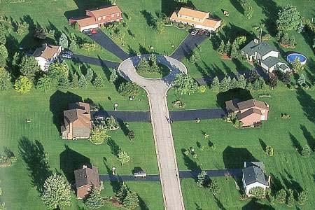
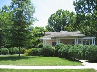

58 Chapter 4: Future Development Guide June 2011 Visual Character Description: Suburban-Neighborhood Development Pattern Transportation Green Space 4-18
59 Chapter 4: Future Development Guide June 2011 SUBURBAN-CENTER Intent: ENHANCE existing suburban centers and CREATE new centers to improve the quality of life with an increased sense of place and community. General Characteristics: Suburban-Center (S-CTR) is characterized by commercial and residential development at the intersection of major transportation corridors. The general development pattern is centered at, or in close proximity to, the major intersection with single use commercial, office, and residential uses as well as mixed use development. Street networks are defined by curvilinear and linear streets with moderate distances between intersections. Buildings have shallow to moderate setbacks and use the building structure or landscaping to frame the street. Roadway cross sections are typically defined by the roadway, curb and gutter, sidewalks, and formal landscaping at the edge of the public right-of- way and private property. Access to properties should be managed with limited curb cuts, frontage roads, and side streets. Connectivity is moderate for vehicles and high for bikes and pedestrians. Uniform sign standards should apply with appropriate sign types including building mounted, projecting, awning, and monument. Landscaping standards should apply along the corridor, including in and along parking lots to provide shade, reduce impervious surfaces, shield parking areas, and improve the appearance of individual sites and the entire corridor. Future development should emphasize connectivity and housing diversity and be organized in a nodal fashion with commercial/mixed use development opportunities concentrated at important intersections. Application: S-CTR is generally at the intersection of primary roads and along major transportation corridors. Primary Future Land Uses Residential uses such as single-family attached and multifamily Office and commercial uses Mixed use development with appropriate mixtures of residential, office, and commercial uses DESIGN PRINCIPLES Site Design Vehicular access provided by side streets or frontage roads Shallow to moderate setbacks are generally 40 to 20 feet in depth Moderate lot coverage with medium building footprint in relation to lot size Density/Intensity Moderate density/intensity 1-5 story buildings Green Space Formal landscaping with built areas Moderately dense street trees, bushes, and planting strips Transportation High pedestrian connectivity with sidewalks and bikeways Moderate vehicular connectivity with curvilinear and linear streets and generous to moderate distance between intersections Infrastructure Municipal water and sewer service Telecommunications available Civic benefit uses such as places of worship, schools, municipal services, community centers or municipal parks, passive recreation (including greenways and trails) Compatible Zoning Classifications R-4, R-5; B-1, B-2, B-3 or B-4 with proposed Suburban Center Overlay District 4-19


60 Chapter 4: Future Development Guide June 2011 Visual Character Description: Suburban-Center Development Pattern Transportation Green Space 4-20
61 Chapter 4: Future Development Guide June 2011 SUBURBAN-CORRIDOR Intent: ENHANCE existing and CREATE suburban corridors to improve the quality of life with an increased sense of place, establish a well-functioning corridor that facilitates traffic flow, provide for a variety of land uses that serve local needs, facilitate an appropriate transition from intensive corridor uses to adjacent neighborhoods, encourage concentration of higher intensity uses into mixed-use nodes and discourage strip commercial development. General Characteristics: Suburban-Corridor (S-COR) is characterized by residential and low-intensity commercial development along major transportation corridors. The general development pattern is linear along the corridors with mixed use, commercial and office concentrated at intersections with stretches of higher-intensity residential uses in between buffering adjacent S-N areas. Large concentrations of mixed use, office and commercial uses should occur only in S- CTR and are not appropriate in S-COR. Street networks are defined by curvilinear and linear streets with moderate distances between intersections. Buildings have moderate to deep setbacks and use the building structure or landscaping to frame the street. Roadway cross sections are typically defined by the roadway, curb and gutter, sidewalks, and formal landscaping at the edge of the public right-of-way and private property. Access to properties should be managed with limited curb cuts, frontage roads, and side streets. Connectivity is moderate for vehicles and high for pedestrians/bicycle users. Uniform sign standards should apply with appropriate sign types including building mounted, projecting, awning, and monument. Landscaping standards should apply along the corridor, including in and along parking lots to provide shade, reduce impervious surfaces, shield parking areas, and improve the appearance of individual sites and the entire corridor. Future development should emphasize connectivity and housing diversity and should provide opportunities for development of higher intensity residential along major transportation arteries. Application: S-COR is generally located along principal arterials and with direct frontage or access to the major roadway. Zone changes from non-commercial districts to districts that allow commercial should occur only after adoption of a corridor land use and transportation study that identifies appropriate locations for small-scale nodes with less impact than S-CTR areas and should include an overlay zoning to manage design and access. DESIGN PRINCIPLES Site Design Vehicular access provided by side streets or frontage roads Deep to moderate setbacks are generally 40 to 20 feet Moderate lot coverage with medium building footprint in relation to lot size Density/Intensity Moderate density/intensity 1-3 story buildings Green Space Formal landscaping Moderately dense street trees, bushes, and planting strips Transportation High pedestrian connectivity with sidewalks and bikeways Moderate vehicular connectivity with curvilinear and linear streets and generous to moderate distance between intersections Infrastructure Municipal water/sewer service Telecommunications available Primary Future Land Uses Residential uses such as single-family and multi-family Office and commercial uses Mixed use development with appropriate mixtures of residential, office, and commercial uses Civic benefit uses such as places of worship, schools, municipal services, community centers or municipal parks, passive recreation (including greenways and trails) Compatible Zoning Classifications R-2, R-4, R-5; B-1, B-2, B-3 or B-4 with proposed Corridor Overlay District 4-21


62 Chapter 4: Future Development Guide June 2011 Visual Character Description: Suburban-Corridor Development Pattern Transportation Green Space 4-22

63 Chapter 4: Future Development Guide June 2011 Development Category: Urban The Urban Development Category is defined by the highest intensity of development. The intent of this category is to enhance and create quality, walkable communities with residential and nonresidential uses in close proximity to one another. Additionally, this category intends to preserve historic buildings and street patterns associated with traditional town centers. The development pattern of urban areas is defined by high intensity of street connection, buildings, and land uses. Commercial areas are defined by buildings that consume most of the lot and have little to no setbacks from the street. The building uses are typically a mixture of retail, office, and residential uses. The scale of buildings varies but is intended to frame the street with two or more stories. Residential neighborhoods are defined by smaller lots, smaller yard setbacks, and are located closer to the street than suburban residential development. The transportation network of urban areas is an intense network of linear streets, smaller, walkable blocks, and frequent intersections. Mobility options are greater in urban areas with walkable distances between land uses and an emphasis on integrating motor vehicle traffic and pedestrians. A typical cross section of an urban street includes the roadway, curb and gutter, street trees or other street furniture, and a sidewalk. On-street parking is also a part of urban areas. It provides activity along the street and a buffer between moving traffic and the pedestrian walkways. Green space in urban areas is made up of street trees or other plantings that line sidewalks, small urban parks, and small yards in urban neighborhoods. Urban areas also provide the highest degree of public and utility services. Water, sewer, electricity, and other utilities are all provided. Additionally, the full range of public safety services are available and can provide the quickest response times in urban areas. Civic services such as government buildings are also typically located in urban areas. URBAN CHARACTER AREAS Urban-Neighborhood Urban-Neighborhood 4-23
64 Chapter 4: Future Development Guide June 2011 URBAN-NEIGHBORHOOD Intent: ENHANCE and MAINTAIN existing urban neighborhood character by accommodating in-fill development that respects the scale, setback, and style of existing adjacent homes and protects and stabilizes existing dwellings, many of which have historic value. CREATE new urban neighborhoods to improve the quality of life in the community with an increased sense of place. General Characteristics: Urban Neighborhood (U-N) is characterized by compact, walkable development in close proximity to a city or neighborhood center. The general development pattern is defined by residential development and civic uses such as schools. Buildings have moderate to shallow setbacks and use the building structure or landscaping to frame the street. Street networks are defined by linear streets with moderate to short distances between intersections. Roadway cross sections are typically defined by the roadway, curb and gutter, sidewalks, and formal landscaping at the edge of the public right-of-way and private property. On-street parking should be encouraged. Connectivity is high for vehicles, pedestrians, and bicycle users. Green space on individual lots is reduced since lots are smaller. Neighborhood parks provide large green space and recreation. Future development should emphasize connectivity and housing diversity by accommodating a mix of housing types and sizes with redevelopment, including small-lot single family, townhomes, and live/work units. Duplexes, townhomes and multi-family units should only be located at key intersections and where full services, public facilities and routes of potential public transportation are available Access to nearby corridors and centers should be improved with additional pedestrian and bicycle infrastructure. Application: U-N areas are generally those neighborhoods adjacent to the District-Downtown (Spring Hill Town Center Area). Primary Future Land Uses Residential uses such as single family attached and detached Civic benefit uses such as places of worship, schools, municipal services, community centers or municipal parks, passive recreation (including greenways and trails) DESIGN PRINCIPLES Site Design Vehicular access provided by alleys and private driveways Shallow building setbacks are generally 20 feet or less in depth Moderate to high lot coverage with medium to large building footprint in relation to lot size Density/Intensity Moderate to high density/intensity 1-3 story buildings Green Space Formal landscaping with built areas Moderately dense street trees, bushes, and planting strips Neighborhood parks Transportation High pedestrian connectivity with sidewalks and bikeways High vehicular connectivity with curvilinear and linear streets and moderate to short distance between intersections Infrastructure Municipal water and sewer service Telecommunications available Compatible Zoning Classifications R-2, R-4, R-5, R-6; Residential PUD 4-24


65 Chapter 4: Future Development Guide June 2011 Visual Character Description: Urban-Neighborhood Development Pattern Transportation Green Space 4-25

66 Chapter 4: Future Development Guide June 2011 Development Category: District The District Category accommodates activities and uses that are not addressed by the traditional community elements of open space, neighborhoods, centers, and corridors. The intent of this category is to create and enhance areas that permit specific land uses or services and to help integrate special use areas into the community fabric. The development patterns for districts are typically large land developments or important activity centers. Examples include airports, industrial sites that require a large geographic area, or traditional town centers. DISTRICT CHARACTER AREAS District Mixed Use Community District-Downtown District-Employment District-Interstate Gateway District-Medical Arts Typically large buffers are required to limit the impacts of the land use on adjacent areas. To help limit the district s impact on the surrounding character areas, efforts should be made to mirror the character of the surrounding areas at the district edge. Similar street types and landscaping buffers are an example of this type of character merging. For districts such as traditional town centers, efforts should be made to connect the district with the surrounding character areas. Sidewalk connections and design elements such as sidewalks, streets, and trails should emphasize the connecting points and the edges of this type of district. Likewise, measures should be taken to limit buffers and other design elements that would emphasize separation between the district and the surrounding character areas. District-Downtown Transportation in and around districts can vary greatly. For heavy land uses such as industrial uses, the transportation system should be designed to accommodate large, heavy vehicles. Access to loading or heavy service areas should be accommodated on site and away from major road access points. For traditional town centers, transportation system should be designed to accommodate all forms of transportation including cars, bicycles, and pedestrians. Green space is variable in districts. Most green space is associated with landscape buffers or large open areas such as an airport runway, or formal civic spaces such as a town square. District-Employment Utility services are an important component of district areas. Where heavy uses are located, such as industrial uses or airports, it is important that water, sewer, and electrical services are provided. Wastewater and sewage are important to manage. 4-26
67 Chapter 4: Future Development Guide June 2011 DISTRICT-MIXED USE COMMUNITY Intent: CREATE mixed-use communities that reflect a mix of residential, commercial, office and open space developed based on traditional small town and city neighborhood development principles that accommodate compact, mixed use neighborhoods where residential commercial and civic buildings are within close proximity to each other. General Characteristics: District-Mixed Use Community (D-MUC) is defined by compact, mixed-use development typical of traditional neighborhood development (TND). Buildings have shallow setbacks and use the building structure to frame the street. Street networks are defined by linear streets with moderate to short distances between intersections. Roadway cross sections are typically defined by the roadway, curb and gutter, sidewalks and formal landscaping at the edge of the public right of way and private property. Parking for mixed use and multifamily areas is limited to on-street and behind or beside buildings. Connectivity is high for vehicles, pedestrians, and bicycle users. Future development should emphasize connectivity and housing diversity by accommodating a mix of housing types and sizes, including small-lot single family, townhomes and live/work units. Mixed use development nodes should be incorporated within the communities to provide commercial and service uses within walking distance of residences. Vertical mixed-use development that places residential above ground floor office and retail uses is encouraged. Duplexes, townhomes and multifamily units should locate near or within mixed use development nodes. Future development should reinforce traditional pedestrianscaled development patterns, including building placement, lighting, site features, sidewalk use and amenities, traffic patterns, etc. Green space is characterized by street trees, planters, planting strips, and formal public parks and squares. Application: D-MUC is applied when there is an expressed interest in the area s development pattern evolving to promote a mixture of housing types, commercial, and office land uses as well as greater connectivity. Implementation of this area should follow the requirements of the Traditional Neighborhood Development zoning ordinance. Primary Land Uses Mixed use development with appropriate mixtures of residential, office, and commercial uses DESIGN PRINCIPLES Site Design Vehicular access provided by alleys and private driveways Shallow building setbacks, generally 20 feet or less in depth for residential areas Buildings in mixed use node areas should be built to the edge of the sidewalk Moderate to high lot coverage with medium to large building footprint in relation to lot size Density/Intensity Moderate to high density/intensity 1-5 story buildings Green Space Formal landscaping with built areas Moderately dense street trees, bushes, and planting strips Neighborhood parks Transportation High pedestrian connectivity with sidewalks and bikeways High vehicular connectivity with curvilinear and linear streets and moderate to short distance between intersections Infrastructure Municipal water and sewer service Telecommunications available Office and commercial uses Residential uses such as single-family detached, single-family attached and multi-family Civic benefit uses such as places of worship, schools, municipal services, community centers or municipal parks Compatible Zoning Classifications R-6, Planned Unit Development 4-27


68 Chapter 4: Future Development Guide June 2011 Visual Character Description: District-Mixed Use Community Development Pattern Transportation Green Space 4-28
69 Chapter 4: Future Development Guide June 2011 DISTRICT-DOWNTOWN Intent: CREATE a downtown in Spring Hill to improve the quality of life and to increase the sense of place and community. It is intended to encourage a true live, work, play environment that includes a mixture of the government facilities, new commercial and residential, historic buildings and long-term services that can create vitality and reinforce the area s role as an activity and civic center. General Characteristics: District-Downtown (D-D) is characterized by compact, walkable development typical of town centers. The general development pattern is defined by compact, mixed use development. Buildings have shallow setbacks and use the building structure to frame the street. Green space is characterized by street trees, planters, planting strips, and formal public parks and squares. Street networks are defined by linear streets with short distances between intersections. Roadway cross sections are typically defined by the roadway, curb and gutter, and sidewalks with a well defined pedestrian environment. Parking is limited to on-street and behind or beside buildings. Connectivity is high for vehicles, pedestrians, and bicycle users. Future development should emphasize connectivity and uses that generate a high level of activity. It should reinforce traditional pedestrian-scaled development patterns, including building placement, lighting, site features, sidewalk use and amenities, traffic patterns, etc. It should retain and enhance existing building stock with appropriate maintenance and rehabilitation, and encourage mixed use development in buildings with underutilized upper floors and infill opportunities (e.g. residential above ground floor retail). Application: D-D area is centrally located within Spring Hill and generally encompass the area within a quarter mile radius of the intersection of US 31 and Beechcroft Road. Primary Land Uses Mixed use development with appropriate mixtures of residential, office, and commercial uses Office and commercial uses Entertainment and cultural centers Residential uses such as single-family attached and multifamily DESIGN PRINCIPLES Site Design Vehicular access provided by alleys and private driveways Shallow building setbacks are generally 20 feet or less in depth Moderate to high lot coverage with medium to large building footprint in relation to lot size Density/Intensity Moderate to high density/intensity 1-5 story buildings Green Space Formal landscaping with built areas Moderately dense street trees, bushes, and planting strips Neighborhood Parks Transportation High pedestrian connectivity with sidewalks and bikeways High vehicular connectivity with curvilinear and linear streets and moderate to short distance between intersections Infrastructure Municipal water and sewer service Telecommunications available Civic benefit uses such as places of worship, schools, municipal services, community centers or municipal parks Compatible Zoning Classifications R-4, R-5; B-2; MU Overlay District 4-29


70 Chapter 4: Future Development Guide June 2011 Visual Character Description: District-Downtown Development Pattern Transportation Green Space 4-30
71 Chapter 4: Future Development Guide June 2011 DISTRICT-EMPLOYMENT Intent: ENHANCE and MAINTAIN existing business and industrial facilities and CREATE new facilities to accommodate economic growth. General Characteristics: The District-Employment (D-E) is intended to incorporate many aspects of commerce such as professional office buildings, corporate office, regional office, high-tech and research facilities and small office campuses and light industrial uses such as warehousing and wholesale. Building development should be variable within D-E to promote the specific needs of large-scale activities or businesses and accommodate large-footprint distribution facilities, industrial activities, or office park developments Appropriate landscaping and open space between buildings and adjacent land uses should be provided to help limit negative visual and noise impacts of activity within the district on surrounding areas. Internal transportation should be designed to accommodate heavy and large vehicles associated with industrial or shipping activity. Access to the district should be controlled with limited connections to surrounding development and should be located along a major roadway. Master planning is required to address access and circulation. Future development should reflect a campus or unified development pattern that includes on-site stormwater detention or retention features, such as pervious pavements, provides for connectivity between uses, has controlled signage (height, size, type) to prevent visual clutter and includes supporting commercial uses to serve workers and patrons of these developments. Buildings set in a campus setting should have an internal pedestrian circulation system that makes walking from building to building convenient. Application: D-E areas are located throughout the county and include existing industrial areas or areas that have been designated for future industrial development. DESIGN PRINCIPLES Site Design Vehicular access provided by side streets or frontage roads Deep to moderate setbacks are generally 40 to 20 feet in depth Moderate lot coverage with medium building footprint in relation to lot size Variable buffer distances to accommodate unique uses Density/Intensity Moderate density/intensity 1-3 story buildings Green Space Formal landscaping with built areas Moderately dense street trees, bushes, and planting strips Transportation Moderate vehicular connectivity with curvilinear and linear streets and generous to moderate distance between intersections Infrastructure Municipal water and sewer service Telecommunications available Primary Future Land Uses Civic benefit uses such as places of worship, schools, municipal services, community centers or municipal parks, passive recreation (including greenways and trails) Office uses such as business parks or large business facilities Technology parks and research facilities Industrial uses such as low or high intensity manufacturing, assembly, distribution, processing, wholesale trade, or similar Compatible Zoning Classifications B-1, B-2, B-3, B-4; M-1, M-2, M


72 Chapter 4: Future Development Guide June 2011 Visual Character Description: District-Employment Development Pattern Transportation Green Space 4-32
73 Chapter 4: Future Development Guide June 2011 DISTRICT-INTERSTATE GATEWAY Intent: ENHANCE highway commercial businesses associated with interstate interchanges, to define a visual gateway to Spring Hill and CREATE opportunities for industrial or large business facilities to take advantage of I-65 access and proximity to Nashville. General Characteristics: The District-Interstate Gateway (D- IG) areas are intended to accommodate industrial and business development that is not easily accommodated within the Community Elements (Open Space, Neighborhoods, Corridors, or Centers). D-IG areas are expected to capitalize on their I-65 access and develop with large-scale distribution facilities, industrial activities, office park developments, and highway commercial activity when infrastructure is in place to support such uses. D-IG areas are characterized by auto-oriented commercial and industrial uses that cater to travelers along I-65 and the available workforce. As prominent gateways to the city, attention should be paid to permitted signage, the presence of sidewalks and other site or streetscape features that can enhance the aesthetic and functional qualities of the area. Application: The D-IG areas are located at the proposed interchanges at Buckner Road and Interstate 65 and at Kedron Road and I-65. Primary Future Land Uses Passive recreation, including greenways and trails Civic benefit uses such as places of worship, schools, municipal services, community centers or municipal parks, passive recreation (including greenways and trails) Commercial uses such as gas stations, restaurants, hotel and motel uses, or other similar interstate highway oriented uses Industrial uses such as low or high intensity manufacturing, assembly, distribution, processing, wholesale trade, or similar DESIGN PRINCIPLES Site Design Vehicular access provided by side streets or frontage roads Deep to moderate setbacks are generally 40 to 20 feet in depth Moderate lot coverage with medium building footprint in relation to lot size Density/Intensity Moderate density/intensity 1-3 story buildings Green Space Formal landscaping with built areas Moderately dense street trees, bushes, and planting strips Transportation Moderate vehicular connectivity and generous to moderate distance between intersections Shared side and rear commercial parking Infrastructure Municipal water and sewer service Telecommunications available Office uses such as business parks or large business facilities Compatible Zoning Classifications B-1, B-2, B-3, B-4; M-1, M-2. M-3; Commercial PUD, Industrial PUD; Interchange Overlay District 4-33


74 Chapter 4: Future Development Guide June 2011 Visual Character Description: District-Interstate Gateway Development Pattern Transportation Green Space 4-34
75 Chapter 4: Future Development Guide June 2011 DISTRICT-MEDICAL ARTS Intent: CREATE concentration of medical arts related facilities to provide community health care services and attract ancillary uses to accommodate economic growth in this growth industry. General Characteristics: The District-Medical Arts (D-MA) is intended to incorporate a concentration of medical-related offices, facilities and ancillary uses such as professional medical and dental offices, nursing home facilities, retail pharmacies and restaurants. Building development should be variable within D-MA to promote the specific needs of an area that accommodates a variety of scale and building design that supports the goal of encouraging a walkable, medical center area. Mixed-use opportunities, such as medical offices above ground floor retail, are encouraged. Appropriate landscaping and open space between buildings and adjacent land uses should be provided to enhance the appearance of the area and buffer negative visual and noise impacts of activity within D-MA on surrounding areas. Open space should be retained and landscaping incorporated into site design and parking areas. Front-yard parking should be discouraged. Future development should reflect unified development pattern that includes connectivity between uses, controlled signage (height, size, type) to prevent visual clutter and supporting commercial uses to serve workers and patrons of these developments. The area should include an extensive pedestrian circulation system that makes walking convenient. It should also accommodate housing that would benefit from proximity to health services (senior housing, nursing home, special needs housing, and guest lodging for families of hospital patients). Application: The D-MA generally includes properties to the northeast of the intersection of Old Kedron Road and Saturn Parkway. Primary Future Land Uses Civic benefit uses such as places of worship, schools, municipal services, community centers or municipal parks, passive recreation (including greenways and trails) DESIGN PRINCIPLES Site Design Vehicular access provided by side streets or frontage roads Deep to moderate setbacks are generally 40 to 20 feet in depth Moderate lot coverage with medium building footprint in relation to lot size Variable buffer distances to accommodate unique uses Density/Intensity Moderate density/intensity 1-3 story buildings (with the exception of hospital site buildings) Green Space Formal landscaping with built areas Moderately dense street trees, bushes, and planting strips Transportation Moderate vehicular connectivity with curvilinear and linear streets and generous to moderate distance between intersections Infrastructure Municipal water and sewer service Telecommunications available Hospital or clinic uses Office and commercial uses Mixed use (upper floor office or residential and ground floor retail) Special housing such as senior housing, assisted living facility, special needs housing, guest lodging for patients families) Compatible Zoning Classifications R-4, R-5; B-1, B-2, B-3, B-4, Commercial PUD 4-35


76 Chapter 4: Future Development Guide June 2011 Visual Character Description: District-Medical Arts Development Pattern Transportation Green Space 4-36
77 Chapter 4: Future Development Guide June 2011 CHARACTER AREA IMPLEMENTATION STRATEGY The Character Area Implementation Strategy is used to link the desired physical development patterns identified in the Future Development Guide Character Area Descriptions with appropriate modifications to development regulations necessary to implement the descriptions and policy intent. For some of the Character Areas, the desired physical development patterns are prohibited by existing regulations. Likewise, some of the desired development patterns are not regulated currently and new regulations are needed to help guide and implement the desired development patterns. Below is a list of specific strategies for each Character Area that when implemented, will help Maury County achieve its desired vision of future development. For additional explanation of terms and implementation tools, refer to the Implementation Program and the Glossary of Terms and Development Concepts. Natural - Open Space N-OS Strategy 1. Pursue Government Purchase of environmentally sensitive lands for the creation of wildlife areas, nature preserves, and public parks. N-OS Strategy 2. Develop a land conservation program with the Land Trust of Tennessee, Nature Conservancy or other similar entity to create conservation easements or other similar conservation tools that preserve important natural areas. N-OS Strategy 3. Review Floodplain protection ordinance to ensure compliance with state and federal regulations. N-OS Strategy 4. Review development regulations to ensure stormwater and erosion controls mitigate construction and development impacts on natural areas. N-OS Strategy 5. Develop a Citywide Parks and Greenways Master Plan that outlines a citywide system of interconnected parks and greenway/trail corridors, addresses greenway trail crossings of all roads, defines specific priorities for property acquisition to develop the system. N-OS Strategy 6. Inventory and assess the viability of converting existing private open space into public open space. Rural Neighborhood R-N Strategy 1. Adopt a conservation subdivision ordinance to ensure the preservation of important natural features and the rural character of Spring Hill. R-N Strategy 2. Maintain one dwelling unit per acre zoning regulations. Rural-Center R-CTR Strategy 1. Develop R-CTR Master Plan to guide development activity. 4-37
78 Chapter 4: Future Development Guide June 2011 Rural-Corridor R-COR Strategy 1. Adopt Rural Corridor overlay district that defines standards for site design, access management and street design that supports context sensitive street design and preserves the rural character. Suburban Neighborhood S-N Strategy 1. Develop street connectivity requirements that require a connected system of streets with in new subdivisions and connections to existing subdivisions, including requiring multiple stub out streets to allow for future connectivity when adjacent properties develop. S-N Strategy 2. Adopt a conservation subdivision ordinance. S-N Strategy 3. Adopt a Tree Protection/Replacement Ordinance that limits clearing and grading to maintain the natural tree canopy as much as possible. S-N Strategy 4. Reduce PUD minimum area requirements to encourage smaller developments and innovative infill development. S-N Strategy 5. Develop residential infill guidelines applicable in Suburban Neighborhood areas in order to ensure that the scale and character of new development on vacant lots is compatible with existing development. Suburban-Center S-CTR. Strategy 1. Develop S-CTR Master Plans to guide enhancements and redevelopment activity. S-CTR Strategy 2. Develop a Center Overlay District to regulate building placement, design, and size, sign placement, size, and materials, landscaping, access management, interparcel access, and other elements that contribute to the look and function of the center. Suburban-Corridor S-COR. Strategy 1. Develop S-COR Master Plan to guide enhancements and development activity. S-COR Strategy 2. Develop a S-COR Overlay District to regulate building placement, design, and size, sign placement, size, and materials, landscaping, access management, interparcel access, and other elements that contribute to the look and function of the center. Urban-Neighborhood U-N Strategy 1. Develop U-N Neighborhood Plans to guide enhancements and redevelopment activity. U-N Strategy 2. Develop a Traditional Neighborhood Development (TND) ordinance to create walkable, compact residential development. U-N Strategy 3. Develop a PUD zoning category to encourage innovative site design and development. 4-38
79 Chapter 4: Future Development Guide June 2011 U-N Strategy 4. Reduce minimum lot dimensions to encourage compact, walkable development patterns. U-N Strategy 5. Amend the zoning ordinance to include flexible setback provisions for infill development to reduce setback requirements while ensuring new standards respect the existing development dimensions. District-Downtown D-D Strategy 1. Develop D-D Master Plan to guide enhancements and redevelopment activity. D-D Strategy 2. Develop an D-D overlay district to regulate building placement, design, and size, sign placement, size, and materials, landscaping, access management, interparcel access, and other elements that contribute to the look and function of the Downtown. D-D Strategy 3. Enhance connections between D-D and adjacent neighborhoods with improved streetscapes and development of underutilized parking areas and vacant lots. D-D Strategy 4. Enhance existing green space, such as squares and plazas, and create opportunities for new public green space. D-D Strategy 5. Examine opportunities to encourage an increase in upper-floor office and residential uses in downtown areas. D-D Strategy 6. Require street trees and appropriate streetscape elements on all streets D-D Strategy 7. Require architectural and storefront treatments that provide a pedestrianoriented façade and prohibit windowless walls. D-D Strategy 8. Prohibit parking lots between building fronts and the street. On-street parking, structured parking, and on-site surface parking lots behind buildings are appropriate. District-Employment Center D-EC Strategy 1. Review and modify industrial zoning category standards to accommodate desired business development. District-Interstate Gateway D-IG Strategy 1. Develop an D-IG overlay district to regulate building placement, design, and size, sign placement, size, and materials, landscaping, access management, interparcel access, and other elements that contribute to the look and function of the district D-IG Strategy 2.Expand sewer service to proposed Interchange areas not currently served. District-Medical Arts D-MA Strategy 1. Develop a Medical Arts District Master Plan and follow up with the development of D-MA overlay zoning 4-39

80 Chapter 4: Future Development Guide June 2011 FUTURE DEVELOPMENT MAP The Future Development Map is used to identify the geographic location of the character areas within Spring Hill and its Urban Growth Boundary. The map is intended to help guide decision making related to the physical location of development and where the most appropriate type, scale and intensity of development should occur. 4-40
81 Chapter 4: Future Development Guide June 2011 TRANSPORTATION Assessment of the Existing Transportation System The transportation assessment portion of the provides an overview of the current transportation network within Spring Hill s Urban Growth Boundary (UGB), or the study area. All forms of transportation, including highway, air, rail, and bicycle/pedestrian systems were evaluated to assess the adequacy of the existing transportation network to serve future travel demands. The safety of the transportation system was also a main consideration while assessing opportunities for improvements to transportation in the city. EXISTING STREET AND HIGHWAY SYSTEM This section provides an overview of the existing roadway network in Spring Hill, including a discussion of functional classifications, traffic volume, levels of service, and crash data. Traffic volumes obtained from TDOT count stations within the study area and the most recent traffic counts from the City of Spring Hill provided the basis for the existing conditions analysis. Evaluating the existing condition of the City s roadway network helped identify roadway deficiencies and transportation projects to address congestion, safety, and other travel related issues. The existing conditions analysis was conducted for all functionally classified routes within the city s UGB. Some of the more frequently traveled routes in the study area include I-65, SR 396 (Saturn Parkway), US 31, US 431 (Lewisburg Pike), and SR 247 (Duplex Road). All of these routes provide connections that promote the movement of people, goods, and services between Spring Hill and the rest of the region. Functional Classification The existing roadway facilities in Spring Hill are each classified according to the amount of access and mobility they provide, or how the road functions. According to the Federal Highway Administration (FHWA), functional classification is the process by which streets and highways are grouped into classes, or systems, according to the character of service they are intended to provide. It is a hierarchical organization of streets and highways that facilitates the safe and efficient operation of vehicles along different types of facilities. It then becomes necessary to determine how travel can be channeled within the transportation network in a logical and efficient manner using these facilities. Functional classification defines the nature of this channelization process by defining the role that any particular road or street should play in serving the flow of trips through the highway network. 1 Figure 4-1 below shows schematically how various street classifications relate to each other in terms of movement and access. As land access increases, traffic movement decreases on the lower classified roadways and vice versa as land access decreases, traffic movement increases along the higher classified roads

82 Chapter 4: Future Development Guide June 2011 Figure 4-1: Traffic Movement and Land Access The federal functional classification of existing facilities is required in order for a roadway to be eligible for federal funding under current transportation legislation. The Safe, Accountable, Flexible, Efficient Transportation Equity Act: A Legacy for Users (SAFETEA-LU) states that a roadway must be functionally classified as a collector or higher to be eligible for federal funds designated for roadway improvement projects. The functional classification of existing facilities is also significant because it specifies the desired amount of access control, or locations where vehicles can enter or leave a roadway. When there is no access control, intersecting roads or driveways may connect to the mainline at any point. Typically, local roads have no access control. With partial control of access there is minimum spacing of access locations. With full access control, connections are only allowed at major crossroads such as interchanges along an interstate. Full or partial control of access helps reduce traffic conflicts. 2 Following is a brief description of functional classes of roadways and examples of each in Spring Hill. Freeway A divided arterial highway for through traffic, with full access control, high speeds, and grade separation at major intersections. I-65 and SR 396 (Saturn Parkway) function as freeways in Spring Hill. Arterial A class of road serving major traffic movements (high-speed, high volume) for travel between main points of interest. Arterials emphasize a high level of mobility for through movement. While they may provide access to abutting land, their primary function is to serve traffic moving through the area. Therefore, arterials require a much higher level of access control than collectors or local streets. US 31 and US 431 are examples of arterials in the study area. Collector In rural areas, a route that serves intra-county rather than statewide travel. In urban areas, a street that provides direct access to neighborhoods and arterials. As their name suggests, collector roadways have the primary purpose of collecting traffic from local roadways and distributing it to its destination or to an arterial roadway. Collectors offer a compromise between mobility and access. Duplex Road, Buckner Lane, and Buckner Road are examples of Spring Hill collectors

83 Chapter 4: Future Development Guide June 2011 Local Street Local streets are not considered major roadways. Their primary function is to provide direct access to land with little emphasis on the movement of through traffic. Belshire Way, Denning Lane, and Derryberry Lane are examples of local streets in Spring Hill. This plan focuses on Spring Hill s functionally classified roads. These roadways have the greatest impact on the transportation system, as they are primarily intended to move traffic and have less emphasis on land access than local roads. In contrast, local roads are primarily intended to provide access to land as illustrated above. As indicated in Figure 4-2 below, a functional roadway system facilitates a progressive transition in the flow of traffic from the provision of access to the provision of movement. Freeways and arterial facilities primarily provide the function of moving vehicles while collector and local streets concentrate more on providing access to property. Figure 4-2: Roadway Functional Class System A list of Spring Hill s existing roadway functional class and their existing number of lanes is provided in Table 4-1. Figure 4-3 illustrates Spring Hill s functionally classified roadways. 4-43
84 Chapter 4: Future Development Guide June 2011 Table 4-1: Existing Roadway Functional Class & Number of Lanes ROUTE SPRING HILL ROADS FUNCITONAL CLASS NUMBER OF LANES I-65 Interstate 4 SR 396 / Saturn Parkway Freeway 4 SR 6 / US Hwy 31 / Main Street / Columbia Pike Arterial 3 Lanes from county Line to Kedron Road SR 6 / US Hwy 31 / Main Street / Columbia Pike Arterial 4 Lanes from Kedron Road to SR 99/US 412 SR 247 / Beechcroft Road / Duplex Road Collector 2 Buckner Lane Collector 2 Buckner Road Collector 2 Campbell Station Parkway / Stewart Campbell Point Collector 2 Commonwealth Drive Collector 2 Depot Street Collector 2 John Lunn Road / Royal Park Boulevard Collector 2 Kedron Parkway Collector 2 Meadow View Drive Collector 2 New Port Royal Road Collector 2 Old Kedron Road Collector 2 Old Military Road Collector 2 Port Royal Road Collector 4 Ray Williams Drive Collector 2 Stephen Yokich Parkway / Town Center Parkway Collector 2 Sunflower Drive Collector 2 Wilkes Lane Collector
85 Chapter 4: Future Development Guide June 2011 Figure 4-3: Existing Roadway Functional Class Map 4-45
86 Chapter 4: Future Development Guide June 2011 Traffic Volumes Spring Hill s traffic history is provided by the Tennessee Department of Transportation (TDOT) and the City of Spring Hill s Public Works Department. Each year, TDOT publishes Annual Average Daily Traffic (AADT) counts for every county in the state of Tennessee. The counts are supplied by traffic count stations positioned along roadways throughout the state. The location of each station is determined by TDOT. There are currently 19 TDOT traffic counting stations located in the Spring Hill study area with traffic data through The City also collects traffic counts for 17 different locations throughout Spring Hill. The city s traffic data is available from 2003 through August Tables 4-6 and 4-7 list each count station within the study area and its respective traffic counts. Spring Hill and TDOT traffic counts indicate that Interstate 65, Saturn Parkway, and SR-6/US-31 are the most traveled roadways in Spring Hill. Interstate 65 travels north and south through the eastern portion of the study area and connects Spring Hill to the cities of Franklin and Nashville, Tennessee to the north and Columbia, Tennessee to the south. Saturn Parkway provides an east-west connection from I-65 to SR-6/US-31, and SR-6/US- 31 provides a north-south connection from the City of Columbia to the City of Franklin. Buckner Road, Kedron Road, and Port Royal Road are also heavily traveled. The traffic count tables in the appendix also show the percentage of growth in traffic each year for all count stations. A summary of the roads that have seen the greatest increases and decreases in traffic are presented in Tables 4-2 and 4-3 below. Again, some stations have older data available than other locations. As Table 4-2 indicates, Port Royal Road, Kedron Road, and Jim Warren Road have seen the greatest increases in traffic in the last few years with 30.4 and 26 percent average annual growth rates, respectively. US 31 and SR 247 (Beechcroft Road and Duplex Road) have also seen large increases in traffic from 2000 to Table 4-3 lists the roads that have seen the greatest decreases in traffic. While Interstate 65, Saturn Parkway, and Kedron Road experience significant amounts of daily traffic, the amount of traffic these routes experience has remained consistent and even decreased from 2000 to 2008 in some instances. 4-46
87 Chapter 4: Future Development Guide June 2011 Table 4-2: Top 10 Traffic Growth Rates Annual Average Daily Traffic Volumes (vehicles per day) &Annual Traffic Growth Rates (%) Avg. Annual Traffic Station Number Route Location Growth Rate (%) % -7.3% 32.2% 6.3% 20.0% 13.1% % PORT ROYAL ROAD SOUTH OF SH Count HAYNES CROSSING % 56.8% % KEDRON ROAD 1 SOUTH OF PORT SH Count ROYAL % % SH Count JIM WARREN PORT ROYAL % 12.0% 21.8% 10.4% 8.3% 19.0% % SH Count PORT ROYAL WATER PLANT % 9.1% 3.0% 10.8% 73.2% -14.1% 16.7% 24.0% 22.0% SR247 DUPLEX ROAD EAST OF SPRING HILL % 14.7% 9.6% 62.1% 4.6% 4.5% 5.2% 1.3% 16.8% KEDRON ROAD NEAR WILLIAMSON CO LINE % 8.6% -4.1% 96.2% 11.3% -3.8% -2.7% 12.3% 16.5% SR247 BEECHCROFT - SPRING HILL % 35.6% 5.3% 96.1% 3.0% 16.4% 14.7% -19.6% 15.6% SR247 DUPLEX ROAD NEAR MAURY CO LINE % 10.3% -5.6% 30.5% 6.1% 3.4% % DUPLEX CHAPMANS SH Count RETREAT % 8.8% 78.8% 4.7% 0.9% 11.5% -2.0% -1.1% 14.3% SR247 NEAR MARSHALL CO LINE Source: Tennessee Department of Transportation and City of Spring Hill 4-47
88 Chapter 4: Future Development Guide June 2011 Table 4-3: Bottom 5 Traffic Growth Rates Annual Average Daily Traffic Volumes (vehicles per day) &Annual Traffic Growth Rates (%) Avg. Annual Traffic Station Number Route Location Growth Rate (%) % 13.4% -10.8% % DENNING LANE AT KEDRON SH Count ROAD % -1.9% 6.3% -2.8% 4.8% 0.5% -7.3% 13.2% -1.0% I0065 I-65 - SOUTH OF SATURN PKWY % -11.3% -10.8% 11.3% 6.8% -5.9% % KEDRON ROAD AT ROYAL PARK SH Count ROAD % 7.4% -7.7% 8.8% 3.6% 3.8% % KEDRON RD % 3.3% 8.2% -1.1% 3.7% 3.4% 11.8% 2.0% 1.6% SR396 SATURN PKWY - E. OF KEDRON RD % 5.4% -11.6% 10.9% 4.4% -6.8% -5.2% 9.0% 2.3% SR006 U.S SOUTHWEST SPRING HILL % 0.9% 0.5% 5.4% 2.3% 6.8% 0.3% - 3.1% SATURN PKWY - E. OF PORT SR396 ROYAL RD % 5.8% 8.1% -4.5% 5.7% 7.4% 10.6% - 3.4% I0065 SOUTH OF SR % 4.0% 29.1% 11.7% 1.8% 18.6% % SH Count DUPLEX ROAD - WEST OF MILES JOHNSON % 13.9% 0.6% -1.6% 3.0% 13.8% 15.3% -8.3% 4.1% U.S SOUTH OF DUPLEX ROAD SR106 NEAR MARSHALL CO LINE % 33.8% -6.0% % SH Count U.S SOUTH TARGET SOUTH Source: Tennessee Department of Transportation and City of Spring Hill 4-48

89 Chapter 4: Future Development Guide June 2011 Level of Service Level of Service (LOS) is a term that is used to describe how well traffic operates on a roadway segment or at an intersection, and is based on the roadway s capacity and traffic volumes. Roadway capacity is defined by the functional class and number of lanes on a particular roadway. Volume is the actual number of vehicles on a roadway. LOS utilizes a letter system to indicate how well a roadway operates with letters ranging from A to F A being excellent and F failing (see diagram). LOS C is generally acceptable for typical roadway function while LOS D is typically considered to be the minimum acceptable LOS in an urbanized area. Figure 4-4 is a graphic depiction of the Level of Service Concept: Figure 4-4: Roadway Level of Service Concept The Highway Capacity Manual generally describes each LOS as follows: A=Free flow B=Reasonably free flow C=Stable flow D=Approaching unstable flow E=Unstable flow F=Forced or breakdown flow For comparison purposes, Table 4-4 lists the typical traffic volumes that can be accommodated for each LOS based on the roadway functional classification and number of travel lanes. Table 4-4: Level of Service Threshold by Functional Classification Typical Daily Service Volumes Related to LOS Road Type LOS A LOS B LOS C LOS D LOS E 4 Lane Freeway 31,700 45,300 56,200 68,000 90,700 2 Lane Arterial Urban 6,500 9,400 11,600 14,000 18,700 3 Lane Arterial Urban 8,200 11,600 14,400 17,500 23,300 4 Lane Arterial Urban 10,700 15,400 19,000 23,000 30,700 5 Lane Arterial Urban 12,400 17,600 21,900 26,500 35,300 2 Lane Arterial Rural 8,400 12,000 14,900 18,000 24,000 3 Lane Arterial Rural 10,500 15,000 18,600 22,500 30,000 2 Lane Collector Urban 5,100 7,400 9,100 11,000 14,
90 Chapter 4: Future Development Guide June 2011 Typical Daily Service Volumes Related to LOS Road Type LOS A LOS B LOS C LOS D LOS E 3 Lane Collector Urban 6,400 9,200 11,300 13,700 18,300 4 Lane Collector Urban 8,400 12,000 14,900 18,000 24,000 5 Lane Collector Urban 10,700 15,400 19,000 23,000 30,700 2 Lane Collector Rural 6,500 9,400 11,600 14,000 18,700 3 Lane Collector Rural 8,200 11,600 14,500 17,500 23,300 Most of Spring Hill s roadways are operating at a LOS C or better with the exception of US 31 at count station nine near the Duplex Road intersection, which operates at a level of service E. Buckner Road at Main Street and Kedron Road at Port Royal Road operate at levels of service D. A portion of US 31 at count station 7, just north of the Saturn Parkway interchange, I-65 north of the Duplex Road intersection, Kedron Road at the Battlefield, and Port Royal Road south of Hayne s Crossing operate at LOS C. All other roadways operate at LOS B and A. While LOS C is considered acceptable, the segments of US 31 operating at LOS C and worse are a concern as traffic continues to increase almost daily with the completion of new housing and commercial developments. Table 4-5 below provides current LOS data for each count station in the study area. Table 4-5: Existing Level of Service Data EXISTING MAURY COUNTY LEVELS OF SERVICE Route TDOT Count Station 2008 AADT 2009 AADT LOS I ,794 - A I ,001 - C Kedron Rd 237 1,854 - A Kedron Rd 90 7,224 - B Kedron Rd 170 5,934 - B SR 247/Beechcroft Rd/Duplex Rd 6 4,591 - A SR 247/Beechcroft Rd/Duplex Rd 10 6,881 - B SR 247/Beechcroft Rd/Duplex Rd 116 2,330 - A SR 247/Beechcroft Rd/Duplex Rd 126 4,647 - A SR 247/Beechcroft Rd/Duplex Rd 169 2,387 - A SR 396/Saturn Parkway ,877 - A SR 396/Saturn Parkway ,233 - A SR 6/US Hwy 31/Main St/Columbia Pk 7 17,634 - C SR 6/US Hwy 31/Main St/Columbia Pk 9 19,258 - E SR 106/US Hwy 431/Lewisburg Pk 65 (North of Duplex) 5,168 - A SR 106/US Hwy 431/Lewisburg Pk 72 (South of Duplex) 3,878 - A SR 106/US Hwy 431/Lewisburg Pk 221 3,391 - A SR 106/US Hwy 431/Lewisburg Pk 236 3,657 - A SR 246/Carters Creek Pk 144 2,378 - A SR 246/Carters Creek Pk 4 2,329 - A Beechcroft Road at Railroad - - 5,033 A Buckner Lane at Cameron Farms - - 6,755 B Buckner Road at Main Street ,403 D Denning Ln at Kedron Duplex Road at Chapman Retreat - - 5,222 B 4-50
91 Chapter 4: Future Development Guide June 2011 EXISTING MAURY COUNTY LEVELS OF SERVICE Route TDOT Count Station 2008 AADT 2009 AADT LOS Duplex Road west of Miles Johnson Pkwy - - 5,963 B Greens Mill Road at Kedron Road - - 3,261 - Jim Warren Road at Port Royal - - 6,899 - Kedron Road at Battlefield - - 7,931 C Kedron Road at Royal Park Road - - 9,850 D Kedron Road at Water Treatment Plant - - 3,784 A Kedron Road south of Port Royal - - 3,414 A Mahlon Moore at Kedron Road - - 3,033 - North Main at Target north - - 9,926 B Miles Johnson Pkwy south of Duplex - - 1,723 - Miles Johnson Pkwy north of Duplex - - 2,282 - Miles Johnson Pkwy at Main Street - - 2,869 - Port Royal south of Hayne s Crossing ,522 C Port Royal at Water Treatment Plant - - 4,242 A South Main at Target south - - 9,445 B Safety Safety is a primary goal of all modes of transportation. The Safe, Accountable, Flexible, Efficient Transportation Equity Act: A Legacy for Users (SAFETEA-LU) promotes more efficient and effective Federal surface transportation programs throughout the United States and established a new core Highway Safety Improvement Program (HSIP) that is structured and funded to make significant progress in reducing highway fatalities, incapacitating injuries, and crashes in general. Every year TDOT develops lists to help identify potential improvement projects that meet the intent of the HSIP requirements. One of these lists is an inventory of High Risk Rural Roads (HRRR). The HRRR list identifies sections of rural roads that are functionally classified as local, minor collector, or major collector that have experienced high numbers of severe crashes. HRRR improvements are generally lower cost projects, some of which can be repeated along relatively long sections of highway. There are no roadways in Spring Hill listed on the 2007 HRRR list. AIR/RAIL There is no air transport in the Spring Hill study area, and rail service in Spring Hill is strictly for freight transportation and not used for public transportation. CSX Transportation is the only Class I railroad within Spring Hill. There is one primary rail yard in Spring Hill and it is located at the General Motors plant. CSX has a mainline rail that travels south from Nashville, paralleling US 31, and ends in Columbia, TN. At that point it connects to a short line operated by Tennessee Southern Railroad (TSRR). TSRR operates two tracks that travel south from Columbia. The western line leads from Columbia to a port facility in Florence, Alabama. The eastern line leads from Columbia to Pulaski, Tennessee. Maury Regional Airport is the closest general aviation airport facility located in Maury County. It is located in Mt. Pleasant so is not within the study area. The airport has two runways, one that is approximately 6,000 feet long by 100 feet wide, and another that is approximately 2,000 feet long by 200 feet wide. It offers charter service for passengers and freight, aircraft maintenance, and car rental and limousine services. There are approximately 30 aircraft based at the airport and an average of nearly 80 aircraft takeoffs and landings per day. 4-51
92 Chapter 4: Future Development Guide June 2011 BICYCLE/PEDESTRIAN FACILITIES Bicycling and walking are becoming increasingly important modes of transportation for the City of Spring Hill as transportation costs continue to rise and alternative modes off transportation become increasingly important. To address this need, this plan is intended to help create a comprehensive, multi-modal strategy that includes bicycling and walking as integral parts of the transportation infrastructure. This section provides policy recommendations to take advantage of the many benefits that bicycling and walking can offer, such as greater mobility, less traffic congestion, cleaner air, and lower transportation costs. Benefits of Bicycling and Walking Bicycle and pedestrian facilities are great assets to any community. Not only do they enhance the aesthetics of an area, but they also serve as places where people can exercise, spend time with their family, and congregate to get to know their neighbors. The presence of these facilities alone helps to encourage community activity, which, in turn, enhances the safety and security of the community. In addition to these quality-of-life issues, bicycle and pedestrian facilities help meet some of the community s basic transportation needs. There is a growing population (such as children, senior citizens, the poor, the physically active, and the environmentally concerned) that either cannot or chooses not to drive and must rely on other forms of transportation. Spring Hill s population, in particular, is composed of relatively young residents with 11.4 percent under 5 years of age and 10.9 percent age 25 to 29 years. 3 Sidewalks and bikeways can provide safe, convenient, and free travel options for this population, as well as for the rest of the community. Other benefits of bicycling and walking are outlined below. Greater Mobility Every trip, regardless of mode, involves some form of pedestrian travel, whether it is walking from home to the grocery store, walking from a parked vehicle to the grocery store, or walking from the bus stop to the grocery store. Many of these types of trips are made out of necessity, so it is important that all citizens are able to access these essential locations even if they do not own an automobile. In fact, according the 2001 National Household Travel Survey (NHTS) one in 12 U.S. households does not own an automobile, and 12 percent Americans 15 years of age and older cannot, or do not, drive. 4 According the Bureau of Transportation, next to the automobile, bicycling is the second-most preferred form of transportation. 5 Providing safe, convenient, and attractive bicycle and pedestrian facilities provides desirable transportation alternatives to the automobile, thereby encouraging these types of trips and meeting the community s basic transportation needs. Less Traffic Congestion Traffic congestion is becoming an increasing concern for most communities. Traffic congestion results when the traffic demand on a street or roadway network is greater than the amount of traffic that that street or roadway network was designed to efficiently carry. In addition to interfering with mobility, traffic congestion results in driver frustration, wasted time, wasted energy, and pollution. Traffic congestion, as well as its negative impacts, can be reduced by incorporating bicycle and pedestrian facilities into the transportation network and by encouraging these alternative modes of travel. Converting a portion of motorized trips to bicycling and walking trips is a very realistic goal, especially when one considers that 40% of all trips are less than two miles in length. 6 This distance represents a ten-minute bike ride or a 30-minute walk for most people. 3 Source: U.S. Census Bureau, American Community Survey ( geo_id=16000us &-qr_name=acs_2007_3yr_g00_s0101&-ds_name=acs_2007_3yr_g00_)

93 Chapter 4: Future Development Guide June 2011 Cleaner Air Approximately 60% of the pollution created by automobile emissions happens in the first few minutes of vehicle operation, before pollution control devices can work effectively. Because of this, shorter automobile trips are actually more polluting than longer trips on a per-mile basis. By converting a four mile round trip to bicycling, approximately 15 pounds of pollutants can be kept out of the air. These pollutants, which include carbon dioxide, carbon monoxide, and nitrogen oxides, are contributors to respiratory problems, cardiovascular problems, smog, and acid rain. 7 Lower Transportation Costs Owning and maintaining an automobile can be very expensive. According to the American Automobile Association (AAA, Your Driving Costs), the average cost of operating a sedan for one year is about $7,800. In contrast, the cost of operating a bicycle for one year is only about $120 (American League of Bicyclists), and walking is free. 8 By converting some automobile trips to bicycling and walking, families can eliminate the need for a car or, at least, a second car. In addition to saving families money, bicycling and walking can also reduce transportation-related costs for communities. Bicycling and walking trips cause little, if any, wear and tear on roadways, and the infrastructure supporting these travel modes can usually be provided with less impact and at a lower cost than infrastructure for motorized travel. Bicycling and walking also require less space per trip than motorized travel. Converting automobile trips to bicycling and walking can reduce traffic congestion and postpone, or even eliminate, the need for roadway widening and construction projects. Current Bicycle and Pedestrian Facilities and Planning Efforts Currently, Spring Hill s bicycle and pedestrian facilities consist of sidewalks, multi-use trails in the City s parks and neighborhoods, and the roadway network. Each of these facility types are briefly described below. Existing Sidewalks Spring Hill s Subdivision Regulations require that five-foot wide sidewalks be constructed on at least one side of new streets that have 50-foot wide right-of-ways and on both sides of streets that have right-of-ways wider than 50 feet. This practice has resulted in sidewalks being constructed on at least one side of most streets in the City s newer developments. Because the sidewalks are localized within the individual developments, as opposed to connecting to other sidewalk systems, the existing sidewalk network primarily serves recreational users and is primarily intended for pedestrian use. The roadway design guidelines presented in the city s Major Thoroughfare Plan also recommend a five-foot sidewalk for all urban local, collector, and arterial street cross sections. Due to the differences in the traveling speeds of bicyclists and pedestrians, bicyclists should be discouraged from riding on sidewalks

94 Chapter 4: Future Development Guide June 2011 Existing Multi-Use Trails The City of Spring Hill has a significant acreage of parks and open space, and some of these areas include multi-use trails that can be used by bicyclists, pedestrians, and other non-motorized users. Although multi-use trails are excellent for recreational users and novice bicyclists, the City s trails are limited. Also, because the parks are primarily concentrated along US-31 instead of being embedded within the City s residential neighborhoods, many of the trail users must drive to the parks in order to use the trails. This lack of convenience can deter would-be trail users. Existing Roadway Network Although the City of Spring Hill does not have any designated on-street bicycle facilities, the area s roadways can provide safe, convenient, and direct routes for bicyclists. Typically, intermediate and expert cyclists prefer riding on roads instead of trails since these routes are more direct and since the movements of roadway users are more predictable than the movements of trail users. However, without dedicated on-road bicycle facilities, motorists may be less likely to share the road, and this safety concern may discourage some people from bicycling for transportation. Also, other safety issues, such as debris on the streets or inlet grates that are not bicycle-friendly, may discourage on-road bicycling. Because the presence of well-designed bicycle and pedestrian facilities influences the decision to bike or walk for transport, these facilities help stimulate single-mode trips (such as a biking trip or a walking trip) as well as multimodal trips (such as walking to a transit stop and then riding the bus for the remainder of the trip). As the recommended roadway projects move toward implementation, it is essential that bicycle and pedestrian facilities be considered as part of those projects in order to provide multiple modes of transportation for people in Spring Hill. It is also important that interconnectivity between residential and commercial areas becomes more prominent. The roadway design guidelines presented in the city s Major Thoroughfare Plan provide cross-section recommendations for four-foot wide dedicated bike lanes for urban collectors, rural collectors, and rural arterials. 4-54

95 Chapter 4: Future Development Guide June 2011 Figure 4-5: Existing Trails 4-55

96 Chapter 4: Future Development Guide June 2011 Bicycle and Pedestrian Needs As Spring Hill s population continues to grow, so will its need for a connective network of bicycle and pedestrian facilities. To be proactive in this regard, it is recommended that the City of Spring Hill develop a bicycle and pedestrian plan for the area located within the City s Urban Growth Boundary and that this plan be coordinated with neighboring communities and jurisdictions. This plan should focus on providing connections between destinations, such as connecting residential developments, employment centers, retail centers, parks, and other activity centers. The pedestrian plan should include recommendations for sidewalks and multi-use trails and should also consider providing safe street crossings that are compliant with the American s with Disabilities Act. Pedestrian support facilities, such as benches, pedestrian-scaled lighting, water fountains, restrooms, and information kiosks, should also be addressed in the plan, as well as sidewalk design considerations The bicycle plan should include recommendations for both on-street facilities (such as bike lanes/shoulders, wide outside lanes, and bike routes) and off-street facilities (such as multi-use trails). Bicycle support facilities, such as bike racks and lockers, showers, lighting, and directional signage, should also be addressed in the plan, as well as bikeway design considerations. It is anticipated that many of the recommended bicycle and pedestrian facilities can either be constructed as part of the road improvement projects that are identified in the City s Major Thoroughfare Plan or by private developers as development occurs within the area. For this reason, it is important that the City of Spring Hill establish a bicycle and pedestrian plan. Without an adopted plan, it may be difficult to incorporate bicycle and pedestrian facilities in future projects. The bicycle and pedestrian plan is intended to be used as a guide by local and state officials, as well as private developers, in planning and implementing sidewalks and bikeways within the City. 4-56
97 Chapter 4: Future Development Guide Table 4-6: Spring Hill Traffic Counts Station Number Route Location TDOT TRAFFIC COUNTS Annual Average Daily Traffic Volumes (vehicles per day) &Annual Traffic Growth Rates (%) Avg. Annual Traffic Growth Rate (%) % 10.30% 4.20% 21.80% 3.00% 9.90% 4.70% -6.10% 11.2% NORTH OF JAMESON SR % 8.6% -4.1% 96.2% 11.3% -3.8% -2.7% 12.3% 16.5% BEECHCROFT SR247 SPRING HILL % 5.4% -11.6% 10.9% 4.4% -6.8% -5.2% 9.0% 2.3% SOUTHWEST SR006 SPRING HILL % 4.6% 3.0% 31.3% 3.0% 8.0% -7.0% 29.9% 11.8% NORTHEAST SR006 SPRING HILL % 9.1% 3.0% 10.8% 73.2% -14.1% 16.7% 24.0% 22.0% EAST OF SPRING SR247 HILL % 0.6% 6.7% 10.9% 1.2% 6.5% -7.3% 17.6% 5.5% SR106 N OF DUPLEX % 13.9% 0.6% -1.6% 3.0% 13.8% 15.3% -8.3% 4.1% SOUTH OF DUPLEX NEAR MARSHALL SR106 CO LINE % 7.9% 27.7% 3.0% -6.2% 5.3% 6.0% 8.8% 6.7% SOUTHEAST OF SPRING HILL % 8.8% 78.8% 4.7% 0.9% 11.5% -2.0% -1.1% 14.3% 4-60
98 Chapter 4: Future Development Guide Annual Average Daily Traffic Volumes (vehicles per day) &Annual Traffic Growth Rates (%) Avg. Annual Station Number Route Location Traffic Growth Rate (%) SR247 NEAR MARSHALL CO LINE % 35.6% 5.3% 96.1% 3.0% 16.4% 14.7% -19.6% 15.6% SR247 NEAR MAURY CO LINE % 9.5% 6.0% 12.3% 1.7% 8.2% -36.1% 47.7% 5.3% SR246 NEAR WILLIAMSON CO LINE % -8.1% -0.6% 18.4% 1.0% 11.8% 6.7% 5.6% 6.6% SR247 NEAR WILLIAMSON CO LINE % 14.7% 9.6% 62.1% 4.6% 4.5% 5.2% 1.3% 16.8% NEAR WILLIAMSON CO LINE % -1.9% 6.3% -2.8% 4.8% 0.5% -7.3% 13.2% -1.0% I0065 SOUTH OF SATURN PKWY % 3.3% 8.2% -1.1% 3.7% 3.4% 11.8% 2.0% 1.6% SR396 SATURN PKWY - E. OF KEDRON RD % 5.8% 8.1% -4.5% 5.7% 7.4% 10.6% 3.4% I0065 SOUTH OF SR % NEAR MARSHALL CO LINE % 0.9% 0.5% 5.4% 2.3% 6.8% 0.3% 3.1% SR396 SATURN PKWY - E. OF PORT ROYAL RD
99 Chapter 4: Future Development Guide Station Number Route Location Annual Average Daily Traffic Volumes (vehicles per day) &Annual Traffic Growth Rates (%) Avg. Annual Traffic Growth Rate (%) % 22.9% 3.0% -21.3% 7.3% 24.6% 7.1% S. OF WILLIAMSON CO % 7.4% -7.7% 8.8% 3.6% 3.8% 0.7% KEDRON RD
100 Chapter 4: Future Development Guide Table 4-7: Spring Hill Traffic Counts Annual Average Daily Traffic Volumes (vehicles per day) &Annual Traffic Growth Rates (%) Avg. Annual Location Traffic Growth Rate (%) Growth rate 27.9% -27.2% 35.3% -3.9% -3.8% 8.6% 4.4% BUCKNER CAMERON FARMS ADT Growth rate 5.2% 29.0% -10.4% 0.5% 32.3% 0.5% 10.4% BUCKNER MAIN STREET ADT Growth rate 25.0% 10.3% -5.6% 30.5% 6.1% 3.4% 14.4% DUPLEX CHAPMANS RETREAT ADT Growth rate 4.9% 0.5% 19.7% -6.1% 6.9% -0.7% 4.3% BEECHCROFT RAILROAD ADT Growth rate -5.2% 25.2% 4.5% 25.0% 2.3% 2.0% 10.3% KEDRON BATTLEFIELD ADT Growth rate 12.7% -11.3% -10.8% 11.3% 6.8% -5.9% -0.1% KEDRON ROYAL PARK ROAD ADT Growth rate -20.8% 30.0% 3.7% 12.8% -7.5% 15.6% 4.8% KEDRON ROAD WATER PLANT ADT Growth rate 59.7% -7.3% 32.2% 6.3% 20.0% 13.1% 30.4% PORT ROYAL SOUTH OF HAYNES CROSSING ADT Growth rate 24.1% 12.0% 21.8% 10.4% 8.3% 19.0% 23.5% PORT ROYAL WATER PLANT ADT Growth rate -4.0% 0.0% 18.0% 2.8% 1.0% 9.2% 4.7% MAHLON KEDRON ROAD ADT Growth rate -4.7% 13.4% -10.8% -1.2% DENNING KEDRON ROAD ADT Growth rate 12.2% 6.3% 9.6% GREENS MILL KEDRON ROAD ADT
101 Chapter 4: Future Development Guide Growth rate -3.0% 56.8% 26.0% KEDRON ROAD 1 SOUTH OF PORT ROYAL ADT Growth rate -6.9% 22.9% 5.5% 6.9% NORTH TARGET NORTH ADT Growth rate -10.3% 33.8% -6.0% 4.2% SOUTH TARGET SOUTH ADT Growth rate 26.0% 26.0% JIM WARREN PORT ROYAL ADT Growth rate -31.1% 4.0% 29.1% 11.7% 1.8% 18.6% 4.1% DUPLEX ROAD WEST OF MILES JOHNSON ADT
102 Chapter 4: Future Development Guide June 2011 Future Conditions This section identifies future levels of service based on capacity analysis and provides proposed improvements for roadways in the Spring Hill study area. Improvements to the city of Spring Hill s transportation system will help to accommodate forthcoming increases in traffic and offer a safe and connected transportation system. The short and long-term transportation improvements presented in this section will work in conjunction with the comprehensive land use plan recommendations to meet the present and future needs for mobility and access as the city continues to grow. FUTURE STREET AND HIGHWAY SYSTEM This section provides an overview of the future roadway network for Spring Hill s Urban Growth Boundary (UGB), including a discussion of future traffic volumes and levels of service. Historic traffic volumes obtained from the Tennessee Department of Transportation (TDOT) and the City of Spring Hill provided the basis for the existing conditions analysis and helped identify roadway deficiencies. These deficiencies led to the development of transportation projects meant to address congestion and mobility issues. The future conditions analysis was conducted for all functionally classified roads within the study area. Future Traffic Volumes Spring Hill s traffic history is presented in the existing transportation section above and contains traffic counts from 19 TDOT traffic counting stations in the Spring Hill study area and 17 Spring Hill count stations. This information provides the basis for the traffic projections presented in this chapter (see Tables 4-12 and 4-13). Future year traffic volumes were derived out to the year 2030 by assuming an average annual growth rate from 2000 and 2001 to Annual growth rate values varied between.15 and 2 percent and assume a maximum 2 percent growth rate. Historic traffic counts from 2000 to 2008 are presented in Chapter X. Appendix X provides a traffic projections table that lists all of the count stations in the study area and the respective traffic counts showing the interim years of 2010, 2015, 2020, and This table also shows the percentage of growth in traffic projected each year to The roads that are projected to experience the greatest increases in traffic by 2030, based on the projected average annual traffic growth rate, are listed in Table 4-8 below. SR 247, Port Royal Road, Kedron Road, and Jim Warren Road are expected to experience the greatest increases in traffic by 2030, with expected percent increases of 2.0 percent. This is a similar pattern to the historic traffic counts and suggests continued growth in these areas. Table 4-9 lists the roads that are projected to see the smallest increases in traffic no routes were expected to see a decrease in traffic. Again, like the historic traffic counts indicate, even though Interstate 65, Saturn Parkway, and Kedron Road experience significant amounts of daily traffic, the amount of traffic these routes are expected to experience is projected to remain consistent through
103 Chapter 4: Future Development Guide June 2011 Station Number Route Location Table 4-8: Top 10 Spring Hill Projected Traffic Growth Rates Projected Annual Average Daily Traffic Volumes (vehicles per day) Projected Avg. Annual Traffic Growth Rate (%) SR 247 NEAR MAURY CO LINE % - SH Count PORT ROYAL SOUTH OF HAYNES CROSSING % - SH Count PORT ROYAL WATER PLANT % - SH Count KEDRON ROAD 1 SOUTH OF PORT ROYAL % - SH Count JIM WARREN PORT ROYAL % SR 247 BEECHCROFT - SPRING HILL % SR 247 EAST OF SPRING HILL % SR 247 NEAR MARSHALL CO LINE % NEAR WILLIAMSON CO LINE % - SH Count BUCKNER MAIN STREET % - SH Count DUPLEX CHAPMANS RETREAT % - SH Count KEDRON BATTLEFIELD % SR 246 NORTH OF JAMESON % Source: Tennessee Department of Transportation and City of Spring Hill 4-66
104 Chapter 4: Future Development Guide June 2011 Station Number Route Location Table 4-9: Bottom 10 Spring Hill Projected Traffic Growth Rates Projected Annual Average Daily Traffic Volumes (vehicles per day) Projected Avg. Annual Traffic Growth Rate (%) I-65 SOUTH OF SATURN PKWY % - SH Count DENNING KEDRON ROAD % SR 246 NEAR WILLIAMSON CO LINE % SR 396 SATURN PKWY - E. OF PORT ROYAL RD % - SH Count KEDRON ROYAL PARK ROAD % KEDRON RD % SR 6 SOUTHWEST SPRING HILL % SR 396 SATURN PKWY - E. OF KEDRON RD % SR 106 N OF DUPLEX % I-65 SOUTH OF SR % Source: Tennessee Department of Transportation and City of Spring Hill 4-67
105 Chapter 4: Future Development Guide June 2011 Level of Service Level of Service (LOS) describes how well traffic operates on a roadway segment or at an intersection, and is based on the roadway s capacity and traffic volumes. Based on 2030 projections, four routes will fall to Level of Service (LOS) D or worse. These are in addition to the routes that will remain at these levels, as discussed in the existing conditions section. Interstate 65, north of the Saturn Parkway interchange, will fall from a current LOS C to LOS D in A portion of US 31will fall from a current LOS C to LOS D while its current LOS D will fall to LOS F. Kedron Road and Port Royal Road will both fall from a current LOS C to LOS E in This is all due, in large part, to the growth in the Spring Hill area. In some instances, only a slight increase in traffic is projected, but the current LOS for some routes is nearly LOS D. Therefore, even a small amount of growth in traffic will result in a LOS D. Table 4-10 below provides projected LOS data for all of the functionally classified routes in Spring Hill based on projected traffic counts. Table 4-10: Projected Level of Service Data PROJECTED SPRING HILL LEVELS OF SERVICE Route TDOT Count Station Projected 2030 AADT LOS I ,331 A I ,260 D Kedron Rd 237 1,854 A Kedron Rd 90 10,842 C Kedron Rd 170 9,075 C SR 247/Beechcroft Rd/Duplex Rd 6 7,021 B SR 247/Beechcroft Rd/Duplex Rd 10 6,881 B SR 247/Beechcroft Rd/Duplex Rd 116 3,563 A SR 247/Beechcroft Rd/Duplex Rd 126 7,184 B SR 247/Beechcroft Rd/Duplex Rd 169 3,573 A SR 396/Saturn Parkway ,716 A SR 396/Saturn Parkway ,939 B SR 6/US Hwy 31/Main St/Columbia Pk 7 20,185 D SR 6/US Hwy 31/Main St/Columbia Pk 9 28,824 F SR 106/US Hwy 431/Lewisburg Pk 65 (North of Duplex) 6,754 B SR 106/US Hwy 431/Lewisburg Pk 72 (South of Duplex) 5,804 A SR 106/US Hwy 431/Lewisburg Pk 221 5,075 A SR 106/US Hwy 431/Lewisburg Pk 236 5,474 A SR 246/Carters Creek Pk 144 2,475 A SR 246/Carters Creek Pk 4 3,524 A Beechcroft Road at Railroad - 6,989 B Buckner Lane at Cameron Farms - 9,443 B Buckner Road at Main Street - 15,446 F Denning Ln at Kedron Duplex Road at Chapman Retreat - 7,753 B Duplex Road west of Miles Johnson Pkwy - 8,172 C Greens Mill Road at Kedron Road - 4,792 - Jim Warren Road at Port Royal - 10,457 - Kedron Road at Battlefield - 11,776 E Kedron Road at Royal Park Road - 10,264 D 4-68
106 Chapter 4: Future Development Guide June 2011 PROJECTED SPRING HILL LEVELS OF SERVICE Route TDOT Count Station Projected 2030 AADT LOS Kedron Road at Water Treatment Plant - 5,431 B Kedron Road south of Port Royal - 5,174 B Mahlon Moore at Kedron Road - 4,325 - North Main at Target north - 14,587 B Port Royal south of Hayne s Crossing - 18,979 E Port Royal at Water Treatment Plant - 6,429 A South Main at Target south - 13,030 B By 2030, many of Spring Hill s roadways are still operating at a LOS C or better. However, there are a few routes that are projected to function poorly. The following routes and portions of these routes are projected to operate at LOS D, E, or F by 2030: I-65 north of Saturn Parkway SR 6/US 31 Buckner Road at Main Street Kedron Road Port Royal Road The next section provides recommendations to improve these poorly operating segments of roadway among other transportation improvements. Recommended Improvements The information presented in the existing transportation section of this document helped determine the future year 2030 traffic projections and Level of Service for the roadways within the Spring Hill study area. Using this information along with the existing roadway functional classification and laneage, as well as input from the public charrettes, locations for future improvements have been identified. In addition, each proposed project has been assigned a priority of either long term or short term. Short term projects are projects to be constructed within 0 to 10 years, and long term projects are to be built within a timeframe of 10 or more years. Because the presence of well-designed bicycle and pedestrian facilities influences the decision to bike or walk for transport, it is important that as these recommended roadway projects move toward implementation, that bicycle and pedestrian facilities be considered as part of these projects. Table 4-11 below is a list of proposed transportation projects for Spring Hill. Exhibit X provides a graphical depiction of these projects. 4-69
107 Chapter 4: Future Development Guide June 2011 Table 4-11: Spring Hill Proposed Transportation Improvements Spring Hill Proposed Transportation Improvements Project Number Location Termini From Termini To Length in miles Recommended Improvement Priority 1 I-65 SR-840 SR-396/ Saturn Pkwy Widen from 4 to 8 lanes Short- Term 2 SR-6/US-31 Kedron Rd. Miles Johnson Pkwy 1.12 Reconstruct existing 3 lanes including streetscape improvements Short- Term 3 SR-6/US-31 Miles Johnson Pkwy. Buckner Rd Widen to 4 lane median divided roadway Short- Term 4 Duplex Rd. SR-6/US-31 I Widen from 2 to 3 lanes and correct vertical alignment issues Short- Term 5 John Lunn Rd./ Royal Park Blvd. Kedron Rd. Port Royal Rd Reconstruct to provide 3 lanes and correct horizontal and vertical alignment issues Short- Term 6 Port Royal Rd. Saturn Pkwy. Kedron Rd Widen to provide a standard 2-lane crosssection with turn lanes at warranted locations Short- Term 7 Buckner Ln. Duplex Rd. Thompson Station Rd Widen from 2 to 3 lanes Short- Term 8 Buckner Rd. SR-6/US-31 Buckner Ln Widen from 2 to 3 lanes 9 Buckner Rd. Ext. Buckner Ln. Just west of I Extend as 3-lane road Short- Term Short- Term 10 Buckner Rd. Ext./ Thompson Station Rd. Connector Buckner Rd. extension Thompson Station Rd Construct new 2-lane road with turn lanes at warranted locations Short- Term 11 Reserves Blvd. Ext. SR-6/US-31 north of Saturn Pkwy. Kedron Rd Construct new 3-lane road Short- Term 12 Common-wealth Dr. Ext. N. SR-6/US-31 Duplex Rd Extend as 2-lane road with turn lanes at warranted locations Short- Term 13 Kedron Rd. SR-6/US-31 Port Royal Rd Widen from 2 to 3 lanes Short- Term 4-70
108 Chapter 4: Future Development Guide June 2011 Spring Hill Proposed Transportation Improvements Project Number Location Termini From Termini To Length in miles Recommended Improvement Priority 14 Miles Johnson Pkwy. SR-6/US-31 Duplex Rd Construct new 2-lane road with turn lanes at warranted locations Short- Term 15 Commonwealth Dr. Ext. S. Southern terminus Port Royal Rd./ Commonwealth Ext. (P.25) 0.84 Extend as 2-lane road with turn lanes at warranted locations Short- Term 16 Port Royal Rd./ Reserves Pkwy. Conection Port Royal Rd. Reserves Pkwy Construct new 2-lane road with turn lanes at warranted locations Short- Term 17 New Port Royal Rd. Ext. Northern terminus Thompson Station Rd Extend as 2-lane road with turn lanes at warranted locations Short- Term 18 Campbell Station Blvd. Eastern terminus Buckner Ln Extend as 2-lane road with turn lanes at warranted locations Short- Term 19 Hurt Rd. Duplex Rd. Bunbury Dr Extend as 2-lane road with turn lanes at warranted locations Short- Term 20 Miles Johnson Pkwy. Ext. N. Northern terminus Wilkes Ln Construct new 2-lane road with turn lanes at warranted locations Short- Term 21 Wilkes Ln. Western terminus SR-6/US Widen to provide a standard 2-lane crosssection with turn lanes at warranted locations Short- Term 22 Port Royal Rd. Saturn Pkwy. Duplex Rd Widen from 2 to 3 lanes and correct horizontal and vertical alignment issues Short- Term 23 Long Hunter Chase Dr. Port Royal Rd. Derryberry Ln./ Kedron Rd. Connection (P24) 0.78 Construct new 2-lane road with turn lanes at warranted locations Short- Term 24 Rice Road Jim Warren Rd. Rice Rd Construct new 2-lane road with turn lanes at warranted locations Short- Term 25 Miles Johnson Pkwy/Port Royal Connection Miles Johnson Pkwy Port Royal Rd Construct new 2-lane road with turn lanes at warranted locations Short- Term 4-71
109 Chapter 4: Future Development Guide June 2011 Spring Hill Proposed Transportation Improvements Project Number Location Termini From Termini To Length in miles Recommended Improvement Priority 26 Crossings Circle Ext. Current terminus at Crossings Circle Reserves Blvd. Ext. (P11).74 Construct new 3-lane road Short- Term 27 Tom Lunn Road Ext. Port Royal Rd. Rice Rd..75 Construct new 3-lane road Short- Term 28 Beechcroft Rail Crossing Rail Crossing N/A Construct bridge over CSX railway Mid-Term 29 SR-247/ Beechcroft Rd. E. Dr. Robinson Rd. SR-6/US Widen from 2 to 3 lanes and realign the intersection of Beechcroft Rd. and SR- 6/US-31 with Duplex Rd. Mid-Term 30 Duplex Rd. E. I-65 US-431/ Lewisburg Pk Widen from 2 to 3 lanes and correct horizontal and vertical alignment issues Mid-Term 31 Duplex Rd. Interchange I-65 I-65 N/A Construct interchange at I- 65 and Duplex Rd. Mid-Term 32 Denning Ln. SR-6/US-31 Kedron Rd Widen to provide a standard 2-lane crosssection and correct horizontal and vertical alignment issues Mid-Term 33 Buckner Rd. Ext. 2 Just west of I-65 US-431/ Lewisburg Pk interchange Extend as 3-lane road and construct interchange at I- 65 and Buckner Rd. Mid-Term 34 I-65 SR-396/ Saturn Pkwy. Kedron Rd Widen from 4 to 6 lanes Mid-Term 35 SR-247/ Beechcroft Rd. W. Carters Creek Pk. Dr. Robinson Rd Widen to provide a standard 2-lane crosssection with turn lanes at warranted locations. Mid-Term 4-72
110 Chapter 4: Future Development Guide June 2011 Spring Hill Proposed Transportation Improvements Project Number Location Termini From Termini To Length in miles Recommended Improvement Priority 36 Rice Rd. Ext. Port Royal Rd. Derryberry/ Kedron Rd. Connection (P.24) 0.78 Extend as a 2-lane road with turn lanes at warranted locations Mid-Term 37 Cleburne Rd. Beechcroft Rd. Petty Ln Petty Rd. Beechcroft Rd. Cleburne Rd Widen to provide a standard 2-lane crosssection with turn lanes at warranted locations and correct horizontal and vertical alignment issues Widen to provide a standard 2-lane crosssection with turn lanes at warranted locations and correct horizontal and vertical alignment issues Mid-Term Mid-Term 39 Kedron Rd. Port Royal Rd. US-431/ Lewisburg Pk. Widen from 2 to 3 lanes and construct interchange at I-65 and Kedron Rd interchange Long- Term 40 Kedron Rd. Connection Buckner Rd. extension east of I-65 Kedron Rd. east of I Construct new 3-lane road Long- Term 41 SR-396/ Saturn Pkwy. Ext. I-65 US-431/ Lewisburg Pk Extend as 4-lane freeway & construct interchange at SR-396/Saturn Pkwy. and US-431/Lewisburg Pk. Long- Term 42 Town Center Pkwy. Ext. Beechcroft Rd. Buckner Rd Extend as a 2-lane road with turn lanes at warranted locations Long- Term 4-73

111 Chapter 4: Future Development Guide June 2011 Figure 4-6: Spring Hill Proposed Transportation Improvements 4-74
112 Chapter 4: Future Development Guide Table 4-12: Spring Hill Traffic Counts, Projected Station Number Route Location Projected Avg. Annual Traffic Growth Rate (%) Growth rate 1.90% SR246 NORTH OF JAMESON ADT Growth rate 1.95% SR 247 BEECHCROFT - SPRING HILL ADT Growth rate 0.62% SR 6 SOUTHWEST SPRING HILL ADT Growth rate 1.85% SR 6 NORTHEAST SPRING HILL ADT Growth rate 1.95% SR 247 EAST OF SPRING HILL ADT Growth rate 1.22% SR 106 N OF DUPLEX ADT Growth rate 1.85% SR 106 SOUTH OF DUPLEX NEAR MARSHALL CO LINE ADT Growth rate 1.85% NEAR MAURY CO LINE ADT Growth rate 1.95% SR 247 NEAR MARSHALL CO LINE ADT Growth rate 2.00% SR 247 NEAR MAURY CO LINE ADT Growth rate 0.18% SR 246 NEAR WILLIAMSON CO LINE ADT
113 Chapter 4: Future Development Guide Growth rate 1.85% SR 247 NEAR WILLIAMSON CO LINE ADT Growth rate 1.95% NEAR WILLIAMSON CO LINE ADT Growth rate 0.10% I-65 SOUTH OF SATURN PKWY ADT Growth rate 0.68% SR 396 SATURN PKWY - E. OF KEDRON RD. ADT Growth rate 1.29% I-65 SOUTH OF SR-840 ADT Growth rate 1.85% NEAR MARSHALL CO LINE ADT Growth rate 1.19% SR 396 SATURN PKWY - E. OF PORT ROYAL RD. ADT Growth rate 1.85% S. OF WILLIAMSON CO ADT Growth rate 0.42% KEDRON RD ADT
114 Chapter 4: Future Development Guide Table 4-13: Spring Hill Traffic Counts, Projected Location Projected Avg. Annual Traffic Growth Rate (%) Growth rate 1.61% BUCKNER CAMERON FARMS ADT Growth rate 1.90% BUCKNER MAIN STREET ADT Growth rate 1.90% DUPLEX CHAPMANS RETREAT ADT Growth rate 1.58% BEECHCROFT RAILROAD ADT Growth rate 1.90% KEDRON BATTLEFIELD ADT Growth rate 0.20% KEDRON ROYAL PARK ROAD ADT Growth rate 1.74% KEDRON ROAD WATER PLANT ADT Growth rate 2.00% PORT ROYAL SOUTH OF HAYNES CROSSING ADT Growth rate 2.00% PORT ROYAL WATER PLANT ADT Growth rate 1.70% MAHLON KEDRON ROAD ADT Growth rate 0.15% DENNING KEDRON ROAD ADT Growth rate 1.85% 4-76
115 Chapter 4: Future Development Guide GREENS MILL KEDRON ROAD ADT Growth rate 2.00% KEDRON ROAD 1 SOUTH OF PORT ROYAL ADT Growth rate 1.85% NORTH TARGET NORTH ADT Growth rate 1.54% SOUTH TARGET SOUTH ADT Growth rate 2.00% JIM WARREN PORT ROYAL ADT Growth rate 1.51% DUPLEX ROAD WEST OF MILES JOHNSON ADT
116 Chapter 5: Implementation Program June 2011 CHAPTER 5 5. IMPLEMENTATION PROGRAM Summary of recommended actions Spring Hill should take in order to implement the Community Vision and Future Development Guide The Implementation Program outlines the overall strategy for achieving the community s vision for future development and for implementing the future development guide. This section summarizes general implementation tools and strategies and identifies the specific measures to be undertaken by Spring Hill to implement the Community Vision. The Implementation Program includes the following sections: Summary of implementation tools and strategies Implementation Program Elements Implementation Program Table SUMMARY OF TOOLS AND STRATEGIES The summary below outlines the general tools and strategies that Spring Hill can use to implement the vision, goals, and policies of this Plan. Typically, jurisdictions use a combination of the following tools and strategies to implement a comprehensive plan. Small area plans Overlay districts Regulation review and amendment Adjustment and creation of regulations, guidelines, and implementation tools Small Area Plans A small area plan is typically developed for a small geographic area of a local jurisdiction and in most cases is created to address two main objectives. One, a small area plan is meant to provide greater detail than that provided by a comprehensive plan. Small area plans typically focus on activity centers such as a downtown, major transportation corridors and neighborhoods with unique planning needs. The greater detail addresses goals, policies, and guidelines that are more applicable to the specific area of study. The greater detail helps inform the second objective of a neighborhood plan, an action plan. 5-1
117 Chapter 5: Implementation Program June 2011 Most small area plans are developed as an implementation strategy to help guide and coordinate local decision making. In many instances, neighborhood plans are used to coordinate local governments, government agencies, school boards, nonprofit organizations, and for profit organizations. Tasks and coordination can range from organizing trash pick-ups to rezoning recommendations, to funding needs for specific projects. In combining both objectives, most small area plans are structured to include the five elements below to help facilitate the planning process and action steps: Plan organization The plan should be organized in a logical and functional manner to guide the planning process Planning process validation This section should outline the process for the plan development through research, community participation and consensusbuilding to provide legitimacy to the plan Neighborhood Establishment This section typically defines the physical boundaries of the neighborhood to create a community image and identity Functional elements This section addresses the specific goals, policies, and guidelines by categorizing specific elements such as housing, transportation, parks and open space, land use, urban design, etc. Implementation Framework This section links the goals and objectives of the functional elements section to programs, actions, and schedules used to implement the plan Overlay Districts Overlay districts are zoning districts that are additional regulatory standards that are superimposed on existing zoning districts. Overlay zoning districts provide a method of establishing special development standards for an area that help to preserve its existing character or create a new character based on the desired future character of an area. For this plan, overlay zoning districts are recommended to help implement the unique design requirements for special areas such as centers, corridors and districts, and particularly those areas with small area master plans. When an overlay district is used in conjunction with a small area master plan, the overlay district is used to translate the planning policies into zoning and regulatory power. Typically overlay zoning districts address building placement, design, and size, sign placement, size, and materials, landscaping, access management, interparcel access, and other elements that contribute to the look and function of the district. Regulation Review and Amendment Typically after the vision, goals, and policies are established in a comprehensive plan, a review of the existing regulations, policies, and procedures is needed to identify whether the existing government regulations encourage, allow, discourage or in some cases do not allow the type of development desired. Many times there are discrepancies between the desired development pattern and the legal tools and regulations that help a community develop efficiently to improve the quality of life. A review of the existing regulations, policies, and procedures allows local governments to assess where they are at and what they need to change to, if anything, encourage and allow the type of the development desired. 5-2
118 Chapter 5: Implementation Program June 2011 Adjustment and Creation of Regulations, Guidelines, and Implementation Tools Once discrepancies have been identified between the community vision, goals, and polices of a comprehensive plan, amendments to existing regulations and the creation of new regulations, guidelines, and tools needs to be conducted. In some cases, regulations and procedures only need minor modifications to help a local government achieve its desired vision. In other cases, some regulations need to be completely replaced or new regulations need to be created to achieve the desired development pattern, community services, and quality of life. Typical actions include updates to zoning regulations, creation of new zoning districts, creation of new programs such as tax incentive programs, and the creation of design guidelines for future development. Spring Hill should use the Implementation Program Table below to prioritize and guide this process of review, updating, and creating regulations, guidelines, and implementation tools to achieve the community vision of this Plan. IMPLEMENTATION PROGRAM ELEMENTS The Implementation Program identifies specific implementation actions the city intends to take during the 20-year implementation period of this Plan. Implementation actions include the specific strategies identified in the Community Vision and Future Development Guide of this Plan. Elements of the Implementation Program, presented below in Table 5-1, include: Type of Action/Strategy Identifies if the strategy falls into the category of Guidelines, Inventory/Assessment, Master Plan/Small Area Plan, Process/Program or Subdivision Regulation/Zoning Ordinance amendments. Action/Implementation Strategy - Provides descriptions of activities and projects that can help the city achieve its community vision. Strategy Reference Number Identifies the specific strategy/strategies from the Community Vision and Future Development Guide chapters of the document that are represented by the Action/Implementation Strategy. In many cases the Action/Implementation Strategy shown below is abbreviated. Check the Strategy Reference number to located the specific details related to each strategy. 5-3
119 Chapter 5: Implementation Program June 2011 Type of Action/ Strategy Action/ Implementation Strategy Strategy Ref. Number Guidelines Develop infill development guidelines H Guidelines Develop residential infill guidelines applicable in Suburban-Neighborhood areas S-N 5 Inventory/ Assessment Conduct countywide cultural resources survey NCR Inventory/ Assessment Conduct housing study to identify the state of the current housing stock and the future housing needs of the city H 1.1.3, H Inventory/ Assessment Develop a vacant site inventory identifying lots suitable for infill development LUCC Inventory/ Assessment Develop an inventory of buildings suitable for redevelopment LUCC Inventory/ Assessment Inventory/ Assessment Inventory/ Assessment Inventory/ Assessment Master Plan/ Small Area Plan Master Plan/ Small Area Plan Identify new water resources and water conservation measures to meet the future drinking water needs Review and modify access management regulations to promote orderly and efficient traffic circulation along corridors identified in the Future Development Guide Develop an inventory and assess the validity of converting existing private open space into public open space Prepare an existing conditions analysis of the sidewalks to identify substandard facilities and prioritize repairs/replacement projects Develop a citywide greenway master plan Develop a recreation master plan that accesses current facilities, determine future needs and prioritize capital investments CFIS T CFIS 2.1.3, N-OS 6 T T 1.2.1, NCR 2.1.1, N-OS 5 CFIS 2.1.1, LUCC 1.2.2, N-OS 5 Master Plan/ Small Area Plan Develop Center Master Plans for S-CTR areas S-CTR 1 Master Plan/ Small Area Plan Develop Corridor Master Plans for S-COR areas S-COR 1 Master Plan/ Small Area Plan Develop Corridor Master Plans for R-CTR areas R-CTR 1 Master Plan/ Small Area Plan Develop District Master Plan for D-D area D-D 1 Master Plan/ Small Area Plan Develop Small Area/Neighborhood Plans for U-N Areas U-N 1, H 1.4.3, LUCC Other Study Develop a citywide, multi-modal transportation plan T Other Study Develop a regional strategy to manage water resources that secures access to drinking water CFIS Other Study Other Study Process/ Program Process/ Program Process/ Program Process/ Program Process/ Program Process/ Program Examine opportunities to encourage an increase upper-floor office and residential uses in downtown areas Seek local designation of existing National Register properties to ensure long-term preservation of the resources, and/or identify incentives for their preservation (e.g. building façade easements) Apply to the Certified Local Government (CLG) Program to become eligible for federal historic preservation funds Consider pursuit of government purchase of environmentally sensitive lands for the creation of wildlife areas, nature preserves, and public parks Construct sidewalks, trails, and bike lanes that connect neighborhoods to schools and that create safe opportunities for children to reach school Continue to coordinate adult education opportunities that enhance the job skills of the county s workforce and that meet the needs of existing or desired businesses Coordinate school site selection between planning officials, neighborhoods, and the school board to identify school locations within or near existing neighborhoods Coordinate working relationships with planning staff, local businesses and economic development organizations to ensure new and existing business developments are in line with the principles of the Future Development Guide D-D 5 NCR NCR N-OS 1 LUCC ED LUCC 1.2.1, IC ED
120 Chapter 5: Implementation Program June 2011 Type of Action/ Strategy Action/ Implementation Strategy Strategy Ref. Number Process/ Program Process/ Program Process/ Program Develop a land conservation program with the Land Trust of Tennessee, Nature Conservancy or other similar entity to create conservation easements or other similar conservation tools that preserve important natural areas Develop capital improvements plan that encourages investment in existing services and facilities, and encourages investment in water conservation and new water resources; emphasize infrastructure expansion only to areas identified to accommodate growth; and that enhances the quality of life in already developed areas Develop financing tools for landowners that facilitate investment in struggling neighborhoods (i.e. tax rebates, small low interest loan programs, CDBG funds for interior and exterior renovations or home energy improvements N-OS 2 CFIS 3.1.1, CFIS H Process/ Program Develop policies to discourage water/sewer expansion into rural areas CFIS Process/ Program Process/ Program Process/ Program Process/ Program Process/ Program Process/ Program Sub. Regs/ Zoning Update Expand code enforcement efforts to address more aggressively the dilapidated housing or poorly maintained vacant lots Pursue Main Street designation by National Trust for Historic Preservation and Tennessee Dept. of Economic Development Refine communication and coordination efforts regarding development activity to ensure orderly and efficient development patterns Update the development review process to coordinate development approval with existing school capacity and planned facilities Work with Cumberland region transportation agencies and governments to connect Spring Hill to a regional transit system Work with regional and state transportation agencies to create meaningful transportation connections to other areas of the Cumberland region and state Amend zoning ordinance to accommodate infill housing at setbacks and minimum lot sizes that are compatible with surrounding homes, but are not what is required by code H NCR IC CFIS T T LUCC 1.1.1, U-N 5 Sub. Regs/ Zoning Update Consider development of a Senior Living Overlay District H Sub. Regs/ Zoning Update Sub. Regs/ Zoning Update Coordinate utilities infrastructure improvements with infill redevelopment and new development efforts to minimize energy use and maximize investment in existing infrastructure Develop a Conservation Subdivision Ordinance CFIS NCR 2.3.2, NCR 2.4.1, LUCC 2.1.2, S-N 2 Sub. Regs/ Zoning Update Develop a mixed use zoning district or develop a mixed use overlay zoning district LUCC Sub. Regs/ Zoning Update Develop a Traditional Neighborhood Development (TND) ordinance U-N 2 Sub. Regs/ Zoning Update Develop a Tree Protection/Replacement Ordinance S-N 3 Sub. Regs/ Zoning Update Develop Center Overlay District for S-CTR areas S-CTR 2 Sub. Regs/ Zoning Update Develop Corridor Overlay Districts for S-COR areas S-COR 2, LUCC Sub. Regs/ Zoning Update Develop District Overlay District for D-D area D-D 2 Sub. Regs/ Zoning Update Develop District Overlay District for D-MA areas D-MA 1 Sub. Regs/ Zoning Update Sub. Regs/ Zoning Update Develop incentive programs for infill development that encourage infill development within city limits Create incentives such as density bonuses or expedited permit processing for affordable housing development H H Sub. Regs/ Zoning Update Develop incentives that encourage housing diversity H Sub. Regs/ Zoning Update Sub. Regs/ Zoning Update Develop incentives to encourage developers to create publicly accessible neighborhood parks as part of their development projects Develop street typologies guide that promotes context sensitive street designs and appropriate street cross sections CFIS T Sub. Regs/ Zoning Update Develop/Update PUD zoning category to encourage innovative site design and development U-N 3 5-5
121 Chapter 5: Implementation Program June 2011 Type of Action/ Strategy Action/ Implementation Strategy Strategy Ref. Number Sub. Regs/ Zoning Update Sub. Regs/ Zoning Update Sub. Regs/ Zoning Update Sub. Regs/ Zoning Update Establish provisions to ensure capital improvements needed to accommodate future development are provided concurrent with new development Establish site design and development regulations that address watershed protection (e.g. aquatic buffers, erosion/sediment control, and stormwater operation and maintenance) Identify development incentives to encourage big business to locate in Special Districts identified in the Future Development Guide Incorporate minimum open space and tree protection requirements into development standards CFIS NCR ED NCR Sub. Regs/ Zoning Update Maintain one dwelling unit per acre zoning regulations for R-N 2 area R-N 2 Sub. Regs/ Zoning Update Sub. Regs/ Zoning Update Sub. Regs/ Zoning Update Sub. Regs/ Zoning Update Sub. Regs/ Zoning Update Permit development of accessory dwelling units or elderly cottage housing (i.e. granny flats) by-right in all residential areas Prohibit parking lots between building fronts and the street; on-street parking, structured parking, and on-site surface parking lots behind buildings are appropriate Reduce minimum lot dimensions within U-N areas to encourage compact, walkable development patterns Reduce PUD minimum area requirements to encourage smaller developments and innovative infill development Require architectural and storefront treatments that provide a pedestrian-oriented façade and prohibit windowless walls in D-D areas H D-D 8 U-N 4 S-N 4 D-D 7 Sub. Regs/ Zoning Update Require sidewalks in all new development T Sub. Regs/ Zoning Update Require street trees and appropriate streetscape elements on all streets D-D 6 Sub. Regs/ Zoning Update Sub. Regs/ Zoning Update Sub. Regs/ Zoning Update Sub. Regs/ Zoning Update Sub. Regs/ Zoning Update Sub. Regs/ Zoning Update Sub. Regs/ Zoning Update Future Development Map Review and modify development regulations to incorporate the recommendations from the Duck River Watershed Growth Readiness Report and the Duck River Highlands Project Review and modify industrial zoning category standards to accommodate desired business development Review and modify site design requirements to promote context sensitive street design and multimodal transportation options such as pedestrian and bicycle facilities Review and update various zoning districts, (including PUDs) to incorporate Traditional Neighborhood Design principles in new development that promote a diversity of housing types Review development regulations to ensure stormwater and erosion controls mitigate construction and development impacts on natural areas Review Floodplain protection ordinance to ensure compliance with state and federal regulations Strengthen street design requirements in subdivision regulations and development regulations pertaining to street continuation between existing and new developments Concentrate industrial and big business development within Special Districts (see Future Development Guide) NCR D-EC 1, D-IG 1 T H N-OS 4 N-OS 3 T 1.2.2, S-N 1 ED Future Development Map Direct residential growth to S-N and U-N areas LUCC Future Development Map Future Development Map Future Development Map Future Development Map Future Development Map Other Study Other Study Discourage development in environmentally sensitive areas, as delineated in the Natural development category Encourage location of large business and industrial facilities within the special districts identified in the Future Development Guide and Map Encourage location of small business development along the corridors and within the centers and appropriate districts identified in the Future Development Guide and Map Locate major commercial activity along the corridors and within the centers identified in the Future Development Guide and Map Promote mixed-use development in rural centers, suburban centers and Spring Hills town center that creates opportunities to live in close proximity to job opportunities Enhance connections between D-D area and adjacent neighborhoods with improved streetscapes and development of underutilized parking areas and vacant lots Enhance existing green space, such as squares and plazas, and create opportunities for new public green space NCR ED ED ED ED D-D 3 D-D 4 5-6
122 Chapter 5: Implementation Program June 2011 Type of Action/ Strategy Action/ Implementation Strategy Strategy Ref. Number Process/ Program Process/ Program Process/ Program Process/ Program Process/ Program Continue to promote commercial services that meet the regional needs of Spring Hill and the surrounding area Continue to work with federal agencies to identify funding sources related to transportation, utilities, community facilities and services, housing, economic development, and environmental and historic resource protection Continue to work with regional agencies such as the South Central Tennessee Development District and organizations such as Cumberland Region Tomorrow to coordinate planning and development efforts in the region Continue to work with state agencies to identify funding sources related to transportation, utilities, community facilities and services, housing, economic development, and environmental and historic resource protection Continue to work with surrounding communities to coordinate planning and development efforts at the boarders of Spring Hill ED IC IC IC IC
123 Chapter 5: Implementation Program June 2011 PLAN MAINTENANCE The Spring Hill Planning Commission is responsible for maintaining the plan to accurately reflect current community conditions and the community s vision and priorities for the future (within their respective areas of jurisdiction). Maintenance of the plan includes minor plan amendments, progress reports and significant plan updates, each of which is described in more detail below. Minor Plan Amendments Minor amendments to the Comprehensive Plan provide the opportunity with relatively minor updates and revisions such as changes in Character Area designations, implementation actions, or for the annual review of Plan consistency with ordinances and regulations. Minor Plan Amendments should be processed throughout the year and be prepared and distributed in the form of addenda to the adopted plan. Planning Commissions should review and consider proposed amendments and hold a public hearing on the proposed amendments according to the standard plan adoption procedures. Progress Reports The Planning Commission and Spring Hill staff should prepare an Annual Report for submittal and presentation to their respective elected officials. The report should contain the status of implementation, significant actions and accomplishments, as well as recommendations for needed actions and programs to be developed and implemented in the coming year. The time schedule for preparing the Annual Report should be coordinated with the preparation of the annual budget so that the recommendations will be available early in the budgeting process. Significant Plan Updates Significant updates to the joint plan should occur at least every 5 to 10 years. These updates will ensure continued usefulness of the plan for use by public officials, staff, and others. Annual plan amendments from the previous years should be incorporated into the next major plan update. Plan updates will be a significant undertaking involving public officials, departments, and citizens, with consultant services utilized if necessary. As part of a joint plan update, the base data including population projections and existing land use should be reviewed and updated. Additionally, the goals, objectives and policies of the plan should be analyzed and reviewed to determine their effectiveness and relevance to current conditions. Goals, objectives, and policies that were not previously achieved should be identified and new or modified elements should be developed as necessary. The result of a significant plan update will be a new joint plan for Maury County and each jurisdiction, including identification of current goals, objectives, and actions. 5-8
124 Glossary June 2011 GLOSSARY G 6. GLOSSARY Comprehensive glossary of terms and phrases used throughout this plan and other community planning documents providing a brief description for each term or phrase Accessory Dwelling Unit (ADU) -A self-contained housing unit incorporated within a single-family dwelling (not within accessory structures, except with a Special Permit) that is clearly a subordinate part of the singlefamily dwelling. Adaptive Reuse or Adaptive Use - The redevelopment of existing older or abandoned structures for new development opportunities. These activities provide for the revitalization and redevelopment of older urban areas by providing new uses for existing structures. (e.g., residential loft units in former warehouse buildings). Adequate Public Facilities Ordinances (APFO) - Adequate public facilities ordinances prevent new construction until municipal services, including water, sewer, roads, and schools, are available to serve that development. Agricultural Districts/Preservation Areas -Areas designed to keep land in agriculture that are legally recognized. Landowners may voluntarily enroll in programs and may receive special benefits and protection from regulation. Agricultural Zoning -Agricultural zoning, including forestry zoning, restricts land uses to farming and livestock, other kinds of open-space activities and limited home building. It is sometimes used in tandem with urban growth restrictions. Alleys - Service easements running behind or between rows of houses. Alleys provide access to utilities and sanitation, garages, backyards and accessory units. Annexation - A change in existing community boundaries resulting from the incorporation of additional land. Aquifer -A water-bearing geologic formation. The source of ground water for drinking and irrigation. Big Box Retailer - Large, stand-alone discount stores, such as Wal-Mart and Office Depot Biodiversity - The grand diversity of life on Earth and all the interconnections that support these myriad forms of life; includes variety of life at the genetic, species and ecosystem levels. Bioretention System -The bioretention system (also referred to as a rain garden or a biofilter ) is a stormwater management practice to manage and treat stormwater runoff using a conditioned planting soil bed and planting materials to filter runoff stored within a shallow depression. The method combines physical filtering and adsorption with bio-geochemical processes to remove pollutants. The system consists of an inflow component, a pretreatment element, an overflow structure, a shallow ponding area (less than 9 deep), a surface organic layer of mulch, a planting soil bed, plant materials, and an underdrain system to convey treated runoff to a downstream facility. Blight - Physical and economic conditions within an area that cause a reduction of or lack of proper utilization of that area. A blighted area is one that has deteriorated or has been arrested in its development by physical, economic, or social forces. BMP (Best Management Practice) refers to the practice considered most effective to achieve a specific desired result for protection of water, air and land and to control the release of toxins. Board of Zoning Appeals - A group appointed by the local legislative body to consider minor zoning adjustments, such as conditional use permits and variances. It is empowered to conduct public hearings and to impose conditions of approval. Brownfields -Sites that are underutilized or not in active use, on land that is either contaminated or perceived as contaminated. G-1


125 Glossary June 2011 Buffer Zone - A strip of land created to separate and protect one type of land use from another. Built Environment -The urban environment consisting of buildings, roads, fixtures, parks, and all other improvements that form the physical character of a city. Bus lanes - A lane on a street or highway reserved primarily, or exclusively, for buses. Bus rapid transit (BRT) - BRT combines the quality of rail transit and the flexibility of buses. It can operate on bus lanes, HOV lanes, expressways or ordinary streets. Business Improvement District (BID) -A public/private sector partnership in which property and business owners of a defined area elect to make a collective contribution to the maintenance, development and marketing/promotion of their commercial district. Capital Facilities (Infrastructure) - Public facilities characterized by a one-time cost, a useful life generally exceeding five years, significant and construction costs and long-term financing requirements. Land acquisition, site preparation, development planning, and engineering Central Business District (CBD) -The downtown retail trade and commercial area of a city or town, or an area of very high land valuation, traffic flow, and concentration of retail business offices, theaters, hotels and services. Cluster Development -A pattern of development in which industrial and commercial facilities and homes are grouped together on parcels of land in order to leave parts of the land undeveloped. Cluster development is often used in areas that require large lot sizes, and typically involves density transfer. Zoning ordinances permit cluster development by allowing smaller lot sizes when part of the land is left as open space. Commercial - Land use that is primarily for businesses, which may include shopping, restaurants, gas stations, etc. Community Services - Services provided to citizens by a local government that may include police, fire, hospital, schools, trash removal, water treatment, recycling, etc. These services are paid for by local taxes and user fees. Conservation Subdivisions Conservation subdivisions (also called cluster subdivisions) are an alternative to conventional residential lot designs. Designers identify land resources (e.g. scenic views, steep slopes, riparian areas, etc.) worthy of conservation, then design development in a way that respects and preserves the resources identified. Conservation subdivisions make development in Greenfield, or undeveloped, areas much more sustainable since open space is protected. By clustering homes, future households are accommodated more efficiently on less developed land. A chief component of the conservation subdivision is that the developer can develop the same number of lots with conservation subdivisions as he can with conventional subdivisions. The difference is that conservation subdivisions allow the development to occur with much smaller lots that are clustered in order to preserve the areas for open space. Conservation subdivisions can be residential or mixed-use developments in which a significant portion of overall acreage is set aside as undivided, permanently protected open space, while houses are clustered on the remainder of the property. They are similar in many respects to golf course communities, but instead of a manicured golf course, they feature natural forests, meadows, wetlands and community gardens or farmland. Conservation subdivisions contrast with conventional subdivisions in which nearly the entire parcel is subdivided into house lots and streets. Conventional subdivisions provide few green spaces for walking, little habitat for wildlife and few opportunities for residents to interact with their neighbors. Conservation subdivisions, on the other hand, provide all of these things. Alternatives for rural area (top) with equal residential and commercial square footage with conventional large-lot rural zoning regulations (center) and with conservation subdivision regulations (bottom). Source: Center for Rural Mass. G-2
126 Glossary June 2011 Commuter Rail - Train service that takes suburban commuters to jobs close in and back again Compact Building Design - The act of constructing buildings vertically rather than horizontally, configuring them on a block or neighborhood scale that makes efficient use of land and resources, and is consistent with neighborhood character and scale. Compact building design reduces the footprint of new construction, thus preserving greenspace to absorb and filter rain water, reduce flooding and stormwater drainage needs, and lower the amount of pollution washing into our streams, rivers and lakes. Conservation Areas -Environmentally sensitive and valuable lands protected from any activity that would significantly alter their ecological integrity, balance, or character, except in cases of overriding public interest. Conservation Development -Consideration of landscape history, human culture, topography, and ecological values in subdivision design. Using cluster housing, zoning, covenants, and other design features, at least half of a subdivision can be preserved as open space, farmland, or natural areas. Conservation Easements -Conservation easements are voluntary, legally binding agreements for landowners that limit parcels of land or pieces of property to certain uses. Land under conservation easements remains privately owned, and most easements are permanent. Conservation Subdivision See Conservation Development. Context Sensitive Design (CSD) -A collaborative, interdisciplinary approach that involves all stakeholders to develop a facility that fits its physical setting and preserves scenic, aesthetic, historic, and environmental resources. CSD is an approach that considers the total context within which a project will exist. Deed Restriction -A legally binding restriction on the use, activity, and/or limitation of property rights, recorded at the registry of deeds. Density Bonus -Allows developers to build in specified areas densities that are higher than normally allowed. Density -The average number of people, families, or housing units on one unit of land. Density is also expressed as dwelling units per acre. Design Flexibility - Allows for flexibility in parking and open space designations, setbacks and height limitations in order to facilitate the production of a range of affordable housing types. Design Standards -Design standards or guidelines can serve as a community s desire to control its appearance, from within and without, through a series of standards that govern site planning policies, densities, building heights, traffic and lighting. Development Fees - Fees charged to developers or builders as a prerequisite to construction or development approval. The most common are -(1) impact fees (such as parkland acquisition fees, school facilities fees, or street construction fees) related to funding public improvements which are necessitated in part or in whole by the development; (2) connection fees (such as water line fees) to cover the cost of installing public services to the development; (3) permit fees (such as building permits, grading permits, sign permits) for the administrative costs of processing development plans; and, (4) application fees (rezoning, CUP, variance, etc.) for the administrative costs of reviewing and hearing development proposals. Development Rights -Development rights give property owners the right to develop land in ways that comply with local land use regulation. Disinvestment - The withdrawal of taxes, capital, jobs and other resources from a community. Down-zoning - A change in zoning classification to less intensive use and/or development. Ecosystem services - The natural processes within an ecosystem that cycle nutrients through the system, convert and disperse energy, purify water and generate air Ecosystem -The species and natural communities of a specific location interacting with one another and with the physical environment. Eminent Domain - The legal right of government to take private property for public use provided the owner is offered just compensation for the taking of property. Endangered -Species that are in danger of extinction. It also is a category that denotes protection under federal law (Endangered Species Act). EPA (Environmental Protection Agency) - The federal body charged with responsibility for natural resource protection and oversight of the release of toxins and other threats to the environment. ERI (Environmental Resource Inventory) - A listing and description of natural resources and general environmental characteristics of a given geographic area. Estuary - A water body where salt and fresh water meet resulting in brackish water. These areas usually have associated marshlands and are critical nursery and feeding habitat for a variety of marine species. Eutrophication - The natural aging process of water bodies, by siltation and organic decomposition, which reduces both water volume and oxygen levels. Surface run-off or airborne deposition of nitrogen and phosphorus accelerate this. Exotic Species - A species that has invaded an ecosystem in which it does not normally occur, usually through accidental (or intentional) human introduction Fenestration - General term used to denote the pattern or arrangement of openings, ie, windows and doors, etc, in a façade G-3
127 Glossary June 2011 Fiscal Impact Analysis - The analysis of the estimated taxes that a development project would generate in comparison to the cost of providing municipal services required by that project. Flexible Routes - Routes that will provide curb-to-curb service within a defined corridor, generally within 1/2 to 1 mile of the route. Flood Hazard Area -Total stream and adjacent area periodically covered by overflow from the stream channel containing 1) the floodway which is the channel itself and portions of the immediately adjacent overbank that carry the major portion of flood flow, and 2) the flood fringe beyond it which is inundated to a lesser degree. Flood Plain -Nearly level area adjacent to a water body, subject to inundation under heavy rain or blockage conditions (overflow area). Floor Area Ratio (FAR) -A measure of development intensity. FAR is the ratio of the amount of floor area of a building to the amount of area of its site. For instance, a one-story building that covers an entire lot has an FAR of 1. Similarly, a one-story building that covers 1/2 of a lot has an FAR of 0.5. Form-based Code - Form-based codes foster predictable built results and a high-quality public realm by using physical form (rather than separation of uses) as the organizing principle for the code. These codes are adopted into city or county law as regulations, not mere guidelines. Form-based codes are an alternative to conventional zoning. Genetic diversity - A variation in the inherited characteristics (such as coloration and height) of individuals within and between populations of a species. GIS (Graphic Information Systems) -GIS technology is used to develop maps that depict resources or features such as soil types, population densities, land uses, transportation corridors, waterways, etc. GIS computer programs link features commonly seen on maps (such as roads, town boundaries, water bodies) with related information not usually presented on maps, such as type of road surface, population, type of agriculture, type of vegetation, or water quality information. A GIS is a unique information system in which individual observations can be spatially referenced to each other. Green Infrastructure - A strategically planned and managed network of parks, greenways, conservation easements and working lands with conservation value that supports native species, maintains natural ecological processes, sustains air and water resources and contributes to the health and quality of life for communities and people. Green Spaces and/or Open Spaces - Areas left relatively natural and undeveloped in urban and suburban settings, such as parks, bicycle and pedestrian trails and natural wildlife areas. Also includes the living environment of a species, that provides whatever that species needs for its survival, such as nutrients, water and living space Greenfields -Newly developed commercial real estate on what was previously undeveloped open space. GreenPrint -A strategic approach to integrating critical natural resource areas into community and regional plans. Greenspace - Permanently protected land and water, including agricultural and forestry land, that is in its undeveloped, natural state. Greenway -A linear open space; a corridor composed of natural vegetation. Greenways can be used to create connected networks of open space that include traditional parks and natural areas. Groundwater -All water below the surface of the land. It is water found in the pore spaces of bedrock or soil, and it reaches the land surface through springs or it can be pumped using wells. Growth Management -A term that encompasses a whole range of policies designed to control, guide, or mitigate the effects of growth. Habitat fragmentation - The division of large tracts of natural habitat into smaller, disjunct parcels. Habitat -Living environment of a species, that provides whatever that species needs for its survival, such as nutrients, water and living space. High density development overlay - Creates a new high-density overlay zoning to encourage the production of rental, workforce homeownership and special needs housing. Applies to locations with appropriate infrastructure and transportation, such as rezoned commercial properties or multi-family residential sites. The overlay zone would mandate minimum higher densities in special overlay and other zones in exchange for provision of a range of needed community housing. High occupancy vehicle (HOV) lanes - A lane or lanes on a highway, freeway, separate right of way, or arterial street restricted for use by vehicles carrying more than one person. Historic Area -An area or building in which historic events occurred, or one which has special value due to architectural or cultural features relating to the heritage of the community. Elements in historic areas have significance that necessitates preservation or conservation. Housing Element - A comprehensive assessment of current and projected housing needs for all economic segments of the community. It sets forth local housing policies and programs to implement those policies. G-4
 needed to serve the new")

128 Glossary June 2011 Impact Fees - Costs imposed on new development to fund public facility improvements required by new development and ease fiscal burdens on localities. Impact Fees or Taxes - Assessments levied on new development to help pay for construction of parks and the infrastructure(schools, roads, and other public facilities) needed to serve the new population; impact taxes differ from fees in that they allow assessments to be proportional to the size of the new house or business. Impervious Surface -Any surface through which rainfall cannot pass or be effectively absorbed. (Roads, buildings, paved parking lots, sidewalks etc.) Incentive Zoning - Provides for give and take compromise on zoning restrictions, allowing for more flexibility to provide environmental protection. Incentive zoning allows a developer to exceed a zoning ordinance's limitations if the developer agrees to fulfill conditions specified in the ordinance. The developer may be allowed to exceed height limits by a specified amount in exchange for providing open spaces or plazas adjacent to the building. Inclusionary Zoning - A system that requires a minimum percentage of lower and moderate income housing to be provided in new developments. Industrial - Land use that is primarily for businesses, such as warehouses, manufacturing plants, automobile service shops, etc. Infill - Development that occurs on previously developed land within established communities. Infill Development -Infill projects use vacant or underutilized land in previously developed areas for buildings, parking, and other uses. Infrastructure -Water and sewer lines, roads, urban transit lines, schools and other public facilities needed to support developed areas. Initial study - An analysis of a project's potential environmental effects and their relative significance. Initiative - A ballot measure which has been placed on the election ballot as a result of voter signatures and which addresses a legislative action. Greyfield Redevelopment Today s American urban landscape is dotted with shopping malls which have become obsolete. These shopping centers, built primarily in the 1970 s and 1980 s, are dying due to various factors including differences in the market, changes in accessibility, and increased competition. A new tool for design experts is to turn these fading centers, named greyfields for the typically empty parking lots surrounding them, into thriving downtown communities. Greyfield revitalization efforts attempt to exchange afflicting influences with smart new growth that is both more environmentally friendly and establishes a strong sense of place. Revitalization of greyfield sites often consists of major redevelopment rather than conventional regional retail or simple face-lifts. Design initiatives are inspired by classic urban form and by classic urban form and characterized by attractive, walkable streets and high density. Many greyfield sites are more suitable to be converted into housing, retail, office, services, and public space rather than standard retail. In these cases mixed-use development becomes an attractive option. The mixed-use development plan concept replaces an isolated big box store with large parking lot with traditional, urban design that places buildings close to the street, separated only by a sidewalk and landscaped strip. Parking is located in the rear or to the side of the commercial buildings in order to create a friendly pedestrian environment along each street. The design connects the development to the adjacent community s street grid with pedestrian-friendly streetscapes. Eastgate Town Center, before (top) and proposed after (bottom) in Chattanooga, Tennessee. Source: Dover Kohl & Partners Intermodal -Those issues or activities which involve or affect more than one mode of transportation, including transportation connections, choices, cooperation and coordination of various modes. Also known as multimodal. Jitney - Privately-owned, small or medium-sized, vehicle usually operated on a fixed route but not on a fixed schedule. G-5
129 Glossary June 2011 Land Trusts -Nonprofit organizations interested in the protection of natural resources and historic areas. Activities include public education, purchase and coordination of conservation easements, and planning services. Land Use -The manner in which a parcel of land is used or occupied. Leapfrog Development - Development that occurs beyond the limits of existing development and creates areas of vacant land between areas of developed land. Level of Service (LOS) - A qualitative measure describing operational conditions within a traffic stream in terms of speed and travel time, freedom to maneuver, traffic interruptions, comfort and convenience and safety. Light Rail - The modern version of a streetcar or tram. Line-haul service - A fixed-route bus system that operates on arterial streets or on toll ways or expressways. Linkages - Features that promote the interconnectedness of neighborhoods, commercial and office areas, open space resources and public places, and provide convenient access between these different uses. Live-work Unit - Buildings that offer the opportunity for individuals to live and work in the same structure. Units may be rental or condominium. Purchase of home and office may be accomplished through a single mortgage. Location Efficient Mortgage -A lending program that allows homebuyers to borrow more money based on the transportation cost savings of living near mass transit. Lot Area - Lot area is the total square footage of horizontal area included within the property lines. Low Impact Development (LID) -An approach to environmentally friendly land use planning. It includes a suite of landscaping and design techniques that attempt to maintain the natural, pre-developed ability of a site to manage rainfall. LID techniques capture water on site, filter it through vegetation, and let it soak into the ground where it can recharge the local water table rather than being lost as surface runoff. Master Plan -A statement, through text, maps, illustrations or other forms of communication, that is designed to provide a basis for decision making regarding the long term physical development of the municipality. Metropolitan Planning Organization (MPO) - The organization designated by local elected officials as being responsible for carrying out the urban transportation and other planning processes for an area. Minimum Density Standards - Standards that establish minimum higher densities to ensure that existing land available for development is not underutilized. Mitigation -Process or projects replacing lost or degraded resources, such as wetlands or habitat, at another location. Mixed Use - Development that combines two or more of the types of development -residential, commercial, office, industrial or institutional. Modal Split -A term that describes how many people use alternative forms of transportation. Frequently used to describe the percentage of people using private automobiles as opposed to the percentage using public transportation. National Environmental Policy Act (NEPA) - A comprehensive federal law requiring analysis of the environmental impacts of federal actions such as the approval of grants; also requiring preparation of an Environmental Impact Statement (EIS) for every major federal action significantly affecting the quality of the human environment. Neo-Traditional Development -A traditional neighborhood, where a mix of different types of residential and commercial developments form a tightly knit unit. Residents can walk or bike to more of the places they need to go and municipal services costs are lower due to the close proximity of residences. A more compact development also reduces the amount of rural land that must be converted to serve urban needs. New Urbanism -Neighborhood design trend used to promote community and livability. Characteristics include narrow streets, wide sidewalks, porches, and homes located closer together than typical suburban designs. NIMBY ("Not in My Backyard") - NIMBY is an acronym for the sentiment that exists among some people who do not want any type of change in their neighborhood. Nodal Development Nodal development concentrates mixed used development (such as commercial, office and higher density residential) to provide required densities and service to make transit affordable and to foster community hubs where daily services can be reached within walking distance. Non-Point Source Pollution (NPS) - Pollution that cannot be identified as coming from a specific source and thus cannot be controlled through the issuing of permits. Storm water runoff and some deposits from the air fall into this category. Nonporous Surface - A surface that water cannot permeate. Open Space -Used to describe undeveloped land or land that is used for recreation, farmland as well as all natural habitats (forests, fields, wetlands etc.). Overlay Districts -Zoning districts in which additional regulatory standards are superimposed on existing zoning. Overlay districts provide a method of placing special restrictions in addition to those required by basic zoning ordinances. G-6
130 Glossary June 2011 Overlay Zone - A set of zoning requirements that is superimposed upon a base zone. Overlay zones are generally used when a particular area requires special protection (as in a historic preservation district) or has a special problem (such as steep slopes, flooding or earthquake faults). Development of land subject to overlay zoning requires compliance with the regulations of both the base and overlay zones. Parcel Map - A minor subdivision resulting in fewer than five lots. The city or county may approve a parcel map when it meets the requirements of the general plan and all applicable ordinances. Payment in Lieu of Taxes (PILOT) -Local property tax incentive arrangements offered through governmental agencies known as Industrial Development Boards ( IDBs ). Under PILOT arrangements, companies make payments to the local IDBs in lieu of payment of traditional real or personal property taxes. In Tennessee, property owned by local IDBs is exempt from property taxes. Pedestrian-Friendly - A term used to describe streets or areas that are laid out in an interconnected network providing convenient and safe pedestrian access between important destinations. Areas that are pedestrian-friendly, are attractively landscaped, provide visual interest and a sense of security to encourage walking. Planned Unit Development (PUD) -PUDs are areas that are planned and developed as one entity, by a single group. Planned unit developments usually include a variety of uses, including different housing types of varying densities, open space, and commercial uses. Project planning and density is calculated for the entire development rather than individual lots. Planning Commission - A group of residents appointed by the City Council to consider land use planning matters. The commission's duties and powers are established by the local legislative body and might include hearing proposals to amend the general plan or rezone land, initiating planning studies (road alignments, identification of seismic hazards, etc.), and taking action on proposed subdivisions. Priority Funding Areas (PFA) -Programs to guide development into designated areas and away from conservation areas using infrastructure investments. Public Spaces - Places that create community identity, foster social interaction and add community vitality. They may include major sites in central locations such as urban riverfronts, downtown plazas and parks, shopping streets and historic districts. Public spaces may be libraries, post offices or other civic building areas. Smaller, less central sites include neighborhood streets and parks, playgrounds, gardens, neighborhood squares and older suburban commercial centers. Purchase of Development Rights The purchase of development rights (PDR) involves the voluntary sale by a landowner of the right to develop a property to a government agency or private nonprofit land trust. The land owner receives a cash payment in return of signing a legally binding agreement, a deed of easement that restricts the use of the land, usually in perpetuity to farming and open space. The land remains private property with no right of public access. State and local governments have relied primarily on the sale of bonds to finance the purchase of development rights. The sale of development rights lowers the value of the farm for estate tax purposes, aiding in the transfer of the farm to the next generation. The price of the development rights is determined by an appraisal. Although future generations that farm a preserved farm will have development rights to sell, the farm will retain a value for farming, and the land can be sold to someone else to farm. PDR and the purchase of conservation easement are the same thing. By convention, however, PDR refers to the purchase of a conservation easement by a government agency, whereas the acquisition of conservation easements is done by private land trusts. The PDR also tends to refer to the preservation of active farm and forestlands. When development rights are purchased from several; contiguous farms, development can be more effectively directed away from the farming area, allowing farm owners to invest in their farms without complaints from non-farm neighbors. Public-Private Partnerships - A collaborative arrangement between public and private entities in which resources and information are shared in order to serve a particular public purpose. Public-private partnerships specify joint rights and responsibilities and imply some sharing of risks, costs or assets, thereby allowing parties to effectively achieve common goals. Purchase of Development Rights (PDR) -Programs through which local governments may purchase development rights and dedicate the land for conservation easements, protecting it as open space or agricultural areas. Quality Growth -Well-planned development that protects open space and farmland, revitalizes communities, keeps housing affordable and provides more transportation choices. G-7
131 Glossary June 2011 Quality of Life -Those aspects of the economic, social and physical environment that make a community a desirable place in which to live or do business. Quality of life factors include those such as climate and natural features, access to schools, housing, employment opportunities, medical facilities, cultural and recreational amenities, and public services. Redevelopment - Reinvestment in older elements of a region a historic structure, long-time residential community, brownfield, shopping center or main street offers an opportunity to revitalize communities while preserving social and environmental values. Redevelopment Plan Enabled under Tennessee statue , a Redevelopment Plan is adopted to guide development and investment in a Redevelopment District. The Redevelopment Plan is a legal document that defines a specific geographic area for public/private investment and creates specific legal tools to assist in the redevelopment process. These tools include modifying land use controls, land assembly rights, and financial investment mechanisms such as TIF financing. Referendum - A ballot measure challenging a legislative action by the city council or county board of commissioners. Referenda petitions must be filed before the action becomes final and may lead to an election on the matter. Rehabilitation - In communities with a large stock of older housing or other structures that could lend themselves more easily to conversion into residential units, rehabilitation can be a very affordable and environmentally-friendly way to provide more housing, commercial areas and offices. Residential - Land use that is primarily for houses, townhouses, apartments or other dwelling types. Resource Efficiency - The efficient use of natural resources maximizes productivity while minimizing waste and environmental impact. For example, buildings that incorporate energy efficient technologies are typically more comfortable, have lower utility bills and have less impact on the environment. Resource efficiencies garnered through sensitive design, increased densities, integration of land uses and a balanced transportation system may improve air quality, reduce traffic congestion and save money. Reverse Commute - A trip that is running in the opposite direction of the heaviest traffic. The reverse commute generally involves travel between employment locations in the outlying suburban areas and residence locations closer to the urban core of the metropolitan area. Riparian Area -Vegetated ecosystems along a waterbody through which energy, materials, and water pass. Riparian areas characteristically have a high water table and are subject to periodic flooding. Runoff - The water that flows off the surface of the land, ultimately into our streams and water bodies, without being absorbed into the soil. Rural character - Rural character consists of qualities such as horse farms, lakes, pastures, farms, estates and undisturbed roadsides. Areas contain mature and natural landscape with informal placement of trees and indigenous vegetation is characteristic of the area. Scale - Urban designers typically emphasize the importance of human scale in successful environments. Considerations of human scale include building height and bulk regulations to ensure that new development and redevelopment efforts are pedestrian-oriented and compatible with the existing built environment. Sediment and Erosion Control - Practices and processes that effectively protect the soil surface from the erosive force of rain, storm water runoff and, in some cases, wind. Higher rates of erosion and sediment loss typically accompany urban development. A variety of planning, design and engineering practices are used to minimize the negative impacts of erosion on urban streams. Sedimentation - Build up of soils in streams and lakes via runoff from surrounding land, especially land cleared of vegetation. Sense of Place - A feeling of attachment and belonging to a particular place or environment having a special character and familiarity. Setback - A minimum distance required by zoning to be maintained between two structures or between a structure and property lines. Shared Parking - Parking area that is utilized by more than one business, development or property to minimize parking surfaces in an area. Shared parking works best when the various users have customers with parking needs at different times of the day. Siltation - Process by which loose soil is transferred and builds up in streams, rivers, and lakes, causing changes in stream channels and in depth. It may result in filling in an area and/or causing flooding. Site Plan -A scaled plan showing proposed uses and structures for a parcel of land. A site plan could also show the location of lot lines, the layout of buildings, open space, parking areas, landscape features, and utility lines. Smart Growth - - Well-planned, environmentallysensitive land development that protects open space and farmland, revitalizes communities, keeps housing affordable and provides more transportation choices. Special Districts -Geographic areas in which fees or taxes are collected to fund investments or services benefiting properties within the district. G-8

132 Glossary June 2011 Sprawl -Development patterns where rural land is converted to urban/suburban uses more quickly than needed to house new residents and support new businesses, and people become more dependent on automobiles. Sprawl defines patterns of urban growth that includes large acreage of low-density residential development, rigid separation between residential and commercial uses, residential and commercial development in rural areas away from urban centers, minimal support for non-motorized transportation methods, and a lack of integrated transportation and land use planning. Stream Corridor -The area (containing wetlands, flood plains, woodlands, unique habitats, and steep slopes) which lies between relatively level uplands and stream banks and through which water, draining from the uplands, flows and is naturally cleansed and stored. Base flow for streams comes from ground water as springs and seeps. Stream - A body of water flowing in a channel. Streetscape -The space between the buildings on either side of a street that defines its character. The elements of a streetscape include -building frontage/façade; landscaping (trees, yards, bushes, plantings, etc.); sidewalks; street paving; street furniture (benches, kiosks, trash receptacles, fountains, etc.); signs; awnings; and street lighting. Subdivision -A subdivision occurs as the result of dividing land into lots for sale or development. Subdivision Rules and Regulations -Procedures, requirements, and provisions governing the subdivision of land that is specified in formal Rules and Regulations promulgated by a city or town. Sustainable Development -Development with the goal of preserving environmental quality, natural resources and livability for present and future generations. Sustainable initiatives work to ensure efficient use of resources. Traditional Neighborhood Development The term traditional neighborhood development (TND) describes the planning and urban design of pre- and early 20 th -Century urban form built prior to the nation s reliance on the automobile. The early forms of these neighborhoods are primarily streetcar and commuter rail suburbs. On a smaller scale they resemble traditional American small towns of the early 20 th Century. More recent forms are primarily large master planned communities. In general, TNDs consist of the following characteristics: Compact defined urban neighborhoods composed of compatible mix of uses and housing types Network of connected streets with sidewalks and trees for convenient and safe movement throughout the neighborhoods for all modes of transportation Focus on pedestrian over the automobile, while retaining automobile convenience Integrate parks and public spaces into each neighborhood Placement of important civic buildings and key sites to create landmarks and a strong sense of place Instead of isolating uses from one another, traditional neighborhood development places emphasis on creating quality environments that are not left behind for the newest area next door. TNDs accommodate growth for a diverse array of lifestyles, incomes, and needs. TNDs provide marketable and viable choices that will retain a sense of belonging and identity. The TND philosophy contends that an appropriate mix of uses, housing types, and strong design provide the backbone livable and sustainable neighborhoods. TND concepts are key to the community s future as development moves south from the Nashville area Traditional Neighborhood Development form: (1) Lower-density residential, (2) Urban residential, (3) Mixeduse center, (4) Open Space & Civic Site and (5) Linear Park. G-9
The Five Components of the McLoughlin Area Plan
 The Five Components of the McLoughlin Area Plan This documents contains the complete language of the five components of the McLoughlin Area Plan: The Vision Statement The Values The Guiding Principles
Town of Peru Comprehensive Plan Executive Summary
 Town of Peru Comprehensive Plan Executive Communities that plan grow by choice, not by chance. A plan makes growth thoughtful, understandable, and predictable. A plan shows that a community is managing
Plano Tomorrow Vision and Policies
 Plano Tomorrow Vision and Policies PLANO TOMORROW PILLARS The Built Environment The Social Environment The Natural Environment The Economic Environment Land Use and Urban Design Transportation Housing
Chapter 1: Introduction
 Chapter 1: Introduction The Penn Avenue Community Works Corridor Vision and Implementation Framework presents an integrated communitybased vision and a coordinated, long-term implementation framework for
Preliminary Plan Framework: Vision and Goals
 Preliminary Plan Framework: Vision and Goals Draft: May 2015 Introduction Since the Town of Milliken s comprehensive plan was last updated in 2010, the community was heavily impacted by the 2013 flood,
CHAPTER 12 IMPLEMENTATION
 CHAPTER 12 IMPLEMENTATION The 2010 Town of Denton Comprehensive Plan is intended to capture a vision of the future of Denton. As such, it provides a basis for a wide variety of public and private actions
Cumberland Region Tomorrow is a private, non-profit, citizen based regional organization working with Greater Nashville Regional Council
 Cumberland Region Tomorrow is a private, non-profit, citizen based regional organization working with Greater Nashville Regional Council and others in the public and private sectors, dedicated to planning
PSRC REVIEW REPORT & CERTIFICATION RECOMMENDATION
 PSRC REVIEW REPORT & CERTIFICATION RECOMMENDATION KITSAP COUNTY COUNTYWIDE PLANNING POLICIES July 2, 2012 BACKGROUND A major emphasis of the Washington State Growth Management Act (GMA) is the need to
Implementation Guide Comprehensive Plan City of Allen
 Implementation Guide 2030 Comprehensive Plan City of Allen DRAFT 2015 Implementation Guide Allen 2030 Comprehensive Plan INTRODUCTION The Comprehensive Plan serves as a guide for the growth and development
Chapter 2: Vision, Goals and Strategies
 Chapter 2: Vision, Goals and Lake Elmo Today & Tomorrow Comprehensive Plan 2040 2 VISION, GOALS & STRATEGIES - DRAFT 4-6-2018 INTRODUCTION Comprehensive Plan Purpose Perhapse the most important objective
Concord Community Reuse Project Goals and Guiding Principles. Overarching Goals (OG)
") Concord Community Reuse Project Goals and Guiding Principles Overarching Goals (OG) No priority is implied by the order of presentation of the goals and guiding principles. Overarching goals for the Concord
Concord Community Reuse Project Goals and Guiding Principles Overarching Goals (OG) No priority is implied by the order of presentation of the goals and guiding principles. Overarching goals for the Concord
Visioning Statement and Guiding Principles
 Visioning Statement and Guiding Principles Planning for the Future The General Plan The General Plan represents Woodland's shared vision of the future and defines a path to lead the community toward its
2040 LUP is a part of the Comprehensive Plan and carries the same legal authority. Economic Challenges
 1.1. Guiding Anchorage s Growth Where will new residents settle over the next two decades? Where will people work, shop, and play? Will there be enough room to grow? How will Anchorage look? Will growth
A BLUEPRINT FOR BROCKTON A CITY-WIDE COMPREHENSIVE PLAN
 A BLUEPRINT FOR BROCKTON A CITY-WIDE COMPREHENSIVE PLAN Public Meeting October 2016 1 Plan Summary and Discussion Public Meeting May 4 2017 City of Brockton Bill Carpenter, Mayor Department of Planning
CHAPTER 3 VISION, GOALS, & PLANNING PRINCIPLES. City of Greensburg Comprehensive Plan. Introduction. Vision Statement. Growth Management Goals.
 CHAPTER 3 VISION, GOALS, & PLANNING PRINCIPLES Introduction The Greensburg Comprehensive Plan is intended as a working community document. A combination of long and short-term goals, this document is intended
Wasatch CHOICE for 2040
 Wasatch CHOICE for 2040 Economic Opportunities We Can Choose a Better Future We enjoy an unparalleled quality of life along the Wasatch Front. People from all over the world are drawn to our stunning scenery,
CHAPTER 8 ISSUES, CONCERNS, CONSTRAINTS AND OPPORTUNITIES
 CHAPTER 8 ISSUES, CONCERNS, CONSTRAINTS AND OPPORTUNITIES Introduction This River Conservation Plan was developed during a time of tremendous activity and effort in planning the transformation of the Delaware
Comprehensive Plan. Faribault, Minnesota. Hoisington Koegler Group Inc. Claybaugh Preservation Architecture Inc. Howard R. Green Company Bonz/REA
 Comprehensive Plan Faribault, Minnesota Adopted by the Faribault City Council July 8, 2003 prepared for: prepared by: Hoisington Koegler Group Inc. Claybaugh Preservation Architecture Inc. Howard R. Green
ELK GROVE GENERAL PLAN VISION
 2-1 CHAPTER 2: 2-2 CREATING OUR The Community Vision for Elk Grove, expressed through a Vision Statement and a series of Supporting Principles, is a declaration of the kind of community that Elk Grove
The transportation system in a community is an
 7 TRANSPORTATION The transportation system in a community is an important factor contributing to the quality of life of the residents. Without a sound transportation system to bring both goods and patrons
WATERFORD Plan of Preservation, Conservation and Development Supplement Part 1 - Policy Element
 WATERFORD 2012 Plan of Preservation, Conservation and Development 2015 Supplement Part 1 - Policy Element Effective June 11, 2015 2015 Plan Update GOAL To respond to the evolving land use needs and continually
V. Vision and Guiding Principles
 V. Vision and Guiding Principles The Master Plan for the Powers Ferry Corridor seeks a foundation in the desires of the community. At times, various elements of the community offered opposing viewpoints,
Laberge Group. Town of Coeymans. Draft Comprehensive Plan. Overview of Planning Process
 Draft : Presentation of Goals & Strategies Laberge Group Benjamin H. Syden, A.I.C.P., E.D.P Director in Charge Nicole Allen, A.I.C.P. Senior Planner Anjali Malhotra Planner Presentation Outline Introductions
EXHIBIT A. Tax Increment Reinvestment Zone No. 1 (Town Center) First Amended Project Plan 1
 First Amended Project Plan 1") EXHIBIT A Tax Increment Reinvestment Zone No. 1 (Town Center) First Amended Project Plan 1 1 As amended by Resolution No. 2008-02-001(TR1R) of the Tax Increment Reinvestment Zone No.1, and approved to
EXHIBIT A Tax Increment Reinvestment Zone No. 1 (Town Center) First Amended Project Plan 1 1 As amended by Resolution No. 2008-02-001(TR1R) of the Tax Increment Reinvestment Zone No.1, and approved to
Plan Overview. Manhattan Area 2035 Reflections and Progress. Chapter 1: Introduction. Background
 Plan Overview The Manhattan Urban Area Comprehensive Plan (the Comprehensive Plan) is a joint planning initiative of the City of Manhattan, Pottawatomie County, and Riley County. The 2014 Comprehensive
DRAFT FOR PUBLIC REVIEW. Game Plan for a Healthy City
 DRAFT FOR PUBLIC REVIEW 2018 Game Plan for a Healthy City 2 Denveright. Parks & Recreation Game Plan Draft for Public Review Draft for Public Review Executive Summary Game Plan Overview Executive Summary
4.1.3 LAND USE CATEGORIES
 4.1.3 LAND USE CATEGORIES a. City Center District The City Center District incorporates the existing character and mix of uses in downtown Belmont to encourage redevelopment and new development in keeping
SAN RAFAEL GENERAL PLAN 2040 INTRODUCTION AND OVERVIEW
 SAN RAFAEL GENERAL PLAN 2040 INTRODUCTION AND OVERVIEW Steering Committee Presentation February 14, 2018 Purpose of General Plan Guide land use and development decisions Coordinate transportation, infrastructure,
CITY OF CHARLOTTESVILLE, VIRGINIA CITY COUNCIL AGENDA
 CITY OF CHARLOTTESVILLE, VIRGINIA CITY COUNCIL AGENDA Agenda Date: December 16, 2013 Action Required: Adoption of Resolution Presenter: Staff Contacts: Title: James E. Tolbert, AICP, Director of NDS James
3. VISION AND GOALS. Vision Statement. Goals, Objectives and Policies
 Vision Statement Queen Creek s interconnected network of parks, trails, open spaces and recreation opportunities provide safe and diverse activities and programs that sustain its unique, small town, equestrian
Port Lavaca Future Land Use
 Port Lavaca Future Land Use Introduction The City of Port Lavaca is beginning to see sustained growth, after many years of relative stable population. New single family homes, apartments, and businesses
This page intentionally blank.
 This page intentionally blank. Parks, Recreation, and Open Space Chapter Relationship to Vision Vision Parks, Recreation and Open Space Chapter Concepts County Government. County government that is accountable
Living in Albemarle County s Urban Places
 Living in Albemarle County s Urban Places ALBEMARLE COUNTY, VIRGINIA A Closer Look at Albemarle s Approach to Managing Growth and Creating Quality Urban Environments www.albemarle.org Page 2 Living in
North Fair Oaks Community Plan Summary and Information
 North Fair Oaks Community Plan Summary and Information WHAT IS THE NORTH FAIR OAKS COMMUNITY PLAN? The North Fair Oaks Community Plan is part of the San Mateo County General Plan, and establishes policies
Introduction. Chapter 1. Purpose of the Comprehensive Plan Plan Organization Planning Process & Community Input 1-1
 Chapter 1 Introduction Lakewood 2025: Moving Forward Together Purpose of the Comprehensive Plan Plan Organization Planning Process & Community Input 1-1 Purpose of the Comprehensive Plan The Comprehensive
This page has been intentionally left blank.
 This page has been intentionally left blank. Chapter 3 3-2 3. Employment 3.A Niagara Economic Gateway 3.A.1 General The Niagara Economic Gateway comprises: a) The Gateway Economic Zone which includes all
City of Royalton Comprehensive Land Use Plan 2005 to Revision February 8, 2011
 City of Royalton Comprehensive Land Use Plan 2005 to 2015 2011 Revision February 8, 2011 PART ONE: INTRODUCTION TO THE COMPREHENSIVE PLAN 1.0 Purpose and Introduction The Comprehensive Land Use Plan provides
A. WHAT IS A GENERAL PLAN?
 I. Introduction A. WHAT IS A GENERAL PLAN? A general plan is the planning guideline for the future of a city. It contains goals and policies which regulate urban development, the protection of the natural
City of Palm Coast 2035 Comprehensive Plan - Goals, Objectives, and Policies EXECUTIVE SUMMARY
 EXECUTIVE SUMMARY INTRODUCTION The original Comprehensive Plan, with two adopted planning timeframes, was adopted in 2004, following the City s incorporation in 1999. The first timeframe is five (5) years
Gold Line Bus Rapid Transit Transit Oriented Development (BRTOD) Helmo Station Area Plan
 Helmo Station Area Plan") Appendix F Gold Line Bus Rapid Transit Transit Oriented Development (BRTOD) Helmo Station Area Plan Introduction and Purpose of the Plan The Gold Line Bus Rapid Transit facility is an eleven-mile dedicated
Appendix F Gold Line Bus Rapid Transit Transit Oriented Development (BRTOD) Helmo Station Area Plan Introduction and Purpose of the Plan The Gold Line Bus Rapid Transit facility is an eleven-mile dedicated
In surveys, Dallas residents say what they want to change most
 NEIGHBORHOODS ELEMENT In surveys, Dallas residents say what they want to change most in the city is its appearance they want it to look beautiful, with trees and pedestrian-friendly neighborhoods. The
Rezoning Issues Setting a Foundation for Zoning Decisions
 Rezoning Issues Setting a Foundation for Zoning Decisions City Council Workshop May 2, 2016 Agenda Goal Need actionable items and sequence of steps Foundation for Zoning Decisions Council Workshop Discussion
S A C R A M E N T O C O U N T Y JACKSON HIGHWAY & GRANT LINE EAST VISIONING STUDY
 JACKSON HIGHWAY & GRANT LINE EAST S A C R A M E N T O C O U N T Y P L A N N I N G D E P A R T M E N T SUMMARY AND WORKBOOK November 19, 2008 History of the Visioning Study Sacramento County has two growth
CHAPTER 1. Ms. Guajardo s Class - Central Elementary CH 1 1
 INTRODUCTION CHAPTER 1 Ms. Guajardo s Class - Central Elementary CH 1 1 1.1 SETTING South Centre City is a linear corridor south of Downtown Escondido paralleling Centre City Parkway and South Escondido
1.0 Purpose of a Secondary Plan for the Masonville Transit Village
 Report to Planning and Environment Committee To: Chair and Members Planning & Environment Committee From: John M. Fleming Managing Director, Planning and City Planner Subject: Masonville Transit Village
SECTION ONE: INTRODUCTION. introduction
 introduction 1 INTRODUCTION Since it was first established in 1843 as a trading post for the Hudson s Bay Company, Victoria has evolved into a Provincial capital city that is recognized across Canada and
Executive Summary. NY 7 / NY 2 Corridor
 Executive Summary NY 7 / NY 2 Corridor Transportation and Land Use Study December 2005 Prepared for: Town of Colonie Capital District Transportation Committee Prepared by: Introduction: Land use decisions
2030 Comprehensive Plan VISION STATEMENT
 RESOURCE DOCUMENT for Steering Committee Meeting #2 July 12, 2017 2030 Comprehensive Plan VISION STATEMENT Steering Committee from 2008 Established the Lauderdale s Vision as: Creating a livable, lovable
Gloucester County s Comprehensive Plan. The Community Connection
 Gloucester County s Comprehensive Plan The Community Connection Current Comp Plan Adopted in 1991 with a 20 year planning horizon Updated in 1995 with Part V- Implementation Recommendations and Appendix
CITY OF LANGLEY OFFICIAL COMMUNITY PLAN BYLAW, 2005, NO APPENDIX II - REGIONAL CONTEXT MAP
 CITY OF LANGLEY OFFICIAL COMMUNITY PLAN BYLAW, 2005, NO. 2600 APPENDIX II - REGIONAL CONTEXT MAP ± Legend Agricultural Mixed Employment Industrial Conservation & Recreation Regional City Centre Urban Containment
Blueprint Denver A BLUEPRINT FOR AN INCLUSIVE CITY. Executive Summary
 Blueprint Denver A BLUEPRINT FOR AN INCLUSIVE CITY Executive Summary PUBLIC REVIEW DRAFT 2 1/7/2019 DENVERIGHT BLUEPRINTDENVER Blueprint Denver: A Blueprint for an Inclusive City An Equitable City Planning
LAND USE ELEMENT. Purpose. General Goals & Policies
 LAND USE ELEMENT Purpose This Land Use Element contains the goals and policies necessary to support the City s responsibility for managing land resources and guiding development through implementing regulations,
Prepared for the Citizens of Forsyth County by the City-County Planning Board
 Prepared for the Citizens of Forsyth County by the City-County Planning Board Bryce A. Stuart Municipal Building 100 East First Street, Winston-Salem, NC 27101 336.727.8000 www.cityofws.org/planning www.legacy2030.com
CHAPTER 2 GOALS, OBJECTIVES AND POLICIES
 CHAPTER 2 GOALS, OBJECTIVES AND POLICIES The goals, objectives and policies of this Comprehensive Plan Update serve as guidelines for directing future growth, revitalization, development, adaptive reuse
HOUSING ELEMENT GOALS, OBJECTIVES, AND POLICIES
 HOUSING ELEMENT GOALS, OBJECTIVES, AND POLICIES Goal 6 Maintain and enhance the supply of decent, safe, energy efficient and affordable housing and maximize viable options and opportunities for present
Harlem Avenue Corridor Plan: Corridor Planning Across Municipal Boundaries
 Harlem Avenue Corridor Plan: Corridor Planning Across Municipal Boundaries Heather Tabbert, Manager, Local Planning and Programs Division Regional Transportation Authority (RTA) Jen McNeil Dhadwal, Principal
RECREATION AND OPEN SPACE ELEMENT GOALS, OBJECTIVES, AND POLICIES
 RECREATION AND OPEN SPACE ELEMENT GOALS, OBJECTIVES, AND POLICIES Goal 7 To provide park facilities, recreation programs, and open space resources that are safe, adequate, and accessible to all City residents,
Arlington, Virginia is a worldclass
 EXECUTIVE S U M M A RY Arlington maintains a rich variety of stable neighborhoods, quality schools and enlightened land use policies, and received the Environmental Protection Agency s highest award for
MONTCO 2040: A SHARED VISION The New Comprehensive Plan for Montgomery County. Dra Themes and Goals March, 2014
 MONTCO 2040: A SHARED VISION The New Comprehensive Plan for Montgomery County Dra Themes and Goals March, 2014 INTRODUCTION 2 WHAT IS A COMPREHENSIVE PLAN? A comprehensive plan is a long-range plan required
6 Growth Management Challenges and Opportunities
 6 Growth Management Challenges and Opportunities The Town has established a goal of attaining a 50% participation rate with respect to employment opportunities versus residential population. The Town s
implementation10 Village of Greendale Comprehensive Plan: Greendale, Wisconsin. Revisiting a Greenbelt Community
 implementation10 Village of Greendale Comprehensive Plan: 2010 - Village of Greendale Comprehensive Plan: 2010 - Implementation The recommendations of this Plan must be implemented by the Village of Greendale,
Section 4 BUILDING THE MASTER PLAN
 The Master Plan 33 Section 4 BUILDING THE MASTER PLAN Figure 4:1. A collaborative effort characterized the two design workshops sponsored by DISC to create hypothetical Master Plans for the Towers Property
Sacramento Area Council of Governments (SACOG)
") Sacramento Area Council of Governments (SACOG) The Blueprint Vision The SACOG Board of Directors adopted the Preferred Blueprint Scenario in December 2004, a bold vision for growth that promotes compact,
Sacramento Area Council of Governments (SACOG) The Blueprint Vision The SACOG Board of Directors adopted the Preferred Blueprint Scenario in December 2004, a bold vision for growth that promotes compact,
TENNESSEE STATE ROUTE 109 CORRIDOR MANAGEMENT AGREEMENT MEMORANDUM OF UNDERSTANDING CORRIDOR MANAGEMENT ALONG STATE ROUTE 109
 TENNESSEE STATE ROUTE 109 CORRIDOR MANAGEMENT AGREEMENT MEMORANDUM OF UNDERSTANDING CORRIDOR MANAGEMENT ALONG STATE ROUTE 109 I. Purpose The purpose of this Agreement is to provide a framework for the
Broken Arrow Comprehensive Plan Update Public Workshop Meeting #3 January 23,
 Broken Arrow Comprehensive Plan Update Public Workshop Meeting #3 January 23, September 25,2018 2018 26 April 2016 AGENDA 1. Status Presentation - Charrette Recap - Proposed Vision Framework - Preliminary
3 Vision and Goals. Vision and Goals. Blueprint for Bloomsburg. Vision. Town of Bloomsburg Comprehensive Plan,
 Vision and Goals 3 Vision and Goals Citizens of the Town of Bloomsburg clearly value their natural and cultural heritage, the walkable, mixed use pattern of downtown, the access to education, and the community
10 Implementation. Implementation. Responsibility for Implementation. Blueprint for Bloomsburg. Town of Bloomsburg Comprehensive Plan 10-1
 Implementation 10 Implementation This chapter overviews how to use the comprehensive plan as a land use and programming tool for the Town of Bloomsburg and recommends annual review of the plan by the Town
1 Introduction. Chapter. In this chapter:
 Chapter 1 Introduction In this chapter: 1.1 A Snapshot of the Region 1.2 Towards a Sustainable Region 1.3 The Provincial Context 1.4 Purpose and Organization The Regional Municipality of York Official
4- PA - LD - LIVELY DOWNTOWN. LD - Background
 4- PA - LD - LIVELY DOWNTOWN LD - Background The downtown has been the service centre for the community since the city s inception and the area continues to supply people with their personal services,
2018 Northampton Township Comprehensive Plan
 2018 BUCKS COUNTY, PENNSYLVANIA What is a? A comprehensive plan is a municipality s main policy document that details the collective vision for the future, the historic, environmental, and cultural facilities
Chapter 6: Community Character
 Chapter 6: Community Character The term "community character" covers a broad spectrum of concerns. First and foremost, community character is a visual concept. In Long Grove, however, community character
Chapter 3. Community Vision and Goals
 Chapter 3. Community Vision and Goals 3.1 Public Involvement Charlevoix s master plan was prepared in a way that maximized public participation. Dating back to 2004, the Planning Commission and staff held
FOUR MILE RUN VALLEY WORKING GROUP AND CHARGE
 FOUR MILE RUN VALLEY WORKING GROUP AND CHARGE Adopted April 16, 2016 Amended July 19, 2016 Overview of Integrated Effort The overall goal of the Four Mile Run Valley (4MRV) initiative is to develop a comprehensive
CITY OF PUYALLUP. Background. Development Services
 CITY OF PUYALLUP Development Services 333 South Meridian Puyallup WA 98371 To: City Council From: Katie Baker, AICP, Planning Division Re: South Hill Neighborhood Plan Adoption Date: (Meeting date: February
TABLE OF CONTENTS. Transportation Chapter 1 - Introduction and Purpose of Planning to 1-3. Utilities
 Chapter 1 - Introduction and Purpose of Planning... 1-1 to 1-3 Pennsylvania Municipalities Planning Code (Act 247)...1-1 Previous County Planning Activities...1-1 Objectives of the Plan...1-2 Elements
7Page 1 CLEMMONS COMMUNITY COMPASS 1 PLAN OVERVIEW
 1 Plan Overview WHAT IS I THE CLEMMONS COMMUNITY COMPASS? The Clemmons Community Compass is our community s comprehensive plan. It serves as our blueprint and provides direction for the future of the Village
IMPLEMENTATION STRATEGIES. In This Chapter. Goals & Strategies 182 Project List 183 Future Land Use 186 CHAPTER 11 IMPLEMENTATION STRATEGIES
 In This Chapter Goals & Strategies 182 Project List 183 Future Land Use 186 11 IMPLEMENTATION STRATEGIES NORTH AUGUSTA, SC 2017 COMPREHENSIVE PLAN 179 Individual commitment to a group effort that is what
Route 1 Corridor Study
 Route 1 Corridor Study Westbrook, Connecticut A Vision for the Connecticut Shoreline Public Informational Meeting July 28, 2015 Lower Connecticut River Valley Council of Governments Fitzgerald & Halliday,
Draft Historic Preservation Vision, Goals, and Policies
 Draft Historic Preservation Vision, Goals, and Policies This document contains a first draft of goals and policies for the Historic Preservation Plan. The goals and policies are organized under five vision
Public Open House #1
 Public Open House #1 TONIGHT S AGENDA Welcome Project Overview The Big Picture The Station Area The Analysis Thoughts about Future Change Breakout Group Discussions Summation / Next Steps Project Overview
CHAPTER 7: Transportation, Mobility and Circulation
 AGLE AREA COMMUNITY Plan CHAPTER 7 CHAPTER 7: Transportation, Mobility and Circulation Transportation, Mobility and Circulation The purpose of the Transportation, Mobility and Circulation Chapter is to
SECTION II SECTION II STATEMENT OF GOALS, OBJECTIVES, PRINCIPLES, ASSUMPTIONS, POLICIES AND STANDARDS
 STATEMENT OF GOALS, OBJECTIVES, PRINCIPLES, ASSUMPTIONS, POLICIES AND STANDARDS 1 2 STATEMENT OF GOALS, OBJECTIVES, PRINCIPLES, ASSUMPTIONS, POLICIES AND STANDARDS INTRODUCTION The New Jersey Municipal
Regional Context Statement
 Regional Context Statement REGIONAL CONTEXT STATEMENT 3. REGIONAL CONTEXT STATEMENT In 1995, the Provincial Government passed into law the Growth Strategies Act. The purpose of this provincial initiative
Municipal Development Plan Update Urban Service Area and Hamlets
 ENCLOSURE 1 Municipal Development Plan Update Urban Service Area and Hamlets Priorities Committee January 24, 2017 MUNICIPAL DEVELOPMENT PLAN UPDATE SHAPING OUR FUTURE MDP Update - Agenda MDP Update Public
Economy Vision Statements: Social Wellbeing Vision Statements: Natural Environment Vision Statements:
 Economy Vision Statements: 1. Our business environment makes us a region of choice for new employers as we encourage entrepreneurship and have a vibrant, diversified and resilient regional economy. 2.
DRAFT Amsterdam/Churchill Community Plan (4/17/08) Adopted By the Gallatin County Commission
 Adopted By the Gallatin County Commission") DRAFT Amsterdam/Churchill Community Plan (4/17/08) Adopted By the Gallatin County Commission Table of Contents Acknowledgements Chapter 1: Introduction A Brief History What s Next Authority Organization
DRAFT Amsterdam/Churchill Community Plan (4/17/08) Adopted By the Gallatin County Commission Table of Contents Acknowledgements Chapter 1: Introduction A Brief History What s Next Authority Organization
TREASURE COAST REGIONAL PLANNING COUNCIL M E M O R A N D U M. To: Council Members AGENDA ITEM 5H
 TREASURE COAST REGIONAL PLANNING COUNCIL M E M O R A N D U M To: Council Members AGENDA ITEM 5H From: Date: Subject: Staff October 17, 2008 Council Meeting Local Government Comprehensive Plan Review Draft
COMMUNITY DESIGN. GOAL: Create livable and attractive communities. Intent
 COMMUNITY DESIGN Intent An attractive, well-designed County will attract quality development, instill civic pride, improve the visual character of the community, and create a strong, positive image for
TRANSPORTATION ELEMENT GOALS, OBJECTIVES, AND POLICIES
 TRANSPORTATION ELEMENT GOALS, OBJECTIVES, AND POLICIES GOAL 2 The City shall provide a safe, convenient, effective, and energy efficient multimodal transportation system which is coordinated with the Future
Lesson 6. Corridor Planning
 Lesson 6 Corridor Planning 1 Learning Outcomes Identify land use strategies and solutions that can be incorporated into multimodal transportation corridor plans Identify land use stakeholders and describe
Corridor Vision. 1Pursue Minnehaha-Hiawatha Community Works Project. Mission of Hennepin County Community Works Program
 1Pursue Minnehaha-Hiawatha Community Works Project Minnehaha-Hiawatha Community Works is a project within the Hennepin Community Works (HCW) program. The mission of the HCW program is to enhance how the
Municipal Plan*Assessment
 Municipal Plan*Assessment This tool was developed to assist in reviewing municipal master plans and in determining if these plans are consistent with smart growth principles, neighboring municipal plans,
EXECUTIVE SUMMARY DRAFT CHAPTER 1 INTRODUCTION EXECUTIVE SUMMARY
 CHAPTER 1 EXECUTIVE SUMMARY INTRODUCTION Through the joint efforts of the City of Tulsa planning staff and the Land Services division of Indian Nations Council of Governments (INCOG), the Berryhill Land
3. ELEMENTS OF THE METRO VISION 2035 PLAN
 3. ELEMENTS OF THE METRO VISION 2035 PLAN What is Metro Vision and why does it matter? For more than 50 years, DRCOG has championed a regional perspective on key issues facing the metropolitan area and
Implementation Vision
 Introduction The implementation chapter is the how to portion of the plan. It describes the actions necessary to realize the visions presented in this document through the goals, objectives, and policies
TRANSIT-ORIENTED DEVELOPMENT POLICY DRAFT. City Planning and Development Department Kansas City, Missouri
 TRANSIT-ORIENTED DEVELOPMENT POLICY DRAFT City Planning and Development Department Kansas City, Missouri What is Transit Oriented Development (TOD)? Development that focuses land uses around a transit
Secrest Short Cut and Monroe Expressway Small Area Plan AUGUST 29, 2018
 Secrest Short Cut and Monroe Expressway Small Area Plan AUGUST 29, 2018 Background and Process Monroe Expressway will be open by the end of 2018 Union County and Indian Trail identified a need to revisit
EXISTING COMPREHENSIVE PLAN
 EXISTING COMPREHENSIVE PLAN Town Center Land Use Element: V. LAND USE POLICIES Town Center Mercer Island's business district vision as described in "Your Mercer Island Citizen-Designed Downtown" was an
2136 & 2148 Trafalgar Road Town of Oakville Region of Halton
 PLANNING JUSTIFICATION REPORT 2136 & 2148 Trafalgar Road Town of Oakville Region of Halton Zoning By-Law Amendment Application 2500674 Ontario Inc. November 2016 Table of Contents Page 1.0 Location/Summary
IMPLEMENTING SOMERSET COUNTY S INVESTMENT FRAMEWORK
 IMPLEMENTING SOMERSET COUNTY S INVESTMENT FRAMEWORK SMART CONSERVATION THROUGH SMART GROWTH NJ LAND CONSERVATION RALLY March 22, 2014 Laurette Kratina, PP, AICP, Supervising Planner Somerset County Planning