ELDERBERRY NEIGHBORHOOD DEVELOPMENT PLAN
|
|
|
- Lester Dean
- 5 years ago
- Views:
Transcription
1 ELDERBERRY NEIGHBORHOOD DEVELOPMENT PLAN Recommendations for Land Use and Development City of Madison Department of Planning and Development Planning Unit Adopted March 5, 2002
2 ELDERBERRY NEIGHBORHOOD DEVELOPMENT PLAN - TABLE OF CONTENTS INTRODUCTION...1 EXISTING CONDITIONS... 3 The Elderberry Neighborhood Planning Area 3 Municipal Jurisdiction and Property Ownership 3 Existing Land Use 3 Existing Zoning 5 Topography and Natural Features 5 Storm Water Drainage 6 Site Analysis 6 GENERAL DEVELOPMENT CONCEPT... 8 Elderberry Neighborhood Development Plan Goals 9 RECOMMENDED LAND USES...11 Residential Land Uses 11 Commercial Land Uses 13 Employment Districts 13 Neighborhood Commercial Centers 14 Institutional Land Uses 16 Parks and Open Spaces 16 Neighborhood Parks and Playfields 17 Storm Water Management Facilities 18 Gateway Into Madison 18 RECOMMENDED TRANSPORTATION FACILITIES Arterial Streets 19 Collectors and Local Streets 20 Transit Service and Bikeways 21 DEVELOPMENT STAGING Development Staging Areas 23 Development Staging Recommendations 23 PLAN IMPLEMENTATION Land Use Plan Amendment 25 Central Urban Service Area Amendment 25 Village Center Planning and Design Standards 25 Zoning 26 Land Subdivision Regulations 26 Official Map 27 Capital Improvements Program and Capital Budget 28 Annexation Policy 28 Interagency Cooperation 28 TABLE 1: Municipal Jurisdiction & Property Ownership... 4 TABLE 2: Existing Land Use 5 TABLE 3: Proposed Land Use 11 TABLE 4: Proposed Dwelling Units 12 MAPS At the End of Report APPENDIX: Traffic Impact Analysis...At the End of Report ADOPTING RESOLUTION... At the End of Report
3 INTRODUCTION The Elderberry Neighborhood Development Plan has been prepared to guide the future growth and development of a new neighborhood located on the City of Madison s west side. Mineral Point Road, Pioneer Road, Old Sauk Road and Pleasant View Road bound the planning area. The plan was prepared through a joint planning effort that included the participation of neighborhood property owners and residents, City officials, and other affected groups and individuals. Throughout the planning process, there was a discussion between property owners, neighborhood residents and City staff as public and private planning objectives were identified. This plan reflects an effort to consider the private objectives of the parties, while providing a comprehensive long-range vision for neighborhood development. The Elderberry Neighborhood Development Plan designates the types, locations, and amounts of land recommended for the different types of land use (such as residential, commercial, and parks and open space) and provides for the compact, logical, efficient expansion of the City. It provides a general description of the expected character of the neighborhood once it is developed and recommends implementation measures to help achieve that character. The plan establishes the parameters of acceptable development, and once adopted, as an element of the City s Master Plan, will serve as the plan against which future development proposals are evaluated. A discussion of the plan s general concept and goals begins on Page 8. The Elderberry Neighborhood Development Plan is the thirteenth in a series of neighborhood development plans prepared since the adoption of the Peripheral Area Development Plan as an element of the City of Madison Master Plan in December of The Peripheral Area Development Plan examined the relative efficiency of providing urban services, among other factors, and identified those areas most appropriate for the City of Madison s long-term urban growth. These growth areas were identified as Urban Expansion districts and generally assigned classifications to reflect near-term, mid-term, or long-term development potential. The areas recommended as first-priority locations for urban expansion were designated as Urban Expansion-A districts. Areas deemed suitable for eventual urban development, but over longer time frames, were designated as Urban Expansion-B and Transition Reserve districts. The Peripheral Area Development Plan also recommended that a detailed neighborhood development plan be prepared and adopted for all designated growth areas prior to requesting an amendment to include the area within the Central Urban Service Area, and before granting any development approvals within the area. The eastern half of the Elderberry neighborhood is located within Peripheral Planning Area W2B north of Mineral Point Road, an Urban Expansion-B district. The western half of the neighborhood is located within Peripheral Planning Area W6, a Transition Reserve district. Areas that have adopted neighborhood development plans bound the Elderberry Neighborhood. These include the Blackhawk Neighborhood (March 1994) to the north, the Junction Neighborhood (September 1990) to the east, and the Westside Neighborhood (June 1999) to the south. Adoption of the Elderberry Neighborhood Development Plan is only one step in the planning process. Commitment and continued cooperative effort by public officials, property owners and Elderberry NDP--March 5,
4 developers, and community citizens are needed to ensure that the area is developed as envisioned in the neighborhood plan. Elderberry NDP--March 5,
5 The Elderberry Neighborhood Planning Area EXISTING CONDITIONS The Elderberry neighborhood planning area is bounded by Pioneer Road on the west, Mineral Point Road on the south, Pleasant View Road on the east and Old Sauk Road on the north. The planning area is partly in the City of Madison and partly in the Town of Middleton, and consists mostly of undeveloped and agricultural land, although a variety of other uses are also present. The natural character of the area is defined by gently rolling hills and open spaces. Municipal Jurisdiction and Property Ownership The Elderberry neighborhood planning area comprises about 1,114 total acres. Approximately 489 acres, or 44 percent, of the planning area is located within the City of Madison, while about 625 acres, or 56 percent, is within the Town of Middleton. All of the land within the planning area is located within the Middleton-Cross Plains School District. Most of the land in the planning area consists of relatively large holdings of unplatted land. A number of smaller, primarily residential parcels, are located along Old Sauk Road, or within the existing rural subdivision known as the Brassington Plat. Although the majority of the developable land within the planning area consists of relatively large parcels, some of the smaller parcels also are either vacant or may have potential for additional subdivision and development. Municipal jurisdiction and property ownership in the planning area are shown on Map 1 and Table 1 (all maps are located at the back of the plan). Table 1 is located on the following page. Existing Land Use The vast majority of the properties within the Elderberry neighborhood planning area are used for agriculture, open space, or are vacant. The balance of the land consists of a small number of residential parcels, an existing church, a cemetery, and an electric sub-station. Map 2 and Table 2 show existing land uses within the planning area. The larger holdings in agricultural and open space uses include lands owned by the University of Wisconsin, approximately 253 acres in the eastern portion of the planning area, the Stanley & Florence Herrling Trust, approximately 137 acres in the southwestern portion of the planning area, and the Town of Middleton, approximately 115 acres in the middle of the planning area. The prominent non-residential land uses in the planning area include the Jehovah Witness Church and the Wisconsin Power & Light Company electrical substation located near the southwest corner of the Old Sauk Road/Pleasant View Road intersection, and a cemetery located in the northeast corner of the Pioneer Road/Mineral Point Road intersection. The Jehovah Witness Church and WP&L properties are located within the City of Madison. 3
6 Table 1 Municipal Jurisdiction & Property Ownership Jurisdiction/Ownership City of Madison Acres University of Wisconsin Regents Town of Middleton Weber, James R. & Susan K Walz, Thomas P Other small parcels & street rights-of-way Town of Middleton City of Madison Sub-TOTAL Herrling Trust, Stanley & Florence Theis, Laverne & Randall Garfoot Living Trust Schewe Family Trust & Schewe, Arlene Schewe, Arlene Backus, Clarene V Middleton Community Church Helmbreck, Barbara J. & Ray L Noltner Trust Machian, George R. & Judith L City of Madison Water Utility Kingdon, Robert M Schiller, Carroll A. & Louis W Murphy, Janet A. & Richard J Luyet, Francois & Jackie L Other small parcels & street rights-of-way Town of Middleton Sub-TOTAL TOTAL in Planning Area Elderberry NDP--March 5,
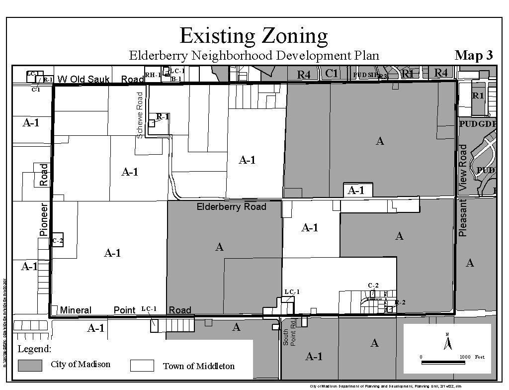
7 There are currently approximately 47 single-family dwellings within the planning area, including houses located on smaller parcels along the highways, the houses in the Brassington Plat, and farm homes. Three of the homes are located within the City of Madison, with the remainder located in the Town of Middleton. TABLE 2 Existing Land Use (excluding street right-of-way) City of Madison Acres % Of Total Single-Family Residential Industrial (electrical sub-station) Institutional (church) Agricultural/Undeveloped TOTAL Town of Middleton Acres % Of Total Single-Family Residential Institutional (cemetery) Agricultural/Undeveloped Existing Zoning TOTAL All of the City of Madison lands within the Elderberry neighborhood planning area currently have Agriculture District (A) zoning. Although farming and other agricultural uses are allowed as permitted uses, the Agriculture District is also used as an interim zoning designation on future development lands annexed to the City. Permanent zoning is assigned as a part of development, which is contingent on the availability of urban services and conformance to an adopted neighborhood development plan. Most of the Town of Middleton lands within the neighborhood planning area have Dane County Agriculture District (A-1) zoning, which permits single-family homes in addition to a variety of agricultural uses and selected other uses. Map 3 shows the existing zoning in the planning area. Topography and Natural Features The topography of the Elderberry neighborhood planning area is characterized by a series of gently rolling ridges and shallow valleys, with some steeper slopes occurring in the northwest portion of the planning area. A relatively major north-south ridgeline divides the planning area approximately in half, with grades that generally slope to the east and southwest edges of the planning area from this central ridgeline. The highest elevations within the planning area are located in the northwest portion of the planning area. Other high ground is generally located along the central ridgeline. There are small, isolated wooded areas located in the northwest and central portions of the planning area, including where Elderberry Road currently turns due north. There are also Elderberry NDP--March 5,
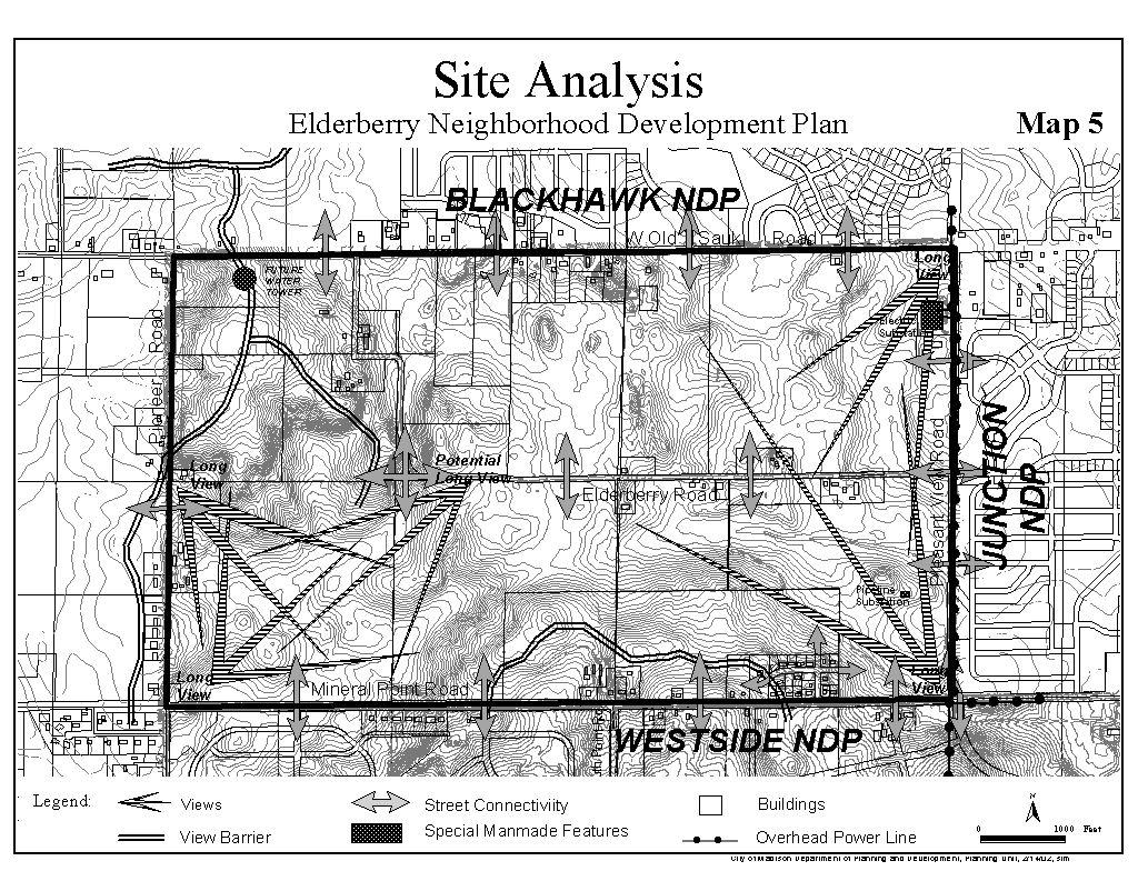
8 scattered oak trees and vegetation along fencerows located throughout the planning area. The wooded area located near the bend in Elderberry Road also includes some steeper topography and a drainage feature. This steeper slope is part of the more varied topography located in the northwest portion of the planning area. The drainage feature is part of a major drainageway that carries storm water for the western half of the planning area south to Mineral Point Road. Map 4 shows the existing natural features in the planning area. Storm Water Drainage The Elderberry Neighborhood is located within two watersheds. The western portion of the Elderberry Neighborhood lies within the Upper Sugar River watershed and the eastern portion lies in the Six Mile--Pheasant Branch Creek watershed. As stated earlier, a relatively major north-south ridgeline generally divides the planning area in half. Natural surface drainage within the Elderberry Neighborhood is generally to the south in the western half of the planning area and to the east in the eastern half. In the western portion of the Elderberry Neighborhood, a major southerly flowing drainage feature collects storm water and passes under Mineral Point Road before continuing south. This drainageway is part of a larger drainage pattern that continues south of Mineral Point Road through the western portions of the Westside and Mid-Town Neighborhoods. In the eastern portion of the planning area, most of the land drains east crossing Pleasant View Road in the area just south of Elderberry Road. A smaller area in the north central portion of the planning area drains north, crossing Old Sauk Road into an existing drainageway located just west of Waterside Street in the Blackhawk Neighborhood. Map 4 shows the drainage patterns within the planning area. Site Analysis The inventory and analysis of the existing land uses, natural features and planning issues associated with the planning area are used to provide a context for identifying alternative development concepts, and later detailing a single neighborhood development plan. Land use issues associated with this analysis relate to the residential uses expected to occur over the longterm in adjacent areas to the west, north and east; and the employment uses programmed for the areas south of Mineral Point Road. Existing developed land uses within the planning area, while limited, require that an effort be made to incorporate them as part of the larger plan. Similarly, efforts to formulate an efficient plan for land use and street patterns must take into account how properties might function both individually and collectively within the development plan. Natural feature issues associated with the planning area include drainage and open space functions that must be accommodated, steeper slopes that may pose obstacles for street alignment or connectivity, and view opportunities from or into the area. Several storm water drainage and detention features have been delineated and incorporated within the plan. Most of the grades within the planning area are not viewed as an obstacle for future streets, with the exception of some steeper slopes in the central and northwest portions of the planning area. Due to the gently rolling nature of much of the topography, it is anticipated that typical one-story and multi-story developments would obscure many of the existing long view opportunities. Elderberry NDP--March 5,
9 There are several prominent planning issues and objectives associated with the planning area. These include the need to create a network of travel corridors and streets within the planning area and street connectivity beyond; a mix of land uses and land use patterns that function as a cohesive neighborhood within the planning area; a neighborhood that functions as a cohesive part of this larger west side area; and a clarification of the urban service issues that will influence the timing and location of development within the planning area. A more detailed list of the plan s goals begins on Page 9. Mineral Point Road and Pleasant View Road will eventually function as major arterial roadways. Increasing traffic volumes, roadway noise exposure and Mineral Point Road s function as a gateway entrance into the Madison urban area are potential issues that should be further examined as part of specific development proposals. Elderberry NDP--March 5,
10 ELDERBERRY NEIGHBORHOOD DEVELOPMENT PLAN GENERAL DEVELOPMENT CONCEPT The Elderberry neighborhood planning area is a relatively large area comprising 1,114 acres. Connections with the existing Madison neighborhoods to the north, east and south are an important element of the plan. The planning area is adjacent to Mineral Point Road, a major arterial highway that carries significant volumes of traffic. It is expected that traffic volumes will continue to increase as development in this area and western Dane County continues. The location of the Elderberry Neighborhood and its relationship to Mineral Point Road make the area an important gateway into the City of Madison. Its location means this neighborhood will be among the first urbanized areas encountered when entering the City from the west on Mineral Point Road. It is important to take advantage of this opportunity to make a positive first impression. Sensitive urban design along this corridor will enhance this gateway. The recommended residential areas are planned to accommodate a broad range of housing types, residential densities, and tenure, and it is expected that this range will be realized as the neighborhood is developed. It is proposed that a variety of housing types and densities be provided in all parts of the neighborhood. However, most of the medium and low-medium density housing is proposed at locations relatively close to the commercial centers or to major parks or open space, so that walking distances to neighborhood activity centers are minimized for the largest number of residents. The character and design of development is important, as is integration of individual developments into the neighborhood as a whole. The proposed public street network is designed to create relatively small blocks and a high degree of interconnection within the neighborhood. In general, it is recommended that both multi-family and single-family developments seek to work within the recommended street system rather than proposing isolated enclaves of development served by private streets. A neighborhood village center commercial district is proposed on the high ground in the south-central portion of the planning area, just north of Mineral Point Road along South Point Road extended. This village center is intended to function as a neighborhood focal point, with an emphasis on neighborhood-oriented retail and service uses. The design and layout of development within the village center will be a critical factor in forming a functional and cohesive neighborhood-oriented asset and focal point. Another smaller neighborhood convenience-commercial center is proposed in the north-central portion of the planning area at the intersection of South Point Road extended and Old Sauk Road. A large commercial district serving as an employment area is proposed in the south-central portion of the planning area, adjacent to the village center. A second office/research commercial area is planned in the southeast corner of the planning area on lands owned by the University of Wisconsin. The employment areas will include professional offices, light industrial, and research development uses, which will provide additional employment opportunities for the neighborhood and community. No regional retailing or major highway-oriented uses are recommended in the commercial centers. The neighborhood development plan also incorporates several locations that will accommodate existing and proposed community-based uses and institutional facilities. In the eastern half of Elderberry NDP--March 5,
11 the planning area, an existing church site is identified. In the western half of the neighborhood, a small existing cemetery and a large site that a local church proposes to develop are identified. In addition, the City of Madison Water Utility has purchased property in the northwest portion of the planning area as a site for a future water tower and possible well site to serve the far west side of the City, including most of the future Elderberry Neighborhood. Public parks and open spaces are purposefully located throughout the neighborhood where they not only provide convenient recreation and open space opportunities to the surrounding neighborhood, but where they also enhance the visual character of the neighborhood by providing terminal views at the ends of local street segments, and an open space amenity along frequently traveled routes. A community park and playfield is recommended in the southeast portion of the planning area as part of a broader open space plan to serve the neighborhood and larger west side area. The preservation of oak trees and wooded areas is encouraged where possible in the parks and private development. The recommended system of collector and local streets is planned to create a high degree of connectivity within the neighborhood and provide multiple routes to most destinations--for pedestrians, bicycles, and motor vehicles. The basic street pattern is grid-like, and it is recommended that both commercial and residential developments maintain a strong relationship to the public street and sidewalk system. All streets include public sidewalks, and are intended to also serve as bikeways. Proposed collector streets are intended to provide travel corridors within the Elderberry Neighborhood and to facilitate movement and connection to surrounding neighborhoods. The existing arterial street, Mineral Point Road, will continue to provide a key point of access to the planning area while also serving regional through traffic. Additional private access to Mineral Point Road and bordering collector roadways should be limited, and alternative access provided by the proposed neighborhood street system. To improve connections to the adjacent neighborhoods, it is recommended that north-south and east-west collector streets connect with the established street pattern of these existing neighborhoods and that future streets in these areas be coordinated to provide connectivity. Elderberry Neighborhood Development Plan Goals The following planning goals for the Elderberry Neighborhood are viewed as critical to the creation of a cohesive neighborhood that functions well within the context of the larger west side area. The Elderberry Neighborhood Development Plan seeks to: Encourage a mix of land uses and land use patterns within the neighborhood. Encourage a broad range of housing types, densities, tenures, prices, and rents within the neighborhood and provide this range to all parts of the neighborhood. Locate most of the low-medium and medium density residential uses relatively close to the neighborhood s activity centers and park & open space areas, so that a majority of the neighborhood s residents can walk to these amenities. Elderberry NDP--March 5,
12 Avoid locating large region-serving retail uses, such as discount department stores, or highway-oriented uses, such as fast food drive-ins or automobile sales lots, in the neighborhood. Create a mixed-use, relatively compact, pedestrian-friendly employment district in order to provide opportunities for residents to live close to where they work and a district that contains sensitive urban design, especially to Mineral Point Road. Include the following design characteristics within the neighborhood commercial centers: relatively small blocks, multi-story buildings, mixed-use development with office or residential uses above retail uses, buildings located close to the sidewalk with parking lots to the rear or on side streets rather than in front of businesses, short term parking along business streets, minimum gaps in the street-level retail frontage, high levels of pedestrian amenity including street trees and other plantings, street furniture, and special lighting, and good linkages with the surrounding neighborhood. Size and locate the park & open space areas in order to provide convenient access to these amenities for all of the neighborhood residents, create terminal views and high visibility of the park & open space areas, and use the full allowance of the parkland dedication requirements. Preserve natural features, wooded areas and oak groves where possible. Create an inter-connected street network with small blocks, sidewalks, and bikeways that preserves through streets and connections with the adjacent neighborhoods and provides multiple routes for transit use. Reduce the number of cul-de-sacs to only those that are required because of topography or other constraints. Elderberry NDP--March 5,
13 RECOMMENDED LAND USES The Elderberry Neighborhood is planned primarily as a residential community, and the largest percentage of the land within the planning area, about 56 percent, is recommended for residential development. About eight percent of the planning area is recommended for park and open space uses, including the large playfield in the southeast corner of the neighborhood. Commercial uses are recommended for about ten percent of the planning area, primarily in the proposed commercial and employment centers. Identified institutional uses and other specialized uses account for less than two percent of the land, while most of the balance, about 25 percent, will be required for street rights-of-way. Recommended land uses within the Elderberry Neighborhood are presented on the Land Use and Street Plan (Map 6) and are summarized in Table 3. TABLE 3 Proposed Land Use Land Use Acres % Of Total Residential Low Density Residential (<8 du/acre) Low-Medium Density Residential (8-11 du/acre) Medium Density Residential (12-16 du/acre) Commercial Employment District Neighborhood Centers Industrial (Electrical Sub-station) Institutional Park and Open Space Parks and Playfield Drainage and Detention Street Right-of-Way TOTAL 1, Residential Land Uses A total of 621 acres are recommended for residential uses in the Elderberry Neighborhood, not including residential uses occurring as part of mixed-use developments in the designated commercial districts. Creation of a range of housing types, tenures, rents, and densities within each housing type, is one of the goals of the Elderberry Neighborhood Development Plan. This diversity is represented on the Land Use and Street Plan map by designating sub-areas within the neighborhood for low, low-medium, and medium density residential development. The mapped locations for housing in different density ranges illustrate the recommended development patterns, but some flexibility in implementing the recommendations is assumed. It is not expected that every residential development will necessarily correspond exactly to the specific density range indicated--but that the general pattern and distribution of densities and housing Elderberry NDP--March 5,
14 types be consistent with the intent of the neighborhood plan recommendations. Also, variations in building structures and cost should be expected within each of these designations. The neighborhood development plan recommends about 476 acres for low density development at less than eight dwelling units per acre, about 62 acres for low-medium density development at 8 to 11 dwelling units per acre, and about 83 acres for medium density development at 12 to 16 units per acre. Assuming that development occurred within each range at an average net density of 4, 10, and 14 dwelling units per acre, respectively, a total of 3,634 dwelling units would occur within the neighborhood at full build-out. This would result in about 1,851 low-density dwelling units, 619 low-medium density dwelling units, and 1,164 medium density units (see Table 4). Based on these acreage and density allocations, about 51 percent of the projected total number of housing units would be in the low-density range, 17 percent in the low-medium density range, and 32 percent in the medium density range. Most of the low-density housing will consist of single-family units on a variety of lot sizes; while the low-medium and medium density housing will include a variety of multi-family housing types, including duplexes, apartments, townhouses, and other forms of housing--and will include both condominium and rental housing. As a general objective, it is recommended that from 50 to 60 percent of all housing units developed in the neighborhood be single-family units and that 40 to 50 percent be multi-family units, including both rental and condominium units. As the neighborhood is developed, the actual built densities should be monitored, and the density recommendations for specific locations may be adjusted to maintain this approximate ratio. TABLE 4 Proposed Dwelling Units Density Range Residential Low Density Residential (<8 du/acre) Low-Medium Density Residential (8-11 du/acre) Medium Density Residential (12-16 du/acre) Dwelling Units % Of Total 1, , TOTAL 3, The recommended pattern and distribution of higher density residential uses place a high percentage of this development in close proximity to the neighborhood commercial centers, the employment district, and the neighborhood park features. These locations are considered the most appropriate for more intensive urban residential forms--including, for example, multi-story apartments and town houses. The commercial centers are envisioned as relatively compact, walkable, street-oriented commercial districts that will become convenience shopping and destination activity centers for this neighborhood, and perhaps, for surrounding neighborhoods as well. Park features and to some extent the employment district, are viewed as walkable destinations served by the recommended higher density residential uses. Street patterns incorporated as part of these land use patterns provide the opportunity for a future transit route that will link the higher density residential areas, the two neighborhood commercial centers, the employment district, and several of the park facilities. Elderberry NDP--March 5,
15 Medium density uses might also include mixed-use development within or adjacent the neighborhood centers and western portions of the employment district. Because of the topography, there may be opportunities to place some of the necessary parking underground, thus enhancing the compact character of the development and reducing the need for large surface parking lots often associated with higher densities. The Brassington rural subdivision is recommended for continued low-density residential uses. The existing lots are larger than is typical in an urban neighborhood, and the neighborhood plan recognizes that some of the current owners may eventually want to divide their parcels to permit additional development, while other residents will want to continue their current use unchanged. Areas recommended for low-density residential use are envisioned to be primarily single-family development. Although under some circumstances, low-density development could take other residential forms. It is anticipated that a variety of lot sizes within the low-density range will be provided as the land is subdivided, including the smaller lots characterized as traditional neighborhood development. In addition, the area within one-quarter mile of Pioneer Road is designated for low-density residential uses in compliance with the City s agreement with the Town of Middleton. Commercial Land Uses Recommended commercial land uses within the Elderberry Neighborhood are concentrated at several locations, a proposed 84.4-acre employment district and neighborhood commercial "village center" in the south-central portion of the neighborhood, a 19.6-acre office/research area in the southeast corner of the neighborhood, and a 3.5-acre neighborhood conveniencecommercial center in the north-central portion of the neighborhood. It is generally recommended that additional commercial locations not be developed within the planning area, so that the proposed commercial centers can become well established as focal points of community activity and commerce within the neighborhood. Commercial development along the frontages of Mineral Point Road, Old Sauk Road, Pleasant View Road, or South Point Road extended, beyond what is recommended in the neighborhood plan, would also disrupt the development pattern of the reverse-access lots intended to minimize future traffic conflicts on these major roadways. Employment Districts The larger of the two employment districts is located in the south-central portion of the neighborhood, north of Mineral Point Road and west of South Point Road extended. A proposed east-west collector street bisects the district. Mineral Point Road and the proposed collector street will provide for the primary orientation of development within the district. Adjacent areas to the north and west of the employment district are recommended for residential uses. Development of the employment district should provide a sensitive transition to these residential uses, which may include buffering, screening, or special design features. The proposed neighborhood commercial village center lies adjacent to the east. It is intended that the village Elderberry NDP--March 5,
16 center would define the primary character of development on South Point Road immediately north of Mineral Point Road. The main employment district is approximately 73 acres in size. Several general types of uses are recommended in the main employment district including business and professional offices, biotech, research and light industrial uses. In addition, because of its visibility from Mineral Point Road, this is also an attractive location for highquality corporate office development. The plan proposes a mix of employment uses in the district that will significantly expand the range of employment available in the neighborhood, and provide additional opportunities for neighborhood residents to work closer to home. Because Mineral Point Road forms a gateway to Madison from the west, it is important that development visible from the highway be of the highest design quality. A detailed development plan for the employment district will be required before development there begins, and individual project proposals will also require Plan Commission approval. It is recommended that in the review of both general and specific development plans; careful consideration is given to urban design--and particularly to the view from Mineral Point Road. It is considered important that individual projects contribute as a unified part of the district as a whole. Important factors to consider include ensuring that the site s building design and materials create an attractive appearance on all sides of the development, especially the elevations visible from Mineral Point Road; that adequate site landscaping is provided on all sides; and that parking areas do not dominate the view. A portion of the main employment district may be suitable as a community shopping and service center providing a range of retail goods and services to the neighborhoods on Madison s west side. Expected businesses might include a large grocery store, as well as restaurants and taverns, and similar uses. Because residential development in the Elderberry Neighborhood is still a few years away, it may be several years before there is a large enough local market to support community-based retailing at this location. The relationship between the neighborhood commercial center and community based shopping and service areas should be defined as part of specific development plans. The second, smaller employment district is located in the southeast corner of the planning area on lands owned by the University of Wisconsin. This 19.6-acre parcel is envisioned for professional office, biotech, and research type uses. It is recommended that, to the extent possible, both of the employment districts be planned to encourage compact, pedestrian-friendly clusters of complementary businesses including multi-story buildings to encourage and facilitate mixed-use developments. Neighborhood Commercial Centers Two neighborhood commercial districts are proposed as part of the Elderberry Neighborhood Development Plan. One which would straddle South Point Road extended at Mineral Point Road in the south-central portion of the planning area, and a second at the intersection of South Point Road extended and Old Sauk Road in the north-central portion of the neighborhood. The proposed south-central neighborhood commercial district is proposed as a village center which carries with it the stated objective of functioning as a neighborhood-oriented focal point Elderberry NDP--March 5,
17 and activity center. It is generally envisioned that a village center development concept would incorporate a village green open space feature, around which mixed-use development might be focused, create a pedestrian friendly atmosphere, and include pedestrian friendly connections to nearby employment and residential areas. The proposed employment district adjacent to the village center to the west establishes the basis that some aspects of this village center would be geared to serving uses within the employment district. The village center concept is only generally defined, and details will need to be clarified by future concept development and planning, but some of the elements might include: An emphasis on creating an integrated neighborhood business street, as distinct from an aggregation of essentially separates business sites A focus on the collector street as the primary axis for the business district. Buildings and signage should be oriented toward this street rather than Mineral Point Road Relatively small blocks created by the public street system Multi-story buildings encouraged, particularly along the collector street Mixed-use development encouraged, with office or residential uses above retail uses Buildings located close to the sidewalk, with parking lots to the rear or on side streets rather than in front of businesses Short term parking along business streets Minimum gaps in the street-level retail frontage High levels of pedestrian amenity, including street trees and other plantings, street furniture, and special lighting Good linkages with the surrounding residential neighborhood and employment district Because there are no similar neighborhood commercial centers either in the Blackhawk Neighborhood to the north or in the Junction Neighborhood to the east, the proposed village center could become a focal point for community activities and convenience and specialty shopping for surrounding residential neighborhoods. While proposed primarily as a center providing convenience goods and services, the mix of uses in the village center might include clothing shops, hardware stores, gift shops, jewelers, specialty food stores and small specialty retailers of all kinds. Small professional and business offices (including offices above retail uses) as well as community and civic facilities such as day care centers, neighborhood centers, or branch post offices, also might be located in the village center. Another possibility for the village center would be specialty shopping and entertainment activities, such as art galleries, antique shops, unique restaurants, brew pubs, or small theatres, for example. Because of the village center s smaller size and scale, and special urban design character, it would be difficult for large businesses, or uses requiring extensive parking, for example, to be compatible with the compact, pedestrian-oriented village center development concept. Another smaller neighborhood commercial center is proposed at the intersection of South Point Road extended, Old Sauk Road and Bear Claw Way. Bear Claw Way is an existing street that extends north from Old Sauk Road into the Blackhawk Neighborhood. The proposed location at Old Sauk Road provides the opportunity to serve residents of both the Blackhawk and Elderberry Neighborhoods. The site is envisioned as a small, convenience-type commercial center with uses that might include a small grocery or specialty food shop, a laundry, hairdresser or barber, Elderberry NDP--March 5,
18 or similar uses that people patronize frequently. A neighborhood-oriented development concept, which emphasizes pedestrian friendly access, is also expected to be an important component of this commercial center. None of the commercial centers are recommended as a location for large region-serving retail uses, such as discount department stores, or for highway-oriented uses, such as fast food driveins or automobile sales lots. Institutional Land Uses Four institutional sites are included in the development plan, two of which recognize existing institutional uses. The existing Jehovah's Witnesses Church is located on the west side of Pleasant View Road, a short distance south of Old Sauk Road. The church property includes approximately 2.6-acres. The other existing institutional use is a cemetery located at the northeast corner of the Pioneer Road and Mineral Point Road intersection. The property contains approximately 0.7-acres. Two additional sites in the northwest portion of the planning area are proposed for future institutional uses. The City of Madison's Water Utility has purchased a 16-acre parcel, approximately five acres of which will be used for a future water tower and possible well site. The Water Utility may sell off the remaining acreage, which the development plan has recommended for low-density residential uses. The second proposed site is owned by the Middleton Community Church and contains about 18- acres. The church has indicated its intent to eventually develop the site for religious and other community functions. Preliminary review of the site indicates that storm water management facilities will likely need to be located on a portion of the property, therefore only about 12 acres are recommended for institutional use. Preliminary review also indicates that sanitary and storm water sewer easements may also be needed across this property. Future development of this site should examine these issues as a part of development approval. Parks and Open Spaces A system of neighborhood parks is recommended to provide convenient recreational opportunities and open space amenities for residents of the Elderberry Neighborhood. In addition, a major park/playfield serving both local and regional residents is proposed on the University of Wisconsin lands in the southeast portion of the neighborhood. A major drainage greenway is delineated which carries much of the storm water from the western portion of the neighborhood to points south. This drainage greenway has been incorporated into a neighborhood park in the southwest portion of the planning area. The combination of park and drainage features is envisioned to create a larger, better-connected open space amenity for the neighborhood. Similarly, a drainage greenway carrying storm water in the eastern portion of the neighborhood to points east will also be incorporated into the community park and playfield on the UW lands. In total, approximately 85 acres are recommended for neighborhood park and playfield development. Elderberry NDP--March 5,
19 Two large areas that are adjacent to the northwest portion of the planning area and owned by the Town of Middleton will provide additional park and open space opportunities for area residents. These include the Town Hall and park site at the southwest corner of Pioneer Road and Old Sauk Road and a large site north of Old Sauk Road. The Town Hall site includes softball diamonds and a play area. The site north of Old Sauk Road is currently undeveloped, at least a portion of which will likely be reserved for open space. These park and open space features in combination with the proposed park and open spaces within the Elderberry Neighborhood are viewed as positive contributions to the larger community park and open space system. Neighborhood Parks and Playfields Three neighborhood parks; a community park and playfield; and a village green to be incorporated into the south-central neighborhood commercial center have been identified within the neighborhood plan. Neighborhood parks illustrated in the plan range from about seven to ten acres, although the size and shape of these park features may be adjusted at the time of platting to take full advantage of the actual required parkland dedications. Additionally, it has been suggested that a single larger consolidated park might be an option for neighborhood park development in the western portion of the planning area. While this option may be revisited in the future, neighborhood plan recommendations for parks reflect an effort to apply current community park standards and objectives, promote park access and visibility, and to increase the parks potential contribution as neighborhood amenities. Wherever possible, parks are placed where they will provide terminal views at the end of street segments, and where they will have high visibility to persons traveling along the neighborhood s principle streets. These relationships are considered important and are among the many small attributes that collectively make a neighborhood an interesting and enjoyable place. A community park and playfield is proposed in the southeastern portion of the planning area, and is intended to serve active recreational needs and programs associated with the neighborhood and larger west side area. Its recommended location is intended to serve its larger west side area function, by providing a high degree of access and visibility, in particular from Pleasant View Road, a major area roadway. A drainage greenway and detention facility, which traverses this area, was incorporated as part of the larger park/playfield feature. The site contains approximately 27 acres, most of which is currently owned by the University of Wisconsin. A City of Madison community park may include a combination of active and passive recreational facilities such as: picnic shelters, softball diamonds, tennis courts, playgrounds, and is generally capable of serving a larger area. The playfields could contain more extensive athletic facilities, such as soccer fields or baseball diamonds and would possibly include concession facilities and lighted ball fields. The park and playfield use may also be viewed as a transition between the recommended residential uses to the north and west, and the recommended non-residential uses to the south. It is recommended that a village green open space feature be incorporated as part of the development concept for the south-central neighborhood commercial center. It is envisioned that the development concept would also reflect layout and design choices that would promote pedestrian-friendly access and neighborhood-oriented qualities. The exact form of this open Elderberry NDP--March 5,
20 space feature should be a prominent consideration when a development plan for the neighborhood center is prepared. Storm Water Management Facilities A major storm water drainageway and detention feature is recommended for the western portion of the planning area that begins on the Middleton Community Church property at Old Sauk Road and extends south to Mineral Point Road. The proposed drainage feature is part of a larger drainage system that extends north of Old Sauk Road and continues south of Mineral Point Road. Preliminary review indicates that a storm water detention facility will be needed on a portion of the Middleton Community Church property, and is recommended within the neighborhood plan. The width of the proposed greenway is 100 feet, although a more precise sizing of storm water management facilities will be determined as part of future development review and storm water analysis. Storm water drainage and detention facilities are also recommended in the southeast portion of the planning area, before crossing Pleasant View Road and continuing east into the Junction Neighborhood. Several additional detention facilities are also identified to address smaller drainage patterns along the northern edge of the planning area. As with most storm water management facilities, their location and size will be determined more precisely as part of the development review and approval processes. It is expected that the balance of the storm water management needs within the planning area will be accommodated either by surface drainage in the street or in underground storm sewers. Pedestrian and bicycle facilities should be incorporated into the drainage features and greenways where possible, providing access and connections to the neighborhood parks and the community playfield. Gateway Into Madison Mineral Point Road is a major entry to the Madison urban area from the west, and is recognized as the point where the City s urban development will begin. It is recommended that lands adjacent to Mineral Point Road be developed in a manner that enhances the attractiveness of this entry point. To ensure that the entryway to the City creates a strong "first impression" of Madison as a very attractive urban community, development adjacent to this roadway should be required to maintain high standards of urban design. These standards should encompass such factors as building architecture, signs and graphics, site landscaping, and treatment of parking and storage areas. Elderberry NDP--March 5,
21 RECOMMENDED TRANSPORTATION FACILITIES A system of arterial, collector, and local streets is recommended to provide connections to adjacent neighborhoods and internal circulation within the Elderberry Neighborhood (Map 6 - Land Use and Street Plan). Sidewalks are recommended along both sides of all public streets, and separate walkways and bikeways where needed to create more direct connections for pedestrian and bicycle travel will be reviewed as specific development proposals are considered. Because the proposed local street system is designed to provide a high level of connectivity within the neighborhood, most bicycle travel will be accommodated within the street rights-ofway. On heavily traveled streets including Old Sauk Road, Pleasant View Road, Mineral Point Road, Elderberry Road, South Point Road and other proposed collectors, dedicated bicycle lanes or separate bikeways within the right-of-way are recommended. When bus service to the Elderberry Neighborhood becomes feasible, several alternative routes will be available for consideration due to the interconnected street system. A transit route is identified in the neighborhood plan that would serve the activity centers and higher density residential areas. To the extent possible, the plan attempts to limit the number of cul-de-sacs by emphasizing street connectivity within the neighborhood. Cul-de-sacs are only proposed where topography or other natural features limit the local street connections. As development proposals are received, street patterns and connections should be reviewed in order to emphasize street connectivity over culde-sacs where possible. As a part of the planning process, the Madison Area Metropolitan Planning Organization (MPO) completed a traffic impact analysis for the Elderberry Neighborhood, including an analysis of the phase one development area and the neighborhood at full build out. The MPO found that there is sufficient capacity in the existing and committed roadway system to handle future traffic volumes from the phase one development of the Elderberry Neighborhood. The report is included as an appendix to this plan. Arterial Streets Two roadways will function as arterial streets and provide primary access to the Elderberry Neighborhood. Mineral Point Road provides the southern boundary of the planning area and extends eastward into Madison and westward through the Town of Middleton and Town of Cross Plains. Pleasant View Road forms the eastern boundary of the planning area and extends north into the City of Middleton. The proposed realignment of County Road M through the Westside Neighborhood will connect to Pleasant View Road at Mineral Point Road. This realignment will provide a direct connection south to the City of Verona and points beyond. In addition to serving as an arterial street for Madison's west side neighborhoods and commercial areas, Mineral Point Road is an important regional highway serving western Dane County. Although currently constructed as a rural highway west of Junction Road, the segment of this roadway serving the Elderberry and Westside Neighborhoods will ultimately be reconstructed as an urban arterial street. Based on regional traffic projections, Mineral Point Road is expected to Elderberry NDP--March 5,
22 eventually have four travel lanes, a median, and bicycle lanes and/or separate bikeways. Additional lanes may be provided for turning movements at key intersections. To accommodate potential future roadway needs, the recommended right-of-way is 120 feet. As is the case in the Westside Neighborhood to the south, the Elderberry Neighborhood local street system is designed to provide reverse access to properties fronting on Mineral Point Road, Pleasant View Road, and Old Sauk Road. Additional private driveway access to these roadways is generally not recommended. Pleasant View Road will be as an important roadway serving the Elderberry and Junction neighborhoods and will also ultimately be constructed as an urban arterial street with bicycle lanes and/or separate bikeways where needed. To accommodate potential future roadway needs, the recommended right-of-way for Pleasant View Road is also 120 feet (Map 7 - Street Classification). Collector and Local Streets The proposed network of collector and local streets is an integral component of the Elderberry Neighborhood Development Plan--specifically designed to link neighborhood land uses and adjacent neighborhoods and provide multiple routes to most neighborhood destinations. A system of existing and planned collector streets will provide primary access into the neighborhood from Mineral Point Road and Pleasant View Road, and form important travel corridors that link the major neighborhood activity centers and adjacent neighborhoods. The Elderberry Neighborhood is bounded on the west and north by existing collector streets. Pioneer Road is the western most north-south minor collector and will serve as the western edge for the City of Madison. The recommended right-of-way width for this collector is 100 feet. The other existing collector includes Old Sauk Road, the northern most major east-west collector for the Elderberry Neighborhood. The recommended right-of-way width for this collector east of its future intersection with South Point Road is 120 feet and 80 feet west of the future South Point Road intersection. These collectors will include sidewalks along both sides of the streets and portions will include bike lanes and/or separate bikeways to provide for pedestrian and bicycle circulation. A system of proposed collectors would function as the primary travel corridors within the Elderberry Neighborhood and provide the primary access points from the surrounding collector and arterial streets. Several north-south collectors, including South Point Road extended, are proposed which provide connections between Mineral Point Road and Old Sauk Road. Several east-west collectors, including Elderberry Road extended, are proposed which provide connections between Pleasant View Road and Pioneer Road. The alignment and spacing of these collectors forms a grid-like pattern, which carries over to local street patterns presented in the plan. The recommended right-of-way width for these collector streets is 80 feet. These proposed collectors would also include sidewalks along both sides of the streets and bicycle lanes and/or separate bikeways where needed. South Point Road extended will serve as the featured north-south collector linking the commercial centers, associated parks, and higher density residential areas. The south-central neighborhood commercial center will be located on both sides of South Point Road extended, creating a main street type of presence and function. Elderberry NDP--March 5,
23 The grid-like local street pattern creates relatively small blocks, and it is intended that both commercial and residential developments maintain a strong relationship to the public street and sidewalk system. All streets will include public sidewalks, and additional mid-block walkways are recommended where needed to further increase pedestrian accessibility. It is recommended that lots backing up to the arterial and major collector streets be deeper (150 feet) in order to provide additional opportunity for buffering. The recommended right-of-way width for most local streets is 60 feet. Transit Service and Bikeways A proposed transit route for future Madison Metro bus service to the Elderberry Neighborhood is illustrated in the neighborhood development plan on Map 7. Because of the interconnected street pattern, other routes would also be possible. The route shown on Map 7 serves the proposed commercial centers and passes within one-quarter mile of most of the recommended higher-density residential locations. As is the case with most newly developing areas, public bus service is unlikely to be extended to the Elderberry Neighborhood initially, due to the relatively higher costs and lower potential rider-ship characteristic of peripheral locations. The Elderberry Neighborhood Development Plan recognizes the role of bicycling and walking as major modes of travel and recreation, and all of the collectors and local streets are intended to also serve as bikeways. Where the street pattern does not provide a reasonably direct route to important neighborhood destinations, an alternative connection should be provided for bicycles and pedestrians and will be reviewed as specific developments are proposed. Along the arterials and major collectors, dedicated bicycle lanes or separate paths within the right-of-way will be developed, as needed, and as the opportunity arises. Bicycle lanes are most likely to be added at the time that the segments are re-built as four-lane streets. Elderberry NDP--March 5,
24 DEVELOPMENT STAGING The Elderberry Neighborhood Development Plan delineates three sub-areas as phases in its development staging plan (see Map 8). The lands within each sub-area share characteristics regarding the timing of public services extension and neighborhood street access needs which make it reasonable to recommend that the lands within each sub-area would be generally suitable for urban development at about the same time. The actual sequence of land development within each phase, however, will depend upon a variety of individual factors--including property owner interest, the budgeting and scheduling of public improvements and City services, whether the street pattern recommended in the neighborhood development plan can be implemented at that time, and the plans of adjacent property owners, to name just a few. There may also be good reasons to allow some of the lands within each phase to develop before other lands, at any given time. The boundaries of the three designated phases should be considered approximate-- particularly boundaries that are not roadways. The actual limit of development at any given time will ultimately depend upon such factors as access to planned public streets and the ability to provide public sewer and water service to the location. The three development staging areas include: phase one, a acre area in the north-central portion of the planning area; phase two, a acre area encompassing the eastern half of the planning area (exclusive of phase one); and phase three, a acre area encompassing the western half of the planning area. It is recommended that development within the Elderberry Neighborhood generally occur in phases, beginning with the area designated as phase one. It is not intended, however, that the start of development in any phase necessarily should be deferred until development within the preceding phase extends to a particular location, or reaches a certain percentage of full build-out. Simultaneous development at multiple locations within the neighborhood also benefits the neighborhood by increasing choices, and development over a relatively broad area will help establish and implement the planned system of local streets designed to link neighborhood subareas, features and activity centers together. The most appropriate time to begin development in any phase depends more on the availability of City infrastructure improvements and City services than on the pace of development in other phases. The factor most often cited when making development-staging recommendations is the efficient extension of public services. Phase one lands, the small area in the north-central portion of the neighborhood, can be provided with sanitary sewers draining north and east before connecting to existing mains in Old Sauk Road. Phase two lands encompass the eastern half of the planning area, and includes a large area owned by the University of Wisconsin. The timing of development or the extension of services on the UW lands will likely be a key factor influencing the timing of development in the phase two area. Phase three lands, which encompass the western half of the planning area, drain south and would need to be served by a new sanitary sewer interceptor coming from the south. This would be a major interceptor that is also needed to serve the western portions of the Westside and Mid-Town Neighborhoods. It is not known at this time when this sewer interceptor will be constructed, however the City of Madison and Madison Metropolitan Sewerage District are currently studying its feasibility, cost, and timing. Elderberry NDP--March 5,
25 Development Staging Areas The phase one development area is located in the north-central portion of the Elderberry Neighborhood, and includes the part of the planning area that could be served by gravity sanitary sewers draining north and east into existing City of Madison sewer lines located in Old Sauk Road. The phase one area would be served by an extension of this existing main west along Old Sauk Road. The phase one area encompasses properties owned by James & Susan Weber, Laverne & Randall Theis, and multiple smaller properties fronting on Old Sauk Road. Water service to the phase one area would be provided as an extension of existing water mains in the Blackhawk Neighborhood. However, the existing capacity at the Blackhawk booster pump station would need to be increased in order to serve the phase one area. Ultimately, the phase one and phase three development areas would be served by the new water tower to be constructed in the northwest portion of the planning area, on lands recently purchased by the Water Utility. The phase two development area is located south and east of the phase one area and includes the remaining eastern half of the neighborhood. The phase two area includes several large ownerships, including lands owned by the University of Wisconsin, Clarene Backus, and Charles and Catherine Garfoot. Public sanitary sewer service to phase two will be provided by gravity sewer lines draining generally eastward into existing sewer lines located adjacent to the Attic Angels development on Pleasant View Road. Because the University of Wisconsin controls a large portion of the phase two area, the timing of development in phase two will depend largely on the University s timeline for development of its lands. Water service can be provided to the phase two area by extending the City s existing water service from either the northeast or southeast portions of the planning area. The phase three development area consists of the western half of the planning area. These lands will need to be served by a future sanitary sewer interceptor that would approach the area from the south. The City of Madison and the Madison Metropolitan Sewerage District are currently studying the feasibility, cost and timing of a providing a sewer interceptor that would serve this area. Water service to the phase three area will require the construction of the new water tower in the northwest portion of the planning area. Elderberry NDP--March 5,
26 Development Staging Recommendation At this time, it is recommended that development be allowed to begin within phase one in 2002, within phase two in the next several years, and within phase three when the necessary public infrastructure, namely the sanitary sewer interceptor from the south and the new water tower, becomes available. It is further recommended that, following the adoption of the Elderberry Neighborhood Development Plan, the City of Madison submit an application to the Dane County Regional Planning Commission to amend the Central Urban Service Area to include the phase one development area lands within the Elderberry Neighborhood. Elderberry NDP--March 5,
27 PLAN IMPLEMENTATION Currently, the lands within the Elderberry Neighborhood consist primarily of large, undivided parcels; are zoned for agricultural rather than urban uses; and are all outside of the Central Urban Service Area. This section of the development plan recommends the actions needed to prepare the neighborhood for development with the full range of urban services, and to ensure that future development is consistent with the recommendations of this neighborhood development plan. Land Use Plan Amendment The lands within the Elderberry planning area are included in the broad growth recommendations of the adopted Peripheral Area Development Plan, but are not covered by a more detailed plan for the development of the neighborhood. The Elderberry Neighborhood Development Plan provides detailed land use and transportation recommendations to guide the area s future growth and urban development. It is recommended that the Elderberry Neighborhood Development Plan be adopted as an element of the City of Madison Master Plan. It is further recommended that the land use recommendations included in the neighborhood development plan also be incorporated into the adopted City of Madison Land Use Plan, and that the appropriate land use designations be incorporated into the Land Use Plan Map. Central Urban Service Area Amendment Lands within the Elderberry planning area are not currently within the Central Urban Service Area. In order for the City of Madison to provide public sanitary sewer and the full range of urban services to future development in the neighborhood, the lands proposed for development must first be included within the Service Area. Following adoption of the Elderberry Neighborhood Development Plan as an element of the City of Madison Master Plan, it is recommended that the City of Madison prepare and submit to the Dane County Regional Planning Commission an application to amend the Dane County Land Use and Transportation Plan, and the Dane County Water Quality Plan to include the phase one development area of the Elderberry Neighborhood in the Central Urban Service Area. Proposed development staging within the neighborhood is shown on Map 8. Village Center Planning and Design Standards The neighborhood development plan recommends that the proposed neighborhood commercial center located in the south-central portion of the planning area be developed as a compact, pedestrian-oriented village center following an urban, rather than suburban, design model. Some of the characteristics of this proposed village center are discussed in the Recommended Land Uses section of this neighborhood development plan, but the concept has not been fully Elderberry NDP--March 5,
28 articulated. Also, the City does not presently have the standards or regulations needed to implement the village center concept. Before development of the proposed neighborhood commercial center can begin, more detailed design plans and development standards will have to be prepared to guide the development of the village center. It is recommended that following the adoption of the Elderberry Neighborhood Development Plan, and prior to the development of any portion of the lands recommended for the neighborhood commercial center in the south-central portion of the neighborhood, a more detailed development plan and design guidelines for the village center be prepared. The development plan and design guidelines should incorporate the standards needed to develop the neighborhood commercial center as a relatively compact, pedestrian-oriented development of compatible uses and structures, as described in the neighborhood development plan. Zoning With a few minor exceptions, all of the land within the Elderberry Neighborhood, both in the City of Madison and in the Town of Middleton, is zoned to an agricultural use district. The few exceptions are parcels zoned to allow the current non-agricultural uses, in particular the Dane County Commercial and Residential zoning to reflect the existing commercial and residential uses in the Town. Other existing uses and undeveloped lands in the City remain under the Agriculture District zoning applied at the time of annexation. In addition to allowing agricultural uses, the City of Madison Agriculture District zoning is intended as interim zoning placed on future urban development lands. It is recommended that all lands within the Elderberry Neighborhood be zoned to conform to the land use recommendations of the adopted neighborhood development plan. It is further recommended that lands currently zoned Agriculture District be rezoned to another district only at such time as there is a specific subdivision and/or a specific development proposal sufficiently detailed to ensure that development within the district will be consistent with the neighborhood plan. Planned Unit Development-General Development Plan zoning should incorporate any additional standards that may be required to ensure consistency with neighborhood plan recommendations. It is recommended that lands within the proposed south-central neighborhood commercial center not be rezoned from the Agricultural District until a more detailed development plan and urban design standards are prepared to guide the future village center development. Land Subdivision Regulations Most of the lands in the Elderberry Neighborhood will need to be subdivided into smaller parcels before they are developed with urban uses. As these lands are proposed for development, many of the neighborhood plan recommendations can be implemented through the City of Madison s land subdivision regulations. Subdivision establishes the location of public streets, parks and storm water management facilities, and the land required for these purposes will be acquired Elderberry NDP--March 5,
29 through dedication as provided in the subdivision regulations. The spatial relationships between the proposed streets, proposed parks, and other land uses illustrated in the Elderberry Neighborhood Development Plan reflect important neighborhood planning objectives, and these relationships need to be maintained as the land is developed if these objectives are to be realized. Subdivision also establishes the sizes and arrangement of individual development parcels, and proposed land divisions will be reviewed to ensure that neighborhood plan recommendations regarding provision of a variety of residential housing types, sizes, and densities, for example, are being implemented. The neighborhood development plan also recommends that building siting and design create a pedestrian-friendly, street-oriented neighborhood character, and not allow the street elevations to be dominated by driveways, garage doors and automobile parking areas. Proposed subdivisions, therefore, may be required to provide information showing how the lots may be developed with building designs that maintain the desired street character. It is recommended that future subdivisions within the Elderberry Neighborhood conform to the recommendations of the adopted neighborhood development plan, particularly regarding the location of arterial and collector streets, neighborhood parks and playfields, drainage greenways, storm water management facilities, and the creation of building lots that will help facilitate the development of a variety of housing types and densities within the neighborhood. It is further recommended that local streets within proposed subdivisions either generally conform to the pattern of local streets shown in the neighborhood plan, or otherwise reflect the objectives illustrated in the neighborhood development plan regarding street circulation and provision of multiple routes, access to parks, orientation of streets to visual features and the provision of solar energy, and storm water drainage. NOTE: To assist prospective developers in designing subdivisions that conform to the neighborhood plan, larger, 1 =200 scale Land Use and Street Plan maps are available from the Department of Planning and Development. Official Map The City of Madison Official Map is used to reserve rights-of-way and other sites for specified future public uses until such time as they are acquired through dedication or other means. As a result of this planning process, numerous additions to the Official Map are needed to reflect the proposed neighborhood design. It is recommended that the City of Madison Official Map be revised to identify the proposed alignment and right-of-way widths of the arterial and collector streets and the storm water drainage greenways and detention and retention areas recommended in the Elderberry Neighborhood Development Plan. Elderberry NDP--March 5,
30 Capital Improvements Program and Capital Budget The Elderberry Neighborhood Development Plan proposed several types of public improvements and facilities for which public funds may be required. Public improvements and facilities that might require some public funding include proposed public parks and open spaces, arterial, collector and local streets, storm water management facilities, sanitary sewer facilities, water distribution facilities, and similar improvements. Implementation of some of the public improvements recommended in the neighborhood development plan will also require participation and cost sharing by other units of government. It is recommended that the responsible City departments include within future capital improvement programs and the capital budget those public improvements and facilities for which public funding is required to implement the Elderberry Neighborhood Development Plan. It is further recommended that the City continue to work cooperatively with other agencies and units of government to seek their participation in the development planning and the costs of public improvement projects of mutual benefit recommended in the neighborhood development plan. Annexation Policy About 44 percent of the land within the Elderberry neighborhood planning area is currently within the City of Madison. The orderly development of lands within the neighborhood will require extension of public utilities and improvements and provision of the full range of urban services. It is intended that the City of Madison provide the full range of urban services to developing properties within the neighborhood, as recommended in the Peripheral Area Development Plan. It is recommended that urban development on lands currently outside the City of Madison occur only following their annexation to the City of Madison. It is also recommended that no subdivision be approved by the City of Madison unless there is assurance that the full range of urban services will be provided at the time of such approval. Interagency Cooperation The Elderberry Neighborhood Development Plan will provide a mechanism to coordinate the activities of various City agencies and other units of government in the implementation of this concept. It is recommended that the City of Madison work with the appropriate agencies and other units of government to fully implement the Elderberry Neighborhood Development Plan. Elderberry NDP--March 5,

31
32
33

34
35

36
Amendment to the Elderberry Neighborhood Development Plan
 Amendment to the Elderberry Neighborhood Development Plan Recommendations for Land Use, Transportation and Development July 13, 2018 City of Madison, Wisconsin Department of Planning and Community and
Town of Portola Valley General Plan. Nathhorst Triangle Area Plan
 Town of Portola Valley General Plan Amended December 10, 1997 Table of Contents Introduction... 1 Planning Area... 1 Objectives... 2 Principles... 2 Standards... 4 Description... 4 Community Commercial...
Gold Line Bus Rapid Transit Transit Oriented Development (BRTOD) Helmo Station Area Plan
 Helmo Station Area Plan") Appendix F Gold Line Bus Rapid Transit Transit Oriented Development (BRTOD) Helmo Station Area Plan Introduction and Purpose of the Plan The Gold Line Bus Rapid Transit facility is an eleven-mile dedicated
Appendix F Gold Line Bus Rapid Transit Transit Oriented Development (BRTOD) Helmo Station Area Plan Introduction and Purpose of the Plan The Gold Line Bus Rapid Transit facility is an eleven-mile dedicated
The transportation system in a community is an
 7 TRANSPORTATION The transportation system in a community is an important factor contributing to the quality of life of the residents. Without a sound transportation system to bring both goods and patrons
Ten Mile Creek Planning Area
 PLANNING AREA POLICIES TEN MILE CREEK Ten Mile Creek Planning Area Location and Context The Ten Mile Creek Planning Area ( Ten Mile Creek area ) is located south of the current Boise AOCI, generally south
LAND USE MEADOWS PLANNING AREA
 LAND USE MEADOWS PLANNING AREA I. Profile of Meadows Planning Area A. Location Meadows Planning Area is delineated by I-5 on the north, the Nisqually Bluffs representing the growth boundary on the east,
RECOMMENDATIONS GENERAL DEVELOPMENT CONCEPT
 II RECOMMENDATIONS GENERAL DEVELOPMENT CONCEPT The development concept for the Pumpkin Hollow neighborhood envisions a vibrant residential community on Madison s northeast side characterized by a wide
YONGE STEELES CORRIDOR SECONDARY PLAN. Young + Wright / IBI Group Architects Dillon Consulting Ltd. GHK International (Canada) Ltd.
 Ltd.") PART A: PREAMBLE 1.0 PURPOSE The purpose of this Secondary Plan is to provide a development framework for intensification of the Yonge/ Steeles corridor including the north side of Steeles Avenue West
PART A: PREAMBLE 1.0 PURPOSE The purpose of this Secondary Plan is to provide a development framework for intensification of the Yonge/ Steeles corridor including the north side of Steeles Avenue West
COLVER ROAD INDUSTRIAL CONCEPT PLAN
 COLVER ROAD INDUSTRIAL CONCEPT PLAN A CONCEPTUAL LAND USE AND TRANSPORTATION PLAN FOR TA-4 AN URBAN RESERVE AREA OF THE CITY TALENT City of Talent Adopted by City Council Resolution No., June, 2015 PART
2.0 AREA PLANS. Lakeside Business District. Lakeside Business District Land Use Categories:
 Lakeside Business District Lakeside Business District Land Use Categories: Campus Commercial Campus Commercial means a mixture of uses which includes corporate offices, office parks, hotels, commercial,
Westwind Developments Ltd. PIONEER LANDS AREA STRUCTURE PLAN - PROPOSED AMENDMENT
 FEBRUARY 2013 TABLE OF CONTENTS 1.0 BACKGROUND... 1 1.1 Amendment... 1 2.0 LOCATION & CONTEXT... 2 2.1 Land Ownership... 2 3.0 POLICY CONTEXT... 3 3.1 Municipal Development Plan... 3 3.2 Capital Region
RESOLUTION NO R
 e e RESOLUTION NO R04 0054 BE IT RESOLVED by the Mayor and City Council ofthe City ofpapillion that The Papillion Comprehensive Plan is hereby amended to incorporate the Option A Future Land Use Map Transportation
EXISTING COMPREHENSIVE PLAN
 EXISTING COMPREHENSIVE PLAN Town Center Land Use Element: V. LAND USE POLICIES Town Center Mercer Island's business district vision as described in "Your Mercer Island Citizen-Designed Downtown" was an
Bourne Downtown Site Planning
 Prepared for: The Town of Bourne, MA In Cooperation with: Bourne Financial Development Corporation Prepared by:, Inc. June 24, 2009 Table of Contents Introduction and Summary... 1 Site Existing Conditions...
TO: Mayor & Council DATE: April 12, The Planning and Development Department and the Engineering Department recommend that Council:
 CORPORATE REPORT NO: R080 COUNCIL DATE: April 12, 2010 REGULAR COUNCIL TO: Mayor & Council DATE: April 12, 2010 FROM: SUBJECT: General Manager, Planning and Development General Manager, Engineering Neighbourhood
SYRINGA VALLEY SPECIFIC PLAN NARRATIVE
 SYRINGA VALLEY SPECIFIC PLAN NARRATIVE Introduction With this application, Pleasant Valley South LLC ( Pleasant Valley ) seeks the City of Boise s approval of a new Specific Plan Ordinance to be added
4.11 Town Centre Secondary Plan (Former City of Cumberland)
") 4.11 Town Centre Secondary Plan (Former City of Cumberland) 4.11.1 Town Centre Objectives 4.11.1.1 Introduction The reason for the preparation of this Secondary Plan for the Town Centre is as follows:
4.11 Town Centre Secondary Plan (Former City of Cumberland) 4.11.1 Town Centre Objectives 4.11.1.1 Introduction The reason for the preparation of this Secondary Plan for the Town Centre is as follows:
Outline Plan in Belvedere (Ward 9) at Street SE, LOC (OP)
 at Street SE, LOC (OP)") 2018 October 04 Page 1 of 12 EXECUTIVE SUMMARY This outline plan application was submitted by B&A Planning Group on 2016 July 15, on behalf of Tristar Communities Inc. for 50.14 hectares (123.89 acres)
2018 October 04 Page 1 of 12 EXECUTIVE SUMMARY This outline plan application was submitted by B&A Planning Group on 2016 July 15, on behalf of Tristar Communities Inc. for 50.14 hectares (123.89 acres)
Blackhawk Neighborhood Development Plan
 Blackhawk Neighborhood Development Plan Recommendations for Land Use and Development City Of Madison Department of Planning and Development Planning Unit March 1994 Amendments Adopted: August 2006 Blackhawk
Planning Districts INTRODUCTION
 INTRODUCTION To facilitate detailed examination of development prospects for all areas of the community, Delano has been divided into 14 planning districts. The location of these planning districts is
Staff Report and Recommendation
 Community Planning and Development Planning Services 201 W. Colfax Ave., Dept. 205 Denver, CO 80202 p: 720.865.2915 f: 720.865.3052 www.denvergov.org/cpd TO: City Council Neighborhoods and Planning Committee
ARTICLE 6: Special and Planned Development Districts
 ARTICLE 6: Special and Planned Development Districts 6-10 Traditional Neighborhood Development (TND) District 6-10.10 Purpose and Intent The Traditional Neighborhood Development (TND) District provides
DEVELOPMENT FRAMEWORK POST 2030 LAND USE PLAN INTRODUCTION
 INTRODUCTION Oak Grove s Comprehensive Plan identifies a future Metropolitan Urban Service Area (MUSA). The Metropolitan Council does not anticipate extending utilities to this area prior to 2030. The
UNIVERSITY OF MICHIGAN:
 Chapter Eight UNIVERSITY OF MICHIGAN: North Campus I. Introduction The University of Michigan currently owns approximately 800 acres of land in the northeast section of Ann Arbor. North Campus refers to
9 th Street Sub Area Plan
 9 th Street Sub Area Plan In the 1990 s, when the Township prepared the last Master Plan, the 9 th Street corridor was studied as part of a larger 9 th Street Focus Area that included the West Main Street
CHAPTER 7: VISION AND ACTION STATEMENTS. Noble 2025 Vision Statement
 CHAPTER 7: VISION AND ACTION STATEMENTS This chapter presents the vision, policy and action statements that transform the comprehensive planning study, an analysis of Noble s past, future trends and community
ESTABLISH AN EFFICIENT TOWN CENTER
 ESTABLISH AN EFFICIENT TOWN CENTER 4 Overview Lisbon residents are proud of the history of Newent and at the same time recognize its current importance as a centralized location for a variety of municipal
OP Council Resolution June 16, Planning and Development Services
 OP-08-01 Council Resolution June 16, 2008 Planning and Development Services Kingsgate Landing Outline Plan Table of Contents 1.0 Introduction 1 1.1 Purpose of Plan 1 1.2 Plan Area Location 1 1.3 Ownership
Access Management: An Overview
 Figures 1-5 Below Evolution of development along a highway. In the early stages, land along the road is used for farming with little traffic generated. As time passes, the highway corridor becomes a de
North Oakville East Parks Facilities Distribution Plan. November, 2009
 North Oakville East November, 2009 POLICY CONTEXT 1) Purpose a) The purpose of this document is to be a guide for the location, configuration, design and development of the parks system for the North Oakville
Additional information about land use types is given in Chapter 5. Design guidelines for Centers and Neighborhoods are given in Chapter 7.
 4. Place Types Introduction In Albemarle County s Development Areas, the Neighborhood is the fundamental unit of community planning. The County s Neighborhood Model, an adopted part of the Comprehensive
Hockessin Community Redevelopment Plan
 Hockessin Community Redevelopment Plan 3.1 Introduction The Community Redevelopment Plan for the Village of Hockessin is the result of the people s vision for a distinct village center that serves as the
PORT WHITBY COMMUNITY
 PORT WHITBY COMMUNITY SECONDARY PLAN UPDATE COMMUNITY IMPROVEMENT PLAN URBAN DESIGN GUIDELINES September 2015 DRAFT PROPOSED AMENDMENT NUMBER # to the Whitby Official Plan PURPOSE: The intent of this Amendment
Cross Country Neighborhood Development Plan
 Cross Country Neighborhood Development Plan Recommendations for Land Use and Development City Of Madison Department of Planning and Development Planning Unit January 1993 Amendments Adopted: October 1998
MARSH ROAD NEIGHBORHOOD DEVELOPMENT PLAN
 MARSH ROAD NEIGHBORHOOD DEVELOPMENT PLAN City of Madison Department of Planning and Development Planning Unit October 1999 Adopted by the Madison Plan Commission: September 27, 1999 Adopted by the Madison
POCKET COMMUNITY PLAN
 POCKET COMMUNITY PLAN Part Three : COMMUNITY PLAN AREAS AND SPECIAL STUDY AREAS CONTENTS Community Location... 3-P-3 Community Vision... 3-P-4 Community Profile... 3-P-4 Community Issues... 3-P-6 Land
Metro. Activity Center Design Guidelines. Recommendations For Developing Focused, Mixed-Use Commercial/Residential Centers
 Metro Activity Center Design Guidelines Recommendations For Developing Focused, Mixed-Use Commercial/Residential Centers Metro Activity Centers What is a MAC? Legacy, the adopted guide for the future growth
Derry Green Corporate Business Park
 Town of Milton Derry Green Corporate Business Park Urban Design Guidelines BMI/Pace - June 2010 Draft 3 Prepared by: Brook McIlroy Planning + Urban Design / Pace Architects Suite 300-51 Camden Street Toronto,
Mid-Town Neighborhood Development Plan
 Mid-Town Neighborhood Development Plan Recommendations for Land Use and Development City Of Madison Department of Planning and Development Planning Unit August 1999 Amendments Adopted: May 2001 April 2004
Policies and Code Intent Sections Related to Town Center
 Policies and Code Intent Sections Related to Town Center The Town Center Vision is scattered throughout the Comprehensive Plan, development code and the 1994 Town Center Plan. What follows are sections
URBAN DESIGN BRIEF. 2136&2148 Trafalgar Road. Town of Oakville
 URBAN DESIGN BRIEF 2136&2148 Trafalgar Road Town of Oakville Prepared By: METROPOLITAN CONSULTING INC For 2500674 Ontario Inc November 2016 TABLE OF CONTENTS Page No. 1.0 Introduction/Description of Subject
Appendix C: Interim Mixed-Use Evaluation Criteria
 Appendix C: Interim Mixed-Use Evaluation Criteria C-1 Appendix C: Interim Mixed-Use Evaluation Criteria PURPOSE: The implementation of numerous policies contained within the Master Plan hinges on the creation
Central and East Neighbourhoods - Hermitage Outline Plan
 Central and East Neighbourhoods - Hermitage Outline Plan Office Consolidation September 2013 Prepared by: Planning and Policy Services Branch Planning and Development Department City of Edmonton The Central
Urban Development Areas Frederick County
 18 Urban Development Areas Frederick County UDA Needs Profile: All UDAs Frederick County, Virginia's northernmost county has two UDA s, surrounded by the City of Winchester and located adjacent to the
S o u t h C e n t r a l O u t l i n e P l a n. Leduc Business Park. North Leduc Industrial Area Structure Plan C it y of Led u c.
 Leduc Business Park North Leduc Industrial Area Structure Plan C it y of Led u c Prepared for Farm Air Properties Inc. January, 2007 Table of Contents Page Number 1.0 Purpose of Plan and Definition of
SECTION UNIFIED DEVELOPMENT ORDINANCE SECTION Part 1 Ordinance. ARTICLE 1 Zoning Districts
 SECTION 1-100 UNIFIED DEVELOPMENT ORDINANCE SECTION 1-300 Part 1 Ordinance SECTION 1-100. Introduction. ARTICLE 1 Zoning Districts Crystal Lake strives to maintain a balance of various land uses for a
Description of Preferred Alternative
 Chapter 2 Description of Preferred Alternative 2.1 Introduction This chapter of the programmatic Sammamish Town Center Sub-area Plan Final EIS provides a more detailed description of the Preferred Alternative
4. INDUSTRIAL 53 CASTLE ROCK DESIGN
 4. INDUSTRIAL 53 CASTLE ROCK DESIGN CASTLE ROCK DESIGN 54 4. INDUSTRIAL Overview Well-designed and attractive industrial centers are the product of blending economic realities with both functional and
Century Highfield Sub Area Plan
 Century Highfield Sub Area Plan The Century Highfield Sub Area Plan provides an opportunity to re evaluate the vision that was set forth for this area when the Township conducted a similar planning exercise
City of Grande Prairie Development Services Department
 City of Grande Prairie Development Services Department ROYAL OAKS NORTH OUTLINE PLAN OP-07-03 NW 35-71-6 W6M May 7, 2007 Royal Oaks North Outline Plan TABLE OF CONTENTS 1.0 INTRODUCTION........ 3 1.1 Purpose
Elderberry, Pioneer, Junction
 February 15, 2018 Pioneer Road Pioneer Mineral Point Road Elderberry Pleasant View Road Junction Junction Road Agenda Recap of Background Information, Open House #1 Draft Neighborhood Development Plan
3. VISION AND GOALS. Vision Statement. Goals, Objectives and Policies
 Vision Statement Queen Creek s interconnected network of parks, trails, open spaces and recreation opportunities provide safe and diverse activities and programs that sustain its unique, small town, equestrian
Cottage Grove Neighborhood Development Plan
 City of Madison Cottage Grove Neighborhood Development Plan Department of Planning and Development Planning Unit Adopted: Madison City Plan Commission March 2, 1992 Madison Common Council April 7, 1992
PROTOTYPE DESIGN/INTRODUCTION
 PART III: PROTOTYPE DESIGN These concepts and guidelines described earlier were used to develop a prototype design for an emerging suburban area located west of the City of Milwaukee. This was done to
Neighborhood Districts
 NEIGHBORHOOD DISTRICTS SEVEN MAIN DISTRICTS Neighborhood Districts While the Development Plan provides a broad-scale overview of the neighborhood, this section focuses on uses and relationships at the
KANATA CENTRUM 255 KANATA AVENUE OFFICIAL PLAN AMENDMENT ZONING BY-LAW AMENDMENT
 KANATA CENTRUM 255 KANATA AVENUE OFFICIAL PLAN AMENDMENT ZONING BY-LAW AMENDMENT JUNE 2015 PREPARED BY: FOTENN Consultants Inc. 223 Mcleod Street Ottawa, ON K2P OZ8 (613) 730-5709 PREPARED FOR: Kanata
KEIZER STATION PLAN INTRODUCTION
 KEIZER STATION PLAN INTRODUCTION Planning for this area began in 1987 when the Keizer Comprehensive Plan established the Chemawa Activity Center and McNary Activity Center. The first Chemawa Activity Center
LAND USE OVERVIEW WHAT YOU WILL FIND IN THIS CHAPTER
 LAND USE WHAT YOU WILL FIND IN THIS CHAPTER Information about the City s expected population and employment growth. Description and capacity of existing and future land use designations. Policies that
Planned Residential Neighborhoods Land Use Goals
 Planned Residential Neighborhoods Land Use Goals Issue: Guidelines that provide for diverse high quality residential areas that include a variety of housing styles and layouts are needed. Goal 1: Create
CITY OF PUYALLUP. Background. Development Services
 CITY OF PUYALLUP Development Services 333 South Meridian Puyallup WA 98371 To: City Council From: Katie Baker, AICP, Planning Division Re: South Hill Neighborhood Plan Adoption Date: (Meeting date: February
Complete Neighbourhood Guidelines Review Tool
 Complete Neighbourhood Guidelines Review Tool Prepared By: City of Regina Planning Department October 2014 Page 1 of 14 Community Development Review Checklist for Secondary Plans and Concept Plans The
Town Center. Block 5 Existing multifamily residential units are expected to remain.
 Area Guidelines Germantown s districts should be developed as distinct communities with unique features that are supported through the guidelines. The guidelines not only help distinguish these districts
Section 9 NEIGHBORHOOD DESIGN
 Section 9 NEIGHBORHOOD DESIGN City of Lancaster Comprehensive Plan D u n k i n, S e f k o & A s s o c i a t e s, I n c. NEIGHBORHOOD DESIGN INTRODUCTION There are many ways in which a neighborhood can
Appendix I-A3 DENAIR COMMUNITY PLAN
 Appendix I-A3 DENAIR COMMUNITY PLAN Adopted by the Stanislaus County Board of Supervisors DECEMBER 15, 1998* *A technical update removing reference to the former Stanislaus County Redevelopment Agency
C. Westerly Creek Village & The Montview Corridor
 C. Westerly Creek Village & The VISION Community Vision When the goals of the city are achieved Westerly Creek Village, a distinctive community defined by Montview Boulevard and Westerly Creek, is a strong
Former Rockcliffe Airbase Community Design Plan Guiding Design Vision and Principles December 4, 2013
 APPENDIX 5 - Guiding Design Vision and Principles Former Rockcliffe Airbase Community Design Plan Guiding Design Vision and Principles December 4, 2013 Vision Statement The redevelopment of the former
Proposed Comprehensive Plan Strategies DRAFT for discussion June 28, 2017
 Proposed Comprehensive Plan Strategies DRAFT for discussion June 28, 2017 Land Use Rural Areas Refine the Farm and Forest area (FF) Update FF boundaries to account for existing lots less than five acres
CITY OF TIGARD EXPECTED SERVICE AREA
 CITY OF TIGARD EXPECTED SERVICE AREA City overview / Background Incorporated in 1961, the has experienced rapid growth over the years. This growth can be attributed to many factors, primarily the close
Bylaw No. B-03/2011 Adopted by Airdrie City Council February 21, 2012
 COOPER S CROSSING STAGE 4 Neighbourhood Structure Plan City of Airdrie WESTMARK HOLDINGS LTD. Bylaw No. B-03/2011 Adopted by Airdrie City Council February 21, 2012 CONSULTANTS: LAND USE PLANNING: Southwell
Master Zoning Plan for the Northeast Property. in El Paso, Texas. Approved August Master Zoning Plan for the Northeast Property. City of.
 El Paso, Texas in El Paso, Texas Prepared for: City of Prepared by: Texas Kimley-Horn and Associates, Inc. 12700 Park Central Drive Suite 1800 Dallas, Texas 75251 Tel: (972) 770-1300 Approved August 2008
Asbury Chapel Subdivision Sketch Plan
 Asbury Chapel Subdivision Sketch Plan PART 1: PROJECT SUMMARY Applicant: NVR Inc. Project Size: +/- 76.13 acres Parcel Numbers: 02101112,02116101,02116112, 02116113 Current Zoning: Transitional Residential
General Location Annex, Rezone & Preliminary Plat Lansdowne Addition, Unit Three
 NEWFOUNDLAND I-5 Agricultural District Subject Site SUNDANCE ANDERSON Single Family Residential CHRISTY PUD Agricultural District Highway Business General Location Annex, Rezone & Preliminary Plat Lansdowne
6 Growth Management Challenges and Opportunities
 6 Growth Management Challenges and Opportunities The Town has established a goal of attaining a 50% participation rate with respect to employment opportunities versus residential population. The Town s
Mark-up of the effect of the proposed Bronte Village Growth Area OPA No.18 on the text of section 24, Bronte Village, of the Livable Oakville Plan
 Mark-up of the effect of the proposed Bronte Village Growth Area OPA No.18 on the text of section 24, Bronte Village, of the Livable Oakville Plan Notes: This document is provided for information purposes
Strategic Growth Area #1 Northampton Boulevard Corridor Area
 Strategic Growth Area #1 Northampton Boulevard Corridor Area Description Strategic Growth Area #1 has established itself as a major employment center in Southside Hampton Roads. Opportunities exist to
1.0 Future Land Use. 1.1 Introduction. 1.2 Future Land Use Objectives
 1.0 Future Land Use 1.1 Introduction Can Holly Springs continue to accommodate significant growth while retaining and enhancing a Village-like atmosphere? Can enough commercial land be set aside for business
SECTION II SECTION II STATEMENT OF GOALS, OBJECTIVES, PRINCIPLES, ASSUMPTIONS, POLICIES AND STANDARDS
 STATEMENT OF GOALS, OBJECTIVES, PRINCIPLES, ASSUMPTIONS, POLICIES AND STANDARDS 1 2 STATEMENT OF GOALS, OBJECTIVES, PRINCIPLES, ASSUMPTIONS, POLICIES AND STANDARDS INTRODUCTION The New Jersey Municipal
Dwelling Units Max 12 dwelling units per acre/min 8 dwelling units per acre. Development Mix 80% non residential/20% residential
 13. OSTEEN LOCAL PLAN Background: The Osteen Local Plan area is located in southwest Volusia County along the SR 415 corridor between Lemon Bluff Road and Acorn Lake Road and includes 3,990 acres. The
BROOKHILL NEIGHBORHOOD MODEL ZONING MAP AMENDMENT PREFACE TO APPLICATION
 BROOKHILL NEIGHBORHOOD MODEL ZONING MAP AMENDMENT PREFACE TO APPLICATION June 15, 2015 Revised: August 1, 2016 I. VISION Brookhill is a proposed community based upon the principles of Albemarle County
AWH REPORT OF THE PLANNING AND DEVELOPMENT DEPARTMENT FOR APPLICATION FOR REZONING ORDINANCE TO PLANNED UNIT DEVELOPMENT
 AWH REPORT OF THE PLANNING AND DEVELOPMENT DEPARTMENT FOR APPLICATION FOR REZONING ORDINANCE TO PLANNED UNIT DEVELOPMENT MAY 8, 2014 The Planning and Development Department hereby forwards to the Planning
COMMUNITY DESIGN. GOAL: Create livable and attractive communities. Intent
 COMMUNITY DESIGN Intent An attractive, well-designed County will attract quality development, instill civic pride, improve the visual character of the community, and create a strong, positive image for
This application has been applied for with support of an Outline Plan to provide the technical details for the site s development.
 Page 1 of 13 EXECUTIVE SUMMARY This application consists of a Land Use Amendment application proposing redesignation from Special Purpose Future Urban Development (S-FUD) District to an assortment of multiresidential,
3.10 LAND USE SETTING PROJECT SITE EXISTING LAND USE DESIGNATIONS AND ZONING. General Plan Land Use Designations.
 This section of the Draft EIR addresses the existing land uses on and adjacent to the project site and discusses the potential impacts of the proposed project on existing land uses. Key issues addressed
FUTURE LAND USE ELEMENT
 FUTURE LAND USE ELEMENT GOAL I: To create and sustain a great place to live, play, and prosper Objective 1: The City of Ocala shall incorporate the principles and strategies of the Ocala 2035 Vision into
5.1 Site Plan Guidelines
 5. Community Core Guidelines Development of the Community Core will take place by plan of subdivision and site plan approval. It will occur in a phased manner that will reflect the timing of residential
1. Parks & Recreation Neighborhood Parks Community Parks Special Use Sites 2. Open Space 3. Trails
 Appendix A: Park Classifications The intent of parks and recreation classifications is to aid in making acquisition and design decisions for park sites, facilities and the organization of recreation space
ELMVALE ACRES SHOPPING CENTRE MASTER PLAN
 ELMVALE ACRES SHOPPING CENTRE MASTER PLAN Contents 1.0 INTRODUCTION... 2 2.0 LOCATION... 2 3.0 EXISTING CONTEXT... 2 4.0 VISION & GUIDING PRINCIPLES... 2 5.0 LAND USE AND BUILT FORM... 4 5.1 St. Laurent
OFFICE CONSOLIDATION SECONDARY PLAN AREA 22 THE BRAMALEA SOUTH INDUSTRIAL SECONDARY PLAN
 OFFICE CONSOLIDATION SECONDARY PLAN AREA 22 THE BRAMALEA SOUTH INDUSTRIAL SECONDARY PLAN November 2010 EXPLANATORY NOTES (Secondary Plan Area 22) General (pertaining to all secondary plan office consolidations)
*** DRAFT 2 FOR PUBLIC REVIEW ***
 6.7 The area is generally bounded by the Red Hill Valley Parkway to the west, Lake Avenue to the east, the Queen Elizabeth Way (QEW) to the north, and by the properties just south of Queenston Road to
EXHIBIT B PROJECT NARRATIVE POULSBO MEADOWS
 EXHIBIT B PROJECT NARRATIVE POULSBO MEADOWS Name of Project: Poulsbo Meadows; A Planned Residential Development (PRD)/Plat Applicants Name: PBH Group LLC/Byron Harris PO Box 1010 Silverdale, WA 98038 Description
Mitchell Ranch South MPUD Application for Master Planned Unit Development Approval Project Narrative. Introduction
 Mitchell Ranch South MPUD Application for Master Planned Unit Development Approval Project Narrative Introduction Mitchell Ranch South is a proposed single family (detached) residential development on
BUILDER LOTS FOR SALE
 BUILDER LOTS FOR SALE NORTHERN CULPEPER - 135 ACRES RESIDENTIAL DEVELOPMENT 1256 Old Bridge Road, Amissville, VA 20106 SALE PRICE: $995,000 LOT SIZE: 135+ Acres APN #: Tax Map 2 Parcel 23 ZONING: R-1 ACCESS:
ROAD CLOSURE AND LAND USE AMENDMENT SILVER SPRINGS (WARD 1) NORTHEAST OF NOSEHILL DRIVE NW AND SILVER SPRINGS ROAD NW BYLAWS 2C2018 AND 29D2018
 NORTHEAST OF NOSEHILL DRIVE NW AND SILVER SPRINGS ROAD NW BYLAWS 2C2018 AND 29D2018") Page 1 of 19 EXECUTIVE SUMMARY This application proposes redesignating two parcels in the community of Silver Springs from Special Purpose Future Urban Development (S-FUD) District and undesignated road
Page 1 of 19 EXECUTIVE SUMMARY This application proposes redesignating two parcels in the community of Silver Springs from Special Purpose Future Urban Development (S-FUD) District and undesignated road
CHAPTER 3 VISION, GOALS, & PLANNING PRINCIPLES. City of Greensburg Comprehensive Plan. Introduction. Vision Statement. Growth Management Goals.
 CHAPTER 3 VISION, GOALS, & PLANNING PRINCIPLES Introduction The Greensburg Comprehensive Plan is intended as a working community document. A combination of long and short-term goals, this document is intended
Land Use Amendment in Southwood (Ward 11) at and Elbow Drive SW, LOC
 at and Elbow Drive SW, LOC") 2018 November 15 Page 1 of 10 EXECUTIVE SUMMARY This land use amendment application was submitted by Rick Balbi Architect on 2017 August 31 on behalf of Sable Developments Ltd, and with authorization from
2018 November 15 Page 1 of 10 EXECUTIVE SUMMARY This land use amendment application was submitted by Rick Balbi Architect on 2017 August 31 on behalf of Sable Developments Ltd, and with authorization from
IMPLEMENTATION STRATEGIES. In This Chapter. Goals & Strategies 182 Project List 183 Future Land Use 186 CHAPTER 11 IMPLEMENTATION STRATEGIES
 In This Chapter Goals & Strategies 182 Project List 183 Future Land Use 186 11 IMPLEMENTATION STRATEGIES NORTH AUGUSTA, SC 2017 COMPREHENSIVE PLAN 179 Individual commitment to a group effort that is what
7Page 91 CLEMMONS COMMUNITY COMPASS 7 COMMUNITY CHARACTER
 7 Community Character The beauty of Clemmons won t necessarily be a reflection of our past, but our future. This quote from Comprehensive Plan Steering Committee member Wayne Dodson captures the essence
Chapter 10 IMPLEMENTATION RECOMMENDATIONS
 Chapter 10 IMPLEMENTATION RECOMMENDATIONS The recommended land use plan presented in the previous chapter provides a design for the attainment of the urban and rural development and open space preservation
TUMBLEDOWN NEIGHBORHOOD PLAN
 TUMBLEDOWN NEIGHBORHOOD PLAN Recommendations for Land Use and Development Town of Middleton July 2005 - DRAFT August 2005 - Prepared By: Vierbicher Associates, Inc. 999 Fourier Drive Madison, WI 53717
CHAPTER 22 Rural Open Space Community Developments
 CHAPTER 22 Rural Open Space Community Developments Section 22.1 Description and Purpose The intent of this Chapter is to offer property owners an alternative to traditional zoning requirements for rural