Washington Township Mercer County. Periodic Reexamination of Master Plan Pursuant to N.J.S.A. 40:55D 89 & Land Use Element Amendment
|
|
|
- Evelyn Gilbert
- 5 years ago
- Views:
Transcription
1 Washington Township Mercer County Periodic Reexamination of Master Plan Pursuant to N.J.S.A. 40:55D 89 & Land Use Element Amendment MARCH 21, 2007 Periodic Reexamination of Master Plan and Land Use Element prepared by the Washington Township Master Plan Subcommittee with assistance from Remington, Vernick & Arango Engineers.
2 Washington Township Administration Mayor David Fried Sonja R. Walters, Township Council President David L. Boyne, Township Council Vice President Larry Schneider, Township Councilman Ronda C. Hyams, Township Councilwoman William Lesniak, Township Councilman Mary K. Caffrey, Township Administrator John M. West, Director of Community Development Washington Township Master Plan Subcommittee Mary K. Caffrey Thomas Halm Sheree McGowan Edward Nelson Washington Township Planning Board Edward Nelson, Chairman Sheree McGowan, Vice Chairwoman William Lesniak, Township Councilman Daniele Breyta Mary K. Caffrey Trisha Danze Paula Fett Thomas Halm Dennis Kirkpatrick Mike St. John Jean Ward Consultants Carmella Roberts John M. West Jerry Dasti, Esq. Remington Vernick & Arango Engineers 2
3 Table of Contents 1.0 Introduction Review of Past Conditions Heritage Goal Commerce Goal Linkages and Edges Goal Infrastructure and Sustainability Goal Community Goal Changing Conditions Changes in Planning Assumptions Recommended Goals and Objectives Heritage Goal Commerce Goal Linkages and Edges Goal Infrastructure and Sustainability Goal Community Goal Specific Recommendations Introduction Historic Preservation Element Circulation Element Utilities Element Community Facilities Element Park and Recreation Facilities Element Land Use Element Amendment Introduction Transfer of Development Rights (TDR) Villages Zoning Districts Gateways Green Building Standards Route 130 Corridor Municipal Complex Intermodal Parking Facility Cluster Design Options 51 3
4 1.0 Introduction The Washington Township Master Plan Subcommittee has met periodically over the past several months to discuss the reexamination of the Washington Township Master Plan, adopted in 2000, as well as proposed changes to the Land Use Element. Some of the changes are substantive in nature, while others are corrections of errors that were contained in the original document. There are also some matters that are discussed herein for clarification purposes, though they are not technically required to be contained in the Master Plan. Public hearings were held on January 17, 2007 and January 24, 2007 to obtain public input on the proposed reexamination report as well as the proposed amendments to the Land Use Element. The Planning Board adopted this reexamination report and Land Use Amendment on March 21, N.J.S.A. 40:55D-1 et seq. entitled Municipal Land Use Law (MLUL) requires all municipalities to reexamine their master plans at least every six years. The purpose of this requirement is for municipalities to have regular, periodic reviews of current information and changing conditions within the municipality in the interest of keeping long-range planning as up-to-date as possible. Under the MLUL, the reexamination must address the following: a. The major problems and objectives relating to land development in the municipality at the time of the adoption of the last reexamination report. b. The extent to which such problems and objectives have been reduced or increased subsequent to such date. c. The extent to which there have been significant changes in the assumptions, policies, and objectives forming the basis for the master plan of development regulations as last revised, with particular regard to the density and distribution of population and land uses, housing conditions, circulation, conservation of natural resources, energy conservation, collection, disposition, and recycling of designated recyclable materials, and changes in State, County, and municipal policies and objectives. d. The specific changes recommended for the master plan or development regulations, if any, including underlying objectives, policies, and standards, or whether a new plan or regulations should be prepared. e. The recommendations of the Planning Board concerning the incorporation of redevelopment plans adopted pursuant to the Local Redevelopment and Housing Law P.L. 1992, c.79 (C.40A:12A-1 et al.) in the land use plan element of the municipal master plan, and recommended changes, if any, in the local development regulations necessary to effectuate the redevelopment plans of the municipality. The Washington Township Master Plan elements reexamined in this report consist of the following: Goals and Objectives Land Use Farmland Preservation Open Space
5 Conservation Park and Recreation Facilities Circulation Historic Preservation Utilities Community Facilities Plan This report is the first reexamination of these elements, all of which have been adopted since The Housing Element/Fair Share Plan was recently reexamined and updated to meet the Council Of Affordable Housing s (COAH) third round regulations (December 2005) and therefore is not required to be addressed in this reexamination report. Also, the Municipal Stormwater Management Plan was adopted on March 28, 2005 and therefore is not required to be addressed in this reexamination report. 2.0 Review of Past Conditions and Changes in Goals and Objectives As discussed above, the MLUL provides that the reexamination report shall review the major problems and objectives relating to land development in the municipality at the time of the last reexamination report and shall discuss the extent to which such problems and objectives have been reduced or have increased subsequent to such date. The following section evaluates the goals set forth in the 2000 Master Plan. Based on this evaluation and the changing conditions within the Township, Section 5.0 of this reexamination report establishes new goals and objectives which will replace in entirety the goals and objectives set forth in the 2000 Master Plan. The 2000 Master Plan identified the following goals and objectives: 2.1 Heritage Goal Protect the rural character, the rural quality of life, and the cultural heritage of the Township. This goal remains applicable Objectives Provide an environment where farming can continue as a viable economic activity, and the farmlands are therefore preserved. The Township has aimed to preserve farming through discouraging large lot development through the utilization of cluster designs, and by working with Mercer County and the New Jersey Preservation Program. The Township should update their Land Preservation map to show existing preserved farmland and proposed parcels for farmland preservation. Additionally, the Township should review their cluster ordinance to determine if any amendments are needed, such as additional criteria for preserved lands and proposed layout requirements. Promote the preservation of natural open spaces, stream corridors, wetlands, view sheds, forests, and the quality of water and air. 5
6 The Township in conjunction with Mercer County has promoted open space and stream corridor preservation. This reexamination report recommends the Township be more aggressive in their natural resource preservation efforts. Promote the preservation of historic sites and buildings. Take steps to assure that this will take place in the near future, to prevent further loss of the Township s historic heritage. The Township has introduced an ordinance creating a Historic Overlay Zone and a Historic Preservation Subcommittee. The ordinance will help to ensure that future development does not negatively impact the historic districts, structures, and other features within the Township. The Township should continue to pursue funding sources to assist with the purchase and preservation of properties. Plan the pattern of future development so that traffic does not adversely affect the character of the rural roads. Through the use of zoning, the Township has tried to ensure that development along rural roads does not negatively affect the character of the rural roads. The Township has implemented tactics, such as limiting road widenings in front of new developments and placing restrictions on road usage. Establish planning and design standards so that new developments are of a scale that is compatible with the Township s historic and rural character. The Township has taken steps to implement this objective. The Township passed an ordinance creating a cluster design option in the RR and R1.5 zones. The cluster option allows for the redistribution of an entire parcel s development potential to one smaller portion of the same parcel. A deed restriction is then placed on the farmland (or other open space) portion of the development, to permanently prohibit future building. Additionally, the Township established a TDR program and the development rights were successfully transferred to receiving areas within the Township. Finally, the Village of Windsor was placed on the National Register of Historic Places providing assurance that the historic and rural character of the Village will be maintained. Promote a variety of housing types and sizes, including a variety of house lot sizes. To help meet this objective, the Township has created multiple residential zoning districts, each with specific bulk & area standards. In addition, the Township has passed and enforces a no-look alike ordinance in the residential zones with the exception of the Town Center zone and the Mixed Use/Age Restricted zone (MU/ARCD to ensure that a variety of housing styles and elevations are provided. Take all steps that are available to direct growth in a way that discourages sprawl type of development. Town Center is the major focus of the Township s current and future growth. Town Center is designed following neotraditonal or new urbanism design standards. Such 6
7 design features as a grid-like pattern of streets, smaller lots, and real alleys are utilized. Residential lots in Town Center are arranged on a grid-like pattern of streets. There is a wide variety of housing types. Additionally, as another mechanism to curb sprawl, the Township completed a Transfer of Development Rights (TDR) program and created a cluster option under the RR and R1.5 zoning regulations. Encourage the provision of small community parks in residential development (clusters, centers) that are accessible to the whole Township community. These parks will add to the open quality of the community fabric that is so important to the Township s heritage and character. 2.2 Commerce Goal This objective remains applicable; however it should be revised. While open space is provided with the cluster developments in the RR or R1.5 zones, the open space is rarely interconnected to the community fabric. Additionally, often the open space is environmentally constrained land and is therefore used for passive recreation versus active recreation. The Township should determine if small parks are desirable for smaller subdivisions. Consideration could be given to determining a number of residential lot threshold for the provision of small community parks. Encourage office and retail uses to locate in a pattern of compact nodes in the Township. There has neither been office nor retail developed in a pattern of compact nodes in the Township since the adoption of the 2000 Master Plan. This style of development has not generated significant interest along the main commercial corridors of the Township. This goal and its associated objectives need to be significantly revised and updated to promote realistic forms of commercial development Objectives As discussed above, all of the objectives below need to be revised and updated as the current goals and the below objectives were not successfully executed over the past six years. As discussed in greater detail in the following sections of this reexamination report, there is a lack of commercial development within the Township. In order to successfully encourage commerce, the Township needs to promote practicable objectives. A new commerce goal and associated objectives are provided in Section 5.0. Village commercial and highway center uses should relate to the local marketplace. Commercial and office campus uses near the Turnpike should relate to the regional marketplace, and should be concentrated in the vicinity of the I-195/Turnpike intersection. In no event should event should large regional shopping centers be encouraged. Encourage the development of new businesses, and the extension of existing businesses, in appropriate areas, which result in jobs that can be filled by the residents of the Township. Identify the Trenton-Robbinsville Airport as an economic asset to the Township; balance this value of the Airport with the needs of the adjacent residential and commercial properties. Remember that the preservation of the rural character and quality of life applies to the Airport s residential neighbors as much as it does to the rest of the Township. 7
8 Continue to support the development of the Town Center concept, and apply that concept to other commercial/retail nodes. 2.3 Linkages and Edges Goal Connect centers, neighborhoods and other destinations. Improve the quality and legibility of the Township s network of roadways, trails, and gateways. Create appropriate edges, barriers and buffers to distinguish agricultural lands from developing areas, creating an enduring landscape which minimizes land use conflicts. This goal remains applicable; however, intermittent development patterns, neighborhood resistance to trails that run between or adjacent to private property, private property restrictions and environmental constraints have affected the feasibility of various connections. Current linkages should be examined and a new assessment of possible and practical linkages should be developed. Additionally, while the objectives listed below are applicable they are generally not pragmatic and do not serve as effective guides for implementation. The objectives should be reviewed and amended accordingly Objectives Respect and respond to the adjacent communities at the Township s edges, including especially their aspirations to preserve farmland and to create regional trail systems. In addition respond to any plans of these communities that could have an adverse affect on Washington Township. This objective remains applicable; however it needs to be revised. The Township should continue to coordinate with Mercer County in preservation and open space acquisition efforts. During the development review process, the Township has requested conservation easements along the Assunpink Creek as well as Miry Run and Bear Brook Creek to help support the creation of linear regional trails. The Township should review neighboring municipalities master plans to ensure their goals are consistent with the Township s goals and revise this objective accordingly. Encourage patterns of development, and create connections between the various development areas, that will promote walking and biking to the schools, the library, shops, employment, and nearby neighborhoods. This objective remains applicable; however it needs to be revised. Recently, the Township requested sidewalks be provided throughout residential neighborhoods and along primary access roads. As discussed above, due to various constraints, connections are not always feasible. Therefore, the Township should examine current development patterns as well as any environmental constraints present and revise this objective to reflect more reasonable connection opportunities. Promote patterns of development that will eventually permit the use of public transportation. This objective should be reviewed and revised to reflect practical and feasible locations and routes for public transportation. According to the 2000 Census data, roughly 90% of persons employed over 16 years of age, utilized a private automobile 8
9 to commute to work, whereas 5% used public transportation. While public transportation is not utilized by the majority of Township residents, given the higher density development located in Town Center, encouraging more public transportation would help to decrease traffic in the Township. Public transit to nearby commuter rail stations should also be considered. Promote interconnecting bike and walking trails throughout the Township. Develop a plan for the trails that takes full advantage of both the open spaces and the edges of rural roads. As discussed above, while this goal remains applicable, bike and walking trails through certain areas of the Township are not practical. A new assessment of bike and walking trails should be completed. Additionally, the Township should inventory existing rural roads to ensure that a rural road is connected to either another rural road, a road with a sidewalk or an adjacent trail system. Establish visual and operational design criteria for roadways that preserve their rural character. An inventory of existing rural roads should be completed. This objective should be revised to reflect the current status of rural roads. Additionally, the Township should take steps to prevent unnecessary road widenings and to encourage the preservation of trees along rights-of-way. Encourage commercial developments that take advantage of the existing roadways, and that encourage walking among them, so that new roads and road widenings are unnecessary. While this objective remains applicable, as discussed in greater detail under the Commercial goal, the style of commercial development desired and the feasibility of such a development needs to be reevaluated. Recognize and define the Trenton-Robbinsville Airport s development constraints, and the potential impacts on adjoining properties. Carefully, evaluate the impact on roadways, noise, safety, air quality, and perhaps most importantly, the activities of the Sharon School. The State Air Safety and Hazardous Zoning Act regulates uses which lie within the Airport Hazard Safety Zone. Under these regulations, the minimum residential lot size is 3 acres. This requirement overrides those of the RR, R1.5 and VD zones which lie within the Airport Hazard Safety Zone. This objective should be reviewed and revised to reflect the limitations on land development and consideration should be given to the development impact on roadways, noise, air quality, and surrounding uses. Recognize the historic character, infrastructure, and special scale of Allentown in the planning of future development and future traffic movements in the southeastern corner of the community. This objective should be revised to state that per the Municipal Land Use Law, the Township will develop specific ordinances, taking into account the relationship of the proposed development in the Township to the surrounding area including adjacent municipalities. 9
10 2.4 Infrastructure and Sustainability Goal Ensure that investment in infrastructure supports a sustainable pattern of land uses which builds on past public investment in roads, schools, utilities, and public open space. This goal should either be significantly revised or incorporated into the above-mentioned goals. The goal includes portions of the other goals and it may better serve the Township to reduce redundancy. If this goal is revised, it should reflect current development patterns and include objectives which are relevant and which can be implemented by the Township Objectives Identify the immediate and future needs of the schools. This objective is being addressed by the Washington Township Board of Education. Identify the future needs of public facilities and lands; take steps for early acquisition of those lands. This objective needs to be revised. An inventory of available lands left for acquisition should be completed. Additionally, the Township should note on the inventory the priority level of each parcel for acquisition. To help prevent increases in real estate taxes, and to create a sustainable economy for the Township, assure that housing development is balanced with new commercial development. This objective remains applicable; however, it may be better served under the Commercial goal. Support the Township s commitment to provide recreational and cultural facilities and programs that are designed to accommodate the needs of residents of all ages. The Township has taken numerous steps to address this objective. For example, the Township s public library and senior center provide programming for Township residents. The library has storytimes designated for young children as well as an arts and crafts program for slightly older children. The senior center provides meals, counseling, and activities focused around the needs of senior citizens. And while the Township has an active Arts Council, sponsors a recreation program, and a variety of cultural events sponsored by the Parent Teacher Association (PTA), a volunteer recreational program also exists which provides diverse athletic opportunities to the children of the Township. This objective should be revised to include greater detail on additional recreational and cultural facilities and programs desired. Encourage development that promotes walking, biking, and (in the future) the use of public transportation thus reducing automobile trips in the Township. 10
11 This objective is repetitive and is addressed under the Linkages and Edges goal. Promote the recovery of recyclable materials from solid wastes. This objective remains applicable, however, the Township does not currently have a recycling element of the master plan and this goal could be addressed by the Township s Department of Public Works. Encourage the use of buildings and landscape materials, and individual building designs, that promote energy efficiency and that are environmentally sensitive in their manufacture and use. This objective remains applicable; however, the Township has not adopted any ordinances which promote the use of green buildings or energy efficient construction materials. This objective should be reevaluated and greater detail provided on how to encourage energy efficient buildings and landscaping. Encourage development that promotes resource conservation and, where appropriate, the reuse of farmland for recreational purposes. While this objective remains applicable, it has been addressed under the Heritage goal and accompanying objectives. The planning of public parks and/or playgrounds should make them easily accessible to all of the population groups of the Township. This planning process should include small community parks in the various neighborhoods of the Township. This objective remains applicable. However, in order to avoid redundancy; it should be combined with a similar objective discussed above under the Heritage goal. Coordinate public open spaces with a larger regional plan for conservation and recreation. This objective remains applicable. The Township continues to work with Mercer County in the acquisition of open spaces for recreation and conservation. Take steps to assure that the results of large commercial developments in adjacent communities do not adversely affect the traffic and development in the Township, and that the Township retains its ability to achieve its Goals and Objectives. 2.5 Community Goal In order to effectively implement this objective, the Township should define what steps should be taken to ensure any impacts to the Township are addressed. This objective should be rewritten to include more specific language. Encourage a sense of one community throughout the Township, where all the separate areas and neighborhoods feel connected to the Township, and where the designs of individual homes, businesses, and shops, promote their connections to each other and to their adjacent neighborhoods. 11
12 This goal remains valid. New objectives should be considered to help accomplish this goal, as many of the objectives below are redundant Objectives Create trail and sidewalk connections between the various development areas to promote walking, bicycling, jogging, etc. to all of the activities of the Township. This objective should be deleted from this section as it s discussed under the Linkages and Edges goal. Revise the current planning methods for cluster design and planning, to assure that they become neighborhoods that are linked in many ways to the wider Township community. This objective overlaps with objectives under the Heritage and Linkages and Edges goals. If possible, the Township should consolidate the objectives under one goal. Discourage site design proposals that isolate residents by buffers, berms and reverse frontages. This objective remains applicable. The Township has discouraged developers from rear frontage as it creates an inconsistent street wall and discourages interaction between neighborhoods. This objective could be revised to clearly define where buffers are desired. Preserve narrow rural roads, to minimize the speed of traffic, and to encourage safety. Roads should be designed so that easy access between neighborhoods is maintained, and they will accommodate walkers and bikers as part of the pedestrian linkage system for the whole Township. This objective is redundant. Rural roads are discussed under the Linkages and Edges goal. Create a place where people of all ages can live, and can circulate easily to join in community life. Avoid creating a place that relies entirely on the automobile for movement and connection. This objective is being met through the development of Town Center as well as the proposed bicycle paths and trails throughout the Township. When residential development occurs, public parks and/or playgrounds should be planned that accommodate recreational demand anticipated the new residents. These parks should be designed to be readily available and accessible to others in the Township. This objective is redundant. Planning for public parks and/or playgrounds is discussed under the Infrastructure and Sustainability goal as well as the Heritage goal. The Township should consolidate the objectives under one goal. 12
13 Encourage the creation of jobs in the Township which can easily be filled by residents of all ages, and which can be easily accessible to the community by its roads and trails. The office and commercial development in Town Center will help to create jobs that can be filled by Township residents. Residents who live in Town Center will be able to walk or bike to their places of employment, however, residents of other areas would have to rely on a private automobile for their commute. This objective should be revised accordingly. Establish circulation and land use patterns that make the Town Center become the focus of Township life. This objective overlaps with other objectives under this goal. To avoid, repetition, it should be deleted. 3.0 Changing Conditions The assessment of the goals and objectives in Section 2.0 reveals that problems have increased in two major areas, the continued underutilization of commercial corridors and the increased conversion of farmland and open space into low density residential development. The rural character of Washington Township is threatened by increasing market pressures for housing development coupled with provisions of the existing master plan that fail to prevent the extension of low-density suburban sprawl in these areas. The last master plan recommended implementing an overlay zone to allow for villages or clusters within the Rural Residential (RR) zone. Due to the current Sewer Service Area boundary, villages are generally not feasible. A cluster provision has been added to the Township zoning ordinances. However, cluster-style development is an option and not mandatory, thus it is not always effective in curbing suburban sprawl development. Under today s conditions, the existing planning and zoning will contribute to the complete transformation of Washington Township from a somewhat rural community to a suburban area with isolated patches of preserved land and open space. Due to the number of unimproved and underutilized properties along the primary commercial corridors, there is not only an imbalance between residential and commercial development but also a lack of local neighborhood services. 4.0 Changes in Planning Assumptions The following changes in planning assumptions are made for the 2006 reexamination report: According to the New Jersey Division of Codes and Standards, between 2000 and 2005, 707 building permits have been issued for residential construction. As shown below in Figure 1, there has been a significant increase (approximately 291%) in the amount of residential construction since It is assumed that the increase in new residential dwellings was partly due to the development of Town Center (as discussed in greater detail below) and also due the development of large-lot subdivisions in the Rural Residential (RR) and Low Density Residential (R1.5) zones. It can be further assumed that this surge in residential development contributed to an increase of school-aged children. While residential development surged over the past five years, the amount of 13
14 nonresidential development decreased by approximately 92% between 2000 and Figure 2 illustrates this downward trend; however it should be noted that much of the decrease depicted is due to the approval of a single large warehouse development in It can be assumed that due to land constraints and somewhat strict design standards, there was very little commercial development within the Township. It can be further assumed that since there has been little commercial growth to offset the residential growth as well as meet the demands of the new residents, methods to increase commercial development in the Township, such as redevelopment along the Route 130 corridor and private-public partnerships, will be implemented over the next six years. Figure 1. Housing Units Authorized by Building Permits Issued ( ) Building Permits Year Building Permits Issued Source: New Jersey Division of Codes and Standards, Figure 2. 14
15 Square Feet of Nonresidential Space Authorized by Building Permits ( ) 1,800,000 1,600,000 1,400,000 1,200,000 1,000, ,000 Square Feet of Nonresidential Space 600, , , Source: New Jersey Division of Codes and Standards, Notes: Nonresidential space does not include square feet devoted to education or utility, signs, and fences. In 1998, Washington Township successfully petitioned the State for designation of Washington Town Center as an official Center recognized by the State Plan. The designation encompasses a 330-acre parcel at the point where Route 33 and Route 130 come together and includes the small village of Robbinsville. Since 1998, Town Center has substantially developed into a mixed-use, compact, pedestrian-oriented community. When completed Town Center will include the following: A mixture of more than 1,200 residential units, including townhouses, duplexes, single family detached homes and assisted living facilities. Approximately 250,000 square feet of retail and office space situated along Route 33 in a true Main Street with sidewalk cafes, stores and community activities. Approximately 30 acres of public gardens, parks, lakes and village squares. Off road paths connecting Town Center to adjacent neighborhoods, schools and public amenities. Up to 365 acres of preserved greenbelt around Town Center and the adjacent Foxmoor development. The official Center designation is set to expire within the next year. The Township is currently proceeding with the recertification of the Center designation for Town Center through the State s Plan Endorsement process. Additionally, it can be assumed that Town Center will continue to develop, thus placing potential demand on the current roadway and circulation network. To offset potential traffic problems, the Township should continue to pursue funding for construction of the Route 33 bypass and should research the feasibility of an intermodal parking facility adjacent to Town Center. 15
16 Over the past ten years, the age group of 65 years or more has represented roughly 10 percent of the Township population 1. It is assumed that this sector of the population will remain steady, if not increase over the next six years. Currently, there are no age-restricted residential developments in Washington Township. The Township would like to incorporate age-restricted housing in the Mixed Use/Age Restricted Zone (MU/ARCD), specifically within a development proposed on Gordon Road. Consistent with the goals of the Township, a developer is proposing to develop this area, which is known as the Gordon-Simpson tract, to include a mixed-use commercial and multi-generational residential village-style development using a compact village design that preserves a significant amount of the existing agricultural fields and forests and promotes pedestrian movement within the commercial and office areas. The residential component will include housing styles targeted towards singles, couples, and a portion will be age-restricted for senior citizens. Additionally, the development will encompass units that are affordable to low and moderate income residents. It can be assumed that the need for age-restricted housing will continue to increase and the Township should endeavor to promote the development of the Gordon Simpson tract. Over the past six years, the Township has actively pursued methods to protect its historic resources. However, the township recognizes that a balance must be established between the need to protect its heritage with the need to promote commercial activity in appropriate designated areas. Commercial activity is fundamental to the promotion of a financially viable community that can attract and retain an appropriate age and socioeconomic mix. Additionally, increased commerce will enable residents to afford to grow old in the Township as well as increase the quality of life for both younger and older residents by allowing neighborhood services to be provided locally rather than regionally. It can be assumed that the establishment of this balance will be aggressively pursued by the Township. Over the past six years, the Township, acting alone, and in conjunction with Mercer County has preserved approximately 1,600 acres of open space 2. The Township, which has successfully utilized innovative density transfer programs in the past, is committed to encouraging development that incorporates smart growth planning techniques. While the Township acknowledges that node or village style development is not always feasible, the Township would like to encourage the proposed development of the Gordon Simpson tract (as discussed above) as well as explore other forms of development rights or density transfer programs. In order to facilitate the development of this tract and any other areas deemed suitable for compact development, it is assumed that the Township will have to petition for Plan Endorsement from the New Jersey Office of Smart Growth as well as request an amendment to the Sewer Service Area boundary from the New Jersey Department of Environmental Protection. The Township and its economic development consultant have been researching methods to promote sustainable development. Encouraging use of public transit as well as supporting building designs that promote energy efficiency are under consideration. It can be assumed that the Township will incorporate tools into its Land Development Ordinance that advance the Township s desire to become an energy smart community. In late 2005, a high level of mold was discovered in the Township municipal building. A mold and moisture evaluation of the building is currently ongoing and is anticipated for completion in 1 United States Bureau of the Census, Office of the Director of Community Development, Washington Township,
17 2006. Township offices have been relocated to various locations within the Township. The municipal court has moved to a trailer facility adjacent to the existing municipal building. It can be assumed that a new location for a municipal complex will be needed. During the past decade, Washington Township has experienced a steady growth in population that has seen the Washington Township School District grow on an average of 13% per year 3. Additionally, the increase in enrollment at Sharon Elementary School cannot presently be accommodated in the existing building. As a result, in September 2006, trailers will be provided adjacent to the school and will serve as classroom facilities. Therefore, it can be assumed that new school facilities will be needed in the immediate future and that the Township should begin analyzing possible sites for new and/or expanded facilities. Regional changes that impact Washington Township and the planning assumptions include the following: As shown in Figure 3, the 2001 New Jersey State Development and Redevelopment Plan (SDRP) designated Washington Township as being within Planning Area 2 (PA2), the Suburban Planning Area; Planning Area 4 (PA4), the Rural Planning Area; and Planning Area 4B (PA4B), the Environmentally Sensitive Planning Area (PA4B). The primary purpose of the PA2 designation is to provide for much of the State s future development while promoting growth in Centers and other compact forms. The PA2 encourages the protection of natural resources and the revitalization of cities and towns. The major thrust of the PA4 and PA4B designations is to encourage the preservation of rural and environmentally sensitive areas and farmland and to promote the expansion of existing villages and hamlets by channeling development away from rural and environmentally sensitive areas to areas in and around existing villages and hamlets and/or new villages and hamlets. 3 Washington Township Public School District,

18 Figure 3. Since 2004, Mercer County has facilitated the current cross acceptance process for the SDRP in which Washington Township participated. The Township recommended development activity be concentrated at Town Center, the Gordon Simpson tract, and the PCD zone adjacent to the New Jersey Turnpike. Additionally, the Township suggested completing the greenbelt around Town Center. In an attached letter to the Cross Acceptance Survey, the Township discussed their desire for an amendment to the Sewer Service Area boundary to allow for the development of the Gordon Simpson tract. The State Planning Commission anticipates concluding the cross acceptance process in late The Mercer Regional Chamber of Commerce, in collaboration with the Greater Mercer Transportation Management Association (TMA), is working with Washington Township, West 18
19 Windsor Township, Hamilton Township, Mercer County, and the State of New Jersey to create a vision for the Route 130 corridor in Mercer County. The planning process is currently underway with completion anticipated in early New stormwater regulations were promulgated by the State and will be enforced by the New Jersey Department of Environmental Protection (NJDEP). These regulations will impact how a community plans to address water quality issues and implements stormwater controls for improving water quality and reducing downstream flooding. In December 2004 the New Jersey Council on Affordable Housing (COAH) adopted new affordable housing obligations for all municipalities in the State. Washington Township submitted its third-round Housing Element and Fair Share Plan in Recommended Goals and Objectives Based on discussions under Section 2.0 and Section 3.0 of this document, the following goals and objectives are set forth the 2006 reexamination report: 5.1 Heritage Goal Where feasible, protect the rural character, the rural quality of life, and the cultural heritage of the Township Objectives Promote the preservation of natural open spaces, stream corridors, wetlands, view sheds, forests, and the quality of water and air. Promote the preservation of historic sites and buildings within the proposed Historic Overlay Zone. Where appropriate, encourage the adaptive reuse of historic buildings. Plan the pattern of future development so that traffic does not adversely affect the existing character within the Township. Establish planning and design standards so that new developments are of a scale that is compatible with the Township s historic and rural character. Promote a variety of housing types and sizes, including a variety of house lot sizes. Continue to take steps to direct growth in a way that discourages sprawl types of development. Encourage the provision of passive open space in residential development. In large residential developments and in Town Center, promote the provision of small community parks that are accessible to the whole Township community. 19
20 5.2 Commerce Goal Encourage new commercial development and redevelopment projects in designated areas of the community thereby balancing new development and ratables with the needs of the community Objectives Encourage the redevelopment of specific areas along Route 130. Promote retail and office development that is at a pedestrian-scale and that is aesthetically-pleasing to the public through the use of architecture, landscaping and buffers, and by adopting on-premise sign regulations which promote safety and prevent sign proliferation. Continue to support the development of the Town Center concept and uses that are mutually supportive and integrate residential, office, and commercial land uses at appropriate locations within the Township. In an effort to attract national retailers to Town Center, research methods to provide additional parking within and adjacent to Town Center. Encourage the development of flex uses in specific areas. Flex uses are buildings that contain a certain percentage of a light industrial or warehouse use and the remaining percentage is devoted to commercial uses. Due to environmental constraints in the commercial areas of the Township, encourage vertical patterns of commercial development versus linear commercial development patterns. The Township should endeavor to create a sustainable economy for the Township by taking steps to assure that housing development is balanced with new commercial development. Recognize the Trenton-Robbinsville Airport as an economic asset to the Township, but ensure a balance with the needs of the adjacent residential and commercial properties. Preserve the rural character and quality of life to the Airport s residential neighbors. 5.3 Linkages and Edges Goal Connect centers, neighborhoods and other destinations. Improve the quality and legibility of the Township s network of roadways, trails, and gateways. Create appropriate edges, barriers and buffers to distinguish agricultural or preserved lands from developing areas, creating an enduring landscape which minimized land use conflicts Objectives Promote the development of linear regional trails along the Assunpink Creek, Miry Run, and Bear Brook Creek in conjunction with the surrounding municipalities and counties by 20
21 requesting conservation easements during the development review process and by supporting public acquisition efforts of adjacent parcels. Encourage sidewalks, where deemed applicable, within all residential developments and along the primary access roads. Promote interconnecting bicycle and walking trails throughout the Township. Develop a plan for the trails that acknowledges intermittent development patterns, neighborhood resistance to trails that run between or adjacent to private property, private property restrictions, and environmental constraints. Promote patterns of development that will eventually facilitate the use of public transportation. Establish visual and operational design criteria for roadways that encourages the use of street trees and appropriate landscaping. Recognize and define the Trenton-Robbinsville Airport s development constraints, and the environmental impacts on adjoining properties. Continue to work to ensure that the fire department can respond to meet acceptable insurance industry standards to all areas of the Township, and to encourage the creation of streets and cut-throughs for the exclusive use by emergency vehicles. 5.4 Infrastructure and Sustainability Goal Balance the investment in infrastructure against the other goals and policies of the Township Master Plan and ensure that such infrastructure enhances the quality of life within the Washington Township community Objectives Work with various public agencies to help identify the future needs of public facilities and lands; if necessary, take steps for early acquisition of those lands. Encourage the necessary infrastructure improvements to help the Township provide housing and services for the entire population. In conjunction with the Washington Township Department of Public Works and the County of Mercer, promote the recovery of recyclable materials from solid wastes. Consider adopting ordinances which encourage the use of buildings and landscape materials that promote energy efficiency and that are environmentally sensitive in their manufacture and use. Continue to work with Mercer County to coordinate public open spaces with a larger regional plan for conservation and recreation. 21
22 Encourage the submission of a Traffic Impact Statement (TIS), Community Impact Statement (CIS), and Environmental Impact Statement (EIS) with all new development applications within the Township. The Township should consider reviewing and updating its requirements for the TIS, CIS, and EIS in an effort to make the documents more effective and useful to the Planning and Zoning Boards. Additionally, for development applications in adjoining communities that could affect the Township, request review of appropriate documentation. Continue to support the Township s commitment to provide recreational and cultural facilities and programs that are designed to accommodate the needs of residents of all ages. 5.5 Community Goal Encourage a sense of one community throughout the Township, where all the separate areas and neighborhoods feel connected to the Township, and where the designs of individual homes, businesses, and shops, promote their connections to each other and to their adjacent neighborhoods Objectives Discourage site design proposals that isolate residents by buffers, berms and reverse frontages. Design and develop land uses to ensure compatibility and appropriate transitions as well as uses that vary in scale. Continue to support the development of Town Center as place where people of all ages can live, and can circulate easily to join in community life. Encourage the creation of jobs in the Township which can easily be filled by residents of all ages. Continue to advance the creation of community parks and recreation areas. 6.0 Specific Recommendations 6.1 Introduction In order to meet the changing needs of the Township and to address the Goals and Objectives set forth in this reexamination report, the Planning Board makes the following recommendations to specific elements of the 2000 Master Plan. Please note that due to the amount of recommendations for the Land Use Element a separate Land Use Element Amendment is proposed and included as Section 7.0 of this reexamination report. 22
23 6.2 Historic Preservation Element Two prominent recommendations set forth in the 2000 Historic Preservation Element were to develop ordinances intended to preserve historically significant landmarks and to provide for a historic preservation review process for parcels proximate to, or part of, a development application. In an effort to implement these recommendations, the Township introduced and adopted an ordinance in 2006 creating a Historic Overlay Zone and a Historic Preservation Subcommittee. The Historic Overlay Zone encompasses the Village of Windsor, the Hamlet of New Canton, and the Hamlet of New Sharon. The 2000 Historic Resources Inventory includes these areas but does not specify the blocks and lots that are encompassed. Upon adoption of this reexamination, the Historic Resources Inventory will include these areas by block and lots as follows: Village of Windsor: Lots 32, 33, 34, 35, 36, 37, 38, 39, 40, 41, 42, 43, 44, 45, 47, 48, 49, 50, 51, 52, 53, 54 and 55 in Block 10; Lots 1.01, 3, 4, 5, 6, 7, 8, 9, 10, 11, 12, 13, 14, 15, 16, 17, 18, 19, 20, 21, 22, 23, 24, 25, 26, 27, 28, 29, 30, 31, 32, 33, 34, 35, 36 and 37 in Block 11; Lots 1.01, 3, 4, 5, 6, 6.01, 6.02, 7, 8, 9.01, 9.02, 10 and 11 in Block 12; Lots 1, 2, 3, 4, 21,22, 23, 24, 25, 26.01, and 31 in Block 13; Lots 2.01, 2.02, 3, 4, 5, 6, 7, 8, 9, 10, 11, 12, 14, 15, 17, 70,75 and in Block 14. Hamlet of New Sharon: Lots 11, 13, 14, 15, 16, 17, 18, 19, 21, 22, 23, 24, 25, 37, 39, 40, 44, and 45 in Block 44. Hamlet of New Canton: Lots 9, 10 and 23 in Block Circulation Element The 2000 Circulation Element included considerable discussion of the development of trail and greenway network throughout the Township. The Township was urged to establish a coordinated system of trails and other facilities to assure Township residents that they will have a variety of facilities on which to walk or bicycle to all Township attractions. However, due to intermittent development patterns, neighborhood resistance to trails that run between or adjacent to private property, private property restrictions, and environmental constraints, the feasibility of the trail and greenway network proposed is severely compromised. Objectives of this reexamination report include promoting interconnecting bicycle and walking trails throughout the Township and encouraging sidewalks, where deemed applicable, within all residential developments and along primary access roads. In order to meet these objectives, the trail and greenway map should be updated to reflect feasible and sensible connections. Figure 4 below illustrates possible linkages and connections which could realistically be implemented. Also, illustrated on Figure 4 are possible connections with Mercer County s plan for regional walking and bike trails. However, Mercer County has not formally determined the alignment of their proposed paths so at this point the Township can only estimate the locations of the Assunpink Greenway Trail and the Bear Brook Greenway Trail. The County has proposed two other trails, the Robbinsville Industrial Track Rails-to-Trails and the Hutchinson Park Trail, which are being jointly pursued by the County and the Township. Additionally, it should be noted that while this reexamination report encourages the creation of a contiguous north-south trail along the former Camden and Amboy right-of-way (ROW), in locations 23
24 where the ROW crosses the frontage of a property and could therefore hinder commercial development along Route 130, the trail should deviate from the ROW and be located at the rear of the property. Please note that because Town Center, as a whole, is connected via trails, paths, and sidewalks, only linkages to Town Center from surrounding areas are depicted on Figure 4. Figure 4 should supersede the Trails and Greenways map on page VII-27 of the 2000 Circulation Element. 24
25 Figure 4. 25
26 As illustrated above on Figure 4, in order for the entire Township to be linked by pedestrian and/or bicycle trails, a safe and efficient method to cross Route 130 needs to be provided. This reexamination report recognizes that it is at the intersections, where the paths of people, cyclists, and vehicles come together, which can be the most challenging part of negotiating a pedestrian and bicycle network. If pedestrians and/or cyclists cannot cross the street safely, then mobility is severely limited, access is denied, and walking or biking as modes of travel is discouraged. Facilitating safe and efficient pedestrian access across Route 130 is vital to the success of the proposed pedestrian and bicycle circulation network. Additionally, Route 130 separates Town Center and the existing library and senior center, two hubs of Township activity, therefore, in order to truly make Town Center a center, pedestrian accessibility is fundamental. The 2000 Master Plan recommends construction of a pedestrian bridge from the existing municipal complex across Route 130 between existing Route 33 and Route 526. The purpose of this bridge is to establish a pedestrian connection between the east side of Route 130 with the west side of Route 130 allowing circulation from the east to Town Center and from Town Center to the municipal complex. However, due to the possible relocation of the municipal building (see Section 7.6), the costs and maintenance associated with a pedestrian bridge, chronic low pedestrian usage of such bridges throughout the country, and the possible redevelopment activity along Route 130 (see Section 7.5) this reexamination report considers other pedestrian crossing options. In lieu of providing a pedestrian bridge, the Township should work with the New Jersey Department of Transportation (NJDOT) to develop design guidelines for intersections that are responsive to the needs to pedestrians, which can be followed whenever new intersections are built or when existing intersections are being improved or reconstructed. The Township has identified the following existing intersections which when improved or reconstructed need to be redesigned to be better responsive to the needs of pedestrians and cyclists: Route 526 and Route 130 Woodside Road and Route 130 Meadowbrook Road and Route 130 The design guidelines should propose pedestrian enhanced crossings at these intersections. These types of crossings not only provide a safe, efficient, and cost-effective method to cross wider roadways but also can provide visually appealing aesthetics that help to create a sense of place along the roadway. In order to create pedestrian enhanced crossings, landscaped pedestrian refuge islands, as shown below in Photos 1 and 2, should be utilized. Refuge islands are commonly found along wide, multi-land streets where adequate pedestrian crossing time could not be provided without adversely affecting the traffic flow. These islands provide a resting as well as a safety area for pedestrian caught in the street when a signal changes. Pedestrian refuge islands should be appropriately landscaped and aesthetic elements such as marked paving, street furniture, and lighting could also be provided. 26


, as well as signal placement, so that motorists waiting at a red")
27 Photo 1. Photo 2. Additionally, textured crosswalks, using non-slip brick or pavers, should be employed at each crossing. As shown above in Photos 1 and 2, textured crosswalks are more visible and can also raise drivers awareness through increased noise and vibration. Crosswalk illumination measure should also be considered. Good placement of lighting and adequate lighting levels can enhance and environment for walking, as well as increase pedestrian safety and security. Signal enhancements can greatly benefit pedestrians and should also be considered. These include automated pedestrian detectors, larger traffic signals to insure visibility, and countdown signals (refer to Photo 3), as well as signal placement, so that motorists waiting at a red light cannot see the signals on the cross street and anticipate the green indication. Photo 3. Incorporating either a pedestrian bridge or pedestrian enhanced crossings is necessary to create walking and bicycle links to Township schools, recreation areas, and open spaces, and between the various neighborhoods. 6.4 Utilities Element In order to accommodate the proposed development of the Gordon Simpson tract, which not only provides mixed-use development including age-restricted and affordable housing but also helps to establish Route 130 as a viable commercial corridor, the Sewer Service Area boundary should be extended to the Gordon Road village and other areas that will be reflected in the TDR Analysis that is currently underway. Additionally, if the pending TDR analysis recommends additional centers, the Sewer Service Area boundary should be extended to service the designated areas. This document also endorses the physical extension of Township sewer lines in order to promote commercial development in selected areas throughout the Township. The Municipal Utilities Authority (MUA) should work with the Township, specifically the Community Development Director, along with the Planning & Zoning Boards to prioritize extension projects and create a timeline for expansion. 27
28 6.5 Community Facilities Element The 2000 Community Facilities Element reviewed and analyzed the following municipal facilities and services: Administration and government Police services Fire protection Public works Emergency services Public library Senior center Municipal Utility Authority School Facilities As stated in the 2000 Master Plan, the Township, community facilities are the focus of civic life where residents from separate areas and neighborhoods feel connected to the Township. The information contained below in sections through shall serve as supplements to the Administration and Government section, the Police Service section, the Fire Protection section, and the School Facilities section. Section shall serve as an addition to the 2000 Community Facilities Element Administration and Government The 2000 Community Facilities Element discussed the possible need for an addition to the existing municipal building. A facility needs analysis has not been completed. However, since, as discussed in Section 4.0 of this reexamination report, a high level of mold was discovered in the municipal building forcing the temporary relocation of Township offices and the municipal court., this reexamination report recommends prior to securing permanent facilities, a facility needs analysis be conducted. The facility needs analysis should consider the number of employees in each department or division, storage requirements, parking needs, and court operations Fire Services In 2006, a comprehensive evaluation of the fire protection services in the Township was completed, and the department will be folded into the Township s Department of Public Safety on January 1, The evaluation revealed that there are sections of the Township that the fire department cannot respond to within acceptable insurance industry standards. The Township should determine what measures need to be implemented to insure that all township residents are equally protected. Measures such as, the construction of new firehouse or the dedication of streets exclusively for emergency access, should be considered School Facilities The 2000 Community Facilities Element contained a public school facilities analysis that was developed in school year Due to the increased enrollment experienced since 2000, it is anticipated that additional facilities will be needed in the immediate future. The Superintendent of Schools was 28
29 contacted by the Director of Community Development in an effort to consider the future needs of the school district in this reexamination report. Please see Appendix A for copies of this correspondence. Correspondence with the Washington Township Board of Education revealed that over the past five years, enrollment has increased at every grade level, with significant increases in the elementary grades and kindergarten. Overall, enrollment has increased over 37%. This trend in enrollment shows no sign of slowing down; between 2005 and 2006 there was an increase of sixty-two (62) students enrolled in kindergarten. As a consequence of the continued rise in enrollments, the Board of Education is employing temporary classroom facilities at Sharon School and is currently considering options for expanding school facilities. While the Board of Education has not made any definite decision regarding future facilities and infrastructure needs, they do acknowledge that within the next six years a new facility will be needed to house students. It is anticipated that an Educational Facilities Master Plan will be prepared. Currently, the Board is conducing a demographic study, which when completed will be circulated to the Planning Board and the Township Council. Although the Board of Education is responsible for planning all public school related facilities, there should be coordination between the Board s plans and the Township s plans. Additionally, the Planning Board should consider the findings of the demographic study and recommendations set forth in the Educational Facilities Master Plan during future amendments to the Community Facilities Element Comprehensive Facility Assessment Document In order to consolidate the data compiled by the various community agencies or facilities, a Comprehensive Facility Assessment Report should be issued every six years. This document could serve as a guide for future capital and land use planning. Currently, each agency or facility conducts their own needs analysis but there is very little communication between the agencies or facilities. A consolidation of the each agency s or facility s needs will be more effective and efficient in terms of funding, planning, and space allocation. Additionally, this report will help inform decisions made by the Township Council, Planning and Zoning Boards, and the Department of Community Development. 6.6 Park and Recreation Facilities Element An objective of this reexamination report is to continue to support the Township s commitment to provide recreational and cultural facilities and programs that are designed to accommodate the needs of residents of all ages. In an effort to help meet this objective, the Township should encourage recreational facilities by requiring either onsite recreation in all new residential developments or request the developer make a contribution to the Township s recreation trust fund. The Township recognizes that some residential developments are too small to accommodate a recreation area and a contribution to the recreation trust fund would better the serve the Township residents. Please note that above recommendation shall be an addition to the existing Park and Recreation Facilities Element. 29
30 7.0 Land Use Element Amendment 7.1 Introduction It is the intent of this Land Use Element Amendment to supersede any parts of the 2000 Master Plan that are inconsistent herewith, including any portions of the Introduction, Open Space Element, Conservation Element, Farmland Preservation Element, Park and Recreation Facilities Element, Historic Preservation Element, Utilities Element, Community Facilities Element and the Circulation Element, to the extent of such inconsistencies. 7.2 Transfer of Development Rights (TDR) Villages One of the primary focuses of the 2000 Land Use Element was the creation of seven Transfer of Development Rights (TDR) villages. Specifically, the Land Use Element envisioned residential development on smaller lots that was reflective of their rural locations and their proximity to large open farm lands. The streets, in general, were to be arranged in a compact grid-like pattern enabling residents to walk around the block, no matter what the street layout is like, which can help promote a sense of community in the village. Front porches and common open space or a village green were encouraged as further means to promote community interaction. Finally, farmland and/or preserved open space should be contiguous to the village and the views from the roadways outside the village must appear open and rural. Figure 5 illustrates the location of the proposed seven TDR villages. 30
31 Figure 5. Source: Washington Township 2000 Master Plan, Washington Township GIS Data, 2005 The locations of the villages were selected due to their location in the Township, the presence of available land for development, and proximity to open space and/or farmland. Most of the villages are situated within the Rural Residential (RR) zone. However, many of the villages were situated outside of the Sewer Service Area boundary which makes compact style development difficult and most likely either a sewer service amendment or an on-site disposal system would be required. As a result, only one of the seven villages, Gordon Road 4, is proposed for development consistent with the guidelines set for the in the 2000 Land Use Element. It should be noted that a sewer service amendment is required for this development to continue forward. Additionally, an assessment of the other proposed villages revealed the following: Robbinsville-Edinburg Road Due to surrounding development, this location is no longer feasible for a village. 4 The proposed Gordon Road village encompasses the Gordon Simpson tract. The development referenced in this section is the above-mentioned development for the Gordon Simpson tract. 31
32 Sharon Road The parcels within this proposed village have either been preserved or developed under the existing zoning. Windsor Extension The tracts identified in the historic Village of Windsor have recently been acquired by Mercer County and are designated for preservation. Old York Road The parcels within this proposed village have been developed under the existing zoning. Hankins Road The parcels within this proposed village have been developed under the existing zoning. Robbinsville-Allentown Road A village in this location is no longer feasible. The surrounding land uses are predominately light industrial. A detailed evaluation of this area is discussed in Section 7.4 of this Amendment. It should also be noted that the Township had successfully completed its initial TDR program prior to the 2000 Master Plan, and is in the process of performing an analysis to determine if a revised version of the village TDR program discussed above or a variation of a TDR program, such as non-contiguous density transfer program, is still feasible in the Township. A portion of this analysis will be a comprehensive build-out analysis to see if realistic sites exist as sending or receiving areas and to also examine if additional center designations are needed. Therefore, it is the intent of the this Amendment to repeal the TDR village concept in its current form, with the exception of the proposed village at Gordon Road, from the Master Plan and to encourage the Township to implement the findings, where applicable, of the pending TDR analysis. 7.3 Zoning Districts There are currently twenty (21) different zoning districts in Washington Township, including the newly created Mixed-Use/Age-Restricted Conservation Development Zone and the Historic Overlay Zone. The following section will discuss the two newly created districts, recommend changes to the existing zoning districts, and propose a new zoning district for the commercial area immediately outside of the existing Town Center MU/ARCD Mixed-Use/Age-Restricted Conservation Development Zoning Designation In order to create a zoning district which would permit the establishment of a mixed-use/age restricted conservation development with the objective to provide a mixed-use development of age-restricted housing integrated with non age-restricted units combined with appropriate intensities of commercial and other non-residential uses, the Township passed a zoning amendment creating the Mixed- Use/Age-Restricted Conservation Development Zone (MU/ARCD). The Township also feels that this zone will help to create a more blended organic community on one or more sites in proper locations as recommended by the 2000 Master Plan. The MU/ARCD zone is located at the site of the Gordon Road village (as shown above in Figure 5). As briefly discussed above, a development, which is designed to meet the village guidelines set forth in the 2000 Master Plan, is proposed for the Gordon Road village. The proposed layout concentrates the commercial and office uses at the intersection of Route 130 and Gordon Road. The residential development, which includes age-restricted and non-age restricted units, will respect the existing wetlands and natural buffers by clustering the dwelling units into walkable neighborhood blocks around a central wetlands preservation area with several access points along Gordon Road. Additionally, the 32
33 layout will include 60 affordable residential multi-family rental units, which will help meet the Township s Round Three COAH obligation. A neighborhood YMCA or community center is also proposed for the site. The proposed development is confined to approximately 25% (100+ acres) of the entire property and the remaining 75% (320 acres) will remain as open space and viable agricultural fields. The proposed open space area would provide both passive and active recreation opportunities in the geographic center of the Township HO Historic Overlay Zoning Designation As discussed in Section 6.2 of the Master Plan Reexamination, an ordinance was introduced and adopted creating a Historic Overlay Zone (H-O). The purpose of the ordinance is to protect, enhance, and perpetuate especially noteworthy examples or elements of the Township s historic character and environment in order: to safeguard the heritage of the Township by preserving resources which reflect elements of its cultural, social, economic, architectural and agrarian history; to encourage the continued use of historic sites and to facilitate their appropriate use; to maintain and develop an appropriate and harmonious setting for the historic and architecturally significant buildings, structures, site objects, hedgerows, vistas, and tree stands within the Township; to manage change by preventing alteration or new construction not in keeping with any historic district; to discourage the unnecessary demolition of historic and cultural resources; and to promote the conservation of historic and cultural resources. The H-O zone includes the Village of Windsor, the Hamlet of New Canton, and the Hamlet of New Sharon. The ordinance established a Historic Preservation Subcommittee and established standards and a review process for development applications requiring examination by the subcommittee. Additionally, in an effort to ensure the historic integrity of the Township, this Amendment recommends notifying the Historic Preservation Subcommittee of all development applications submitted to the Township. The Subcommittee will have the opportunity to provide comment to the Planning and/or Zoning Boards on each application; however, the Boards are not required to follow the Subcommittee recommendations RR Rural Residential Zoning Designation Zone Name: The 2000 Master Plan recommended changing the name of this district to Rural Agriculture. Based on development patterns and trends, this Amendment recommends continuing to classify this zone as Rural Residential. As shown below in Figure 6, there are very few large tracts of land available left for development, as such the land use within the district is more rural residential in character then rural agricultural. Also, it should be noted that over the past six years, the Township has aggressively pursued public and private funding and State and County assistance to preserve open space lands within this zone. 33
34 District Regulations: An informal build out analysis of unimproved parcels within the RR zone was performed in conjunction with the drafting of this Amendment. The analysis, which calculated the number of possible residential lots remaining, considered environmental and other development constraints. The analysis revealed that a maximum of 150 new residential single-family dwelling units could be constructed 5. The analysis further revealed that there were very few large parcels available for major subdivision development. Considering the lack of available land for development within the RR zone, this Amendment recommends not altering the existing bulk and area regulations. However, if the TDR analysis reveals that there is an opportunity for the implementation of development transfer techniques involving some of the remaining parcels within the RR zone every effort should be made to amend the land use regulations accordingly. 5 Office of the Director of Community Development, Washington Township,


35 Figure 6. 35
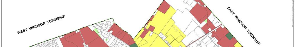
36 7.3.4 ORH Office Research, Hotel Zoning Designation Permitted Use: Based on trends in the development of warehouse and office space, it is recommended that a new use be added to the list of the permitted uses for the ORH Office Research, Hotel District under Section B of the Washington Township Zoning Ordinance. Specifically, it is recommended that Flex Buildings be added to the list of permitted uses. Additionally, design standards should be provided in Section G, a new section, for all flex buildings, including façade treatment, landscaping, and lighting. Design Standards: In addition to adding a new use to the ORH zone, it is recommended that a new zone-wide design standard be added to Section F. In order to promote a cohesive look to the buildings within the zone, a campus-style design should be encouraged. A campus-style design would ensure that the buildings efficiently utilize the land and circulation patterns are well-connected and not haphazard. Additionally, the suggested design standards set forth below in Section 7.4 should be considered and potentially incorporated into the ORH regulations OC-2 Office/Commercial Zoning Designation Parcel-Specific Zoning Map Recommendations: Block 28, Lots 3.01, 5, and 6, which are located along Sharon Road adjacent to a large tract of preserved land and opposite a parcel classified at OC-2, are currently within the Low Density Residential District (R1.5) (refer to Figure 7 below). It is believed that residential land uses are no longer appropriate for this area, particularly given the boundaries of the Airport Hazard Safety Overlay Zone (AC) include these parcels, and the close proximity of other commercial zoning districts. It is recommended that these parcels be zoned for commercial development. This is more compatible with the regulations of the AC zone and will provide opportunities for commercial and economic development proximate to Route 130. This will be consistent with one of the goals of the Master Plan Reexamination, which is to encourage new commercial development and redevelopment projects in designated areas of the community thereby balancing new development and ratables with the needs of the community TC Town Center Zoning Designation Design Regulations: At current there are 4 TC zoning distinctions. Along with the proposed redevelopment of the Route 130 Corridor, the Township recommends amending the TC District to include another distinction for the parcels currently zoned TC along Route 130 as well as parcels along Route 33 bounded by Robbinsville Edinburg Road to the west and Route 130 to the east. The goal is to have this area act as a transition from the 2-4 story structures throughout the rest of Town Center and the development along Route 130. To this end, this re-examination recommends no change of use from those permitted throughout the rest of Town Center but a height restriction of no more than 3 stories HC Highway Commercial Zoning Designation With the planned extension to the Sewer Service Boundary, the Township is seeking to provide a cohesive land use scheme to the entire corridor. In order to create a zoning district encompassing the majority of Route 130, the Township recommends the creation of an HC Highway Commercial Zone, replacing the existing OC-1 & OC-2 Office Commercial Zoning Districts as well as other neighboring parcels (Figure 8). The goal of this new district is to encourage attractive and site specific commercial 36
37 developments throughout the entire length of Route 130, identified as the Township s main commercial corridor. The uses are mostly consistent with those allowed within the OC-1 & OC-2 Zoning Districts, with a few modifications, provisions and additional design standards. Land use standards for the new HC Highway Commercial Zone include but are not limited to the following: Permitted Uses: Retail Restaurants, including drive-in Office, general & medical Business or professional services Conditional Uses: Hotels with a 100 room minimum & restaurant Gas stations with convenience stores of over 2,500 sf Churches or houses of worship Prohibited Uses: New or used sales or rental of motor vehicle lots Automotive repair without a parts store being greater than 50% of the total square feet Motels Gas Stations Adult Book Stores XXX Movie Theaters Paraphernalia Stores Junk Yards Massage Parlors VC Village Commercial Zoning Designation In addition to the HC Highway Commercial Zone along Route 130, a portion of the former OC-1 & OC-2 zones as well as a portion of the RR Rural Residential zone along Main St. is recommended to be rezoned into the VC Village Commercial Zone. To take advantage of the surrounding historic communities adjacent to this area, it is recommended that a new zoning district be created that encourages smaller lot sizes contributing to a more friendly pedestrian scale environment. Design standards for this district should be extensive and liberally enforced in order to create a unique sense of place with offices and retail for both residents and visitors to explore. 37
38 Figure 7 Source: Washington Township GIS Data,
39 Figure 8 Source: Washington Township GIS Data, Gateways While there are many gateways into Washington Township, this Amendment focuses on the remaining commercially viable gateways. As shown on Figure 9 below, there are three gateways, which while they present an opportunity for development it is fundamental that if development should happen, all efforts to guarantee appropriate gateway treatment be utilized. Figure 9 39
40 Source: Washington Township GIS Data, 2005 The gateways on Route 130 welcome residents and visitors to one of the primary commercial corridors in the Township whereas the Wittenborn gateway reminds residents and demonstrates to visitors the rural history of the Township. In order to maintain the rural feel and open vista of the Wittenborn gateway, this Amendment encourages the preservation of the Wittenborn property. However, this Amendment recognizes the development pressures facing the Wittenborn property, and therefore, supports commercial development (as described in greater detail below) as long as the existing farmhouse is preserved and the open vistas are incorporated into such development. The 2000 Land Use Element had listed the Wittenborn gateway as a potential TDR village (the Robbinsville-Allentown village). However, as discussed above in Section 7.2 and in greater detail below, a village in this location may no longer feasible. The Wittenborn gateway is currently within the Rural Residential Transition District (RR-T1) and is bordered to the northeast by parcels zoned Office, Research, Hotel District (ORH), to the east and northwest by parcels zoned Rural Residential (RR), to the south by Allentown Borough, and west by Upper Freehold Township. The surrounding development in Upper Freehold Township is primarily light industrial uses. Due to the surrounding land uses, the Wittenborn could play a key role as a transitional zone between the Rural Residential and light industrial uses. Also, do to its size and the current demand for office and/or flex space within the Township, any development should be allowed to proceed in phases in order to avoid creating a glut of empty office space within the Township. 40
41 Any rezoning of the Wittenborn parcel should incorporate design standards to ensure the gateway remains intact. Building design standards should be provided to ensure overall high quality building and the maximum size for a building footprint should be 10,000 square feet. Also, as stated above, the existing farmhouse should remain and adaptive reuse of the structure encouraged. Finally, a campus setting should be supported and the exterior appearances of the buildings should complement the character of the area. Design standards to consider include but are not limited to: Architectural Interest: To provide architectural interest, create a three dimensional effect and further reduce the visual scale and impact of a building. The following techniques should be used: 1. A height restriction should be placed on any proposed development in order to ensure that the development be compatible with the existing historic structure. 2. Variations in building treatment should be liberally used and should include painted panels, reveals, awnings or canopies, all openings, wall texture changes, changes in building height and variations in roof lines. 3. Architectural treatments which provide vertical and horizontal effects to the façade should be utilized. 4. Buildings entries and building corners should be readily identifiable through the use of canopies, marquees, architectural treatment and through the use of different materials, such as glass. 5. Extensive use of small-scale elements, such as planter walls and hedges should be provided particularly around building entrances. 6. The front and two side elevations of all buildings and structures should be constructed of a high quality aesthetic material, such as brick, architectural block, or architectural precise concrete. 7. Roofs should be designed to minimize their visual impact to residential neighborhoods and from public rights-of-way. 8. The location of any buildings and any associated parking areas should consider the visual impact to the gateway. Every effort should be made to ensure the buildings are sited to preserve the existing visual environment. Color and Texture: To provide a visually pleasing building the following but not limited to techniques should be used: 1. Texture patterns should be provided to create shadow patterns, which will reduce the visual impact and mass of a building. 2. Variations in color should be kept to a minimum. 41
42 3. Color should be subdued in tone and the use of earth tones is encouraged. 4. Accent colors may be used but should be complement the surrounding environment and be consistent with adjacent buildings. Pedestrian Circulation: In order to facilitate a interconnected environment and limit the amount of vehicular circulation onsite, the following but not limited to techniques should be used: 1. On-site concrete or brick sidewalks, or such other material acceptable to the Township, should be provided to create a continuous pedestrian network throughout the park and to connect with existing or planned sidewalks surrounding the building(s). 2. Street furniture, such as benches, should be incorporated into the pedestrian circulation network. 3. Vehicular and pedestrian circulation patterns should be separated. A landscaped buffer should provide a separation between pedestrian and vehicular ways. 4. Pedestrian crossings should be indicated by such techniques as changed pavement materials or texture, signals, signage, or painted stripes, as determined by the Township. 5. Bicycle lanes and bicycle paths should be provided where applicable. Landscaping: Fundamental to maintaining the gateway is development and implementation of a comprehensive landscape plan. The following but not limited to components should be considered: 1. A cohesive landscaping plan, which considers the preservation of the gateway, should be developed for the site. 2. All proposed landscaping should be consistent with the natural surroundings. However, the planting of Sweet Gum trees should be prohibited. 3. Consider massing trees at critical points rather than in a straight line at predetermined intervals along streets. 4. Consider the impact of any proposed landscaping plan at various time intervals, i.e. shrubs may grow and eventually block sight distances. 5. Landscaping should be used to accent and complement buildings. For example, groupings of tall trees to break up long, low buildings and lower plantings for lower buildings. 6. Vary the type and amount of landscaping with type of development, and accent site entrances with special landscaping treatment, as shown below in Photos 4 & 5. 42


43 Photo 4 Photo Berms and changes in topography should be used to reduce the perceived height of buildings. 8. Trees should be located along building walls in strategic locations to further reduce the visual impact of long facades. 43


44 9. Landscaped buffers, including berms, should be located between buildings, structures, parking areas, loading and unloading areas and public roads in locations which provide for maximum shielding and lighting. And finally, the Township is willing to work and engage with the Wittenborn parcel land owner to ensure a quality development for the Township. To this end, the owner has submitted in conjunction with this re-examination a proposed layout of the parcel including the following images (6a-6d) as concept designs. These images are included herein as a guide for the future development of the parcel. Photo 6a Photo 6b Photo 6c Photo 6d 7.5 Green Building Standards Washington Township recognizes that the built environment has a tremendous impact on the environment. The Township believes that buildings can interact more positively with the environment if special attention is paid to preserving the site s integrity and natural characteristics, landscaping appropriately, and selecting materials that have lower embodied energy. Since Washington Township has had a significant amount of residential development over the past six years, the Township believes that a program mandating higher performance of housing is a good way of keeping real estate and community values high as the more or less uniform housing stock matures. A method to achieve this goal is to adopt a residential Green Building Program, which is designed to ensure a higher quality of life for Washington s citizens. The Green Building Program could focus on 44
45 several areas including waste reduction, pollution reduction, water conservations, energy conservation, and sustainable development. By enforcing the standards of this program, the Township will give future generations the legacy of environmental sensitivity, functionally efficient homes, and a commitment to conservation. Additionally, the adoption of Green Building Program is consistent with an objective of this reexamination report, which is to encourage the use of buildings and landscape materials, and individual building design, that promote energy efficiency and that are environmentally sensitive in their manufacture and use. Suggested Minimum Green Building Standards: Energy Efficiency - The minimum standard for energy efficiency of single-family residential structures could be the Environmental Protection Agency s Energy Star TM designation as it currently stands or may be amended. Water Conservation - The minimum standards for water conservation could include: 1. Providing information in home models concerning the benefits of xeriscaping and water conservation practices. 2. If bedding areas are installed, they should be mulched (recycled-content mulch or compost). 3. If an irrigation system is installed, it should include a rain and freeze sensor, installed to manufacturer s specifications. 4. If an irrigation system is installed, it should be a zoned irrigation system. Waste Recycling The minimum standards for waste recycling could include: 1. Construction waste (brick and wood) hauled form the building site by the builder should be taken to a site or facility legally empowered to accept it for recycling as approved by the County and State in which the facility is located. 2. Construction waste reduction/reuse plan written and followed by builder. 3. Donate unwanted building materials to a non-profit building organization. 4. Provide a composting system option installed in yard for homebuyer (manufactured or made at site). Landscaping and Solar Orientation According to the United States Department of Energy (USDOE), Washington Township is situated within the Temperate Climatic Region, which means that landscaping should be designed to maximize warming effects of the sun in the winter, to maximize shade in the summer, to deflect winter winds away from buildings, and to funnel summer breezes toward the home. For the Temperate Climatic Region, the USDOE recommends the following landscaping techniques: 1. To block solar heat in the summer but let much of it in during the winter, use deciduous trees. To provide continuous shade or to block heavy winds, use dense evergreen trees or shrubs. 2. Utilize a large bush or row of shrubs to shade a patio or driveway. 3. Whenever feasible, use drought-tolerant plants. 45
46 4. Utilize windbreaks to block wind close to the ground by using trees and shrubs that have low crowns. Dense evergreen trees and shrubs planted to the north and northwest of the homes are the most common type of windbreak. 5. For snow drifts, plan low shrubs on the windward side of your windbreak. The shrubs will trap snow before it blows next to your home. 7.6 Route 130 Corridor A principal component of the 2000 Land Use Element was the development of the Route 130 corridor. Particularly, the Land Use Element pictured a boulevard with nodes of commercial development, and a green pattern of open space between the nodes. Parking was encouraged to the rear and side of buildings and landscaped walkways were to be constructed along the building frontage. Typically, there are many challenges to node style development, including economic and social forces, design and development issues, and financing complexities. Along Route 130, these challenges are exacerbated, given the existing non-cohesive structures and uses, the amount of regional traffic along the roadway, and the fact that many of the parcels are constrained by wetlands. The Township recognizes that the development of Route 130 as a vibrant commercial artery is fundamental to achieving the commerce goal set forth in this reexamination report, which is to encourage new commercial development and redevelopment projects in designated areas of the community thereby balancing new development and ratables with the needs of the community. Portions of Route 130 should be studied for possible designation of areas in need of redevelopment. An area in need of redevelopment designation along Route 130 will promote better use of abandoned or underutilized parcels, will encourage remediation of environmental hazards, will help to identify uses and services desired by Township residents, will facilitate the extension of sewer service to areas currently within the sewer service area but not serviced and will eliminate the need for residents to drive longer distances for neighborhood services. During this re-examination process, the Township Planning Board engaged in a lengthy discussion concerning residential uses along the corridor, but ultimately came to the conclusion that the area as a whole is unsuitable for such uses. In order to achieve the vision described above, it has been determined that the recommendations set forth for the Route 130 corridor in the 2000 Land Use Element should be repealed and replaced by the recommendations set forth below Recommendations for the Development and Redevelopment of the Route 130 Corridor This reexamination report recommends the Township authorize the Planning Board to conduct a preliminary investigation for determination of an area in need of redevelopment for parcels along or adjacent to the Route 130 corridor. Specifically, the Planning Board should study the gateway area (as shown below on Figure 10). In areas along Route 130 where redevelopment is neither needed nor feasible, the Township in conjunction with the Planning Board should conduct a zoning analysis to help establish if any zoning changes are needed beyond the HC & VC Zoning changes already endorsed by this re-examination in order to facilitate development that represents highest and best use of the land. 46
47 Figure 10 Source: Washington Township GIS Data, 2005 The redevelopment plan and amended zoning regulations described in detail in section discourage most auto-related uses and motels and should prohibit adult book stores, XXX movie theaters, paraphernalia stores, junk shops, junk yards and massage parlors. Additionally, since Route 130 is one of the Township s main arteries for commercial development and a goal of this reexamination report is to encourage commercial development projects in designated areas thereby balancing new development and ratables with the needs of the community. Design standards should be incorporated into any redevelopment plan and/or revised zoning regulations. An objective of this reexamination report is to promote retail and office development that is at a pedestrian-scale and that is aesthetically pleasing to the public through the use of architecture, landscaping and buffers, and by adopting on-premise sign regulations which promote safety and prevent sign proliferation. The design standards should consider the following but not limited to components: 1. Building facades 2. Building materials 3. Fences 4. Landscaping 5. Pedestrian walkways 6. Lighting 7. Signage 8. Color 47


48 Photos 6-10 illustrate examples of development that would meet the commerce goal of this reexamination as well as the above-cited objective. Photo 6. This photo illustrates decorative fencing around a basin, lighting, and generous use of landscaping. Photo 7. This photo illustrates a brick façade on a shopping center which when combined with visually pleasing signage, awnings, and lighting create an inviting environment. 48
 as well as a brick façade with architectural features.")


49 Photo 8. Photo 9 and 10. This photo illustrates the use of street furniture (benches) as well as a brick façade with architectural features. Note while the parking is in the front it does not limit pedestrian circulation between the various stores. Photos 9 and 10 illustrate the use of landscaping and pedestrian walkways in surface parking lots. The landscaping helps to break up the paved areas and creates a more visually appealing environment. As shown in the photos, any proposed developments should have an overall coordinated design scheme, with internal circulation providing ready access to all of the proposed uses. Buildings should be complementary to one another in terms of roofline, façade material, color and similar elements. Pedestrian areas should include coordinated sidewalk treatment; trash receptacles; benches; planters and the like. Also, site elements, such as signage and lighting standards, should be paired to the building design Extension of Sewer Service along Route 130 within the Sewer Service Area As discussed in Section 6.4 of this reexamination report, it was determined that sewer service should be extended along Route 130 within the existing sewer service area boundary. The expansion of sewer service will encourage retail and office development along this corridor as well as allow for more efficient use of the land. 49
INTRODUCTION. b. The extent to which such problems and objectives have been reduced or have increased subsequent to such date.
 INTRODUCTION INTRODUCTION The Municipal Land Use Law directs a Planning Board to prepare a Periodic Reexamination Report every six years that identifies and describes the following: a. The major problems
SECTION II SECTION II STATEMENT OF GOALS, OBJECTIVES, PRINCIPLES, ASSUMPTIONS, POLICIES AND STANDARDS
 STATEMENT OF GOALS, OBJECTIVES, PRINCIPLES, ASSUMPTIONS, POLICIES AND STANDARDS 1 2 STATEMENT OF GOALS, OBJECTIVES, PRINCIPLES, ASSUMPTIONS, POLICIES AND STANDARDS INTRODUCTION The New Jersey Municipal
4.1.3 LAND USE CATEGORIES
 4.1.3 LAND USE CATEGORIES a. City Center District The City Center District incorporates the existing character and mix of uses in downtown Belmont to encourage redevelopment and new development in keeping
Section XI RELATIONSHIP TO OTHER PLANS
 Section XI RELATIONSHIP TO OTHER PLANS INTRODUCTION The land development plans 1 for the municipalities bordering West Windsor were reviewed to determine their relative compatibility to the planning policies
2018 Northampton Township Comprehensive Plan
 2018 BUCKS COUNTY, PENNSYLVANIA What is a? A comprehensive plan is a municipality s main policy document that details the collective vision for the future, the historic, environmental, and cultural facilities
Living in Albemarle County s Urban Places
 Living in Albemarle County s Urban Places ALBEMARLE COUNTY, VIRGINIA A Closer Look at Albemarle s Approach to Managing Growth and Creating Quality Urban Environments www.albemarle.org Page 2 Living in
Silverdale Regional Center
 Silverdale Regional Center Vision for Silverdale Regional Center The Silverdale Regional Center Plan (Plan) will guide the evolution of the Silverdale Regional Center from a collection of strip malls and
Hockessin Community Redevelopment Plan
 Hockessin Community Redevelopment Plan 3.1 Introduction The Community Redevelopment Plan for the Village of Hockessin is the result of the people s vision for a distinct village center that serves as the
2010 Plan of Conservation and Development
 2010 Plan of Conservation and Development Wilton Planning and Zoning Commission Adopted November 2, 2009 Effective January 1, 2010 WILTON 2010 PLAN OF CONSERVATION & DEVELOPMENT PARTICIPANTS Planning &
Regional Context Statement
 Regional Context Statement REGIONAL CONTEXT STATEMENT 3. REGIONAL CONTEXT STATEMENT In 1995, the Provincial Government passed into law the Growth Strategies Act. The purpose of this provincial initiative
The transportation system in a community is an
 7 TRANSPORTATION The transportation system in a community is an important factor contributing to the quality of life of the residents. Without a sound transportation system to bring both goods and patrons
CHAPTER 7: VISION AND ACTION STATEMENTS. Noble 2025 Vision Statement
 CHAPTER 7: VISION AND ACTION STATEMENTS This chapter presents the vision, policy and action statements that transform the comprehensive planning study, an analysis of Noble s past, future trends and community
Section 9 NEIGHBORHOOD DESIGN
 Section 9 NEIGHBORHOOD DESIGN City of Lancaster Comprehensive Plan D u n k i n, S e f k o & A s s o c i a t e s, I n c. NEIGHBORHOOD DESIGN INTRODUCTION There are many ways in which a neighborhood can
TREASURE COAST REGIONAL PLANNING COUNCIL M E M O R A N D U M. To: Council Members AGENDA ITEM 5I
 TREASURE COAST REGIONAL PLANNING COUNCIL M E M O R A N D U M To: Council Members AGENDA ITEM 5I From: Date: Subject: Staff December 12, 2008 Council Meeting Local Government Comprehensive Plan Review Town
CHAPTER 4 FUTURE LAND USE AND URBAN SERVICES DISTRICTS
 CHAPTER 4 FUTURE LAND USE AND URBAN SERVICES DISTRICTS Introduction This chapter discusses how Benzie County should grow and change in the future. A community can grow and change in many different ways.
and services The protection and conservation of environmentally significant and sensitive natural heritage features and functions.
 6. Land Use 6.0 Preamble A healthy and livable city is one in which people can enjoy a vibrant economy and a sustainable healthy environment in safe, caring and diverse neighbourhoods. In order to ensure
Planned Development Review Revisions (Project No. PLNPCM )
") Planned Development Review Revisions (Project No. PLNPCM2014-00139) Standard residential development Planned Development Example: Smaller lot sizes than what is allowed to create open space amenity. What
Planned Development Review Revisions (Project No. PLNPCM2014-00139) Standard residential development Planned Development Example: Smaller lot sizes than what is allowed to create open space amenity. What
The Illinois Department of Transportation and Lake County Division of Transportation. Route 173, including the Millburn Bypass
 The Illinois Department of Transportation and Lake County Division of Transportation welcome you to this Public Hearing for U.S. Route 45 from Illinois Route 132 to Illinois Route 173, including the Millburn
NEW CASTLE COUNTY S ZONING DISTRICTS
 NEW CASTLE COUNTY S ZONING DISTRICTS This is general information about New Castle County s zoning districts. The information included is by no means exhaustive or complete. Before designing plans to develop
S A C R A M E N T O C O U N T Y JACKSON HIGHWAY & GRANT LINE EAST VISIONING STUDY
 JACKSON HIGHWAY & GRANT LINE EAST S A C R A M E N T O C O U N T Y P L A N N I N G D E P A R T M E N T SUMMARY AND WORKBOOK November 19, 2008 History of the Visioning Study Sacramento County has two growth
3. VISION AND GOALS. Vision Statement. Goals, Objectives and Policies
 Vision Statement Queen Creek s interconnected network of parks, trails, open spaces and recreation opportunities provide safe and diverse activities and programs that sustain its unique, small town, equestrian
Town Center (part of the Comprehensive Plan)
") Town Center (part of the Comprehensive Plan) Mercer Island Town Center Looking North (2014) In 1994, a year-long process culminated in a set of design guidelines and code requirements for the Town Center
Town Center (part of the Comprehensive Plan) Mercer Island Town Center Looking North (2014) In 1994, a year-long process culminated in a set of design guidelines and code requirements for the Town Center
V. Vision and Guiding Principles
 V. Vision and Guiding Principles The Master Plan for the Powers Ferry Corridor seeks a foundation in the desires of the community. At times, various elements of the community offered opposing viewpoints,
SUMMERSIDE / MT. CARMEL REINVESTMENT CORRIDOR COMMUNITY DEVELOPMENT STRATEGY
 SUMMERSIDE / MT. CARMEL REINVESTMENT CORRIDOR COMMUNITY DEVELOPMENT STRATEGY FEBRUARY 2013 I. Location of the Summerside/Mt. Carmel Reinvestment Corridor The Summerside/Mt. Carmel Reinvestment Corridor
RECREATION AND OPEN SPACE ELEMENT GOALS, OBJECTIVES, AND POLICIES
 RECREATION AND OPEN SPACE ELEMENT GOALS, OBJECTIVES, AND POLICIES Goal 7 To provide park facilities, recreation programs, and open space resources that are safe, adequate, and accessible to all City residents,
LAND USE ELEMENT. Purpose. General Goals & Policies
 LAND USE ELEMENT Purpose This Land Use Element contains the goals and policies necessary to support the City s responsibility for managing land resources and guiding development through implementing regulations,
ARTICLE 6: Special and Planned Development Districts
 ARTICLE 6: Special and Planned Development Districts 6-10 Traditional Neighborhood Development (TND) District 6-10.10 Purpose and Intent The Traditional Neighborhood Development (TND) District provides
SECTION 1 Introduction...1. SECTION 2 Regional Context Criteria for Planning Districts Description of Planning District...
 Table of Contents SECTION 1 Introduction...1 SECTION 2 Regional Context...2 2.1 - Criteria for Planning Districts...2 2.2 - Description of Planning District...2 SECTION 3 Goals & Objectives...5 SECTION
REQUEST FOR QUALIFICATIONS
 REQUEST FOR QUALIFICATIONS VILLAGE OF HAMBURG COMPREHENSIVE ZONING/LAND USE REGULATIONS UPDATE Prepared By: Village of Hamburg 100 Main Street Hamburg, New York 14075 Village of Hamburg RFQ Page 1 of 10
6. Consistency with Local Plans
 6. Consistency with Local Plans 6.1. Chapter Overview 6.1.1. Introduction This section presents the goals, objectives and policies of municipal, county and state planning entities, as well as known development/redevelopment
Gloucester County s Comprehensive Plan. The Community Connection
 Gloucester County s Comprehensive Plan The Community Connection Current Comp Plan Adopted in 1991 with a 20 year planning horizon Updated in 1995 with Part V- Implementation Recommendations and Appendix
Hibbing. Land Use. Hibbing Comprehensive Plan 8.1. Land Use
 Hibbing 8.1 Introduction 8.3 Information and Assessment 8.5-8.14 Recommendations 8.15-8.17 Implementation 8.18-8.19 8.2 Introduction Although land use was not identified as a discrete goal during the community
Official Plan Review
 Official Plan Review Summary Report - The Built Environment August 2014 Part 1: Introduction Planning for a healthy, prosperous and sustainable community is an important goal for our municipality. From
Dwelling Units Max 12 dwelling units per acre/min 8 dwelling units per acre. Development Mix 80% non residential/20% residential
 13. OSTEEN LOCAL PLAN Background: The Osteen Local Plan area is located in southwest Volusia County along the SR 415 corridor between Lemon Bluff Road and Acorn Lake Road and includes 3,990 acres. The
Town of Peru Comprehensive Plan Executive Summary
 Town of Peru Comprehensive Plan Executive Communities that plan grow by choice, not by chance. A plan makes growth thoughtful, understandable, and predictable. A plan shows that a community is managing
Chapter 10 IMPLEMENTATION RECOMMENDATIONS
 Chapter 10 IMPLEMENTATION RECOMMENDATIONS The recommended land use plan presented in the previous chapter provides a design for the attainment of the urban and rural development and open space preservation
AWH REPORT OF THE PLANNING AND DEVELOPMENT DEPARTMENT FOR APPLICATION FOR REZONING ORDINANCE TO PLANNED UNIT DEVELOPMENT
 AWH REPORT OF THE PLANNING AND DEVELOPMENT DEPARTMENT FOR APPLICATION FOR REZONING ORDINANCE TO PLANNED UNIT DEVELOPMENT MAY 8, 2014 The Planning and Development Department hereby forwards to the Planning
CITY CLERK. Parkland Acquisition Strategic Directions Report (All Wards)
") CITY CLERK Clause embodied in Report No. 10 of the, as adopted by the Council of the City of Toronto at its meeting held on November 6, 7 and 8, 2001. 10 Parkland Acquisition Strategic Directions Report
CITY CLERK Clause embodied in Report No. 10 of the, as adopted by the Council of the City of Toronto at its meeting held on November 6, 7 and 8, 2001. 10 Parkland Acquisition Strategic Directions Report
9 CITY OF VAUGHAN OFFICIAL PLAN AMENDMENT NO BOCA EAST INVESTMENTS LIMITED
 9 CITY OF VAUGHAN OFFICIAL PLAN AMENDMENT NO. 631 - BOCA EAST INVESTMENTS LIMITED The Planning and Economic Development Committee recommends the adoption of the recommendations contained in the following
The Five Components of the McLoughlin Area Plan
 The Five Components of the McLoughlin Area Plan This documents contains the complete language of the five components of the McLoughlin Area Plan: The Vision Statement The Values The Guiding Principles
Guiding Principles, Objectives, Strategies and Policies
 Guiding Principles, Objectives, Strategies and Policies Section 1 Introduction These Guiding Principles were adopted as part of the 1999 Athens-Clarke County Comprehensive Plan and are carried over, in
CHAPTER 12 IMPLEMENTATION
 CHAPTER 12 IMPLEMENTATION The 2010 Town of Denton Comprehensive Plan is intended to capture a vision of the future of Denton. As such, it provides a basis for a wide variety of public and private actions
EXISTING COMPREHENSIVE PLAN
 EXISTING COMPREHENSIVE PLAN Town Center Land Use Element: V. LAND USE POLICIES Town Center Mercer Island's business district vision as described in "Your Mercer Island Citizen-Designed Downtown" was an
CHAPTER 7: Transportation, Mobility and Circulation
 AGLE AREA COMMUNITY Plan CHAPTER 7 CHAPTER 7: Transportation, Mobility and Circulation Transportation, Mobility and Circulation The purpose of the Transportation, Mobility and Circulation Chapter is to
CONSENT CALENDAR CITY PLANNING COMMISSION AGENDA ITEM NO: A.1, A.2 STAFF: LARRY LARSEN
 Page 8 CONSENT CALENDAR CITY PLANNING COMMISSION AGENDA ITEM NO: A.1, A.2 STAFF: LARRY LARSEN FILE NO: CPC PUZ 14-00013 - QUASI-JUDICIAL FILE NO: CPC PUD 14-00014 QUASI-JUDICIAL PROJECT: APPLICANT: OWNER:
Improve Neighborhood Design and Reduce Non Point Source Water Pollution
 HOW TO Planning Guide Improve Neighborhood Design and Reduce Non Point Source Water Pollution This document was funded by a grant from the New Hampshire Coastal Program with funding from the National Oceanic
The West Vaughan Employment Area Secondary Plan Policies
 Part 2: The West Vaughan Employment Area Secondary Plan Policies 2.1 General Policies It is the policy of Council: 2.1.1. That the West Vaughan Employment Area (the WVEA), identified on Schedule 1, will
Making Transit Oriented Development Work For Boonton, NJ
 Making Transit Oriented Development Work For Boonton, NJ Bloustein School of Planning and Public Policy Studio Dan Burton Loannie Dao Webster Slater Brandon Williams Ian Watson Maria Laham Nicola Mammes
CHAPTER 3 VISION, GOALS, & PLANNING PRINCIPLES. City of Greensburg Comprehensive Plan. Introduction. Vision Statement. Growth Management Goals.
 CHAPTER 3 VISION, GOALS, & PLANNING PRINCIPLES Introduction The Greensburg Comprehensive Plan is intended as a working community document. A combination of long and short-term goals, this document is intended
General Reexamination of the Master Plan
 General Reexamination of the Master Plan Remington & Vernick Engineers, Inc. 232 Kings Highway East Haddonfield, New Jersey 08033 March 17, 2004 Adopted by Harrison Township Planning Board on April 7,
Woodburn Comprehensive Plan Growth Management Goals and Policies
 Goal Woodburn Comprehensive Plan Growth Management Goals and Policies G-1. The City's goal is to manage growth in a balanced, orderly and efficient manner, consistent with the City s coordinated population
CITY OF PUYALLUP. Background. Development Services
 CITY OF PUYALLUP Development Services 333 South Meridian Puyallup WA 98371 To: City Council From: Katie Baker, AICP, Planning Division Re: South Hill Neighborhood Plan Adoption Date: (Meeting date: February
Asbury Chapel Subdivision Sketch Plan
 Asbury Chapel Subdivision Sketch Plan PART 1: PROJECT SUMMARY Applicant: NVR Inc. Project Size: +/- 76.13 acres Parcel Numbers: 02101112,02116101,02116112, 02116113 Current Zoning: Transitional Residential
ESTABLISH AN EFFICIENT TOWN CENTER
 ESTABLISH AN EFFICIENT TOWN CENTER 4 Overview Lisbon residents are proud of the history of Newent and at the same time recognize its current importance as a centralized location for a variety of municipal
PORT WHITBY COMMUNITY
 PORT WHITBY COMMUNITY SECONDARY PLAN UPDATE COMMUNITY IMPROVEMENT PLAN URBAN DESIGN GUIDELINES September 2015 DRAFT PROPOSED AMENDMENT NUMBER # to the Whitby Official Plan PURPOSE: The intent of this Amendment
Chapter Master Planned Communities (MPC) District
 District") Sections 14.53.010 Purpose and Intent 14.53.020 Applicability 14.53.030 Procedure 14.53.040 MPC Standards 14.53.050 Required Findings 14.53.010 Purpose and Intent Chapter 14.53 Master Planned Communities
Sections 14.53.010 Purpose and Intent 14.53.020 Applicability 14.53.030 Procedure 14.53.040 MPC Standards 14.53.050 Required Findings 14.53.010 Purpose and Intent Chapter 14.53 Master Planned Communities
HE VISION. Building a Better Connected Place
 HE VISION Building a Better Connected Place WALK INTO THE FUTURE. Life in Cranberry, 2030 Here s what our residents told us they wanted to see in their community by 2030: The Cranberry of 2030 is a place
TRANSPORTATION AND LAND USE
 CHAPTER 10 TRANSPORTATION AND LAND USE Transportation and land use are intimately linked. The expansion of a highway typically spurs housing, employment growth and land development in the communities that
DRAFT Amsterdam/Churchill Community Plan (4/17/08) Adopted By the Gallatin County Commission
 Adopted By the Gallatin County Commission") DRAFT Amsterdam/Churchill Community Plan (4/17/08) Adopted By the Gallatin County Commission Table of Contents Acknowledgements Chapter 1: Introduction A Brief History What s Next Authority Organization
DRAFT Amsterdam/Churchill Community Plan (4/17/08) Adopted By the Gallatin County Commission Table of Contents Acknowledgements Chapter 1: Introduction A Brief History What s Next Authority Organization
Intergovermental Coordination
 Intergovermental Coordination CITY OF WINTER PARK CHAPTER 8: INTERGOVERNMENTAL COORDINATION ELEMENT INTERGOVERNMENTAL COORDINATION ELEMENT GOAL 8-1: PROVIDE FOR IMPROVED INTERGOVERNMENTAL COORDINATION
C. Westerly Creek Village & The Montview Corridor
 C. Westerly Creek Village & The VISION Community Vision When the goals of the city are achieved Westerly Creek Village, a distinctive community defined by Montview Boulevard and Westerly Creek, is a strong
THE CITY OF VAUGHAN BY-LAW BY-LAW NUMBER
 THE CITY OF VAUGHAN BY-LAW BY-LAW NUMBER 123-2013 A By-law to designate the whole of the City of Vaughan as a Site Plan Control Area, and to adopt site development guidelines and rules of procedure for
E. RURAL COMMERCIAL/INDUSTRIAL PARK MODEL
 E. RURAL COMMERCIAL/INDUSTRIAL PARK MODEL 1. PURPOSE The purpose of the Rural Commerce/Industrial Park Model is to provide parameters within which a grouping of business buildings with parking, loading
4 Sustainability and Growth Management
 4 Sustainability and Growth Management Introduction Traditionally, has assumed growth and development with limited consideration for the long-term negative social, environmental or economic impacts on
RESIDENTIAL DISTRICTS
 RESIDENTIAL DISTRICTS The residential district standards have been revised to reflect on-the-ground conditions, while continuing to respect the use patterns established within the neighborhoods. This will
VILLAGE & TOWN OF BERGEN: COMPREHENSIVE PLAN
 VILLAGE & TOWN OF BERGEN: COMPREHENSIVE PLAN CPC Public Hearing April 21, 2016 History 1996 Comprehensive Plan Comprehensive Plan Update Committee Consultant (LaBella Associates): December 2014 Residents
PLAN ELEMENTS WORKSHOP. April 5, 2016
 PLAN ELEMENTS WORKSHOP April 5, 2016 needs more housing. But there is no one-size fits-all solution. Every neighborhood has its own character. In some places, density is not only appropriate it is badly
WEST WESTFIELD AVENUE REDEVELOPMENT PLAN I BOROUGH OF ROSELLE PARK
 Prepared For: DRAFT Borough of Roselle Park 110 East Westfield Avenue Roselle Park, New Jersey 07204 2016 WEST WESTFIELD AVENUE REDEVELOPMENT PLAN I BOROUGH OF ROSELLE PARK Prepared By: Neglia Engineering
implementation10 Village of Greendale Comprehensive Plan: Greendale, Wisconsin. Revisiting a Greenbelt Community
 implementation10 Village of Greendale Comprehensive Plan: 2010 - Village of Greendale Comprehensive Plan: 2010 - Implementation The recommendations of this Plan must be implemented by the Village of Greendale,
Implementation Guide Comprehensive Plan City of Allen
 Implementation Guide 2030 Comprehensive Plan City of Allen DRAFT 2015 Implementation Guide Allen 2030 Comprehensive Plan INTRODUCTION The Comprehensive Plan serves as a guide for the growth and development
VILLAGE OF CLEMMONS PLANNING BOARD DRAFT STAFF REPORT
 VILLAGE OF CLEMMONS PLANNING BOARD DRAFT STAFF REPORT PETITION INFORMATION Docket # C-226 Staff Megan Ledbetter Petitioner(s) JBJH Properties, LLC Owner(s) JBJH Properties, LLC Subject Property 5892-49-1766
Baumgarten MPUD. Exhibit 3 Evaluation Criteria
 Pursuant to LDC subsections 10.02.13 B, 10.02.08 F and Chapter 3 G. of the Administrative Code, staff s analysis and recommendation to the Planning Commission, and the Planning Commission s recommendation
North Fair Oaks Community Plan Summary and Information
 North Fair Oaks Community Plan Summary and Information WHAT IS THE NORTH FAIR OAKS COMMUNITY PLAN? The North Fair Oaks Community Plan is part of the San Mateo County General Plan, and establishes policies
Comprehensive Plan ADOPTED APRIL 2014
 Comprehensive Plan ADOPTED APRIL 2014 8 8. Outstanding Recreational & Cultural Opportunities We are proud of our community s parks and recreation system. Our community will ensure that the legacy of our
Proposed Walkability Ordinance for City of Knoxville (6/16/17)
") Proposed Walkability Ordinance for City of Knoxville (6/16/17) New or revised text is highlighted Section 1: Purpose The purpose of this ordinance is to set requirements for walkability and pedestrian
Proposed Walkability Ordinance for City of Knoxville (6/16/17) New or revised text is highlighted Section 1: Purpose The purpose of this ordinance is to set requirements for walkability and pedestrian
6 Growth Management Challenges and Opportunities
 6 Growth Management Challenges and Opportunities The Town has established a goal of attaining a 50% participation rate with respect to employment opportunities versus residential population. The Town s
Municipal Plan*Assessment
 Municipal Plan*Assessment This tool was developed to assist in reviewing municipal master plans and in determining if these plans are consistent with smart growth principles, neighboring municipal plans,
This page intentionally blank.
 This page intentionally blank. Parks, Recreation, and Open Space Chapter Relationship to Vision Vision Parks, Recreation and Open Space Chapter Concepts County Government. County government that is accountable
COLVER ROAD INDUSTRIAL CONCEPT PLAN
 COLVER ROAD INDUSTRIAL CONCEPT PLAN A CONCEPTUAL LAND USE AND TRANSPORTATION PLAN FOR TA-4 AN URBAN RESERVE AREA OF THE CITY TALENT City of Talent Adopted by City Council Resolution No., June, 2015 PART
Further input invited as Colchester Growth Strategy nears final phase
 IUE 3 / NOVEMBER 2015 Further input invited as Colchester Growth trategy nears final phase trathcona County is seeking public feedback as it enters the final phase of work on a Growth Management trategy
Proposed Comprehensive Plan Strategies DRAFT for discussion June 28, 2017
 Proposed Comprehensive Plan Strategies DRAFT for discussion June 28, 2017 Land Use Rural Areas Refine the Farm and Forest area (FF) Update FF boundaries to account for existing lots less than five acres
COMMUNITY DESIGN. GOAL: Create livable and attractive communities. Intent
 COMMUNITY DESIGN Intent An attractive, well-designed County will attract quality development, instill civic pride, improve the visual character of the community, and create a strong, positive image for
Section 4 BUILDING THE MASTER PLAN
 The Master Plan 33 Section 4 BUILDING THE MASTER PLAN Figure 4:1. A collaborative effort characterized the two design workshops sponsored by DISC to create hypothetical Master Plans for the Towers Property
EXHIBIT A. Tax Increment Reinvestment Zone No. 1 (Town Center) First Amended Project Plan 1
 First Amended Project Plan 1") EXHIBIT A Tax Increment Reinvestment Zone No. 1 (Town Center) First Amended Project Plan 1 1 As amended by Resolution No. 2008-02-001(TR1R) of the Tax Increment Reinvestment Zone No.1, and approved to
EXHIBIT A Tax Increment Reinvestment Zone No. 1 (Town Center) First Amended Project Plan 1 1 As amended by Resolution No. 2008-02-001(TR1R) of the Tax Increment Reinvestment Zone No.1, and approved to
TOP TEN LIST OF COMMUNITY CONCERNS REGARDING PROPOSED AMENDMENTS TO CHAPTER 42
 TOP TEN LIST OF COMMUNITY CONCERNS REGARDING PROPOSED AMENDMENTS TO CHAPTER 42 1. Extend the urban area to Beltway 8 in stages, over say a three-year period, prioritizing development in transit and declining
ARLINGTON COUNTY, VIRGINIA
 ARLINGTON COUNTY, VIRGINIA County Board Agenda Item Meeting of September 19, 2015 DATE: September 11, 2015 SUBJECTS: Outdoor Café at Citizen Burger Bar A. SP# 418 Site Plan Amendment to modify an approved
Planned Residential Neighborhoods Land Use Goals
 Planned Residential Neighborhoods Land Use Goals Issue: Guidelines that provide for diverse high quality residential areas that include a variety of housing styles and layouts are needed. Goal 1: Create
3.5 Historic Old Town Character Area
 3.5 Historic Old Town Character Area Downtown Suwanee is characterized by two areas: Historic Old Town and Town Center. Due to their proximity and similar purposes, the two areas can function together
KEIZER STATION PLAN INTRODUCTION
 KEIZER STATION PLAN INTRODUCTION Planning for this area began in 1987 when the Keizer Comprehensive Plan established the Chemawa Activity Center and McNary Activity Center. The first Chemawa Activity Center
Table of Contents. Elm Avenue Improvement Plan City of Waco, Texas. Introduction 1. Existing Context 1 Figure 1 2.
 Table of Contents Introduction 1 Existing Context 1 Figure 1 2 Plan Guidelines 3 Future Urban Form 4 The West-End 4 Main Street 6 The East-End 7 Figure 2 9 Public Improvement Recommendations 7 General
Chapter 9 Community Facilities & Services Plan. Introduction. Cooperative Efforts. Monitoring of Needs
 Chapter 9 Community Facilities & Services Plan Introduction The location of key community facilities such as water, sewer, schools, parks, and roads is important to the provision of the necessary services
The Corporation of the Town of Milton
 Report To: From: Council Barbara Koopmans, Commissioner, Planning and Development Date: May 7, 2018 Report No: Subject: Making it Possible Positioning the Town s Strategy for Growth and Economic Development
McDonald s Restaurant - Purcellville Town of Purcellville Special Use Permit Statement of Justification July 24, 2014
 Introduction / Written Statement McDonald s Restaurant - Purcellville McDonald s Corporation is proposing to redevelop the existing McDonald s eating establishment with a drive-through located at 121 N
Rural Land Use Designations Kittitas County December 6, 2007 Draft
 KITTITAS COUNTY COMMUNITY DEVELOPMENT SERVICES 411 N. Ruby St., Suite 2, Ellensburg, WA 98926 CDS@CO.KITTITAS.WA.US Office (509) 962-7506 Fax (509) 962-7682 Rural Land Use Designations Kittitas County
9 th Street Sub Area Plan
 9 th Street Sub Area Plan In the 1990 s, when the Township prepared the last Master Plan, the 9 th Street corridor was studied as part of a larger 9 th Street Focus Area that included the West Main Street
TREASURE COAST REGIONAL PLANNING COUNCIL M E M O R A N D U M. To: Council Members AGENDA ITEM 5H
 TREASURE COAST REGIONAL PLANNING COUNCIL M E M O R A N D U M To: Council Members AGENDA ITEM 5H From: Date: Subject: Staff October 17, 2008 Council Meeting Local Government Comprehensive Plan Review Draft
Tāhuhu whakaruruhau ā-taone The sheltering ridge pole
 B2. Tāhuhu whakaruruhau ā-taone - Urban growth and form B2.1. Issues Tāhuhu whakaruruhau ā-taone The sheltering ridge pole Auckland s growing population increases demand for housing, employment, business,
Gold Line Bus Rapid Transit Transit Oriented Development (BRTOD) Helmo Station Area Plan
 Helmo Station Area Plan") Appendix F Gold Line Bus Rapid Transit Transit Oriented Development (BRTOD) Helmo Station Area Plan Introduction and Purpose of the Plan The Gold Line Bus Rapid Transit facility is an eleven-mile dedicated
Appendix F Gold Line Bus Rapid Transit Transit Oriented Development (BRTOD) Helmo Station Area Plan Introduction and Purpose of the Plan The Gold Line Bus Rapid Transit facility is an eleven-mile dedicated
Be it enacted by the Town Board of the Town of Guilderland that the following new A (Transit Oriented Development (TOD) District) is adopted:
 District) is adopted:") Local Law No. 4 of 2018 (Adoption of 280-18A (Transit Oriented Development District) Be it enacted by the Town Board of the Town of Guilderland that the following new 280-18A (Transit Oriented Development
Local Law No. 4 of 2018 (Adoption of 280-18A (Transit Oriented Development District) Be it enacted by the Town Board of the Town of Guilderland that the following new 280-18A (Transit Oriented Development
Chapter IV: Development Pattern
 Chapter IV: Development Pattern Introduction The 2002 Prince George s County Approved General Plan designates three growth policy tiers Developed, Developing, and Rural as well as three center designations