AGENDA. I. Roll Call Page
|
|
|
- Archibald Stewart
- 5 years ago
- Views:
Transcription
1 VILLAGE OF POPLAR GROVE A GREAT PLACE TO CALL HOME Special Joint Meeting of The Village Board and The Planning and Zoning Commission January 31st, :00 AM Village Board Room: 200 Hill Street, Poplar Grove, IL Board Members (President) John Neitzel (Trustees) Ron Quimby,Don Bawden,Jeff Goings, Bob Fry, Judi Zangs, Owen Costanza Planning and Zoning Commission Members (Chairman) Jake Dykstra Jessica Roberts, Keith Richard, Steve Mundy, Don Statler, Ed Wethington, George Waddell, Gina DelRose, Kathy Miller AGENDA I. Roll Call Page II. III. IV. Approval of Agenda Public Comment Public Comment is encouraged. The Village Board and P&Z Commission will receive comments from the public, pursuant to State Statutes. Comments will be limited to five minutes on topics relating to the Village of Poplar Grove. Be further advised that matters brought up at this time may be referred to the appropriate committee or individual for further discussion or consideration. New Business A. Discussion of Updating Comprehensive Plan Recommendations 1 B. Community Character C. Current and Future Land Use Plan D. Parks and Recreation E. Financial Planning and Management V. Adjournment:
2 Comprehensive Plan Page 40 May 11, 2009 (Pages 40-49) XIII. COMPREHENSIVE PLAN RECOMMENDATIONS COMMUNITY CHARACTER Poplar Grove is a mixture of rural and suburban qualities common to many small midwestern towns and villages. One of the attractions for development in this area is this mixture of traditional rural and suburban lifestyles. Listed below are suggestions received from the audience at the public forum meeting held in February and our committee s recommendations regarding the public input. Also incorporated is input from a joint meeting on 10/25/08 between the Village Board, the Planning Commission and Committee Volunteers. Recommendations: 1. The community should have a common architectural theme. The Comprehensive Plan is one source for developing a consensus or vision for what our community should look like 5-10 years into the future. Based upon geographical location and use, the use of multiple themes can be appropriate. For example, our commercial corridors (Routes 76 and 173) can have an architectural standard appropriate that will promote existing and future commercial development. Architectural Standards An example of architectural standards for this commercial corridor could be to limit parking facing the highway. Require developers to build into the development a larger ratio of parking either at the sides or behind the commercial building. Require ornamental brick with a mandate requiring a specific amount of glass to eliminate the look of a continuous unending brick wall facing the highway. Also require landscaping requirements that can also be used to enhance the aesthetic appeal for our community as well as the commercial development. These types of requirements would not restrict development, but rather attract high quality commercial development that appeals to the developer and the community. Historical Downtown Preservation An initiative that blends new development with the existing architecture that uses less brick, less set back, and blends well within the existing buildings rather than looking out of place is prudent to preserve Poplar Grove s historical downtown. Any incentives or initiatives to promote development around the New City Hall may attract certain businesses to locate in this vicinity. However, we feel that commercial
3 Comprehensive Plan Page 41 May 11, 2009 development will naturally occur adjacent to our existing highway corridors (Routes 76 and 173) and to some extent State Street/Poplar Grove Road. Residential Development Standards Residential developments would have separate standards. Architectural standards should remain consistent however themes could vary within each development but not to such a point that it disrupts harmonious continuation from one development to another. Neighborhoods should be developed to be pedestrian friendly with sidewalks, bike paths, street lights, community parks and or green space. Require larger buffer requirements between multi-family residences and single family home developments. Standards for residential developments bordering highway corridors should include additional requirements that benefit the homeowners as well as maintain desired visibility from the main highway to passing traffic. Anti-monotony requirements, set backs, and landscaping that provides a barrier from the highway, are a few examples that could be mutually beneficial to the developer/homeowner and the community. Gated subdivisions are not a part of the overall long range plans of the Village. Nor does it fit with the direction or goals of the Comprehensive Plan. Regarding current developments that have already been annexed in the ability to apply new requirements that may come as a result of the Comprehensive Plan are limited at best. Every attempt should be made to encourage voluntary compliance by developers to any new standards recommended by the Comprehensive Plan. Changes to approved developments by the developer will require the review by the Planning Commission and approval by the Village Board. This may provide an opportunity to encourage developers to incorporate updated regulations resulting from the Comprehensive Plan. Unified Development Ordinances (UDO) UDOs can be one of the fundamental building blocks of any community s Comprehensive Plan. Details regarding commercial/residential development and architectural and landscaping standards are integral components of UDOs. We suggest the Village review UDOs of other communities to study and provide examples for consideration for developing Poplar Grove s own UDO. 2. Commercial Signage It is recommended that a review of existing ordinances for commercial signage be completed by the Village Ordinance Committee to insure compatibility with the vision and guidelines of the Comprehensive Plan. This should include standards for size, color, height, style, and anti-monotony provisions. Village of Poplar Grove, Boone County Illinois Comprehensive Plan Page 42 May 11, 2009
4 3. Inter-governmental Cooperation It is recommended that a dialog be maintained between our Village officials and other communities in our area to ensure our standards are consistent and represent the best interest of our village. As an example Belvidere recently changed their zoning code and design criteria as well as modified their annexation agreements to include allowances for code and architectural standard changes. 4. Development of a contiguous Bike Path throughout the Community It is recommended that the Village incorporate bike paths that connect with the Long Prairie Trail by way of following creek beds and green spaces already identified on the land use plan. Include a bike path adjacent to Route 76 from the extreme southern edge of the Village border to the LPT similar to the Perryville bike path in Rockford. Communicate any long range plans for Village bike paths and any potential connections to the LPT with the BCCD. 5. Intergovernmental agreement Work together to develop, build and regulate parks, recreation, library, pool, etc. First it should be noted that the extreme southern portion of Poplar Grove is a part of the Belvidere Park taxing district. It is recommended that a committee be formed to study the feasibility, interest, and financial implications of removing these residents from the Belvidere Park District. The same or a different committee should also be formed to study the feasibility of creating a Poplar Grove Park District. It is recommended that it would be a worthy endeavor to create intergovernmental agreements between the Village, the school districts, the BCCD and any civic organizations, to develop, build and utilize recreational facilities. This would lessen the tax burden on any one taxing body as well as maximize the utilization of such facilities. 6. Traffic Patterns and Growth Relative to Schools as well as Commercial and Downtown Districts. It is recommended that the Village work with School Districts 100 and 200 to review their long range plans and incorporate them into the land use plan of the Villages Comprehensive Plan. Parallel connections within residential development along Route 173 is a suggestion proposed in the 173 Growth Corridor update to the Boone County Comprehensive Plan. It is recommended that any future residential development along Route 173 and Route 76 should incorporate this design concept to reduce traffic congestion and enhance public safety.
5 Comprehensive Plan Page 43 May 11, Joint Playground and Recreational Facility Development As an extension of reviewing the long range development plans for School Districts 100 and 200 it is recommended that the Village explore opportunities to jointly develop playground and recreational space and facilities to maximize utility and cost effectiveness for both the village residents as well as students in the schools. 8. Land Use - Light Industrial Development Light industrial development can enhance the Village tax base as well as provide additional job opportunities for area residents. It is recommended that the Village seek opportunities to expand the availability of light industrial space beyond what is outlined in the proposed Land Use Plan. The most logical location for an industrial park which would attract the interest of businesses would be an area that provides easy access to the Highway 173 interchange at Interstate 90. The extreme western border of the Village along Route 173 would be the logical area to explore expanding light industrial zoning changes.
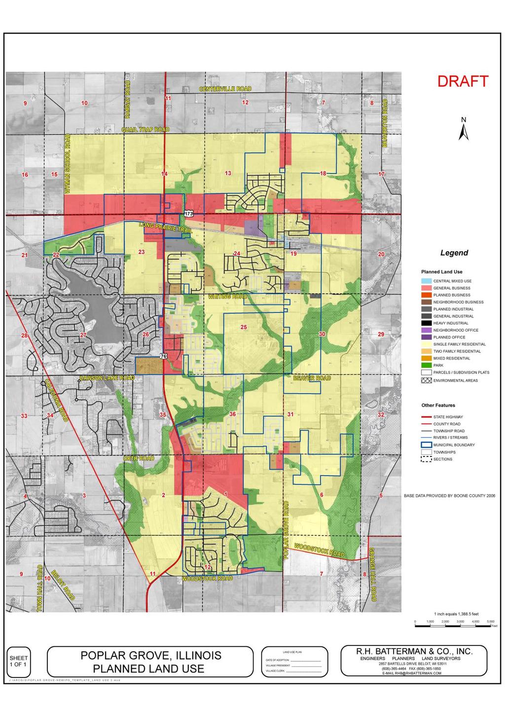
6 Comprehensive Plan Page 44 May 11, 2009 CURRENT AND FUTURE LAND USE PLAN The current land use plan for Poplar Grove is a guideline for the future growth and development of the village. The village of Poplar Grove has adopted a zoning map (pg 20 ) of the village comprising 16 different zoning classifications. This land use plan also includes territory one and one half miles beyond the corporate limits as of June The intention of the village plan is to develop as much territory for commercial and industrial use as a means of increasing revenues and employment opportunities. Major arterial roadway corridors have been identified for both commercial and industrial development to also take advantage of the existing transportation systems. Residential Areas Residential areas account for the major portion of the village land area. The following zoning districts are used to designate residential territory: A-1, A-2, R-1, R-2, R-3, and PCD (A Agricultural, R Residential, PCD - Planned Community Development). These districts are being identified as areas currently occupied by residential use or are residential for future developments. Full urban infrastructure has been identified as a requirement for developing residential neighborhoods including streets and water and sewer systems. In addition, pedestrian walkways and bicycle paths offer residents expanded recreation opportunities. All yards are expected to be landscaped to an accepted standard and maintained at all times. PCD districts require special approval as a separate development by village officials. Commercial Districts These areas are designated for current and future business development. The following zoning districts are used to designate commercial territory: C-1, C-2, C-3, and C-4 (CCommercial). The current commercial areas include the original downtown district, an area surrounding the Route 173 and Route 76, the Countryside Mall, and the entire length of Route 173 between Route 76 and Poplar Grove Road (State Street). The Countryside Mall on Route 76 is currently a center of commercial activity offering the potential for expansion in the future. Other areas where commercial activity should be encouraged include the Orth Road and Route 76 intersection to take advantage of the aviation industry interests. The Orth Road intersection with Poplar Grove Road has been zoned to take advantage of a neighborhood business potential. The advantage of neighborhood businesses is the close accessibility and the access for vehicles without entrances/exits through a major highway corridor. Commercial zoned areas should be identified in areas adjacent to the of the transportation corridors. The advantage of developing neighborhood businesses is the close accessibility for local residents and the access for vehicles without entrances/exits through a major highway corridor.
7 Comprehensive Plan Page 45 May 11, 2009 Agriculture Districts Agriculture districts include A-1 and A-2. Agriculture districts are historically land areas that were farmed before being annexed into the village and are grandfathered in by their current use. When an agriculture zoned property is proposed for development, it is automatically changed to an R-1 residential zoning. Any further zoning would require rezoning procedures. Hobby farms (two or more acres) are an allowable use in the A-2 areas. Industrial Districts Industrial districts within the village boundaries include I-1, I-2, and I-3. Industrial development, consistent with the vision for the village, should be encouraged to provide an enhanced tax base for the community as well as local jobs for residents. Areas currently identified are at the east end of East Park Street, some land adjacent to Route 173, and some of the areas in the vicinity of our WWTP in the south edge of the village. All industrial developments should do so with a regard to landscaping, noise, and pollution, and other factors to insure design consistent with the community character recommendations. Office/Professional Districts Office/Professional districts include O-1 and O-2. Office/Professional uses include limited use and is usually reserved for areas surrounding residential districts and may be blended with commercial districts as a part of a neighborhood business district. We currently have identified an area in the vicinity of the village hall on Hill Street and an area in the vicinity near the Candlewick gate. This type of development should meet the architectural standards for professional commercial space currently under development by the village. Park, Green Space, and Recreational Territory Poplar Grove has numerous areas in this category that have been previously identified for uses under this definition. Areas included within this category include land along the Beaver Creek watershed and its tributaries. Development should support both passive and active activities. Any plans for future use should include plans for protection of the environment before approval.
8
9 Comprehensive Plan Page 47 May 11, 2009 PARKS AND RECREATION A healthy and vibrant community requires adaptation of plans to provide recreational opportunities for all of the residents in the Poplar Grove area. Poplar Grove currently has parks and green spaces as shown in exhibit on page 19. Some of these areas are well developed and used extensively by residents and visitors alike while others require development and resident-based planning. As we progress and the Village grows, continued gap analysis to ensure sufficient Park space and facilities support the needs of the community. Recommendations: 1. Park District It is recommended that a Park District for the Village of Poplar Grove be developed, as recommended in the Community Character segment of this plan. The proposed district could initially include the northern part of the village not currently served by the Belvidere Park District. 2. Lions Park The present Lions Park provides multi-faceted recreational opportunities for the residents and a similar facility in the central or southern part of the village should be planned for the near future. 3. Pedestrian Walkways and Bike Paths A portion of the Long Prairie Trail Bike Path passes through Poplar Grove and is a significant recreational facility provided through the Boone County Conservation District. Expansion of the bike path through interconnection to residential developments should be encouraged. An interconnected system of biking and walking paths would be a substantial enhancement to the community. 4. Community Recreational Facilities The need for addition community facilities will become required as the population increases. These facilities could include a mixed-use community center, a communitybased library, or expanded recreational area.
10 Comprehensive Plan Page 48 May 11, 2009 FINANCIAL PLANNING AND MANAGEMENT Given the recent and anticipated growth of the community, the Village of Poplar Grove is at a critical junction relative to its financial discipline. The village needs to develop a new set of financial and management tools, reports, and discipline to effectively manage the quality of life and meet the operating and capital needs of the community. Recommendations: 1. Annual Budget Process While the current reporting systems and reports are fully compliant with all regulatory requirements, reports should be developed to assist the mayor and board in planning and managing the short-term operational needs as well as long-term capital projects. Additional procedures should be developed to further enhance budgeting and reporting functions. 2. Sinking Funds Procedures should be developed to create set asides or sinking funds to prepare for future replacement of major infrastructure facilities such as water or sewer systems. This is required as the village moves from developer-funded to tax-funded infrastructure. The result of this change can be a reduction or elimination of future debt/bond needs for the village. 3. Competitive Bid Process A process for reviewing bid processes for all contracted services should be developed to ensure the Village is receiving the most value for all contracted services. All contracts should be reviewed by the Finance Committee, legal counsel, and finally the full Board prior to execution of any agreements. 4. Fees and Taxes An annual review of village taxes and fees should be implemented. The costs of goods and services provided by the village are subject to the same financial challenges faced by businesses and families. Fees and taxes are used to fund the provision of services to the residents of the village. It is important to maintain the fiscal integrity of the village to meet both current and future costs associated with these services. A comprehensive review is required to ensure that the village will be able to continue to meet the needs of the residents of the community while maintaining financial integrity. This review will ensure any changes to the fee and tax structure are fair and balanced. Village of Poplar Grove, Boone County Illinois Comprehensive Plan Page 49 May 11, 2009
11 5. Accounting Systems An annual review of the financial processes and systems used by the village should be implemented. The financial systems used by the village must keep pace with the population increases and the mixture of residential and commercial changes. This is a short-term goal. 6. Capital Budget Planning A one, two and five year Capital Budget Plan should be developed by the Finance Committee and submitted to the board for review and approval on an annual basis. Implementation of this process will allow the Village to project future funding needs to meet the community s growth plan while maintaining a balanced revenue and expense budget on an annual basis.
3. VISION AND GOALS. Vision Statement. Goals, Objectives and Policies
 Vision Statement Queen Creek s interconnected network of parks, trails, open spaces and recreation opportunities provide safe and diverse activities and programs that sustain its unique, small town, equestrian
Parks, Trails, and Open space Element
 Parks, Trails, and Open space Element Parks, Trails, and Open Space element Parks, Recreation, and Open Space are important components of the quality of life desired by the residents of Elk Grove. This
S A C R A M E N T O C O U N T Y JACKSON HIGHWAY & GRANT LINE EAST VISIONING STUDY
 JACKSON HIGHWAY & GRANT LINE EAST S A C R A M E N T O C O U N T Y P L A N N I N G D E P A R T M E N T SUMMARY AND WORKBOOK November 19, 2008 History of the Visioning Study Sacramento County has two growth
V. Vision and Guiding Principles
 V. Vision and Guiding Principles The Master Plan for the Powers Ferry Corridor seeks a foundation in the desires of the community. At times, various elements of the community offered opposing viewpoints,
Chapter 10 IMPLEMENTATION RECOMMENDATIONS
 Chapter 10 IMPLEMENTATION RECOMMENDATIONS The recommended land use plan presented in the previous chapter provides a design for the attainment of the urban and rural development and open space preservation
Town of Peru Comprehensive Plan Executive Summary
 Town of Peru Comprehensive Plan Executive Communities that plan grow by choice, not by chance. A plan makes growth thoughtful, understandable, and predictable. A plan shows that a community is managing
CHAPTER 7: Transportation, Mobility and Circulation
 AGLE AREA COMMUNITY Plan CHAPTER 7 CHAPTER 7: Transportation, Mobility and Circulation Transportation, Mobility and Circulation The purpose of the Transportation, Mobility and Circulation Chapter is to
Joint Study Session of the Sutter County. March 2, 2009
 Joint Study Session of the Sutter County Board of Supervisors and Planning Commission March 2, 2009 CURRENT APPLICATION General Plan Amendment Specific Plan Specific Plan Appendices Utility Plans Transit/AQ
Executive Summary. NY 7 / NY 2 Corridor
 Executive Summary NY 7 / NY 2 Corridor Transportation and Land Use Study December 2005 Prepared for: Town of Colonie Capital District Transportation Committee Prepared by: Introduction: Land use decisions
Secrest Short Cut and Monroe Expressway Small Area Plan AUGUST 29, 2018
 Secrest Short Cut and Monroe Expressway Small Area Plan AUGUST 29, 2018 Background and Process Monroe Expressway will be open by the end of 2018 Union County and Indian Trail identified a need to revisit
CHAPTER 12 IMPLEMENTATION
 CHAPTER 12 IMPLEMENTATION The 2010 Town of Denton Comprehensive Plan is intended to capture a vision of the future of Denton. As such, it provides a basis for a wide variety of public and private actions
2030 Comprehensive Plan VISION STATEMENT
 RESOURCE DOCUMENT for Steering Committee Meeting #2 July 12, 2017 2030 Comprehensive Plan VISION STATEMENT Steering Committee from 2008 Established the Lauderdale s Vision as: Creating a livable, lovable
2.0 AREA PLANS. Lakeside Business District. Lakeside Business District Land Use Categories:
 Lakeside Business District Lakeside Business District Land Use Categories: Campus Commercial Campus Commercial means a mixture of uses which includes corporate offices, office parks, hotels, commercial,
NEW CASTLE COUNTY S ZONING DISTRICTS
 NEW CASTLE COUNTY S ZONING DISTRICTS This is general information about New Castle County s zoning districts. The information included is by no means exhaustive or complete. Before designing plans to develop
CHAPTER 7: VISION AND ACTION STATEMENTS. Noble 2025 Vision Statement
 CHAPTER 7: VISION AND ACTION STATEMENTS This chapter presents the vision, policy and action statements that transform the comprehensive planning study, an analysis of Noble s past, future trends and community
BROOKHILL NEIGHBORHOOD MODEL ZONING MAP AMENDMENT PREFACE TO APPLICATION
 BROOKHILL NEIGHBORHOOD MODEL ZONING MAP AMENDMENT PREFACE TO APPLICATION June 15, 2015 Revised: August 1, 2016 I. VISION Brookhill is a proposed community based upon the principles of Albemarle County
TREASURE COAST REGIONAL PLANNING COUNCIL M E M O R A N D U M. To: Council Members AGENDA ITEM 5I
 TREASURE COAST REGIONAL PLANNING COUNCIL M E M O R A N D U M To: Council Members AGENDA ITEM 5I From: Date: Subject: Staff December 12, 2008 Council Meeting Local Government Comprehensive Plan Review Town
The transportation system in a community is an
 7 TRANSPORTATION The transportation system in a community is an important factor contributing to the quality of life of the residents. Without a sound transportation system to bring both goods and patrons
4-Town Comprehensive Plan DRAFT 7/30/07
 4-Town Comprehensive Plan DRAFT 7/30/07 Acknowledgements ning Committee Town of Harrisburg Norman Roof Randy Nicol Town of Martinsburg Terry Thisse Paul Kelly Town of Montague Jan Bagdanowicz Wendy Perry
Implementation Guide Comprehensive Plan City of Allen
 Implementation Guide 2030 Comprehensive Plan City of Allen DRAFT 2015 Implementation Guide Allen 2030 Comprehensive Plan INTRODUCTION The Comprehensive Plan serves as a guide for the growth and development
This chapter describes the purpose of the Plan, introduces how the Plan is organized and provides contextual background for the Plan.
 Chapter 1: INTRODUCTION Purpose of a Comprehensive Plan The 2040 Comprehensive Plan establishes Medina s vision as a community and sets goals and objectives which guide future decisions and policies. The
SAN RAFAEL GENERAL PLAN 2040 INTRODUCTION AND OVERVIEW
 SAN RAFAEL GENERAL PLAN 2040 INTRODUCTION AND OVERVIEW Steering Committee Presentation February 14, 2018 Purpose of General Plan Guide land use and development decisions Coordinate transportation, infrastructure,
Small Area Plan. South Gateway
 Small Area Plan Adopted May 12, 2008 South Gateway Purpose. The South Gateway Small Area Plan defines the City s expectations for the future of the southern entrance to the City at Interstate 85 and Highway
Chapter 6: Community Character
 Chapter 6: Community Character The term "community character" covers a broad spectrum of concerns. First and foremost, community character is a visual concept. In Long Grove, however, community character
Parks, Trails, and Open Space Element
 P arks, Recreation, and Open Space are important components of the quality of life desired by the residents of Elk Grove. This Element of the General Plan addresses the City s goals, policies, and actions
Section 9 NEIGHBORHOOD DESIGN
 Section 9 NEIGHBORHOOD DESIGN City of Lancaster Comprehensive Plan D u n k i n, S e f k o & A s s o c i a t e s, I n c. NEIGHBORHOOD DESIGN INTRODUCTION There are many ways in which a neighborhood can
Hockessin Community Redevelopment Plan
 Hockessin Community Redevelopment Plan 3.1 Introduction The Community Redevelopment Plan for the Village of Hockessin is the result of the people s vision for a distinct village center that serves as the
1.0 Introduction. Purpose and Basis for Updating the TMP. Introduction 1
 1.0 Introduction The Town of Castle Rock is situated between the metropolitan areas of Denver and Colorado Springs, amidst a unique terrain of rolling hills, mesas, ravines, and waterways. Like many Front
COUNTY-WIDE PLANNING POLICIES
 Thurston County COUNTY-WIDE PLANNING POLICIES November 10, 2015 These policies were adopted by the Board of County Commissioners on September 8, 1992. They were ratified earlier by each of the seven cities
CHARLES PUTMAN CHARLES PUTMAN AND ASSOCIATES, INC
 MEMORANDUM CHARLES PUTMAN & ASSOCIATES, INC. LAND DEVELOPMENT CONSULTANTS PLANNING ZONING PERMITTING 4722 NW Boca Raton Boulevard, Suite C-106 Boca Raton, Florida 33431 Phone: 561/994-6411 FAX: 561/994-0447
EXHIBIT A. Tax Increment Reinvestment Zone No. 1 (Town Center) First Amended Project Plan 1
 First Amended Project Plan 1") EXHIBIT A Tax Increment Reinvestment Zone No. 1 (Town Center) First Amended Project Plan 1 1 As amended by Resolution No. 2008-02-001(TR1R) of the Tax Increment Reinvestment Zone No.1, and approved to
EXHIBIT A Tax Increment Reinvestment Zone No. 1 (Town Center) First Amended Project Plan 1 1 As amended by Resolution No. 2008-02-001(TR1R) of the Tax Increment Reinvestment Zone No.1, and approved to
HE VISION. Building a Better Connected Place
 HE VISION Building a Better Connected Place WALK INTO THE FUTURE. Life in Cranberry, 2030 Here s what our residents told us they wanted to see in their community by 2030: The Cranberry of 2030 is a place
Planning Districts INTRODUCTION
 INTRODUCTION To facilitate detailed examination of development prospects for all areas of the community, Delano has been divided into 14 planning districts. The location of these planning districts is
Port Lavaca Future Land Use
 Port Lavaca Future Land Use Introduction The City of Port Lavaca is beginning to see sustained growth, after many years of relative stable population. New single family homes, apartments, and businesses
9 CITY OF VAUGHAN OFFICIAL PLAN AMENDMENT NO BOCA EAST INVESTMENTS LIMITED
 9 CITY OF VAUGHAN OFFICIAL PLAN AMENDMENT NO. 631 - BOCA EAST INVESTMENTS LIMITED The Planning and Economic Development Committee recommends the adoption of the recommendations contained in the following
ARTICLE 6: Special and Planned Development Districts
 ARTICLE 6: Special and Planned Development Districts 6-10 Traditional Neighborhood Development (TND) District 6-10.10 Purpose and Intent The Traditional Neighborhood Development (TND) District provides
City of Heath. Town Center Concept
 In the give-and-take of getting projects designed, financed, and approved, the famous refrain from the film Field of Dreams is heard often: if you build it, they will come. From the perspective of the
Yadkin River Greenway Feasibility Study Fact Sheet Village of Clemmons, Town of Lewisville, Town of Bermuda Run
 Fact Sheet Village of Clemmons, Town of Lewisville, Town of Bermuda Run Project Background The Yadkin River Greenway Feasibility Study is a joint project with the Village of Clemmons, the Town of Bermuda
E. RURAL COMMERCIAL/INDUSTRIAL PARK MODEL
 E. RURAL COMMERCIAL/INDUSTRIAL PARK MODEL 1. PURPOSE The purpose of the Rural Commerce/Industrial Park Model is to provide parameters within which a grouping of business buildings with parking, loading
Sorted citizen input comments in review of Blount County plans July, August, and September 2007
 Sorted citizen input comments in review of Blount County plans July, August, and September 2007 The following presents sorted citizen input comments from three sessions held in July, August and September
Living in Albemarle County s Urban Places
 Living in Albemarle County s Urban Places ALBEMARLE COUNTY, VIRGINIA A Closer Look at Albemarle s Approach to Managing Growth and Creating Quality Urban Environments www.albemarle.org Page 2 Living in
The Vision. Photo provided by The Minervini Group. 46 Vision, Objectives & Strategies
 Vision, Objectives & Strategies The is the public framework and guide for future development of the Grand Traverse Commons. The establishes public polices for infrastructure, the preservation of natural
COMPREHENSIVE PLAN & UNIFIED DEVELOPMENT ORDINANCE
 Village of Forsyth COMPREHENSIVE PLAN & UNIFIED DEVELOPMENT ORDINANCE Community Planning #6 Prepared by: Vision Statement We envision the Forsyth Community as one which will continue to maintain a small
Proposed Comprehensive Plan Strategies DRAFT for discussion June 28, 2017
 Proposed Comprehensive Plan Strategies DRAFT for discussion June 28, 2017 Land Use Rural Areas Refine the Farm and Forest area (FF) Update FF boundaries to account for existing lots less than five acres
Warren County/Bowling Green Focus 2030 Comprehensive Plan VOLUME 1 INDEX
 Appendix 5: Index VOLUME 1 INDEX A Aesthetics ES-6, FLU-15, FLU-17, FLU-24, NCR-7 Agricultural Base FLU-18, FLU-20 Agricultural Centers, Rural FLU-11 Agricultural District NCR-17-NCR-18 Agricultural Economy
CITY OF COLWICH COMPREHENSIVE PLAN LAND USE LAND USE 1
 LAND USE LAND USE 1 WHAT YOU WILL FIND IN THIS CHAPTER: Discussion of today s conditions and tomorrow s projections Discussion of challenges and opportunities Discussion of the environmental quality goals,
Laberge Group. Town of Coeymans. Draft Comprehensive Plan. Overview of Planning Process
 Draft : Presentation of Goals & Strategies Laberge Group Benjamin H. Syden, A.I.C.P., E.D.P Director in Charge Nicole Allen, A.I.C.P. Senior Planner Anjali Malhotra Planner Presentation Outline Introductions
Vision Statement for the Town of Flower Mound Master Plan The Town of Flower Mound Master Plan furthers the established community based vision to:
 Vision Statement for the The furthers the established community based vision to: Preserve the country atmosphere and natural environment that makes Flower Mound a unique and desirable community; Mitigate
Burton Station Village Community Meeting February 26, 2014
 February 26, 2014 SGA Plan Overview Recent announcements by the City of Norfolk regarding the closure of Lake Wright Golf Course and retail development proposals Update on infrastructure improvement plans
Section 1. Executive Summary
 Executive Summary (This page left blank intentionally) Executive Summary Background Economic growth in southern Leavenworth County over the past decade has been strong. As both the number of business and
4.1.3 LAND USE CATEGORIES
 4.1.3 LAND USE CATEGORIES a. City Center District The City Center District incorporates the existing character and mix of uses in downtown Belmont to encourage redevelopment and new development in keeping
IMPLEMENTATION STRATEGIES. In This Chapter. Goals & Strategies 182 Project List 183 Future Land Use 186 CHAPTER 11 IMPLEMENTATION STRATEGIES
 In This Chapter Goals & Strategies 182 Project List 183 Future Land Use 186 11 IMPLEMENTATION STRATEGIES NORTH AUGUSTA, SC 2017 COMPREHENSIVE PLAN 179 Individual commitment to a group effort that is what
AWH REPORT OF THE PLANNING AND DEVELOPMENT DEPARTMENT FOR APPLICATION FOR REZONING ORDINANCE TO PLANNED UNIT DEVELOPMENT
 AWH REPORT OF THE PLANNING AND DEVELOPMENT DEPARTMENT FOR APPLICATION FOR REZONING ORDINANCE TO PLANNED UNIT DEVELOPMENT MAY 8, 2014 The Planning and Development Department hereby forwards to the Planning
OVERVIEW OF PLANS FOR THE JEFFERSON COUNTY COUNTRYSIDE FARM In the Context of Quality Place Characteristics
 OVERVIEW OF PLANS FOR THE JEFFERSON COUNTY COUNTRYSIDE FARM In the Context of Quality Place Characteristics By Steve Grabow, Professor and Community Development Educator University of Wisconsin-Extension,
Concord Community Reuse Project Goals and Guiding Principles. Overarching Goals (OG)
") Concord Community Reuse Project Goals and Guiding Principles Overarching Goals (OG) No priority is implied by the order of presentation of the goals and guiding principles. Overarching goals for the Concord
Concord Community Reuse Project Goals and Guiding Principles Overarching Goals (OG) No priority is implied by the order of presentation of the goals and guiding principles. Overarching goals for the Concord
SECTION E. Realizing the Plan
 SECTION E Realizing the Plan 60 DESIGN REGINA - OFFICIAL COMMUNITY PLAN SECTION E Realizing the Plan Design Regina has been an ambitious plan-making exercise, with a high level of community, stakeholder,
Silverdale Regional Center
 Silverdale Regional Center Vision for Silverdale Regional Center The Silverdale Regional Center Plan (Plan) will guide the evolution of the Silverdale Regional Center from a collection of strip malls and
Applicant Name Phone / Fax / Address City State Zip Code . Property Owner Phone / Fax / Address City State Zip Code
 Master Development Plan Application Community Development Department City of Redmond 411 SW 9 th Street Redmond, Oregon 97756 541-923-7721 541-548-0706 FAX Master Development Plan Fee $38,862.52 File Number
TREASURE COAST REGIONAL PLANNING COUNCIL M E M O R A N D U M. To: Council Members AGENDA ITEM 5H
 TREASURE COAST REGIONAL PLANNING COUNCIL M E M O R A N D U M To: Council Members AGENDA ITEM 5H From: Date: Subject: Staff October 17, 2008 Council Meeting Local Government Comprehensive Plan Review Draft
RECREATION AND OPEN SPACE ELEMENT GOALS, OBJECTIVES, AND POLICIES
 RECREATION AND OPEN SPACE ELEMENT GOALS, OBJECTIVES, AND POLICIES Goal 7 To provide park facilities, recreation programs, and open space resources that are safe, adequate, and accessible to all City residents,
Onondaga County Sustainable Streets Project. Onondaga County Planning Federation June 7, Onondaga County Sustainable Streets Project 1
 Onondaga County Sustainable Streets Project Onondaga County Planning Federation June 7, 2012 Onondaga County Sustainable Streets Project 1 Sustainable Streets 1. Introduction to the SMTC 2. Sustainable
General Location Annex, Rezone & Preliminary Plat Lansdowne Addition, Unit Three
 NEWFOUNDLAND I-5 Agricultural District Subject Site SUNDANCE ANDERSON Single Family Residential CHRISTY PUD Agricultural District Highway Business General Location Annex, Rezone & Preliminary Plat Lansdowne
RECREATION AND OPEN SPACE ELEMENT
 RECREATION AND OPEN SPACE ELEMENT Last amended August 19, 2008 Table of Contents Objective Page 5.1 Park system defined... 5-1 5.2 Access to parks and recreational facilities... 5-2 5.3 Recreation and
PUBLIC SERVICES ELEMENT GOALS / POLICIES / MEASURES
 PUBLIC SERVICES ELEMENT GOALS / POLICIES GOALS / POLICIES / MEASURES Authority The Public Services Element addresses provision of municipal services to City residents. The following paragraphs provide
2025 COMPREHENSIVE PLAN PASCO COUNTY, FLORIDA
 GOAL FLU 6: PASADENA HILLS FUTURE LAND USE: PASADENA HILLS AREA PLAN GOALS, OBJECTIVES, AND POLICIES PASADENA HILLS AREA PLAN: OVERVIEW The Pasadena Hills Area Plan Goals, Objectives, and Policies are
Staff Report to the North Ogden City Planning Commission
 Staff Report to the North Ogden City Planning Commission SYNOPSIS / APPLICATION INFORMATION Application Request: Concept review on a legislative application to rezone land located at approximately 1750
City of Hermosa Beach Administrative Policy #
 City of Hermosa Beach Administrative Policy # SUBJECT: Living Streets Policy Date: Approved by: City Council Authority: Public Works Department & Community Development Department Mayor, PURPOSE The City
Guiding Principles, Objectives, Strategies and Policies
 Guiding Principles, Objectives, Strategies and Policies Section 1 Introduction These Guiding Principles were adopted as part of the 1999 Athens-Clarke County Comprehensive Plan and are carried over, in
TABLE OF CONTENTS. Transportation Chapter 1 - Introduction and Purpose of Planning to 1-3. Utilities
 Chapter 1 - Introduction and Purpose of Planning... 1-1 to 1-3 Pennsylvania Municipalities Planning Code (Act 247)...1-1 Previous County Planning Activities...1-1 Objectives of the Plan...1-2 Elements
Chapter 5: Recreation
 Chapter 5: Recreation Introduction and Setting Recreational opportunities within Nevada County are varied, ranging from public parks with intensively used active recreational facilities, to vast tracts
Baumgarten MPUD. Exhibit 3 Evaluation Criteria
 Pursuant to LDC subsections 10.02.13 B, 10.02.08 F and Chapter 3 G. of the Administrative Code, staff s analysis and recommendation to the Planning Commission, and the Planning Commission s recommendation
DEVELOPMENT FRAMEWORK POST 2030 LAND USE PLAN INTRODUCTION
 INTRODUCTION Oak Grove s Comprehensive Plan identifies a future Metropolitan Urban Service Area (MUSA). The Metropolitan Council does not anticipate extending utilities to this area prior to 2030. The
Urban Development Areas Bedford County
 5 Urban Development Areas Bedford County UDA Needs Profile: All UDAs Bedford County has designated two UDAs: areas just outside the Bedford City Limits (generally to the south and east of the city) and
IH35 Corridor Plan Amendment to the Comprehensive Plan
 IH35 Corridor Plan Amendment to the Comprehensive Plan Background The corridor plan for the IH35 corridor is an amendment to the Burleson comprehensive plan. Generally, the purpose of a corridor plan is
Improve Neighborhood Design and Reduce Non Point Source Water Pollution
 HOW TO Planning Guide Improve Neighborhood Design and Reduce Non Point Source Water Pollution This document was funded by a grant from the New Hampshire Coastal Program with funding from the National Oceanic
Gold Line Bus Rapid Transit Transit Oriented Development (BRTOD) Helmo Station Area Plan
 Helmo Station Area Plan") Appendix F Gold Line Bus Rapid Transit Transit Oriented Development (BRTOD) Helmo Station Area Plan Introduction and Purpose of the Plan The Gold Line Bus Rapid Transit facility is an eleven-mile dedicated
Appendix F Gold Line Bus Rapid Transit Transit Oriented Development (BRTOD) Helmo Station Area Plan Introduction and Purpose of the Plan The Gold Line Bus Rapid Transit facility is an eleven-mile dedicated
The Village of Sugar Grove, in partnership with Kane County, the Illinois Department of Transportation, and the Illinois Tollway welcomes you to the
 The Village of Sugar Grove, in partnership with Kane County, the Illinois Department of Transportation, and the Illinois Tollway welcomes you to the first Public Meeting for the proposed interchange improvement
A. WHAT IS A GENERAL PLAN?
 I. Introduction A. WHAT IS A GENERAL PLAN? A general plan is the planning guideline for the future of a city. It contains goals and policies which regulate urban development, the protection of the natural
LAND USE ELEMENT. Purpose. General Goals & Policies
 LAND USE ELEMENT Purpose This Land Use Element contains the goals and policies necessary to support the City s responsibility for managing land resources and guiding development through implementing regulations,
Hibbing. Land Use. Hibbing Comprehensive Plan 8.1. Land Use
 Hibbing 8.1 Introduction 8.3 Information and Assessment 8.5-8.14 Recommendations 8.15-8.17 Implementation 8.18-8.19 8.2 Introduction Although land use was not identified as a discrete goal during the community
2025 COMPREHENSIVE PLAN PASCO COUNTY, FLORIDA
 GOAL FLU 6: PASADENA HILLS FUTURE LAND USE: PASADENA HILLS AREA PLAN GOALS, OBJECTIVES, AND POLICIES PASADENA HILLS AREA PLAN: OVERVIEW The Pasadena Hills Area Plan Goals, Objectives, and Policies are
Comprehensive Plan ADOPTED APRIL 2014
 Comprehensive Plan ADOPTED APRIL 2014 8 8. Outstanding Recreational & Cultural Opportunities We are proud of our community s parks and recreation system. Our community will ensure that the legacy of our
Developer s Program. The Station at East 54
 Developer s Program The Station at East 54 Existing Conditions The Station at East 54 is proposed for a 1.12 acre site at the northeast corner of Hamilton Road and Prestwick Road, tucked between the East
A citizen s guide to the. Comprehensive Plan. City of Lakeville, Minnesota 1
 A citizen s guide to the Comprehensive Plan 2008 City of Lakeville, Minnesota 1 Introduction The City of Lakeville completed an update of its Comprehensive Plan in 2008. A comprehensive plan is a tool
1.0 Circulation Element
 5/9/18 1.0 Circulation Element 1.1 Introduction As growth and development occur in Apache County, enhancements to its circulation system will be necessary. With time, more roads will be paved and air and
13 THORNHILL YONGE STREET STUDY IMPLEMENTATION CITY OF VAUGHAN OPA 669 AND TOWN OF MARKHAM OPA 154
 13 THORNHILL YONGE STREET STUDY IMPLEMENTATION CITY OF VAUGHAN OPA 669 AND TOWN OF MARKHAM OPA 154 The Planning and Economic Development Committee recommends the adoption of the recommendations contained
Chapter 2: Vision, Goals and Strategies
 Chapter 2: Vision, Goals and Lake Elmo Today & Tomorrow Comprehensive Plan 2040 2 VISION, GOALS & STRATEGIES - DRAFT 4-6-2018 INTRODUCTION Comprehensive Plan Purpose Perhapse the most important objective
OPEN SPACE CHAPTER 7: OVERVIEW. Preserve open space to protect natural resources, enhance character and provide passive recreation opportunities
 CHAPTER 7: OPEN SPACE OVERVIEW Ridgefield has made tremendous progress permanently preserving areas of town as open space. Open space preservation can serve many important purposes, including: protect
7Page 91 CLEMMONS COMMUNITY COMPASS 7 COMMUNITY CHARACTER
 7 Community Character The beauty of Clemmons won t necessarily be a reflection of our past, but our future. This quote from Comprehensive Plan Steering Committee member Wayne Dodson captures the essence
Future Land Use and Transportation
 Planning & Zoning Board Workshop Comprehensive Plan for Village of Estero Future Land Use and Transportation April 6, 2017 January Kick-off Meeting Public Input What do you like about Estero? Location
CHAPTER 4 FUTURE LAND USE AND URBAN SERVICES DISTRICTS
 CHAPTER 4 FUTURE LAND USE AND URBAN SERVICES DISTRICTS Introduction This chapter discusses how Benzie County should grow and change in the future. A community can grow and change in many different ways.
STAFF SUMMARY FOR S17-02 SPECIAL USE PERMIT APPLICATION
 APPLICATION SUMMARY Case Number: S17-02 Request: STAFF SUMMARY FOR S17-02 SPECIAL USE PERMIT APPLICATION SUP application in order to develop a convenience food store. Applicant: Property Owner(s): Cindee
IH35 Corridor Plan Amendment to the Comprehensive Plan
 IH35 Corridor Plan Amendment to the Comprehensive Plan Background The corridor plan for the IH35 corridor is an amendment to the Burleson comprehensive plan. Generally, the purpose of a corridor plan is
Draft Stillwater 2030 Comprehensive Plan- Goals and Policies
 Draft Stillwater 2030 Comprehensive Plan- Goals and Policies Instructions- Review each goal and policy and discuss with group any changes, deletions for additions to the list using your groups pen. Keep
TEMPLE MEDICAL & EDUCATION DISTRICT
 City of Temple, Texas TEMPLE MEDICAL & EDUCATION DISTRICT 1 Description. The City of Temple joined in partnership with key public and private entities to jointly promote education and medical activities
Town of Castle Rock DRCOG 2013 Annual Growth and Development Report. Introduction. Section 1 Metro Vision 2035
 Town of Castle Rock DRCOG 2013 Annual Growth and Development Report Introduction This is the Town of Castle Rock s sixth annual report to the Denver Regional Council of Governments (DRCOG) reporting on
Stafford County Strategic Plans
 Stafford County Strategic s Strategic Department Description Date Adopted Board of Supervisors Priorities Fiscal Responsibility Education Public Safety Infrastructure Economic Development Service Excellence
PLANNING COMMISSION WORKSESSION AGENDA. City Hall Second Floor Conference Room 9027 Center Street. July 1, :30 PM
 MEMBERS Harry J. Clark, Chairperson Bruce Wood, Vice-Chairperson Russell Harrison Ken Johnson Robert W. Schilpp Martha Wilson PLANNING COMMISSION WORKSESSION AGENDA City Hall Second Floor Conference Room
BUILDER LOTS FOR SALE
 BUILDER LOTS FOR SALE NORTHERN CULPEPER - 135 ACRES RESIDENTIAL DEVELOPMENT 1256 Old Bridge Road, Amissville, VA 20106 SALE PRICE: $995,000 LOT SIZE: 135+ Acres APN #: Tax Map 2 Parcel 23 ZONING: R-1 ACCESS:
EXECUTIVE SUMMARY DRAFT CHAPTER 1 INTRODUCTION EXECUTIVE SUMMARY
 CHAPTER 1 EXECUTIVE SUMMARY INTRODUCTION Through the joint efforts of the City of Tulsa planning staff and the Land Services division of Indian Nations Council of Governments (INCOG), the Berryhill Land