Elliot Park 5. Neighborhood Master Plan. Design Guidelines
|
|
|
- Adelia Barton
- 5 years ago
- Views:
Transcription


1 Elliot Park 5 Neighborhood Master Plan August 2002


2 Types of Guidelines Introduction The is intended to be a framework within which creative design can and should occur. The following detailed guidelines were prepared to further define the character, purpose and structure of the plan. In all cases, the guidelines must be applied in harmony with other existing neighborhood and City plans, programs and initiatives that support desired objectives for the Elliot Park neighborhood. The chapter is organized into the following categories: Neighborhood Guidelines Streetscape Site Development Architecture Parking Access and Connections Guidelines Downtown Mixed Use Residential Central Core Historic 9th Street Guidelines Destination Streets Connector Streets Neighborhood Streets This icon will appear at the top of each page to identify the type of guideline discussed. Definitions and Context These guidelines are organized so that every street and every block within the Elliot Park neighborhood can be considered at some level of detail - even if no specific project or improvement has been suggested as yet in the Master Plan. In this way, future projects and neighborhood initiatives, yet to be determined, will respond to the same guidelines as the projects already underway. This will ensure that ongoing redevelopment work meets the intent of the plan while promoting the desired continuity and design direction over time. A general summary, included here for each guideline category, provides a quick reference to the various sections of this chapter. Neighborhood Guidelines: There are a number of guidelines that apply to the entire Elliot Park neighborhood, including recommendations for streetscape, site development, architecture, parking, transit and pedestrian/bicycle connections. These guidelines provide the basis for more detailed decision-making related to overall neighborhood character (aesthetics and identity), preferred building types (scale and massing) and thoughtful urban design (land use and public space). Neighborhood Neighborhood 2


3 Guidelines: As part of the planning process, Study Team and stakeholder workshops identified a variety of unique visual qualities and physical features that characterize specific areas within the neighborhood. These districts, described in the Master Plan (Chapter 4), are important to consider both as separate 'zones' and as integrated pieces of the overall plan. These guidelines were created to further define the essence of each district while providing specific suggestions for preservation, protection and ongoing improvements. Neighborhood The primary purpose of these guidelines is to clarify and direct innovative solutions for streetscape improvements, best site development practices and high quality architecture. Guidelines: The Master Plan identifies a hierarchy of street types that define various corridors passing through or serving the neighborhood districts. As a means to describe the specific visual quality and physical characteristics for each, the corridor guidelines provide recommendations related to street function, transit use, width (dimensions), parking and other amenities or improvements. Neighborhood 3


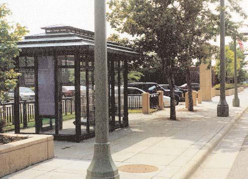
4 Neighborhood Guidelines - Streetscape Introduction Streetscape guidelines refer to the visual character and physical improvements for public rights-of-way in the Elliot Park neighborhood. The goal is to foster a safe and interesting public realm to invite pedestrian activity, promote traffic calming, increase transit use and encourage community gathering. Streetscape Components Summary Plants Lights Walls and Fences Pavements Furniture Public Art Street trees are the major element, planted in both formal and informal patterns throughout the neighborhood. Additional interest and seasonal color provided by flowers, grasses and bulbs with an emphasis on native species. Light poles and fixtures are also very prominent elements along the street. Provide various heights and styles to meet City standards for lighting levels including street, walkway, plaza, park and other public spaces. Walls and fences add interest and identity to the street and help identify or transition from public to private space. They also bring emphasis to specific spaces or mimic architectural materials at street level. Changes in color and texture underfoot can add both visual and physical variety to the street. Special pavements mark crosswalks and emphasize special use areas. Although sometimes an attractive nuisance, street furniture can be a welcome addition at transit stops, building entries, parks and other public spaces. Furniture needs to be durable and easy to maintain. Many opportunities occur throughout the neighborhood to integrate public art as part of signage, lighting, furniture, walls and fences. There also are opportunities for sculpture, murals and other installations. Plants Planting includes street trees, flowering trees and other landscape materials along the public right-of-way such as flowers, grasses, bulbs and groundcovers. The primary goal of streetscape plantings is to maintain and improve the 'urban forest,' a significant Minneapolis asset. plant street trees; spacing should be 30 minimum refer to the City tree master plan and consult City forester to review selection of appropriate tree species include annual and perennial flowers, strategically located shrubs and other types of plantings to provide screening, define space and add variety, seasonal color and highlight important neighborhood nodes or gathering places Lights Lighting includes pedestrian-scale lighting (the familiar acorn' or 'lantern' globes atop 12' posts) and other seasonal, special event related and/or architectural lighting. ensure that the type, spacing and quality of fixtures will provide consistent lighting levels along the street minimize glare onto adjacent properties and into vehicular traffic on the street use City of Minneapolis standard fixtures and posts at recommended spacing throughout the corridor increase lighting levels at primary nodes, special use areas and street intersections by using a combination of multi-headed fixtures and tighter spacing 4


5 Walls and Fences These include metal, brick, stone and other materials used to separate discrete spaces, strengthen the definition and character of a space, and define the edge between private and public property. select materials appropriate to specific site conditions, land use and architectural character work with property owners and commercial tenants early in the process to discuss opportunities for improvements on private property, including design character, materials, cost, maintenance issues and other concerns work with the City early in the process to discuss opportunities for improvements within the public right-of-way, including design character, materials, budgets, schedule, special service district options and other concerns Pavements Special pavements include textured, colored concrete, stone and unit pavers for sidewalks, crosswalks, transit stops, medians, gathering places and neighborhood connection points. use creative scoring of standard concrete for sidewalks with additional detail and change of materials at important nodes, crosswalks and transit stops focus available streetscape budget on more visible elements, such as lighting, plantings and fencing explore opportunities to stamp concrete with neighborhood logo or street names to express community identity or provide public art opportunities work with the City Public Works Department to explore creative options for street crossings including a change in pavements or more interesting striping or marking Furniture This includes benches, trash receptacles, newspaper boxes, transit shelters and other furnishings. Furniture should be used to accent special use areas, transit stops, providing places for rest, waiting, meeting and people watching. street furniture should match, or complement color, scale and detailing of adjacent buildings and other streetscape improvements street furniture should be constructed from comfortable and durable materials, such as wooden bench slats or powdercoated metals in collaboration with Metro Transit staff, pursue additional transit stops and shelters, potential relocations and stop improvements Public Art Public art can either be infused throughout other streetscape elements, such as fences, walls, signage and furniture, or can be created as stand-alone (but integrated) pieces, such as murals and sculpture. identify opportunities for public art and cultural celebration at many scales and locations throughout the neighborhood collaborate with the many neighborhood artists living in the area to help define and implement a public art master plan work with City staff and developers to include public art and gathering space as an intentional center piece for new development projects 5


6 Neighborhood Guidelines - Site Development Introduction Site development guidelines bring definition to the interface between the building edge and the variety of public spaces that characterize the Elliot Park neighborhood. These guidelines imply a strong link between architecture and site - how buildings define or are defined by the spaces around them, and the visual and physical connections to the public realm. Site Development Components Summary Land Use New development in Elliot Park will continue to include a mix of housing, retail, office, restaurant and recreational uses. New development will blend with and enhance existing neighborhood uses, amenities, landmarks and character. Safety and Security Elliot Park will continue to promote policies and procedures to ensure that all citizens feel welcome, safe and protected as part of this community. Setbacks New development should fit within the existing character and fabric of each district, placing buildings close to the street, matching existing setbacks where appropriate. Parks and Open Space Providing a linked system of public parks and open spaces is critical to the health and well being of neighborhood residents, workers and visitors. Provide opportunities for both large and small scale neighborhood breathing space integrated into site scale and block scale development. Maintenance Provide a detailed list of maintenance needs and a specific approach and budget to meet those needs. Encourage creative, shared programs and policies to match funding and human resources to address maintenance challenges. Management Match Police efforts with neighborhood initiatives to identify and address specific behavior and nuisance issues. Maintain property inventories (use GIS mapping) to monitor status and health of neighborhood properties. Land Use This addresses the proposed mix of uses, both adaptive reuse and infill opportunities, which meet specific neighborhood objectives for new housing, business growth and public open space. periodically re-evaluate the Elliot Park Master Plan based on new market information, neighborhood polling, questionnaires and changing land use patterns to determine the mix of uses which best serve neighborhood needs periodically re-evaluate new development opportunities and specific sites made available by ongoing refinements to the Master Plan and evolution of neighborhood objectives Safety and Security This responds to both the perception and reality of 'safety', the intuitive feeling and need for human comfort, fit and belonging. Safety and security must be addressed on several levels including physical design, community 'eyes on the street' and standard policing procedures. (see Management) require that new development and redevelopment projects create and maintain clear sight lines to building entries, parking areas, the sidewalk and other buildings encourage outdoor use areas, including sidewalk seating and patios with views of the street, for new and existing buildings ensure adequate but not excessive lighting levels throughout sites work with property owners and City to ensure high maintenance levels, trash pickup, graffiti cleaning (see Maintenance) continuity of the interior/exterior view 6
, matching existing building setbacks to provide continuity and encourage visual and physical")


7 Setbacks Setbacks are the defined distance a structure is 'set back' from a given reference point such as a street right of way line, property line or another structure. in most cases, new construction projects should place buildings close to the street (along edge of walk), matching existing building setbacks to provide continuity and encourage visual and physical interaction between building uses, sidewalk and street Parks and Open Space This includes areas along the street that accommodate the public or semi-public activities of the neighborhood. Public parks and open space are essential to a successful neighborhood. These amenities must invite programmed, unprogrammed, active and passive uses of public space. provide a continuous, accessible and recognizable system of public spaces linked to city streets and sidewalks, to local and regional parks/trails, to the Mississippi River, to local and regional attractions and other area amenities Maintenance Successful planning and project implementation must include a defined program and detailed budget for ongoing maintenance operations. Even the most exciting projects and interesting destinations quickly lose their appeal if the trash is not collected, snow is not removed or streetlights are not replaced on a regular basis. define a specific budget and approach to meet the maintenance needs of existing neighborhood amenities and proposed improvements implement a regular program and schedule for sidewalk cleaning, snow removal, trash collection and streetlight repair/replacement explore various approaches, including special service districts, paint-up/fix-up programs and other options to meet maintenance needs Management This includes the policies and procedures needed to monitor and respond to behavior and nuisance issues. Although some of these issues can be met by standard Police department activities, some guidelines should address the less tangible challenges related to respectful, thoughtful behavior. For example: special events/celebrations, operating hours for bars/restaurants and so on. provide specific, published policy and procedure guidelines encourage consistent follow-through to target issues and meet specific neighborhood needs create and update (on a regular basis) GIS data files to monitor status and health of neighborhood properties 7
, adaptive re-use of existing structures and a variety of facade improvement and paint-up/fix-up initiatives.")

8 Neighborhood Guidelines - Architecture Overview Architectural guidelines describe the character, elements and desired direction for design and construction of buildings proposed in the Neighborhood Plan. These guidelines address new construction (both residential and commercial), adaptive re-use of existing structures and a variety of facade improvement and paint-up/fix-up initiatives. Some places are memorable because of the architectural uniformity of surrounding buildings. Other places have a more eclectic character, created over time with fewer constraints and less uniformity. Each has its own charm. Although the Elliot Park neighborhood has a mix of buildings and spaces, future development should reflect the best of the neighborhood's existing character while allowing opportunities to explore high-quality contemporary design solutions. This will serve to emphasize Elliot Park's vitality comes, at least in part, from this diverse mix. Architects frequently use familiar words in unfamiliar ways to describe ways of engaging people with their surroundings. These guidelines provide both written and photographic descriptions to help create a common understanding of what we mean by these terms and of how they can be applied to the Elliot Park neighborhood environment. Scale Scale refers to the relationship between the size of a person and the dimension of spaces and building elements. Appropriately scaled buildings create "the good fit" within sensitively-designed places. A number of older buildings in the Elliot Park neighborhood offer examples of appropriately scaled facades that relate to human scale. the Elliot Park Master Plan supports the idea of increased density and intensifying the mix of uses at specific nodes, which suggests that this community should examine a new scale of architecture at these locations: generally 4 story, but not to exceed 10 story buildings proposed development should reflect the scale of existing adjacent buildings where appropriate, (i.e. given that there is a good contextual model to build upon) building scale should respond to adjacent parks, open space and the public realm Massing Massing addresses the volumetric size and articulation of building elements. Buildings can feel too bulky or too small for their sites; in such cases, a building seems out of place. For larger structures, the perceived massiveness can be reduced by stepping the building's height up or down and breaking the facade into distinct elements. as new buildings are constructed in the Elliot Park neighborhood, the most appropriate of existing buildings should provide cues for massing larger buildings are certainly appropriate facing the street, but their massing should be responsive to their context, especially as they relate to smaller residences fronting on side street. landscape solutions, including street trees, layered plantings and plantings for seasonal color should be used to enhance existing buildings that feel too small 8

 may be set farther back from the street, but")

9 Spatial Enclosure This addresses the sense of free-flowing or confined space. Typically, urban areas tend to be characterized by more enclosed, defined public spaces surrounded by buildings. Currently, the Elliot Park neighborhood has several vacant lots and many parking lots that reduce the continuity and spatial enclosure of the street as an outdoor room. new buildings should be constructed within six feet of the street property or right-of-way line and should extend as long as practical to define and contain space at the street's edge at open lots, fencing, trellises, trees and other plantings should be employed to continue the street wall multi-family residential housing (apartments, townhomes) may be set farther back from the street, but building scale and massing and site treatments must be increased to compensate for this shift Rhythm Rhythm addresses the regularity or irregularity of recurring features or elements that make up the building, such as windows, porches and bays. The Elliot Park neighborhood has a diverse collection of buildings with varied forms, functions, and design motifs. When there is a regular rhythm of building forms and elements, differences seem less significant and individual structures tend to merge into a more harmonious unit. Such regular patterns amplify the natural rhythms of movement, encouraging people to continue walking along a street. When an overall rhythm of building elements is established, unique elements become more valued and meaningful. new buildings should strengthen the rhythms of the Elliot Park neighborhood by emphasizing increased activity at neighborhood nodes (see the Master Plan Chapter 4) and the continuity of the building wall along the street between nodes over several decades, this would help knit the street's buildings into a cohesive fabric the most immediate way to develop a regular rhythm, however, would be through planting of street trees at regular intervals Proportion and Orientation This refers to the dimensional and directional relationship between the formal elements that shape a space or a building and its facades within the overall composition. Buildings in the Elliot Park neighborhood generally have a horizontal orientation, that is, their facades are longer than they are tall. upper floors should be more balanced between vertical and horizontal orientations the lack of containment on the street detracts from the intensity of the experience there (see Spatial enclosure) 9


10 Neighborhood Guidelines - Architecture Solar Access Solar access defines the capacity of a site or building to receive unobstructed sunlight. We are becoming increasingly aware of the physiological benefits and the alternative energy potential of sunlight. Especially in dense, urban neighborhoods, it is important to encourage infill projects that take advantage of passive solar heating, but at the same time include careful design to minimize shadows on adjacent properties. as new buildings are constructed in Elliot Park, the direct access to sunlight enjoyed by adjacent residences and other buildings on the street should be maintained new buildings should be of limited height, set back from property lines, or stepped down toward adjacent properties so that solar access is maintained Entry Conditions Entry elements define the character of access into and within buildings, such as roof overhangs, raised porches, railings, recesses and other projecting forms. A building's entry tells us in subtle ways that we are welcome and, in some cases, how we are expected to act upon entering. building entrances should be oriented toward the front of the building and toward the street whenever possible employing recesses, porches, transparent entry systems and other elements should convey an inviting, and open impression a regularly spaced series of entrances along the street is preferable to a single entry in long buildings Facade Materials and Building Signage This refers to the types of materials selected and the mixing of materials to create a building facade. During the past hundred years, building materials have expanded from a limited range of natural materials to an array of synthetic materials. As a consequence of using these new materials, our built environment has become less homogeneous and less cohesive. The Elliot Park neighborhood exhibits a wide range of building materials: wood, brick, metal, concrete masonry, stucco, plastics and others. This is partially due to the variety of building types ranging from single-family houses to light industrial structures. Signage materials and design are included as part of a building s facade. future buildings should employ materials of high quality, durability, and character, taking into account the balance of life-cycle costs with first costs of the material glass, steel and masonry are encouraged - plastics and aluminum are discouraged except in limited applications large backlit signs on high poles will not be allowed as they create an environment that does not encourage an active pedestrian environment 10


11 Roof Forms and Materials This refers to the shape of the roof, its composition, and the selection of materials used to cover it. Roof forms can enliven a building and a streetscape. Roof materials can also add texture and color to attract attention and interest as people walk or drive along the street. The buildings in the Elliot Park neighborhood have varied roof forms and materials. where appropriate, roof elements may be used to mark key street intersections or focus attention on significant buildings by using roof forms and materials that relate to each other up and down the street, a more harmonious streetscape can be achieved in structures with flat roofs, facade and parapet details become more significant Public/Private Continuum This defines the subtle changes in space and forms that traditionally inform people when they are moving between public and private places. As new development occurs, the greatest challenge for builders and the neighborhood will be to create a design continuity of forms, materials, and spaces without diminishing the variety that makes Elliot Park a distinctive neighborhood. buildings in Elliot Park should provide a sense of arrival and of transition from their most public to most private spaces. For example, the street and public sidewalk are the most public and the residential interior or "back of the shop" are the most private a variety of building and site elements can be employed for the semi-public and semi-private spaces: planting buffers, entry recesses or porches, vestibules and lobbies, etc. can fulfill these intermediate roles Exterior/Interior Connection This addresses the necessity of providing visual connectors, through the use of windows and glass entries, to connect the interior spaces of a building to the exterior public realm. These connectors draw people out of the buildings and into the street both visually and physically and from outside in (such as store fronts) thereby increasing street life and safety. discourage temporary and permanent commercial window signage which blocks the views into or out of buildings future development needs to encourage numerous window openings and multiple entry points along the street edge 11


. Objective #2 - Manage parking to meet Elliot Park neighborhood needs, not downtown needs.")
12 Neighborhood Guidelines - Parking Parking Approach In keeping with traditional urban design principles, the street is designed to accommodate the car while not allowing it to dominate. The same holds true for parking. To meet long range plans for new development in Elliot Park, parking strategies must provide an appropriate balance of on-street, small surface lot and structured parking solutions. Manage on-street parking to meet specific needs of each district. Continue to explore shared parking solutions or creative infill development for existing surface lots. Turn this... The Master Plan (Chapter Four) identifies a number of distinct districts within the neighborhood, with unique qualities and numerous opportunities for redevelopment within each. As part of this guidelines chapter, the 'district parking approach' was introduced as a means to target overall parking needs and still address specific needs for each district. More detailed recommendations are included in the 'district guidelines' section and are based on the following overall parking objectives: Objective #1 - Meet each district's parking needs internally (i.e., within the general area of each district). Objective #2 - Manage parking to meet Elliot Park neighborhood needs, not downtown needs. Objective #3 - Market Elliot Park as a neighborhood where one can live/work without needing a car (or perhaps only one car per household). establish EPNI as a (not-for-profit) parking management district develop and manage off-street parking resources review zoning provisions, parking requirement, compliance for new development investigate (with City departments) potential changes in regulations and policy to support district parking strategies explore and implement shared off-street parking programs manage on-street parking as appropriate for each district, including meters, signed time limits and residential permit parking coordinate with Downtown Transportation Management Organization and Metro Commuter Services to reinforce commute alternatives for businesses/employees monitor parking demand by land use type and use to identify parking requirements within the neighborhood - provide outreach/information to residents and students to encourage reduced automobile use or dependency consider demonstration car-sharing or short term auto rental programs for neighborhood residents to reinforce reduced car ownership needs...into this. 12


13 Neighborhood Guidelines Access & Connections Transit Elliot Park is already well served by transit, with multiple express and local bus routes operating throughout the neighborhood. Two enhancements to the existing system are proposed: Extend Metro Transit service along Chicago Avenue north to connect Elliot Park with the Downtown East Hiawatha LRT station - the existing Route 5 that serves the neighborhood turns into downtown along Seventh Street South, two blocks short of the Downtown East LRT stop, and four blocks short of Washington Avenue. Introduce a new Downtown Circulator route to connect Elliot Park to Loring Park and the riverfront area that would use 15th Street, Chicago Avenue, 14th Street, and 11th Avenue through the neighborhood. This service would ultimately provide a circumferential route along downtown to connect Elliot Park, the riverfront, the Historic Mills, entertainment, residential and the Loring Park areas. The neighborhood should work with Metro Transit to identify and integrate other transit improvements such as: more shelters, adequate transit stops and opportunities for a neighborhood circulator system. This planted center median calms traffic and provides a pedestrian safe zone along Lexington Parkway, St. Paul. work with City representatives to explore street design alternatives that promote a balance of uses work with City representatives to define specific objectives for traffic calming, safe crosswalks and streetscape improvements Pedestrian and Bicycle Increasing pedestrian movement and bicycle use can be accomplished in two ways: first, provide the physical facilities and improvements that will encourage foot and bicycle traffic; second, ensure that pedestrian/bicycle systems are designed and located next to safe, highly visible and interesting places to be, connected with the street and the mix of neighborhood uses/activities. Creative bike facilities like these... pursue opportunities for dedicated bike lanes/trails either on or off-street as part of the local and regional bike plan provide connections to regional pedestrian and bicycle systems ensure that detailed design and construction of new bicycle facilities support or integrate with existing neighborhood programs already underway 13
, is important to consider both as a separate 'zone' and also how it fits within the overall neighborhood.")
14 Guidelines - Overview Introduction As part of the planning process, Study Team and stakeholder workshops identified a variety of unique visual qualities and physical features that characterize specific areas within Elliot Park. Each district, described in the Master Plan (Chapter 4), is important to consider both as a separate 'zone' and also how it fits within the overall neighborhood. guidelines in this section were created to further define the essence of each district while providing specific recommendations for preservation, protection and ongoing improvements. Character Summary Context Scale Land Use Landmarks Residential Central Core Historic 9th Street Mixed-Use Southern portion of the neighborhood Mostly 2-4 stories Single and multi-family housing Confluence of the various 2-5 stories Housing, retail districts, neighborhood districts storefront office The transition between downtown 2-5 stories Primarily residential architecture and traditional single-family residential blocks Transition zones to and from freeway 2-5 Stories Mix of housing, office access routes and light manufacturing Many significant properties Band Box Diner Historic residential properties Strutwear Building Downtown Transition between mid-rise downtown stories to 6 stories Retail on first floor; primary and the residential neighborhood along 8th Street office, possible residential on upper floors Armory, Lutheran Brotherhood How to use these Guidelines Guidelines for each district include a reference map and brief description of location followed by recommendations related to scale, land use, landmarks and district parking strategies. Small photographs in the side bars show existing conditions accompanied by a larger image illustrating proposed improvements, suggested development character or other district opportunities. 14
 and I-94.")


15 Guidelines - Residential Location This district covers much of the southern area of the neighborhood, between Grant Street/14th Street (proposed Elliot Park Boulevard) and I-94. Scale Infill and new housing - two to four stories. Do not encourage any additional mid-rise development. Land Use Single and multi-family housing. Encourage infill housing within these blocks. Develop new housing between Chicago and Portland Avenues and 14th Street (Elliot Park Boulevard) and 15th Street. Mixed-use development along Chicago Avenue should be encouraged. Landmarks and Amenities Develop an historic housing overlay district for the area south of 15th Street, between Elliot and 12th Avenues to preserve and enhance existing residential properties. Parking Strategies Promote strategies for shared parking - commercial uses during the day, residential at night. Designate on-street parking for residents only (permit parking); discourage street parking for downtown workers. Promote strategies for reduced parking demand, car dependency in Elliot Park. Provide small, dispersed surface lots New development should provide underground parking. Current Character Current Character Proposed improvements will preserve and enhance the character of residential areas. Example 15


16 Guidelines - Mixed Use Location Transition zones to and from freeway access routes. Mix of uses includes residential, churches, small commercial and institutions. Current Character Scale Housing in this district should be two to five stories and should be similar to the type of density achieved at the East Village. Office and light manufacturing to eight stories. Scale, massing and rhythm of new development should follow the existing texture. One-quarter block facades should be encouraged. Land Use Mixed-use development of housing, office and light manufacturing. Develop housing around the 8th Street and 11th Avenue intersection. Current Character Landmarks and Amenities Explore opportunities for public gathering space across from the Strutware building at 11th Avenue and 7th Street. Develop streetscape improvements along 11th Avenue. Develop neighborhood freeway gateways along 7th and 8th Streets. Right-size 8th Street to reduce visual and physical impacts of this high traffic street. Narrow street as much as possible to add width to public walkways. Example Parking Strategies Provide some on-street parking. Promote below grade parking for all new construction. Encourage shared use of parking structures. Promote reduction of surface lots. Proposed development could include a mix of residential over office uses. 16

 stepping down to 6 stories along 8th Street.")


17 Guidelines - Downtown Location The Downtown of Elliot Park is the transition zone between the mid to highrise downtown buildings in downtown and the three to four story buildings in the neighborhood. Current Character Scale 12 to 16 stories in the northwest corner (north of 8th St. between 5th and Park Ave.) stepping down to 6 stories along 8th Street. New developments must be (or perceived to be) no larger than a quarter-block scale. Scale, massing and rhythm of new development should follow the existing texture. Current Character Land Use Primarily office to accommodate the growing downtown. Retail at the first floor, possibly with housing on the upper floors. Landmarks and Amenities Continue efforts to develop the Armory as a neighborhood and downtown community asset. Develop streetscape improvements along Portland, Park and Chicago Avenues. Develop Chicago Avenue as a neighborhood Main Street. Increase urban open space around the edges of the Armory building. Parking Strategies Increased use of below grade and structured parking. Elimination of surface parking. Larger scale buildings can also provide interesting detail and pedestrian level amenities to create safe and inviting places for neighborhood interaction. Example 17


18 Guidelines - Central Core Location Confluence of the downtown, residential and mixed-use districts. This district should be the neighborhood core, the center of social activity, and serve as the transition zone between the other districts, emphasizing pedestrian scale and use. Current Character Scale Two to five stories blending with the existing historic buildings. Scale, massing and rhythm of new development should follow the existing historic texture. One-quarter block facades should be encouraged. Land Use Mixed-use development of housing and commercial space. New housing fronting on proposed Elliot Park Boulevard. Current Character Landmarks and Amenities Develop a significant open space/plaza around the Centennial/10th Street intersection. Develop streetscape improvements within this center core. Develop Chicago Avenue as a neighborhood Main Street. Image intersections should be developed along Portland, Park and Chicago Avenues. New traffic circle at Chicago Avenue and 9th Street. Example Parking Strategies Promote strategies for shared parking - commercial uses during the day, residential at night. Provide small, dispersed surface lots. New housing should provide underground or off-street (screened) parking. Explore on-street parking options, including angle parking to increase spaces on narrow, quiet streets. Consider residential parking permits. Pedestrian scale amenities and ground floor shops/restaurants create safe, active streets. 18


19 Guidelines - Historic 9th Street Location Housing along 9th Street is the transition between downtown architecture and traditional single-family residential blocks. Current Character Scale This housing should be two to five stories to blend with the existing historic buildings. Scale, massing and rhythm of new housing should follow the existing historic texture. One-quarter block facades should be encouraged. Land Use Primarily residential with limited commercial and storefront office on the first floor. Landmarks and Amenities Create a larger historic overlay district to enhance existing historic buildings. Develop streetscape improvements along 9th Street. Image intersections should be developed along Portland, Park and Chicago Avenues. Current Character Parking Strategies Promote strategies for shared parking - commercial uses during the day, residential at night. Explore on-street parking options, including angle parking to increase spaces on narrow, quiet streets. Consider residential parking permits. Provide small, dispersed surface lots. New housing should provide underground or hidden off-street parking. Streetscape themes, continuity of materials, color and texture highlight historic streets and districts. Example 19

20 Guidelines - Overview Introduction The patterns of traffic movement to and from the Downtown core exert both positive and negative influences on the Elliot Park neighborhood. The existing street grid that serves these movements has, over the years, created the impression that Elliot Park is mostly a pass-thru neighborhood. Measures to address both local and regional connectivity, while at the same time responding to livability issues, would moderate the influence of major traffic movements on the neighborhood. The Master Plan identifies a hierarchy of street types that define various corridors passing through or serving the neighborhood districts. As a means to describe the specific visual quality and physical characteristics for each, corridor guidelines provide recommendations related to street function, transit use, width (dimensions), parking and other amenities or improvements. Character and Summary Guidelines Function Transit Use Street Names Parking Amenities Type Destination Streets Connector Streets Local Connector Streets Regional Neighborhood Streets active, signature streets supporting retail, restaurant destination uses streets that link local amenities and attractions; one way pairs streets that link regional destinations to the freeway system; one-way pairs quiet, walkable streets - off the main street network bus transit route; enhanced transit stops bus transit route; enhanced transit stops major transit route; bus and LRT improvements bus transit routes and stops nearby Chicago Avenue 11th Avenue 9th Street Elliot Park Blvd. Portland Avenue Park Avenue 7th Street 8th Street 5th Street 6th Street 4th Avenue 5th Avenue All other Streets bump outs; parking on both sides bump outs; Parking on both sides no bump outs; parking on both sides no bump outs; parking on both sides variety of street improvements to encourage pedestrian/bike activity enhance streetscape to improve pedestrian and bike movement enhance streetscape to improve pedestrian and bike movement less intense treatment to match quiet street quality Right Sizing the Streets The size of the roadway, in terms of how many through lanes are required to satisfy movement needs, is a necessary component for determining how a street interfaces with the urban design goals for a corridor. Right sizing seeks to achieve a level of movement appropriate to each corridor while minimizing the number of through lanes. This is accomplished by setting movement goals (Levels of Service) that reflect traffic delay appropriate to the urban environment in Elliot Park. The suggested street requirements are based on the assumption that a reasonable amount of delay equivalent to a high Level of Service D is expected in such an urban environment. The use of one-way or two-way street operations also enters into the decision on right sizing and reflects the integration of Elliot Park into the larger downtown Minneapolis street grid. Destination Streets are generally two-way with one-lane in each direction and accommodation of other modes (pedestrians, bicycles, transit). Regional Connectors are one-way with three to four lanes in consideration of the increased traffic capacity needed to carry regional movement. Community Connectors are one-way in consideration of their need to connect to the one-way grid in downtown and generally have two to three lanes. 20


 at intersections; shelters at high volume locations.")

21 Guidelines - Destination Streets Destination Streets include: Chicago Avenue 11th Avenue Elliot Park Boulevard (currently Grant Street/14th Street) Historic 9th Street Function These streets are signature neighborhood streets that would reflect the destination characteristics of each district in their design. They would be essentially similar in basic cross-section, being two lane, two-way streets with curb parking. They are multi-modal streets that serve autos, transit, bikes and pedestrians. Lighting, plantings and streetscaping would vary by district to reinforce the destination character of each street. Transit Use Curbside transit stops (near/far side) at intersections; shelters at high volume locations. Dedicated bike lanes on Ninth Street (westbound only), Eleventh Avenue and Elliot Park Boulevard (both ways). Widened sidewalks where travel/parking lanes narrowed; trade off with widened boulevard planting areas. Bicycle/Pedestrian Amenities Curb extensions to shorten crossing distances and provide space for transit stops/shelters. Landscaped boulevards with trees. (Signature) street lighting appropriate to each district/ destination; encourage, enhance pedestrian character and use of destination streets. Bike parking facilities at key nodes. Existing Proposed Typical street section showing lane and walk widths and potential streetscape improvements. 21


22 Guidelines - Connector Streets Connector Streets include: Local Connectors 7th and 8th Streets Portland and Park Avenues Regional Connectors 5th and 6th Streets 4th and 5th Avenues Function These streets link the Elliot Park neighborhood to greater Minneapolis and to the regional freeway system. Connector streets are high volume streets that accommodate heavy volumes of traffic from outside the neighborhood. Existing Transit Use Curbside transit stops (near/far side) at intersections; shelters at high volume locations. Dedicated bike lane on Portland and Park Avenues Bicycle/Pedestrian Amenities Curb extensions to shorten crossing distances and provide space for transit stops/shelters on Portland and Park Avenues. Widened sidewalks and integrated street tree plantings to provide an improved pedestrian environment. Historic lighting to match city standards. Bike parking/storage facilities at key roles. Proposed Typical street section showing lane and walk widths and potential streetscape improvements. 22
.")


23 Guidelines - Neighborhood Streets Neighborhood Streets include: The rest of the streets not highlighted in this map (for example 10th Avenue, 15th Street). Function: These streets serve a limited through traffic function and provide access to buildings within the neighborhood. Bicycle and transit movement needs to be accommodated along some of these streets. Transit Use Downtown Circulator on 15th Street, with enhanced transit stops. Bike lane on 10th Street. Dedicated shared bike routes throughout neighborhood. Existing Bicycle/Pedestrian Amenities: Upgraded street tree and lighting program. Site furnishings at key locations. Proposed Typical street section showing lane and walk widths and potential streetscape improvements. 23


24 Implementation - Next Steps Project printed on 100% postconsumer recycled paper. New East Village mixed use - residential and commercial development at 8th St. and 11th Ave. What Happens Next? Actively pursue projects that best demonstrate what you want Pre-qualify development groups to ensure appropriate, responsible project construction Work through policy issues up front to secure city buy-in Actively pursue city adoption of this Master Plan as part of the Minneapolis Plan and other city planning tools Actively pursue public/private partnerships to support various plan recommendations Solicit developers who will work with Elliot Park to design and develop appropriate projects It is a critical next step to take the Master Plan, together with these detailed guidelines, and apply them to specific projects and activities throughout the neighborhood. Elliot Park has spent considerable time and effort to create this document; what needs to be done to put this plan in motion? Simply stated: Leadership, communication and patience... the keys to success! EPNI Staff, the Master Plan Steering Committee, Study Teams and other neighborhood participants have worked together to set priorities, selecting projects that will have the most positive impact and will best demonstrate the new course of action for redevelopment. Leadership at this level of planning should be carried forward to various neighborhood committees and business organizations to expand ownership of the Master Plan and ensure continued support for these neighborhood-based initiatives. Continued communication of ideas to a much wider audience of both public and private stakeholders is also essential for success - in fact, the format and content of this document is organized to more easily target an audience that includes: City Councilmembers, The Metropolitan Council, The Mayor, City Planning Department, Department of Public Works, the Minneapolis Parks and Recreation Board, Hennepin County, the real estate and development community, local businesses, institutions and corporations, foundations, education and advocacy organizations. These groups and individuals are seeking exactly the kinds of projects and ideas described in this Master Plan. Carry the story to them. And last of all, be patient! This Master Plan is a framework for development activities that will take time - years, perhaps decades to realize. It is gratifying to see change take place as a direct result of neighborhood efforts, but at the same time it is challenging to stay involved as the pace slows, project priorities shift or overall neighborhood objectives are redefined. But stay with it, and the incremental changes - the little success stories - will add up! Proposed Grant Park residential development at Grant St. and Portland Ave. 24 Elliot Park Neighborhood, Inc. Hokanson/Lunning/Wende Associates, Inc. Close Landscape Architecture, Inc.
Community Design Plan
 Gardena General Plan 2006 Authority While the is not a required element of a General Plan, it is included because improving the community appearance and image is paramount to the overall quality of life
13. New Construction. Context & Character
 13. New Construction Context & Character While historic districts convey a sense of time and place which is retained through the preservation of historic buildings and relationships, these areas continue
4.9 Mendocino Avenue Corridor Plan Design Guidelines
 4.9 Mendocino Avenue Corridor Plan Design Guidelines The Mendocino Avenue Corridor Plan addresses the area between College Avenue and Steele Lane. Mendocino Avenue is a busy arterial that runs parallel
Elliot Park 4. Neighborhood Master Plan. The Master Plan
 Elliot Park 4 Neighborhood Master Plan August 2002 Why Master Plan? Construction cranes signal new growth downtown as the backdrop to this smaller scale, quiet neighborhood. Do nothing or plan for the
FRUITVALE TRANSIT VILLAGE (Phase 2) Residential Project
 Residential Project") FRUITVALE TRANSIT VILLAGE (Phase 2) Residential Project DEVELOPER: SIGNATURE PROPERTIES ARCHITECT: HKIT ARCHITECTS April 23, 2010 TABLE OF CONTENTS 3 Vision 4 Description of Site 5 Guiding Concepts 6
FRUITVALE TRANSIT VILLAGE (Phase 2) Residential Project DEVELOPER: SIGNATURE PROPERTIES ARCHITECT: HKIT ARCHITECTS April 23, 2010 TABLE OF CONTENTS 3 Vision 4 Description of Site 5 Guiding Concepts 6
PUBLIC RIGHT-OF-WAY IN THIS CHAPTER PUBLIC REALM
 PUBLIC RIGHT-OF-WAY This section provides design guidelines for improvements in the public right-of-way. The public right-of-way refers to streets, sidewalks, non-vehicular thoroughfares, parks and greenways
Policies and Code Intent Sections Related to Town Center
 Policies and Code Intent Sections Related to Town Center The Town Center Vision is scattered throughout the Comprehensive Plan, development code and the 1994 Town Center Plan. What follows are sections
appendix and street interface guidelines
 appendix five: building and street interface guidelines appendix 5 building and street interface guidelines BOULEVARDS Boulevards are generally characterized by higher levels of traffic movement at higher
4. INDUSTRIAL 53 CASTLE ROCK DESIGN
 4. INDUSTRIAL 53 CASTLE ROCK DESIGN CASTLE ROCK DESIGN 54 4. INDUSTRIAL Overview Well-designed and attractive industrial centers are the product of blending economic realities with both functional and
SECTION TWO: Overall Design Guidelines
 SECTION TWO: Overall Design Guidelines This section provides overall design principles and guidelines for the Gardnerville Mixed-use Overlay. They provide criteria for mixed-use places consisting of residential,
Future Five. Design/ Development Guidelines. January 2008 Amended June 08 per City Council motion
 Future Five Design/ Development Guidelines January 2008 Amended June 08 per City Council motion 5-Points Design Guidelines Table of Contents I. Introduction 3 II. Area boundaries 4 III. Review Process
Table of Contents. Elm Avenue Improvement Plan City of Waco, Texas. Introduction 1. Existing Context 1 Figure 1 2.
 Table of Contents Introduction 1 Existing Context 1 Figure 1 2 Plan Guidelines 3 Future Urban Form 4 The West-End 4 Main Street 6 The East-End 7 Figure 2 9 Public Improvement Recommendations 7 General
New-Cast Mixed-use Development Proposal King Street West, Newcastle, Ontario
 URBAN DESIGN BRIEF New-Cast Mixed-use Development Proposal King Street West, Newcastle, Ontario TABLE OF CONTENTS: 1.0 Executive Summary 2.0 Creating Vibrant and Sustainable Urban Places: Excerpts from
Town Center Design Guidelines
 Adopted by City Council on September 18, 2018 Design Theme The Draper Town Center Design Theme is defined as encompassing those architectural design styles that were prevalent in the construction of civic
The Vision. Photo provided by The Minervini Group. 46 Vision, Objectives & Strategies
 Vision, Objectives & Strategies The is the public framework and guide for future development of the Grand Traverse Commons. The establishes public polices for infrastructure, the preservation of natural
WINDSOR GLEN DESIGN GUIDELINES
 WINDSOR GLEN DESIGN GUIDELINES Adopted by Council, 2006 WINDSOR GLEN REDEVELOPMENT DESIGN GUIDELINES August 2006 1.0 Master Plan Organization For this area of the Coquitlam Town Centre, a mix of high,
CITY OF MERCER ISLAND DESIGN COMMISSION STAFF REPORT
 CITY OF MERCER ISLAND DESIGN COMMISSION STAFF REPORT Agenda Item: 2 March 9, 2011 Project: Description: Applicant: DSR11-004 The applicant is requesting approval to replace the existing exterior wood framed
URBAN DESIGN BRIEF URBAN DESIGN BRIEF 721 FRANKLIN BLVD, CAMBRIDGE August 2018
 URBAN DESIGN BRIEF URBAN DESIGN BRIEF 721 FRANKLIN BLVD, CAMBRIDGE August 2018 DESIGN BRIEF CONTENTS PART A 1.0 INTRODUCTION 2.0 DESCRIPTION & ANALYSIS OF SITE CONTEXT 3.0 DESIGN CONSTRAINTS AND OPPORTUNITIES
Metro. Activity Center Design Guidelines. Recommendations For Developing Focused, Mixed-Use Commercial/Residential Centers
 Metro Activity Center Design Guidelines Recommendations For Developing Focused, Mixed-Use Commercial/Residential Centers Metro Activity Centers What is a MAC? Legacy, the adopted guide for the future growth
Midtown Greenway Land Use and Development Plan Executive Summary
 Midtown Greenway Land Use and Development Plan Executive Summary Introduction The Midtown Greenway Land Use and Development Plan sets policy direction for land use and development in the Midtown Greenway
The University District envisions, in its neighborhood
 Envisioning the University District Link Light Rail in Seattle s neighborhoods CIY OF SEALE CONCEP-LEVEL SAION AREA PLANNING RECOMMENDAION RESOLUION # 30165 EXHIBI L Vision 08.2000 he University District
Othello Neighborhood Design Guidelines
 Othello Neighborhood Design Guidelines 1 S ORCAS ST S OTHELLO ST 42ND AVE S 2 Note: Design Review does not apply to all zones. See Citywide Guidelines for details. Additionally, zoning areas on this map
Robbinsdale LRT Station. CDI Development Guidelines. August Overview
 Robbinsdale LRT Station August 2018 Overview The City of Robbinsdale may have the coolest opportunity site along the 13 mile stretch of the Bottineau LRT corridor / Blue Line extension. Located a block
II. SINGLE FAMILY RESIDENTIAL
 II. SINGLE FAMILY RESIDENTIAL Castle Rock is made up of numerous individually built houses and subdivision tracts that have been developed during the past century. Some of the tracts are diverse in architectural
FREEWAY/TOURIST DISTRICT
 FREEWAY/TOURIST DISTRICT DESIGN STANDARDS FOR THE CITY OF MOUNTLAKE TERRACE March, 2014 MOUNTLAKE TERRACE FREEWAY/TOURIST DESIGN STANDARDS March, 2014 1 TABLE OF CONTENTS Introduction...1 Design Site Design
SUBCHAPTER 4-B GUIDELINES FOR THE B-3 COMMERCIAL CHARACTER AREA
 1 SUBCHAPTER 4-B GUIDELINES FOR THE B-3 COMMERCIAL CHARACTER AREA Downtown Bozeman should be the location of buildings of greatest height and intensity in the community. The following guidelines apply
DRAFT. 10% Common Open Space
 % OF CHARLOTTE IS CATEGORIZED AS A. LAND USES : Placeholder map displaying location of Place Type GOALS: Accommodate XX% of future growth. Provide a concentration of primarily commercial and civic activity
FLORIN ROAD CORRIDOR Site Plan and Design Review Guidelines Checklist
 FLORIN ROAD CORRIDOR Site Plan and Design Review Guidelines Checklist Applicant s Name: Project Address: Phone: Email: Applicant shall fill out the design guidelines checklist for all guidelines applicable
DRAFT. October Wheaton. Design Guidelines
 October 2011 DRAFT Wheaton Design Guidelines 2 Draft - Design Guidelines - Wheaton Sector Plan Contents 04 Section 1: Introduction 06 Section 2: Context 08 Section 3: Design Guidelines 09 Goal 1: Create
ROBBINSDALE LRT STATION CDI DEVELOPMENT GUIDELINES
 August 2018 OVERVIEW The City of Robbinsdale has a prime-opportunity site in the middle of the 13 mile stretch of the Bottineau LRT corridor / Blue Line extension. Robbinsdale offers a prominent, vital,
WEST LOOP DESIGN GUIDELINES CHECKLIST
 WEST LOOP DESIGN GUIDELINES CHECKLIST Section 1.0 General Strategies 1.1 DESIGN EXCELLENCE: ENCOURAGE HIGH QUALITY AND INNOVATIVE DESIGN OF NEW BUILDINGS WITHIN THE WEST LOOP WITHOUT BEING PRESCRIPTIVE
CENTERS AND CORRIDORS
 INITIAL DESIGN STANDARDS AND GUIDELINES for CENTERS AND CORRIDORS City of Spokane Planning Services Third Floor, City Hall 808 W. Spokane Falls Blvd. Spokane, WA 99201-3329 (509) 625-6300 www.spokaneplanning.org
City of Farmington. Downtown Plan. Amendment to the 1998 Master Plan Adopted October 11, 2004
 City of Farmington Amendment to the 1998 Master Plan Adopted October 11, 2004 Introduction Planning Background 1 Scope and Components of the Plan Amendment 2 Concept Introduction 3 Plan Concepts 3 Conceptual
Highland Village Green Design Guidelines
 Highland Village Green Design Guidelines Publishing Information Title Highland Village Green Design Guidelins Author The City of Calgary Status DRAFT - Proposed document subject to changes Additional Copies
VEHICULAR AND PEDESTRIAN CIRCULATION
 This perspective sketch communicates the intended character and quality of a proposed streetscape design. Locate benches near a major intersection where people tend to gather. Seating and lighting provide
Town Center (part of the Comprehensive Plan)
") Town Center (part of the Comprehensive Plan) Mercer Island Town Center Looking North (2014) In 1994, a year-long process culminated in a set of design guidelines and code requirements for the Town Center
Town Center (part of the Comprehensive Plan) Mercer Island Town Center Looking North (2014) In 1994, a year-long process culminated in a set of design guidelines and code requirements for the Town Center
VILLAGE OF SKOKIE Design Guidelines for Mixed-Use Districts NX Neighborhood Mixed-Use TX Transit Mixed-Use CX Core Mixed-Use
 VILLAGE OF SKOKIE Design Guidelines for Mixed-Use Districts NX Neighborhood Mixed-Use TX Transit Mixed-Use CX Core Mixed-Use TABLE OF CONTENTS CHAPTER 1 SITE DESIGN Purpose 1 CHAPTER 2 SITE DESIGN Streetscape
Streetscape Patterns. Design Guidelines, Ridgewood Village Center Historic District, Ridgewood, N.J. page 20
 North Broad Street has a unique streetscape pattern with broad curving street, tight enclosure on the east side with attached commercial buildings aligned with the sidewalk, and landscaped open space on
Urban Design & Placemaking
 Urban Design & Placemaking What is Urban Design? Urban Design is the discipline of creating equitable, vibrant, and sustainable places with distinct identities. The profession pulls from other built environment
CHAPTER 12 DESIGN GUIDELINES FOR PUBLIC IMPROVEMENTS
 CHAPTER 12 DESIGN GUIDELINES FOR PUBLIC IMPROVEMENTS Introduction This chapter provides design guidelines for public sector improvements in the downtown. This includes streetscape design, as well as the
CHAPTER 3 VISION, GOALS, & PLANNING PRINCIPLES. City of Greensburg Comprehensive Plan. Introduction. Vision Statement. Growth Management Goals.
 CHAPTER 3 VISION, GOALS, & PLANNING PRINCIPLES Introduction The Greensburg Comprehensive Plan is intended as a working community document. A combination of long and short-term goals, this document is intended
PIKE PINE RENAISSANCE: ACT ONE. October 19, 2017
 PIKE PINE RENAISSANCE: ACT ONE October 19, 2017 WATERFRONT SEATTLE PROGRAM PROJECT INTRODUCTION Pike and Pine streets, between First and Melrose avenues Pedestrian and streetscape improvements Budget:
V. Gateways GATEWAYS / V-1
 V. GATEWAYS / V-1 Many of Chesapeake s gateways are located on highways and call for bold and attractive designs that motorists can understand, appreciate, and enjoy. can also take the form of natural
B L A C K D I A M O N D D E S I G N G U I D E L I N E S for Multi-family Development
 B L A C K D I A M O N D D E S I G N G U I D E L I N E S for Multi-family Development Adopted June 18, 2009 This section of the Design and focuses on site planning and design guidance for new multi-family
4.1.3 LAND USE CATEGORIES
 4.1.3 LAND USE CATEGORIES a. City Center District The City Center District incorporates the existing character and mix of uses in downtown Belmont to encourage redevelopment and new development in keeping
Ivywild On The Creek PRELIMINARY CREEK DISTRICT MASTER PLAN
 Ivywild On The Creek PRELIMINARY CREEK DISTRICT MASTER PLAN Introduction: Rejuvenating an extraordinary Creekside neighborhood THE CREEKSIDE DISTRICT The Ivywild On The Creek Neighborhood District Master
City of Redlands Architectural Guidelines for Non-Residential Development
 14. Building articulation shall be included in the design of building, in order to create a formal entry statement. Avoid this Do this Page 11 15. Give special attention to creating pedestrian scale and
The open space system should provide connective elements, relate to natural resources, and enhance the suburban character of the landscape..
 The open space system should provide connective elements, relate to natural resources, and enhance the suburban character of the landscape.. Mixed-use and infill development should maintain or enhance
3.1 community vision. 3.3 required plan elements
 Chapter 3 Community Form 3.1 community vision 3.2 Parks & landscaping concepts 3.3 required plan elements D R A F T 20 Community Form Chapter 3 3.0 Community form 3.1 community vision The Specific Plan
Transportation. Strategies for Action
 Transportation A major priority for the Overlake Neighborhood is to develop a multimodal transportation system. To achieve this system, a balance has to be found among travel, circulation and access needs;
GUIDING PRINCIPLES IN THIS CHAPTER
 GUIDING PRINCIPLES The guiding principles and design concepts in this chapter work together with the Chapel Hill 2020 Comprehensive Plan to support new public places that can be enjoyed by all while also
section five BEAUTIFICATION PLAN
 section five BEAUTIFICATION PLAN BEAUTIFICATION PLAN Section Five Beautification Plan The goal of the Beautification Plan is to improve the Route 8-Sunnyland Corridor in terms of aesthetics and to create
Historic Preservation Preserve, restore or adaptively re-use historic structures and landscapes.
 Checklist for New Construction Developers of building projects in the Loring Park Neighborhood are encouraged to pursue the standards that are identified below. For large projects requiring special allowances,
Corridor Identity. Section 9. Introduction. Corridor Guiding Principles
 Corridor Identity An attractive and healthy community is a critical element of a quality place, and the design of quality places is a balance between environmental, economic, and social considerations.
The Five Components of the McLoughlin Area Plan
 The Five Components of the McLoughlin Area Plan This documents contains the complete language of the five components of the McLoughlin Area Plan: The Vision Statement The Values The Guiding Principles
Corridor Vision. 1Pursue Minnehaha-Hiawatha Community Works Project. Mission of Hennepin County Community Works Program
 1Pursue Minnehaha-Hiawatha Community Works Project Minnehaha-Hiawatha Community Works is a project within the Hennepin Community Works (HCW) program. The mission of the HCW program is to enhance how the
Walnut Creek Transit Village Design Guidelines. Part Three III - 25
 C. General Design Criteria Part Three DRAFT 0/6/ III - 5 Frontage Types Frontage is a semi-public transition zone at the ground level where public and private realms meet. An understanding of various frontage
Hockessin Community Redevelopment Plan
 Hockessin Community Redevelopment Plan 3.1 Introduction The Community Redevelopment Plan for the Village of Hockessin is the result of the people s vision for a distinct village center that serves as the
Clairtrell Area Context Plan
 Clairtrell Area Context Plan March 2005 Urban Development Services City Planning Contents 1. Introduction... 4 2. Development Structure... 6 2.1 Streets... 7 2.1.1 Sheppard Avenue and Bayview Avenue...
BUSINESS DISTRICT DESIGN GUIDELINES
 Des Plaines, Illinois Prepared for the City of Des Plaines by: The Lakota Group Laurie Marston, AICP March 2005 Section 5: Streetscape Elements Business District Design Guidelines STREETSCAPE ELEMENTS
East Bayshore Road Neighbourhood
 East Bayshore Road Neighbourhood Northridge Property Management Urban Design Brief 3195 East Bayshore Road City of Owen Sound January 2016 East Bayshore Road Neighbourhood Northridge Property Management
5.1 Site Plan Guidelines
 5. Community Core Guidelines Development of the Community Core will take place by plan of subdivision and site plan approval. It will occur in a phased manner that will reflect the timing of residential
City of Hermosa Beach Administrative Policy #
 City of Hermosa Beach Administrative Policy # SUBJECT: Living Streets Policy Date: Approved by: City Council Authority: Public Works Department & Community Development Department Mayor, PURPOSE The City
Elliot Park 2. Neighborhood Master Plan. Historical Perspective
 Elliot Park 2 Neighborhood Master Plan Historical Perspective August 2002 Early History Development patterns and the growth of Minneapolis largely grew out of the city s historical response to its geography.
Streets Vision
 streets 86 2.9 Vision : The Most Prevalent and Important Public Spaces Fixed routes of human travel have served as corridors for commerce and places for human interaction from the earliest trails and foot
BROOKLYN PARK / 85TH AVE LRT STATION CDI DEVELOPMENT GUIDELINES DRAFT
 August 2018 Page intentionally left blank The Brooklyn Park Library adjacent to the 85th Ave LRT Station Area. OVERVIEW The Blue Line LRT Extension / Bottineau corridor offers a unique opportunity to leverage
INSTITUTIONAL USE DESIGN COMPATIBILITY TECHNIQUES
 INSTITUTIONAL USE DESIGN COMPATIBILITY TECHNIQUES INTRODUCTION Community institutions are an important part of the character and vitality of neighborhoods in Forsyth County. Institutional uses include
Status Update (2006 vs. Now) Citizen s Advisory Committee February Plan for Prosperity
 Citizen s Advisory Committee February Plan for Prosperity") Status Update (2006 vs. Now) Citizen s Advisory Committee February 2018 Plan for Prosperity 2000 2017 2000 2017 Gardnerville Population 6,000 5,760 5746 5,500 5,000 5,067 5,550 5,165 5,394 5,412 5,250
Status Update (2006 vs. Now) Citizen s Advisory Committee February 2018 Plan for Prosperity 2000 2017 2000 2017 Gardnerville Population 6,000 5,760 5746 5,500 5,000 5,067 5,550 5,165 5,394 5,412 5,250
Regency Developments. Urban Design Brief. Holyrood DC2 Rezoning
 Regency Developments Urban Design Brief Holyrood DC2 Rezoning Stantec Consulting Ltd. 7-31-2017 1. Overview Regency Developments intends to rezone the lands located at 8510 and 8511 93 Avenue, within the
hermitage town center
 hermitage town center A Community Vision prepared by Strada for The City of Hermitage and The Mercer County Regional Planning Commission January 2007 table of contents introduction 3 design principles
BUILDING SCALE AND SETBACKS 5 ELEMENTS:... 5 FAÇADES (COMMERCIAL/RESIDENTIAL) 5
 5") VISION STATEMENT 3 UTILIZATION OF THE GUIDELINES 3 IMPLEMENTATION 3 PROCEDURES FOR DESIGN REVIEW 3 LAND USE AND ZONING 4 LAND USE 4 ELEMENTS:... 4 ZONING 4 ELEMENTS:... 4 BUILDING SCALE AND SETBACKS 5
VISION STATEMENT 3 UTILIZATION OF THE GUIDELINES 3 IMPLEMENTATION 3 PROCEDURES FOR DESIGN REVIEW 3 LAND USE AND ZONING 4 LAND USE 4 ELEMENTS:... 4 ZONING 4 ELEMENTS:... 4 BUILDING SCALE AND SETBACKS 5
ELK GROVE TOWN CENTER DESIGN GUIDELINES
 ......... ELK GROVE TOWN CENTER DESIGN GUIDELINES LAGUNA RIDGE SPECIFIC PLAN... June 2008 ............ DESIGN GUIDELINES Table of Contents Contents Section A: Town Center Overview...1 A.1. Purpose and
Bayshore Boulevard Home Improvement District Design Guidelines
 Bayshore Boulevard Home Improvement District Design Guidelines guidelines for New construction projects and major alterations IN the bayshore boulevard home improvement special use DISTRICT SAN FRANCISCO
4 Park Planning and Design
 4 Park Planning and Design Park Constellations Elliot Gateway/Mills Loring North Loop Commons Twins Minneapolis Park & Recreation Board Downtown Service Area Master Plan 4-1 PROJECT APPROACH REFERENCE
4.0 Design Guidelines For The Village Centre. South fields Community Architectural Design Guidelines Town of Caledon
 4.0 Design Guidelines For The Village Centre 4.0 Design Guidelines for the Village Centre The Village Centre is the focal point of the entire South Fields Community and is designed as a traditional commercial
Urban Design Manual PLANNING AROUND RAPID TRANSIT STATIONS (PARTS) Introduction. Station Study Areas
 Introduction. Station Study Areas") 111111 PLANNING AROUND RAPID TRANSIT STATIONS (PARTS) Introduction The ION rapid transit system will link Waterloo, Kitchener and Cambridge through a central transit corridor (CTC). There are a number
111111 PLANNING AROUND RAPID TRANSIT STATIONS (PARTS) Introduction The ION rapid transit system will link Waterloo, Kitchener and Cambridge through a central transit corridor (CTC). There are a number
Sheridan Boulevard S TAT I O N A R E A P L A N S H E R I D A N B O U L E VA R D S TAT I O N A R E A P L A N
 Sheridan Boulevard S TAT I O N A R E A P L A N 1 City of Lakewood Adopted November, 2006 S H E R I D A N B O U L E VA R D S TAT I O N A R E A P L A N The Vision The City of Lakewood s overall vision is
5.7 Design Criteria for the Private Realm Organization of Private Realm Design Standards and Guidelines Guidelines vs.
 5.7 Design Criteria for the Private Realm The Private Realm (shown in Exhibit 5.7a) includes the privately owned property not included in the Setback Realm described in the previous section. It encompasses
general corridor design guidelines gen-0.0
 general corridor design guidelines gen-0.0 facades gen-1.0 GEN-1.1: TRANSPARENCY GEN-1.1.1: WALL OPENINGS In order to create buildings that are visually interesting for passers-by, blank ground floor
VISION AND GUIDING DESIGN PRINCIPLES
 pleasure point commercial corridor VISION AND GUIDING DESIGN PRINCIPLES Public Draft November 26, 2018 County of Santa Cruz with assistance from MIG CONTENTS PART I: INTRODUCTION AND VISION... 3 Community
Lehigh Acres Land Development Regulations Community Planning Project
 Lehigh Acres Land Development Regulations Planning Effort Summary In July, 2010 Commissioner Frank Mann invited the Lehigh Acres community to start discussing how to achieve their recently adopted community
6. BUILDINGS AND SPACES OF HUMAN SCALE
 The Neighborhood Model: Building Block for the Development Areas Design Approaches 79 6. BUILDINGS AND SPACES OF HUMAN SCALE There are many elements of buildings and spaces that contribute to the creation
Public Art Plan. We have elected to submit Public Art Plans before or concurrently with the CSP Submittal per the FDP Manual
 Public Art Plan The intent of the Horizon Uptown Public Arts Program is to create great places that engage the community and leverage the neighborhood development and economic vitality. The Horizon Uptown
R STREET CORRIDOR NEIGHBORHOOD Site Plan and Design Review Supplemental Guidelines Checklist
 R STREET CORRIDOR NEIGHBORHOOD Site Plan and Design Review Supplemental Guidelines Checklist Applicant s Name: Project Address: Phone: Email: Applicant shall fill out the design guidelines checklist for
Cha p t e r 2: Ge n e r a l De s i g n Gu i d e l i n e s
 Downtown Ann Arbor Design Guidelines Cha p t e r 2: Ge n e r a l De s i g n Gu i d e l i n e s This chapter presents general design guidelines for new site plan or PUD projects in downtown Ann Arbor. The
Long Lost Allies? Walking Advocates & Business District Organizations. Matt Kazinka Lake Street Council. Shaina Brassard Seward Redesign
 Long Lost Allies? Walking Advocates & Business District Organizations Shaina Brassard Seward Redesign Rob Hanson West Broadway Business and Area Coalition Matt Kazinka Lake Street Council Jamie Schumacher
Chapter 1: Introduction
 Chapter 1: Introduction The Penn Avenue Community Works Corridor Vision and Implementation Framework presents an integrated communitybased vision and a coordinated, long-term implementation framework for
SECTION TWO: Urban Design Concepts
 SECTION TWO: Urban Design Concepts The Gardnerville Plan for Prosperity shapes economic opportunities presented by regional growth. The Urban Design Concepts provide policies and concepts for land use,
ARLINGTON COUNTY, VIRGINIA
 ARLINGTON COUNTY, VIRGINIA County Board Agenda Item Meeting October 15, 2005 DATE: September 28, 2005 SUBJECT: Request to Advertise the adoption of the 2005 Clarendon Sector Plan C. M. RECOMMENDATION:
EXISTING COMPREHENSIVE PLAN
 EXISTING COMPREHENSIVE PLAN Town Center Land Use Element: V. LAND USE POLICIES Town Center Mercer Island's business district vision as described in "Your Mercer Island Citizen-Designed Downtown" was an
P A I N E S V I L L E D O W N T O W N P L A N
 DEVELOPMENT YIELDS In addition to the qualitative aspects of the plan, it is important to understand the redevelopment concepts from a quantitative standpoint. How many new homes are being proposed p in
Urban Design 9Identity
 Urban Design 9Identity URBAN DESIGN IDENTITY Urban design is about connecting people to their places through the built environment, nature, and overall urban form. Done well, it creates a memorable space
A. Background Summary of Existing Challenges and Potential Possibilities. 1. Summary of Existing Assets and Potential Opportunities
 A. Background 1 A Main Street Master Plan Study was performed and completed in October of 2007. The study was initiated to review current land uses and development patterns along Main Street, from Parrish
SPRINGHILL LAKE TRANSIT VILLAGE
 Greenbelt Metro Area Sector Plan - Subarea Design Policies and Guidelines - Springhill Lake Transit Village 113 SPRINGHILL LAKE TRANSIT VILLAGE Residential Neighborhood and Village Center CONCEPT Springhill
DRAFT DRAFT DRAFT DRAFT
 # 19 EXPAND GREEN AND OPEN SPACES AND COMMUNITY FACILITIES IN TANDEM WITH NEW DEVELOPMENT The role of Eglinton will change in the coming years, along with the intensity of activity and land uses. As more
The Village. Chapter 3. Mixed Use Development Plan SPECIFIC PLAN
 The Village SPECIFIC PLAN Chapter 3 3.1 INTRODUCTION 3.1.1 Purpose This Chapter describes the development regulations applicable to the Mixed-Use and Transit Center Planning Areas. These form-based regulations
Zoning Code Issues Prioritization
 City of Streetsboro The City of Streetsboro has begun the process of updating its Zoning Code. The new Zoning Code will be based on the recently adopted Comprehensive Plan, which establishes the overall
CHAPTER FIVE COMMUNITY DESIGN
 CHAPTER FIVE COMMUNITY DESIGN CHAPTER FIVE - COMMUNITY DESIGN Assumptions Frazier Park and Lebec have historically developed according to different patterns of spatial form. While both communities are
MISSION STREETSCAPE PLAN. Neighborhood Commercial Streets handle continuous activity. Neighborhood Commercial STREET ROW: Main Design Treatments
 Neighborhood Commercial STREET ROW: 64-80 Main Design Treatments CORNER reduce crossing distance for pedestrians, create entrances to a residential area and slow cars down. help widen sidewalk allocating
ATTACHMENT A. SILVERDALE DESIGN STANDARDS Amendments to the Waaga Way Town Center Chapter
 ATTACHMENT A SILVERDALE DESIGN STANDARDS Amendments to the Waaga Way Town Center Chapter Chapter 10. Waaga Way Town Center 10.1 Physical Identity Elements & Opportunities The Waaga Way Town Center includes