TOWNSCAPE. Form Based Codes
|
|
|
- Sara Warner
- 5 years ago
- Views:
Transcription


1 Key Standards Processes and Procedures 1. Are you considering using an FBC in your community? 2. Are you trying to determine if it will be effective? 3. Are you trying to determine how you can best sell the concept to your PZ and CC? 4. Are you just trying to get a better understanding of what an FBC is? 5. What other questions do you hope to get answered?
2 1. Overview 2. Key Standards of FBCs 3. Processes and Procedures
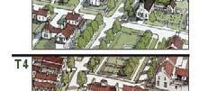
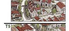
3 Truly great places have certain characteristics ti some accidental, some designed: Land use mix Building height, setback, openness Continuity of facades Street design Handling of parking Flexibility /Organic Goal is to: 1. Create great places where people want to be. 2. Design the public realm for flexibility and sustainability. Conwy, Wales Fort Worth
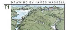
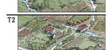
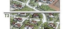
4 Natural Transect duany plater-zyberk
5 Foodstuff Transect duany plater-zyberk Building Type Transect
6 Norman Rockwell Transect Paris Hilton/Brad Pitt Transects duany plater-zyberk
7 De-emphasizesemphasizes Use and Setbacks, and Emphasizes Form Ensures a High Quality Public Realm Calibrated to the City s Vision and Character
8 Creating great streets Blocks and Massing Versatile Building / Infrastructure Mixing of Uses Introducing public open space & Clustering anning ealty/gateway Pla Photo: Arcadia Re Ephesus, 1 st CBC Disney Land Collingwood, Ont.
9 Provides Sustainability Mixture of Uses Variety of unit size & type Quality Flexible Infrastructure of Buildings, Parks, Streets t and Trails Travel Options walk, cycle, transit Shade paved areas Connected to walkways, transit, open space and services Reduced d parking footprint t Roads Transit Parks/Open Space/Trails Drainage Civic Space/Facilities Ownership Patterns
10 Townscape, Inc.


11
12 1. Streets 2. Block Face 3. Uses 4. Buildings/Building Types 5. Civic Space 6. Parking 7. Signs


13
14
15


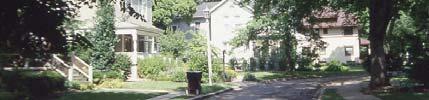
16 Opportunities to Meet and Greet Classic Elements ~ Windows at grade along all street faces ~ Windows above to be oriented vertically ~ Trees and awnings to provide shade ~ Brick, stone and stucco construction
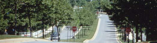
17 Bulb-outs at crossings Special paving at crosswalks On-street parking and street trees Pedestrian- oriented signage Shade for Pedestrians, Vehicles and Paved Surfaces Lawrence-Livermore Livermore Labs: 7-11 degrees cooler ambient 40 degrees cooler on surface

18 Articulation Landmark features at intersections and view termini Building Line Building Height Life Cycle Needs Changing Demographics and Preferences Changing Work Patterns & Job Creation


.")

19 Boomers! Note: The reference population for these data is the resident population. Source: U.S. Bureau of the Census, 1943, Table 2. Household With Children 48% 33% 28% Without Children 52% 67% 72% Single 13% 26% 28% Source: Census for 1960 and 2000, 2025 adapted from Martha Farnsworth Riche, How Changes in the Nation s Age and Household Structure Will Reshape Housing Demand in the 21st Century, HUD (2003). DFW in % of all Households are single persons 47% of Mortgagees are singles DMN Sept 26, 2005 The Metroplex will add about 4 million people over the next 25 years; going from 5 million in 2000, to 9.1m in 2030.
20 71% of elderly want transit options (AARP) Affluent elderly are wanting urbane opportunities 50% of public want expanded transit investment, but only 25% want new roads (NAR) Young Professionals are delaying child-rearing Even families with children are increasingly looking for pedestrian- oriented communities Life-Cycle Housing More social community when people are out of their cars Create Synergy of Uses Housing & Retail Plazas & Retail Live-Work
21 Sachse Ages: No Moves or Deaths 80% 70% 60% 50% 40% 30% 20% 10% 0% Under 45 Over 45 Sachse Home Re-Sales $/SF $85.00 $83.00 $81.00 $79.00 $77.00 $75.00 $73.00 $71.00 $69.00 $67.00 $ ,400-2,100 SF 2,100-4,500 SF
22 Proximity to Open Space Trails Retail Services Schools Transit Properties near DART light rail stations recorded valuation increases about 25% greater than neighborhoods in a control group not served by DART between 1994 and Between 1997 and 2001, median values of residential properties increased 32.1% near DART stations compared to 19.5% in non- DART areas. Median values of office buildings near DART stations increased 24.7% versus 11.5% for non-dart properties. Source: UNT Center for Economic Development and Research, DART Light Rail s Effect on Taxable Property Valuations and Transit-Oriented Development, January 2003:
23 Properties within 100 feet of public open space have a 23% Premium. There is a measurable premium for up to a quarter mile. Three Minute Walk Accounts for 85% of Total Premium. 41% 63% 76% 85% 91% Source: Valuing Open Space: Land Economics and Neighborhood Parks Massachusetts Institute of Technology Center For Real Estate, and School Of Architecture Based on MLS Data for 3,400 Home Re-sales Near 15 Neighborhood Parks Across DFW The Apple Cart $ Versus The Fruit Cart $$$ Variables: Mix of Uses Housing Type and Size, Proximity to Amenity (Transit, Open Space, Trails, Walkable Retail)
24 Can create a distinctive destination Compactness Background, Landmark and Civic Buildings Buildings should be flexible for different uses over time ~ Flexible space, esp. at grade ~ Building types with quality materials and form


25 Tripartite Architecture/Bay Rhythm/Expression Ground floor must be constructed of durable materials Retail at-grade ~ Accentuate Retail ~ Canopies on south, east and west sides ~ Clear glass Windows at grade to be between 30% and 70% of façade Expression Line Between Ground Floor and upper Floors Top Middle Base Bay Rhythm Flex Space at-grade ~ Located on-grade ~ Min. 15 feet floor to floor ~ Canopies along 75% of façade ~ Windows at grade to be between 60% and 80% of façade


26 Residential At-grade ~ Ground Floor min. 2 ft. above sidewalk to separate private space ~ 14-foot setback from front Build-to Line; 8 feet for patio, stoop and stair, and 6 feet of landscape ~ Front Door ~ Windows with a view of sidewalk and street for security and interest ~ Handicapped accessible units to have a low fence with gate. Single Family Patio home Town home Live-Work Mixed Residential Commercial Mixed Use Flexible loft space
27 Add Residential Unit Types and Sizes to Complement Existing Housing, NOT Duplicate it
28
29


30


31 Rockwall Downtown Green: AnOpenSpace,availablefor unstructuredrecreation.agreenmaybe spatiallydefinedbystreets,landscapingand/or buildingfrontages.itslandscapeshallconsistof g lawnandtrees.theminimumsizeshallbe1/4 acre. Square: AnOpenSpaceavailablefor unstructuredrecreationandcivicpurposeslike thecourthousesquare.asquareisspatially S ti definedbybuildingfrontagesorstreets.its landscapeshallconsistofpaths,lawnsand trees,formallydisposed.squaresshallbe locatedattheintersectionofimportant Thoroughfares.Theminimumsizeshallbe1/4 acreandthemaximumshallbe5acres. Plaza: AnOpenSpaceavailableforCivic purposesandcommercialactivities.aplaza shallbespatiallydefinedbybuildingfrontages orstreets.itslandscapeshallconsistprimarily ofpavementbutincludeshadeintheformof treesorstructure.plazasshouldbelocatedat theintersectionofimportantstreets.the minimumsizeshouldbe3,000squarefeet. PocketParks/Plazas: AnOpenSpace availableforcivicpurposesandcommercial activities.theyshallbespatiallydefinedby buildingfrontagesandstreets.itslandscape shallconsistprimarilyofpavementbutinclude of pavement include shadeintheformoftreesorstructure.the minimumsizeshouldbeatleast400square feet.
32 Maximize on-street parking Hide surface parking Line parking structures with buildings Minimize the Amount of land paved df for parking Consolidate and Share Parking Central Parking Area Limit Assigned Spaces Limit Amount of Parking that can Be Provided Ensure ease of parking accessibility Parking reductions for Mixed Use and Transit Parking structures Provide for Lining Bicycle Parking South Norwalk, CT
33 Signs appropriate for a walkable district 1. Control Building Elements, avoid Style 2. Parking How handled, Reductions in a pedestrian environment Local parking strategy 3. Open Space Requirements
34 Process: Framework Plan Regulating Plan Development Plan Building Permit Review Process Framework Plan Regulating g Plan Development Plan Building Permit


 in which")


35 Council Adopts as part of Comprehensive Plan Council Adopts as part of Zoning on Property 1. Continuity of access, parking; 2. Public areas/amenities; 3. Reflect elements of the Framework Plan contained in the Comprehensive Plan for the district or sub-district(s) in which the property is located; 4. Where required at-grade retail construction standards will be applied; 5. Designation of terminal vista / Landmark intersection locations


36 Staff Approves Administratively if meets standards and intent of Code 1. Detailed Plan showing proposed 6. General building anticipated uses streets, building footprints, parking areas, and landscaped areas. 7. Parking standards 2. Comprehensive sidewalk 8. Required landscaping under this treatment and corresponding code Plazas or open space 9. Signage standards 3. Public access easements 4. Building disposition 5. Building elevations and possible section 10. Any Waivers being requested Warrants/Waivers Minor: Staff approval upon recommendation by UDO or CRC Major: Council Approval upon recommendation by PZ Requires a Development Plan prior to Building Permit Site Plan Building Elevations and Sections Building Function/Proposed Use Parking Standards being met Any Minor Waivers being requested.
")


37 Director of Planning and Development (Director) or Designee Decides Minor Waivers (often based on recommendation by UDO and/or CRC) Consolidated Review Committee (CRC) Appointed by City Manager Director, City Engineer, Fire Department, UDO, Others Urban Design Officer (UDO) Third party expert in TND and Sustainable Development Appointed by City Manager with Recommendation of CRC Cost to be born by development fees CRC Advises/ Recommends Director Decides/ Recommends to PZ/CC UDO Advises/ Recommends Design review for best product Incentives for development
38 1. The creation of a Sense of Place and Identity 2. Healthy Mix of Land Uses retail, housing, office, open space 3. Variety of Housing Types 4. Multi-modal modal: Pedestrian, bicycle and auto-friendly 5. Strong design and development Standards 6. Balance of Standards and Process that requires and rewards good development Key Standards Processes and Procedures
ARTICLE 6: Special and Planned Development Districts
 ARTICLE 6: Special and Planned Development Districts 6-10 Traditional Neighborhood Development (TND) District 6-10.10 Purpose and Intent The Traditional Neighborhood Development (TND) District provides
TRANSIT ORIENTED DEVELOPMENT PINELLAS COUNTY MPO LIVABLE COMMUNITIES INITIATIVE PINELLAS COUNTY COMPREHENSIVE PLAN AMENDMENTS
 PINELLAS COUNTY MPO LIVABLE COMMUNITIES INITIATIVE MODEL LAND DEVELOPMENT CODE TRANSIT ORIENTED DEVELOPMENT PINELLAS COUNTY COMPREHENSIVE PLAN AMENDMENTS MPO Livable Communities Initiative Goal: Improve
Urban Design Manual PLANNING AROUND RAPID TRANSIT STATIONS (PARTS) Introduction. Station Study Areas
 Introduction. Station Study Areas") 111111 PLANNING AROUND RAPID TRANSIT STATIONS (PARTS) Introduction The ION rapid transit system will link Waterloo, Kitchener and Cambridge through a central transit corridor (CTC). There are a number
111111 PLANNING AROUND RAPID TRANSIT STATIONS (PARTS) Introduction The ION rapid transit system will link Waterloo, Kitchener and Cambridge through a central transit corridor (CTC). There are a number
WELCOME and introduction
 1 WELCOME and introduction Mobility Hub Locations within Burlington STUDY OVERVIEW STUDY OBJECTIVES The City of Burlington is developing four Area Specific Plans, one for each of Burlington s Mobility
Lehigh Acres Land Development Regulations Community Planning Project
 Lehigh Acres Land Development Regulations Planning Effort Summary In July, 2010 Commissioner Frank Mann invited the Lehigh Acres community to start discussing how to achieve their recently adopted community
Appendix A COMMUNITY IMPROVEMENT PLAN DESIGN GUIDELINES
 Appendix A COMMUNITY IMPROVEMENT PLAN DESIGN GUIDELINES INTRODUCTION The continuous and desirable improvement of Arnprior requires a clear understanding of what is envisioned for the Town. These Design
EXISTING COMPREHENSIVE PLAN
 EXISTING COMPREHENSIVE PLAN Town Center Land Use Element: V. LAND USE POLICIES Town Center Mercer Island's business district vision as described in "Your Mercer Island Citizen-Designed Downtown" was an
FRUITVALE TRANSIT VILLAGE (Phase 2) Residential Project
 Residential Project") FRUITVALE TRANSIT VILLAGE (Phase 2) Residential Project DEVELOPER: SIGNATURE PROPERTIES ARCHITECT: HKIT ARCHITECTS April 23, 2010 TABLE OF CONTENTS 3 Vision 4 Description of Site 5 Guiding Concepts 6
FRUITVALE TRANSIT VILLAGE (Phase 2) Residential Project DEVELOPER: SIGNATURE PROPERTIES ARCHITECT: HKIT ARCHITECTS April 23, 2010 TABLE OF CONTENTS 3 Vision 4 Description of Site 5 Guiding Concepts 6
A BLUEPRINT FOR BROCKTON A CITY-WIDE COMPREHENSIVE PLAN
 A BLUEPRINT FOR BROCKTON A CITY-WIDE COMPREHENSIVE PLAN Public Meeting October 2016 1 Plan Summary and Discussion Public Meeting May 4 2017 City of Brockton Bill Carpenter, Mayor Department of Planning
B L A C K D I A M O N D D E S I G N G U I D E L I N E S for Multi-family Development
 B L A C K D I A M O N D D E S I G N G U I D E L I N E S for Multi-family Development Adopted June 18, 2009 This section of the Design and focuses on site planning and design guidance for new multi-family
Appendix A. SmartCode
 Appendix A Adopted June 16, 2003 Ordinance No. 2152 N.C.S. Appendix A of the uses material from SmartCode. Notwithstanding any other agreements with Duany Plater-Zyberk & Company (DPZ) or the Municipal
4.1.3 LAND USE CATEGORIES
 4.1.3 LAND USE CATEGORIES a. City Center District The City Center District incorporates the existing character and mix of uses in downtown Belmont to encourage redevelopment and new development in keeping
URBAN DESIGN BRIEF URBAN DESIGN BRIEF 721 FRANKLIN BLVD, CAMBRIDGE August 2018
 URBAN DESIGN BRIEF URBAN DESIGN BRIEF 721 FRANKLIN BLVD, CAMBRIDGE August 2018 DESIGN BRIEF CONTENTS PART A 1.0 INTRODUCTION 2.0 DESCRIPTION & ANALYSIS OF SITE CONTEXT 3.0 DESIGN CONSTRAINTS AND OPPORTUNITIES
North Downtown Specific Plan MEMORANDUM
 North Downtown Specific Plan MEMORANDUM MEETING DATE: November 13, 2017 TO: Members of the North Downtown Specific Plan Advisory Committee FROM: Jeanine Cavalli, Senior Planner SUBJECT: Materials for the
DRAFT Northeast Quadrant of Kipling Avenue and Highway 7 DRAFT AUGUST 29, Goals Land Use. The goals of this Plan are to:
 AUGUST 29, 2017 12.15 Northeast Quadrant of Kipling Avenue and Highway 7 12.15.1 Goals 12.15.2 Land Use The goals of this Plan are to: 12.15.2.1 General Provisions: a) Ensure the development of a compact
Policies and Code Intent Sections Related to Town Center
 Policies and Code Intent Sections Related to Town Center The Town Center Vision is scattered throughout the Comprehensive Plan, development code and the 1994 Town Center Plan. What follows are sections
SECTION TWO: Overall Design Guidelines
 SECTION TWO: Overall Design Guidelines This section provides overall design principles and guidelines for the Gardnerville Mixed-use Overlay. They provide criteria for mixed-use places consisting of residential,
MULTIFAMILY RESIDENTIAL DESIGN PRINCIPLES Site Plan and Design Review Principles Checklist
 MULTIFAMILY RESIDENTIAL DESIGN PRINCIPLES Site Plan and Design Review Principles Checklist Applicant s Name: Project Address: Phone: Email: Applicant shall fill out the design guidelines checklist for
Sahuarita District & Phase 1 Master Plan. Town Council December 11, 2017
 Sahuarita District & Phase 1 Master Plan Town Council December 11, 2017 Visioning Study Visioning Process Advisory Group Meetings Community Questionnaire Town Center Case Studies Community Analysis The
40 Years of Smart Growth Arlington County s Experience with Transit Oriented Development in the Rosslyn-Ballston Metro Corridor
 40 Years of Smart Growth Arlington County s Experience with Transit Oriented Development in the Rosslyn-Ballston Metro Corridor A presentation by the Arlington County Department of Community Planning,
Transit Station Area Development Guidelines
 Transit Station Area Development Guidelines Adopted June 2017 Transit Station Area Development Guidelines Table of Contents Development Around Transit Stations Using the Guidelines Thresholds and Procedures
FLORIN ROAD CORRIDOR Site Plan and Design Review Guidelines Checklist
 FLORIN ROAD CORRIDOR Site Plan and Design Review Guidelines Checklist Applicant s Name: Project Address: Phone: Email: Applicant shall fill out the design guidelines checklist for all guidelines applicable
elk grove design guidelines Table Contents
 Table Contents of I. Introduction... 7 A. Purpose and Intent...7 B. Background...7 C. Organization and Use...8 II. Administration... 11 A. What is Design Review?...11 B. When is Design Review Required?...11
PLAN ELEMENTS WORKSHOP. April 5, 2016
 PLAN ELEMENTS WORKSHOP April 5, 2016 needs more housing. But there is no one-size fits-all solution. Every neighborhood has its own character. In some places, density is not only appropriate it is badly
40 Years of Smart Growth Arlington County s Experience with Transit Oriented Development in the Rosslyn-Ballston Metro Corridor
 40 Years of Smart Growth Arlington County s Experience with Transit Oriented Development in the Rosslyn-Ballston Metro Corridor A presentation by the Arlington County Department of Community Planning,
THE CIVIC DISTRICT DEVELOPMENT OPPORTUNITIES
 1 THE CIVIC DISTRICT DEVELOPMENT OPPORTUNITIES The Civic District is the physical and emotional heart of the downtown. It is also a major gateway into the central core, establishing the image and identity
ARTICLE XX TRANSIT CENTER DISTRICT REGULATIONS
 ARTICLE XX TRANSIT CENTER DISTRICT REGULATIONS (Updated 08/15/17, Ord. 3808) Part 1 (DTC) Downtown Carrollton Transit Center Page 20-2 Part 2 (TMTC) Trinity Mills Transit Center Page 20-23 Part 3 (FTC)
The Five Components of the McLoughlin Area Plan
 The Five Components of the McLoughlin Area Plan This documents contains the complete language of the five components of the McLoughlin Area Plan: The Vision Statement The Values The Guiding Principles
URBAN DESIGN BRIEF 181 Burloak Drive, Oakville
 URBAN DESIGN BRIEF 181 Burloak Drive, Oakville February 2017 Our File: 1730B 230-7050 WESTON ROAD / WOODBRIDGE / ONTARIO / L4L 8G7 / T: 905 761 5588/ F: 905 761 5589/WWW.MHBCPLAN.COM TABLE OF CONTENTS
Derry Green Corporate Business Park
 Town of Milton Derry Green Corporate Business Park Urban Design Guidelines BMI/Pace - June 2010 Draft 3 Prepared by: Brook McIlroy Planning + Urban Design / Pace Architects Suite 300-51 Camden Street Toronto,
FUTURE LAND USE ELEMENT
 FUTURE LAND USE ELEMENT GOAL I: To create and sustain a great place to live, play, and prosper Objective 1: The City of Ocala shall incorporate the principles and strategies of the Ocala 2035 Vision into
DALY CITY VISIONING PROCESS COMMUNITY WORKSHOP 3 MAY 8, 2008
 DALY CITY VISIONING PROCESS COMMUNITY WORKSHOP 3 MAY 8, 2008 PROCESS General Plan - a statement of the community s values, vision and aspirations for now and into the future... Timeframe LONG TERM - 2030
Joint Study Session of the Sutter County. March 2, 2009
 Joint Study Session of the Sutter County Board of Supervisors and Planning Commission March 2, 2009 CURRENT APPLICATION General Plan Amendment Specific Plan Specific Plan Appendices Utility Plans Transit/AQ
Preliminary Recommendations Tk Takoma/Langley Crossroads Sector Plan
 Preliminary Recommendations Tk Takoma/Langley Crossroads Sector Plan Vision is to achieve a Transit Oriented, pedestrian friendly Community that Celebrates and builds upon the cultural Diversity of the
GREENING THE BOULEVARD Master Plan Concepts for Venice Boulevard between Lincoln and Sawtelle
 GREENING THE BOULEVARD Katherine Spitz Associates Inc. 4212½ Glencoe Avenue Marina Del Rey, CA 90292 310 574 4460 Fax 574 4462 January 2008 Table of Contents Overview Proposed Design Improvements Illustration
CHAPTER 7: VISION AND ACTION STATEMENTS. Noble 2025 Vision Statement
 CHAPTER 7: VISION AND ACTION STATEMENTS This chapter presents the vision, policy and action statements that transform the comprehensive planning study, an analysis of Noble s past, future trends and community
Clairtrell Area Context Plan
 Clairtrell Area Context Plan March 2005 Urban Development Services City Planning Contents 1. Introduction... 4 2. Development Structure... 6 2.1 Streets... 7 2.1.1 Sheppard Avenue and Bayview Avenue...
TOWN OF FAIRVIEW. CPDD Commercial Planned Development District
 TOWN OF FAIRVIEW CPDD Commercial Planned Development District Adopted: September 11, 2014 TOWN OF FAIRVIEW Commercial Planned Development District BACKGROUND This Planned Development District ( PDD ) governs
Danvers High Street I-1 District Study
 Danvers High Street I-1 District Study Presentation of Final Recommendations Planning Board Presentation June 26 th, 2018 1 Introductions Metropolitan Area Planning Council Sam Cleaves AICP, Principal
3.0 URBAN DESIGN. December 6, OVERVIEW
 Urban Design 3.0 URBAN DESIGN December 6, 2007 3.1 OVERVIEW The highly urban character of Easton Place is defined by the overall design of the community. The following sections provide an overview of the
SUBCHAPTER 4-B GUIDELINES FOR THE B-3 COMMERCIAL CHARACTER AREA
 1 SUBCHAPTER 4-B GUIDELINES FOR THE B-3 COMMERCIAL CHARACTER AREA Downtown Bozeman should be the location of buildings of greatest height and intensity in the community. The following guidelines apply
appendix and street interface guidelines
 appendix five: building and street interface guidelines appendix 5 building and street interface guidelines BOULEVARDS Boulevards are generally characterized by higher levels of traffic movement at higher
(DC1) Direct Development Control Provision DC1 Area 4
 Direct Development Control Provision DC1 Area 4") . General Purpose (DC) Direct Development Control Provision DC Area 4 The purpose of this Provision is to provide for an area of commercial office employment and residential development in support of the
. General Purpose (DC) Direct Development Control Provision DC Area 4 The purpose of this Provision is to provide for an area of commercial office employment and residential development in support of the
Future Five. Design/ Development Guidelines. January 2008 Amended June 08 per City Council motion
 Future Five Design/ Development Guidelines January 2008 Amended June 08 per City Council motion 5-Points Design Guidelines Table of Contents I. Introduction 3 II. Area boundaries 4 III. Review Process
Aesthetics and Design
 University of Connecticut Department of Geography Urban and Regional Planning Lecture 8. Adjunct Lecturer: Donald J. Poland, MS, AICP E-mail: don@donaldpoland.com Web: www.donaldpoland.com Aesthetics and
2.0 THE PLATINUM TRIANGLE VISION
 2.0 THE PLATINUM TRIANGLE VISION The envisions an exciting future for the area surrounding Angel Stadium of Anaheim, the Honda Center and The Grove of Anaheim. 2.1 Planning Principles In order to further
The Village. Chapter 3. Mixed Use Development Plan SPECIFIC PLAN
 The Village SPECIFIC PLAN Chapter 3 3.1 INTRODUCTION 3.1.1 Purpose This Chapter describes the development regulations applicable to the Mixed-Use and Transit Center Planning Areas. These form-based regulations
PINE CURVE REZONING. Property does not meet criteria for open space preservation and is not a candidate for a park
 PINE CURVE REZONING BACKGROUND Purchased as two parcels in 2001 and 2002 Annexed and Zoned Greater Downtown District Historic Center September 25, 2002 and October 7, 2002 WHAT THE PROJECT IS AND IS NOT
A. Background Summary of Existing Challenges and Potential Possibilities. 1. Summary of Existing Assets and Potential Opportunities
 A. Background 1 A Main Street Master Plan Study was performed and completed in October of 2007. The study was initiated to review current land uses and development patterns along Main Street, from Parrish
Supplemental Design Guidelines
 Supplemental Design Guidelines 65 SUPPLEMENTAL DESIGN GUIDELINES As a supplemental reference to the project, the following diagrams are included to illustrate the site planning approaches that were followed
WINDSOR GLEN DESIGN GUIDELINES
 WINDSOR GLEN DESIGN GUIDELINES Adopted by Council, 2006 WINDSOR GLEN REDEVELOPMENT DESIGN GUIDELINES August 2006 1.0 Master Plan Organization For this area of the Coquitlam Town Centre, a mix of high,
PINE CURVE REZONING. BACKGROUND Purchased as two parcels in 2001 and 2002
 BACKGROUND Purchased as two parcels in 2001 and 2002 WHAT THE PROJECT IS AND IS NOT A Rezoning establishes the land use standards for Annexed and Zoned Greater Downtown District Historic Center September
GUIDING PRINCIPLES IN THIS CHAPTER
 GUIDING PRINCIPLES The guiding principles and design concepts in this chapter work together with the Chapel Hill 2020 Comprehensive Plan to support new public places that can be enjoyed by all while also
Corridor Identity. Section 9. Introduction. Corridor Guiding Principles
 Corridor Identity An attractive and healthy community is a critical element of a quality place, and the design of quality places is a balance between environmental, economic, and social considerations.
U T D N o r t h C a m p u s T O D and D o w n t o w n D e n t o n T O D
 U n i v e r s i t y o f T e x a s a t D a l l a s C i t y o f R i c h a r d s o n U T D N o r t h C a m p u s T O D and D o w n t o w n D e n t o n T O D Rick Leisner, AICP Assistant Director of Development
1.0 VISION STATEMENT. December 6, PRINCIPLES
 Vision Statement Lincoln Regional Airport 1.0 VISION STATEMENT 1.1 City LOCATION of AND OVERVIEW The Easton Lincoln Place Land Use Master Plan identifies the principles, goals, policies, and standards
ARLINGTON COUNTY, VIRGINIA
 ARLINGTON COUNTY, VIRGINIA County Board Agenda Item Meeting October 15, 2005 DATE: September 28, 2005 SUBJECT: Request to Advertise the adoption of the 2005 Clarendon Sector Plan C. M. RECOMMENDATION:
Plano Tomorrow Vision and Policies
 Plano Tomorrow Vision and Policies PLANO TOMORROW PILLARS The Built Environment The Social Environment The Natural Environment The Economic Environment Land Use and Urban Design Transportation Housing
EXHIBIT A. Tax Increment Reinvestment Zone No. 1 (Town Center) First Amended Project Plan 1
 First Amended Project Plan 1") EXHIBIT A Tax Increment Reinvestment Zone No. 1 (Town Center) First Amended Project Plan 1 1 As amended by Resolution No. 2008-02-001(TR1R) of the Tax Increment Reinvestment Zone No.1, and approved to
EXHIBIT A Tax Increment Reinvestment Zone No. 1 (Town Center) First Amended Project Plan 1 1 As amended by Resolution No. 2008-02-001(TR1R) of the Tax Increment Reinvestment Zone No.1, and approved to
What Does It Take To Create A Town Center?
 What Does It Take To Create A Town Center? Context, Design, and Process The Prince Frederick Master Plan Update 1 Background and Overview A Brief History of Town Centers in Calvert County 2 Background
SECTION TWO: Urban Design Concepts
 SECTION TWO: Urban Design Concepts The Gardnerville Plan for Prosperity shapes economic opportunities presented by regional growth. The Urban Design Concepts provide policies and concepts for land use,
A. WHAT IS A GENERAL PLAN?
 I. Introduction A. WHAT IS A GENERAL PLAN? A general plan is the planning guideline for the future of a city. It contains goals and policies which regulate urban development, the protection of the natural
CITY OF GARDEN CITY. Garden City Design Review Committee Staff Contact: Chris Samples STAFF REPORT: DSRFY Page 1
 Page 1 CITY OF GARDEN CITY 6015 Glenwood Street Garden City, Idaho 83714 Phone (208)472-2921 Fax (208)472-2926 File Number: DSRFY2018-12 For: Brilliant Services - New Commercial Structure Location: 211
Bayshore Boulevard Home Improvement District Design Guidelines
 Bayshore Boulevard Home Improvement District Design Guidelines guidelines for New construction projects and major alterations IN the bayshore boulevard home improvement special use DISTRICT SAN FRANCISCO
Courthouse Square Planning & Urban Design Study. Courthouse Square Working Group #13 October 15, 2014
 Courthouse Square Planning & Urban Design Study Courthouse Square Working Group #13 October 15, 2014 1 Courthouse Square Process Working Group Community Courthouse Square Advisory Groups & Civic Associations
PROTECT AND PROMOTE QUALITY OF LIFE AND LIVABILITY FOR THE CITIZENS OF GAINESVILLE THROUGH QUALITY URBAN DESIGN.
 Goals, & Urban Design Element PROTECT AND PROMOTE QUALITY OF LIFE AND LIVABILITY FOR THE CITIZENS OF GAINESVILLE THROUGH QUALITY URBAN DESIGN. GOAL 1 By 2003, the City shall adopt urban design standards
Community Design Guidelines. Port Wallace DRAFT
 Community Design Guidelines Port Wallace DRAFT Energy 1 2 3 Nature Movement Connections Built Form DRAFT Layout Energy 1 Nature Community Design Guidelines GREAT COMMUNITIES PROTECT, CELEBRATE, AND CONSERVE
Design Guidelines and Development Standards for Southwood Ranch. Prepared February, 2016 by
 Design Guidelines and Development Standards for Southwood Ranch D e s i g n D i s t r i c t Prepared February, 2016 by Table of Contents Introduction 2 District Overlay Map. 3 Development Standards. 4
Pedestrian and Bike Bridge LOGO
 6.2.2 Pedestrian and Bike Bridge The proposed pedestrian and bike crossing re-envisions the existing bridge at Pismo Creek on Cypress Street. The bridge is currently underutilized by vehicular through
Blueprint Denver A BLUEPRINT FOR AN INCLUSIVE CITY. Executive Summary
 Blueprint Denver A BLUEPRINT FOR AN INCLUSIVE CITY Executive Summary PUBLIC REVIEW DRAFT 2 1/7/2019 DENVERIGHT BLUEPRINTDENVER Blueprint Denver: A Blueprint for an Inclusive City An Equitable City Planning
Complete Neighbourhood Guidelines Review Tool
 Complete Neighbourhood Guidelines Review Tool Prepared By: City of Regina Planning Department October 2014 Page 1 of 14 Community Development Review Checklist for Secondary Plans and Concept Plans The
Town Center (part of the Comprehensive Plan)
") Town Center (part of the Comprehensive Plan) Mercer Island Town Center Looking North (2014) In 1994, a year-long process culminated in a set of design guidelines and code requirements for the Town Center
Town Center (part of the Comprehensive Plan) Mercer Island Town Center Looking North (2014) In 1994, a year-long process culminated in a set of design guidelines and code requirements for the Town Center
Midtown Greenway Land Use and Development Plan Executive Summary
 Midtown Greenway Land Use and Development Plan Executive Summary Introduction The Midtown Greenway Land Use and Development Plan sets policy direction for land use and development in the Midtown Greenway
Metro. Activity Center Design Guidelines. Recommendations For Developing Focused, Mixed-Use Commercial/Residential Centers
 Metro Activity Center Design Guidelines Recommendations For Developing Focused, Mixed-Use Commercial/Residential Centers Metro Activity Centers What is a MAC? Legacy, the adopted guide for the future growth
ATTACHMENT A. SILVERDALE DESIGN STANDARDS Amendments to the Waaga Way Town Center Chapter
 ATTACHMENT A SILVERDALE DESIGN STANDARDS Amendments to the Waaga Way Town Center Chapter Chapter 10. Waaga Way Town Center 10.1 Physical Identity Elements & Opportunities The Waaga Way Town Center includes
Official Plan Review: Draft Built Form Policies
 PG.30.1 REPORT FOR ACTION Official Plan Review: Draft Built Form Policies Date: May 15, 2018 To: Planning and Growth Management Committee From: Chief Planner and Executive Director, City Planning Division
4. INDUSTRIAL 53 CASTLE ROCK DESIGN
 4. INDUSTRIAL 53 CASTLE ROCK DESIGN CASTLE ROCK DESIGN 54 4. INDUSTRIAL Overview Well-designed and attractive industrial centers are the product of blending economic realities with both functional and
13. New Construction. Context & Character
 13. New Construction Context & Character While historic districts convey a sense of time and place which is retained through the preservation of historic buildings and relationships, these areas continue
Draft Bergamot Area Plan
 ATTACHMENT 1 Draft Bergamot Area Plan Taskforce on the Environment April 15, 2013 www.bergamotplan.net 1 Overview WHAT IS THE BERGAMOT AREA PLAN? A Community-Based Planning Document Guiding the Future
Urban Design Brief. 875 Wellington Road. Proposed One-Storey Fast Food Restaurant and Two-Storey Restaurant. Wellington Harlech Centre Inc.
 Urban Design Brief 875 Wellington Road Proposed One-Storey Fast Food Restaurant and Two-Storey Restaurant Wellington Harlech Centre Inc. Prepared By: (519) 433-7587 info@yorkdev.ca May 3 rd 2013 1 Table
CHAPTER 1. Ms. Guajardo s Class - Central Elementary CH 1 1
 INTRODUCTION CHAPTER 1 Ms. Guajardo s Class - Central Elementary CH 1 1 1.1 SETTING South Centre City is a linear corridor south of Downtown Escondido paralleling Centre City Parkway and South Escondido
Wide asphalt driveway abutting school property. garage built with incompatible materials, too close to park. incompatible fencing materials
 Wide asphalt driveway abutting school property incompatible fencing materials garage built with incompatible materials, too close to park Lack of plantings as a buffer between private property and open
ARTICLE 2 FORM BASED DISTRICT STANDARDS
 ARTICLE 2 FORM BASED DISTRICT STANDARDS 2.1 INTENT 2.1.1 Intent It is the intent of these standards to: a. Provide the City of Rowlett with pedestrian-oriented/bicycle-friendly districts and neighborhoods
McCowan Precinct Plan Study Background & Deliverables
 1 DRAFT & WITHOUT PREJUDICE McCowan Precinct Plan Study Background & Deliverables In September, 2011, City Planning (Scarborough District) began a study of an area within the Scarborough Centre, identified
1 Adapted from the Statewide Transit-Oriented Development Study by CalTrans, 2006
 APPENDIX C: LAND USE PLANNING FOR ENHANCED RAIL SERVICE 72 BACKGROUND One of the consistent themes heard from localities in the Route 29 corridor Planning Forums was the need for expanding rail service
Buildings may be set back to create small plazas provided that these setbacks do not substantially disrupt the street wall s continuity.
 6-22 Community Design Street Walls and Street-front Setbacks The siting of buildings will play a critical role in establishing the character and sense of place for the District. Siting buildings at the
New Partners for Smart Growth Conference February 5, 2010
 Dan Stroh, Planning Director City of Bellevue Planning and Community Development Bellevue, WA New Partners for Smart Growth Conference February 5, 2010 Summary of Project Long-range plan update for Bel-Red
lot flankage Y street 16m 6m landscape strip for large site 3m landscape strip for small medium site
 Commercial General Commercial Objectives Create developments compatible with adjacent land uses in scale, function and character Define a consistent and attractive street edge with quality landscaping,
Section 9 NEIGHBORHOOD DESIGN
 Section 9 NEIGHBORHOOD DESIGN City of Lancaster Comprehensive Plan D u n k i n, S e f k o & A s s o c i a t e s, I n c. NEIGHBORHOOD DESIGN INTRODUCTION There are many ways in which a neighborhood can
Overview of the Plan. The Building Blocks of Centers, Neighborhoods and Network INTERNAL DRAFT
 Overview of the Plan 4 East Davidson Ramah Church Rd June Washam Rd Bradford District Park Bradford Shearer Rd Campus District NC 73 Davidson-Concord North Rocky River This Master Plan projects an approximate
Attachment 1 TOWN OF NEW TECUMSETH. Manual for the Preparation of an Urban Design Report
 Attachment 1 TOWN OF NEW TECUMSETH Manual for the Preparation of an Urban Design Report July 2010 TABLE OF CONTENTS Background, Policy Framework and the Preparation of Urban Design Reports 1. Introduction
BROOKLYN PARK / 85TH AVE LRT STATION CDI DEVELOPMENT GUIDELINES DRAFT
 August 2018 Page intentionally left blank The Brooklyn Park Library adjacent to the 85th Ave LRT Station Area. OVERVIEW The Blue Line LRT Extension / Bottineau corridor offers a unique opportunity to leverage
The Baileys Planning District portion of the Comprehensive Plan contains site design recommendations for both the Baileys Crossroads Community
 The Baileys Planning District portion of the Comprehensive Plan contains site design recommendations for both the Baileys Crossroads Community Business Center and the Seven Corners Community Business Center.
5.1 Site Plan Guidelines
 5. Community Core Guidelines Development of the Community Core will take place by plan of subdivision and site plan approval. It will occur in a phased manner that will reflect the timing of residential
Project Consulting Team:
 THE DOWNTOWN CHERRYVILLE LAND USE + STREETSCAPE MASTER PLAN WAS FUNDED THROUGH THE GENEROUS DONATIONS OF THE FOLLOWING: The Community Foundation of Gaston County ElectriCities of North Carolina The Cherryville
Table of Contents. Elm Avenue Improvement Plan City of Waco, Texas. Introduction 1. Existing Context 1 Figure 1 2.
 Table of Contents Introduction 1 Existing Context 1 Figure 1 2 Plan Guidelines 3 Future Urban Form 4 The West-End 4 Main Street 6 The East-End 7 Figure 2 9 Public Improvement Recommendations 7 General
Community Mixed Use Zone Districts (CMU)
") 18.28.500 Community Mixed Use Zone Districts (CMU) The Community Mixed Use Zone Districts (CMU) are intended to help implement the land use goals and strategies found in the Golden Vision 2030 values,
18.28.500 Community Mixed Use Zone Districts (CMU) The Community Mixed Use Zone Districts (CMU) are intended to help implement the land use goals and strategies found in the Golden Vision 2030 values,
Town Center Design Guidelines
 Adopted by City Council on September 18, 2018 Design Theme The Draper Town Center Design Theme is defined as encompassing those architectural design styles that were prevalent in the construction of civic
East Central Area Plan
 East Central Area Plan Steering Committee Meeting March 8 th, 2018 CHUN Tears McFarlane House Vision Statement Development Opportunities Analysis Vision Elements 1. Equitable, Affordable and Inclusive
ARTICLE 13 STREETS General
 ARTICLE 13 STREETS 13.1 General Streets shall be designed to suit their functions. Many streets have purposes other than vehicular traffic. As an alternative to current N.C. Department of Transportation