An evaluation of the reduced environmental impact from high density development
|
|
|
- Baldric Melton
- 5 years ago
- Views:
Transcription
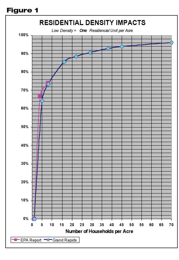
1 An evaluation of the reduced environmental impact from high density development By Randel Lemoine Intuitively, it seems that a high-rise building will generate less rainwater runoff than a single-story building of the same floor area. This is because the high-rise will have less roof area (impervious area), resulting in less runoff. Less intuitive, however, is the fact that a higher-density residential development also will generate less runoff than a lower-density residential development with the same number of residences. Although the higher-density development will have a greater percentage of impervious area per acre of development, the total impervious area per residence actually will be less. Thus, each residence will generate less runoff, thereby having less of an impact on the community s water resources. This fact has been documented by the EPA in a report entitled Protecting Water Resources with Higher-Density Development (EPA publication 231-R ). Consistent with the City of Grand Rapids desire to promote low-impact development (LID) and smart growth initiatives, city staff expanded upon the EPA report by evaluating the water resource impacts for higher densities and different types of development, with the intent of determining the appropriate density thresholds to define high-density development and establishing a standard evaluation method for granting a waiver or reduction in the city s stormwater regulations for high-density developments. Evaluation of Development Types and Densities As in the EPA report, the city s runoff evaluation is based on the runoff caused by impervious areas such as roofs, roads, driveways, and sidewalks per unit of development, rather than simply the percent of impervious area. Therefore, a residential development is evaluated on the average impervious area per residence, a parking facility development on the average impervious area (exposed impervious surface area) per parking space, and an office or commercial development on the average impervious area (roof area) per gross floor area. The impervious area for a higher-density development is compared with the impervious area of a predefined, low-density development with an equal number of development units (residences, parking spaces, or gross floor area). The runoff reduction is estimated by subtracting from one the ratio of the site s actual impervious area (AIsite) divided by the impervious area (Ai LD ) of a low-density development having the same number of units, and converted to a percentage, as shown in Equation 1: Percent Runoff Reduction = (1 Aisite / Ai LD ) x 100%. Impact-Reduction Goal A previous evaluation of vegetated roof systems conducted by Grand Rapids city staff had determined that vegetated roof systems provided more than an 80% reduction in runoff when compared with a standard roof. The 80% runoff reduction justified granting a waiver of the stormwater management requirements, because the impact of a vegetated roof system closely resembled that of natural pervious areas. Therefore, it seems reasonable to use the same 80% runoff reduction as the threshold for the granting of a waiver for high-density developments. Residential Development
2
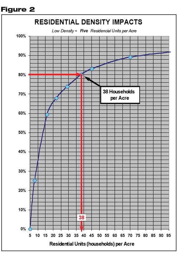
3 Figure 1 shows the runoff reductions from the EPA report and from Grand Rapids extended analysis. The resulting curves are very similar for the densities evaluated in both of the analyses, the only difference being that Grand Rapids analysis was extended to include much higher densities. The curves show a rapid rise in the percent of runoff reduction between the densities of one residence per acre and five residences per acre, followed by smaller runoff reductions indicated by a flattening of the curve as densities increase beyond five residences per acre. Although there were only three different densities evaluated in the EPA report, the same rapid rise and flattening of the curve is evident. The EPA report effectively demonstrates that higher-density developments will result in less impact on the overall watershed. However, the density of one residence per acre for the base low-density residential development does not seem appropriate when applied to urbanized communities for consideration of waiving the stormwater management requirements. Generally, urbanized communities have very few residential areas with densities less than five residences per acre. And, given the dramatic difference in runoff impact (150%) for developments of one residence per acre versus five residences per acre, the definition of a low-density residential development is five residences per acre for this analysis, rather than one residence per acre as defined in the EPA report. Typically, a residential development with five residences per acre will have an average of 4,700 square feet of impervious area per residence. The impervious area includes roof, patio, sidewalk, and driveway. Figure 2 shows the relative percent of runoff reduction for higher densities compared with an equivalent low-density residential development of five residences per acre with the same number of residences. The 80% runoff reduction for residential developments is obtained at a density of 38 residences per acre.
4
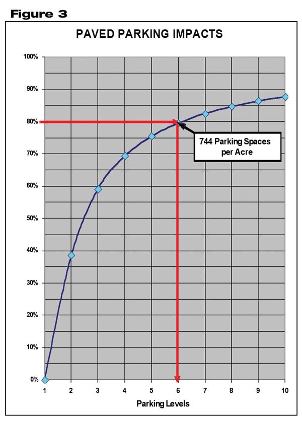
5 Parking Facility Development The configuration for low-density parking facilities was defined as a 1-acre surface parking lot with a 10-foot vegetation buffer on three sides, two parking spaces on each side of a single 20- foot-wide drive aisle, and a driveway at each end. The parking spaces were assumed to be 9 feet wide by 20 feet long. The low-density parking facility has an optimum density of 134 parking spaces per acre with a total impervious area of 36,850 square feet, resulting in a unit density of 275 square feet of impervious area per parking space. The higher-density parking facilities were defined as being a 1-acre multi-level parking facility. A rule of thumb, which was provided by Mark DeClercq of Walker Parking Consultants, for estimating parking deck area needed to accommodate a given number of parking spaces is 350 square feet of deck area per parking space. Assuming a parcel size of 1 acre, the parking spaces per level were calculated by taking 43,560 square feet per acre and dividing by 350 square feet per parking space, which yields 124 spaces per parking level. Because only the upper level of a multi-level parking facility receives rainfall, the runoff will remain constant regardless of the number of parking levels. Therefore, while the number of parking spaces increases with each additional parking level, there is less runoff per parking space. Figure 3 shows the relative percentage of runoff reduction compared with a surface parking lot with the same number of parking spaces. The 80% runoff reduction occurs when there are six levels of parking, which translates into a density of 744 parking spaces per acre of land area used by the facility.
6
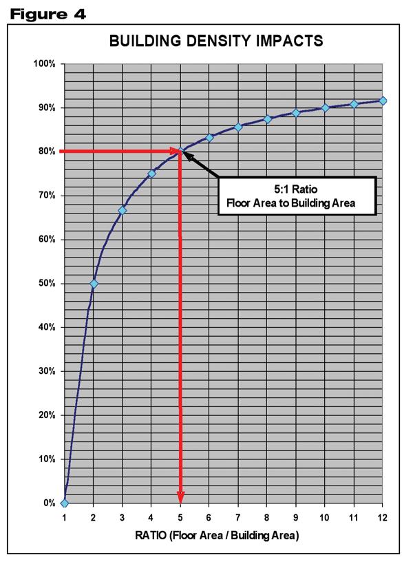
7 Commercial and Office Development The configuration for the low-density commercial/office development was defined as a singlestory commercial or office building. The runoff was estimated for the building area being 100% impervious. Because a building s density is related to the floor space, the ratio of floor space area divided by the building roof area was used as the indicator for density. The 80% threshold is reached by buildings with a gross floor area five times greater than the building roof area or, in other words, by buildings that are at least five stories in height. Figure 4 shows the relative percentage of runoff reduction compared to a single-story building of equal floor space.
8

9 Mixed-Use Development Most high-density developments involve a mix of uses. Such developments typically have retail use at street level, parking decks in the back and beneath the development, office spaces on the second and possibly third levels, and residential use on the remaining upper floors. Therefore, an empirical method is needed for evaluating the runoff impact reduction for such mixed-use developments. The evaluation is based on the average impervious area per unit of the predefined low-density development unit, which is shown in Table 1. The equivalent low-density impervious area (Ai LD ) for each use type is estimated by taking the number of proposed development units (i.e., residences, parking spaces, or gross floor area) and multiplying by the typical impervious area for each development unit. The equivalent low-density impervious area (Ai LD ) for a residential development is calculated by multiplying the number of proposed residences by 4,700 square feet per residence. The Ai LD for a parking facility is calculated by multiplying the number of proposed parking spaces by 275 square feet per parking space. The Ai LD for all other uses such as office, retail, and hotel is simply the proposed gross floor area. The development s total equivalent low-density impervious area (Ai LD ) for the mixed uses is the sum of the Ai LD for each of the different uses. The percent runoff reduction is estimated using Equation 1, incorporating the development s actual site impervious area (Aisite) (less any vegetated roof areas) and the development s total equivalent low-density impervious area (Ai LD ). The goal for granting a waiver from the stormwater management requirements is for at least an 80% reduction in runoff relative to an equivalent low-density development. Conclusion The granting of a waiver from certain stormwater management requirements for high-density developments makes good sense from an overall watershed perspective. High-density developments provide more spaces for living, working, and commerce while reducing the total disturbed land area, requiring fewer streets, and minimizing the overall volume of runoff discharged into the surface waters of the watershed. In spite of these environmental benefits for the watershed, the increased peak discharge from high-density development into local and downstream drainage systems must be considered. If the local and downstream drainage systems can accommodate that discharge, as is the case for the Grand Rapids downtown area, then a waiver can be granted. However, if the local and downstream drainage system cannot accommodate that discharge, public officials need to consider improvements to the drainage system (including offsite detention) to accommodate the granting of such a waiver. Therefore, although high-density development should be fostered as a watershed best management
10 practice, consideration must be given to the capacity of the local and downstream drainage systems to accommodate and manage the peak discharges before a waiver or reduction in the stormwater management requirements is granted. Currently, the City of Grand Rapids has granted waivers for two high-density developments. These two developments, involving a total of 1.2 acres of redevelopment, avoided the creation of over 14 acres of impervious area elsewhere in the watershed. This more-than-tenfold reduction was due, in large part, to the city s policy that deliberately recognizes the value of high-density development and rewards such development by reducing or waiving certain stormwater requirements. Combined with other low-impact development policies and practices like promoting the Green Building Council s Leadership in Energy and Environmental Design certification, vegetated roof covers, porous paving, rain gardens, and runoff capture and reuse, the City of Grand Rapids is quickly redeveloping into a community with a healthy environment in which to live, work, and play. Randel Lemoine, P.E., is with the City of Grand Rapids Environmental Services. SW October 2007 pages 90-95,
Introduction Post Construction Stormwater Management Performance Requirements
 Introduction Post Construction Stormwater Management Performance Requirements The primary objective of these Post Construction Stormwater Management Performance Requirements is to minimize the downstream
Community LID Workgroup Issue Paper #6
 Community LID Workgroup Issue Paper #6 Topic: Hard and Impervious Surface Coverage Limits Objective: Minimize the amount of hard and impervious surfaces in developments to allow more stormwater to infiltrate
Introduction Post-Construction Stormwater Management Performance Requirements
 EZ MANUAL Introduction Post-Construction Stormwater Management Performance Requirements The primary objective of these Post-Construction Stormwater Management Performance Requirements is to minimize the
NEORSD Green Infrastructure Grant (GIG) Program Opening Remarks
 Program Opening Remarks") NEORSD Green Infrastructure Grant (GIG) Program Opening Remarks 2019 NEORSD GIG Eligibility and Technical Requirements Project must be located in the Sewer District s combined sewer area Location Applicant
NEORSD Green Infrastructure Grant (GIG) Program Opening Remarks 2019 NEORSD GIG Eligibility and Technical Requirements Project must be located in the Sewer District s combined sewer area Location Applicant
Rhode Island Stormwater Design and Installation Standards Manual
 Rhode Island Stormwater Design and Installation Standards Manual RIDOT Workshop LID Site Planning and Design Strategies: How to Meet Minimum Standard No. 1 August 25, 2011 Low Impact Development (LID)
Time Value of Money and Optimization Process
 Time Value of Money and Optimization Process Cost Definitions Inflation increase in cost of products over time, decrease of purchasing power Recurring cost a cost that happens multiple times at regular
GREEN ON THE HORIZON. Challenges of Integrating LID into New Development. Southeast Stormwater Association
 GREEN ON THE HORIZON Challenges of Integrating LID into New Development Southeast Stormwater Association Annual Seminar, Charleston SC October 9, 2014 JENNIFER A. NUNN, PE THE BALMORAL GROUP Acknowledgments
LID Permit Requirements. Lisa Austin. Geosyntec Consultants
 LID Permit Requirements Lisa Austin Geosyntec Consultants Presentation Outline Types of LID Permit Requirements Specified site design Specified LID BMPs LID performance metrics Specified Site Design (San
Standards Manual. RIDOT Workshop. Design Strategies: How to Meet Minimum Standard No. 1 July 13, 2011
 Rhode Island Stormwater Design and Installation Standards Manual RIDOT Workshop LID Site Planning and Design Strategies: How to Meet Minimum Standard No. 1 July 13, 2011 Low Impact Development (LID) Community
Can Urban Redevelopment Restore Aquatic Resources
 Can Urban Redevelopment Restore Aquatic Resources with Standards for Stormwater Retention and Landscape Performance? Rebecca C. Stack District of Columbia Department of the Environment Industry, Agriculture,
3. Are there any projects exempt from the definition of Regulated Projects?
 STORMWATER REQUIREMENTS: OVERVIEW OF PROVISION C.3 Background: On October 14, 2009, the Regional Water Quality Control Board, San Francisco Bay Region, issued a municipal regional stormwater permit (MRP)
WEFTEC.06. ** City of Caldwell, Idaho
 COST-BENEFIT ANALYSIS OF URBAN STORMWATER RETROFITS AND STREAM DAYLIGHTING USING LOW IMPACT DEVELOPMENT TECHNOLOGIES Sherrill Doran*, Dennis Cannon** * CH2M HILL, 322 East Front Street, Suite 200 Boise,
Low Impact Development a great program that helps make the best use of something we re all familiar with - rainwater. practices.
 Management practices best Low Impact Development a great program that helps make the best use of something we re all familiar with - rainwater. Long Beach Development Services Building a Better Long Beach
5. LOW IMPACT DEVELOPMENT DESIGN STANDARDS
 5. LOW IMPACT DEVELOPMENT DESIGN STANDARDS Low Impact Development (LID) requires a shift in stormwater management away from conveying runoff to a small number of downstream points through hydraulically
Green Infrastructure Incentives. Abby Hall EPA Headquarters Office of Policy, Economics and Innovation
 Green Infrastructure Incentives Abby Hall EPA Headquarters Office of Policy, Economics and Innovation Types of Incentives Fee Discount Development Incentives Rebates & Installation Financing Stormwater
Evaluating Low Impact Development Practices for Stormwater Management on an Industrial Site in Mississippi
 Evaluating Low Impact Development Practices for Stormwater Management on an Industrial Site in Mississippi Dennis S. Painter, Tennessee Valley Authority, Nashville, Tennessee Donald Becker, Tennessee Valley
Ancient Greek and Roman planners recognized the importance of centralized gathering spaces within urban
 TEAMS Competition 2014 Urban Green Space Design Introduction Ancient Greek and Roman planners recognized the importance of centralized gathering spaces within urban areas. Early Greek agora and Roman forums
4. CONCEPT PLAN DEVELOPMENT
 4. CONCEPT PLAN DEVELOPMENT Concept Plan Step 1: Identify Site Constraints and Opportunities Review the existing site to identify constraints and opportunities for GI Practices to meet the RRv. Constraints
City of Elmhurst. City of Elmhurst. Storm Sewer System Workshop November 22, 2010
 City of Elmhurst City of Elmhurst Storm Sewer System Workshop November 22, 2010 1 City of Elmhurst Watershed divide (green dashed line) through Elmhurst Area east of divide drains to Addison Creek Area
Background / Regulatory Requirements
 Chapter 2 Background / Regulatory Requirements This Chapter summarizes stormwater problems resulting from development and explains the post-construction requirements for development projects. 2.1 Stormwater
Post-Construction Stormwater Management Checklist* (5,000 SF or Greater)
") Applicability: Required for projects that create and/or replace 5,000 square feet or greater of impervious surface (i.e. asphalt roads, concrete structures, building area, sidewalks, etc.). Impervious
Applicability: Required for projects that create and/or replace 5,000 square feet or greater of impervious surface (i.e. asphalt roads, concrete structures, building area, sidewalks, etc.). Impervious
Green Infrastructure Recommendations For Parks and Public Spaces
 Green Infrastructure Recommendations For Parks and Public Spaces Issued by the Jersey Water Works Green Infrastructure Committee And Prepared by Meliora Design This document recommends ways to integrate
Post - Construction Hydromodification Development Requirements
 Condensed Version - Interim Low Impact Development / Hydromodification Guidelines, City of Lompoc 1 Post - Construction Hydromodification Development Requirements I. PURPOSE A. The purpose of these requirements
Site design measures. Chapter. This Chapter explains how site design measures can reduce the size of your project s stormwater treatment measures.
 Chapter 4 Site Design Measures This Chapter explains how site design measures can reduce the size of your project s stormwater treatment measures. Site design measures for water quality protection are
Retrofitting Sacramento State Campus with Low Impact Development Stormwater Control Measures: A Local Project with Regional Intent
 Retrofitting Sacramento State Campus with Low Impact Development Stormwater Control Measures: A Local Project with Regional Intent Kevin Murphy, P.E. Joel Shinneman, EIT OWP at Sacramento State 1 Project
Scorecard. WaterQuality. Appendix B USEPA WATER QUALITY SCORECARD APPENDIX B
 Appendix B USEPA WATER QUALITY SCORECARD EPA 231B09001 October 2009 http://www.epa.gov WaterQuality Scorecard Incorporating Green Infrastructure Practices at the Municipal, Neighborhood, and Site Scales
Article 20 Stormwater Management
 Article 20 Section 20.01 Intent Article 20 The purpose of this Article is to protect the health, safety, and general welfare of the citizens by requiring compliance with accepted standards and practices
Project Applicant Checklist for NPDES Permit Requirements SAN MATEO COUNTYWIDE STORMWATER POLLUTION PREVENTION PROGRAM
 Project Applicant Checklist for NPDES Permit Requirements SAN MATEO COUNTYWIDE STORMWATER POLLUTION PREVENTION PROGRAM I. PROJECT DATA Project Name Bay Meadows Development Phase II Project Address 2600
Rain Gardens. Welcoming and filtering rainwater naturally. Asad Rouhi Northern Virginia Soil and Water Conservation District
 Rain Gardens Welcoming and filtering rainwater naturally Asad Rouhi Northern Virginia Soil and Water Conservation District Urban Development Impact Inadequate drainage, erosion, flooding Northern Virginia
HEALTH SCIENCES BUILDING REDEVELOPMENT PROJECT
 INTRODUCTION In recent years, the University of Cincinnati (University) has demonstrated a commitment to identifying and implementing sustainable goals and objectives throughout University s Uptown Campuses.
Exercises: Using LID Feasibility Worksheets
 Exercises: Using LID Feasibility Worksheets Laura Prickett, EOA, Inc. Thanks to Lisa Austin, Geosyntec, for help with Case Studies November 17, 2011 Case Studies 1. Fremont Commercial Project Screening
Three threshold measures will be applied together to capture project scale and scope and impacts:
 The regulatory consequences to the County from State and Federal water quality regulations if the pollution impacts are not addressed by each project. The extreme difficulty, cost, and equity issues associated
LOW IMPACT DEVELOPMENT GUIDANCE MANUAL AND LID WORKING GROUP ACTIVITIES. Powerpoint Templates. MS4 Statewide Stormwater Summit June 18, 2013
 LOW IMPACT DEVELOPMENT GUIDANCE MANUAL AND LID WORKING GROUP ACTIVITIES MS4 Statewide Stormwater Summit June 18, 2013 Powerpoint Templates Evan Canfield, Ph.D, P.E. Pima County Regional Flood Control Outline
Metropolitan Area Planning Council 60 Temple Place, Boston, Massachusetts fax
 Metropolitan Area Planning Council 60 Temple Place, Boston, Massachusetts 02111 617-451-2770 fax 614-482-7185 www.mapc.org Serving the 101 Cities Towns in the Metropolitan Boston Region MEMORANDUM TO:
STORMWATER MANAGEMENT CODES ANALYSIS RICHLAND COUNTY, SC SITE PLANNING ROUNDTABLE
 STORMWATER MANAGEMENT CODES ANALYSIS RICHLAND COUNTY, SC SITE PLANNING ROUNDTABLE Codes analyses for each subcommittee were completed to assist participants of the Richland County Site Planning Roundtable.
Incorporating Sustainable Practices and Water Quality into Roadway Design. May 24, 2017
 Incorporating Sustainable Practices and Water Quality into Roadway Design May 24, 2017 Justin Oswald, P.E., CFM Freese and Nichols, Inc. Presenters Todd Buckingham, P.E., ENV SP Freese and Nichols, Inc.
RESIDENTIAL STORM WATER PERMIT & CREDIT APPLICATION WORKSHEET AND CHECKLIST
 Engineering Department - Phone: (651) 792-7004 Fax: (651) 792-7040 2660 Civic Center Dr. Roseville, MN 55113 RESIDENTIAL STORM WATER PERMIT & CREDIT APPLICATION WORKSHEET AND CHECKLIST This application
One County s Success in Linking Watershed Protection and Land Use Planning
 One County s Success in Linking Watershed Protection and Land Use Planning Bob Thompson Porter County Plan Commission March 28, 2012 Indiana Watershed Leadership Academy Population 160,000 Approximately
Going Green with the NYS Stormwater Design Standards
 Going Green with the NYS Stormwater Design Standards Shohreh Karimipour, P.E. NYSDEC History of Stormwater Management Ancient Greek Cisterns Water Cistern Systems in Greece from Minoan to Hellenistic Period,
STORMWATER REPORT FOR WALMART SUPERCENTER STORE # SIOUX FALLS, LINCOLN COUNTY, SOUTH DAKOTA BFA PROJECT NO
 STORMWATER REPORT FOR WALMART SUPERCENTER STORE # 2443-00 SIOUX FALLS, LINCOLN COUNTY, SOUTH DAKOTA BFA PROJECT NO. 3286 March 1, 2012 I hereby certify that this engineering document was prepared by me
Low Impact Development Site Design
 Chapter 4 Low Impact Development Site Design In this Chapter: How site design measures can reduce stormwater treatment measure size Tree preservation and planting Self-treating and self-retaining areas
Lincoln 270. City of Lincoln. Stormwater Management Plan. April 2, 2013
 Lincoln 270 City of Lincoln Stormwater Management Plan April 2, 2013 # 2005.48 Prepared By: Civil Engineering Solutions, Inc. 590 E Street Lincoln, Ca 95648 (916) 645 5700 1.0 Background: The project site
Appendix E: Illustrative Green Infrastructure Examples
 Appendix E: Illustrative Green Infrastructure Examples Integrating LID into San Francisco s Urban Landscape Figure E. High-density Residential Figure E. Low-density Residential Figure E. Mixed Use 7 Figure
5. FINAL DEVELOPMENT PLAN APPROVAL MENORAH MEDICAL CENTER OFFICE BUILDING Vicinity of the southwest corner of 119 th Street and Nall Avenue
 5. FINAL DEVELOPMENT PLAN APPROVAL MENORAH MEDICAL CENTER Avenue 1. APPLICANT: Hoefer Wysocki Architects, L.L.C., is the applicant for this request. 2. REQUESTED ACTION: The applicant is requesting final
Stormwater Management Techniques WMPF LAND USE TRAINING INSTITUTE MARCH 14, 2018
 Stormwater Management Techniques WMPF LAND USE TRAINING INSTITUTE MARCH 14, 2018 Potential Impacts of New Development Urban development can significantly increase stormwater runoff Water quality considerations
Types and Basic Design of Post-Construction BMPs
 Types and Basic Design of Post-Construction BMPs F O R R E S I D E N T I A L L A N D S C A P E R S D A N B O G O E V S K I O H I O E P A N O R T H E A S T D I S T R I C T O F F I C E J U L Y 9, 2 0 1 3
understanding Green Infrastructure In Zoning
 understanding Green Infrastructure In Zoning Purpose Measurable standards can be adopted within municipal zoning codes, and subdivision and stormwater regulations, to promote a comprehensive approach to
WATERSHED RESTORATION PLAN
 WHITTEN BROOK WATERSHED RESTORATION PLAN Appendices March 2011 Skowhegan Conservation Commission 1 APPENDICES Appendix 1. Watershed Maps...49 Map 1. Topography...49 Map 2. Soils...50 Map 3. Soil Erodibility...51
GOING GREEN! NEWBURYPORT S PLAN FOR THE FUTURE
 GOING GREEN! NEWBURYPORT S PLAN FOR THE FUTURE Jennifer K. Lachmayr, PE, BCEE Kathryn B. Edwards, PE November 2015 Agenda Background Little River Flood Study Little River Pilot Program Vision for Implementation
NEPONSET WATERSHED TOWN BYLAWS AND REGULATIONS THAT ARE CONSISTENT WITH PROPER STORMWATER MANAGEMENT
 NEPONSET WATERSHED TOWN BYLAWS AND REGULATIONS THAT ARE CONSISTENT WITH PROPER STORMWATER MANAGEMENT = Current Bylaw and/or regulation is consistent with MAPC Recommendations = Current Bylaw and/or regulation
GENERAL ASSEMBLY OF NORTH CAROLINA SESSION 2007 SESSION LAW SENATE BILL 1967
 GENERAL ASSEMBLY OF NORTH CAROLINA SESSION 2007 SESSION LAW 2008-211 SENATE BILL 1967 AN ACT TO PROVIDE FOR IMPROVEMENTS IN THE MANAGEMENT OF STORMWATER IN THE COASTAL COUNTIES IN ORDER TO PROTECT WATER
PLANNED DEVELOPMENT (MASTER PLAN & UNIT PLAN)
") Central Permit Center 555 Santa Clara Street Vallejo CA 94590 Business License Building Fire Prevention Planning Public Works 707.648.4310 707.648.4374 707.648.4565 707.648.4326 707.651.7151 PLANNED DEVELOPMENT
Central Permit Center 555 Santa Clara Street Vallejo CA 94590 Business License Building Fire Prevention Planning Public Works 707.648.4310 707.648.4374 707.648.4565 707.648.4326 707.651.7151 PLANNED DEVELOPMENT
Green Infrastructure & Low Impact Development
 Green Infrastructure & Low Impact Development CITY OF COVINGTON STORMWATER MANAGEMENT WHAT IS GREEN INFRASTRUCTURE? Green infrastructure uses vegetation, soils and natural processes to manage water and
Introduction to Low Impact Development. Dr Kathy Chaston Coral & Coastal Management Specialist NOAA Office of Ocean & Coastal Resource Management
 Introduction to Low Impact Development Dr Kathy Chaston Coral & Coastal Management Specialist NOAA Office of Ocean & Coastal Resource Management http://hawaii.gov/dbedt/czm/resource/publication.php A Comprehensive
Green Infrastructure and Low-Impact Development Technologies
 Green Infrastructure and Low-Impact Development Technologies The guiding principles of these technologies is to manage stormwater at their sources using natural means, and establish conditions so that
Neighborhood-Scale Water Quality Improvements The Broadway Neighborhood Stormwater Greenway Project
 Neighborhood-Scale Water Quality Improvements The Broadway Neighborhood Stormwater Greenway Project Presenter: Stacy Luell, Geosyntec Consultants Co-Authors: R. Batchelder, W. Tam, M. Hanna, M. Sadeghi
Boardman River Watershed VILLAGE OF KALKASKA. WATER QUALITY ACTION PLAN Fall 2009
 Boardman River Watershed VILLAGE OF KALKASKA WATER QUALITY ACTION PLAN Fall 2009 Partners: The Watershed Center Grand Traverse Bay Northwestern Michigan College - Great Lakes Water Studies Institute Grand
GREEN BUILDING PROGRAM. COUNTY OF LOS ANGELES A joint effort by Department of Regional Planning and Department of Public Works
 GREEN BUILDING PROGRAM COUNTY OF LOS ANGELES A joint effort by Department of Regional Planning and Department of Public Works Waste Management Board Fire Department Realtors National Park Service Regional
Draft Rhode Island Stormwater Design and Installation Standards Manual
 Draft Rhode Island Stormwater Design and Installation Standards Manual Summary The May 2009 Public Review Draft version of the RI Stormwater Design and Installation Standards Manual consists of approximately
Low Density Projects. Design Objective
 E-1. Low Density Projects Design Objective Low density projects are not required to be equipped with Stormwater Control Measures (SCMs) in exchange for limiting their built-upon area, maximizing dispersed
Rebecca Dohn October 13, 2017
 Rebecca Dohn October 13, 2017 Why Green Infrastructure? Population Growth 46,000 45,000 44,000 43,000 42,000 41,000 40,000 39,000 38,000 37,000 36,000 Impervious Acres 2 Why Green Infrastructure? 3 Why
Stormwater Low Impact Development - A Natural Solution
 Stormwater Low Impact Development - A Natural Solution Sarah U Ren Program Director The Watershed Center of Grand Traverse Bay 231-935-1514, suren@gtbay.org Our Mission: The Watershed Center advocates
Managing Stormwater Runoff with Green Infrastructure "Enhancing Community Resiliency to the Changing Climate"
 Managing Stormwater Runoff with Green Infrastructure "Enhancing Community Resiliency to the Changing Climate" Presented at Stormwater Management on the Whale Pond Brook Watershed Meeting Christopher C.
Impervious Cover Assessment and Reduction Action Plan for Woodstown, New Jersey
 Impervious Cover Assessment and Reduction Action Plan for Woodstown, New Jersey Christopher C. Obropta, Ph.D., P.E. obropta@envsci.rutgers.edu www.water.rutgers.edu March 24, 2015 Rutgers Cooperative Extension
Landscaping Standards
 CHAPTER 29 ARTICLE 403 29.403 Landscaping Standards Purpose: The purpose of this section is to protect and promote the public health, safety and general welfare by requiring landscaping in relation to
Planning, Design, and Construction of Green Infrastructure.
 Planning, Design, and Construction of Green Infrastructure www.water.rutgers.edu What is Green Infrastructure? an approach to stormwater management that is costeffective, sustainable, and environmentally
APPENDIX G: TOWN ORDINANCE REVIEW
 APPENDIX G: TOWN ORDINANCE REVIEW TYLin (225740) Woodard & Curran SWMP January 2013 Stormwater LID strategies, ranked for Zoning Bylaw and Site Plan Review Standards Dimensional Requirements Permit the
Site Design for Protecting Water Quality 2013 Award Winning Projects
 C.3. Workshop, May 29, 2013 Site Design for Protecting Water Quality 2013 Award Winning Projects Vishakha Atre Santa Clara Valley Urban Runoff Program Current New Development and Redevelopment Requirements
BUFFERS, TREE PROTECTION AND LANDSCAPING. Sec Purpose and Intent.
 ARTICLE 20 BUFFERS, TREE PROTECTION AND LANDSCAPING Sec. 20.1. Purpose and Intent. Trees improve air and water quality, reduce soil erosion, reduce noise and glare, provide habitat for desirable wildlife,
Michael Clark, P.E. & Michael Moonan, RLA Weston and Sampson Engineers & David Lachance Woodbury Ridge Developer
 Michael Clark, P.E. & Michael Moonan, RLA Weston and Sampson Engineers & David Lachance Woodbury Ridge Developer Woodbury Ridge An LID Conservation Subdivision Presentation to: Low Impact Development
Retrofit of the Gwinnett County DWR Facility Using Low Impact Development Practices SESWA 2012 Annual Conference October 19, 2012
 Retrofit of the Gwinnett County DWR Facility Using Low Impact Development Practices SESWA 2012 Annual Conference October 19, 2012 Jeff Herr, P.E., D.WRE National Stormwater Leader jherr@brwncald.com Acknowledgements
STORMWATER GREEN INFRASTRUCTURE AND PLANNING/ZONING BOARDS
 STORMWATER GREEN INFRASTRUCTURE AND PLANNING/ZONING BOARDS Source: Center for Watershed Protection, 2007 Southern Tier Central Regional Planning & Development Board Chemung County Stormwater Team OUTLINE
Metropolitan Area Planning Council 60 Temple Place, Boston, Massachusetts fax
 Metropolitan Area Planning Council 60 Temple Place, Boston, Massachusetts 02111 617-451-2770 fax 614-482-7185 www.mapc.org Serving the 101 Cities and Towns in the Metropolitan Boston Region MEMORANDUM
Regional Stormwater Management Program
 Business Risk Exposure (BRE) Score BTU Community Cost-Share Program (CCSP) Cistern Condition Rating of RSS Asset Criticality of a RSS asset Detention Basin Education Credit Equivalent Residential Unit
INTRODUCTION TO THE ADAPTING TO RISING TIDES EXISTING CONDITIONS AND STRESSORS REPORT
 INTRODUCTION TO THE ADAPTING TO RISING TIDES EXISTING CONDITIONS AND STRESSORS REPORT The Adapting to Rising Tides (ART) project evaluated the current condition of shoreline and community assets, and the
Table of Contents G.1.a Water Resources - Surface Water - Drainage
 Table of Contents G.1.a Water Resources - Surface Water - Drainage 1. INTRODUCTION... 1335 2. ENVIRONMENTAL SETTING... 1335 a. Regional Hydrology... 1335 b. Local Hydrology... 1337 c. On-site Hydrology...
A P P E N D I X D. Project Stormwater Plan Worksheets
 A P P E N D I X D Worksheets for Section 1: Basic Project Information This worksheet must be filled out for all projects required to implement the 2015 Post- Construction Stormwater Standards Manual. A
Green Infrastructure Stormwater Management Options in an Ultra-Urban Redevelopment. Sandy Doyle-Ahern
 Green Infrastructure Stormwater Management Options in an Ultra-Urban Redevelopment Sandy Doyle-Ahern sdoyleahern@emht.com + The City of Columbus Downtown Business Plan was developed in 2002 with the goal
RETAINING RUNOFF AT ITS SOURCE
 RETAINING RUNOFF AT ITS SOURCE Atlantic Beach Case Study Jose Maria Guzman, PE, D.WRE Jacksonville Environmental Symposium August 2013 Outline Overview of stormwater issues in Atlantic Beach, FL City s
Directors Rules for Seattle Municipal Code, Chapters Stormwater Code
 Directors Rules for Seattle Municipal Code, Chapters 22.800 22.808 Stormwater Code Requirements for Green Stormwater Infrastructure to the Maximum Extent Feasible for Single-Family Residential and Parcel-Based
a great new program that helps make the best use of something we re all familiar with - rainwater. Building a Better Long Beach
 Management practices best Introducing LID a great new program that helps make the best use of something we re all familiar with - rainwater. Long Beach Development Services Building a Better Long Beach
Sustainable Stormwater Retrofit Best Practices
 Sustainable Stormwater Retrofit Best Practices Presenter Zach Sample, PE Stormwater Products Manager XP Solutions XP Solutions has a long history of Providing original, high-performing software solutions
Urban Sustainability Area Designation
 Urban Sustainability Area Designation City of Santa Cruz October 2013 The City of Santa Cruz Urban Sustainability Area (USA) encompasses the City s business centers and primary transportation corridors
CHAPTER 11 SITE DESIGN AND LOW IMPACT DEVELOPMENT
 CHAPTER 11 SITE DESIGN AND LOW IMPACT DEVELOPMENT Source: City of Bend Chapter Organization 11.1 Purpose... 11-1 11.2 Applicability... 11-1 11.3 Low Impact Development Overview... 11-2 11.3.1 Key Strategies...
Zoning Design Standards. Low Impact Development Code Update Thurston County Planning Commission March 2, 2016
 Zoning Design Standards Low Impact Development Code Update Thurston County Planning Commission March 2, 2016 Background Zoning regulations include limitations on the size and location of structures within
Growing Sustainable Communities Conference
 Growing Sustainable Communities Conference M A N A G I N G S T O R M W A T E R W I T H G R E E N I N F R A S T R U C T U R E O C T O B E R 1 2, 2 0 1 1 Creating A Sustainable Development Code L A U R A
City of Waco Stormwater Management Regulations
 1.0 Applicability: City of Waco Stormwater Management Regulations These regulations apply to all development within the limits of the City of Waco as well as to any subdivisions within the extra territorial
Assessing Directly Connected Impervious Areas in Residential Subdivisions in Western Sydney, NSW
 Assessing Directly Connected Impervious Areas in Residential Subdivisions in Western Sydney, NSW 1, 1 Cardno (APAC South), 203 Pacific Highway St Leonards, 2065. Email: Stephen.Gribble@cardno.com.au Key
STORM WATER UTILITY FREQUENTLY ASKED QUESTIONS
 STORM WATER UTILITY FREQUENTLY ASKED QUESTIONS In 2007, the City Council adopted Ordinance No. 1155 establishing a storm water utility in the City. No fee structure was adopted at that time. The idea of
City of Sun Prairie Wetland Buffer Reduction Request
 City of Sun Prairie Wetland Buffer Reduction Request Westside Development Area January 9, 2017 Prepared by: City of Sun Prairie 300 E. Main Street Sun Prairie, WI 53590 BACKGROUND The City of Sun Prairie
LID CASE STUDY DESIGN WORKSHOP HSG B/D SOIL EXAMPLE SINGLE FAMILY SUBDIVISION WITH OUTPARCEL
 LID CASE STUDY DESIGN WORKSHOP HSG B/D SOIL EXAMPLE SINGLE FAMILY SUBDIVISION WITH OUTPARCEL B Y : M A R T Y W A N I E L I S T A A N D E R I C L I V I N G S T O N August, 2016 ACKNOWLEDGEMENTS The Low
Placement of the soil should be in lifts of mm and loosely compacted (tamped lightly with a backhoe bucket).
.") 6 Rain Gardens Rain Gardens 6.1 Introduction A rain garden is used to attenuate peak flows and to provide stormwater treatment. Rain gardens use the concept of bioretention, a water quality practice in
6 Rain Gardens Rain Gardens 6.1 Introduction A rain garden is used to attenuate peak flows and to provide stormwater treatment. Rain gardens use the concept of bioretention, a water quality practice in
Draft Impervious Cover Reduction Action Plan for West New York, Hudson County, New Jersey
 Draft Impervious Cover Reduction Action Plan for West New York, Hudson County, New Jersey Prepared for the Town of West New York by the Rutgers Cooperative Extension Water Resources Program March 29, 2017
LOW IMPACT DEVELOPMENT (LID) SAMPLER
 SAMPLER") LOW IMPACT DEVELOPMENT (LID) SAMPLER August 2007 The Low Impact Development Sampler is a selection of LID projects in eleven of the Upper Susquehanna Coalition s fourteen member counties (as of 2003).
LOW IMPACT DEVELOPMENT (LID) SAMPLER August 2007 The Low Impact Development Sampler is a selection of LID projects in eleven of the Upper Susquehanna Coalition s fourteen member counties (as of 2003).
Water sensitive urban design
 WSUD in your backyard Living Smart Mellissa Bradley, Program Manager 16 May 2017 Water sensitive urban design. is an approach to urban planning and design that integrates the management of the total water
5/22/2012. Low Impact Development through NPDES Permits TAKE AWAY MESSAGES. Municipal Stormwater NPDES Permits
 Low Impact Development through NPDES Permits Ed O Brien eobr461@ecy.wa.gov 360/407-6438 TAKE AWAY MESSAGES Municipal SW permits will require LID on new and redevelopment projects Site LID: necessary but
Concreteville, CT. March 10, 2004
 Concreteville, CT March 10, 2004 Reducing Runoff is the most topically direct follow up to Linking Land Use to Water Quality (Basic NEMO). There is a good deal of overlap, but the major differences is
Urban Stormwater Management
 State Regulations and Sustainable Infrastructure April 16, 2011 Urban Stormwater Management Drivers Ecosystem Services LID and Light Imprint New Urbanism Comments MD Stormwater Regulations Larry S. Coffman
Introduction to Low Impact Development. Fred Milch. East Central Florida Regional Planning Council
 Introduction to Low Impact Development Fred Milch East Central Florida Regional Planning Council Low Impact Development (LID) Low impact development (LID) is a term used to describe a land planning and
Annual Reporting for FY Regional Supplement for New Development and Redevelopment
 Regional Supplement for New Development and Redevelopment San Francisco Bay Area Municipal Regional Stormwater Permit September 2012 Table of Contents Page INTRODUCTION 2 Low Impact Development 2 C.3.c.iii.(1)