Defra s Water Availability and Quality Evidence Programme. Comparative Costings for Surface Water Sewers and SuDS.
|
|
|
- Dana Jefferson
- 5 years ago
- Views:
Transcription

1 Defra s Water Availability and Quality Evidence Programme Comparative Costings for Surface Water Sewers and SuDS. Marlborough Road, Telford, Shropshire. R&D Technical Report Produced: February 2011 Author: Graham Fairhurst 1
2 Research contractor: Department for Environment Food and Rural Affairs Defra project officer: Rachel Boulderstone Publishing organisation Department for Environment, Food and Rural Affairs Water Availability and Quality, Ergon House, Horseferry Road London SW1P 2AL Tel: Fax: Crown copyright (Defra);(2010) Copyright in the typographical arrangement and design rests with the Crown. This publication (excluding the logo) may be reproduced free of charge in any format or medium provided that it is reproduced accurately and not used in a misleading context. The material must be acknowledged as Crown copyright with the title and source of the publication specified. The views expressed in this document are not necessarily those of Defra. Its officers, servants or agents accept no liability whatsoever for any loss or damage arising from the interpretation or use of the information, or reliance on views contained herein. Published by the Department for Environment, Food and Rural Affairs (July 2011). 2
3 Contents 1. Location Site Characteristics The Highway Layout The Surface Water Drainage System as Built The SuDS Concept The Estimates Opportunities for SuDS if the site concept and layout had been modified Benefits Lessons Learnt Summary ANNEX 1: Plan showing Surface Water Sewers. ANNEX 2: Plan showing SuDS Concept. ANNEX 3: Estimates of Sewers and SuDS. ANNEX 4: Site Photographs. 3
4 1. Location 1.1 The development is located in Hadley, in the northern part of Telford, Shropshire, within Telford & Wrekin Borough (a unitary authority). Hadley has had a long history of industry ranging from extractive industries (coal and brick clay) to heavy and light engineering production. Since the development of Telford New Town from 1968 onwards, Hadley has seen more manufacturing and related land uses develop. The industrial base has seen significant changes over the last 100 years and change has been a theme over the past 10 or so years. The major brickworks has declined in output and even some of the newer industries have now closed down. This has meant that alternative uses have had to be found for underused and cleared sites. Many of these sites have been re-used for housing. 1.2 The locality is underlain by dense, impermeable clay (known as Etruria Marl), whilst to the south the land rises onto the coal measures which have been extensively mined. 1.3To the east, the site is bounded by the brickworks and to the south and west by established housing mostly dating from the 1930s and 1950s. Marlborough Road connects the site with this earlier development and to the centre of Hadley in the west and links to Sommerfield Road in the east. 1.4 Telford remains a fast growing town and at the time this estate was built was expanding at about 800 new homes per year. 1.5 The highway adoption is the responsibility of Telford & Wrekin Council. The Council s engineers have also provided advice on drainage, land stability and land quality. The sewerage systems (foul and surface water) have been vetted directly by Severn Trent Water. 1.6 The National Grid Reference of the site is: SJ Site Characteristics 2.1 This is a 11.24ha site which was developed between 2002 and 2004 and lies for the most part on brownfield land which formed part of the brickworks. The site slopes moderately and generally to the north and east and is underlain by the dense, impermeable clay. 2.2There was formerly a small watercourse flowing south to north adjacent to the site, but this was incorporated within the surface water sewerage infrastructure provided to enable the development of the New Town in the 1970s. The only outfalls for surface water from this site are therefore to a surface water sewer that flows west to east beneath Trench Lock, the road which forms the northern boundary of the site, and to a similar sewer that flows beneath Sommerfield Road which is situated to the east of the site. These two sewers join and then connect to a large diameter sewer tunnel which outfalls into an engineered open channel system that discharges into the River Tern about six kilometres to the north west. This surface water sewerage system conveys a significant pollution load from the urban area. In accordance with normal Environment Agency practice for surface water sewers, the discharge to the river is not consented. The engineered open channels that convey the water to the river are mostly along the routes of former small watercourses and are trapezoidal in cross-section and lined with 4
5 gabions. Without this engineered lining, the peak discharges from the sewerage system could not have been handled without significant erosion and environmental damage. The open channels are not an attractive feature and support little biodiversity. 2.3 To the east the site is bounded by the active brickworks and to the south and west by established housing mostly dating from the 1930s and 1950s. 2.4 The Marlborough Road estate has a mix of housing types ranging from mid-sized detached houses, through three storey town houses to terraced houses and three and four storey flats. The majority of the development comprises smaller, starter home units. A large proportion of these have been bought on a buy-to-let basis. The development therefore has both a high occupancy and most residents have cars. 2.5 The development is laid out to a modern, high-density layout with features such as: Narrow highways with sharp bends and other traffic calming features. Terraced housing with very small gardens. A high level of parking provision. Parking courtyards, some of which are fronted by garages with flats above. Shared surfaces which serve several properties. 2.6 It is generally well designed, with attractive houses and attention paid to the materials used and to high quality hard and soft landscaping. For example most unadopted parking courts and linking walkways are brick paved (with clay paviors) and most green areas provided attractive settings for some of the houses. Because of the high density and high level of parking provision impermeable areas are large. 3. The Highway Layout 3.1 The site has a complex, convoluted highway layout which facilitates high density development. The layout and detailing have clearly been considered at the earliest stages of the development concept and have been well thought through, with regard to access and to integrated traffic calming. 3.2 Marlborough Road forms the only vehicular route which passes through the estate. 3.3 The Council as highway authority, has a reluctance to adopt brick paving. As a result, the more heavily trafficked highways are surfaced with tarmacadam as are many of the adoptable footways. Brick paving is however to be found in certain adoptable areas. There are a large number of unadopted parking courts and shared driveways each of which serve several properties. These all function as shared surfaces, used by vehicles and pedestrians and are mostly brick paved. All of the highway drainage and the drainage of unadopted surfaces is to conventional gullies. 4. The Surface Water Drainage System as Built 4.1 Surface water drainage is all to a traditional pipe system which largely follows the highway network. The main system flows northwards to connect to 5
6 the main surface water sewer in Trench Lock. The extreme eastern part of the site and the section of Marlborough Road linking to Sommerfield Road are drained via a separate surface water system to the sewer in Sommerfield Road. The sewered solution is shown in Appendix All of the properties are drained by private drains and private sewers to the public sewerage system which was adopted through a Section 104 agreement under the Water Industry Act. 4.3 The highway gullies are connected to the adopted surface water sewers via pipe connections. There are no separate highway drains. 4.4 As the site connects to established surface water sewers which had capacity to receive the 1 in 30 year flows from the development, there are no flow attenuation features within the development and none at the points of connection to the existing sewers. 4.5 Whilst there is very extensive use of brick paving throughout the development, none of this is porous paving. There no other SuDS features, although some householders may have installed rainwater butts. 5. The SuDS Concept 5.1 Subsoil conditions within this site do not permit a reliance on infiltration techniques. The SuDS concept is therefore one which relies upon attenuation storage and slow conveyance. The main conveyance route is to the east to the village green in Marlborough Road and then to the north along a green corridor. A secondary conveyance system serves the small part of the site to the east and the section of Marlborough Road which connects to Sommerfield Road. Essentially the flow routes are similar to those employed in the surface water sewer design. The concept is shown in Appendix Surface water from the highway is drained into porous surfaces and/or on the surface via short routes to swales or basins. The concept assumes the surfaces are shaped to fall toward the swales and/or basins. The subgrade beneath the porous surfacing is assumed to be shaped to gentle falls towards filter drains. 5.3 Because of the density of the development, there are relatively few opportunities to use swales, but there are grass verges along Marlborough Road which are assumed to be shaped into swales with under-drainage. It has been practical to place basins in many of the other surfaced and open areas. 5.4 Experience indicates that with high car ownership, parking of vehicles on verges and swales can sometimes be problematic. Therefore it has been assumed that a kerb with drainage openings in the face is provided between the carriageway and the swales. Alternative solutions to this issue could be hit and miss kerbs, bollards, low trip rail type of fencing and/or shrub planting at the edge of the swale/basin and these may be suitable in some parts of the site. 5.5 The principles employed for the SuDS are: 6
7 a) Source Control: Porous paving of the house driveways. Porous paving of the adopted cul-de-sacs and unadopted parking courts and shared driveways. It is assumed that the more heavily trafficked spine road through the site is surfaced with conventional tarmac. Roof water disconnection with downspouts discharging to rainwater butts which overflow to individual filter drains (or garden swales where there is space) and/or into the porous stone structure beneath the porous paved parking courts and shared driveways and with residual discharge passing to the adoptable swales and basins. b) Local Control: Adoptable swales, detention basins and ponds which form a continuous, slow conveyance system, which in general follows the same routes as the surface water sewers did. The swale system works at two levels: 1. A surface based swale system (with the main swales 1.8m wide and of V section, with a depth of 0.3m). 2. A slightly deeper, porous pipe system which sits beneath the centre line of the swales. This deeper system is intended to take flows beyond the capacity of the surface swales and there are 20 grated inlets from the surface swales to the lower system. The swales are located where there is grass verge and roadside landscaping. The basins have been assumed to be shallow, generally not more than about 400mm deep so that they will have opportunity to lose water through evaporation and slight infiltration but will not retain more than about 100mm depth in drier periods of weather. It is assumed that they will be landscaped and may have some shrubs and trees around and within them. They have been made as large as reasonably possible in area and have been located wherever the site layout had some available space. They have all been placed in visible areas which have direct connectivity to either the highway or to other open space (for oversight and maintenance). The locations comprise: Public open space - Here, they have generally been placed in what would otherwise be less usable corner positions so as to retain the availability of larger, flat grassed areas for recreational games. Some highway areas - Here, flank frontages of properties have provided opportunities, as have visibility splays at junctions and peripheral garden space in awkward shaped plots. In these cases, it is assumed that the land occupied by them would become public open space or would be covered by an easement to allow the SAB to maintain them. Ponds are provided in a number of places. These are located within those more extensive and very visible green areas within the site which do not provide play space for children. The site includes a sizeable, feature village green which forms the setting for town houses at the eastern end of the site. It is assumed the central part of this area hosts a pond and that this will be available for flow storage via fluctuating water levels and adjacent floodable area for more extreme events. Clearly it is assumed that this pond will provide enhanced landscape value to its setting. 7
8 A similar approach is taken to the green corridor to the north of the village green. Here, it is assumed that a linear pond feature with permanent water is provided and flow storage is provided within the system. In this location there is opportunity to use the feature to enhance the landscaping which is rather bland. 5.6 In order to provide full continuity within the surface system of swales, basins and ponds, some sections of pipe (200mm diameter) are necessary beneath highways. This is particularly the case at junctions. Because these sections of pipes are extremely shallow, protecting cover (and space for a concrete surround) has been secured by through the traffic calming features. These features increase the total cover to about 250mm. 5.7 In all cases where a basin or swale discharges into a pipe or a pipe discharges into a basin or swale, no engineered headwalls or gratings would be built (the concept assumes that all pipe entries are formed by shaping the swale around them). Care has been taken to ensure that all connections between piped sections occur in the open at basins and swales. There are no manholes within the concept. 5.8 It is assumed that flow control devices would be provided at the outlets to the larger ponds and at immediately prior to the connections to the sewerage system. 5.9 The under-draining pipes beneath the swales form a fully connected system that is independent from the surface system of swales and shallow pipes (being connected only by the specific inlets). The under-draining pipes sit within a trench of standard pipe trench width for the pipe sizes (mostly 250mm diameter and 300mm diameter at the downstream end) and have pipe soffit 150mm below the swale invert giving a maximum depth of these pipes to invert of the order of 750mm. This is a comfortably safe depth for excavation work without the need for expensive trench support systems and the scale of these works will yield relatively small amounts of surplus material for disposal. Access to this system for any maintenance work is via the inlets from the swales The concept does not envisage adoptable SuDS requiring significant areas of private space within housing plots being brought into the public realm to accommodate SuDS features. There may be some small adjustments of property boundaries (e.g. along flank frontages) to provide a small amount of additional space. Such adjustments are marginal and seen as having no cost as they would be made at the time of designing the development and would have no effect on the attractiveness of plots for sale. Within the concept, all adoptable, local control SuDS features are placed within areas where oversight is available. The features are either within: Adopted highway areas. Landscape areas that have been adopted by the local authority. Although these are adopted by the local authority (in this case unitary), formal arrangements could be put in place to cover the situation within the two tier local government system (where landscape may be taken over by the district tier) and the fact that the SAB role is a distinct area of responsibility. This could be done by easements being established by the developer as the estate was laid out to safeguard the SuDS. 8
9 Shared access features such as parking courts or shared driveways. Whilst these areas are not adopted, the SuDS features would be reasonably secure from third party damage because these areas cannot be altered by any one property owner. However, it is envisaged that full security for the SuDS features in such areas would be provided by easements established by the developer as the estate was laid out The concept provides for the source control and local control system to deal with the 1 in 30 year event The 1 in 100 year event is managed by securing a viable, continuous flood route through the development generally along the route of the conveyance system. 6. The Estimates 6.1 These are shown in Appendix 3. The approach taken with the estimates has been to identify only those elements of the development that change between the sewered and SuDS concepts and then to estimate the difference in the total costs of these changes. The changes are principally in connection with the drainage infrastructure itself (e.g. swales instead of sewers) and surfaces (e.g. porous paving in some areas instead of other brick paving and tarmac). The estimates therefore represent only a proportion of the total infrastructure costs of the development. 6.2 The rates used are local ones from Telford & Wrekin Council s annually tendered minor works contract. These rates have been used consistently for all of the estimating for both the SuDS and the sewered options in order to have a sound basis for comparison. 6.3 There is little doubt that a bespoke, tendered contract for each of the concepts would have secured lower rates and lower out-turn costs for both the sewer and SuDS schemes. 6.4 The total estimated cost for the sewer features is 1,074,528. The total estimated cost for the SuDS features is 966,119. This represents a saving per unit of the order of 280 with the SuDS concept. 7. Opportunities for SuDS if the site concept and layout had been modified 7.1 As the layout of this development has been largely determined by the need to achieve the high density and by the main access route, there is probably not huge opportunity to suggest significant ways in which the layout itself could have been made more SuDS friendly. The exercise has in fact shown that this development is quite readily adaptable to a SuDS solution. Clearly, there would have been some opportunities to improve the implementation of SuDS had they been considered within the initial concept, particularly in the ways in which some open space areas could have had more than one use (within e.g. amenity, recreation, parking, surface water management). Whilst this development has a broad mix of dwelling types (two storey terraced houses, three story town houses and three and four storey flats), the designers of this development have wished to use traditional features such as tiled pitched roofs consistently. If the concept had a brief 9
10 with modernist features such as flat or gently sloping roofs, then there would have been opportunity to utilise green roofs. 7.2 One is left with a view that this development has benefited from generally good planning and detailed design (an example in this respect being the way in which the highway concept and detailing support the high density) and that the design team could have successfully factored in a good quality SuDS solution within the overall concept. 8. Benefits 8.1 Even though this is a generally well designed development, the use of SuDS would probably have had the effect of enhancing the attractiveness of the estate. The SuDS would enable some of the paved areas to be softened by introducing more trees and shrubs and other surface detail. There are areas of paving within the estate where bollards have been used to separate the parts which can be driven over from the ones where it is desired to exclude cars. This is not a particularly neat solution and SuDS features could easily have been used to provide this separation. Biodiversity within a highdensity development of this type is not a particularly strong theme and use of SuDS would greatly enhance this aspect; in particular through the basins and ponds. 8.2 The storage and attenuation provided by the SuDS would have had the effect of reducing the burden on the public sewerage system. Although this system is capable of taking the unattenuated 1 in 30 year storm event from this estate, attenuation of the flows would have conserved capacity for other developments and re-developments in the area. This would help to secure better value from the substantial investment in the sewerage infrastructure that has taken place over the past 20 years and reduce the risk of expensive and disruptive upsizing of sewers at a later date. Attenuation of flows from this estate would also have had the effect of giving more resilience to the downstream system in events beyond 1 in 30 years. 8.3 The slow conveyance and attenuation of flows will have the effect of removing pollutants and reducing the current pollution load carried by the surface water sewer system into the open channels and river. This would improve their water quality, amenity and biodiversity. 8.4 As most of the SuDS features are visible within the estate, they will be subject to oversight by the residents. In this way the features can provide an educational resource and evidence to the residents that their development is placing reduced demands upon the wider environment. Simple, surface SuDS features such as the ones which could be used here, can lend themselves to local, co-operative maintenance by residents, particularly as risks and skill requirements are both very low. Where co-operative inputs are mobilised, they can have beneficial effects in helping to build a stronger and safer community. 9. Lessons Learnt 9.1 The SuDS concept has been developed by considering numerous themes in a holistic manner. These include: 10
11 Minimising impacts upon the layout and detailing within the estate as the design of the high-density layout will already have had to broker a range of planning and other requirements. Aesthetics within the development. Residents needs. Access within the development for service vehicles. Access to all properties by vehicle and foot. Traffic safety. SuDS safety. Access to SuDS features for inspection and maintenance. What can be expected of residents and visitors in terms of parking culture. Using green spaces for both landscape and surface water management. A viable flood route. 9.2 In particular the work has shown that it should be possible to incorporate SuDS into well designed, high-density developments. This SuDS scheme has involved minimal alteration to the development and highway concept and does not weaken any of the design principles that have been adopted. The main changes from the original design are: The use of porous paving. The use of porous paving in the adoptable highway areas would need the co-operation of the highway authority. The introduction of swales instead of verges. This again would require the co-operation of the highway authority. Within this estate, even with its large number of cars to be parked, there is no evidence of parking on the existing verges and therefore no reason why swales would be impractical. The introduction of basins. Within the highway areas this would require the co-operation of the highway authority. Within the highway areas and in other areas, these basins should have a positive benefit in terms of landscape. As this is a high density development, there are limited numbers of trees and shrubs. The relatively small opening up of surfaced areas to provide these basins will also give opportunity for some landscaping which would break up some of the more extensive, bleaker paved areas. The introduction of ponds into some of the green landscape areas. This would not detract from the use of these areas as they are mostly currently seen as providing passive amenity value. The introduction of open water will have the effect of strengthening the visual amenity of these areas and provide biodiversity value. Where green areas also have a role of providing play (or kick about ) space, then they have not been selected for ponds. Instead, the fringes of the areas have been used for swales or linear basins that would be designed to be self draining. 10. Summary 10.1 The exercise has shown that a high-density development is amenable to a SuDS drainage solution which is compliant with the proposed Standards and which can provide added value to the development. It also indicates that SuDS in this type of development can offer a cheaper drainage solution than traditional sewers. The exercise has confirmed the key role that highway adoption standards and design will play in securing good SuDS solutions. In a development such as this with a good design concept and good detailing, SuDS ought not to be a difficult theme to incorporate. 11
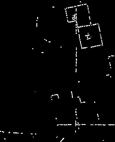
12 Key: Surface Water Sewers SW Underground Storage Pipes Watercourse Culverted Watercourse Swales Basin or Flood Meadow Floodable Area Pond Pipes Case Study 2 Marlborough Road Surface Water Sewer Plan Scale : 1:2500


13
14 APPENDIX 3 ` Case Study 2 (Marlborough Road), Estimate. Item Standard Drainage SUDS Qty Qty Pipework 2730m 255,175 2,145m 109,065 Manholes 97nr 105,550 Gullies incl. connections 133 nr 30,590 Catch Pits 20 nr 6,900 Gulley Pipework 399m 17,556 Basins Excavation 2,890m 3 7,803 Basins -Soft Spots and Fill 20m Basins Headwalls / Control Devices 12 no. 12,000 Excavation-Trimming of Swales and Basins 2,890m 2 7,803 Swales - Excavation 938m 3 4,878 Surplus Material Disposal 2,075m 3 51,875 Topsoil / Seeding 2,890m 2 3,468 House Connection Pipework (say 12m / house) 4,644m 204,336 House Connection Pipework (say 12m / house) 4,644m 204,336 Bricklin Mews (Type 1) (Area paved additional subbase for porous paving) 1,240m 2 39,680 Driveway - Surface Course (40mm) 3525m 2 29,963 Driveway - Binder Course (60mm) 3525m 2 35,250 Driveway Sub - base Course (Type 1) 529m 3 16, m 3 16,928 Driveway Additional Sub-base (Type 1) 529m 3 16,928 Porous Block Paving to Driveways 3525m 2 70,831 Driveway Geotextile Membrane 3525m 2 4,935 Cul de Sacs - Surface Course (40mm) 6,095m 2 51,808 Cul de Sacs - Binder Course (60mm) 6,095m 2 60,950 Cul de Sacs Sub - base Course (Type 1) 1828 m 3 58, m 3 58,496 Cul de Sacs - Porous Block Paving (80mm) 5600m 2 179,200 Cul de Sacs Geotextile Membrane 5600m 2 7,840 Cul de Sacs Additional Sub base (150mm) 840m 3 26,880 Raised Platform over swale pipe road crossings 420m 2 7,140 Sub Total 866, ,128 Prelims 14% 121, ,078 Design Supervision 10% 86,602 77,913 Total 1,074, ,119 House Number 387 Site Area 112,442m 2 Density 34.4 Units/ha.


15


16

17
Springhill Cohousing Development, Springfield Road, Stroud, Gloucestershire
 Springhill Cohousing Development, Springfield Road, Stroud, Gloucestershire SuDS used Swales Permeable paving Sub-base replacement geocellular storage Rill surface channel collection and conveyance Pond
Springhill Cohousing Development, Springfield Road, Stroud, Gloucestershire
 Springhill Cohousing Development, Springfield Road, Stroud, Gloucestershire Location: Springhill Cohousing Development, Springfield Road, Stroud, Gloucestershire Description: A dynamic SuDS scheme defines
paving case study GREAT WESTERN PARK DIDCOT OXFORDSHIRE
 October 2013 Uniclass L534:L217 SuDS Management Train Permeable Paving Master-planning Major Development Shared Surfaces paving case study GREAT WESTERN PARK DIDCOT OXFORDSHIRE www.paving.org.uk Introduction
Green Roofs and Stormwater Management Virginia Stovin
 Green Roofs and Stormwater Management Virginia Stovin Department of Civil and Structural Engineering Pennine Water Group University of Sheffield Outline Urban stormwater management Conventional solutions,
Urban Stormwater: Best Practice Environmental Management Guidelines. CSIRO This electronic edition published by CSIRO PUBLISHING, 2006.
 Urban Stormwater: Best Practice Environmental Management Guidelines. Chapter 5 Water Sensitive Urban Design Key references Department of Planning, 1993, Better Drainage: Guidelines for the Multiple Use
Stebonheath Primary School, Llanelli
 Stebonheath Primary School, Llanelli SuDS used Swales Permeable paving Rain gardens Geocellular storage Bioretention basin Pond Benefits Reduction in local flood risk. Runoff volume reduction by nearly
Alma Road Rain Gardens, London
 Alma Road Rain Gardens, London SuDS used Rain gardens Permeable paving Tree planting Benefits 1. Location Reduction in flooding from intense rainfall. Reduced surface water pollution to receiving water
Retrofitting SuDS. Virginia Stovin. Department of Civil and Structural Engineering Pennine Water Group University of Sheffield.
 Retrofitting SuDS Virginia Stovin Department of Civil and Structural Engineering Pennine Water Group University of Sheffield Outline Urban stormwater management Conventional approach, problems and costs
Delivering SuDS in Leicestershire Early Experiences. Wednesday 23 rd July Introduction
 Delivering SuDS in Leicestershire Early Experiences Wednesday 23 rd July 2014 Mark Danvers, Assistant Engineer, Engineering Design Leicestershire County Council Introduction Lead Local Flood Authority
DESIGN & ACCESS STATEMENT
 DESIGN & ACCESS STATEMENT Land to the South East of the A495, Bronington Erection of 31 Dwellings (27 dwellings and 4 bungalows including 4 Affordable Dwellings), Realignment and Improvements to A495 (including
Former North Works, Lickey Road, Longbridge, Birmingham
 Committee Date: 14/11/2013 Application Number: 2013/06431/PA Accepted: 27/08/2013 Application Type: Full Planning Target Date: 26/11/2013 Ward: Longbridge Former North Works, Lickey Road, Longbridge, Birmingham
Renfrew Close, London
 Renfrew Close, London SuDS used Rain gardens Shallow rainwater conveyance channel Shallow detention basin Conveyance channels Benefits 1. Location Effective reduction in flood risk. Creation of attractive,
Olympic Park, London. SuDS used. 1. Location. 2. Description. Case study
 Olympic Park, London SuDS used Porous asphalt strips Wetlands Swales Filter strips Filter drains Balancing ponds Rainwater harvesting 1. Location Olympic Park, Stratford, East London, E20 2ST. 2. Description
PDP DESIGN & ACCESS STATEMENT
 PDP The Planning & Design Partnership Planning.. Architecture.. Interiors.. Landscape The Chicory Barn Studio, The Old Brickyards, Moor Lane, Stamford Bridge York, The East Riding Of Yorkshire, YO41 1HU.
Cambrian North Basin, Llanelli
 Cambrian North Basin, Llanelli SuDS used Detention Basin Benefits Reducing combined sewer overflow pollution events. Biodiversity and habitat creation. Amenity value through benches and linking cycle paths.
Public Consultation. Land at Monks Farm, North Grove. Welcome
 Welcome Welcome to our public exhibition for development on Land at Monks Farm, orth Grove. Gallagher Estates and Gleeson Strategic Land are preparing an outline planning application for new homes, open
Housing Development at Balloonagh Tralee Co Kerry
 Design Statement Housing Development at Balloonagh Tralee Co Kerry Area of site 10,400m2 24 houses-12no 3 bed, 12no 2 bed and 4 single bed apartments total residential area of 2411m2 Open space provided
Junction of Bispham Road and Bristol Avenue, north of Blackpool town centre, Lancashire, next to the former TVR car factory.
 Moor Park, Blackpool SuDS used Swales Basins Benefits Control of runoff to greenfield runoff rate. Wetland features manage runoff to ensure clean water enters the natural drainage system. Significantly
Derry City and Strabane District Council Planning Committee Report
 Derry City and Strabane District Council Planning Committee Report COMMITTEE DATE: 23 rd March 2016 APPLICATION No: APPLICATION TYPE: PROPOSAL: LOCATION: APPLICANT: LA11/2015/0395/F Residential Development
Welcome to our public exhibition
 About our development Welcome to our public exhibition This exhibition gives you the chance to view and comment on our proposals for a new residential development of 165 high-quality homes, along with
Forest Way School Coalville, Leicestershire
 Forest Way School Coalville, Leicestershire SuDS used Rainwater harvesting Swales Detention basin Kerb drains Filter drains Benefits Control of runoff to greenfield runoff rate. Wetland features manage
Manor Ponds, Sheffield
 Manor Ponds, Sheffield SuDS used Ponds Basins Benefits 1. Location Substantial improvement in amenity and biodiversity value. Effective stormwater treatment. Engagement/educational opportunity for all
St Andrews Park, Uxbridge
 St Andrews Park, Uxbridge SuDS used Permeable Paving Swale Detention Basins Benefits Source and Regional Controls Aesthetic for residents 1. Location St Andrews Park, Uxbridge 2. Description The 44 hectare
WELCOME. Land North of STEVENAGE. We would like to thank you for attending our public exhibition today.
 WELCOME We would like to thank you for attending our public exhibition today. The purpose of this event is to share our proposals and hear your thoughts on our ideas. Members of the project team are on
CALA HO ME S WELCOME
 WELCOME Welcome to this public consultation event for our proposed residential development of 56 high quality homes on land to the north east of Station Road in Earls Colne. Thank you for taking the time
Melton, School SuDS scheme, Mowbray
 Melton, School SuDS scheme, Mowbray SuDS used Swales Basins Benefits Control of runoff to pre-development. Wetland features manage runoff to ensure clean water enters the natural drainage system. Significant
Toronto Complete Streets Guidelines
 Toronto Complete Streets Guidelines 108 110 7.1 Green Infrastructure Design Principles 112 7.2 Context-Sensitive Green Streets 114 7.3 Key Green Street Elements Green infrastructure refers to natural and
Opportunistic approaches to incorporating multi-functioning SuDS into housing redevelopments
 Opportunistic approaches to incorporating multi-functioning SuDS into housing redevelopments Making Sustainable Drainage Schemes (SuDS) work for everyone 28th February 2018 Roger Nowell SuDS Lead Officer
TarmacDry the asphalt porous paving system. Take control of rainwater management.
 TarmacDry the asphalt porous paving system. Take control of rainwater management. We ve only got to look back to the floods of 2007 to respect the power of even the UK s moderate climate. And it s from
Welcome to our public exhibition
 About Our Scheme Welcome to our public exhibition This exhibition gives you the chance to view and comment upon our emerging proposals for a new residential development of 68 new homes on the site of the
Delivering SuDS. in Oxfordshire
 Delivering SuDS. in Oxfordshire GORDON HUNT COUNTY DRAINAGE ENGINEER from April 2011 Oxfordshire County Council became The Lead Local Flood Authority and from??? We become The Suds Approving Body (the
Development of land adjacent to Braggs Farm Lane and Rumbush Lane, Dickens Heath. Welcome. Today s exhibition. The proposal site
 Welcome Welcome to this event to discuss the development of land adjacent to Braggs Farm Lane. is currently in the preliminary stages of designing proposals to sensitively develop this site with high-quality
SUDS: Innovation or a Tried and Tested Practice?
 SUDS: Innovation or a Tried and Tested Practice? Anthony Kirby Entered in ICE Papers Competition 2003 Winner of James Forrest Medal in Nov 2004 1 Scope of Presentation SUDS principles SUDS overview SUDS:
Section Three, Appendix 16C Medium Density Housing, Design Assessment Criteria (Residential 8A zone)
") APPENDIX 16C MEDIUM DENSITY HOUSING, DESIGN ASSESSMENT CRITERIA (RESIDENTIAL 8A ZONE) PURPOSE OF APPENDIX 16C (RESIDENTIAL 8A ZONE) In the Residential 8A Zone the following are defined as restricted discretionary
APPENDIX 16C MEDIUM DENSITY HOUSING, DESIGN ASSESSMENT CRITERIA (RESIDENTIAL 8A ZONE) PURPOSE OF APPENDIX 16C (RESIDENTIAL 8A ZONE) In the Residential 8A Zone the following are defined as restricted discretionary
5. LOW IMPACT DEVELOPMENT DESIGN STANDARDS
 5. LOW IMPACT DEVELOPMENT DESIGN STANDARDS Low Impact Development (LID) requires a shift in stormwater management away from conveying runoff to a small number of downstream points through hydraulically
8.0 Design and Form of Development 43/
 42/ 8.0 Design and Form of Development 43/ Rothwells Farm, Golborne/ Development Statement Figure 7. Site Constraints Key 44/ Site Boundary 360 Bus Route/Stops Existing Trees Underground Water Pipe Sensitive
Statement of Community Involvement LAND OFF SOUTHDOWN ROAD HORNDEAN, HAMPSHIRE
 LAND OFF SOUTHDOWN ROAD HORNDEAN, HAMPSHIRE CONTENTS Page 1. Introduction 3 2. Pre-application Discussions 4 3. The Consultation Process 5 4. Consultation Feedback 7 5. Responses to Consultation Feedback
Lead Local Flood Authority SuDS Policy Statement
 Lead Local Flood Authority SuDS Policy Statement Meeting Sustainable Drainage System Standards in Hertfordshire Addendum to the Local Flood Risk Management Strategy for Hertfordshire March 2015 Contents
An Introduction to Sustainable Drainage
 An Introduction to Sustainable Drainage Systems (SuDS) This resource has been produced by Newground who work in partnership with the Environment Agency Last reviewed: Nov 2018 For more information visit:
Neighbourhood Planning Local Green Spaces
 Neighbourhood Planning Local Green Spaces Introduction... 2 1. Why green space is important... 4 2. Neighbourhood plans and green space... 6 3. Evidence... 8 Statutory designations... 9 Green space audit...
Site north of Hattersley Road West (east of Fields Farm Road), Hattersley
, Hattersley") Application Number 17/00982/REM Proposal Site Applicant Recommendation Reason for report Application for the approval of reserved matters (means of access, landscaping, layout, scale and appearance) relating
Application Number 17/00982/REM Proposal Site Applicant Recommendation Reason for report Application for the approval of reserved matters (means of access, landscaping, layout, scale and appearance) relating
SuDS The business case. Steve Wilson
 SuDS The business case Steve Wilson Introduction Principles of design for cost effective SuDS Evidence that capital costs of SuDS with source control are usually lower than piped systems designed using
Greening streets, retrofit rain gardens, Nottingham
 Greening streets, retrofit rain gardens, Nottingham SuDS used Rain gardens Benefits Proven surface water capture and infiltration leading to reduced pressure on downstream sewer and watercourse. Increased
Newcourt Masterplan. November Exeter Local Development Framework
 Newcourt Masterplan November 2010 Exeter Local Development Framework Background The Exeter Core Strategy Proposed Submission sets out the vision, objectives and strategy for the development of Exeter up
Appendix D - Technical Design Criteria for BMPs
 Appendix D - Technical Design Criteria for BMPs City of Wayzata Page 3 On-site infiltration features Definitions and Scope: Infiltration facilities are constructed basins or depressions located in permeable
STATEMENT OF OBJECTION TO THE PROPOSED DEVELOPMENT OF LAND AT CHURCH CLIFF DRIVE FILEY
 STATEMENT OF OBJECTION TO THE PROPOSED DEVELOPMENT OF LAND AT CHURCH CLIFF DRIVE FILEY You will be aware that Scarborough borough council have adopted a new local plan that includes land at Church Cliff
Priors Farm Estate SuDS Retrofitting Project, Cheltenham
 Priors Farm Estate SuDS Retrofitting Project, Cheltenham SuDS used Detention basins Bioretention Planters Rain Gardens Benefits Reduction of surface water flooding 1. Location Priors Farm Estate, Oakley,
Derry City and Strabane District Council Planning Committee Report
 Derry City and Strabane District Council Planning Committee Report COMMITTEE DATE: 23rd March 2016 APPLICATION No: APPLICATION TYPE: PROPOSAL: LOCATION: APPLICANT: AGENT: LA11/2015/0263/O Outline Planning
RESIDENTIAL ROAD DESIGN GUIDE Rev 0 06/85. Residential Road. Design Guide
 Residential Road Design Guide CONTENTS Section 1 1.1 Principles of Design Section 2 2.1 Road Hierarchy Section 3 3.1 3A Local Distributor Road 3.5 3B Transitional Road Section 4 4.1 4A Collector Road 4.5
Blythe Valley Park, Solihull, West Midlands
 Blythe Valley Park, Solihull, West Midlands SuDS used Swales Attenuation ponds Constructed wetlands Polishing ponds Benefits Control of volumes and flows on site. High water quality standards achieved.
QUEENSTOWN LAKES DISTRICT COUNCIL SUBDIVISION DESIGN GUIDELINES
 Attachment C: Draft QLDC Subdivision Design Guidelines QUEENSTOWN LAKES DISTRICT COUNCIL DESIGN GUIDELINES A DESIGN GUIDE FOR AND DEVELOPMENT IN THE URBAN ZONES QUEENSTOWN OFFICE 10 Gorge Road Queenstown
Homeowners Guide to Stormwater BMP Maintenance
 Homeowners Guide to Stormwater BMP Maintenance What You Need to Know to Take Care of Your Property Rain Barrel Dry Well Rain Garden Pervious Asphalt Porous Pavers City of El Monte Stormwater BMP Management
Sustainable Urban Drainage Systems. Diederik Rousseau Tineke Hooijmans
 Sustainable Urban Drainage Systems Diederik Rousseau Tineke Hooijmans Contents Presentation Water cycle links The issues facing stormwater management Conventional approach and drawbacks SUDS triangle and
Section Three, Appendix 17C Multiple Unit Housing Design Assessment Criteria
 APPENDIX 17C MULTIPLE UNIT HOUSING DESIGN ASSESSMENT CRITERIA Purpose of Appendix 17C In the Residential 9 Zone the construction and use of multiple household units located within the Multiple Household
APPENDIX C: STORMWATER CONTROL PLAN
 APPENDIX C: STORMWATER CONTROL PLAN STORM WATER MANAGEMENT PLAN FOR PLEASANT HILL, CALIFORNIA Prepared for Compliance with the Clean Water Program (C.3) and the San Francisco Bay Regional Water Quality
II. SINGLE FAMILY RESIDENTIAL
 II. SINGLE FAMILY RESIDENTIAL Castle Rock is made up of numerous individually built houses and subdivision tracts that have been developed during the past century. Some of the tracts are diverse in architectural
FORMER CANADIAN FORCES BASE (CFB) ROCKCLIFFE SECONDARY PLAN. Official Plan Amendment XX to the Official Plan for the City of Ottawa
 ROCKCLIFFE SECONDARY PLAN. Official Plan Amendment XX to the Official Plan for the City of Ottawa") FORMER CANADIAN FORCES BASE (CFB) ROCKCLIFFE SECONDARY PLAN Official Plan Amendment XX to the Official Plan for the City of Ottawa 1 INDEX THE STATEMENT OF COMPONENTS PART A THE PREAMBLE PAGE Purpose...
FORMER CANADIAN FORCES BASE (CFB) ROCKCLIFFE SECONDARY PLAN Official Plan Amendment XX to the Official Plan for the City of Ottawa 1 INDEX THE STATEMENT OF COMPONENTS PART A THE PREAMBLE PAGE Purpose...
Why we need the Counters Creek storm relief sewer
 Counters Creek storm relief sewer Why we need the Counters Creek storm relief sewer The problem The sewer network we operate today has been much improved and vastly extended over the years and remains
Wessex Water Operations Centre, Claverton Down
 Wessex Water Operations Centre, Claverton Down SuDS used Basins Green roofs Permeable paving Soakways Swale Benefits Reduced runoff flows entering the surface water sewer. Effective SuDS integration into
Section 4 - Public Realm & Landscape proposals Landscape Masterplan. Section 4 52
 - Public Realm & Landscape proposals Landscape Masterplan 52 Proposed Masterplan - Green Infrastructure Strategy District Park 4.33 Ha to provide Passive and active recreation with a large play area which
RESIDENTIAL ACTIVITY PERFORMANCE STANDARDS
 Preferred Options Consultation Q&A Sheet RESIDENTIAL ACTIVITY PERFORMANCE STANDARDS What are the key goals for managing the design of residential buildings in the Second Generation Plan (2GP)? The key
Rainwater Management an issue for the 21 st Century. Hydrological Cycle
 Canadian Society of Landscape Architects CONGRESS 2014 Rainwater Management an issue for the 21 st Century Don Crockett, BCSLA, CSLA Principal, Golder Associates Ltd. May 2014 Hydrological Cycle PRE- URBAN
Urban Conservation Practice Physical Effects ESTABLISHMENT, GROWTH, AND HARVEST NUTRIENT MANAGEMENT
 NOT WELL 800 - Urban Stormwater Wetlands A constructed system of shallow pools that create growing conditions for wetland plants to lessen the impacts of stormwater quality and quantity in urban areas.
Northumbrian Water is required to provide investment to reduce spills at Whitburn and St Peter s, Sunderland in
 Whitburn Spill Reduction Living Water, Loving Sunderland : improving the sewer network in the Roker, Seaburn, Fulwell and St Peter s areas of Sunderland by Chris McLarnon & David Groark Northumbrian Water
Subsurface Infiltration Bed
 Subsurface Infiltration Bed The Subsurface Infiltration Bed BMP consists of a storage bed underlying either a vegetated or hardscaped surface for the purpose of temporary storage and infiltration of stormwater
SOUTH CAMBRIDGESHIRE DISTRICT COUNCIL. Planning and New Communities Director
 SOUTH CAMBRIDGESHIRE DISTRICT COUNCIL REPORT TO: Planning Committee 5 June 2013 AUTHOR/S: Planning and New Communities Director S/0747/13/FL HISTON Construction of Car Park at Histon Baptist Church, Station
Persimmon Homes Thames Valley Date received: 2 nd April week date(major): 2 nd July 2014 Ward: Nascot
: 2 nd July 2014 Ward: Nascot") PART A Report of: DEVELOPMENT MANAGEMENT SECTION HEAD Date of Committee: 26 th June 2014 Site address: Rounton, 28, Nascot Wood Road Reference Number: 14/00497/REM Description of Development: Reserved
PART A Report of: DEVELOPMENT MANAGEMENT SECTION HEAD Date of Committee: 26 th June 2014 Site address: Rounton, 28, Nascot Wood Road Reference Number: 14/00497/REM Description of Development: Reserved
Planning & Development. Background. Subject Lands
 Planning & Development APPLICATION BRIEFING Prepared For: Planning Advisory Committee Submitted by: Jason Fox, Director of Planning & Development Date: Subject: Development Agreement Application by Brentwood
Chapter 13 Residential Areas: Appendices APPENDIX 1 Residential Areas
 Chapter 13 Residential Areas: Appendices Page 1 Chapter 13 Residential Areas: Appendices APPENDIX 1 Residential Areas Design Code for Intensive Housing INTRODUCTION DESIGN ELEMENTS A NEIGHBOURHOOD DESIGN
Victoria Park Health Centre, Leicester
 Victoria Park Health Centre, Leicester SuDS used Biodiversity roof Infiltration basin Wetland Benefits 1. Location Effective runoff volume reduction. Effective biological treatment of runoff. Biodiversity
Uniclass L534:L217. December permeable. paving CASE STUDY ADOPTION IN OXFORDSHIRE.
 December 2011 Uniclass L534:L217 permeable paving CASE STUDY ADOPTION IN OXFORDSHIRE www.paving.org.uk Introduction Oxfordshire County Council has taken a positive and pragmatic approach to adopting streets
Leduc Industrial Outline Plan SE W4
 Leduc Industrial Outline Plan SE 1-50-25-W4 Within the North Leduc Industrial ASP Prepared for: Leduc Energy Park Ltd. Prepared by: Stantec Consulting Ltd. File No. 1161 104655 V5 Table of Contents 1.0
Kittson Parkway / Watershed Park Parking Lot
 Kittson Parkway / Watershed Park Parking Lot Date Constructed: Summer 2005 Site Location / Description: Kittson Parkway, North Delta, British Columbia. Permeable parking lot adjacent to Watershed Park;
Rainwise. Sustainable Drainage Solutions. Working with communities to manage rainwater. Wuppertal Court, Jarrow
 Rainwise Sustainable Drainage Solutions Working with communities to manage rainwater Wuppertal Court, Jarrow Wuppertal Court is located near the centre of Jarrow and is approximately 1km south of the River
Tree Pits Construction Guide
 Tree Pits Construction Guide What are tree pits? Tree pits collect stormwater runoff from small carpark areas or roads. Runoff filters through the tree roots and surrounding soil mix, trapping sediment
39 WALLACEVILLE STRUCTURE PLAN
 39 WALLACEVILLE STRUCTURE PLAN PRECINCT DESCRIPTIONS, INTENTIONS AND OUTCOMES Wallaceville Living Precinct Area A At approximately 13.4ha, this precinct is the largest precinct and the precinct provides
MATURE SUBURBS RESIDENTIAL DEVELOPMENT GUIDELINES
 MATURE SUBURBS RESIDENTIAL DEVELOPMENT GUIDELINES DRAFT FEBRUARY 2005 BIRMINGHAM CITY COUNCIL 1 Introduction Mature Suburbs Residential Development Guidelines - Interim Supplementary Planning Advice -
Welcome to our Public Consultation
 About our development This exhibition gives you the chance to view and comment on our emerging plans for a proposed residential development located on land to the West of Alwyn Road, Rugby. Welcome to
Technical note. Option 3a (cyan route) Project: To: A428 Bus Enhancement Scheme. Rid Hollands, Colin Young
 Project: To: A428 Bus Enhancement Scheme. Rid Hollands, Colin Young") Project: A428 Bus Enhancement Scheme To: Rid Hollands, Colin Young Subject: Flood Risk Desktop study From: Liz Hillcoat, Charlotte Nunns Date: 26 Jan 2017 cc: Term Awarded Watercourse Main River Ordinary
Project: A428 Bus Enhancement Scheme To: Rid Hollands, Colin Young Subject: Flood Risk Desktop study From: Liz Hillcoat, Charlotte Nunns Date: 26 Jan 2017 cc: Term Awarded Watercourse Main River Ordinary
St Michaels C of E Junior & Infant School, Nantmel Grove, Bartley Green, Birmingham, B32 3JS
 Committee Date: 06/03/2014 Application Number: 2013/08595/PA Accepted: 19/11/2013 Application Type: Full Planning Target Date: 14/01/2014 Ward: Bartley Green St Michaels C of E Junior & Infant School,
SECTION 7A: WHAKARONGO RESIDENTIAL AREA
 SECTION 7A: WHAKARONGO RESIDENTIAL AREA CONTENTS 7A.1 Introduction 1 7A.2 Resource Management Issues 1 7A.3 Objectives and Policies 1 7A.4 Methods 4 7A.5 Residential Zone 4 7A.5.1 Rules: Controlled Activities
BLETCHLEY PARK AREA - DEVELOPMENT FRAMEWORK
 ANNEX A To Item 9 REVISED TEXT: additions shown bold and underlined, deletions in (brackets and in italics). BLETCHLEY PARK AREA - DEVELOPMENT FRAMEWORK This framework sets out the key objectives and requirements
SOUTH CAMBRIDGESHIRE DISTRICT COUNCIL. Executive Director (Operational Services) Corporate Manager (Planning and New Communities)
 Corporate Manager (Planning and New Communities)") SOUTH CAMBRIDGESHIRE DISTRICT COUNCIL REPORT TO: Planning Committee 12 January 2011 AUTHOR/S: Executive Director (Operational Services) Corporate Manager (Planning and New Communities) Notes: S/1848/10
SOUTH CAMBRIDGESHIRE DISTRICT COUNCIL REPORT TO: Planning Committee 12 January 2011 AUTHOR/S: Executive Director (Operational Services) Corporate Manager (Planning and New Communities) Notes: S/1848/10
I609. Penihana North Precinct
 I609. Penihana North Precinct I609.1. Precinct description The Penihana North Precinct is located south of the Swanson Railway Station, adjacent to the Rural Urban Boundary (RUB) and Waitakere Ranges Heritage
Promoting Sustainable Drainage Systems
 www.islington.gov.uk Promoting Sustainable Drainage Systems Design Guidance for Islington Contents Purpose of this Guidance... 2 1. Introduction... 3 1.1 Managing rainfall in the city... 3 1.2 SUDS characteristics
Sustainable Urban Drainage Systems (SuDs)
") Sustainable Urban Drainage Systems (SuDs) Brendan Colgan, Chartered Engineer Hydrological Cycle - managing the entire cycle is the goal Disruption of the Hydrological Cycle Why use SuDS? G Traditional
Sustainable Urban Drainage Systems (SuDs) Brendan Colgan, Chartered Engineer Hydrological Cycle - managing the entire cycle is the goal Disruption of the Hydrological Cycle Why use SuDS? G Traditional
Welcome to our exhibition
 Welcome to our exhibition The Homes & Communities Agency (HCA) welcomes you to this public exhibition explaining our proposals for the redevelopment of the former Lea Castle Hospital site. About the Homes
Appendix H: Easement cross sections
 Appendix H: Easement cross sections SHARED PATH 1.5m FOOTPATH NATURE STRIP 7.3m CARRIAGEWAY 2.7m NATURE STRIP EXISTING PIPELINE 150mm DIA 5.0m (approx.) LOCAL ACCESS ROAD EXISTING PIPELINE 500mm DIA 2.7m
WALNUT TREE FARM SWAN LANE LITTLE CHART ASHFORD KENT TN27 0PS
 WALNUT TREE FARM SWAN LANE LITTLE CHART ASHFORD KENT TN27 0PS WALNUT TREE FARM SWAN LANE LITTLE CHART ASHFORD KENT TN27 0PS Pluckley Charing Ashford Cranbrook Canterbury Gatwick Airport 1 mile 3 miles
LEADING INNOVATIONS IN SUSTAINABLE URBAN DRAINAGE
 LEADING INNOVATIONS IN SUSTAINABLE URBAN DRAINAGE FLEXIBLE POROUS PAVING Trailflex is a low cost and completely SUDS compliant water management solution. Trailflex uses recycled car tyre and stone bound
Introduction. Welcome to this consultation regarding the draft redevelopment proposals for the former CeramTec factory on Sidmouth Road, Colyton.
 Introduction Welcome to this consultation regarding the draft redevelopment proposals for the former CeramTec factory on Sidmouth Road, Colyton. We are currently considering options for the mixed-use redevelopment
INTRODUCTION. Land south of Bishopswood Lane, Tadley
 0 INTRODUCTION THE SITE Introduction Gladman Developments Ltd. has successfully invested in communities throughout the UK over the past 0 years, developing high quality and sustainable residential, commercial
When planning stormwater management facilities, the following principles shall be applied where possible.
 2.0 Principles When planning stormwater management facilities, the following principles shall be applied where possible. 2.0.1 Drainage is a regional phenomenon that does not respect the boundaries between
NON-TECHNICAL SUMMARY
 Proposed Sand and Gravel Extraction and Associated Processing Operations with Restoration to a Mixture of Agriculture and Nature Conservation including Areas of Shallow Water at Hedgeley, Northumberland
Land Adj. 63 Sunny Bank Road, Sutton Coldfield, Birmingham, B73 5RJ
 Committee Date: 11/07/2013 Application Number: 2013/03520/PA Accepted: 20/05/2013 Application Type: Full Planning Target Date: 15/07/2013 Ward: Sutton Vesey Land Adj. 63 Sunny Bank Road, Sutton Coldfield,
Appendix I. Checklists
 Appendix I Checklists Town of Greenwich Drainage Manual Department of Public Works - Engineering Division Town Hall - 101 Field Point Road, Greenwich, CT 06836-2540 Phone 203-622-7767 - Fax 203-622-7747
Story Homes. Land at Thirsk Road, Kirklevington. An Introduction to Story Homes. Our Foundations. Commitment to Consultation.
 Story Homes An Introduction to Story Homes Founded by Fred Story in 1987, Story Homes has a long and successful reputation of building high quality and high specification homes. The family owned business
Complete Neighbourhood Guidelines Review Tool
 Complete Neighbourhood Guidelines Review Tool Prepared By: City of Regina Planning Department October 2014 Page 1 of 14 Community Development Review Checklist for Secondary Plans and Concept Plans The
Site ref: AS06 Site Name or Address: Murreys Court, Agates Lane
 Site ref: AS06 Site Name or Address: Murreys Court, Agates Lane Proposed Land Use: Total Site Area (Ha): Housing 1.85 Ha Description: It is understood that the owner has no plans to dispose of the site
DESIGN AND ACCESS STATEMENT Reserved Matters Application
 DESIGN AND ACCESS STATEMENT Reserved Matters Application Submitted to: Newcastle Under Lyme Borough Council Prepared by: Nicol Thomas Architects On behalf of: Kier Living Proposed Residential Development