Professional Wetland Scientist. Certified Professional Soil Scientist. Certified Professional Soil Classifier. Certified Crop Advisor
|
|
|
- Maximilian Collins
- 6 years ago
- Views:
Transcription
1


2 Professional Wetland Scientist Certified Professional Soil Classifier Certified Professional Soil Scientist Certified Crop Advisor ~Army Corp/EPA Wetlands ~Wetland Delineations ~Wetland Scoring For Mitigations ~Wetland Restorations ~Problem Soils Investigations ~Hydric Soil Delineations ~Teaching/Training/Instruction ~Soil Compaction Diagnosis ~Soil Quality/Cover Crops ~Soil Drainage Issues ~Controlled Traffic Evaluations ~Preferential Flow Issues (Liq. Manure and Phos.) ~Smoking Tile Field Days ~Meeting Speaker World Wide Soil Adventures


3

4

5

6 Soil Profiles Master Horizons O has properties dominated by organic matter > 20% organic matter A topsoil, mineral surface horizon darkened by the accumulation of humified organic matter E a bleached eluviated horizon characterized by the loss of organic matter, clay and iron B subsoil, a horizon of alteration or accumulation of material illuviated from overlying horizons C Parent material R Bedrock TDP - Basic Soils Soil Properties 6
7

8

9

10
11

12

13

14

15
16
17 VPD SWPD MWD
18 SWPD VPD VPD SWPD
19 SWPD SWPD VPD SWPD VPD
20 WD MWD VPD SWPD
21 ODNR-DSWR PipelineStandard_ Not mandatory requirements unless cited by other laws, rules or legal agreements. Users are encouraged to use them as guidance for development of plans, on site practices and implementation or for remediating problem areas.
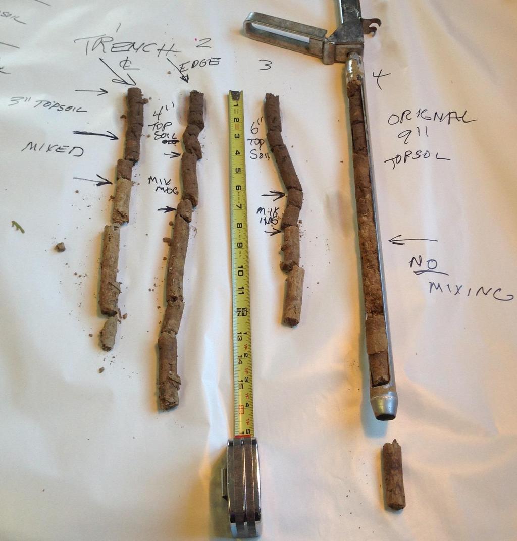
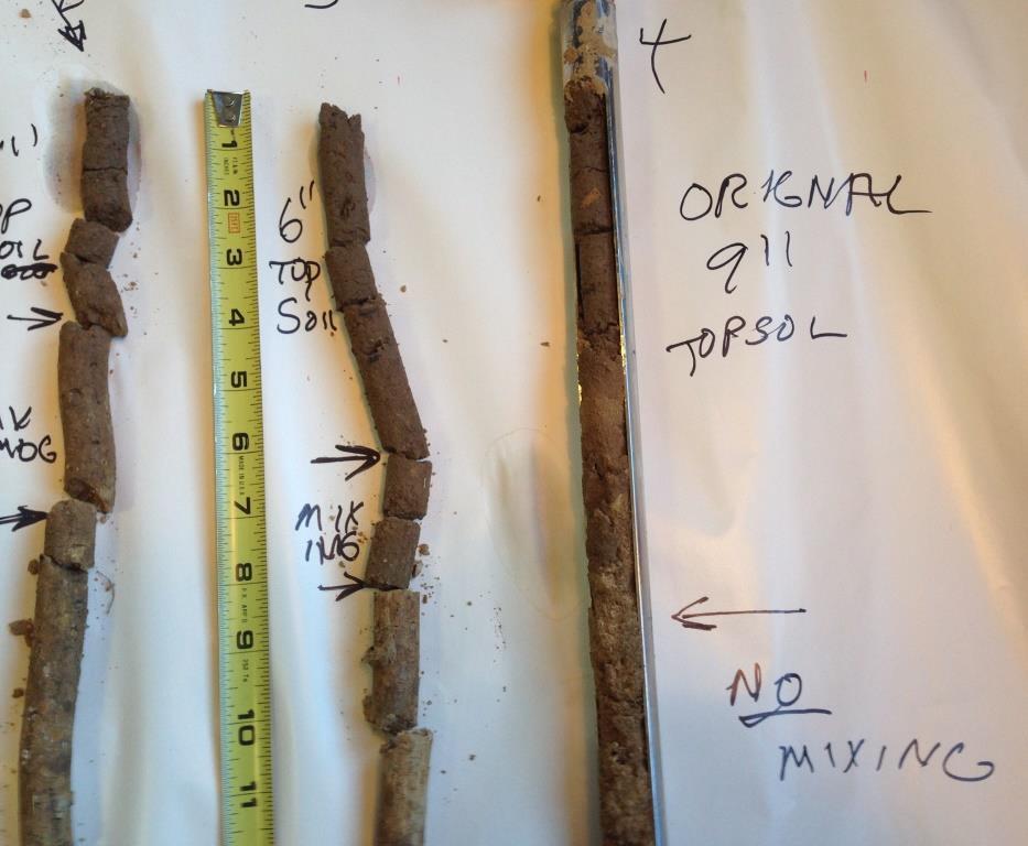
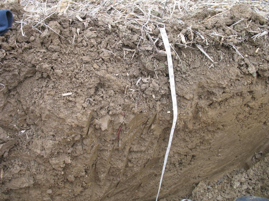
22 Subsoil Definitions Subsoil is defined as the soil material that starts at the bottom of the topsoil to a depth of three feet. Exceptions to this are soils where fractured bedrock or hard bedrock is encountered before three feet.
23 Topsoil The upper most part of the soil commonly referred to as the plow layer, the A layer,or the A horizon, or its equivalent in uncultivated soils It is the surface layer of the soil that has the darkest color or the highest content of organic matter (as Identified in the USDA County Soil Survey and verified w/ right of way samples).
24 Topsoil is described as all surface and near surface soil horizons (layers) that have a moist Munsell color value of 4 and chroma of 3 or darker and a clay content increase of 10% or less between the individual horizons. On agricultural land at least the top eight inches will be considered topsoil. Horizons with up to a twenty five percent mixing of the subsoil into the topsoil by agricultural processes will still be considered topsoil.
25 In areas demonstrating substantial soil erosion, topsoil colors may be lighter than a moist Munsell color value of 4 and chroma 3. In these areas the top 8 inches will be considered topsoil. Surface horizons with a moist Munsell color value of 4 and chroma of 3 or darker in forested areas that have not been plowed are typically thinner. In these areas the top six inches will be considered topsoil. In areas where the above conditions do not apply, the top eight inches will be considered topsoil on agricultural land and the top six inches will be considered topsoil on forested land that has not been plowed.
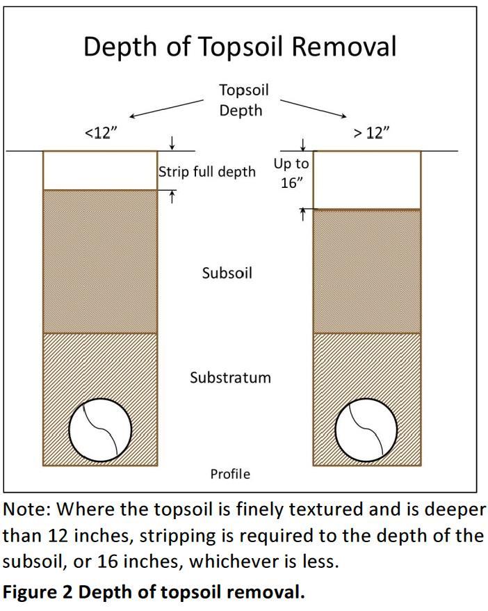
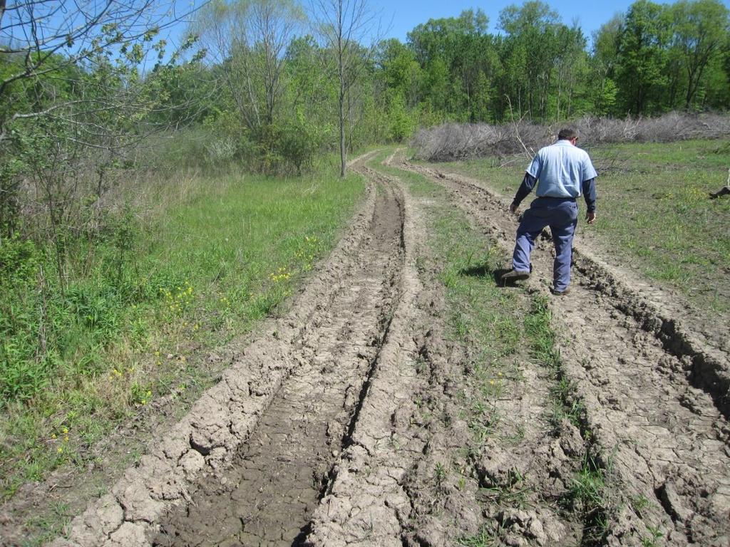
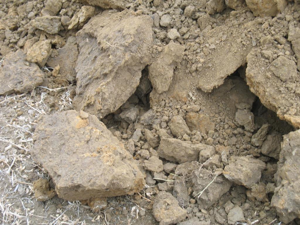
26 D. Soil Removal and Protection 1. Topsoil and subsequent horizons shall be determined by a properly qualified inspector, soil scientist or soil technician who will set stakes or flags every 200 feet along the right of way identifying the depth of topsoil to be removed. Topsoil will be stripped to the actual depth of the topsoil, not to exceed 16 inches (see Figure 2).
27 Proposed Alternative: Use Soil Survey Maps Save Typical Stated Topsoil Depth, minus 2 inches Problems: Map Units may contain several Different Soil Components Named Component will have a range of Top Soil Depths Who wants to lose several thousands of years worth of Topsoil (Minus 2 Inches) after you ve spent your whole life trying to build it up???
28

29

30 Association of Ohio Pedologists Consultant List AOP CERTIFIED SOIL SCIENTISTS: Meet National Standards through the Soil Science Society of America Are qualified Are professional Have earned one or more of these degrees with an emphasis in soil science: Bachelor of Science Master of Science PhD Have field experience Meet continuing education requirements
31
32 Sensitive Agricultural Soils areas of cropland, hayland, or pasture that are more susceptible than other agricultural soils to construction disturbance due to slope, relative soil wetness, and/or shallowness to bedrock. Wetness conditions are the result of factors such as landscape position, soil texture, seasonal water table and/or slowly permeable subsoil horizons (e.g., areas of laterally draining subsoils). All sensitive agricultural soils including, but not limited to, those identified in the county soil survey as fragipans, lacustrine soils, dense basal tills, soils with a seasonally high water table, or soils with less than 5 feet of depth to bedrock are to be located and identified on the project map
33 Sensitive Agricultural Soils Dense Till: Hoytville, Nappanee, Blount, Pewamo, Glynwood, Bennington, Cardington, Mahoning, Etc Lacustrine: Paulding, Roselms, Latty, Fulton Fragipans: Wooster, Canfield, Wadsworth, Ravenna, Rittman Seasonally High Water Table: Hoytville, Nappanee, Blount, Pewamo, Glynwood, Bennington, Paulding, Roselms, Latty, Fulton, Mahoning, Trumbull, Wadsworth

34 Ohio NRCS FOTG Lists by County
35 Triple Lift
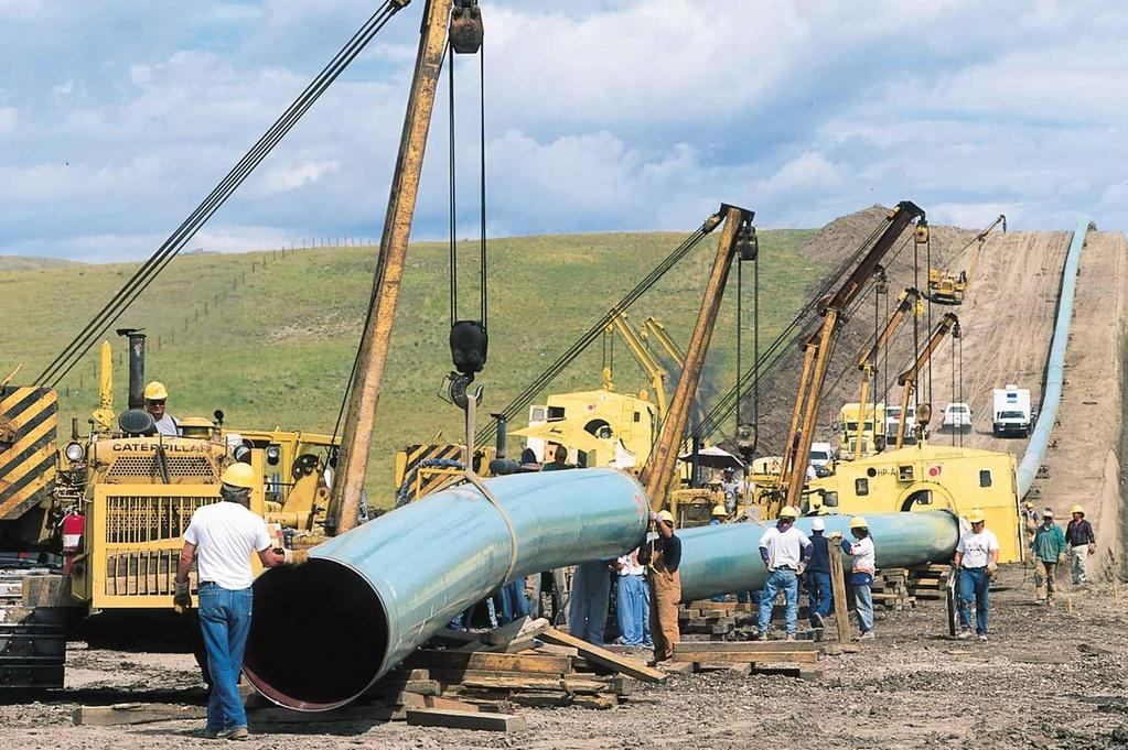
36 Topsoil shall be removed following clearing and prior to any activity by any equipment or delivery trucks. Inspector shall monitor the site specific depths of Topsoil stripping Topsoil removed the full width of the right of way and stock piled along either edge and on the right of way.
37 Topsoil must be replaced so that after Settling occurs, the topsoil s original depth and contour is restored. In no instance, will the topsoil materials be used for any other purpose or removed from the right of way.
38 Minimum Cover Maintain a minimum of 60 inches of cover over the pipeline. Unless: Bedrock encountered ~ Minimum 36 inches Brushy and Wooded land not suitable for Cropland ~ Minimum 36 inches
39 Rocks The cover within the pipeline trench, bore pits, or other excavations shall not be backfilled with soil containing rocks of any greater concentration or size than existed prior to the pipeline construction.
40 Rocks used for Pads, Roads, Etc The use of durable geotextile matting as an underlayment to help prevent rock and stone from becoming embedded in the subsoil
41

42

43

44
45
46

47
48

49

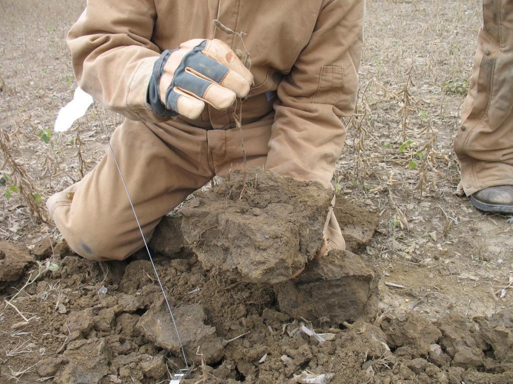
50
51
52
53
54

55 Structure Types

56
57 Ripping Prior to topsoil replacement, the subsoil shall be fractured by deep ripping to a depth of 16 inches below the surface of the subsoil. Maximum teeth spacing of 16 inches. All stone and rock material (3) inches and larger in size which has been lifted to the surface shall be collected and removed from the site for disposal.
58 Topsoil Replaced (Manure Research). Full Soil Profile Subsoiled to a depth not to exceed 16 inches. All 3 inch or bigger Rock picked Again. Disked 3 times.

59
60

61
62 Randy Reeder s Research The first time you drive over a ripped area, it will recompact to it s original structure, unless there are roots to prop them open The Silicate Clay Lattices have a Memory Severe Compaction needs roots and OM to heal
63 Principals of Soil Health Limit Soil Disturbance Increase Soil Microbial Diversity Grow Living Roots Year Round Keep the Soil Covered Reduce Compaction
 Conservation Agriculture Cover Crop Research")
64 Mike Plummer, Univ. of Illinois (Retired) Conservation Agriculture Cover Crop Research Utilities and Strip Mines
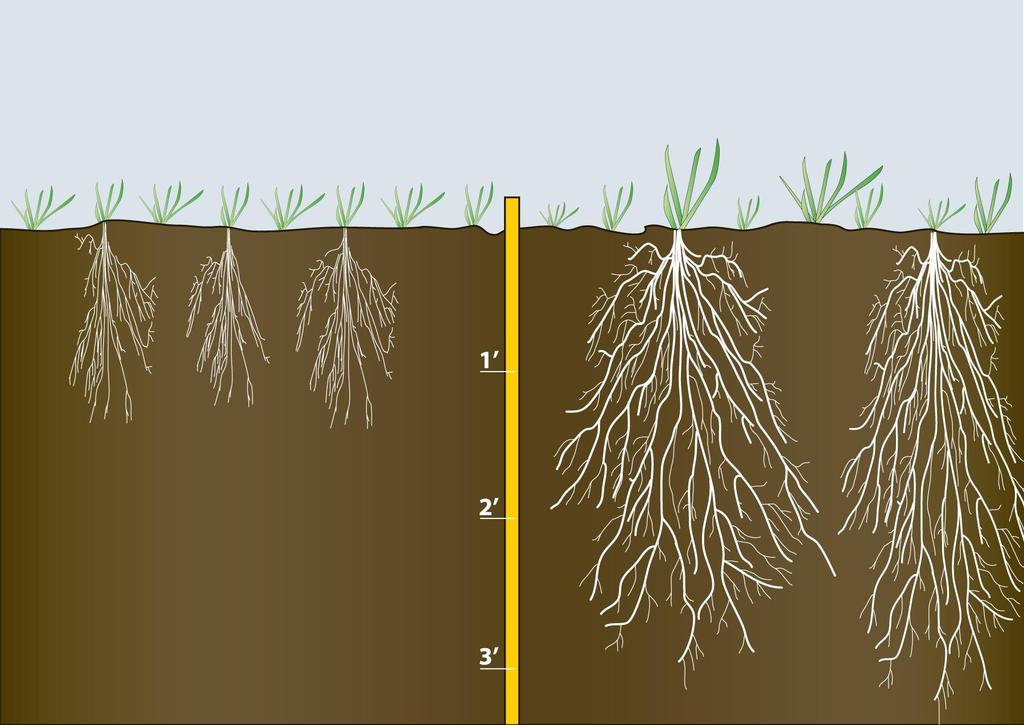
65 Mike Plummer This is going to be a 7-10 year project, even if you save all your topsoil and put your Subsoil and Parent Material (Triple Lift) back in order Expect % Yield Reduction first 2 years Save your money and leave in Summer Mix cover crops for 2 Years Fall Year 2, plant wheat Year 3, Early August Drill Winter Mix into Straw
66 Year 4 Corn planted into Winter cover Year 4 August evaluate Stand/Canopy for <50% Shade and interseed with Winter Mix with Drops, whole Field, Best (build in as a cost of doing business) Or, fly on over right of way (second Best) Year 5 Soybeans into winter Cover Continue W, C, SB with Winter Cover Evaluate Years 7-10 (Especially if Constructed Wet)
67 Summer Mix Years 1-2 Millets Buckwheat Sweet clover Cowpeas
68 Early August Years 1-10 Radish Turnip Annual ryegrass Hairy vetch (or another Legume) Cereal rye
69 Annual ryegrass fine roots Move through the compaction platy layers (Even when the surface is dormant) Allowing the other plants with bigger roots to infiltrate Add organic matter and allow larger roots to develop.

70

71 Jamie Scott, Indiana
72

73 Annual Rye Grass Roots 5 Feet Deep

74
75 Annual Ryegrass Many professionals don t know how to manage it, control it or even how to order the right varieties for use as a cover crop
76 Indiana Certified Crop Advisor Website 64 Page PDF Annual ryegrass: Facts, Fiction and Management Michael Plumer Conservation Agriculture
77 Mike Plummer In May follow up with the summer annuals again Then the winter annuals in Early August again 10 year+ type of project in many cases. Rarely do I see crop yields getting back to near normal for 5-7 years or more.
78 Mike Plummer Alfalfa has not worked very well Unless it is used only with a perennial grass Clipped 2x a year And left undisturbed for 4 + years.

79 Jay and Dave Brant Agree with Mike Plumer s Mix Substitute Sudan Grass for Millet and Mow once, 10 inches or higher
 Would Add Sweet Clover in")
80 Allen Dean, Williams County Agrees with Mike Plumer s Mix Would stick with the Millet because of the Height of the Sudan Grass (8Feet) Would Add Sweet Clover in Nov
81 Your Land/Your Plan Use the ODNR Pipeline Standard as a Starting Point. (Add Cover Crops) Get a second opinion of Professionals (Major Surgery) Soil Scientists, Lawyers, Ditchers, Cover Crop Plan Ahead. Get the Details in Writing (Contract). Camp Out with a Dedicated Note Book (Phone Numbers), Tape Measure and Digital Camera (Who, What, Where and When. Record it all, Good and Bad)
82 Your Land/Your Plan Have an Alternate Inspector to back you up when you can t be there. Refer to the Plan. Make sure the Details Happen. Have a comparison plot adjacent to right of way keep yield records (OSU ~ Steve Culman). This will be a minimum 5 year and more likely a 7-10 Year Project.
83 Your Land/Your Plan Whatever you do, Don t!!!: Just take the money and do nothing for the Land This is Forever Your Kids Your Grand Kids Great Grand Kids Great, Great Grand Kids


84
85 Professional Wetland Scientist Certified Professional Soil Classifier Certified Professional Soil Scientist Certified Crop Advisor ~Army Corp/EPA Wetlands ~Wetland Delineations ~Wetland Scoring For Mitigations ~Wetland Restorations ~Problem Soils Investigations ~Hydric Soil Delineations ~Teaching/Training/Instruction ~Soil Compaction Diagnosis ~Soil Quality/Cover Crops ~Soil Drainage Issues ~Controlled Traffic Evaluations ~Preferential Flow Issues (Liq. Manure and Phos.) ~Smoking Tile Field Days ~Meeting Speaker World Wide Soil Adventures
2012 FINAL SOILS AREA 2 Envirothon Questions Answer KEY
 2012 FINAL SOILS AREA 2 Envirothon Questions Answer KEY Questions 1-6 to be answered at the soil pit: 1. Soil scientists categorize soils by drainage classes. What is the drainage class of the soil at
Ohio Pipeline Standard and Construction Specifications
 Ohio Pipeline Standard and Construction Specifications December 28, 2015 PURPOSE This document provides measures intended to limit the impact of construction of a pipeline on agricultural productivity
MARBLE RIVER WIND POWER PROJECT Agricultural Protection Measures
 MARBLE RIVER WIND POWER PROJECT Siting Considerations 1. Locate access roads and, to the extent allowed by local laws, wetlands and topography, individual wind turbines and other structures along field
HAVE YOU NOTICED at construction sites how a
 Explaining a Soil Profile HAVE YOU NOTICED at construction sites how a cross section of soil has a layered look? Soil near the top of the cross section is often dark, and soil below appears lighter. What
List of Equipment, Tools, Supplies, and Facilities:
 Unit A: Principles of Soil Lesson 3: Horizons of Soil Student Learning Objectives: Instruction in this lesson should result in the students achieving the following objectives: 1. Explain a soil profile
Methods, approaches, and procedures to minimize active agricultural land impacts during pipeline construction, surface restoration, and pipeline
 Agricultural Impact Minimization Plan Methods, approaches, and procedures to minimize active agricultural land impacts during pipeline construction, surface restoration, and pipeline operation. PennEast
2014 Iowa FFA Soil Judging CDE Exam
 2014 Iowa FFA Soil Judging CDE Exam 1. Landscape position is one aspect of evaluating the surface features of a certain tract of land. Identifying the correct landscape position will indicate: a. If the
Area 3 Envirothon Soils Questions Key
 Area 3 Envirothon Soils Questions Key 1. Soil aeration is the exchange of air in soil with air from the atmosphere. When a soil is well aerated, the air within the soil is very similar to the atmosphere
Methods, approaches, and procedures to minimize active agricultural land impacts during pipeline construction, surface restoration, and pipeline
 Agricultural Impact Minimization Plan Methods, approaches, and procedures to minimize active agricultural land impacts during pipeline construction, surface restoration, and pipeline operation. PennEast
2016 Iowa FFA Soils Evaluation CDE Exam
 2016 Iowa FFA Soils Evaluation CDE Exam 1. Which of the following is true regarding soil horizons? a. A horizon is darker in color and has more organic matter b. B horizon is darker in color and has more
Iowa FFA Soil Career Development Event 2008
 Iowa FFA Soil Career Development Event 2008 1. In Iowa, corn suitability ratings for soil mapping units specifies a. natural weather conditions b. surface and subsurface drainage installed where needed
Soil Horizons cont. Oa- highly decomposed Oi-undecomposed
 Soils Soil Basics Soil Horizons Soil Horizons cont. O Horizon: Or organic layer Organic layer of decomposing plant and animal tissue. Wooded upland areas have thin O horizons Wetlands may have thick O
EXAMPLE Point A: Sandy Loam: 65% Sand _ 20% Silt _ 15% Clay. Point B: %Sand % Silt % Clay. Point C: %Sand % Silt % Clay. Point D: %Sand % Silt % Clay
 SOIL TEXTURE Refers to proportions of sand, silt and clay size particles. These proportions determine water infiltration rates, permeability rates, and water holding rates. Using a soil texture triangle.
Soil Restoration in Accordance with. The NYSDEC 2015 Stormwater Management Design Manual
 Soil Restoration in Accordance with The NYSDEC 2015 Stormwater Management Design Manual William Buetow CPESC, CPSS TRC Solutions Clifton Park, NY Implementation of Soil Restoration as a Green Infrastructure
This definition is from the Soil Science Glossary (Soil Science Society of America).
.") What is Soil? This definition is from the Soil Science Glossary (Soil Science Society of America). soil - (i) The unconsolidated mineral or organic material on the immediate surface of the earth that serves
What is Soil? This definition is from the Soil Science Glossary (Soil Science Society of America). soil - (i) The unconsolidated mineral or organic material on the immediate surface of the earth that serves
UPLAND EROSION CONTROL, REVEGETATION, AND MAINTENANCE PLAN
 UPLAND EROSION CONTROL, REVEGETATION, AND MAINTENANCE PLAN 01/17/2003 VERSION UPLAND EROSION CONTROL, REVEGETATION, AND MAINTENANCE PLAN TABLE OF CONTENTS I. APPLICABILITY... 1 II. SUPERVISION AND INSPECTION...
2014 Envirothon Georgia Soil Study Guide
 2014 Envirothon Georgia Soil Study Guide In addition to materials in this document, 2014 Georgia Envirothon contestants are responsible for materials found in the following documents: From The Surface
Explaining a Soil Profile
 Lesson C6 5 Explaining a Soil Profile Unit C. Plant and Soil Science Problem Area 6. Basic Principles of Soil Science Lesson 5. Explaining a Soil Profile Content/Process Statement: PLS3 Core Content Standard:
IOWA FFA STATE SOILS CDE SATURDAY, OCTOBER 13, 2007 AMES, IOWA
 IOWA FFA STATE SOILS CDE SATURDAY, OCTOBER 13, 2007 AMES, IOWA 1. Moderately sloping has what percent slope: a. 9-14% b. 2-5% c. 5-9% d. over 14% 2. Which of the following horizons is the loose underlying
2018 Iowa FFA Soil Judging CDE Exam 1. Landscape positions characterizes the location of the soil on the landscape and identifies potential risks.
 2018 Iowa FFA Soil Judging CDE Exam 1. Landscape positions characterizes the location of the soil on the landscape and identifies potential risks. Which landscape position is considered the floodplain
HORT 102: Soil Properties. Cultivated Plants: Lecture 15. [Teresa Koenig] Slide #: 1 Slide Title: Intro Information Slide
![HORT 102: Soil Properties. Cultivated Plants: Lecture 15. [Teresa Koenig] Slide #: 1 Slide Title: Intro Information Slide](/thumbs/76/74082590.jpg "HORT 102: Soil Properties. Cultivated Plants: Lecture 15. [Teresa Koenig] Slide #: 1 Slide Title: Intro Information Slide") HORT 102: Soil Properties Cultivated Plants: Lecture 15 [Teresa Koenig] Slide #: 1 Slide Title: Intro Information Slide Title: Lecture 15 Soil Properties Speaker: Teresa Koenig Created by: Teresa Koenig,
HORT 102: Soil Properties Cultivated Plants: Lecture 15 [Teresa Koenig] Slide #: 1 Slide Title: Intro Information Slide Title: Lecture 15 Soil Properties Speaker: Teresa Koenig Created by: Teresa Koenig,
SOIL FORMATION AND LANDSCAPE STABILITY
 SOIL FORMATION AND LANDSCAPE STABILITY Smith and Pun, Chapter 14 WHAT IS SOIL? Soils are natural three-dimensional bodies used for many purposes, the most important of which is to produce food and fiber
Explaining a Soil Profile
 Lesson C1 3 Explaining a Soil Profile Unit C. Basic Principles of Agricultural/Horticultural Science Problem Area 1. Using Basic Soil Science Principles Lesson 3. Explaining a Soil Profile New Mexico Content
APPENDIX G-3 Agricultural Impact Mitigation Plan Ohio
 APPENDIX G-3 Agricultural Impact Mitigation Plan Ohio G3-1 Appendix G-3 Appendix G-3 G3-2 ROVER PIPELINE LLC Rover Pipeline Project AGRICULTURAL IMPACT MITIGATION PLAN OHIO April 2015 G3-3 Appendix G-3
Section 1. Judging the soil pit (questions 1-4)
") CONNECTICUT ENVIROTHON 2009 SOILS QUESTIONS Please select the best response to the following questions. There are 25 questions; each question is worth 4 points. Section 1. Judging the soil pit (questions
CONNECTICUT ENVIROTHON 2009 SOILS QUESTIONS Please select the best response to the following questions. There are 25 questions; each question is worth 4 points. Section 1. Judging the soil pit (questions
Learning Objectives Part 1. Chapter 4 Soil Physical Properties. Soil Physical Properties. Color. Physical properties part 1
 Learning Objectives Part 1 Chapter 4 Soil Physical Properties Know what color tells you about a soil Describe the concept of soil texture and its importance Use the textural triangle to determine a soil
ASCE - Philadelphia. Soils & Stormwater Management. Matthew C. Hostrander, CPSS, SEO Soil Scientist. Gilmore & Associates, Inc.
 ASCE - Philadelphia Soils & Stormwater Management Matthew C. Hostrander, CPSS, SEO Soil Scientist Gilmore & Associates, Inc. Course Overview COURSE OUTLINE Soil Science Fundamentals Discuss United States
Soil Interpretations Erosion and Sedimentation Control Planning and Design Workshop
 Soil Interpretations Erosion and Sedimentation Control Planning and Design Workshop Presented by Richard Brooks Presentation prepared by Kristin May Resource Soil Scientists USDA-Natural Resources Conservation
Loam: About 40% sand, 40% silt, 20% clay. Mixture of pore sizes to balance water retention and aeration. Considered the best soil for growing crops.
 Soil Characteristics Soil is formed from a combination of two Primary sources: Weathering of Parent Rock ( ) = material introduced by plants, animals, and decomposers Minor sources: Nutrients incorporated
DO YOU KNOW YOUR SOILS? (Rev. 10/11)
") DO YOU KNOW YOUR SOILS? (Rev. 10/11) Circle all the correct answers. 1. What is the layer normally present on the surface of the soil in cropped fields? a. O c. Ap e. B g. R b. A d. E f. C 2. Available
DO YOU KNOW YOUR SOILS? (Rev. 10/11) Circle all the correct answers. 1. What is the layer normally present on the surface of the soil in cropped fields? a. O c. Ap e. B g. R b. A d. E f. C 2. Available
Introduction to Environmental Science. Soil Characteristics. Chapter 11 Soil
 Chapter 11 Soil Soil Characteristics It s more than dirt Most soils are 100s of years old Weathering breaks down parent rock Soil Separates (particle types) Sand (largest) Silt Clay (smallest) Plants contribute
2017 Iowa FFA Soil Judging CDE Exam
 2017 Iowa FFA Soil Judging CDE Exam 1. Landscape positions vary in soil composition and makeup. What landscape position would be characterized by having strata and lenses of different textures in the profile:
Explaining a Soil Profile
 Lesson A4-8: Explaining a Soil Profile Horticulture Cluster Illinois Agricultural Education Curriculum Unit A. Horticultural Science Problem Area 4. Growing Media Nutrients, and Fertilizers Lesson 8. Explaining
1. Position (2 pts.) 2. Parent Material (2 pts.) 3. Slope Characteristics (2 pts.) 4. Surface Stoniness or Rockiness (2 pts.)
 2. Parent Material (2 pts.) 3. Slope Characteristics (2 pts.) 4. Surface Stoniness or Rockiness (2 pts.)") Maryland Envirothon SOILS Exam Guidance Information (revised 2017) Objective: To test students' knowledge and awareness of basic soil science and its application in wise land-use planning and therefore
Maryland Envirothon SOILS Exam Guidance Information (revised 2017) Objective: To test students' knowledge and awareness of basic soil science and its application in wise land-use planning and therefore
Soil & Site Evaluator - Need to Know
 Soil & Site Evaluator - Need to Know I. The professional will understand the factors of soil development and demonstrate their importance to site evaluations. A. Topography 1. Landscape description 2.
THE SCORE CARD. Observed Soil Properties. Interpretive Soil Properties
 Rev. 07/18/2008 Jim Doolittle Doug Malo Tom Schumacher Plant Science Department SDSU and Kent Cooley Lance Howe Bruce Kunze Jim Millar Walt Schaefer Dan Shurtliff Steve Winter USDA Natural Resources Conservation
WQ-07 INFILTRATION TRENCH
 Greenville County Technical Specification for: WQ-07 INFILTRATION TRENCH 1.0 Infiltration Trench 1.1 Description Infiltration Trenches are excavations filled with stone to create an underground reservoir
Soil Colors, Texture & Structure
 Application Soil Colors, Texture & Structure Limiting conditions Soil color type/depth of system Bedrock type/depth of system Soil texture, structure, percolation rate size and type of system Sara Heger,
ON LANDSCAPING, SOILS, SOIL AMENDMENTS AND PROPER SEED ESTABLISHMENT (BOTH GRASS LAWNS AND MEADOWS).
.") ON LANDSCAPING, SOILS, SOIL AMENDMENTS AND PROPER SEED ESTABLISHMENT (BOTH GRASS LAWNS AND MEADOWS). John D. Chibirka USDA-NRCS Resource Soil Scientist 1238 County Welfare Road, Suite 220 Leesport, PA
ON LANDSCAPING, SOILS, SOIL AMENDMENTS AND PROPER SEED ESTABLISHMENT (BOTH GRASS LAWNS AND MEADOWS). John D. Chibirka USDA-NRCS Resource Soil Scientist 1238 County Welfare Road, Suite 220 Leesport, PA
STATE TAX COMMISSION OF MISSOURI ASSESSOR MANUAL
 STATE TAX COMMISSION OF MISSOURI ASSESSOR MANUAL CHAPTER: REVISION DATE: 10/1/2008 Page 1 of 18 7.3 The purpose of this section of the Assessor s Manual is to supplement the State Tax Commission s published
Soils and the Environment. A Summary of RI Envirothon Study Materials Compiled by Sally Paul
 Soils and the Environment A Summary of RI Envirothon Study Materials Compiled by Sally Paul Why Soils Food and water resources Disposing of waste Support for human structures Growing timber and fibers
Pipeline Reclamation at the Williston Research Extension Center - NDSU. Austin Link Agronomy Research Specialist
 Pipeline Reclamation at the Williston Research Extension Center - NDSU Austin Link Agronomy Research Specialist Reclaiming a 36 Pipeline with Crop Rotations Introduction May 15 th, 2015, installation of
The Nature of Soil Soil Conservation Sustainable Ag.
 Chapter 6 & 7 The Nature of Soil Soil Conservation Sustainable Ag. Climate Soil Forming Factors Parent material Organisms Topography Time Value of Soil Soil is under appreciated Condition of soil affects
Inherent Factors Affecting Soil ph. Soil ph Management
 Soil ph is a measure of soil acidity or alkalinity. It is an important indicator of soil health. It affects crop yields, crop suitability, plant nutrient availability, and soil micro-organism activity,
Land Formation. Field Development
 Land Formation California Rice Production Workshop, v15 Field Development Field development refers to configuring the field shape, surface slope and installation of water control structures to optimize
Team number Page 1 of Canon Envirothon Soils Station Test. Soils and Climate Change
 Team number Page 1 of 9 2006 Canon Envirothon Soils Station Test Soils and Climate Change There are many kinds of soil on the surface of the earth. The kind of soil that is present at a given location
SECTION PLANTING PART 1 - GENERAL 1.1 RELATED DOCUMENTS
 SECTION 329000 PLANTING PART 1 - GENERAL 1.1 RELATED DOCUMENTS A. Drawings and general provisions of the Contract, including General and Special Conditions and Division 01 Specification Sections, apply
THE TENNESSEE VEGETABLE GARDEN
 THE BACKYARD SERIES BACKYARD VEGETABLES W 346-A THE TENNESSEE VEGETABLE GARDEN SITE SELECTION AND SOIL TESTING Natalie Bumgarner, Assistant Professor and UT Extension Residential and Consumer Horticulture
Surface Coal Mining and Reclamation in ND. Guy Welch ND Public Service Commission
 Surface Coal Mining and Reclamation in ND Guy Welch ND Public Service Commission Surface Coal Mines in North Dakota Approximately 1500 acres are disturbed each year History of Reclamation in ND First surface
Soil characteristics that influence nitrogen and water management
 Section C Soil characteristics that influence nitrogen and water management Soil characteristics vary across the landscape Soils vary from one field to another, and often within the same field. Soil differences
Unit E: Basic Principles of Soil Science. Lesson 3: Understanding Soil Color
 Unit E: Basic Principles of Soil Science Lesson 3: Understanding Soil Color 1 Important Terms Bright-colored Color Deciduous hardwood forest Dull-colored Humus Mottle-colored Native vegetation Structure
Why do soils differ across the landscape?
 Today s Objectives: Elements of soil formation Describe important soil physical & chemical properties Describe the ability to use and interpret soil survey information (printed and digital) List some site
Horner-McLaughlin Woods: Soil Types
 Horner-McLaughlin Woods: Soil Types Not present at HMW Adrian Muck Conover Loam 0-4% Slopes Houghton Muck Miami Loam 2-6% Slopes Miami Loam 6-12% Slopes Miami Loam 12-18% Slopes t 0 0.125 0.25 Miles Mary
Soil & Site Evaluator - Need to Know
 Soil & Site Evaluator - Need to Know I. The professional will understand the factors of soil development and demonstrate their importance to site evaluations. A. Topography 1. Landscape & landform description
Unit 6 Lesson 3 What Is Soil? Copyright Houghton Mifflin Harcourt Publishing Company
 Soil Is Not Just Dirt When you are in a forest or garden, what is under your feet? Below the sticks, rocks, and plants, there is soil. Soil Is Not Just Dirt What is soil? What are parts of soil? Soil is
Lesson 3: Understanding Soil Color
 Lesson 3: Understanding Soil Color 1 Bright colored Color Dull colored Humus Mottle colored Native vegetation Structure Tall prairie grass Texture Deciduous hardwood forest 2 I. Soils have many features
FFA Rural Soil CDE. Items necessary for soil judging. FFA Land Judging Contest 2015
 FFA Rural Soil CDE FFA Land Judging Contest 2015 Changes are coming to the Soil Judging Career Development Event (CDE), starting in the upcoming school year, to better reflect today s challenges with soil.
2016 Area 3 Envirothon Muskingum County Soils Test ANSWER KEY
 2016 Area 3 Envirothon Muskingum County Soils Test ANSWER KEY 1. The majority of the bedrock in Muskingum County is. a. sedimentary bedrock b. glacial bedrock c. igneous bedrock d. metamorphic bedrock
What Makes Up Your Profile?
 What Makes Up Your Profile? Soil Isn t a Dirty Word Objectives Students will be able to determine soil changes in relationship to depth. Students will explain how soils are formed. Materials overhead projector
Overview of Soil Properties
 Willie Harris apatite@ufl.edu Acknowledgments: Wade Hurt Mike Vepraskas FAESS Soil Scientists Overview of Soil Properties Website to download files of talks: wgharris.ifas.ufl.edu.hsw.htm Meaning of Soil
Overview of Soil Properties
 Willie Harris apatite@ufl.edu Acknowledgments: Wade Hurt Mike Vepraskas FAESS Soil Scientists Overview of Soil Properties Website to download files of talks: wgharris.ifas.ufl.edu.hsw.htm Meaning of Soil
Mature basalt volcanic soils
 MANAGING NORTHLAND SOILS Mature basalt volcanic soils 8.1.2 Soil types in this group Kerikeri friable clay (KE) Kerikeri friable clay with large boulders (KEb) Matarau friable clay (MC, MCH*) Matarau friable
ASSOCIATION OF OHIO PEDOLOGISTS NEWSLETTER VOL 44 ISSUE3
 ASSOCIATION OF OHIO PEDOLOGIST OHIO S PROFESSIONAL SOIL SCIENTISTS I Would like to thank the Planning Committee, Executive Council, and others for the outstanding success of the joint Workshop with The
Vegetated Filter Strips and Buffers
 3.15 Sediment Control Description: Buffer strips (existing vegetation) and filter strips (planted vegetation) are sections of vegetated land adjacent to disturbed areas. They are designed with low slopes
Urban Conservation Practice Physical Effects ESTABLISHMENT, GROWTH, AND HARVEST NUTRIENT MANAGEMENT
 NOT WELL 800 - Urban Stormwater Wetlands A constructed system of shallow pools that create growing conditions for wetland plants to lessen the impacts of stormwater quality and quantity in urban areas.
Holdrege. Nebraska State Soil. Soil Science Society of America. Introduction. History. What is Holdrege Soil? Where to dig a Holdrege.
 Holdrege Nebraska State Soil Soil Science Society of America Introduction Many states have a designated state bird, flower, fish, tree, soil, rock, etc. And, many states also have a state soil - one that
SECTION TURF AND GRASSES
 SECTION 32 92 00 TURF AND GRASSES PART 1: GENERAL 1.01 DESCRIPTION Restore all disturbed grass and landscaped areas to conditions equal to or better than before the work began and to the satisfaction of
List of Equipment, Tools, Supplies, and Facilities:
 Unit A: Principles of Soil Lesson 2: Overview of Soil Science Student Learning Objectives: Instruction in this lesson should result in the students achieving the following objectives: 1. Understand the
DOES YOUR SOIL dry out more slowly after a heavy rain than
 "c. -;> TILTH OF CORN-BE J[ SOILS Y f T-, Cannot Be Maintained ~ 0 I~ 0 Without Legumesuand IG ~.. By R. S. STAUFFER, Associate Professor of Soil Physics DOES YOUR SOIL dry out more slowly after a heavy
Soil Science Society of America. What is Miami Soil? Where to dig Miami
 Miami Indiana State Soil Soil Science Society of America Introduction Many states have a designated state bird, flower, fish, tree, rock, etc. And, many states also have a state soil one that has significance
RAIN GARDEN ILLINOIS URBAN MANUAL PRACTICE STANDARD. (feet) CODE 897 DEFINITION
 CODE 897 DEFINITION") ILLINOIS URBAN MANUAL PRACTICE STANDARD RAIN GARDEN (feet) CODE 897 Source: Kendall County Soil and Water Conservation District DEFINITION Rain gardens are small, shallow, flat bottomed depressions constructed
ILLINOIS URBAN MANUAL PRACTICE STANDARD RAIN GARDEN (feet) CODE 897 Source: Kendall County Soil and Water Conservation District DEFINITION Rain gardens are small, shallow, flat bottomed depressions constructed
There are different types of weathering weathering and weathering. Both types work together to change Earth s surface.
 Weathering effects Classifying Sediment The surface processes that break down rock are called. Weathering breaks rock into smaller and smaller pieces. Tiny moss plants, earthworms, wind, rain, and even
SECTION VI. (Sub-section 241) Grassing. 1. Scope of Work General Sprigging Sodding thru 241-3
 Grassing. 1. Scope of Work General Sprigging Sodding thru 241-3") SECTION VI (Sub-section 241) Grassing Article Page 1. Scope of Work 241-1 2. General 241-1 3. Sprigging 241-1 4. Sodding 241-1 thru 241-3 5. Soil Amendments 241-3 6. Non Grassed Areas 241-4 7. Topsoil
SECTION VI (Sub-section 241) Grassing Article Page 1. Scope of Work 241-1 2. General 241-1 3. Sprigging 241-1 4. Sodding 241-1 thru 241-3 5. Soil Amendments 241-3 6. Non Grassed Areas 241-4 7. Topsoil
Infiltration. Keep Water Where it Falls. Frank Franciosi Novozymes
 Keep Water Where it Falls Frank Franciosi Novozymes Defined refers to the movement of water into the soil layer. The rate of this movement is called the infiltration rate. If rainfall intensity is greater
Inherent Factors Affecting Soil ph. Soil ph Management
 Soil ph is a measure of soil acidity or alkalinity. It is an important indicator of soil health. It affects crop yields, crop suitability, plant nutrient availability, and soil micro-organism activity
Piles, Trenching, Inverters, Cables, Material Deliveries
 Agricultural Inspection Report General Information Project Name Albany Date of Inspection 20161012 Start/End Time 7:50 am Inspector s Name(s) Inspector s Title(s) Describe present phase of construction
WEATHERING AND SOIL FORMATION. 8th Grade- Mr. Stelma
 WEATHERING AND SOIL FORMATION 8th Grade- Mr. Stelma WEATHERING EFFECTS The surface processes that break down rock are called weathering. Weathering breaks rock into smaller and smaller pieces. Tiny moss
Understanding and Building Your Soil Health
 Understanding and Building Your Soil Health Presented By: Holly Utrata-Halcomb, Administrator, Hamilton County Soil & Water Conservation District, Cincinnati, Ohio Ann Brandt, Business Mngr. Walnut Creek
Reference Card S-2, Side A: Delineating Horizon Boundaries
 Reference Card S-2, Side A: Delineating Horizon Boundaries Distinguishing Soil Horizons Soil horizons are delineated based on differences in: Texture Color Structure and Consistence Redoximorphic Features
OHIO STATE UNIVERSITY EXTENSION. Soil and Nutrients. OSUE Master Gardeners Mahoning County Class of Bill Snyder March 21, 2017
 OHIO STATE UNIVERSITY EXTENSION Soil and Nutrients OSUE Master Gardeners Mahoning County Class of 2017 Bill Snyder March 21, 2017 Soil vs DIRT Ecological Roles of Soil 1. Medium for plant growth 2. Recycling
Soil is formed by various processes and originates from parent material.
 Soils and sediments usually contain organic matter from decayed vegetation. A majority of the organic matter is humic substances. o Humic substances are naturally formed from the decomposition of vegetation.
The entire site supports grass on which sheep had been grazing recently.
 PHYSICAL CHARACTERISTICS REPORT FOR LAND AT HORSEHAY A^ Agricultural Land Classification of approximately 14 hectares of land to the southwest of Horsehay was undertaken in November 1989. The site lies
Pits 1 & 3 Questions. 7. Subsurface: Texture (5 pts) A. Coarse B. Moderately course C. Medium D. Fine E. Very Fine
 A. Coarse B. Moderately course C. Medium D. Fine E. Very Fine") Minnesota Soils Scorecard Questions for Pits 1-4 Scantron # 105481 Use your soils scorecard to fill out the answers on your scantron Bubble in the front side of the sheet for Pit 1 (# 1-45) and Pit 2 (#51-95)
Minnesota Soils Scorecard Questions for Pits 1-4 Scantron # 105481 Use your soils scorecard to fill out the answers on your scantron Bubble in the front side of the sheet for Pit 1 (# 1-45) and Pit 2 (#51-95)
Wisconsin Contractors Institute Continuing Education
 Wisconsin Contractors Institute Continuing Education Erosion & Sediment Control Course # 12775 2 hours Wisconsin Contractors Institute N27 W23953 Paul Road, Suite 203 Pewaukee, WI 53072 Website: www.wicontractorsinstitute.com
Unit D: Fruit and Vegetable Crop Production. Lesson 1: Planning and Preparing a Vegetable Garden Site
 Unit D: Fruit and Vegetable Crop Production Lesson 1: Planning and Preparing a Vegetable Garden Site 1 Terms Adequate sunlight Climate Compost Cool-season vegetables Cover crop Crop rotation Fertile soil
SUBSURFACE DRIP DISPERSAL OF EFFLUENT for LARGE SYSTEMS. Presented by: David Morgan and Rodney Ruskin
 SUBSURFACE DRIP DISPERSAL OF EFFLUENT for LARGE SYSTEMS Presented by: David Morgan and Rodney Ruskin Program Map Making Program Soil Parent material, Relief, Time. Organisms, Color, Texture, Depth, Profile
2011 Wisconsin Envirothon Soils and Land Use Exam
 2011 Wisconsin Envirothon Soils and Land Use Exam USE THE OCONTO COUNTY SOIL SURVEY TO ANSWER QUESTIONS 1-4 The Pensaukee River Wetland Complex is a mixture of state (Pensaukee Wildlife Area) and privately
URBAN SOILS & SEATTLE EXAMPLES
 Class Results - Mystery Soil #1 14 12 10 8 6 4 2 0 Sandy Clay Loam Sandy Loam Silty Loam Class Results - Mystery Soil #2 6 5 4 3 2 1 0 Silty Clay Clay Loam Sandy Sandy Silty Sandy Silty Loamy Loam Clay
AGRICULTURAL LAND CLASSIFICATION
 AGRICULTURAL LAND CLASSIFICATION STAINSBY HALL, MIDDLESBROUGH PROPOSED GOLF COURSE ADAS December 1990 Leeds Regional Office 2FCS 5100 CONTENTS 1. INTRODUCTION AND GENERAL SITE CHARACTERISTICS 2. AGRICULTURAL
EARTH SCIENCE CONCEPTS -Geologic time scale
 EARTH SCIENCE CONCEPTS -Geologic time scale -Plate Tectonics -Earthquakes *result of vibrations (often due to plate movement) deep in the Earth that release energy *often occur at transform boundaries
Land Capability Classifications
 Land Capability Classifications Unit: Soil Science Problem Area: Basic Principles of Soil Science Student Learning Objectives. Instruction in this lesson should result in students achieving the following
SOIL DATA: Avondale. in Allen, TX. This information was taken from NRCS web soil survey of Collin County, Texas.
 SOIL DATA: Avondale in Allen, TX This information was taken from NRCS web soil survey of Collin County, Texas. United States Department of Agriculture Soil Conservation Service in cooperation with Texas
FFA Urban Soil CDE. Items necessary for soil judging. FFA Land Judging Contest 2015
 FFA Urban Soil CDE FFA Land Judging Contest 2015 Changes are coming to the Soil Judging Career Development Event (CDE), starting in the upcoming school year, to better reflect today s challenges with soil.
SECTION 6. Routine Maintenance Activity Details
 SECTION 6 Routine Maintenance Activity Details 80. DEBRIS REMOVAL When Deadfall, and other objects, such as shopping carts, tires, appliances, and mattresses have accumulated in the drain. Why To prevent
Alberta policy and regulations for grassland reclamation criteria, evolution of the criteria from the 1995 version to today
 Alberta policy and regulations for grassland reclamation criteria, evolution of the criteria from the 1995 version to today Jody Spady on behalf of Reclamation Criteria Advisory Group (RCAG) Native Prairie
a. Section includes planting soils specified by composition of the mixes.
 SECTION 32 9113 SOIL PREPARATION PART 1 - GENERAL 1.1 RELATED DOCUMENTS A. Drawings and general provisions of the Contract, including General and Supplementary Conditions and Division 01 Specification
If you are not able to turn in your notebook see me or Dan ASAP
 Notebook Collection Collecting hard copies now OR Electronic versions using Catalyst drop box Due by 5:30 pm today Use website for link If you are not able to turn in your notebook see me or Dan ASAP URBAN
RECOMMENDED BEST MANAGEMENT PRACTICES FOR RESTORATION OF WETLANDS AFTER TEMPORARY IMPACTS
 RECOMMENDED BEST MANAGEMENT PRACTICES FOR RESTORATION OF WETLANDS AFTER TEMPORARY IMPACTS Prepared in partial fulfillment of a U.S. Environmental Protection Agency State Wetland Program Development Grant
SECTION AMENDED TOPSOIL
 SECTION 02486 AMENDED TOPSOIL PART 1 - GENERAL 1.01 SUMMARY A. Work described in this section includes requirements for soil amendments, soil preparation, preparation and finish grading of turf restoration
DEVELOPING VEGETATIVE COVERS ON HIGHLY DISTURBED AREAS. (Reclamation/Revegetation)
") DEVELOPING VEGETATIVE COVERS ON HIGHLY DISTURBED AREAS (Reclamation/Revegetation) Prepared by Paul D. Ohlenbusch 119 Nighthawk Way Georgetown, TX 78633 512-639-0973 grassbydesign@suddenlink.net http://www.grassbydesign.com
DEVELOPING VEGETATIVE COVERS ON HIGHLY DISTURBED AREAS (Reclamation/Revegetation) Prepared by Paul D. Ohlenbusch 119 Nighthawk Way Georgetown, TX 78633 512-639-0973 grassbydesign@suddenlink.net http://www.grassbydesign.com