LISA ANDERSON-OGILVIE, AICP DEPUTY COMMUNITY DEVELOPMENT DIRECTOR AND PLANNING ADMINISTRATOR
|
|
|
- Magdalen Whitehead
- 5 years ago
- Views:
Transcription
1 FO MTING OF: DCMB 18, 2018 CAS NO.: D-SP-DAP-TV18-07 TO: FOM: PLANNING COMMISSION LISA ANDSON-OGILVI, AICP DPUTY COMMUNITY DVLOPMNT DICTO AND PLANNING ADMINISTATO SUBJCT: DSIGN VIW SIT PLAN VIW DIVWAY APPOACH PMIT T GULATION VAIANC CAS NO ; 1881 WILTSY OAD S AMANDA NOS D, P, ZO, AND N QUST Summary: Proposed development of a new 111-unit apartment complex. equest: A Class 3 Design eview and Class 3 Site Plan eview application for development of a new 111-unit apartment complex, with a Class 2 Driveway Approach permit for new driveway approaches on Wiltsey oad S and Candy Flower Court S, and a Tree egulation Variance request to remove Oregon white oaks ranging in size from 24 inches to 40 inches in diameter, for property approximately 6.5 acres in size, zoned M-I and M-II (Multi-Family esidential), and located at 1881 Wiltsey oad S (Marion County Assessor s Map and Tax Lot numbers: 083W14D / and 01101). OWN: APPLICANT: AGNT: Cliff W. lling, lling Properties LLC David A. Montagne, Montagne Development Brandie Dalton, Multi-Tech ngineering, Inc. COMMNDATION Based upon the Facts and Findings contained in this staff report, staff recommends that the Planning Commission GANT the request for a consolidated design review, site plan review, driveway approach permit and tree regulation variance for development of a 111-unit apartment complex for property located at 1881 Wiltsey oad S subject to the following conditions of approval: Condition 1: Condition 2: Prior to building permit issuance, where a proposed building crosses over an existing property line, either (1) pursuant to SC , a property boundary verification shall be recorded, or (2) the property line shall be adjusted or removed. Development of the solid waste service area shall conform to all applicable standards of SC Chapter 800.
2 Design eview / Site Plan eview / Driveway Approach Permit / Tree eg. Variance Case No Planning Commission meeting of December 18, 2018 Page 2 Condition 3: Condition 4: Condition 5: Condition 6: Condition 7: Condition 8: Condition 9: Condition 10: Condition 11: Condition 12: Prior to building permit issuance, the site plan shall be modified to include a minimum of two off-street loading spaces for the proposed use, meeting applicable location and dimension requirements of SC Chapter 806. Per SC (d)(2), when more than 75 percent of the existing trees are proposed for removal, a minimum of two replacement trees shall be incorporated into the landscape plan and planted, in addition to the landscaping required under this chapter. For the removal of 79 trees in excess of 75 percent, a total of 158 replacement trees shall be provided. Convey land for dedication to equal a half-width right-of-way of 30 feet on the development side of Wiltsey oad S. Construct a property line sidewalk and install street trees along the frontage of Wiltsey oad S to meet Collector street standards as specified in the PWDS and consistent with the provisions of SC Chapter 803. Convey land for dedication at the terminus of Candy Flower Court S pursuant to PWDS. Construct a cul-de-sac improvement at the terminus of Candy Flower Court S to Cul-de-sac street standards as specified in the PWDS and consistent with the provisions of SC Chapter 803. Design and construct a storm drainage system at the time of development in SC Chapter 71 and PWDS. Modify the easterly driveway approach accessing Wiltsey oad S to meet the requirements of SC Chapter 804 and PWDS. All trees designated for preservation shall be marked and protected during construction. Any significant tree shall require that at least 70 percent of a circular area beneath the tree measuring one foot in radius for every one inch of dbh be protected by an above ground silt fence, or its equivalent. Protection measures shall continue until the issuance of final occupancy. A minimum of eight Oregon White Oaks (Quercus garryana), with a minimum caliper of 2, shall be incorporated into the landscape design and replanted for the proposed development.
3 Design eview / Site Plan eview / Driveway Approach Permit / Tree eg. Variance Case No Planning Commission meeting of December 18, 2018 Page 3 BACKGOUND On October 5, 2018, design review, site plan review, and driveway approach permit applications were submitted to develop the subject property with a 111-unit multi-family residential use. Additional information was requested from the applicant, and a tree regulation variance was submitted on November 14, The applications were deemed complete for processing on November 20, The 120-day State mandated decision deadline for this case is March 20, The public hearing before the City of Salem Planning Commission is scheduled for October 5, 2018, at 5:30 p.m. in the Salem City Council Chambers, Civic Center oom 240, located at 555 Liberty Street S. Notice of public hearing was sent by mail to surrounding property owners pursuant to Salem evised Code (SC) requirements on November 28, Public hearing notice was posted on the property on December 7, 2018 by the applicant pursuant to SC requirements. POPOSAL The applicant has submitted Design eview, Site Plan eview, Driveway Approach Permit and Tree egulation Variance applications for development of a 111-unit multifamily apartment complex for property located at 1881 Wiltsey oad S (Attachment A). APPLICANT S PLANS AND STATMNT The applicant s proposed site plan and building plans are included as Attachment B, and the applicant s statement addressing the applicable approval criteria for the consolidated request is included as Attachment C. SUMMAY OF COD The following items are submitted to the record and are available upon request: All materials submitted by the applicant, including any applicable professional studies such as traffic impact analysis, geologic assessments, and stormwater reports; any materials and comments from public agencies, City departments, neighborhood associations, and the public; and all documents referenced in this report. FACTS AND FINDINGS 1. Salem Area Comprehensive Plan (SACP) designation The Salem Area Comprehensive Plan (SACP) map designation for the subject property is "Multi-Family esidential". The subject property is within the Urban Growth Boundary and is within the Urban Service Area. 2. Zoning and Surrounding Land Uses The subject property is zoned M-I and M-II (Multi-Family esidential). The
4 Design eview / Site Plan eview / Driveway Approach Permit / Tree eg. Variance Case No Planning Commission meeting of December 18, 2018 Page 4 proposed use includes development of a 111-unit apartment complex on property zoned both M-I and M-II (Multi-Family esidential). Multi-family uses are allowed as a permitted use in both the M-I and M-II zone. Zoning designations for surrounding properties is as follows: North: S (Single Family esidential) Single family dwellings; South: M-I and M-II (Multi-Family esidential) Apartment Complex; ast: Across Wiltsey oad S, M-II (Multi-Family esidential) zone Apartment Complex; West: CG (General Commercial) and C (etail Commercial) lawn and garden supply store, vacant 3. Site Analysis The subject property is approximately 6.4 acres in size. Wiltsey oad S, which his designated as a collector street within the Salem Transportation System Plan (TSP), abuts the property to the south. Candy Flower Court S, which is designated as a local street abuts the property to the north. The subject property slopes downward from east to west. There are several existing trees on the site, and there is a stormwater detention pond at the northwest corner of the property. 4. Neighborhood and Citizen Comments The subject property is located within the Salem Gateway Neighborhood Association (SGNA). Notice was provided to SGNA and surrounding property owners within 250 feet of the subject property. At the time of this staff report, no comments were received from SGNA or from surrounding property owners. 5. City Department and Public Agency Comments The Building and Safety Division reviewed the proposal and indicated no objections. The Fire Department reviewed the proposed and indicated that they have concerns with this application. Two separate and approved means of fire department access are required. One is provided from Candy Flower and another is provided from Wiltsey. The private utility sheet appears to show proposed fire hydrant locations in a light grey shade. The fire hydrant near Candy Flower is located in a drive aisle. Fire will verify items including fire department access and water supply at time of building permit plan review. The Public Works Department has reviewed the proposal and provided a memo included as Attachment D.
5 Design eview / Site Plan eview / Driveway Approach Permit / Tree eg. Variance Case No Planning Commission meeting of December 18, 2018 Page 5 Salem Keizer School District has reviewed the proposal and provided a memo included as Attachment. 6. Analysis of Class 3 Design eview Criteria SC Chapter (e)(2) provides that: A Class 3 Design eview shall be approved if all of the applicable design review guidelines are met. SC provides that multiple family developments shall comply with all of the applicable design review guidelines set forth in SC Chapter 702. Open Space Design eview Guidelines and Standards (b)(1) Common Open Space (A) A variety of open space areas of sufficient size shall be provided for use by all residents. Finding: The corresponding design standard requires a minimum of 30 percent of the gross site area to be designated as common open space. The subject property is approximately 6.4 acres, or 278,784 square feet in size requiring approximately 83,635 square feet of landscape area (278,784 x 0.3 = 83,635.2). The proposed site plan indicates that a total of 132,092 square feet, or approximately 45.8 percent of the development site is provided as landscaping or open space area, including landscaping within perimeter setbacks, the off-street parking area, the stormwater detention area and recreation areas. The open space areas provided exceed the corresponding design standard. (B) Common open space shall be distributed around buildings and throughout the site. Finding: Common open space areas are provided throughout the site, a significant portion of the common open space area is occupied by an existing stormwater detention area at the north portion of the site. A variety of play areas and recreation areas are provided throughout the site adjacent to buildings 1, 5, 8 and 9. (C) The amount of perimeter setbacks used for common open space shall be minimized. Finding: Common open space and recreation areas are distributed throughout the development site. Open space areas are minimized in the perimeter setback areas.
6 Design eview / Site Plan eview / Driveway Approach Permit / Tree eg. Variance Case No Planning Commission meeting of December 18, 2018 Page (c)(1) Children s Play Areas and Adult ecreation Areas (A) A variety of common open area opportunities shall be provided for enjoyment by all residents. Finding: Multi-family developments containing 20 units or more require children s pay areas and adult recreation area. The proposed 111-unit apartment complex requires that the recreation area(s) be a minimum of 2,086 square feet in size. The proposed site plan shows a play area approximately 900 square feet in size near proposed building 5, a pickleball court approximately 1,800 square feet in size near proposed building 8, and a play/recreation area approximately 2,550 square feet in size near building 9, for a total of 5,250 square feet of recreation area exceeding the requirement of the corresponding design standard. In addition, the proposed development provides a 2,697 square foot recreation building. (B) Children s play and/or adult recreation areas shall be located centrally within the development. Finding: ecreation areas are distributed throughout the site. (C) Children s play areas, if provided, shall be located in a manner to incorporate safety into the design by including such things as locating play areas to be visible from dwelling units, locating play areas away from physical barriers such as driveways and parking areas, and selection of play equipment with safe designs. Finding: The proposed children s play area is provided at the north end of the property, away from abutting streets. The site plan indicates that fence 30 inches in height will be provided around the play area (d)(1) Private Open Space. (A) Individual private open space shall be provided for each dwelling unit in all newly constructed multiple family developments. Finding: ach of the proposed dwelling units is provided with a deck or patio. Ground floor dwelling units will be provided with a patio 96 square feet in size, and upper floor units will be provided with decks or balconies that are a minimum of 48 square feet in size. Proposed private open space areas exceed the minimum dimensions required by the corresponding design standards. (B) Private open space shall be easily accessible from the dwelling unit.
7 Design eview / Site Plan eview / Driveway Approach Permit / Tree eg. Variance Case No Planning Commission meeting of December 18, 2018 Page 7 Finding: Private open space areas are accessible from each dwelling unit. (C) If private open space is located adjacent to common open space, a buffer between the two open space areas shall be provided. Finding: Ground floor private open space areas are separated from common open space areas by a five-foot tall sign obscuring wood fence. Landscaping Design eview Guidelines and Standards (b)(1) General Landscaping (A) A variety of tree types shall be distributed throughout the site to maximize tree canopy. Finding: The corresponding design standard requires a minimum of one tree to be planted for every 2,000 square feet of gross floor area. The subject property is approximately 278,784 square feet in size, requiring a minimum of 139 trees (278,784 / 2,000 = 1394). The number of trees provided for the development site will be reviewed with the landscape and irrigation plans required at the time of building permit submittal. (B) Landscaping shall be used to shield the site from winter winds and summer sun. Finding: Trees and shrubs will be distributed throughout the development site to provide shade during the summer and to shield from winter winds. (C) xisting trees shall be preserved to the maximum extent possible. Finding: The existing conditions plan provided by the applicant indicates that there are 321 existing trees on the subject property, including five significant trees (Oregon white oaks greater than 24 inches in diameter at breast height). The plans indicate that 320 trees will be removed, including four significant trees. One significant tree on the property will be preserved. As noted in the Section 7, the applicant is required to comply with the tree preservation and replanting requirements of SC Chapter 807. (D) Where a development site abuts property zoned esidential Agriculture (A) or Single Family esidential (S), an appropriate combination of landscaping and screening shall be provided that is sufficient to buffer between the multiple family development and the abutting A or S zoned property. Finding: The subject property abuts S zoned property to the north. New shrubs and trees, as well as fencing meeting the Type C screening requirements of SC Chapter 807 will be installed along the boundary
8 Design eview / Site Plan eview / Driveway Approach Permit / Tree eg. Variance Case No Planning Commission meeting of December 18, 2018 Page 8 abutting S zoned properties providing an appropriate buffer between the proposed multi-family development and abutting S zoned properties (c)(1) Street Frontage (A) The residential character of the site shall be enhanced with trees planted within the public right-of-way. Finding: New street trees are required to be installed on Wiltsey oad S, in compliance with the standards in SC Chapter (d)(1) Building xteriors (A) Landscaping shall be planted to define and accentuate the primary entry way of each dwelling unit, or combination of dwelling units. Finding: Landscaping is provided along the entryways for each of the proposed buildings. (B) Vertical and horizontal landscape elements shall be provided along all exterior walls to soften the visual impact of buildings and create residential character. Finding: The proposed landscaping plan indicates a variety of trees, shrubs and ground cover will be provided along the exterior walls of the buildings (e)(1) Privacy (A) Landscaping, or a combination of landscaping and fencing, shall be used to buffer the multiple family development from abutting properties. Finding: The site plan indicates that landscaping and fencing will be installed along the interior property lines providing a buffer between the proposed multi-family development and abutting properties. (B) Landscaping shall be used to enhance the privacy of dwelling units. Methods may include fencing in combination with plant units. Finding: The preliminary landscape plan indicates that trees and shrubs will be provided around the exterior walls of the proposed buildings and a combination of landscaping and fencing will be used to screen ground floor private open space areas (f)(1) Parking Areas (A) Canopy trees shall be distributed throughout the interior, and planted along the perimeter, of parking areas.
9 Design eview / Site Plan eview / Driveway Approach Permit / Tree eg. Variance Case No Planning Commission meeting of December 18, 2018 Page 9 Finding: The preliminary landscape plan indicates that a variety of canopy trees will be provided throughout the proposed parking areas. Crime Prevention Through nvironmental Design (a)(1) Safety Features for esidents (A) Multiple family developments shall be designed in a manner that considers crime prevention and resident safety. Finding: The applicant indicates that fencing will not be placed in areas that obstructs visibility. All buildings have windows provided in habitable rooms which are oriented towards open space areas and the proposed parking area. Lighting will be provided on building and along pedestrian paths. (B) Landscaping and fencing shall be provided in a manner that does not obscure visual surveillance of common open space, parking areas, or dwelling unit entryways. Finding: The preliminary landscape plan and the applicant s statement indicate that no fences or plant materials will be located in areas which obstruct visibility. All landscaping adjacent to open space areas will not exceed 3 feet in height. Parking, Site Access, and Circulation (b)(1) General Parking and Site Access (A) Parking areas shall be designed to minimize the expanse of continuous parking. Finding: Landscape islands with canopy trees are provided within the proposed parking area to minimize the expanse of continuous parking. (B) Pedestrian pathways shall be provided that connect to and between buildings, common open space, parking areas, and surrounding uses. Finding: The proposed site plan includes pedestrian pathways which connect the parking areas, common open space areas and dwelling units to the public right-of-way. (C) Parking shall be located to maximize the convenience of residents. Finding: Parking areas are distributed throughout the development site, in a convenient distance from the proposed multi-family buildings.
10 Design eview / Site Plan eview / Driveway Approach Permit / Tree eg. Variance Case No Planning Commission meeting of December 18, 2018 Page 10 (D) Parking areas and circulation systems shall be designed in a manner that considers site topography, natural contours, and any abutting properties zoned esidential Agriculture (A) or Single Family esidential (S). Finding: The proposed site plan and locations of the proposed buildings is sited in a way that addresses the topography of the site and natural landform, but also takes into consideration minimum dwelling unit density requirements, and existing utility easements (c)(1) Site Access (A) Accessibility to and from the site shall be provided for both automobiles and pedestrians. Finding: The primary vehicle entrance to the development site is provided by a full movement driveway onto Wiltsey oad S. Secondary access to the site is provided by a driveway leading to an extension of Candy Flower Court S. An emergency access only with a gate will be provide on Wiltsey oad S. A major pedestrian pathway is provided through the center of the development site with connections to the public sidewalks on Candy Flower Court S and Wiltsey oad S. (B) Site access shall be provided in a manner that minimizes vehicle and pedestrian conflicts. Finding: Marked crosswalks are provided on the proposed site plan wherever a pedestrian pathway crosses a vehicle use area. (C) Where possible, driveway access shall be provided onto collector or local streets rather than arterial streets. Finding: The primary access for the development site is from a full movement driveway on Wiltsey oad S, which is classified as a collector street on the Salem Transportation System Plan (TSP). A second driveway will be provided on Candy Flower Court S, which is designated as a local street. The subject property does not abut an arterial street. (D) Where possible, driveway access shall be consolidated with either existing or future driveways serving adjacent developments. Finding: Abutting properties to the north are zoned single-family residential and are occupied by single family dwellings. Abutting property to the west is zoned commercial, which does not allow multi-family residential uses as a permitted use. Abutting property to the east is occupied by an existing multifamily residential use. Shared driveway access is not possible with the abutting properties.
11 Design eview / Site Plan eview / Driveway Approach Permit / Tree eg. Variance Case No Planning Commission meeting of December 18, 2018 Page 11 () Parking areas shall be located to minimize their visibility from the public rightof-way and abutting properties. Finding: Parking areas will be setback and buffered from surrounding streets and abutting properties by a combination of landscaping, setbacks and fencing along the interior property lines. Building Mass & Façade Design (b)(1) General Siting and Building Mass (A) Buildings shall be sited with sensitivity to topography and natural landform. Finding: The proposed site plan and locations of the proposed buildings is sited in a way that addresses the topography of the site and natural landform, but also takes into consideration minimum dwelling unit density requirements, and existing utility easements. (B) The development shall be designed to reinforce human scale. Finding: The proposed multi-family buildings comply with height and setback requirements of the underlying zone. (C) Buildings with long monotonous exterior walls shall be avoided. Finding: Vertical and/or horizontal offsets are proposed in the design for each building, avoiding or limiting the appearance of a building with a long monotonous exterior wall. No building dimension exceeds more than 150 feet in length (c)(1) Compatibility (A) Contrast and compatibility shall be provided throughout the site through building design, size, and location. Finding: The proposed buildings are three stories in height, the design includes vertical and/or horizontal building offsets, as well as contrasting siding materials. (B) Appropriate transitions shall be provided between new buildings and structures on-site and existing buildings and structures on abutting sites. Finding: The proposed buildings comply with the maximum height requirement and setback requirements of the M-I and M-II zones. The proposed height and setbacks for the proposed development provide an appropriate transition with abutting residential uses.
12 Design eview / Site Plan eview / Driveway Approach Permit / Tree eg. Variance Case No Planning Commission meeting of December 18, 2018 Page 12 (C) Architectural elements and façade materials shall be used to provide continuity throughout the site. Finding: The proposed design provides articulated building entrances and the use a contrasting building materials. (D) The majority of dwelling units within the development shall be placed as close as possible to the street right-of-way. Finding: The corresponding design standard requires sites with 75 feet or more of buildable width to have buildings placed at the setback line for a minimum of 50 percent of the buildable width. There is approximately 400 feet of frontage adjacent to Wiltsey oad S, minus the 10 foot setback to the residentially zoned property to the east and commercially zoned property to the west, the buildable width is approximately 380 feet. The standard requires a minimum buildable width 190 feet in length to be provided on the setback line. Proposed building 10 is on the setback line adjacent to Wiltsey oad S and is approximately 135 feet in width. In addition, proposed building 1 is approximately 70 feet in length, but is located off the 20 foot setback. The applicant is requesting a reduction to the buildable width standard to provide an open space area that preserves an existing significant tree near the southwest portion of the property. The site plan proposes the dedication of new right-of-way for Candy Flower Court S near the northeast portion of the property. Proposed building 6 is placed near the 20 foot setback line for Candy Flower Court S, however a significant portion of the buildable width adjacent to Candy Flower Court S is occupied by utility easements for storm drainage and sanitary sewer. The applicant is requesting a reduction to the buildable width standard because of physical limitations of the easements. The applicant meets the intent of the guideline by providing buildings as close as possible to the setback line adjacent to Wiltsey oad S and Candy Flower Court S. () Architecturally defined and covered entryways shall be incorporated into the design of buildings. Finding: Articulated covered entryways or porticos are incorporated into the building designs at common entryways (d)(1) Building Articulation (A) The appearance of building bulk shall be minimized by: (i) stablishing a building offset interval along building facades; and
13 Design eview / Site Plan eview / Driveway Approach Permit / Tree eg. Variance Case No Planning Commission meeting of December 18, 2018 Page 13 Finding: The corresponding design standard requires buildings within 28 feet of every property line to have a setback that varies by at least 4 feet in depth. The proposed site plan provides setbacks that vary between buildings by 4 feet or more in depth. (ii) Dispersing windows throughout building facades. Finding: The design standards require windows to be provided in all habitable rooms, other than bathrooms, that face required setbacks, common open areas, and parking areas. The proposed plans indicate that windows will be provided in all habitable spaces which face towards open space and parking areas. (B) Articulation shall be provided at the common entry way to all residential buildings. Finding: Covered entry ways, which are clearly defined and accessible, are provided at the individual entryways for each building. (C) Building roofs shall reinforce the residential character of the neighborhood. Finding: The design standards require that the horizontal length of roof shall not exceed 100 feet without providing a change of elevation of at least 4 feet. The proposed building designs do not include any dimension greater than 100 feet in length without a change in elevation of at least 4 feet being provided. ecycling (a)(1) On-Site Design and Location of Facilities (A) Facilities shall be provided to allow recycling opportunities for tenants that are as conveniently located as the trash receptacles, and that are in compliance with any applicable federal, state, or local laws. Finding: The site plan includes one solid waste and recycling service area to be provided to serve residents. As proposed and conditioned the enclosure meet the solid waste service area requirements of SC Chapter (B) The design and materials of recycling areas shall be similar to the design and materials of the buildings within the development. Finding: The proposed plans indicate that the enclosure will be cmu block construction and a metal gate with lap siding, materials that are similar and compatible with the materials of the buildings. (C) ecycling areas shall be located to provide adequate access for franchised
14 Design eview / Site Plan eview / Driveway Approach Permit / Tree eg. Variance Case No Planning Commission meeting of December 18, 2018 Page 14 haulers, and shall have containers sufficient to allow collection of all recyclables collected by the haulers. Finding: The proposed enclosure meets the solid waste service area requirements of SC Chapter , including requirements for vehicle operation and servicing area. Adequate space is provided to allow for the servicing of recyclables. 7. Analysis of Class 3 Site Plan eview Approval Criteria SC (f)(3) establishes the following criteria for a Class 3 Site Plan eview: Criterion 1: The application meets all applicable standards of the UDC. Finding: The proposal includes a request to develop a 111-unit apartment complex for property with two zoning designations, M-I and M-II (Multi-Family esidential). The following is a summary of the use and development standards of the M-I zone (SC Chapter 513) and the M-II zone (SC Chapter 514). Development Standards M-I Zone: SC (a) - Uses: xcept as otherwise provided in Chapter 513, the permitted, special, conditional and prohibited uses in the M-I zone are set forth in Table Finding: Multifamily uses are allowed as a permitted use in the M-I zone per Table SC (b) Lot Standards: Lots within the M-I zone shall conform to the standards set forth in Table The minimum lot area for a multi-family use in the M-I zone is 4,000 square feet. Finding: The M-I portion of the subject property is approximately 2.58 acres in size, exceeding the minimum lot size requirement. SC (c) Dwelling Unit Density: Dwelling unit density within the M-I zone shall conform to the standards set forth in Table Maximum dwelling unit density cannot be varied or adjusted. Finding: The M-I portion of the subject property is approximately 2.58 acres in size. Per Table 513-3, the minimum dwelling unit density is eight units per acre and the maximum dwelling unit density if 14 units per acre. A minimum of 21 dwelling units and a maximum of 37 dwelling units are permitted in the M-I
15 Design eview / Site Plan eview / Driveway Approach Permit / Tree eg. Variance Case No Planning Commission meeting of December 18, 2018 Page 15 portion of the property. Thirty-six dwelling units are proposed within the M-I zone, in compliance with the density allowance in Table SC (d) Setbacks: Setbacks within the M-I zone shall be provided as set forth in Tables and North: Adjacent to the north is property zoned S (Single-Family esidential). Per Table 513-5, a minimum 10 foot building and vehicle use area is required adjacent to a residential zone. equired landscaping shall meet the Type C standard set forth in SC Chapter 807. Type C landscaping includes a minimum of 1 plant unit per 20 square feet of landscape area and installation of a 6-foot-tall sight obscuring fence or wall. Also adjacent to the north if future right-of-way for Candy Flower Court. Multifamily buildings require a minimum 12 foot building setback, plus 1 foot for each 1 foot of height over 12 feet, but need not exceed 20 feet in depth. Vehicle use areas require a minimum 12 foot setback adjacent to a street. Finding: Proposed building 5 is setback from the northern property line approximately 62 feet, exceeding the minimum setback. Proposed building 6 is greater than 20 feet in height and requires a minimum 20 foot setback adjacent to Candy Flower Court S, building 6 is setback approximately 22.5 feet and the proposed vehicle use area is setback approximately 20 feet from the future rightof-way for Candy Flower Court S meeting or exceeding minimum setback requirements. South: See the M-II zone findings. ast: Adjacent to the east is property zoned M-I and M-II (Multi-Family esidential). Per Table 513-5, a minimum 10 foot building and vehicle use area is required adjacent to a residential zone. equired landscaping shall meet the Type C standard set forth in SC Chapter 807. Type C landscaping includes a minimum of 1 plant unit per 20 square feet of landscape area and installation of a 6-foot-tall sight obscuring fence or wall. Finding: Proposed building 6 is setback 10 feet from the eastern property line, meeting or exceeding the minimum setback requirement. West: Adjacent to the west is property zoned CG (General Commercial) and C (etail Commercial). Per Table 513-5, a minimum 10 foot building and vehicle use area setback is required adjacent to a commercial zone. equired landscaping shall meet the Type C standard set forth in SC Chapter 807. Type C landscaping includes a minimum of 1 plant unit per 20 square feet of landscape area and installation of a 6-foot-tall sight obscuring fence or wall. Finding: Proposed building 4 is setback approximately 60 feet and the proposed
16 Design eview / Site Plan eview / Driveway Approach Permit / Tree eg. Variance Case No Planning Commission meeting of December 18, 2018 Page 16 vehicle use area is setback 25 feet from the western property line, meeting or exceeding minimum setback requirements. SC (e) - Lot Coverage, Height: The maximum lot coverage allowance for all uses in the M-I zone is 50 percent. The maximum building height allowance for multi-family uses is 35 feet. Finding: The site plan indicates that the proposed multi-family buildings have a footprint of approximately 278,784 square feet, for a lot coverage of approximately 15 percent (41,218 / 278,784 = 14.8) for the total site, less than the maximum lot coverage requirement for both the M-I and M-II zones. The average height for proposed multi-family buildings 4, 5 and 6 is approximately 34.5 feet in height, less than the 35 foot maximum height allowance. SC (g) - Landscaping: Landscaping within the M-I zone shall be provided as set forth in this subsection. (1) Setbacks. equired setbacks shall be landscaped. Landscaping shall conform to the standards set forth in SC Chapter 807. (2) Vehicle Use Areas. Vehicle use areas shall be landscaped as provided under SC Chapter 806 and SC Chapter 807. Finding: Landscape and irrigation plans will be reviewed for conformance with the requirements of SC Chapters 806 and 807 at the time of building permit application review. SC (h) Outdoor Storage: Within the M-I zone, outdoor storage shall be screened from streets and adjacent properties by a minimum 6-foot high sight-obscuring fence, wall, or hedge. Finding: Outdoor storage areas are not provided for the proposed use. SC Design eview: Multiple family development shall be subject to design review according to the multiple family design review guidelines or the multiple family design review standards set forth in SC Chapter 702. Finding: A Class 3 Design eview application has been submitted for the proposed multi-family development, findings are included in Section 6 of this report. Development Standards M-II Zone: SC (a) - Uses: xcept as otherwise provided in Chapter 514, the permitted, special, conditional and prohibited uses in the M-II zone are set forth in Table
17 Design eview / Site Plan eview / Driveway Approach Permit / Tree eg. Variance Case No Planning Commission meeting of December 18, 2018 Page 17 Finding: Multifamily uses are allowed as a permitted use in the M-II zone per Table SC (b) Lot Standards: Lots within the M-II zone shall conform to the standards set forth in Table The minimum lot area for a multi-family use in the M-II zone is 4,000 square feet. Finding: The M-II portion of the subject property is approximately 3.82 acres in size, exceeding the minimum lot size requirement. SC provides that every building or structure shall be entirely located on a lot. Where two or more lots are under single ownership to accommodate a single development, the entire combined area shall be considered as a single lot for purposes of the UDC. However, the Building Code does not allow buildings to cross over existing property lines. The site plan indicates that proposed buildings 1 and 8 cross over an existing property line. SC (a) provides that the property boundary verification process may be used whereby the outside boundary of two or more contiguous units of land held under the same ownership may be established as the property line for purposes of application of the Building Code. Condition 1: Prior to building permit issuance, where a proposed building crosses over an existing property line, either (1) pursuant to SC , a property boundary verification shall be recorded, or (2) the property line shall be adjusted or removed. SC (c) Dwelling Unit Density: Dwelling unit density within the M-II zone shall conform to the standards set forth in Table Maximum dwelling unit density cannot be varied or adjusted. Finding: The M-I portion of the subject property is approximately 3.82 acres in size. Per Table 514-3, the minimum dwelling unit density is 12 units per acre and the maximum dwelling unit density if 28 units per acre. A minimum of 46 dwelling units and a maximum of 107 dwelling units are permitted in the M-II portion of the property. Seventy-five dwelling units are proposed within the M-II zone, in compliance with the density allowance in Table SC (d) Setbacks: Setbacks within the M-II zone shall be provided as set forth in Tables and North: See the M-I zone findings. South: Adjacent to the south is right-of-way for Wiltsey oad S. Multi-family buildings require a minimum 12 foot building setback, plus 1 foot for each 1 foot of height over 12 feet, but need not exceed 20 feet in depth. Vehicle use areas require a minimum 12 foot setback adjacent to a street.
18 Design eview / Site Plan eview / Driveway Approach Permit / Tree eg. Variance Case No Planning Commission meeting of December 18, 2018 Page 18 Finding: Proposed buildings 1 and 10 are greater than 20 feet in height and require a minimum 20 foot setback adjacent to Wiltsey oad S. Proposed building 1 is setback approximately 23 feet and proposed building 10 is setback approximately 20 feet from Wiltsey oad S. The proposed vehicle use area is setback approximately 20 feet from Wiltsey oad S meeting the minimum setback requirement. ast: Adjacent to the east is property zoned M-I and M-II (Multi-Family esidential). Per Table 513-5, a minimum 10 foot building and vehicle use area is required adjacent to a residential zone. equired landscaping shall meet the Type C standard set forth in SC Chapter 807. Type C landscaping includes a minimum of 1 plant unit per 20 square feet of landscape area and installation of a 6-foot-tall sight obscuring fence or wall. Finding: Proposed buildings 7, 8 and 9 are setback 10 feet or greater from the eastern property line, meeting or exceeding the minimum setback requirement. West: Adjacent to the west is property zoned CG (General Commercial) and C (etail Commercial). Per Table 513-5, a minimum 10 foot building and vehicle use area setback is required adjacent to a commercial zone. equired landscaping shall meet the Type C standard set forth in SC Chapter 807. Type C landscaping includes a minimum of 1 plant unit per 20 square feet of landscape area and installation of a 6-foot-tall sight obscuring fence or wall. Finding: Proposed buildings 2 and 3 are setback approximately 85 feet and the proposed vehicle use area is setback 10 feet from the western property line, meeting or exceeding minimum setback requirements. SC (e) - Lot Coverage, Height: The maximum lot coverage allowance for all uses in the M-II zone is 50 percent. The maximum building height allowance for multi-family uses is 50 feet. Finding: The site plan indicates that the proposed multi-family buildings have a footprint of approximately 278,784 square feet, for a lot coverage of approximately 15 percent (41,218 / 278,784 = 14.8) for the total site, less than the maximum lot coverage requirement for both the M-I and M-II zones. The average height for proposed building 1 is 24 feet, and for multi-family buildings 2, 3, 7, 8, 9, and 10 the average height is approximately 40 feet in height, less than the 50 foot maximum height allowance. SC (g) - Landscaping: Landscaping within the M-II zone shall be provided as set forth in this subsection. (1) Setbacks. equired setbacks shall be landscaped. Landscaping shall conform to the standards set forth in SC Chapter 807. (2) Vehicle Use Areas. Vehicle use areas shall be landscaped as provided under SC Chapter 806 and SC Chapter 807.
19 Design eview / Site Plan eview / Driveway Approach Permit / Tree eg. Variance Case No Planning Commission meeting of December 18, 2018 Page 19 Finding: Landscape and irrigation plans will be reviewed for conformance with the requirements of SC Chapters 806 and 807 at the time of building permit application review. SC (h) Outdoor Storage: Within the M-II zone, outdoor storage shall be screened from streets and adjacent properties by a minimum 6-foot high sight-obscuring fence, wall, or hedge. Finding: Outdoor storage areas are not provided for the proposed use. SC Design eview: Multiple family development shall be subject to design review according to the multiple family design review guidelines or the multiple family design review standards set forth in SC Chapter 702. Finding: A Class 3 Design eview application has been submitted for the proposed multi-family development, findings are included in Section 6 of this report. General Development Standards SC 800 SC (a) Applicability. Solid waste service area design standards shall apply to all new solid waste, recycling, and compostable services areas, where us of a solid waste, recycling, and compostable receptacle of 1 cubic yard or larger is proposed. Finding: The proposed development includes a new solid waste service area with a receptacle size greater than 1 cubic yard, therefore the standards of SC are applicable. SC (b) Solid Waste eceptacle Placement Standards. All solid waste receptacles shall be placed at grade on a concrete pad that is a minimum of 4 inches thick, or on an asphalt pad that is a minimum of 6 inches thick. The pad shall have a slope of no more than 3 percent and shall be designed to discharge stormwater runoff. 1) Pad area. In determining the total concrete pad area for any solid waste service area: a. The pad area shall extend a minimum of 1-foot beyond the sides and rear of the receptacle. b. The pad area shall extend a minimum 3 feet beyond the front of the receptacle. c. In situations where receptacles face each other, a minimum four feet of pad area shall be required between the fronts of the facing receptacles.
20 Design eview / Site Plan eview / Driveway Approach Permit / Tree eg. Variance Case No Planning Commission meeting of December 18, 2018 Page 20 Finding: The design and materials for the slab is not indicated in the proposed plans, but will be reviewed for conformance with this development standard at the time of building permit review. A distance of approximately 7 feet is provided between receptacles that face each other, exceeding the minimum requirement. 2) Minimum Separation. a. A minimum separation of 1.5 feet shall be provided between the receptacle and the side wall of the enclosure. b. A minimum separation of 5 feet shall be provided between the receptacle and any combustible walls, combustible roof eave lines, or building or structure openings. Finding: Adequate separation distance is provided within the enclosure. eceptacles will not be placed within 5 feet of a building or structure. 3) Vertical Clearance. a. eceptacles 2 cubic yards or less in size shall be provided with a minimum of 8 feet of unobstructed overhead or vertical clearance for servicing. b. eceptacles greater than 2 cubic yards in size shall be provided with a minimum of 14 feet of unobstructed overhead or vertical clearance for serving. Finding: The design and materials for the enclosure walls is not indicated in the proposed plans, but will be reviewed for conformance with this development standard at the time of building permit review. SC (e) Solid Waste Service Area nclosure Standards. When enclosures area used for required screening or aesthetics, such enclosure shall conform to the following standards: 1) Front Opening of nclosure. The front opening of the enclosure shall be unobstructed and shall be a minimum of 12 feet in width. Finding: The width of the proposed front opening for the enclosure is approximately 17 feet, exceeding the minimum standard. 2) Measures to Prevent Damage to nclosure. nclosures constructed of concrete, brick, masonry block, or similar types of material shall contain a minimum four-inch nominal high bumper curb at ground level located 12 inches inside the perimeter of the outside walls of the enclosure, or a fixed bumper rail to prevent damage from receptacle impacts. Finding: The proposed site plan indicates that the enclosure walls will be cmu block. A bumper curb 12 inches inside the perimeter of the outside walls of the enclosure is required, however the curb is not indicated on the proposed plans.
21 Design eview / Site Plan eview / Driveway Approach Permit / Tree eg. Variance Case No Planning Commission meeting of December 18, 2018 Page 21 Condition 2: Development of the solid waste service area shall conform to all applicable standards of SC Chapter ) nclosure Gates. Any gate across the front opening of an enclosure shall swing freely without obstructions. For any opening that is 15 feet or greater in width, the gates shall open a minimum of 90 degrees. All gates shall have restrainers in the open and closed positions. Finding: The proposed gates can swing to 90 degrees in compliance with this provision. SC (f) Solid Waste Service Area Vehicle Access. 1) Vehicle Operation Area. A vehicle operation area shall be provided for solid waste collection service vehicles that are free of obstructions and no less than 45 feet in length and 12 feet in width. Vehicle operation areas shall be made available in front of every receptacle. Finding: The proposed vehicle operation area for each enclosure meets the minimum dimensional requirements for service vehicle access. Off-Street Parking, Loading, and Driveways SC 806 SC Off-Street Parking; When equired. Off-street parking shall be provided and maintained for each proposed new use or activity. SC Proximity of Off-Street Parking to Use or Activity Served. equired off-street parking shall be located on the same development site as the use or activity it serves; or, within residential zones, required off-street parking may be located within 200 feet of the development site containing the use or activity it serves. Finding: equired off-street parking spaces are provided on the same development site as the use or activity it serves. SC Amount of Off-Street Parking. a) Minimum equired Off-Street Parking. The minimum number of off-street parking spaces required for a multi-family use is 1.5 spaces per dwelling unit. b) Compact Parking. Up to 75 percent of the minimum off-street parking spaces required under this Chapter may be compact parking spaces. c) Carpool and Vanpool Parking. New developments with 60 or more required off-street parking spaces, and falling within the Public Services and Industrial use classifications, and the Business and Professional Services use category,
22 Design eview / Site Plan eview / Driveway Approach Permit / Tree eg. Variance Case No Planning Commission meeting of December 18, 2018 Page 22 shall designate a minimum of 5 percent of their total off-street parking spaces for carpool or vanpool parking. d) Maximum Off-Street Parking. Unless otherwise provided in the SC, offstreet parking shall not exceed the amounts set forth in Table Finding: The proposed 111 dwelling unit multi-family apartment complex requires a minimum of 167 off-street parking spaces (111 x 1.5 = 166.5). The maximum off-street parking allowance for the use is 292 spaces (167 x 1.75 = 292.3). There are 198 off-street parking spaces provided for the proposed development, consistent with the minimum and maximum off-street parking requirements. Forty-four of the proposed parking spaces are designated as compact spaces (22 percent). Carpool/vanpool spaces are not required for the proposed multifamily residential use. SC Off-Street Parking and Vehicle Use Area Development Standards. Unless otherwise provided under the UDC, off-street parking and vehicle use areas, other than driveways and loading areas, for uses or activities other than Single Family and Two Family shall be developed and maintained as provided in this section. a) General Applicability. The off-street parking and vehicle use area development standards set forth in this section apply to: 1. The development of new off-street parking and vehicle use areas. 2. The expansion of existing off-street parking and vehicle use areas, where additional paved surface is added. 3. The alteration of existing off-street parking and vehicle use areas, where the existing paved surface is replaced with a new paved surface; and 4. The paving of an un-paved area. Finding: Off-street parking and vehicle use area development standards apply to the new off-street parking area. b) Location. Off-street parking and vehicle use areas shall not be located within required setbacks. Finding: The proposed off-street parking area complies with all applicable setback requirements. c) Perimeter Setbacks and Landscaping. Perimeter setbacks shall be required for off-street parking and vehicle use areas abutting streets, abutting interior front, side, and rear property lines, and adjacent to buildings and structures.
23 Design eview / Site Plan eview / Driveway Approach Permit / Tree eg. Variance Case No Planning Commission meeting of December 18, 2018 Page 23 Where an off-street parking or vehicular use area is located adjacent to a building or structure, the off-street parking or vehicle use area shall be setback from the exterior wall of the building or structure by a minimum 5- foot-wide landscape strip or by a minimum 5-foot-wide paved pedestrian walkway. Finding: The proposed off-street parking area complies with all applicable perimeter and interior setback requirements. d) Interior Landscaping. Interior landscaping shall be required for off-street parking areas 5,000 square feet or greater in size. Finding: Off-street parking areas exceeding 50,000 square feet in size require a minimum interior landscaping requirement of 8 percent. The proposed site plan indicates that the off-street parking area is approximately 82,397 square feet in size, requiring a minimum of 6,592 square feet of interior parking lot landscaping (82,397 x 0.08 = 6,591.8). Approximately 10,343 square feet of interior parking lot landscaping is proposed (approximately 12.6 percent), exceeding the minimum requirement. A minimum of one deciduous shade tree is proposed for every 12 parking spaces. e) Off-Street Parking Area Dimensions. Off-street parking areas shall conform to the minimum dimensions set forth in Table Finding: The proposed off-street parking spaces are sufficient to meet the minimum dimensions for standard and compact sized parking spaces. f) Additional Off-Street Parking Area Development Standards (f-m). Finding: The proposed off-street parking area is developed consistent with the additional standards for grade, surfacing, and drainage. Bumper guards or wheel barriers are not required for the proposed off-street parking area. The proposed compact parking spaces shall be clearly marked indicating the spaces are reserved for compact parking only. The striping, and lighting will meet the standards of SC 806. The proposed parking area has more than 6 spaces and is required to be screened from abutting residentially zoned property by a minimum 6-foot-tall sight-obscuring fence, wall, or hedge. The proposed site plan indicates a minimum 6-foot-tall sight obscuring fence will be provided screening the proposed parking area from abutting residential uses. Bicycle Parking SC General Applicability. Bicycle parking shall be provided and maintained for any new use or activity.
24 Design eview / Site Plan eview / Driveway Approach Permit / Tree eg. Variance Case No Planning Commission meeting of December 18, 2018 Page 24 SC Proximity of Bicycle Parking to use or Activity Served. Bicycle parking shall be located on the same development site as the use or activity it serves. SC Amount of Bicycle Parking. A multi-family use is required to have the greater of 4 bicycle spaces or a minimum of 0.1 bicycle spaces per dwelling unit. Finding: The proposed 111-unit apartment complex requires a minimum of 11 bicycle parking spaces (111 x 0.1 = 11.1). The proposed site plan indicates that bicycle racks with a total of 12 bicycle parking spaces will be provided with a six space bike rack provided near building 4 and a six space bike rack provided near building 9. SC Bicycle Parking Development Standards Unless otherwise provided under the UDC, bicycle parking areas shall be developed and maintained as set forth in this section. a) Location. Bicycle parking areas shall be located within a convenient distance of, and shall be clearly visible from, the primary building entrance. In no event shall bicycle parking areas be located more than 50 feet from the primary building entrance. b) Access. Bicycle parking areas shall have direct and accessible access to the public right-of-way and the primary building entrance. c) Dimensions. Bicycle parking spaces shall be a minimum of 6 feet by 2 feet, and shall be served by a minimum 4-foot-wide access aisle. d) Bicycle acks. Where bicycle parking is provided in racks, the racks may be floor, wall, or ceiling racks. Bicycle racks shall accommodate the bicyclist s own locking device. Finding: The proposed bicycle parking spaces are within 50 feet of the main entry for the buildings. Dimensions and design of the bicycle parking spaces will be reviewed at the time of Building Permit. Off-Street Loading Areas SC General Applicability. Off-street loading areas shall be provided and maintained for each proposed new use or activity. SC Proximity of Off-Street Loading Areas to Use or Activity Served. Off-street loading shall be located on the same development site as the use or activity it serves. SC Amount of Off-Street Loading. For multiple family uses containing units, a minimum of two off-street loading spaces are required per Table
25 Design eview / Site Plan eview / Driveway Approach Permit / Tree eg. Variance Case No Planning Commission meeting of December 18, 2018 Page 25 Finding: The applicant s statement and proposed site plan does not address the minimum off-street loading requirement for the development. Condition 3: Prior to building permit issuance, the site plan shall be modified to include a minimum of two off-street loading spaces for the proposed use, meeting applicable location and dimension requirements of SC Chapter 806. Landscaping All required setbacks shall be landscaped with a minimum of 1 plant unit per 20 square feet of landscaped area. A minimum of 40 percent of the required number of plant units shall be a combination of mature trees, shade trees, evergreen/conifer trees, or ornamental trees. Plant materials and minimum plant unit values are defined in SC Chapter 807, Table All building permit applications for development subject to landscaping requirements shall include landscape and irrigation plans meeting the requirements of SC Chapter 807. Finding: The proposed site plan indicates that 132,092 square feet of landscaping is provided for the development site. A minimum of 6,605 plant units are required for the proposed development (132,092 / 20 = 6,604.6). Of the required plant units, a minimum of 6,605 plant units shall be a combination of mature trees, shade tree, evergreen/conifer trees, or ornamental trees. Landscape and irrigation plans will be reviewed for conformance with the requirements of SC 807 at the time of building permit application review. SC (d) Tree eplanting equirements. In addition to the landscaping required under this chapter, when existing trees, as defined under SC Chapter 808, are proposed for removal from within required setbacks or from a development site, replanting shall be required as provided in this subsection. Subsection(2) provides that when more than 75 percent of the existing trees, as defined under SC Chapter 808, on a development site are proposed for removal, two new trees shall be planted for each tree removed in excess of 75 percent. eplanted trees shall be of either a shade or evergreen variety with a minimum 1.5 inches caliper. For purposes of this section, existing trees within vision clearance areas, or within areas to be cleared for required roads, utilities, sidewalks, trails, or stormwater facilities, shall not be counted in the total percentage of trees removed from the development site. Finding: The applicant s existing conditions plan indicates that there are 321 trees on the subject property. One existing significant tree will be preserved with the proposed development, the remaining 320 trees are proposed for removal.
26 Design eview / Site Plan eview / Driveway Approach Permit / Tree eg. Variance Case No Planning Commission meeting of December 18, 2018 Page 26 Per SC (d)(2), 241 trees may be removed (321 x 0.75 = 240.8), but for each tree removed beyond 241, a minimum of two new trees shall be planted in addition to the landscaping required under SC Chapter 807. Two trees shall be replanted to replace each of the 79 trees removed in excess of 75 percent for a total of 158 replacement trees. Condition 4: Per SC (d)(2), when more than 75 percent of the existing trees are proposed for removal, a minimum of two replacement trees shall be incorporated into the landscape plan and planted, in addition to the landscaping required under this chapter. For the removal of 79 trees in excess of 75 percent, a total of 158 replacement trees shall be provided. Natural esources SC Preservation of Trees and Vegetation: The City's tree preservation ordinance, under SC Chapter 808, provides that no person shall remove a significant tree (Oregon White Oak greater than 24 inches in diameter at breast height) (SC ) or a tree or native vegetation in a riparian corridor (SC ), unless the removal is excepted under SC (a)(2), undertaken pursuant to a permit issued under SC (d), undertaken pursuant to a tree conservation plan approved under SC , or permitted by a variance granted under SC Significant trees are identified on the subject property, the applicant has requested a Tree egulation Variance pursuant to SC to allow for the removal of four significant trees, see Section 9 of this report. SC Wetlands: Grading and construction activities within wetlands are regulated by the Oregon Department of State Lands (DSL) and US Army Corps of ngineers. State and Federal wetland laws are also administered by the DSL and Army Corps, and potential impacts to jurisdictional wetlands are addressed through application and enforcement of appropriate mitigation measures. According to the Salem-Keizer Local Wetland Inventory (LWI) the subject property does not contain any wetland areas. SC Landslide Hazards: According to the City s adopted landslide hazard susceptibility maps and SC Chapter 810 (Landslide Hazards), there are mapped 2-point landslide hazard areas on the subject property. The proposed multi-family residential activity adds two activity points to the proposal, which results in a total of four points, indicating a low landslide risk, therefore a geologic assessment is not required for the proposed development. Criterion 2: The transportation system provides for the safe, orderly, and efficient circulation
27 Design eview / Site Plan eview / Driveway Approach Permit / Tree eg. Variance Case No Planning Commission meeting of December 18, 2018 Page 27 of traffic into and out of the proposed development, and negative impacts to the transportation system are mitigated adequately. Finding: The proposed development is subject to a special setback equal to 30 feet from centerline on the development side of Wiltsey oad S. The existing configuration of Wiltsey oad S does not meet current standards for its classification of street per the Salem TSP. The existing street condition is lacking right-of-way width, sidewalk, and street trees. The applicant shall convey land for dedication to equal a half-width right-of-way of 30 feet on the development side of Wiltsey oad S. Condition 5: Condition 6: Convey land for dedication to equal a half-width right-of-way of 30 feet on the development side of Wiltsey oad S. Construct a property line sidewalk and install street trees along the frontage of Wiltsey oad S to meet Collector street standards as specified in the PWDS and consistent with the provisions of SC Chapter 803. The applicant shall also construct sidewalk and install street trees as specified in the City Street Design Standards and consistent with the provisions of SC Chapter 803. Trees being removed as part of street construction require a removal permit pursuant to SC The existing configuration of Candy Flower Court S does not meet current standards for its classification of street per the Salem TSP. The applicant shall convey land for dedication at the terminus of Candy Flower Court S pursuant to PWDS and construct a complete cul-de-sac improvement at the terminus of Candy Flower Court S to Cul - de-sac street standards as specified in the PWDS and consistent with the provisions of SC Chapter 803. Prior to accepting the property to be dedicated, the City will need to quitclaim the existing stormwater easement located within the area to be dedicated as right-of-way. Condition 7: Condition 8: Convey land for dedication at the terminus of Candy Flower Court S pursuant to PWDS. Construct a cul-de-sac improvement at the terminus of Candy Flower Court S to Cul-de-sac street standards as specified in the PWDS and consistent with the provisions of SC Chapter 803. Criterion 3: Parking areas and driveways are designed to facilitate safe and efficient movement of vehicles, bicycles, and pedestrians.
28 Design eview / Site Plan eview / Driveway Approach Permit / Tree eg. Variance Case No Planning Commission meeting of December 18, 2018 Page 28 Finding: The driveway accesses onto Wiltsey oad S and the completed Candy Flower Court S cul-de-sac bulb provide for safe turning movements into and out of the property. The applicant is proposing fill over an existing sanitary sewer easement to facilitate the construction of a parking area. Placing fill in an easement requires a Design xception. Criterion 4: The proposed development will be adequately served with City water, sewer, stormwater facilities, and other utilities appropriate to the nature of the development. Finding: The Public Works Department has reviewed the applicant s preliminary plan for this site. The water, sewer, and storm infrastructure are available within surrounding streets/areas and are adequate to serve the proposed development. The applicant is proposing connections to the existing main located in Wiltsey oad S for both fire and domestic service. Separate taps to the existing main will be needed for each service. The applicant is proposing to extend a private sewer system into the site from the existing sewer main located in Candy Flower Court S. The applicant is advised that a sewer monitoring manhole will be required, and the trash area shall be designed in compliance with PWDS. The applicant s engineer submitted a statement demonstrating compliance with PWDS Appendix 004-(4)(b) and SC Chapter 71. The preliminary stormwater design demonstrates the use of green stormwater infrastructure to the maximum extent feasible. Condition 9: Design and construct a storm drainage system at the time of development in SC Chapter 71 and PWDS. The applicant shall design and construct all utilities (sewer, water, and storm drainage) according to PWDS and to the satisfaction of the Public Works Director. 8. Analysis of Class 2 Driveway Approval Permit Criteria Per SC (a), a driveway approach permit shall be obtained prior to constructing any driveway approach. DIVWAY APPOACH PMIT Wiltsey oad S (east entrance) Analysis of the driveway approach based on relevant criteria in SC (d) is as follows: Criterion 1: The proposed driveway approach meets the standards of this Chapter and the Public Works Design Standards.
29 Design eview / Site Plan eview / Driveway Approach Permit / Tree eg. Variance Case No Planning Commission meeting of December 18, 2018 Page 29 Finding: The proposed driveway meets the standards for SC 804 and PWDS. Criterion 2: No site conditions prevent placing the driveway approach in the required location. Finding: There are no site conditions prohibiting the location of the proposed driveway, except that construction of the driveway approach may require relocation of an existing utility pole. Condition 10: Modify the easterly driveway approach accessing Wiltsey oad S to meet the requirements of SC Chapter 804 and PWDS. Criterion 3: The number of driveway approaches onto an arterial are minimized. Finding: The proposed driveway is not accessing onto an arterial street. Criterion 4: The proposed driveway approach, where possible: a) Is shared with an adjacent property; or b) Takes access from the lowest classification of street abutting the property. Finding: The proposed driveway to Wiltsey oad S, a Collector, is necessary to provide an additional access point to meet fire code requirements. Criterion 5: The proposed driveway approach meets vision clearance standards. Finding: The proposed driveway meets the PWDS vision clearance standards set forth in SC Chapter 805. Criterion 6: The proposed driveway approach does not create traffic hazards and provides for safe turning movements and access. Finding: The proposed driveway will not create a known traffic hazard and will provide for safe turning movements for access to the subject property. Criterion 7: The proposed driveway approach does not result in significant adverse impacts to the vicinity.
30 Design eview / Site Plan eview / Driveway Approach Permit / Tree eg. Variance Case No Planning Commission meeting of December 18, 2018 Page 30 Finding: The location of the proposed driveway does not have any adverse impacts to the adjacent properties or streets. Criterion 8: The proposed driveway approach minimizes impact to the functionality of adjacent streets and intersections. Finding: The proposed driveway approach is located on a Collector street and does not create a significant impact to adjacent streets and intersections. Criterion 9: The proposed driveway approach balances the adverse impacts to residentially zoned property and the functionality of adjacent streets. Finding: The proposed development is surrounded by residentially zoned property. The proposed development abuts Collector and Local streets. The driveway balances the adverse impacts to residentially zoned property and will not have an effect on the functionality of the adjacent streets. DIVWAY APPOACH PMIT Wiltsey oad S (west entrance) Analysis of the driveway approach based on relevant criteria in SC (d) is as follows: Criterion 1: The proposed driveway approach meets the standards of this Chapter and the Public Works Design Standards. Finding: The proposed driveway meets the standards for SC 804 and PWDS. Criterion 2: No site conditions prevent placing the driveway approach in the required location. Finding: There are no site conditions prohibiting the location of the proposed driveway. Criterion 3: The number of driveway approaches onto an arterial are minimized. Finding: The proposed driveway is not accessing onto an arterial street. Criterion 4:
31 Design eview / Site Plan eview / Driveway Approach Permit / Tree eg. Variance Case No Planning Commission meeting of December 18, 2018 Page 31 The proposed driveway approach, where possible: a) Is shared with an adjacent property; or b) Takes access from the lowest classification of street abutting the property. Finding: The proposed driveway to Wiltsey oad S, a Collector. The driveway cannot be shared with adjacent property because of topographic constraints. Access is being taken from Candy Flower Court S, a local street, but an additional access on Wiltsey oad S is warranted. Criterion 5: The proposed driveway approach meets vision clearance standards. Finding: The proposed driveway meets the PWDS vision clearance standards set forth in SC Chapter 805. Criterion 6: The proposed driveway approach does not create traffic hazards and provides for safe turning movements and access. Finding: The proposed driveway will not create a known traffic hazard and will provide for safe turning movements for access to the subject property. Criterion 7: The proposed driveway approach does not result in significant adverse impacts to the vicinity. Finding: The location of the proposed driveway does not have any adverse impacts to the adjacent properties or streets. Criterion 8: The proposed driveway approach minimizes impact to the functionality of adjacent streets and intersections. Finding: The proposed driveway approach is located on a Collector street and does not create a significant impact to adjacent streets and intersections. Criterion 9: The proposed driveway approach balances the adverse impacts to residentially zoned property and the functionality of adjacent streets. Finding: The proposed development is surrounded by residentially zoned property. The proposed development abuts Collector and Local streets. The driveway balances the adverse impacts to residentially zoned property and will not have an effect on the functionality of the adjacent streets.
32 Design eview / Site Plan eview / Driveway Approach Permit / Tree eg. Variance Case No Planning Commission meeting of December 18, 2018 Page 32 DIVWAY APPOACH PMIT Candy Flower Court S Analysis of the driveway approach based on relevant criteria in SC (d) is as follows: Criterion 1: The proposed driveway approach meets the standards of this Chapter and the Public Works Design Standards. Finding: The proposed driveway meets the standards for SC 804 and PWDS. Criterion 2: No site conditions prevent placing the driveway approach in the required location. Finding: There are no site conditions prohibiting the location of the proposed driveway. Criterion 3: The number of driveway approaches onto an arterial are minimized. Finding: The proposed driveway is not accessing onto an arterial street. Criterion 4: The proposed driveway approach, where possible: a) Is shared with an adjacent property; or b) Takes access from the lowest classification of street abutting the property. Finding: The proposed driveway to Wiltsey oad S is located with access to the lowest classification of street abutting the subject property. Criterion 5: The proposed driveway approach meets vision clearance standards. Finding: The proposed driveway meets the PWDS vision clearance standards set forth in SC Chapter 805. Criterion 6: The proposed driveway approach does not create traffic hazards and provides for safe turning movements and access.
33 Design eview / Site Plan eview / Driveway Approach Permit / Tree eg. Variance Case No Planning Commission meeting of December 18, 2018 Page 33 Finding: The proposed driveway will not create a known traffic hazard and will provide for safe turning movements for access to the subject property. Criterion 7: The proposed driveway approach does not result in significant adverse impacts to the vicinity. Finding: The location of the proposed driveway does not have any adverse impacts to the adjacent properties or streets. Criterion 8: The proposed driveway approach minimizes impact to the functionality of adjacent streets and intersections. Finding: The proposed driveway approach is located on a local street and does not create a significant impact to adjacent streets and intersections. Criterion 9: The proposed driveway approach balances the adverse impacts to residentially zoned property and the functionality of adjacent streets. Finding: The proposed development is surrounded by residentially zoned property. The proposed development abuts Collector and Local streets. The driveway balances the adverse impacts to residentially zoned property and will not have an effect on the functionality of the adjacent streets. 9. Analysis of Tree egulation Variance Criteria SC Chapter (d) provides that an applicant for a Tree egulation Variance shall be granted if either the hardship or economic use criteria is met. In this case the applicant has requested a Tree egulation Variance under the hardship criteria found in SC (d)(1), the applicable approval criteria is included below: Criterion 1: There are special conditions that apply to the property which create unreasonable hardships or practical difficulties which can be effectively relieved by a variance. Finding: The applicant is requesting to remove four of the five significant trees (Oregon white oaks greater than 24 in diameter at breast height) located on the subject property. The applicant identifies special conditions relating to the relatively large sewer easement and storm drainage detention area located on
34 Design eview / Site Plan eview / Driveway Approach Permit / Tree eg. Variance Case No Planning Commission meeting of December 18, 2018 Page 34 the subject property. Development in these areas is limited which creates a hardship on how the site can be designed in a way that meets minimum dwelling unit density, off-street parking standards, and grading requirements, while also preserving significant trees. The applicant has identified hardships for preserving the four significant trees. One significant tree, approximately 60 in diameter will be preserved, with preservation measures taken to ensure the tree is protected during construction. Staff finds that the request complies with this criterion. Condition 11: All trees designated for preservation shall be marked and protected during construction. Any significant tree shall require that at least 70 percent of a circular area beneath the tree measuring one foot in radius for every one inch of dbh be protected by an above ground silt fence, or its equivalent. Protection measures shall continue until the issuance of final occupancy. Criterion 2: The proposed variance is the minimum necessary to allow the otherwise lawful proposed development or activity. Finding: The applicant is requesting the minimum variance necessary to allow the proposed development to comply with dwelling unit density, multi-family design guidelines, and off-street parking area development standards. As a condition of approval, the applicant shall replant a minimum of two Oregon White Oaks at the time of development to mitigate for the removal of each significant tree, for a total of eight replacement trees. Condition 12: A minimum of eight Oregon White Oaks (Quercus garryana), with a minimum caliper of 2, shall be incorporated into the landscape design and replanted for the proposed development. COMMNDATION Based upon the Facts and Findings contained in this staff report, staff recommends that the Planning Commission GANT the request for a consolidated Class 3 Design eview, Class 3 Site Plan eview, Class 2 Driveway Approach Permit, and Tree egulation Variance for development of a 111-unit multi-family use for property located at 1881 Wiltsey oad S 97306, subject to the following conditions of approval: Condition 1: Condition 2: Prior to building permit issuance, where a proposed building crosses over an existing property line, either (1) pursuant to SC , a property boundary verification shall be recorded, or (2) the property line shall be adjusted or removed. Development of the solid waste service area shall conform to all applicable standards of SC Chapter 800.
35 Design eview / Site Plan eview / Driveway Approach Permit / Tree eg. Variance Case No Planning Commission meeting of December 18, 2018 Page 35 Condition 3: Condition 4: Condition 5: Condition 6: Condition 7: Condition 8: Condition 9: Condition 10: Condition 11: Condition 12: Prior to building permit issuance, the site plan shall be modified to include a minimum of two off-street loading spaces for the proposed use, meeting applicable location and dimension requirements of SC Chapter 806. Per SC (d)(2), when more than 75 percent of the existing trees are proposed for removal, a minimum of two replacement trees shall be incorporated into the landscape plan and planted, in addition to the landscaping required under this chapter. For the removal of 79 trees in excess of 75 percent, a total of 158 replacement trees shall be provided. Convey land for dedication to equal a half-width right-of-way of 30 feet on the development side of Wiltsey oad S. Construct a property line sidewalk and install street trees along the frontage of Wiltsey oad S to meet Collector street standards as specified in the PWDS and consistent with the provisions of SC Chapter 803. Convey land for dedication at the terminus of Candy Flower Court S pursuant to PWDS. Construct a cul-de-sac improvement at the terminus of Candy Flower Court S to Cul-de-sac street standards as specified in the PWDS and consistent with the provisions of SC Chapter 803. Design and construct a storm drainage system at the time of development in SC Chapter 71 and PWDS. Modify the easterly driveway approach accessing Wiltsey oad S to meet the requirements of SC Chapter 804 and PWDS. All trees designated for preservation shall be marked and protected during construction. Any significant tree shall require that at least 70 percent of a circular area beneath the tree measuring one foot in radius for every one inch of dbh be protected by an above ground silt fence, or its equivalent. Protection measures shall continue until the issuance of final occupancy. A minimum of eight Oregon White Oaks (Quercus garryana), with a minimum caliper of 2, shall be incorporated into the landscape design and replanted for the proposed development.
36 Design eview / Site Plan eview / Driveway Approach Permit / Tree eg. Variance Case No Planning Commission meeting of December 18, 2018 Page 36 Prepared by Aaron Panko, Planner III Application Deemed Complete Date: November 14, 2018 State Mandated Decision Date: March 14, 2019 Attachments: A. Vicinity Map B. Proposed Site Plan and Building levations C. Applicant s Statement D. Public Works Memo. Salem Keizer School District Memo G:\CD\PLANNING\CAS APPLICATION Files 2011-On\DSIGN VIW\2018\Staff eport\d-sp-dap-tv18-07.amp.docx
37 Vicinity Map 1881 Wiltsey oad S SUGA PLUM ST S MU AY S T S FABY D S NOVAK CT S D L N S Inset Map KUBL BLVD BATTLCK INTSTAT 5 YV ONN CT S Subject Property SU GA P LU M AV S YV ONN ST S CA N D Y FL OW C T S MILDD LN S HILL D SUNNYSID D k COMMCIAL ST LA ND A U S T S SOAPSTON AV S PIKS PASS CT S GNSTON CT S WILTSY D S OLD D LN S LIMSTON AV S PA K C T S COMMCIAL ST S MAD A S ST S BLKNAP SPINGS ST S DWPOINT ST S KA I DAWN AV S CYSTAL CT S PIKS PASS ST S B LU I V D S MISTYMONING AV S Legend Taxlots Urban Growth Boundary City Limits Feet Outside Salem City Limits Historic District n Schools Ê Parks Community Development Dept. This product is provided as is, without warranty. In no event is the City of Salem liable for damages from the use of this product. This product is subject to license and copyright limitations and further distribution or resale is prohibited. G:\CD\PLANNING\Aaron\2018\Design eview\1881 Wiltsey oad S\VicinityMap.mxd - 10:14:48 AM
38 MTNGINING.NT LLING APATMNT COMPLX SC. 14, T. 8 S.,. 3 W., W.M. CITY OF SALM MAION COUNTY, OGON MULTI TCH NGINING SVICS, INC th ST. S.. SALM, O PH. (503) FAX (503) office@mtengineering. SIT Δ Δ SHT INDX SD1 SD2 SD3 SD4 SD5 SD6 VICINITY MAP Owner / Developer: MONTAGN DVLOPMNT INC. P.O. BOX 3308 SALM, OGON COV SHT XISTING CONDITIONS PLAN SIT PLAN OPN SPAC PLAN GADING & DAINAG PLAN PIVAT UTILITY PLAN L1.1 SCHMATIC LANDSCAP PLAN CATION BLD. (BLD. #1) A1.1 FLOO PLAN A1.2 BUILDING LVATIONS TYP "A" & "B" UNITS (BLD.'S #2-6 & 8) A2.31 LOW FLOO PLAN A2.41 MIDDL & UPP FLOO PLAN A2.80 BUILDING LVATIONS TYP "C" UNITS (BLD.'S #7 & 9) A3.31 LOW FLOO PLAN A3.41 MAIN FLOO PLAN A3.50 UPP FLOO PLAN A3.90 BUILDING LVATIONS TYP "A" & "B" UNITS (BLD. #10) A4.31 LOW FLOO PLAN A4.41 MAIN & UPP FLOO PLAN A4.80 BUILDING LVATIONS NO CHANGS, MODIFICATIONS O PODUCTIONS TO B MAD TO THS DAWINGS WITHOUT WITTN AUTHOIZATION FOM TH DSIGN NGIN. DIMNSIONS & NOTS TAK PCDNC OV GAPHICAL PSNTATION. LLING APATMNT COMPLX COV SHT J:\ \6732-llingApts\Dwg v18\6732p.dwg, SD1-COV, 11/5/2018 2:09:07 PM, GDettwyler MTNGINING.NT 0' 40' 1 INCH SCAL: 1" = 40' 6732p SD1-COV Design: M.D.G. Drawn: G.I.D. Checked: ---- Date: JULY 2018 Scale: AS SHOWN T S GI M A J ULY N K D XPIS: JOB # OGON 1 D P I 4, SD1. O F G N G 78 SS ON I N Z AL
39 MULTI TCH NGINING SVICS, INC th ST. S.. SALM, O PH. (503) FAX (503) Δ XISTING CONDITIONS PLAN Δ LLING APATMNT COMPLX J:\ \6732-llingApts\Dwg v18\6732p.dwg, SD2-XCOND, 11/5/2018 2:09:09 PM, GDettwyler MTNGINING.NT 0' 30' 1 INCH SCAL: 1" = 30' 6732p SD2-XCOND NO CHANGS, MODIFICATIONS O PODUCTIONS TO B MAD TO THS DAWINGS WITHOUT WITTN AUTHOIZATION FOM TH DSIGN NGIN. Design: M.D.G. Drawn: G.I.D. Checked: ---- Date: JULY 2018 Scale: AS SHOWN T S GI M A J ULY N K D JOB # OGON 1 D P I 4, DIMNSIONS & NOTS TAK PCDNC OV GAPHICAL PSNTATION. XPIS: SD2. O F G N G 78 SS ON I N Z AL


40 th ST. S.. SALM, O. 973 PH. (503) FAX (503) NGINING SVICS, IN MULTI TCH.N IN M T NG I NG T Δ 0' 30' 1 INCH SCAL: 1" = 30' DIMNSIONS & NOTS TAK PCDNC OV GAPHICAL PSNTATION. NO CHANGS, MODIFICATIONS O PODUCTIONS TO B MAD TO THS DAWINGS WITHOUT WITTN AUTHOIZATION FOM TH DSIGN NGIN. N 9654 OGON U M A LY 1 4, K D N.G Z CATION BLD. / MANAG'S OFFIC TASH COMPACTO / CYCL PLAY /CATION AAS U.S. MAIL BOX AA D POFS T GI N SI AL ON Design: M.D.G. Drawn: G.I.D. Checked: ---Date: JULY 2018 Scale: AS SHOWN TOTAL PAKING STALLS STANDAD STALLS COMPACT STALLS HANDICAP STALLS TOTAL BICYCL SPACS (11 QUID) (2) BIK ACKS G IS SD3-SIT TOTAL APATMNTS UNITS TYP "A" 2-Bd, 2-Ba (963 S.F.) UNITS TYP "B" 2-Bd, 2-Ba (1029 S.F.) UNITS TYP "C" 1-Bd, 1-Ba (728 S.F.) UNITS 6732p J J:\ \6732-llingApts\Dwg v18\6732p.dwg, SD3-SIT, 11/5/2018 2:09:10 PM, GDettwyler LLING APATMNT COMPLX SIT PLAN Δ XPIS: TH INDICATD LOW FLOO UNITS IN BUILDINGS 3,4 & 7 A TO B TYP A UNITS IN ACCODANC WITH TH 2014 OSSC SC (NOTD ON FLOO PLANS). ALL OTH LOW FLOO UNITS TO B TYP B UNITS IN ACCODANC WITH TH 2014 OSSC SC JOB # 6732 SD3
41 LLING APATMNT COMPLX OPN SPAC PLAN MULTI TCH NGINING SVICS, INC th ST. S.. SALM, O PH. (503) FAX (503) LANDSCAP AA NO CHANGS, MODIFICATIONS O PODUCTIONS TO B MAD TO THS DAWINGS WITHOUT WITTN AUTHOIZATION FOM TH DSIGN NGIN. DIMNSIONS & NOTS TAK PCDNC OV GAPHICAL PSNTATION. J:\ \6732-llingApts\Dwg v18\6732p.dwg, SD4-OS, 11/5/2018 2:09:12 PM, GDettwyler PAVD AA MULTI-FAMILY SIT TOTALS: TOTAL AA 281,174 S.F. (6.45 AC.) --- LANDSCAP AA (PVIOUS AA) 132,092 S.F. (45.75%) LANDSCAP W/IN PIMT STBACKS 31,675 S.F. LANDSCAP W/IN PAKING 10,343 S.F. --- IMPVIOUS AA 141,417 S.F. (50.30%) PAKING & DIVWAY 82,397 S.F. SIDWALK 16,810 S.F. BUILDINGS 41,218 S.F. MTNGINING.NT 0' 30' 1 INCH SCAL: 1" = 30' 6732p SD4-OS Design: M.D.G. Drawn: G.I.D. Checked: ---- Date: JULY 2018 Scale: AS SHOWN T S GI M A J ULY N K D OGON 1 D P I 4, 9 XPIS: JOB # O F G N G 78 SS ON N Z SD4 I AL
42 MULTI TCH NGINING SVICS, INC th ST. S.. SALM, O PH. (503) FAX (503) Δ Δ GADING & DAINAG PLAN J:\ \6732-llingApts\Dwg v18\6732p.dwg, SD5-GD, 11/5/2018 2:09:13 PM, GDettwyler NO CHANGS, MODIFICATIONS O PODUCTIONS TO B MAD TO THS DAWINGS WITHOUT WITTN AUTHOIZATION FOM TH DSIGN NGIN. DIMNSIONS & NOTS TAK PCDNC OV GAPHICAL PSNTATION. LLING APATMNT COMPLX MTNGINING.NT 0' 30' 1 INCH SCAL: 1" = 30' NOT: STOM WAT TATMNT FACILITY SHALL UTILIZ PWDS APPNDIX 004-(4)(b) TO MT TH QUIMNT FO GSI. 6732p SD5-GD Design: M.D.G. Drawn: G.I.D. Checked: ---- Date: JULY 2018 Scale: AS SHOWN T S GI M A J ULY N K D XPIS: JOB # OGON 1 D P I 4, SD5. O F G N G 78 SS ON I N Z AL
43 MULTI TCH NGINING SVICS, INC th ST. S.. SALM, O PH. (503) FAX (503) Δ Δ GADING & DAINAG PLAN J:\ \6732-llingApts\Dwg v18\6732p.dwg, SD5-GD, 9/6/2018 2:32:58 PM, GDettwyler NO CHANGS, MODIFICATIONS O PODUCTIONS TO B MAD TO THS DAWINGS WITHOUT WITTN AUTHOIZATION FOM TH DSIGN NGIN. DIMNSIONS & NOTS TAK PCDNC OV GAPHICAL PSNTATION. LLING APATMNT COMPLX MTNGINING.NT 0' 30' 1 INCH SCAL: 1" = 30' 6732P SD5-GD Design: M.D.G. Drawn: G.I.D. Checked: ---- Date: JULY 2018 Scale: AS SHOWN T S GI M A J ULY N K D XPIS: JOB # OGON 1 D P I 4, SD5. O F G N G 78 SS ON I N Z AL
44 J:\ \6732-llingApts\Dwg v18\6732p.dwg, SD6-UT, 11/5/2018 2:09:15 PM, GDettwyler NO CHANGS, MODIFICATIONS O PODUCTIONS TO B MAD TO THS DAWINGS WITHOUT WITTN AUTHOIZATION FOM TH DSIGN NGIN. DIMNSIONS & NOTS TAK PCDNC OV GAPHICAL PSNTATION. LLING APATMNT COMPLX PIVAT UTILITY PLAN MULTI TCH NGINING SVICS, INC th ST. S.. SALM, O PH. (503) FAX (503) office@mtengineering. MTNGINING.NT 0' 30' 1 INCH SCAL: 1" = 30' 6732p SD6-UT Design: M.D.G. Drawn: G.I.D. Checked: ---- Date: JULY 2018 Scale: AS SHOWN T S GI M A J ULY N K D OGON 1 D P I 4, 9 XPIS: JOB # 6732 SD6. O F G N G 78 SS ON I N Z AL

45
46
47
48 CONSULTANTS NGINING SVICS, INC th ST. S.. SALM, O PHON: (503) * FAX: (503) office@multitech.ws x x x x x CL CL x x x x CL CL J:\ \6732-llingApts\Dwg v18\sd\c-sd.dwg, A1.1FL, 7/31/ :38:34 AM, GDettwyler SQUA FOOTAG: MAIN FLOO: 2697 SQ.FT. 2ND FLOO: 0000 SQ.FT. 2ND FL. BONUS: 0 SQ.FT. TOTAL FOOTAG: 2697 SQ.FT. GAAG: 0000 SQ.FT. T S GI M A J ULY N K D OGON 1 D P I 4,. O F G N G 78 SS ON I N Z enew date June 30, 2019 AL
49 CONSULTANTS NGINING SVICS, INC th ST. S.. SALM, O PHON: (503) * FAX: (503) office@multitech.ws J:\ \6732-llingApts\Dwg v18\sd\c-sd.dwg, A1.2LV, 7/31/ :38:36 AM, GDettwyler T S GI M A J ULY N OGON K D 1 D P I 4,. O F G N G 78 SS ON I N Z enew date June 30, 2019 AL
50 MA K D G N. UL Y 1 4, enew date Z G IS N 9654 AL ON J J:\ \6732-llingApts\Dwg v18\sd\bldab-sd.dwg, A2.31LFL, 9/24/2018 8:45:56 AM, GDettwyler D POFS T GI N SI OGON June 30, 2019
51 J:\ \6732-llingApts\Dwg v18\sd\bldab-sd.dwg, A2.41MUFL, 9/24/2018 8:45:57 AM, GDettwyler T S GI M A J ULY N OGON K D 1 D P I 4,. O F G N G 78 SS ON I N Z enew date June 30, 2019 AL
52 J:\ \6732-llingApts\Dwg v18\sd\bldab-sd.dwg, A2.80LV, 9/24/2018 8:45:59 AM, GDettwyler T S GI M A J ULY N OGON K D 1 D P I 4,. O F G N G 78 SS ON I N Z enew date June 30, 2019 AL
53 J:\ \6732-llingApts\Dwg v18\sd\bldc-sd.dwg, A3.31LFL, 7/31/2018 9:28:45 AM, GDettwyler T S GI M A J ULY N OGON K D 1 D P I 4,. O F G N G 78 SS ON I N Z enew date June 30, 2019 AL
54 J:\ \6732-llingApts\Dwg v18\sd\bldc-sd.dwg, A3.41MFL, 7/31/2018 9:28:47 AM, GDettwyler T S GI M A J ULY N OGON K D 1 D P I 4,. O F G N G 78 SS ON I N Z enew date June 30, 2019 AL
55 J:\ \6732-llingApts\Dwg v18\sd\bldc-sd.dwg, A3.50UFL, 7/31/2018 9:28:48 AM, GDettwyler T S GI M A J ULY N OGON K D 1 D P I 4,. O F G N G 78 SS ON I N Z enew date June 30, 2019 AL
56 J:\ \6732-llingApts\Dwg v18\sd\bldc-sd.dwg, A3.90LV, 7/31/2018 9:28:49 AM, GDettwyler T S GI M A J ULY N OGON K D 1 D P I 4,. O F G N G 78 SS ON I N Z enew date June 30, 2019 AL
57 MA K D G N. UL Y 1 4, enew date Z G IS N 9654 AL ON J J:\ \6732-llingApts\Dwg v18\sd\bld10ab-sd.dwg, A4.31LFL, 9/25/2018 9:09:07 AM, GDettwyler D POFS T GI N SI OGON June 30, 2019
58 J:\ \6732-llingApts\Dwg v18\sd\bld10ab-sd.dwg, A4.41MUFL, 9/25/2018 9:09:10 AM, GDettwyler T S GI M A J ULY N OGON K D 1 D P I 4,. O F G N G 78 SS ON I N Z enew date June 30, 2019 AL
59 J:\ \6732-llingApts\Dwg v18\sd\bld10ab-sd.dwg, A4.80LV, 9/25/2018 9:09:12 AM, GDettwyler T S GI M A J ULY N OGON K D 1 D P I 4,. O F G N G 78 SS ON I N Z enew date June 30, 2019 AL
60 lling Apartments Design eview October 4, 2018 The following statement addresses the applicable Design eview Standards in the SC Chapter 702 (Multiple Family Design eview Guidelines and Design eview Standards) and the requirements under the M1 and M2 Zone Districts. Information provided on the site plans for the Design eview application further address applicable code requirements. On September 6, 2018, a Design eview Pre-Application Conference (P-AP-18-91) was held with the applicant and City staff to discuss the development of the subject property. Proposal (Sheet SD3): The subject property is 6.40 acres in size, zoned M1 and M2, and located at 1881 Wiltsey oad S (083W14D/Tax Lot 1100 and 1101). The applicant is proposing a development consisting of 111 apartment units as shown on the site plans. The applicant is requesting to meet the Design eview Standards within SC All standards have been addressed and met as outlined within this narrative and on the site plans. Multi-Family esidential (M1) Chapter 513 Density: The site being developed is 6.40 acres in size. The M1 portion of the site is 2.58 acres in size. Development in an M1 zone shall meet a minimum of 8 dwelling units and shall not exceed 14 dwelling units. Therefore, the site shall be developed with a minimum of 21 and allowed to have a maximum of 36 units. As shown on the site plan, there are 36 units proposed on the property. The development is in compliance with the minimum and maximum density requirements. See attached site plan. Setbacks: All minimum setbacks to property lines, between buildings and distances to the entrances are met as shown on the tentative plan. Therefore, all setback requirements have been met. Setbacks are shown on the tentative plan. North: Adjacent cul-de-sac Building 6: 22-foot setback Parking: 20-foot setback lling Apts. #6732 Page 1 October 4, 2018
61 North: ast: West: Adjacent S zoned property (existing single-family dwellings) Building 5: 62-foot setback Adjacent M2 zoned property (existing multi-family dwellings) Building 6: 10-foot setback Adjacent CG and C zoned properties (vacant) Building 4: 60-foot setback Parking: 10-foot setback Maximum Height: Maximum building height allowed in the M1 area is 70. buildings are in compliance with the requirements of the Code. All proposed *Building 4 is 40 feet in height (measured to the highest) and 34.5 feet in height (measured to the middle of the gable). *Building 5 is 40 feet in height (measured to the highest) and 34.5 feet in height (measured to the middle of the gable). *Building 6 is 40 feet in height (measured to the highest) and 34.5 feet in height (measured to the middle of the gable). Therefore, the buildings are in compliance with the building height requirement. Lot Coverage: Lot Coverage: The buildings on the site (both the M1 and M2 portions) cover 15% (41,218sq.ft.) of the lot. Therefore, lot coverage is under the 50% maximum allowed and in compliance with code. Stormwater: As stated on the Grading and Drainage Plan, the proposal is treating at least 80% hard surface with Green Water Infrastructure. Therefore, meeting the requirements of the Public Works Department. Multi-Family esidential (M2) Chapter 514 Density: The site being developed is 6.40 acres in size. The M2 portion of the site is 3.82 acres in size. Development in an M2 zone shall meet a minimum of 12 dwelling units and shall not exceed 28 dwelling units. Therefore, the site shall be developed with a minimum of 26 and allowed to have a maximum of 107 units. As shown on the site plan, there are 75 units proposed on the property. The development is in compliance with the minimum and maximum density requirements. See attached site plan. lling Apts. #6732 Page 2 October 4, 2018
62 Setbacks: All minimum setbacks to property lines, between buildings and distances to the entrances are met as shown on the tentative plan. Therefore, all setback requirements have been met. Setbacks are shown on the tentative plan. Northeast: ast: Southeast: South: West: Adjacent M2 zoned property (existing multi-family dwellings) Building 9: 30-foot setback Adjacent M2 zoned property (existing multi-family dwellings) Building 7: 10-foot setback Building 8: 11-foot setback Adjacent M2 zoned property (existing multi-family dwellings) Building 9: 12-foot setback Building 10: 30-foot setback Adjacent Wiltsey oad Building 10: 20-foot setback Building 1: 23-foot setback Parking: 20-foot setback Adjacent CG and C zoned properties (vacant) Building 2: 87-foot setback Building 3: 87-foot setback Parking: 10-foot setback Maximum Height: Maximum building height allowed in the M2 area is 50. buildings are in compliance with the requirements of the Code. All proposed *Building 1 (ecreation Building) is 24 feet in height (measured to the highest point). *Building 2 is 40 feet in height (measured to the highest) and 34.5 feet in height (measured to the middle of the gable). *Building 3 is 40 feet in height (measured to the highest) and 34.5 feet in height (measured to the middle of the gable). *Building 7 is 39.1 feet in height (measured to the highest) and 34.4 feet in height (measured to the middle of the gable). *Building 8 is 40 feet in height (measured to the highest) and 34.5 feet in height (measured to the middle of the gable). lling Apts. #6732 Page 3 October 4, 2018
63 *Building 9 is 39.1 feet in height (measured to the highest point) and 34.5 feet in height (measured to the middle of the gable). *Building 10 is 40 feet in height (measured to the highest) and 34.5 feet in height (measured to the middle of the gable). Therefore, the buildings are in compliance with the building height requirement. Lot Coverage: The buildings on the site (both the M1 and M2 portions) cover 15% (41,218sq.ft.) of the lot. Therefore, lot coverage is under the 50% maximum allowed and in compliance with code. Stormwater: As stated on the Grading and Drainage Plan, the proposal is treating at least 80% hard surface with Green Water Infrastructure. Therefore, meeting the requirements of the Public Works Department. Multiple Family Design eview Standards- Chapter (b)(2) and (c)(2) Common Open Space Standards: In multi-family developments, a portion of the land not covered by buildings and parking shall be of adequate size and shape and in the proper location to be functional for outdoor recreation and relaxation. The standards are also intended to ensure that open space is an integral part of the overall development design. The minimum open space area required for this development is 30% of the site. The subject property is 281,174 (6.40 acres) square feet in size with 132,092 square feet of landscaped open space. Therefore, totaling 46% open space. See the open space plan provided: Landscaped Open Space-132,092s.f. (46%) Landscape w/in Perimeter Setbacks-31,675s.f. (25%) Landscape w/in Parking-10,343s.f. (13%) of parking area ecreation Building-2,697s.f. (2%) The proposed development provides a 2,697 square foot recreation building in the southern portion of the site, a 2,550 square foot play area in the southern portion of the development, a 900 square foot play area in the northern portion of the site, and landscaped open space areas throughout the site. The recreation building and play areas are available to all 111 dwelling units and accessible via the proposed pedestrian pathways (6-foot wide paved sidewalks). The recreation building, play areas, and open space areas are located in convenient and safe areas for the residents. The proposed development provides approximately 132,092s.f. square feet of total landscaped common open space throughout the site, along with a recreation building and a pickleball court. Therefore, this standard has been met. See lling Apts. #6732 Page 4 October 4, 2018
64 attached site plans and open space plan (d)(2) Private Open Space Standards (See Building Floor Plans and Landscape Plans): ach unit will have private open space as required by code. Ground floor units will have patio areas that are 96 square feet in size, with no dimension less than 6 feet. All second and third story units will have balconies/decks that are a minimum 48 square feet in size. All private open space areas are located contiguous to the dwelling unit and will be screened with a 5- foot-high sight obscuring wood fence. See attached floor plans to see how this has been met. This private open space includes the patios and balconies/decks. Therefore, this standard has been met (b)(2) Landscaping Standards (Sheets L1.1, L1.2, L1.3): The subject property does abut S zoned properties to the north. Landscaping is being provided adjacent all property lines and within the interior of the development. Landscaping has been provided throughout the site as identified on the landscape plans. A minimum of 1 tree will be planted for every 2,000 square feet of the site. Trees and vegetation have been provided throughout the development as shown on the landscape plans. There is 132,092 square feet of landscaped area throughout the site. Therefore, 46% of the site is landscaped. Landscape plans have been provided and demonstrate how the landscape standards have been met. A permanent underground irrigation system will be provided when development plans are final. There is one significant tree located next to Building 1. This significant tree is a 60 Oregon White Oak. This 60 Oregon White Oak located next to Building 1 will be preserved. All preservation measures will be taken to ensure protection of this tree during grading and construction of the site. Also, new trees will be provided through the site as shown on the landscape plans (c)(2) Street Frontage Standards (Sheets L1.1, L1.2, L1.3): The landscape plans identify how this standard is met. Trees will be provided along the street frontage with one canopy tree per 50 linear feet. See attached landscaped plans. Therefore, this standard has been met (d)(2) Building xterior Standards (Sheets L1.1, L1.2, L1.3): The exterior of the buildings will be landscaped to provide a visually appealing development. Trees and shrubs will be planted in front of and around all buildings as shown on the landscape plans. This will help to provide shading and privacy for residents. Therefore, this standard has been met (e)(2) Privacy Standards (See all Building Floor Plans and Sheet L1.1, L1.2, L1.3): All ground level private open space areas (patios) will be screened and separated with fencing. This will help to provide privacy for ground level residents. Therefore, this standard has been lling Apts. #6732 Page 5 October 4, 2018
65 met (f)(2)landscape Parking Standards (Sheets SD3 and L1.1, L1.2, L1.3): In order to take into consideration circulation, pedestrian access, landscaping, and the requirements of the code, the parking areas have been carefully designed. All parking areas are landscaped as required, and separated by landscaped bays that are a minimum of 18-feet in width as shown on the site plan. The parking areas and landscaped areas provide for visually appealing apartment grounds. Interior Parking Lot Landscaping: SC (d)(2) requires a minimum of 5 percent landscaping within parking areas less than 50,000 square feet in size and a minimum of 8 percent landscaping within parking areas 50,000 square feet and greater in size. The parking area within the development is 82,397 (parking and driveways) square feet in size with 10,343 square feet (13%) of landscaping. Therefore, this standard has been met. Therefore, this standard has been met. See attached site plans (a)(2) Crime Prevention Standards: Safety of the residents is very important, and all requirements are met to assure safety and compliance with code. There are no fences or plant materials located in areas within the development that obstruct visibility. All landscaping adjacent to open space areas will not exceed 3 feet in height. All buildings have windows provided in habitable rooms and windows that face the parking lots and open space areas. This helps provide an eye on the development. Lighting on the buildings and along the sidewalks will be provided as well. Therefore, this standard has been met. See attached site plans (b)(2) Parking, Site Access, and Circulation Standards: The subject property has street frontage on Wiltsey oad (south) and Candy Flower Court (north) along the property lines. Internal accessways are proposed within the development. All parking areas greater than 6,700 square feet in area are within the requirements of the code and are separated by planter bays that are a minimum of 18 feet in width. The layout of the parking areas has been taken into consideration and provides for safe and efficient circulation throughout the development. As shown on the site plan, all buildings are separated from all pathways by a minimum 10-foot setback. The parking area along right-of-way is setback a minimum of 20 feet as required by code. lling Apts. #6732 Page 6 October 4, 2018
66 Therefore, this standard has been met. Parking: The development is for a 111-unit apartment complex. Code requires 1.5 vehicle parking spaces per every 1 dwelling units. The applicant is required to provide a minimum of 167 on-site vehicle parking spaces and is allowed a maximum of 292 on-site vehicle parking spaces. As shown on the site plan, 198 on-site parking spaces are being provided. Adequate parking has been provided throughout the development with 1.78 parking spaces per dwelling unit. The site plan indicates the ratios provided for standard, compact, handicap spaces and location of bike spaces. One-hundred and forty-seven (147) standard size parking stalls, forty-four (44) compact parking stalls, and seven (7) handicap stalls are provided through-out the site. All parking areas will be served by 20 to 26-foot wide internal private and public streets along with two-way accessways that run through the development. Bicycle parking is also required on site. The Code requires 0.1 bicycle parking space per dwelling unit. leven (11) bicycle parking spaces are required for this development. Twelve (12) bike space have been provided on the site. Two (2) bike racks have been provided on the site and located in a convenient location for the residents. Therefore, this standard has been met (c)(2) Pedestrian Site Access Standards: The internal pedestrian circulation system consists of hard 6-foot wide surfaced sidewalks that provide easily identifiable and safe connections between the residential units, parking, recreation areas, manager s apartment, the trash disposal area, and adjacent properties. The pedestrian system connects the buildings to the public sidewalk system and adjacent properties as required. The sidewalks are raised above the surface of the travel lanes. This provides a clear separation between vehicles and pedestrians. Any pedestrian pathways that cross the parking area or driveways will be marked and a minimum of five-6 feet wide. The pedestrian pathways will be lighted. Proposed pedestrian sidewalk connections are illustrated on the tentative site plan. The design of pedestrian circulation systems shall provide clear and identifiable connections within the multiple family development and to adjacent uses and public streets/sidewalks. The proposed development provides safe and convenient bicycle and pedestrian access from within the development to adjacent residential areas. Therefore, this standard has been met. lling Apts. #6732 Page 7 October 4, 2018
67 (b)(2) Building Mass and Façade Design Standards: These standards are intended to promote building and site design that contributes positively to a sense of neighborhood and to the overall streetscape by carefully relating building mass, entries and yards to public streets. The building design does not have long flat walls or roof lines. The buildings will have an offset that breaks up the front of the buildings and the roof lines. Balconies (decks) and dormers are incorporated in the building design to add some visual element to the buildings. There are no buildings within the development that will exceed 150 feet in length. The buildings on the site are about 88 to 140 feet in length. The height and length of the buildings and structures conform to the measuring requirements in code. All buildings face the interior of the lot. The rear side of Building 10 faces Wiltsey oad. The street side will be designed to be visually appealing, by providing similar design as is being provided for the front building facade for all buildings. In order to be consistent with the front facade of the building; windows, offsets, and architectural features will be incorporated in the portions of the building facing the right-of-way. Varied materials and textures are being used on the building facade. The applicant has provided building elevations to show how this is being complied with. The materials used on the front, rear, and sides of the apartments are the same; shake siding, trim board, lap siding, and stone around the pillars. See attached building elevations. Therefore, this standard has been met (c)(2) Compatibility Standards: The subject property does abut S zoned property to the north. The setbacks to adjacent to the S zoned property to the north are required to have a setback of one-foot for every one-foot in building height. Building 5 is located near the north property line and provides a setback of 62 feet. The primary entrances for each individual unit is provided through a covered entry way. All building entries are clearly defined and easily accessible. The design of the building with the use of roofline offsets and covered entry ways, promote a positive sense of neighborhood. All building entrances face the internal street/parking system. The subject property has 390 feet of buildable width (this excludes required side setbacks) along Wiltsey oad. Buildings 10 (140 feet in length) and the recreation building (70 feet in length) are located on the setback line along Wiltsey oad. Code requires a minimum of 50% of the buildable width be occupied by buildings placed on the setback line. As shown on the site plan, the buildings total 210 feet of the buildable width along the street frontage. Therefore, occupying 54% of the buildable width of street frontage along Wiltsey oad. All roof-mounted equipment will be screened and integrated into the building design. review of this requirement will take place at the time of building permits. Further lling Apts. #6732 Page 8 October 4, 2018
68 Therefore, this standard has been met (d)(2) Building Articulation Standards: All buildings have entrances physically and visually connected to the internal public sidewalk system and the parking lots. All external stairways are recessed into the buildings. Therefore, physically and visually incorporating them into the buildings architecture design. The primary entrances for each individual unit is provided through a covered entry way. All building entries are clearly defined and easily accessible. The design of the building with the use of roofline offsets and covered entry ways, promote a positive sense of neighborhood. The building design does not have long flat walls or roof lines. The buildings will have an offset that breaks up the front of the buildings and the roof lines. All buildings will have a minimum of 4-foot offsets, balconies, patios, eves, and windows incorporated into the design of each of the buildings. Therefore, this standard has been met. See building elevations (a)(2) ecycling: There is one (1) trash/recycle area provided within the development. The trash receptacle is accessible for all residents via the paved internal sidewalk system. The trash/recycle area will be screened and enclosed with a sight-obscuring fence or wall. Detail plans for the trash receptacles have been provided. Therefore, meeting this standard. Conclusion: The applicant satisfies all of the design review standards for the multi-family dwelling project proposed. lling Apts. #6732 Page 9 October 4, 2018
69 SC (f)(3) Class 3 Site Plan eview Criteria: lling Apartments Class 3-Site Plan eview October 4, 2018 (A) The application meets all applicable standards of the UDC; Applicant Findings: The applicant has addressed all applicable standards per the UDC as shown on the site plan. The applicant is proposing the development of 6.40 acres of M1 and M2 zoned property. The applicant is proposing to develop the site with 111 apartment units as shown on the site plans. The applicant is meeting the standards of the Multi-Family Design Handbook (SC Chapter 702) and the Chapters 513 and 514. All standards have been addressed and met as outlined within the narrative and on the site plans. All applicable standards have been outlined below and on the attached site plans. Chapter 513 (M1) Density: The site being developed is 6.40 acres in size. The M1 portion of the site is 2.58 acres in size. Development in an M1 zone shall meet a minimum of 8 dwelling units and shall not exceed 14 dwelling units. Therefore, the site shall be developed with a minimum of 21 and allowed to have a maximum of 36 units. As shown on the site plan, there are 36 units proposed on the property. The development is in compliance with the minimum and maximum density requirements. See attached site plan. Setbacks: All minimum setbacks to property lines, between buildings and distances to the entrances are met as shown on the tentative plan. Therefore, all setback requirements have been met. Setbacks are shown on the tentative plan. North: Adjacent cul-de-sac Building 6: 22-foot setback Parking: 20-foot setback North: Adjacent S zoned property (existing single-family dwellings) Building 5: 62-foot setback ast: Adjacent M2 zoned property (existing multi-family dwellings) Building 6: 10-foot setback West: Adjacent CG and C zoned properties (vacant) Building 4: 60-foot setback Parking: 10-foot setback
70 Maximum Height: Maximum building height allowed in the M1 area is 70. All proposed buildings are in compliance with the requirements of the Code. *Building 4 is 40 feet in height (measured to the highest) and 34.5 feet in height (measured to the middle of the gable). *Building 5 is 40 feet in height (measured to the highest) and 34.5 feet in height (measured to the middle of the gable). *Building 6 is 40 feet in height (measured to the highest) and 34.5 feet in height (measured to the middle of the gable). Therefore, the buildings are in compliance with the building height requirement. Lot Coverage: The buildings on the site (both the M1 and M2 portions) cover 15% (41,218sq.ft.) of the lot. Therefore, lot coverage is under the 50% maximum allowed and in compliance with code. Stormwater: As stated on the Grading and Drainage Plan, the proposal is treating at least 80% hard surface with Green Water Infrastructure. Therefore, meeting the requirements of the Public Works Department. Chapter 514 (M2) Density: The site being developed is 6.40 acres in size. The M2 portion of the site is 3.82 acres in size. Development in an M2 zone shall meet a minimum of 12 dwelling units and shall not exceed 28 dwelling units. Therefore, the site shall be developed with a minimum of 26 and allowed to have a maximum of 107 units. As shown on the site plan, there are 75 units proposed on the property. The development is in compliance with the minimum and maximum density requirements. See attached site plan. Setbacks: All minimum setbacks to property lines, between buildings and distances to the entrances are met as shown on the tentative plan. Therefore, all setback requirements have been met. Setbacks are shown on the tentative plan. Northeast: ast: Southeast: South: Adjacent M2 zoned property (existing multi-family dwellings) Building 9: 30-foot setback Adjacent M2 zoned property (existing multi-family dwellings) Building 7: 10-foot setback Building 8: 11-foot setback Adjacent M2 zoned property (existing multi-family dwellings) Building 9: 12-foot setback Building 10: 30-foot setback Adjacent Wiltsey oad
71 Building 10: 20-foot setback Building 1: 23-foot setback Parking: 20-foot setback West: Adjacent CG and C zoned properties (vacant) Building 2: 87-foot setback Building 3: 87-foot setback Parking: 10-foot setback Maximum Height: Maximum building height allowed in the M2 area is 50. All proposed buildings are in compliance with the requirements of the Code. *Building 1 (ecreation Building) is 24 feet in height (measured to the highest point). *Building 2 is 40 feet in height (measured to the highest) and 34.5 feet in height (measured to the middle of the gable). *Building 3 is 40 feet in height (measured to the highest) and 34.5 feet in height (measured to the middle of the gable). *Building 7 is 39.1 feet in height (measured to the highest) and 34.4 feet in height (measured to the middle of the gable). *Building 8 is 40 feet in height (measured to the highest) and 34.5 feet in height (measured to the middle of the gable). *Building 9 is 39.1 feet in height (measured to the highest point) and 34.5 feet in height (measured to the middle of the gable). *Building 10 is 40 feet in height (measured to the highest) and 34.5 feet in height (measured to the middle of the gable). Therefore, the buildings are in compliance with the building height requirement. Lot Coverage: The buildings on the site (both the M1 and M2 portions) cover 15% (41,218sq.ft.) of the lot. Therefore, lot coverage is under the 50% maximum allowed and in compliance with code. Stormwater: As stated on the Grading and Drainage Plan, the proposal is treating at least 80% hard surface with Green Water Infrastructure. Therefore, meeting the requirements of the Public Works Department. (B) The transportation system provides for the safe, orderly, and efficient circulation of traffic into and out of the proposed development, and negative impacts to the transportation system are mitigated adequately; Applicant Findings: A TG form has been submitted as part of this packet to determine if a TIA is needed. The subject property has street frontage on Candy Flower Court to the north and Wiltsey oad
72 to the south. Wiltsey oad is designated as a collector street and Candy Flower Court is designated as a local within the City of Salem Transportation Plan. The applicant is providing access onto Wiltsey oad and Candy Flower Court. A Driveway Approach Permit has been provided as well. As shown on the site plan, safe and efficient access and circulation has been provided into and throughout the development. (C) Parking areas and driveways are designed to facilitate safe and efficient movement of vehicles, bicycles, and pedestrians; and Applicant Findings: Parking: The development is for a 111-unit apartment complex. Code requires 1.5 vehicle parking spaces per every 1 dwelling units. The applicant is required to provide a minimum of 167 on-site vehicle parking spaces and is allowed a maximum of 292 onsite vehicle parking spaces. As shown on the site plan, 198 on-site parking spaces are being provided. Adequate parking has been provided throughout the development with 1.78 parking spaces per dwelling unit. All parking areas will be served by 20 to 26-foot wide internal private and public streets along with two-way accessways that run through the development. Bike racks have been provided on the site and located in a convenient location for the residents. Parking areas and driveways have been designed to City standards and provide safe circulation throughout the development. The design of pedestrian circulation systems shall provide clear and identifiable connections within the multiple family development and to adjacent uses and public streets/sidewalks. The proposed development provides safe and convenient bicycle and pedestrian access from within the development to adjacent residential areas. Therefore, this standard has been met. (D) The proposed development will be adequately served with City water, sewer, stormwater facilities, and other utilities appropriate to the nature of the development. Applicant Findings: Utility plans have been provided that show how the site will be served with City water, sewer, storm water facilities, and other utilities appropriate to the development.
73 Class 2-Driveway Approach Permit October 4, 2018 SC (d) Criteria. A Class 2 Driveway Approach Permit shall be granted if: (1) The proposed driveway approach meets the standards of this Chapter and the Public Works Design Standards; Applicant esponse: The site is located at along Wiltsey oad (south) and Candy Flower Court (north), zoned M1 and M2. Wiltsey oad is designated as a collector street and Candy Flower Court is designated as a local street on the Salem Transportation System Plan. The driveway approaches will meet Public Works design standards. There is one driveway approach onto Wiltsey oad and one onto Candy Flower Court, via a proposed cul-de-sac. As shown on the site plan the driveway approaches are required for access to the site and are in compliance with design standards. (2) No site conditions prevent placing the driveway approach in the required location; Applicant esponse: The location of the driveways was taken into consideration prior to laying the site out. The location of the proposed driveways takes into consideration the location of the existing streets, proposed street connections, and existing trees. Therefore, all factors were taken into consideration and there are no conditions on the site that prevent the driveway approaches. (3) The number of driveway approaches onto an arterial are minimized; Applicant esponse: Wiltsey oad is designated as a collector street and Candy Flower Court is designated as a local street on the Salem Transportation System Plan. Therefore, this criterion is not applicable. (4) The proposed driveway approach, where possible: (A) Is shared with an adjacent property; or (B) Takes access from the lowest classification of street abutting the property; Applicant esponse to (4)(B): The subject property abuts Wiltsey oad to the south, which is a collector street and Candy Flower Court to the north, which is a local street. Access to both streets is necessary in order to provide safe and efficient circulation. Candy Flower Court has the lower street classification and therefore, per code should provide the access to the site. However, direct access onto Candy Flower is not feasible, therefore, access onto Candy Flower Court from the development will be taken from a proposed cul-de-sac located within the development.
74 Due to the shape of the proposed development and the fact that Candy Flower Court provides access to a large existing single-family dwelling neighborhood, two driveway access points are needed for safe and efficient circulation. Both proposed driveways are necessary. Therefore, this criteria has been met. (5) The proposed driveway approach meets vision clearance standards; Applicant esponse: Through the pre-app process, the applicant has been working with Public Works to ensure that the driveway approaches are in the required location and meet the vision clearance standards. As shown on the site plan, this criterion has been met. (6) The proposed driveway approach does not create traffic hazards and provides for safe turning movements and access; Applicant esponse: The driveways do not create traffic hazards. As shown on the site plan, this criterion has been met. (7) The proposed driveway approach does not result in significant adverse impacts to the vicinity; Applicant esponse: Public Works has had the opportunity to review the site plan for any adverse impacts. No adverse impacts to the vicinity have been identified. As shown on the site plan, the location of the driveways will not have any impacts on the subject property or adjacent properties. This criterion has been met. (8) The proposed driveway approach minimizes impact to the functionality of adjacent streets and intersections; and Applicant esponse: The applicant has been working with Public Works to ensure that the driveway approaches are in the required locations to minimize impacts to adjacent streets and intersections. As shown on the site plan, this criterion has been met. (9) The proposed driveway approach balances the adverse impacts to residentially zoned property and the functionality of adjacent streets. Applicant esponse: The applicant has been working with Public Works to ensure that the driveway approaches are in the required location to help balance the adverse impacts to residentially zoned property. As shown on the site plan, this criterion has been met.
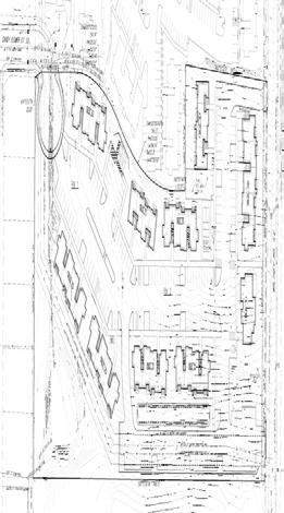
75
76 CITY OF < C AT YOU SVIC : m s TO: FOM: Aaron Panko, Planner III Community Development Department Glenn J. Davis, P, CFM, Chief Development ngineer Public Works Department DAT: December 10, 2018 SUBJCT: PUBLIC WOKS COMMNDATIONS D-SP-DAP-TV18-07 ( P) 1881 WILTSY OAD S 111-UNIT APATMNT COMPLX POPOSAL A Class 3 Design eview and Class 3 Site Plan eview application for development of a new 111-unit apartment complex, with a Class 2 Driveway Approach permit for new driveway approaches on Wiltsey oad S and Candy Flower Court S, and a Tree egulation Variance request to remove Oregon white oaks ranging in size from 24 inches to 40 inches in diameter, for property approximately 6.5 acres in size, zoned M-I and M-II (Multi-Family esidential), and located at 1881 Wiltsey oad S (Marion County Assessor Map and Tax Lot numbers: 083W14D / and 01101). COMMNDD CONDITIONS OF APPOVAL Convey land for dedication to equal a half-width right-of-way of 30 feet on the development side of Wiltsey oad S. Convey land for dedication at the terminus of Candy Flower Court S pursuant to PWDS. Construct a property line sidewalk and install street trees along the frontage of Wiltsey oad S to meet Collector street standards as specified in the PWDS and consistent with the provisions of SC Chapter 803. Construct a cul-de-sac improvement at the terminus of Candy Flower Court S to Cul-de-sac street standards as specified in the PWDS and consistent with the provisions of SC Chapter 803. Modify the easterly driveway approach accessing Wiltsey oad S to meet the Code authority references are abbreviated in this document as follows: Salem evised Code (SC); Public Works Design Standards (PWDS); Salem Transportation System Plan (Salem TSP); and Stormwater Management Plan (SMP).
77 Aaron Panko, Planner III December 10, 2018 Page 2 Me yie\ LMO requirements of SC Chapter 804 and PWDS. 6. Design and construct a storm drainage system at the time of development in SC Chapter 71 and PWDS. FACTS Streets 1. Wiltsey oad S a. Standard This street is designated as a Collector street in the Salem TSP. The standard for this street classification is a 34-foot-wide improvement within a 60-foot-wide right-of-way. b. xisting Conditions This street has an approximate 34-foot improvement within a 40-foot-wide right-of-way abutting the subject property. 2. Candy Flower Court S a. b. Standard This street is designated as a Local street in the Salem TSP. The standard for this street classification is a 30-foot-wide improvement within a 50-foot-wide right-of-way; the cul-de-sac standard is a 38-foot-radius improvement within a 45-foot-radius right-of-way. xisting Conditions This street has an approximate 30-foot improvement within a 60-foot-wide right-of-way which terminates at the boundary of the subject property. Storm Drainage 1. xisting Conditions a. b. c. A public detention basin is located in the northwest corner of the property within a public easement (eel 3570, Page 309). A ditch and 15-inch storm mains are located on the northern portion of the property within a public easement (eel 3570, Pages 310 and 311). These easements and mains cross the sewer easement and force mains. The subject property is within the Battle Creek Drainage Basin. JPG:\Group\pubwks\PLAN_ACT\PAFinal18\Site Plan eview\ p_1881 Wiltsey oad S.doc
78 Aaron Panko, Planner III December 10, 2018 Page 3 MMO Water 1. xisting Conditions a. The subject property is located within the S-2 water service level. b. An 8-inch water main is located in both Wiltsey oad S and Candy Flower Court S. Mains of this size generally convey flows of 900 to 2,200 gallons per minute. Sanitary Sewer 1. xisting Conditions a. An 8-inch sewer line is located in Candy Flower Court S. b. A 30-foot-wide sewer easement is located on the property and houses two force mains (14-inch and 20-inch). CITIA AND FINDINGS SIT PLAN VIW Analysis of the development based on relevant criteria in SC (f)(3) is as follows: Criteria: SC (f)(3)(A) The application meets all applicable standards of the UDC (Unified Development Code) Finding With completion of the conditions above, the subject property meets all applicable standards of the following chapters of the UDC: Floodplain; 802- Public Improvements; Streets and ight-of-way Improvements; Driveway Approaches; Vision Clearance; Wetlands; and Landslides. Public Works staff has reviewed the Flood Insurance Study and Flood Insurance ate Maps and has determined that no floodplain or floodway areas exist on the subject property. According to the Salem-Keizer Local Wetland Inventory (LWI) the subject property does not contain any wetland areas. According to the City s adopted landslide hazard susceptibility maps and SC Chapter 810 (Landslide Hazards), there are mapped 2-point landslide hazard areas on JPG:\Group\pubwks\PLAN_ACT\PAFinal18\Site Plan eview\ p_1881 Wiltsey oad S.doc

79 Aaron Panko, Planner III December 10, 2018 Page 4 MMO the subject property. The proposed activity of a multi-family development adds 2 activity points to the proposal, which results in a total of 4 points. Therefore, the proposed development is classified as a low landslide risk and no additional information is required. Criteria: SC (f)(3)(B) The transportation system provides for the safe, orderly, and efficient circulation of traffic into and out of the proposed development, and negative impacts to the transportation system are mitigated adequately Finding-The proposed development is subject to a special setback equal to 30 feet from centerline on the development side of Wiltsey oad S. The existing configuration of Wiltsey oad S does not meet current standards for its classification of street per the Salem TSP. The existing street condition is lacking rightof-way width, sidewalk, and street trees. The applicant shall convey land for dedication to equal a half-width right-of-way of 30 feet on the development side of Wiltsey oad S. The applicant shall also construct sidewalk and install street trees as specified in the City Street Design Standards and consistent with the provisions of SC Chapter 803. Trees being removed as part of street construction require a removal permit pursuant to SC The existing configuration of Candy Flower Court S does not meet current standards for its classification of street per the Salem TSP. The applicant shall convey land for dedication at the terminus of Candy Flower Court S pursuant to PWDS and construct a complete cul-de-sac improvement at the terminus of Candy Flower Court S to Cul'de-sac street standards as specified in the PWDS and consistent with the provisions of SC Chapter 803. Prior to accepting the property to be dedicated, the City will need to quitclaim the existing stormwater easement located within the area to be dedicated as right-of-way. Criteria: SC (f)(3)(C) Parking areas and driveways are designed to facilitate safe and efficient movement of vehicles, bicycles, and pedestrians Finding The driveway accesses onto Wiltsey oad S and the completed Candy Flower Court S cul-de-sac bulb provide for safe turning movements into and out of the property. The applicant is proposing fill over an existing sanitary sewer easement to facilitate the construction of a parking area. Placing fill in an easement requires a Design xception. Criteria: SC (f)(3)(D) The proposed development will be adequately served with City water, sewer, storm drainage, and other utilities appropriate to the nature of the development JPG:\Group\pubwks\PLAN_ACT\PAFinal18\Site Plan eview\ p_1881 Wiltsey oad S.doc
80 Aaron Panko, Planner III December 10, 2018 Page 5 MMO Finding The Public Works Department has reviewed the applicant s preliminary plan for this site. The water, sewer, and storm infrastructure are available within surrounding streets/areas and are adequate to serve the proposed development. The applicant is proposing connections to the existing main located in Wiltsey oad S for both fire and domestic service. Separate taps to the existing main will be needed for each service. The applicant is proposing to extend a private sewer system into the site from the existing sewer main located in Candy Flower Court S. The applicant is advised that a sewer monitoring manhole will be required, and the trash area shall be designed in compliance with PWDS. The applicant s engineer submitted a statement demonstrating compliance with PWDS Appendix 004-(4)(b) and SC Chapter 71. The preliminary stormwater design demonstrates the use of green stormwater infrastructure to the maximum extent feasible. The applicant shall design and construct all utilities (sewer, water, and storm drainage) according to PWDS and to the satisfaction of the Public Works Director. DIVWAY APPOACH PMIT - Wiltsey oad S (east entrance) Analysis of the driveway approach based on relevant criteria in SC (d) is as follows: A Class 2 Driveway Approach Permit shall be granted if: (1) The proposed driveway approach meets the standards of this Chapter and the Public Works Design Standards; Finding The proposed driveway meets the standards for SC 804 and PWDS. (2) No site conditions prevent placing the driveway approach in the required location; Finding There are no site conditions prohibiting the location of the proposed driveway, except that construction of the driveway approach may require relocation of an existing utility pole. (3) The number of driveway approaches onto an arterial are minimized; Finding The proposed driveway is not accessing onto an arterial street. (4) The proposed driveway approach, where possible: JPG:\Group\pubwks\PLAN_ACT\PAFinal18\Site Plan eview\ p_1881 Wiltsey oad S.doc
81 Aaron Panko, Planner III December 10, 2018 Page 6 MMO i. ii. Is shared with an adjacent property; or Takes access from the lowest classification of street abutting the property; Finding The proposed driveway to Wiltsey oad S, a Collector, is necessary to provide an additional access point to meet fire code requirements. (5) Proposed driveway approach meets vision clearance standards; Finding The proposed driveway meets the PWDS vision clearance standards set forth in SC Chapter 805. (6) The proposed driveway approach does not create traffic hazards and provides for safe turning movements and access; Finding The proposed driveway will not create a known traffic hazard and will provide for safe turning movements for access to the subject property. (7) The proposed driveway approach does not result in significant adverse impacts to the vicinity; Finding The location of the proposed driveway does not have any adverse impacts to the adjacent properties or streets. (8) The proposed driveway approach minimizes impact to the functionality of adjacent streets and intersections; and Finding The proposed driveway approach is located on a Collector street and does not create a significant impact to adjacent streets and intersections. (9) The proposed driveway approach balances the adverse impacts to residentially zoned property and the functionality of adjacent streets. Finding The proposed development is surrounded by residentially zoned property. The proposed development abuts Collector and Local streets. The driveway balances the adverse impacts to residentially zoned property and will not have an effect on the functionality of the adjacent streets. DIVWAY APPOACH PMIT - Wiltsey oad S (west entrance) Analysis of the driveway approach based on relevant criteria in SC (d) is as follows: JPG:\Group\pubwks\PLAN_ACT\PAFinal18\Site Plan eview\ p_1881 Wiltsey oad S.doo
82 Aaron Panko, Planner III December 10, 2018 Page 7 MMO A Class 2 Driveway Approach Permit shall be granted if: (1) The proposed driveway approach meets the standards of this Chapter and the Public Works Design Standards; Finding The proposed driveway meets the standards for SC 804 and PWDS. (2) No site conditions prevent placing the driveway approach in the required location; Finding There are no site conditions prohibiting the location of the proposed driveway. (3) The number of driveway approaches onto an arterial are minimized; Finding The proposed driveway is not accessing onto an arterial street. (4) The proposed driveway approach, where possible: i. ii. Is shared with an adjacent property; or Takes access from the lowest classification of street abutting the property; Finding-The proposed driveway to Wiltsey oad S, a Collector. The driveway cannot be shared with adjacent property because of topographic constraints. Access is being taken from Candy Flower Court S, a local street, but an additional access on Wiltsey oad S is warranted. (5) Proposed driveway approach meets vision clearance standards; Finding The proposed driveway meets the PWDS vision clearance standards set forth in SC Chapter 805. (6) The proposed driveway approach does not create traffic hazards and provides for safe turning movements and access; Finding The proposed driveway will not create a known traffic hazard and will provide for safe turning movements for access to the subject property. (7) The proposed driveway approach does not result in significant adverse impacts to the vicinity; JPG:\Group\pubwks\PLAN_ACT\PAFinal18\Site Plan eview\ p_1881 Wiltsey oad S.doc
83 Aaron Panko, Planner III December 10, 2018 Page 8 MMO Finding The location of the proposed driveway does not have any adverse impacts to the adjacent properties or streets. (8) The proposed driveway approach minimizes impact to the functionality of adjacent streets and intersections; and Finding The proposed driveway approach is located on a Collector street and does not create a significant impact to adjacent streets and intersections. (9) The proposed driveway approach balances the adverse impacts to residentially zoned property and the functionality of adjacent streets. Finding The proposed development is surrounded by residentially zoned property. The proposed development abuts Collector and Local streets. The driveway balances the adverse impacts to residentially zoned property and will not have an effect on the functionality of the adjacent streets. DIVWAY APPOACH PMIT - Candy Flower Court S Analysis of the driveway approach based on relevant criteria in SC (d) is as follows: A Class 2 Driveway Approach Permit shall be granted if: (1) The proposed driveway approach meets the standards of this Chapter and the Public Works Design Standards; Finding The proposed driveway meets the standards for SC 804 and PWDS. (2) No site conditions prevent placing the driveway approach in the required location; Finding There are no site conditions prohibiting the location of the proposed driveway. (3) The number of driveway approaches onto an arterial are minimized; Finding The proposed driveway is not accessing onto an arterial street. (4) The proposed driveway approach, where possible: i. Is shared with an adjacent property; or JPG:\Group\pubwks\PLAN_ACT\PAFinal18\Site Plan eview\ p_1881 Wiltsey oad S.doc
84 Aaron Panko, Planner III December 10, 2018 Page 9 MFiwin L_ IVI V-/ n. Takes access from the lowest classification of street abutting the property; Finding The proposed driveway to Candy Flower Court S is located with access to the lowest classification of street abutting the subject property. (5) Proposed driveway approach meets vision clearance standards; Finding The proposed driveway meets the PWDS vision clearance standards set forth in SC Chapter 805. (6) The proposed driveway approach does not create traffic hazards and provides for safe turning movements and access; Finding The proposed driveway will not create a known traffic hazard and will provide for safe turning movements for access to the subject property. (7) The proposed driveway approach does not result in significant adverse impacts to the vicinity; Finding The location of the proposed driveway does not have any adverse impacts to the adjacent properties or streets. (8) The proposed driveway approach minimizes impact to the functionality of adjacent streets and intersections; and Finding The proposed driveway approach is located on a local street and does not create a significant impact to adjacent streets and intersections. (9) The proposed driveway approach balances the adverse impacts to residentially zoned property and the functionality of adjacent streets. Finding The proposed development is surrounded by residentially zoned property. The proposed development abuts Collector and Local streets. The driveway balances the adverse impacts to residentially zoned property and will not have an effect on the functionality of the adjacent streets. Prepared by: Jennifer Scott, Program Manager cc: File JPG:\Group\pubwks\PLAN_ACT\PAFinal18\Site Plan eview\ p_1881 Wiltsey oad S.doc
85
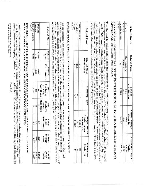
86

87
FOR MEETING OF: DECEMBER 18, 2018 CASE NO.: DR-CU-SPR-DAP18-06 AGENDA ITEM: 6.1 PLANNING COMMISSION LISA ANDERSON-OGILVIE, AICP PLANNING ADMINISTRATOR
 FOR MEETING OF: DECEMBER 18, 2018 CASE NO.: DR-CU-SPR-DAP18-06 AGENDA ITEM: 6.1 TO: FROM: PLANNING COMMISSION LISA ANDERSON-OGILVIE, AICP PLANNING ADMINISTRATOR SUBJECT: DESIGN REVIEW CONDITIONAL USE SITE
LISA ANDERSON-OGILVIE, AICP DEPUTY COMMUNITY DEVELOPMENT DIRECTOR AND PLANNING ADMINISTRATOR
 FOR MEETNG OF: NOVEMBER 21, 2017 CASE NO.: DR-SPR-ADJ-DAP17-06 TO: FROM: PLANNNG COMMSSON LSA ANDERSON-OGLVE, ACP DEPUTY COMMUNTY DEVELOPMENT DRECTOR AND PLANNNG ADMNSTRATOR SUBJECT: DESGN REVEW STE PLAN
PUBLIC WORKS - COMMUNITY DEVELOPMENT. Staff Report. Site Plan Review. SP July 5, 2018
 PUBLIC WORKS - COMMUNITY DEVELOPMENT 333 Broadalbin Street SW, PO Box 49, Albany, Oregon 97321-144 BUILDING 541-917-7553 PLANNING 541-917-755 Staff Report Site Plan Review SP-2-17 July 5, 218 Summary This
BUFFERS, TREE PROTECTION AND LANDSCAPING. Sec Purpose and Intent.
 ARTICLE 20 BUFFERS, TREE PROTECTION AND LANDSCAPING Sec. 20.1. Purpose and Intent. Trees improve air and water quality, reduce soil erosion, reduce noise and glare, provide habitat for desirable wildlife,
MULTIFAMILY RESIDENTIAL DESIGN PRINCIPLES Site Plan and Design Review Principles Checklist
 MULTIFAMILY RESIDENTIAL DESIGN PRINCIPLES Site Plan and Design Review Principles Checklist Applicant s Name: Project Address: Phone: Email: Applicant shall fill out the design guidelines checklist for
5.1.1 The streetscape along US Highway 64 (Brevard Road); and, The built environment within new residential developments; and,
; and, The built environment within new residential developments; and,") Article 5. Landscaping 5.1 Purpose The Town of Laurel Park s landscape standards are designed to create a beautiful, aesthetically pleasing built environment that will complement and enhance community
Article 5. Landscaping 5.1 Purpose The Town of Laurel Park s landscape standards are designed to create a beautiful, aesthetically pleasing built environment that will complement and enhance community
EXHIBIT A. Chapter 2.7 SPECIAL PLANNED DISTRICTS. Article XVIII 15th Street School Master Planned Development
 EXHIBIT A Chapter 2.7 SPECIAL PLANNED DISTRICTS Article XVIII 15th Street School Master Planned Development Sections: 2.7.3600 15 th Street School Master Planned Development 2.7.3610 Purpose 2.7.3620 Definitions
CHAPTER ADDITIONAL REQUIREMENTS IN THE NC, NEIGHBORHOOD COMMERCIAL ZONE
 CITY OF MOSES LAKE MUNICIPAL CODE CHAPTER 18.31 ADDITIONAL REQUIREMENTS IN THE NC, NEIGHBORHOOD COMMERCIAL ZONE Sections: 18.31.010 Purpose 18.31.020 Minimum Lot Area 18.31.030 Setbacks 18.31.040 Maximum
REZONING APPLICATION MPD SUPPLEMENT
 REZONING APPLICATION MPD SUPPLEMENT For Staff Use Only: DATE/TIMESTAMP: ZA# RECEIVED BY: The intent of the Master Planned District (MPD) designation is to allow flexibility in the design and construction
SMALL LOT DESIGN STANDARDS. An Illustrated Working Draft for Test Implementation
 SMALL LOT DESIGN STANDARDS An Illustrated Working Draft for Test Implementation SMALL LOT DESIGN STANDARDS ILLUSTRATED WORKING FOR TEST IMPLEMENTATION OVERVIEW SMALL LOT CODE AMENDMENT & POLICY UPDATE
STANDARDS THAT APPLY TO ALL OR SOME DEVELOPMENT PROJECTS WITH RESIDENTIAL USES
 6 STANDARDS THAT APPLY TO ALL OR SOME DEVELOPMENT PROJECTS WITH RESIDENTIAL USES STANDARDS THAT APPLY TO ALL OR SOME DEVELOPMENT PROJECTS WITH RESIDENTIAL USES 6-1 Figure 6-1: Parking Stall Width 9 Stall
CHAPTER 26 LANDSCAPING (Chapter added in its entirety 05-08)
") CHAPTER 26 LANDSCAPING (Chapter added in its entirety 05-08) 26.01 DESCRIPTION AND PURPOSE. Landscaping is an important element of the use, development and preservation of land, and a significant factor
CHAPTER 26 LANDSCAPING (Chapter added in its entirety 05-08) 26.01 DESCRIPTION AND PURPOSE. Landscaping is an important element of the use, development and preservation of land, and a significant factor
Chapter PEDESTRIAN COMMERCIAL (PC) ZONING DISTRICT
 ZONING DISTRICT") Chapter 11-17 PEDESTRIAN COMMERCIAL (PC) ZONING DISTRICT Sections: 11-17-01 GENERAL PURPOSE 11-17-02 PERMITTED BUILDING TYPES 11-17-03 USES PERMITTED WITH DESIGN REVIEW 11-17-04 USES PERMITTED BY CONDITIONAL
Chapter 11-17 PEDESTRIAN COMMERCIAL (PC) ZONING DISTRICT Sections: 11-17-01 GENERAL PURPOSE 11-17-02 PERMITTED BUILDING TYPES 11-17-03 USES PERMITTED WITH DESIGN REVIEW 11-17-04 USES PERMITTED BY CONDITIONAL
EXHIBIT B PROJECT NARRATIVE POULSBO MEADOWS
 EXHIBIT B PROJECT NARRATIVE POULSBO MEADOWS Name of Project: Poulsbo Meadows; A Planned Residential Development (PRD)/Plat Applicants Name: PBH Group LLC/Byron Harris PO Box 1010 Silverdale, WA 98038 Description
Application for Site Plan Review
 Application for Site Plan Review City of Pontiac Office of Land Use and Strategic Planning 47450 Woodward Ave, Pontiac, MI 48342 T: 248.758.2800 F: 248.758.2827 Property/Project Address: Sidwell Number:
GENERAL LANDSCAPE PROVISIONS. The following landscape provisions shall be adhered to by all land uses unless otherwise noted:
 CHAPTER 1.18 Sections: 1.18.005 Purpose. 1.18.010 Landscaping, Buffering, and Fencing Improvements Required. 1.18.015 General Landscape Provisions. 1.18.020 Landscaping Plan. 1.18.025 Single-Family Dwellings
F. Driveways. Driveways which provide access to off-street parking or loading from public streets shall comply with the following:
 Section 20.945.040 General Design Standards for Surface Parking Areas. A. Review Authority. Parking lot design and drainage shall be subject to review and approval of the City Transportation Manager. B.
ARTICLE 3 LANDSCAPING AND SCREENING REQUIREMENTS
 ARTICLE 3 CHAPTER 4 LANDSCAPING AND SCREENING REQUIREMENTS SEC 3.401 SEC 3.402 (D) (E) PURPOSE: The purpose of this Chapter is to establish minimum standards for the design, installation, and maintenance
Site Development Plan (SDP) Checklist
 Checklist") Development Services Department 100 N. Wilcox Street, Castle Rock CO 80104 303-660-1393 or CRGov.com Site Development Plan (SDP) Checklist A complete Site Development Plan (SDP) submittal will contain
Development Services Department 100 N. Wilcox Street, Castle Rock CO 80104 303-660-1393 or CRGov.com Site Development Plan (SDP) Checklist A complete Site Development Plan (SDP) submittal will contain
Landscape and fencing requirements of this Chapter shall apply to all new landscaped areas.
 Chapter 19.06. Landscaping and Fencing. Sections: 19.06.01. Purpose. 19.06.02. Required Landscaping Improvements. 19.06.03. General Provisions. 19.06.04. Landscaping Plan. 19.06.05. Completion of Landscape
City of Vaughan Urban Design Guidelines for Infill Development in Established Low-Rise Residential Neighbourhoods
 City of Vaughan Urban Design Guidelines for Infill Development in Established Low-Rise Residential Neighbourhoods DRAFT - September 2016 Contents 1. Introduction 1 2. Policy Context 3 3. Characteristics
B L A C K D I A M O N D D E S I G N G U I D E L I N E S for Multi-family Development
 B L A C K D I A M O N D D E S I G N G U I D E L I N E S for Multi-family Development Adopted June 18, 2009 This section of the Design and focuses on site planning and design guidance for new multi-family
SUBMITTAL REQUIREMENTS
 WHEN PROCESS TYPE III IS USED References to Process Type III applications are found in several places in the Milton Municipal Code (MMC), indicating that the development, activity, or use, is permitted
Design Guidelines for Residential Subdivisions
 Design Guidelines for Residential Subdivisions Development Services 972-466-3225 cityofcarrollton.com This page intentionally left blank. Table of Contents Purpose... 1 Design Objectives... 1 Design Guidelines
F. The following uses in the HR District: attached single-family dwellings, condominiums, and institutional uses; and
 1102 DESIGN REVIEW 1102.01 PURPOSE AND APPLICABILITY Section 1102 is adopted to provide standards, criteria, and procedures under which design review may be approved. Design review is required for: A.
Harmony Technology Park Third Filing, Second Replat Custom Blending, Project Development Plan/Final Development Plan - FDP #130021
 ITEM NO FDP #130021 MEETING DATE July 23, 2013 STAFF Pete Wray ADMINISTRATIVE TYPE I HEARING STAFF REPORT PROJECT: APPLICANT: OWNER: Harmony Technology Park Third Filing, Second Replat Custom Blending,
Ephrata Municipal Code, Chapter 19.07, Landscaping Regulations DRAFT January 28, 2013 Page 1
 Chapter 19.07 LANDSCAPING REGULATIONS Sections: 19.07.010 Purpose. 19.07.020 Landscape plan approval. 19.07.030 Failure to complete required landscaping Inspection. 19.07.040 General landscape requirements
5.1 Commercial and Industrial Development. (Effective April 1, 2006)
") 5.1 Commercial and Industrial Development. (Effective April 1, 2006) A. Applicability: The requirements of this section (5.10) shall apply to all uses within the LB Local Business; HB Highway Business;
5.1 Commercial and Industrial Development. (Effective April 1, 2006) A. Applicability: The requirements of this section (5.10) shall apply to all uses within the LB Local Business; HB Highway Business;
SITE PLAN REVIEW APPLICATION
 SITE PLAN REVIEW APPLICATION CITY OF THE DALLES Community Development Department 313 Court Street The Dalles, OR 97058 (541) 296-5481, ext. 1125 Fax (541) 298-5490 www.ci.the-dalles.or.us Date Filed File#
6 STANDARDS THAT APPLY TO ALL
 6 STANDARDS THAT APPLY TO ALL DEVELOPMENT PROJECTS WITH RESIDENTIAL USES This chapter presents standards that are applicable to all projects with residential uses. STANDARDS THAT APPLY TO ALL DEVELOPMENT
CITY OF KEIZER MASTER PLAN APPLICATION & INFORMATION SHEET
 CITY OF KEIZER MASTER PLAN APPLICATION & INFORMATION SHEET PRE-APPLICATION CONFERENCE Prior to the actual filing of a Master Plan application, it is strongly recommended that the applicant contact Planning
Si necesita ayuda para comprender esta informacion, por favor 1/ame DECISION OF THE HEARINGS OFFICER
 z 0... en - u w c LL 0 w u -... 0 z May 9, 2016 6(al Si necesita ayuda para comprender esta informacion, por favor 1/ame 503-588-6173 DECISION OF THE HEARINGS OFFICER CONDITONAL USE I CLASS 3 SITE PLAN
AWH REPORT OF THE PLANNING AND DEVELOPMENT DEPARTMENT FOR APPLICATION FOR REZONING ORDINANCE TO PLANNED UNIT DEVELOPMENT
 AWH REPORT OF THE PLANNING AND DEVELOPMENT DEPARTMENT FOR APPLICATION FOR REZONING ORDINANCE TO PLANNED UNIT DEVELOPMENT MAY 8, 2014 The Planning and Development Department hereby forwards to the Planning
Request Change in Nonconformity. Staff Recommendation Approval. Staff Planner Jonathan Sanders
 Applicant & Owner Public Hearing April 11, 2018 City Council Election District Beach Agenda Item 5 Request Change in Nonconformity Staff Recommendation Approval Staff Planner Jonathan Sanders Location
CHAPTER 530 SITE PLAN REVIEW
 ARTICLE I. GENERAL PROVISIONS CHAPTER 530 SITE PLAN REVIEW Community Planning and Economic Development Development Services Division 250 South 4 th Street, Room 300 Minneapolis MN 55415-1316 612-673-3000
Chapter RM MULTI FAMILY BUILDING ZONES
 Chapter 19.17 RM MULTI FAMILY BUILDING ZONES 19.17.010 Established 19.17.020 Primary Permitted Uses 19.17.030 Accessory Permitted Uses 19.17.040 Secondary Permitted Uses 19.17.050 Conditional Property
36.1. PURPOSE APPLICABILITY DESIGN REVIEW GUIDELINES
 CHAPTER 36: DESIGN STANDARDS 36.1. PURPOSE The purpose of this chapter is to ensure that projects are designed and constructed consistent with the Community Design Subelement of the Land Use Element and
SITE PLAN REVIEW APPLICATION AND CHECKLIST
 SITE PLAN REVIEW APPLICATION AND CHECKLIST PROJECT SUMMARY: Project Name: City/ETA Location: City ETA (Application fee & number of copies needed are based on location) Property Location (Legal Description
Request Alternative Compliance to the prescribed criteria of the Oceanfront Resort District Form-Based Code. Staff Planner Kristine Gay
 Applicant/Owner Ocean Rental Properties, LLC Public Hearing April 13, 2016 City Council Election District Beach Agenda Item 1 Request Alternative Compliance to the prescribed criteria of the Oceanfront
Landscaping Standards
 CHAPTER 29 ARTICLE 403 29.403 Landscaping Standards Purpose: The purpose of this section is to protect and promote the public health, safety and general welfare by requiring landscaping in relation to
CITY OF ZEELAND PLANNING COMMISSION
 APPLICATION FOR SITE PLAN REVIEW AND SPECIAL LAND USE Date City Official App. Filing Fee Rec'd ($350) NOTE TO APPLICANT: Please submit this application for Site Plan Review along with twenty (20) copies
Building and Site Design Standards
 Commercial Design Standards All Business and Industrial Uses as Described in Section 2234 Requiring Special Permit Review Except Large-Scale Ground Mounted Solar Photovoltaic Installations and Wireless
City of Yelm. Tahoma Terra Final Master Plan Development Guidelines. Table of Contents
 City of Yelm Tahoma Terra Final Master Plan Development Guidelines Table of Contents Table of Contents... 1 Purpose... 2 Low Density Residential (R4-6)... 3 Moderate Density Residential (R6-10)... 5 Neighborhood
Section 511: 11 th Street Overlay District 1. Intent: 11 th Street is the primary entrance route into the city from the south, providing direct
 Section 511: 11 th Street Overlay District 1. Intent: 11 th Street is the primary entrance route into the city from the south, providing direct access from US Highway 12. As such, the community has identified
ARTICLE IV: DEVELOPMENT STANDARDS 404 MASTER PLANNING
 IV 13 404 MASTER PLANNING Master Planning through the Site Analysis (Master Planning Site Analysis) or Planned Development (Master Planning Planned Development) is provided to encourage development which
ARTICLE 9: LANDSCAPING AND FENCING REQUIREMENTS
 ARTICLE 9: LANDSCAPING AND FENCING REQUIREMENTS Section 9.01 Intent The intent of the landscaping requirements are to improve the appearance of lot areas and soften paved areas and buildings; to provide
ARTICLE 9: Landscaping
 ARTICLE 9: Landscaping 9-10 Legislative Intent The purpose of this Article is to regulate the planting and preservation of landscape materials; to facilitate the creation of an attractive and healthy environment;
Wide asphalt driveway abutting school property. garage built with incompatible materials, too close to park. incompatible fencing materials
 Wide asphalt driveway abutting school property incompatible fencing materials garage built with incompatible materials, too close to park Lack of plantings as a buffer between private property and open
4030 COMMERCIAL (C AND CM)
") 4030 COMMERCIAL (C AND CM) 4030.10 Intent and Purpose The C and CM districts are intended to permit the range of commercial uses in areas which are appropriate for such uses consistent with the General
4030 COMMERCIAL (C AND CM) 4030.10 Intent and Purpose The C and CM districts are intended to permit the range of commercial uses in areas which are appropriate for such uses consistent with the General
Request Alternative Compliance to the prescribed criteria of the Oceanfront Resort District Form- Based Code. Staff Recommendation Approval
 Applicant Property Owner Steven H. Murden Public Hearing June 14, 2017 City Council Election District Beach Agenda Item 8 Request Alternative Compliance to the prescribed criteria of the Oceanfront Resort
KEIZER STATION PLAN INTRODUCTION
 KEIZER STATION PLAN INTRODUCTION Planning for this area began in 1987 when the Keizer Comprehensive Plan established the Chemawa Activity Center and McNary Activity Center. The first Chemawa Activity Center
DESIGN REVIEW COMMITTEE AGENDA ITEM
 DESIGN REVIEW COMMITTEE AGENDA ITEM AGENDA DATE: OCTOBER 3, 2012 TO: Chair Woollett and Members of the Design Review Committee THRU: FROM: SUBJECT: Leslie Aranda Roseberry, Planning Manager Daniel Ryan,
The purpose of the requirements in this Article is to provide for landscaping and screening of parking and other outdoor areas that will:
 XIII. LANDSCAPING & SCREENING A. Purpose The purpose of the requirements in this Article is to provide for landscaping and screening of parking and other outdoor areas that will: 1. Protect residential
SITE PLAN REVIEW PROCESS
 BOWNE TOWNSHIP PO Box 35, 8240 Alden Nash Road, Alto, Michigan 49302 Ph. 616-868-6846 Fax 616-868-0110 http://www.bownetwp.org SITE PLAN REVIEW PROCESS 1. Application Form and Fee Schedule Site Plan Review
Eastcreek Farm. Planned Development Standards September, 2014
 Eastcreek Farm Planned Development Standards September, 2014 ekfarm Contents 01. General Standards 02. Residential Development Standards 03. Architectural Design Standards 04. Landscape Design Standards
PLANNED UNIT DEVELOPMENT & SUBDIVISION STAFF REPORT Date: May 18, 2017
 & PUD-0000102-2017 PLANNED UNIT DEVELOPMENT & SUBDIVISION STAFF REPORT Date: May 18, 2017 NAME SUBDIVISION NAME Dauphin Creek Estates Subdivision Dauphin Creek Estates Subdivision LOCATION CITY COUNCIL
DEPARTMENT OF PLANNING JEFFERSON PARISH, LOUISIANA
 DEPARTMENT OF PLANNING JEFFERSON PARISH, LOUISIANA DESIGN REVIEW REPORT : CPZ-3-1 : (S) Cynthia Lee-Sheng AT LARGE: A Chris Roberts B Elton M. Lagasse ADVERTISING DATES: 06/03/1 06/10/1 06/17/1 PAB PUBLIC
Chapter 19.5 LANDSCAPING REQUIREMENTS
 Chapter 19.5 LANDSCAPING REQUIREMENTS Sec. 19.5-1. Intent The intent of the landscaping requirements stated herein are as follows: To aid in stabilizing the environment's ecological balance by contribution
CHAPTER 22 Rural Open Space Community Developments
 CHAPTER 22 Rural Open Space Community Developments Section 22.1 Description and Purpose The intent of this Chapter is to offer property owners an alternative to traditional zoning requirements for rural
DCA , Stormwater Quality and Facilities Ordinance June 23, 2009
 PROPOSED NEW SECTION 10.486 Stormwater Quality and Detention Facilities, Public Streets. A. Purpose. It is the City s policy to maintain the natural hydrology and preserve water quality by mitigating the
Urban Design Brief 1576 Richmond Street City of London
 Urban Design Brief City of London Treadstone Developments October 31, 2014 Urban Design Brief October 31, 2014 TABLE OF CONTENTS Page No. INTRODUCTION... 1 SECTION 1 LAND USE PLANNING CONCEPT... 1 1.1
Be it enacted by the Town Board of the Town of Guilderland that the following new A (Transit Oriented Development (TOD) District) is adopted:
 District) is adopted:") Local Law No. 4 of 2018 (Adoption of 280-18A (Transit Oriented Development District) Be it enacted by the Town Board of the Town of Guilderland that the following new 280-18A (Transit Oriented Development
Local Law No. 4 of 2018 (Adoption of 280-18A (Transit Oriented Development District) Be it enacted by the Town Board of the Town of Guilderland that the following new 280-18A (Transit Oriented Development
FREEWAY/TOURIST DISTRICT
 FREEWAY/TOURIST DISTRICT DESIGN STANDARDS FOR THE CITY OF MOUNTLAKE TERRACE March, 2014 MOUNTLAKE TERRACE FREEWAY/TOURIST DESIGN STANDARDS March, 2014 1 TABLE OF CONTENTS Introduction...1 Design Site Design
LANDSCAPE ORDINANCE PASADENA PLANNING DEPARTMENT (713) FAX (713)
 FAX (713)") LANDSCAPE ORDINANCE PASADENA PLANNING DEPARTMENT (713) 475-5543 FAX (713) 477-1072 ARTICLE X. LANDSCAPING OF NONRESIDENTIAL SITES* Sec. 9-195. Applicability. (a) This article shall apply to the following:
LANDSCAPE ORDINANCE PASADENA PLANNING DEPARTMENT (713) 475-5543 FAX (713) 477-1072 ARTICLE X. LANDSCAPING OF NONRESIDENTIAL SITES* Sec. 9-195. Applicability. (a) This article shall apply to the following:
DESIGN AND LANDSCAPE GUIDELINES FOR DEVELOPMENT
 DESIGN AND LANDSCAPE GUIDELINES FOR DEVELOPMENT IN THE SECOND SUPERVISORIAL DISTRICT (REVISED) ADOPTED BY RIVERSIDE COUNTY BOARD OF SUPERVISORS ON SEPTEMBER 15, 1998 REVISED OCTOBER 23, 1998 REVISED AUGUST
CHESAPEAKE LANDSCAPE ORDINANCE
 CHESAPEAKE LANDSCAPE ORDINANCE CONSERVATION PRESERVATION CZO 19-600 Effective October 16, 2008 BUFFER YARD C PARKING LOT REFORESTATION YEAR 1 REFORESTATION YEAR 4 BUFFER YARD F CBPA REFORESTATION Page
II. SINGLE FAMILY RESIDENTIAL
 II. SINGLE FAMILY RESIDENTIAL Castle Rock is made up of numerous individually built houses and subdivision tracts that have been developed during the past century. Some of the tracts are diverse in architectural
4. INDUSTRIAL 53 CASTLE ROCK DESIGN
 4. INDUSTRIAL 53 CASTLE ROCK DESIGN CASTLE ROCK DESIGN 54 4. INDUSTRIAL Overview Well-designed and attractive industrial centers are the product of blending economic realities with both functional and
Article 10: Landscaping and Buffering
 10.01: Purpose Article 10: Landscaping 10.01: Purpose The purpose of this article is to: A) Promote and protect the interest of the public convenience, comfort, prosperity, or general welfare in accordance
PLANNED UNIT DEVELOPMENT APPLICATION
 PLANNED UNIT DEVELOPMENT APPLICATION CITY OF THE DALLES Community Development Department 313 Court Street The Dalles, OR 97058 (541) 296-5481, ext. 1125 Fax (541) 298-5490 www.ci.the-dalles.or.us Date
CASE NUMBER: 16SN0701 APPLICANT: Hanky, LLC
 STAFF S ANALYSIS AND RECOMMENDATION Planning Commission (CPC) Public Hearing Date: MAY 17, 2016 CPC Time Remaining: 100 DAYS Applicant s Agent: DANIEL L. CASKIE (804-569-7060) Applicant s Contact: MICHAEL
B. Blocks, Buildings and Street Networks
 B. Blocks, Buildings and Street Networks Figure IV.4 A rational block pattern with connected streets Introduction The single most important element in the physical and functional integration of mixed use
At Your Disposal CUP Amendment, Lot 20, Village Service Commercial, at 128 Bastille Dr. (PLN17-208)
") MEMORANDUM Archuleta County Development Services Planning Department 1122 HWY 84 P. O. Box 1507 Pagosa Springs, Colorado 81147 970-264-1390 Fax 970-264-3338 TO: Archuleta County Planning Commission FROM:
MEMORANDUM Archuleta County Development Services Planning Department 1122 HWY 84 P. O. Box 1507 Pagosa Springs, Colorado 81147 970-264-1390 Fax 970-264-3338 TO: Archuleta County Planning Commission FROM:
GENERAL INFORMATIONaaaaaaaaaaaaaaaaaaaaaaaaaaaaaaaa
 To: Planning and Zoning Commission From: City Staff Date: November 15, 2016 Re: Case #16026 Raymore Activity Center Site Plan GENERAL INFORMATIONaaaaaaaaaaaaaaaaaaaaaaaaaaaaaaaa Applicant/ Property Owner:
PART I-D BUFFERS AND LANDSCAPING REQUIREMENTS
 District Regulations Of General Applicability ARTICLE IX PART I-D BUFFERS AND LANDSCAPING REQUIREMENTS 9-107 BUFFERS AND LANDSCAPING 9-107 A. General Landscaping and Maintenance Requirements. Except for
The following specific definitions shall apply to the landscaping and screening regulations contained in this article:
 ARTICLE XII. LANDSCAPING Sec. 5-421. Purpose. The purpose of landscaping and screening requirements is to improve certain setback and yard areas, including off-street vehicular parking and open-lot sales
CENTERS AND CORRIDORS
 INITIAL DESIGN STANDARDS AND GUIDELINES for CENTERS AND CORRIDORS City of Spokane Planning Services Third Floor, City Hall 808 W. Spokane Falls Blvd. Spokane, WA 99201-3329 (509) 625-6300 www.spokaneplanning.org
VILLAGE OF SKOKIE Design Guidelines for Mixed-Use Districts NX Neighborhood Mixed-Use TX Transit Mixed-Use CX Core Mixed-Use
 VILLAGE OF SKOKIE Design Guidelines for Mixed-Use Districts NX Neighborhood Mixed-Use TX Transit Mixed-Use CX Core Mixed-Use TABLE OF CONTENTS CHAPTER 1 SITE DESIGN Purpose 1 CHAPTER 2 SITE DESIGN Streetscape
CHAPTER SPECIAL PURPOSE AND OVERLAY ZONING DISTRICTS
 Special Purpose and Overlay Zoning Districts 106.28.010 CHAPTER 106.28 - SPECIAL PURPOSE AND OVERLAY ZONING DISTRICTS SPECIAL PURPOSE AND OVERLAY ZONING DISTRICTS Sections: 106.28.010 - Purpose 106.28.020
The petition proposes the development of five townhomes on a vacant parcel between Charlotte Latin School and Providence Presbyterian Church.
 Rezoning Petition 2017-202 Final Staff Analysis June 18, 2018 REQUEST LOCATION Current Zoning: R-3 (single family residential) Proposed Zoning: UR-2(CD) (urban residential, conditional) with five-year
PLANNED UNIT DEVELOPMENT STAFF REPORT Date: June 2, 2016
 # 9 ZON2016-01032 PLANNED UNIT DEVELOPMENT STAFF REPORT Date: June 2, 2016 DEVELOPMENT NAME JJT Properties LLC LOCATION 1147 & 1151 East I-65 Service Road South and 1180 Sledge Drive (Southeast corner
STORMWATER MANAGEMENT CODES ANALYSIS RICHLAND COUNTY, SC SITE PLANNING ROUNDTABLE
 STORMWATER MANAGEMENT CODES ANALYSIS RICHLAND COUNTY, SC SITE PLANNING ROUNDTABLE Codes analyses for each subcommittee were completed to assist participants of the Richland County Site Planning Roundtable.
Urban Planning and Land Use
 Urban Planning and Land Use 701 North 7 th Street, Room 423 Phone: (913) 573-5750 Kansas City, Kansas 66101 Fax: (913) 573-5796 Email: planninginfo@wycokck.org www.wycokck.org/planning To: From: City Planning
VEHICULAR AND PEDESTRIAN CIRCULATION
 This perspective sketch communicates the intended character and quality of a proposed streetscape design. Locate benches near a major intersection where people tend to gather. Seating and lighting provide
EXISTING COMPREHENSIVE PLAN
 EXISTING COMPREHENSIVE PLAN Town Center Land Use Element: V. LAND USE POLICIES Town Center Mercer Island's business district vision as described in "Your Mercer Island Citizen-Designed Downtown" was an
COMMUNITY DEVELOPMENT DEPARTMENT 333 Broadalbin Street SW, P.O. Box 490 Albany, OR 97321
 COMMUNITY DEVELOPMENT DEPARTMENT Broadalbin Street SW, P.O. Box 0 Albany, OR NOTICE OF FILING Ph: --0 Fax: -- www.cityofalbany.net DATE OF NOTICE: February, 0 FILE: SP-0- TYPE OF APPLICATION: Site Plan
ZONING ORDINANCE FOR THE ZONED UNINCORPORATED AREAS ARTICLE 1150 OF PUTNAM COUNTY, WEST VIRGINIA Page 95 ARTICLE 1150 SITE PLAN REVIEW
 OF PUTNAM COUNTY, WEST VIRGINIA Page 95 1150.01 PURPOSE 1150.02 APPLICABILITY 1150.03 APPLICATION PROCESS 1150.04 REVIEW PROCESS 1150.05 REVIEW CRITERIA 1150.06 SITE PLAN GUIDELINES 1150.01 PURPOSE ARTICLE
Improve the appearance of off-street parking areas, vehicular use areas, and property abutting public and private roads;
 Bedford Township, MI (Monroe Co.) 2012 http://library.municode.com/index.aspx?clientid=02123 400.1907 - Landscaping and screening. Se 1907. 1. Intent. Landscaping, greenbelts, and screening are necessary
PLANNING JUSTIFICATION REPORT
 PLANNING JUSTIFICATION REPORT 55 DELHI STREET CITY OF GUELPH PREPARED FOR: VESTERRA PROPERTY MANAGEMENT PREPARED BY: LABRECHE PATTERSON & ASSOCIATES INC. SCOTT PATTERSON, BA, CPT, MCIP, RPP PRINCIPAL,
General Location Courtyard at LMH Final Development Plan and Final Plat
 R-1 LEYDEN RIDGE LOMA RIDGE LOBDELL R-3 MILLER PARKWAY LAUSSAC Subject Property R-3 LOCHENSHIRE LESMER R General Location Courtyard at LMH Final Development Plan and Final Plat ¹ 230 115 0 230 Feet Airport
Urban Design Guidelines Townhouse and Apartment Built Form
 Urban Design Guidelines Townhouse and Apartment Built Form Town of Wasaga Beach Table of Contents 1. Introduction 1.1. Purpose 1.2. Urban Design Principles 1.3. Application of Guidelines 2. Site Design,
D. Landscape Design. 1. Coverage Intent: To provide adequate landscaping materials that enhance the appearance of development projects.
 D. Landscape Design The standards and guidelines in this section give design guidance for the landscaping components of industrial and office projects. City regulations require that all landscaping be
Required yards shall be horizontally unobstructed except as follows:
 ARTICLE IV: DEVELOPMENT STANDARDS 418 SETBACKS IV 111 418 SETBACKS 418 1 Obstruction in Required Yards Required yards shall be horizontally unobstructed except as follows: 418 1.1 Cornices, eaves, belt
ARTICLE 5 LANDSCAPE IMPROVEMENTS
 ARTICLE 5 LANDSCAPE IMPROVEMENTS 5-1 Purpose and Applicability 5-2 Landscape Plans and Installation 5-3 Landscaping Standards 5-4 Landscape Maintenance ARTICLE 5-1 PURPOSE AND APPLICABILITY 5-1-1 Purpose
Eastcreek Farm. Planned Development Standards July, 2015
 Eastcreek Farm Planned Development Standards July, 2015 ek farm 01. General Standards 1.2 Applicability of Standards All regulations not specified in these Planned Development (PD) Standards for Eastcreek
ARTICLE 8 DESIGN STANDARDS
 ARTICLE 8 DESIGN STANDARDS 8.000 Overview. The purpose of this Article is to establish additional standards for certain uses. These standards are intended to reduce adverse effects on surrounding property
MIXED-USE ZONING DISTRICT DESIGN GUIDELINES
 MIXED-USE ZONING DISTRICT DESIGN GUIDELINES In addition to the development regulations contained in the Mixed-Use Zoning District, design guidelines are presented here to provide an added level of definition
Chapter 11. Industrial Design Guidelines 11.1 INTRODUCTION AND PURPOSE 11.3 SITE PLANNING GUIDELINES 11.2 GENERAL DESIGN OBJECTIVES
 Chapter 11 Industrial Design Guidelines 11.1 INTRODUCTION AND PURPOSE The following industrial/design guidelines seek to assure high quality development in Santa Ana s industrial districts by: The design
E. Natural areas include habitats such as wetlands, tidal marshes, waterways, natural drainage-ways, woodlands and grassland meadows.
 Adopted November 1999 I. Purpose A. The purpose of these guidelines is to assist in the design and layout of open space, as provided on developed lots within the District. The intent of these guidelines
Policies and Code Intent Sections Related to Town Center
 Policies and Code Intent Sections Related to Town Center The Town Center Vision is scattered throughout the Comprehensive Plan, development code and the 1994 Town Center Plan. What follows are sections