Awahuri/Kitchener Reserve Management Plan. Foreword
|
|
|
- Clinton Baldwin
- 5 years ago
- Views:
Transcription


1
2
3 Foreword In 1998 the Council notified the public of its intention to prepare management plans for a number of its reserves as required under the Reserves Act The and is the final of these plans to be released. It covers two of the District s premier reserves and. These reserves provide a range of recreational, leisure, botanical and educational opportunities within a natural setting for the local community as well as visitors to the District. Both of these reserves provide native bush walks. is one of the few remaining original semi-swamp podocarp forests in the District and has strong historic botanical significance. is a former homestead and garden with exotic trees in a native forest setting and has panoramic views over the surrounding area. The management plan is an important document which identifies the issues and sets out the policies for managing these reserves. One of the main issues is using the reserves for recreational activities and at the same time protecting and enhancing their significant natural resources. A key to achieving a balance once the policies are in place, is the implementation of development and/or improvement plans which build on the recreational use of the reserves as well as their unique natural qualities Ian McKelvie Mayor 3
4 4
5 Contents INTRODUCTION...9 BACKGROUND PROCESS EXISTING MANAGEMENT PLANS MANAGEMENT PLAN REVIEW RESERVES ACT CLASSIFICATION LEGAL AND PLANNING LINKS WITH OTHER COUNCIL PLANS AND STRATEGIES The Manawatu District Plan (District Plan) Long Term Council Community Plan (LTCCP) Annual Plan and Budget Asset (AMP) Guidelines for Events on Parks and Reserves Bylaws RELATIONSHIP WITH THE PLANS OF OTHER AGENCIES MANA WHENUA DESCRIPTION OF RESERVES AWAHURI/KITCHENER RESERVE MT LEES RESERVE VISION AND OBJECTIVES...25 INTRODUCTION VISION OBJECTIVES NATURAL AND CULTURAL RESOURCES RECREATION RESOURCES MANAGEMENT DEVELOPMENT/PROMOTION STAKEHOLDERS RESERVE RESOURCES NATURAL RESOURCES POLICIES Database Identification, Protection Enhancement and Management of Indigenous Biodiversity and Ecosystems
6 1.1.3.Landscape Features Protection and Enhancement of Waterways, Land Stability, Stream Management and Flood Mitigation in Management of Exotics in Amenity Planting in Mt Lees Woodlots in Damage to or Removal of Plant Material CULTURAL RESOURCES POLICIES Identification and Protection Traditional Land Use RECREATIONAL RESOURCES USE POLICIES Activities - General Access Pedestrian and Vehicle Providing for Special Needs Dogs and Horses Camping and Campervans Firearms and Hunting Rubbish Fire Recreation Monitoring FACILITIES,STRUCTURES,TRACKS AND TRAILS POLICIES: Facilities, Buildings and Structures Park Furniture Design Toilets Playground Facilities Road and Carpark Development Tracks, Paths and Boardwalks New Zealand Foot Trail Heritage Trails MANAGEMENT ADMINISTRATION POLICIES Lands Coming Under this Plan Naming of Delegated Authorities
7 4.1.4.Bylaws Funding Character Areas Relationship with Other Reserves and Facilities Leases, Licences and Permits Fees and Charges Utilities (Rights of Way, Other Easements and Communication Stations) Sale of Liquor Mt Lees Homestead MAINTENANCE POLICIES Maintenance of Facilities, Services and Amenity Standards and Service Delivery VISITOR HEALTH AND SAFETY POLICIES Sanitary Water Hazards Pesticides and Hazardous Chemicals Civil Defence Visitor Safety PROMOTION/EDUCATION POLICIES Marketing Signs Information and Interpretation STAKEHOLDERS STATUTORY AND NON STATUTORY INTEREST GROUPS AND THE COMMUNITY POLICIES Other Agencies Tangata Whenua, Iwi and Hapu Community Participation Adjacent Land Owners Other Stakeholders DEVELOPMENT INTRODUCTION AIMS AWAHURI/KITCHENER RESERVE
8 MT LEES POLICIES DESIGN CRITERIA FOR RESERVES AWAHURI/KITCHENER RESERVE MT LEES RESERVE GLOSSARY BIBLIOGRAPHY APPENDICES...83 APPENDIX APPENDIX APPENDIX

9 Introduction Background Process Existing s Review Reserves Act 1977 Classification Mana Whenua Legal and Planning Links with Other Council Plans and Strategies Relationship with the Plans of Other Agencies Description of Reserves 9
10 10

11 Background The, (management plan) provides for the management of, Kitchener Park and Awahuri Scenic Reserve. For the purposes of the management plan, all the lands that make up Kitchener Park and Awahuri Scenic Reserve are considered as one reserve and referred to as. For the location of these reserves please see Figure 1 below. Halcombe Bulls Rangitikei River Sanson Feilding SH1 Awahuri Awahuri/Kitchener Scenic Reserve Process Figure 1 Location Map The management plan has been prepared in accordance with Section 41 of the Reserves Act It establishes a vision for the reserves and provides a policy framework for their protection, recreational use, management and development. The intention to prepare plans for the reserves covered by this management plan was publicly advertised in The submissions received, as well as information gleaned from a search of records and literature, discussions with key stakeholders and informal discussions with representatives from some key interest groups, have all been taken into account in the preparation of this plan. The Strategic Planning and Policy Committee, 11
12 the Marae Consultative Standing Committee and the Manawatu District Council (the Council) also considered this management plan. Development/Improvement Plans have been prepared for the reserves and are included. Following public notification of the management plan, any submissions received will be taken into account in preparing the final management plan. As Awahuri/Kitchener Reserve and have Scenic status, the final management plan will be forwarded to the Minister of Conservation for approval. Existing s Management plans were prepared for in 1979 and Awahuri Scenic Reserve in This plan replaces these management plans. However the two earlier plans will be retained on file for future reference as they contain information about previous activities that have occurred on the reserves. Review Once approved, the, will be fully reviewed at five yearly intervals. Alterations and additions may be made from time to time to reflect changing circumstances with respect to reserve management and development. Any proposed alterations or additions to the management plan will be publicly notified in accordance with Section 41 of the Reserves Act Reserves Act 1977 The Reserves Act 1977 specifies the management requirements for the Council s reserves. The purpose of the Act is: Classification To make further provision for their acquisition, control, management, maintenance, preservation (including the protection of the natural environment), development, and use, and to make provision for public access to the coastline and the countryside. A key requirement of the Reserves Act 1977 is the classification of reserves and the preparation of management plans that are consistent with the purposes for which the reserves have been classified. The management plan provides for and ensures that the objectives and policies in the plan are in line with the different classifications that affect the reserves. 12
13 The lands that make up and have been classified Scenic under Section 19(1) (a) and Section 19(1)(b) respectively. An area in has been vested in the Council but has not yet been classified. This area will also be classified Scenic under Section 19(1) (a). Reserves classified under Section 19(1) (a) are managed primarily to protect and preserve: in perpetuity for their intrinsic worth and for the benefit, enjoyment, and use of the public suitable areas possessing such qualities of scenic interest, beauty, or natural features or landscape that their protection and preservation are desirable in the public interest. Reserves classified Scenic under Section 19(1) (b) are managed primarily to provide: suitable areas which by development and the introduction of flora, whether indigenous or exotic, will become of such scenic interest or beauty that their development, protection and preservation are desirable in the public interest. Sections 55 and 56 of the Reserves Act 1977 set out the administrative powers of the Council for Scenic reserves. In addition the Council has further powers under delegations set out in Appendix 2C of the Reserves Act Guide for Territorial Local Authorities. Legal and Planning Treaty of Waitangi The management plan aims to interpret and administer the Reserves Act 1977 to give effect to the principles of the Treaty of Waitangi in the formulation and implementation of the Council s reserves management policy as required under Section 4 of the Conservation Act The Council is committed to effective on-going consultation with iwi. All policies pertaining to reserves are reviewed by the Marae Consultative Standing Committee which includes representatives of local iwi. The Council also has a responsibility to consult with the Mana Whenua of the area. (For a list of iwi and hapu with interest in the area see Policy )). Section 8 Part II Purpose and Principles of the Resource Management Act 1991, takes into account the principles of the Treaty of Waitangi when managing the use, development, and protection of natural and physical resources. Section 4 of the Conservation Act 1987 requires administrators managing lands under the Reserves Act 1977 to give effect to the principles of the Treaty of Waitangi including 13
14 when formulating and implementing Council s reserve management policy. In the context of Mt Lees and s these principles are: To act reasonably and in good faith To make informed decisions To consider whether active steps are needed to protect Maori interests To avoid actions that would prevent the redress of claims To recognise that Government must be able to govern To consult with tangata whenua, iwi and hapu and to take into account issues or concerns raised where activities are likely to disturb or impact on sites of cultural significance on the reserve when major developments are proposed To recognise and provide for the relationship of Maori and their culture and traditions with their ancestral lands, water, sites, Waahi Tapu and other taonga, in the management of Mt Lees and s. Local Government Act 2002 The purpose of Local Government and the role of local authorities is: to provide for democratic and effective local government that recognises the diversity of New Zealand communities [and] for local authorities to play a broad role in promoting the social, economic, environmental, and cultural wellbeing of their communities, taking a sustainable development approach. In particular the Act provides for decision-making, consultation and community outcomes along with financial management processes. The Act places restrictions on the disposal of reserves (s138) and the collection and use of development contributions for reserves (s and s204, 205). It also empowers the Council to make bylaws (s ). This management plan is the starting point to the Council s commitment to developing Mt Lees and s in consultation with the community. Resource Management Act 1991 The management plan is a means by which the Council can meet its responsibilities under the Resource Management Act 1991 (RMA). Responsibilities include the: Protection and promotion of sustainable management of the natural and physical resources of the District (s5(1)) 14
15 Preservation of the natural character of the reserves and their protection from inappropriate subdivision, use and development (s6(a)) Relationship of Maori and their culture and traditions with their ancestral lands, water, sites, waahi tapu and other taonga (s6(e)) Maintenance and enhancement of public access to and along the coast (s6(d)) Regard to Kaitiakitanga (s7(a)) Protection of the intrinsic values of ecosystems and the finite characteristics of natural and physical resources of the District (7(d)(g)) Control of actual and potential adverse effects including effects on the Mt Lees and s (s31(b)) Management and protection of the District s natural and physical resources including its natural and physical resources in reserves (s31(a)). Other Legislation The Council in providing and managing its reserves is guided by a number of other Acts. These Acts affect how the Council plans and manages its reserves, as well as give the Council a clear mandate to develop its reserves. The policies in this plan are in compliance with these Acts. The policies of the management plan are in accordance with a number of other Acts relevant to the management of reserves: Building Act 2004, Conservation Act 1987, Disabled Persons Community Welfare Act 1975, Foreshore and Seabed Act 2004, Health Act 1956, Health and Safety in Employment Act 1992, Historic Places Act 1993, Litter Act 1979, Maori Fisheries Act 1992, Pesticides Act 1969 and the Sale of Liquor Act Links with other Council Plans and Strategies The management plan sits within a wide range of Council plans required under some of those Acts identified above, in particular the Resource Management Act 1991 (RMA) and the Local Government Act 2002 (LGA). The RMA requires the Council to prepare a district plan to provide for the sustainable management of the District s natural and physical resources including those in its parks and reserves. The LGA requires the Council to prepare a Long Term Council Community Plan which sets out Council s priorities for the next 10 years and provides information on Council services, budgets and major projects. 15

16 Figure 2 below illustrates the relationship the management plan has with the plans prepared by the Council under these two Acts. When these plans are reviewed they should take into account the policies in the management plan. Figure 2: Relationship with other District Council Plans The Manawatu District Plan (District Plan) The District Plan provides for the sustainable management of the District s land-related resources under the RMA and guides activities that affect the use of these resources including the District s reserves. For instance, in accordance with Section 75 of the RMA, the District Plan is required to state the environmental results that are anticipated from the implementation of the Council s policies and methods. In order to do this, different zones have been identified to differentiate the types of activities, development constraints and opportunities that can take place within these zones. The two main zones affecting Mt Lees and s are the Recreation Zone and Flood Channel Zone. The objectives for the Recreation Zone are: 16
17 To cater for the recreational needs of the District s people, while maintaining the amenities of other zones. (District Plan Section 4.8 Recreation Zone) The Flood Channel Zone applies especially to, where the risk of flooding means that land use and structures need special management. Other areas in the District Plan which pertain to Mt Lees and Awahuri/Kitchener Reserves are Section 3 - Heritage Values and Section 6 Esplanade Reserves and Strips. The District Plan also provides for management plans to guide and control the development and management of reserves. The RMA also requires the policies of the District Plan to be consistent with the Regional Policy Statement and any relevant regional plans. s prepared under the Reserves Act 1977 must also be consistent with regional policy statements and plans. The objectives and policies, which affect the planning, provision and management of Mt Lees and s include matters pertaining to ecosystems, landscape, heritage and the built environment. Long Term Council Community Plan (LTCCP) The LTCCP sets out Council s priorities for the next 10 years and provides information on Council services, budgets and major projects. The plan also outlines how Council contributes to meeting community outcomes. These outcomes set the strategic direction for the District. The plan must be updated every three years. Reserves in this management plan contribute to achieving a number of community outcomes including promoting heritage value, planting trees and native bush reforestation, retaining open green areas and small bush land, preserving the natural assets of the District and developing tourism. Annual Plan and Budget This document sets out the Council s intended activities project-by-project for the current financial year. It provides a breakdown of what expenditure will be incurred and how funding will be sourced for a particular project. It provides detailed information on how the Council will work towards its strategic objectives and a breakdown of the longterm financial strategy. It includes expenditure on reserves and special projects affecting reserves. 17
18 The coming year s expenditure as projected in the 10 year expenditure programme is reviewed prior to commencing the new financial year. The objectives of the reserve management plans are reviewed regularly and priorities set for funding to implement the policies of these plans. Implementation of policies takes time and is prioritised through public consultation via the Annual Plan and Budget process. Asset (AMP) The AMP is an essential part of long-term financial planning. It details the management of the Council s reserve assets, against which the future service potential of the assets is matched with the expected service level. Development and management of the reserves is overseen by the Parks and Reserves Manager. The day-to-day maintenance of the reserves is contracted out. The AMP also provides an indication of the Council s future expenditure needs for operational and infrastructural maintenance of its reserves. The AMP lists all the equipment and facilities in each of the reserves along with a condition assessment and is used to develop replacement and/or upgrading programmes for the reserves covered by a management plan. The existing AMP does not currently include soft assets such as significant trees and bush areas. It is proposed that the AMP be revised to include these. Guidelines for Events on Parks and Reserves Guidelines for events have been developed to encourage full use of reserves and to manage events on reserves so that activities do not damage reserves or their facilities and natural features, or cause adverse effects to reserve users or reserve neighbours. Use must also meet requirements under the Reserves Act 1977 and the Conservation Act The guidelines set out a simple, clear process and a brochure guides event organisers. Bylaws The Council Bylaw is a rule or regulation that applies to both private land and public places controlled or managed by the Council. It outlines conditions for the operation of Mt Lees and s including opening hours, conditions for use, outlines prohibited activities and animal control and provides for penalties for not complying with the bylaw. Bylaws relevant to the coastal reserves include Public Places, Animal Control, Fires and Traffic Safety. 18
19 Open Space Framework The Open Space Framework gives clear direction for effective planning, management and development of the District s public open space, including Mt Lees and s. It provides key directions, principles and actions to aid decision making over the next 10 years and should therefore be taken into account when decisions are made about reserves covered by this management plan. The key directions aim to: strengthen the existing public open space network improve access to natural areas for recreation improve the natural environment promote and develop the open space network strengthen partnerships to ensure effective and efficient use of the District s open space resources. Relationship with the Plans of Other Agencies The reserves in this management plan exist in the context of the wider landscape. It is therefore desirable to adopt a strategic approach to the management of the reserves that recognises the integrated and multi-faceted nature of landscape. Such an approach acknowledges that reserves are ecologically interdependent with the wider landscape. As a number of agencies and institutions manage the landscape in the Manawatu, their data and plans should be coordinated and taken into account when making decisions on management of the reserves in this management plan. Regional Policy Statement The Regional Policy Statement (RPS) promotes the sustainable management of the region s natural and physical resources. The objectives and policies that affect the planning, provision and management of Mt Lees and s include ecosystems, landscape and heritage and the built environment. Horizons Regional Council is combining seven separate environmental plans including the RPS into one document which is currently in its draft form. The One Plan will direct management of the region s resources for the next decade. The following plans from the regional council also guide management of resources within the region: Regional Plan for Beds of Rivers and Lakes and Associated Activities Manawatu Catchment Water Quality Plan 19
20 Native Biodiversity Statement Issues and Opinions for the Manawatu District Regional Plant Pest Management Strategy Regional Animal Pest Management Strategy. Department of Conservation and Ministry for the Environment Both these agencies have useful policy guidance strategies on the promotion of habitats for indigenous plants. The following documents are relevant: The New Zealand Biodiversity Strategy (DoC & MfE) Manawatu Plains Ecological District: Survey report for the Protected Natural Areas Programme (Wanganui Conservancy, DoC). Mana Whenua There is a long history of Maori occupation in the Manawatu, therefore, ongoing involvement with Maori in the management and development of the lands covered by this management plan is essential and required under a number of statutes (refer to the following section Legal and Planning for details), as long as actions are congruent with the purposes of the Reserves Act and with a reserve s classification. Settlement of claims under the Treaty of Waitangi may impact on the administration of the lands covered by this management plan should they be included in Treaty of Waitangi settlement claims. Mana Whenua, as defined in the Resource Management Act 1991, means customary authority exercised by an iwi or hapu in an identified area (for a list of iwi and hapu with interest in the area see Policy )). Description of Reserves and are premier reserves. They are used by a wide variety of people, both local and visitors to the Manawatu, for a range of recreational, botanical, educational and leisure opportunities. Copies of the land title plans for these reserves are attached as Appendix 1 and a schedule of property details as Appendix 2. 20
21 AWAHURI/KITCHENER RESERVE History and Management was once part of the Kawakawa Block, which originally belonged to Ngati Kauwhata and was known as Awahuri Bush. Awahuri was the principal settlement of Ngati Kauwhata and the lands surrounding the scenic reserve wetlands marks the birthplace of Ngati Kauwhata iwi in the Manawatu. Ngati Kauwhata iwi came from Maungatautari Cambridge and traveled inland to take central and eastern Manawatu. The greater number settled on the fringes of the Oroua River, upstream from Feilding and down to Rangiotu. The name Awahuri refers literally to a bend in the river. However the name is also symbolic of a new beginning and the scenic reserve marks the point of that new beginning following the journey from Maungatautari. The reserve is made up of four areas that were acquired at different periods. The former Feilding Borough Council purchased the original area known as Kitchener Park from the Riddiford family in 1915 to preserve the native bush and on condition that a strip of road be established (the existing park entrance and driveway was the original main road to Feilding). In 1916 it was named Kitchener Park after Lord Kitchener. The Crown purchased the adjacent land for scenic purposes in In 1980, the reserve was classified for scenic purposes and was named Awahuri Scenic Reserve. In 1986, the former Feilding Borough Council was appointed to manage and control it. The Manawatu District Council took over responsibility for it in Since 1989 additional pieces of land have been added to the reserve, including the area between Makino Stream (boundary of Kitchener Park) and Awahuri Road. Physical/Landscape Characteristics The reserve is south east of Fielding between Kawa Kawa Road and Awahuri Road. It is hectares and is located on flat land at the junction of the Mangaone West and Makino Streams. The reserve is one of the few remaining areas of the original semiswamp podocarp forest in the Manawatu District and has fine collections of kahikatea, matai and totara. One of the kowhai (Sophora microphylla) recorded at over 20 metres high is believed to be the tallest in New Zealand. It also has significant botanical importance with one of the finest collections of epiphyllous lichens in the country many of which 21
22 have not been seen elsewhere in New Zealand 1. The reserve also contains the regionally threatened plant species Fuchsia perscandens and Tecrudium parvifolium. The reserve has strong historic botanical significance figuring in the scientific research and teachings of botanist H. H. Allen. There are three landscape character areas in the reserve: 1) Bush area. 2) Central entrance area. 3) Undeveloped area. The reserve is frequently flooded and the stopbanks, which have been created to divert the streams, have restricted drainage in part of the reserve creating some ponding. In some areas this has affected the water table to the extent that many totara have died. Over the years the area has also suffered from grazing and infestation by exotic weeds particularly Tradescantia fluminensis, which has severely depleted groundcover species including fern species which support epiphyllous lichens. In 1991 the Council and the community undertook an extensive restoration and weed eradication programme which has greatly enhanced the health of the bush. This work is being continued by the Council and the community. Recreational Facilities, Amenities and Use Schools, scientists and university groups use the reserve for educational purposes and scientific research as well as other interest groups. It is the starting point for the Te Kawau Heritage Trail because of its historical associations with the District. The reserve has limited facilities. A boardwalk has been constructed through part of the reserve which enables access through the swampy areas. MT LEES RESERVE History and Management The land was purchased by the Wilson family in 1873 and in 1931 Ormond Wilson took over the property. The area was extensively farmed until 1950 and was largely bare of trees except for a number of small patches of regenerated native bush growing in the 1 Barbara Polly and Carol West. Kitchener Park Then and Now, Wellington Botanical Society Bulletin September 1996 no
23 gullies. These included totara, matai, rimu and tawa. There were also large groves of cabbage trees which were removed when the homestead was built in In 1950 the bush gully, which was known to local Maori as O-te-Ao, was fenced off and the native bush plantings extended. A number of specimen exotic trees were also planted at this time including Ginkgo biloba, Liriodendron tulipifera and Cryptomeria. In 1972 the land was gifted to the Crown. The intention of the gifting was to preserve the native and exotic flora and fauna and to extend the planting in the long term to cover the whole reserve, including plantation trees for shelter and as a source of revenue. It was gazetted as a Scenic reserve under the Reserves Act in The Council took over responsibility for the reserve in At the time, it was intended that the Scenic reserve status be changed to Recreation Reserve but this did not proceed. Physical/Landscape Characteristics The reserve is on Ngaio Rd, Sanson and covers an area of hectares. Since 1950 the farm has been transformed into a gentleman s garden planted in natives and exotics. The garden was originally part of the farm owned by Ormond Wilson and was created by him for his own recreation and enjoyment. It had no higher botanical ideal other than to display a range of exotics in a framework of native plantings. However it is a fine example of an early New Zealand garden utilising both natives and exotics as part of the overall aesthetic. The homestead and gardens are on a flat terrace beside the road with the bush gully and plantation area dropping away steeply at the rear. There are panoramic views from the homestead to Mt Ruapehu to the north, Mt Taranaki to the south and as far south as Kapiti Island. A number of tracks have been developed through the bush area. The area is rich in native bird life with kereru, morepork, tuis, fantails, bellbirds and kingfisher. The area has a number of invasive pests and weeds including ginger, muehlenbeckia rabbits and possums which require eradication. The area is prone to strong winds and shelter-belts have been planted to protect the bush gully plantings and the plantations. The reserve has six landscape character areas: 1) Entrance and parking area (including the daffodil lawn). 2) House and garden (including the summer house and tennis court). 3) Woodland garden (including the bush walk). 4) Dell (including the old dam adjacent to Ngaio Road). 5) Lookout (with an area to be revegetated with totara). 23
24 6) Woodlots (comprising approximately 60% of the reserve and largely planted in Pinus radiata, Eucalyptus species, Douglas fir and Japanese cedar). Recreational Facilities, Amenities and Use The reserve includes the homestead which is used as a bed and breakfast, a children s play area, summer house, tennis court, tracks and a look-out (a list of facilities is included in the Asset ). It is used by a range of visitors, particularly organised gardening and horticultural groups, educational parties, tour groups, school groups, social and sporting groups, work groups, weddings and members of the New Zealand Motor Caravan Association. It is particularly popular with elderly people and young families. The reserve provides opportunities for visitors to experience the changing seasons particularly spring and autumn. Its facilities also enable it to be used for a variety of functions and it has in the past been used as part of the Cancer Society s Daffodil Day Programme. While Ormond Wilson planted a number of exotics including the forestry plantations, his later writings indicated that if he had known more about native plants he would have planted more of these and not removed all the cabbage trees. The plantings that are in place should therefore not be taken as fixed i.e. ginger and agapanthus, which are now recognised as invasive plants. Ginger is recognised as an Environmental Pest Plant in the Horizons Regional Pest Management Strategy. 24

25 Vision and Objectives Vision Objectives 25
26 26
27 Introduction Vision A separate vision statement identifies the unique qualities of each reserve. The objectives and policies in the management plan are aimed at achieving these visions. The objectives and policies in the management plan are largely generic to both reserves; however reserve specific policies have been added where the issues have identified the need for these. The remnant low-land semi-swamp forest is rehabilitated and made accessible to the community for their use and enjoyment and for educational purposes and scientific research. The special character of the indigenous and exotic plantings and the woodlots are maintained and enhanced for the use and enjoyment of the community. Objectives NATURAL AND CULTURAL RESOURCES 1) To conserve and enhance indigenous ecosystems in recognition of the values of. 2) To enhance the native and exotic plantings at. 3) To identify, maintain and conserve cultural heritage sites on the reserves and interpret them for public enjoyment and education. 27
28 RECREATION RESOURCES 1) To provide a mix of complementary recreational and educational opportunities that is compatible with the conservation objectives of this plan. MANAGEMENT 1) To manage the reserves in line with their classification, community needs, integrating their ecological and amenity values with recreational use and development. 2) To create cohesive and integrated reserves that provide facilities and amenities that enable the community to take advantage of the reserves natural, recreational and educational opportunities. DEVELOPMENT/PROMOTION 1) To actively promote the reserves as local, district and regional natural, recreational and educational resources. 2) To develop the reserves in line with community aspirations to the extent possible within the resources available. STAKEHOLDERS 1) To work with other agencies, iwi, hapu, and the community to ensure integrated management of the reserves and to enhance recreational opportunities while protecting their natural, cultural and landscape features. 28

29 Reserve Resources Natural Resources Cultural Resources Recreational Resources 29
30 30
31 1. Natural Resources 1.1. POLICIES Database 1) A database of natural features on the reserves will be compiled and maintained as part of the Reserves Asset (AMP) database and as part of the ongoing management of the reserves. Explanation: Research programmes can be used in monitoring the natural ecosystems of the reserves for their ongoing management. Existing information should be reviewed and further studies undertaken on both Mt Lees and s to compile a database of native and exotic flora and fauna and other features of the reserves. This information should be included in the AMP. The AMP has identified some general plantings in the reserves but a comprehensive database is necessary to determine important natural features, particularly plants and plantings, along with a condition assessment and maintenance programmes required to keep them in a healthy state. 1) A comparative study based on earlier reports will be undertaken to determine any changes in the plant species present and to assess any threats to future planting and weed control programmes. 2) Scientific studies and research will be encouraged where this will assist in management of the reserve. Explanation: contains locally significant low-land semi-swamp forests and a nationally significant foliiclous (formally epipyllous) lichen collection. Botanical research work has been undertaken in the past on the reserves and should continue. It is appropriate to reassess the sites to establish any changes in site conditions that might assist in the management of the reserve, as well as providing other information for research purposes. 1) A site plan including an inventory of existing plantings and original plantings will be developed to consolidate on the earlier plantings and to guide future planting programmes. 31
32 Identification, Protection Enhancement and Management of Indigenous Biodiversity and Ecosystems 1) Indigenous biodiversity and ecosystems will be identified, maintained and enhanced to ensure the long-term sustainability of the reserves. 2) Pest and weed eradication plans will be developed and the removal of pests and weed species prioritised. 3) Native revegetation plans for the reserves will be developed prior to commencing revegetation programmes. Explanation: There is a need to remove threats from wild animals and invasive weed species to protect any remaining indigenous flora and to ensure revegetation programmes are successful. Possum control programmes will continue to be undertaken in the reserves and land adjacent to them. 4) Where possible, indigenous plants propagated from within the reserve will be used for planting programmes, alternatively plants from local sources will be used. 5) Surveys to identify indigenous wildlife and wildlife habitats on and adjacent to the reserves will be carried out on a regular basis as resources permit, in association with other agencies. 6) The reserves will be monitored for the impact of activities such as wandering stock, domestic animals, dumping garden waste and other uses arising from general activities on or adjacent to the reserves on native flora and fauna, and public awareness of the impacts will be raised. Explanation: Habitats like those on the reserves support native flora and fauna. As land use (including recreational use) of the reserves and adjacent areas changes, there is a need to raise public awareness of the sensitivities of natural areas and monitor these for any impacts that may arise. For example, domestic animals such as dogs and cats either brought onto a reserve or in adjacent settlements can impact on wildlife. 7) The Council will explore ways of improving the ecological sustainability of these reserves by improving linkages with other forest remnants in the area, promoting pest and weed eradication programmes on adjacent land, and encouraging native plantings on private land and along rivers and waterways. 32
33 Explanation: The ecological sustainability of the reserves could be improved by developing linkages with other forest bush and wetland remnants in the area as identified in Key Direction 3 of the Council s Open Space Strategy. 8) Indigenous species management plans and biodiversity restoration plans will be developed for the reserves. Explanation: A biodiversity restoration plan and indigenous species management plans will identify approaches to indigenous species enhancement. These would most likely include predator control and species (re) introduction. 9) Promotional material will be established to educate the public about the impacts of wandering stock, domestic animals and the dumping of garden waste on the reserves. 1) Priority will be given to the eradication of Tradescantia fluminensis, honeysuckle and possums as well as other invasive weeds and pests. Explanation: Intensive grazing in the past and frequent flooding due to shingle deposits resulted in the establishment of invasive weeds, particularly Tradescantia fluminensis, which destroyed the forest under-canopy by smothering the potential re-growth of regenerating species. This affected the ecological sustainability of the reserve. Fencing to keep stock out of the reserve and weed eradication programmes have managed to control the spread of Tradescantia fluminensis, and have helped in the regeneration of the under-canopy. These programmes need to be extended to ensure the ecological sustainability of the reserve. 1) Exotic plants which have become naturalised and are starting to spread, will be assessed to determine their invasive quality using criteria for establishing Effect on system (EoS - supplied by the Department of Conservation). Any species which have mid/high EoS scores should be controlled or eradicated Landscape Features 1) The natural character of the reserves, including landscape features, will be protected and enhanced. Explanation: 33
34 Natural character includes all natural landforms and native bush areas, river and stream areas at, as well as the exotic plantings and the former Wilson homestead and gardens at. 2) Landscape enhancement, the design of new facilities and landscape development may be carried out provided it is in keeping with the character of the reserve. 3) Landscape Plans which enhance the existing character of the reserves will be prepared in line with the Development /Improvement Plans as areas of the reserves are developed. Explanation: Mt Lees and s have a number of values that should be protected. has particularly high ecological and natural values and Mt Lees has exotic plantings, the former Wilson homestead and gardens. Both have strong landscape character, native flora and fauna, informal feel and naturalness Protection and Enhancement of Waterways, Land Stability, Stream Management and Flood Mitigation in 1) Modification to native flora and fauna, habitats and landforms by the construction of access routes and easements may be permitted where these are essential for emergency works related to stream management, flood control and erosion purposes. Comment: Note that Resource Management Act consents would be required for any such works. 2) Methods to allow some flooding of the wetland area in while controlling the re-infestation of Tradescantia fluminensis, will be investigated. This will include reviewing stop-bank systems and considering possible weed filtration methods to help improve the ecological sustainability of the reserve. Explanation: are located at the junction of Mangaone West Stream and Makino Stream. It is a natural semi-swamp wetland area which has always been subject to varying degrees of flooding. Flooding has no doubt been exacerbated by the deforestation of the plains area. One of the main effects of flooding is the re-infestation of the reserve by Tradescantia fluminensis each time the reserve floods. Methods of controlling 34
35 the re-infestation including reviewing the size of the stop-bank, wetland treatment systems and filtration methods should be investigated to help control the problem. Wetland planting programmes upstream could also help prevent major flooding. is identified in the Flood Channel Zones in the District Plan. 3) The Council will liaise with Horizons Regional Council on flood control, planting programmes and the siting of facilities in. Explanation: Horizons Regional Council is responsible for stream management and erosion control. The Council needs to liaise with Horizons Regional Council to investigate the options, merits and costs of alternative erosion control techniques including planting programmes to manage flooding and erosion of the stream bank while protecting and enhancing the natural ecosystem. Cost effective and ecologically sustainable solutions are required to manage the streams from any adverse effects of flooding while protecting and enhancing the natural ecosystems. 4) The Council will work with Horizons Regional Council to develop assessment criteria to use when considering proposals to modify the reserve for flood control. Comment: This will include a definition of what is considered essential flood control works. 5) The Council will consider the wider catchment areas of Mangaone West Stream and Makino Stream when implementing flood management measures Management of Exotics in 1) Exotic trees at will be replaced over the longer term unless they are required for flood control purposes. Explanation: While exotics have become part of the landscape in the District, their presence in is anomalous to the indigenous character of these reserves. The development of native revegetation plans and pest and weed eradication plans would ensure that native plant and wildlife habitats are maintained and enhanced. 35
36 Amenity Planting in Mt Lees 1) Important trees will be identified and maintenance requirements assessed. 2) Garden areas will be assessed for botanical importance and plant association uniqueness. 3) A rehabilitation programme will be drawn up and implemented for specimen trees and amenity plantings. Explanation: The key feature of is the combination plantings arising from a mix of native and exotic flora. The components need to be identified, assessed and rehabilitated to retain the original intentions of Ormond Wilson and realise the potential of the garden as a unique and outstanding visitor attraction Woodlots in 1) The woodlots will be managed as a natural resource for endowment purposes, as an educational resource, for landscape and recreation purposes and as part of Horizons Regional Council s Native Biodiversity Information Issues and Options for the Manawatu District. 2) A review of the existing woodlots will be undertaken to ensure the design and layout maximises landscape and recreation opportunities. Explanation: Forestry plantations were planted at Mt Lees to provide a source of revenue for the reserve as well as aesthetic and recreational opportunities. These plantations need to be reviewed to ensure the design and layout of the plantations and the trees planted fit in with the concept/development plan for the reserve Damage to or Removal of Native Plant Material 1) Unauthorised damage to or removal of native plant material is prohibited. 2) Collection of native specimens may be authorised by the Department of Conservation for essential management purposes, iwi cultural purposes, or for approved scientific or educational study, 36
37 which will contribute to the general knowledge available on the reserves (refer also policy ) Traditional Land Use). 3) No felling or clearing of native vegetation within reserves will be permitted except with the written consent from the Minister of Conservation (delegated to the Department of Conservation, Wanganui Conservancy). 1) Council will use as it sees fit trees removed from the amenity garden areas that are senescent or have fallen due to storm damage and exotic trees planted for timber, including possible sale of timber that cannot be utilised by the Council and the consequent funds used for reserve purposes. 37
38 2. Cultural Resources 2.1. POLICIES Identification and Protection 1) The Council will identify, protect and conserve cultural heritage sites on the reserves. 2) The Council will consult with iwi and hapu on any activities that are likely to disturb or impact on sites of cultural significance. Explanation: Cultural heritage sites may include archaeological sites and traditional sites, and historic sites, buildings, objects and areas. Not all cultural heritage sites are known and knowledge of sensitive sites such as waahi tapu may have restricted access. There is little information available about the history and cultural use of the reserves. Further research will enable more effective interpretation and management of the reserves and conservation of cultural heritage sites. 3) Research will be undertaken on the historic and cultural use of the reserves and iwi and hapu association with them. 4) Research will be undertaken to determine whether any sites or structures on the reserves should be included in the District Plan and classified under the Historic Places Act 1993 and before carrying out any activity that is likely to damage, modify or destroy such a site or structure. 5) Where sites or structures are found to have heritage significance, conservation and maintenance plans will be prepared prior to any major development or maintenance work being undertaken. 6) Further research will be undertaken on the historical and cultural significance of the reserves for conservation, interpretation, management, promotion and education purposes. 7) If any archaeological sites (including oven stones, charcoal, shell middens, ditches, banks, pits, building foundations, artefacts of Maori and European origin or human burials) are uncovered during physical works in the reserves, the Council will require the contract manager to adopt the following protocol: 38
39 Accidental Discovery Protocol - Work shall cease immediately at that place. - The contractor must shut down all machinery, secure the area and advise the contract manager. - The contract manager shall notify the Central Region Archaeologist of the New Zealand Historic Places Trust and if necessary the appropriate consent process shall be initiated. - The contract manager shall notify appropriate iwi groups to determine what further actions are appropriate to safeguard the site or its contents as follows: Reserve Kitchener/ Awahuri Mt Lees Iwi Aorangi Marae Kauwhata Marae Te Iwa Marae Ngati Kauwhata Ngati Kauwhata Ngati Rangatahi Ngati Pikiahu Ngati Wae Wae Poupatate Marae Tikanaga Marae Te Hiiri Marae Taumata O Te Ra Marae Kotuku Marae Ngati Matakouri 8) If skeletal remains are uncovered the contract manager shall advise the Police. 9) Works on the site shall not resume until the New Zealand Historic Places Trust, the Police (if skeletal remains are involved) and appropriate iwi groups have each given the appropriate approval for work to continue. Explanation: Under the Historic Places Act 1993, all archaeological sites (within the meaning of the Act) are afforded statutory protection. This applies to unrecorded archaeological sites that may be accidentally uncovered. If there is 'reasonable cause' to suspect an archaeological site may be modified, damaged or destroyed in the course of any activity, an archaeological authority is required from the New Zealand Historic Places Trust. An authority is required whether or not the land on which an archaeological site may be present is designated, or a resource or building consent has been granted, or the activity is permitted by a district or regional plan. 39
40 Traditional Land Use 1) Discussions will be held with iwi and hapu to establish whether there is any historic and cultural use of Mt Lees and Awahuri/Kitchener Reserves that needs to be taken into account in the future management of the reserves. 2) Mechanisms for managing Maori custodial rights on affected reserves will be explored with iwi and hapu where this affects reserve management and use. 3) Collection of native specimens for cultural purposes is to be referred to the Department of Conservation for authorisation. 40
41 3. Recreational Resources Use 3.1. POLICIES Activities - General 1) The Council will promote and encourage maximum use and enjoyment of the reserves through a range of informal, low impact recreation, leisure and educational activities such as picnicking, walking and observing nature. 2) More active pursuits such as mountain biking will be considered where these do not have an adverse effect on the environment, other established recreational activities or on neighbours. These activities will be assessed for their impacts and addressed specifically in each situation. Explanation: The reserves provide for a range of recreational opportunities. The most common are picnicking, walking and observing plant, bird and animal habitats. Visitors have an impact on the reserves such as damaging natural or ornamental areas, for example by not keeping to marked paths and boardwalks, and through littering. There is limited potential for activities such as mountain biking in due to its small size and sensitive habitats, however there is some scope for development at Mt Lees Reserve, especially in and around the forest plantation areas Access Pedestrian and Vehicle 1) The public are generally permitted unrestricted foot access to the reserves at all times unless there is a notice to say otherwise for reasons such as pest control, weed spraying operations and special events. Restrictions will be in accordance with the Reserves Act ) Vehicle access may be prohibited between sunset and 8.00 a.m. for park security and visitor safety, and will be controlled by gates. 3) Vehicle access within the reserves is restricted to formed driveways and parking areas. 41
42 4) Vehicle access will be controlled to avoid impact on natural and cultural features, sensitive habitats and recreation activities. 5) Vehicle access points and articulation within the reserves will be clearly defined and conveniently located. 6) Trail bikes and other motorised off-road vehicles will be restricted to vehicle access routes and designated areas. 7) Motorised scooters for the elderly and disabled may be permitted on designated paths. 8) Special access arrangements may be made for events. Approval will be subject to an assessment of impacts/effects and the ability to ameliorate any adverse effects Providing for Special Needs 1) Access to recreational opportunities and facilities will be provided in the reserves, as far as possible, for people with disabilities and other members of the community with special needs Dogs and Horses 1) Dogs are prohibited in. Dogs on a leash are permitted in. 2) Dog faeces are required to be placed in the doggy loo bins provided in Kitchener /Awahuri Reserve. 3) Horses are prohibited in the reserves except for special events and with the consent of the Parks and Reserves Manager. Explanation: The reserves have important stands of native bush and in Mt Lees exotic planting and garden areas which can be damaged by uncontrolled horses and dogs. The Manawatu District Council Control of Animals Bylaw 2008 regulates dogs in public places Camping and Campervans 1) Camping and campervan overnight stays are not permitted at this reserve. 42
43 Explanation: Campervan overnight stays are not practicable at for public safety reasons. 1) Campervans complying with NZS465:2001 as being self-contained may stay on the reserve car park for a maximum of two nights. 2) In the longer term a camping ground may be developed on the reserve (refer Development Section). 3) The Council will provide information on the nearest point to Mt Lees for emptying chemical toilets. 4) The Council will work with the New Zealand Motor Caravan Association to develop waste disposal points and services for campervans. 5) Charges for campervans will be as set out in the Annual Plan and will be reviewed from time to time. 6) Campervan numbers may be restricted during periods of heavy use. Explanation: Busy periods require extra services such as rubbish collection. A contribution to the cost of these services will be made through fees collected from campervans Firearms and Hunting 1) The use of firearms in the reserves is prohibited except for pest management purposes authorised by the Council Rubbish 1) A take home policy for rubbish will be adopted for both Mt Lees and s. 2) Rubbish removal for events and organised activities will be the responsibility of the event organisers. 3) Litter on-site will be monitored and responded to accordingly. Explanation: A take home litter policy will be promoted to encourage responsible litter management by day visitors to the reserves. While some back up is necessary to collect loose litter, this approach is more cost effective and avoids providing and 43
44 Fire maintaining rubbish bins. The take home litter policy will be monitored as to its effectiveness. 1) No open fires will be permitted at any time. 2) Portable gas barbecues will be permitted. Explanation: It is necessary to prohibit open fires including braziers because of potential damage to the vegetation. The availability and cost of gas barbecues enables open air cooking with minimal risk of fire Recreation Monitoring 1) The impact from recreation activities will be regularly monitored to ensure there are no adverse effects on the reserves. 2) The Council may modify or stop activities that cause environmental degradation or nuisance including nuisance to adjoining properties. 3) The Council may appoint rangers to manage recreational activities and monitor any impacts on the reserves. Explanation: The Council may, under Section 8(9) of the Reserves Act 1977, appoint rangers to assist in ensuring public enjoyment of the reserves and adjacent areas while monitoring their impact on the environment and facilities and services. They also have the power to implement policies, bylaws and issue offence notices etc. as set out in Sections of the Reserves Act
45 Facilities, Structures, Tracks and Trails 3.2. POLICIES: Facilities, Buildings and Structures 1) New buildings and facilities will be kept to a minimum and their design will reflect the reserves natural character and setting and will be appropriate to their classification, primary use and location. 2) Development of facilities will take into account both the current and projected level of use and visitor needs, to ensure facilities are developed appropriately. 3) Facilities, tracks and trails will be reviewed to identify where provision can be made for people with special needs. 4) Development and Landscape Plans will be required for new facilities and will include an assessment of the effects of any new building, structure or facility on a reserve s environment and its use. Plans are to be submitted to the Council for approval prior to any construction work commencing. 5) Development Plans will be established for any new areas that are added to reserves before beginning any construction work or planting. 6) A lease agreement will be required for any reserve building not used by the Council. 7) Maintenance requirements for new facilities that are owned and operated by the Council will be incorporated into the Council s asset management programme Park Furniture 1) Park furniture design will be functional and visually appropriate to the type of reserve and its surroundings and will be consistent with reserve design guidelines. 2) Existing furniture e.g. seating, picnic tables, shelters, signs and information boards will be upgraded to meet new guidelines as necessary and as resources allow. 45
46 3) Fences and barriers may be erected where appropriate for the control and management of the reserve and will be consistent with reserve design guidelines. 4) The design of new facilities and upgrading of existing ones will take into account the requirements of people with special needs. Explanation: Reserve facilities must be developed to ensure effective use and visitor enjoyment. Design should be appropriate to the character and use of a reserve and construction should be robus and, aesthetically pleasing with low maintenance requirements. Lease agreements for buildings should set out maintenance standards etc Design 1) Design guidelines will be prepared for new buildings, facilities and structures as well as for signs, fences and barriers. They will include form, location, colour, visual and aesthetic impact, and impact on natural and cultural features, recreational activities and disturbance to wildlife Toilets 1) Where new toilets are installed they will be built and operated to recognised environmental standards, provide for disabled access and be visitor friendly. 2) Toilets will be assessed against design guidelines and current building and sewage treatment practice across all reserves as part of a condition assessment for asset management. 3) Toilets will be placed sensitively to ensure they sit comfortably within the reserve environment, are noticeable and easily accessible. 4) The organisers of large group events will supply portable toilet facilities where these are required to supplement permanent toilet facilities. 5) The asset maintenance programme will be reviewed to ensure that there is adequate maintenance provision and that the current toilet maintenance is adequately monitored. Explanation: 46
47 As visitor numbers increase at popular reserves, toilet facilities need to be upgraded and expanded to meet health and environmental standards and to be attractive to families and visitors to the area Playground Facilities 1) Children s playground equipment will comply with current safety standards. 1) Play opportunities will be developed that are appropriate to the style and character of the garden (refer Development/Improvement Plan) Road and Carpark Development 1) Driveways and carparks will be defined to assist vehicle circulation and articulate appropriate use of reserve areas. 2) The location and construction of driveways, carparks and control barriers will be designed to ensure harmony with the landscape and ecologically sensitive areas Tracks, Paths and Boardwalks 1) Existing tracks will be graded according to the level of use (refer DoC Track Service and Standards). 2) Tracks, paths, boardwalks, lookouts and handrails will be maintained and their condition regularly assessed as part of the asset management programme. 3) The design and construction of new tracks, paths and boardwalks will take into account the sensitivity of the environment, likely impacts from levels of use, people with special needs and be appropriate to the experience the visitor is seeking 4) Entrances to tracks will be clearly defined from carparks and main access points e.g. tracks at Kitchener Park and from the carpark at Mt Lees. 5) Where damage is being caused to the environment from ill-defined track entrances, these will be upgraded. 47
48 Explanation Maintaining and developing tracks and trails to set standards is not only good asset management practice but is also important for public safety New Zealand Foot Trail 1) The Council will investigate developing links to the New Zealand Foot Trail with Mt Lees and s. Explanation: Developing links with the New Zealand Foot Trail will promote the use of the reserves and improve access to the area generally. The New Zealand Foot Trail will eventually cover the length of New Zealand. The Te Araroa Trust has identified a route through Feilding linking Wanganui with Palmerston North Heritage Trails 1) Where the reserves are included in the District s heritage trails, they will be clearly identified and promoted Explanation: Mt Lees and s feature in the Haunui Heritage Trails network. Te Kawau Heritage Trail begins at Awahuri/Kitchener Reserve. The reserves need to be clearly identified in brochures, and information panels containing material about the reserves should be put in place. 48

49 Management Administration Maintenance Visitor Health and Safety Promotion/Education 49
50 50
51 4. Administration 4.1. POLICIES Lands Coming Under this Plan 1) Any land not classified under the Reserves Act 1977 but that falls within the reserve boundary, as identified on the Reserve Land Title Plans in Appendix 1 and the corresponding schedule in Appendix 2, including accreted land, comes under the policies of this plan. Explanation: Section 359 in (See Appendix 1 Reserve Land Title Plans) is not considered to be part of the reserve as it has a different classification (Local Purpose Reserve) and a different administering body (Horizons Regional Council). However the Council and Horizons have an agreement to work together over the weed management of this land together with the remainder of Kitchener Park. This is described in Horizons Regional Council s Kitchener Park Weed. 2) Accreted land adjacent to the reserves comes under the policies of this plan Naming of 1) The Council will approach the Minister of Conservation to have the land comprising Kitchener Park and Awahuri Scenic Reserve named (refer Table 1 on the following page). Explanation A reserve can be named at the time of classification (s.16 (10) or by a separate action at a later stage after further consultation with the community. While the naming process is not essential to undertaking the reserve management planning process, it can be undertaken at the same time as classifying or reclassifying reserves. Kitchener Park and Awahuri Scenic Reserve are managed by the Council as one contiguous unit and are known collectively as Kitchener Park. In order to clearly identify the reserve, it would be appropriate to formally give it one name which can then be used for information, location, emergency purposes etc. combines the names of both reserves and reflects their status under the Reserves Act The name also takes into account the Maori name and the European name given to Kitchener Park during World War I. However, as the Council has only been appointed to manage and control Awahuri Scenic Reserve, the Minister of Conservation s approval is required for the naming of it under section 16(10) of the Reserves Act
52 Table 1: Lands to be Renamed Current Reserve Name Kitchener Park Awahuri Scenic Reserve Identification hectares, more or less, in total, being Pt Lot 1 DP 2613, in CT 232/33; and Pt Lot 1 DP 1423, in CT 51B/230, situated in District of Manawatu hectares more or less, being Pt Lot 19 DP 2994 BLK I Kairanga Survey District; and Sections 356, 357, 358 & 360 Town of Sandon; and Lots 5-8 DP BLK XIII Oroua SD CT 49A/ Delegated Authorities 1) The reserves will be managed by the Council within the powers delegated to it under Sections 55 and 56 of the Reserves Act They will also be managed according to their Scenic classifications under Sections 19(1)(a) and (b) of the Reserves Act 1977, and in accordance with the terms under which the land is held by the Council. Comment: Bylaws The Council also has further powers to control the reserve under delegations as set out in Appendix 2 C of the Reserves Act Guide for Territorial Local Authorities. 1) Manawatu District Bylaw Public Spaces, Animal Control, Fires and Traffic Safety will be applied in the management of the reserves (refer the Council or Council website for these Bylaws). Explanation: Bylaws are considered necessary to provide controls over visitor activity and behaviour, and to ensure visitor safety and the protection of reserve resources. The Council is empowered to prepare and enforce bylaws under the terms of the Reserves Act The Local Government Act sets out the process for the adoption of bylaws. 52
53 Funding 1) Funding for maintenance programmes, on-going protection, development and enhancement programmes will be identified in the LTCCP and the Annual Plan. 2) All programmes will be prioritised and funded when resources or opportunities allow. 3) Alternative sources of funding (other than rates) and other means of implementing programmes will also be considered. Explanation: The Council is responsible for maintaining reserve assets and funding capital works that are part of core park services. The levels of service are limited to the level of funding available through rates and other sources. However, community aspirations are usually higher than the level of funding available, and a number of projects are suitable for funding through community grants, sponsorship etc. and/or can be advanced through volunteer and works scheme programmes. These projects add considerable value to reserves and their facilities.. Such programmes also contribute to greater community ownership and pride in reserves Character Areas 1) Landscape Character Areas will guide and control the use and development of the different parts of the reserves. They will be based on the types of uses permitted in relation to the primary purpose and classification of the reserves (refer Development and Improvement Plans). 1) landscape character areas include: Bush area Central entrance area Undeveloped picnic and wetland area. 1) Landscape character areas include: Entrance and parking House and garden Woodland garden 53
54 Dell Lookout Woodlots Relationship with Other Reserves and Facilities 1) The Council will consider any development and use of Mt Lees and s and their facilities in the context of existing and proposed reserves and facilities in the District. 2) Future planning for the reserves may also take into account opportunities in neighbouring areas and provision of services through other providers including commercial providers. Explanation: There are a number of reserves and facilities in the District which are managed by other agencies and private landowners. Recognising the links between Mt Lees and s and neighbouring properties and other service providers will extend and complement development of the reserves Leases, Licences and Permits 1) Individuals, groups and community organisations requiring exclusive use of Mt Lees or s or part of a reserve must apply to the Parks and Reserves Manager and may be required to have an agreement. 2) A formal agreement may be required where there is sole occupation involving a larger group of people or having a significant impact on a reserve over a defined period. 3) A licence is required for any commercial activities. 4) A lease, licence or permit or easement is required for the occupation of any reserve land by a public utility. Explanation: Reserves are available to the community at most times. However, there may be times when application is made or reserves ot be used for other purposes including commercial recreation activities, filming, weddings and events. The Council charges for the use of the reserves for activities, other than day-to-day recreational activities, as a contribution towards reserve management costs. Refer to Council document Guidelines for Events on Parks and Reserves for details. Leases and licences are contractual agreements made between the Council and groups using facilities or land on a reserve vested in the Council or on a reserve Council has been appointed to control and manage (sections 48,55,56 59A 54
55 and 74 of the Reserves Act). The responsibilities of both the Council and the leasee or licensee will be clearly stated in the lease or licence agreement. A clear statement of responsibilities ensures that the leasee or licencee knows exactly what the Council considers to be acceptable use of its reserves and associated facilities and appropriate behaviour on public land. The Council will develop guidelines for leases, licences and permits Fees and Charges 1) Entry to the reserves is free. 2) Charges will be made for the following: Use of reserves and facilities for regular or one-off events Casual hire Campervans Commercial activities, recreation operations and concessions Rights of way, other easements, utilities and communication stations. 3) Charges may be made for the following: Scientific research programmes carried out for commercial purposes Use of reserves for community events Bookings for club and group activities Weddings. 4) The Council will set its charges for use of its reserves and facilities for events and functions and other activities in the reserves through the Annual Plan process, where issues of fairness and equity are given full consideration. Explanation: Mt Lees and s are available to the community at most times. However, there may be times when appication is made for the reserves to be used for other purposes including commercial recreation activities, filming, weddings and events. The Council should charge for the use of the reserves for activities other than day-to-day recreational activities as a contribution towards reserve management costs Utilities (Rights of Way, Other Easements and Communication Stations) 1) The placement of utilities and the establishment of rights of way, other easements or communication stations within Mt Lees and 55
56 s will generally not be allowed unless exceptional circumstances 2 apply. Explanation: From time to time it may be necessary for rights of way, other easements or communication stations to be placed on, over or through the reserves. Where they may be required, they should be placed unobtrusively with minimal impact on the functioning and amenity values of the reserves. Section 48 and 48A (for vested reserves) and Section 59A of the Reserves Act 1977 (for other reserves) and Sections of the RMA set out the types of rights of way, other easements or communication stations permitted on reserves and the processes required to be undertaken. If the activity is outside of powers delegated to Council, the consent of the Minister is required. The RMA also sets out the requirements for public notification of the proposed work, consideration of alternative sites, assessment of impacts on the site and measures to mitigate adverse impacts. The policies in this plan are specific to the reserves and are additional to the RMA and Reserves Act requirements. The onlt registered formal lease over land in this management plan is a lease over the Mt Lees homestead Sale of Liquor 1) The Council will develop guidelines for the sale and use of liquor on the reserves. Explanation: The consumption, sale or supply of liquor in reserves has the potential to cause adverse effects (such as noise and public disorder) to park users, neighbours and other members of the public. A set of guidelines will help in managing the sale of liquor on reserves Mt Lees Homestead 1) The Mt Lees homestead is a heritage building and will continue to be leased to keep the building occupied for surveillance purposes and amenity services. Comment: 2 Exceptional circumstances allows for the placement of a utility on a reserve to be considered (rights of way, other easements or communication stations) when the reserve affords the only site available and all other sites or options are proven to be unsuitable and when the utility is an essential service for wider community benefit. Impacts will be taken into account and the normal notification and consultation process would apply prior to making a decision for approval or otherwise. This does not preclude requirements under both the RMA resource consent process and delegated authority required by the Minister of Conservation. 56
57 The homestead is currently leased and provides a bed and breakfast facility. The presence of a resident lessee is valuable and creates security. 5. Maintenance 5.1. POLICIES Maintenance of Facilities, Services and Amenity 1) Mt Lees and s will be given high priority by the Council in its maintenance programme in recognition of their premier status. 2) The Reserve Asset (AMP) database will be maintained to keep an update of all the reserves hard and soft assets (refer Policy 1.1.1). Explanation: The management plan provides policies on management, development and planning for reserves and the AMP provides the operational details and should be in accordance with the plan. They should share a common database on the reserves resources, features and facilities Standards and Service Delivery 1) The Council will continue developing performance standards and quality measures to ensure appropriate maintenance levels are established for Mt Lees and s. 2) The types and levels of service and standards of facilities for the reserves will be reviewed and services will be targeted in order to protect native bush, other plantings, gardens and facilities according to user needs and level of use. 3) The Council will, in identifying maintenance requirements for each reserve, consider the maintenance activities that can be carried out by user groups. This will be used to help offset user charges and provide for those activities that extend beyond the service levels provided by the Council. Maintenance carried out by user groups will be done within an agreed framework with the Council. 57
58 4) The AMP and the Council s Reserves Contract Agreement will be reviewed to ensure that it is in accordance with the Management Plan. Explanation: The Council has an AMP that provides for general maintenance standard of park facilities and amenities. This plan requires ongoing development and improvement. The Reserves Contract Agreement is linked with the AMP. Both these documents will be reviewed to ensure that they are in accordance with the. 6. Visitor Health and Safety 6.1. POLICIES Sanitary 1) Appropriate sewage and grey-water disposal will be provided at reserves with toilet and water facilities. They will be designed and sited to protect waterways. 2) Toilets will be maintained to ensure there is no leachate into watertables. 3) Toilet facilities will be provided in areas where there is concentrated use and hygiene is likely to be an issue. Explanation: Water Where there is high visitor use, there is an increased risk both to the environment and visitor health and safety. The location, type and standards of toilets are important for protecting water quality and maintaining visitor health. 1) The Council will provide potable drinking water or notices to explain that water should be treated, where drinking water is available. 2) Streams will be monitored to ensure water quality standards are being met. Explanation: There is a growing awareness of the risks of disease from drinking water contaminated by organisms such as giardia and cryptosporidium. With increasing visitor numbers there is an increased risk both to the environment 58
59 Hazards and visitor health and safety. Water quality should therefore be monitored at. 1) The Council will identify natural and other hazards affecting Mt Lees and s and take appropriate precautions to minimise risks through cordoning off hazardous areas and placing notices in appropriate places. 2) Visitor Health and Safety Plans will be developed and will include identifying the types of conditions under which potential hazards are likely to arise and the checks required to be carried out to prevent and/or manage such conditions. Explanation: A Visitor Health and Safety Plan identifies the appropriate means of dealing with any natural or other hazards that may occur on the reserves, such as tree fall Pesticides and Hazardous Chemicals 1) The Council will provide for the safe use of pesticides and other chemicals used in its management operations. 2) The Council will minimise the use of hazardous chemicals in its reserves by exploring more environmentally friendly alternatives. 3) Where hazardous chemicals are to be used, consideration shall be given to the times for application and methods undertaken, to ensure minimum risks to visitors to the reserves and neighbouring properties. 4) Adequate warning signs and public notification shall be given prior to and during the period in which the hazardous chemicals are used. Explanation While it may be necessary to use hazardous chemicals including pesticides for weed and pest eradication programmes, they are a potential threat to the health of reserve users. It is essential that the Council investigates, and wherever possible, uses alternative methods and where these are not possible, minimise any potential risk to reserve users and neighbours. Hazardous chemicals will be applied in accordance with the Hazardous Substances and New Organisms Act. 59
60 Civil Defence 1) The Council will continue to assist and co-operate with search and rescue and other authorities having responsibilities for public health and safety. 2) The Council will co-operate in using Mt Lees and s for civil defence purposes as may be required under some emergency situations Visitor Safety 1) The Council will address visitor safety by closing Mt Lees and s to vehicles from dusk to dawn as required, and will liaise with police about increasing police patrols in the reserves as necessary. 2) The Council will encourage wider use of the reserves by school groups, educational institutions and walking groups to raise the profile of the reserves. It will also encourage more community participation in weed control and planting programmes. This will maintain a public presence on the reserves. Explanation: Visitor safety and vandalism are problems in some of the reserves. The proposed measures are aimed at improving the current situation. 3) The Council will continue to assist and co-operate with authorities having responsibilities for public health and safety. 4) Visitor Health and Safety Plans will be developed and will identify situations that may require access for emergency services. Event organisers will be made aware of their responsibilities for maintaining access. Explanation: Emergency services such as ambulances usually require access to reserves to attend injuries or medical emergencies. A Visitor Health and Safety Plan will ensure access for emergency services are provided for. 60
61 7. Promotion/Education 7.1. POLICIES Marketing 1) The Council will work with key stakeholders to develop a marketing strategy and reserves branding will be developed to promote the premier status of the reserves and their unique qualities. Comment: The Council will work with key stakeholders who have an interest in the reserves development e.g. for Mt Lees the Mt Lees homestead lessees. 2) Promotional material will be developed in conjunction with other interested agencies and parties. 3) The New Zealand Environmental Care Code that provides guidelines for visitors on protecting the natural environment will be promoted. 4) Campervan guidelines (relevant to ) will be developed and included in relevant promotional material and on-site information. 5) Educational opportunities will be explored for the reserves to be used and developed as an education resource for schools, Massey University and other botanical interest groups. 6) Promotional opportunities will be investigated for the reserves to be used for heritage tours, events and other appropriate occasions which do not impact on the ecological and tranquil values of the reserves and their setting. Explanation: Signs Mt Lees and s deserve to be more widely known, both locally and regionally, and priority should be given to promoting their natural, educational, scientific, heritage and recreational values. 1) Consistent signage will be developed and installed throughout the reserves. 61
62 2) Major entry signs will be put in place at the reserves primary entrances. 3) The use of signs will be kept to a minimum but will be consistent with the need to provide visitor information and interpretation about facilities and features of the reserve, and to help promote public safety and enjoyment. 4) Entrances to the reserves will be clearly marked and sign-posted from Feilding town centre and the main highways. 5) Design guidelines will be established for signs, information boards, barriers and fences. Explanation: Directional signage from Feilding town centre and the main highways, and information signage within and outside the reserves need to be put in place. Existing signage requires upgrading and standardising for all the Council s reserves Information and Interpretation 1) A database will be maintained of individual reserve resources, features, facilities and uses, and for recording information as it becomes available. 2) Information on access, use, visitor facilities and opportunities, and natural and cultural resources will be progressively improved and extended as necessary. 3) The Council will liaise with DoC and Horizons Regional Council to standardise information used in the reserves. 4) On-site interpretation of the reserves natural, historic and amenity features will be developed over time as part of visitor information and development of the reserves as an education resource. 5) Use of the reserves as an education facility for schools, tertiary institutions and the general public will be encouraged. 6) On-site interpretation of natural and cultural resources and landscape features will be provided at appropriate locations in the reserves. 7) Interpretative material will represent both European and Maori interpretations of the features and values of the area. 62
63 8) The development of a new shelter with toilets and interpretation at will be investigated (refer Development /Improvements Plans. Explanation: Accurate, up to date, and widely available information about the reserves is essential if they are to be fully utilised by the local community and visitors to the area. 63
64 64

65 Stakeholders Statutory and Non Statutory Interest Groups and the Community 65
66 66
67 8. Statutory and Non Statutory Interest Groups and the Community 8.1. POLICIES Other Agencies 1) The Council will work with other land administering agencies on matters affecting the reserves including DoC, Palmerston North City Council and Horizons Regional Council. 2) The Council will work with Horizons Regional Council for stream management on (refer Policy 1.2.4). 3) The Council will work with DoC on matters affecting natural and historic resources on the reserves and with the New Zealand Historic Places Trust on matters affecting cultural resources on the reserves. Explanation: The Council will work alongside other territorial authorities, DoC and other government and non-government agencies such as Forest and Bird and clubs, to avoid unnecessary duplication of recreation opportunities, spread impacts on the environment and increase recreational opportunities Tangata Whenua, Iwi and Hapu 1) The Council will give effect to the principles of the Treaty of Waitangi in the management of its reserves (refer section headed Treaty of Waitangi for these principles). 2) The appropriate iwi and hapu will be consulted (see earlier section Mana Whenua ) and issues or concerns raised taken into account by the Council where major developments are proposed and activities are likely to disturb or impact on sites of cultural significance. 3) The Council will recognise and provide for the relationship of Maori and their culture and traditions with their ancestral lands, water, sites, waahi tapu and other taonga, in the management of the reserves. 67
68 Explanation: The types of activities where consultation may be required include: development of pest and weed eradication plans and native revegetation plans, fencin, sewage disposal, toilet facilities, identification, research and protection of cultural heritage sites, information and signage, development of bylaws, and changes to management plans Community Participation 1) The Council will encourage community participation in the planning, management and development of the reserves. 2) The Council will consult with the community and affected parties when major works are proposed in the reserves that differ from those identified in the Development/Improvement Plans. 3) The Council will support and build on the existing revegetation and weed eradication programme being undertaken in association with other agencies at. 4) Where community programmes are in place, the Council will establish agreements identifying roles and responsibilities to ensure effective management and development of such programmes. 5) Community groups will be encouraged to access funding and other support from sources outside of the Council in the development of reserve activities e.g. planting programmes. 6) Local communities will be encouraged to act as reserve watchdogs to protect the reserves and to guard public safety. Explanation: Community support is integral to the successful management of the reserves. The Council needs to identify the level of maintenance and development it is responsible for in the reserves and also areas where the community can be encouraged to take responsibility. For example, the community may be involved in maintaining areas that have been revegetated. Revegetation projects and weed eradication programmes are long term and to be effective need support from the community to ensure their success Adjacent Land Owners 1) The Council will work with private landowners to maintain stockproof fencing on reserve boundaries and other issues of common interest such as pest and weed control programmes. 68
69 2) The nature and proximity of neighbouring properties will be taken into account when the location of parking areas, entrances and facilities is being determined. Explanation: The effectiveness of reserve management programmes, including pest management, stock control, recreational impact, emergency management, and trespass issues require a co-operative working relationship between the Council and adjacent landowners. 3) Where activities on the reserves are causing a nuisance to adjoining properties, the Parks and Reserves Manager may recommend that consultation be undertaken between the reserve users, affected neighbours and the Council. This consultation should be directed towards resolving the issues with mitigation measures, which will primarily be the responsibility of the group causing the effects. The Council is not responsible for any damage caused by a recreation or other user group. Explanation: Activities occurring on reserves may adversely affect the amenity values of adjacent properties or areas. The Council and/or the group concerned should adequately mitigate any adverse effects Other Stakeholders 1) The Council will work with other stakeholders (such as the Mt Lees homestead lessees) to ensure integrated management of the reserve and to enhance recreational opportunities while protecting the natural, cultural and landscape features of the reserve. 69
70 70

71 Development Introduction Aims Design Criteria for Reserves Policies Design Criteria 71
72 72
73 Introduction The Development/Improvement Plans establish a clear vision for the reserves, create cohesion and integrate the different landscape character areas, and look to provide appropriate levels of services and facilities. They are made up of two components - development, which relates to new capital works, and improvement, which is about upgrading existing facilities and/or programmes that seek to improve the amenity values of the reserves over a period of time. Separate plans have been developed for the reserves and take into account the vision and objectives (refer section Vision and Objectives and the landscape character areas identified in Policy 4.2.6). The plans address issues such as access, provision of services e.g. toilets, protection and enhancement of natural heritage features, and the provision of and upgrading of park buildings and structures. The plans provide a blueprint for the development and improvement of the reserves over a period of time and can be implemented through a range of mechanisms as opportunities and resources allow. While there is no requirement on the Council or interested community groups to implement the plan, it enables them to look to the future and to assess priorities for the development and improvement of the reserves. Aims AWAHURI/KITCHENER RESERVE 1) Investigating methods of flood control. 2) Improving the edges of Mangaone West and Makino Streams to integrate flood management work in a more natural way. 3) Considering the wider catchment area of Mangaone West and Makino Streams to assist in the flood management of the reserve. 4) Investigating methods of filtering out weed species and debris from flood waters. 5) Continuing good regeneration processes. 6) Extending access to the reserve. 7) Providing visitor information. 8) Extending the character of the reserve into the area west of the Mangaone West Stream. 73
74 9) Developing the entranceway into the reserve. 10)Developing the reserve in the context of the wider District. MT LEES 1) Reinforcing the entranceway, improving vehicle circulation and parking. 2) Restoring, enhancing, improving and developing amenity areas within the reserve around the dam, the old garden amongst the native vegetation, the paths and tracks, the daffodil lawn and viewpoints and lookouts. 3) Developing the house garden and facilities for public use and enjoyment. 4) Managing exotic plantings including exotic plant pests in the woodland garden area. 5) Managing the woodlots for amenity and as a natural resource. 6) Developing potential for overnight self-contained campervans. 7) Reinforcing the park-like style by planting tree groups in the open grassed areas around the dam and in the southern woodlot area fronting Ngaio Road. 8) Investigate replacing unsuccessful eucalypt species in the woodlots. Policies Implementing the Development/Improvement Plans 1) The Development/Improvement Plans will be the basis on which future development and improvements to the reserves will occur. 2) The design criteria will be the basis for future detailed works. 3) Design guides will be prepared for all landscape construction elements and landscape furniture e.g. tracks, paths, boardwalks, fences, traffic barriers, signs, information, seats, shelters, barbecues, bins and other furniture before any future development occurs. 74
75 Design Criteria for Reserves AWAHURI/KITCHENER RESERVE 1. Main Entrance Improve amenity at entrance with planting Retain visibility and improve signage Allow for overflow parking outside main entrance Construct a new Destination Place (unmanned) providing shelter/toilets/and interpretation Create grassed space and picnic area Create sealed carparking area and reinforced grass bus-parking area Achieve continuous planting along road edge on the opposite side of Kawakawa Road by planting on Council land and liaising with private owners on extending planting at the southern end of the reserve. 2. Undeveloped Area Retain some grassed open space for future sheltered picnic areas at strategic places when planting. Plant fast-growing exotic species as nursery crops for native plants e.g. tree lucerne (Chamaecytisus palmensis) Comment: Under 19(1)(a) of the Reserves Act consent of the Minister (delegated to the Department of Conservation Wanganui Conservancy) is required to plant exotic trees on the reserve. Create wetland habitat in low-lying area with boardwalk loop Erect fencing along Awahuri-Feilding Road and plant perimeter Establish new access to bush areas via proposed bridge. 3. Remaining Bush Complete tracks and board walks Carry out flood repair work to environmentally enhance the area Improve stream edge to integrate flood management work in a more natural way Investigate methods of flood control which allow water into the reserve but will filter out weed species and debris. 75
76 MT LEES RESERVE 1. Overall Reserve Improve the approach to the reserve, internal vehicle circulation and parking Improve the relationship between the garden and house Develop the house for public use Build on the theme of exotic plantings set within a native framework Create viewing opportunities Extend track systems throughout the reserve Improve signage to walking tracks. 2. Entrance and Parking Redesign the gateway and setback entrance for easier identification Create a new vehicle accessway to the parking area and close off the road to the house except for house traffic Redesign the carpark, play and picnic spaces for greater capacity and better circulation. 3. House and Garden Redesign the garden around the house for public use Continue to improve the relationship between the house and garden Minimise the impact of service buildings. Woodland Garden Restore the old garden amongst the native bush, based on the theme of exotic plantings in a native setting. Dell Create a wetland around the edge of the dam to attract water fowl Improve the park-like effect with more tree groups in open grassland Investigate the potential to add feature sculptures in a range of settings and backdrops Install a gazebo and redesign the area around the gazebo and dam. 4. Lookout Create a mix of individual and group specimen totara tree plantings in a grassed setting, building on existing trees Create viewing opportunities. 76

77

78
79 5. Woodlots Plant the existing grassed area fronting Ngaio Road with deciduous trees. Planting will be carried out by Manawatu Tree Trust (there is potential to develop overflow and overnight parking screened by amenity tree planting in this area i.e. alongside the farm accessway) Extend the track system at appropriate management stages as trees develop. 77
80 78
81 Glossary Amenity Planting Plan: broadly define planting areas, establish planting themes appropriate to the character and purpose of a reserve, specifies species location, species type with the specific purpose of creating attractive plant groupings using either native and exotic plant species or a mixture of both. Amenity values: those natural or physical qualities and characteristics of an area that contribute to people s appreciation of its pleasantness, aesthetic coherence, and cultural and recreational attributes (RMA). Archaeological site: any place, including shipwrecks, which was associated with human activity that occurred before 1900 AD, and which through investigation by archaeological techniques may provide scientific, cultural, or historical evidence on (or about ) the exploration, occupation, settlement, or development of New Zealand (Historic Places Act 1993). Campervans: motor vehicles which provide mobile accommodation for up to six people and have certified self-contained toilet and waste water storage facilities and are not longer than 5.5 metres or weighing more than 2,500 kg. Cultural heritage sites: include: archaeological sites, traditional sites, and historic sites, buildings, objects and areas and/or historic or commemorative trees. Cultural resources: include cultural heritage sites, traditional sites, and waahi tapu sites. Eco-sourced species: species or genetic variants of native plants found in their natural state. Environment: includes a) ecosystems and their constituent parts, including people and communities; and b) all natural and physical resources; and c) amenity values; and d) the social, economic, aesthetic, and cultural conditions which affect the conditions stated in paragraphs (a) to (c) (Resource Management Act 1991). Flood Channel Zone: area identified in the Manawatu District Plan where the risk from flooding means that land use and buildings need special management. 79
82 Indigenous vegetation: species or genetic variants of plants found naturally in New Zealand. Landscape features: include clearly distinct physical features that are a component part of a reserve e.g. stream, hill, cliff face etc. Natural features: include features on a reserve that are part of nature and may include individual plant or tree specimens and ecosystems that by their nature require special care and attention for their preservation. Natural resources: include plants and animals and their habitats, landscape and landforms, geological features, and systems of interacting living organisms, and their environment (Conservation Act 1987). Pest and Weed Eradication Plan: plan or programme to eliminate wild animals that damage the natural environment including goats, rabbits, hares, wild cats and dogs, noxious plants as identified under the Noxious Plants Act 1978 s4, and invasive weeds that are threatening the ecological health or amenity planting of an area. Senescent tree: a tree which is reaching the end of its life Traditional site: a place or site that is important by reason of its historical significance or spiritual or emotional associations with Maori. Visitor Health and Safety Plan: identifies situations where the health or safety of park visitors may be compromised and where access for emergency services may be required. The plan also identifies areas where event organisers need to be aware of responsibilities towards such matters. Waahi tapu: sacred place (Waitangi Tribunal Report [Wai27] 1991); a place sacred to Maori in the traditional, spiritual, religious, ritual, or mythological sense (Historic Places Act 1993). Waterways: include rivers, streams and storm-water courses. Wildlife habitat: the environment in which a group of animal species live. 80
83 Bibliography Beca Stevens, 21 April 1998: Parks & Reserves Asset Version 1. K. Franz, S.J. Lyons. Buick T.L., 1903: Old Manawatu, Palmerston North. Department of Conservation, June 1995: Manawatu Plains Ecological District PNA Report. Department of Lands and Survey, 1979: Mount Lees Reserve. Series No. SR 7D.O RES N4102/4311:File8/3/236. Department of Lands and Survey May 1986: Awahuri Scenic Reserve. Series No. SR 210. Downes T. W., 1990: Early history of Rangitikei, and notes on the Ngati Apa tribe From Transactions of the New Zealand Institute, Vol. XLII, 1909, Government Print, Wellington. Feilding Borough Council, 1983: Schedule of Reserves. Haunui Heritage Trails: Valley Trail, [Manawatu District]. Heads of Agreement between the Crown and Rangitaane o Manawatu: Holcroft M.H. 1972: The Line of the Road, John McIndoe Ltd. Dunedin. Land Information New Zealand, 2000: Certificates of Title, Gazette Notices, Survey Office Plans et. Al. Local Government New Zealand/Department of Conservation, 1999: Reserves Act Guide. Manawatu District Council, 1st August 1998: Manawatu District Plan, Publicly Notified. McEwen J.M., 1986: Rangitaane A Tribal History Reed Methuen, Auckland. Ogle Colin, 2 July 1993: Kitchener Park, Unpublished Report, Department of Conservation. Polly Barbara, and West Carol, September 1996: Kitchener Park Then and Now in Wellington Botanical Society Bulletin No 47. Stewart John Tiffen, 1859: Ahuaturanga or Upper Manawatu and Oroua Blocks of Land [Plan], Native Land Purchase Department (Copy of SO Plan (Roll Plan 418) 7 December 1970). Wilson, Ormond, 1982: An Outsider Looks Back, Port Nicholson Press. 81
84 82

85 Appendices 1. Reserve Land Title Plans 2. Schedule of Property Details 3. ICOMOS New Zealand: Charter for the Conservation of Places of Cultural Heritage Value 83
86 84
87 Appendix 1 Reserve Land Title Plans 85
88 86
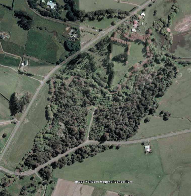
89
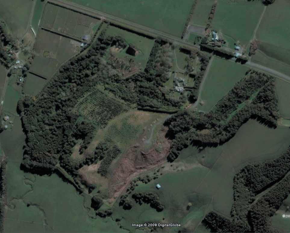
90
Manawatu District Council. Kowhai Park Management Plan. Foreword
 Foreword The was approved by the Council on 31 July 2003. The management plan was prepared under the Reserves Act 1977, which requires local authorities to develop management plans for their reserves.
PART 5 - NATURAL AND PHYSICAL ENVIRONMENT
 CONTENTS...PAGE 5.1 INTRODUCTION...3 5.2 NATURAL RESOURCES...4 5.3 PHYSICAL RESOURCES...4 5.4 COASTAL ENVIRONMENT...4 5.5 HERITAGE FEATURES...4 5.6 HAZARDS...4 5.7 SUMMARY...4 ISTHMUS SECTION - OPERATIVE
B4. Te tiaki taonga tuku iho - Natural heritage
 B4. Te tiaki taonga tuku iho - Natural heritage Tuia I runga, tuia i raro, tuia ki te waonui a Tiriwa Bind the life forces of heaven and earth to the great realm of Tiriwa B4.1. Issues Auckland s distinctive
H7 Open Space zones. (a) provide for the needs of the wider community as well as the needs of the community in which they are located;
 provide for the needs of the wider community as well as the needs of the community in which they are located;") H7. Open Space zones H7.1. Background The majority of land zoned as open space is vested in the Council or is owned by the Crown. However some areas zoned open space are privately owned. While the open
H7. Open Space zones H7.1. Background The majority of land zoned as open space is vested in the Council or is owned by the Crown. However some areas zoned open space are privately owned. While the open
3.0 PART THREE: STRATEGIES FOR RESERVES
 3.0 PART THREE: STRATEGIES FOR RESERVES 3.1 RESERVE ACT OBJECTIVES The purposes of the Reserves Act 1977 are: providing for the preservation and management of areas for the benefit and enjoyment of the
Chapter 3: Natural Environment. Proposed Waikato District Plan Stage 1. (Notified version)
") Chapter 3: Natural Environment Proposed Waikato District Plan Stage 1 Page 2 of 7 Contents Chapter 3: Natural Environment... 3 3.1 Indigenous Vegetation and Habitats... 3 3.1.1 Objective Biodiversity and
Chapter 3: Natural Environment Proposed Waikato District Plan Stage 1 Page 2 of 7 Contents Chapter 3: Natural Environment... 3 3.1 Indigenous Vegetation and Habitats... 3 3.1.1 Objective Biodiversity and
Appendix 1 Structure plan guidelines
 Appendix 1 Structure plan guidelines This appendix forms part of the regional policy statement [rps]. 1.1. Introduction Structure plans are an important method for establishing the pattern of land use
Tāhuhu whakaruruhau ā-taone The sheltering ridge pole
 B2. Tāhuhu whakaruruhau ā-taone - Urban growth and form B2.1. Issues Tāhuhu whakaruruhau ā-taone The sheltering ridge pole Auckland s growing population increases demand for housing, employment, business,
Appendix A. Planning Processes. Introduction
 1 Planning Processes Introduction This appendix outlines a number of planning processes which are used in the Auckland Region to support the effective management of development in the region s rural and
NEW ZEALAND COASTAL POLICY STATEMENT
 NEW ZEALAND COASTAL POLICY STATEMENT 1994 This New Zealand Coastal Policy Statement 1994 was issued by notice in the Gazette on 5 May 1994. PREFACE The Resource Management Act 1991 established a new coastal
Proposed Southland District Plan 2012 Appeal Version October 2016
 S e c t i o n 3. 5 - F i o r d l a n d / R a k i u r a Z o n e The Fiordland/Rakiura Zone encompasses the Fiordland and Rakiura National Parks and part of Mt Aspiring National Park. It also includes areas
I541. Te Arai North Precinct
 I541. Te Arai North Precinct I541.1. Precinct Description The Te Arai North Precinct contains approximately 616ha of coastal land north of Te Arai Point, generally known as Mangawhai North Forest. The
Section 3b: Objectives and Policies Rural Environment Updated 19 November 2010
 Page 1 of Section 3b 3b RURAL ENVIRONMENT 3b.1 Introduction The Rural Environment comprises all the land outside of the Residential, Town Centre and Industrial Environments. Most land within the District
General management framework, outcomes and policies
 General management framework, outcomes and policies Management framework, & 3 General management framework 3.1 Management framework summary The management framework sets out how the parks will be managed
CA.1 Coastal Area. Index. CA.1.1 Description and Expectations
 Index.1.2.3.4 CA.2 CA.2.1 CA.2.2 CA.2.3 CA.3 CA.3.1 CA.3.2 CA.3.1 CA.4 CA.4.1 CA.4.2 CA.4.3 CA.4.4 CA.5 CA.5.1 CA.5.2 Description and Expectations Objectives Policies Guidance Note Landuse Eligibility
Plan Modification to Chapter B2 of the Auckland Unitary Plan(AUP) Operative in part (15 November 2016)
 Operative in part (15 November 2016)") UNITARY PLAN UPDATE REQUEST MEMORANDUM TO FROM Phill Reid Linley Wilkinson DATE 25 September 2018 SUBJECT Plan Modification to Chapter B2 of the Auckland Unitary Plan(AUP) Operative in part (15 November
UNITARY PLAN UPDATE REQUEST MEMORANDUM TO FROM Phill Reid Linley Wilkinson DATE 25 September 2018 SUBJECT Plan Modification to Chapter B2 of the Auckland Unitary Plan(AUP) Operative in part (15 November
Historic Heritage Historic Heritage Explanatory Statement Significant Issues Objectives and Policies...
 Section Contents Historic Heritage... 2 7. Historic Heritage... 2 Explanatory Statement... 2 7.1 Significant Issues... 3 7.2 Objectives and Policies... 3 7.3 Activity Lists... 4 7.4 Matters of Control
RURAL ZONE - POLICY. Rural Zone Policy. Issue: Rural Environment. Ruapehu District Plan Page 1 of 8
 Rural Zone Policy RU2 RURAL ZONE - POLICY RU2.1 Introduction The natural resources of the rural environment in the Ruapehu District provide the basis for the existing and potential character, intensity
STRATEGIC DIRECTION. QLDC PROPOSED DISTRICT PLAN [PART TWO] DECISIONS VERSION 3 strategic direction
![STRATEGIC DIRECTION. QLDC PROPOSED DISTRICT PLAN [PART TWO] DECISIONS VERSION 3 strategic direction](/thumbs/79/79711764.jpg "STRATEGIC DIRECTION. QLDC PROPOSED DISTRICT PLAN [PART TWO] DECISIONS VERSION 3 strategic direction") 3 STRATEGIC DIRECTION QLDC PROPOSED DISTRICT PLAN [PART TWO] DECISIONS VERSION 3 strategic direction QLDC DISTRICT PLAN [PART TWO] AUGUST 2015 3 strategic direction 3.1 Purpose This chapter sets out the
3 STRATEGIC DIRECTION QLDC PROPOSED DISTRICT PLAN [PART TWO] DECISIONS VERSION 3 strategic direction QLDC DISTRICT PLAN [PART TWO] AUGUST 2015 3 strategic direction 3.1 Purpose This chapter sets out the
Section 6A 6A Purpose of the Natural Features and Landscapes Provisions
 Section 6A 6A Purpose of the Natural Features and Landscapes Provisions This Chapter addresses the protection and management of natural features and landscapes within the City. The City has a number of
P art B 10 HERITAGE VALUES. Community Enablement and Physical Resources ISSUE
 10 HERITAGE VALUES ISSUE There is growing public concern within the District at the loss of heritage sites and places, and of the need for the recognition and protection of heritage and cultural values
SECTION 2.4 URBAN DEVELOPMENT AND STRATEGIC URBAN DIRECTIONS
 SECTION 2.4 URBAN DEVELOPMENT AND STRATEGIC URBAN DIRECTIONS 2.4.1 INTRODUCTION In 1993/94 the Hastings District Council completed the Hastings Urban Development Strategy. The purpose of this study was:
APPENDIX 9: Archaeological Assessment by Ken Phillips
 APPENDIX 9: Archaeological Assessment by Ken Phillips ARCHAEOLOGICAL ASSESSMENT PROPOSED SERVICE STATION DEVELOPMENT BRUCE ROAD, PAPAMOA TAURANGA Prepared by KEN PHILLIPS (MA HONS) MARCH 2016 ARCHAEOLOGY
PART 3 - RESOURCE MANAGEMENT
 CONTENTS... PAGE 3.1 INTRODUCTION... 3 3.2 NATURAL AND PHYSICAL ENVIRONMENT... 3 3.3 URBAN SUSTAINABLE MANAGEMENT... 5 3.4 RESOURCE MANAGEMENT ISSUES... 5 3.5 RESOURCE MANAGEMENT OBJECTIVES AND POLICIES...
E15. Vegetation management and biodiversity
 E15. management and biodiversity E15.1. Background contributes to a range of ecosystem services such as erosion and sediment control, reducing stormwater flows, protecting or enhancing water quality, amenity
8.2 Sector 2 Kelburn Park
 8.2 Sector 2 Kelburn Park Kelburn Park, near Victoria University 8.2.1 Character and use Kelburn Park is a sector of the Town Belt, of a scale and character more like a suburban park. However, the woodland
CITY VIEW OBJECTIVES
 SECTION 2: CITY VIEW OBJECTIVES CONTENTS 2.1 Introduction 1 2.2 Strategic Direction 1 2.3 The City View Resource Management Issues for the City 1 2.4 The Goal 3 2.5 The City View Objectives 3 Palmerston
I542. Te Arai South Precinct
 I542. Te Arai South Precinct I542.1. Precinct Description The Te Arai South Precinct contains approximately 750ha of coastal land south of Te Arai Point, known as Mangawhai South Forest. The land within
AUCKLAND COUNCIL DISTRICT PLAN PAPAKURA SECTION
 AUCKLAND COUNCIL DISTRICT PLAN PAPAKURA SECTION OPERATIVE 16 JUNE 1999 D P Hawkins, Mayor T McLean, Chief Executive Officer Given under the Common Seal of the Papakura District Council this 16th day of
WELLINGTON CITY DISTRICT PLAN
 Section 32 Report WELLINGTON CITY DISTRICT PLAN PROPOSED DISTRICT PLAN CHANGE 54 REZONING 178 AND 180 OWHIRO BAY PARADE 1 Introduction Before a Proposed District Plan change is publicly notified the Council
UNIVERSITY TOWN NEIGHBOURHOODS 5.2 ECO-CORRIDOR MELBOURNE CAMPUS MASTER PLAN 2014
 5.2 ECO-CORRIDOR 37 ECO-CORRIDOR EXISTING CONDITIONS & VISION NEIGHBOURHOOD VISION Investment in the Eco-corridor Neighbourhood will signify the University s commitment to supporting local ecology and
PART 6 - HUMAN ENVIRONMENT
 CONTENTS...PAGE 6.1 INTRODUCTION...3 6.2 ISSUES AND STRATEGY...3 ISTHMUS SECTION - OPERATIVE 1999 Page 1 Page 2 ISTHMUS SECTION - OPERATIVE 1999 PART 6 - HUMAN ENVIRONMENT 6.1 INTRODUCTION The Plan seeks
LANDSCAPE GUIDELINES. Countryside & Coastal Countryside Environments. Landscape, Natural Character & Amenity Values Guide
 Landscape, Natural Character & Amenity Values Guide Copyright WDC 2009 Version A2 18May09 Environmental Services Group Publication Countryside & Coastal Countryside Environments START HERE Quality Land
Appendices. Contents. Appendices - Sep 1997 CP-1 AP-1
 Appendices Contents 1. Goals for Protected Areas in British Columbia... AP-3 2. Guiding Principles for Protected Areas... AP-4 3. Resource and Recreation Use Guidelines for Protected Areas... AP-5 4. Aboriginal
2A District-wide Policies
 2A Introduction This Chapter contains policies which are relevant to subdivision, use and development activities occurring across all zones and areas of the District. The policies in this Chapter implement
GIBBSTON CHARACTER ZONE. QLDC PROPOSED DISTRICT PLAN [PART FOUR] AUGUST gibbston character zone
![GIBBSTON CHARACTER ZONE. QLDC PROPOSED DISTRICT PLAN [PART FOUR] AUGUST gibbston character zone](/thumbs/75/72573993.jpg "GIBBSTON CHARACTER ZONE. QLDC PROPOSED DISTRICT PLAN [PART FOUR] AUGUST gibbston character zone") 23 GIBBSTON CHARACTER ZONE QLDC PROPOSED DISTRICT PLAN [PART FOUR] AUGUST 2015 23 gibbston character zone QLDC PROPOSED DISTRICT PLAN [PART FOUR] AUGUST 2015 23 gibbston character zone 23.1 Zone Purpose
23 GIBBSTON CHARACTER ZONE QLDC PROPOSED DISTRICT PLAN [PART FOUR] AUGUST 2015 23 gibbston character zone QLDC PROPOSED DISTRICT PLAN [PART FOUR] AUGUST 2015 23 gibbston character zone 23.1 Zone Purpose
9.1 ISSUES OBJECTIVES RULES - Class B - Heritage Items RULES - Class C - Heritage Items RULES - Old Town Overlay Area 18
 9 HISTORIC HERITAGE 9.1 ISSUES 7 9.2 OBJECTIVES 7 9.3 POLICIES 8 9.4 RULES - Class A - Heritage Items 13 9.5 RULES - Class B - Heritage Items 15 9.6 RULES - Class C - Heritage Items 17 9.7 RULES - Old
1 INTRODUCTION TO NATURAL ENVIRONMENT
 Kāpiti Coast District Plan Review Section 32 Analysis Summary Report 1 INTRODUCTION TO NATURAL ENVIRONMENT Diverse landscapes, plants and animals make up the natural environment of the District. Much has
Cotswolds AONB Landscape Strategy and Guidelines. June 2016
 Cotswolds AONB Landscape Strategy and Guidelines June 2016 Cotswolds AONB Landscape Strategy and Guidelines Introduction The evolution of the landscape of the Cotswolds AONB is a result of the interaction
Parks. Network Plan. For more information, contact Greater Wellington. 142 Wakefield Street PO Box Manners Street Wellington 6142
 Parks Network Plan For more information, contact Greater Wellington 142 Wakefield Street PO Box 11646 Manners Street Wellington 6142 T 04 384 5708 F 04 385 6960 www.gw.govt.nz July 2011 GW/CP-G-11/101
CITY OF NAPIER DISTRICT PLAN. The following resource management issues have been identified as significant:
 Chapter 56 HERITAGE 56.1 RESOURCE MANAGEMENT ISSUES The following resource management issues have been identified as significant: 56.1.1 The possibility of the loss of identified heritage features through
Published in March 2005 by the. Ministry for the Environment. PO Box , Wellington, New Zealand ISBN: X.
 Action Pack Published in March 2005 by the Ministry for the Environment Manatū Mō Te Taiao PO Box 10-362, Wellington, New Zealand ISBN: 0-478-18994-X ME number: 580 This document is available on the Ministry
Rural (Urban Expansion) Environment
 Environment") RUEE.1 Rural (Urban Expansion) Environment Subsequent to the receipt of appeals, a 'marked up' version of the Proposed District Plan was prepared. The provisions of the Proposed Version of the Plan subject
RUEE.1 Rural (Urban Expansion) Environment Subsequent to the receipt of appeals, a 'marked up' version of the Proposed District Plan was prepared. The provisions of the Proposed Version of the Plan subject
CONTENTS. Reserve Management Plan Playford Park
 PREFACE Located in the heart of Levin s urban area, Playford Park is an important and valuable open space and recreation area for both the town of Levin and the Horowhenua District. As such the review
Part 7 Heritage. Diagrams and tables
 Part 7 Heritage Contents Page 7.1 Introduction... 3 7.2 Resource management issues... 3 7.3 Objective... 5 7.4 Resource management strategy... 5 7.5 Roles and responsibilities... 6 7.6 Notification requirements
Section 32 report: Natural heritage for the Proposed Natural Resources Plan for the Wellington Region
 Section 32 report: Natural heritage for the Proposed Natural Resources Plan for the Wellington Region Issues and Evaluation Report Section 32 report: Natural heritage for the Proposed Natural Resources
Call for Artists for: Design and Construction of Environmental Art Activation Story Mill Community Park, Bozeman, MT
 Call for Artists for: Design and Construction of Environmental Art Activation Story Mill Community Park, Bozeman, MT Seeking artists to design, fabricate and install art elements in the nature sanctuary
10.0 Open Space and Public Realm
 10.0 Open Space and Public Realm 10.0 Open Space and Public Realm The Public Open Space System is comprised of: outdoor spaces available for public use that are either publicly owned (e.g., parks and
D10. Outstanding Natural Features Overlay and Outstanding Natural Landscapes Overlay
 D10. Outstanding Natural Features Overlay and Outstanding Natural Landscapes Overlay D10.1. Background These provisions give effect to Policy 15(a) of the New Zealand Coastal Policy Statement 2010, and
Ōtaki to north of Levin expressway
 Constraint maps Introduction Roads of national significance Wellington Northern Corridor Ōtaki to north of expressway Seven maps showing areas of constraint have been prepared as background information
TAKANINI STRUCTURE PLAN AREAS 6A & 6B: ARCHAEOLOGICAL ASSESSMENT
 TAKANINI STRUCTURE PLAN AREAS 6A & 6B: ARCHAEOLOGICAL ASSESSMENT Report prepared for Hosken & Associates Ltd By Barry Baquie (MA) Rod Clough (PhD) April 2006 Clough & Associates Ltd heritage@clough.co.nz
SECTION FOUR: MISSION STATEMENT, GOALS & OBJECTIVES
 SECTION FOUR: MISSION STATEMENT, GOALS & OBJECTIVES Chapter Summary Chapter Ten: Mission Statement, Goals & Objectives To fulfill its mission, the Parks and Recreation Commission has identified four basic
SECTION ONE North East Industrial Zone Design Guide Palmerston North City Council June 2004
 SECTION ONE North East Industrial Zone Design Guide Palmerston North City Council June 2004 young heart easy living 1 Preface Industrial areas are a very important component of the economic well-being
I326. Ōrākei 1 Precinct
 I326. Ōrākei 1 recinct I326.1. recinct Description The Ōrākei 1 recinct includes the land identified as hapu reservation (land held for the purposes of a marae, church, urupa and related hapu amenities)
D10. Outstanding Natural Features Overlay and Outstanding Natural Landscapes Overlay
 D10. Outstanding Natural Features Overlay and Outstanding Natural Landscapes Overlay D10.1. Background These provisions give effect to Policy 15(a) of the New Zealand Coastal Policy Statement 2010, and
Managing our Landscapes Conversations for Change
 Managing our Landscapes Conversations for Change Frequently Asked Questions The new State Government is committed to a significant reform program that will change the way natural resources are managed.
12 Subdivision, Services and Infrastructure
 12 Subdivision, Services and Infrastructure Section 12A 12A Purpose of Subdivision Provisions... 1 12A.1 General Subdivision Objectives and Policies... 2 12A.2 Activity Status Rules... 4 12A.3 General
8.3 Sector 4 Brooklyn Hills
 8.3 Sector 4 Brooklyn Hills Wellington Town Belt on the Brooklyn Hills between Mt Cook and Brooklyn 8.4.1 Character and use This sector extends around the city-facing slopes below Brooklyn, from Mortimer
POLICY SRT/D4 STORMWATER MANAGEMENT
 POLICY SRT/D4 STORMWATER MANAGEMENT BACKGROUND Increasing population, decreasing rainfall and increasing community expectations regarding environmental issues have led to increasing recognition of the
Rural (Urban Expansion) Environment
 Environment") RUEE.1 Rural (Urban Expansion) Environment Index RUEE.1 RUEE.1.1 RUEE.1.2 RUEE.1.3 RUEE.1.4 RUEE.2 RUEE.2.1 RUEE.2.2 RUEE.2.3 RUEE.2.4 RUEE.3 Rural (Urban Expansion) Environment Description and Expectations
RUEE.1 Rural (Urban Expansion) Environment Index RUEE.1 RUEE.1.1 RUEE.1.2 RUEE.1.3 RUEE.1.4 RUEE.2 RUEE.2.1 RUEE.2.2 RUEE.2.3 RUEE.2.4 RUEE.3 Rural (Urban Expansion) Environment Description and Expectations
I611. Swanson North Precinct
 I611. Swanson North Precinct I611.1. Precinct Description Swanson North is located in the north eastern foothills of the Waitakere Ranges. It is outside the Waitakere Ranges Heritage Area Act and the Waitakere
SUSTAINABLE MANAGEMENT
 . Sustainable Management.1 The Concept of Sustainable Management The concept of sustainable management recognises there are limits to the use of natural and physical resources and there is a need to balance
Site Assessment Technical Document Appendix A: Glossary
 Central Bedfordshire Council www.centralbedfordshire.gov.uk Site Assessment Technical Document Appendix A: Glossary July 2017 1.1.11-1 - ii Appendix A: Glossary Term Agricultural Land Classification AONB
PREFACE. Reserve Management Plan Levin Railway Reserves & Kawiu Corner Reserve
 PREFACE Stretching from Kimberley Road to Roslyn Road the Levin Railway Reserves provide a valuable green corridor adjacent to the main railway trunk line running through the middle of Levin, while the
3-2 Environmental Systems
 3-2 Environmental Systems 3.0 ENVIRONMENTAL SYSTEMS CONTENTS 3.1 GREENWAY SYSTEM 3.1.1 General Policies 3.1.2 Natural Heritage Network 3.1.3 Natural Heritage Network Enhancement Lands 3.1.4 Rouge Watershed
SECTION 32 SUBDIVISION, DEVELOPMENT AND EARTHWORKS
 SECTION 32 SUBDIVISION, DEVELOPMENT AND EARTHWORKS 1 Section 32 Report Publicly Notified on 27 August 2014 CONTENTS 1. STRATEGIC CONTEXT... 3 2. RESOURCE MANAGEMENT ISSUES... 6 3. SCALE AND SIGNIFICANCE
ROCHFORD LOCAL DEVELOPMENT FRAMEWORK: Sustainability Appraisal/ Strategic Environmental Assessment. Rochford Core Strategy Preferred Options Document
 ROCHFORD LOCAL DEVELOPMENT FRAMEWORK: Sustainability Appraisal/ Strategic Environmental Assessment Non Technical Summary Rochford Core Strategy Preferred Options Document October 2008 SUSTAINABILITY APPRAISAL
Master Plan Objectives and Policies
 Master Plan Objectives and Policies Introduction This chapter identifies the Park issues and recommended policies established by this Master Plan. The issues were identified through meetings with staff,
The management plan meets the requirements of the Reserves Act 1977.
 SUBURBAN RESERVES MANAGEMENT PLAN 2015 I 4 INTRODUCTION 1.1 PURPOSE OF THE PLAN Within any community, open space holds important landscape, recreational, social, ecological, amenity, and cultural or heritage
open space environment
 This section updated August 09 GUIDELINE TO THE RULES The Open Space Environment Rules apply to activities on sites within the Open Space Environment as shown on the Human Environments Maps. Most of the
Khandallah, Broadmeadows, Ngaio, Crofton Downs and Kaiwharawhara
 3 Management sector plans 3.1 Sector 1 Khandallah, Broadmeadows, Ngaio, Crofton Downs and Kaiwharawhara A unique feature of this sector is the harbour escarpment and the steep gullies off Onslow Road and
PART FOUR: IMPLEMENTATION NEW INITIATIVES
 PART FOUR: IMPLEMENTATION NEW INITIATIVES The new initiatives are specific projects or actions identified in Part Three, Policies. This section sets out the priorities for their implementation to assist
Site Option 3: Te Matai
 Site Option 3: Te Matai Location Napier Drain looking south east Description The Te Matai growth option is located between the existing residential boundary (Ruamahanga Crescent) Napier Road (State Highway
Group Executive Liveability and Natural Assets
 Strategic policy Community Gardens Policy Corporate Plan reference: Endorsed by Council on: Policy Owner: A healthy environment Maintaining and enhancing the region s natural assets, liveability and environmental
7. Landscape. Introduction
 Introduction Our landscapes provide us with a Marlborough identity and are an integral part of the Marlborough environment. Landscapes are distinct spatial areas influenced by location-specific processes
Planning Proposal Charlestown Swim and Leisure Centre LEP Amendment
 Planning Proposal Charlestown Swim and Leisure Centre LEP Amendment Amendment No. 4 to Lake Macquarie Local Environmental Plan 2014 (PP_2014_LAKEM_005_00) Local Government Area: Name of Draft LEP: Lake
HAWKE S BAY REGIONAL PARK NETWORK PLAN
 HAWKE S BAY REGIONAL PARK NETWORK PLAN Introduction s and Background to the Plan Key 1. Tutira Regional Park 2. Waihapua Forest - Future Regional Park 3. Tangoio Forest - Future Regional Park 4. Waitangi
Policy and Resources Committee 10 th October Green Infrastructure Supplementary Planning Document (SPD) Summary. Title
 Summary. Title") Policy and Resources Committee 10 th October 2017 Title Report of Wards Status Urgent Key Enclosures Officer Contact Details Green Infrastructure Supplementary Planning Document (SPD) Deputy Chief Executive
Policy and Resources Committee 10 th October 2017 Title Report of Wards Status Urgent Key Enclosures Officer Contact Details Green Infrastructure Supplementary Planning Document (SPD) Deputy Chief Executive
Local Development Scheme
 Local Development Scheme 2012 2016 The Local Development Scheme (LDS) is a project plan that outlines how and when the Authority will update its planning policies and other associated documents. It ensures
Rural Environment and Conservation
 Rural Environment and Conservation 117 Rural Environment and Conservation Introduction and Resources 118 BSc (Hons) Conservation and Environment 119 BSc (Hons) Wildlife Management 120 BSc (Hons) Rural
Reserve Management Plan - Tairua/Pauanui
 Tairua/Pauanui Reserve Management Plans Volume 1 : Objectives and Policies Volume 1 : Objectives and Policies Process in preparing this Reserve Management Plan in accordance with the Reserves Act 1977
ISSUES AND OPTIONS Kapiti Coast District Reserves Acquisition Strategy
 SP-19-697 Chairperson and Committee Members STRATEGY AND POLICY COMMITTEE 31 JANUARY 2019 Meeting Status: Public Purpose of Report: For Decision REVOCATION CONSIDERATIONS FOR STRATEGIES AND POLICIES PURPOSE
Road transport activities and infrastructure can have adverse effects on the environment and community.
 22 Road Transport 22.1 Significant Issues Road transport activities and infrastructure can have adverse effects on the environment and community. Land use activities can have adverse effects on the safety
RULES FOR URBAN TREE GROUPS AND REMOVAL OF INDIGENOUS VEGETATION REMOVAL
 27A RULES FOR URBAN TREE GROUPS AND REMOVAL OF INDIGENOUS VEGETATION REMOVAL Activities Table Policies 4.4.10, 12.4.7, 12.4.10, 12.4.11, 12.4.12, 12.4.13, 12.4.14, 12.4.15, and 12.4.16 27A.1 Activities
Town of Cobourg Heritage Master Plan. Statutory Public Meeting
 Town of Cobourg Heritage Master Plan Statutory Public Meeting April 25 th 2016 Presentation Overview 1. Introduction 2. Project background and schedule overview 3. Review of strategic direction content
TAURANGA CITY COUNCIL CITY PLAN SECTION 32 REPORT. Chapter 16 Rural Zones
 125 TAURANGA CITY COUNCIL CITY PLAN SECTION 32 REPORT Chapter 16 Rural Zones Table of Contents 1. INTRODUCTION... 3 2. PURPOSE OF THE CHAPTER... 3 3. RECORD OF DEVELOPMENT OF PROVISIONS... 4 3.1 Background
Overview Report. Proposed Development
 Overview Report Proposed Development the construction of a 1km cycle/pedestrian trail including a new footbridge, new car park and entrance road at Drumshanbo Lock and a new pedestrian/cycle road crossing,
3. STATEMENTS OF DESIRED CHARACTER FOR PLANNING AREAS AND PRECINCTS
 3.30 Planning Area No. 30 Mary River Valley 3.30.1 Location and Role This Planning Area encompasses rural lands in the western part of the Shire. These lands are located within the catchment area of the
Wetland Design Manual. A1: Vision, core outcomes and aspirational outcomes
 Wetland Design Manual A1: Vision, core outcomes and aspirational outcomes Table of contents Introduction 5 Vision 6 Core outcomes 7 Effective pollutant removal and flow management... 7 Community safety...
Better Urban Planning Wananga for Maori Practitioners working in the Built Environment: Te Noho Kotahitanga Marae Tamaki Makaurau, 17 June 2016
 Better Urban Planning Wananga for Maori Practitioners working in the Built Environment: Te Noho Kotahitanga Marae Tamaki Makaurau, 17 June 2016 Comments from Hirini Matunga via Papa Pounamu, NZPI 16 June
3. Neighbourhood Plans and Strategic Environmental Assessment
 1. Introduction This report sets out a draft Screening Determination for the Preston Parish Council s Neighbourhood Plan and has been prepared by rth Hertfordshire District Council. The purpose of the
Public Consultation. Land at Monks Farm, North Grove. Welcome
 Welcome Welcome to our public exhibition for development on Land at Monks Farm, orth Grove. Gallagher Estates and Gleeson Strategic Land are preparing an outline planning application for new homes, open
Contents Kaitoke Regional Park Overiew
 Contents Kaitoke Regional Park Overiew Kaitoke Regional Park 3 Vision 4 Plan s purpose 5 Regional Parks Network Management Plan 5 Land status 6 Plan outline 6 Management plan and decision-making frameworks
Stock-Taking on Integrated Coastal Zone Management (ICZM) in the Black Sea IMPLEMENTATION AUDIT QUESTIONNAIRE 2010
 in the Black Sea IMPLEMENTATION AUDIT QUESTIONNAIRE 2010") Stock-Taking on Integrated Coastal Zone Management (ICZM) in the Black Sea IMPLEMENTATION AUDIT QUESTIONNAIRE 2010 PURPOSE The purposes of this questionnaire are: (a) to perform the policy, legal and institutional
Stock-Taking on Integrated Coastal Zone Management (ICZM) in the Black Sea IMPLEMENTATION AUDIT QUESTIONNAIRE 2010 PURPOSE The purposes of this questionnaire are: (a) to perform the policy, legal and institutional
Hobart A Strategic Framework
 Hobart 2025 A Strategic Framework Adopted by the Hobart City Council 15 October 2007 Table of Contents Introduction...2 Vision and Future Directions...3 FD1 Offers opportunities for all ages and a city
WELCOME GYPSY LANE. Wider Site Location plan. Proposals for the development of LAND OFF FOXLYDIATE LANE WEBHEATH. Proposals for the development of
 WELCOME The developers are preparing an outline planning application for a residential led development and need the community s views in order to develop the proposals further WHAT IS PROPOSED? A high
Understanding Wellington City s DISTRICT PLAN
 Understanding Wellington City s DISTRICT PLAN Wellington City Council 1 UNDERTANDING WELLINGTON CITY S DISTRICT PLAN CONTENTS 1. Introduction...3 1.1. Overview of this Guide...3 1.2. What is the District
Slope Stability Management Framework
 Slope Stability Management Framework For the assessment, evaluation, prioritization and mitigation of slope stability concerns. 2013/06/19 The Slope Stability Management Framework provides guidance to
If I can be of further assistance, please done hesitate to contact me.
 A Chara, We have read with interest your Review of Section 40 of the Wildlife Act - Burning/Cutting Controls. From a road safety perspective, we would support the introduction of any measures that would
GREENBANK DEVELOPMENT MASTERPLAN
 DEVELOPMENT MASTERPLAN POTENTIAL TRAIN STATION COMMUNITY CENTRE Greenbank will be a connected masterplanned community providing easy access to local and surrounding amenity. Affordable quality homes, green