6. DOWNTOWN. The Downtown Element focuses on supporting and expanding the vitality and enhancement of Downtown Chico as the City s central core.
|
|
|
- Theodora Potter
- 5 years ago
- Views:
Transcription


1 VISION In 2030, Downtown Chico is the heart of the community and the center of cultural activity. Engaging and active at the street level, it is a multi-story, mixed-use hub, with specialty retail, restaurants, residences, services, entertainment, and civic and cultural uses. Downtown Chico serves as both a visitor destination and a community center with activities that attract heavy pedestrian traffic. Downtown is walkable with supportive parking facilities, and new development is designed with the pedestrian and bicyclist in mind. North and South Downtown each has its own distinct but complementary character. INTRODUCTION The Downtown Element focuses on supporting and expanding the vitality and enhancement of Downtown Chico as the City s central core. Established in 1860, Downtown Chico represents the historic foundation of the community. Located on the original town grid, Downtown is a vibrant, compact, urban district with a diverse mixture of historic and modern structures. The area is approximately ten blocks long and five blocks wide, bordered on the east and west by residential neighborhoods, to the south by Little Chico Creek, and to the north by Big Chico Creek and the CSU Chico campus. The character of North Downtown is distinct from that in South Downtown, and they are each considered sub-districts of Downtown. Figure DT-1 delineates the boundaries of Downtown Chico. Downtown is the social, cultural, and entertainment core of the City with a mix of retail, service, civic, office, and residential uses. Buildings include multi-story, mixed-use structures that contribute to a lively pedestrian environment. Downtown is cherished by local residents and visitors for its public art, unique shops, public open spaces, local farmers markets, and events such as parades and festivals. Historically, policies associated with Downtown Chico have been integrated into several different elements of the General Plan. Because of Downtown s important role in making Chico a successful and sustainable community, the City has created a separate element to address key issues associated with Downtown. Since this element is for a specific subarea of the City, it addresses many of the major issues of the General Plan such as land use, circulation, and open space, as found in other elements, but with a specific focus on Downtown. Where appropriate, cross-s are provided to alert the reader to the applicable policies or actions in other elements. Chico General Plan 6-1

2 6. DOWNTOWN 6-2 Chico General Plan
3 ISSUES AND CONSIDERATIONS This Element addresses key issues related to Downtown that were identified and evaluated by the Downtown Ad Hoc Committee and the larger community as part of the General Plan Update, including: mixed-use development, the character of South Downtown, circulation and traffic calming, placemaking, wayfinding, and Downtown s relationship with CSU Chico. Policy guidance is found in the goals, policies, and actions section of this element. An explanation of specialized terms can be found in the General Plan Glossary (Appendix A). DOWNTOWN VISION ILLUSTRATION AND CONCEPTS The Downtown Element addresses key issues through its goals, policies and actions. In addition, the key issues informed development of the Downtown Vision Illustration (Figure DT-2) and corresponding Vision Concepts that, when considered together, represent Chico s future vision for Downtown as an evolving, vibrant, mixed-use, urban neighborhood. DOWNTOWN VISION ILLUSTRATION The Downtown Vision Illustration (Figure DT-2) is meant to inspire development that advances the community s vision for Downtown through images and conceptual development patterns which are based on the Vision Concepts, Land Use Diagram, and General Plan policies. The Downtown Vision Illustration is not a master plan or a specific blueprint for future development, nor does the illustration mandate any parcel or site specific development solution. Rather, the Vision Illustration is intended to help the reader visualize the development types, patterns, and overall intensity anticipated for the future of Downtown. DOWNTOWN VISION CONCEPTS Concept #1: Downtown Intensification The City s plan to accommodate future jobs and housing growth in a compact and sustainable development pattern relies on infill and redevelopment. Downtown is a key opportunity for higher density and intensity of development given its central location, development patterns, and proximity to employment, services, transit, education, and other amenities. Concept #2: South Downtown District South Downtown (south of 6th Street) has significant redevelopment potential due to existing parcel and building sizes. The district could benefit from developing a stronger Chico General Plan 6-3


4 sense of place and from an extension of the pedestrian-oriented character of North Downtown. Future development in South Downtown will include higher density, multi-story, and mixed-use buildings with public open spaces and parking on the interior of lots to create a pedestrian-friendly environment. South Downtown will transition smoothly to North Downtown by way of architectural design, development standards, streetscape improvements, and permitted uses for a more unified and vibrant Downtown. Commercial service and auto-oriented uses in South Downtown will be managed to limit uses that could detract from the pedestrian-oriented character of Downtown. Concept #3: Mixed-Use Development Chico residents desire a more livable and mixed-use Downtown where residents can walk to shopping, commercial services, and recreational amenities. The addition of more residential and office uses in Downtown will provide a 24-hour market for commercial success. Methods, such as incentives for new mixed-use development and public/private partnerships, are intended to promote a greater mix of uses in Downtown. Concept #4: Pedestrian Activity Pedestrian activity and connectivity is essential to the success of Downtown Chico. The existing street grid pattern, colored crosswalks, bulbouts, and street furniture will be preserved, expanded and further enhanced with additional amenities such as sidewalk dining, art, shade, and seating. Additional open space areas that are clean and wellmaintained will provide small refuges and gathering places on corners and block interiors. Public parking in the Downtown will be easy to find and will facilitate pedestrian access to the central core. Concept #5: Development Transition at Neighborhood Edges While Downtown is envisioned to continue growing as an intensive mixed-use center, it is important to protect adjacent residential neighborhoods from potential negative influences caused by increased density and land use intensity. The Downtown Vision Illustration (Figure DT-2) and the Downtown Land Use Diagram (Figure DT-3) call for a transition in development intensity in areas adjacent to existing residential neighborhoods. Concept #6: Preservation of Historic Buildings Engaging the public in the identification, preservation, and celebration of cultural and historic resources in Downtown helps maintain the community s shared value for the unique character and historical integrity of the area. The City supports the preservation and adaptive reuse of historic buildings in order to develop these unique structural assets of Downtown to their highest and best use. 6-4 Chico General Plan


5 Concept #7: Integrated Parking Structures A stand-alone parking structure is not conducive to a quality pedestrian environment; therefore, new parking structures will be ringed primarily with ground-floor commercial suites or otherwise integrated into larger mixed-use development projects. Concept #8: Parking Access and Management Maintaining an adequate parking supply is integral to supporting a vibrant downtown. Future parking options will include modern, safe, convenient, and identifiable street, surface, underground, and structured parking throughout Downtown. Concept #9: Traffic Calming While Downtown relies on adequate traffic volume and flow to maintain its vitality, traffic should not disturb the pedestrian experience. Downtown streets will be designed and improved with consideration for slowing the speed of vehicles, supporting non-vehicular modes of travel, accommodating parking, and providing a safe pedestrian environment. Concept #10: Relationship with California State University, Chico CSU Chico blends into the commercial and residential fabric of Downtown due to its proximity. The vitality of Downtown is closely tied to the University s population of students, faculty, and staff. Collaboration between the University and the City on projects, such as improving pedestrian and bicycle connections to the University, is critical to achieving the Downtown Vision. Concept #11: Open Space Protection and Enhancement As Downtown matures and urbanizes, it is important to enhance and maintain public access to open spaces, creeks, parks, and plazas. Concept #12: Downtown as a Key Transportation Hub Chico s Downtown is served by public transit, with multiple routes converging on the Downtown Transit Center. Downtown is and will continue to be an important link in Citywide and regional circulation for all modes of transportation. Concept #13: Downtown as the Cultural and Civic Community Core As Chico has grown, the role of Downtown has diversified. In addition to its traditional role as a commercial center, Downtown is also the focal point for local governmental affairs and cultural events for the community. While striving to enhance the economic viability of Downtown, it is important to maintain its Chico General Plan 6-5


6 central role in cultural and civic activities such as music, art, public meetings, parades, outdoor markets, and festivals. Concept #14: Enhance Downtown Gateways, Landmarks, and Wayfinding The network of high-volume streets, some one-way, combined with aging and incomplete signage can make navigating and finding key destinations and parking in Downtown difficult. As a solution, a new wayfinding system with creative signage and landmarks unique to Downtown will be developed to help residents and visitors navigate the area, find destinations and convenient parking, accentuate Downtown gateways, and to strengthen the sense of place and identity of Downtown. 6-6 Chico General Plan
7
8

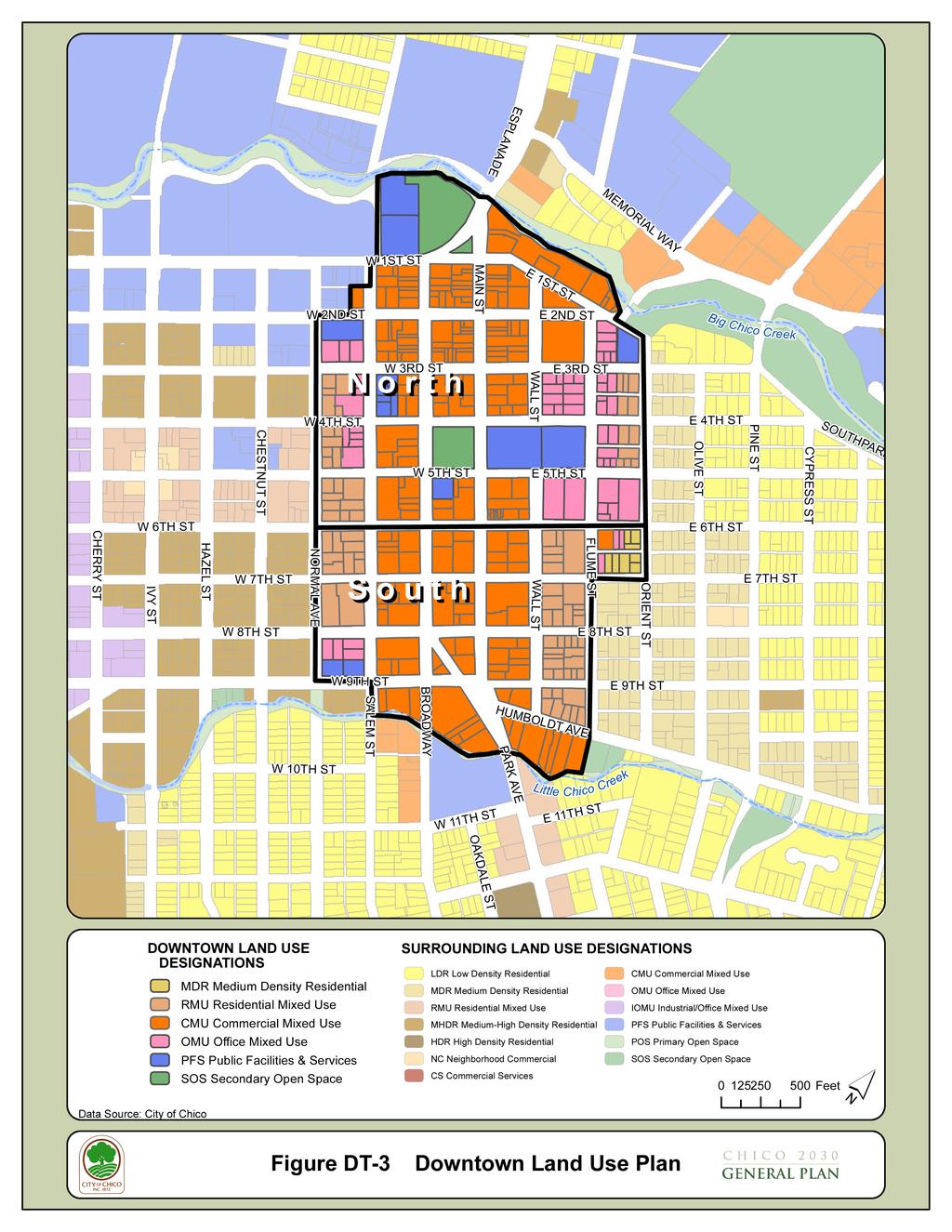
9 6. DOWNTOWN DOWNTOWN LAND USE DIAGRAM As identified in the Land Use Element, Downtown Chico is a designated Opportunity Site, which means that the area is optimal for infill, redevelopment, and revitalization in keeping with the City s desire for a compact growth footprint and sustainable development pattern. The Land Use Diagram for Downtown shown in Figure DT-3 (and in Land Use Element Figure LU-1) establishes land use designations that will guide future development and redevelopment. Downtown includes several mixed-use land use designations to encourage more vertical and horizontal integration of uses and higher density and intensity of development. A transition in land use designations is identified for the areas flanking the Downtown core to provide a thoughtful interface with surrounding residential neighborhoods. Vertical Integration of Uses Chico General Plan 6-9
10
11 GOALS, POLICIES, AND ACTIONS Goal DT-1: Emphasize the role of Downtown as the civic, commercial, and cultural core of the community. Goal DT-2: Strengthen Downtown with a variety of land uses, mixed-use developments, and redevelopment throughout Downtown. Goal DT-3: Enhance the pedestrian environment in Downtown. Goal DT-4: Achieve new development and redevelopment in Downtown that promotes the Downtown Vision Illustration and Concepts. Goal DT-5: Support all modes of transportation in and around Downtown. Goal DT-6: Reinforce the identity of Downtown, and distinguish it from adjacent neighborhoods. Goal DT-7: Establish a Park Once and Walk environment by improving Downtown parking. Goal DT-8: Preserve and enhance landmarks or buildings of special historic or architectural interest. Goal DT-1: Emphasize the role of Downtown as the civic, commercial, and cultural core of the community. Policy DT-1.1 (Support Vitality of Downtown) Maintain and enhance the vitality and economic well-being of Downtown to support its status as the City s center. Action DT (Support Downtown Business) Support Downtown business and property owners by helping to develop and fund public/private partnerships, such as business improvement districts, to provide for increased maintenance, cleanliness, security, marketing, business retention and recruitment. Policy DT-1.2 (Businesses Variety) Encourage a variety of Downtown business types to provide a unique shopping experience. ED ED Policy DT-1.3 (City as Liaison for Downtown Issues) Enhance the City s role as a Downtown liaison with merchants, property owners, CSU Chico, and the community at large. Action DT (City Attention to Downtown Issues) Continue to allocate staff resources to address current and future Downtown issues. Chico General Plan 6-11
12 Action DT (Downtown Working Group) - Meet with Downtown property owners, businesses, residents, CSU Chico, and others interested in Downtown to discuss solutions to key Downtown policy issues and support implementation of the Downtown Element. Action DT (CSU Chico and CUSD) Consult with CSU Chico and Chico Unified School District to address mutual interests in Downtown. Policy DT-1.4 (Civic Center) Preserve and enhance the civic focus of Downtown by maintaining existing civic structures and uses, such as City Hall, the Plaza, and the Post Office, and by encouraging other civic uses to locate Downtown. CRHP and PPFS-7.1 ED-2.2 SUS PPFS-7.1.2, CD Policy DT-1.5 (Culture and Arts) Encourage the development of cultural and arts facilities and activities in public spaces throughout Downtown to reinforce its role as the cultural core of the City and region. Action DT (Plaza Park) Reinforce the role of the Plaza as the cultural heart of Downtown by continuing to sponsor and allow cultural activities, and events that bring residents and visitors to Downtown such as concerts, and cycling, art and seasonal events. Action DT (Farmers Markets) Support the operation and enhancement of farmers markets within Downtown. Action DT (Art in Downtown) Continue to provide locations and funding to support the installation of art in public places Downtown. Policy DT-1.6 (Downtown Theaters) Support the continued use, rehabilitation, and preservation of Downtown theaters. Goal DT-2: Strengthen Downtown with a variety of land uses, mixed-use developments, and redevelopment throughout Downtown. Policy DT-2.1 (Mixed Land Uses) Promote development of Downtown as a mixed-use activity center with particular priority to projects including residential uses to help create an economically healthy and vibrant Downtown throughout the day and night. Action DT (Incentives for Vertical Mixed Use) Utilize City incentives identified in Action LU to support developers who construct vertical mixeduse projects within Downtown Chico General Plan
13 Action DT (Incentives for Housing above Non-Residential Uses) Utilize City incentives identified in Action LU to support developers who build housing above non-residential ground-floor uses in Downtown. CIRC-8.3 Policy DT-2.3 (Resident Serving Uses) Encourage resident-serving land uses, such as pharmacies and small grocery stores, in Downtown. Action DT (Allowed Uses) Maintain the Municipal Code to allow frequently visited, resident-serving uses by right in Downtown. Action DT (Residential Parking) Consider the inclusion of dedicated residential parking spaces in new parking facilities. Policy DT-2.4 (Existing Building Code) Encourage the reuse of existing buildings in Downtown by utilizing the International Existing Building Code which provides flexibility in the retrofitting of buildings. Action DT (Reuse Upstairs) Promote intensified use and reuse of existing suites above ground floors. Policy DT-2.5 (Revitalization and Redevelopment) Promote revitalization of underutilized, deteriorated areas and buildings through development incentives, public/private partnerships, and public investment. ED-1.3 and ED-3.1 Action DT (Downtown Utilities) Work with local utility providers to assess and improve infrastructure to meet the needs of the development projected for Downtown. Action DT (Public/Private Development Partnerships) Investigate the use of City-owned properties and underutilized private parking lots in public/private partnerships as an incentive for new development Downtown. Action DT (Incentive for Land Assembly) Utilize City incentives identified in Action LU to support assemblage of multiple properties Downtown for larger integrated development projects. ED ED Goal DT-3: Enhance the pedestrian environment in Downtown. Policy DT-3.1 (Design for the Pedestrian Environment) Enhance the highquality pedestrian environment within Downtown through the design and maintenance of buildings, sidewalks, open spaces, and other pedestrian amenities. CIRC 4.3 and CD 3.2 Chico General Plan 6-13
14 CD CD Action DT (Downtown Design Guidelines) Maintain and apply the Design Guidelines Manual for Downtown building rehabilitation, new construction, parking, signs, streetscape, pedestrian pathways, and sidewalks. Action DT (Common Spaces) Modify standards and building fees to allow and encourage the incorporation of architectural features that create welcoming outdoor places for residents, employees and visitors. Policy DT-3.2 (Streetscape Environment) Ensure a lively streetscape environment. Action DT (Ground-floor Uses) Maintain the Municipal Code to ensure the North Downtown zoning district requires development to incorporate retail or other uses that contribute to increased pedestrian activity on the ground-floor and requires use permit approval for other ground-floor uses. CIRC-8.2 Action DT (Mixed-use Parking Structures) Ensure that new parking structures in Downtown are ringed primarily with ground-floor retail suites, other pedestrian-oriented uses, or will be otherwise integrated into larger mixed-use development projects. Policy DT-3.3 (Public Realm) Develop public areas in Downtown that are comfortable, welcoming, and available for use by the whole community. Action DT (Sidewalk Uses) Encourage the active use of sidewalks by expanding their allowed uses to include outdoor seating and dining, streetscape and landscape furnishings, and other pedestrian features, while maintaining space for a path of travel. Action DT (Enhance Downtown Open Space) Increase the use of public open space by providing well-maintained and well-lit pedestrian pathways, landscaping, street furniture, courtyards, shade, and other amenities. CD-3.4 and S-5.5 Policy DT-3.4 (Public Safety Design) Design Downtown streets and public spaces that enhance public safety and discourage crime by providing streetfronting uses ( eyes on the street ), adequate lighting and sight lines, and features that cultivate a sense of community ownership. Policy DT-3.5 (Pedestrian Priorities) Prioritize facilities for pedestrian travel within Downtown. CIRC and LU Action DT (Enhance Sidewalks) Enhance pedestrian facilities with features such as wide sidewalks, bulb-out corners, and street furniture, placing an emphasis on extending sidewalk features to South Downtown Chico General Plan
15 Action DT (Bicycling and Skateboarding on Sidewalks) Enforce regulations prohibiting bicycling and skateboarding on sidewalks to maintain pedestrian safety, and promote alternate routes for bicyclists. Action DT (Highway 32) Consult with Caltrans to identify ways to improve pedestrian access and safety where Highway 32 crosses Downtown. Policy DT-3.6 (Location of Parking) Reduce the visual prominence of parking by locating off-street parking safely behind or within structures, or otherwise screening it from the public right-of-way. CIRC Policy DT-3.7 (Scale of Downtown Streets) Design Downtown streets to encourage more sidewalk pedestrian activity. Action DT (Number of Travel Lanes) Giving special consideration for north-south circulation patterns and the delivery needs of Downtown businesses, identify options to reduce the number of travel lanes on Downtown streets to accommodate additional diagonal parking or an enhanced pedestrian environment. Action DT (Truck Deliveries) Facilitate an effort among Downtown businesses and delivery companies to develop Downtown loading and unloading guidelines with the objective of reducing vehicle congestion that can discourage pedestrian and bicycling activity. CIRC-9.2 Goal DT-4: Achieve new development and redevelopment in Downtown that promotes the Downtown Vision Illustration and Concepts. Policy DT-4.1 (Urban Development) Ensure that new development in Downtown is urban in character. Action DT (Coordinate Development Design Features) Work with property owners who desire to coordinate development activities over multiple sites to create projects with complementary design features and shared facilities. Policy DT-4.2 (Building Context) Ensure that new construction in Downtown matches or increases the development intensity of its block. Action DT (New Construction) New construction in Downtown North will have a minimum building height of two-stories, or no less than the average height of the existing buildings on both sides of the block in which the building is located, whichever is greater. CD and CD-5.2 Chico General Plan 6-15
16 Action DT (Downtown Edges) Require new development at the edges of Downtown to be designed with transitions in building height and mass, where appropriate, to complement the physical character of the adjoining development. Policy DT-4.3 (South Downtown) Support redevelopment in South Downtown that contributes to a more unified and vibrant Downtown. Action DT (South Downtown Zoning) Maintain the Municipal Code to allow uses that attract pedestrian activity and limit uses that could detract from the pedestrian-oriented character of South Downtown. Goal DT-5: Support all modes of transportation in and around Downtown. CIRC CIRC Policy DT-5.1 (Multimodal Circulation) Promote a balanced multimodal circulation system to and throughout Downtown that includes pedestrians, bicycles, vehicles, and public transit. Action DT (Downtown as Transportation Hub) Promote Downtown as a key transportation hub, emphasizing the Downtown Transit Center. Action DT (Expand Bicycle Amenities) Create additional bicycle lanes and safe, convenient, and attractive bicycle parking, including covered spaces. Action DT (Bicycle and Pedestrian Safety) Identify and address hazards for pedestrians and bicyclists. Action DT (Transit Passes) Coordinate and distribute subsidized transit passes for Downtown residents and employees to encourage increased transit use. SUS 1.6, CD-2.1.1, and CIRC CD CD Goal DT-6: Reinforce the identity of Downtown, and distinguish it from adjacent neighborhoods. Policy DT-6.1 (Street Pattern) Maintain the historic street grid as a recognizable part of Downtown, avoiding the permanent removal of grid segments. Policy DT-6.2 (Creeks and Neighborhood Context) Enhance Downtown s integration with bordering creeks and adjacent residential neighborhoods. Action DT (Downtown Gateways) Establish gateway landmarks that create a sense of entry and a welcoming first impression for residents and visitors at major entry points to Downtown from the south, east and west Chico General Plan
17 Action DT (Creek Path) Create a pedestrian/bicycle path along Big Chico Creek to improve circulation through Downtown and provide public access to the creek. Action DT (Creek Access) Maintain public access to Big and Little Chico Creeks through adjacent development. Action DT (Creekside Development) Require development and redevelopment along Downtown creeks to incorporate design features fronting the creek such as outdoor seating or dining, public open spaces, and creekside façade improvements. Policy DT-6.3 (Directional Signage) Provide unique signage throughout Downtown to strengthen its identity. Action DT (Design of Signs) Install signs and landmarks throughout Downtown with graphics that reflect the character and history of Downtown to reinforce a uniform, recognizable Downtown brand and to help residents and visitors navigate and find key destinations and parking. PPFS and CD ED CD Goal DT-7: Establish a Park Once and Walk environment by improving Downtown parking. Policy DT-7.1 (Downtown Parking) Provide parking in convenient locations throughout Downtown. Action DT (Parking Strategy) Implement a comprehensive Downtown parking strategy that addresses the needs of customers, visitors, employees, and residents. CIRC CIRC-8.3 Action DT (Parking Facilities) Develop and charge for publicly-owned, well-lit, and safe parking facilities that allow 24-hour access to Downtown. Policy DT-7.2 (Parking Supply) Increase the use of the existing Downtown parking supply. Action DT (Downtown Parking Requirements) Maintain the Municipal Code to eliminate minimum parking requirements in North Downtown, and reduce or eliminate minimum parking requirements in South Downtown. LU Action DT (On-Street Parking) Preserve existing on-street parking along main traffic corridors to support street-level activities, and convert parallel parking to diagonal parking where possible to increase parking supply. Chico General Plan 6-17

18 Policy DT-7.3 (Parking Facilities) Design parking facilities with limited vehicle access points to minimize pedestrian/auto conflicts. Goal DT-8: Preserve and enhance landmarks and buildings of special historic or architectural interest. CRHP-1.1, CRHP-2.1.1, and CD Policy DT-8.1 (Building Preservation) Encourage the preservation, enhancement, and adaptive reuse of buildings of special historic or architectural interest. Action DT (Facade Improvements) Provide incentives for façade improvement projects in Downtown. CRHP Action DT (Historic Building Preservation) Apply the Landmark Overlay zoning district to preserve and protect buildings of special historic or architectural interest within Downtown. LU Policy DT-8.2 (Historic Building Code) Encourage the preservation of significant historic buildings in Downtown by utilizing the California State Historic Building Code, which makes provisions for the special treatment of qualified historic buildings Chico General Plan
Urban Design Manual PLANNING AROUND RAPID TRANSIT STATIONS (PARTS) Introduction. Station Study Areas
 Introduction. Station Study Areas") 111111 PLANNING AROUND RAPID TRANSIT STATIONS (PARTS) Introduction The ION rapid transit system will link Waterloo, Kitchener and Cambridge through a central transit corridor (CTC). There are a number
111111 PLANNING AROUND RAPID TRANSIT STATIONS (PARTS) Introduction The ION rapid transit system will link Waterloo, Kitchener and Cambridge through a central transit corridor (CTC). There are a number
Policies and Code Intent Sections Related to Town Center
 Policies and Code Intent Sections Related to Town Center The Town Center Vision is scattered throughout the Comprehensive Plan, development code and the 1994 Town Center Plan. What follows are sections
EXISTING COMPREHENSIVE PLAN
 EXISTING COMPREHENSIVE PLAN Town Center Land Use Element: V. LAND USE POLICIES Town Center Mercer Island's business district vision as described in "Your Mercer Island Citizen-Designed Downtown" was an
Town Center (part of the Comprehensive Plan)
") Town Center (part of the Comprehensive Plan) Mercer Island Town Center Looking North (2014) In 1994, a year-long process culminated in a set of design guidelines and code requirements for the Town Center
Town Center (part of the Comprehensive Plan) Mercer Island Town Center Looking North (2014) In 1994, a year-long process culminated in a set of design guidelines and code requirements for the Town Center
The Five Components of the McLoughlin Area Plan
 The Five Components of the McLoughlin Area Plan This documents contains the complete language of the five components of the McLoughlin Area Plan: The Vision Statement The Values The Guiding Principles
The University District envisions, in its neighborhood
 Envisioning the University District Link Light Rail in Seattle s neighborhoods CIY OF SEALE CONCEP-LEVEL SAION AREA PLANNING RECOMMENDAION RESOLUION # 30165 EXHIBI L Vision 08.2000 he University District
THEMES, VISION, + PRINCIPLES
 CHAPTER 2: THEMES, VISION, + PRINCIPLES This page intentionally left blank. 20 VISION DRAFT AUGUST 2018 2 2 THEMES, VISION, + GUIDING PRINCIPLES The Key Themes, Vision, and Guiding Principles presented
CHAPTER 3 VISION, GOALS, & PLANNING PRINCIPLES. City of Greensburg Comprehensive Plan. Introduction. Vision Statement. Growth Management Goals.
 CHAPTER 3 VISION, GOALS, & PLANNING PRINCIPLES Introduction The Greensburg Comprehensive Plan is intended as a working community document. A combination of long and short-term goals, this document is intended
4- PA - LD - LIVELY DOWNTOWN. LD - Background
 4- PA - LD - LIVELY DOWNTOWN LD - Background The downtown has been the service centre for the community since the city s inception and the area continues to supply people with their personal services,
4.1.3 LAND USE CATEGORIES
 4.1.3 LAND USE CATEGORIES a. City Center District The City Center District incorporates the existing character and mix of uses in downtown Belmont to encourage redevelopment and new development in keeping
V. Vision and Guiding Principles
 V. Vision and Guiding Principles The Master Plan for the Powers Ferry Corridor seeks a foundation in the desires of the community. At times, various elements of the community offered opposing viewpoints,
City of Farmington. Downtown Plan. Amendment to the 1998 Master Plan Adopted October 11, 2004
 City of Farmington Amendment to the 1998 Master Plan Adopted October 11, 2004 Introduction Planning Background 1 Scope and Components of the Plan Amendment 2 Concept Introduction 3 Plan Concepts 3 Conceptual
About Momentum Midland
 About Momentum Midland Achieving a community s full potential in terms of economic development and quality of life is critically important to its long term sustainability. Core to achieving this is a vibrant
Table of Contents. Elm Avenue Improvement Plan City of Waco, Texas. Introduction 1. Existing Context 1 Figure 1 2.
 Table of Contents Introduction 1 Existing Context 1 Figure 1 2 Plan Guidelines 3 Future Urban Form 4 The West-End 4 Main Street 6 The East-End 7 Figure 2 9 Public Improvement Recommendations 7 General
Downtown North Las Vegas Demonstration Site Project. Project Update
 Downtown North Las Vegas Demonstration Site Project Project Update 7.16.14 Presentation Overview Project Purpose and Process Planning Context Opportunities and Barriers Summary Community Input Preliminary
8implementation. strategies
 PROGRAM STRATEGIES 8implementation strategies T he implementation actions of this chapter are designed to support and carry out the land use, economic development, transportation, urban design, and program
Plano Tomorrow Vision and Policies
 Plano Tomorrow Vision and Policies PLANO TOMORROW PILLARS The Built Environment The Social Environment The Natural Environment The Economic Environment Land Use and Urban Design Transportation Housing
A P P E N D I X B - O P P O R T U N I T Y S I T E S
 A P P E N D I X B - O P P O R T U N I T Y S I T E S OPPORTUNITY SITES As listed in the Land Use Element, the City has identified 15 Opportunity Sites expected to be the focus of change and revitalization
DALY CITY VISIONING PROCESS COMMUNITY WORKSHOP 3 MAY 8, 2008
 DALY CITY VISIONING PROCESS COMMUNITY WORKSHOP 3 MAY 8, 2008 PROCESS General Plan - a statement of the community s values, vision and aspirations for now and into the future... Timeframe LONG TERM - 2030
Complete Neighbourhood Guidelines Review Tool
 Complete Neighbourhood Guidelines Review Tool Prepared By: City of Regina Planning Department October 2014 Page 1 of 14 Community Development Review Checklist for Secondary Plans and Concept Plans The
Table L-1 Summary Action Strategy. Action Item Timing Status Responsible Agency
 CHAPTER 4: CIRCULATION ELEMENT ISSUE #1: MAJOR THOROUFARES AND TRANSPORTATION ROUTES A balanced transportation system for Fontana is provided that meets the mobility needs of current and future residents
CONTENTS 6.1 URBAN DESIGN
 6-2 Urban Design and Sustainable Development 6.0 URBAN DESIGN AND SUSTAINABLE DEVELOPMENT CONTENTS 6.1 URBAN DESIGN 6.1.1 General Policies 6.1.2 The Public Realm 6.1.3 Streets and Blocks 6.1.4 Streetscapes
SECTION ONE: INTRODUCTION. introduction
 introduction 1 INTRODUCTION Since it was first established in 1843 as a trading post for the Hudson s Bay Company, Victoria has evolved into a Provincial capital city that is recognized across Canada and
Hockessin Community Redevelopment Plan
 Hockessin Community Redevelopment Plan 3.1 Introduction The Community Redevelopment Plan for the Village of Hockessin is the result of the people s vision for a distinct village center that serves as the
Bourne Downtown Site Planning
 Prepared for: The Town of Bourne, MA In Cooperation with: Bourne Financial Development Corporation Prepared by:, Inc. June 24, 2009 Table of Contents Introduction and Summary... 1 Site Existing Conditions...
A. Background Summary of Existing Challenges and Potential Possibilities. 1. Summary of Existing Assets and Potential Opportunities
 A. Background 1 A Main Street Master Plan Study was performed and completed in October of 2007. The study was initiated to review current land uses and development patterns along Main Street, from Parrish
CHAPTER 6: Community Design and Appearance
 AGLE AREA COMMUNITY Plan CHAPTER 6 CHAPTER 6: Community Design and Appearance Community Design and Appearance How a community is designed and what a community looks like are attributes fundamental to the
Silverdale Regional Center
 Silverdale Regional Center Vision for Silverdale Regional Center The Silverdale Regional Center Plan (Plan) will guide the evolution of the Silverdale Regional Center from a collection of strip malls and
Lehigh Acres Land Development Regulations Community Planning Project
 Lehigh Acres Land Development Regulations Planning Effort Summary In July, 2010 Commissioner Frank Mann invited the Lehigh Acres community to start discussing how to achieve their recently adopted community
Draft Memorandum #1: Goals and Vision for Revitalization
 Keizer Revitalization Plan Draft Memorandum #1: Goals and Vision for Revitalization Submitted to: City of Keizer April 12, 2018 (revised) Prepared By: Angelo Planning Group and Otak, Inc. Project No. 17482.A
CHAPTER 7: Transportation, Mobility and Circulation
 AGLE AREA COMMUNITY Plan CHAPTER 7 CHAPTER 7: Transportation, Mobility and Circulation Transportation, Mobility and Circulation The purpose of the Transportation, Mobility and Circulation Chapter is to
Sahuarita District & Phase 1 Master Plan. Town Council December 11, 2017
 Sahuarita District & Phase 1 Master Plan Town Council December 11, 2017 Visioning Study Visioning Process Advisory Group Meetings Community Questionnaire Town Center Case Studies Community Analysis The
Chapter 4. Linking Land Use with Transportation. Chapter 4
 Chapter 4 Linking Land Use with Transportation Chapter 4 59 Chapter 4 Linking Land Use with Transportation Community Design and Transportation Program Introduction Since the 1950s, the predominant development
CITY OF PUYALLUP. Background. Development Services
 CITY OF PUYALLUP Development Services 333 South Meridian Puyallup WA 98371 To: City Council From: Katie Baker, AICP, Planning Division Re: South Hill Neighborhood Plan Adoption Date: (Meeting date: February
FUTURE LAND USE ELEMENT
 FUTURE LAND USE ELEMENT GOAL I: To create and sustain a great place to live, play, and prosper Objective 1: The City of Ocala shall incorporate the principles and strategies of the Ocala 2035 Vision into
Rosslyn Plaza PDSP (SP #422) SPRC Staff Presentation
 SPRC Staff Presentation") Rosslyn Plaza PDSP (SP #422) SPRC Staff Presentation ote Guiding Principles included in this document are taken from the latest working draft of the Guiding Principles dated. The illustrations included
Rosslyn Plaza PDSP (SP #422) SPRC Staff Presentation ote Guiding Principles included in this document are taken from the latest working draft of the Guiding Principles dated. The illustrations included
Chapter 6--Urban Design
 6.1 Introduction... 6-1 6.1.1 Background & Scope... 6-1 6.1.2 Relationship to State Law... 6-2 6.1.3 Relationship to Other General Plan Chapters... 6-2 6.2 Guiding Principles... 6-2 6.3 Urban Design Guidelines...
7Page 91 CLEMMONS COMMUNITY COMPASS 7 COMMUNITY CHARACTER
 7 Community Character The beauty of Clemmons won t necessarily be a reflection of our past, but our future. This quote from Comprehensive Plan Steering Committee member Wayne Dodson captures the essence
Community Design Plan
 Gardena General Plan 2006 Authority While the is not a required element of a General Plan, it is included because improving the community appearance and image is paramount to the overall quality of life
Status Update (2006 vs. Now) Citizen s Advisory Committee February Plan for Prosperity
 Citizen s Advisory Committee February Plan for Prosperity") Status Update (2006 vs. Now) Citizen s Advisory Committee February 2018 Plan for Prosperity 2000 2017 2000 2017 Gardnerville Population 6,000 5,760 5746 5,500 5,000 5,067 5,550 5,165 5,394 5,412 5,250
Status Update (2006 vs. Now) Citizen s Advisory Committee February 2018 Plan for Prosperity 2000 2017 2000 2017 Gardnerville Population 6,000 5,760 5746 5,500 5,000 5,067 5,550 5,165 5,394 5,412 5,250
CAL POLY MASTER PLAN UPDATE, March 2015
 Some Key Themes in the General Guiding Principles Academic Mission The plan must foremost advance the University s academic mission and student success. Foresight and Adaptability The plan should take
C. Westerly Creek Village & The Montview Corridor
 C. Westerly Creek Village & The VISION Community Vision When the goals of the city are achieved Westerly Creek Village, a distinctive community defined by Montview Boulevard and Westerly Creek, is a strong
Visioning Statement and Guiding Principles
 Visioning Statement and Guiding Principles Planning for the Future The General Plan The General Plan represents Woodland's shared vision of the future and defines a path to lead the community toward its
LAND USE OVERVIEW WHAT YOU WILL FIND IN THIS CHAPTER
 LAND USE WHAT YOU WILL FIND IN THIS CHAPTER Information about the City s expected population and employment growth. Description and capacity of existing and future land use designations. Policies that
ROBBINSDALE LRT STATION CDI DEVELOPMENT GUIDELINES
 August 2018 OVERVIEW The City of Robbinsdale has a prime-opportunity site in the middle of the 13 mile stretch of the Bottineau LRT corridor / Blue Line extension. Robbinsdale offers a prominent, vital,
In surveys, Dallas residents say what they want to change most
 NEIGHBORHOODS ELEMENT In surveys, Dallas residents say what they want to change most in the city is its appearance they want it to look beautiful, with trees and pedestrian-friendly neighborhoods. The
REGIONAL ACTIVITY CENTER
 DRAFT REGIONAL ACTIVITY CENTER 70 EAST BENCH MASTER PLAN DRAFT 06 Introduction The East Bench Regional Activity center is comprised of large educational, research, medical, and employment centers. These
1.0 VISION STATEMENT. December 6, PRINCIPLES
 Vision Statement Lincoln Regional Airport 1.0 VISION STATEMENT 1.1 City LOCATION of AND OVERVIEW The Easton Lincoln Place Land Use Master Plan identifies the principles, goals, policies, and standards
City of Long Beach. creating vibrant and exciting places
 City of Long Beach creating vibrant and exciting places Land Use Element Urban Design Element Overview of the two draft General Plan elements Discuss areas of change Economic goals of the plans Case study
Robbinsdale LRT Station. CDI Development Guidelines. August Overview
 Robbinsdale LRT Station August 2018 Overview The City of Robbinsdale may have the coolest opportunity site along the 13 mile stretch of the Bottineau LRT corridor / Blue Line extension. Located a block
DRAFT. October Wheaton. Design Guidelines
 October 2011 DRAFT Wheaton Design Guidelines 2 Draft - Design Guidelines - Wheaton Sector Plan Contents 04 Section 1: Introduction 06 Section 2: Context 08 Section 3: Design Guidelines 09 Goal 1: Create
Guiding Principles, Objectives, Strategies and Policies
 Guiding Principles, Objectives, Strategies and Policies Section 1 Introduction These Guiding Principles were adopted as part of the 1999 Athens-Clarke County Comprehensive Plan and are carried over, in
PUBLIC RIGHT-OF-WAY IN THIS CHAPTER PUBLIC REALM
 PUBLIC RIGHT-OF-WAY This section provides design guidelines for improvements in the public right-of-way. The public right-of-way refers to streets, sidewalks, non-vehicular thoroughfares, parks and greenways
AMITY STATION Revised Concept Plan Review West Rosemary Street Chapel Hill, NC September 27, 2016
 AMITY STATION Revised Concept Plan Review West Rosemary Street Chapel Hill, NC September 27, 2016 DEVELOPER'S PROGRAM Introduction This is a request for review of a Revised Concept Plan by Chapel Hill
Blueprint Denver A BLUEPRINT FOR AN INCLUSIVE CITY. Executive Summary
 Blueprint Denver A BLUEPRINT FOR AN INCLUSIVE CITY Executive Summary PUBLIC REVIEW DRAFT 2 1/7/2019 DENVERIGHT BLUEPRINTDENVER Blueprint Denver: A Blueprint for an Inclusive City An Equitable City Planning
Town of Cobourg Heritage Master Plan. Statutory Public Meeting
 Town of Cobourg Heritage Master Plan Statutory Public Meeting April 25 th 2016 Presentation Overview 1. Introduction 2. Project background and schedule overview 3. Review of strategic direction content
Mark-up of the effect of the proposed Bronte Village Growth Area OPA No.18 on the text of section 24, Bronte Village, of the Livable Oakville Plan
 Mark-up of the effect of the proposed Bronte Village Growth Area OPA No.18 on the text of section 24, Bronte Village, of the Livable Oakville Plan Notes: This document is provided for information purposes
ARLINGTON COUNTY, VIRGINIA
 ARLINGTON COUNTY, VIRGINIA County Board Agenda Item Meeting October 15, 2005 DATE: September 28, 2005 SUBJECT: Request to Advertise the adoption of the 2005 Clarendon Sector Plan C. M. RECOMMENDATION:
SECTION TWO: Urban Design Concepts
 SECTION TWO: Urban Design Concepts The Gardnerville Plan for Prosperity shapes economic opportunities presented by regional growth. The Urban Design Concepts provide policies and concepts for land use,
A BLUEPRINT FOR BROCKTON A CITY-WIDE COMPREHENSIVE PLAN
 A BLUEPRINT FOR BROCKTON A CITY-WIDE COMPREHENSIVE PLAN Public Meeting October 2016 1 Plan Summary and Discussion Public Meeting May 4 2017 City of Brockton Bill Carpenter, Mayor Department of Planning
Pedestrian and Bike Bridge LOGO
 6.2.2 Pedestrian and Bike Bridge The proposed pedestrian and bike crossing re-envisions the existing bridge at Pismo Creek on Cypress Street. The bridge is currently underutilized by vehicular through
A Vibrant Downtown. Chapter 5 Cary Public Art Opportunities 31
 A Vibrant Downtown Cary s vision for Downtown is a unique, vibrant, dynamic, pedestrian friendly location; a regional destination and a place to live, work, and recreate, according to the 2001 Town Center
VISION, GOALS & CONCEPT DIAGRAM 2.0
 CHAPTER 2.0 2.1 Vision Creation Process 2.2 City Center Vision Statement, Goals and Objectives 2.3 Individual Zone Visions 2.4 Steps in City Building 2.5 Urban Form Concept Diagram for City Center VISION,
New-Cast Mixed-use Development Proposal King Street West, Newcastle, Ontario
 URBAN DESIGN BRIEF New-Cast Mixed-use Development Proposal King Street West, Newcastle, Ontario TABLE OF CONTENTS: 1.0 Executive Summary 2.0 Creating Vibrant and Sustainable Urban Places: Excerpts from
WELCOME and introduction
 1 WELCOME and introduction Mobility Hub Locations within Burlington STUDY OVERVIEW STUDY OBJECTIVES The City of Burlington is developing four Area Specific Plans, one for each of Burlington s Mobility
Transportation. Strategies for Action
 Transportation A major priority for the Overlake Neighborhood is to develop a multimodal transportation system. To achieve this system, a balance has to be found among travel, circulation and access needs;
SUBCHAPTER 4-B GUIDELINES FOR THE B-3 COMMERCIAL CHARACTER AREA
 1 SUBCHAPTER 4-B GUIDELINES FOR THE B-3 COMMERCIAL CHARACTER AREA Downtown Bozeman should be the location of buildings of greatest height and intensity in the community. The following guidelines apply
THE 355/270 CORRIDOR:
 THE 355/270 CORRIDOR: Strategic Ideas for Sustaining a Livable Work Place Project Summary ACCESS LIFE DESIGN HEALTH WORK Montgomery County Planning Department The Maryland-National Capital Park and Planning
DRAFT City of Titusville 2040 Comprehensive Plan Future Land Use, Housing, and Transportation Elements April 16, 2018
 DRAFT City of Titusville 2040 Comprehensive Plan Future Land Use, Housing, and Transportation Elements April 16, 2018 Prepared by Canin Associates for the City of Titusville About the Comprehensive Plan:
Downtown Whitby Action Plan
 Downtown Whitby Action Plan Final Report October 2016 Table of Contents Introduction 1 Public Consultation 2 Walkability 3 Downtown Whitby Walkability Map 4 Vision 5 Goal & Objectives 6 Objective 1 7 Objective
Ivywild On The Creek PRELIMINARY CREEK DISTRICT MASTER PLAN
 Ivywild On The Creek PRELIMINARY CREEK DISTRICT MASTER PLAN Introduction: Rejuvenating an extraordinary Creekside neighborhood THE CREEKSIDE DISTRICT The Ivywild On The Creek Neighborhood District Master
Subarea 4 Indian Creek. Vision The combination of park networks and transportation amenities make Subarea 4 the greenest hub in the Corridor.
 indian creek 180 extends south from 101st Street to I-435. The I-435 and Metcalf intersection is one of the primary intersections in the Kansas City Metro Area. The area includes several residential neighborhoods
The Village. Chapter 3. Mixed Use Development Plan SPECIFIC PLAN
 The Village SPECIFIC PLAN Chapter 3 3.1 INTRODUCTION 3.1.1 Purpose This Chapter describes the development regulations applicable to the Mixed-Use and Transit Center Planning Areas. These form-based regulations
CHAPTER 1. Ms. Guajardo s Class - Central Elementary CH 1 1
 INTRODUCTION CHAPTER 1 Ms. Guajardo s Class - Central Elementary CH 1 1 1.1 SETTING South Centre City is a linear corridor south of Downtown Escondido paralleling Centre City Parkway and South Escondido
COMMUNITY DESIGN. GOAL: Create livable and attractive communities. Intent
 COMMUNITY DESIGN Intent An attractive, well-designed County will attract quality development, instill civic pride, improve the visual character of the community, and create a strong, positive image for
Clairtrell Area Context Plan
 Clairtrell Area Context Plan March 2005 Urban Development Services City Planning Contents 1. Introduction... 4 2. Development Structure... 6 2.1 Streets... 7 2.1.1 Sheppard Avenue and Bayview Avenue...
4. INDUSTRIAL 53 CASTLE ROCK DESIGN
 4. INDUSTRIAL 53 CASTLE ROCK DESIGN CASTLE ROCK DESIGN 54 4. INDUSTRIAL Overview Well-designed and attractive industrial centers are the product of blending economic realities with both functional and
Tonight s Agenda. 7:45 p.m. Next Steps 8:00 p.m. Close
 Community Workshop #3 January 28, 2016 Team Tonight s Agenda 6:00 p.m. Welcome and Introductions! 6:15 p.m. Draft Specific Plan Overview Project Process Update Vision and Objectives Overview Key Findings
appendix and street interface guidelines
 appendix five: building and street interface guidelines appendix 5 building and street interface guidelines BOULEVARDS Boulevards are generally characterized by higher levels of traffic movement at higher
Sheridan Boulevard S TAT I O N A R E A P L A N S H E R I D A N B O U L E VA R D S TAT I O N A R E A P L A N
 Sheridan Boulevard S TAT I O N A R E A P L A N 1 City of Lakewood Adopted November, 2006 S H E R I D A N B O U L E VA R D S TAT I O N A R E A P L A N The Vision The City of Lakewood s overall vision is
Port Lavaca Future Land Use
 Port Lavaca Future Land Use Introduction The City of Port Lavaca is beginning to see sustained growth, after many years of relative stable population. New single family homes, apartments, and businesses
Metro. Activity Center Design Guidelines. Recommendations For Developing Focused, Mixed-Use Commercial/Residential Centers
 Metro Activity Center Design Guidelines Recommendations For Developing Focused, Mixed-Use Commercial/Residential Centers Metro Activity Centers What is a MAC? Legacy, the adopted guide for the future growth
Study Area. Capitol Way. Greening America s Capitals 11/13/2014. A Greening America s Capitals Project
 Olympia, WA: Greening Capitol Way Supporting Communities move towards sustainability is a priority for the federal government. A Greening America s Capitals Project Office of Sustainable Communities U.S.
Community Design Guidelines. Port Wallace DRAFT
 Community Design Guidelines Port Wallace DRAFT Energy 1 2 3 Nature Movement Connections Built Form DRAFT Layout Energy 1 Nature Community Design Guidelines GREAT COMMUNITIES PROTECT, CELEBRATE, AND CONSERVE
Lower Merion Commercial Districts Issues and Characteristics Handbook November 2013
 Lower Merion Commercial Districts Issues and Characteristics Handbook November 2013 DRAFT TOWNSHIP-WIDE VISION: To maintain and enhance commercial areas to complement the surrounding high-quality residential
38 Queen s University Campus Master Plan Part 1
 38 Queen s University Campus Master Plan Part 1 46 The Campus at the City Scale Chapter 4 The Campus at the City Scale 39 Queen s is an urban University centrally located in Kingston. Decisions made by
The Vision. Photo provided by The Minervini Group. 46 Vision, Objectives & Strategies
 Vision, Objectives & Strategies The is the public framework and guide for future development of the Grand Traverse Commons. The establishes public polices for infrastructure, the preservation of natural
THE CIVIC DISTRICT DEVELOPMENT OPPORTUNITIES
 1 THE CIVIC DISTRICT DEVELOPMENT OPPORTUNITIES The Civic District is the physical and emotional heart of the downtown. It is also a major gateway into the central core, establishing the image and identity
Appendix A COMMUNITY IMPROVEMENT PLAN DESIGN GUIDELINES
 Appendix A COMMUNITY IMPROVEMENT PLAN DESIGN GUIDELINES INTRODUCTION The continuous and desirable improvement of Arnprior requires a clear understanding of what is envisioned for the Town. These Design
THE NEIGHBORHOOD TODAY
 THE NEIGHBORHOOD TODAY CORE AREA VISION How are we Good Urbanism A Site s DNA thinking about Elements of great Unique elements urban communities embedded in a place the site and design? ELEMENTS LIKE:
5.1 Site Plan Guidelines
 5. Community Core Guidelines Development of the Community Core will take place by plan of subdivision and site plan approval. It will occur in a phased manner that will reflect the timing of residential
URBAN DESIGN BRIEF URBAN DESIGN BRIEF 721 FRANKLIN BLVD, CAMBRIDGE August 2018
 URBAN DESIGN BRIEF URBAN DESIGN BRIEF 721 FRANKLIN BLVD, CAMBRIDGE August 2018 DESIGN BRIEF CONTENTS PART A 1.0 INTRODUCTION 2.0 DESCRIPTION & ANALYSIS OF SITE CONTEXT 3.0 DESIGN CONSTRAINTS AND OPPORTUNITIES
Chapter 1: Introduction
 Chapter 1: Introduction The Penn Avenue Community Works Corridor Vision and Implementation Framework presents an integrated communitybased vision and a coordinated, long-term implementation framework for
City of Pasadena General Plan
 City of Pasadena General Plan DRAFT LAND USE ELEMENT January 22, 2015 City of Pasadena General Plan Draft Land Use Element Table of Contents Section 1: Land Use Element Goals and Policies Guiding Principles...
Chapter 2: Vision, Goals and Strategies
 Chapter 2: Vision, Goals and Lake Elmo Today & Tomorrow Comprehensive Plan 2040 2 VISION, GOALS & STRATEGIES - DRAFT 4-6-2018 INTRODUCTION Comprehensive Plan Purpose Perhapse the most important objective
FLORIN ROAD CORRIDOR Site Plan and Design Review Guidelines Checklist
 FLORIN ROAD CORRIDOR Site Plan and Design Review Guidelines Checklist Applicant s Name: Project Address: Phone: Email: Applicant shall fill out the design guidelines checklist for all guidelines applicable
Implementation Guide Comprehensive Plan City of Allen
 Implementation Guide 2030 Comprehensive Plan City of Allen DRAFT 2015 Implementation Guide Allen 2030 Comprehensive Plan INTRODUCTION The Comprehensive Plan serves as a guide for the growth and development
NEIGHBORHOOD 3: UNIVERSITY EDGE
 NEIGHBORHOOD 3: UNIVERSITY EDGE Aerial View of North Indiana Avenue EXISTING CHARACTER The University Edge neighborhood represents the primary town/gown interface between the campus and the city of Bloomington,
hermitage town center
 hermitage town center A Community Vision prepared by Strada for The City of Hermitage and The Mercer County Regional Planning Commission January 2007 table of contents introduction 3 design principles
PROTECT AND PROMOTE QUALITY OF LIFE AND LIVABILITY FOR THE CITIZENS OF GAINESVILLE THROUGH QUALITY URBAN DESIGN.
 Goals, & Urban Design Element PROTECT AND PROMOTE QUALITY OF LIFE AND LIVABILITY FOR THE CITIZENS OF GAINESVILLE THROUGH QUALITY URBAN DESIGN. GOAL 1 By 2003, the City shall adopt urban design standards