tinyan lee the hastings experience masterplan : hastings corridor individual design sustainable urbanism : the hastings corridor
|
|
|
- Janis Harrison
- 5 years ago
- Views:
Transcription
1 tinyan lee the hastings experience masterplan : hastings corridor individual design


2 Research Context Managing urban growth in Burnaby has become an increasing challenge. Burnaby currently has an estimated population of 202,799, and this amount is expected to double in the next 50 years. Rapid growth has created the need for new housing, shops, jobs and infrastructure. However, developable space is limited and endlessly replicating the existing single family housing neighborhood pattern is not an option. Sustainable communities are those that balance ecology, economy and equity. In order to design landscapes that enhance natural function and improve quality of life, issues of density, environmental protection, stormwater management and affordability need to be considered as an integrated whole. Green infrastructure and connectivity between green spaces has been a significant part of our masterplan for the Hastings region, and the re-envisioning of the residential block is an opportunity to tackle these issues as a whole. MacdonaldAvenue Cambridge Street Oxford Street The block chosen for further study. Gilmore Avenue The block chosen is part of the green corridor system that link existing green spaces. Water Urbanization has a significant negative impact on natural hydrological function and water flow. In Burnaby, stormwater is channeled off and deposited off site. This method of stormwater management disrupts surface flow and does not allow water to soak into the ground and irrigate vegetation. This does not allow ground water to recharge, and can cause aquifer levels to drop. Disruption to the watershed can have drastic impact on vegetation and wildlife. However, by simply allowing water to infiltrate through the soil rather than directing it through pipes, we can protect our watershed. Infiltration systems where rainwater is absorbed into the ground maintain the hydrological cycle of soil and ensure that ground water is recharged at a natural rate. The proliferation of impervious surfaces generates large amounts of stormwater runoff which carry pollutants such as nutrients, toxins and pathogens. Allowing stormwater to infiltrate on site reduces pollution and degradation of water bodies. Density/ Affordability Increasing density and providing more housing options allow people of diverse economic backgrounds to reside in the same community. Infrastructure costs and taxes are lower with higher density neighborhoods since costs are sharedmore people. Providing a range of homes for people of different incomes can create a socially diverse neighborhood. Quality of Life Green infrastructure can substantially improve the urban environment, both ecologically and socially. Plants and trees can remove pollutants form the air and help create a more favorable microclimate by providing shade and releasing water during the transevaporation process. Vegetation creates much needed habitat for fauna in the city. Urban green spaces can also bring substantial social benefits, providing gathering and recreational spaces for people. Studies have shown that contact with nature can be restorative, relieving the stress of city life and improving mental health. Opportunities Increasing density in the residential block and retrofitting additional green infrastructure such as green alleys, boulevards and greenways is a viable option to address the issues of growth, affordability, and stormwater management while improving the quality of life for the residents of the Hastings Region. Burnaby has an extensive street and alley grid system, which could be developed into a green system that offers a unique sense of place to individual neighborhoods. TYL : 1


3 Objectives and Principles GoaI Integrate green infrastructure into the built environment in order to develop a green system that links existing green spaces, and will bring social, economical and ecological benefits. Objectives 1. Develop a pattern of integrating green space with blocks of increased density 2.Affordable green infrastructure which increases value of property 3.Minimalize urban runoff 4.Create habitat 5.Increase interaction of people with people in their neighborhood and with the environment Principles 1.Infiltration of ECOLOGICAL Systems into the Built Environment Regional Level: Connecting existing green spaces through a system of green streets and alleys in order to enhance and restore the ecological system Block level: Intergrating more permeable and green spaces into the block, creating greener urban fabric 2.Green IFRASTRUCTURE performs multiple functions Green infrastructure allows on site storm water management, provides habitat and also community spaces for people. TYL : 2


4 Principles Principles 3.FLEXIBILITY for change 4. AFFORDABLE housing and infrastructure 5. Definition of Hastings as a distinct PLACE In anticipation towards change in the next 50 years, density will need to increase to accomodate the increasing population. There is also a gradual diversification in building types, allowing people of various socioeconomic backgrouds to reside in the same neighborhood. Green infrastructure performs both ecological and social functions, and is more affordable in a higher density neighborhood where there s more people to share the cost. Regional level: Green infrastructure connects connects Hastings as a region and increases the sense of place in Hastings as a whole Block level: Each block is given a a stronger sense of place with additional green infrastructure, making each neighborhood distinct within the overall green network TYL : 3


5 Precedent Study Green Alley and Boulevards Building Types Greenway and Community Garden 2 Unit House Green Boulevard Green Boulevard 3 Unit House Green Alley Community Garden 6 Unit House Green Driveway Community Garden TYL : 4


6 Greenalley Options Option 1:Crushed Stone Pros: The CHEAPEST option, allowing grass to grow out of crush stone over time. This allows 100% on site storm water infiltration, in contrast to the conventional alley where water is directed to the drain Cons: Has a tendency to get muddy, not well suited for alleys with heavy usage Option 2: Country Lane Pros: The DURABLE option, with driving strips and pavers. It has more complex plantings, higher habitat value. This option also provides 100% on site storm water infiltration for the alley. Cons: Costs more than Option 1, plantings require additional maintenance. Scale 1: TYL : 5


7 Diagrams Public/ Private Space Public, government managed Public, privately managed Semi private, privately managed Private, privately managed The green boulevard, green alley and green way are public spaces that are accessible to everyone, but are all privately managed. This requires heavy participation from the residents of the block. Residents will be encouraged to take greater ownership over boulevards and alleys, creating unique plantings. There are community garden plots and habitat orientated plants within the greenway, again requiring heavy involvement from the community. Density 6 unit dwelling 3 unit dwelling 2 unit dwelling In anticipation to the great increase of population over the next 50 years, the overall density of the residential block needs to be raised. Raise in density is concentrated along main arterials and green corridors. The character of the single family house is retained, but more units are retrofitted. With this configuration it comes to a total of 80 units per block, approximately 16 dwelling units per acre. This is a significant increase from the exisiting block with 18 buildings. Assuming 2 dwelling units for each building, it comes to 36 units per block and 7.2 dwelling units per acre. TYL : 6

8 Block Axonometric Green Alley Green Boulevard Greenway TYL : 7 Pedestrian Oriented Experience Higher density and proximity to transit encourages less dependence on cars, and the greenery also has the effect of slowing traffic. The diverse greenery will create an engaging pedestrian and biking experience, creating a more lively and socially active neighborhood.


9 Perspective Green Alley Alleys are multipurpose public spaces which are privately maintained, and are influenced by behavior of residents, service and access patterns. Alleys generally service local traffic, and can create an intimate atmosphere which encourages informal social interaction. The environmental value of alleys could be greatly enhanced with plantings along the alley and permeable paving materials. Residents are encouraged to take ownership of the planting strips outside their property. For conventional asphalt alleys approximately 75% rainfall becomes runoff, but with this alley configuration runoff is reduced to 10-20% of rainfall. TYL : 8


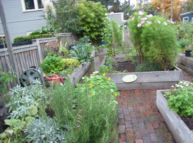
10 Perspective Green Way and Green Boulevard The half of the Green Way is allocated for small community garden plots, and the other half provides opportunity for higher denser shrubs, groundcovers which provide valuable habitat for fauna. The Green Boulevard displays a greater diversity of planting than the conventional tree and lawn boulevard. Space for community garden plots within the Green Way is limited, so the space on the boulevards can be utilized for additional community garden plots. TYL : 9

11 Conclusion Conclusion This design strives to create healthy habitat for humans and other living beings, provide affordable homes for future residents, while keeping in mind the needs of the environment. The block design shows possibilities and direction for integration of green infrastructure in a residential block that can hopefully be adapted for use in many different neighborhoods. This block is part of a greater system of green corridors, is a component of the greener urban fabric that will be developed over the next 50 years. The quality of life of residents of the Hastings Region can be enhanced while protecting and restoring the natural functions of the landscape. References (All photos taken by author) City of Burnaby, Welcome to Burnaby, < City Farmer Canada s Office of Urban Agriculture, City Farmer s Country Lane Reduces Rain Water Discharge to Vancouver s Storm Sewers < cityfarmer.org/lanes.html> Macdonald, Christie 2002, Turning Alleys into Assets, University of British Columbia. Sustainable Urban Landscapes, Site Design Manual for BC Communities, Setting the Context, < designmanual.html> TYL : 10
Toronto Complete Streets Guidelines
 Toronto Complete Streets Guidelines 108 110 7.1 Green Infrastructure Design Principles 112 7.2 Context-Sensitive Green Streets 114 7.3 Key Green Street Elements Green infrastructure refers to natural and
Green Infrastructure and Low-Impact Development Technologies
 Green Infrastructure and Low-Impact Development Technologies The guiding principles of these technologies is to manage stormwater at their sources using natural means, and establish conditions so that
Green Infrastructure & Low Impact Development
 Green Infrastructure & Low Impact Development CITY OF COVINGTON STORMWATER MANAGEMENT WHAT IS GREEN INFRASTRUCTURE? Green infrastructure uses vegetation, soils and natural processes to manage water and
Proposed Credit Program
 Proposed Credit Program What is the credit program? The proposed credit program will provide property owners with the opportunity to reduce their annual Stormwater Utility bill by up to 40% by managing
Stormwater Runoff and the District of Columbia RiverSmart Homes Defined:
 Stormwater Runoff and the District of Columbia Stormwater runoff is rainwater that flows off impervious surfaces such as rooftops, driveways, roads, sidewalks and sometimes even lawns. Stormwater runoff
Neighborhood Infrastructures Blue Green Infrastructure
 Neighborhood Infrastructures Blue Green Infrastructure Blue green infrastructure refers to the components of the neighborhood fabric that connect habitat, parks and open space while managing stormwater.
LOUISIANA STATE UNIVERSITY COMPREHENSIVE & STRATEGIC CAMPUS MASTER PLAN. APPENDIX G - Stormwater Study Findings & Stormwater Solutions
 LOUISIANA STATE UNIVERSITY COMPREHENSIVE & STRATEGIC CAMPUS MASTER PLAN APPENDIX G - Stormwater Study Findings & Stormwater Solutions LSU: MP Narrative July 2017 3.5 Open Space Existing Conditions The
COMPLETE GREEN STREET CHECKLIST
 COMPLETE GREEN STREET CHECKLIST This document was developed to dissect the structure of an urban street and explore opportunities to make our streets more complete while also integrating green street strategies.
Smart Growth Development Checklist
 2004 Smart Growth Development Checklist Smart Growth Development Checklist Corporation of the City of New Westminster Guide and manage growth in a manner which is consistent with the principles of sustainable
INTRODUCTION TO GREEN INFRASTRUCTURE HOW WE CAN PROTECT OUR COMMUNITIES AND OUR WATERS Maywood Public Library Bergen County, New Jersey
 INTRODUCTION TO GREEN INFRASTRUCTURE HOW WE CAN PROTECT OUR COMMUNITIES AND OUR WATERS Maywood Public Library Bergen County, New Jersey Jeremiah D. Bergstrom, LLA, ASLA Rutgers Cooperative Extension Water
CHAPTER 8. Mrs. Zimman s Class - Central Elementary
 SUSTAINABILITY CHAPTER 8 Mrs. Zimman s Class - Central Elementary 8.1 OVERVIEW Green infrastructure also known as low impact development (LID) and environmental or sustainable site design is an environmentally
Improve Neighborhood Design and Reduce Non Point Source Water Pollution
 HOW TO Planning Guide Improve Neighborhood Design and Reduce Non Point Source Water Pollution This document was funded by a grant from the New Hampshire Coastal Program with funding from the National Oceanic
Green Infrastructure Overview
 Green Infrastructure Overview Christopher C. Obropta, Ph.D., P.E. obropta@envsci.rutgers.edu Jeremiah Bergstrom, LLA, ASLA jbergstrom@envsci.rutgers.edu February 26, 2016 Water Resources Program NJDEP
green streets San Antonio, Texas February 17-18, 2009 Chris Kloss
 green streets San Antonio, Texas February 17-18, 2009 Chris Kloss www.lowimpactdevelopment.org typical pollutants Examples of Stormwater Pollutants Typical of Roads. 1,2 Pollutant Source Effects Trash
SQUAMISH 2010 AND BEYOND COMMUNITY VISION
 Our plan has been imagined and created to be both pragmatic and visionary. At the core of the strategy is a consideration of the highway s role and its impact on the community. First and foremost in creating
Green Streets An Innovative Street Design Approach
 Green Streets An Innovative Street Design Approach Great streets do not just happen. Overwhelmingly, the best streets derive from a conscious act of conception and creation of the street as a whole. The
Transportation. Strategies for Action
 Transportation A major priority for the Overlake Neighborhood is to develop a multimodal transportation system. To achieve this system, a balance has to be found among travel, circulation and access needs;
Pavements Built for the Future
 Pavements Built for the Future Main Street Warrenville, IL Permeable Interlocking Concrete Pavement Durable, Sustainable, Attractive Segmental paving dates back to the Roman Empire. Today s version is
UBC URBAN STUDIO, FALL 2002 PEDESTRIAN ORIENTED
 SECTION B PEDESTRIAN ORIENTED PATTERN: CITY OF VANCOUVER B.1 Vision Overview Regional Framework Energy 50% of all energy used within the Region to be produced by the Region. Energy production methods to
Alternative Uses of Compost: Rain Gardens and Green Solutions for Stormwater Management
 Alternative Uses of Compost: Rain Gardens and Green Solutions for Stormwater Management Photos: David Dods, URS David Dods, Senior Environmental Engineer URS Corporation, Overland Park, Kansas Agenda 1.
Green Streets. Sustainable Stormwater Solutions for Greener Communities and a Cleaner Bay
 Green Streets Sustainable Stormwater Solutions for Greener Communities and a Cleaner Bay As the Bay Area continues to grow through development of roads, revitalization of neighborhoods, and construction
Introduction to Low Impact Development. Fred Milch. East Central Florida Regional Planning Council
 Introduction to Low Impact Development Fred Milch East Central Florida Regional Planning Council Low Impact Development (LID) Low impact development (LID) is a term used to describe a land planning and
Gold Line Bus Rapid Transit Transit Oriented Development (BRTOD) Helmo Station Area Plan
 Helmo Station Area Plan") Appendix F Gold Line Bus Rapid Transit Transit Oriented Development (BRTOD) Helmo Station Area Plan Introduction and Purpose of the Plan The Gold Line Bus Rapid Transit facility is an eleven-mile dedicated
Appendix F Gold Line Bus Rapid Transit Transit Oriented Development (BRTOD) Helmo Station Area Plan Introduction and Purpose of the Plan The Gold Line Bus Rapid Transit facility is an eleven-mile dedicated
Stormwater & South Carolina. A Case for Low Impact Development
 Stormwater & South Carolina A Case for Low Impact Development what is stormwater? stormwater & development Volume of Water stormwater & development Peak Flow Urban Natural Peak Flow Rain Event Time Components
Permeable Interlocking Concrete Pavement A Low Impact Development Tool Training for Developers
 Permeable Interlocking Concrete Pavement A Low Impact Development Tool Training for Developers Presented by: Interlocking Concrete Pavement Institute The Low Impact Development Center, Inc. North Carolina
2.1 Principles & Objectives
 Designing With The Landform 2.1 Principles & Objectives Land planning which integrates the natural features of a site (i.e., designing with the landform ) into the site design is a major component of the
Green Infrastructure Recommendations For Parks and Public Spaces
 Green Infrastructure Recommendations For Parks and Public Spaces Issued by the Jersey Water Works Green Infrastructure Committee And Prepared by Meliora Design This document recommends ways to integrate
S A C R A M E N T O C O U N T Y JACKSON HIGHWAY & GRANT LINE EAST VISIONING STUDY
 JACKSON HIGHWAY & GRANT LINE EAST S A C R A M E N T O C O U N T Y P L A N N I N G D E P A R T M E N T SUMMARY AND WORKBOOK November 19, 2008 History of the Visioning Study Sacramento County has two growth
East Central Area Plan
 East Central Area Plan Steering Committee Meeting March 8 th, 2018 CHUN Tears McFarlane House Vision Statement Development Opportunities Analysis Vision Elements 1. Equitable, Affordable and Inclusive
When planning stormwater management facilities, the following principles shall be applied where possible.
 2.0 Principles When planning stormwater management facilities, the following principles shall be applied where possible. 2.0.1 Drainage is a regional phenomenon that does not respect the boundaries between
Rainwater Management an issue for the 21 st Century. Hydrological Cycle
 Canadian Society of Landscape Architects CONGRESS 2014 Rainwater Management an issue for the 21 st Century Don Crockett, BCSLA, CSLA Principal, Golder Associates Ltd. May 2014 Hydrological Cycle PRE- URBAN
Planning, Design, and Construction of Green Infrastructure.
 Planning, Design, and Construction of Green Infrastructure www.water.rutgers.edu What is Green Infrastructure? an approach to stormwater management that is costeffective, sustainable, and environmentally
STORMWATER TOOL. Rain Garden
 Rain Garden What is a Rain Garden? A rain garden is a shallow, planted depression that absorbs the water that flows from your roof or any hard surface, allowing it to drain directly into the soil. Rain
Going Green with the NYS Stormwater Design Standards
 Going Green with the NYS Stormwater Design Standards Shohreh Karimipour, P.E. NYSDEC History of Stormwater Management Ancient Greek Cisterns Water Cistern Systems in Greece from Minoan to Hellenistic Period,
DRAFT FOR PUBLIC REVIEW. Game Plan for a Healthy City
 DRAFT FOR PUBLIC REVIEW 2018 Game Plan for a Healthy City 2 Denveright. Parks & Recreation Game Plan Draft for Public Review Draft for Public Review Executive Summary Game Plan Overview Executive Summary
Community Gardens: Rainwater and Solar Harvesting Project
 Community Gardens: Rainwater and Solar Harvesting Project Context: Problem: As Toronto continues to grow, increased development and impermeable surfaces continues to strain the City s water infrastructure
From and
 GREEN INFRASTRUCTURE IN PROVIDENCE, RI The Box Office From http://web.uri.edu/riss/the-box-office/ and http://www.morrisbeacon.com/media/portfolioprojects/implementation/box-office/box%20office.pdf: At
Concord Community Reuse Project Goals and Guiding Principles. Overarching Goals (OG)
") Concord Community Reuse Project Goals and Guiding Principles Overarching Goals (OG) No priority is implied by the order of presentation of the goals and guiding principles. Overarching goals for the Concord
Concord Community Reuse Project Goals and Guiding Principles Overarching Goals (OG) No priority is implied by the order of presentation of the goals and guiding principles. Overarching goals for the Concord
Managing Stormwater Naturally. July 17, 2013
 Managing Stormwater Naturally July 17, 2013 1 This image cannot currently be displayed. Guiding Documents 2 Stormwater Purpose Statement The City Council hereby finds, determines and declares the City
Title: South Britannia Community Centre Tobi Fenton
 Title: South Britannia Community Centre Tobi Fenton South Britannia is laid out in a grid of 120x60 meter blocks with Main Street oriented towards Howe Sound. The concentrated centre is located at the
92 Minnesota Stormwater Manual
 92 Minnesota Stormwater Manual E. Landscaping Many of the previous practices could also be included in a general category that stresses the importance of stable landscapes with native vegetation. In many
J. Paul Guyer, P.E., R.A.
 J. Paul Guyer, P.E., R.A. Paul Guyer is a registered civil engineer, mechanical engineer, fire protection engineer, and architect with over 35 years experience in the design of buildings and related infrastructure.
include playgrounds, sports fields, community gardens and picnic areas.
 DEVELOPMENT PLAN OPEN SPACE SYSTEM OPEN SPACE SYSTEM The neighborhood provides for a range of open space types. The Village Square is an important open space in the neighborhood. It serves as a gathering
Rainfall Capture and Green Subdivision Design:
 Rainfall Capture and Green Subdivision Design: Applying the Water Balance Model Kim Stephens, MEng, PEng, Project Coordinator Inter-Governmental Partnership from Stormwater Management to Rainwater Management
VEHICULAR AND PEDESTRIAN CIRCULATION
 This perspective sketch communicates the intended character and quality of a proposed streetscape design. Locate benches near a major intersection where people tend to gather. Seating and lighting provide
Hopkins. Development Guidelines May Overview. Sponsored by: Blake Road Corridor Collaborative City of Hopkins
 Hopkins Blake Road LRT Station Area Development Guidelines May 2015 Sponsored by: Blake Road Corridor Collaborative City of Hopkins Overview Hopkins is a dynamic community of over 17,000 residents located
CHAPTER 11 SITE DESIGN AND LOW IMPACT DEVELOPMENT
 CHAPTER 11 SITE DESIGN AND LOW IMPACT DEVELOPMENT Source: City of Bend Chapter Organization 11.1 Purpose... 11-1 11.2 Applicability... 11-1 11.3 Low Impact Development Overview... 11-2 11.3.1 Key Strategies...
FUNDAMENTAL BUILDING BLOCKS
 FUNDAMENTAL BUILDING BLOCKS THE WEB OF GIBSONS - EXISTING Lacks Community Structure and Support Circulation, surface water flow and buildings are disjointed from the community Social neighbourhoods are
The open space system should provide connective elements, relate to natural resources, and enhance the suburban character of the landscape..
 The open space system should provide connective elements, relate to natural resources, and enhance the suburban character of the landscape.. Mixed-use and infill development should maintain or enhance
Ecosystems and Biodiversity Ecosystem Services in the City. City of Burnaby Environmental Sustainability Strategy
 Ecosystems and Biodiversity Ecosystem Services in the City City of Burnaby Environmental Sustainability Strategy Realms of concern / Realms of possibility In ecosystems, everything is connected to everything
Introduction to Low Impact Development. Dr Kathy Chaston Coral & Coastal Management Specialist NOAA Office of Ocean & Coastal Resource Management
 Introduction to Low Impact Development Dr Kathy Chaston Coral & Coastal Management Specialist NOAA Office of Ocean & Coastal Resource Management http://hawaii.gov/dbedt/czm/resource/publication.php A Comprehensive
DEALING WITH STORM WATER MANAGEMENT
 December 2012 DEALING WITH STORM WATER MANAGEMENT This fact sheet provides information on the guiding principles of storm water management practices, explains the difference between structural and non-structural
Appendix E: Illustrative Green Infrastructure Examples
 Appendix E: Illustrative Green Infrastructure Examples Integrating LID into San Francisco s Urban Landscape Figure E. High-density Residential Figure E. Low-density Residential Figure E. Mixed Use 7 Figure
Westbound: A One-day Exploration of Growth
 Westbound: A One-day Exploration of Growth Frog Pond Area 2018 UGB Expansion Proposal June 13, 2018 Growing Out: UGB Asks Four cities submitted proposals to expand greater Portland s urban footprint by
Landscape and Streetscape Design 2.5
 Landscape and Streetscape Design 2.5 2.5.1 Goals 2.5.2 Planting 2.5.3 Sidewalks and Pavement 2.5.4 Furnishings 2.5.5 Walls 2.5.6 Lighting 2.5.7 Stormwater 2.5.8 Street Cross Sections 2.5 LANDSCAPE AND
DRAFT. 10% Common Open Space
 % OF CHARLOTTE IS CATEGORIZED AS A. LAND USES : Placeholder map displaying location of Place Type GOALS: Accommodate XX% of future growth. Provide a concentration of primarily commercial and civic activity
CROWN POINT SUBDIVISION
 CROWN POINT SUBDIVISION A COMPARISON OF CONVENTIONAL VERSUS CONSERVATION SUBDIVISION DESIGN DEVELOPER: PAUL LUCIANO BUILDERS LAND PLANNING & DESIGN: DAVID LAIRD ASSOCIATES FUNDING PROVIDED BY: PA SEA GRANT
Using Green Infrastructure To Protect Water Quality
 Using Green Infrastructure To Protect Water Quality Green Infrastructure for Revitalization West Union Iowa s Green Street Pilot Project Green Pilot Streetscape Project A Sustainable Vision for West Union
UBC Social, Ecological Economic Development Studies (SEEDS) Student Reports
 Student Reports") SEEDS Student Reports 1 UBC Social, Ecological Economic Development Studies (SEEDS) Student Reports University Neighbourhood Association Open House Assessment Rebecca Colter Ivy Chen Nicholas Sinkewicz
SEEDS Student Reports 1 UBC Social, Ecological Economic Development Studies (SEEDS) Student Reports University Neighbourhood Association Open House Assessment Rebecca Colter Ivy Chen Nicholas Sinkewicz
SYRINGA VALLEY SPECIFIC PLAN NARRATIVE
 SYRINGA VALLEY SPECIFIC PLAN NARRATIVE Introduction With this application, Pleasant Valley South LLC ( Pleasant Valley ) seeks the City of Boise s approval of a new Specific Plan Ordinance to be added
Low Impact Development/Better Site Design Roundtable
 Low Impact Development/Better Site Design Roundtable Pros, Cons and Planning Considerations January 2010 http://livingindryden.org/images/route13/flooding04042005b.jpg Prepared by: Shannon Rooney, P.E.
Community Design Guidelines. Port Wallace DRAFT
 Community Design Guidelines Port Wallace DRAFT Energy 1 2 3 Nature Movement Connections Built Form DRAFT Layout Energy 1 Nature Community Design Guidelines GREAT COMMUNITIES PROTECT, CELEBRATE, AND CONSERVE
LOW DENSITY RESIDENTIAL
 LOW DENSITY RESIDENTIAL Corner lots with coach houses to increase diversity, provide unity to the streetscape and increase eyes on the street. Garages and ancillary units accessed via rear lanes. Parking
Leduc Industrial Outline Plan SE W4
 Leduc Industrial Outline Plan SE 1-50-25-W4 Within the North Leduc Industrial ASP Prepared for: Leduc Energy Park Ltd. Prepared by: Stantec Consulting Ltd. File No. 1161 104655 V5 Table of Contents 1.0
DOWNTOWN RESIDENTIAL DISTRICT DEVELOPMENT OPPORTUNITES
 DOWNTOWN RESIDENTIAL DISTRICT DEVELOPMENT OPPORTUNITES Out of all the areas in Downtown Painesville, this district provides the greatest opportunity for change with the vacation of Lake East Hospital.
water that enters our streams during storms. Any water the rain garden can t accept will continue into the storm sewer system.
 North Kensington Street and 32 nd Street North Green Street and Sewer Capacity Meeting Friday, July 20 and Monday, July 23, 2012 Summary of Citizen Questions and Concerns Thank you for participating in
Stormwater Management Techniques WMPF LAND USE TRAINING INSTITUTE MARCH 14, 2018
 Stormwater Management Techniques WMPF LAND USE TRAINING INSTITUTE MARCH 14, 2018 Potential Impacts of New Development Urban development can significantly increase stormwater runoff Water quality considerations
Christopher J. Webb, PE. Chris Webb & Associates, Inc., PS, Bellingham, WA
 Christopher J. Webb, PE Chris Webb & Associates, Inc., PS, Bellingham, WA www.chriswebbpe.com THE CHARETTE April 22, 2008 (Earth Day) THE CHARETTE Goals Consider innovative approaches and evaluate application
Water in storm drains does not go to a treatment plant
 Watershed Planning Workshop Upper Mainstem & Middle Four Mile Run November 30, 2011 Fairlington Community Center Arlington s watersheds Chesapeake Bay watershed Watershed Planning Initiated May 2008 Contracted
Rebuilding Landscapes. Permit Ready Garden Design Templates
 Rebuilding Landscapes Permit Ready Garden Design Templates Project Goals Streamline permitting Save homeowner cost Water saving designs Fire Safer guidelines Attractive, engaging front yard plans Integrate
The following principles guide the development of goals and strategies to protect and promote these amenities:
 OPEN SPACE/PARKS/TRAILS/RECREATION GOALS/STRATEGIES Cherry Hills Village is a living environment that offers low density development, open areas, public scenic vistas, public trails and public parks. This
Queensborough Eastern Neighbourhood Node. Community Open House
 Queensborough Eastern Community Open House The Vision The Queensborough Eastern will become the heart of eastern Queensborough. Through a sensitive mix of viable commercial and residential areas, the neighbourhood
Kelowna Sustainability Checklist
 Kelowna Sustainability Checklist The City of Kelowna endeavours to Sustain the Environment. Encourage development and land use changes that will not compromise the ability of future generations to meet
URBAN DESIGN BRIEF URBAN DESIGN BRIEF 721 FRANKLIN BLVD, CAMBRIDGE August 2018
 URBAN DESIGN BRIEF URBAN DESIGN BRIEF 721 FRANKLIN BLVD, CAMBRIDGE August 2018 DESIGN BRIEF CONTENTS PART A 1.0 INTRODUCTION 2.0 DESCRIPTION & ANALYSIS OF SITE CONTEXT 3.0 DESIGN CONSTRAINTS AND OPPORTUNITIES
Tennessee Stormwater Management Program. Stormwater Management Site Assessment and Inventory Checklist. Quick Check o Vicinity Map within Watershed
 Tennessee Stormwater Management Program Project Name: Location: File Number: Reviewer: Date of Submittal: Review Date: Project Meeting Chronology: Type of Meeting: Date: Stormwater Management Site Assessment
Structural Measures at a Glance
 Structural Measures at a Glance 1 Combined Approaches (Notional Graphic) www.nyc.gov Sea Level Change 2 Sandy s Rebuild By Design Effort: Hoboken www.rebuildbydesign.org 3 Courtesy of the Office of Metropolitan
Creative Use of Aging Infrastructure
 Creative Use of Aging Infrastructure ULI, New York July 2007 October 22, 2014 Summary To be built over the 101 Freeway between Hollywood Boulevard and Santa Monica Boulevard. A mile in length 44 acres
Subregion 4 Central Avenue-Metro Blue Line Corridor Transit-Oriented Development (TOD) Implementation Project. Community Meeting April 27, 2011
 Implementation Project. Community Meeting April 27, 2011") Subregion 4 Central Avenue-Metro Blue Line Corridor Transit-Oriented Development (TOD) Implementation Project Community Meeting April 27, 2011 Overview Introduction to Subregion 4 TOD Implementation Program
Subregion 4 Central Avenue-Metro Blue Line Corridor Transit-Oriented Development (TOD) Implementation Project Community Meeting April 27, 2011 Overview Introduction to Subregion 4 TOD Implementation Program
City of Yelm. Tahoma Terra Final Master Plan Development Guidelines. Table of Contents
 City of Yelm Tahoma Terra Final Master Plan Development Guidelines Table of Contents Table of Contents... 1 Purpose... 2 Low Density Residential (R4-6)... 3 Moderate Density Residential (R6-10)... 5 Neighborhood
Green Roof Fact Sheet
 Rushern L. Baker, III County Executive Green Roof Fact Sheet What is a green roof? A green roof is a low-maintenance, vegetated roof system that stores rainwater in a lightweight, engineered soil. The
Dogpatch/22nd Street Greening
 TEAM MEMBERS Prepared for: GreenTrustSF Central Waterfront www.gtsfcw.org Prepared by: Fletcher Studio San Francisco, CA www.fletcherstudio.com Landscape Architecture Urban Design Environmental Planning
Wasatch CHOICE for 2040
 Wasatch CHOICE for 2040 Economic Opportunities We Can Choose a Better Future We enjoy an unparalleled quality of life along the Wasatch Front. People from all over the world are drawn to our stunning scenery,
Using LID Projects for Sustainable Development: A Case Study from the Chain of Lakes City
 Using LID Projects for Sustainable Development: A Case Study from the Chain of Lakes City When we try to pick out anything by itself, we find it hitched to everything else in the universe. John Muir M.J.
3.0 DESCRIPTION OF THE EAST CLAYTON LAND USE PLAN
 3.0 DESCRIPTION OF THE EAST CLAYTON LAND USE PLAN Section 3 provides a description of the various land uses proposed in the East Clayton Development Concept (Figure 3.1). The land uses are based upon the
Northern Territory Compact Urban Growth Policy
 Northern Territory Compact Urban Growth Policy A Reference Policy Document to clause 2.7 (Reference to Policy) of the NT Planning Scheme May 2015 Table of Contents 1 Policy Setting... 3 1.1 Context for
City of Langford Green Development Checklist
 City of Langford Green Development Checklist The following Green Development Checklist creates a sustainability standard for all comprehensive development within the City of Langford. The commitments made
BE WATER WISE. Managing Your Onlot Stormwater. Sept. 23, 2006 Watershed Weekend
 BE WATER WISE Managing Your Onlot Stormwater Sept. 23, 2006 Watershed Weekend 2006 1 All water resources are interrelated through the Hydrologic Cycle Sept. 23, 2006 Watershed Weekend 2006 2 What is Storm
Conservation Development
 Acknowledgements RIDEM: Scott Millar Anthony Lachowicz-Planning and Zoning Consultant Director of Planning 1 : a creative land use technique that allows a community to guide growth to the most appropriate
Bethesda Downtown Plan
 Bethesda Downtown Plan Planning Board Update Connecticut Avenue Location Economic Sustainability Social Environmental Scope Coming Soon! Team Listening, Twitter Outreach We Are Here Engagement Challenge
Rainscaping. Rainscaping includes rain gardens, bioswales, combinations of. A guide to local projects in St. Louis
 Rainscaping A guide to local projects in St. Louis Rain garden on South Grand Boulevard in the city of St. Louis. Rainscaping includes rain gardens, bioswales, combinations of plantings, water features,
2.0 THE PLATINUM TRIANGLE VISION
 2.0 THE PLATINUM TRIANGLE VISION The envisions an exciting future for the area surrounding Angel Stadium of Anaheim, the Honda Center and The Grove of Anaheim. 2.1 Planning Principles In order to further
STORMWATER QUALITY MARION STREET GREEN INFRASTRUCTURE PROJECT COMMON SOURCES OF URBAN POLLUTANTS URBAN STORMWATER
 STORMWATER QUALITY COMMON SOURCES OF URBAN POLLUTANTS Fertilizers Litter Pet-waste COMMON POLLUTANTS FOUND IN URBAN STORMWATER BACTERIA TRASH METALS Dumpsters Vehicle exhaust, automotive fluids, etc. IMPACTS
Final Impervious Cover Assessment for Upper Deerfield Township, Cumberland County, New Jersey
 Final Impervious Cover Assessment for Upper Deerfield Township, Cumberland County, New Jersey Prepared for Upper Deerfield Township by the Rutgers Cooperative Extension Water Resources Program September
RAIN GARDENS. Task: PART 1 (60 minutes) Student Directions: Steps you will be following: Directions for beginning: Source Information:
 Student Directions: Steps you will be following: Directions for beginning: Source Information:") PART 1 (60 minutes) Student Directions: Your assignment: Steps you will be following: Your neighborhood council is researching the benefits of installing rain gardens in your community. You will read two
PART 1 (60 minutes) Student Directions: Your assignment: Steps you will be following: Your neighborhood council is researching the benefits of installing rain gardens in your community. You will read two
Appendix D - Technical Design Criteria for BMPs
 Appendix D - Technical Design Criteria for BMPs City of Wayzata Page 3 On-site infiltration features Definitions and Scope: Infiltration facilities are constructed basins or depressions located in permeable
The Five Components of the McLoughlin Area Plan
 The Five Components of the McLoughlin Area Plan This documents contains the complete language of the five components of the McLoughlin Area Plan: The Vision Statement The Values The Guiding Principles
4 Sustainability and Growth Management
 4 Sustainability and Growth Management Introduction Traditionally, has assumed growth and development with limited consideration for the long-term negative social, environmental or economic impacts on
WHAT WE HEARD REPORT - Summary Bonnie Doon Mall Redevelopment Application (LDA )
") WHAT WE HEARD REPORT - Summary Bonnie Doon Mall Redevelopment Application (LDA18-0184) PROJECT ADDRESS: 1 Bonnie Doon Shopping Centre NW, 8420 85 Street NW & 8715 85 Street NW PROJECT DESCRIPTION: Rezoning
WHAT WE HEARD REPORT - Summary Bonnie Doon Mall Redevelopment Application (LDA18-0184) PROJECT ADDRESS: 1 Bonnie Doon Shopping Centre NW, 8420 85 Street NW & 8715 85 Street NW PROJECT DESCRIPTION: Rezoning
Ancient Greek and Roman planners recognized the importance of centralized gathering spaces within urban
 TEAMS Competition 2014 Urban Green Space Design Introduction Ancient Greek and Roman planners recognized the importance of centralized gathering spaces within urban areas. Early Greek agora and Roman forums
STILL CREEK CD-1 GUIDELINES (BY-LAW NO. 6654) Adopted by City Council April 24, 1990
 Adopted by City Council April 24, 1990") $2 City of Vancouver Land Use and Development Policies and Guidelines Community Services, 453 W. 12th Ave Vancouver, BC V5Y 1V4 F 604.873.7344 fax 873.7060 planning@city.vancouver.bc.ca STILL CREEK CD-1
$2 City of Vancouver Land Use and Development Policies and Guidelines Community Services, 453 W. 12th Ave Vancouver, BC V5Y 1V4 F 604.873.7344 fax 873.7060 planning@city.vancouver.bc.ca STILL CREEK CD-1