BIRMINGHAM CITY COUNCIL DRAFT LOCAL DEVELOPMENT ORDER ADVANCED MANUFACTURING HUB, BIRMINGHAM
|
|
|
- Lorena Palmer
- 5 years ago
- Views:
Transcription
1 BIRMINGHAM CITY COUNCIL REPORT OF DIRECTOR OF PLANNING AND REGENERATION PLANNING COMMITTEE 14 th November 2013 DRAFT LOCAL DEVELOPMENT ORDER ADVANCED MANUFACTURING HUB, BIRMINGHAM 1. Subject and Brief Summary of Proposals 1.1 This report advises your Committee of the responses from the consultation exercise for the proposed Local Development Order for the Advanced Manufacturing Hub, at East Aston. 1.2 The report also advises on suggested revisions to the LDO. 2. Recommendations 2.1 That the revisions to the LDO are agreed, the LDO is then sent to the Secretary of State and that subject to no intervention, that the LDO is formally adopted. 3. Contact Officer Victoria Chadaway, Planning and Regeneration Tel:
2 4.0 Background 4.1 A report was presented to Planning Committee on 11 th July 2013, detailing the draft Local Development Order for the Advanced Manufacturing Hub in East Aston. Committee endorsed the report for consultation purposes. 4.2 Formal consultation was undertaken on the draft LDO, which finished on 16 th August This consisted of the following; Press Notice 5 Site Notices around the boundaries of the LDO sites Notification letters to all land owners within the LDO area Consultation letters to owners and occupiers of premises adjacent to the LDO areas 910 letters sent Consultation letters to statutory consultees as defined by Article 34 of the Town and Country Planning (Development Management Procedure) (England) Order 2010 Website with information and opportunity to comment on line 5.0 Consultation responses 5.1. Highways Agency (HA) Welcomes the core aims of the draft LDO to promote elements of the Aston Regional Investment Site (RIS) through the simplification of planning controls. The land uses set out in the LDO are agreeable to the HA. However the HA recommends that there are should be stronger links made in the LDO to the Travel Plan requirements set out in the Aston, Newtown and Lozells Area Action Plan (AAP). In particular HA consider that policy T6 of the AAP should be replicated in full in the LDO English Heritage (EH) Consider that insufficient evidence has been provided with the LDO to demonstrate that the measures proposed by the LDO would necessarily result in the conservation of the grade II* Aston Parish Church and the adjacent conservation area in a manner appropriate to their significance in accordance with national policy for the historic environment. EH consider that the absence of any description of the significance of the parish church as part of the LDO, and the contributions made by its setting to the area, suggests an inadequate consideration of the impact of the LDO on this heritage asset. From Aston Hall, its Park and Witton Lane, the LDO development of the Serpentine Site will provide a backdrop to the parish church. Due consideration of this wider context should be demonstrated through the LDO Network Rail (NR) Raise concern that the LDO may result in proposals being undertaken near to or next to the operational railway which may impact upon its safety, performance and operation. NR request that any proposals approved under the LDO ensure that access points and infrastructure of the railway is not impacted West Midlands Fire Service (WMFS) Would like to be consulted on development with regard to water supplies and access for fire fighting for each development prior to it reaching Building Regulations stage. 2
3 5.5. Natural England (NE) - have no comments to make on this consultation Environment Agency (EA) No objections to this proposal with the conditions proposed Stuart Homer, Land owner of Concentric Park Industrial Estate (SH) Objects on the following grounds: No reason is given as to why phase 2 of AAP is not included in LDO; It has not been mentioned that large part of the LDO not in HCA/ Council Ownership, and that area includes a thriving industrial estate; Reducing parking in an effort to encourage use by public transport will result in residential side streets becoming congested and impacting on local residential amenity; Improving the Lichfield Road/ Aston Hall Road junction will not improve access to the Strategic Highway Network but will exacerbate the existing issues by increasing the volume of traffic arriving at these pinch points; Concentric Park Industrial Estate which is facing closure as a result of this proposal has created 150 jobs in the last 2 years. Evidence suggests that this is a far higher employment rate density than that expected through the LDO; Concentric Park Industrial Estate has already regenerated a derelict site and supports businesses involved in automotive and aerospace manufacturing as well as other diverse sectors; The demolition of Concentric Park Industrial Estate will put many businesses and jobs at risk in the very sectors that are being promoted; By taking phase 2 of the RIS out of the LDO existing poor quality buildings will continue to frame the main routes leading to and though the RIS; and The LDO bears little resemblance to the AAP and will not help deliver the comprehensive, managed and high quality development promised in the AAP Aston Parish Church (APC) - Object to the Serpentine Site (Area 2 of the LDO as shown on the LDO boundary plan) being included in the LDO but will withdraw this objection if they receive evidence that the issues outlined below have been addressed: Evidence presented in the planning documents makes it clear that the Serpentine Site with a statutory conservation area, listed buildings, archaeological requirements and being adjacent to housing makes it very different to the other two areas included in this proposal; It is unclear how this proposal meets the requirement of Aston, Newtown, Lozells Area Action Plan (AAP) section 7.18, regarding improved pedestrian access to Aston Churchyard; Who is to own and maintain the security wall between the Churchyard and Serpentine Site that was installed by Asda when the site was used for a supermarket? The church is keen to open up public access to the churchyard and a more appropriate boundary treatment is needed for this. There is nothing in this proposal about improving the boundary; How does this proposal to limit building heights to 15m meet the requirement of AAP section 2.16 that the design of new development should be of high quality taking into consideration its historic context, building materials, massing and views; What is the estimated S106 grant and how much of this will be for the community and to improve public access to the churchyard; Will there be adequate car parking facilities on the site; 3
4 Is preserving public access to the site guaranteed? Security gating would be inappropriate; The entrance to the Serpentine Ground between the Aston Tavern and the churchyard is a disgrace, what are the proposals for it being landscaped and who is responsible for this; How are pedestrians to gain access to the 15m landscape buffer from Aston Hall Road; Who is to be responsible for the maintenance of the 15m landscape buffer and to what standard will it be maintained? Who will be responsible for removing fly tipping; What is to happen to the vacant land between the LDO boundary and the conservation area churchyard shown white on the plan? (The Church considers this should be a public open space integrated into the closed churchyard area maintained by the City Council); A 15m high wall is permitted by the LDO on the railway boundary, furthermore there is no restriction on building massing so how are sightlines to be maintained from the railway and A38(M) into the conservation area?; Roof materials should be specified, crinkly tin will not do; and What safeguards are there that the development will present an appropriate aspect elevation for the residential properties on the western edge of the area? 5.9 One objection has been received from a local resident on the grounds that the Councils intentions are unclear and she wishes to be offered a house exchange. 6.0 Response to Consultations 6.1. Highways Agency has raised no objection to the LDO but has suggested that stronger links should be made in the LDO to the Travel Plan requirements set out in the AAP. Condition B14 of the LDO would require any occupiers of new buildings constructed though the LDO to affiliate to Company Travel Wise in Birmingham. Policy T6 of the AAP requires developers and/ or occupiers within the RIS to sign up to and implement the Framework Travel Plan produced by the City Council, in consultation with Centro and the Highways Agency. Condition B14 of the LDO can be amended to reflect this recommendation by HA and to ensure compliance with the AAP English Heritage have not objected to the LDO but have raised comments regarding the evidence contained in the LDO and whether this adequately demonstrates that the conditions proposed as part of the LDO would result in the conservation of Aston Parish Church in a manner appropriate to its significance in accordance with national policy. To address this concern a full Heritage Statement has now been commissioned. The remit of the Heritage Statement was to consider the significance of Aston Parish Church and the wider conservation area and consider whether the proposed LDO conditions had gone far enough in ensuring the protection or enhancement of the grade II* Parish Church and the conservation area. The Heritage Statement is appended to this report (appendix B) and it is now proposed that this should become an appendix to the LDO Contextual views of the grade II* listed Aston Parish Church and through the conservation area have been fully considered as part of the heritage assessment of this site. These views are depicted within the Heritage 4
5 Statement. The views though the conservation area from Aston Hall demonstrate that the Serpentine Site (shown as Area 2 on the LDO boundary plan) is screened from view by the presence of the church yard and its trees. These views were considered in September when the trees were in full leaf. However, it is considered that the density of these trees is such that they will comprise an effective screen to the Serpentine Site even in winter, although it is possible that there would be limited glimpses of the Serpentine Site during the winter months The most exposed view of the proposed Serpentine Site from the conservation area is at the entrance to the site off Aston Hall Road Having considered the significance of the heritage assets adjacent to the LDO, the Heritage Statement makes several recommendations to ensure the protection of the conservation area and the adjacent grade II* listed Aston Parish Church. The majority of the recommendations made in the Heritage Statement are for improvement to the boundary of the church yard within communally accessible areas of the site (such as at the site entrance and throughout circulation areas of the site). These recommendations include repairing the collapsed northern churchyard wall, removing graffiti, ensuring the design of the entrance to the Serpentine Site to consider the setting of the conservation area (perhaps by including a landscape feature) and representing the meander of the former Serpentine river across the site in some way. It is not possible to require these works though the remit of the LDO but officers recognise the need to undertake these works and have secured S106 funding and Growing Places grant funding to enable these works Policy R5 of the Aston Newtown and Lozells AAP states that a comprehensive approach is required to develop the RIS and to ensure an integrated and high quality development. A Development Framework is currently being prepared by the Council which will address site wide issues beyond the scope of the LDO such as public realm improvements. This will set out a clear rationale for public realm improvement which will include improvement works to the Serpentine Site The Heritage Statement has also set out that the roofscape of any proposed development on the Serpentine Site is important from long distance views across the conservation area. Roofing materials will be required to be submitted by condition B1 of the LDO. This will ensure that appropriate materials are agreed for the construction of buildings on the Serpentine Site including ensuring that sensitive roofing materials are used A final recommendation on the Heritage Statement is for the Holte Almshouses to be recalled in boundary treatment along the Aston Hall Road. The former Almshouses site fall within Area 3 of the LDO site and this part of the site is currently developed with large warehouse buildings in operation by Astra Engineering. As the Council is not the land owner of this site, we can not insist in the creation of this boundary treatment on this land through the LDO I consider that account has been taken of the important historic context of the area and that through the Heritage Statement it is sufficiently evidenced that the conditions of the LDO along with provisions to be included in the Development Framework would result in the conservation of Aston Parish 5
6 Church and the Aston Parish Church and Conservation Area in a manner appropriate to their significance in accordance with national policy Concerns raised by Network Rail and West Midlands Fire Service are not material planning considerations but matter of good development practise in bringing forward these sites for development. Although the LDO seeks to simplify the planning process, it remains necessary for developers to comply with all relevant licences, permits and controls required under other legislation Objection has been raised by Stuart Homer who is the current land owner of Concentric Park Industrial Estate which falls within Area 1 of the Draft LDO boundary. Mr. Homer has stated that no reason has been given as to why phase 2 of AAP is not included in the LDO. The LDO seeks to streamline and simplify the planning process by extending permitted development rights for industrial uses (B1 (b), B1 (c) and B2), thereby reducing costs and lead in times for developers and providing certainty to the market. The LDO is being prepared for the majority of the RIS, but excludes a small proportion of Phase 1, all of Phase 2 and parts of Phase 3 as these areas are more sensitive to development with a number of sites adjacent to well established residential uses. Guidance in the form of a Development Framework will be prepared for the sites within the RIS that are not covered by the LDO. The framework will cover site-wide issues, such as public realm improvements Objection is raised that reducing parking in an effort to encourage use by public transport will result in residential side streets becoming congested and impacting on local residential amenity. The RIS site is currently well served by public transport, with frequent rail services on the cross-city and Walsall lines calling at Aston Station and showcase style bus services on the Lichfield Road. In addition, improved passenger information, including real time information is proposed at new stop locations Objection has been raised that improving the Lichfield Road/ Aston Hall Road junction will not improve access to the Strategic Highway Network but will exacerbate the existing issues by increasing the volume of traffic arriving at these pinch points. The works to the Lichfield Road/ Aston Hall Road fall outside of the scope of the LDO. However the proposed highway improvements to Lichfield Road/Aston Hall Road will improve the flow of traffic along this key transport corridor and will also provide a greatly improve access to the RIS. The City Council has worked closely with the Highways Agency (HA) to assess the traffic impact of the RIS on the strategic road network (SRN) In respect of the Concentric Controls Land, at the moment this land comprises a business park of 30 units with a number of operational businesses, which are said to employ approximately 150 people. The business park has been operating since mid The current use of the site, which is low quality small scale industrial accommodation, does not conform to the objective of the RIS which is to create a high quality development suitable for companies with international/ national operations. The City Council will seek to work with the land owner to enable the effective relocation of the various businesses, including potential financial support packages where relevant. The inclusion of this land in the LDO provides a complete development frontage to Salford Lake and will allow adjoining land currently in the ownership of the HCA to be effectively released for 6
7 development Objection has been raised that by taking phase 2 of the RIS out of the LDO existing poor quality buildings will continue to frame the main routes leading to and though the RIS and that the LDO bears little resemblance to the AAP and will not help deliver the comprehensive, managed and high quality development promised in the AAP. However, the NPPF encourages a proactive approach to meet the development needs of business and reduce the burden of planning requirements. This LDO has therefore been prepared for part of the RIS, which seeks to incentivise development by removing the need for subsequent planning consent. It sets out planning conditions which address the requirements of the AAP. For example, the LDO contains conditions which address policies R2-R4 in the AAP, which include a landscape buffer between the development and Salford Lake/ Aston Hall and Church Conservation Area, flood risk mitigation measures, energy standards and noise mitigation measures. A development framework will be prepared to address site wide issues beyond the scope of the LDO such as public realm improvements. The development framework will also provide planning guidance on development plots (such as those fronting Lichfield Road) not covered by the LDO. In terms of the AAP requirement for a scheme of management the LDO effectively controls the type of end user to meet the objectives of the RIS as outlined in the AAP. The highway, transport and environmental improvements referred to in Policy R6 will now be delivered by the City Council rather than through S106 or highways agreements. The package of planning measures comprising LDO, planning applications and development framework address all the matters set out in Policies R2 R6 of the AAP Objection has been raised to this proposal by Aston Parish Church. The majority of the concerns raised relate to the need for improvements to the boundary of the church and for linked access across the church yard and though the site. Officers have been working with Aston Parish Church to agree how these improvements can be achieved. These will be set out in the Development Framework for the RIS Aston Parish Church have commented that the Serpentine Site is a sensitive site to develop due to is location adjacent to the parish church, including the conservation area, with archaeological interest and adjacent to housing. Whilst the LDO seeks to streamline the planning system to promote development, the LDO has not been made without conditions or limitations. Account has been taken of the important historic context of the area and a Heritage Statement has now been completed to accompany the LDO. Conditions proposed on the LDO seek to ensure the residential amenity of existing local occupiers and to protect the character of the area (this includes limitations on the height of the building, requiring materials to be submitted and requiring significant areas of landscaping as part of any development). An archaeological investigation has been carried out on this site to the satisfaction of the City Archaeologist Objection has been raised that in theory a 15m high building is permitted by the LDO adjacent to the railway boundary and that there are no restriction on building massing so sightlines from the railway and A38(M) could be lost. Due to the need to service individual proposed units allowed under the LDO with parking and circulation areas it is highly unlikely that there would be a solid built construction along the entire boundary of the railway up to the 15m 7
8 buffer zone. As such there will still be sightline to the conservation area from the railway line. The elevated height of the A38(M) ensures views of the spire of the church even with development permitted though the LDO Objection has been raised that roof materials should be specified. This will be the case and is required by condition B1 of the LDO Objections raised by a local resident do not raise any material planning matters that should be considered further as part of this assessment. 7.0 Suggested revisions to the LDO 7.1. That the Heritage Statement carried out by PCPT architects is appended to the LDO demonstrating that a full assessment of the significance of Aston Parish Church and the Aston Hall and Church Conservation Area has been undertaken That condition B14 of the LDO is amended to require developers to sign up to the Framework Travel Plan. 8. Conclusions 8.1. With the conditions and restrictions proposed and with the revisions detailed above, it is considered that the LDO achieves the right balance of streamlining the planning system and promoting economic growth in this area, in line with the AAP, whilst also ensuring the character and quality of the area. 8.2 Subject to no intervention by the Secretary of State, the LDOs would be adopted and take effect as soon as possible, in accordance with the Orders outlined in Appendix A. 8
9 Appendix A Draft LDO for Advanced Manufacturing Hub, Aston Within the area defined by Plan 1 (Appendix C) planning permission is hereby granted exclusively for operational development associated with the following uses: Permitted Development Operational Development for use within: a) Use Class B1 (b) Research and Development of products and Process b) Use Class B1 (c) Light Industry c) Use Class B2 General Industry: Use for the carrying out of an industrial process other than one falling in class B1 Development not permitted Where the proposal is Schedule 1 EIA development. Where the proposed development would fall within the description of Schedule 2 of the Town and Country Planning (Environmental Impact Assessment) Regulations 2011, unless the Local Planning Authority has, following the submission of a request for screening opinion, determined in accordance with the criteria within Schedule 3 of the same regulations, that the development is unlikely to have a significant effect on the environment by virtue of factors such as its nature, size or location and is therefore not EIA development. No advertisement consent is granted as part of this LDO No changes of use to B8 Storage and Distribution uses or B1 (a) Office use is permitted. General LDO Conditions: This LDO only grants planning permission as detailed. It remains necessary for all LDO permitted development to comply with relevant licences, permits and controls required under other legislation. The LDO is subject to conditions which are detailed in Table 1 (Appendix B). For development to be permitted under LDO the development must comply with these conditions. 9
10 Table 1 General conditions Reasons Restrictions to Changes of Use A1 - Notwithstanding the provisions of the Town and Country Planning (General Permitted Development) Order 1995 (or any Order revoking or re-enacting that Order with or without modification), buildings permitted by this order shall be used for uses B1 (b), B1(c) and B2 only and for no other purpose including any other purpose in Classes B1 (a) and B8 of the Schedule to the Town and Country Planning (Use Classes) Order 1987, or in any provision equivalent to that Class in any statutory instrument amending, revoking and/or re-enacting that Order with or without modification. In order to define the permission in accordance with Paragraphs 3.8 and 3.10 of the Birmingham UDP 2005 and the NPPF. Design A2 - All new buildings must be designed with main entrances and glazed elevations that front onto street frontages. In order to enhance streetscape quality and safety in accordance with Paragraphs 3.8 and 3.10 of the Birmingham UDP 2005, Places for All SPG, Aston, Newton and Lozells Area Action Plan (2012) and the NPPF A3 - The total height of development (including plant and machinery) shall not exceed 15 metres above ground level. In order to protect amenity and create a high quality built environment in accordance with Paragraphs 3.8 and 3.10 of the Birmingham UDP 2005, Places for All SPG, Aston, Newton and Lozells Area Action Plan (2012) and the NPPF. 10
11 A4 - Adjacent to public highways, the minimum width of perimeter landscaping shall be 4 metres. Use of site perimeter security fencing should be minimised: where required, it must be of an attractive design and set back at least 2 metres from the edge of public highways and its visual impact reduced by landscaping. In order to protect amenity and create a high quality built environment in accordance with Paragraphs 3.8 and 3.10 of the Birmingham UDP 2005, Places for All SPG, Aston, Newton and Lozells Area Action Plan (2012) and the NPPF. A5 - Car parking areas of 900m 2 or more must incorporate high quality landscaping including trees and indigenous planting. A6 - No built development is permitted in the landscaped buffers shown on Plan 1 Appendix C. In order to protect amenity and create a high quality built environment in accordance with Paragraphs 3.8 and 3.10 of the Birmingham UDP 2005, Places for All SPG, Aston, Newton and Lozells Area Action Plan (2012) and the NPPF. In order to create a buffer against flood zone 3, sites of historical importance, noise sensitive site and between any proposed development in accordance with Paragraphs 3.8, 3.10 and 3.27 of the Birmingham UDP 2005, Places for All SPG, Aston, Newton and Lozells Area Action Plan (2012) and the NPPF. 11
12 Energy Efficiency A7 - All buildings must be designed to ensure energy consumption is minimised and meets the Building Research Establishment's Environmental Assessment Method (BREEAM) "very good" ratings as a minimum. In accordance with paragraphs 3.8 and 3.10 of the Birmingham UDP 2005, Aston, Newton and Lozells Area Action Plan (2012) and the NPPF. Drainage A8 - There shall be no new buildings, structures (including gates, walls and fences) or raised ground levels within 8 metres of the River Tame. Noise and Vibration A9 No operational activities associated with the permitted uses shall be carried out on external spaces. To prevent the increased risk of flooding, to improve and protect water quality, improve habitat and amenity, and ensure future maintenance of these in accordance with Paragraphs of the Birmingham UDP 2005, Sustainable Management of Urban Rivers and Floodplains SPD and PPS25 In order to define the permission and safeguard the amenities of occupiers of premises/dwellings in the vicinity in accordance with paragraphs 3.8 and 3.10 of the Birmingham Unitary development plan and the NPPF. 12
13 A10 - Within Area 2 (Serpentine) between the hours of and the maximum instantaneous noise levels (LAFmax) from the development shall not exceed 55 db, or 10 db above the existing LA90 (whichever is the greater) assessed from adjoining noise sensitive residential premises on Village Road and Serpentine Road. Where monitoring is not possible from these noise sensitive premises details of alternative monitoring locations should be submitted to and approved by the Local Planning Authority and monitoring shall then be carried out at these agreed locations. A11 - Cumulative plant noise rating levels arising from the plant and equipment at any development (assessed by BS4142:1997) shall not exceed 10 db below the existing ambient (LAeq), nor 5 db below the existing background (LA90) at residential noise sensitive premises at Village Road and Serpentine Road. Storage and Waste A12 - Equipment, raw materials, finished or unfinished products or parts, crates, packing materials or waste shall only be stacked or stored within buildings permitted by this consent. In order to secure the satisfactory development of the application site and safeguard the amenities of occupiers of premises/dwellings in the vicinity in accordance with Paragraphs 3.8 and 3.10 of the Birmingham UDP 2005 and the NPPF. In order to secure the satisfactory development of the application site and safeguard the amenities of occupiers of premises/dwellings in the vicinity in accordance with Paragraphs 3.8 and 3.10 of the Birmingham UDP 2005 and the NPPF. In order to define the permission and safeguard the amenities of occupiers of premises/dwellings in the vicinity in accordance with paragraphs 3.8 and 3.10 of the Birmingham Unitary development plan and the NPPF. 13
14 Conditions requiring details to be submitted Design B1 - No development shall take place until samples of the materials to be used in the construction of the external surfaces of any buildings hereby permitted have been submitted to and approved in writing by the Local Planning Authority. Details of samples shall both be provided for on site consideration and detailed on an annotated elevation drawing. The development shall be implemented in accordance with the approved details. Noise and Vibration B2 - Prior to the installation of any new buildings, structure, plant or machinery a scheme of insulation against the emission of noise shall be submitted to and approved in writing by the Local Planning Authority. The development shall be implemented in accordance with the approved details and thereafter maintained. B3 - Prior to the occupation of any B2 use that would cause vibration in excess of 0.14 mm/s peak particle velocity; details shall be submitted to the Local Planning Authority demonstrating that the principles of BS6472:2008 have been followed. Reasons In order to secure the satisfactory development of the application site in accordance with Paragraphs 3.8 and 3.10 of the Birmingham UDP To ensure that the buildings, structures and plant are adequately sound proofed in the interests of the amenities of the occupiers of nearby premises in accordance with Paragraphs 3.8 and 3.10 of the Birmingham UDP 2005 and the NPPF. In order to secure the satisfactory development of the application site and safeguard the amenities of occupiers of premises/dwellings in the vicinity in accordance with Paragraphs 3.8 and 3.10 of the Birmingham UDP 2005 and the NPPF. Lighting B4 - Development hereby approved within Area 2 shall not be To ensure a high 14
15 occupied until a detailed external lighting scheme has been submitted to and approved in writing by the Local Planning Authority. The detailed lighting scheme shall include site plans showing horizontal and vertical overspill to include light trespass and source intensity. All lighting works shall be implemented in accordance with the approved details and shall be completed prior to the occupation of any part of the development and thereafter maintained. Land Contamination B5 - Prior to commencement of development of each building plot, a site assessment and, if required, remediation scheme to deal with the risks associated with contamination of the site for the intended use shall be submitted to and approved, in writing, by the Local Planning Authority: 1) A preliminary risk assessment, which has identified: all previous uses potential contaminants associated with those uses a conceptual model of the site indicating sources, pathways and receptors Potentially unacceptable risks arising from contamination at the site. 2) A site investigation scheme, based on (1) to provide information for a detailed risk assessment of the risk to all receptors that may be affected, including those off site. 3) If contamination is found to be present and assessed as an unacceptable risk to human health, safety and the environment, an options appraisal and remediation strategy shall be submitted giving full details of the remediation measures required and how they are to be undertaken, timetable of works and site management procedures. 4) A verification plan providing details of the data that will be collected in order to demonstrate that the works set out in (3) are complete and identifying any requirements for longer-term monitoring of pollutant linkages, maintenance and arrangements for contingency action. quality of external environment, to complement the development proposals, and to protect and reinforce local character in accordance with Paragraphs 3.8, 3.10, 3.14 and 3.16A of the Birmingham UDP 2005, Places for All SPG and Lighting Places SPD. In order to secure the satisfactory development of the application site and safeguard the amenities of occupiers of premises/dwellings in the vicinity in accordance with Paragraphs 3.8 and 3.10 of the Birmingham UDP 2005 and the NPPF. The scheme shall be implemented as approved and must ensure that the site will not qualify as contaminated land under Part 2A of the Environmental Protection Act 1990 (and subsequent legislation) in relation to the intended use of the land after remediation. 15
16 Flood Risk B6 - Prior to the commencement of development of each new building plot, developers are required to demonstrate that flood resiliency and resistancy has been incorporated into the proposed design. These details should then be submitted to the planning authority for approval in writing. Building works should be carried out in accordance with these approved details. Within the design there would be a general requirement for a flood emergency plan for any units proposed within Flood Zone 2. B7 - No development shall take place until a surface water drainage scheme for each proposed site, based on sustainable drainage principles and an assessment of the hydrological and hydro geological context of the development, has been submitted to and approved in writing by the Local Planning Authority. The scheme shall subsequently be implemented in accordance with the approved details before the development is completed. Odour B8 - Details of the extract ventilation and odour control equipment shall be submitted to and approved in writing by the Local Planning Authority for approval prior to the occupation of any new building where an extraction flue is required. The development shall be implemented in accordance with the approved details and thereafter maintained. In order to secure the satisfactory development of the application site and safeguard the amenities of occupiers of premises/dwellings in the vicinity in accordance with Paragraphs 3.8 and 3.10 of the Birmingham UDP 2005 and the NPPF. To prevent the increased risk of flooding, to improve and protect water quality, improve habitat and amenity, and ensure future maintenance of these in accordance with Paragraphs of the Birmingham UDP 2005, Sustainable Management of Urban Rivers and Floodplains SPD and PPS25 In order to define the permission and safeguard the amenities of occupiers of premises/dwellings in the vicinity in accordance with paragraphs 3.8 and 3.10 of the Birmingham Unitary development plan 16
17 and the NPPF. Ecology B9 - No new development permitted by this order, including demolition, shall take place until an ecological assessment extended phase 1 survey including bat survey and a report have been submitted to and approved in writing by the Local Planning Authority. The scope of the survey shall be agreed in advance with the Local Planning Authority. The survey report shall be accompanied by a strategy, which provides full details of measures for mitigation and enhancement. The development (including demolition) shall then be implemented in accordance with the approved details of the mitigation strategy. B10 - No trees or hedgerows shall be uprooted, felled, lopped, topped, or cut back in any way until a scheme for such works has been submitted to and approved in writing by the Local Planning Authority. Highways B11 - No development shall take place on the Holte and Priory site (Area 1) until full details of the siting and design of a means of vehicular access have been submitted to and approved in writing by the Local Planning Authority. The details of any proposed vehicular access will have been informed by a Transport Assessment that will have included a junction capacity study for the Lichfield Road/ Aston Hall Road junction. The approved access shall be implemented before the first permitted development at this site is brought into use. No other new accesses are permitted by this order. B12 - No building shall be occupied until that part of the service road, which provides access to it has been constructed in accordance with details to be submitted to and the approved by the Local Planning Authority. In order to secure the satisfactory development of the application site in accordance with Paragraphs of the Birmingham UDP 2005, PPS9 and the Nature Conservation Strategy for Birmingham SPG. In order to secure the satisfactory development of the application site in accordance with Paragraphs of the Birmingham UDP 2005, PPS9 and the Nature Conservation Strategy for Birmingham SPG. In order to secure the satisfactory development of the application site in the interests of highway safety in accordance with Paragraphs 3.8, 3.10, 6.17 and 6.39 of the Birmingham UDP In order to secure the satisfactory development of the application site in the interests of highway safety in accordance with 17
18 Paragraphs 3.8, 3.10, 6.17 and 6.39 of the Birmingham UDP B13 - No new building plot development shall take place until details of the vehicle parking and turning areas have been submitted to and approved in writing by the Local Planning Authority, such details to include surface treatment. These areas shall be provided in accordance with the approved plans prior to occupation of any part of the development hereby permitted and thereafter maintained and shall not be used for other than their designated purpose. B14 - No new building shall be occupied until the occupiers of the premises have affiliated to the Framework Travel Plan produced by the City Council, in consultation with Centro and the Highways Agency. Reason: In order to achieve a more sustainable development in accordance with Paragraphs 3.8, 3.10 and 6.17 of the Birmingham UDP B15 - Prior to the commencement of work at each new building plot details of the provision for the secure, and where appropriate, covered storage for cycles and motorcycles shall be submitted to and approved in writing by the Local Planning Authority. Provision shall thereafter be implemented and maintained in accordance with the approved details. In order to secure the satisfactory development of the application site in the interests of highway safety in accordance with Paragraphs 3.8, 3.10, 6.17 and 6.39 of the Birmingham UDP In order to secure the satisfactory development of the application site in the interests of highway safety in accordance with Paragraphs 3.8, 3.10, 6.17 and 6.39 of the Birmingham UDP In order to secure the satisfactory development of the application site in the interests of highway safety in accordance with Paragraphs 3.8, 3.10, 6.17 and 6.39 of the Birmingham UDP
19 Appendix B Heritage Statement 19

20 Appendix C Plan 1 20
21 21


22 HERITAGE STATEMENT SERPENTINE SITE ASTON 3736x13Final
23 1.00 INTRODUCTION & SCOPE 2.00 PROPOSALS 3.00 GUIDANCE & POLICY 4.00 SITE AND SURROUNDING AREA 5.00 HISTORY & CONTEXT 6.00 ASSESSMENT OF SIGNIFICANCE 7.00 IMPACT OF PROPOSALS Appendix 1 ILLUSTRATIONS 2 Briefing for LDO Heritage Statement 3 ENGLISH HERITAGE LISTINGS 4 ASTON AMH - Archaeology Summary Savills Innovation Court 121 Edmund Street Birmingham B3 2HJ PCPT Architects Spencerpoint Jewellery Quarter Birmingham B18 6DS David Mahony ARB RIBA/CA AABC FRSA davidmahony@pcptarchitects.co.uk 3736x13Final

24 1.00 INTRODUCTION & SCOPE 01 PCPT Architects are working with Savills to provide support to an application for a Local Development Order (LDO) at Aston, Birmingham. PCPT are preparing this Heritage Statement Purpose of this Heritage Statement 01 The LDO is spread across three separate adjacent sites totalling 22 hectares to the east of the Aston Hall and Church Conservation Area (CA). Only a small part of the CA extends into one of the three sites (the Serpentine, Area 2) but all the south and south west boundary of this site adjoins the CA. The CA includes two important buildings - Aston Hall (and its associated park), Aston Church of St Peter and St Paul s and two other extant buildings (Holte Hotel and Aston Tavern); a fifth building (Westbrook House), which was in the original CA designation of 1972, has been lost. 02 There is evidence from desk-top studies and investigations on site that the Serpentine site and lands to the east are the site of the medieval village of Aston. 03 The LDO is proposed as the site for an Advanced Manufacturing Hub (AMH) on the three sites. Buildings that may be developed here might be of an industrial type by nature of style and design. 04 This Heritage Statement will review the impacts - principally the visual impacts - of this development upon the adjoining CA to assist the decision making for the LDO and inform the designs of the buildings, going forward. Local Development Order (LDO) Boundary 3736x13Final
25 1.20 Context 01 The area was a wooded and arable valley which, from the early C17th., was parkland of a distinctly rural character with views from the Hall, over the River Tame and east, towards Erdington. From the mid C19th. parts of the estate were nibbled away and by the early C20th the character had been transformed into an entirely urban aspect from the Hall to the east with a diminished park and the Church remaining. In the 1960 s and 70 s the elevated Aston Expressway was built and the character of the area was transformed s - Aston Hall, in the foreground, the Church. At this time two of the LDO sites had been developed, but not the Serpentine site which is clearly shown as open space Scope 01 The specific objectives of this Heritage Statement have been informed by the East Aston RIS Heritage Summary prepared to support the draft LDO and that in section 1.40 Recommendations, advises: The Aston Hall Conservation Area extends into the southern part of the former Serpentine site. Any proposals for development within this area will need to take into account the existing character and appearance of the Conservation Area. Proposals for new development should enhance the Conservation Area. 02 Briefing for LDO Heritage Statement (Appendix 2) describes specifically the matters to be addressed, as A description of the site and its heritage assets 3736x13Final A description of the wider context, the heritage assets and their setting A history of the hall, estate and Church and other heritage assets An assessment of the significance of these heritage assets An evaluation of the impact of the proposed LDO development on the heritage assets; and An explanation of the design concept for the proposed development that would be granted through the LDO and how this seeks to ensure the significance of the heritage assets are protected.
26 03 Briefing for LDO Heritage Statement (Appendix 2) includes the statement: the Council has identified funding though S106 monies and from a grant through a Growing Places Fund bid for public realm improvements to this area. It is the Councils intention to work with the Aston Parish Church and make use of these funds to create improvements to the curtilage of the church yard and provide links though the church yard to the LDO site. This would tie in to the proposed landscaped boundary to the LDO where this is adjacent to the church. This will seek to ensure that the importance of the church as part of the character of this area is protected.. 04 Impacts might cover a wide spread of potential topics. For the AMH, PCPT have assessed that the following need to be addressed and are appropriate to this stage: Visual impact - massing, form and layout Integration into the CA - links, landscape screening and opportunities. the following have not been considered in detail: Visual impact - Design Quality. Because of the early stage and a requirement in Policy R4 of the AAP and repeated in 8.13 of the LDO, Policy 3.8 of the Birmingham Unitary Development Plan (UDP) and again in 8.6 of the LDO it was viewed that there is sufficient in the LDO to ensure an appropriate standard of design Noise, traffic and environmental. 05 The impacts on the CA were seen to be resulting from the redevelopment of the Serpentine site and that the impacts from other (two) sites (see 4.00/01) were not considered although the archaeology in the Queens Road site (Area 3) is covered -7.40/ x13Final

27 2.00 PROPOSALS 2.10 The Bigger Picture 01 The Aston, Newtown and Lozells Area Action Plan 2012 (AAP) looks at delivery through infrastructure and the designation of Regional Investment Sites (RIS). Not only is East Aston seen as an important development opportunity, it is also a strategic gateway site along major arterial roads with airport links to the city centre and the country s motorways. The East Aston RIS has since been identified as the Advanced Manufacturing Hub (AMH) in the City s Economic Zones Prospectus (September 2012) with the Local Development Order (LDO) providing an overarching approach to forward planning, development and determination of planning applications Layout design 01 The AAP defines the uses on the three sites as: A) Use Class B1b Research and Development of Products and Process B) Use Class B1c Light Industry C) Use Class B2 General Industry; Use for the carrying out of an Indus trial process other than falling in Class B1 Layout of the sites extracted from the AMH brochure 3736x13Final

28 02 A development approach is described and a layout has been prepared to guide thinking as to layout, configuration and general development parameters. The layout and illustrative material within the AMH brochure for the Serpentine site shows three 12 metre high separate rectilinear industrial type units that appear of a familiar framed construction - pitched roof with a cladded side-wall vernacular - similar to those in a large area north of the site towards the M6. At this stage the design is illustrative with little detail to the design. 03 The development will be market led, not proscribed, however it is important that any development fits into the context of the Conservation Area and this will have to be established at an early stage. This Heritage Statement sets out to describe the issues and suggests how they could be met. 3D modelling of the Serpentine site extracted from the AMH brochure 3736x13Final
29 3.00 GUIDANCE & POLICY 01 The Local Development Order (LDO) would: grant planning permission conditionally and with limitations. This reflects the need to comply with legislative requirements, protect the amenity of existing surround ing occupiers and ensure that new development occurs as sustainable as possible. Failure to comply with a condition or limitation attached to the LDO will be en forceable by the Local Planning Authority. 02 Briefing for LDO Heritage Statement suggests that this Heritage Statement should address the following national and local planning policies. National NPPF Local Regeneration though Conservation SPG Archaeology Strategy 2004 SPG Birmingham Unitary Development Plan (2005) Aston, Newtown and Lozells Area Action Plan (2012) SPD Specific Listed Building descriptions 3.10 National Planning Policy 01 The National Planning Policy Framework (NPPF) (DCLG 2012) sets out planning policies relating to the conservation of the historic environment. Heritage Assets are parts of the historic environment that are important because of their history or merit or association. Policies relate both the treatment of the assets themselves and their settings, both of which are a material consideration in development management decisionmaking. 02 The NPPF states: In determining applications, local planning authorities should require an applicant to describe the significance of any heritage assets affected, including any contribution made by their setting. The level of detail should be proportionate to the assets importance and no more than is sufficient to understand the potential impact of the proposal on their significance. As a minimum the relevant historic environment record should have been consulted and the heritage assets assessed using appropriate expertise where necessary. Where a site on which development is proposed includes or has the potential to include heritage assets with archaeological interest, local planning authorities should require developers to submit an appropriate desk-based assessment and, where necessary, a field evaluation. The effect of an application on the significance of a non-designated heritage asset should be taken into account in determining the application. In weighing applications that affect directly or indirectly non-designated heritage assets, balanced judgement will be required having regard to the scale of any harm or loss of significance of the heritage asset. 03 The NPPF is purposely a succinct document but it carries much of the spirit of the former PPS5 (Policy Statement 5 - Planning for the Historic Environment 2010) which can be useful in assisting interpretation. Within PPS5, Policies HE6, 7 and 9 were par- 3736x13Final
30 ticularly helpful in understanding the purpose of any Historical and Heritage Statement and required an applicant to provide, as part of any application for planning under the 1990 Act, a description of the significance of the heritage asset and the contribution of setting to that significance together with an assessment of the impact of the proposals. Consequently a report might identify every aspect as to why the building is significant (ie a work by a particular architect, a building built at a particular time or of special importance to the community or an important place in social affairs and history, a good design or setting or one that reflects its times with uniqueness) in order to assess the impact of the work in the application upon that significance. 0.4 The level of detail should be proportionate to the importance of the heritage asset - (HE6.1) and the more significant the designated heritage asset, the greater the presumption in favour of conservation should be (HE9.1). The highest significance for buildings is given to Grade I and II* buildings (HE9.1) Local Policy 01 Local planning policy is enshrined in the Birmingham Unitary Development Plan, which was adopted in 1993, revised in 2005 and has policies which seek to guard Conservation Areas and listed buildings. 02 The Aston, Newton and Lozells Area Action Plan1 (AAP) provides policies which underlie the regeneration proposals and help to guide future development and planning applications for the AAP. Policies SD5 and R2 of the AAP states that development proposals will be required to preserve and enhance the character and appearance of the Aston Hall Church Conservation Area as underpinned by policy 3.28 of the UDP detailed above in paragraph 8.7. In order to preserve and enhance the character and appearance of the church a landscaped boundary is proposed adjacent to the church yard. This will ensure that an open character is retained directly adjacent to this important historic asset protecting the character of this area. Conditions will also be required as part of the LDO to ensure that any new building is limited to 15m in height, that all new development is appropriately landscaped and for the submission of materials prior to the commencement of development. These conditions will adequately ensure that any proposed development within Area 2 adjacent to the conservation area and Grade II* listed St. Peter and St. Pauls Church will not harm the historic setting of this area and as such the LDO is in accordance with policies SD5 and R2 of the Aston, Newton and Lozells Area Action Plan (2012). Policy R2 of the Aston, Newtown and Lozells Area Action Plan (2012) requires an archaeological excavation to be carried out as part of development proposals in the vicinity of identified archaeological sites to determine whether any local or regionally significant remains survive below ground. An archaeological excavation has recently been carried out within the vicinity of these archaeological sites pursuant to a condition of application reference 2012/07962/PA for the erection of a two storey side and single storey rear extension to the Aston Tavern public house, which falls within the Aston Hall and Church Conservation Area as shown in Figure 7 of this document. The majority of the remainder of the sites of archaeological interest fall to the edge of Area 2 of the LDO site or with already developed land in Area 3. Limitations are to be imposed on the developable area within Area 2 by imposing a landscaped buffer area. 3736x13Final
 Aston Hall and Park Registered Park and Garden, etc.")
31 3.30 Heritage Assets within the Conservation Area 01 The following designated Heritage Assets are located in the Aston Hall and Church Conservation Area (CA): Aston Hall. Tower Lodges and Stable Range, etc., Grade I Listed located m to the west of the Serpentine site (HER ref: 01155,20738, 02188, 02189, 20528) Aston Hall and Park Registered Park and Garden, etc., Grade II located c. 100m to the west of the site (HER ref: 03293) Church of St Peter and St Paul, Grade II* - adjoins the Serpentine site to the north of the A38M (HER ref: 01363). 02 Undesignated assets located in the Aston Hall and Church Conservation Area (CA) : Aston Tavern Public House dating from the C19th (HER Ref: 21078) - adjoins the Serpentine site Holte Hotel (Trinity Lane) locally listed Grade B - 500m to the west of the site. (Grade B buildings, structures or features are important in the city wide context, or make a significant contribution to the local environment. Positive efforts will always be made to retain them) Westbrook House was a C14th. timber framed house demolished in 1977 (HER ref: 03296) - adjoins the Serpentine site Areas of High Archaeological Potential within the site 01 The southern and western part of the former Serpentine site (Area 2) to the north of the elevated Aston Expressway could contain remains associated with the former medieval settlement of Aston (HER ref: 20648) adjacent to the church as well as being the former course of the River Serpentine (HER ref: 21252) which may contain palaeoenvironmental remains. 02 A small pocket of land to the south of Aston Hall Road - on Area 3 the Queens Road site - where it meets the Aston Expressway (HER Ref: 2998) this is the site of former Holte Almshouses dating from the mid C17th. Archaeological sites shaded in light blue. 3736x13Final

32 4.00 SITE & SURROUNDING AREA 01 The Serpentine site is considered as the one development site which will impact on the Aston Hall and Church Conservation area (CA). Between the other two sites and the CA lies the elevated Aston Expressway which is a significant enough structure to nullify the visual impact on the CA and these two sites do not adjoin or read in the context of the CA. 02 The Serpentine site is immediately adjacent and abutting the CA. The site is 7 hectares, rectangular with boundaries: the north west, the back gardens (their sunny elevation) a linked detached range of post second word war housing with several access points the north east, the Birmingham to Walsall train line, elevated to approx. 3.00m. The line is not electrified the east, the elevated Aston Expressway and a small former club - boarded up currently - is within the site with Aston Hall Road beyond. At the south is the Aston Tavern which lies within the CA and although not locally listed it is important to the character of the CA and is being extended and refurbished to soon reopen as a public house to re-house the King Edward VII public house that is to be demolished the south is the main site access to Aston Hall Road and the churchyard of Aston Church of St Peter and St Paul. 03 The Serpentine was the location of fairs from Victorian times to the 1970 s and it remained undeveloped until the 1970 s when the Aston Expressway and the club, an ASDA supermarket and a Sports Hall with extensive car parking were built. Only the former club and the Expressway remain. 04 The current appearance of the site is an almost completely hard paved expanse dominated by the trees to the churchyard, the church spire and particularly the Expressway overhead. 05 The part of the land that will form the entrance to the Serpentine site, lies within the CA. 3736x13Final Satellite view of the Serpentine site (edged in red)

33 5.00 HISTORY & CONTEXT 5.10 The Aston Hall and Church Conservation Area 01 The Conservation Area was designated by committee in 1972 evidently mindful of the imminent impact of the elevated Aston Expressway. In addition to the Hall, Park, Church and Westbrook House, which was then still standing, the designation included Holte Hotel, Aston Tavern and some housing to the western boundary. 02 The CA was extended (in fact reduced) by committee in 1975 and 1977 when housing was lost in boundary moves. In 1977 Westbrook House itself was demolished. 03 Although it is hard to escape the dominant effect of the elevated Aston Expressway from anywhere in the CA, in summer it is well screened such that the Hall, Park and Church set the context. The street pattern remains much as the medieval plan but the roads are very much improved busy highways, however the public realm spaces and settings are very poor; everything seems intent on ameliorating the effect of the Expressway which, in winter, still has a powerful effect and it is then that the label Conservation Area as supposing something more than the sum of its parts, may be slightly misleading. 04 Indeed, it is clear that the designation report that was before the Council on the 27th January 1972 recognised this and specifically a need to designate mindful of the impending expressway. In the closing words, the designation report to committee says: This area does, therefore, have considerable architectural and historic interest and will be one of the most striking sights for motorists on entering and leaving the City along the Aston expressway when this is open 05 To that end the CA has been entirely justified as, on driving into the city, the view of the Church, its spire with the Hall on the horizon are an inspiring sight that has been retained for the benefit of the city and hopefully says a lot of positives about how visitors see the city. On the ground it is not so pleasant. Conservation Area (CA) edged green with the two listed properties shaded. 3736x13Final


34 5.20 Aston Village and Archaeology 01 The settlement of Aston is described as Estone (derivation settlement east of Icknield Street) in the Doomsday Book. It seems focused around the River Tame, with a mill and possibly a church implying a settlement of some size. This village area is within the Serpentine site. 02 Around 1400 the village and area passed into the Holte family where it was to stay for some 400 years as a small settlement beside the river. The Holtes grew wealthy from the law and particularly from the disposals following the Dissolution and less than sixty years later they moved their seat to the elevated site where they built the current Hall. 03 Mapping shows that the village in the mid C19th was still a small settlement lining the main street with houses with, on the one side, long gardens down to the river. The arrival of the railway diverted the river to the other side of the rail line and the urban form remained much as this until the early years of the C20th saw extensive change. 04 The likely extent of the medieval village of Aston is shown on the Tomlinson map of Aston Manor (1758) This assumption has been backed by desk studies in 1998 (Archaeological Assessment of Aston Villa Development proposals, Aston) and more recently with excavations to the rear of Aston Tavern (2013). The detail are summarised in Appendix 4 (Aston AMH: Archaeological Summary) that has been prepared by Dr. Mike Hodder which places the settlement within the Serpentine site and has been relied on to assess the significance of archaeology to the site. A scene from the current Serpentine site with Aston Church with the Hall beyond, x13Final
35 5.30 Aston Hall and Park 01 The large Jacobean style mansion was completed in 1635 and built by the Holte family to the designs of a Midland mason, John Thorpe. There is no evidence of a previous settlement on the hill top area. A three storey structure in brick with a roofscape of battlements, turrets with shaped and broken gables and crests and finials. A deep C shape house plan around a courtyard is typical of the time but here at Aston that depth seems elongated by two matching tower lodges either side in a typical mirrored plan. The square plan to all four sides gives different garden and parkland aspects falling away from the elevated position. To the east (towards the Serpentine site) was the steep incline down to the River Tame with the church included in the parkland setting. This was the main approach to the Hall with the main entrance and an avenue of chestnut trees alongside. Today, this is the aspect towards the Aston Expressway so there is no avenue stretching into the distance and the bucolic river aspect has long gone. 02 The Holte family tended to live by their wits and mortgages and were never able to invest in the property. When the Holtes had chanced once too often, James Watt junior moved in as the tenant and he did embark on a programme of repairs in an antique and Jacobean revival style that means we have the interiors and the whole elevations that together seems one composition today. 03 The adjacent range of two storey stables were substantially repaired recently and have a separate listing. 04 As part of the Hall s parkland from 1635 to 1814, the rural nature of the riverside Aston village did not change, although the Holte family had moved out and a series of tenants arrived and an urban encroachment started. Large parts were sold off in 1819 and in that year the Hall became the residence of the Watt family until 1848 when again parts of the park were sold for development and it was reduced from 300 acres to just 43. In 1858 it was acquired by The Aston Hall and Park Company and visited by Queen Victoria. The company venture - the park as a place of entertainment - abruptly stopped in 1858 when a tight-rope walker was killed and the Queen, a founder patron, is said to have communicated her dismay that a female should have been sacrificed to the gratification of the demoralising taste and expressed surprise that a town like Birmingham did not have the means to buy the Hall; and so in 1864 it did. Soon a football club had taken over the exhibition area and whilst the Hall remained a municipal museum of curiosities for a long time, it become a stately home style of museum after the second world war. 05 Today it remains a proud possession of the city. It is run by the newly formed Birmingham Museums Trust with a regular series of events and popular candlelight evenings around Christmas most years. 06 A very detailed description of the history and current use as a museum is available at The listed building descriptions for the Hall and the stables are shown in Appendix 3 and give a detailed description. 3736x13Final

36 5.40 Church of St Peter & St Pauls - Aston Parish Church 01 Possibly of Saxon origin. The tower is the one original part of the structure which was a nave and then two aisles added either side and a chancel. The C15th tower is a square plan of four stages marked by moulded string courses with angle buttresses with an unusual treatment of the bell stage. The tower is surmounted by an elegant, broachless octagonal spire (1770 s). 02 The medieval church was the parish church of the valley - Erdington, Castle Bromwich, Water Orton with a priest (Westbrook House), a group of almshouses as well as a vicar. From the C17th for 200 years it had a significant context in a parkland setting closely related to the Hall up the hill and the depository of Holte family s memorials; tombs, brasses and chapels. 03 All apart from the tower and spire was replaced in the late C19th. (photo below). With a burgeoning residential population, the need for servicing a larger congregation and the fact that no family was at home in the Hall made rebuilding a likely option. The rebuilt church dates from , with the south porch added in 1908, to designs of Julius Alfred Chatwin ( ), the Birmingham church and commercial architect. 04 The church is constructed from brownish-grey sandstone, under slate roofs. The plan is nave and south and north aisles to full length with a bit more decoration and embellishment at the chancel which is five sided. The interior is long and high with a hammerbeam roof in a single space and contains many of the memorials, monuments and effigies from the previous church. 05 The works to the church were paid for by John Feeny, owner of the Birmingham Post. John Alfred Chatwin was the foremost Birmingham church architect of his time and his works include remodelling of St Martin s in the Bullring, additions to the Cathedral and huge new churches such as St Augustine's in Edgbaston. Chatwin has associations with Barry and Pugin from their work at the city s Grammar School and he probably worked on the Houses of Parliament as a young man. Indeed the church roof here is supposed to be modelled on Westminster Hall. Chatwin was a style pluralist moving across the Gothic (St Peter & St Paul s is Decorated) to Italianate particularly in his bank work (Old Joint Stock, as now is, in St Phillip s Square) and to robust classical (St Phillip s east end). 3736x13Final

.")
37 5.50 Other Assets in the Conservation Area The Holte Hotel 01 The Holte Hotel (the Holte) is within the grounds of the Villa Park Football Stadium and is owned by the club. It was built in a Jacobean style that reflects the nearby Aston Hall. A restoration was carried out in 2006 after many years of neglect. 02 After 1879 permanent buildings were erected in this part of the park to house a theatre, ballroom, art gallery, aquarium, zoo and restaurants and an hotel, which the current Holte replaced in It was built by the Holt Brewery whose emblem was a squirrel (see photo below). 03 Unlisted nationally or locally, its status is overdue a review particularly because of its contribution to the CA and prominent setting at the junction of two roads. The Aston Tavern 04 The site is on the main street of the medieval Aston and is perhaps, with the church, the one extant link with the form of the village settlement from that time. Archaeological investigations were carried out in 2013 which confirmed the location of the settlement of Aston and that this site had been a drinking establishment possible in the C18th. (photo above shows a previous Aston Tavern in its street setting) 05 The current Aston Tavern was built in 1904, and had remained very much unchanged until closure in the late 1990 s, complete with ornate tilework, acid etched windows and bench seating. 05 The building is currently undergoing a refurbishment and extension. Such an investment should be welcomed as a very noticeable improvement to the CA. Westbrook House 06 This is recorded as a C14/15th timber framed house, possibly for the priest. When the CA was designated the building was already described as possibly beyond repair and five years later it was demolished; a great loss to the setting and an understanding of the village of Aston. 3736x13Final

. The most significant Warwickshire house of its time it is nationally important.")
38 6.00 SIGNIFICANCE Aston Village 01 The survival of archaeological remains of medieval Aston is significant and this significance is raised because of the possible four known former medieval villages of the vast modern city of Birmingham, only two Kings Norton and Minworth Graeves have previously been investigated. Aston Hall and Park 02 The Hall is described as one of the last great Jacobean houses to be built in Britain and remains substantially unaltered. It is large and on a scale with its contemporaries at Blickling, Hatfield (A Foster). The most significant Warwickshire house of its time it is nationally important. Its location close to the city centre, its accidental prominence as a result of the Aston Expressway and the fact that it was one of the first stately homes to be purchased by a corporation all add to this significance. Church 03 Andy Foster (Pevsner Architectural Guides) describes this as Chatwin s finest church and certainly the interiors towards the chancel are a treat. JA Chatwin is an increasingly important figure and his body of church work is becoming more widely recognised. 04 The tower and spire is familiar and must be one of the most significant landmarks in the city especially for the many motorists travelling into the city. It is no bad tower and spire to act as a gateway to the city, and the history of the church as it moved from an association with the Holtes, the Hall and then became a major city church by the pre-eminent local church architect for a new community all extends this significance. Other considerations 05 As the original designation of the Conservation Area noted in 1972, the views from the Aston Expressway have to be a consideration. A site adjacent to the Conservation Area may perhaps also demonstrate a special significance in showing itself well (and certainly not being a detractor) to the many travellers coming to the city. 3736x13Final The Aston Hall
39 7.00 IMPACT OF PROPOSALS 01 A site visit was carried out last week of September Weather was clear. Internal access to the church and Hall was facilitated. The site and the Conservation Area were studied and the following views were assessed. High significance: a From room(s) in the Hall Butler s Attic b From beside the stables c From the churchyard d From Aston Hall Road into the entrance e Of the church from the Aston Expressway f From beside the Hall s tower lodges Medium significance: g From the tower of the Church h From rooms in the stables i From the Aston Expressway over the site Low significance j Of the Church and Hall from the train (Walsall to Birmingham). Views d,e,f,j,g and i had clear view of the site. All the other views were most effectively obscured by trees with summer foliage. 3736x13Final
40 02 The proposed uses for the three sites and the likely form of the new buildings are outlined within the Local Development Order and the Advanced Manufacturing Hub brochure. The detail of the design and most aspects of the layout are at a preliminary stage. This Heritage Statement will provide an opportunity to inform these evolving designs within the context of a Conservation Area. 03 The Serpentine site (Area 2 on the LDO) is the site that, of the three, has the most impact on the CA, although there is a consideration in 7.40/02 Archaeology of the Area 3, the Queens Road Site. Architects drawings (Webb Gray) for the Serpentine site in the AMH brochure, show three separate rectilinear industrial type units that appear of a familiar framed construction - pitched roof with a cladded side-wall vernacular - similar to those in a large area north of the site towards the M6. The height is described as a maximum height of 15 metres although the units illustrated appear maximum 12 metres high with continuous eaves/gutter (7.50/G). The site plans shows the units occupying the rear half of the Serpentine Site, pushed towards the north alongside the railway and furthest away from the CA. Between these buildings and the CA are areas of car parking and servicing with few features as yet defined although a landscape treatment is shown along the north west and south west boundaries that adjoin the CA. The layout suggests that a full height office element at the corner of each unit looks towards the main entrance off Aston Hall Road as the main point of visual interest and a connection on arrival at the site. 04 A series of visuals to accompany the Heritage Statement to show the impact and to guide discussion of recommendations (7.50) have been prepared based on these early design concepts within the AMH but with a height of 15 metres. These are shown in Appendix It is too early to assess the quality of the design but the requirements in 1.30/04 should be applied. 06 Birmingham industrial developments close to motorways - M6/Gravelley Industrial Park - have a very poor relationship to the elevated road. Examples such as A40 Westway (London) should be considered. 07 The opportunities to integrate the new development into the wider CA, to provide better links to public transport, Whitton station and between the sites all to increase the economic well being of the area should be encouraged. (1.30/03, 7.10/03/05). The figures in brackets with the letter affixed - eg 7.50/G - refer to headings in the section 7.50 Recommendations 3736x13Final
41 7.10 Aston Hall and Church Conservation Area 01 Along the shared boundary between the Serpentine Site and the CA is the churchyard wall and within the churchyard are mature deciduous broadleaf trees (7.00/01/c) which provide adequate screening from the area surrounding the church and beyond. The wall is clearly most effective for casual and visitor use of the churchyard and the trees more effective as a screen from further away. Both should be relied upon (7.50/ A) for a number of years. From closer to the church (in effect back from the wall and slightly elevated), there is an horizon looking back to the Serpentine site - over the top of the wall and below a point at which the mature trees in the churchyard start to spread into a crown that is not so well screened (7.50/C). 02 The most exposed view of the development from the CA will (perhaps appropriately) be at the proposed entrance to the development site off Aston Hall Road (7.00/01/d). The loss of Westbrook House (on the left hand side of the entrance) in 1977 is a serious detractor to this setting, all the same the Aston Tavern (on the right hand side) remains and is being improved although it still appears adrift; not linked and remote from the body of its CA. (7.50/D) 03 Pulling back into the grounds of Aston Hall and towards the Hall itself, an inclined slope faces north east and directly towards the Serpentine Site. This is an important approach/exit way to this side of the Hall. On the lower parts of the slope a length of wall surrounding the Aston Hall Park shields all to the north east and then on progressing up the slope the body of the Church itself and the churchyard s deciduous trees will provide a complete screen. At the time of the visit (September 2013) it was not possible to assess the impacts in winter - (7.50/B) - but a group of photographs available on the web appear to confirm that this block out is effective up towards the top of the slope with only glimpses offered of the Serpentine Site, however at the top of the slope, by the entrance to the stable block, by the tower lodges and by the Hall s east courtyard (7.00/01/b and f), these glimpses may be more obvious in winter (7.50/F). 04 The impact of the development upon the Holte (hotel) was not considered significant. 3736x13Final


42 Winter views obtained from the web showing a likely wintertime screening - see 7.30/03, 7.50/B Above, the view from by the Hall similar to 7.00/01 view f Below, the churchyard 3736x13Final
43 7.20 Aston Hall 01 The Hall was build on an un-developed place at the top of a hill overlooking the valley of the River Tame, as a relocation of the Holte family from a previous house in Duddeston. As a Jacobean house it typically had a square perimeter castle form (a C shape enclosing a courtyard), where each of the four compass points has an extensive aspect. On completion in the early C17th the view to the north and east over the Tame valley would have been especially significant. Clearly this aspect from the Hall has been eroded for some time by development from the mid C19th, and re-development of the Serpentine site should not seriously add to this damaged aspect. 02 The north and the east elevations of the Hall have windows that afford a view towards the Serpentine Site. The north is generally the servants quarters and the east really only has a single room on each floor with an aspect towards the Serpentine site.. Neither of the other two sites are visible from here; the Aston Expressway obscures. The Serpentine site lies at an angle of incidence of around 60 degrees from the north windows and 30 degrees from the east. Views towards the Serpentine site from the range of rooms along this north elevation and the east wing are mostly obscured by the roof of the range of stables and, where gaps appear, the extensive summer foliage of the Park and churchyard trees will obscure. In winter however, the effect through these gaps will be very similar to that which this report supposes for the Park /03 03 The Butler s Attic (7.00/01/a) is at the second floor on the extreme east of the east wing at a corner, and is the room in the Hall closest to the Serpentine Site. The window looks east with the Church spire a direct view in the middle distance. The room is open to the public, although the window is within the alarmed area and not normally accessible. At this point, (see photo) looking towards the development site, there is a gap between the stables roof and freestanding tower which would in winter provide a glimpse of the development through the trees. The Butler s Attic is not a principal room however on the floor directly below is the Best Bedchamber (with same east facing window configuration) and although it is considered that a glimpse of the development in winter would be possible, this would be restricted here. 04 Glimpses of the development from the upper rooms of the stables will be possible through the trees in winter (7.00/01/h). 05 No significant long view of the Hall from the area will be affected although any (winter) view from the railway carriages will be lost. View a as existing - from the Butler s Attic 3736x13Final
 the development will be laid out before the")

.")

44 7.30 The Church 01 From the top of the tower (7.00/01/g - see photo below) the development will be laid out before the visitor. Clearly this is not for public access and such an aspect should not be unreasonable in an urban area, however a considered and designed roofscape would be beneficial (7.50/F/G). 02 Other aspects from the church will not be affected by the development and no long views of the Church and spire will be affected by the development although a view of the railway carriages will disappear. View g as existing - from the top of the tower 3736x13Final
45 7.40 Archaeology 01 The bulk of the site appears to have been undeveloped up until the late C20th. As the inner side of the meander the ground was low and liable to flooding and was not settled. The outer bluff side was settled and a series of excavations and mapping research has been undertaken. The bluff side is on the edge of the site - north west, south west and in these areas no buildings are planned (7.50/E) 02 The Queens Road Site (Area 3 in the LDO) was the site of the Holte Almshouses- (7.50/K) Tomlinson s map of Aston Manor, 1758, with approximate position of the Serpentine site edged in red. 3736x13Final
46 7.50 Recommendations A There is a gap of collapsed northern churchyard wall that needs to be rebuilt and the condition of the wall should be surveyed and other local repairs made, as required. Graffiti should be removed B A further visit must be carried out in winter to ascertain the actual impacts when the leaves are off the trees and thus to confirm the assumption made in this Heritage Statement C For the purposes of the Heritage Statement and screening of the Conservation Area from the impacts of the development, it should not be necessary to add to the landscape screening within the site apart from in the area referred to in 7.30/01 where a select few taller conifer shrubs might be appropriate within the development site D The design of the main site entrance off Aston Hall Road at the point where it crosses the Conservation Area has to be carefully considered and the designs for any entrance to the AMH must consider a proper setting for the Aston Tavern which might, effectively, bring the Aston Tavern back into its Conservation Area E Vehicular entrances to business or industrial parks usually take the opportunity to welcome visitors and provide a fitting arrival. Whist it is acknowledged that the arrival into the site has little or no extant historic significance, it was the focus of the premedieval settlement of Aston. The opportunity to incorporate a landscape feature or artwork that might interpret the settlement of Aston is compelling and would improve the setting from the Conservation Area F With the great significance of the Hall consideration has to be given to colours of walling and roof material. The screening in summer appears satisfactory and even the heavy tree sans foliage will provide a significant screening. Glimpses (as used in the text) refers to the tendency for a winter view through trees intended to screen, to be far less effective when bright colours or shiny surface beyond attract the eye. That is not to say a sombre pallet should be adopted, but white or reflective coatings must be avoided and extensive use of any light colour would be unfortunate. It is important to note the view from the Church tower but also from the elevated Aston Expressway in this regard G The roofscape is especially important for many of the reasons given in F, above. It is suggested that a more varied plan form or profile to the roof could break up the large expanse. The alignment should also be considered. The 15metre height is accepted but could be varied, indeed small areas of taller elements would address the elevated Aston Expressway although long views towards Church and the Hall should not be seriously diminished in consequence H The line of the meander (serpentine) might be represented in some way on the site. The form of the river could be reflected and the perimeter landscaped area could incorporate a footpath/cycleway and public access to allow a better understanding, public use and interpretation of the site as well as adding to sustainability and connectivity K In the Area 3 Queens Road site, the Holte Almshouses should be recalled in the boundary treatment along the Aston Hall Road from existing information. 3736x13Final
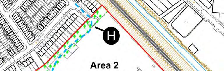
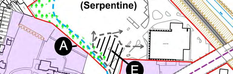

47 3736x13Final

48 Appendix 1 ILLUSTRATIONS 3736x13Final


49 View g - from the top of the tower of the Church View from inside the boundary of the Serpentine site 3736x13Final View d - from the Aston Hall Road, looking at the entrance of the site


50 View of the Serpentine Site with the new development and the Church View a - Winter view from the Butler s Attic 3736x13Final
Planning and Regeneration PO Box 28, Birmingham B1 1TU DECISION DOCUMENT APPLICATION NUMBER: 2017/05933/PA TOWN AND COUNTRY PLANNING ACT 1990
 Planning and Regeneration PO Box 28, Birmingham B1 1TU DECISION DOCUMENT APPLICATION NUMBER: 2017/05933/PA TOWN AND COUNTRY PLANNING ACT 1990 APPLICANT EDSI 1 Lancaster Circus Queensway Birmingham B4 7DJ
TRANSPORT AND WORKS ACT 1992 TRANSPORT AND WORKS (APPLICATIONS AND OBJECTIONS PROCEDURE)(ENGLAND AND WALES) RULES 2006
(ENGLAND AND WALES) RULES 2006") TRANSPORT AND WORKS ACT 1992 TRANSPORT AND WORKS (APPLICATIONS AND OBJECTIONS PROCEDURE)(ENGLAND AND WALES) RULES 2006 THE MIDLAND METRO (BIRMINGHAM CITY CENTRE EXTENSION LAND ACQUISITION AND VARIATION)
TRANSPORT AND WORKS ACT 1992 TRANSPORT AND WORKS (APPLICATIONS AND OBJECTIONS PROCEDURE)(ENGLAND AND WALES) RULES 2006 THE MIDLAND METRO (BIRMINGHAM CITY CENTRE EXTENSION LAND ACQUISITION AND VARIATION)
Departure from the Development Plan. Town Council objection to a major application. DETERMINE
 Item No. 9 APPLICATION NUMBER CB/17/01642/OUT LOCATION Land rear of 43 to 91 Silver Birch Avenue South of Alder Green and Aspen Gardens, Aspen Gardens, Stotfold PROPOSAL Outline application for up to 95
DEVELOPMENT MANAGEMENT REPORT
 ITEM A08-1 DEVELOPMENT MANAGEMENT REPORT TO: BY: DATE: DEVELOPMENT: SITE: WARD: APPLICATION: APPLICANT: Development Management Committee Development Manager Proposed live/work unit in connection with existing
Land Adj. 63 Sunny Bank Road, Sutton Coldfield, Birmingham, B73 5RJ
 Committee Date: 11/07/2013 Application Number: 2013/03520/PA Accepted: 20/05/2013 Application Type: Full Planning Target Date: 15/07/2013 Ward: Sutton Vesey Land Adj. 63 Sunny Bank Road, Sutton Coldfield,
CA//16/00504/FUL. Canterbury City Council Military Road Canterbury Kent CT1 1YW. Crown copyright and database rights 2016 Ordnance Survey
 O Scale 1:1,250 Map Dated: 09/05/2016 CA//16/00504/FUL Crown copyright and database rights 2016 Ordnance Survey 100019614 Canterbury City Council Military Road Canterbury Kent CT1 1YW AGENDA ITEM NO 13
SOUTH CAMBRIDGESHIRE DISTRICT COUNCIL. Executive Director (Operational Services) Corporate Manager (Planning and New Communities)
 Corporate Manager (Planning and New Communities)") SOUTH CAMBRIDGESHIRE DISTRICT COUNCIL REPORT TO: Planning Committee 12 January 2011 AUTHOR/S: Executive Director (Operational Services) Corporate Manager (Planning and New Communities) Notes: S/1848/10
SOUTH CAMBRIDGESHIRE DISTRICT COUNCIL REPORT TO: Planning Committee 12 January 2011 AUTHOR/S: Executive Director (Operational Services) Corporate Manager (Planning and New Communities) Notes: S/1848/10
Replacement Golf Course Facilities and Residential Development, Churston. Environmental Statement Non-Technical Summary
 Replacement Golf Course Facilities and Residential Development, Churston Environmental Statement Non-Technical Summary July 2011 Reproduced from the Ordnance Survey s map with the permission of the Controller
Parish of Repton NEIGHBOURHOOD DEVELOPMENT PLAN
 Parish of Repton NEIGHBOURHOOD DEVELOPMENT PLAN BASIC CONDITIONS STATEMENT December 2018 CEF 4 Legal Requirements This statement has been produced by the NDP Working Group on behalf of Repton Parish Council
Newcourt Masterplan. November Exeter Local Development Framework
 Newcourt Masterplan November 2010 Exeter Local Development Framework Background The Exeter Core Strategy Proposed Submission sets out the vision, objectives and strategy for the development of Exeter up
YMCA Erdington (Phase 2), 300 Reservoir Road, Erdington, Birmingham, B23 6DB
, 300 Reservoir Road, Erdington, Birmingham, B23 6DB") Committee Date: 13/06/2013 Application Number: 2013/03011/PA Accepted: 30/04/2013 Application Type: Full Planning Target Date: 30/07/2013 Ward: Stockland Green YMCA Erdington (Phase 2), 300 Reservoir Road,
Committee Date: 13/06/2013 Application Number: 2013/03011/PA Accepted: 30/04/2013 Application Type: Full Planning Target Date: 30/07/2013 Ward: Stockland Green YMCA Erdington (Phase 2), 300 Reservoir Road,
SOUTH CAMBRIDGESHIRE DISTRICT COUNCIL. REPORT TO: Planning Committee 1 April 2015 Planning and New Communities Director
 SOUTH CAMBRIDGESHIRE DISTRICT COUNCIL REPORT TO: Planning Committee 1 April 2015 AUTHOR/S: Planning and New Communities Director Application Number: Parish(es): Proposal: Site address: Applicant(s): Recommendation:
Sustainability Statement. Whitby Business Park Area Action Plan
 Sustainability Statement Whitby Business Park Area Action Plan November 2014 Contents Page 1. Introduction 1 2. Scoping 3 3. Sustainability Appraisal of Options 6 4. Assessment of Draft Area Action Plan
Derry City and Strabane District Council Planning Committee Report. Environmental Improvement Scheme. Derry City & Strabane District Council
 Derry City and Strabane District Council Planning Committee Report COMMITTEE DATE: 7 th September 2016 APPLICATION No: APPLICATION TYPE: PROPOSAL: LA11/2015/0776/F Environmental Improvement Scheme Provision
Application Recommended for Approval Hapton with Park Ward
 Application Recommended for Approval Hapton with Park Ward APP/2017/0036 Outline Planning Application Outline application for the construction of a new 3 bedroom dwelling (with all matters reserved for
Description Details submitted pursuant to discharge of condition 5 (Design Code) attached to planning permission 13/01729/OUT.
 attached to planning permission 13/01729/OUT.") ITEM 9 Application Number: 18/00266/DISCON Description Details submitted pursuant to discharge of condition 5 (Design Code) attached to planning permission 13/01729/OUT. AT The Point, 602 Midsummer Boulevard,
ITEM 9 Application Number: 18/00266/DISCON Description Details submitted pursuant to discharge of condition 5 (Design Code) attached to planning permission 13/01729/OUT. AT The Point, 602 Midsummer Boulevard,
Report Author/Case Officer: Paul Keen Senior Planning Officer (Dev Control) Contact Details:
 Contact Details:") APP 03 Application Number: 17/02060/FUL Description A full planning application for the demolition of an existing bungalow (C3 use class) and associated out buildings and the erection of two, two storey
APP 03 Application Number: 17/02060/FUL Description A full planning application for the demolition of an existing bungalow (C3 use class) and associated out buildings and the erection of two, two storey
Derry City and Strabane District Council Planning Committee Report
 Derry City and Strabane District Council Planning Committee Report COMMITTEE DATE: 23 rd March 2016 APPLICATION No: APPLICATION TYPE: PROPOSAL: LOCATION: APPLICANT: LA11/2015/0395/F Residential Development
Mr & Mrs Connolly per Pump House Designs Pump House Yard The Green SEDLESCOMBE, East Sussex. TN33 0QA
 AGENDA ITEM NO: 5 (c) Report to: PLANNING COMMITTEE Date: 03 June 2015 Report from: Head of Housing and Planning Services Application Address: Proposal: Application No: Recommendation: Ward: File No: Applicant:
Redevelopment of the site, including demolition of existing buildings, for approximately 96 new dwellings and associated works - outline
 Application Number 15/00986/OUT Proposal Site Applicant Recommendation Redevelopment of the site, including demolition of existing buildings, for approximately 96 new dwellings and associated works - outline
MATURE SUBURBS RESIDENTIAL DEVELOPMENT GUIDELINES
 MATURE SUBURBS RESIDENTIAL DEVELOPMENT GUIDELINES DRAFT FEBRUARY 2005 BIRMINGHAM CITY COUNCIL 1 Introduction Mature Suburbs Residential Development Guidelines - Interim Supplementary Planning Advice -
Mid Suffolk District Council Planning Control Department 131 High Street Needham Market IP6 8DL
 Mid Suffolk District Council Planning Control Department 131 High Street Needham Market IP6 8DL OUTLINE PLANNING PERMISSION Town and Country Planning Act 1990 THE TOWN AND COUNTRY PLANNING (DEVELOPMENT
PARISH / WARD: Peacehaven / Peacehaven East PROPOSAL:
 APPLICATION ITEM LW/16/0802 NUMBER: NUMBER: 7 APPLICANTS NAME(S): Mr J Robison & Ms S Teng PARISH / WARD: Peacehaven / Peacehaven East PROPOSAL: Planning Application for Conversion of existing garage to
Neighbourhood Planning Local Green Spaces
 Neighbourhood Planning Local Green Spaces Introduction... 2 1. Why green space is important... 4 2. Neighbourhood plans and green space... 6 3. Evidence... 8 Statutory designations... 9 Green space audit...
DONCASTER METROPOLITAN BOROUGH COUNCIL. PLANNING COMMITTEE 3 rd May Expiry Date:
 DONCASTER METROPOLITAN BOROUGH COUNCIL PLANNING COMMITTEE 3 rd May 2016 Application 7 Application Number: 16/00741/FUL Application Expiry Date: 3 rd May 2016 Application Type: Full application Proposal
2014/0590 Reg Date 26/06/2014 Chobham
 2014/0590 Reg Date 26/06/2014 Chobham LOCATION: PROPOSAL: TYPE: APPLICANT: OFFICER: ASCOT PARK POLO CLUB, WESTCROFT PARK FARM, WINDLESHAM ROAD, CHOBHAM, WOKING, GU24 8SN Erection of a two storey detached
Tennis Court Rear Of 3-5 Corringway London NW11 7ED
 Location Tennis Court Rear Of 3-5 Corringway London NW11 7ED Reference: 18/4122/FUL Received: 3rd July 2018 Accepted: 3rd July 2018 Ward: Garden Suburb Expiry 28th August 2018 Applicant: Ms Sarah Robinson
Garages To Rear Of The Willows 1025 High Road London N20 0QE
 Location Garages To Rear Of The Willows 1025 High Road London N20 0QE Reference: 15/03944/FUL Received: 25th June 2015 Accepted: 2nd July 2015 Ward: Totteridge Expiry 27th August 2015 Applicant: Mr Alex
St Michaels C of E Junior & Infant School, Nantmel Grove, Bartley Green, Birmingham, B32 3JS
 Committee Date: 06/03/2014 Application Number: 2013/08595/PA Accepted: 19/11/2013 Application Type: Full Planning Target Date: 14/01/2014 Ward: Bartley Green St Michaels C of E Junior & Infant School,
PLANNING COMMITTEE REPORT
 PLANNING COMMITTEE REPORT TO: BY: Planning Committee South Head of Development DATE: 19 December 2017 DEVELOPMENT: SITE: WARD: APPLICATION: APPLICANT: Conversion of existing water storage reservoir to
STATEMENT OF OBJECTION TO THE PROPOSED DEVELOPMENT OF LAND AT CHURCH CLIFF DRIVE FILEY
 STATEMENT OF OBJECTION TO THE PROPOSED DEVELOPMENT OF LAND AT CHURCH CLIFF DRIVE FILEY You will be aware that Scarborough borough council have adopted a new local plan that includes land at Church Cliff
Statement of Community Involvement LAND OFF SOUTHDOWN ROAD HORNDEAN, HAMPSHIRE
 LAND OFF SOUTHDOWN ROAD HORNDEAN, HAMPSHIRE CONTENTS Page 1. Introduction 3 2. Pre-application Discussions 4 3. The Consultation Process 5 4. Consultation Feedback 7 5. Responses to Consultation Feedback
Former North Works, Lickey Road, Longbridge, Birmingham
 Committee Date: 14/11/2013 Application Number: 2013/06431/PA Accepted: 27/08/2013 Application Type: Full Planning Target Date: 26/11/2013 Ward: Longbridge Former North Works, Lickey Road, Longbridge, Birmingham
26 September 2014 CONSULTATION EXPIRY : APPLICATION EXPIRY : 22 July 2014 SUMMARY RECOMMENDATION: PERMISSION
 Item No.: 5 The information, recommendations and advice contained in this report are correct as at the date of preparation, which is more than one week in advance of the Committee meeting. Because of the
Plots 4 & 6, Prologis Park, Midpoint Way, Sutton Coldfield, Birmingham, B76 9EH
 Committee Date: 19/03/2015 Application Number: 2015/00285/PA Accepted: 19/01/2015 Application Type: Full Planning Target Date: 20/04/2015 Ward: Sutton New Hall Plots 4 & 6, Prologis Park, Midpoint Way,
Designations protecting the historic designed landscape
 Historic Landscape Project Designations protecting the historic designed landscape A. Key national designations affecting the historic environment: 1. Listed buildings 2. Scheduled Monuments (generally
Date: TOWN AND COUNTRY PLANNING (ENVIRONMENTAL IMPACT ASSESSMENT) REGULATIONS 2011: REGULATION 13 SCOPING OPINION
 REGULATIONS 2011: REGULATION 13 SCOPING OPINION") PLANNING & BUILDING CONTROL Tracy Harvey Head of Planning & Building Control Rob Wells Savills Innovation Court 121 Edmund Street Birmingham B3 2HJ Our Ref: 5/16/3441 E-mail: Date: planning@stalbans.gov.uk
PLANNING & BUILDING CONTROL Tracy Harvey Head of Planning & Building Control Rob Wells Savills Innovation Court 121 Edmund Street Birmingham B3 2HJ Our Ref: 5/16/3441 E-mail: Date: planning@stalbans.gov.uk
Planning and Regulatory Committee 20 May Applicant Local Councillor Purpose of Report
 Planning and Regulatory Committee 20 May 2014 7. APPLICATION FOR PLANNING PERMISSION FOR THE CARRYING-OUT OF DEVELOPMENT PURSUANT TO PLANNING PERMISSION REFERENCE NUMBER 603451 DATED 28 FEBRUARY 2007 WITHOUT
Reserved Matters application for a site that straddles the boundary between CBC and BBC
 BBC APPLICATION 15/02682/MAR NUMBER CBC APPLICATION CB/15/04294/RM NUMBER LOCATION Wixams Land at former storage depot, Bedford Road, Wilstead Bedfordshire PROPOSAL Reserved Matters Application for Strategic
Agenda Update Sheet. Planning Committee A
 Agenda Update Sheet Planning Committee A Date: 22 nd June 2017 Agenda Section 5: Applications Part I Recommended for Approval ITEM: 1 DM/16/5502 Summary of Consultees Surrey County Council No objection
Land at Rampton Road. Cottenham
 Land at Rampton Road Cottenham Introduction TEP is preparing an outline planning application for 54 dwellings on 6.9 hectares of land adjacent to Rampton Road, Cottenham on behalf of the owners Cambridgeshire
It is recommended that the Committee resolve to APPROVE the application and grant planning permission subject to the following conditions:
 LOCATION: Phase 2A Millbrook Park (Site of Former Inglis Barracks), Mill Hill East, London, NW7 1PZ REFERENCE: H/04606/12 Received: 04 December 2012 Accepted: 17 December 2012 WARD: Mill Hill Expiry: 18
Plumpton Neighbourhood Development Plan Revised Pre Submission Document - Regulation 14 Consultation
 REPRESENTATIONS... Plumpton Parish Council Plumpton Neighbourhood Development Plan Revised Pre Submission Document - Regulation 14 Consultation Representations submitted on behalf of: Cala Homes (South
Plaistow and Ifold Neighbourhood Plan Pre-Submission Consultation Draft
 Mrs Beverley Weddell Clerk to Plaistow And Ifold Parish Council Lock House Lodge Knightons Lane Dunsfold, GU8 4NU. Dear Mrs Weddell, Our ref: Your ref: Telephone Fax HD/P5402/ 01483 252040 18 th October
Great Easton Neighbourhood Plan Statement of Basic Conditions
 Great Easton Neighbourhood Plan 2017-2031 Statement of Basic Conditions OCTOBER 2016 GREAT EASTON PARISH COUNCIL Contents 1.0 Introduction....Page 2 2.0 Summary of Submission Documents and Supporting Evidence..
Welcome to our exhibition
 Welcome to our exhibition The Homes & Communities Agency (HCA) welcomes you to this public exhibition explaining our proposals for the redevelopment of the former Lea Castle Hospital site. About the Homes
Longbridge Town Centre Phase 2 Planning Application
 Longbridge Town Centre Phase 2 Planning Application Non-Technical Summary of the Environmental Statement December 2013 Introduction A full application for Planning Permission has been submitted to Birmingham
Public Consultation. Land at Monks Farm, North Grove. Welcome
 Welcome Welcome to our public exhibition for development on Land at Monks Farm, orth Grove. Gallagher Estates and Gleeson Strategic Land are preparing an outline planning application for new homes, open
Case Officer: Sarah Kay File No: CHE/14/00515/REM Tel. No: (01246) Plot No: 2/6132 Ctte Date: 15 th September 2014 ITEM 1
 Plot No: 2/6132 Ctte Date: 15 th September 2014 ITEM 1") Case Officer: Sarah Kay File No: CHE/14/00515/REM Tel. No: (01246) 345786 Plot No: 2/6132 Ctte Date: 15 th September 2014 ITEM 1 APPROVAL OF RESERVED MATTERS FROM APPLICATION CHE/12/00234/OUT (1) LAYOUT,
Case Officer: Sarah Kay File No: CHE/14/00515/REM Tel. No: (01246) 345786 Plot No: 2/6132 Ctte Date: 15 th September 2014 ITEM 1 APPROVAL OF RESERVED MATTERS FROM APPLICATION CHE/12/00234/OUT (1) LAYOUT,
CA//17/02777/FUL. Scale 1:1,250. Planning Services Canterbury City Council Military Road Canterbury Kent CT1 1YW
 O CA//17/02777/FUL Scale 1:1,250 Map Dated: 15/03/2018 Planning Services Canterbury City Council Military Road Canterbury Kent CT1 1YW AGENDA ITEM NO 16 PLANNING COMMITTEE APPLICATION NUMBER: SITE LOCATION:
SOUTH CAMBRIDGESHIRE DISTRICT COUNCIL. Director of Development Services
 SOUTH CAMBRIDGESHIRE DISTRICT COUNCIL REPORT TO: Development and Conservation Control Committee 5 th April 2006 AUTHOR/S: Director of Development Services S/2290/05/F Haslingfield House (Revised Design)
SOUTH CAMBRIDGESHIRE DISTRICT COUNCIL. Planning and New Communities Director
 SOUTH CAMBRIDGESHIRE DISTRICT COUNCIL REPORT TO: Planning Committee 9 January 2013 AUTHOR/S: Planning and New Communities Director S/2270/12/FL FEN DRAYTON 850m long flood defence embankment ranging in
Site north of Hattersley Road West (east of Fields Farm Road), Hattersley
, Hattersley") Application Number 17/00982/REM Proposal Site Applicant Recommendation Reason for report Application for the approval of reserved matters (means of access, landscaping, layout, scale and appearance) relating
Application Number 17/00982/REM Proposal Site Applicant Recommendation Reason for report Application for the approval of reserved matters (means of access, landscaping, layout, scale and appearance) relating
1 The development hereby permitted shall be carried out in accordance with the following approved plans:
 Location 59 Greenway Close London N20 8ES Reference: 16/00011/HSE Received: 30th December 2015 Accepted: 7th January 2016 Ward: Totteridge Expiry 3rd March 2016 Applicant: Mr Ankit Shah Proposal: Part
Introduction. Grounds of Objection
 Planning application ref. number 18/04496/APP Planning application to Aylesbury Vale District Council for the erection of 17 dwellings and associated works to the South of Hogshaw Road Granborough. Granborough
Kibworth Harcourt. Introduction. Introduction
 Introduction Introduction Welcome to this public exhibition on the proposals for the delivery of new homes on land at The Kibworths. The purpose of today s exhibition is to give you the opportunity to
PLANNING COMMITTEE DATE: 07/09/2015 REPORT OF THE SENIOR MANAGER PLANNING AND ENVIRONMENT SERVICE CAERNARFON. Number: 4
 Number: 4 Application Number: C15/0034/37/LL Date Registered: 21/05/2015 Application Type: Full - Planning Community: Llanaelhaearn Ward: Llanaelhaearn Proposal: Location: Summary of the Recommendation:
UTT/17/2075/FUL - (BERDEN) (Referred to Committee by Councillor Janice Loughlin. Reason: In the Public Interest)
 (Referred to Committee by Councillor Janice Loughlin. Reason: In the Public Interest)") UTT/17/2075/FUL - (BERDEN) (Referred to Committee by Councillor Janice Loughlin. Reason: In the Public Interest) PROPOSAL: LOCATION: APPLICANT: Amendments to the design of a scheme for a 49.99MW battery
UTT/17/2075/FUL - (BERDEN) (Referred to Committee by Councillor Janice Loughlin. Reason: In the Public Interest) PROPOSAL: LOCATION: APPLICANT: Amendments to the design of a scheme for a 49.99MW battery
University Park, Worcester Non Technical Summary December 2011
 University Park, Worcester Non Technical Summary December 2011 Introduction UW Wrenbridge LLP, a Joint Venture Company of the University of Worcester and Wrenbridge Land Ltd (the Applicants ) intend to
Welcome to our exhibition
 Welcome to our exhibition housing development A46 Wildmoor Alcester Road Canal Quarter A422 Town Centre housing development Warwickshire-based IM Properties, one of the UK s largest privately owned property
LETTER OF OBJECTION LAND TO THE SOUTH WEST OF FORGE GARAGE, HIGH STREET, PENSHURST, KENT, TN11 8BU
 Senior Planning Officer Andrew Byrne Sevenoaks District Council Community & Planning Services PO Box 183 Argyle Road Sevenoaks Kent TN13 1GN 04 November 2011 Your Ref: 11/02258/FUL For the attention of
St Marys Church Of England High School Downage London NW4 1AB
 Location St Marys Church Of England High School Downage London NW4 1AB Reference: 16/2877/FUL Received: 29th April 2016 Accepted: 10th May 2016 Ward: Hendon Expiry 5th July 2016 Applicant: Proposal: Governors
Schedule of Planning Applications Committee Date: 23 May Reference: 06/17/0726/F Parish: Hemsby Officer: Mr J Beck Expiry Date:
 Schedule of Planning Applications Committee Date: 23 May 2018 Reference: 06/17/0726/F Parish: Hemsby Officer: Mr J Beck Expiry Date: 22-05-2018 Applicant: Proposal: Site: Mr Gillett Change of use to the
Applicant s partner is an employee of the Council COMMITTEE TO DETERMINE
 Item No. 13 APPLICATION NUMBER CB/13/02360/FULL LOCATION Land adj to 2 Sandy Lane, Leighton Buzzard, LU7 3BE PROPOSAL Demolition of existing garages & construction of a new 2 bed bungalow, together with
Construction of 9 dwellings and associated infrastructure.
 Application Number 16/00653/FUL Proposal Site Applicant Recommendation Construction of 9 dwellings and associated infrastructure. Land at Grange Road South, Hyde McDermott Developments Ltd Approve REPORT
LAND & DEVELOPMENT OFFICE. 170 Church Road, Hove, BN3 2DJ mishonmackay.com
 LAND & DEVELOPMENT OFFICE 170 Church Road, Hove, BN3 2DJ 01273 829300 land@mishonmackay.com mishonmackay.com APPLICATION NUMBER: APPLICANTS NAME(S): PROPOSAL: LW/15/0462 Seaview Developments ( Sussex )
Change Paper / Date CAIRNGORMS NATIONAL PARK AUTHORITY
 Change Paper / Date CAIRNGORMS NATIONAL PARK AUTHORITY Title: Prepared by: REPORT ON CALLED-IN PLANNING APPLICATION FIONA MURPHY (PLANNING OFFICER DEVELOPMENT MANAGEMENT) DEVELOPMENT PROPOSED: REFERENCE:
Planning Area Committee 25 June 2018 Addendum to Officers Report RESTRICTION OF PERMITTED DEVELOPMENT RIGHTS - EXTENSIONS
 Planning Area Committee 25 June 2018 Addendum to Officers Report 17/8150/RMA West Hendon Regeneration Area (Phase 6) Pages 11 54 The conditions section shall be changed as follows: RESTRICTION OF PERMITTED
Ward: West Wittering. Proposal Change of use from public highway pavement to residential garden use.
 Parish: West Wittering Ward: West Wittering WW/17/03295/FUL Proposal Change of use from public highway pavement to residential garden use. Site Izora 1 Watersedge Gardens West Wittering PO20 8RA Map Ref
1.0 INTRODUCTION. Brantham Industrial Area Regeneration - Factory Lane - Brantham
 1.0 INTRODUCTION Welcome to this exhibition of our proposals for the regeneration of the Brantham Industrial Area located off Factory Lane in Brantham. This presentation will give you an opportunity to
12 TH ANNUAL CHILTERNS AONB PLANNING CONFERENCE ENGLISH HERITAGE: HISTORIC ENVIRONMENT GOOD PRACTICE ADVICE
 12 TH ANNUAL CHILTERNS AONB PLANNING CONFERENCE ENGLISH HERITAGE: HISTORIC ENVIRONMENT GOOD PRACTICE ADVICE MARTIN SMALL HISTORIC ENVIRONMENT PLANNING ADVISER ENGLISH HERITAGE Policy ENGLISH HERITAGE GOOD
RULE 6 (6) STATEMENT OF CASE
 STATEMENT OF CASE") RULE 6 (6) STATEMENT OF CASE Former Allerthorpe Park Golf Club, Allerthorpe, YO42 4RL Submitted on Behalf of Allerthorpe Parish Council Appeal by Turnwalk Ltd. and Park Leisure 2000 Ltd. Appeal Reference:
RULE 6 (6) STATEMENT OF CASE Former Allerthorpe Park Golf Club, Allerthorpe, YO42 4RL Submitted on Behalf of Allerthorpe Parish Council Appeal by Turnwalk Ltd. and Park Leisure 2000 Ltd. Appeal Reference:
BLETCHLEY PARK AREA - DEVELOPMENT FRAMEWORK
 ANNEX A To Item 9 REVISED TEXT: additions shown bold and underlined, deletions in (brackets and in italics). BLETCHLEY PARK AREA - DEVELOPMENT FRAMEWORK This framework sets out the key objectives and requirements
SOUTH CAMBRIDGESHIRE DISTRICT COUNCIL. Planning and New Communities Director
 SOUTH CAMBRIDGESHIRE DISTRICT COUNCIL REPORT TO: Planning Committee 9 January 2013 AUTHOR/S: Planning and New Communities Director S/2064/12/FL WATERBEACH Demolition of existing 35 no. shared amenity apartments
REFERENCE: B/00601/12 Received: 11 February 2012 Accepted: 21 February 2012 WARD(S): High Barnet Expiry: 17 April 2012
: High Barnet Expiry: 17 April 2012") LOCATION: 37 Kings Road, Barnet, Herts, EN5 4EG REFERENCE: B/00601/12 Received: 11 February 2012 Accepted: 21 February 2012 WARD(S): High Barnet Expiry: 17 April 2012 Final Revisions: APPLICANT: PROPOSAL:
LOCATION: 37 Kings Road, Barnet, Herts, EN5 4EG REFERENCE: B/00601/12 Received: 11 February 2012 Accepted: 21 February 2012 WARD(S): High Barnet Expiry: 17 April 2012 Final Revisions: APPLICANT: PROPOSAL:
Final Revisions: Provision of single storey modular classroom and associated works.
 LOCATION: St Catherines Catholic Primary School, Vale Drive, Barnet, Herts, EN5 2ED REFERENCE: B/01924/12 Received: 17 May 2012 Accepted: 28 May 2012 WARD(S): Underhill Expiry: 23 July 2012 Final Revisions:
SPG 1. * the northern and western sections which are open fields used for pasture and grazing;
 SPG 1 1.0 INTRODUCTION This development brief is based on the allocation of the Priors Hall site for employment and countryside recreational purposes in the Corby Borough Local Plan. The brief is intended
REFERENCE: 15/01661/FUL Registered: 16 March 2015 Expiry date: 25 October 2016
 LOCATION: Land North Of Charcot Road, Colindale REFERENCE: 15/01661/FUL Registered: 16 March 2015 Expiry date: 25 October 2016 WARD: Colindale APPLICANT: PROPOSAL: Fairview New Homes (Colindale) Ltd Erection
Test Valley Borough Council Southern Area Planning Committee 8 January 2019
 ITEM 11 APPLICATION NO. 18/02218/FULLS APPLICATION TYPE FULL APPLICATION - SOUTH REGISTERED 23.08.2018 APPLICANT Rugby Football Union SITE The Trojans Club, Stoneham Lane, Eastleigh, SO50 9HT, CHILWORTH
Ground Floor Flat 15 Redbourne Avenue London N3 2BP
 Location Ground Floor Flat 15 Redbourne Avenue London N3 2BP Reference: 17/4160/FUL Received: 28th June 2017 Accepted: 29th June 2017 Ward: West Finchley Expiry 24th August 2017 Applicant: Proposal: Mr
Land off Nursery Road / Church Street, Lozells, Birmingham, B19. Erection of 5 no. dwellings and retention of area of public open space.
 Committee Date: 08/08/2013 Application Number: 2013/03635/PA Accepted: 14/06/2013 Application Type: Full Planning Target Date: 09/08/2013 Ward: Lozells and East Handsworth Land off Nursery Road / Church
SOUTH CAMBRIDGESHIRE DISTRICT COUNCIL. Planning and New Communities Director
 SOUTH CAMBRIDGESHIRE DISTRICT COUNCIL REPORT TO: Planning Committee 3 October 2012 AUTHOR/S: Planning and New Communities Director S/1723/12/OL CAXTON AND ELSWORTH OUTLINE APPLICATION FOR ERECTION OF RESTAURANT/TAKEAWAY
Site off Hattersley Road West (bound by Hattersley Road West to the north west and Sandy Bank Avenue to the south and west), Hattersley
, Hattersley") Application Number 17/00984/REM Proposal Site Applicant Recommendation Reason for report Application for the approval of reserved matters (means of access, landscaping, layout, scale and appearance) relating
Application Number 17/00984/REM Proposal Site Applicant Recommendation Reason for report Application for the approval of reserved matters (means of access, landscaping, layout, scale and appearance) relating
Site Address: Site Accessed off Bondfield Close, Bondfield Crescent, Wombwell, Barnsley, S73 8TX
 2017/0155 Applicant: Craig Hawley, Gleeson Regeneration Ltd Description: Residential development of 49 no dwelling houses. Site Address: Site Accessed off Bondfield Close, Bondfield Crescent, Wombwell,
St Barnabas C of E Primary School, Spring Lane, Erdington, Birmingham, B24 9BY
 Committee Date: 12/06/2014 Application Number: 2014/02967/PA Accepted: 29/04/2014 Application Type: Full Planning Target Date: 24/06/2014 Ward: Erdington St Barnabas C of E Primary School, Spring Lane,
Perth and Kinross Council Development Management Committee 8 June Pre-Application Report by Development Quality Manager
 Perth and Kinross Council Development Management Committee 8 June 2016 5(3)(i) 16/259 Pre-Application Report by Development Quality Manager Residential development at St Martins Road, Land 120 metres West
INTRODUCTION NORTH HEYBRIDGE GARDEN SUBURB
 INTRODUCTION This event is being hosted by the promoters of the proposed North Heybridge Garden Suburb who are working with Maldon District Council and other key stakeholders on the preparation of a comprehensive
Perth and Kinross Council Development Management Committee 20 February 2013 Report of Handling by Development Quality Manager
 Perth and Kinross Council Development Management Committee 20 February 2013 Report of Handling by Development Quality Manager 4(4)(iii) 13/81 Erection of sports hall, associated changing facilities, offices
Ref: A073350/SM/sm Date: 13 September 2013
 Ref: A073350/SM/sm Date: 13 September 2013 Ian Parkinson Development Control Team Leader Planning Portsmouth City Council Civic Offices Guildhall Square Portsmouth PO1 2AY Dear Ian LIGHT & GLEAVE VILLA
DELEGATION REPORT REPORT OF THE CHIEF PLANNING OFFICER. WARD: Hyde Park & Woodhouse Application: 12/01402/FU
 DELEGATION REPORT REPORT OF THE CHIEF PLANNING OFFICER WARD: Hyde Park & Woodhouse Application: 12/01402/FU Address: 153 Woodhouse Lane Woodhouse Leeds LS2 3ED Applicant: West Yorkshire Police Estates
volume 11 environmental assessment section 2 environmental impact assessment Part 7 ha 218/08
 DESIGN MANUAL FOR ROADS AND BRIDGES volume 11 environmental assessment section 2 environmental impact assessment Part 7 ha 218/08 glossary of terms Used in DMRB Volume 11, Sections 1 and 2 SUMMARY This
SOUTH CAMBRIDGESHIRE DISTRICT COUNCIL. Planning and New Communities Director
 SOUTH CAMBRIDGESHIRE DISTRICT COUNCIL REPORT TO: Planning Committee 5 June 2013 AUTHOR/S: Planning and New Communities Director S/0747/13/FL HISTON Construction of Car Park at Histon Baptist Church, Station
DELEGATED DECISION on 1st September 2015
 Application N o : 14/04810/OUT LONDON BOROUGH OF BROMLEY TOWN PLANNING RENEWAL AND RECREATION DEPARTMENT DELEGATED DECISION on 1st September 2015 14/04810/OUT Claire Harris 4 Oaklands Road Bromley BR1
Persimmon Homes Thames Valley Date received: 2 nd April week date(major): 2 nd July 2014 Ward: Nascot
: 2 nd July 2014 Ward: Nascot") PART A Report of: DEVELOPMENT MANAGEMENT SECTION HEAD Date of Committee: 26 th June 2014 Site address: Rounton, 28, Nascot Wood Road Reference Number: 14/00497/REM Description of Development: Reserved
PART A Report of: DEVELOPMENT MANAGEMENT SECTION HEAD Date of Committee: 26 th June 2014 Site address: Rounton, 28, Nascot Wood Road Reference Number: 14/00497/REM Description of Development: Reserved
SUBJECT TO ATTACHED SCHEDULE OF THIRTY SIX CONDITIONS
 Stratton House 58/60 High West Street Dorchester Dorset DT1 1UZ Duchy of Cornwall Poundbury Farmhouse Poundbury Farm Way Poundbury Dorchester DT1 3RT Tel: (01305) 251010 Fax: (01305) 251481 Minicom: (01305)
REFERENCE: B/03745/12 Received: 02 October 2012 Accepted: 05 October 2012 WARD(S): Totteridge Expiry: 30 November 2012.
: Totteridge Expiry: 30 November 2012.") LOCATION: 15A Pyecombe Corner, London, N12 7AJ REFERENCE: B/03745/12 Received: 02 October 2012 Accepted: 05 October 2012 WARD(S): Totteridge Expiry: 30 November 2012 Final Revisions: APPLICANT: PROPOSAL:
LOCATION: 15A Pyecombe Corner, London, N12 7AJ REFERENCE: B/03745/12 Received: 02 October 2012 Accepted: 05 October 2012 WARD(S): Totteridge Expiry: 30 November 2012 Final Revisions: APPLICANT: PROPOSAL:
Derry City and Strabane District Council Planning Committee Report
 Derry City and Strabane District Council Planning Committee Report COMMITTEE DATE: 20.12.2017 APPLICATION No: APPLICATION TYPE: PROPOSAL: LOCATION: APPLICANT: AGENT: A/2014/0495/F Full Construction of
5 Gratton Terrace London NW2 6QE. Reference: 17/5094/HSE Received: 4th August 2017 Accepted: 7th August 2017 Ward: Childs Hill Expiry 2nd October 2017
 Location 5 Gratton Terrace London NW2 6QE Reference: 17/5094/HSE Received: 4th August 2017 Accepted: 7th August 2017 Ward: Childs Hill Expiry 2nd October 2017 Applicant: WSD (Gratton) Ltd Proposal: The
DONCASTER METROPOLITAN BOROUGH COUNCIL. PLANNING COMMITTEE - 15th October Expiry Date:
 DONCASTER METROPOLITAN BOROUGH COUNCIL PLANNING COMMITTEE - 15th October 2013 Application 3 Application Number: 13/01158/FUL Application Expiry Date: 31st July 2013 Application Type: Full Application Proposal
Birmingham Science Park Aston, Woodcock Street, Birmingham, B7 4BB
 Committee Date: 11/06/2015 Application Number: 2015/02024/PA Accepted: 23/03/2015 Application Type: Full Planning Target Date: 22/06/2015 Ward: Nechells Birmingham Science Park Aston, Woodcock Street,