HISTORIC AMERICAN LANDSCAPES SURVEY ROCK HILL ESTATE. Dr. Henry Alford Porter Landscape
|
|
|
- Alyson Randall
- 5 years ago
- Views:
Transcription
1 HISTORIC AMERICAN LANDSCAPES SURVEY ROCK HILL ESTATE Dr. Henry Alford Porter Landscape VDHR# The Rock Hill Estate is currently composed of acres of land and addressed at 1025 Park Street in the City of Charlottesville, Virginia. The parcel is located within the Piedmont Plateau physiographic region of the state and sits on the north side of the Route 250 Bypass, just east of McIntire Park and a small watercourse known as Schenk s Branch. The topography of the property is marked by hilly and steeply sloped terrain, augmented by stepped-terrace walls and stairs, and dotted by rock outcroppings and various stone features befitting the name of Rock Hill. Within the past twenty years or more, the parcel became largely wooded and overgrown, but recent clean-up efforts have significantly improved visibility of the site. Today, the extant Rock Hill Landscape can be divided into three distinct sections: the formal garden area at the south side of the parcel, the natural area at the northwest corner, and the Modern area, associated with mid- to late-twentieth century construction which replaced much of the historic lawn and orchard, located in the northeast section of the property. The entire parcel is enclosed by a mortared stone wall, ranging from roughly 4 ½ to more than 5 in height, and was historically approached from the southeast via an access road, later Rugby Avenue and currently the Route 250 Bypass, extending west from what is now known as Park Street, one of Charlottesville s oldest roadways. The parcel is currently owned and occupied by the Monticello Area Community Action Agency (MACAA), but several buildings on site are presently vacant. MACAA was established in 1965 to serve the City of Charlottesville and the Counties of Albemarle, Fluvanna, Louisa, and Nelson in an effort to eradicate poverty and to improve the lives of people living in our communities a mission that stems from the Economic Opportunity Act of The property was obtained by the organization in the early 1990s, and is one of ten centers across the region where the agency conducts various aid programs. The facilities at Rock Hill house the group s main offices. In a letter dated March 7, 2008, the Virginia Department of Historic Resources (DHR) found the Rock Hill Landscape eligible for individual listing on the National Register of Historic Places (NRHP) under Criterion C for its embodiment of the distinctive characteristics of a Colonial Revival-period designed historic landscape. National Register Bulletin 18: How to Evaluate and Nominate Designed Historic Landscapes, and Preservation Brief 36: Protecting Cultural Landscapes: Planning, Treatment, and Management of Historic Landscapes, define a Designed Historic Landscape as: a landscape that was consciously designed or laid out by a landscape architect, master gardener, architect, or horticulturist according to design principles, or an amateur gardener working in a recognized style or tradition. The landscape may be associated with a significant person(s), trend, or event in landscape architecture; or illustrate an important development in the theory and practice of landscape architecture. Aesthetic values play a significant role in designed landscapes. Examples include parks, campuses, and estates. 1 MACAA History and Programs, Monticello Area Community Action Agency (MACAA) [March 2011], macaa.org/about/who.html. 1
2 The designed historic landscape at Rock Hill is largely credited to Dr. Henry Alford Porter, who lived on the estate from 1930 until his death in November of Extant elements of the Rock Hill Landscape reflect a mix of stylistic trends including the Colonial Revival, Picturesque, and Country Place Era, and thereby, harkens use of the term Eclectic. However, successive layering of the landscape by numerous owners in the twentieth century has blurred its stylistic distinction. Closer investigation of the property reveals prominent features of the later phases of the Picturesque style in garden design: a period that emphasized naturalistic garden elements in conjunction with architectural landscape features, which Derek Clifford referred to as the new Picturesque in A History of Garden Design, inspired by English gardeners like William Robinson and Gertrude Jekyll. 2 Extant Picturesque features at Rock Hill include perennial and evergreen plantings, like rhododendrons, boxwoods, and American hollies, mature oaks, beeches, pines, and hemlocks, the use of rugged stonework and softened architectural forms, as well as the creation of scenic vistas where emphasis is placed on the broader landscape beyond property boundaries. Reflecting this later phase of Picturesque is the Beaux Arts influence seen in the separation of spaces within the landscape by function and purpose. The manner in which the built environment and designed landscape were historically interrelated, to present a clear balance of both naturalistic and formal design features, has been diminished by the demolition of the original Rock Hill residence and new construction associated with later use of the site. However, significant elements of the historic designed landscape remain to convey Rock Hill s unique composition. Though Dr. Porter is largely credited with much of the Rock Hill Landscape s design, he undoubtedly built upon pre-existing features like the rock-lined driveway, and the parterres it created, and he incorporated certain tree species like old oaks and maples as well as an historic orchard. Porter, and perhaps the previous occupant, architect Eugene Bradbury, may have intentionally employed features of the Picturesque style in this landscape to make appropriate use of Rock Hill s steep terrain and location at the foothills of the Blue Ridge Mountains. Landscape architect, Frank Waugh, described the two prominent styles of landscape design at the turn-of-the-century as the natural and architectural, but added a chapter to address a third, the Picturesque, remarking that: A broken and uneven surface is especially adapted to the production of picturesque effects.mountain scenery is not commonly architectural in style; neither does it have the smooth and flowing outlines of the English ideal garden. Should a landscape gardener find himself with a piece of mountain ground to work upon, he would hardly be excusable should he attempt any other treatment than the picturesque effects usually found in such places. 3 Persisting into the second-quarter of the twentieth century, this style would have also provided a smooth visual transition to the 90-acre McIntire Park that bordered the entire west side of the Rock Hill property. 4 From the early-nineteenth century until sometime after the Civil War, Rock Hill operated as a single-unit family farm, but by the late-nineteenth century, it had evolved into a small country estate. In 1909, Rock Hill was reduced to a 7.7-acre parcel with boundaries that generally define the lot today. Beginning in the summer of 1959, the Rock Hill property was converted for use as a whites-only private school, part of the Charlottesville Educational Foundation s response to federally mandated desegregation in America s public schools. Known as the Rock Hill Academy ( ), and later the Covenant School and Christian Heritage Academy, the use of the property as a private educational institution persisted until 1989, when the site was given to the Charlottesville-Albemarle YMCA. 2 Derek Clifford, A History of Garden Design (New York: Frederick A. Praeger, 1963), Frank Waugh, Landscape Gardening (New York: Orange Judd Company, 1905), The first portion of McIntire Park to be annexed by the City of Charlottesville was roughly 90 acres in size, and obtained through condemnation, a process that began with a deed date November 14, 1925 (Albemarle County Deed Book [ACDB] 192: 15). 2
3 Much of the research informing this study centers on the historical significance of Rock Hill under NRHP Criterion C, for its embodiment of distinctive characteristics of a Colonial Revival-period designed historic landscape, as described in previous investigations and affirmed by the state historic preservation officer. Rock Hill s functional transition from private residence to private school may be historically significant in its own right as a reflection of a socio-cultural event known as the Massive Resistance, when Virginia s education system was shattered in an effort to avoid integration, and the number of private educational facilities in the state erupted to maintain the social status quo. Just recently having come of age for NRHP consideration, additional research is needed to place the Rock Hill Academy within the context of the Massive Resistance movement, and properly evaluate its historic significance and integrity at both the local and state levels. This intensive investigation and written history of the Rock Hill property and its designed historic landscape was produced by Dovetail Cultural Resource Group, a Historic Preservation consultant based in Fredericksburg, Virginia, and commenced in December of This work was conducted at the request of the City of Charlottesville and in fulfillment of the Route 250 Bypass Interchange at McIntire Road Memorandum of Agreement (MOA) dated May of Physical History of Rock Hill Archival research suggests that there are roughly four historic periods of development associated with the Rock Hill property, the dates of which have been largely determined by the chain of title and periods of ownership that resulted in visible changes to the resource. The first period ( ) denotes the creation of an independent farm, including a substantial dwelling and supportive agricultural buildings, cultivated fields, and fences, on about acres of land carved out from a larger undeveloped tract. The second period ( ) includes several improvements to the house and property, but ends with the division of the farm into a country estate and suburban villa. This shift reflected individual circumstances, but also the greater general economic tensions of the era and the increasing trend of suburbanization in areas just north of the City of Charlottesville. The third period ( ) is most significant to the development of the NRHP-eligible designed historic landscape at Rock Hill, and highlights the property s evolution into an iconic suburban residence. This third period is marked, first, by the occupation of architect Eugene Bradbury and his family; second, by the ownership of Dr. Henry A. Porter and his wife, Elizabeth; and lastly, by the stewardship of Captain John W. and Louise Gibbs. Available historical evidence credits Dr. Porter as the dominant force behind the creation of this significant landscape, yet no formal plans or construction records have been uncovered to provide any further details. Based on construction techniques, historic photographs, extant vegetation, and stylistic elements found within the Rock Hill Landscape, it is estimated that most of the extant historic features date from the first- and second-quarters of the twentieth century. Therefore, this third period identifies Rock Hill s period of maturation, while the fourth ( ) and final period of development detailed in this investigation stems from the property s transition to use as a private educational institution. The origins of Rock Hill are typical of late-eighteenth-century development in Central Virginia, as the land was once part of a larger tract of land, some 696 acres, gifted by wealthy landowners, Nicholas H. and Molly Lewis, in 1786 to their son, Thomas Walker Lewis. 5 Thomas Walker Lewis died around the age of 44 in July of 1807, leaving ten minor children, a widow, Elizabeth, and a will requesting that his estate be divided according to 5 ACDB 9: 210. A later survey of this tract indicated that it actually contained some 888 acres. 3
4 Virginia s intestate laws. 6 By the early 1810s, the dower of Elizabeth Lewis had been legally set aside (290 acres) with a later survey of the property indicating that it actually contained 888 acres, but his children remained minors, and were not awarded property of their own at this time. As they came of age, his orphaned children petitioned for shares of their father s estate through several cases in the Superior Court of the Chancery. Unfortunately, no clear account or physical survey detailing the division of Lewis land is available in public records today, but written records from various Chancery cases indicate that lots for Lewis property were drawn in the early 1820s. 7 Thomas Meriwether Lewis, the second son of Thomas Walker Lewis, drew Lot No. 2, reportedly containing 64 ½ acres, that was surveyed and laid off in 1821 the same year he made a contract for its sale. 8 This survey and division of land marks the genesis of the Rock Hill tract. The name associated with this property first appears in public records as Rock hill, and is used to describe a tract of land in the 1828 guardian accounts of Eliza M. W. Leitch. 9 Her father, James Leitch, was a merchant and store keeper who negotiated the purchase of a portion of Thomas Walker Lewis estate, being some 60 to 70 acres, also known as Lot No. 2, from his brother-in-law, Thomas M. Lewis, on August 6, A particularly telling Chancery court case, Joseph Watson et al. v. James Clarke, details the birth of the Rock Hill tract as a farming property and the construction of a fairly expensive dwelling house on site sometime between 1821 and The case began with a complaint from Joseph and Ellen Watson in 1827, the sister and brother-in-law of James Leitch, who filed suit against James Clarke, the guardian of Eliza Leitch, claiming that James intended to give the Rock Hill property to their family, but an untimely death prevented him from formalizing this intention through a transfer of legal title. The Watsons stated that James Leitch encouraged multiple family members from Ireland to immigrate to Albemarle County, often employing them in his business endeavors, and that he specifically pressured his aging father, John Leitch, to make the journey. Joseph and Ellen Watson, along with their children, accompanied their nearly 80-year-old father to America and took up residence with him at Rose Hill, a place that James had rented for a couple years to help get his father settled in Albemarle County. Soon after their arrival, James made arrangements to purchase the Rock Hill tract from Thomas M. Lewis, at the cost of $35 per acre, and immediately engaged his family members, among others, in the construction of a suitable residence thereon. Upon completion of the residence at Rock Hill, his father and the Watson family directly occupied the property. In September of 1826, John Leitch died and James permitted the Watsons to continue living at Rock Hill until he passed away intestate shortly before February Without a will, James widow Mary Leitch and her only child, a minor daughter named Eliza, inherited the Rock Hill tract, the latter under the guardianship of James 6 Lewis explained that, being so well pleased with the laws respecting the distribution of the property of per son s who die intestate, I should never have written these lines was it not to prevent the sale of my negroes (Albemarle County Will Book [ACWB] 4: 280). 7 A search of relevant Chancery case records from the early 1800s until the 1840s revealed few details on the division of Thomas W. Lewis land, but no plat. In proceedings of the Chancery case led by Lewis eldest children against their guardian, William D. Meriwether (Index No ), who apparently refused to make any division of the land, but did concede to dividing his slaves. Another Chancery case, Index No , Elizabeth Lewis, et al. v. W. D. Meriwether, contained an order, placed in 1819, for the division of Thomas Lewis property, but did not report on its outcome. All Chancery case files are on file in the Manuscript Room, Library of Virginia, Richmond. 8 James Clark, Guardian v. James Leitch, Administrators, Albemarle County Chancery Case Index No , on file in the Manuscript Room, Library of Virginia, Richmond. Through this arrangement, Thomas was keeping his father s land in the family as Leitch had reportedly married his older sister, Mary Walker Lewis, around ACWB 9: ACDB 23: Joseph Watson et al. v. James Clark, Guardian, Albemarle County Chancery Case Index No
5 Clarke. Both women continued to reside at the family s primary estate, known as Pantops, and began requiring rent from the occupants of Rock Hill. 12 Depositions in Watson et al. v. Clarke reveal further details of Rock Hill s initial development as a farm, including aspects of its built environment. Several neighbors reported that stonework was involved in improvements made to the property, including the house, and that Joseph Watson and James brother, Samuel Leitch, assisted in the construction effort. James Clarke argued that James Leitch paid for the necessary materials and labor involved in Rock Hill s improvement, noting that James sent his slaves to clear fields and harvest firewood, routinely exercising management of the property. Clarke further stated that Leitch considered occupying Rock Hill himself, since he built a rather large and valuable residence, which he estimated to be worth around $2, Legal title to the property was not given until after the Chancery Court had settled the case of Watson v. Clarke in favor of the defendant and Eliza M. L. Leitch, and formally divided her father s property in the case of Clarke v. Leitch that ended in When Thomas M. Lewis was finally able to execute a deed for the property in July of 1835, Eliza was married to her step-brother, Meriwether L. Anderson. Taxes on the 64 ½-acre property for the years prior to this formal transfer were paid by Thomas M. Lewis, and despite Clarke s assertions that the Rock Hill residence was worth $2,000 during Chancery Court proceedings, tax records from 1828 valued buildings at Rock Hill to be worth just $500 and the land at just $36.60 an acre, making a total valuation of $2, From 1835 until 1837, the Andersons continued to pay taxes based on this early valuation, but records from 1838 notably differ with comments remarking $500 off for improvements, no figure appears to denote the value of buildings on the property and the value of each acre is down to $28.70 resulting in a total value of just $1, This assessment explains why the Andersons sold the entire property to Reverend James Fife for just $1,800 the following year, and suggests that something happened to the residence erected by Leitch in the previous decade. 17 James Fife continued to pay a considerable tax for each one of Rock Hill s 64 ½ acres through the early 1840s, but by 1846, Fife was reportedly living on the property with buildings worth an estimated $760 and land valued at $42 an acre (a total value of $2,740). These tax figures indicate that Fife built (or perhaps rebuilt) a costly house and made additional improvements to the property, such as the acquisition of a lot containing more than 1 acre along Cochran s Mill Road (Park Street Extended) from G. A. Sinclair in Such improvements enabled Fife to sell Rock Hill in 1847, at what may have been a slightly inflated price, to Robert D. Dwyer for $4, Unfortunately, there are no Mutual Assurance Society policies associated with this property at any point in its history to illustrate the size or physical composition of early improvements at Rock Hill Joseph Clarke was the husband of Eliza s aunt Margaret Lewis. Records from Eliza s guardian accounts show that her uncle Andrew Leitch paid rent on the Rock Hill tract for a period of at least half a year, and the Chanc ery case reports that a year s rent (some $500) was required as bond in Watson s suit (ACWB 9: 219; ACWB 9: 308; ACWB 10: 8; ACWB 11: 20; ACWB 11: 505; Albemarle County Chancery Case, Index No ). 13 Chancery Case, Index No The court determined that no matter what James Leitch had intended for Rock Hill, he did not take action to formally relinquish his claim to the land, and therefore, his estate could not be legally compelled to sell it. Yet Eliza s full owner ship of the property was secured through a later Chancery case, James Clarke v. James Leitch, Admin. (Index No ), resulting in a deed of sale dated July 14, 1835 (ACDB 32: 345). 15 Albemarle Count Land Book (ACLB) ACLB 1837 and ACLB ACDB 37: ACLB 1840, 1843, and 1846; ACDB 38: ACDB 45: A physician by the name of James Leitch also lived in Charlottesville at this time and was perhaps related to the James Leitch (merchant and storekeeper) who once owned Rock Hill. It is likely that Dr. James Leitch insured a house along Park Street through the Mutual Assurance Society in 1840 and expanded his coverage in 1846, as seen in the Society s records (Reel 16, 5
6 Perhaps the first published description of the property was made by Samuel P. Hargrave, a farmer who purchased it in 1848, after Dwyer and his wife defaulted on their mortgage to prominent businessmen, James Michie and R. K. Meade. Hargrave and his wife, Mary B., resided on the property when they placed an advertisement for its sale in the Jeffersonian Republican on August 2, 1860, identifying Rock Hill as being situated on 70 acres of valuable land, nearly all of which was enclosed by a rock fence. Hargrave went on to explain that the farm was divided, nearly in half, by a well-ditched out creek with about ten acres of flat and productive land lying adjacent. The improvements consist of a handsome stuccoed house with six rooms. A colonnade porch in front and in the rear. The one in front extending the whole length of the house. A brick kitchen with two rooms; also a framed house for servants; a new barn with four apartments and all other necessary outhouses. A spring of the purest water near the house, shaded by magnificent oaks and other trees, affording a delightful retreat in hot weather. The stream from this spring united with the stream from another spring, and is then conducted to the barn yard nurturing stock within the enclosure. 21 Hargrave s description provides a snapshot of Rock Hill s first period of development from Albemarle County wilderness to an Antebellum farm ( ); its size, organization, and built environment at this time reflect a well-established agricultural property. Although the 1860 advertisement bolsters the farm s sense of gentility and pastoral refinement, the 1850 Agricultural Census and Albemarle County tax records corroborate the fact that Rock Hill was highly valued in comparison with other farms of similar acreage in the vicinity. 22 The second period of Rock Hill s development may have begun as early as 1863, once Samuel Hargrave sold the acre farm to George W. Dillard, a wealthy merchant who lived elsewhere in Albemarle County. 23 It is possible that George Dillard and his wife Lucy rented the property during the final years of the Civil War, but it is uncertain who occupied the residence at this time. By 1866, the couple had sold the farm to William W. Flannagan for $6,200 (a price $2,220 less than what Dillard paid for it). 24 The son of Charlottesville banker B. C. Flannagan, William (W. W.) was about 22 years old when he bought the Rock Hill tract. The Federal Census of 1870 shows that he and his wife, Fannie Jordan Flannagan, were living on the property with two children, Dallas and Eva, and other family members, with William identifying himself as a Banker by trade. 25 According to the Agricultural Census of 1870, the farm consisted of 50 improved acres and 22 acres of unimproved woodland, but Flannagan s preference for banking was evident, as the farm reported no sizable crop production and relatively few farm animals, machinery, or agricultural implements. Domestic use of the land was more apparent, since the family did maintain a roughly 8-acre orchard, a 1/2-acre vineyard, and more than a 1/2 acre of potatoes. This fact is supported by the Census valuation of the farm s saleable products at just $40, indicating that the family did not depend on the farm to generate much of their income. Vol. 103, No and Reel 18, Vol. 114, No ). It is probably Dr. Leitch s policy that appears in The Papers of K. Edward Lay, Box 35, at Small Special Collections along with materials describing the Rock Hill property, since the dates on the 1840 and 1846 policies are more than a decade after the death of James Leitch, the merchant and father of Eliza Leitch Anderson. Furthermore, Eliza M. L. Anderson had gained legal title to the property by July of 1835 from Thomas Lewis, and sold it to James Fife by October Regrettably, a search for other Mutual Assurance Society policie s using names of Rock Hill property owners, guardians, and relatives did not yield any relevant results. 21 Rock Hill for Sale, Jeffersonian Republican, August 2, 1860, on file at Albemarle Charlottesville Historical Society (ACHS). 22 Selected U.S. Federal Census Non-Population Schedules, , Ancestry.com database online [March 2011]. 23 ACDB 60: 369; U. S. Federal Census records from 1850, 1860, and 1870 consistently report George W. Dillard and his family residing in St. Anne s Parish. 24 ACDB 62: United States Federal Census, Ancestry.com database online [March 2011]. 6
7 Albemarle County tax records during this period chart a dramatic rise in the value of Rock Hill during Flannagan s tenure. 26 In 1865, Dillard paid taxes on $2,452 worth of land and $1,500 worth of buildings at Rock Hill. In 1868, $1,000 was added for improvements to the buildings value, and by 1871, Flannagan was assessed taxes on buildings worth $5,000 and land around $4,900 suggesting that substantial improvements to the house or other farm buildings occurred during this period. 27 However, such prosperity did not last for the family after the nation s financial panic of 1873, and by the mid-1870s Flannagan had mortgaged Rock Hill to cover several debts. During this period of turmoil, William set aside a portion of the property for his wife the area which contained the house through a deed of trust with Louis T. Hanckel in 1875, to protect this asset and separate Fannie from the financial problems plaguing his business pursuits. 28 In November of 1876, William Flannagan and his father, B. C. Flannagan, both declared bankruptcy. 29 With the permission of their debtors, the Flannagan s sold 2.8 acres at the northeastern corner of the Rock Hill property by deed dated December 12, 1876, to a neighbor, John D. Watson. 30 By 1878, the Flannagan family s finances had not significantly improved, and much of the Rock Hill estate became property of the Charlottesville National Bank, but Mrs. Flannagan was permitted to keep 22.6 acres containing the main residence, garden, and orchards. 31 In 1893, Fannie sold a 1-acre parcel at the southeastern corner of Rock Hill to Agnes Flannagan, wife of B. C., who sold the land shortly afterwards. Both this parcel and the acreage sold to Watson in 1876 were located adjacent to Park Street (Extended), and their development was consistent with the larger trend of suburban development occurring along that roadway in the 1880s and 1890s (Appendix A, Figure 1, p. 27). In the mid-1890s, Fannie Flannagan and her son Dallas were both in debt to the Peoples National Bank for a sum of $5,000 and $4,500, respectively. Though neither resided in Charlottesville at that time, an agreement dated October 6, 1894, shows that Fannie legally gave the property to Dallas, who then used it to secure both debts held by the bank. As both parties were hesitant to make such matters public record, it is unclear when Dallas Flannagan defaulted on this loan; however, the bank did not legally acquire the Rock Hill property until In June of 1900, the Bank s Board of Directors and President, John White, sold the land to George Burnley Sinclair for $8, City directories indicate that G. B. Sinclair and his family did not reside at Rock Hill ; it was instead occupied by his widowed mother, Glenna F. Sinclair, and several siblings. 34 G. B. Sinclair was noted as a lawyer, and later a judge for the City Corporation Court, living at 416 Park Street. 35 He first subdivided the 21.6-acre 26 Hard copies of Albemarle County Land Books are on file at the Albemarle County Circuit Clerk s Office, but microfilm copies are available at the Library of Virginia. These records conflict sharply with Federal Census valuations of the property, yet the local Land Book totals were used to determine taxes, and perhaps therefore more likely to reflect accurate figures. 27 ACLB 1868 through ACDB 69: ACDB 71: This parcel was recorded as 2.14 acres in Albemarle County tax records from 1877, and was taken from the northern end of Flannagan s Rock Hill property. Today, this parcel is occupied by a circa 1878 dwelling known as Hard Bargain (DHR# ), currently addressed as 1105 Park Street (Charlottesville City Assessor Records Online). 31 ACDB 74: 356; ACDB 73: 471; ACDB 74: 354; A survey by G. W. Dolen was referenced in the deeds conveying the Rock Hill tract to Orsen Adams, the appointed receiver of the Bank in 1878, however, this survey was not copied or filed with these transactions, nor has it been retrieved from associated Albemarle County Court records. 32 It appears that both Dallas and Fannie Flannagan were residents of the state of New York at the time, ACDB 105: 356; ACDB 105: ACDB 117: Charlottesville City Directory, and , on file at ACHS. 35 Charlottesville City Directory, ; 1910 United States Federal Census, Ancestry.com database online [February 2011]. 7
8 property in April of 1908, when he sold roughly 6 acres to James F. Minor, a law writer for the Michie Company. 36 A provision from the deed from this transaction gave Sinclair the right to...quarry and remove stone from the old stone quarry as now opened on the land for the purpose of improving Rock Hill for a period of two years from sale date. 37 This provision suggests that Sinclair may have been responsible for some improvements at Rock Hill, like the stone-lined driveway and gutters visible in early historic photographs. 38 While no architectural plans of the Rock Hill residence have been discovered from any point in its history, the colonnaded porches described in the 1860 advertisement are elements often associated with the Early Classical and Greek Revival styles. Improvements made during Flannagan s tenure likely included modifications to the house such as the Second-Empire, two-story, bay window with decorative roof cresting and other Queen Anne architectural trimmings depicted in a turn-of-the-century photograph featuring the Sinclair family all of which give the Rock Hill residence an Eclectic sense of style in the early 1900s (see Appendix A, Figure 3, p. 28). 39 The second division of Rock Hill began in May of 1908, when Sinclair secured a debt to Mrs. Venable by mortgaging three small lots on the west side of Park Street, between what would become Rugby Avenue and Park Hill. In that same year, Sinclair made improvements to the property, noted in the county Land Book, leading to an increase of $3,500 worth of buildings on the property. 40 Deeds confirm that this increase was the result of a new house, known as Leven Lindens erected for his mother, Glenna, on a lot that she would later purchase from him in Glenna s new house is likely the residence currently addressed at 1021 Park Street. The third and most relevant subdivision of the Rock Hill estate was made in May of 1909 when Sinclair traded property with Eugene Bradbury, conveying to the Charlottesville newcomer the lot containing the historic house. 42 Although no formal survey accompanied this land exchange, it would later become evident that the property had been reduced to 7.7 acres in this transaction it is roughly these same boundaries which continue to frame the Rock Hill Landscape today, more than 100 years later (Appendix A, Figure 1, p. 27). The lasting 7.7-acre parcel, carved from a acre farmstead that was previously distilled from a 70-acre farm, reflects a dramatic shift from Rock Hill s initial landscape design, and marks the end of the second period of development in the property s history ( ). This transition from well-established farm property to small country estate may have been driven by a particular set of circumstances, but the result was typical. The largest factors contributing to Rock Hill s subdivision during this period were economic and geographic in nature; the property s proximity to the city grid and location alongside a significant public road (now Park Street) made it more susceptible to the same trends in suburban residential development that impacted most American cities in the latenineteenth and early-twentieth century. The third, and most historically significant, period of development at Rock Hill ( ) charts the maturation of the historic country estate as it gained the designed historic landscape presently considered eligible for listing in 36 ACDB 137: 318; Minor was noted as living on the property listed at Park Hill in the Charlottesville City Directory, ACDB 137: The earliest known image of Rock Hill was printed in 1956, but taken around the turn of the century. It captures the southeast corner of the residence, the stone-lined driveway, and members of the Sinclair family. Rock Hill, 10-Room Dwelling of Gibbs, Built to Last, The Daily Progress, June 11, 1956, on file at ACHS. 39 Rock Hill, 10-Room Dwelling of Gibbs, Built to Last, The Daily Progress, June 11, ACLB ACLB 1908; Charlottesville City Directory, ; Glenna purchased a lot at the northeastern corner of Rock Hill, fronting Park Street, and another lot along Park Street, south of Rugby Avenue: ACDB 140: 243 and 141: ACDB 140: 243. In exchange for Rock Hill, Bradbury gave Sinclair two parcels totaling some acres that he purchased from R. Layton Rhodes in August of 1907 (ACDB 140: 33 and ACDB 136: 2). 8
9 the NRHP, and physically reflects the tenure of at least two, and as many as four, owner-occupants. The first residents of Rock Hill during this period were architect Eugene Bradbury, his wife, Minnie, and their three young children. 43 As an architect, Bradbury may have made some improvements of his own at Rock Hill, given his proficiency in the field of design. He was born in 1874 in Arlington, and educated at Virginia Military Institute before studying architecture at Columbia University, and perhaps George Washington University as well. 44 Prior to moving to Charlottesville, Bradbury worked in Washington, D. C., under architect Waddy Wood, and later for Paul J. Pelz, the Supervising Architect of the Office of the Treasury. 45 Bradbury moved to Charlottesville in 1907 after getting a job with the Charlottesville Lumber Company, where he probably knew the company s Treasurer and General Manager, A. W. Griffin, who was for several years connected with the Supervising Architect s Office. 46 His position at the Lumber Company connected him professionally to its Vice President, John M. White, who was also the President of the Peoples National Bank, as well as its President, Charles Edgar. In 1906, Edgar was living at Birdwood, one of the finest mansion plantations in the South, and reported to be one of the largest lumber operators in this country, his interests extending from the far Northwest to the Gulf States. 47 Charlottesville city directories note that Bradbury maintained an office in town, suggesting that he had left the Lumber Company to work independently as early as Architectural Historian Edward Lay noted that Bradbury designed at least forty buildings in the Charlottesville area, a majority of which appear to have been residential in nature, and classified his work as architecture of The Eclectic Era ( ). 49 Others have frequently noted a regionally inspired classicism in Bradbury s designs, evidenced by his early works at Lewis Mountain (1909) and Four Acres (1910), as well as later projects like the Proposed Entrance Gateway at the University of Virginia (1914) and the residence of Mrs. Crump (1922). 50 At least one example of Bradbury s work in the Charlottesville area was augmented by landscape architect Warren H. Manning ( ), who designed the site around Lewis Mountain and later authored the Master Plan for the University of Virginia s landscape in Manning worked under Frederick Law Olmstead in the 1880s, but started his own practice in 1896, having crafted an approach to planting design emulating the natural landscape 43 By April 1910, two illiterate African-American servants were reported working in the house, a 41-year-old cook named Sarah James, and a 19-year-old houseboy named Frank Jackson United States Federal Census, Ancestry.com database online [March 2011]. 44 In 1955, Eugene Bradbury reported in the AIA Directory that he was professionally educated at Columbia University, with undergraduate work at Virginia Military Institute; see George S. Koyl, ed., American Architects Directory, AIA (New York: R. R. Bowker Co., 1955), 57. Architectural Historian, K. Edward Lay, remarked in his 2000 book, The Architecture of Jefferson Country: Charlottesville and Albemarle County that Bradbury studied architecture at George Washington University (p ), without any mention of Columbia University. 45 Edward K. Lay, The Architecture of Jefferson Country: Charlottesville and Albemarle County, (Charlottesville: University Press of Virginia, 2000), Charlottesville Lumber Co., The Daily Progress historical and industrial magazine, 1906 (repr., Albemarle County Historical Society, 1992); Advertisement, The Daily Progress, January , on file at ACHS. 47 Charlottesville Lumber Co., An exception appears in the directory of , when no Bradbury is listed in town. In 1912, his office is in the Law Building, and by 1914, it is at Court House Square. After 1922, it is listed at 123 East Main Street. Charlottesville City Directories, on file at ACHS. 49 Lay, 255; List of Architectural Projects in Charlottesville and Vicinity Designed by Eugene Bradbury, manuscript on file, University of Virginia, Small Special Collections, Charlottesville. 50 Architectural Drawings of the Kearney House (1909) and Architectural Drawings of Eugene Bradbury (1910), manuscripts on file at University of Virginia, Small Special Collections, Charlottesville. 51 Manning Master Plan, From Village to Grounds, exhibit online, University of Virginia [May 2011], virginia.edu/exhibits/show/architecture-after-jefferson/university-beautiful/1 9
10 but also integrating formal plantings and structured gardens. 52 Historic images of the landscape at Lewis Mountain show heavy use of stone terracing that becomes more refined as it approaches the residence. 53 Though a collection of Bradbury s architectural drawings at the University of Virginia contains a few site plans, there is no evidence to suggest that Bradbury was actively designing landscapes. However, the architect undoubtedly gave thought to the relationship between the built and natural environments of each site he worked. The skillful manner in which he was capable of marrying sites to buildings (and vice versa) is particularly visible in historic photographs of the Charlottesville Country Club, where the clubhouse lightly rests upon a hillside with two oversized porches, divided by a large, random-rubble stone chimney, to provide a panoramic view of undulating terrain at the rear. It is not clear what impacts Bradbury had on the Rock Hill Landscape or its residence, but it is apparent that he was conscious of the latest trends in landscape design. Tax records from 1910 to 1913 valued buildings at Rock Hill to be worth $3,200, and the land at $600, for a total of $3, In 1916, Bradbury gifted Rock Hill to his wife, Minnie Lenora Bradbury, and in 1917, she began paying taxes on 3.28 acres of the property (valued at $360 with no buildings) to the City of Charlottesville following the 1916 annexation. 55 In the years that followed, Mrs. Bradbury paid county taxes on the remaining acres of Rock Hill, but the value of its buildings did not fluctuate throughout their occupation, suggesting that the Bradbury s made few changes to the house or built environment. After 1924, Eugene Bradbury no longer appears in Charlottesville city directories, either as an architect or a resident. Records from the couple s divorce proceedings noted that Eugene abandoned his wife and children in November of 1924, although their separation was not final until December Minnie and the children remained at Rock Hill until 1928, taking out loans against the property more than once before selling it to Grover T. Failes, President of the Failes-Burrage Construction Co., Inc. 57 This transaction resulted in a survey of the property, the first, and only, survey of Rock Hill to be filed in either City or County court records. Grover Failes owned many properties in Albemarle County, but moved into Rock Hill soon after this purchase, as it was coincidently located near his business at the end of Park Street. 58 Within a year, Failes sold the land to another investor, a real estate mogul named B. E. Wheeler, Jr., who in turn, sold the property within six months to Dr. Henry A. and Elizabeth B. Porter in January of Yet the couple did not move in right away, as the 1930 Federal Census reported Porter and his wife to be renting a house in town, on Altamont Circle, in April of that year. Before they moved to Charlottesville in 1929, the Porters had resided in numerous cities in America, as Henry built his ministerial career. In 1903 the pair became naturalized U.S. citizens, but they were born in Canada, Henry in New Brunswick and Elizabeth in Ontario. 60 In 1905, Porter received a doctorate in divinity from Central College in Cedar Rapids, Iowa, but Census and immigration data shows that they also lived in Rochester, New York, Louisville, Kentucky, Oklahoma City, Oklahoma, and Atlanta, Georgia before moving to Charlottesville in American Landscape Architecture Designers and Places, Building Watchers Series (Washington D. C.: The Preservation Press, 1989), See Holsinger Studio Collection, database online [March 2011], holsinger/. 54 ACLB 1910, 1911, and The same value given to the house in 1906, under the ownership of G. B. Sinclair. 55 ACDB 161: 431; CCLB Albemarle County Chancery Order Book (ACCOB) 28: Mortgages: ACDB 197: 509; ACDB 199: 270; ACDB 201: 423. Deed to Failes: CCDB 62: 103 and plat: ACDB 201: Charlottesville City Directory 1929, on file at ACHS. 59 Charlottesville City Deed Book (CCDB) 65: 469; CCDB 68: U.S. Passport Applications, , National Archives and Records Administration (NARA), Washington D.C.; ARC Identifier / MLR Number A1 534; NARA Series: M1490; Roll #104. Online at Ancestry.com, [February 2011]. 10
11 As the whole of the property was not annexed by the City of Charlottesville until 1939, Porter continued to split taxes between the County and City, in District 2 and the 1 st Ward, respectively. In 1932, the built resources at Rock Hill were valued in the County tax records at $2,000 an assessment that persists until 1944, when it was increased to $2,500. In this same period, the seven plus acres at Rock Hill were consistently worth $1,000 from 1932 until 1944, when the value of the land rose to $2,500. Perhaps a more telling change is noted by City tax records between 1938 and 1939, when the value of Porter s 3.24 acres rose from $600 to $1,200 and still reported no added value for buildings or improvements, thereby making it difficult to determine the reason for this boost. 61 Between 1945 and 1946, a significantly larger increase in the value of buildings at Rock Hill was reported, rising from $2,500 to $5,500, while the land increased from $2,500 to $2, It is possible that this jump in value reflected the construction of the two-story, random-rubble, stone garage that remains on the property today. Furthermore, it may be worth noting that the shape and color of the stones employed in its construction are slightly different from those found in much of the perimeter stone walls which appear to be earlier features of the site. 63 Regardless, the timing of this increase coincided with Dr. Porter s retirement from his position as minister of the First Baptist Church in June of 1945, and before his sudden death from a heart attack on November 8, Early photographs of the residence at Rock Hill show an irregular house plan with Second Empire or Queen Anne architectural accents on an older two-and-a-half-story, three-bay residence with a projecting, central gable and flanking porches, that faces southeast. One photograph, thought to date from 1940, shows the house in much of the same condition as it appears in the circa-1900 Sinclair family picture, with darkened shutters and trim that contrasts sharply with a light-colored stucco (Appendix A, Figure 5, p. 29). 65 Long-time Charlottesville resident and member of First Baptist Church, Mrs. Lucy Buchholtz, recalled delivering eggs to the Reverend Porter s house as a young girl and indicated that the house was covered by a yellow-painted stucco harling at that time. 66 This evidence suggests that the Porters had more of an impact on the landscape rather than making substantial alterations to the residence. Porter s will directed that much of his estate be sold by his appointed trustees, and the proceeds therefrom and such cash as may be in my estate, be held and invested for the benefit of my wife, Elizabeth Porter, a wish, Porter explained, intended to relieve her of the burden of maintenance required by their properties, particularly Rock Hill. 67 Porter added a special note requesting that his library be given to Virginia Union University at the time of his death, excepting 100 volumes for his wife s personal use during the remainder of her life, and further directed that upon Elizabeth s death, the residue of their estate was to be given to this African-American educational institution. Mrs. Porter did not live much more than a year after her husband s death, and on December 15, 1947, Rock Hill was sold at public auction to Emma Hart Johnson, the wife of the former City Superintendent of schools, Dr. James G. Johnson. 68 It is not clear if the Johnson s ever lived at Rock Hill or what their motivation was for its purchase, but 61 It is worth noting that the City of Charlottesville annexed a significant amount of territory in , encompassing all 7.7 acres of Rock Hill within its boundaries. 62 CCLB 1944; 1945; Though annual County and City Land Books do not report substantial increases in the value of Porter s Rock Hill property until after 1944, this type of historic record is not necessarily the most accurate method for charting alterations or improv ements to a property owner s landscape. Unfortunately, very few historic resources have emerged to provide details on the Rock Hill landscape during the Porters occupation of the property. 64 Dr. H. A. Porter Dies Suddenly, The Daily Progress, Afternoon Ed.: November 8, 1946, front page. 65 David McNair, Rock Hill forever: Charlottesville s not-so-secret gardens, The Hook [Charlottesville, VA.], July 6, 2011, [July 2011]; 66 Lucy Buchholtz, interview held via telephone on June 13, 2011, conducted by Danae Peckler, Dovetail Cultural Resource Group. 67 CCWB 5: CCDB 136: 37; Rock Hill, 10-Room Dwelling, The Daily Progress, June 11,
12 the couple sold the property about four months later to Theodore R. Wood, likely a purchasing agent for Captain John W. and Louise B. Gibbs, for the price of $30, Wood sold Rock Hill one day later, on April 16, 1948, to the Gibbs. 70 Research suggests that John W. Gibbs, a retired military officer, and his wife Louise, made some modifications to the Rock Hill residence, including the color change, painting the entire house white with black shutters, and the addition of some Colonial Revival-inspired architectural trimmings, like the Asian lattice porch railings on either side of the front porch. In a 1956 article in The Daily Progress entitled, Rock Hill, 10-Room Dwelling of the Gibbs, Built to Last, the author traced the property s ownership and made some assertions that have not been verified by archival research, but it is the author s comments on the property s current state that is most valuable to its history. Particular attention was given to the Gibbs sense of stewardship of both the Rock Hill house and Porter s landscape, noting, At the present time it has hundreds of azaleas in a wide color assortment. Rhododendron, pink and white dogwood, magnolias, boxwoods of several varieties, native hardwoods, pines, yew and all the conventional flowering shrubs 71 Additional information on the historic components of the Rock Hill Landscape was gathered by Dave McNair in an interview with former Rock Hill resident, Mary Gibbs Lane, daughter of Captain John Gibbs. According to McNair s article, Burned and Bypassed: Rock Hill has a Ghost of a Garden, published in local news source, The Hook, Ms. Lane described the historic landscape and provided details regarding some features that no longer exist, like the Japanese rock garden. 72 In 1952, the City of Charlottesville condemned two small sections of land on the southern boundary of Rock Hill in preparation for the construction of the Route 250 Bypass (Appendix A, Figure 2, p. 27). 73 In October of 1952, Gibbs purchased a lot fronting 70 feet on Park Street from James and Myrtle Yowell, perhaps in anticipation of the increased traffic and speed on the Route 250 Bypass and for the construction of a new point of entry (Appendix A, Figure 2, p. 27). 74 Several years later, the roadway s construction impacted the perimeter stone wall, and according to Ms. Lane, consumed much of Dr. Porter s Japanese rock garden. No evidence remains above ground of this feature as substantial grading during the roadwork in-filled much of the low-lying area over Schenk s Branch. Physical evidence of the historic Rugby Avenue roadway remains visible on the south side of the Bypass where the old road now serves as a driveway or access road to the Charlottesville Albemarle Rescue Squad. 75 Construction drawings for the Route 250 Bypass dating to 1957, on file at the Virginia Department of Transportation, detail the southern boundary of the property, noting the pond, perimeter wall, and the presence of various types of vegetation including Dogwood, oak, willow, ash, maple, spruce, fruit and shade trees, and a plethora of boxwoods at this time (Figure 16, p. 34). 76 Aerial photographs dating from 1957 provide a look at the Rock Hill Landscape shortly after construction of the Route 250 Bypass, while it was still in the Gibbs possession, 69 CCDB 137: CCDB 137: Rock Hill, 10-Room Dwelling, The Daily Progress, June 11, McNair, Burned and Bypassed: Rock Hill has a Ghost of Garden, The Hook, November 11, 2010 [May 2011], 73 CCDB 167: 338 and 167: CCDB 167: 438. This lot of land stemmed from divisions made by G. Burnley Sinclair in 1917, when he sold the 4.7 -acre parcel lying between the Rock Hill residence and Park Street to S. V. Straley (see ACDB 165:447). 75 The Charlottesville Albemarle Rescue Squad is located at 828 McIntire Road, just southwest of Rock Hill (Charlottesville City Assessor). 76 State Route 250 Plat No. 7 and 8 (1957). Manuscript on file, Virginia Department of Transportation, Central Office, Location & Design Division, Plan File Room, Richmond. 12
13 and show a more mature landscape than seen in earlier photographs. 77 Unfortunately, the mature vegetation covers much of the landscape s features, making it difficult to identify any other alterations resulting during Gibbs 21-year tenure (Appendix A, Figure 14, p. 33). Although details regarding the creation and construction of specific landscape features are lacking, it is clear that the form and much of the design framework visible at Rock Hill today stems from the third period in its development, from 1909 until Future research efforts, such as intensive-level archaeological study, additional interviews with Rock Hill residents descendants, or a large-scale local oral history project, may garner additional information to aid in further interpretation of this significant period in the property s evolution. On June 3, 1959, the acres that presently comprise the property of study were sold to the Charlottesville Education Foundation, marking the end of Rock Hill s use as a private residence and country estate, and the beginning of its transition into an educational facility. During the first few years of the Charlottesville Education Foundation s occupation of Rock Hill, minimal changes were made to the landscape. By 1961, three two-story, four-room classroom buildings and a rectilinear lunchroom had been erected on the property. 78 Aerial photographs dating to 1966, depict further alterations at Rock Hill, including the demolition of the historic residence following a fire in 1963, substantial clearing and partial infill of the pond along the south side of the property, and construction of a large parking lot and gymnasium at the northeast corner of the property, replacing the historic orchard (Appendix A, Figure 15, p. 33). 79 Additional construction in the 1980s, and particularly between 1990 and 1996, enclosed much of the space between the individual classroom buildings, expanded the parking lot at the northeast corner of the property, and completely filled the pond along the Bypass. 80 Despite these alterations, many subtle features of Rock Hill s designed historic landscape remain, such as the abundant stone walls, terraces, stairs, and walkways. Other features, like the historic pond, orchard, and Japanese rock garden have the potential for restoration; however, without physical evidence of Porter s design or clear knowledge of his intentions, any such restorations efforts would be challenging. Given the uncertainty of the design intent, it is recommended that any new construction employ contemporary interpretations of Rock Hill s historic landscape features to avoid speculation. Charles Birnbaum s Preservation Brief 36, entitled Protecting Cultural Landscapes: Planning, Treatment, and Management of Historic Landscapes, issues the following guidance: Restoration may include the removal of features from other periods and/or the construction of missing or lost features and materials from the reconstruction period. In all cases, treatment should be substantiated by the historic research findings and existing conditions documentation. Restoration and re-construction treatment work should avoid the creation of a landscape whose features did not exist historically. False historicism in every treatment should be avoided. This applies to individual features as well as the entire landscape. 77 Charlottesville & Albemarle Orthophotography (2006), University of Virginia, Geospatial and Statistical Data Center [February 2011], 78 Charlottesville Educational Foundation Schools ( ), Catalogue on file at the Albemarle-Charlottesville Historical Society. 79 Charlottesville & Albemarle Orthophotography (2006), University of Virginia, Geospatial and Statistical Data Center [February 2011], 80 Ibid. 13
14 Historical Context The cultural and historic significance of the Rock Hill Landscape is said to stem from the actions of Dr. Henry Alford Porter during his shared ownership of the property with his wife, Elizabeth B. Porter, from January 1930 until December Residing on the property for nearly sixteen years, The Daily Progress once reported that Porter used the landscape as a private Works Project, employing various people during the Depression Era. 81 To date, no additional evidence has emerged to support the article s supposition that Porter spent nearly $90,000 in an effort to employ out-of-work Americans, but such private financial information is often difficult to uncover without surviving family papers. 82 Further, historical research has not uncovered original drawings or plans for the Rock Hill Landscape, nor has it identified a licensed or trained design professional associated with the property. To date, no records have been found to detail the construction or individual craftsman responsible for any of the landscape s features. Local history attributes the design to Dr. Porter himself, acting as an amateur, a notion seemingly corroborated by archival research revealing that Porter had a familiarity with both the arts and landscape design. Before studying ministry at the Rochester Seminary, Henry Porter was awarded a Bachelor of Arts, conferred by McMaster University of Toronto, Canada, in 1894, the first year such degrees were awarded by this institution. 83 Endowed as a Christian school of learning, classes in Porter s time were taught solely in arts and theology. 84 Living in Charlottesville for more than sixteen years, Dr. Porter became an active member of the community as well as his church. Articles from The Daily Progress reveal that Porter urged the highest ambitions for graduates of the McIntire School, hosted a picnic at Rock Hill for the Charlottesville Volunteer Fireman, and further served the community as a member of the Chamber of Commerce, being especially active in the work of the [Charlottesville and Albemarle County] Beautification Commission, a group that worked in conjunction with the Garden Club to consciously improve area highways and public parks through plantings. 85 In 1933, the Commission asked the Albemarle and Rivanna Garden Clubs to pay particular attention to the beautification of McIntire Park. 86 Therefore, it is quite possible that Porter used his background in the arts, as well as his experience with the Beautification Commission, to steer the design of the Rock Hill Landscape himself. In addition to his work improving the appearance of local roadways and parks, Dr. Porter was also laboring to bring peace and spirituality to area residents as pastor of the First Baptist Church, and far beyond its doors. Several of Porter s sermons were published throughout his career, one of which directly addressed racial issues, entitled The Race Question. 87 Porter remained sympathetic to the African Americans situation, donating his library and the residue of his estate to Virginia Union University an educational institution for African Americans in Richmond, Virginia still in existence today Rock Hill, 10-Room Dwelling, The Daily Progress, June 11, Upon his sudden death in November of 1946, Porter s estate and personal assets were valued at a total of $65,505.75, with the Rock Hill property assessed at $30,000 (City of Charlottesville Inventory Book 5: 166). 83 McMaster University, History of McMaster University, electronic document [June 2011], univsec/history.cfm. 84 Ibid. 85 Highest Ambitions Urged by Porter, The Daily Progress, May 30, 1938; Dr. Porter Promises Surprise to Firemen, The Daily Progress, June 14, 1938; Rites Tomorrow for Dr. Porter, The Daily Progress, November 9, Today, a handful of mature dogwoods continue to line the Route 250 Bypass and dot the park. Garden Clubs to Direct Planting, The Daily Progress, March 30, Porter, Henry Alford, The Race Question (Atlanta: Baptist Home Mission Board), CCDB 136:
15 Regardless of who carried out the plans at Rock Hill, this heavily crafted landscape was an expression of the Porter s cultural experience, artistic leanings, and social status. The landscape was a conduit for the Porters values in both its physical construction and aesthetic appeal. A number of historic designed landscapes from private estates have been identified in the Charlottesville and Albemarle County area, several of which are detailed in historic Garden Club publications and a few of which are listed on the NRHP. Many of the region s known historic designed landscapes are attributed to Richmond landscape architect, Charles F. Gillette, who coincidently began his career working for Warren Manning in Boston before studying landscape designs in England. Gillette is known for a decidedly Eclectic approach to landscape design, but is said to have particularly embraced the formal principles of European Renaissance tradition and Colonial Revival themes from historic gardens in Virginia throughout much of his work. 89 Some of Gillette s designs include country estates like Blue Ridge Farm and Casa Maria, where he employed boxwood parterres, stone walls, and other features to complement scenic mountain views. 90 Though it shares comparable material compositions and reflects similar design intentions with Gillette and other landscape architects of the early-twentieth century, the landscape at Rock Hill appears more vernacular and informally crafted by virtue of the form and workmanship of its features. Furthermore, historic records from the state s Garden Club and local chapters do not mention the landscape at Rock Hill, nor do they list Dr. or Mrs. Porter as members of their organization. 91 Taken on the whole, the design of Rock Hill may be aptly termed eclectic, yet the landscape is more new Picturesque than Country Place Era or Colonial Revival. Though the formal areas contain symmetrical Colonial Revival plantings and forms, this style of landscape design was not applied to the entire parcel. Moreover, the Country Place Era also contained more formal features like fountains, allees, and garden sculpture not found at Rock Hill. 92 The distinct separation of the Rock Hill Landscape into formal, functional, and naturalistic sectors ordered around a prominent country residence seems to reflect the Beaux Arts influence upon the Picturesque movement, while the specific architectural features of the landscape, plantings and the arrangement thereof more generally reflects the increasing influence of English design on landscape architecture in America in the early- to mid-twentieth century. The Cultural Landscape Foundation, a non-profit organization created to increase public education and awareness of historic cultural landscapes in America, states that the Picturesque style evolved in the Beaux Arts era and remained popular until the 1940s: as the larger landscape setting for many estate-scale Neoclassical dwellings and associated formal garden complexes. This use of the Picturesque followed the lead of the late 18 th century British landscape gardener Henry Repton, who added formal gardens and terraces around the perimeter of large country houses to moderate the transition from the Neoclassical architecture to the surrounding parkland. Thus American designers often placed formal gardens (as well as tennis courts, swimming pools and other amenities) adjacent to the house (or linked to it by terraces and 89 The Cultural Landscape Foundation, Charles Freeman Gillette ( ), [June 2011], 90 DHR Data Sharing System forms: Blue Ridge Farm ( ) and Casa Maria ( ). 91 Rock Hill does not appear in the Garden Club of Virginia s book, Homes and Gardens in Old Virginia, that was published in 1950, nor was it included in Margaret Bemiss s 2009 book, Historic Virginia Gardens: Preservation Work of the Garden Club of Virginia, Historic documents dating as far back as 1928 from the Rivanna Garden Club, the Charlottesville chapter of the state organization, are available at UVA s Small Special Collections. 92 The Cultural Landscape Foundation, Country Place Era Garden, [February 2011], 15
16 pergolas), locating these Beaux-Arts features within a greater Picturesque naturalistic designed landscape context. 93 While the architecture of the Rock Hill residence was not overtly Neoclassical, early- to mid-twentieth century modifications sought to create a sophisticated country estate with an Antebellum mansion as the focal point of an elaborate landscape. In the book, History of Garden Design, Englishman Derek Clifford noted that despite a prevalent eclecticism, the dominant style of the first half of the twentieth century was this version of the picturesque, the new picturesque, which was a fusion of the architectural, the botanical, and the natural garden, a type of landscape design that taste-making pioneer Christopher Hussey termed organic gardening in his 1927 publication, The Picturesque: Studies in a Point of View. 94 The new picturesque, was particularly influenced by landscape gardeners like Gertrude Jekyll, who reinterpreted and refined the philosophy and designs perpetuated by her mentor, William Robinson to include use of topiary, statues, urns, obelisks, hedges, and geometrical water The result was a geometrical garden with a difference. 95 She advocated for poetry between the landscape and the built environment, suggesting that buildings grow out of the garden, and that gardens echo the solidarity of buildings through firm borders, pathways, steps and walls. 96 Jekyll, Hussey, and others shaping the emerging profession of landscape design, reached a larger audience via routine publications, such as Country Life and The Garden magazines, disseminating their ideas among peers and informing the gardens of their readers, and the general public, by extension. Specific elements at Rock Hill that reflect the new Picturesque or Eclectic style attributed to Dr. Porter include the construction of a majority of the rough-cut and locally-quarried stone walls, repeated rows of garden terraces, stone stairways and switchback trails along with the use of plantings like various types of boxwoods, hollies, yews, rhododendrons, beech, pine and hemlock trees. Scenic vistas appear from vantage points within the natural area, looking northwest, west, and south into McIntire Park; from the house, looking southeast, south, and west; and from various places along pathways of circulation, particularly from the southeastern end of the driveway and pedestrian walkway, looking west and southwest. Retention of pre-existing natural and built historic features, such as hardwood trees and the rock-lined driveway, further illustrate Dr. Porter s preferences in landscape design and how he crafted the Rock Hill property. Though no longer extant, the pond and rock garden were also somewhat indicative of the new Picturesque style. It is likely that some form of the pond pre-dated Porter s ownership of the property, given the location and elevation of the spring, but an historic image from the early 1960s reveals that a masonry retaining wall was used to shore up the west end of this feature very similar in form and material as other rock walls found on the property. 97 Further, periodicals remarked on the creation of rock gardens (also known as rockeries and somewhat common in earlytwentieth-century America), noting their ideal location to be within a natural ravine with waterways, but these features could also be crafted from old quarries where, artificially fissured, blasted ledges, underlying good soil conditions with reasonably abundant moisture, protection from sweeping winds, yet ample overhead light, were 93 The Cultural Landscape Foundation, Picturesque. [February 2011], 94 Clifford, Ibid., Ibid., In the June 3, 1891, Charlottesville Gossip column printed on page two of The Times [Richmond, VA], details regarding a carriage accident at Rock Hill, then noted as the residence of B. C. Flannagan, the reporter wondered if a great accident was avoided when the carriage hit a tree instead of falling down the steep incline, into the deep and large fish-pond at the foot of the hill. Article accessed electronically through the Library of Congress, Chronicling America database, chroniclingamerica.loc.gov/lccn/sn / /ed-1/seq-2/. 16
17 factors admitting of happy results. 98 J. Woodward Manning, landscape architect and brother of Warren Manning, a landscape architect as well, wrote an article entitled American Rock Gardens in 1911 published in the quarterly magazine of the American Society of Landscape Architects, Landscape Architecture, providing information and making recommendations regarding the creation and design of rock gardens. In this article, Manning credited Englishman William Robinson, a leader in the new Picturesque movement, with creating many fine examples of rock gardens in Great Britain and catapulting the trend to America in the 1890s. 99 The manner in which Rock Hill s features are ordered within different sectors of the landscape, while also organized under a coherent design through consistent plantings and built features bears additional marks of the early-twentieth-century Picturesque tradition. American landscape architect and author, Frank Waugh, discussed the prevalence of dark color masses, monotones, and serried skylines inherent to the new picturesque design, and still visible at Rock Hill today, in his 1905 publication, Landscape Gardening. Waugh specifically notes: The scattering specimens of starved and deformed pines which one sees at some places on rugged hill or mountain sides have a charming picturesqueness in themselves which fits well into their surroundings. Solid group of symmetrically developed trees in such situations would be patent detractions from the general local effect. 100 The scattering of various types of plantings, particularly those with dark evergreen foliage, are particularly prevalent at Rock Hill, and consistently pierce its skyline from vantage points both in and outside of the landscape s boundaries. Taken together with the rugged character of the rock-lined driveway, stairways, walkways, terraces, and walls, the Picturesque qualities of the property somewhat outweigh the formal, Colonial Revival-inspired elements of the landscape s southern and southeastern edges. To deny this landscape a specific style or a coherent design tradition is in some way hitting the nail on the head; The garden of Robinson, of Gertrude Jekyll, and of Lutyens was neither a theatre, nor an ambulatory, nor a picture, nor a setting for a building, nor a poem, nor a demonstration of a philosophic principle, nor a scientific collection: it was in part all of these, but it was predominantly itself, a work of art in kind unlike any other. 101 Though Porter certainly reused existing landscape features at Rock Hill, he undoubtedly crafted the landscape according to principles of the new Picturesque movement to express a coherent, and eclectic, design scheme. Description Summary and Character-Defining Features Dr. Porter appears to have divided the Rock Hill Landscape into three primary sectors: the formal and ornamental area filling the south side of the property facing Rugby Avenue (later covered by the Route 250 Bypass), the naturalistic woodland area along the west side adjacent to McIntire Park and Schenk s Branch, and the functional domestic space filling the northeast corner of the property. Without formal drawings or plans from the significant period of development, identifying and interpreting Rock Hill s historic landscape features is somewhat difficult. Dating extant structures is further challenged by the time period in which these elements were constructed, as nearly all of the material and construction methods stem from the first-half of the twentieth century when construction technologies, particularly those associated with masonry work, remained fairly consistent. However, using the 98 J. Woodward Manning, American Rock Gardens, Landscape Architecture, Vol. II, No. 1 (Oct 1911), Ibid., Waugh, Clifford,
18 results of historic research in combination with close visual inspection, some insights into the growth and development of the landscape during this third period can be made. Extant features of the third development period abound, many of which have been altered over time through natural processes, neglect, and/or human modification. All but one of the extant buildings at Rock Hill, a circa-1945, twostory garage erected by Dr. Henry Porter, date to the fourth development period. As the only surviving building from the site s domestic use and period of significance, the stone garage is an important feature of the Rock Hill Landscape. The post-1959 architecture of the site reflects its transition for use as a private school during the latterhalf of the twentieth century, and does not contribute to the historic significance as previously defined in project documents. Contributing historic structures within this designed landscape are abundant and include perimeter, as well as internal, uncoursed, mortared, rough-cut stone walls; mortared stone posts creating a pedestrian gateway; stuccoed masonry gateposts framing the historic driveway; an outdoor rough-cut stone fireplace; and a variety of stone steps, stairs, and rock-lined passageways. A majority of these features are built of random-rubble masonry construction using a high-aggregate mortar and local varieties of slate, schist, gneiss, and greenstone giving a consistent look and feel to the character of the Rock Hill Landscape. One exception is the stucco-clad gateposts flanking the historic entrance to Rock Hill which pre-date Porter s occupation, and are likely the oldest built features of the property. Deterioration of the harling has revealed nineteenth-century brickwork, but the molded, pre-cast concrete caps likely date to the early-twentieth century (Appendix B, Photo 5, p. 40). Historic structures of particular interest within the formal garden area include the pedestrian gateposts and built-in bench, as well as the decorative arched section in the exterior stone wall at the western terminus of the walkway (Appendix B, Photo 1 and Photo 2, p. 38). 102 The natural garden area caters more to vegetation than built structures, however, the outdoor fireplace, located at near the northern boundary wall, is of similar construction and material composition as other rubble-masonry features within the landscape (Appendix B, Photo 4, p. 39). Little evidence remains of the lawn and orchard area that historically filled the northeast corner of the property, as this space was an ideal location for the new school buildings given its relatively flat topography when compared to the rest of the site. Within the formal garden area, subtle differences in material composition aid in distinguishing periods of construction. The most telling example of change in materials is visible in the three different types of stairs found throughout the Rock Hill Landscape: single-stone treads, multi-stone treads, and pre-cast concrete stair units. Based on the locations and construction of these stairways, it appears that the stairs constructed with long, single-stone treads are the oldest as they are generally lined by larger, rough-cut stones in keeping with the composition of the exterior stone wall. Single-stone treaded stairways are found in the formal garden terraces, leading south from the pedestrian walkway, but also in the natural garden area, being used in the long western stairway and in the switchback trails (see Appendix B, Photo 9 and Photo 10, p. 42). In contrast, the stairs constructed using multiple stones, held together by a thick layer of mortar, are concentrated in the southern terraces of the formal garden area. In places, these multi-stone stairs were constructed over top of pre-existing terrace walls, indicating that they are later additions (see Appendix B, Photo 11 and Photo 12, p. 43). The third types of stairs were constructed using molds to create pre-cast concrete stair units and likely date to Rock Hill Academy s occupation of the site. These pre-fabricated features are centrally located along the west sides of the northern terrace walls, and only two of the three units remain toady; these features date to the later-half of the twentieth century, and are not considered to be significant or contributing elements to the historic designed landscape. 102 The void found in the center of the arched section might have been filled by an old millstone. The Daily Progress article from June 11, 1956, notes the prevalence of old millstones throughout the landscape, none of which remain today. 18
19 Another example of subtle differentiation in construction methods and materials can be seen at points in the exterior stone wall where adjustments have been made over time, the most notable of which occurred after the property s physical boundaries were altered by the construction of the Route 250 Bypass. When the City of Charlottesville condemned two small sections of land along Rock Hill s southern boundary in 1952, the Gibbs were compensated $15,000 $5,000 for the parcels of.005 and.25 acres of land and another $10,000 for damages. 103 Soon afterwards, the wall was reconstructed along the new property line, and a sincere effort was made to match the existing wall in color and construction, but upon close inspection, subtle variations in the coping, mortar and joinery reveal the location where the old and post-1952 sections unite (see Appendix B, Photo 13 and Photo 14, p. 44). Extant stone masonry elements at Rock Hill visually and physically define its landscape, ordering and linking the space within it, and are, therefore, character-defining features and essential to its historic integrity. Most of these features appear to be unaltered since initial construction, but a few changes and additions, particularly in the terraced areas, have been made since Dr. Porter s occupation. At some point after the initial construction of the northern and what is now the central stone-walled terraces, modifications were made to the southern elevation, adding several sets of multi-stone treaded stairs and reinforcing the south side of the existing central terraces with taller masonry walls. These later additions appear to have reused materials, incorporating some larger, rough -cut stones similar to those employed in stone features elsewhere on the property, but also introduced materials and construction techniques of lesser quality. These later modifications were poorly executed in comparison with the previous work and have been severely damaged by weathering and inadequate repairs over time. To conserve these masonry features, historically sensitive repairs are needed to fill at least two breaks in the perimeter stone wall, and structural modifications will likely be necessary to stabilize the central terrace walls where alterations have accelerated deterioration. Without formal planting plans, it is somewhat difficult to determine what plantings are original to Porter s design. An advertisement describing Dr. Porter s estate prior to its public auction on October 21, 1947, detailed some of the property s landscape features and vegetation, noting the stone wall enclosing the property as well as: Private lake, terraced garden. Shrubbery consisting of hundreds of boxwood, yew, blue spruce, original oaks, maples. 104 The Daily Progress later reported in 1956 that the landscape contained, hundreds of azaleas in a wide color assortment. Rhododendron, pink and white dogwood, magnolias, boxwood of several varieties, native hardwoods, pines, yew, and all the conventional flowering shrubs A dwarf yew on the lawn measures 30 feet across. 105 The author also noted the presence of an oak tree said to be 300 to 400 years old as well as attractive outcroppings of native stone. 106 According to recent site investigations conducted by AECOM and noted in their Rock Hill Treatment Plan, surviving plantings from the period of historic significance include ornamental arrangements of Boxwoods, groupings of Rhododendrons, mature American Holly, and mature Oak, Spruce, Beech, Hemlock, Magnolia, and Pine trees. 107 Several of these features are noted in the existing conditions map prepared by AECOM and presented as the first page in Appendix B. Extant water features on the property include a spring and portion of Schenk s Branch, and an historic rusted pump located in the natural garden area. The historic pond along the south side of the landscape was captured in several 103 CCDB 167: Executor s Sale, Rock Hill, Advertisement included in a presentation created by Daniel Bluestone, date of publication and repository unknown. 105 Rock Hill, 10-Room Dwelling, The Daily Progress, June 11, Ibid. 107 AECOM, DRAFT: Rock Hill Treatment Plan, Charlottesville, April 18,
20 historic photographs; the pond was reported to be 10-feet deep, at the foot of the hill in front of the house. 108 The pond contained a small island and was held in place on its west end by a large stone retaining wall particularly visible in an historic photograph dating to the early 1960s (Appendix A, Figure 7, p. 30). The pond is also depicted in an historic map from 1938, and visible in several historic photographs, aerial images, and Route 250 construction drawings (Appendix A, Figure 4, p. 28; Figure 7, p. 30; Figure 11, p. 31; Figure 12, p. 32; Figure 14 and Figure 15, p. 33; and Figure 16, p. 34). Charlottesville resident, Lucy Buchholtz, recalled children ice-skating on top of it in the winter months during Porter s tenure. 109 The pond was partially filled sometime between 1961 and 1966, and entirely disappeared sometime after A buried pipeline now carries water from the spring at the southeast corner of the property underground to Schenk s Branch, connecting at a point just north of the Route 250 Bypass culvert. The purpose of the pump is not known. However, no spout is visible, suggesting that it was used to control the flow of water and not used to obtain drinking water (Appendix B, Photo 3, p. 39). The manner in which the Rock Hill Landscape was historically divided into three sectors the formal, the natural, and the functional balances the steep topography of the site with its purpose in the early-twentieth century as a suburban retreat. The relationship between the historic built environment and the surrounding landscape is lost along with the original Rock Hill residence, and further eroded by the late-twentieth construction associated with the educational use of the property. However, aerial images provide a sense of the historic lawn and orchard that once filled the northeast corner, and the recent demolition of the school gym building has presented the opportunity for that area to return to open greenspace. Circulation networks throughout the Rock Hill Landscape have been somewhat altered in the second-half of the twentieth century by the property s change in use and shifts in traffic patterns around the parcel. Perhaps the most notable change occurred when a secondary drive, leading west from Park Street and permitting access to the site s northeast corner, was introduced sometime in the mid- to late-1960s. Today, this is the only way to access the property by car, as the historic entrance off Route 250 (previously Rugby Avenue) has been abandoned. Within the property, however, several of the circulation networks dating from Porter s occupation remain as character-defining features of the landscape, particularly those pathways designed for pedestrian use, such as the formal walkway and switchback trails (Appendix B, Photo 15 and Photo 16, p. 45). Scenic views and vistas appear from certain vantage points throughout the Rock Hill Landscape. Extant and relatively intact vistas within the natural area include scenes looking northwest, west, and south into McIntire Park over Schenks Branch. Historic views from the house, usually from an elevation position on the first floor porch, included scenes southeast down the driveway, south over the pond, and southwest across the formal garden terraces. Other scenic views came from various positions along primary pathways of circulation, like those taken from the southeastern end of the driveway looking west over the pond, and from the pedestrian gateway looking west down the walkway. Although many of these viewsheds have been altered by new construction, demolition, or volunteer vegetation, a greater understanding of the stylistic approach employed at Rock Hill, along with historic images, can aid in the interpretation of these important landscape features. Previous Phase I archaeological investigations at Rock Hill excavated nineteen standard test units (STUs) around the perimeter of the MACAA property, largely confined to the southern areas where infill from both the pond and mid-1950s construction of Route 250 are located, and the western edge of the property near Schenks Branch. 110 Report authors determined the site s temporal designation reached from the second-half of the nineteenth century 108 Rock Hill, 10-Room Dwelling, The Daily Progress, June 11, Lucy Buchholtz, interview by author, June 13, Donna J. Seifert et al., Phase I Cultural Resources Investigations, Route 250 Bypass Interchange at McIntire Road, Charlottesville, Albemarle County, Virginia, (Alexandria: John Milner Associates, Inc., 2007),
21 and the first-half of the twentieth, with transects and test units along the formal terraces, generally confined to the western end, revealing soil with various debris materials and a consistent fill pattern that extended to the western boundary wall. 111 A few test units, placed in the natural garden area, contained evidence of flooding and indeterminate debris. This work was conducted without the benefit of in-depth archival work, and though a few subsurface investigations were made elsewhere at Rock Hill and uncovered artifacts of both historic and prehistoric periods, minimal information has been yielded from the domestic and frequently traversed areas of the site. 112 Therefore, additional archaeological study could be of benefit to understanding the property s occupation over time. In summary, the Rock Hill Landscape is historically significant as an amateur-designed, Colonial-Revival period landscape, one of a few such eclectic gardens known to exist in the Charlottesville area. The property s twentiethcentury Picturesque character remains visible in the spatial organization of the landscape and its combination of architectural and natural forms, using perennial and evergreen plantings, varied tree species, stonework and rounded terraces, and scenic vistas to place the property in context with its mountainous surroundings and steep terrain. Sources Consulted A report from the officers and directors of the Charlottesville and Albemarle Beautification Commission. Charlottesville, VA: Publication on file Small Special Collections Library, University of Virginia, Charlottesville. AECOM. Draft: Rock Hill Treatment Plan. Charlottesville, VA: April 18, Albemarle Charlottesville Historical Society. Charlottesville City Directories: , 1895, 1898, , , , , , , , 1924, 1927, 1929, 1931, 1936, Charlottesville. Albemarle County Circuit Court Records: Chancery Books, Deed Books, Land Books, Order Books, Will Books, Records on file, County Circuit Clerk s Office, Charlottesville. Albemarle Home Mutual Fire Insurance Company, Ledger of the Albemarle Home Mutual Fire Insurance Company. Manuscript on file at Small Special Collections Library, University of Virginia, Charlottesville. Alexander, James. Early Charlottesville: Recollections of James Alexander, , ed. Mary Rawlings. Reprinted from the Jeffersonian Republican. Charlottesville, VA: Albemarle County Historical Society, Electronic document available at University of Virginia Digital Collections, Accessed March 2011, American Landscape Architecture: Designers and Places. National Trust for Historic Preservation, Building Watchers Series. Washington, D.C.: The Preservation Press, Architectural Drawings of the Kearney House (1909) and Architectural Drawings of Eugene Bradbury (1910). Manuscripts on file at Small Special Collections Library, University of Virginia, Charlottesville. Birnbaum, Charles A. Preservation Brief 36: Protecting Cultural Landscapes. National Park Service, Washington D.C. (September 1994). Accessed January 2011, Ibid., DHR Data Sharing System forms for sites: 44AB216 and 44AB
22 Birnbaum, Charles A. and Robin Karson, ed. Pioneers of American Landscape Design. New York, NY: McGraw- Hill, Boults, Elizabeth and Chip Sullivan, Illustrated History of Landscape Design. Hoboken, NJ: John Wiley & Sons, Inc., Bradbury, Eugene. Architectural Drawings of Eugene Bradbury ( ). Documents on file at Small Special Collections Library, University of Virginia, Charlottesville. Buchholtz, Lucy. Telephone Interview by author, June 13, 2011, Dovetail Cultural Resource Group, Fredericksburg, Virginia. Burgess, Mary Wickizer. Papers of Mary A. Burgess. Manuscript on file at Small Special Collections, University of Virginia, Charlottesville. Charlottesville and Albemarle Orthophotography (2006). University of Virginia, Geospatial and Statistical Data Center. Accessed February 2011, Charlottesville and Vicinity, U.S. Geological Survey. Washington, D.C.: National Geographic Society, Map on file at Small Special Collections Library, University of Virginia, Charlottesville. Charlottesville Circuit Court Records: Deed Books, Inventory Books, Land Books, Will Books, Records on file, City Circuit Clerk s Office, Charlottesville. Charlottesville Educational Foundation Schools ( ), Catalogue. Manuscript on file, Albemarle- Charlottesville Historical Society, Charlottesville. Charlottesville Gossip, The Times [Richmond, Virginia], June 3, 1891, 2. Library of Congress, Chronicling America database. Accessed June 2011, 1/seq-2/. Charlottesville Lumber Company Advertisement, The Daily Progress [Charlottesville, Virginia], January 30, On file at ACHS, Charlottesville. Charlottesville Lumber Co., The Daily Progress historical and industrial magazine Charlottesville, VA: 1906; reprint, Albemarle County Historical Society, Christian, Frances Archer and Susanne Williams Massie, eds. Homes and Gardens in Old Virginia. Richmond, VA: Garrett and Massie, Inc., City Assessor Online Records, Charlottesville City Assessor Office, online database. Accessed January Clifford, Derek. A History of Garden Design. New York, NY: Frederick A. Praeger, The Cultural Landscape Foundation, Charles Freeman Gillette ( ), Picturesque, Country Place Era Garden, Colonial Revival. Accessed January June 2011, Dr. H. A. Porter Dies Suddenly, The Daily Progress, November 8, Microfilm, Jefferson-Madison Regional Public Library, Charlottesville. Dr. Porter Promises Surprise to Firemen, The Daily Progress, June 14, Microfilm, Jefferson-Madison Regional Public Library, Charlottesville. 22
23 Executor s Sale, Rock Hill Advertisement, Image taken from Daniel Bluestone Presentation (date of publication and original repository unknown), Document at Virginia Department of Historic Resources, Richmond. Garden Clubs to Direct Planting, The Daily Progress, March 30, Microfilm, Jefferson-Madison Regional Public Library, Charlottesville. Highest Ambitions Urged by Porter, The Daily Progress, May 30, Microfilm, Jefferson-Madison Regional Public Library, Charlottesville. Holsinger Studio Photograph Collection, Small Special Collections Library, University of Virginia. database online. Accessed February March 2011, Keller, J. Timothy, and Genevieve P. Keller. How to Evaluate and Nominate Designed Historic Landscapes. National Register Bulletin 18. Washington, D.C.: National Park Service, Koyl, George S., ed. American Architects Directory, AIA. New York, NY: R. R. Bowker Co., Lay, K. Edward. The Papers of K. Edward Lay, Small Special Collections Library, University of Virginia, Charlottesville. --- The Architecture of Jefferson Country: Charlottesville and Albemarle County. Charlottesville: University Press of Virginia, Library of Virginia, Manuscript Room, Albemarle County Chancery Case Records: James Leitch et al. v. Thomas Lewis, Executors (Index No ), Charles Lewis et al v. Elizabeth Lewis et al. (Index No ), Elizabeth Lewis et al v. W. D. Meriwether (Index No ), Joseph Watson et al v. James Clarke (Index No ), James Clark, Guardian v. James Leitch, Administrators (Index No ). Richmond, Virginia. List of Architectural Projects in Charlottesville and Vicinity Designed by Eugene Bradbury. Manuscript on file, University of Virginia, Small Special Collections, Charlottesville. McMaster University. History of McMaster University, Accessed June 2011, history.cfm. McNair, David. Rock Hill forever: Charlottesville s not-so-secret gardens, The Hook [Charlottesville, Virginia], July 6, Accessed July 2011, Burned and Bypassed: Rock Hill has a Ghost of a Garden, The Hook, November 4, Accessed 2011, MACAA History and Programs, Monticello Area Community Action Agency (MACAA). Accessed March 2011, Manning, J. Woodward. American Rock Gardens, Landscape Architecture. Vol. II, No. 1 (Oct 1911). Manning Master Plan, From Village to Grounds, exhibit online at the University of Virginia. Accessed-May 2011, 23
24 Population Census of the United States, 1810, 1820, 1830, 1840, 1850, 1860, 1870, 1880, 1900, 1910, 1920, and National Archives Microfilm Publication; Records of the Bureau of the Census, Ancestry.com electronic database. Accessed January May 2011, Porter, Henry Alford. The Race Question. Atlanta, GA: Baptist Home Mission Board, Rites Tomorrow for Dr. Porter, The Daily Progress, November 9, Microfilm, Jefferson-Madison Regional Public Library, Charlottesville. Rivanna Garden Club. Year book. Manuscript on file at Small Special Collections Library, University of Virginia, Charlottesville. Robinson, Judith Helm, Noel D. Vernon, and Catherine C. Lavoie, Historic American Landscapes Survey Guidelines for Historical Reports. Washington, D.C.: U.S. Department of the Interior, National Park Service, Accessed December 2010, Guidelines.pdf Rock Hill, 10-Room Dwelling of the Gibbs, Built to Last, The Daily Progress, June 11, On file at ACHS, Charlottesville. Rock Hill for Sale, Jeffersonian Republican, August 2, On file at ACHS, Charlottesville. Seifert, Donna J., Juliette Gerhadt, Lynn D. Jones, and Jacky Taylor, Phase I Cultural Resources Investigations, Route 250 Bypass Interchange at McIntire Road, Charlottesville, Albemarle County, Virginia. Alexandria, VA: John Milner Associates, Inc., Selected U.S. Federal Census Non-Population Schedules, National Archives Microfilm Publication; Records of the Bureau of the Census, Ancestry.com electronic database. Accessed March 2011, State Route 250 Plat No. 7 and 8 (1957). Manuscript on file, Virginia Department of Transportation, Central Office, Location & Design Division, Plan File Room, Richmond. U.S. Passport Applications, , National Archives and Records Administration (NARA), Washington D.C.; ARC Identifier / MLR Number A1 534; NARA Series: M1490; Roll No.104. Ancestry.com electronic database. Accessed February 2011, Waugh, Frank. Landscape Gardening. New York, NY: Orange Judd Company,
25 APPENDIX A: HISTORIC IMAGES AND MAPS 25
26 26
 Lot 2 of 2 to G. F. Sinclair, 1909 Figure 1: Rock Hill Property and Divisions, Second Period of Development: at Left, 1876 1900, and at Right, 1900 1909.")
27 51.5 acres to Adams/Mason, acres of Rock Hill retained by Fannie Flannagan 2.8 acres to Watson, acres of Rock Hill to E. Bradbury, 1909 Lot 1 of 2 to G. F. Sinclair, acres to Agnes Flannagan, acres to 4.7 acres to Minor, 1908 Straley, 1917 (with old stone quarry ) Lot 2 of 2 to G. F. Sinclair, 1909 Figure 1: Rock Hill Property and Divisions, Second Period of Development: at Left, , and at Right, Parcel boundaries based on deed references over 1966 aerial image (Dovetail, 2011; Charlottesville and Albemarle Orthophotography). Lot to Gibbs (now driveway), small parcels condemned for Bypass, 1952 Figure 2: Rock Hill Property and Divisions During Third Period of Development ( ). Parcel boundaries based on deed references over 1966 aerial image (Dovetail, 2011; Charlottesville and Albemarle Orthophotography). 27
.")

28 Figure 3: Historic Turn-of the-century Photograph of Rock Hill Residence and Sinclair Family, circa (The Daily Progress, June 11, 1956). Figure 4: Historic Photograph of Rock Hill, date unknown (On file at the Albemarle Charlottesville Historical Society, where it is suspected to be an image from the Holsinger Collection). 28


29 Figure 5: Historic Photograph of the home of Rev. Porter circa 1940 (McNair, Rock Hill forever The Hook (July 6, 2011)). Figure 6: Historic Photographs of Historic Rock Hill Residence, Referred to as the Administration Building, Charlottesville Educational Foundation Schools catalogue, (On file at the Albemarle Charlottesville Historical Society). 29

.")

30 Figure 7: Historic Image of Pond Taken from Upper Story of Rock Hill Residence, Promoting Rock Hill Academy (date and repository of original image unknown; included in Daniel Bluestone s presentation to 250 Interchange Steering Committee and the DHR on March 19, 2008). Figure 8: At Left, Historic Photograph of Rock Hill Drive, Charlottesville Educational Foundation Schools catalogue, (On file at the Albemarle Charlottesville Historical Society). At right, contemporary digital image (C. Taniguchi, April 2010). 30


. 31")
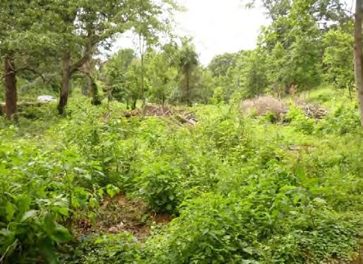
31 Figure 9: At Left, Historic Photograph of West Side, Boxwood Parterre and Former Rock Hill Residence, and at Right, Image from First Graduation, Looking East from Upper Story of Rock Hill Residence. Charlottesville Educational Foundation Schools catalogue, (On file at the Albemarle Charlottesville Historical Society). Figure 10: Historic Photograph of Stone Garage and Snack Bar, Charlottesville Educational Foundation Schools catalogue, (On file at the Albemarle Charlottesville Historical Society). Figure 11: At Left, Historic Photograph of Rock Hill Pond, Charlottesville Educational Foundation Schools catalogue, (On file at the Albemarle Charlottesville Historical Society). At right, contemporary digital image (Dovetail, June 2011). 31


.")


32 Figure 12: At Left, Map of Charlottesville Sponsored by Monticello Dairy, Inc. in October 1938; At Right, Updated Version from May Box highlights general location (On file at Albemarle Charlottesville Historical Society). Figure 13: At Left, USGS 1935 Topographic Map of Charlottesville and Vicinity; At Right, USGS 1987 Topographic Quadrangle Charlottesville East. Box highlights general location (Charlottesville and Albemarle Orthophotography, UVA Geospatial and Statistical Data Center). 32


33 Figure 14: Historic Aerial Photographs of the Rock Hill Estate and Environs, 1937 at Left and 1957 at Right (Charlottesville and Albemarle Orthophotography, UVA Geospatial and Statistical Data Center). Figure 15: Historic Aerial Photographs of the Rock Hill Academy and Environs, 1966 at Left and 1980 at Right (Charlottesville and Albemarle Orthophotography, UVA Geospatial and Statistical Data Center). 33


34 Figure 16: At Top, Eastern Half of Rock Hill, and At Bottom, Western Half of Rock Hill, Owned by John W. Gibbs, Seen on Route 250 Engineer Drawings, Circa 1957 (On file at Virginia Department of Transportation Central Office, Location & Design Division.) 34
35 APPENDIX B: AECOM EXISTING CONDITIONS MAP (2011) AND EXTANT LANDSCAPE FEATURES 35
36 36
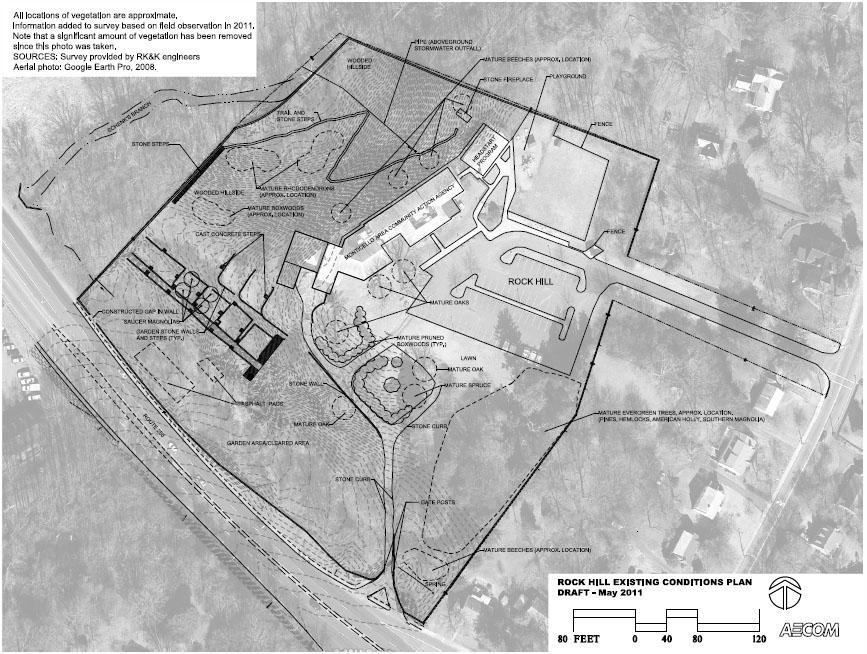
37 37


.")


38 arch gateway & bench Photo 1: At Center, Detail of Pedestrian Gateposts and Built-in Bench, View Looking West Down Pedestrian Walkway (Dovetail, February 2011); at Right, View of Bench and Pedestrian Gateposts, from Central Stairway, Looking Northeast (Dovetail, June 2011). Photo 2: At Left, Decorative Arched Section and Bull s Eye at End of Pedestrian Walkway, View Looking Southwest; at Right, Detail of Bull s Eye (Dovetail, February 2011). A subtle variance in mortar color and rock size seems to suggest that the design was a later addition. 38


39 pump Photo 3: At Right, Pump Situated Near Terminus of Western Stairway in Naturalist Area, View Looking East (Dovetail, February 2011). Photo 4: Outdoor Fireplace at Northeast Corner of Naturalist Area (Dovetail, February 2011). At left, view looking north, and at right, view looking south. 39


.")


40 parterre Photo 5: At left, South Elevation Historic Entrance Gateposts (C. Taniguchi, April 2010); at Center and Right, Details of Eastern Gatepost Deterioration (Dovetail, February 2011). Photo 6: At Left, View of Historic Entrance and Parterre Looking East; at Right, Detail Juncture of Parterre and Sidewalk (Dovetail, February 2011). 40

; at Right, Detail of Parterre")
.")

; at Right, Detail of")
41 threshold single-stone treaded stairs Photo 7: At Center, Southwest Side of Boxwood Garden and Parterre Featuring Wall and Stairs (Dovetail, February 2011); at Right, Detail of Parterre Stairs with Single-Stone Treads (Dovetail, June 2011). Photo 8: At Left, View from Interior of Boxwood Garden Looking North at Site of Former Rock Hill Residence (C. Taniguchi, April 2010); at Right, Detail of Granite Threshold Located at Northern Parterre Opening (Dovetail, February 2011). 41


42 single-stone treaded stairs Photo 9: At Center and Right, Single-Stone Treaded Stairs in Formal Terraced Garden (Dovetail, June 2011 and February 2011). Photo 10: At Left, View of Central Single-Stone Treaded Stairway Looking North (Dovetail, February 2011); At Center, Detail of Central Stairway (Dovetail, June 2011); at Right, Detail of Central Stairway s Southern Terminus with Multi-Stone Treaded Stair and Retaining Wall Addition Leading West (Dovetail, February 2011). 42


.")

43 multi-stone treaded stairs Photo 11: At Right, Detail of Central Terrace Walls and Stairs Looking East. Note cold joint where the multi-stone treaded stairs connect to older wall (Dovetail, June 2011). Photo 12: Details of Multi-Stone Treaded Stairs Leading West into Central Terrace (Dovetail, February 2011). 43


44 Photo 13: Details of Southwestern Junction Pre- and Post-Route 250 Bypass Stonework. Note different sizes in stone, mortar color, and coping (Dovetail, June 2011). Photo 14: At Left, Detail of Southeastern Junction Pre- and Post-Route 250 Bypass Stonework; at Right, View of Southeast Corner from West of Parterre (Dovetail, June 2011). 44


45 Photo 15: Formal Walkway Between Northern and Central Terrace Leading from Pedestrian Gateway to Western Boundary Wall, Both Views Looking East (Dovetail, February and June 2011). Photo 16: At Left, First-Leg Switchback Trail Looking North; at Center, Third-Leg Switchback Trail Looking Northeast; at Right, Third-Leg Switchback Trail Looking South Southwest in Natural Area (Dovetail, June 2011 and February 2011). 45
Tazewell Pike. Neighborhood Conservation Overlay District Design Guidelines
 Tazewell Pike Neighborhood Conservation Overlay District Design Guidelines Knoxville Knox County Metropolitan Planning Commission November 2, 2000 These design guidelines were: Adopted by the Knoxville
Architectural Inventory Form
 COLORADO CULTURAL RESOURCE SURVEY Page 1 of 8 Official Eligibility Determination (OAHP use only) Rev. 9/98 OAHP1403 Date Initials Determined Eligible National Register Determined Not Eligible National
CITY OF MIAMI CEMETERY 1800 N.E. 2 AVENUE
 CITY OF MIAMI CEMETERY 1800 N.E. 2 AVENUE Designation Report City of Miami REPORT OF THE CITY OF MIAMI PLANNING DEPARTMENT TO THE HERITAGE CONSERVATION BOARD ON THE POTENTIAL DESIGNATION OF CITY OF MIAMI
Architectural Inventory Form
 OAHP1403 Rev. 9/98 COLORADO CULTURAL RESOURCE SURVEY Architectural Inventory Form Official eligibility determination (OAHP use only) Date Initials Determined Eligible- NR Determined Not Eligible- NR Determined
PROJECT ASSIGNMENT: DESIGNING AND DRAWING A PLANTATION
 NAME: DATE: PERIOD: D irections This assignment asks you to design and draw a southern plantation on a piece of poster board. This project will allow me to see that you understand how the plantation system
429 Lansdowne Road Building or Property Name. Original owner
 HERITAGE SURVEY AND EVALUATION FORM Municipal Address 429 Lansdowne Road Building or Property Name 042280293 Legal Description PLAN 92 PT BLK 13 JUNC GORE;PT LOT 1 RP4R8942 PART 1 Lot Block Plan Date of
College Park (66-021)
") College Park (66-021) Old Town College Park is a representative example of the many residential subdivisions that emerged as the suburbs of Washington, D.C. expanded with the advent of the streetcar and
College Park (66-021) Old Town College Park is a representative example of the many residential subdivisions that emerged as the suburbs of Washington, D.C. expanded with the advent of the streetcar and
Architectural Inventory Form
 IMPORTANT NOTICE OAHP1403 Rev. 9/98 COLORADO CULTURAL RESOURCE SURVEY Page 1 This survey form represents a only. All information, particularly determinations of eligibility for the National Register, the
Anne Wertsner Wood slide collection
 Wertsner Finding aid prepared by Megan Atkinson and Christiana Dobrzynski Grippe. Last updated on September 30, 2011. Pennsylvania Horticultural Society 2010.11.23 Table of Contents Summary Information...3
HISTORIC SITE FORM - HISTORIC SITES INVENTORY PARK CITY MUNICIPAL CORPORATION (10-08) 1 IDENTIFICATION
 1 IDENTIFICATION") HISTORIC SITE FORM - HISTORIC SITES INVENTORY PARK CITY MUNICIPAL CORPORATION (10-08) 1 IDENTIFICATION Name of Property: Address: 164 Sandridge Road AKA: City, County: Park City, Summit County, Utah Tax
HISTORIC SITE FORM - HISTORIC SITES INVENTORY PARK CITY MUNICIPAL CORPORATION (10-08) 1 IDENTIFICATION Name of Property: Address: 164 Sandridge Road AKA: City, County: Park City, Summit County, Utah Tax
ATTACHMENT A AERIAL PHOTO OF McINTIRE PARK EAST
 ATTACHMENT A AERIAL PHOTO OF McINTIRE PARK EAST McIntire Botanical Garden Request for Proposals Attachments Page 1 of 33 ATTACHMENT B - MEMORANDUM OF AGREEMENT WITH THE CITY OF CHARLOTTESVILLE McIntire
The Maryland-National Capital Park and Planning Commission Prince George's County Planning Department Development Review Division
 The Maryland-National Capital Park and Planning Commission Prince George's County Planning Department Development Review Division 301-952-3530 Note: Staff reports can be accessed at www.mncppc.org/pgco/planning/plan.htm.
HISTORIC SITE FORM - HISTORIC SITES INVENTORY PARK CITY MUNICIPAL CORPORATION (10-08) 1 IDENTIFICATION
 1 IDENTIFICATION") HISTORIC SITE FORM - HISTORIC SITES INVENTORY PARK CITY MUNICIPAL CORPORATION (10-08) 1 IDENTIFICATION Name of Property: William Tretheway House Address: 335 Woodside Avenue AKA: City, County: Park City,
HISTORIC SITE FORM - HISTORIC SITES INVENTORY PARK CITY MUNICIPAL CORPORATION (10-08) 1 IDENTIFICATION Name of Property: William Tretheway House Address: 335 Woodside Avenue AKA: City, County: Park City,
SITE SUMMARY REPORT Arlington Dump NONCD Yadkin County
 SITE SUMMARY REPORT Arlington Dump NONCD 0000644 Yadkin County Hurricane Recovery Act of 2005 State of North Carolina State Contract N06009S Schnabel Project No. 06210002.15 July 31, 2009 Prepared for:
Architectural Inventory Form
 COLORADO CULTURAL RESOURCE SURVEY Page 1 of 8 Official Eligibility Determination (OAHP use only) Rev. 9/98 OAHP1403 Date Initials Determined Eligible National Register Determined Not Eligible National
L 4-1. Heritage Report: Reasons for Heritage Designation. Kodors House. 35 Rosedale Avenue West
 L 4-1 Brampton Heritage Board Date: January 17, 2012 Heritage Report: Reasons for Heritage Designation Kodors House 35 Rosedale Avenue West December 2011 1 L 4-2 Profile of Subject Property Municipal Address
HISTORIC SITE FORM - HISTORIC SITES INVENTORY PARK CITY MUNICIPAL CORPORATION (10-08)
") 1 IDENTIFICATION HISTORIC SITE FORM - HISTORIC SITES INVENTORY PARK CITY MUNICIPAL CORPORATION (10-08) Name of Property: Address: 929 PARK AVE AKA: City, County: Park City, Summit County, Utah Tax Number:
1 IDENTIFICATION HISTORIC SITE FORM - HISTORIC SITES INVENTORY PARK CITY MUNICIPAL CORPORATION (10-08) Name of Property: Address: 929 PARK AVE AKA: City, County: Park City, Summit County, Utah Tax Number:
2: Bond Street, I.O.F Orphanage
 1. Description of Property 2: 37-53 Bond Street, I.O.F Orphanage Municipal Address 37-53 Bond Street ame (if applicable) Independent Order of Foresters (I.O.F.) Orphanage Legal Description PT LTS 15 &
CHAPTER 2: HISTORIC BACKGROUND
 CHAPTER 2: HISTORIC BACKGROUND The historic town of Eastlake was created on June 22, 1911 when the Eastlake Subdivision was recorded at the Adams County Clerk and Recorder s Office. The Eastlake Investment
Chapter 8: BEACH SOUTH OF ATLANTIC AVENUE NEIGHBORHOOD PLANNING AREA ANALYSIS
 Chapter 8: BEACH SOUTH OF ATLANTIC AVENUE NEIGHBORHOOD PLANNING AREA ANALYSIS The Beach South of Atlantic Avenue Neighborhood Planning Area includes the parcels adjacent to S Fletcher Avenue from Atlantic
HISTORIC SITE FORM - HISTORIC SITES INVENTORY PARK CITY MUNICIPAL CORPORATION (10-08)
") 1 IDENTIFICATION HISTORIC SITE FORM - HISTORIC SITES INVENTORY PARK CITY MUNICIPAL CORPORATION (10-08) Name of Property: Address: 1114 PARK AVE AKA: City, County: Park City, Summit County, Utah Tax Number:
1 IDENTIFICATION HISTORIC SITE FORM - HISTORIC SITES INVENTORY PARK CITY MUNICIPAL CORPORATION (10-08) Name of Property: Address: 1114 PARK AVE AKA: City, County: Park City, Summit County, Utah Tax Number:
Thomas Yancey Sr moved to Mecklenburg Co VA where Thomas Yancey Jr was born.
 Below is support that Mary Watkins Yancey daughter of Thomas Watkins Sr from Mecklenburg Co VA was married to Thomas Yancey JR. B:1782. Son of Thomas Yancey Sr and Winifred Yancey from Granville Co NC
IMPORTANT NOTICE. Architectural Inventory Form COLORADO CULTURAL RESOURCE SURVEY I. IDENTIFICATION th Street 5WL.5601
 IMPORTANT NOTICE OAHP1403 Rev. 9/98 COLORADO CULTURAL RESOURCE SURVEY Architectural Inventory Form Page 1 This survey form represents an UNOFFICIAL COPY and is provided for informational purposes only.
Architectural Inventory Form
 COLORADO CULTURAL RESOURCE SURVEY Page 1 of 8 Official Eligibility Determination (OAHP use only) Rev. 9/98 OAHP1403 Date Initials Determined Eligible National Register Determined Not Eligible National
Architectural Inventory Form
 COLORADO CULTURAL RESOURCE SURVEY Page 1 Official eligibility determination (OAHP use only) Date Initials Determined Eligible- NR Determined Not Eligible- NR Determined Eligible- SR Determined Not Eligible-
Toronto and East York Community Council Item TE34.30, as adopted by City of Toronto Council on August 25, 26, 27 and 28, 2014 CITY OF TORONTO
 Authority: Toronto and East York Community Council Item TE34.30, as adopted by City of Toronto Council on August 25, 26, 27 and 28, 2014 CITY OF TORONTO BY-LAW 1393-2017 To designate the property at 481
Physical Structure. This historic image from 1882 emphasizes the dramatic topography that distinguishes Cornell s setting at the top of East Hill.
 Physical Structure The natural, agrarian and urban setting for Cornell s campus is a precious resource to protect and enhance. It has also shaped the physical structure of the campus. Buildings, roads
Glenbrooke North. New Westminster s Neighbourhoods Identifying Historical Contexts. Historical Neighbourhood Context Statements 2008
 Historical Neighbourhood Context Statements 2008 Glenbrooke North Fifth Street: wide boulevard, with garden median at south end 1950s subdivision character along much of Eighth Avenue and east of Fourth
Chapter 9. Historic Preservation Element
 Chapter 9. Historic Preservation Element Introduction This Historic Preservation Element of the Comprehensive Plan coordinates and directs the protection of sites, objects, and buildings central to the
Town of Portola Valley General Plan. Nathhorst Triangle Area Plan
 Town of Portola Valley General Plan Amended December 10, 1997 Table of Contents Introduction... 1 Planning Area... 1 Objectives... 2 Principles... 2 Standards... 4 Description... 4 Community Commercial...
Building Plaque Program. Wheeling Historic Landmarks Commission. For Past, Present and Future Generations
 Wheeling Historic Landmarks Commission Building Plaque Program For Past, Present and Future Generations City of Wheeling 1500 Chapline Street Wheeling, West Virginia 26003 Building Plaque Program The purpose
Cottage City (68-096)
") Cottage City (68-096) Cottage City is one of the smallest incorporated towns in Maryland and was established as a latenineteenth-century railroad suburb. The community is located between the Town of Mount
Cottage City (68-096) Cottage City is one of the smallest incorporated towns in Maryland and was established as a latenineteenth-century railroad suburb. The community is located between the Town of Mount
CITY CLERK. Parkland Acquisition Strategic Directions Report (All Wards)
") CITY CLERK Clause embodied in Report No. 10 of the, as adopted by the Council of the City of Toronto at its meeting held on November 6, 7 and 8, 2001. 10 Parkland Acquisition Strategic Directions Report
CITY CLERK Clause embodied in Report No. 10 of the, as adopted by the Council of the City of Toronto at its meeting held on November 6, 7 and 8, 2001. 10 Parkland Acquisition Strategic Directions Report
District 9, Albus Brooks Blueprint Denver: Area of Change City and County of Denver, National Western Center
 To: Landmark Preservation Commission From: Kara Hahn, Principal Planner, Community Planning & Development (CPD) Date: December 10, 2018 RE: Landmark Designation for the Armour & Company Administration
Calvert Hills (66-037)
") Calvert Hills (66-037) Calvert Hills, a cohesive neighborhood in northwestern Prince George s County, is an excellent illustration of the residential development on the outskirts of Washington, D.C., in
Calvert Hills (66-037) Calvert Hills, a cohesive neighborhood in northwestern Prince George s County, is an excellent illustration of the residential development on the outskirts of Washington, D.C., in
Library Company of Philadelphia. McA MSS 027 GREENWAY FAMILY PAPERS..21 linear feet, 1 box
 Library Company of Philadelphia McA MSS 027 GREENWAY FAMILY PAPERS 1772 1802.21 linear feet, 1 box Series I. Correspondence (1786 1802) Series II. Documents (1772 1799) August 2006 McA MSS 004 2 Descriptive
LUCILLE WINKLER VOIGT COLLECTION, CA. 1897
 Collection # P0019 LUCILLE WINKLER VOIGT COLLECTION, CA. 1897 Collection Information Biographical Sketch Scope and Content Note Contents Cataloging Information Processed by Janet Schmidt and Dorothy A.
Architectural Inventory Form
 COLORADO CULTURAL RESOURCE SURVEY Page 1 of 8 Official Eligibility Determination (OAHP use only) Rev. 9/98 OAHP1403 Date Initials Determined Eligible National Register Determined Not Eligible National
Great Ayton Community Archaeology Project. White House, a brief history
 Great Ayton Community Archaeology Project White House, a brief history White House and White House Farm are situated at the crossroads of Dikes Lane and Aireyholme Lane on the outskirts of Great Ayton,
Guide to the Wilson Family Papers
 This finding aid was created by Franklin Howard and Sarah Jones on October 01, 2018. Persistent URL for this finding aid: http://n2t.net/ark:/62930/f1zp46 2018 The Regents of the University of Nevada.
GARDENS AND ESTATES HORTON COUNTRY HOUSE LONGCROSS ESTATE LA GRANDE MAISON SUDELEY LAWN BARN NEAR BRIXWORTH WINGROVE HOUSE
 Our garden and estate work encompasses both traditional and contemporary design, informed by our skills in historic landscape conservation, and has been consistently well received. We like to work closely
ARLINGTON COUNTY, VIRGINIA
 ARLINGTON COUNTY, VIRGINIA County Board Agenda Item Meeting of January 27, 2007 DATE: January 12, 2007 SUBJECT: U-3101-04-2 Use Permit Review for drive-through facilities; premises known as 5222 Lee Highway
CGT visit to Godolphin 11 th May 2016
 CGT visit to Godolphin 11 th May 2016 The garden at Godolphin Is one of Cornwall s most important medieval gardens and is on the national Register of Parks and Gardens as II*. The Register summary states
HISTORIC SITE FORM - HISTORIC SITES INVENTORY PARK CITY MUNICIPAL CORPORATION (10-08) 1 IDENTIFICATION
 1 IDENTIFICATION") HISTORIC SITE FORM - HISTORIC SITES INVENTORY PARK CITY MUNICIPAL CORPORATION (10-08) 1 IDENTIFICATION Name of Property: Lapage H. Raddon House Address: 817 Woodside Avenue AKA: City, County: Park City,
HISTORIC SITE FORM - HISTORIC SITES INVENTORY PARK CITY MUNICIPAL CORPORATION (10-08) 1 IDENTIFICATION Name of Property: Lapage H. Raddon House Address: 817 Woodside Avenue AKA: City, County: Park City,
Historical Affairs and Landmark Review Board Arlington County, Virginia
 Historical Affairs and Landmark Review Board Arlington County, Virginia HALRB Case 12-04 (HP1200003) A request by Cameron & Catherine Saadat, owners of the property at 1005 South Quinn Street, located
Los Angeles Department of City Planning RECOMMENDATION REPORT
 Los Angeles Department of City Planning RECOMMENDATION REPORT CULTURAL HERITAGE COMMISSION HEARING DATE: January 13, 2011 TIME: 10:00 AM PLACE: City Hall, Room 1010 200 N. Spring Street Los Angeles, CA
Getting round to restoring woodland site
 Monday 12 December 2011 Getting round to restoring woodland site Knock Knowe - house design at Earlston Published on Sunday 4 December 2011 17:44 A RESCUE plan is under way to try to save an historic man-made
DACORUM GOLDEN PARSONAGE Great Gaddesden Brief Description Principal Building: Approach: Stable block other utilitarian buildings: Walled Garden:
 HERTFORDSHIRE GARDENS TRUST LOCAL LIST: DACORUM Present Name of Site GOLDEN PARSONAGE Historic Name (if known) Parish/Town Great Gaddesden National Grid Reference of Principal Building: TL051 125 Present
Houses on the Forest Edge
 Houses on the Forest Edge Vivien Hill 1 Contents 3 Introduction 4 Pavilion Cottages 5 Oak Tree Cottage 6 Arts and Crafts Style 7 Laura House 8 Hillview 9 Bryle House 10 William Wells and the 1851 Census
IMPORTANT NOTICE. Architectural Inventory Form COLORADO CULTURAL RESOURCE SURVEY I. IDENTIFICATION. 655 Bryan Avenue 5BL.10460
 IMPORTANT NOTICE OAHP1403 Rev. 9/98 COLORADO CULTURAL RESOURCE SURVEY Architectural Inventory Form Page 1 This survey form represents an UNOFFICIAL COPY and is provided for informational purposes only.
MOUNT HOPE CEMETERY CONTEXT IN THE RURAL CEMETERY MOVEMENT
 MOUNT HOPE CEMETERY CONTEXT IN THE RURAL CEMETERY MOVEMENT Mount Hope Cemetery is a product of the evolution of traditions and functionalities in the burial of the dead. Prior to the 19 th century, early
Iowa Department of Cultural Affairs State Historical Society of Iowa Iowa Site Inventory Form Continuation Sheet. Related District Number.
 Page 1 SITE DESCRIPTION The Ferd Haak Victor Animatograph Co. building is located on Lot 8, Block 18 of the Original Town of Davenport. The structure is sited on the southeast corner of the intersection
Town of Washington, New Hampshire Master Plan 2015
 OVERVIEW OF CURRENT SITUATION: Historic Background: Washington, a rural town in southwestern New Hampshire, was first settled in 1768 and was incorporated and named in honor of General George Washington
Fall www. aualum.org
 Fall 2007 www. aualum.org Photography by Jeff Etheridge Auburn Magazine For Alumni & Friends of Auburn University 33 34 Fall 2007 www. aualum.org Jean Williams recalls the day she was driving through her
NPS Form OMB No (Oct. 1990)
") NPS Form 10-900 OMB No. 10024-0018 (Oct. 1990) United States Department of the Interior National Park Service NATIONAL REGISTER OF HISTORIC PLACES REGISTRATION FORM 1. historic name: other name/site number:
NPS Form 10-900 OMB No. 10024-0018 (Oct. 1990) United States Department of the Interior National Park Service NATIONAL REGISTER OF HISTORIC PLACES REGISTRATION FORM 1. historic name: other name/site number:
TREE REMOVAL PERMIT PACKET
 PERMIT INTAKE HOURS Permit Applications will be accepted between 8:30 am and 4:30 pm. Community Development Engineering Division 38 Hill Street, Suite G-30 Roswell, GA 30075 770-641-3780 www.roswellgov.com
Authority: North York Community Council Item 31.7, as adopted by City of Toronto Council on May 6, 7 and 8, 2014 CITY OF TORONTO. BY-LAW No.
 Authority: North York Community Council Item 31.7, as adopted by City of Toronto Council on May 6, 7 and 8, 2014 CITY OF TORONTO BY-LAW No. 53-2015 To designate the property at 65 Centre Avenue (Alexander
FIRST COCONUT GROVE SCHOOLHOUSE
 FIRST COCONUT GROVE SCHOOLHOUSE 3429 DEVON ROAD Designation Report City of Miami REPORT OF THE CITY OF MIAMI PLANNING DEPARTMENT TO THE HERITAGE CONSERVATION BOARD ON THE POTENTIAL DESIGNATION OF THE FIRST
HISTORIC SITE FORM - HISTORIC SITES INVENTORY PARK CITY MUNICIPAL CORPORATION (10-08) 1 IDENTIFICATION
 1 IDENTIFICATION") HISTORIC SITE FORM - HISTORIC SITES INVENTORY PARK CITY MUNICIPAL CORPORATION (10-08) 1 IDENTIFICATION Name of Property: John W. Buck House Address: 1110 Woodside Avenue AKA: City, County: Park City, Summit
HISTORIC SITE FORM - HISTORIC SITES INVENTORY PARK CITY MUNICIPAL CORPORATION (10-08) 1 IDENTIFICATION Name of Property: John W. Buck House Address: 1110 Woodside Avenue AKA: City, County: Park City, Summit
Architectural Inventory Form
 OAHP1403 Rev. 9/98 COLORADO CULTURAL RESOURCE SURVEY Architectural Inventory Form Official eligibility determination (OAHP use only) Date Initials Determined Eligible- NR Determined Not Eligible- NR Determined
Architectural Inventory Form (page 1 of 5)
") OAHP1403 Rev. 9/98 COLORADO CULTURAL RESOURCE SURVEY (page 1 of 5) Official eligibility determination (OAHP use only) Date Initials Determined Eligible- NR Determined Not Eligible- NR Determined Eligible-
OAHP1403 Rev. 9/98 COLORADO CULTURAL RESOURCE SURVEY (page 1 of 5) Official eligibility determination (OAHP use only) Date Initials Determined Eligible- NR Determined Not Eligible- NR Determined Eligible-
Look. Using Pictures in Research. >> By Kenneth T. Mills, LS
 Look Closer Using Pictures in Research >> By Kenneth T. Mills, LS number of months ago I began a personal search for the two meridian monuments set in Marshall, North Carolina in 1898 by the U. S. Coast
HISTORIC SITE FORM - HISTORIC SITES INVENTORY PARK CITY MUNICIPAL CORPORATION (10-08) 1 IDENTIFICATION
 1 IDENTIFICATION") HISTORIC SITE FORM - HISTORIC SITES INVENTORY PARK CITY MUNICIPAL CORPORATION (10-08) 1 IDENTIFICATION Name of Property: Address: 158 Main Street City, County: Park City, Summit County, Utah AKA: Tax Number:
HISTORIC SITE FORM - HISTORIC SITES INVENTORY PARK CITY MUNICIPAL CORPORATION (10-08) 1 IDENTIFICATION Name of Property: Address: 158 Main Street City, County: Park City, Summit County, Utah AKA: Tax Number:
HERITAGE REPORT: REASONS FOR HERITAGE DESIGNATION. 62 Union Street. Prepared By:
 L 3-1 1 Brampton Heritage Board Date: January 18, 2011 HERITAGE REPORT: REASONS FOR HERITAGE DESIGNATION 62 Union Street Prepared By: Prepared by: Antonietta Minichillo, Heritage Coordinator Planning,
PG: 82B , Nottingham School House, Nottingham Road
 Nottingham (82B-035) Located in southeastern Prince George s County, the community of Nottingham was established when the General Assembly of the Province of Maryland passed the Act for the Advancement
Central Library of Rochester and Monroe County Historic Monographs Collection
 Rochester PtlMfc Ubrary CHA^IiE^ E UOT C f ) I S motto is ^o-ufltaspiration in Landscape Development. Co preserve all natural beauty so far as is possible; to add to it wherever conditions require; and
NATIONAL REGISTER OF HISTORIC PLACES MULTIPLE PROPERTY DOCUMENTATION FORM CONTINUATION SHEET ASSOCIATED PROPERTY TYPES
 Section F, Page 1 ASSOCIATED PROPERTY TYPES Six common property types are identified with the 48 cemeteries surveyed in the Town of Southampton. These six property types are identified as being associated
buildings sites structures objects 0 Total Number of contributing resources previously listed in the National Register : 0
 NPS Form 10-900 (Rev. 8-86) OMB No. 1024-0018 United States Department of the Interior National Park Service NATIONAL REGISTER OF HISTORIC PLACES REGISTRATION FORM other name/site number: 2. Location street
REQUEST FOR PROPOSALS. Preparation of National Register of Historic Places. Nominations for the following:
 REQUEST FOR PROPOSALS Preparation of National Register of Historic Places Nominations for the following: The Conner Swales Site, The Baumann Village Site, The Bird Point Heaven Village Site, The Wise Village
2154 Dundas Street West Intention to Designate under Part IV, Section 29 of the Ontario Heritage Act
 STAFF REPORT ACTION REQUIRED 2154 Dundas Street West Intention to Designate under Part IV, Section 29 of the Ontario Heritage Act Date: February 2, 2009 To: From: Toronto Preservation Board Toronto and
Architectural Inventory Form
 IMPORTANT NOTICE OAHP1403 Rev. 9/98 COLORADO CULTURAL RESOURCE SURVEY Page 1 This survey form represents a only. All information, particularly determinations of eligibility for the National Register, the
Existing Conditions Summary (Draft for Review)
") Existing Conditions Summary (Draft for Review) Prepared by March 16, 2015 Bird s-eye-view of Norwalk in 1899 (Cropped) Existing Conditions Summary (Draft for Review) March 16, 2015 Table of Contents 1.
Existing Conditions Summary (Draft for Review) Prepared by March 16, 2015 Bird s-eye-view of Norwalk in 1899 (Cropped) Existing Conditions Summary (Draft for Review) March 16, 2015 Table of Contents 1.
DRAFT SECTION 4(f) EVALUATION INTERSTATE 73 FEIS: I-95 to I-73/I-74 in North Carolina
 EVALUATION INTERSTATE 73 FEIS: I-95 to I-73/I-74 in North Carolina") DRAFT SECTION 4(f) EVALUATION INTERSTATE 73 FEIS: I-95 to I-73/I-74 in North Carolina 1.0 INTRODUCTION Section 4(f) of the Department of Transportation Act of 1966, 49 U.S.C. 303, requires that prior to
DRAFT SECTION 4(f) EVALUATION INTERSTATE 73 FEIS: I-95 to I-73/I-74 in North Carolina 1.0 INTRODUCTION Section 4(f) of the Department of Transportation Act of 1966, 49 U.S.C. 303, requires that prior to
Approved: CITY OF ARDEN HILLS, MINNESOTA PLANNING COMMISSION WEDNESDAY, AUGUST 5, :30 P.M. - ARDEN HILLS CITY HALL
 Approved: CITY OF ARDEN HILLS, MINNESOTA PLANNING COMMISSION WEDNESDAY, AUGUST 5, 2015 6:30 P.M. - ARDEN HILLS CITY HALL PLANNING CASES A. Planning Case 15-016; Final Planned Unit Development Arden Plaza;
ROTUNDA/LANDSCAPE CHRONOLOGY
 THE / CHRONOLOGY The following chronology is a summary of the Rotunda and landscape histories. In comparing the two narratives, it appears that work on the landscape around the Rotunda has only correlated
PRESENTED: April 15, 2008 FILE: DP No. 273/ Development Permit No Government Road Townhomes
 DISTRICT OF SQUAMISH REPORT TO: Council FOR: Regular PRESENTED: April 15, 2008 FILE: DP No. 273/2007-26 FROM: SUBJECT: Planning Department Development Permit No. 273 40126 Government Road Townhomes Recommendation
HISTORIC LANDMARK COMMISSION STAFF REPORT
 HISTORIC LANDMARK COMMISSION STAFF REPORT Park Strip Raised Planter Boxes Minor Alteration PLNHLC2014-00603 163 D Street Meeting Date: November 6, 2014 Planning Division Department of Community and Economic
2bPlanning Scheme. Appendix. Conservation - Removal of Structures. Grangegorman
 Appendix 2bPlanning Scheme Grangegorman Conservation - Removal of Structures Innovative Urban Quarter Contemporary Healthcare Facilities Modern Education Hub Accessible Public Spaces Appendix 2b: Purpose
Architectural Inventory Form
 COLORADO CULTURAL RESOURCE SURVEY Page 1 of 7 Official Eligibility Determination (OAHP use only) Rev. 9/98 OAHP1403 Date Initials Determined Eligible National Register Determined Not Eligible National
Heritage Property 70 Liberty Street (Central Prison Chapel)
") STAFF REPORT ACTION REQUIRED Alteration of a Designated Heritage Property 70 East Liberty Street (Central Prison Chapel) Date: October 9, 2012 To: Toronto Preservation Board Toronto East York Community
STAFF REPORT ACTION REQUIRED Alteration of a Designated Heritage Property 70 East Liberty Street (Central Prison Chapel) Date: October 9, 2012 To: Toronto Preservation Board Toronto East York Community
REQUIREMENTS. For FIRE DEPARTMENTS. State of West Virginia. Bob Wise Governor THE DEPARTMENT OF MILITARY AFFAIRS AND PUBLIC SAFETY
 REQUIREMENTS For FIRE DEPARTMENTS State of West Virginia Bob Wise Governor THE DEPARTMENT OF MILITARY AFFAIRS AND PUBLIC SAFETY Joe Martin Secretary West Virginia State Fire Commission 1207 Quarrier St.,
LAND USE PLAN 7. Housing
 21 LAND USE PLAN While the land uses that have historically dominated the Corridor itself have been industrial/commercial, the Master Plan proposes a shift to mixed-use redevelopment, complimented by a
FORM B BUILDING MASSACHUSETTS HISTORICAL COMMISSION MASSACHUSETTS ARCHIVES BUILDING 220 MORRISSEY BOULEVARD BOSTON, MASSACHUSETTS
 FORM B BUILDING MASSACHUSETTS HISTORICAL COMMISSION MASSACHUSETTS ARCHIVES BUILDING 220 MORRISSEY BOULEVARD BOSTON, MASSACHUSETTS 02125 Photograph Assessor s Number USGS Quad Area(s) Form Number UMASS
12 January 12, 2011 Public Hearing APPLICANT: TAILWIND DEVELOPMENT GROUP,LLC PROPERTY OWNER: CITY OF VIRGINIA BEACH
 12 January 12, 2011 Public Hearing APPLICANT: TAILWIND DEVELOPMENT GROUP,LLC PROPERTY OWNER: CITY OF VIRGINIA BEACH STAFF PLANNER: Faith Christie REQUEST: Conditional Change of Zoning (from PD-H1 Planned
Livingston - Stribling House 210 S. Townville Street - Seneca, South Carolina MAIN LEVEL FLOOR PLAN
 MAIN LEVEL FLOOR PLAN UPPER LEVEL FLOOR PLAN Livingston - Stribling House UPPER LEVEL FLOOR PLAN - ALTERNATE BATHROOMS SITE PLAN Features of the Site include: Fences Playhouse Landscaping Circle Driveway
MINNESOTA ARCHITECTURE - HISTORY INVENTORY FORM
 Identification Historic Name Bridge L8849 Current Name Bridge L8849 Field # Address Municipal Road 99 over the Chippewa River City/Twp Montevideo County Chippewa Legal Desc. Twp 117N Range 40W Sec 07 QQ
Plan for Restoration of the Cottage
 Retrospective Plan for Restoration of the Cottage 1936 Restoration The Van Zandt Cottage was first restored in 1936 by the Daughters of the Republic of Texas and the United Daughters of the Confederacy
Long Branch Neighbourhood Character Guidelines Final Report
 STAFF REPORT ACTION REQUIRED Long Branch Neighbourhood Character Guidelines Final Report Date: October 26, 2017 To: From: Wards: Reference Number: Etobicoke York Community Council Director, Community Planning,
Example Codes. City of Brentwood, Tennessee Brentwood Hillside Protection Overlay District Summary
 Example Codes City of Brentwood, Tennessee Brentwood Hillside Protection Overlay District Summary The City of Brentwood in July 2007 adopted a Hillside Protection (HP) Overlay District to address the problems
History of the Cranley Road Area. What is The Cranley Road Area
 History of the Cranley Road Area. What is The Cranley Road Area The Cranley Road Area lies to the east of Guildford. It was originally developed as large Victorian villas by the 4 th Earl of Onslow. It
21: Sovereign Street, Streetscape
 1. Description of Property Municipal Address ame (if applicable) Legal Description Location of Property Ownership Access Current Use Existing Designation General Description Priority Level 21: Sovereign
7.0 OPEN SPACE 7.1 OPEN SPACE DEDICATION CHAPTER 7: OPEN SPACE
 7.0 OPEN SPACE The intent of these requirements is to allow for the usage of centrally located unencumbered land as neighborhood open spaces and not to permit the use of leftover or otherwise unusable
MINNESOTA ARCHITECTURE - HISTORY INVENTORY FORM
 Identification Historic Name Nicollet Avenue Bridge Current Name Nicollet Avenue Bridge Field # Address Nicollet Avenue over Minnehaha Creek City/Twp Minneapolis SHPO Inventory Number Review and Compliance
Appendix 1: Site Inventory Form
 Appendix 1: Site Inventory Form Wapsi Valley Archaeology, Inc. Anamosa, IA 56 X Cemetery Washington 83 24 2 NE X 1 5 approx. 200 approx. 201 unknown unknown Historic Resources Evaluation: 07A: Cemetery
Architectural Inventory Form
 IMPORTANT NOTICE OAHP1403 Rev. 9/98 COLORADO CULTURAL RESOURCE SURVEY Page 1 This survey form represents a only. All information, particularly determinations of eligibility for the National Register, the
The subject site plan amendment proposes the following revisions to the approved site plan:
 PROPOSED AMENDMENT The subject site plan amendment proposes the following revisions to the approved site plan: 1. The building footprint was modified to accommodate the revised architectural design. 2.
General Terms Property, as used to describe eligibility for the National Register of Historic Places:
 Key Definitions Historic Landscapes Compiled by Camille Fife and Barbara Wyatt The field of historic landscape preservation has generated a specific vocabulary. Definitions have been published by two National
CITY OF CYPRESS 5275 Orange Avenue Cypress, California (714) DESIGN REVIEW COMMITTEE PERMIT PROCESS
 DESIGN REVIEW COMMITTEE PERMIT PROCESS") CITY OF CYPRESS 5275 Orange Avenue Cypress, California 90630 (714) 229-6720 DESIGN REVIEW COMMITTEE PERMIT PROCESS 1. Discuss project with Planning staff to determine zoning regulations, any unusual characteristics
CITY OF CYPRESS 5275 Orange Avenue Cypress, California 90630 (714) 229-6720 DESIGN REVIEW COMMITTEE PERMIT PROCESS 1. Discuss project with Planning staff to determine zoning regulations, any unusual characteristics
Baby Point Heritage Conservation District Study. Kick-off Community Meeting March 27, 2017 Humbercrest United Church
 Baby Point Heritage Conservation District Study Kick-off Community Meeting March 27, 2017 Humbercrest United Church Agenda 7:00 Welcome 7:10 HCD Study Overview and Process 8:00 Interactive Discussion /
M E M O R A N D U M PLANNING AND COMMUNITY DEVELOPMENT DEPARTMENT CITY OF SANTA MONICA PLANNING DIVISION
 M E M O R A N D U M 10-B PLANNING AND COMMUNITY DEVELOPMENT DEPARTMENT CITY OF SANTA MONICA PLANNING DIVISION DATE: April 9, 2018 TO: FROM: SUBJECT: The Honorable Landmarks Commission Planning Staff 133