MINNESOTA ARCHITECTURE - HISTORY INVENTORY FORM
|
|
|
- Domenic Francis
- 5 years ago
- Views:
Transcription
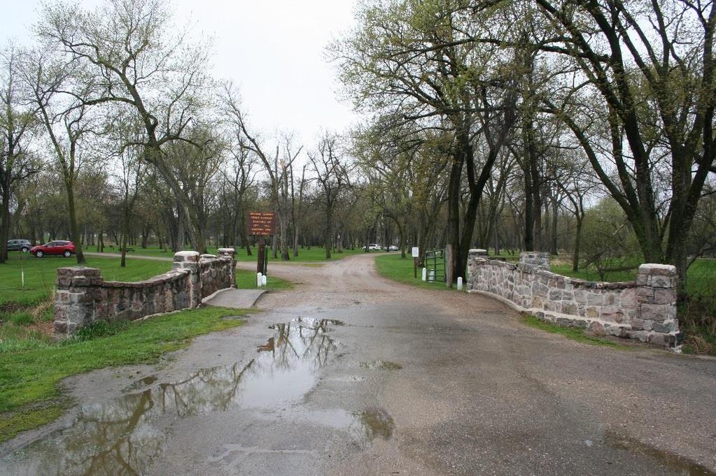
1 Identification Historic Name Bridge L8849 Current Name Bridge L8849 Field # Address Municipal Road 99 over the Chippewa River City/Twp Montevideo County Chippewa Legal Desc. Twp 117N Range 40W Sec 07 QQ SWSE USGS Quad Montevideo SHPO Inventory Number Review and Compliance Number Form (New or Updated) Updated Description Linear Feature? No HPC Status Resource Type Structure Architect/Engineer M.E. Chamberlin Style Rustic UTM Zone 15 Datum 27 Construction Date 1938 Easting Northing Property ID (PIN) Original Use Transportation Current Use Transportation Description Bridge L8849, built in 1938 by the Works Progress Administration (WPA), carries Municipal Road 99 over the Chippewa River at the east entrance of Lagoon Park in. Lagoon Park is a small park bordered to the north and west by the Chippewa River, with a single road that loops around the park. The County Highway 29 overpass is located directly southeast of the bridge, and a residential area is located east of the park. Bridge L8849 is a reinforced-concrete slab span clad in uncoursed, split-faced granite. The bridge is 19 feet long with a main span length of 15 feet. The bridge deck is 26 feet wide, and consists of a 20-foot roadway and a sidewalk on the southeast side of the bridge deck. A stepped masonry railing runs along both approaches and the main span. The approach parapets are curved slightly inward while the deck parapet is curved slightly upward to exaggerate the appearance of a masonry arch bridge. A stringcourse runs along the base of the parapet railings in line with the voussior stones along the concrete slab edge. The vertical face of the concrete slab is articulated by squared voussoirs with an enlarged keystone. Although the concrete slab is slightly arched, it appears to have greater curvature because of the undulating line of its railing walls and the fillets incorporated into the ends of the slab at the abutments. The main span of the bridge is framed by pilasters that rise from the abutments and continue as posts above the roadway. The railings along the approaches project above slightly flared masonry wingwalls. Rock riprap lines the wingwalls. Municipal Road 99 is gravel and the concrete deck slab of the bridge is overlaid with asphalt. Four drainage holes pierce the deck. A utility pipe extends along the northwest elevation of the bridge, and minor repairs have been made to the masonry and mortar on all bridge faces.
2 EVALUATION AND ANALYSIS Historical Context Reinforced-Concrete Highway Bridges in Minnesota, ; Federal Relief Construction in Minnesota, Historical Narrative Bridge L8849 is one of two nearly identical Chippewa River crossings that were built by the WPA in 1938 as part of an extensive improvement of Lagoon Park in Montevideo. The other bridge in the park is Bridge L8850. Initiated in 1935 and completed in 1938, the WPA Lagoon Park Improvement Project (WPA Project Number 461) included the construction of a swimming pool, picnic grounds, buffalo barn, bath house, dock, bridges, and two log cabins. The project was one of several WPA and Public Works Administration (PWA) projects in Montevideo during the 1930s. In addition to the construction of Bridges L8849 and L8850 in 1938, other Federal Relief projects included the construction of a sewage disposal plant in 1934, a water main extension in , a curbing project in 1936, and a retaining wall and stairway in Montevideo City Engineer M.E. Chamberlin designed the general plan for the two bridges. The Lagoon Park project finished that year, and according to the Montevideo American (April 1, 1938), the park project served the entire population and has given employment to more men than any other project. Bridges L8849 and L8850 were highlighted in a publication on the WPA's achievements in Minnesota. (Note: As of June 2014, only two buildings, the bridges, and retaining walls are extant in the park. It is unclear if the buildings are of historic age. Other WPA-constructed resources are no longer extant.) Lagoon Park structures constructed under WPA Project Number 461 were built using a combination of log and stone, materials typical of WPA construction. WPA bridges in Minnesota were most often designed in one of two contemporary architectural trends: a rustic, traditional style, or a WPA/government Deco Moderne style. The bridges in Lagoon Park were built in the rustic style, which often utilized a masonry veneer in keeping with the New Deal's agenda of promoting highway beautification, local craft skills, and labor-intensive public works projects. The bridge was constructed during a period when work relief projects operated by the WPA provided employment for underemployed workers and improved infrastructure throughout Minnesota. During the administration of President Franklin Delano Roosevelt ( ), a number of federal programs, known collectively as the New Deal, were created to alleviate unemployment and stimulate private business. In 1935 the WPA was established to operate a national program of small projects to achieve these objectives. On July 1, 1939, the WPA was incorporated into the Federal Works Agency and was renamed the Work Projects Administration. The WPA was active in Minnesota based on documentation in the Final Report on the WPA Program between 1935 and The number of people employed on WPA projects in Minnesota was 68,840 in September 1938 and remained high just two years later in March 1940 at 49,752. Nearly $6 million of WPA funds had been spent on projects in Minnesota by June Those expenditures financed a total of 1,458 new and rehabilitated bridges and viaducts throughout the state. Significance Bridge L8849 was evaluated under the Federal Relief Construction in Minnesota, Multiple Property Document (Federal Relief Construction MPD) for Criterion A for its association with the WPA. The Federal Relief Construction MPD identifies Transportation Systems as a property type. The property type is further divided into the following structural types : highway, street, and sidewalk projects and airport facility projects. While bridges are not specifically mentioned as a structural type, bridges are often constructed as part of highway or street projects and, for the purpose of this evaluation, are
3 reviewed as part of the highway, street, and sidewalk project structural type. According to the registration requirements, the Transportation System is eligible under Criterion A if it provides an important change in the existing transportation pattern such as a newly developed farm-to-market road, a highway incorporating the principles of landscape design into the construction process, or if it accessed the resort areas of the state or a new airport. Research did not reveal that Bridge L8849 was constructed as part of a larger highway or street development program, improved the state or city s existing transportation pattern, or accessed the state s resort areas or a new airport. The bridge is eligible under the Federal Relief Construction MPD as a contributing resource within Lagoon Park. The WPAconstructed park in Montevideo is specifically mentioned in the Registration Requirements of the Federal Relief Construction MPD as a particularly well-developed park facility built under Federal Relief programs in Minnesota. At the time of its construction the park included a recreation building with full log construction, a bathhouse and shelter building, both built with a combination of log and stone, and two stone vehicular bridges. The Lagoon Park buildings and bridges (CP-MON-118) were determined eligible for National Register listing in 2009 through a Federal Emergency Management Association (FEMA) review. However, a number of resources within the park appear to no longer exist, and re-evaluation of the park and contributing resources for National Register eligibility is recommended. Such an evaluation is beyond the scope of the current project. Bridge L8849 is significant for its architectural design within the Multiple Property Documentation Form of "Reinforced- Concrete Highway Bridges in Minnesota, " (Reinforced-Concrete Highway Bridges MPDF). In Registration Requirement 5, the context states that a concrete bridge may be eligible under Criterion C if it displays notable aesthetics. Bridge L8849 displays aesthetic value in its use of native stone for both the bridge veneer and stepped parapet. These details reflect the Rustic style employed by the National Park Service and utilized nationwide as a design aesthetic for bridge construction during the Great Depression. Therefore, Bridge L8849 fulfills this requirement. Additionally, Bridge L8849 is significant for its association with work relief efforts by the WPA within the historic context of the Reinforced-Concrete Highway Bridges MPDF. Registration Requirement 7 states that a concrete bridge can be eligible if it is documented as being constructed through a New Deal agency and retains architectural merit and integrity as outlined in Registration Requirement 5. The bridge was highlighted in a WPA publication on the agency s achievements in Minnesota and as being part of the larger WPA-constructed Lagoon Park ( ) in Montevideo. Although the bridge was designed by Montevideo City Engineer M.E. Chamberlin, the bridge was constructed using WPA labor. As a result, the bridge possesses a direct association to this important Federal Relief program that provided jobs in communities throughout Minnesota, including in the city of Montevideo, during the mid-1930s and early 1940s. As indicated above, Bridge L8849 also exhibits notable aesthetics in the rustic architectural style. Therefore, the bridge fulfills Registration Requirement 7. The bridge has a period of significance of 1938, which corresponds to the year it was built. Integrity Bridge L8849 retains a high degree of integrity. The bridge remains in its original location and continues to carry Municipal Road 99 over the Chippewa River in Lagoon Park in Montevideo, Minnesota. Therefore, it retains integrity of location and feeling. Its setting within the park and association with transportation, as it continues to carry vehicular traffic, are also retained. To meet the requirements of the Reinforced-Concrete Highway Bridges MPDF the bridge must retain its significant elements in the superstructure. Research did not reveal any substantial alterations since the bridge s construction in At an unknown time a utility pipe was attached to the northwest corner of the east elevation of the bridge, minor repairs to the masonry and mortar were undertaken, and the deck had an asphalt overlay. These modifications do not adversely affect the integrity of the superstructure or aesthetic features of the bridge. As such, the bridge retains integrity of materials, design, and workmanship.
4 Recommendation Bridge L8849 is significant under National Register Criterion C in the area of Engineering for its notable Rustic style and association with a Federal Relief program within the Reinforced-Concrete Highway Bridges MPDF. It meets Registration Requirement 5 as a bridge that displays notable aesthetics. It also meets Registration Requirement 7 as a documented WPAconstructed bridge that retains its architectural merit and integrity. Within the historic context of the Federal Relief Construction MPD, Bridge L8849 does not have significance as a Transportation System since it does not meet the Registration Requirements for the property type. It is a contributing resource in the National Register-eligible Lagoon Park, which is significant under the Federal Relief Construction MPD s Registration Requirements as a Social and Recreational Facilities property type. The bridge retains all aspects of integrity despite the minor addition of a utility pipe on one elevation. While the bridge is recommended individually not eligible under Criterion A, it is part of a larger, eligible historic district that may require re-evaluation. Bridge L8849 is recommended individually eligible for the National Register under Criterion C: Engineering in the area of high artistic value. The period of significance is 1938, which corresponds with the year the bridge was built. Sources Anderson, Rolf T. Federal Relief Construction in Minnesota, National Register of Historic Places Multiple Property Documentation Form, Sec. E, Available at the State Historic Preservation Office, Minnesota Historical Society, St. Paul, Minn. Bridge L8849 electronic record in the Minnesota Department of Transportation Bridge Database. Bridge L8849 File. Available at the Minnesota Department of Transportation, St. Paul, Minn. Chamberlin, ME. Plans for Park Bridge, Montevideo, W.P.A. Project Available at Rodeberg and Associates, Inc., Montevideo, Minn. Field inspection by Jeffrey A. Hess, 23 July Field Inspection by LHB and Mead & Hunt, Inc., 12 May Montevideo American articles from 1938: "WPA Project Includes Civic Improvements" (25 March), "Review Work Relief Projects" (1 April), "WPA Benefits Are Reviewed" (13 May). Montevideo City Council. Proceedings. 21 February National Register of Historic Places. Reinforced-Concrete Highway Bridges in Minnesota. National Register # United States Federal Works Agency. Final Report on the WPA Program, Washington, D.C.: Federal Works Agency, Available online at Library of Congress in electronic format at Works Progress Administration of Minnesota. WPA Accomplishments: Minnesota St. Paul: Works Progress Administration, 1939.
5 Consultant s Recommendation of Eligibility Eligible Individual; Contributing to Eligible Historic District Prepared By Mead & Hunt, Inc. Date Surveyed 5/12/14


6 Property Photographs View facing west View facing east

7 View facing north View facing west-northwest

8 Location Map
MINNESOTA ARCHITECTURE - HISTORY INVENTORY FORM
 Identification Historic Name Nicollet Avenue Bridge Current Name Nicollet Avenue Bridge Field # Address Nicollet Avenue over Minnehaha Creek City/Twp Minneapolis SHPO Inventory Number Review and Compliance
MINNESOTA ARCHITECTURE - HISTORY INVENTORY FORM
 Identification Historic Name Dean Parkway Bridge Current Name Bridge 90661 Field # Address Midtown Greenway over Dean Parkway City/Twp Minneapolis County Hennepin Legal Desc. Twp 29N Range 24W Sec 32 QQ
MINNESOTA ARCHITECTURE - HISTORY INVENTORY FORM
 Identification Historic Name Bridge L8503 Current Name Bridge L8503 Field # Address Seven Bridges Road over Amity Creek City/Twp City of Duluth County St. Louis Legal Desc. Twp 51N Range 13W Sec 32 QQ
MINNESOTA ARCHITECTURE - HISTORY INVENTORY FORM
 Historic Name Identification Chimney Rock Footbridge SHPO Inventory Number Review and Compliance Number Current Name Chimney Rock Footbridge Field # Address Ped. Bridge Over Whitewater River in Whitewater
MINNESOTA ARCHITECTURE - HISTORY INVENTORY FORM
 Historic Name Identification Bridge 89859 / Ramsey Park Swayback Bridge SHPO Inventory Number Review and Compliance Number Current Name Bridge 89859 Field # Address N/A East Oak Street (CSAH 31) over Minnesota
MINNESOTA ARCHITECTURE - HISTORY INVENTORY FORM
 Identification Historic Name Bridge L8477 (Lincoln Park Bridge) Current Name Bridge L8477 Field # Address 10 th Street over Miller s Creek and Lincoln Park Drive City/Twp City of Duluth County St. Louis
MINNESOTA ARCHITECTURE - HISTORY INVENTORY FORM
 Historic Name Bridge R0437 Identification SHPO Inventory Number Review and Compliance Number Current Name Bridge R0437 (Stone Arch Bridge at Terrace Mill) Field # Address N/A Crossing over Chippewa River
North River Mills Bridge Hampshire County State Project # S314-45/ Federal Project # ARRA-4520(003)D FR#: HM-1
D FR#: HM-1") North River Mills Bridge Hampshire County State Project # S314-45/20-2.40 02 Federal Project # ARRA-4520(003)D FR#: 10-1463-HM-1 STATE LEVEL OF HISTORIC DOCUMENTATION November 2010 West Virginia Department
North River Mills Bridge Hampshire County State Project # S314-45/20-2.40 02 Federal Project # ARRA-4520(003)D FR#: 10-1463-HM-1 STATE LEVEL OF HISTORIC DOCUMENTATION November 2010 West Virginia Department
Historic Property Report
 Historic Name: Rutter Parkway Stone Structures Property ID: 706402 Location Address: GeographicAreas: W Rutter Pkwy, Spokane, Washington, USA Spokane,Spokane County,T26R42E03,DARTFORD Quadrangle Information
MINNESOTA ARCHITECTURE - HISTORY INVENTORY FORM
 Identification Historic Name Bridge 62075 Current Name Bridge 62075 Field # Address 3200 Block of Montreal Avenue, over Montreal Avenue City/Twp St. Paul County Ramsey Legal Desc. Twp 28 Range 23 Sec 15
MINNESOTA HISTORIC PROPERTY RECORD PART I. PROPERTY IDENTIFICATION AND GENERAL INFORMATION
 MINNESOTA HISTORIC PROPERTY RECORD PART I. PROPERTY IDENTIFICATION AND GENERAL INFORMATION Common Name: 3589 Bridge Number: 3589 Identification Number: Location: Feature Carried: TH 61 Feature Crossed:
Eligible, see Statement of Significance. Roadside Development on Minnesota Trunk Highways,
 Historic Name CS # 0115 Other Name SHPO Inv # Location Both sides of TH 169 on isthmus between Little Pine Lake and Hickory Lake Hwy District Reference City/Township County Farm Island Township Aitkin
HISTORIC BRIDGES IN PULASKI COUNTY. Bridges Listed on the National Register of Historic Places in Pulaski County
 Arkansas State Highway and Transportation Department HISTORIC BRIDGES IN PULASKI COUNTY Bridges Listed on the National Register of Historic Places in Pulaski County 2004 Arkansas State Highway and Transportation
MINNESOTA HISTORIC PROPERTY RECORD PART I. PROPERTY IDENTIFICATION AND GENERAL INFORMATION
 MINNESOTA HISTORIC PROPERTY RECORD PART I. PROPERTY IDENTIFICATION AND GENERAL INFORMATION Common Name: Fort Snelling-Mendota Bridge Bridge Number: 4190 Identification Number: Location: Feature Carried:
TH 59 8B 34.5 City/Township. Avoca Z15 E N Eligible, see Statement of Significance
 Historic Name CS # 5104 Other Name SHPO Inv # Location NE side of TH 59 about 400' SE of CSAH 6 Hwy District Reference TH 59 8B 34.5 City/Township County Avoca, City of Murray Acres 5 Twp Rng Sec 106N
National Register of Historic Places Continuation Sheet
 NPS Form 10-900-a (Rev. 8/2002) OMB No. 1024-0018 (Expires 5-31-2012) United States Department of the Interior National Park Service National Register of Historic Places Continuation Sheet Bridge No. 5721
Photo Album Intact/Slightly Altered. Eligible, see Statement of Significance. Roadside Development on Minnesota Trunk Highways,
 Historic Name CS # 8607 Other Name SHPO Inv # Location SW side of TH 55 1.5 mi SE of the jct of TH 55 and CSAH 14 Hwy District Reference City/Township County Rockford Township Wright Acres.25 Twp Rng Sec
TH 169/1 1B 265 City/Township. Soudan, City of St. Louis Acres 3.5. Soudan Z15 E N Not Eligible, see Statement of Significance
 Historic Name CS # 6904 Other Name Pioneer Miners Memorial SHPO Inv # Location N side of TH 169/TH 1 2.4 mi E of TH 135 Hwy District Reference TH 169/1 1B 265 City/Township County Soudan, City of St. Louis
Hunterdon County s Stone Arch Bridges
 Hunterdon County s Stone Arch Bridges Hunterdon County s interest in stone arch bridges began in 1992, when a developer wanted to a raze a stone arch bridge so that a road could be widened for a new development.
HISTORIC BRIDGE FOR SALE COLUMBIA BRIDGE IN JACKSON PARK, CHICAGO, ILLINOIS
 HISTORIC BRIDGE FOR SALE COLUMBIA BRIDGE IN JACKSON PARK, CHICAGO, ILLINOIS In Accordance With Illinois Law, The City of Chicago presents this information package as part of an effort to offer this historic
IMPORTANT NOTICE. Architectural Inventory Form COLORADO CULTURAL RESOURCE SURVEY I. IDENTIFICATION th Street 5WL.5601
 IMPORTANT NOTICE OAHP1403 Rev. 9/98 COLORADO CULTURAL RESOURCE SURVEY Architectural Inventory Form Page 1 This survey form represents an UNOFFICIAL COPY and is provided for informational purposes only.
National Register of Historic Places Continuation Sheet
 NPS Form 10-900-a OMB Approval No. 1024-OO18 National Register of Historic Places Continuation Sheet Section number Page SUPPLEMENTARY LISTING RECORD NRIS Reference Number: 98000686 Date Listed: 6/29/98
National Register of Historic Places Continuation Sheet
 NM Form 104004 OKU Appmtl No, Section number Page SUPPLEMENTARY LISTING RECORD NRIS Reference Number: 89001847 Date Listed: 11/6/89 Queens Avenue Bridge Hennepin MN Property Name County State Reinforced-Concrete
Final Design Meeting. September 25, Creating Bridges As Art. Welcome & Introductions. Terry Ward - Project Manager
 Final Design Meeting September 25, 2014 Creating Bridges As Art 1 Welcome & Introductions Terry Ward - Project Manager 2 VQRC Final Design Meetings Meeting Date Items for Discussion Final Design Meeting
Page. I. Introduction 1. II. Project Purpose and Need 2. IV. Description of Section 4(f) Property 2. V. Impacts to Section 4(f) property 3
 Property 2. V. Impacts to Section 4(f) property 3") Table of Contents Programmatic Section 4(f) Evaluation for use of a Historic Bridge Replacement of Route 30/130 Bridge over the Cooper River Structure No. 0405-153 City of Camden, Borough of Collingswood,
Table of Contents Programmatic Section 4(f) Evaluation for use of a Historic Bridge Replacement of Route 30/130 Bridge over the Cooper River Structure No. 0405-153 City of Camden, Borough of Collingswood,
COMMUNICATION URBAN DESIGN REVIEW BOARD CITY OF DES MOINES, IOWA MAY 16, 2017 MEETING
 COMMUNICATION URBAN DESIGN REVIEW BOARD CITY OF DES MOINES, IOWA MAY 16, 2017 MEETING Subject: Recommendation Prepared by: PRELIMINARY DESIGN REVIEW OF LOCUST STREET BRIDGE CONSTRUCTION & COURT AVENUE,
PROJECT BACKGROUND. Preliminary Design Scope and Tasks
 PROJECT BACKGROUND Preliminary Design Scope and Tasks The purpose of this Study is the development of preliminary designs for intersection improvements for Trunk Highway (TH) 36 at the intersections of
Not Eligible, see Statement of Significance. List of Standing Structures Feat# Feature Type Year Built Fieldwork Date. Ca Ca.
 Historic Name CS # 7603 Other Name SHPO Inv # Location Hwy District Reference City/Township County Moyer Township Swift Acres 51 Twp Rng Sec 121N 42W Sec 18 121N 42W Sec 19 Rest Area Class 4 USGS Quad
Historic Bridge Adoption Information Packet
 Historic Bridge Adoption Information Packet Falls County CR 179 over Big Elm Creek Bridge October 2017 Table of Contents Announcement... 3 Bridge Location... 4 Bridge Information... 4 Bridge Condition
Page. I. Introduction 1. II. Project Purpose and Need 1. IV. Description of Section 4(f) Property 2. V. Impacts to Section 4(f) Property 3
 Property 2. V. Impacts to Section 4(f) Property 3") TABLE OF CONTENTS Programmatic Section 4(f) Evaluation for Use of a Public Park Replacement of Route 30/130 Bridge over the Cooper River Structure No. 0405-153 City of Camden, Township of Pennsauken Camden
TABLE OF CONTENTS Programmatic Section 4(f) Evaluation for Use of a Public Park Replacement of Route 30/130 Bridge over the Cooper River Structure No. 0405-153 City of Camden, Township of Pennsauken Camden
Architectural Inventory Form
 COLORADO CULTURAL RESOURCE SURVEY Page 1 of 8 Official Eligibility Determination (OAHP use only) Rev. 9/98 OAHP1403 Date Initials Determined Eligible National Register Determined Not Eligible National
HISTORIC BRIDGES IN CONWAY COUNTY. Bridges Eligible for and Listed on the National Register of Historic Places in Conway County
 Arkansas State Highway and Transportation Department HISTORIC BRIDGES IN CONWAY COUNTY Bridges Eligible for and Listed on the National Register of Historic Places in Conway County 2004 Arkansas State Highway
Architectural Inventory Form
 COLORADO CULTURAL RESOURCE SURVEY Page 1 of 3 Official Eligibility Determination (OAHP use only) Rev. 9/98 OAHP1403 Date Initials Determined Eligible National Register Determined Not Eligible National
How can landscape architects aide in transportation planning process? John Dempsey, PLA Toole Design Group July 24, 2015
 How can landscape architects aide in transportation planning process? John Dempsey, PLA Toole Design Group July 24, 2015 What is Landscape Architecture? Landscape Architecture 1863 What is Landscape Architecture?
Ols Intact/Slightly Altered. Eligible, see Statement of Significance. Roadside Development on Minnesota Trunk Highways, Ca.
 Historic Name CS # 7101 Other Name Grange Shrine SHPO Inv # Location Hwy District Reference City/Township County Elk River, City of Sherburne Acres.2 Twp Rng Sec 32N 26W Sec 13 32N 26W Sec 14 Rest Area
HISTORIC BRIDGES IN BENTON COUNTY. Bridges Listed on the National Register of Historic Places in Benton County
 Arkansas State Highway and Transportation Department HISTORIC BRIDGES IN BENTON COUNTY Bridges Listed on the National Register of Historic Places in Benton County 2004 Arkansas State Highway and Transportation
Iowa Department of Cultural Affairs State Historical Society of Iowa Iowa Site Inventory Form Continuation Sheet. Related District Number.
 Page 1 SITE DESCRIPTION The Ferd Haak Victor Animatograph Co. building is located on Lot 8, Block 18 of the Original Town of Davenport. The structure is sited on the southeast corner of the intersection
Architectural Inventory Form
 COLORADO CULTURAL RESOURCE SURVEY Page 1 of 8 Official Eligibility Determination (OAHP use only) Rev. 9/98 OAHP1403 Date Initials Determined Eligible National Register Determined Not Eligible National
Victoria Bridge Municipal Class EA Civic Works Committee
 Municipal Class EA John Pucchio, P. Eng., Project Manager June 19 2018 Introduction Existing Conditions Municipal Class EA Proposed Bridge Proposed Road Reconstruction Proposed Improvements Construction
Victoria Street Pedestrian Bridge
 Township of Centre Wellington Victoria Street Pedestrian Bridge Class Environmental Assessment County of Wellington & Township of Centre Wellington Badley Bridge Replacement/Rehabilitation (County of Wellington),
Photo Album Intact/Slightly Altered. Eligible, see Statement of Significance Also member of eligible NR district: Lilac Way Historic District
 Historic Name CS # 2735 Other Name Robbinsdale Rock Garden R.P.A. SHPO Inv # Location Hwy District Reference City/Township County Robinsdale, City of Hennepin Acres Twp Rng Sec 118N 21W Sec 9 118N 21W
TH 71 8A 83.9 City/Township. Morton Z15 E N Photo Album Intact/Slightly Altered. Eligible in Near Future, see Statement of Significance
 Historic Name CS # 6508 Other Name SHPO Inv # Location E side of TH 71 250' S of CSAH 2 Hwy District Reference TH 71 8A 83.9 City/Township County Birch Cooley [sic] Township Renville Acres.5 Twp Rng Sec
Municipal Heritage Bridges Cultural, Heritage and Archaeological Resources Assessment Checklist Revised April 11, 2014
 Municipal Heritage Bridges Cultural, Heritage and Archaeological Assessment Checklist Revised April 11, 2014 This checklist was prepared in March 2013 by the Municipal Engineers Association to assist with
West Dennis Center: Bass River to Old Main Street. West Dennis Business District: Old Main Street to Dennis Commons
 West Dennis Center: Bass River to Old Main Street West Dennis Business District: Old Main Street to Dennis Commons Dennisport Center: Dennis Commons to Division Street Main Street Project Goals Project
OFFICIAL CONTROLS IMPLEMENTATION LEGAL REQUIREMENTS
 IMPLEMENTATION The objective of the Implementation component of the Comprehensive Plan is to identify the changes that need to be made to the official controls in order to be consistent with the Comprehensive
Los Angeles River Bridges Staff Presentation. Office of Historic Resources September 2007
 Los Angeles River Bridges Staff Presentation Office of Historic Resources September 2007 Area of Study Historic Context: What makes the bridges historic? Why were they built? When were they built? Who
PennDOT. single spann lanes and 3- mayy need to be to accommodate. any bridge. addition to III. Date: CRP 07/27/2015 CRP.
 (10/27/14) PennDOT Section 106 Field Assessments and Finding Combined Early tification/finding? Yes Concurrence required or requested: Yes MPMS: 51507 ER# (if consultation with PHMC required) ): County:
Fall 2017 Construction Update
 Fall 2017 Construction Update Ward 4 Southeast Engineering Department Riverwalk Red Multi-Use Trail Bridge Rehabilitation The Riverwalk Red Multi Use Trail Bridge was awarded to Cramer and Associates,
Public input has been an important part of the plan development process.
 Lakewood s Comprehensive Plan recognizes that transportation helps shape the community, and that the way the community provides for the safe and efficient movement of people affects the character of the
FY 2018 TRANSPORTATION CAPITAL PROGRAM New Jersey Department of Transportation Projects
 Schooleys Mountain Bridge Rehabilitation Project ID Numbers: N1707 / 173470 Schooleys Mountain Road Bridge was built in 1920 and widened in 1937. The project is a replacement of the bridge structure and
1.0 Circulation Element
 5/9/18 1.0 Circulation Element 1.1 Introduction As growth and development occur in Apache County, enhancements to its circulation system will be necessary. With time, more roads will be paved and air and
Middlebury RS 0174(8)
") Middlebury RS 0174(8) Preferred Alternative Meeting VT 125 Bridge #13 over Middlebury River August 6, 2012 Presented to Presented by Town of Middlebury VTrans & VHB Introductions: Jennifer Fitch VTrans
Middlebury RS 0174(8) Preferred Alternative Meeting VT 125 Bridge #13 over Middlebury River August 6, 2012 Presented to Presented by Town of Middlebury VTrans & VHB Introductions: Jennifer Fitch VTrans
WELCOME TO THE PUBLIC INFORMATION CENTRE. Please Sign In
 WELCOME TO THE PUBLIC INFORMATION CENTRE Replacement of Oxtongue Lake Narrows Bridge & Oxtongue River Bridge, Highway 60 (G.W.P. 93-89-00 & G.W.P. 5550-04-00) Class Environmental Assessment (Group B) Please
Planning Districts INTRODUCTION
 INTRODUCTION To facilitate detailed examination of development prospects for all areas of the community, Delano has been divided into 14 planning districts. The location of these planning districts is
3.1 Survey Monument Preservation Guidelines for New and Reconstruction Projects. B. After construction and prior to recording Notice of Completion:
 3.0 SURVEY 3.1 Survey Monument Preservation Guidelines for New and Reconstruction Projects A. Prior to construction: 1. Public survey records are to be researched for the location of all possible survey
EXHIBIT A. Tax Increment Reinvestment Zone No. 1 (Town Center) First Amended Project Plan 1
 First Amended Project Plan 1") EXHIBIT A Tax Increment Reinvestment Zone No. 1 (Town Center) First Amended Project Plan 1 1 As amended by Resolution No. 2008-02-001(TR1R) of the Tax Increment Reinvestment Zone No.1, and approved to
EXHIBIT A Tax Increment Reinvestment Zone No. 1 (Town Center) First Amended Project Plan 1 1 As amended by Resolution No. 2008-02-001(TR1R) of the Tax Increment Reinvestment Zone No.1, and approved to
July 12, Columbus City Council City Hall 90 West Broad Street Columbus, OH RE: I-70/71 Columbus Crossroads Project
 OHIO DEPARTMENT OF TRANSPORTATION DISTRICT 6 400 EAST WILLIAM STREET DELAWARE, OHIO 43015 800.372.7714 Columbus City Council City Hall 90 West Broad Street Columbus, OH 43215-9015 RE: I-70/71 Columbus
Architectural Inventory Form (page 1 of 5)
") OAHP1403 Rev. 9/98 COLORADO CULTURAL RESOURCE SURVEY (page 1 of 5) Official eligibility determination (OAHP use only) Date Initials Determined Eligible- NR Determined Not Eligible- NR Determined Eligible-
OAHP1403 Rev. 9/98 COLORADO CULTURAL RESOURCE SURVEY (page 1 of 5) Official eligibility determination (OAHP use only) Date Initials Determined Eligible- NR Determined Not Eligible- NR Determined Eligible-
FY STATEWIDE TRANSPORTATION IMPROVEMENT PROGRAM New Jersey Department of Transportation Projects
 69th Street Bridge 02311 02311 A grade separation at 69th Street would eliminate the current at-grade crossing which causes frequent automobile delays due to long freight trains moving through this area.
Minneapolis South Z15 E N Not Eligible, see Statement of Significance Also member of eligible NR district: Lilac Way Historic District
 Historic Name CS # 2735 Other Name SHPO Inv # Location NW corner of TH 100/TH 55 cloverleaf Hwy District Reference City/Township County Golden Valley, City of Hennepin Acres Twp Rng Sec 118N 21W Sec 33
HISTORIC BRIDGES IN CRAWFORD COUNTY. Bridges Listed on the National Register of Historic Places in Crawford County
 Arkansas State Highway and Transportation Department HISTORIC BRIDGES IN CRAWFORD COUNTY Bridges Listed on the National Register of Historic Places in Crawford County 2004 Arkansas State Highway and Transportation
(Exhibit A) Site Plan Adoption Detail and Support Information
 Site Plan Adoption Detail and Support Information") McCormick Park Master Site Plan (Exhibit A) Site Plan Adoption Detail and Support Information July, 2003 McCormick Park Site Plans.... 2-3 McCormick Park Site Plan Comparison... 4 Basic Assumptions about
McCormick Park Master Site Plan (Exhibit A) Site Plan Adoption Detail and Support Information July, 2003 McCormick Park Site Plans.... 2-3 McCormick Park Site Plan Comparison... 4 Basic Assumptions about
HISTORIC SITE FORM - HISTORIC SITES INVENTORY PARK CITY MUNICIPAL CORPORATION (10-08) 1 IDENTIFICATION
 1 IDENTIFICATION") HISTORIC SITE FORM - HISTORIC SITES INVENTORY PARK CITY MUNICIPAL CORPORATION (10-08) 1 IDENTIFICATION Name of Property: Marsac Elementary School Address: 445 MARSAC AVE AKA: 431 Marsac Avenue City, County:
HISTORIC SITE FORM - HISTORIC SITES INVENTORY PARK CITY MUNICIPAL CORPORATION (10-08) 1 IDENTIFICATION Name of Property: Marsac Elementary School Address: 445 MARSAC AVE AKA: 431 Marsac Avenue City, County:
I-90 Mississippi River Bridge & Interchange Project
 I-90 Mississippi River Bridge & Interchange Project Presentation Outline I. Background: Context & Need for Project II. Preferred Alternative Overview III. Project Development IV. Project Management Tools
TH 61 6A 64.6 City/Township. Wabasha North Z15 E N Intact/Slightly Altered. Eligible, see Statement of Significance
 Historic Name CS # 7906 Other Name SHPO Inv # Location NE side of TH 61 1.5 mi NW of Reads Landing Hwy District Reference TH 61 6A 64.6 City/Township County Pepin Township Wabasha Acres.6 Twp Rng Sec 111N
GLEN ROAD PEDESTRIAN BRIDGE ENVIRONMENTAL ASSESSMENT STUDY PUBLIC INFORMATION CENTRE #2 OCTOBER 24, 2017
 GLEN ROAD PEDESTRIAN BRIDGE ENVIRONMENTAL ASSESSMENT STUDY PUBLIC INFORMATION CENTRE #2 OCTOBER 24, 2017 Glen Road Pedestrian Bridge Class Environmental Assessment 1 WELCOME! Welcome to the second Public
You Don't Know What You've Got 'til it's Gone. Creative Cities Summit 2012 Victoria, British Columbia Kate Hagerman Cultural Heritage Specialist
 You Don't Know What You've Got 'til it's Gone Creative Cities Summit 2012 Victoria, British Columbia Kate Hagerman Cultural Heritage Specialist Presentation Outline Waterloo Region Research Based Conservation
Architectural Inventory Form
 IMPORTANT NOTICE OAHP1403 Rev. 9/98 COLORADO CULTURAL RESOURCE SURVEY Page 1 This survey form represents a only. All information, particularly determinations of eligibility for the National Register, the
Phase I Results. Minnesota Local Historic Bridge Study. Minnesota Department of Transportation. Bridge 448 in Olmsted County. Report prepared for
 Phase I Results Minnesota Local Historic Bridge Study Bridge 448 in Olmsted County Report prepared for Minnesota Department of Transportation Bridge L7075 in Todd County Report prepared by www.meadhunt.com
THREE-YEAR CAPITAL IMPROVEMENT PLAN FY
 THREE-YEAR CAPITAL IMPROVEMENT PLAN FY2016 2018 Annual CIP Development Process Public Works & Engineering Divisions Prepare List of Capital Needs and Recommended Deferred Maintenance Public Works & Engineering
East Corridor Final Environmental Impact Statement
 East Corridor Final Environmental Impact Statement Alternatives Considered Operating Plan The requirements for opening day operations versus year 2030 are based on ridership and operations. Opening day
Architectural Inventory Form (page 1 of 5)
") OAHP1403 Rev. 9/98 COLORADO CULTURAL RESOURCE SURVEY (page 1 of 5) I. IDENTIFICATION 1. Resource number 5RT-2050 2. Temporary resource number: 145008005 3. County: Routt County 4. City: Steamboat Springs
OAHP1403 Rev. 9/98 COLORADO CULTURAL RESOURCE SURVEY (page 1 of 5) I. IDENTIFICATION 1. Resource number 5RT-2050 2. Temporary resource number: 145008005 3. County: Routt County 4. City: Steamboat Springs
PRIMARY RECORD Trinomial # NRHP Status Code 3S, 3CS, 5S3 Other Listings Review Code Reviewer Date
 PRIMARY RECORD # NRHP Status Code 3S, 3CS, 5S3 Other Listings Review Code Reviewer Date Page 1 of 6 1252 *Resource Name or # (Assigned by recorder) Old Topanga Canyon Road P1. Other Identifier: *P2. Location:
1.0 INTRODUCTION 1.1 TH 14 WEST STUDY AREA Project Description Functional Classification Purpose of the Project
 1.0 INTRODUCTION 1.1 TH 14 WEST STUDY AREA 1.1.1 Project Description The Trunk Highway (TH) 14 West Corridor is a two-lane roadway approximately 22 miles in length. Located in Nicollet County, the corridor
New Jersey and National Registers of Historic Places. Jonathan Kinney Senior Historic Preservation Specialist NJ Historic Preservation Office
 New Jersey and National Registers of Historic Places Jonathan Kinney Senior Historic Preservation Specialist NJ Historic Preservation Office National Historic Preservation Act Enacted October 15, 1966
Bassett Creek Valley Working Group. October 4, 2017
 Bassett Creek Valley Working Group October 4, 2017 1 Today s Topics Introductions Overview of Design Teams (P+W and WSP) Expertise Working Group Roles and Responsibilities Schedule & Community Engagement
PROJECT SITE The Proposed Project includes the Allen and Pike Street malls between Delancey and South Streets (see Figure 2C-1).
.") Chapter 2, Section C: A. INTRODUCTION This chapter considers the potential of the proposed Reconstruction of the Allen and Pike Street Malls project to affect the urban design characteristics and visual
Chapter 2, Section C: A. INTRODUCTION This chapter considers the potential of the proposed Reconstruction of the Allen and Pike Street Malls project to affect the urban design characteristics and visual
ENVIRONMENTAL REQUIREMENTS FOR FEDERALLY FUNDED PROJECTS: SECTION 106 AND SECTION 4(F)
") ENVIRONMENTAL REQUIREMENTS FOR FEDERALLY FUNDED PROJECTS: SECTION 106 AND SECTION 4(F) Oklahoma Association of County Engineers November 8, 2016 Law and Regulatory Requirements: Section 106 National Historic
ENVIRONMENTAL REQUIREMENTS FOR FEDERALLY FUNDED PROJECTS: SECTION 106 AND SECTION 4(F) Oklahoma Association of County Engineers November 8, 2016 Law and Regulatory Requirements: Section 106 National Historic
REHABILITATION FEASIBILITY STUDY ER#
 REHABILITATION FEASIBILITY STUDY MILLER FARM ROAD BRIDGE PROJECT VENANGO COUNTY BRIDGE NO. 34 CARRYING S.R. 7212, SECTION L00 OVER OIL CREEK OIL CREEK AND CHERRYTREE TOWNSHIPS VENANGO COUNTY, PENNSYLVANIA
Maryland Historical Trust Inventory No. PG: 85B-007 Maryland Inventory of Historic Properties Form
 Maryland Historical Trust Inventory No. PG: 85B-007 Maryland Inventory of 1. Name of Property (indicate preferred name) historic other 2. Location street and number Cedarville State Forest Road, Cedarville
WELCOME TO PUBLIC INFORMATION CENTRE #2. Please Sign In
 WELCOME TO PUBLIC INFORMATION CENTRE #2 Replacement of Oxtongue Lake Narrows Bridge & Oxtongue River Bridge, Highway 60 (G.W.P. 93-89-00 & G.W.P. 5550-04-00) Class Environmental Assessment (Group B) Please
Design Guidelines and Development Standards for Southwood Ranch. Prepared February, 2016 by
 Design Guidelines and Development Standards for Southwood Ranch D e s i g n D i s t r i c t Prepared February, 2016 by Table of Contents Introduction 2 District Overlay Map. 3 Development Standards. 4
STORMWATER UTILITY FREQUENTLY ASKED QUESTIONS
 STORMWATER UTILITY FREQUENTLY ASKED QUESTIONS What is Stormwater? Stormwater is water that falls to the ground during a precipitation event. When land is undeveloped or covered with vegetative surface,
Subject: City of Richfield Cedar Avenue Corridor Plan Comprehensive Plan Amendment, Review File No
 Committee Report Business Item No. 2017-21 Community Development Committee For the Metropolitan Council meeting of January 25, 2017 Subject: City of Richfield Cedar Avenue Corridor Plan Comprehensive Plan
Connecting the DOTs: Nationwide Trends in the Inventory, Evaluation, and Management of Historic Roads
 Connecting the DOTs: Nationwide Trends in the Inventory, Evaluation, and Management of Historic Roads In 2013-2014 Mead & Hunt, Inc. surveyed state Departments of Transportation (DOTs) on how they address
DRAFT SECTION 4(F) EVALUATION LIFT BRIDGE
 EVALUATION LIFT BRIDGE") DRAFT SECTION 4(F) EVALUATION I. DESCRIPTION OF SECTION 4(F) RESOURCE The Section 4(f) resource affected by the proposed action is the Lift Bridge, a property listed on the National Register of Historic
DRAFT SECTION 4(F) EVALUATION I. DESCRIPTION OF SECTION 4(F) RESOURCE The Section 4(f) resource affected by the proposed action is the Lift Bridge, a property listed on the National Register of Historic
2.1 Decision Making Matrix
 2.1 Decision Making Matrix The following decision-making matrix merges the elements of architectural and historical significance and current condition within the over-arching treatment recommendation of
Cleveland Innerbelt Bridge / Central Viaduct City Planning Commission November 6, 2009
 Cleveland Innerbelt Bridge / Central Viaduct City Planning Commission November 6, 2009 Process for Aesthetics Subcommittee June 25, 2009 Kick off Meeting June 26, 2009 Gateway and Tremont Focus Groups
Urban Design Brief Woodland Cemetery Funeral Home 493 Springbank Drive
 Urban Design Brief Woodland Cemetery Funeral Home The Incorporated Synod of the Diocese of Huron April 15, 2016 Urban Design Brief April 15, 2016 TABLE OF CONTENTS Page No. INTRODUCTION... 1 SECTION 1
Mississippi Skyway Preliminary Engineering Report
 EXECUTIVE SUMMARY Mississippi Skyway Preliminary Engineering Report CITY OF RAMSEY, MINNESOTA DECEMBER 2014 City of RAMSEY EXECUTIVE SUMMARY Project Need and Intent The Mississippi Skyway pedestrian bridge
Architectural Inventory Form
 IMPORTANT NOTICE OAHP1403 Rev. 9/98 COLORADO CULTURAL RESOURCE SURVEY Page 1 This survey form represents a only. All information, particularly determinations of eligibility for the National Register, the
Appendix 1: Site Inventory Form
 Appendix 1: Site Inventory Form Wapsi Valley Archaeology, Inc. Anamosa, IA 56 X Cemetery Washington 83 24 2 NE X 1 5 approx. 200 approx. 201 unknown unknown Historic Resources Evaluation: 07A: Cemetery
BRIDGE REHABILITATION ANALYSIS AND FEASIBILITY REPORT
 BRIDGE REHABILITATION ANALYSIS AND FEASIBILITY REPORT SR 0016-037 Main Street Bridge Project Memorial Bridge over the West Branch of Little Antietam Creek in Waynesboro Borough and Washington Township
Black Rock Historic Resource Survey - Section PROJECT DESCRIPTION
 1.0 PROJECT DESCRIPTION Clinton Brown Company PN 08-019 1-1 November 2010 1.0 PROJECT DESCRIPTION Clinton Brown Company Architecture, pc has completed the Historic Resources Survey of the Black Rock Planning
COMMUNITY DESIGN. GOAL: Create livable and attractive communities. Intent
 COMMUNITY DESIGN Intent An attractive, well-designed County will attract quality development, instill civic pride, improve the visual character of the community, and create a strong, positive image for
Corridor Identity. Section 9. Introduction. Corridor Guiding Principles
 Corridor Identity An attractive and healthy community is a critical element of a quality place, and the design of quality places is a balance between environmental, economic, and social considerations.
TH 58 6B 21.6 City/Township. Red Wing Z15 E N Designer Nichols, A R, Attributed. Photo Album Very Altered
 Historic Name CS # 2510 Other Name Red Wing Quarry Park SHPO Inv # Location W side of TH 58 about.6 mi S of Bush St Hwy District Reference TH 58 6B 21.6 City/Township County Red Wing, City of Goodhue Acres
Brentwood - Pacific Palisades Report Non-Parcel Resources 11/26/13
 Non-Parcel Resources Sunset Bl at Mandeville Canyon Rd Air Raid Siren No. 141 Year built: 1940 Context: Public and Private Institutional Development, 1850-1980 Military Institutions and Activities, 1850-1980
Parapet/Formliner/Fencing
 Parapet/Formliner/Fencing Cross Parapet/Formliner/Fencing Street Aesthetic Features Context The I-290 Phase I study is evaluating improvements along 13 miles of the Eisenhower Expressway, from west of
6 BRIDGES. 6.1 Design philosophy. Proposed bridges
 SECTION 6 BRIDGES 6 BRIDGES Throughout the Project, bridges are a key visual element and marker for road users, pedestrians and cyclists. The design of bridges, as with other visible structures, has been