HISTORIC BRIDGES IN PULASKI COUNTY. Bridges Listed on the National Register of Historic Places in Pulaski County
|
|
|
- Edmund Gibbs
- 6 years ago
- Views:
Transcription


1 Arkansas State Highway and Transportation Department HISTORIC BRIDGES IN PULASKI COUNTY Bridges Listed on the National Register of Historic Places in Pulaski County 2004 Arkansas State Highway and Transportation Department Interstate 30 P. O. Box 2261 Little Rock, AR 72203


2 Page 2 Arkansas State Highway and Transportation Department Notes Page 15


3 Page 14 Arkansas State Highway and Transportation Department Page 3 Demolished Historic Bridges The Pulaski County Road 71 Bridge was constructed by the Works Progress Administration (WPA) in 1939 and is a steel multi-beam Bridge. The bridge crossed Bayou Meto in northern Pulaski County. The bridge was demolished in 1995, when a new bridge was constructed. No pictures exists for this bridge Table of Contents Introduction 4 Amboy Overpass # Wolf Creek Bridge # Lake No. 1 Bridge # Edgemere Street Bridge # th Street Bridge # Lincoln Viaduct #M Lakeshore Drive Bridge 12 The Pulaski County Road 67 Bridge was constructed by the WPA in 1939 and is a concrete slab bridge. The bridge crossed Bridge Creek In northern Pulaski County. The bridge was demolished in 2002, when a new bridge was constructed.. Waterside Street Bridge 13 Demolished Historic Bridges 14 The Second Street Bridge was design by Chicago Rock Island and Pacific Railroad Company and constructed by the Fox Construction Company in This bridge was a pony concrete rainbow arch bridge and was the only one of its kind in the state. The bridge crossed the Chicago Rock Island and Pacific Railroad lines and was replaced in 1990 when a new bridge was constructed.


4 Page 4 Arkansas State Highway and Transportation Department Page 13 Introduction Waterside Street Bridge This pamphlet was created by the Arkansas State Highway and Transportation Department (AHTD) to inform local governments and the general public of the Historic Bridges located in their County. The AHTD Historic Bridge Program is designed to balance historic preservation needs with the traffic and safety needs of the public. This program was begun in 1987 by the enactment of the Surface Transportation & Uniform Relocation Assistance Act. This requires Departments of Transportation to inventory all bridges in their state for eligibility to the National Register of Historic Places and encourages states to preserve, rehabilitate or reuse historic bridges. To comply with this law, AHTD conducts historic bridge surveys every five years and will periodically reevaluate previous surveys. This means that the inventory of historic bridges will periodically change with new additions and deletions. This pamphlet contains all historic bridges currently located in this county. When a bridge no longer meets the requirements for safety and engineering, it is programmed for replacement by AHTD and a review of alternatives to the demolition of the bridge is conducted. These alternatives can include leaving the bridge in place in a non-vehicular capacity with a new bridge constructed next to it, making the bridge a one-way couplet, or the bridge could be rehabilitated for either vehicular, pedestrian or bicycle traffic use. If an appropriate alternative cannot be found, the bridge may be marketed. Marketing is aimed at finding an agency or individual willing to assume responsibility for the bridge, whether the bridge remains in place or is moved to a new location. The Waterside Street Bridge was constructed in 1935 by the Metropolitan Trust Company, as part of a $250,000 residential construction project called the Lakewood Development in North Little Rock. The Waterside Street Bridge is an uncoursed rubble masonry arch bridge. This bridge was designed by Frank Carmean, the lead design architect for the Metropolitan Trust Company. The Lakewood Development is significant because it included an innovative system of lakes, open spaces and parks, which the bridge is a part of and reflects the rustic architectural theme of the Development. The bridge is located on Waterside Street in North Little Rock as it crosses an unnamed creek south of Lake No. 1.

.")


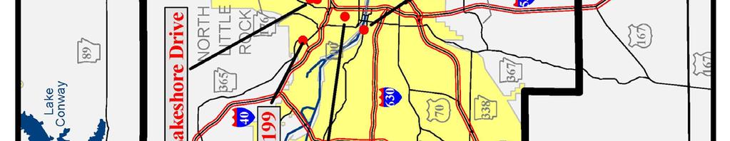
5 Page 12 Arkansas State Highway and Transportation Department Page 5 Lakeshore Drive Bridge In the past some historic bridges have been rehabilitated by the county in which it resides or by the city it serves. When this happens the funding used for these projects has come from Transportation Enhancement Funds distributed by AHTD for the Federal Highway Administration (FHWA). For more information on the Historic Bridge Program contact Robert Scoggin at or Robert.Scoggin@ahtd.state.ar.us. The Lakeshore Drive Bridge was constructed in 1935 by the Metropolitan Trust Company, as part of a $250,000 residential construction project called the Lakewood Development in North Little Rock. The Lakeshore Drive Bridge is an rough squared uncoursed rubble masonry arch bridge. Its vertical columns incorporated into the spandrel walls make it unique. This bridge was designed by Frank Carmean, the design architect for the Metropolitan Trust Company. The Lakewood Development is significant because it included an innovative system of lakes, open spaces and parks, which the bridge is a part of and reflects the rustic architectural theme of the Development. The bridge is located on Lakeshore Drive in North Little Rock as it crosses an unnamed creek west of Lake No. 3.


6 Page 6 Arkansas State Highway and Transportation Department Page 11 Amboy Overpass #02199 Lincoln Viaduct #M0336 Constructed in 1941, the Amboy Overpass was built by the J. P. McNutly in conjunction with the Arkansas State Highway Commission and the Federal Works Agency Public Roads Administration. The Amboy Overpass is a 573-foot long twelve span, steel multi-beam bridge. It is one of the state s largest example of a World War II era steel multi-beam bridge. The bridge was completed the year the United States entered World War II and is unusual for the amount of steel used to construct the bridge, instead of being used in the war effort. The Amboy Overpass is located on State Highway 365 over the Union Pacific Railroad line just north of the junction of State Highways 365 and 176. The Lincoln Viaduct was constructed in 1928 by the Ozark Engineering Company. It was designed by the Missouri-Pacific Railroad Company and presented to the City of Little Rock as a corporate gesture of good will. The Lincoln Viaduct was the first through Rainbow arch bridge built in Little Rock. It is an excellent example of a single span, through Rainbow arch concrete bridge. It is one of only two Rainbow arch bridges in the state. The bridge is located on State Highway 10 (Cantrell Road) and spans the lines of the Union Pacific Railroad Company, between Baring Cross Bridge and Union Station in Little Rock.


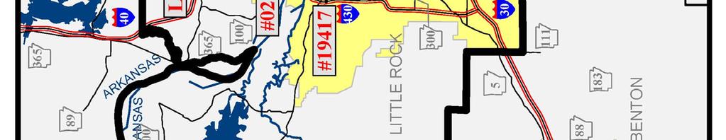
7 Page 10 14th Street Bridge #19417 The 14th Street Bridge was constructed in 1925 by the Missouri-Pacific Railroad Company. This bridge is a timber single span, pony Kingpost truss. It was the only Identified timber Kingpost bridge in Arkansas. In the late 1980s the timber truss was dismantled and steel multi-beams put in its place. The bridge spans the Union Pacific Railroad lines at 14th Street in North Little Rock. Arkansas State Highway and Transportation Department Page 7 Wolf Creek Bridge #16551 The Wolf Creek Bridge is an excellent Arkansas example of a Warren pony truss bridge. Constructed by an unknown builder in 1924, the Wolf Creek Bridge is the only Warren pony truss bridge constructed with a skew in Arkansas. The Wolf Creek Bridge is one of twenty-three Warren pony truss bridges currently surviving in the State and is the only surviving steel truss bridge in Pulaski County. The bridge is located on Pulaski County Road 85 as it crosses Wolf Creek on the Pulaski-Lonoke County border.


8 Page 8 Lake No. 1 Bridge #19407 The Lake No. 1 Bridge was constructed in 1935 by the Metropolitan Trust Company, as part of a $250,000 residential construction project called the Lakewood Development in North Little Rock. The Lake No. 1 Bridge is an uncoursed rubble masonry arch bridge. The bridge was designed by Frank Carmean, the design architect for the Metropolitan Trust Company. The Lakewood Development is significant because it included an innovative system of lakes, open spaces and parks, which the bridge is a part of and reflects the rustic architectural theme of the Development. The bridge is located on Avondale Road in North Little Rock as it crosses Lake No. 1. Arkansas State Highway and Transportation Department Page 9 Edgemere Street Bridge #19409 The Edgemere Street Bridge was constructed in 1935 by the Metropolitan Trust Company, as part of a $250,000 residential construction project called the Lakewood Development in North Little Rock. The Edgemere Bridge is an rough squared uncoursed rubble masonry arch bridge. Its vertical columns incorporated into the spandrel walls make it unique. This bridge was designed by Frank Carmean, the design architect for the Metropolitan Trust Company. The Lakewood Development is significant because it included an innovative system of lakes, open spaces and parks, which the bridge is a part of and reflects the rustic architectural theme of the Development. The bridge is located on Edgemere Road in North Little Rock as it crosses an unnamed creek east of Lake No. 3.
HISTORIC BRIDGES IN CRAWFORD COUNTY. Bridges Listed on the National Register of Historic Places in Crawford County
 Arkansas State Highway and Transportation Department HISTORIC BRIDGES IN CRAWFORD COUNTY Bridges Listed on the National Register of Historic Places in Crawford County 2004 Arkansas State Highway and Transportation
HISTORIC BRIDGES IN BENTON COUNTY. Bridges Listed on the National Register of Historic Places in Benton County
 Arkansas State Highway and Transportation Department HISTORIC BRIDGES IN BENTON COUNTY Bridges Listed on the National Register of Historic Places in Benton County 2004 Arkansas State Highway and Transportation
HISTORIC BRIDGES IN CONWAY COUNTY. Bridges Eligible for and Listed on the National Register of Historic Places in Conway County
 Arkansas State Highway and Transportation Department HISTORIC BRIDGES IN CONWAY COUNTY Bridges Eligible for and Listed on the National Register of Historic Places in Conway County 2004 Arkansas State Highway
HISTORIC AMERICAN ENGINEERING RECORD WATERSIDE STREET BRIDGE. HAER No. AR-72
 HISTORIC AMERICAN ENGINEERING RECORD WATERSIDE STREET BRIDGE LOCATION: STRUCTURAL TYPE: Spanning Lake 1 Tributary at Waterside Street (originally Sunset Drive), North Little Rock, Pulaski County, Arkansas
Historic Bridge Adoption Information Packet
 Historic Bridge Adoption Information Packet Falls County CR 179 over Big Elm Creek Bridge October 2017 Table of Contents Announcement... 3 Bridge Location... 4 Bridge Information... 4 Bridge Condition
Hunterdon County s Stone Arch Bridges
 Hunterdon County s Stone Arch Bridges Hunterdon County s interest in stone arch bridges began in 1992, when a developer wanted to a raze a stone arch bridge so that a road could be widened for a new development.
Los Angeles River Bridges Staff Presentation. Office of Historic Resources September 2007
 Los Angeles River Bridges Staff Presentation Office of Historic Resources September 2007 Area of Study Historic Context: What makes the bridges historic? Why were they built? When were they built? Who
ENVIRONMENTAL REQUIREMENTS FOR FEDERALLY FUNDED PROJECTS: SECTION 106 AND SECTION 4(F)
") ENVIRONMENTAL REQUIREMENTS FOR FEDERALLY FUNDED PROJECTS: SECTION 106 AND SECTION 4(F) Oklahoma Association of County Engineers November 8, 2016 Law and Regulatory Requirements: Section 106 National Historic
ENVIRONMENTAL REQUIREMENTS FOR FEDERALLY FUNDED PROJECTS: SECTION 106 AND SECTION 4(F) Oklahoma Association of County Engineers November 8, 2016 Law and Regulatory Requirements: Section 106 National Historic
Preservation: Why Not In Pennsylvania? Presented By: Nathan Holth
 Preservation: Why Not In Pennsylvania? Presented By: Nathan Holth PA Preservation Barriers Why Not Pennsylvania? Pennsylvania has an unrivaled collection of historic bridges, particularly metal truss bridges,
MINNESOTA ARCHITECTURE - HISTORY INVENTORY FORM
 Identification Historic Name Bridge L8849 Current Name Bridge L8849 Field # Address Municipal Road 99 over the Chippewa River City/Twp Montevideo County Chippewa Legal Desc. Twp 117N Range 40W Sec 07 QQ
HISTORIC AMERICAN ENGINEERING RECORD. MAPLE STREET OVERPASS (St. Louis-San Francisco Railway Viaduct) HAER No. AR-68
 HAER No. AR-68") HISTORIC AMERICAN ENGINEERING RECORD MAPLE STREET OVERPASS (St. Louis-San Francisco Railway Viaduct) LOCATION: Spanning former St. Louis & San Francisco Railroad at Maple Street (State Highway 16), Fayetteville,
HISTORIC AMERICAN ENGINEERING RECORD MAPLE STREET OVERPASS (St. Louis-San Francisco Railway Viaduct) LOCATION: Spanning former St. Louis & San Francisco Railroad at Maple Street (State Highway 16), Fayetteville,
Re: Reevaluation of Statewide Historic Bridge Inventory - Comprehensive Look at Remaining Inventory
 March 7th, 2017 Sarah Clarke Cultural Resources Program Environmental Division Virginia Department of Transportation 1401 East Broad Street Richmond, Virginia 23219 Re: Reevaluation of Statewide Historic
HISTORIC BRIDGE FOR SALE COLUMBIA BRIDGE IN JACKSON PARK, CHICAGO, ILLINOIS
 HISTORIC BRIDGE FOR SALE COLUMBIA BRIDGE IN JACKSON PARK, CHICAGO, ILLINOIS In Accordance With Illinois Law, The City of Chicago presents this information package as part of an effort to offer this historic
PRELIMINARY PUBLIC NOTICE 1-161
 Commander (dpb) First Coast Guard District 1 South Street Battery Park Building New York, NY 10004-1466 March 9, 2018 PRELIMINARY PUBLIC NOTICE 1-161 The United States Coast Guard is soliciting public
Overall Map. Chicago. St. Louis. Summit. Joliet. Dwight. Pontiac. Bloomington-Normal Lincoln. Springfield. Carlinville. Alton EXPERIENCE IT YOURSELF.
 Overall Map Summit Chicago Bloomington-Normal Lincoln New Station Planned New Station Planned Dwight Pontiac Joliet Pedestrian overpass and second platform planned Higher speed service began in this section
SUMMARY. Support the Southeast Arkansas Regional Intermodal Facility.
 SUMMARY THE I-69 LOCATION STUDY The proposed I-69 Location Study from El Dorado to McGehee, Arkansas, represents one section (Section of Independent Utility No. 13) of the nationally designated I-69 Corridor
Clay Street Bridge Replacement Project
 Clay Street Bridge Replacement Project Frequently Asked Questions (FAQs) No. 2 April 4, 2018 The project is located in downtown Placerville on Clay Street between US Highway 50 and Main Street and Cedar
MINNESOTA ARCHITECTURE - HISTORY INVENTORY FORM
 Identification Historic Name Dean Parkway Bridge Current Name Bridge 90661 Field # Address Midtown Greenway over Dean Parkway City/Twp Minneapolis County Hennepin Legal Desc. Twp 29N Range 24W Sec 32 QQ
FY STATEWIDE TRANSPORTATION IMPROVEMENT PROGRAM New Jersey Department of Transportation Projects
 69th Street Bridge 02311 02311 A grade separation at 69th Street would eliminate the current at-grade crossing which causes frequent automobile delays due to long freight trains moving through this area.
Virginia s Historic Bridges. Presented By: Nathan Holth Copyright 2017
 Virginia s Historic Bridges Presented By: Nathan Holth Copyright 2017 Introduction: About Me Website created and maintained by me. Photos, Advocacy, & Documentation 32 States 4 Canadian Provinces 4475
Visitor's Guide to Historic Bridge Park
 Visitor's Guide to Historic Bridge Park Located in Calhoun County, Michigan, southeast of Battle Creek, the park is open year-round from 8:00 AM to 8:00 PM. Entry to the park is free of charge. Guide produced
Corridor Enhancements
 Corridor Enhancements Safety is MoDOT s first priority in widening and rebuilding I-70 across the state of Missouri. MoDOT also understands that the interstate - and its interchanges and overpasses - are
MINNESOTA HISTORIC PROPERTY RECORD PART I. PROPERTY IDENTIFICATION AND GENERAL INFORMATION
 MINNESOTA HISTORIC PROPERTY RECORD PART I. PROPERTY IDENTIFICATION AND GENERAL INFORMATION Common Name: Fort Snelling-Mendota Bridge Bridge Number: 4190 Identification Number: Location: Feature Carried:
Victoria Bridge Municipal Class EA Civic Works Committee
 Municipal Class EA John Pucchio, P. Eng., Project Manager June 19 2018 Introduction Existing Conditions Municipal Class EA Proposed Bridge Proposed Road Reconstruction Proposed Improvements Construction
Los Angeles Department of City Planning RECOMMENDATION REPORT
 Los Angeles Department of City Planning RECOMMENDATION REPORT CULTURAL HERITAGE COMMISSION HEARING DATE: April 15, 2010 TIME: 10:00 AM PLACE: City Hall, Room 1010 200 N. Spring Street Los Angeles, CA 90012
I-494 Rehabilitation Project SP (I-394 to Fish Lake Interchange) June 2014 Section 4(f) De Minimis Determination
 June 2014 Section 4(f) De Minimis Determination") I-494 Rehabilitation Project SP 2785-330 (I-394 to Fish Lake Interchange) June 2014 Section 4(f) De Minimis Determination State Project Number 2785-330 Federal Project No. NHPP-I494 (002) Trunk Highway:
I-494 Rehabilitation Project SP 2785-330 (I-394 to Fish Lake Interchange) June 2014 Section 4(f) De Minimis Determination State Project Number 2785-330 Federal Project No. NHPP-I494 (002) Trunk Highway:
Pennsy Greenway Trail
 Town of Schererville Pennsy Greenway Trail DES. #s: 0401062, 1173595 & 1382661 Construction of Pennsy Greenway Trail beginning at Wilhelm Street and continuing northwest along the former Penn Central railroad
National Register of Historic Places Continuation Sheet
 NPS Form 10-900-a (Rev. 8/2002) OMB No. 1024-0018 (Expires 5-31-2012) United States Department of the Interior National Park Service National Register of Historic Places Continuation Sheet Bridge No. 5721
Historic Property Report
 Historic Name: Rutter Parkway Stone Structures Property ID: 706402 Location Address: GeographicAreas: W Rutter Pkwy, Spokane, Washington, USA Spokane,Spokane County,T26R42E03,DARTFORD Quadrangle Information
You Don't Know What You've Got 'til it's Gone. Creative Cities Summit 2012 Victoria, British Columbia Kate Hagerman Cultural Heritage Specialist
 You Don't Know What You've Got 'til it's Gone Creative Cities Summit 2012 Victoria, British Columbia Kate Hagerman Cultural Heritage Specialist Presentation Outline Waterloo Region Research Based Conservation
MINNESOTA ARCHITECTURE - HISTORY INVENTORY FORM
 Historic Name Identification Chimney Rock Footbridge SHPO Inventory Number Review and Compliance Number Current Name Chimney Rock Footbridge Field # Address Ped. Bridge Over Whitewater River in Whitewater
FY STATEWIDE TRANSPORTATION IMPROVEMENT PROGRAM New Jersey Department of Transportation Projects
 Route 1&9, County Road 99380 99380 Improvements are planned at the Route 1&9, County Road intersection to address operational and safety issues in the vicinity of Manhattan Avenue and County Road. COUNTY:
Connecting the DOTs: Nationwide Trends in the Inventory, Evaluation, and Management of Historic Roads
 Connecting the DOTs: Nationwide Trends in the Inventory, Evaluation, and Management of Historic Roads In 2013-2014 Mead & Hunt, Inc. surveyed state Departments of Transportation (DOTs) on how they address
Fall 2017 Construction Update
 Fall 2017 Construction Update Ward 4 Southeast Engineering Department Riverwalk Red Multi-Use Trail Bridge Rehabilitation The Riverwalk Red Multi Use Trail Bridge was awarded to Cramer and Associates,
How can landscape architects aide in transportation planning process? John Dempsey, PLA Toole Design Group July 24, 2015
 How can landscape architects aide in transportation planning process? John Dempsey, PLA Toole Design Group July 24, 2015 What is Landscape Architecture? Landscape Architecture 1863 What is Landscape Architecture?
L 3-1. Heritage Report: Reasons for Heritage Designation. Wiley Bridge Gorewood Drive, Claireville Conservation Area
 L 3-1 Brampton Heritage Board Date: June 19, 2012 Heritage Report: Reasons for Heritage Designation Wiley Bridge Gorewood Drive, Claireville Conservation Area June 2012 1 L 3-2 Profile of Subject Property
NEW JERSEY DEPARTMENT OF TRANSPORTATION BUREAU OF ENVIRONMENTAL SERVICES NEW JERSEY HISTORIC BRIDGE DATA
 STRUCTURE # 0500006 STONE HARBOR BOULEVARD OVER GREAT CHANNEL OWNER COUNTY MILEPOINT 0.0 FACILITY STONE HARBOR BOULEVARD TOWNSHIP STONE HARBOR BOROUGH TYPE DOUBLE LEAF BASCULE DESIGN RALL # SPANS 11 LENGTH
North River Mills Bridge Hampshire County State Project # S314-45/ Federal Project # ARRA-4520(003)D FR#: HM-1
D FR#: HM-1") North River Mills Bridge Hampshire County State Project # S314-45/20-2.40 02 Federal Project # ARRA-4520(003)D FR#: 10-1463-HM-1 STATE LEVEL OF HISTORIC DOCUMENTATION November 2010 West Virginia Department
North River Mills Bridge Hampshire County State Project # S314-45/20-2.40 02 Federal Project # ARRA-4520(003)D FR#: 10-1463-HM-1 STATE LEVEL OF HISTORIC DOCUMENTATION November 2010 West Virginia Department
Today s Topics. Is Preservation Sustainable? Environmental Benefits of Preservation. Other Benefits of Preservation. Common Issues and Questions
 Today s Topics Is Preservation Sustainable? Environmental Benefits of Preservation Other Benefits of Preservation Common Issues and Questions Preservation Resources Tennessee s Historic Legacy Tennessee
MINNESOTA ARCHITECTURE - HISTORY INVENTORY FORM
 Identification Historic Name Bridge L8503 Current Name Bridge L8503 Field # Address Seven Bridges Road over Amity Creek City/Twp City of Duluth County St. Louis Legal Desc. Twp 51N Range 13W Sec 32 QQ
Eligible, see Statement of Significance. Roadside Development on Minnesota Trunk Highways,
 Historic Name CS # 0115 Other Name SHPO Inv # Location Both sides of TH 169 on isthmus between Little Pine Lake and Hickory Lake Hwy District Reference City/Township County Farm Island Township Aitkin
Beckett Bridge PD& E Study. Presentation to: Board of County Commissioners
 Beckett Bridge PD& E Study Presentation to: Board of County Commissioners October 22, 2013 Introduction Study Began January 2012 Alternatives Presented to Commission October 2013 Alternatives Presented
Prize Bridges 1961 AMERICAN INSTITUTE OF STEEL CONSTRUCTION, INC. 101 Park Avenue, New York 17, N. Y.
 Prize Bridges 1961 Steel bridges selected in the annual national competition conducted by the American Institute of Steel Construction as the most beautiful bridges opened to traffic in 1961. AMERICAN
Visual and Aesthetics
 Such a connection could accommodate timed transfers and improve connections between local transit service and Presidio Shuttle service. Level of Service The results of the analysis are provided on a route-by-route
Washington Pass Overlook
 Washington Pass Overlook The Washington Pass Overlook is located on the Methow Valley Ranger District on the Okanogan-Wenatchee National Forest. The overlook is at the crest of Washington Pass and is part
Phase I Results. Minnesota Local Historic Bridge Study. Minnesota Department of Transportation. Bridge 448 in Olmsted County. Report prepared for
 Phase I Results Minnesota Local Historic Bridge Study Bridge 448 in Olmsted County Report prepared for Minnesota Department of Transportation Bridge L7075 in Todd County Report prepared by www.meadhunt.com
JOINT PUBLIC NOTICE CORPS OF ENGINEERS STATE OF ARKANSAS Application Number: SWL Date: July 5, 2018 Comments Due: July 30, 2018
 US Army Corps of Engineers Little Rock District JOINT PUBLIC NOTICE CORPS OF ENGINEERS STATE OF ARKANSAS Application Number: SWL 2014-00257-1 Date: July 5, 2018 Comments Due: July 30, 2018 TO WHOM IT MAY
Final Design Meeting. September 25, Creating Bridges As Art. Welcome & Introductions. Terry Ward - Project Manager
 Final Design Meeting September 25, 2014 Creating Bridges As Art 1 Welcome & Introductions Terry Ward - Project Manager 2 VQRC Final Design Meetings Meeting Date Items for Discussion Final Design Meeting
Guide to the Rhode Island Department of Transportation Historic Resources Archive Documentation and Archaeology Series records
 Page 1 of 18 Guide to the Rhode Island Department of Transportation Historic Resources Archive Documentation and Archaeology Series records 1997-2015 337 Westminster Street Providence, RI 02903 Tel: 401-222-2353
Chapter 10 Route window W17 Middlegreen Road, St Mary s Road and Trenches bridges. Transport for London
 Chapter 10 Route window W17 Middlegreen Road, St Mary s Road and Trenches bridges Transport for London MIDDLEGREEN ROAD, ST MARY S ROAD AND TRENCHES BRIDGES 10 Route window W17 Middlegreen Road, St Mary
Illinois Planning and Environmental Studies for FRA Applications for High-Speed and Intercity Passenger Rail (HSIPR)
") Illinois Planning and Environmental Studies for FRA Applications for High-Speed and Intercity Prepared by Tim Selover, PE, AICP Parsons Brinckerhoff On April 16, 2009, President Obama described his Vision
Illinois Planning and Environmental Studies for FRA Applications for High-Speed and Intercity Prepared by Tim Selover, PE, AICP Parsons Brinckerhoff On April 16, 2009, President Obama described his Vision
Welcome to the Sellwood Bridge Project Pre-Construction Open House
 Welcome to the Sellwood Bridge Project Pre-Construction Open House 5:30 7:30 p.m. Please sign in here Information stations and project staff are located throughout the room. Goals for Tonight s Meeting
St. Louis Engineering and Transportation Services
 St. Louis Engineering and Transportation Services Amec Foster Wheeler s St. Louis office, with over 80 professional and support personnel, provides excellence in engineering and professional consulting
TOWN OF AURORA ARCHITECTURAL SALVAGE PROGRAM GUIDE
 PLANNING AND DEVELOPMENT SERVICES Development Planning Division Heritage Planning Section Phone: 905-727-3123 ext. 4226 Fax: 905-726-4736 Email: planning@aurora.ca Town of Aurora 100 John West Way, Box
Brentwood - Pacific Palisades Report Non-Parcel Resources 11/26/13
 Non-Parcel Resources Sunset Bl at Mandeville Canyon Rd Air Raid Siren No. 141 Year built: 1940 Context: Public and Private Institutional Development, 1850-1980 Military Institutions and Activities, 1850-1980
Page. I. Introduction 1. II. Project Purpose and Need 2. IV. Description of Section 4(f) Property 2. V. Impacts to Section 4(f) property 3
 Property 2. V. Impacts to Section 4(f) property 3") Table of Contents Programmatic Section 4(f) Evaluation for use of a Historic Bridge Replacement of Route 30/130 Bridge over the Cooper River Structure No. 0405-153 City of Camden, Borough of Collingswood,
Table of Contents Programmatic Section 4(f) Evaluation for use of a Historic Bridge Replacement of Route 30/130 Bridge over the Cooper River Structure No. 0405-153 City of Camden, Borough of Collingswood,
Proposed FY 2004 TRANSPORTATION CAPITAL PROGRAM New Jersey Department of Transportation Projects
 Carteret Industrial Road 98547 This project will address the upgrade of Carteret Industrial Road. The federal Transportation Equity Act for the 21st Century (TEA-21) provided funding for this project under
Longmeadow Parkway Fox River Bridge Corridor. August 6, 2015
 Longmeadow Parkway Fox River Bridge Corridor August 6, 2015 Longmeadow Parkway Bridge Corridor 5.6 miles from Huntley Road to IL 62 Unique municipal/county/state/federal partnership Links Randall Road
Parapet/Formliner/Fencing
 Parapet/Formliner/Fencing Cross Parapet/Formliner/Fencing Street Aesthetic Features Context The I-290 Phase I study is evaluating improvements along 13 miles of the Eisenhower Expressway, from west of
CENTERTON ROAD BRIDGE REPLACEMENT
 CENTERTON ROAD BRIDGE REPLACEMENT FEASIBILITY STUDY BURLINGTON COUNTY BRIDGE C4.4 OVER RANCOCAS CREEK TOWNSHIPS OF MOUNT LAUREL, WESTAMPTON & WILLINGBORO 1 prepared for: BOARD OF CHOSEN FREEHOLDERS BURLINGTON
West Dennis Center: Bass River to Old Main Street. West Dennis Business District: Old Main Street to Dennis Commons
 West Dennis Center: Bass River to Old Main Street West Dennis Business District: Old Main Street to Dennis Commons Dennisport Center: Dennis Commons to Division Street Main Street Project Goals Project
ORDINANCE NO Adopted by the Sacramento City Council. November 10, 2016
 ORDINANCE NO. 2016-0048 Adopted by the Sacramento City Council November 10, 2016 LISTING THE SACRAMENTO RAILYARDS WATER TOWER AS A LANDMARK ON THE SACRAMENTO REGISTER OF HISTORIC & CULTURAL RESOURCES BACKGROUND
DRAFT SECTION 4(F) EVALUATION LIFT BRIDGE
 EVALUATION LIFT BRIDGE") DRAFT SECTION 4(F) EVALUATION I. DESCRIPTION OF SECTION 4(F) RESOURCE The Section 4(f) resource affected by the proposed action is the Lift Bridge, a property listed on the National Register of Historic
DRAFT SECTION 4(F) EVALUATION I. DESCRIPTION OF SECTION 4(F) RESOURCE The Section 4(f) resource affected by the proposed action is the Lift Bridge, a property listed on the National Register of Historic
MINNESOTA ARCHITECTURE - HISTORY INVENTORY FORM
 Identification Historic Name Nicollet Avenue Bridge Current Name Nicollet Avenue Bridge Field # Address Nicollet Avenue over Minnehaha Creek City/Twp Minneapolis SHPO Inventory Number Review and Compliance
The Village of Sugar Grove, in partnership with Kane County, the Illinois Department of Transportation, and the Illinois Tollway welcomes you to the
 The Village of Sugar Grove, in partnership with Kane County, the Illinois Department of Transportation, and the Illinois Tollway welcomes you to the first Public Meeting for the proposed interchange improvement
Maryland Historical Trust Inventory No. PG: 71A-006 Maryland Inventory of Historic Properties Form
 Inventory No. PG: 71A-006 Maryland Inventory of 1. Name of Property (indicate preferred name) historic other 2. Location Concrete Railroad Bridge Washington, Baltimore, & Annapolis Electric Railway Bridge
Grand River Ravines Georgetown Township
 Grand River Ravines Georgetown Township Project Description: The Grand River Ravines County Park property is composed of the 68-acre former Fillmore at the Bend Open Space purchased in 1999 and two more
6:00 8:00 PM I-95 FROM EXIT 57 TO EXIT 60 PROJECT
 PUBLIC INFORMATIONAL MEETING TUESDAY, APRIL 27, 2010 AT NEWBURYPORT CITY HALL, AUDITORIUM 60 PLEASANT STREET NEWBURYPORT, MASSACHUSETTS 6:00 8:00 PM FOR THE PROPOSED WHITTIER BRIDGE / I-95 IMPROVEMENTS
Fredericksburg Historic Resources Survey
 Fredericksburg Historic Resources Survey NOVEMBER 2018 Presentation Overview Historic Resources Surveys Project Background Project Goals Project Approach Results Historic Resources Surveys Historic Resources
WELCOME TO PUBLIC INFORMATION CENTRE #2. Please Sign In
 WELCOME TO PUBLIC INFORMATION CENTRE #2 Replacement of Oxtongue Lake Narrows Bridge & Oxtongue River Bridge, Highway 60 (G.W.P. 93-89-00 & G.W.P. 5550-04-00) Class Environmental Assessment (Group B) Please
BEST PRACTICES FOR PROJECT NOMINATIONS TA Set-Aside Program
 BEST PRACTICES FOR PROJECT NOMINATIONS 2017 TA Set-Aside Program Focus of this presentation Photos Public Support Maps & Exhibits Proposed Budget Design Details Project Evaluation & Selection Criteria
75-89 Wallis Road & 59 Berkshire Road, Hackney Wick, London, E9 5LN
 East London Mixed-Use Development Opportunity CGI of Proposed Scheme Summary A mixed-use development opportunity located in Hackney Wick within the jurisdiction of the London Legacy Development Corporation.
WELCOME! 8 8:30 6: TH STREET IMPROVEMENTS. Open House. Presentation & Q&A
 WELCOME! 168 TH STREET IMPROVEMENTS 6:30 Open House 7 8 Presentation & Q&A 8 8:30 Open House WELCOME Todd Pfitzer City of Omaha Engineer Bob Stubbe City of Omaha Public Works Director Jon Meyer Project
Grand Rounds History
 Grand Rounds History 1883 Plan for Minneapolis Park System prepared by Landscape Architect Horace W. S. Cleveland. The system of connecting parks and parkways was first called the Grand Rounds by William
CHAPTER 4.0: REVISIONS TO THE DRAFT SEIR
 CHAPTER 4.0: REVISIONS TO THE DRAFT SEIR This chapter contains the revisions to the Draft SEIR. Text that has been deleted from the draft document is shown with a red line through the deleted text. Text
From local initiatives to some of the largest and most complex projects, KOA leads the field in:
 Krech Ojard & Associates offers a highly capable multidisciplined team that provides the professional services needed to deliver successful transportation facility improvements. Our team provides multidisciplinary
Minneapolis South Z15 E N Not Eligible, see Statement of Significance Also member of eligible NR district: Lilac Way Historic District
 Historic Name CS # 2735 Other Name SHPO Inv # Location NW corner of TH 100/TH 55 cloverleaf Hwy District Reference City/Township County Golden Valley, City of Hennepin Acres Twp Rng Sec 118N 21W Sec 33
I-70 Corridor Enhancement Plan
 i - Table of Contents Table of Contents Chapter I Overview Chapter II Bridge and Roadway Improvements Chapter III Landscape Enhancements Chapter IV Riparian Corridors Chapter V Showcase Missouri Plan Chapter
THREE-YEAR CAPITAL IMPROVEMENT PLAN FY
 THREE-YEAR CAPITAL IMPROVEMENT PLAN FY2016 2018 Annual CIP Development Process Public Works & Engineering Divisions Prepare List of Capital Needs and Recommended Deferred Maintenance Public Works & Engineering
Engineering Department R.H. Thomson Freeway Records,
 Engineering Department R.H. Thomson Freeway Records, 1958-1977 Overview of the Collection Creator Seattle (Wash.). Engineering Dept. Title Engineering Department R.H. Thomson Freeway Records Dates 1958-1977
Mississippi Skyway Preliminary Engineering Report
 EXECUTIVE SUMMARY Mississippi Skyway Preliminary Engineering Report CITY OF RAMSEY, MINNESOTA DECEMBER 2014 City of RAMSEY EXECUTIVE SUMMARY Project Need and Intent The Mississippi Skyway pedestrian bridge
HISTORIC AMERICAN ENGINEERING RECORD. FRYER S FORD BRIDGE (Fryer Bridge) (Solgohachia Bridge) HAER No. AR-64
 (Solgohachia Bridge) HAER No. AR-64") HISTORIC AMERICAN ENGINEERING RECORD FRYER S FORD BRIDGE (Fryer ) (Solgohachia ) LOCATION: Spanning East Fork of Point Remove Creek at Fryer Road (County Road 67), Solgohachia vicinity, Conway County,
HISTORIC AMERICAN ENGINEERING RECORD FRYER S FORD BRIDGE (Fryer ) (Solgohachia ) LOCATION: Spanning East Fork of Point Remove Creek at Fryer Road (County Road 67), Solgohachia vicinity, Conway County,
Iowa 100 Extension Project Visualizations for Design and Public Involvement ASCE Transportation Conference November 6, 2013 Ames, Iowa
 Iowa 100 Extension Project Visualizations for Design and Public Involvement 2013 ASCE Transportation Conference November 6, 2013 Ames, Iowa Agenda Project Corridor Constraints Key Features Project History
The Capital Design Advisory Committee St. Mary s College of Maryland & Historic St. Mary s City
 The Capital Design Advisory Committee St. Mary s College of Maryland & Historic St. Mary s City Welcome April 21, 2010 Capital Design Advisory Presentation: Relocating Margaret Brent Hall Traffic Calming
Downingtown Station Relocation Plan Site Selection Memo June 12, 2012
 Downingtown Station Relocation Plan Site Selection Memo 06.12.12 June 12, 2012 Background and Overview Downingtown is a borough in Chester County, Pennsylvania located approximately 32 miles west of Philadelphia
AGENDA ACTION ITEMS INFORMATION ITEMS
 NOACA Bicycle and Pedestrian Advisory Council Meeting Friday, March 21 st, 2014 10:30 a.m. NOACA Office 1299 Superior Avenue Cleveland, Ohio 44114 Phone: (216) 241-2414; website: www.noaca.org AGENDA ACTION
I-66 EASTBOUND WIDENING INSIDE THE BELTWAY PARDON OUR DUST MEETING
 I-66 EASTBOUND WIDENING INSIDE THE BELTWAY From the Dulles Connector Road (Route 267) to Fairfax Drive (Route 237) PARDON OUR DUST MEETING Bill Cuttler, PE (VDOT District Construction Engineer, Northern
Appendix E Memorandum of Agreement between FHWA and the SHPO
 Appendix E between FHWA and the SHPO MEMORANDUM OF AGREEMENT BETWEEN THE FEDERAL HIGHWAY ADMINISTRATION AND THE FLORIDA STATE HISTORIC PRESERVATION OFFICER PURSUANT TO 36 CFR PART 800 REGARDING THE WEKIVA
ARKANSAS STATE HIGHWAY AND TRANSPORTATION DEPARTMENT INTER OFFICE MEMORANDUM. January 17, John Fleming, Division Head, Environmental Division
 ARKANSAS STATE HIGHWAY AND TRANSPORTATION DEPARTMENT INTER OFFICE MEMORANDUM January 17, 2017 TO: Master Files FROM: John Fleming, Division Head, Environmental Division SUBJECT: February 2017 Pavement
Great Rivers Greenway CLEAN GREEN CONNEC TED T RAILS
 Great Rivers CLEAN GREEN CONNEC TED T RAILS Great Rivers (GRG) was established in 2000 to create a clean, green, connected St. Louis region. Today, many new and exciting projects demonstrate the social,
Existing Transportation System 5-1
 5-1 The Jackson County transportation system is served by several modes of transportation including streets and highways, multi-modal, non-motorized, rail, and aviation. While the focus of the transportation
TIMOTHY E. DATERS, P.E. White-Daters & Associates, Inc. 24 Rahling Circle Little Rock, AR (501)
") TIMOTHY E. DATERS, P.E. tdaters@whitedaters.com Graduated from University of Iowa, 1975, BSCE Recipient of Fred Stebler Scholarship Graduated from University of Arkansas, 1983, MSCE PROFESSIONAL ORGANIZATION
TIMOTHY E. DATERS, P.E. tdaters@whitedaters.com Graduated from University of Iowa, 1975, BSCE Recipient of Fred Stebler Scholarship Graduated from University of Arkansas, 1983, MSCE PROFESSIONAL ORGANIZATION
Project Goal. RRRC Living Towns Planning Workshp. Town of Halifax Revitalization Project. Dynamic Planning & Management Duo: July 12, 2006
 Project Goal Town of Halifax Revitalization Project RRRC Living Towns Planning Workshp July 12, 2006 Town of Halifax Halifax County *** Revitalization Project Goal*** To create Economic Opportunity and
Borderland Expressway Coalition Status Report Camino Real RMA Board Meeting. El Paso, TX April 11, 2018
 Borderland Expressway Coalition Status Report Camino Real RMA Board Meeting El Paso, TX April 11, 2018 Coalition Key Stakeholders Texas Department of Transportation New Mexico Department of Transportation
Rundel Library Elevated River Terrace Reconstruction City of Rochester, N.Y. Application Number July 2017
 Rundel Library Elevated River Terrace Reconstruction City of Rochester, N.Y. Application Number 75047 July 2017 PROJECT DESCRIPTION The Rundel Library is a nationally registered historic building surrounded
HISTORIC SITE FORM - HISTORIC SITES INVENTORY PARK CITY MUNICIPAL CORPORATION (10-08) 1 IDENTIFICATION
 1 IDENTIFICATION") HISTORIC SITE FORM - HISTORIC SITES INVENTORY PARK CITY MUNICIPAL CORPORATION (10-08) 1 IDENTIFICATION Name of Property: Lapage H. Raddon House Address: 817 Woodside Avenue AKA: City, County: Park City,
HISTORIC SITE FORM - HISTORIC SITES INVENTORY PARK CITY MUNICIPAL CORPORATION (10-08) 1 IDENTIFICATION Name of Property: Lapage H. Raddon House Address: 817 Woodside Avenue AKA: City, County: Park City,
Historic Bridge Foundation Facebook Archives
 Historic Bridge Foundation Facebook Archives Focus Bridges: Harahan Bridge November 2016 In October 2016, Memphis Tennessee became home to one of the most impressive examples of adaptive reuse of a historic
MINNESOTA ARCHITECTURE - HISTORY INVENTORY FORM
 Identification Historic Name Bridge L8477 (Lincoln Park Bridge) Current Name Bridge L8477 Field # Address 10 th Street over Miller s Creek and Lincoln Park Drive City/Twp City of Duluth County St. Louis
historic name: STARR MILL ROAD BRIDGE other name/site number: Beverly Heights Bridge. Bridge No. 4541
 NFS Form 10-900 < (Rev. 8-86)! REGISTRATION FORM RECEIVED OCT 2 8 1993 NATIONAL REGISTER *! 0 2 4 0 0 1 8 =============================================$======================= === 1. Name of Property '
ARGENTA TRAIL (CSAH 28/63) REALIGNMENT SOUTH PROJECT (CP 63-25)
 REALIGNMENT SOUTH PROJECT (CP 63-25)") ARGENTA TRAIL (CSAH 28/63) REALIGNMENT SOUTH PROJECT (CP 63-25) Preliminary Design Report February 2015 Prepared For: City of Inver Grove Heights Dakota County Prepared By: Kimley-Horn and Associates,
ARGENTA TRAIL (CSAH 28/63) REALIGNMENT SOUTH PROJECT (CP 63-25) Preliminary Design Report February 2015 Prepared For: City of Inver Grove Heights Dakota County Prepared By: Kimley-Horn and Associates,