CENTERTON ROAD BRIDGE REPLACEMENT
|
|
|
- Beverly Goodman
- 5 years ago
- Views:
Transcription
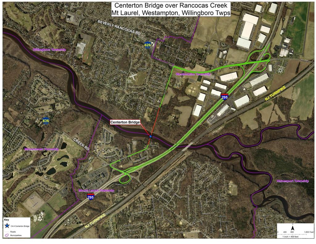
1 CENTERTON ROAD BRIDGE REPLACEMENT FEASIBILITY STUDY BURLINGTON COUNTY BRIDGE C4.4 OVER RANCOCAS CREEK TOWNSHIPS OF MOUNT LAUREL, WESTAMPTON & WILLINGBORO 1

2 prepared for: BOARD OF CHOSEN FREEHOLDERS BURLINGTON COUNTY, NEW JERSEY Joseph Brickley, County Engineer prepared by: MASER CONSULTING AECOM RICHARD GRUBB & ASSOSCIATES 2
3 3
4 4
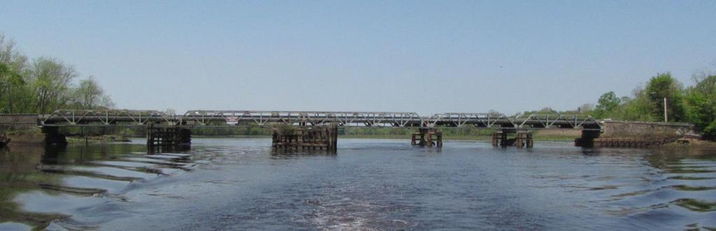
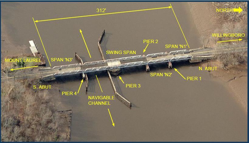
5 BRIDGE HISTORY The existing Centerton Road Bridge is a 312 long steel pony truss with 3 fixed spans and a center moveable swing span. Originally constructed in Major rehabilitation performed in Deck and superstructure repairs performed in 1984/1985. Additional deck repairs made in Bridge closed April 23, s POSTED 8 TONS 1980 s POSTED 4 TONS 1985 to 2009 POSTED 12 TONS 2009 to 2015 POSTED 5 TONS (NO TRUCKS, NO TRAILERS, NO VEHICLES OVER 8 ) APRIL 23, 2015 BRIDGE CLOSED Route I-295 was built in TH lane of travel over the Rancocas Creek between CR 626 (Beverly-Rancocas Road) and CR 636 (Creek Road). 4 TH lane specifically constructed to replace Centerton Road Bridge. 5
6 EXISTING BRIDGE CONDITIONS Bridge is founded on stone masonry abutments, a stone masonry pier under the swing span, and 3 steel I-beam piers. Existing clear roadway width of 18-4 (lane width is 8-6 in each direction). The existing bridge lacks pedestrian and bike access. The existing bridge also lacks shoulders along roadway. A full bridge inspection was performed by Taylor Wiseman & Taylor Engineers with underwater inspection performed by W.J. Castle PE & Associates in April Based on findings, it was recommended the bridge remain closed to vehicular traffic. For the bridge s long term future a major rehabilitation, complete replacement, permanent closure or complete removal should be evaluated due to the bridge s age, substandard features and numerous major deficiencies. Burlington County Engineer s Office concurred with the recommendations. All features of the bridge are substandard. The existing bridge is structurally deficient and functionally obsolete; its structural condition warrants demolition. 6
7 CENTERTON ROAD BRIDGE REPLACEMENT FEASIBILITY STUDY Maser Consulting P.A. considered the following four (4) alternatives and their associated impacts in their feasibility study. Alternative 1 No Build Permanent Elimination of Crossing (removal of structure up to but not including abutments) Alternative 2 Three-Span Fixed Vehicular Bridge Alternative 3 Three-Span Fixed Pedestrian Bridge Alternative 4 New Moveable Swing Bridge 7
8 TRAFFIC STUDY Since the closure of the Centerton Road Bridge, traffic has diverted to routes that run parallel, over Rancocas Creek. Alternate routes consist of: US Route 130 (aka Burlington Pike) 4 th Lane on Route I-295 Route specifically constructed to replace Centerton Road Bridge. A traffic study and capacity analysis was performed using current traffic patterns in the area and anticipated demands into the year Analyses were performed based on current conditions (with the Centerton Road Bridge closed to traffic) as well as based on possible future conditions (construction of a new vehicular crossing). Since the closure of the Centerton Road Bridge, the level of service of I-295 has not been negatively impacted. By comparing results of the analyses, it was determined that a new vehicular crossing would not significantly improve the traffic patterns on I-295 into the year
9 HYDRAULICS & SCOUR ASSESSMENT Similar to the existing bridge, any bridge alternatives should be aligned with the flow and the channel. Piers should be streamlined and circular, if possible. The smaller, the better - to minimize the potential scour depth effects. The bottom of deck should clear the hydraulic design elevation. Machinery associated with any of the alternatives should also be positioned above the flood elevations. Based on findings in the preliminary hydraulics and scour assessment, any of the alternatives considered can be designed as to withstand potential scour. It is recommended that subsurface investigations and hydraulic modeling be conducted during preliminary design phases for any of the alternatives to estimate potential scour depths and design parameters. 9
10 NAVIGATION STUDY Currently, the Centerton Road Bridge provides less than < 4-0 of vertical underclearance over the mean high water of Rancocas Creek. Access to waterways in the vicinity of the bridge is limited to vessels with minimal draft and height requirements given the shallow depths and meandering nature of the waterway. Either of the fixed bridge alternatives would provide 12-0 underclearance over mean high water for a 60-0 wide navigable channel. The 12-0 underclearence over mean high water was established for either of the fixed bridge alternatives through coordination with the U.S. Coast Guard and the New Jersey Marine Police (NJSP). 10
11 ECOLOGICAL ASSESSMENT All designs must attempt to minimize impacts to environmentally sensitive features while also meeting public needs and the requirements for associated permits. Redevelopment of any bridge structure at the project site will be subject to NJDEP permitting and compliance with: Coastal Zone Management Rules (N.J.A.C.7:7) Freshwater Wetlands Protection Act Rules (N.J.A.C 7:7A) Flood Hazard Area Control Act Rules (N.J.A.C. 7:13) U.S.A.C.E. approval (under Section 10 of the Rivers and Harbors Act of 1899 and Section 404 of the Clean Water Act) U.S. Coast Guard review The NJDEP cites potential occurrences of habitat for rare, threatened and/or endangered species in the vicinity of County Bridge #C4.4. The onsite wetlands will be classified as intermediate resource value wetlands with a 50-foot wide transition area or buffer. 11
12 CULTURAL RESOURCES STUDY Based on a review conducted by the Department of Environmental Protection Natural & Historic Resources Historic Preservation Office, the Centerton Road Bridge is individually eligible for listing in the New Jersey and National Registers of Historic Places under Criterion C for its engineering significance. Burlington County was granted permission to remove the bridge by the State Historic Preservation Office. SHPO requests that a plaque be installed near the bridge to commemorate its existence after its removal. RGA, Inc conducted a Phase IA historical and archaeological survey and reconnaissance-level historic architectural survey for the proposed replacement of Centerton Road Bridge. The Phase IA historical and archaeological survey was conducted to determine the archaeological sensitivity of the Area of Potential Effect for Archaeology (APE- Archaeology). No registered archaeological sites are located within or adjacent to the APE-Archaeology, but 23 registered prehistoric and/or historic archaeology sites are located within one mile of the APE-Archaeology. A Phase IB archaeological survey was recommended for portions of the APE- Archaeology with high archaeological sensitivity. 12
13 APE ARCHAEOLOGY (AREAS OF ARCHEOLOGIC AL SENSITIVITY) 13
14 APE ARCHAEOLOGY (AREAS OF ARCHEOLOGIC AL SENSITIVITY) 14
15 ROADWAY DESIGN EVALUATION To accommodate new underclearence requirements established (for fixed bridge alternatives), the vertical alignment of the roadway will be changed dramatically. A dramatic change in vertical alignment requires the entire roadway within the project limits to be fully reconstructed with new full depth pavement. Retaining walls are proposed for both sides of the roadway to minimize environmental disturbances and right of way acquisitions that are associated with raising the roadway so that fixed bridge alternatives meet the underclearence heights established. The next two slides illustrate the significant change in the roadway profile required for Alternative 2 (or any fixed crossing alike). 15

16 ALTERNATIVE 2 BRIDGE ELEVATION (1 OF 3) PROPOSED CENTERTON ROADWAY IN ELEVATION = ± 5 ± PROPOSED CENTERTON ROADWAY IN ELEVATION = ± 5 IN ELEVATION = ± 9 ±
17 ALTERNATIVE 2 BRIDGE ELEVATION (2 OF 3) IN ELEVATION = ± 9 IN ELEVATION = ± 10 ± 80-0 NEW 3-SPAN BRIDGE (± ) 17


18 ALTERNATIVE 2 BRIDGE ELEVATION (3 OF 3) PROPOSED BRIDGE STREET ROADWAY IN ELEVATION = ± 10 IN ELEVATION = ± 9 ± IN ELEVATION = ± 9 PROPOSED BRIDGE STREET ROADWAY IN ELEVATION = ± 4 ± PROPOSED BRIDGE STREET ROADWAY IN ELEVATION = ± 4 ±
19 ROADWAY PROFILE (ALTERNATIVE 2) IN ELEVATION = ± 4 ±

20 ROADWAY PROFILE (ALTERNATIVE 2) IN ELEVATION = ± 4 IN ELEVATION = ± 10 IN ELEVATION = ± 10 IN ELEVATION = ± 8 ±
21 ROADWAY PROFILE (ALTERNATIVE 2) IN ELEVATION = ± 8 ±
22 LAND REQUIREMENTS While all crossings (Alternatives 2, 3 & 4) would require some right of way takings, Alternative 2 (Three-Span Fixed Vehicular Bridge) would require the most. Right of way acquisitions required for Alternative 2 are summarized in the table below: ALTERNATE 2 - R.O.W. TABLE Property Location Township Property Owner Block: 103 Mt Laurel Sherwood Forest Homes, LLC Lot: 8 4 Old Centerton Pike Block: 103 Mt Laurel Deborah A. Scott & James K. Grace Lot: Centerton Road Block: 102 Mt Laurel Michael L. D'Ambra, II & Kathleen M. Casper Lot: Texas Avenue Block: 101 Mt Laurel FANNIE MAE Lot: 8 Block: Mt Laurel Stephen R. Mazzagatti Lot: Centerton Road Block: Mt Laurel Itziar Otegui Lot: Centerton Road Block: Mt Laurel Barry Victor Cranmer A & Ruth Catherine Cramner Lot: Centerton Road Block: Mt Laurel Capuano Realty Lot: Centerton Road Block: 201 Westampton Burlington County Board of Chosen Freeholders Lot: Bridge Street Block: 1128 Westampton Gilbert A. Gehin, Sr. & Ruth M. Gehin-Scott Lot: Bridge Street R.O.W. Taking (SF) R.O.W. Easement (SF) Comments Already Owned By County
23 UTILITY IMPACTS Existing electrical service lines and a submarine cable (not operable) are being removed during demolition of bridge. In stream materials will be abandoned in-place. An 18-inch water main runs below the approach roadways and to the east of the bridge, underneath Rancocas Creek. Subsequent to bridge replacement, the water main may need to be replaced as well. In 1989, the County received an estimate of $2 million to replace the water main the cost to do so could be up to +/-$4 million today. All existing utilities will be maintained and protected during construction. 23
24 ALTERNATIVE 1: NO BUILD PERMANENT ELIMINATION OF CROSSING This option would eliminate the flow of vehicular traffic at this location. The nearest vehicular crossings are via the I-295 Bridge (~1400 to the east), exits 43 and 45, and via Route 130 (Burlington Pike) to the west. This alternative will have no additional environmental impacts, to those already identified as part of the current demolition project. This alternative has no cost associated with it, since the existing bridge demolition will be done under a separate contract. All alternatives require demolition of the existing bridge. 24
25 ALTERNATIVE 2: THREE-SPAN FIXED VEHICULAR BRIDGE The bridge will consist of prefabricated type steel trusses (3-Spans). The bridge would carry standard NJDOT vehicular, pedestrian and bicycle traffic. The proposed bridge underclearance will be 12-0 for a 60-0 wide navigable channel; as per the navigation study. Raising the low chord elevation of the bridge will require significant raising of the approach roadways (in excess of 8 feet) requiring property acquisitions. The total cost of a new bridge would be approximately $25 million. This alternative would have significant environmental and right-of-way impacts. 25

26 ALTERNATIVE 2: THREE-SPAN FIXED VEHICULAR BRIDGE 26
27 ALTERNATIVE 3: THREE-SPAN FIXED PEDESTRIAN BRIDGE The bridge would accommodate both bicycle and pedestrian traffic. The proposed bridge underclearance will be 12-0 for a 60-0 wide navigable channel; as per the navigation study. Raising the low chord elevation of the bridge will require significant raising, which will require staircases and ramps to access the bridge. The total cost of a new pedestrian bridge would be approximately $5.5 million. This alternative will have lower environmental impacts, will have lower right-ofway impacts and will not require water main relocation; when compared to vehicular bridges. 27

28 ALTERNATIVE 3: THREE-SPAN FIXED PEDESTRIAN BRIDGE 28
29 ALTERNATIVE 4: NEW MOVEABLE SWING BRIDGE The bridge would be comprised of non-moveable approach spans, similar to existing ones, and one movable center span (swing). The new bridge will be able to carry all types of standard NJDOT vehicular and pedestrian traffic. The approximate total cost of a new bridge would be approximately $37.0 million, including design and construction inspection. This alternative has the highest construction cost, as well as long term maintenance costs associated with the moveable span operations. 29

30 ALTERNATIVE 4: NEW MOVEABLE SWING BRIDGE 30
31 Table of Impact Scores Alternative PROPERTY TRAFFIC HYDRAULICS NAVIGATION ECOLOGICAL CULTURAL ROADWAY UTILITIES COST TOTAL Alternative 1: No Build Permanent Elimination of Crossing Alternative 2: Three- Span Fixed Vehicular Bridge Alternative 3: Three- Span Fixed Pedestrian Bridge Alternative 4: New Movable Swing Bridge The table above provides a score (between 0 5) for each alternative based on its negative impact on a particular aspect of the project. 31
32 ALTERNATIVE COMPARISON COSTS, IMPACTS, & ESTIMATED SCHEDULES Alternative Cost Impact Score (from table on slide 31) Time for Design/Permitting Time to Implement Alternative 1: No Build Permanent Elimination of Crossing Alternative 2: Three-Span Fixed Vehicular Bridge $0.0 M $25.0 M years 2 years Alternative 3: Three-Span Fixed Pedestrian Bridge $5.5 M years 1 year Alternative 4: New Movable Swing Bridge $37.0 M years 3 years 32
33 SUMMARY OF FINDINGS 1. Demolition of the existing bridge is necessary. 2. Alternatives 2 and 4 (replacement with a vehicular bridge) are not feasible due to the following factors: Do not improve traffic conditions along Route 295. Involve taking private property. Need 3 to 4 years to secure funding (it should be noted that funding agencies are likely to reject these alternatives due to lack of justification). Have significant environmental and cultural resources permitting requirements. Need an additional 3 to 5 years for environmental permitting and land acquisition. 3. Alternative 3 (replacement with a pedestrian bridge): Provides connectivity to the County s trail system. Cost is reasonable and funding is likely available. Time needed to fund, design and construct is reasonable. 33
34 RECOMMENDATIONS 1. Proceed with the demolition of the existing bridge. 2. Consider Alternative 3 (replacement with a pedestrian bridge). 34
Victoria Bridge Municipal Class EA Civic Works Committee
 Municipal Class EA John Pucchio, P. Eng., Project Manager June 19 2018 Introduction Existing Conditions Municipal Class EA Proposed Bridge Proposed Road Reconstruction Proposed Improvements Construction
WELCOME! 8 8:30 6: TH STREET IMPROVEMENTS. Open House. Presentation & Q&A
 WELCOME! 168 TH STREET IMPROVEMENTS 6:30 Open House 7 8 Presentation & Q&A 8 8:30 Open House WELCOME Todd Pfitzer City of Omaha Engineer Bob Stubbe City of Omaha Public Works Director Jon Meyer Project
FY STATEWIDE TRANSPORTATION IMPROVEMENT PROGRAM New Jersey Department of Transportation Projects
 ROUTE/ Project ID No. TIP No. Burlington County Computerized Signal Control, IV D9911 D9911 This ITS project will be a traffic responsive signal system, consisting of 24 intersections--9 on CR 607, 4 on
PRELIMINARY PUBLIC NOTICE 1-161
 Commander (dpb) First Coast Guard District 1 South Street Battery Park Building New York, NY 10004-1466 March 9, 2018 PRELIMINARY PUBLIC NOTICE 1-161 The United States Coast Guard is soliciting public
Project Purpose. Project Need
 Project Purpose The purpose of the project is to implement a bridge improvement solution that corrects the existing safety problem at the Strasburg Pike Bridge. The project will provide a structurally
COMMUNICATION URBAN DESIGN REVIEW BOARD CITY OF DES MOINES, IOWA MAY 16, 2017 MEETING
 COMMUNICATION URBAN DESIGN REVIEW BOARD CITY OF DES MOINES, IOWA MAY 16, 2017 MEETING Subject: Recommendation Prepared by: PRELIMINARY DESIGN REVIEW OF LOCUST STREET BRIDGE CONSTRUCTION & COURT AVENUE,
Historic Bridge Adoption Information Packet
 Historic Bridge Adoption Information Packet Falls County CR 179 over Big Elm Creek Bridge October 2017 Table of Contents Announcement... 3 Bridge Location... 4 Bridge Information... 4 Bridge Condition
Meeting Purpose: Date and Time: Location: Attendance: Handouts:
 Meeting Purpose: Date and Time: Location: Attendance: Handouts: PA Turnpike / I-95 Interchange Project Design Advisory Committee (DAC)/Public Officials Meeting #8 April 12, 2012 at 1:30 p.m. Project Office,
Page. I. Introduction 1. II. Project Purpose and Need 2. IV. Description of Section 4(f) Property 2. V. Impacts to Section 4(f) property 3
 Property 2. V. Impacts to Section 4(f) property 3") Table of Contents Programmatic Section 4(f) Evaluation for use of a Historic Bridge Replacement of Route 30/130 Bridge over the Cooper River Structure No. 0405-153 City of Camden, Borough of Collingswood,
Table of Contents Programmatic Section 4(f) Evaluation for use of a Historic Bridge Replacement of Route 30/130 Bridge over the Cooper River Structure No. 0405-153 City of Camden, Borough of Collingswood,
7th Avenue Creek Master Plan Development Project. City of St. Charles, IL. IAFSM CONFERENCE March 14, 2018 MARKET
 7th Avenue Creek Master Plan Development Project MARKET City of St. Charles, IL IAFSM CONFERENCE March 14, 2018 7 TH AVENUE CREEK PROJECT AREA 2 2008 RAIN EVENT 3 RESIDENTIAL STRUCTURE FLOODING COMMERCIAL
Proposed FY 2004 TRANSPORTATION CAPITAL PROGRAM New Jersey Department of Transportation Projects
 Carteret Industrial Road 98547 This project will address the upgrade of Carteret Industrial Road. The federal Transportation Equity Act for the 21st Century (TEA-21) provided funding for this project under
Public Meeting #3 May 9, 2009 MVVA Team
 Public Meeting #3 May 9, 2009 MVVA Team Welcome to the third Public Meeting for the Lower Don Lands Municipal Class Environmental Assessment (EA) Infrastructure Master Plan and Keating Channel Precinct
Purpose of Open House #3
 Public Meeting #3 May 9, 2009 MVVA Team Purpose of Open House #3 The main purpose of this Open House is to present and seek input on the: Evaluation of transportation and infrastructure design alternatives
Mississippi Skyway Preliminary Engineering Report
 EXECUTIVE SUMMARY Mississippi Skyway Preliminary Engineering Report CITY OF RAMSEY, MINNESOTA DECEMBER 2014 City of RAMSEY EXECUTIVE SUMMARY Project Need and Intent The Mississippi Skyway pedestrian bridge
REHABILITATION FEASIBILITY STUDY ER#
 REHABILITATION FEASIBILITY STUDY MILLER FARM ROAD BRIDGE PROJECT VENANGO COUNTY BRIDGE NO. 34 CARRYING S.R. 7212, SECTION L00 OVER OIL CREEK OIL CREEK AND CHERRYTREE TOWNSHIPS VENANGO COUNTY, PENNSYLVANIA
Page. I. Introduction 1. II. Project Purpose and Need 1. IV. Description of Section 4(f) Property 2. V. Impacts to Section 4(f) Property 3
 Property 2. V. Impacts to Section 4(f) Property 3") TABLE OF CONTENTS Programmatic Section 4(f) Evaluation for Use of a Public Park Replacement of Route 30/130 Bridge over the Cooper River Structure No. 0405-153 City of Camden, Township of Pennsauken Camden
TABLE OF CONTENTS Programmatic Section 4(f) Evaluation for Use of a Public Park Replacement of Route 30/130 Bridge over the Cooper River Structure No. 0405-153 City of Camden, Township of Pennsauken Camden
FY 2005 TRANSPORTATION CAPITAL PROGRAM
 Camden County Civic Center Access Study, Pennsauken 03340 This project will address operational and access improvements on Routes 30, 73 and 90 related to the Crossroads redevelopment project around the
Great Lakes North Central South Central FAX: (718) CONTACT PERSON: ADDRESS: Daniel Hom, PE, Engineer-in-Charge
 CONTACT PERSON: ADDRESS: Daniel Hom, PE, Engineer-in-Charge") AMERICAN SOCIETY OF HIGHWAY ENGINEERS National Project of the Year Award OFFICIAL ENTRY FORM AWARD CATEGORY (Check One): Under $20 Million Over $20 Million SPONSORING REGION (Check One): Northeast Mid-Atlantic
AMERICAN SOCIETY OF HIGHWAY ENGINEERS National Project of the Year Award OFFICIAL ENTRY FORM AWARD CATEGORY (Check One): Under $20 Million Over $20 Million SPONSORING REGION (Check One): Northeast Mid-Atlantic
Preservation: Why Not In Pennsylvania? Presented By: Nathan Holth
 Preservation: Why Not In Pennsylvania? Presented By: Nathan Holth PA Preservation Barriers Why Not Pennsylvania? Pennsylvania has an unrivaled collection of historic bridges, particularly metal truss bridges,
PennDOT. single spann lanes and 3- mayy need to be to accommodate. any bridge. addition to III. Date: CRP 07/27/2015 CRP.
 (10/27/14) PennDOT Section 106 Field Assessments and Finding Combined Early tification/finding? Yes Concurrence required or requested: Yes MPMS: 51507 ER# (if consultation with PHMC required) ): County:
Categorical Exclusion (CE) Determination Project Narrative
 Determination Project Narrative") Categorical Exclusion (CE) Determination Project Narrative Project Information Project Name: SUPERSTRUCTURE REPLACEMENT & SUBSTRUCTURE REHABILITATION, C-17-002, ATLANTIC AVENUE OVER LITTLE HARBOR INLET
Categorical Exclusion (CE) Determination Project Narrative Project Information Project Name: SUPERSTRUCTURE REPLACEMENT & SUBSTRUCTURE REHABILITATION, C-17-002, ATLANTIC AVENUE OVER LITTLE HARBOR INLET
E kv Transmission Line Underground Relocation Project. Initial Evaluation of Bridge Structures
 E-183 115 kv Transmission Line Underground Relocation Project Introduction Initial Evaluation of Bridge Structures July 11, 2017 Robinson and Cole, LLP contacted Power Delivery Consultants, Inc. (PDC)
BRIDGE REHABILITATION ANALYSIS AND FEASIBILITY REPORT
 BRIDGE REHABILITATION ANALYSIS AND FEASIBILITY REPORT SR 0016-037 Main Street Bridge Project Memorial Bridge over the West Branch of Little Antietam Creek in Waynesboro Borough and Washington Township
The MSII reports for the bridge indicate that the Annual Average Daily Traffic at the bridge is 100. The road can be considered a low volume road.
 Page 1 1 INTRODUCTION 1.1 Background The Bronk Road Bridge is located on Bronk Road about 0.2 km north of Thrasher Road and spans Parks Creek, a tributary of the Moira River. Bronk Road is the road allowance
PROJECT STATEMENT LOCATION/DESIGN PUBLIC HEARING. 19 th AVENUE NORTH EXTENSION PROJECT FROM SPRINGDALE DRIVE TO NORTH 2 ND STREET/U.S.
 PROJECT STATEMENT LOCATION/DESIGN PUBLIC HEARING 19 th AVENUE NORTH EXTENSION PROJECT FROM SPRINGDALE DRIVE TO NORTH 2 ND STREET/U.S. 67 HEARING LOCATION: ERICKSEN COMMUNITY CENTER 1401 11 TH AVENUE NORTH
Municipal Class EA Study Public Information Centre No. 1 December 13, :00 pm 7:00 pm. Please sign in so we can keep you updated on this study
 Reconstruction of Regional Road 45 (Creek Road) Between Regional Road 27 (River Road) and Regional Road 63 (Canborough Road) in the Township of Wainfleet Municipal Class EA Study Public Information Centre
Saranac River Trail Greenway C O N D I T I O N S R E P O R T
 Saranac River Trail Greenway C O N D I T I O N S R E P O R T City of Plattsburgh Clinton County, NY For: Clinton County Final Issued: March 22, 2017 This document was prepared for the New York State Department
I. DESCRIPTION OF PROPOSED ACTION... 1 A. General Description... 1 B. Historical Resume and Project Status... 2 C. Cost Estimates...
 PROJECT COMMITMENTS SUMMARY... S-1 1. Type of Action... S-1 2. Description of Action... S-1 3. Summary of Purpose and Need... S-1 4. Alternatives Considered... S-2 5. NCDOT Alternatives Carried Forward...
ITS Concept Development Activity Descriptions
 ITS Concept Development Activity Descriptions October 2015 Procedures are subject to change without notice. Check the NJDOT website to ensure this is the current version. Table of Contents Concept Development
SAN MARTIN BOULEVARD OVER RIVIERA BAY PROJECT DEVELOPMENT & ENVIRONMENT (PD&E) STUDY
 STUDY") KICK-OFF PRESENTATION SAN MARTIN BOULEVARD OVER RIVIERA BAY PROJECT DEVELOPMENT & ENVIRONMENT (PD&E) STUDY PROJECT IDENTIFICATION NUMBER (PID): #001036A May 13, 2015 1 2 PROJECT LOCATION PROJECT HISTORY
KICK-OFF PRESENTATION SAN MARTIN BOULEVARD OVER RIVIERA BAY PROJECT DEVELOPMENT & ENVIRONMENT (PD&E) STUDY PROJECT IDENTIFICATION NUMBER (PID): #001036A May 13, 2015 1 2 PROJECT LOCATION PROJECT HISTORY
15. Wetlands Chapter Overview Introduction
 15. Wetlands 15.1. Chapter Overview 15.1.1. Introduction Pursuant to Presidential Executive Order 11990 entitled Protection of Wetlands, the United States Department of Transportation (USDOT) developed
FY STATEWIDE TRANSPORTATION IMPROVEMENT PROGRAM New Jersey Department of Transportation Projects
 Garden State Parkway, Interchange 67, at Bay Avenue, CR 554 NS0210 NS0210 This project will provide new and modified movements to the Garden State Parkway, Interchange 67 at Bay Avenue (CR 554). Currently,
Transportation Enhancements TE-2012-US Fish and Wildlife Service Quality of Life. Type of Improvement
 Transportation Enhancements 2012 Quality_of_Life Type of Improvement Infrastructure Bikeway Pedestrian Safety Quality of Life Purpose Primary project purpose is for constructing new bikeways (e.g. bike
Welcome. to the 95th Street Terminal Improvement Project Public Hearing
 Welcome to the 95th Street Terminal Improvement Project Public Hearing The purpose of this Public Hearing is to solicit comments from the community about the Environmental Assessment prepared for the 95th
Proposed FY 2004 TRANSPORTATION CAPITAL PROGRAM New Jersey Department of Transportation Projects
 30 130 Collingswood/Pennsauken ( B) 155C Vicinity of Cooper River Bridge at Park Drive to 200 feet north of PATCO Railroad Bridge This project may provide for the construction of a proposed new bridge
S SUMMARY S.1 PREFACE S.2 PURPOSE AND NEED S.3 PROJECT BACKGROUND
 S SUMMARY S.1 PREFACE The Federal Highway Administration (FHWA) and the District Department of Transportation (DDOT), in cooperation with the National Park Service (NPS), are proposing the rehabilitation
Concord, BRF-X-5099 (021), Draft Alternative Analysis
, Draft Alternative Analysis") THE CITY OF CONCORD in conjunction with the STATE OF NEW HAMPSHIRE, DEPARTMENT OF TRANSPORTATION BUREAU OF ENVIRONMENT and the FEDERAL HIGHWAY ADMINISTRATION Concord, BRF-X-5099 (021), 12004 Draft Alternative
THE CITY OF CONCORD in conjunction with the STATE OF NEW HAMPSHIRE, DEPARTMENT OF TRANSPORTATION BUREAU OF ENVIRONMENT and the FEDERAL HIGHWAY ADMINISTRATION Concord, BRF-X-5099 (021), 12004 Draft Alternative
STATE OF TENNESSEE DEPARTMENT OF TRANSPORTATION ENVIRONMENTAL DIVISION
 STATE OF TENNESSEE DEPARTMENT OF TRANSPORTATION ENVIRONMENTAL DIVISION Suite 900 - James K. Polk Building 505 Deaderick Street Nashville, Tennessee 37243-0334 MEMORANDUM TO: FROM: Files Joe W. Matlock,
The purpose of tonight s PIC is to:
 The purpose of tonight s PIC is to: Provide an overview of the work completed to date and a summary of the Class EA process being followed; Provide a summary of public input received so far, including
Commissioners Road West Realignment Environmental Assessment
 City of London Commissioners Road West Realignment Environmental Assessment Public Information Centre No. 1 March 30, 2017 Welcome to the Public Information Centre This first Public Information Centre
7.0 SOCIAL, ECONOMIC, AND ENVIRONMENTAL ISSUES
 7.0 SOCIAL, ECONOMIC, AND ENVIRONMENTAL ISSUES The following list of social, economic, and environmental issues have been identified based on a preliminary inventory of resources in the project area, an
Services Department F May 28, 2007
 Report To: Development Services Committee Item: Date of Report: From: DS-07-144 May 23, 2007 Commissioner, Development File: Date of Meeting: Services Department F-7000-0013 May 28, 2007 Subject: Gibb
Second Line West Pedestrian/Cyclist Crossing of Highway 401 Class EA. Second Line West Pedestrian/Cyclist Crossing of Highway 401 Class EA
 1 1 Purpose of Public Information Centre #2 To provide interested and/or potentially affected stakeholders with an opportunity to participate in the planning and decision-making process for this Municipal
COUNTY OF UNION COMMUNITY STAKEHOLDERS MEETING NO. 1 MEETING REPORT
 COUNTY OF UNION Local Concept Development Study for South Front Street Bridge over the Elizabeth River, City of Elizabeth, Union County, NJ COMMUNITY STAKEHOLDERS MEETING NO. 1 MEETING REPORT DATE: Wednesday,
CURRICULUM VITAE REZA MARSHAL, MECE, PE, PTOE
 CURRICULUM VITAE REZA MARSHAL, MECE, PE, PTOE SPECIALIZATION Traffic Engineering & Highway Design Traffic Signal Analysis & Design MUTCD/Design Standards Traffic Signal Warrant Investigation AASHTO/Design
DESIGN CRITERIA PACKAGE
 RFQ: 17-C-00003 DESIGN-BUILD SERVICES FOR THE DESIGN CRITERIA PACKAGE PREPARED BY: JAMES E. JACKSON, JR. AIA CITY ARCHITECT CONTRACT ADMINISTRATION DEPARTMENT and INTERFLOW ENGINEERING, L.L.C DESIGN CRITERIA
The Illinois Department of Transportation and Lake County Division of Transportation. Route 173, including the Millburn Bypass
 The Illinois Department of Transportation and Lake County Division of Transportation welcome you to this Public Hearing for U.S. Route 45 from Illinois Route 132 to Illinois Route 173, including the Millburn
WELCOME TO OPEN HOUSE TWO November 28, 2018
 Langstaff Road Weston Road to Highway 7 Class Environmental Assessment Study WELCOME TO OPEN HOUSE TWO November 28, 2018 Please sign in and join our mailing list Study Overview York Region is conducting
Clay Street Bridge Replacement Project
 Clay Street Bridge Replacement Project Frequently Asked Questions (FAQs) No. 2 April 4, 2018 The project is located in downtown Placerville on Clay Street between US Highway 50 and Main Street and Cedar
ALTERNATIVES. NCDOT made an early decision to first determine how to build the project (construction method) followed by what to build (alternatives).
 followed by what to build (alternatives).") III. ALTERNATIVES A. CONSTRUCTION METHOD ALTERNATIVES NCDOT made an early decision to first determine how to build the project (construction method) followed by what to build (alternatives). One of the
III. ALTERNATIVES A. CONSTRUCTION METHOD ALTERNATIVES NCDOT made an early decision to first determine how to build the project (construction method) followed by what to build (alternatives). One of the
DRAFT SECTION 4(F) EVALUATION LIFT BRIDGE
 EVALUATION LIFT BRIDGE") DRAFT SECTION 4(F) EVALUATION I. DESCRIPTION OF SECTION 4(F) RESOURCE The Section 4(f) resource affected by the proposed action is the Lift Bridge, a property listed on the National Register of Historic
DRAFT SECTION 4(F) EVALUATION I. DESCRIPTION OF SECTION 4(F) RESOURCE The Section 4(f) resource affected by the proposed action is the Lift Bridge, a property listed on the National Register of Historic
IOWA HIGHWAY 57 / WEST 1 ST STREET STUDY PUBLIC INFORMATIONAL MEETING APRIL 22, 2014
 IOWA HIGHWAY 57 / WEST 1 ST STREET STUDY PUBLIC INFORMATIONAL MEETING APRIL 22, 2014 INTRODUCTION The City of Cedar Falls and the Iowa Department of Transportation are conducting a Public Informational
Pedestrian Trails Within Regulated Areas
 New Jersey Department of Environmental Protection Pedestrian Trails Within Regulated Areas Joslin Tamagno, Environmental Specialist Division of Land Use Regulation, Bureau of Inland Regulation www.nj.gov/dep/landuse
Victoria Street Pedestrian Bridge
 Township of Centre Wellington Victoria Street Pedestrian Bridge Class Environmental Assessment County of Wellington & Township of Centre Wellington Badley Bridge Replacement/Rehabilitation (County of Wellington),
Public Open House. Welcome! Presentation at 5:15 p.m. Please sign-in at the registration table
 Public Open House Welcome! Presentation at 5:15 p.m. Please sign-in at the registration table The Grand Avenue Extension Location and Environmental Study will determine the location of the extension of
National Register of Historic Places Continuation Sheet
 NPS Form 10-900-a (Rev. 8/2002) OMB No. 1024-0018 (Expires 5-31-2012) United States Department of the Interior National Park Service National Register of Historic Places Continuation Sheet Bridge No. 5721
US-69 McAlester. Anthony Echelle, P.E. ODOT Division II Engineer
 US-69 McAlester US-69 from the US-270 junction south approximately 2 miles to Fourteenth Street, including the Village Road (Kinkead Road) interchange and adjacent frontage roads. Anthony Echelle, P.E.
ENVIRONMENTAL REQUIREMENTS FOR FEDERALLY FUNDED PROJECTS: SECTION 106 AND SECTION 4(F)
") ENVIRONMENTAL REQUIREMENTS FOR FEDERALLY FUNDED PROJECTS: SECTION 106 AND SECTION 4(F) Oklahoma Association of County Engineers November 8, 2016 Law and Regulatory Requirements: Section 106 National Historic
ENVIRONMENTAL REQUIREMENTS FOR FEDERALLY FUNDED PROJECTS: SECTION 106 AND SECTION 4(F) Oklahoma Association of County Engineers November 8, 2016 Law and Regulatory Requirements: Section 106 National Historic
Northern Branch Corridor SDEIS March 2017
 14. Water Quality 14.1. Chapter Overview 14.1.1. Introduction This section discusses changes to the potential for activities associated with the development and operation of the Preferred Alternative to
Bostwick Road. Municipal Class Environmental Assessment. Public Information Centre #2 June 14, City of London
 Bostwick Road Municipal Class Environmental Assessment Public Information Centre #2 June 14, 2017 Welcome! Welcome to the 2 nd Public Information Centre for the. Representatives from the and the consulting
HISTORIC BRIDGE FOR SALE COLUMBIA BRIDGE IN JACKSON PARK, CHICAGO, ILLINOIS
 HISTORIC BRIDGE FOR SALE COLUMBIA BRIDGE IN JACKSON PARK, CHICAGO, ILLINOIS In Accordance With Illinois Law, The City of Chicago presents this information package as part of an effort to offer this historic
CHARLES COUNTY GOVERNMENT RFP NO POPES CREEK RAIL TRAIL DESIGN
 CHARLES COUNTY GOVERNMENT Department of Fiscal and Administrative Services Purchasing Division Telephone: 301-645-0656 July 7, 2015 RFP NO. 16-02 POPES CREEK RAIL TRAIL DESIGN ADDENDUM NUMBER ONE TO: All
Bucks Bar Road Bridge Project Public Informational Meeting Wednesday, January 6, 2010
 PRESENTED BY: Bucks Bar Road Bridge Project Public Informational Meeting Wednesday, January 6, 2010 Matthew Smeltzer, P.E. Deputy Director of Engineering, DOT Supervisor Ray Nutting El Dorado County, District
Corridor Enhancements
 Corridor Enhancements Safety is MoDOT s first priority in widening and rebuilding I-70 across the state of Missouri. MoDOT also understands that the interstate - and its interchanges and overpasses - are
Heritage Road Improvements from Steeles Avenue to Rivermont Road
 The Corporation of the City of Brampton Heritage Road Improvements from Steeles Avenue to Rivermont Road Class Environmental Assessment Study (Schedule C) September 19, 2013 The Corporation of the City
FY STATEWIDE TRANSPORTATION IMPROVEMENT PROGRAM New Jersey Department of Transportation Project Descriptions ($ millions)
") ADA Central, Contract 1 DBNUM: 15417 / UPC: 154170 This contract will bring projects into compliance with current ADA design requirements that could not be completed within original design or construction
ADA Central, Contract 1 DBNUM: 15417 / UPC: 154170 This contract will bring projects into compliance with current ADA design requirements that could not be completed within original design or construction
Preliminary Design of Major Rehabilitation Works for the Bridge Structure on PTH 1A Over Assiniboine River and CP Rail (Bridge Site No.
 Preliminary Design of Major Rehabilitation Works for the Bridge Structure on PTH 1A Over Assiniboine River and CP Rail (Bridge Site No. 2582-00) Public Consultation Report December 2014 First Street Bridge
Fall 2017 Construction Update
 Fall 2017 Construction Update Ward 4 Southeast Engineering Department Riverwalk Red Multi-Use Trail Bridge Rehabilitation The Riverwalk Red Multi Use Trail Bridge was awarded to Cramer and Associates,
Kankakee River Bridge & Track Improvements Supplemental Environmental Assessment. May 5, 2016
 Kankakee River Bridge & Track Improvements Supplemental Environmental Assessment May 5, 2016 1 History: Chicago-St. Louis Corridor Since 1980 s IDOT has been looking at this corridor for high-speed service
FY STATEWIDE TRANSPORTATION IMPROVEMENT PROGRAM New Jersey Department of Transportation Projects
 69th Street Bridge 02311 02311 A grade separation at 69th Street would eliminate the current at-grade crossing which causes frequent automobile delays due to long freight trains moving through this area.
Rt. 29 Solutions Project Delivery Advisory Panel. January 7, 2016
 Rt. 29 Solutions Project Delivery Advisory Panel January 7, 2016 Agenda item 1: Introductions Project Delivery Advisory Panel Technical Team 2 Agenda item 2: Interaction and Feedback Live Streaming Dec
PURPOSE AND NEED FOR THE VROOMAN ROAD BRIDGE and ROADWAY IMPROVEMENT PROJECT
 PURPOSE AND NEED FOR THE VROOMAN ROAD BRIDGE and ROADWAY IMPROVEMENT PROJECT PERRY AND LEROY TOWNSHIPS, LAKE COUNTY, OHIO (PID 5669/PID 85131) PREPARED BY: MICHAEL BAKER JR., INC. 1228 EUCLID AVENUE SUITE
DETROIT RIVER INTERNATIONAL CROSSING STUDY. County of Essex. June 4, 2008
 DETROIT RIVER INTERNATIONAL CROSSING STUDY County of Essex June 4, 2008 The Border Transportation Partnership 2 Purpose of the DRIC Study To provide for the safe, efficient and secure movement of people
The Border Transportation Partnership
 DETROIT RIVER INTERNATIONAL CROSSING STUDY Town of LaSalle June 10, 2008 The Border Transportation Partnership 2 1 Purpose of the DRIC Study To provide for the safe, efficient and secure movement of people
PROJECT BACKGROUND. Preliminary Design Scope and Tasks
 PROJECT BACKGROUND Preliminary Design Scope and Tasks The purpose of this Study is the development of preliminary designs for intersection improvements for Trunk Highway (TH) 36 at the intersections of
Final Design Activity Descriptions July, 2017
 Final Design Activity Descriptions July, 2017 Check the Capital Project Delivery website to ensure this is the current version. Table of Contents Final Design Final Design Initiated (4000)... 7 Initiate
Public Information Centre. Welcome
 Transportation Improvements from the Beaver Creek Bridge to the Entrance of Santa s Village District of Muskoka Municipal Class Environmental Assessment Welcome Please sign in Take a comment sheet Staff
Alternatives Development Three conceptual alternatives were developed for the Race Road/Jessup Village Planning Study and are described below:
 Race Road/Jessup Village Planning Study (H550601) Project Newsletter Spring 2015 Project Description The Study Team, consisting of staff from Anne Arundel County (Department of Public Works and Department
DRAFT SECTION 4(f) EVALUATION INTERSTATE 73 FEIS: I-95 to I-73/I-74 in North Carolina
 EVALUATION INTERSTATE 73 FEIS: I-95 to I-73/I-74 in North Carolina") DRAFT SECTION 4(f) EVALUATION INTERSTATE 73 FEIS: I-95 to I-73/I-74 in North Carolina 1.0 INTRODUCTION Section 4(f) of the Department of Transportation Act of 1966, 49 U.S.C. 303, requires that prior to
DRAFT SECTION 4(f) EVALUATION INTERSTATE 73 FEIS: I-95 to I-73/I-74 in North Carolina 1.0 INTRODUCTION Section 4(f) of the Department of Transportation Act of 1966, 49 U.S.C. 303, requires that prior to
Final Design Meeting. September 25, Creating Bridges As Art. Welcome & Introductions. Terry Ward - Project Manager
 Final Design Meeting September 25, 2014 Creating Bridges As Art 1 Welcome & Introductions Terry Ward - Project Manager 2 VQRC Final Design Meetings Meeting Date Items for Discussion Final Design Meeting
East Corridor Final Environmental Impact Statement
 East Corridor Final Environmental Impact Statement Alternatives Considered Operating Plan The requirements for opening day operations versus year 2030 are based on ridership and operations. Opening day
Public Information Meeting
 Public Information Meeting Corridor Study / Environmental Analysis for County Road 600 West from County Road 300 North to County Road 1000 North (96 th Street) Study Limits it County Road 600 West from
SECTION 4(f) DE MINIMIS DOCUMENTATION
 DE MINIMIS DOCUMENTATION") SECTION 4(f) DE MINIMIS DOCUMENTATION Illinois Route 60/83 IL 176 to the intersection of IL 60 (Townline Road) Lake County P-91-084-07 Mundelein Park and Recreation District Project Limit SECTION 4(f)
SECTION 4(f) DE MINIMIS DOCUMENTATION Illinois Route 60/83 IL 176 to the intersection of IL 60 (Townline Road) Lake County P-91-084-07 Mundelein Park and Recreation District Project Limit SECTION 4(f)
Asbury Chapel Subdivision Sketch Plan
 Asbury Chapel Subdivision Sketch Plan PART 1: PROJECT SUMMARY Applicant: NVR Inc. Project Size: +/- 76.13 acres Parcel Numbers: 02101112,02116101,02116112, 02116113 Current Zoning: Transitional Residential
Port of Seattle Street Vacations Summary April, 2016
 Port of Seattle Street Vacations Summary April, 2016 Since the question of street vacations provided to the Port was raised at the April 19 Sustainability and Transportation Committee, the Port is providing
Master Plan for Preservation and Scenic Conservation (1995)
") 3.2 Master Plan for Preservation and Scenic Conservation (1995) The Master Plan for Preservation and Scenic Conservation was developed under the direction of the Guilford Preservation Alliance in the 1980s
3.2 Master Plan for Preservation and Scenic Conservation (1995) The Master Plan for Preservation and Scenic Conservation was developed under the direction of the Guilford Preservation Alliance in the 1980s
ROAD CONSTRUCTION. 36 June 2014 ROADS&BRIDGES
 ROAD CONSTRUCTION 36 June 2014 ROADS&BRIDGES Young is full of life Recent expansion completes continuous, multilane arterial By Donald Hammack, P.E. Contributing Author The Florida Department of Transportation
Project Status. Construction is underway for Phase 3. Overall Project Area and Schedule. Schedule of Current Construction Phases.
 I-95 Avenue Interchange Project Status Construction is underway for Phase 3. Overall Project Area and Schedule Phase 0: Completed 2010 Section GR0: Completed in Fallin 2010 Phase 2: Completed Section GR2:
Spring 2018 Construction Update
 Spring 2018 Construction Update Ward 3 Southwest Engineering Department Locust Street Bridge over the Des Moines River The Locust Street Bridge over the Des Moines River project is being let through the
Northern Branch Corridor DEIS December 2011
 16 Floodplains 161 Chapter Overview 1611 Introduction The flowing chapter identifies floodplains found within the Northern Branch Corridor in accordance with Executive Order 11988, Floodplain Management
FY 2018 TRANSPORTATION CAPITAL PROGRAM New Jersey Department of Transportation Projects
 Route 18, South of Texas Road to Rues Lane, Pavement Project ID Numbers: 11408 / 114080 Initiated from the Pavement Management System, this project will rehabilitate pavement within the project limits.,
Pennsy Greenway Trail
 Town of Schererville Pennsy Greenway Trail DES. #s: 0401062, 1173595 & 1382661 Construction of Pennsy Greenway Trail beginning at Wilhelm Street and continuing northwest along the former Penn Central railroad
Highway & Bridge Capabilities
 Highway & Bridge Capabilities Part of a diversified family of solutions www.jmt.com An Employee Owned Company I-95/I-295/I-495 Interchange, Woodrow Wilson Memorial Bridge, Prince George s County, MD Our
PURPOSE: The purpose is to provide commercial facilities in the Vancouver and Clark County vicinity.
 US Army Corps of Engineers Seattle District Joint Public Notice Application for a Department of the Army Permit and a Washington Department of Ecology Water Quality Certification and/or Coastal Zone Management
GLEN ROAD PEDESTRIAN BRIDGE ENVIRONMENTAL ASSESSMENT STUDY PUBLIC INFORMATION CENTRE #2 OCTOBER 24, 2017
 GLEN ROAD PEDESTRIAN BRIDGE ENVIRONMENTAL ASSESSMENT STUDY PUBLIC INFORMATION CENTRE #2 OCTOBER 24, 2017 Glen Road Pedestrian Bridge Class Environmental Assessment 1 WELCOME! Welcome to the second Public
Charles River Reservation Footbridge Projects/Trail Corridor Proposal. May 7, 2009, 6:30 8:00 pm Newton-Wellesley Hospital Auditorium, Newton
 Charles River Reservation Footbridge Projects/Trail Corridor Proposal May 7, 2009, 6:30 8:00 pm Newton-Wellesley Hospital Auditorium, Newton Commonwealth of Massachusetts Governor Deval L. Patrick Lieutenant
Information for File # SEK
 Information for File # Applicant: Dane County Corps Contact: Simone Kolb Address: 20711 Watertown Rd., Suite F, Waukesha, WI, 53186 E-Mail: simone.e.kolb@usace.army.mil Phone: 262-717-9539 Primary County:
Parks, Trails, and Open space Element
 Parks, Trails, and Open space Element Parks, Trails, and Open Space element Parks, Recreation, and Open Space are important components of the quality of life desired by the residents of Elk Grove. This
ERIE-ATTICA RAILROAD BRIDGE AND TRAIL FEASIBILITY STUDY
 ERIE-ATTICA RAILROAD BRIDGE AND TRAIL FEASIBILITY STUDY Prepared for: Village of Avon 74 Genesee Street Avon, New York 14414 Prepared by: 2165 Brighton-Henrietta Townline Road Rochester, New York 14623
Purpose of Tonight s Meeting
 Location Map 3 Purpose of Tonight s Meeting Explain to you the Alternatives considered Provide information about these Alternatives Engineering Environmental Present the Project Schedule Obtain your input