BRIDGE REHABILITATION ANALYSIS AND FEASIBILITY REPORT
|
|
|
- Daisy Webster
- 6 years ago
- Views:
Transcription
1 BRIDGE REHABILITATION ANALYSIS AND FEASIBILITY REPORT SR Main Street Bridge Project Memorial Bridge over the West Branch of Little Antietam Creek in Waynesboro Borough and Washington Township Franklin County, PA February 2012
2 Franklin County SR Memorial Bridge BRIDGE REHABILITATION ANALYSIS AND FEASIBILITY REPORT Table of Contents Bridge Features and Historical Significance.1 Project Area Description...1 Bridge Condition..2-3 Bridge Use 4 Bridge Future Use.4 Future Growth..4 Detour Routes...4 Project Purpose and Need.5 Bridge Rehabilitation Alternative Analysis Conclusion and Recommendation....8 Appendices Aerial Location Map Photographs PHMC Bridge Inventory & Evaluation Washington Township Boulevard (map) DM-2 Design Criteria Municipal Correspondence and Meeting Minutes
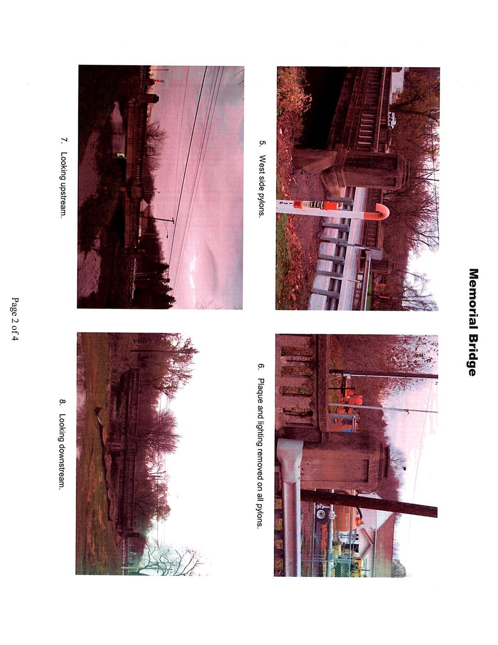
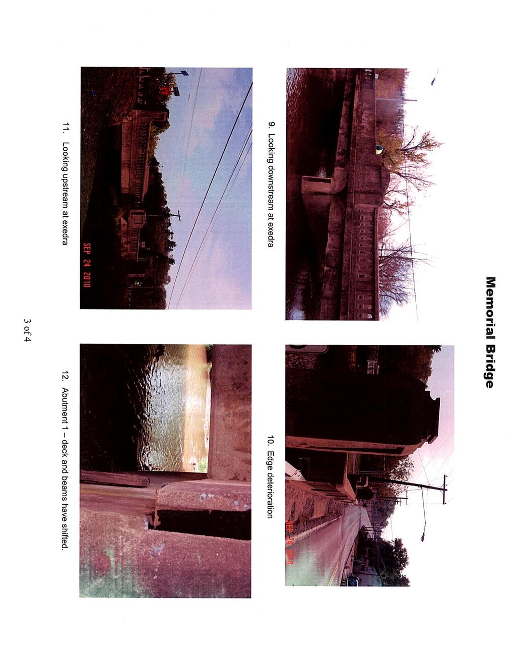
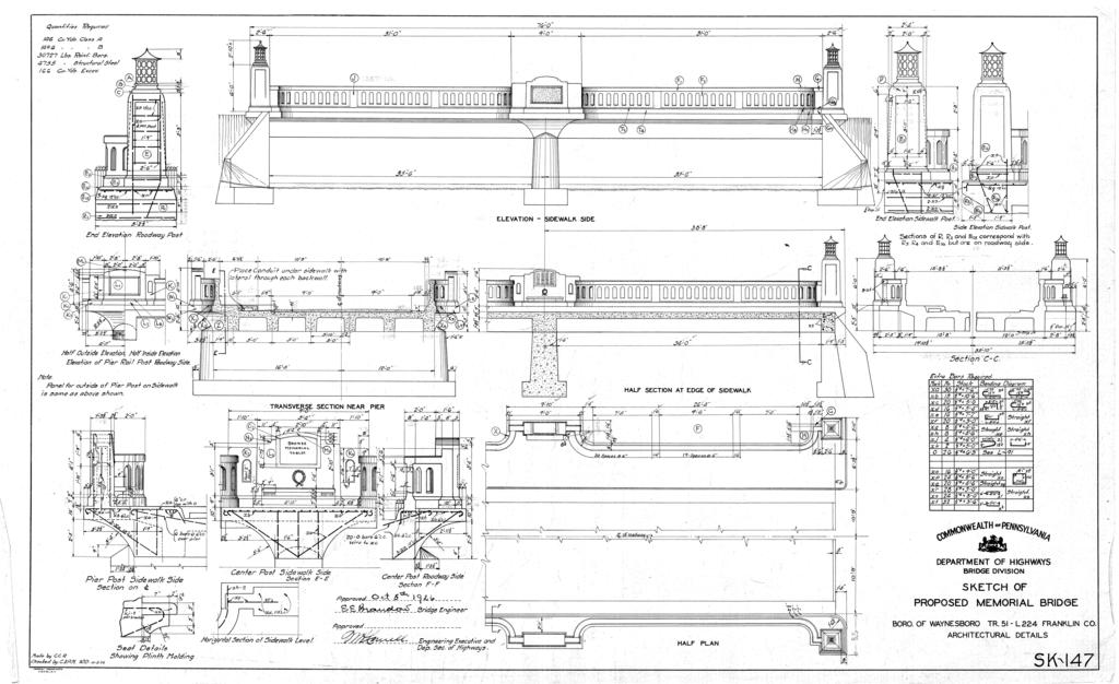
3 Franklin County SR Memorial Bridge BRIDGE REHABILITATION ANALYSIS AND FEASIBILITY REPORT Bridge Features and Historic Significance The Memorial Bridge was built in 1926 and is a 2- span, 76-foot long, reinforced concrete T-beam bridge, supported on concrete abutments and a center pier. The bridge has standard concrete balustrades that have been architecturally embellished by the addition of paneled exedrae [definition (plural): curved outdoor bench] and paneled end pylons (definition: gateway tower). The exedrae and pylons once housed memorial plaques to commemorate Waynesboro's World War I veterans. The bridge is technologically distinguished as an unusual architectonic example of the standard state highway department T- beam bridge design. It dates from first-generation state highway improvements to an early state route and automobile tourist trail (SR 16 in Franklin County is named the Buchanan Trail) and is the only such surviving architectonic highway bridge identified on Route 16. The bridge was surveyed during the 1997 statewide bridge survey and was determined eligible for the National Register of Historic Places. The original bridge had ornamental lighting atop the end pylons. Over the years, all the memorial plaques and the lighting fixtures have been stolen or removed. One plaque was removed by Waynesboro Borough and relocated to a town park memorial. Project Area Description - The bridge carries State Route 16, a 2-lane highway over the West Branch of the Little Antietam Creek. The creek is the western boundary of Waynesboro Borough and the eastern boundary of Washington Township. The roadway is on a tangent (straight-line) alignment in this location. This area of Waynesboro consists of mixed commercial and recreational/social properties. The area does not have the cohesiveness of a historic district. Several property lots to the east are late-19th to early 20th century residences and businesses but these have significant alterations. A modern concrete block structure in the southeast quadrant contains Moose Lodge 1191 with an asphalt parking lot, and the modern Fraternal Order of Eagles (FOE) building and an asphalt parking lot is located at the southwest quadrant. Beyond the FOE property is the modern Buchanan Trail Tire Sales building. The northeast quadrant contains a modern commercial garage with an asphalt parking lot and a small enclosed area containing gas pipe lines. An earlyto-mid 20 th century, small, formed-block building contains the Columbia Gas Co., and a modern concrete block structure for the UGI gas company are located at the northwest quadrant. The bridge is approximately 1/2 mile west of downtown Waynesboro, which has been identified as an eligible historic district by Pennsylvania Historical and Museum Commission (PHMC) (9/8/93). The bridge was originally designed to be a gateway to the historic community, although the historic district is outside the visual area of potential (APE) effects of the bridge. There are no other historic properties within the APE of the project. 1

4 Franklin County SR Memorial Bridge Bridge Condition Built in 1926, the bridge is a 2-span reinforced concrete T-beam bridge, 76- feet long, 24-feet wide and carries two lanes of traffic. The bridge is generally in poor to bad condition. The western approach roadway is 40-feet wide and consists of two 11-foot lanes and 9-foot shoulders. The eastern approach roadway is 40-feet wide with a sidewalk on the south side. The bridge creates a pinch-point on SR 16 due to the 16-foot difference between the bridge and the approach roadway. The speed limit at the bridge is 35 mph. Speed is not a criterion in determining the bridge width. This paragraph is an explanation of what the term T-beam means and how it relates to the existing bridge and its original construction (cross sectional view below). A T-beam type bridge means that the horizontal support of the bridge deck surface looks like a series of T s. The T- beam does not have a flange on the bottom of the beam as opposed to an I-beam which has a flange on the bottom of the beam. A T-beam bridge does not have a separate bridge deck. The deck slab and beams (when constructed) were formed and the concrete poured monolithically (which means a continuous pour with no joints). The deck and beams are one component and are not individual units. They act as one unit to support their weight and the weight of traffic. In the case of a T-beam bridge, the deck is actually the way to connect the beams. Neither the deck nor beams can support their weight without the other. Nor can either be removed without removal of the other. Most bridges constructed by PennDOT today have separately supported beams (all concrete beams are precast) and then a concrete deck is placed on top of the beams. In 1926, construction methods did not include precast individual concrete beams. At the time, a T-beam bridge was the cheapest way to construct short-span bridges. The fact that this is a T- beam bridge is the most important aspect in determining the type of bridge rehabilitation that is feasible for this project. T-Beam The concrete surface of the bridge deck has been overlaid with bituminous. The underside of the concrete has many delaminated areas. Since the surface is overlaid with bituminous we cannot determine the actual surface problems in the underlying concrete. When PennDOT overlays a bridge deck with bituminous pavement the engineers have determined the deck to be in a condition that is beyond normal repair and the next step in the maintenance cycle would be the total replacement of the bridge deck. The problem with a T-beam bridge is that the deck cannot be separately replaced from the beams because as explained above the deck and beams are one solid inseparable unit. 2
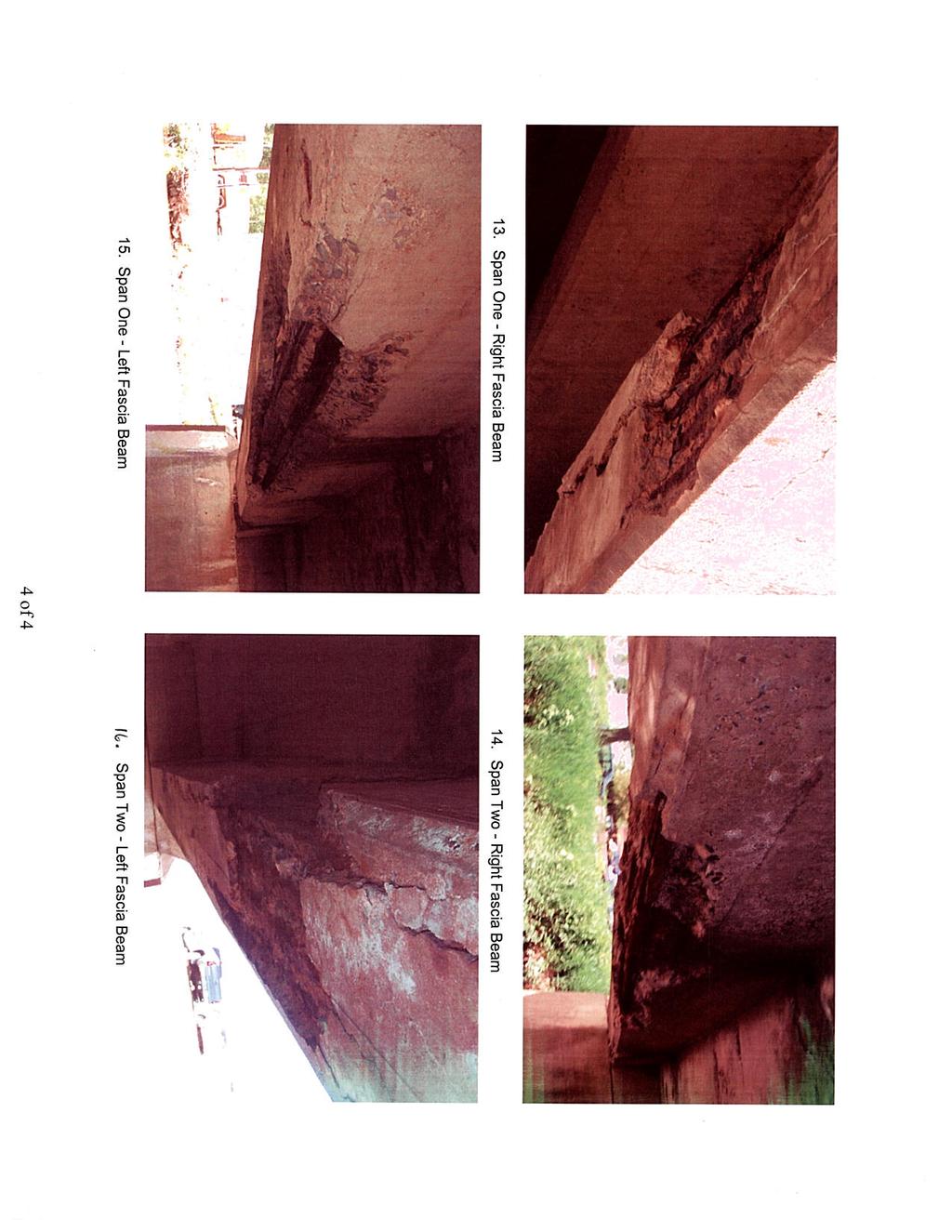
5 Franklin County SR Memorial Bridge The fascia beams, both on the upstream and down stream side, exhibit heavy to severe concrete spalling. Large areas of the beam reinforcing steel are exposed with minor to heavy cross section loss. Spalling and rebar section loss are a concern due to the potential for catastrophic failure of the bridge beam and bridge collapse. Spalling concrete is an indication of internal stresses in the concrete. These can be related to salt intrusion, thermal expansion or additional stress. Over time the concrete has spalled enough to expose a substantial length of the beam reinforcing steel. Since the bars are black steel and not epoxy coated, the bars have experienced accelerated corrosion. This corrosion has led to bar cross section loss which means the bars are actually becoming smaller in diameter due to the steel rusting away. If the bar corrosion continues to propagate and enough steel is lost the bar could potentially fail or weaken to a point which could lead to posting or possible closure of the bridge. Approximately 25 of the upstream parapet has been removed and repaired. This is the result of concrete deterioration and a vehicular accident that damaged the parapet. The pigeon hole parapet is a concern on this structure due to the narrowness of the bridge and heavy traffic. If the bridge parapet is hit by an errant vehicle the vehicle tends to snag or catch on the parapet hole thus causing a situation in which the driver can easily lose control of the vehicle. The upstream bridge deck gutter line concrete is severely deteriorated. Due to water lying in the gutter, holes have been cut in the gutter line of the bridge deck for drainage. This is not proper maintenance and is leading to further deterioration of the bridge surface and the beams underneath the holes. This situation is actually very bad for a T-beam bridge because the holes through the supporting deck have created a failure line where cracks through the deck run from hole to hole to hole. This bridge seems to have the most deterioration at the fascia beams. This makes sense for a couple of reasons: 1. The pigeon hole parapets allow more salt from snow plowing to go through the pigeon hole and drip down to the beams causing deterioration. 2. The most dead-load weight is on the fascia beam since the concrete parapet is above the beam. Since holes were cut through the gutter a crack has formed from hole to hole parallel with the beam below. Due to the concrete being cracked through the deck, the unit is not acting together and additional stresses are being placed on the fascia beam. The result is the spalling of the fascia beam. The pier has rotated slightly and is out of plumb ¼ in 4-feet. Rotation of the pier means that the pier is not sitting on a solid foundation because it is moving horizontally. Pier out of plumb means that the pier is leaning vertically and also not on a solid foundation. Put both of these deficiencies together and this has resulted in a situation where part of the bridge is moving that is not supposed to move. If a supporting structure member such as the pier would fail then this would result in the collapse of the bridge. 3
6 Franklin County SR Memorial Bridge The PennDOT bridge rating is 38.7 out of a scale of 100. PennDOT classifies the bridge as both structurally deficient (SD) and functionally obsolete (FO). There are 413 bridges and culverts in Franklin County. This structure has the 19 th ranked (worst) SD rating. The bridge is not weight posted. See Appendix for photos. Bridge Use The Bridge is located on State Route 16 (SR 16). At the location of the bridge, SR 16 is an urban arterial route and carries 9,890 vehicles per day of which 5% or 495 are trucks. SR 16 is the major east-west route in southern Franklin County and is named Main Street in Waynesboro Borough. SR 16 connects Waynesboro to Interstate 81; approximately 6 miles to the west of the borough. The Waynesboro Ambulance Squad (less than ½ mile west of the bridge on Main Street), Waynesboro Fire Department and Waynesboro Area School District school buses use this bridge on a daily basis. Pedestrian use is very limited due to few walking destinations on the west side of the bridge. Few, if any pedestrians are generated by the private clubs on either side of the bridge or by the tire sales store. Local authorities estimate a maximum of pedestrians per day. SR 16 is not a designated PA Bike Route. Bridge Future Use Waynesboro and Washington Township have a Joint Comprehensive Plan. The number one priority on that plan is the completion of the Washington Township Boulevard (see map in Appendix). The boulevard is essentially a northern bypass of Waynesboro through Washington Township. Some pieces of the route have been built. The eastern part of the route will use existing Prices Church Road where a signalized intersection would be built and SR 16 widened to three-lanes from Prices Church Road east to the Memorial Bridge and into Washington Township. The connection to Prices Church Road is estimated to be competed in In addition, Washington Township was presented plans (in year 2010) for commercial development on a parcel of land along the south side of SR 16 approximately 500- feet west of the bridge. The developer has not started work due to the struggling economy but will most likely resubmit plans in the near future. This parcel will be developed with a nationwide retailer and/or grocery store. When the development does occur it will be a pedestrian destination and will require roadway improvements including a traffic signal, turn lanes, curb and sidewalk. Washington Township has requested that if a new bridge is build that it be made wider to accommodate future traffic, development and pedestrians. Future Growth - Waynesboro s population was 10,147 (2010 census) up +5.5% from Washington Township s population increased 21.2% and Franklin County s population increased 15.7% in the same time period. The greater Waynesboro area population is 29,876. The area has a trend of increasing population growth which means greater future development potential and more vehicular traffic which the bridge and roadway will need to accommodate. No one or any type of vehicle is excluded from using the bridge. Detour Routes There are no detours routes around the Memorial Bridge that would be acceptable as a long-term detour for the 9,890 vehicles per day or truck traffic. If the bridge were 4
7 Franklin County SR Memorial Bridge closed, traffic on SR 16 headed west to I-81 would have to use SR The length of this detour is over 20 miles. Project Purpose and Needs Purpose: The purpose of the project is to provide a safe structure which accommodates expected growth and facilitates multi modal forms of transportation on State Route 16 over the West Branch of the Little Antietam Creek. Needs (in order of priority): (1) Bridge Condition (a) Vehicular: The concrete beams, pier deck and abutments are deteriorated; as a result the bridge is classified as structurally deficient. (b) Pedestrian and Bicycles: The bridge lacks shoulder and functional sidewalks. (2) Safety (a) Vehicular: The existing functionally obsolete bridge is 24-feet wide and the approach road is 40-feet wide on either side of the bridge. The bridge is a pinch-point on an otherwise uniform width road. The bridge must function and safely handle current and future traffic on this urban arterial route. Current daily traffic is 9,890 ADT, of which 5% are trucks. The 20-year traffic projection is 14,989 ADT. The narrowness of the bridge affects the operation and function of the roadway in that it increases the likelihood of sideswipes. For instance, a tractor trailer type truck is 8-feet wide. The bridge has two 12 foot lanes and no shoulder. When two trucks cross the bridge at the same time and are centered in the lane, there are 4-feet between the vehicles and 2 feet to the parapet, leaving little room for lane repositioning. (b) Pedestrian and Bicycles: When trucks cross the bridge and are centered in the lane, there is 2 feet to the parapet. This creates an unsafe condition if a pedestrian or bicyclist is on the bridge at the same time as a truck. 5
8 Franklin County SR Memorial Bridge (3) Future Growth (a) Vehicular: As a result of the future commercial development 500 feet west of the bridge, traffic demands will exceed numbers projected currently. The bridge will see an increase in truck traffic as a result of having to supply the new development with products. As a result the wear and tear on the bridge will become greater not only as ADT rises, but also as the percentage of trucks rises. Turn lanes and a signal will also be required near the western approach roadway for the future development. (b) Pedestrian and Bicycles: The new commercial development will also be a generator of pedestrian and bicyclists across the bridge, and as mentioned previously, the bridge is unsafe for bikes and pedestrians. Bridge Rehabilitation Alternative Analysis. Three alternatives were considered for the proposed project. Alternatives included the no-build, rehabilitation and complete replacement of the bridge on existing alignment. 1. No Build Alternative. The existing bridge is a major link between Waynesboro and Interstate 81. The condition of the bridge is poor and will continue to worsen without corrective action. The No Build Alternative does not meet any of the needs or purpose of the project. The bridge would not be widened, the structural components would not be replaced and pedestrians would not be accommodated. Therefore, the No Build Alternative is not a viable alternative. 2. Rehabilitation Alternative In general, a desired bridge life is 100 years with proper routine maintenance and rehabilitation cycles. A desired bridge deck service life is 50 years. This bridge is 85 years old and has not been properly maintained nor have any structural components been replaced in that time. The reason nothing has been replaced on this bridge in 85 years is because it is a T-beam bridge. The existing T-beam and deck, abutments and pier cannot be rehabilitated due to the amount of deterioration and must be replaced. With a T-beam bridge the entire superstructure (beams and deck) are one unit. Rehabilitation or widening is not possible. The entire superstructure must be removed. Individual components cannot be removed or the bridge will fail. In addition, the exposed reinforcing steel in the fascia beams are corroded to the point that they have lost section and could fail in the future. Patching of the beam is not possible either because this would only be cosmetic and will not fix the structural issues as noted in the bridge conditions. When the parapets are 6
9 Franklin County SR Memorial Bridge removed the defining characteristics of the bridge, namely the end pylons and exedrae, must be demolished because these features are physically connected to the bridge with concrete and reinforcing steel. The pylons and exedrae cannot be saved and will be destroyed during the demolition of the bridge. The structure cannot be rehabilitated without destroying the qualities that qualify the bridge for the National Register. To accommodate pedestrians a sidewalk cannot be cantilevered from the bridge due to the fact that the parapets would have to be removed to construct this type of sidewalk. As a result of the bridge type, this would mean destruction of the whole bridge. For the intended purpose and needs of the project, it is not possible to rehabilitate the bridge and save the bridge s character defining elements. Therefore, the bridge Rehabilitation Alternative is not a viable alternative. No cost is calculated for rehabilitation because a T-beam bridge cannot be rehabilitated. 3. Replacement Alternative Off-Alignment Replacing the existing bridge on another alignment was not analyzed due to the fact the bridge is on tangent alignment. By shifting the bridge from a tangent alignment, you will be introducing a curve into the roadway which will effect not only sight distance but also a driver s expectation of the roadway design. Shifting the roadway was not considered as result required right-of-way takes, sight distance issues, possible environmental impacts and cost. It is estimated that the cost of constructing a new bridge off current alignment will end up costing around 3 million dollars. The major factor in the cost figure is the right of way impacts. Therefore, this option does meet the purpose and need of the project, but is not prudent. 4. Replacement Alternative On-Alignment. Replacing the bridge on the existing alignment will meet all the needs and purpose of the project. A new bridge will be designed and constructed using current methodologies and materials. A new bridge will be wider and have sidewalks and shoulders thus accommodating traffic demands and meeting the needs of the community and pedestrians. The replacement bridge will be designed using Context Sensitive Design and the principals of Smart Transportation to evaluate what aesthetic treatments are appropriate for a new structure. The Replacement Alternative is the selected and most viable and only alternative. Cost is $2,200,000. 7
10 Franklin County SR Memorial Bridge Conclusion and Recommendation The Memorial Bridge is located on State Route 16 and spans the West Branch of the Little Antietam Creek. The creek is the western boundary of Waynesboro Borough and the eastern boundary of Washington Township, two growing municipalities in Franklin County, PA. This arterial route has an ADT of 9,890 and is the direct route to I-81 from Waynesboro. The bridge is eligible for the National Register and was built in 1926 as a tribute to World War I veterans. Since that time, the 24-foot wide bridge has served its intended purpose; but has received little maintenance over the years. The purpose of the project is to provide a safe structure which accommodates expected growth and facilitates multi modal forms of transportation on State Route 16 over the West Branch of the Little Antietam Creek. In the Rehabilitation Alternative Analysis it was determined that the No-Build alternative did not meet the purpose or needs of the project. The Bridge Rehabilitation alternative is not feasible due the bridge being a T-beam structure which cannot be rehabilitated and therefore, did not meet the purpose or needs of the project. The Bridge Replacement Off- Alignment alternative did meet the purpose and need of the project was considered not prudent. The Bridge Replacement Alternative was the only alternative that meets both the purpose and needs of the project. Based on these considerations, it is recommended to advance the Bridge Replacement alternative for this project. 8

11
12
13
14
15
16
17
18
19
20
21
22
23 Washington Township Boulevard will provide dramatically increasing traffic in coming years to support commercial development. The Boulevard was designed as a Route 16 bypass around the traffic congestion of Main Street Waynesboro. Construction of the Boulevard will be complete to Country Club Road by 2010, to Route 997 by 2011, to Route 316 by 2014, and back to Route 16 on the west side of Waynesboro by Completion to Route 997 will provide dramatically improved access to the Rouzerville Commons/Red Run Center commercial area for the Quincy, Mont Alto, Penn State, and wealthy Penn National region of the county. WASHINGTON TOWNSHIP BOULEVARD - ROUTE 16 BYPASS COUNTRY CLUB 16 OLD FORGE RED RUN CENTER ROUZERVILLE COMMONS
24 Chapter 1 - General Design Publication 13M (DM-2) MINIMUM WIDTH CRITERIA FOR BRIDGES I. MINIMUM WIDTH CRITERIA FOR NEW BRIDGES ON NEW FACILITIES (ALL FUNCTIONAL CLASSIFICATIONS) Where a new highway is to be constructed on a new location, bridges shall be designed for a PHL-93 design load structural capacity with the minimum bridge width equal to the pavement and shoulder widths for the applicable functional classification systems indicated in Chapter 1, Table 1.3 through Table 1.8. II. MINIMUM WIDTH CRITERIA FOR BRIDGES ON LIMITED ACCESS FREEWAY (INTERSTATE) FACILITIES A. BRIDGES TO REMAIN IN PLACE (Deck repair or deck overlay, parapet modifications or no bridge work). Where an existing highway is to be rehabilitated or reconstructed and no bridge work is to be performed, or an existing bridge deck is to be repaired or overlaid, the bridge may remain in place when: the design load structural capacity meets MS-18 (HS-20); and the bridge parapet meets current standards (F shape); and the bridge width shall provide 3.6 m (12 ft) lanes and a minimum of a 3.0 m (10 ft) right shoulder and a 1.05 m (3.5 ft) left shoulder. For major long-span bridges, generally over 60 m (200 ft) in length, offsets to the face of the parapet or bridge rail shall be a minimum of 1.05 m (3.5 ft) from the travel lane both left and right. B. DECK REPLACEMENT OR PARTIAL SUPERSTRUCTURE REPLACEMENT. Where a bridge deck is to be replaced, or a portion of the superstructure is to be replaced, the bridge or superstructure shall meet the MS-18 (HS-20) minimum (PHL-93 desirable) design load structural capacity and shall meet the applicable bridge widths indicated in Chapter 1, Table 1.8. For major long-span bridges, generally over 60 m (200 ft) in length, offsets to the face of the parapet or bridge rail shall be a minimum of 1.2 m (4 ft), but not less than the existing widths, from the travel lane both left and right. C. RECONSTRUCTED BRIDGES (Superstructure replacement or bridge replacement). Where the entire superstructure is to be replaced, or the bridge is to be replaced, the superstructure or bridge shall meet the applicable bridge widths indicated in Chapter 1, Table 1.8. For major longspan bridges, generally over 60 m (200 ft) in length, offsets to the face of the parapet or bridge rail shall be a minimum of 1.2 m (4 ft), but not less than the existing width, from the travel lane both left and right. Design load structural capacity shall equal PHL-93. III. MINIMUM WIDTH CRITERIA FOR BRIDGES ON LIMITED ACCESS FREEWAY (NON-INTERSTATE) FACILITIES A. BRIDGES TO REMAIN IN PLACE (Deck repair or deck overlay, parapet modifications or no bridge work). Where an existing highway is to be rehabilitated or reconstructed and no bridge work is to be performed, or an existing bridge deck is to be repaired or overlaid, the bridge may remain in place when: the design load structural capacity meets MS-18 (HS-20); and the bridge parapet meets current standards (F shape); and the bridge width shall provide 3.3 m (11 ft) lanes and a minimum of a 2.4 m (8 ft) right shoulder and a 1.05 m (3.5 ft) left shoulder. For major long-span bridges, generally over 60 m (200 ft) in length, offsets to the face of parapet or bridge rail shall be a minimum of 1.05 m (3.5 ft) from the travel lane both left and right. B. DECK REPLACEMENT OR PARTIAL SUPERSTRUCTURE REPLACEMENT. Where a bridge deck is to be replaced, or a portion of the superstructure is to be replaced, the bridge or superstructure shall meet the MS-18 (HS-20) minimum (PHL-93 desirable) design load structural capacity and shall meet the applicable bridge widths indicated in Chapter 1, Table 1.8. For major long-span bridges, generally over 60 m (200 ft) in length, offsets to the face of the parapet or bridge rail shall be a minimum of 1.2 m (4 ft), but not less than the existing widths, from the travel lane both left and right. C. RECONSTRUCTED BRIDGES (Superstructure replacement or bridge replacement). Where the entire superstructure is to be replaced, or the bridge is to be replaced, the superstructure or bridge shall meet the applicable bridge widths indicated in Chapter 1, Table 1.8. For major longspan bridges, generally over 60 m (200 ft) in length, offsets to the face of the parapet or bridge rail shall be a minimum of 1.2 m (4 ft), but not less than the existing width, from the travel lane both left and right. Design load structural capacity shall equal PHL-93. IV. MINIMUM WIDTH CRITERIA FOR BRIDGES ON ARTERIAL FACILITIES A. BRIDGES TO REMAIN IN PLACE (Deck repair or deck overlay, parapet modifications or no bridge work). Where an existing highway is to be rehabilitated or reconstructed and no bridge work is to be performed, or an existing bridge deck is to be repaired or overlaid, an existing bridge that fits the proposed alignment and profile may remain in place when the design load structural capacity meets MS-18 (HS-20) and the bridge width is equal to or greater than the applicable widths indicated in Table 1 on Pages 1-35 and The approach lane widths plus the approach shoulder widths indicated in Table 1.3 and Table 1.4 may be considered for bridge widths if they are less than the bridge widths on Pages 1-35 and B. DECK REPLACEMENT OR PARTIAL SUPERSTRUCTURE REPLACEMENT. Where a bridge deck is to be replaced, or a portion of the superstructure is to be replaced, the bridge or superstructure shall meet the MS-18 (HS-20) minimum (PHL-93 desirable) design load structural capacity and the minimum bridge width shall equal or exceed the applicable widths indicated in Table 2 on Pages 1-35 and The approach lane widths plus the approach shoulder widths indicated in Table 1.3 and Table 1.4 may be considered for bridge widths if they are less than the bridge widths on Pages 1-35 and If the bridge is not on the National Highway System and the conditions listed on the form in Chapter1, Appendix A, 3R Bridge Width Criteria Documentation are met, the minimum bridge width is equal to the corresponding value listed in Minimum Width Criteria for Rural 3R Projects table in Chapter 1, Section 1.2. If the conditions are not met, this criterion does not apply. Forward a copy of the signed documentation to the Bureau of Design, Highway Quality Assurance Division. C. RECONSTRUCTED BRIDGES (Superstructure replacement or bridge replacement). Where the entire superstructure is to be replaced, or the bridge is to be replaced, the superstructure or bridge shall meet the applicable bridge widths indicated in Chapter 1, Tables 1.3 and 1.4. Design load structural capacity shall equal PHL-93. If the bridge is not on the National Highway System and the conditions listed on the form in Chapter 1, Appendix A, 3R Bridge Width Criteria Documentation are met, the minimum bridge width is equal to the corresponding value listed in Minimum Width Criteria for Rural 3R Projects table in Chapter 1, Section 1.2. If the conditions are not met, this criterion does not apply. Forward a copy of the signed documentation to the Bureau of Design, Highway Quality Assurance Division. 1-34
25 Chapter 1 - General Design Publication 13M (DM-2) MINIMUM WIDTH CRITERIA FOR BRIDGES (CONTINUED) MINIMUM WIDTH CRITERIA FOR BRIDGES ON ARTERIAL FACILITIES (English) TABLE 1 TABLE 2 BRIDGES TO REMAIN IN PLACE DECK REPLACEMENT OR PARTIAL (Deck Repair or Deck Overlay, Parapet SUPERSTRUCTURE REPLACEMENT Modifications or No Bridge Work) TRAFFIC VOLUMES CURRENT (a) TRAFFIC ADT MINIMUM BRIDGE WIDTHS (b) DESIGN LOAD STRUCTURAL CAPACITY MINIMUM BRIDGE WIDTHS (b) (c) (n) DESIGN LOAD STRUCTURAL CAPACITY 400 and Under 28'-0" HS-20 30'-0" HS-20 Min* 401 to '-0" HS-20 32'-0" HS-20 Min* 1501 to '-0" HS-20 34'-0" HS-20 Min* Over '-0" HS-20 34'-0" HS-20 Min* * PHL-93 Desirable TRAFFIC VOLUMES CURRENT (a) TRAFFIC ADT MINIMUM WIDTH CRITERIA FOR BRIDGES ON COLLECTOR AND LOCAL ROAD FACILITIES (English) TABLE 3 BRIDGES TO REMAIN IN PLACE (Deck Repair or Deck Overlay, Parapet Modifications or No Bridge Work) MINIMUM BRIDGE WIDTHS (b) DESIGN LOAD STRUCTURAL CAPACITY (e) TABLE 4 DECK REPLACEMENT OR PARTIAL SUPERSTRUCTURE REPLACEMENT MINIMUM BRIDGE WIDTHS (b) (c) (n) DESIGN LOAD STRUCTURAL CAPACITY (e) TABLE 5 RECONSTRUCTED BRIDGES (Superstructure Replacement or Bridge Replacement) MINIMUM BRIDGE WIDTHS (b) (g) (h) (k) (n) DESIGN LOAD STRUCTURAL CAPACITY 400 and Under 22'-0" (d) (l) HS-15 24'-0" (d) (l) HS-15 Min* 24'-0" (i) (m) PHL to '-0" HS-15 28'-0" HS-15 Min* 28'-0" PHL to '-0" HS-15 30'-0" (f) HS-15 Min* 32'-0" PHL-93 Over '-0" HS-15 34'-0" (f) HS-15 Min* 40'-0" (j) PHL-93 * HS-20 Desirable See General Bridge Width Table Notes on Page
26
27
28
29
30
31
32
Project Purpose. Project Need
 Project Purpose The purpose of the project is to implement a bridge improvement solution that corrects the existing safety problem at the Strasburg Pike Bridge. The project will provide a structurally
PennDOT. single spann lanes and 3- mayy need to be to accommodate. any bridge. addition to III. Date: CRP 07/27/2015 CRP.
 (10/27/14) PennDOT Section 106 Field Assessments and Finding Combined Early tification/finding? Yes Concurrence required or requested: Yes MPMS: 51507 ER# (if consultation with PHMC required) ): County:
Page. I. Introduction 1. II. Project Purpose and Need 2. IV. Description of Section 4(f) Property 2. V. Impacts to Section 4(f) property 3
 Property 2. V. Impacts to Section 4(f) property 3") Table of Contents Programmatic Section 4(f) Evaluation for use of a Historic Bridge Replacement of Route 30/130 Bridge over the Cooper River Structure No. 0405-153 City of Camden, Borough of Collingswood,
Table of Contents Programmatic Section 4(f) Evaluation for use of a Historic Bridge Replacement of Route 30/130 Bridge over the Cooper River Structure No. 0405-153 City of Camden, Borough of Collingswood,
PennDOT Public Meeting. S.R. 3044, Section A01 Castle Shannon Boulevard Roadway Improvement Project
 PennDOT Public Meeting S.R. 3044, Section A01 Castle Shannon Boulevard Roadway Improvement Project Mt Lebanon Township, Allegheny County Mt Lebanon Township Municipal Building November 6, 2014 1 Project
PURPOSE AND NEED FOR THE VROOMAN ROAD BRIDGE and ROADWAY IMPROVEMENT PROJECT
 PURPOSE AND NEED FOR THE VROOMAN ROAD BRIDGE and ROADWAY IMPROVEMENT PROJECT PERRY AND LEROY TOWNSHIPS, LAKE COUNTY, OHIO (PID 5669/PID 85131) PREPARED BY: MICHAEL BAKER JR., INC. 1228 EUCLID AVENUE SUITE
Berkshire Regional Planning Commission Clearinghouse Review Report
 August 19, 2013 SUBJECT: Reconstruction of Housatonic Street, Dalton, MA EOEA#: 15083 LOCATION: Dalton ESTIMATED COST: $8.1 million REVIEW TYPE: ENF PROPONENT: MassDOT and Town of Dalton COMMENTS DUE:
Concord, BRF-X-5099 (021), Draft Alternative Analysis
, Draft Alternative Analysis") THE CITY OF CONCORD in conjunction with the STATE OF NEW HAMPSHIRE, DEPARTMENT OF TRANSPORTATION BUREAU OF ENVIRONMENT and the FEDERAL HIGHWAY ADMINISTRATION Concord, BRF-X-5099 (021), 12004 Draft Alternative
THE CITY OF CONCORD in conjunction with the STATE OF NEW HAMPSHIRE, DEPARTMENT OF TRANSPORTATION BUREAU OF ENVIRONMENT and the FEDERAL HIGHWAY ADMINISTRATION Concord, BRF-X-5099 (021), 12004 Draft Alternative
Victoria Bridge Municipal Class EA Civic Works Committee
 Municipal Class EA John Pucchio, P. Eng., Project Manager June 19 2018 Introduction Existing Conditions Municipal Class EA Proposed Bridge Proposed Road Reconstruction Proposed Improvements Construction
REHABILITATION FEASIBILITY STUDY ER#
 REHABILITATION FEASIBILITY STUDY MILLER FARM ROAD BRIDGE PROJECT VENANGO COUNTY BRIDGE NO. 34 CARRYING S.R. 7212, SECTION L00 OVER OIL CREEK OIL CREEK AND CHERRYTREE TOWNSHIPS VENANGO COUNTY, PENNSYLVANIA
Chapter 1 - General Design Guidelines CHAPTER 1 GENERAL DESIGN GUIDELINES
 CHAPTER 1 GENERAL DESIGN GUIDELINES 1.0 INTRODUCTION This Publication has been developed to provide current, uniform procedures and guidelines for the application and design of safe, convenient, efficient
Beckett Bridge PD& E Study. Presentation to: Board of County Commissioners
 Beckett Bridge PD& E Study Presentation to: Board of County Commissioners October 22, 2013 Introduction Study Began January 2012 Alternatives Presented to Commission October 2013 Alternatives Presented
Municipal Class EA Study Public Information Centre No. 1 December 13, :00 pm 7:00 pm. Please sign in so we can keep you updated on this study
 Reconstruction of Regional Road 45 (Creek Road) Between Regional Road 27 (River Road) and Regional Road 63 (Canborough Road) in the Township of Wainfleet Municipal Class EA Study Public Information Centre
North River Mills Bridge Hampshire County State Project # S314-45/ Federal Project # ARRA-4520(003)D FR#: HM-1
D FR#: HM-1") North River Mills Bridge Hampshire County State Project # S314-45/20-2.40 02 Federal Project # ARRA-4520(003)D FR#: 10-1463-HM-1 STATE LEVEL OF HISTORIC DOCUMENTATION November 2010 West Virginia Department
North River Mills Bridge Hampshire County State Project # S314-45/20-2.40 02 Federal Project # ARRA-4520(003)D FR#: 10-1463-HM-1 STATE LEVEL OF HISTORIC DOCUMENTATION November 2010 West Virginia Department
Proposed FY 2004 TRANSPORTATION CAPITAL PROGRAM New Jersey Department of Transportation Projects
 Carteret Industrial Road 98547 This project will address the upgrade of Carteret Industrial Road. The federal Transportation Equity Act for the 21st Century (TEA-21) provided funding for this project under
MINNESOTA ARCHITECTURE - HISTORY INVENTORY FORM
 Identification Historic Name Nicollet Avenue Bridge Current Name Nicollet Avenue Bridge Field # Address Nicollet Avenue over Minnehaha Creek City/Twp Minneapolis SHPO Inventory Number Review and Compliance
III - design standards
 III - design standards The Circulation Classification and Character section of the Design Standards chapter prescribes the types of circulation routes, the location of the circulation routes, the connections
CONFORMED AGREEMENT INCORPORATED REVISIONS PER AMENDMENT DATED: APRIL 2, 2013 FOR REFERENCE
 CONFORMED AGREEMENT INCORPORATED REVISIONS PER AMENDMENT DATED: APRIL 2, 2013 FOR REFERENCE CITY STREETS AS PART OF STATE HIGHWAYS GUIDELINES REACHED BY THE WASHINGTON STATE DEPARTMENT OF TRANSPORTATION
National Register of Historic Places Continuation Sheet
 NPS Form 10-900-a (Rev. 8/2002) OMB No. 1024-0018 (Expires 5-31-2012) United States Department of the Interior National Park Service National Register of Historic Places Continuation Sheet Bridge No. 5721
CENTERTON ROAD BRIDGE REPLACEMENT
 CENTERTON ROAD BRIDGE REPLACEMENT FEASIBILITY STUDY BURLINGTON COUNTY BRIDGE C4.4 OVER RANCOCAS CREEK TOWNSHIPS OF MOUNT LAUREL, WESTAMPTON & WILLINGBORO 1 prepared for: BOARD OF CHOSEN FREEHOLDERS BURLINGTON
Fall 2017 Construction Update
 Fall 2017 Construction Update Ward 4 Southeast Engineering Department Riverwalk Red Multi-Use Trail Bridge Rehabilitation The Riverwalk Red Multi Use Trail Bridge was awarded to Cramer and Associates,
Page. I. Introduction 1. II. Project Purpose and Need 1. IV. Description of Section 4(f) Property 2. V. Impacts to Section 4(f) Property 3
 Property 2. V. Impacts to Section 4(f) Property 3") TABLE OF CONTENTS Programmatic Section 4(f) Evaluation for Use of a Public Park Replacement of Route 30/130 Bridge over the Cooper River Structure No. 0405-153 City of Camden, Township of Pennsauken Camden
TABLE OF CONTENTS Programmatic Section 4(f) Evaluation for Use of a Public Park Replacement of Route 30/130 Bridge over the Cooper River Structure No. 0405-153 City of Camden, Township of Pennsauken Camden
Existing Transportation System 5-1
 5-1 The Jackson County transportation system is served by several modes of transportation including streets and highways, multi-modal, non-motorized, rail, and aviation. While the focus of the transportation
Definitions. Average Daily Traffic Demand (ADT): The actual number or projected number of cars that pass a point in a 24-hour period.
: The actual number or projected number of cars that pass a point in a 24-hour period.") Definitions Access Management: A combination of physical techniques and transportation policies used to control the flow of traffic between roads and the surrounding lands. Alternative City Form Scenarios:
Definitions Access Management: A combination of physical techniques and transportation policies used to control the flow of traffic between roads and the surrounding lands. Alternative City Form Scenarios:
Derby-Shelton Bridge Pedestrian and Bicyclist Enhancements [1]
![Derby-Shelton Bridge Pedestrian and Bicyclist Enhancements [1]](/thumbs/96/128011958.jpg "Derby-Shelton Bridge Pedestrian and Bicyclist Enhancements [1]") nhancements [1] STATUS OF PROJECT: The project has recently moved from the Preliminary Design Phase to the Final Design Phase following the most recent Public Involvement Meeting held on January 9, 2019
nhancements [1] STATUS OF PROJECT: The project has recently moved from the Preliminary Design Phase to the Final Design Phase following the most recent Public Involvement Meeting held on January 9, 2019
Great Lakes North Central South Central FAX: (718) CONTACT PERSON: ADDRESS: Daniel Hom, PE, Engineer-in-Charge
 CONTACT PERSON: ADDRESS: Daniel Hom, PE, Engineer-in-Charge") AMERICAN SOCIETY OF HIGHWAY ENGINEERS National Project of the Year Award OFFICIAL ENTRY FORM AWARD CATEGORY (Check One): Under $20 Million Over $20 Million SPONSORING REGION (Check One): Northeast Mid-Atlantic
AMERICAN SOCIETY OF HIGHWAY ENGINEERS National Project of the Year Award OFFICIAL ENTRY FORM AWARD CATEGORY (Check One): Under $20 Million Over $20 Million SPONSORING REGION (Check One): Northeast Mid-Atlantic
CHAPTER 10 ROADSIDE SAFETY
 CHAPTER 10 ROADSIDE SAFETY Introduction 10-4 Clear Zone 10-4 Figure 10-1 Recovery Area and Clear Zone Examples Table 10-1 Clear Zone for 3R Projects on National Highway System Table 10-2 Clear Zone for
PROPOSED IMPROVEMENTS
 IV. PROPOSED IMPROVEMENTS The proposed improvements for each alternative carried forward are discussed below. A. FUNCTIONAL CLASSIFICATION AND ROADWAY CROSS-SECTIONS The classifications of the roadways
PROJECT SITE The Proposed Project includes the Allen and Pike Street malls between Delancey and South Streets (see Figure 2C-1).
.") Chapter 2, Section C: A. INTRODUCTION This chapter considers the potential of the proposed Reconstruction of the Allen and Pike Street Malls project to affect the urban design characteristics and visual
Chapter 2, Section C: A. INTRODUCTION This chapter considers the potential of the proposed Reconstruction of the Allen and Pike Street Malls project to affect the urban design characteristics and visual
B. PROPOSED REFINEMENTS POTENTIALLY AFFECTING URBAN DESIGN AND VISUAL RESOURCES
 Chapter 4: Urban Design and Visual Resources A. CONCLUSIONS OF THE FGEIS The FGEIS concluded that the Approved Plan will not result in any significant adverse impact on urban design or visual resources.
Middlebury RS 0174(8)
") Middlebury RS 0174(8) Preferred Alternative Meeting VT 125 Bridge #13 over Middlebury River August 6, 2012 Presented to Presented by Town of Middlebury VTrans & VHB Introductions: Jennifer Fitch VTrans
Middlebury RS 0174(8) Preferred Alternative Meeting VT 125 Bridge #13 over Middlebury River August 6, 2012 Presented to Presented by Town of Middlebury VTrans & VHB Introductions: Jennifer Fitch VTrans
FDOT D4 Complete Streets
 FDOT D4 Complete Streets Context Sensitive Solutions Directs that complete street solutions will complement the context of the community. Collaborative approach to decision making, project development,
Programmatic Implementation of ABC: Module 5 Public Outreach/ABC Results
 Programmatic Implementation of ABC: Module 5 Public Outreach/ABC Results 2 Presentation Outline: Public Outreach ABC Results Cost, schedule and customer satisfaction data Questions 3 ABC Advantages to
The transportation system in a community is an
 7 TRANSPORTATION The transportation system in a community is an important factor contributing to the quality of life of the residents. Without a sound transportation system to bring both goods and patrons
Southern Gateway Project and Public Green
 Southern Gateway Project and Public Green Transportation and Trinity River Project Committee May 23, 2016 Purpose of Presentation Provide the history and an overview of the Southern Gateway Project (SGP)
A raised and landscaped median will be constructed in South College Avenue between Trilby Road and Skyway Drive.
 5.0 ACCESS CONTROL PLAN This section presents the Access Control Plan Update which has been formulated through the considerable input of the governing agencies, business owners, organized homeowner groups,
I-84 HARTFORD PROJECT HARTFORD, CONNECTICUT DRAFT PURPOSE AND NEED STATEMENT
 I-84 HARTFORD PROJECT HARTFORD, CONNECTICUT DRAFT PURPOSE AND NEED STATEMENT October 2016 I. PROJECT BACKGROUND AND HISTORY The City of Hartford is the capital of Connecticut, and the largest employment
Bypass #16 - Bend Parkway (new alignment for US 97) (MP )
 (MP )") Bypass #16 - Bend Parkway (new alignment for US 97) (MP 134.76-141.83) Description: The Parkway is on new alignment for US 97 through Bend. US 97 is a Statewide Highway on the National Highway System that
Bypass #16 - Bend Parkway (new alignment for US 97) (MP 134.76-141.83) Description: The Parkway is on new alignment for US 97 through Bend. US 97 is a Statewide Highway on the National Highway System that
2 ALTERNATIVES AND OPTIONS
 2 ALTERNATIVES AND OPTIONS This chapter documents the process used to develop improvement concepts for Oregon Avenue and describes the resulting project alternatives and options, which were developed in
FY 2018 TRANSPORTATION CAPITAL PROGRAM New Jersey Department of Transportation Projects
 Schooleys Mountain Bridge Rehabilitation Project ID Numbers: N1707 / 173470 Schooleys Mountain Road Bridge was built in 1920 and widened in 1937. The project is a replacement of the bridge structure and
MINNESOTA ARCHITECTURE - HISTORY INVENTORY FORM
 Identification Historic Name Bridge L8849 Current Name Bridge L8849 Field # Address Municipal Road 99 over the Chippewa River City/Twp Montevideo County Chippewa Legal Desc. Twp 117N Range 40W Sec 07 QQ
GLEN ROAD PEDESTRIAN BRIDGE ENVIRONMENTAL ASSESSMENT STUDY PUBLIC INFORMATION CENTRE #2 OCTOBER 24, 2017
 GLEN ROAD PEDESTRIAN BRIDGE ENVIRONMENTAL ASSESSMENT STUDY PUBLIC INFORMATION CENTRE #2 OCTOBER 24, 2017 Glen Road Pedestrian Bridge Class Environmental Assessment 1 WELCOME! Welcome to the second Public
Bostwick Road. Municipal Class Environmental Assessment. Public Information Centre #2 June 14, City of London
 Bostwick Road Municipal Class Environmental Assessment Public Information Centre #2 June 14, 2017 Welcome! Welcome to the 2 nd Public Information Centre for the. Representatives from the and the consulting
COMMUNICATION URBAN DESIGN REVIEW BOARD CITY OF DES MOINES, IOWA MAY 16, 2017 MEETING
 COMMUNICATION URBAN DESIGN REVIEW BOARD CITY OF DES MOINES, IOWA MAY 16, 2017 MEETING Subject: Recommendation Prepared by: PRELIMINARY DESIGN REVIEW OF LOCUST STREET BRIDGE CONSTRUCTION & COURT AVENUE,
WELCOME TO THE PUBLIC INFORMATION CENTRE. Please Sign In
 WELCOME TO THE PUBLIC INFORMATION CENTRE Replacement of Oxtongue Lake Narrows Bridge & Oxtongue River Bridge, Highway 60 (G.W.P. 93-89-00 & G.W.P. 5550-04-00) Class Environmental Assessment (Group B) Please
PREPARED FOR: PLATTEVIEW ROAD CORRIDOR STUDY EXECUTIVE SUMMARY
 PREPARED FOR: PLATTEVIEW ROAD CORRIDOR STUDY EXECUTIVE SUMMARY SEPTEMBER 2016 Introduction The Platteview Road Corridor Study was led by the Metropolitan Area Planning Agency (MAPA) with assistance from
Pine Island Road Corridor Master Plan
 RECOMMENDED DEVELOPMENT PLAN Figure 9: Del Prado Village District Conceptual Framework The Conceptual Framework (Figure 8) for development of the Pine Island Corridor is to encourage mixed-use development
TRANSPORTATION ELEMENT GOALS, OBJECTIVES, AND POLICIES
 TRANSPORTATION ELEMENT GOALS, OBJECTIVES, AND POLICIES GOAL 2 The City shall provide a safe, convenient, effective, and energy efficient multimodal transportation system which is coordinated with the Future
PROJECT STATEMENT LOCATION/DESIGN PUBLIC HEARING. 19 th AVENUE NORTH EXTENSION PROJECT FROM SPRINGDALE DRIVE TO NORTH 2 ND STREET/U.S.
 PROJECT STATEMENT LOCATION/DESIGN PUBLIC HEARING 19 th AVENUE NORTH EXTENSION PROJECT FROM SPRINGDALE DRIVE TO NORTH 2 ND STREET/U.S. 67 HEARING LOCATION: ERICKSEN COMMUNITY CENTER 1401 11 TH AVENUE NORTH
Town of Weston Guardrail Overview Report
 Town of Weston Guardrail Overview Report July 28, 2016 Prepared for: Town of Weston Weston, MA 02493 Submitted by: Nitsch Engineering 2 Center Plaza, Suite 430 Boston, MA 02108 Nitsch Engineering Project
Title 11 Streets and Sidewalks
 Chapter 11.01 - Definitions Title 11 Streets and Sidewalks Low Impact Development (LID) - A stormwater and land use management strategy that strives to mimic predisturbance hydrologic processes of infiltration,
Victoria Street Pedestrian Bridge
 Township of Centre Wellington Victoria Street Pedestrian Bridge Class Environmental Assessment County of Wellington & Township of Centre Wellington Badley Bridge Replacement/Rehabilitation (County of Wellington),
Access Management: An Overview
 Figures 1-5 Below Evolution of development along a highway. In the early stages, land along the road is used for farming with little traffic generated. As time passes, the highway corridor becomes a de
A. INTRODUCTION B. NO ACTION ALTERNATIVE
 Chapter 19: Alternatives A. INTRODUCTION Over the years a variety of potential developments for the East River waterfront in Lower Manhattan have been considered. Some of these plans were very ambitious
A. INTRODUCTION B. PROJECT LOCATION
 Chapter 1: Project Description A. INTRODUCTION The Lower Manhattan Development Corporation (LMDC), a subsidiary of the New York State Urban Development Corporation, doing business as the Empire State Development
2040 Long Range Transportation Plan
 2040 Long Range Transportation Plan Adopted: April 15, 2013 APPENDIX D HIGHWAY NEEDS PLAN PROJECTS FREDERICKSBURG Existing and Committed Projects Fall Hill Avenue/Mary Washington Blvd. (Fredericksburg)
CARVER COUNTY DIVISION OF PUBLIC WORKS LANDSCAPE POLICY. Adopted by the Carver County Board of Commissioners March 3, 2015
 CARVER COUNTY DIVISION OF PUBLIC WORKS LANDSCAPE POLICY Adopted by the Carver County Board of Commissioners March 3, 2015 Policy Statement Goals It is the goal of Carver County Public Works to provide
WELCOME TO PUBLIC INFORMATION CENTRE #2. Please Sign In
 WELCOME TO PUBLIC INFORMATION CENTRE #2 Replacement of Oxtongue Lake Narrows Bridge & Oxtongue River Bridge, Highway 60 (G.W.P. 93-89-00 & G.W.P. 5550-04-00) Class Environmental Assessment (Group B) Please
1 PURPOSE AND NEED 1.1 PURPOSE OF THE PROPOSED ACTION 1.2 NEEDS FOR THE PROPOSED ACTION
 1 PURPOSE AND NEED The Federal Highway Administration (FHWA) and the District Department of Transportation (DDOT), in cooperation with the National Park Service (NPS), are proposing the rehabilitation
1.0 Circulation Element
 5/9/18 1.0 Circulation Element 1.1 Introduction As growth and development occur in Apache County, enhancements to its circulation system will be necessary. With time, more roads will be paved and air and
Chapter 10 Route window W17 Middlegreen Road, St Mary s Road and Trenches bridges. Transport for London
 Chapter 10 Route window W17 Middlegreen Road, St Mary s Road and Trenches bridges Transport for London MIDDLEGREEN ROAD, ST MARY S ROAD AND TRENCHES BRIDGES 10 Route window W17 Middlegreen Road, St Mary
Southern Windsor County RPC Transportation Project Priorities January 2015
 Southern Windsor County RPC Transportation Project Priorities January 205 The Southern Windsor County Regional Planning Commission (the RPC) has been evaluating and prioritizing transportation projects
(BRIDGE NO. 36C-0223)
") City of Palo Alto Newell Road Bridge Replacement (BRIDGE NO. 36C-0223) TYPE SELECTION REPORT DRAFT November 2012 City of Palo Alto Newell Road Bridge Replacement (BRIDGE NO. 36C-0223) TYPE SELECTION REPORT
City of Palo Alto Newell Road Bridge Replacement (BRIDGE NO. 36C-0223) TYPE SELECTION REPORT DRAFT November 2012 City of Palo Alto Newell Road Bridge Replacement (BRIDGE NO. 36C-0223) TYPE SELECTION REPORT
The Illinois Department of Transportation and Lake County Division of Transportation. Route 173, including the Millburn Bypass
 The Illinois Department of Transportation and Lake County Division of Transportation welcome you to this Public Hearing for U.S. Route 45 from Illinois Route 132 to Illinois Route 173, including the Millburn
Historic Bridge Adoption Information Packet
 Historic Bridge Adoption Information Packet Falls County CR 179 over Big Elm Creek Bridge October 2017 Table of Contents Announcement... 3 Bridge Location... 4 Bridge Information... 4 Bridge Condition
Proposed FY 2004 TRANSPORTATION CAPITAL PROGRAM New Jersey Department of Transportation Projects
 30 130 Collingswood/Pennsauken ( B) 155C Vicinity of Cooper River Bridge at Park Drive to 200 feet north of PATCO Railroad Bridge This project may provide for the construction of a proposed new bridge
Moving The Metro. A special construction update for the metro Omaha area.
 Moving The Metro A special construction update for the metro Omaha area. ebraska Department of Roads Spring/Summer 2017 I-80 / I-480 / US-75 Interchange The improvements on this project consist of bridge
CHAPTER 1. Ms. Guajardo s Class - Central Elementary CH 1 1
 INTRODUCTION CHAPTER 1 Ms. Guajardo s Class - Central Elementary CH 1 1 1.1 SETTING South Centre City is a linear corridor south of Downtown Escondido paralleling Centre City Parkway and South Escondido
1.0 INTRODUCTION 1.1 TH 14 WEST STUDY AREA Project Description Functional Classification Purpose of the Project
 1.0 INTRODUCTION 1.1 TH 14 WEST STUDY AREA 1.1.1 Project Description The Trunk Highway (TH) 14 West Corridor is a two-lane roadway approximately 22 miles in length. Located in Nicollet County, the corridor
7.5 Impacts on the Section 4(f) Properties
 Properties") constructive use, such as noise, air quality and visual impacts were also assessed. It was determined that this project would not introduce changes of an external nature that would affect the recreational
constructive use, such as noise, air quality and visual impacts were also assessed. It was determined that this project would not introduce changes of an external nature that would affect the recreational
Clay Street Bridge Replacement Project
 Clay Street Bridge Replacement Project Frequently Asked Questions (FAQs) No. 2 April 4, 2018 The project is located in downtown Placerville on Clay Street between US Highway 50 and Main Street and Cedar
Preservation: Why Not In Pennsylvania? Presented By: Nathan Holth
 Preservation: Why Not In Pennsylvania? Presented By: Nathan Holth PA Preservation Barriers Why Not Pennsylvania? Pennsylvania has an unrivaled collection of historic bridges, particularly metal truss bridges,
NORTH-SOUTH CORRIDOR STUDY EXECUTIVE SUMMARY. Executive Summary
 Executive Summary Background As congestion continues to affect mobility in the region, the Ozarks Transportation Organization (OTO) is particularly concerned with traffic movement. The North-South Corridor
Highway & Bridge Capabilities
 Highway & Bridge Capabilities Part of a diversified family of solutions www.jmt.com An Employee Owned Company I-95/I-295/I-495 Interchange, Woodrow Wilson Memorial Bridge, Prince George s County, MD Our
Tricia Millington, RLA New York State Department of Transportation
 Tricia Millington, RLA New York State Department of Transportation pmillington@dot.state.ny.us Context Sensitive Principles: Context Sensitive Solutions is a philosophy wherein safe transportation solutions
Southern Windsor County RPC Transportation Project Priorities Methodology January 2016
 Southern Windsor County RPC Transportation Project Priorities Methodology January 2016 The Southern Windsor County Regional Planning Commission (the RPC) has been evaluating and prioritizing transportation
INFRASTRUCTURE EXISTING INFRASTRUCTURE A. Circulation B. Signals C. Drainage D. Utilities
 7.01. EXISTING INFRASTRUCTURE A. Circulation B. Signals C. Drainage D. Utilities 7.02. PROPOSED INFRASTRUCTURE A. Overall Concept B. Circulation C. Signals D. Drainage 7.03. INFRASTRUCTURE MAP A. Key Infrastructure
FY 2005 TRANSPORTATION CAPITAL PROGRAM
 Camden County Civic Center Access Study, Pennsauken 03340 This project will address operational and access improvements on Routes 30, 73 and 90 related to the Crossroads redevelopment project around the
New Stanton Project Update July 3, 2012
 New Stanton Project Update July 3, 2012 The Needs BACKGROUND INFO I-70 Geometric Concerns Substandard Horizontal & Vertical Clearance at Center Ave. Bridge (The Center Avenue Bridge is Replaced in all
Creating Complete Roadway Corridors:
 Creating Complete Roadway Corridors: The AASHTO Guide to Transportation Landscape Architecture and Environmental Design NCHRP Project 15-33 Status Report AASHTO Standing Committee on Design Technical Committee
West Dennis Center: Bass River to Old Main Street. West Dennis Business District: Old Main Street to Dennis Commons
 West Dennis Center: Bass River to Old Main Street West Dennis Business District: Old Main Street to Dennis Commons Dennisport Center: Dennis Commons to Division Street Main Street Project Goals Project
6 BRIDGES. 6.1 Design philosophy. Proposed bridges
 SECTION 6 BRIDGES 6 BRIDGES Throughout the Project, bridges are a key visual element and marker for road users, pedestrians and cyclists. The design of bridges, as with other visible structures, has been
MINNESOTA ARCHITECTURE - HISTORY INVENTORY FORM
 Identification Historic Name Dean Parkway Bridge Current Name Bridge 90661 Field # Address Midtown Greenway over Dean Parkway City/Twp Minneapolis County Hennepin Legal Desc. Twp 29N Range 24W Sec 32 QQ
Spring 2018 Construction Update
 Spring 2018 Construction Update Ward 3 Southwest Engineering Department Locust Street Bridge over the Des Moines River The Locust Street Bridge over the Des Moines River project is being let through the
WELCOME! 8 8:30 6: TH STREET IMPROVEMENTS. Open House. Presentation & Q&A
 WELCOME! 168 TH STREET IMPROVEMENTS 6:30 Open House 7 8 Presentation & Q&A 8 8:30 Open House WELCOME Todd Pfitzer City of Omaha Engineer Bob Stubbe City of Omaha Public Works Director Jon Meyer Project
Olde Towne Vision Plan
 Olde Towne Vision Plan Introduction In 2016, the City of Bellevue will complete its move of City offices from Olde Towne Bellevue to its new municipal complex on Wall Street. The City intends to sell its
I-70 Corridor Enhancement Plan
 i - Table of Contents Table of Contents Chapter I Overview Chapter II Bridge and Roadway Improvements Chapter III Landscape Enhancements Chapter IV Riparian Corridors Chapter V Showcase Missouri Plan Chapter
Goals for Tonight s Meeting
 South Anthony Boulevard Railroad Grade Separation Study Report to Community November 30, 2011 Andorfer Commons Theatre Indiana Tech University Goals for Tonight s Meeting Recap of the meeting from last
FY STATEWIDE TRANSPORTATION IMPROVEMENT PROGRAM New Jersey Department of Transportation Projects
 Garden State Parkway, Interchange 67, at Bay Avenue, CR 554 NS0210 NS0210 This project will provide new and modified movements to the Garden State Parkway, Interchange 67 at Bay Avenue (CR 554). Currently,
SDOT DPD. SDOT Director s Rule DPD Director s Rule DCLU DR SED DR of 7 CITY OF SEATTLE
 SDOT SDOT Director s Rule 2-07 DPD Applicant: CITY OF SEATTLE Page 1 of 7 Supersedes: DCLU DR 11-93 SED DR 93-4 Seattle Department of Transportation (SDOT) Department of Planning and Development (DPD)
CHAPTER 7: Transportation, Mobility and Circulation
 AGLE AREA COMMUNITY Plan CHAPTER 7 CHAPTER 7: Transportation, Mobility and Circulation Transportation, Mobility and Circulation The purpose of the Transportation, Mobility and Circulation Chapter is to
Transportation Research Center
 Increasing Design Flexibility in the AASHTO Green Book Your Department Name Presentation to AASHTO Subcommittee on Design Doug Harwood, MRIGlobal July 2017 Transportation Research Center Resolution of
DRAFT SECTION 4(F) EVALUATION LIFT BRIDGE
 EVALUATION LIFT BRIDGE") DRAFT SECTION 4(F) EVALUATION I. DESCRIPTION OF SECTION 4(F) RESOURCE The Section 4(f) resource affected by the proposed action is the Lift Bridge, a property listed on the National Register of Historic
DRAFT SECTION 4(F) EVALUATION I. DESCRIPTION OF SECTION 4(F) RESOURCE The Section 4(f) resource affected by the proposed action is the Lift Bridge, a property listed on the National Register of Historic
Pennsy Greenway Trail
 Town of Schererville Pennsy Greenway Trail DES. #s: 0401062, 1173595 & 1382661 Construction of Pennsy Greenway Trail beginning at Wilhelm Street and continuing northwest along the former Penn Central railroad
BE IT ORDAINED by the Board of Supervisors of Chesterfield County:
 Attachment A AN ORDINANCE TO AMEND THE CODE OF THE COUNTY OF CHESTERFIELD, 1997, AS AMENDED, BY AMENDING AND REENACTING SECTIONS 19.1-52, 19.1-53, 19.1-236, 19.1-247, 19.1-253, 19.1-263, 19.1-341, 19.1-346,
Issues Requiring Future Study
 Issues Requiring Future Study Transportation planning is an ongoing process that tends to identify new issues as it finds solutions for others. Some issues are so complex that a solution to one problem
Section4 Design Vision & Implementation Plan
 Section4 Design Vision & Implementation Plan W Woodschurch Rd 4.1 Design Focus Areas The Framework Plan is simply the starting point for directing the design and implementation of a wide range of transportation
Access Management Strategies for Major Corridors. Town of Amherst, New York Erie County
 Access Management Strategies for Major Corridors Town of Amherst, New York Erie County September 2004 Table of Contents Section I Introduction to the Project A. Project Background 2 Section II Overview
Evaluation of Strobe Lights in Red Lens of Traffic Signals
 36 TRANSPORTATION RESEARCH RECORD 1495 Evaluation of Strobe Lights in Red Lens of Traffic Signals BENJAMIN H. COTTRELL, JR. Strobe lights are used as a supplement to the red lens to draw the attention
Your town s subdivision or land use ordinance standards should reference the following street standards, for example:
 Your town s subdivision or land use ordinance standards should reference the following street standards, for example: Streets shall be designed to move traffic safely and in a way that minimizes environmental
ARTICLE 13 STREETS General
 ARTICLE 13 STREETS 13.1 General Streets shall be designed to suit their functions. Many streets have purposes other than vehicular traffic. As an alternative to current N.C. Department of Transportation